9 minute read
AI in FL: Artificial Intelligence And Virtual Reality Open Possibilities Across The State

BY THOMAS EHLERS, STAFF WRITER
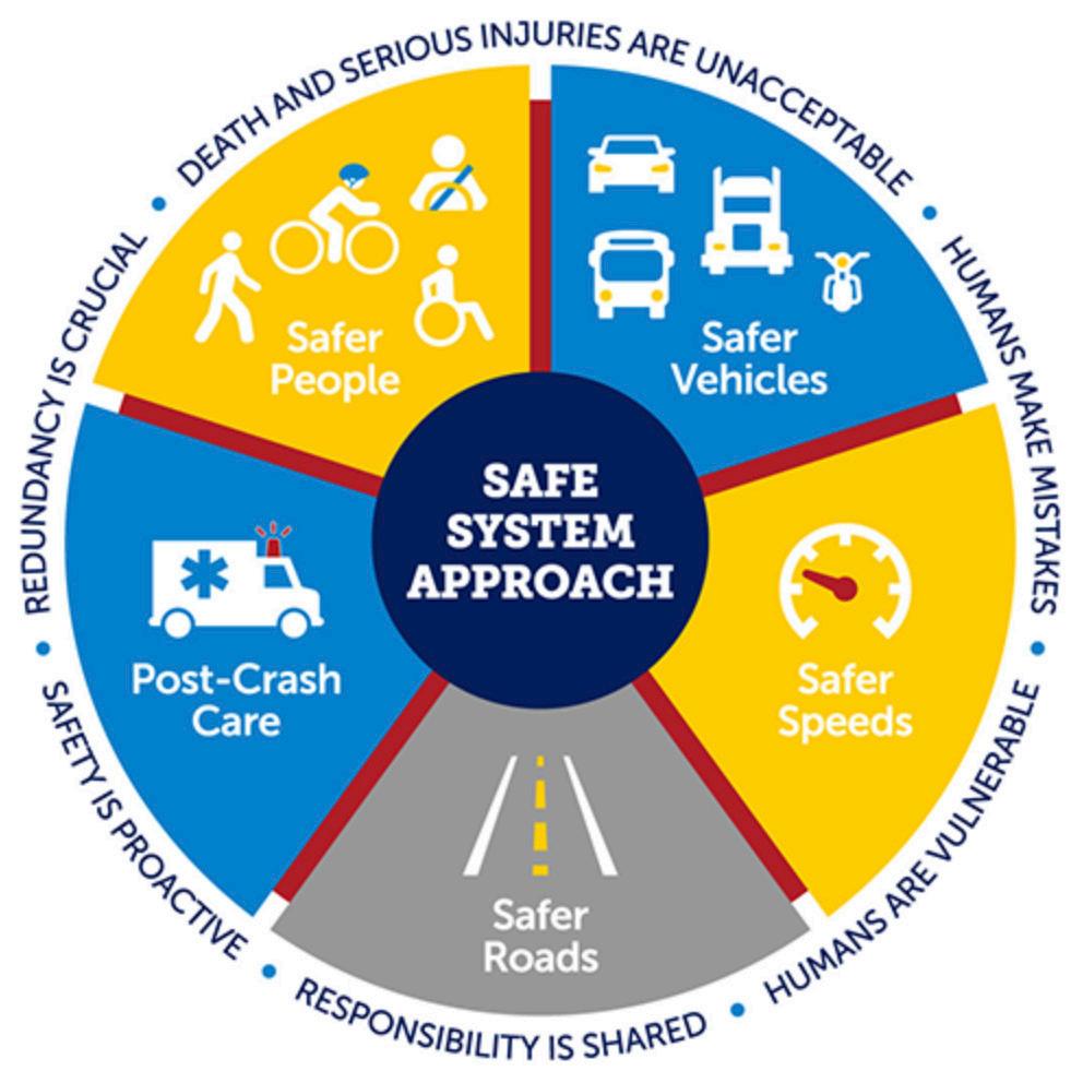
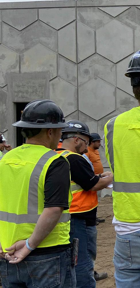
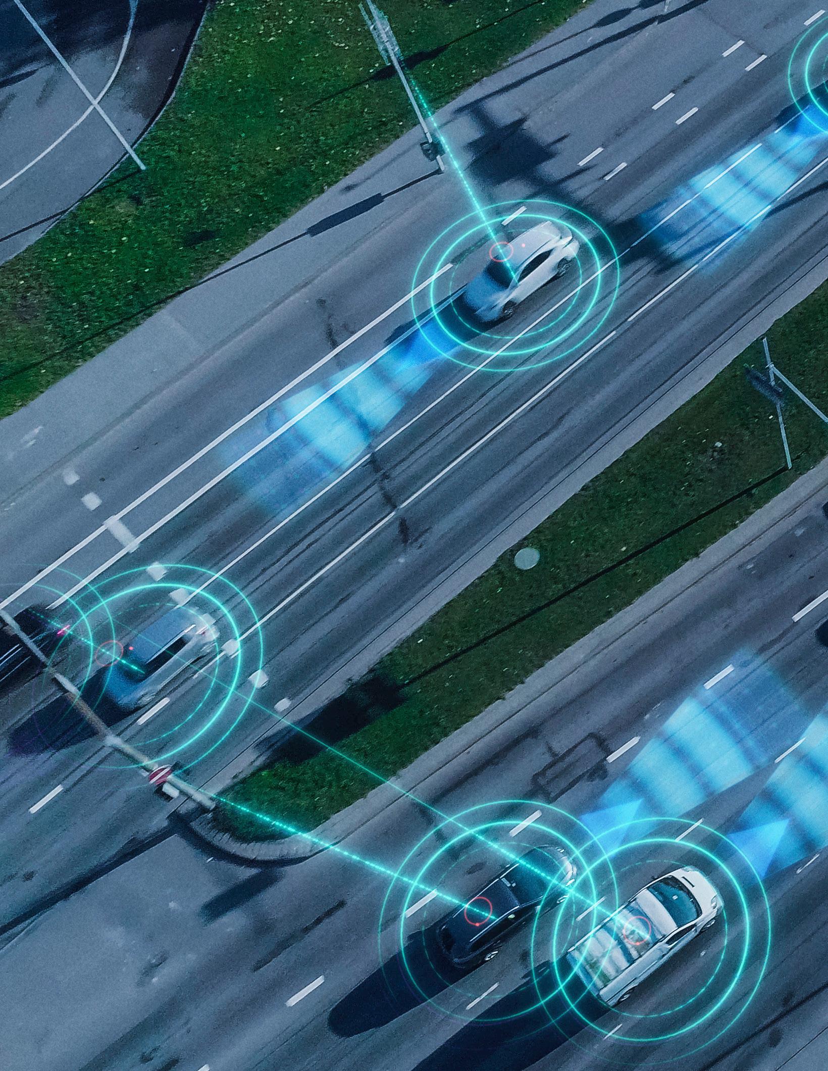
Artificial intelligence (AI) and virtual reality (VR) are no longer futuristic ideas; they are practical technologies used by engineers to impact communities and citizens across Florida. Across the state, engineering teams are integrating AI technology with a focus on creating safer roads for all road users.
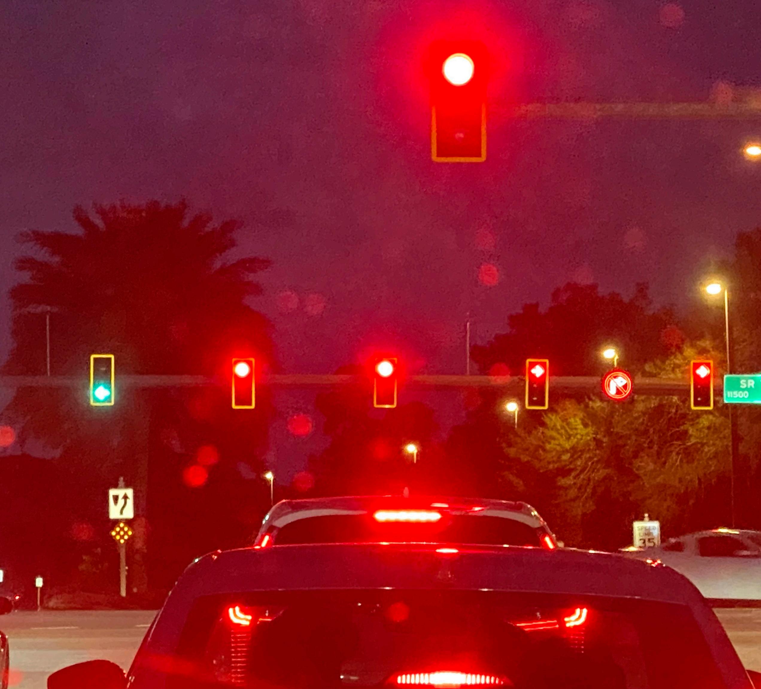
In Central Florida, civil engineering firm Vanasse Hangen Brustlin partnered with Derq, a Dubai-based provider of AI analytics solutions for connected roads and vehicles, to deploy a system that provides real time transportation data to improve safety and operations for Osceola County.
The project was funded by a $500,000 Florida Department of Transportation (FDOT) Local Agency Program (LAP) grant, an FDOT program centered around technology deployment to enhance mobility and safety on the state’s highest-fatality roadways.
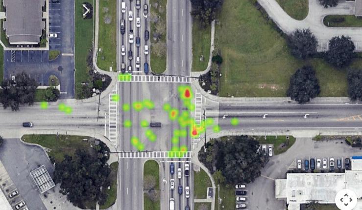
The pilot study – the first of its size for VHB – focused on nine intersections across Osceola County with the goal of providing real-time transportation data to inform improvements.
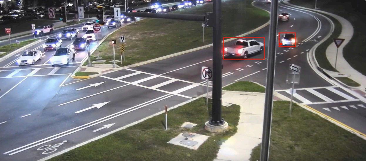
The project group had to overcome a few minor challenges during the rollout, one of which stemmed from the utilization of existing cameras at each location. Video angles, location and quality are paramount to the AI model operating properly, and while there were a few initial detection limitations, the system performed well with the existing cameras, testing at more than 95-percent accuracy across various performance measures.
While the pilot provided helpful insights at all nine intersections, the project made a considerable difference at County Road 532 and the Interstate 4 eastbound off ramp. Part of a diverging diamond interchange – where traffic is routed on the opposite side of the road – the AI model identified a problem area where off-ramp drivers weren’t properly identifying drivers on C.R. 532 or obeying the yield sign.
VHB identified and communicated these challenges, which both local and state officials can use to better improve the elements of the roadway. In addition, the state is able to revisit existing policies and build these findings into future plans in order to help avoid these issues in the future.
“Crash data is a really great indicator of safety problems, but there may only be a few crashes,” said VHB Project Manager and Safety Practice Leader Frank Gross. “There might not be enough crashes to show specific patterns.”
“I think one of the real success stories here is just being able to get into the details of nearmiss events and see the driver behavior, which you typically wouldn't be able to do on a large scale manually. If you went out in the field and you reviewed this for a couple of hours, you may not see exactly what you needed to.”
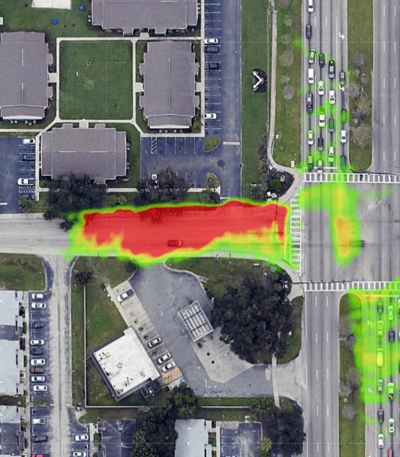
Additionally, the company was able to suggest safety improvements at other intersections, identifying needs for offset left turn lanes at junctions where drivers were using them to bypass traffic. The study also justified access management improvements to prevent drivers from jumping queues and identified a need for better pedestrian accommodations where models detected heavy mid-block crossings, which created a safety concern for drivers and pedestrians.
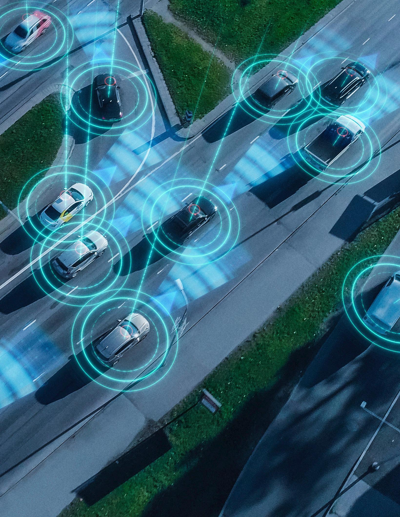
AI Uses in Transportation
In Orlando, the Smart Orlando Downtown Advanced Traffic Operations (SODA TOP) project also showcases the use of AI in transportation. VHB conducted a comprehensive field assessment with the City of Orlando to document conditions at all project intersections to determine existing infrastructure and equipment compatibility.
In all, 24 intersections were used in the SODA TOP study where automated traffic signal performance measures (ATSPMs) were space programmed. Thirteen of these intersections received advanced traffic controller (ATC) upgrades, while 13 more intersections have roadside units (RSUs) for facilitating connected vehicle communications.
The project utilizes CURRUX Vision AI Processor technology for Passive Pedestrian Detection (PPD). Additionally, the AI system provides a range of additional capabilities, not all of which were deployed in this project, including vehicle detection and speed monitoring, turning movement counters, both vehicleto-vehicle and vehicle-topedestrian near-miss detection, red light violation detection and real-time signal timing recommendations.
The project’s AI system is integrated into additional strategic opportunities, including with FDOT District 5 and ATSPM application and SunGuide system. In addition, The AI system provides realtime performance monitoring and optimization capabilities, along with enhanced emergency vehicle preemption and CV capabilities for transit signal priority. This includes reducing manual intervention of signal timings during special events at heavily trafficked locations like Downtown’s Kia Center arena by automatically triggering pre-programmed signal timings at its busy intersections.
However, road projects are only one way that FDOT is using AI.
“FDOT sees significant opportunities for AI and VR technologies to enhance its mission in areas such as infrastructure maintenance, safety and traffic management,” said FDOT Communications Director Michael Williams. “AI allows for the efficient processing of vast amounts of data that our team then interprets for accuracy. FDOT remains committed to ensuring there is always a human decision-maker involved, with transparency and accountability at the center of its approach.”
FDOT is blending AI technologies with geographic information system (GIS) mapping to enhance multiple avenues of operation. This fusion can allow the organization to identify and draw estimated moving area boundaries to improve operations, allowing calculations to be sped up and freeing team members to serve communities in other ways.
In addition, FDOT is utilizing the pair of technologies to modernize its asset inventory system, using them to inventory road sign locations and sign wording. The organization is hoping to compare the AI-aided results and manually collected data to develop a Digital Asset Management System.
VR technology is another emerging opportunity for the state. FDOT is exploring VR’s use in public meetings, where the public is able to engage in an immersive view of projects to visualize future improvements through VR goggles. VR technology also allows FDOT to analyze and identify utility conflicts, which saves resources and ensures transparency.
“This makes it easier to identify potential problems and reach consensus on solutions before construction begins, which reduces costly delays and misunderstandings later,” Williams said. “While these initiatives have been more limited so far, the Department continues to evaluate VR’s potential to improve how it communicates plans and visualizes complex infrastructure scenarios for stakeholders.”
AI Through the Lens
Across the state, AI is taking flight, literally, to save engineers time and resources.
T2D2 is an AI software company that is used by architects and engineers to perform exterior asset condition inspections. Launched in 2021, the company has grown substantially from its beginnings as an R&D arm of engineering firm Thornton Tomasetti and is currently used across the U.S. and globally.
“Our computer vision machine learning is a proprietary technology that takes inspection data – whether that is images from cameras or drones – and processes them within minutes and automatically generates reporting and other downstream workflow data,” said T2D2 CEO Jonathan Ehrlich. “We’ve been used for everything from the Miami-Dade County re-certification for condominium requirements to mixed-use development planning, adaptive reuse and scope of work planning for different kinds of structures across the state.”
Users can upload photos of structures or tap into the company’s network of highly-certified drone pilots to have them capture imagery. The AI model – trained with a vast database of inspection images – identifies and tags conditions by analyzing each image. T2D2’s online portal keeps a record of each image uploaded, allowing users to monitor property deterioration over time and fix minor problems before they grow to larger, more costly issues.
“AI is revolutionizing the way that engineering services are provided," Ehrlich said. “We are a tool in the arsenal that is used for that purpose. We cut down on the time that it takes to perform those services. Our goal is to make our users faster, better and more comprehensive.”
A number of the company’s staffers sit on various committees, including some by the American Society for Testing and Materials (ASTM), and they have helped publish nationwide standards for drone inspection practices. They are creating additional standards in-house, which are being used to guide future standards and grow the company’s network.
“There is ample opportunity for T2D2 to continue to be used by engineers throughout Florida," Ehrlich said. “That includes engineering service professionals but also in-house engineers who are tasked by owners and operators of facilities to provide for the stewardship of assets ongoing.”
Weather and ecological conditions in states like Florida can present heightened challenges, but AI technologies present new opportunities to increase the life span of structures and maximize the value for owners across the state – all while improving T2D2’s service.
“Risk reduction goes hand in hand with increased inspection,” Ehrlich said.
“Understanding that more inspection gives you better data, which leads to reduced risk and higher-quality outcomes, is a core tenant behind the software that T2D2 is able to provide.
“The more that large asset owners are aware of their facility conditions and the more that they are committed to surveying, inspecting and adjusting their data, they’ll begin to establish a trend line over time to make sure they are making up front investments that will essentially ensure sustainable futures for those types of assets, whether those are coastal or inland.”
VR provides a number of prospective opportunities for asset inspection companies like T2D2. VR technology can create enhanced simulations, present a virtual collaborative inspection or even integrate elements of augmented reality (AR) into the space. Ehrlich spoke to the seemingly endless window of possibilities in the space.
“It’s only the first inning in terms of where AI has to add value in the engineering industry,” Ehrlich said. “We’re happy to be here starting from day one – we introduced AI products long before ChatGPT was a household term – and we’re super excited that the rest of the world is turning an eye to where AI can add value in their industry.
"There’s still a lot to be learned about the possibilities and where it can add value moving forward.”