Instant digital products (PDF, ePub, MOBI) ready for you
Download now and discover formats that fit your needs...
Climate Change and Land: An IPCC Special Report on climate change, desertification, land degradation, sustainable land management, food security, and greenhouse gas fluxes in terrestrial ecosystems 1st Edition Ipcc
Center for Afghanistan Studies, University of Nebraska at Omaha, Omaha, NE
About the Authors
John (Jack) F. Shroder is a Senior Research Scholar in the Center for Afghanistan Studies (CAS), as well as an Emeritus Professor of Geography and Geology at the University of Nebraska at Omaha, where he has worked since 1969. Co-founder with Chris Jung of the CAS in 1972, Dr. Shroder has studied Afghanistan’s natural environment in detail using ground surveys and satellite-image analysis for much of the past four decades. Author of many scientific papers and opinion editorials about Afghanistan, and most recently a book entitled Natural Resources in Afghanistan, Dr. Shroder has offered factual information and observations about his geographic and geologic perspectives on centuries of conflict in the region.
Dr. Shroder has traveled extensively throughout Afghanistan, mainly in the 1970s when life in the country was considerably safer than presently. During the time that Shroder was Director of the National Atlas of Afghanistan in 1977–78, four-wheel drive and ambulatory field work, as well as low-altitude aircraft provided by the American embassy, allowed extensive survey of the country. Once the wars started in 1979 and field work was no longer possible, Dr. Shroder used multiple satellite sensors to investigate ground conditions nationwide for the next 30 years. Co-directing the GLIMS Project in Afghanistan after 2000, Dr. Shroder helped to assess the solid and liquid water resources in the Hindu Kush and Western Himalaya as part of the efforts in the Global Land Ice Measurement from Space, which was begun and managed by the U.S. Geological Survey and NASA (National Aeronautics and Space Administration). After the 9/11 attacks in the U.S.A. by Al Qaeda, Dr. Shroder returned to Kabul numerous times to renew professional associations with Afghan professors and to assist in educational development of Kabul Polytechnic University and Kabul University.
Now retired in Crested Butte in the mountains of Colorado, Dr. Shroder maintains an avid interest in all things Afghanistan, and continues to publish extensively on that country.
Sher Jan Ahmadzai is the Director for the Center for Afghanistan Studies (CAS) at the University of Nebraska at Omaha. He has been working at the center since 2007 in various positions. Before joining the CAS, he served in the Office of the President of the Islamic Republic of Afghanistan. Prior to leaving Afghanistan, he served as Director of the Presidential Schedule at the Office of the President of Afghanistan where he was responsible for managing President Hamid Karzai’s dayto-day work schedule. During Mr. Ahmadzai’s efforts at the
Foreword to Transboundary Water Resources in Afghanistan
One of the most urgent challenges of the 21st century is to ensure sustainable food and water security in the face of population and income increases, a changing climate, and growing demands for scarce water resources. This enormous challenge, which has significant political, environmental, social and economic implications, plays itself out in different ways in different contexts.
In the almost 150 countries whose rivers, lakes and/or aquifers cross international boundaries, addressing this challenge requires effective transboundary water management, especially when these water bodies constitute the major or only source of renewable water. In such contexts, no one country can fully control its water resources, and policy makers need to work through international cooperation and transboundary water agreements. To do so successfully, they need to understand the intricacies of the hydrological interrelationships among countries. They need to be able to analyze the way in which dams and irrigation projects in upstream countries impact water availability in downstream countries, and how that might affect their ability to attain water, food, and energy security. They also need to be aware of the impacts that climate change, population growth, and other factors might have on future supply and demand for water.
This is clearly the situation in Afghanistan and the Southwest Asian countries that surround it: Pakistan, Iran, Uzbekistan, Turkmenistan, and Tajikistan. A map of the Amu Darya, Kabul, Helmand, Harirud, and Murghab river basins shows how the waters that emanate from Afghanistan are
intertwined with Afghanistan’s development and that of its downstream neighbors. Importantly, all these countries have arid and semi-arid climates, and depend heavily on irrigated agriculture for their food security. Afghanistan and its neighbors irrigate over 38 million hectares of land, almost twice as much as is irrigated in all of the United States and constituting in some of these countries as much as 80% or 90% of the land available for agricultural production. In a region where food, water, and energy supplies are already vulnerable and subject to increasing pressures from political and social conflicts, population growth, and climate change, the rivers that originate in Afghanistan have a major impact on the water, food, and energy security of their neighbors downstream. And while Afghanistan’s water resources are at present relatively underdeveloped, over time the country will inevitably need to make a greater use of its waters, with significant downstream impacts.
Policy makers in Afghanistan and in the region require a broad understanding of the hydrological interconnections of the region’s shared water resources to use and manage them successfully to meet their development goals. The success of negotiations between countries in the region over the allocation of shared water resources and their use for irrigation, flood/drought management and energy generation will require increasing the capacity of decision-makers in Afghanistan and the region to understand and analyze the hydrology of Afghanistan and its neighboring countries and the management of these shared water resources.
This is why Transboundary Water Resources in Afghanistan, by John Shroder and Sher Jan Ahmadzai, fills an important niche. By providing a comprehensive and science-based view of the interconnected water resources of Afghanistan and its neighbors, the book will equip policy makers and technical advisors in the region with the tools they need to develop effective policies and interact cooperatively with the countries that share its water resources. The book provides a solid introduction to the physical characteristics of water, both in general and specifically in Afghanistan and its neighboring countries, as well as in-depth discussion of water management issues in Central and South Asia and a look at the future of water management in the region. The book also includes chapters on such vital subjects as the characteristics and implications of climate change, hydrological data collection, and international water law.
John Shroder, Emeritus Professor of Geography and Geology at the University of Nebraska at Omaha, has dedicated his academic career to studying and analyzing transboundary water negotiation issues between Afghanistan and Pakistan, and has
brought together in one volume his extensive knowledge and experience of the water resources of the region, as well as the views and perspectives of various other specialists in the field. By helping policy makers in this critically important region to advance water and food security, the book is a significant contribution to the work and mission of the Robert B. Daugherty Water for Food Institute at the University of Nebraska, where Shroder and chapter author Patrick McNamara are Faculty Fellows. The institute was established in 2010 to bring the best of the University’s expertise in water and food to address the challenges of improving water and food security across the globe. Working with Faculty Fellows like Shroder and McNamara and a global network of partners, our mission is to have a lasting and significant impact on food and water security through research, engagement, communication, and education programs.
Roberto L. Lenton Founding Executive Director
Robert B. Daugherty Water for Food Institute at the University of Nebraska
outcomes, and can influence water legalities in the international eye. Training of Afghan government officials and bringing them up to international levels of hydro-understanding will enable them to profit in any sort of water treaty negotiations with hydro-experts from other countries as they all negotiate the international distributions of water allocations and seek additional funding to build dams and irrigation infrastructures.
Recently, much has been made of rivers that dry up before they reach the sea because of human withdrawals upstream (neo-arheism) (Falkenmark and Lannerstad, 2005; Lannerstad, 2002; L’vovich and White, 1990; Meybeck, 2003). In fact, however, all of the large rivers (Kabul, Helmand, and Amu Darya) originating in Afghanistan have been drying up repeatedly as a result of overuse, likely coupled with climate change before they reach their historical destination. These facts are the strongest evidence possible that water issues in Afghanistan are most serious and serve as a strong harbinger of things to come in Central and South Asia, as well as many other semiarid and arid areas of the world. Because of this forecast of such serious problems in a world of coming climate change, study of these aspects of water in Central and South Asia is a highly valuable exercise.
The study of water in all its forms runs the gamut from the stark physics of an unusual material that behaves quite differently from almost all other compounds in nature (expanding when cold, decreasing its density when solid, etc.), and is so essential to life on this planet. This critical necessity extends out to exert control on the bewildering plethora of all the different levels of water delivery and usage for humans. Everyone has some little understanding of water in their own experience with the material, but few can understand all of its attributes unless they study the character of water and the physical and human manipulations thereof.
This means that not only is water an unusual substance essential to life, but its core uses to humanity and all other life transcend simplistic understandings so that great analytical expertise must be applied to manage it properly. Because all too many people can take water for granted, and quite misunderstand some of its apparently mysterious and diverse attributes, they can be rather surprised when the water somehow diminishes or disappears. One of the purposes of this book is to explain some of these mysteries of water in Central and Southwest Asia so that no one in government who has been paying attention will have to wonder too much about what is happening to the hydrologic character of their region.
Building hydro-capacity in any region is thus an issue of education; teaching about the basic physics and chemistry of this vital H2O substance, even while the basic geoscience (surfical physical geography and hydrology of rivers, coupled with the hydrogeology of water underground) is added in to give an essential background context. This is all the basic science, which is not all that complex; it is just that there can be a great deal of it, or even nearly an overwhelming amount, and people may be loath to take on understanding of too much of this information lest they feel that they do not need to understand all of it. Then because so much cultural or sociological baggage concerning water also exists in any given society to surmount as well, the amount of information required can feel fairly overwhelming. Nonetheless, because this information is so essential to wise management of this critical resource, this book is designed to serve as a foundation document to assist water-cognizant agents in Central and Southwest Asia.
Many people in Afghanistan now recognize that most of the illiterate Taliban insurgency against their government does not know that the lowland neighbors who
support the insurgency actually are most interested in unrestricted access to the water that comes from Afghanistan. Keeping that water under-utilized in an under-developed Afghanistan is thus obviously of advantage to the neighboring countries. For lowland countries to foreclose on the rights of upland countries to also develop is obviously not fair. Some solutions to this problem are water-capacity building in Afghanistan so that the government officials will comprehend the situation and be more able to deal with hydro-issues more effectively in future. The age of hydro-diplomacy (Eliasson, 2015) is now firmly upon us, and it is seen as an essential aspect of the human condition as the rising pressures of global water shortages loom largely everywhere, but especially in Central and Southwest Asia.
References
Eliasson, J., 2015. The rising pressure of global water shortages. Nature 517 (7532), 6.
Fagan, B., 2008. The Great Warming: Climate Change and the Rise and Fall of Civilizations. Bloomsbury Press, New York.
Falkenmark, M., Lannerstad, M., 2005. Consumptive water use to feed humanity—curing a blind spot. Hydrol. Earth Syst. Sci. 9, 15–28.
Lannerstad, M., 2002. Consumptive Water Use Feeds the World and Makes Rivers Run Dry, MSc Thesis. Royal Instutue of technology (KTH), Sweden, Stockholm.
L’vovich, M.I., White, G.F., 1990. Use and transformations of terrestrial water systems. In: Turner, B.L. II (Eds.), The Earth as Transformed by Human Action: Global and Regional Changes in the Biosphere Over the Past 300 Years. Cambridge University Press, Cambridge.
Meybeck, M., 2003. Global analysis of river systems: from Earth system controls to Anthropocene syndromes. Phil. Trans. R. Soc. Lond. B 358, 1935–1955.
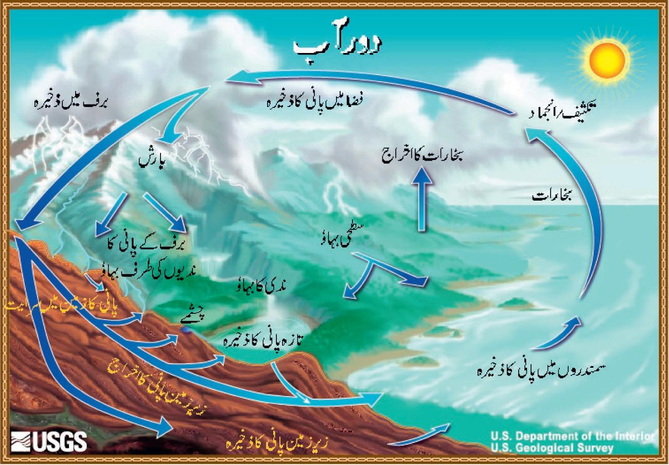
are relevant, as are the processes that move gaseous, liquid, and solid H2O between locations. The basic principles and characteristics of the regional hydrological cycle must figure in the initial discussion, which also includes the regional and local climate controls. Aspects such as the winds that bring precipitation-bearing storms are essential, as are discussions of the snow and ice in the mountains, which later melt seasonally or, after much delay as glacier storage, also melt to eventually become river water downstream. On hillsides, the water runs off and initiates the soil-destroying sheet and gulley erosion that is so detrimental to long-term agricultural productivity and fills up essential water impoundments with sediment so that water availability for irrigation is reduced, and hydroelectric power generation is curtailed. Finally, the configuration of the drainage basins and the major surface rivers is essential to comprehend the main aspects of water availability.
Hidden below the ground surface, of course, are all the unusual aspects of underground water, which, because it has been hidden from view for so long everywhere in the world, tends to be poorly understood and improperly used or under-utilized. Nonetheless, in areas where the environment has long been grossly abused by the hand of man—and Afghanistan is known as emblematic of such a place—great over-utilization or contamination of this vital resource can become a severe problem. In fact, as the climate of the world changes, warming and drying in Central and Southwest Asia, these problems will only get worse, so it is essential for agents of the governments of the region to understand these issues and attempt to seek solutions where possible. In addition, the hazards, risks, and disasters associated with all the forms of H2O in action in Central and Southwest Asia are critical to understand as well, particularly because some of the associated hazard problems are among the worst in the world. Water, of course, constitutes one of the chief natural hazards at work, mainly in the cases of either too much or too little of the compound so that flood and drought disasters are greatly feared and little understood in Afghanistan or throughout the region.
Finally, various aspects of climate change have become ever more obvious to many people of the world as mega-droughts and mega-storms rage across the planet. Among the high mountain water towers of Asia, more and more recognition of glaciers wasting away, increasing meltwater lakes in breakout floods, formerly dependable perennial rivers drying up in certain seasons, increasing dust storms—all appear to be short-term evidence akin to weather variability that might be harbingers of the new realities of common coming climate change. This book is, at least in part, an attempt to bring recognition to the new problems, and by exposing them to greater light, perhaps to help alleviate some societal problems.
1 Characteristics of the Regional Hydrological Cycle
J. Shroder
University
The hydrological cycle in Central and Southwest Asia, of course, operates essentially the same as it does in the rest of the world, but it does have regional variations in character and timing of its phases, energy sources, winds, distributions, climate and topographic influences, and other controlling factors that need to be understood. The high mountains of the region serve as the water-tower catchments for the elusive moisture that passes over the dry lowlands, but fortunately for the people who live there, that moisture precipitates orographically in the mountains above them. Not so fortunately, however, the common devegetation and soil erosion that also occur so commonly in the region, end up despoiling the surficial environments and reducing water infiltration into the surficial soils so that the runoff is accelerated into flashfloods and is thereby wasted. In any case, multiple drainage basins have resulted, the development and use of which are the focus of this book.
Keywords: Water physics, H2O phases, Precipitation, Climate controls, Mountain topography, Glaciers, Devegetation, Rapid runoff, Liquid and solid flow, Drainage systems
I. INTRODUCTION TO PHYSICAL CHARACTERISTICS OF WATER
(C)
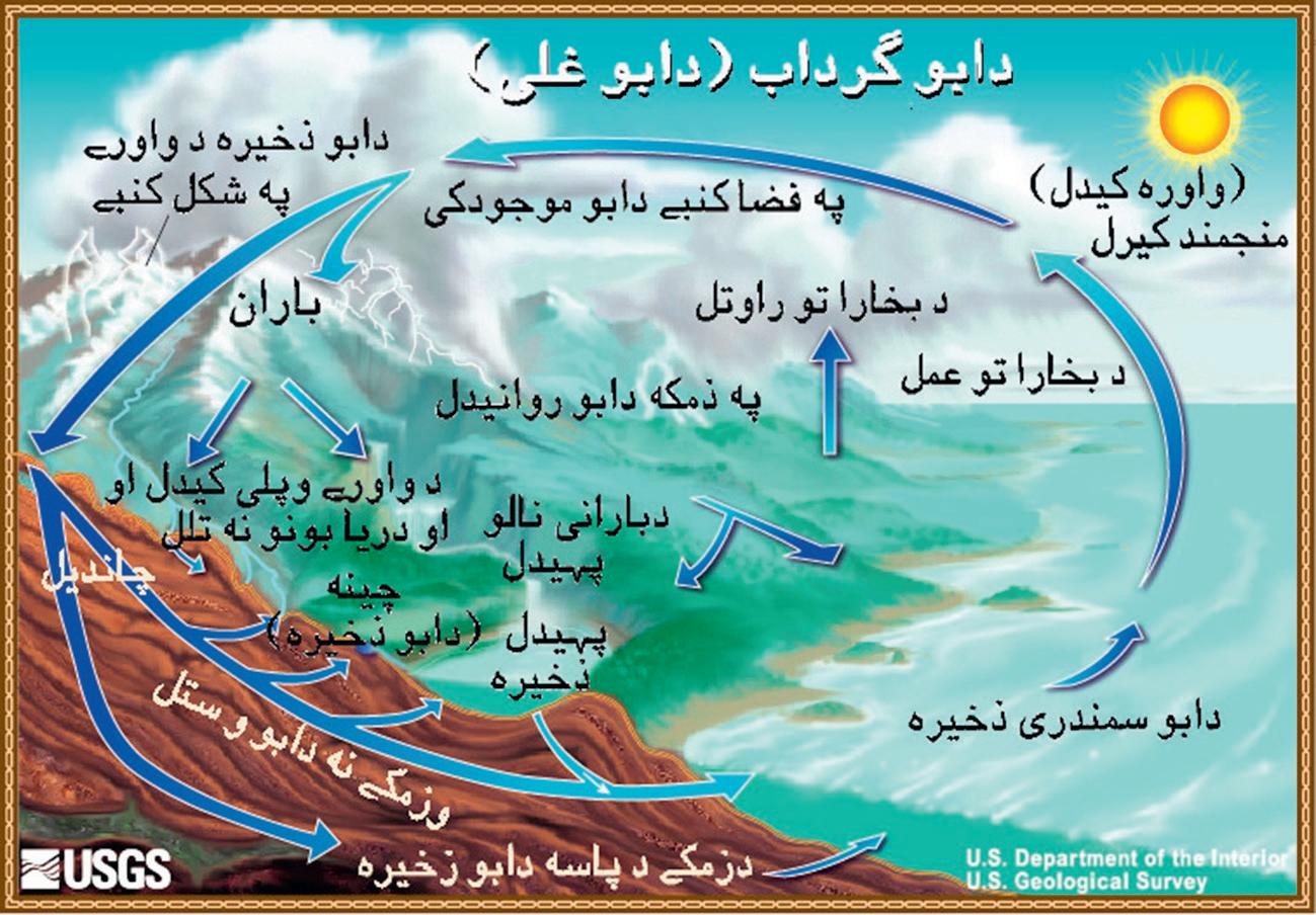
(D)
FIG. 1.1, CONT’D (C) in Pashto; (D) in Urdu; and
Note: Numbers are rounded, so percent summations may not add
FIG. 1.3 The distributions of the world's water by its physical locations. From Shiklomanov, I., 1993. World fresh water resources. In: Gleick, P.H. (Ed.), Water in Crisis: A Guide to the World's Fresh Water Resources. Oxford University Press, New York, http://www.envirothon.org/files/2014/The_Water_Cycle.pdf.
of precipitation; all are characterized also by extremes of what is called continentally wherein winters can be quite cold and summers excessively hot and dry so that any water derived from snow melt and rainstorm precipitation is essential but evaporates quickly.
In general, Afghanistan and its neighboring countries are dominantly arid to semiarid regions, except in the frontal or foothill mountains where more orographic precipitation is caused when air masses are forced to rise and the attendant cooling causes condensation of moisture out of the air (Fig. 1.6). The amount of precipitation increases to the northeast in Afghanistan, and to the north in both Tajikistan and Pakistan, in response to the higher altitudes there (Fig. 1.7). Average annual precipitation is commonly <210 mm in many areas, declining to <110 mm in the southwestern deserts, and increasing to >1000 mm in the high mountains. In all, over 80% of the Afghanistan's water resources have their origin in the mountains >2000 m in altitude, which function as a natural storage of snow and ice that supports perennial flow in all the major rivers in summer. Such is also true of much of northern Pakistan and southwestern Tajikistan, although percentages and altitudes vary (Fig. 1.7).
In Afghanistan, the main period of precipitation in winter is borne on the Westerly winds and extends from November to May, but is shortened in the south to December through April. About half of the precipitation occurs in winter (January to March), mostly as snow. A further third of the moisture falls in spring (April to June). In the summer season some monsoonal precipitation makes it into extreme southeastern Afghanistan along the border with Pakistan, although occasionally monsoon moisture sources go well into the Hindu Kush in Central and Northern Afghanistan as well.
The water cycle is absolutely critical to all these countries, of course, just as it is in Afghanistan. Furthermore, the forces in the hydrological cycle have been nearly totally responsible for shaping most of the structural geomorphic landforms that abound in the region (Shroder, 2014), as well as the largest share of the natural hazards of the region. As overall semiarid to arid nations, a number of places in all of the countries of this region have no real surficial drainage; they are arheic. Elsewhere, however, the drainage net is well developed and provides the basic water source to the people, even as it is also responsible for the general character of most of the landscapes except in the driest of the broad lowland areas (Registan).
The watershed boundaries in Afghanistan begin high on ridge and mountain tops, generally, but not entirely, in the middle and northeast of the country; thereafter the rivers flow radially outward over the borders into neighboring countries. This position at the top of the watersheds places Afghanistan geomorphically as a source of snow and glacier ice storage and melt-water river delivery downstream that combine to produce most of the geomorphology or landforms of the country. Below the land surface of the nation the fractures in the bedrock, and the natural porosity in the sediment-filled basins throughout the nation (Kabul, Jalalabad, Seistan, northern basins), have considerable storage of underground water that is obtained through gently inclined karez tunnels, as well as boreholes and pumps.
Similarly, in Pakistan the high mountains receive plentiful precipitation, particularly from the winter Westerly winds, but also to a certain extent in the foothills to the Himalaya, whereas from there to the south is where most of monsoonal precipitation occurs. In general in Pakistan then, the precipitation received in the country can be divided into two main seasons: the summer monsoon that comes in from the east and southeast from July to September, and the winter Westerly disturbances that come into the country from across Iran and Afghanistan from December to March. In spite of severe monsoonal flooding in 2010 and 2011 in Pakistan, recent analyses show a significantly decreasing trend of precipitation all over the country, with periodic prolonged droughts that will pose severe risks to agriculture and the water-management sectors in Pakistan. The overall climate of Pakistan ranges from the high altitude glacier ice and tundra in the north, down through the more temperate and subtropical climates in the foothills to the semiarid steppes and arid deserts of Baluchistan south of Afghanistan and in Sind to the southeast along the border with India.
In Tajikistan, the high Pamir Mountains catch much of the Westerly precipitation that can come in all seasons but especially in winter and spring. The weather and climate are quite variable between conditions of strong continentality with its extremes of cold and hot temperatures, high-altitude, humid mountain environments, warm and cold steppe climates, and lowland, arid deserts. This presents a number of different climate zones, from subtropical, moderate temperate and Mediterranean-type climates, to high tundra and glacial environments.
None of the other countries in the region (Iran, Turkmenistan, and Uzbekistan) have significant glacier-water storage. For this reason they thus lack any significance to the discussion of transboundary water resources associated with Afghanistan rivers, and so will not be discussed further here.
1.3 MOUNTAIN TOPOGRAPHY OF THE REGION
The highland mountain terrains of Central and Southwest Asia that host the glaciers and snow that provide so much of the local water supplies begin with the so-called “Pamir Knot,” which is located in Central Asia. The Pamir Mountains are formed by the junction or “knot” of the Tian Shan, Karakoram Himalaya, Kunlun, and Hindu Kush ranges. They are among the world's highest-altitude cluster of mountains. They are also known by the Chinese name of Congling 葱嶺 or “Onion Mountains.” The region of the Pamir Knot is centered in the Tajikistan region of Gorno-Badakhshan. Parts of the Pamir knot also lie in the countries of Kyrgyzstan, Afghanistan, and Pakistan. South of GornoBadakhshan, the Wakhan Corridor of Afghanistan runs through the Pamir region, along with the Hindu Kush and Hindu Raj mountains, which also include the northern extremes of the Khyber Paktunkhwa (old North-West Frontier) Province and the northern extremes of the Northern Areas of Pakistan, part of which (Siachen Glacier) in the Karakoram Himalaya is contested with India. As a whole this region is characterized by being the highland source of numerous rivers that emanate from the melt of the profuse snow and glaciers of the region, coupled with plentiful precipitation from the Westerly and Monsoonal moisture sources.
1.3.1 Snow and Glaciers in the Mountains
Snow in mountains that does not melt away each summer will change to glacier ice in 5–7 years. Glacier ice moves downhill because of gravity. Such glacier ice is long-term storage of potential water for use in later years. Because of climate change in the past few decades, however, glacier ice in Afghanistan and the region in general has been melting away (Haritashya et al., 2009; Shroder and Bishop, 2010a,b). Once it is gone, it will not come back for a very long time—maybe never. Some glacier ice in Pakistan has been melting away, but in the highest Karakoram and Nanga Parbat, some glaciers have been growing because of global warming producing greater evaporation from the sea, which produces increased snow at high elevations. All glaciers depend on snow for accumulation to the eventual ice that they become. Then they can flow downhill to warmer locations at lower altitudes where they melt away in what is accounted for by measures of their mass balance (measures of accumulation against wastage) (Fig. 1.8). This melting wastage is controlled mainly by summer temperatures, which themselves are controlled by the amount of sunlight that falls on the ice to melt it, and the cloudiness that occurs to reduce the sunlight.
The accumulation of snow in the highlands in winter both melts and runs off into the rivers in spring and summer, or it remains throughout the year and becomes in a few years, a glacial river of ice. About 3000 separate glaciers exist in Afghanistan with an estimated area of ~2700 km2, but they were once far more numerous than now and they were also much larger more than 11,700 years ago in the Pleistocene (Ice Age) time. At present, the glaciers of Afghanistan are concentrated in the higher northeastern drainages of the country (Amu Darya, Panjshir—Kunar—Kabul). High seismicity, frequent avalanches of snow and ice as well as rocks, coupled with widespread stagnation, retreat, and downwasting of the glacier ice have produced numerous debris-covered ice and rock glaciers, many of which have been