TheGeologyofthe CanaryIslands
Foreword
TheCanaryIslandsarehighlypopularwithtourists,yetrelativelyfewventureawayfromthe resorts.However,forthosewhodoventureinland,thesuperbvolcanicscenerycanstiraninterest andprovokeadesiretolearnmoreaboutit.Today,someofthefascinatingvolcanologicalsitesare markedbynoticeboardsandinterpretivecenters,butthereisclearlyaneedformorecomprehensivedescriptions.Therelevanceisevengreaterforvisitinggeologistsanduniversityfieldexcursions,andthisbooksatisfiesthisneed.
Aclearlywrittenandextremelywell-illustratedbook,itbringsuptodateandextendstheearlier “CanaryIslands”publicationbyCarracedoandDay,whichappearedintheClassicGeologyof EuropeseriespublishedbyTerraPublishingin2002,withmuchnewdata,especiallyfromchemicalandisotopicanalyses,allowingtheadvancementofinterpretationsregardingformation,growth, anderosionofthesefascinatingvolcanicislands.
Theopeningchapterprovidesanoverviewofthearchipelagoandadvancesanup-to-dateanalysisofitstectonicandmagmatichistoryinthecontextofitsplatetectonicsetting.Theauthors makeaveryclear,well-supportedcasefortheislandstohavedevelopedontheedgeofacontinentalplatemovingacrossastationaryMantlePlume,andfortheoccurrenceofrecentvolcanismon themosteasterlyisland,Lanzarote,tobeduetotheinteractionofsmall-scaleuppermantleconvectionattheedgeoftheAfricancratonthatinteractswiththeupwellingmaterialoftheCanarymantleplume.Theysupportthisinterpretationratherthanthealternativemodelinwhichcrustal fractures,suchasapotentialfracturepropagatingfromtheAtlasfault,gaverisetovolcanismupon cuttingthroughthelithosphere,therebypossiblygeneratingfusionbydecompression.
Theauthorsarewell-positionedtopublishthisbookbecausebothhaveperformedextensive researchintheislands.Bothhaveledfieldexcursionprogramswiththeresultthattheaccountof everyislandissupportedbygeologicalexcursionitinerariesthatrevealtheessentialaspectsofthe geology,petrology,andvolcano-tectonicsofeachisland.
Thereareanumberofgeologytextsalreadyavailableregardingindividualislandsandliterally hundredsofarticlespublishedregardingspecificfeatures,includingnewspaperheadlinereports ofpotentialtsunamisresultingfromlandslidescausedbyrecentvolcanismonLaPalmaandof thesub-marineeruptionin2011afewkilometressouthofElHierro,whichproducedfloatingpumice.However,thisbookisdifferent.Itisacomprehensivedescriptionofthewholearchipelago. Theauthorshaveusedrecentlydevelopedmethodsandtechniquestosortoutthevarioustectonic andvolcanologicalconceptsconcerningtheformationandhistoryofeachislandandhaveapplied thesetotheevolutionofthewholearchipelago.Interestingly,theyhavealsobeenabletolinkthis tothevolcanoesoftheMadeiravolcanicprovinceandexplain,insomedetail,theoriginofmany ofthevolcanicfeaturesseeninbothgroupsofislands.Thispublicationthereforesetsabenchmark forgeologicalandvolcanologicaleffortsintheregion.
By,Prof.C.J.Stillman DepartmentofGeology,TrinityCollegeDublin,Ireland
THECANARYISLANDS
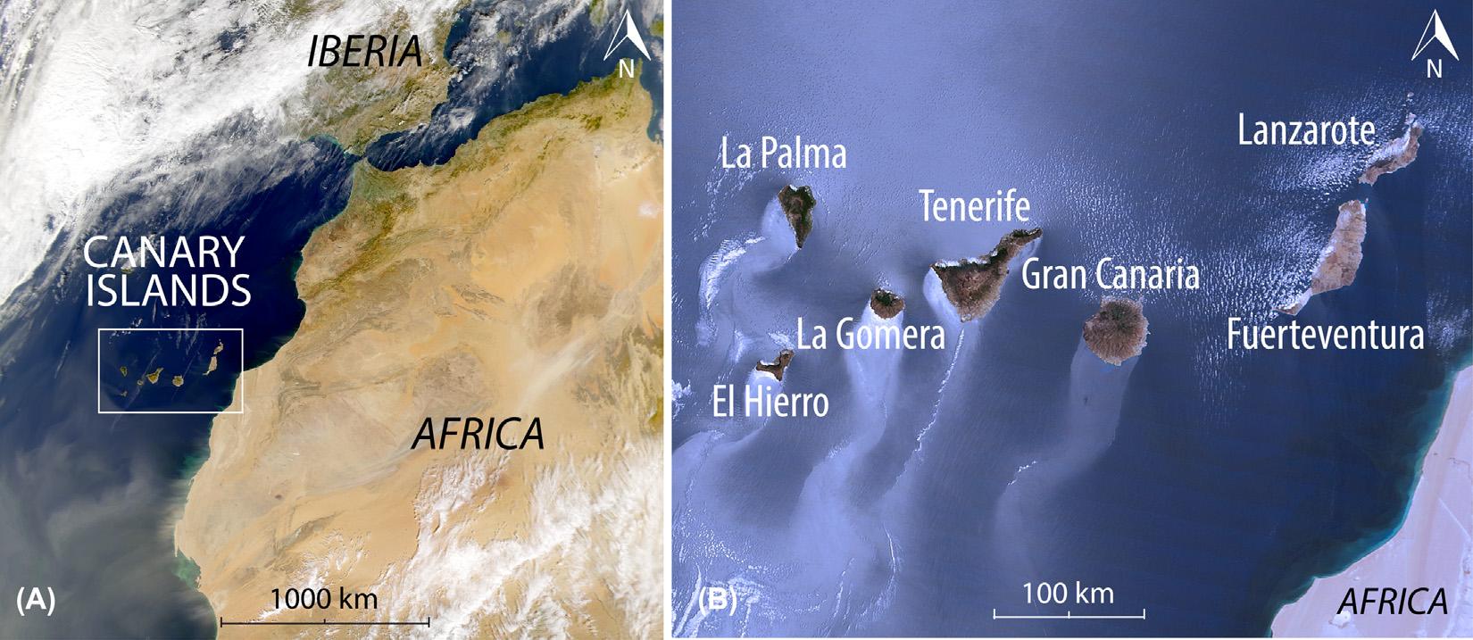
TheCanaryIslandsareanarchipelagoofvolcanicoriginlocatedoffnorthwestAfrica ( Fig.1.1A ).Thearchipelagocomprisessevenmajorislands:Fuerteventura,Lanzarote,Gran Canaria,Tenerife,LaGomera,LaPalma,andElHierro,alongwiththefoursmallerisletsofLa Graciosa,Alegranza,IsladeLobos,andMontan ˜ aClaralocatednorthofLanzarote( Fig.1.1B ). Thetotalsurfaceareaoftheislandsisapproximately7490km2 andtheeasternmostislands, LanzaroteandFuerteventura,areapproximately100kmfromthe Africancoast.Measuredfrom theeasternmosttipofAlegranzatothewesternmostpointofElHierro,theentirearchipelago stretchesoverapproximately500kmintotal.TheC anaryIslandsareconsideredpartoftheecoregionofMacaronesia,whichalsoincludestheAzores,Madeira,CapeVerde,andtheSelvagem islands.
ThepresentpopulationoftheCanaryIslandsisapproximately2,118,700,withTenerife hosting(in2015)888,000inhabitants,GranCanaria847,000,Lanzarote143,000, Fuerteventura107,000,LaPalma82,000,LaGomera21,000,andElHierro11,000. Inaddition,between9and12milliontouristsvi sittheislandsannually.Thedifferentislands receivevariabletouristattention,withapproximately400,000visitorstotheTaburiente CalderaonLaPalma,butapproximately3.5milliontoTeidevolcanoandtheLasCan adas NationalParkonTenerife.
TheCanaryIslandsarealsooneofthegreatestnaturallaboratoriesforvolcanologyonour planet.Inthe19thcentury,manykeyconceptsinvolcanologyhavebeencoinedherebyfamous
(A)GeographicsettingoftheCanaryIslands.TheeasternislandsareclosetotheAfricancontinent(B100km) andarelocatedonthepassivecontinentalmargin.Alltheislandsrestonoceaniccrust,butthecentraland westernislands(B200to600kmoffAfrica)lieoncrustofincreasinglyoceaniccharacter(ie,withprogressively thinnersedimentcover).(B)ThesevenmainislandsoftheCanaryarchipelago(imagesfromNASA).
FIGURE1.1
FIGURE1.2
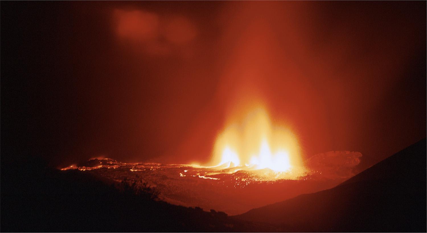
Teneguı´avolcano,thelaston-shoreeruptionrecordedintheCanaries,occurredonLaPalmain1971.The eruptionstartedat15:00onOctober26,1971,fromavolcanicfracture,anditeventuallyformedseveral overlappingstrombolianvents.Thephotographwastaken8hoursaftertheeruptiononsetfromapre-1971cone, lookingSE(picturecourtesyofA.M.Dı´asRodrı´guez).
Therelativelyrecentprogressinseafloormappingandgeomagneticresearcheventuallypromotedtheunderstandingofthegeologyofthewesternislands,whichhasbeenacrucialfactorthat ledtoanoverallviewoftheCanaryarchipelagoasageologicallyclosedentity.Inthisbookwe aimtoprovideinsightintothekeyaspectsoftheirorigin,stagesofevolution,structuralchanges, temporalandspatialdistributionofvolcanism,andpastandcurrenteruptivehazards.
Thewesternislands,LaPalmaandElHierro,lieonadeeperandyoungeroceanicbasement thantheremainingislandsofthearchipelago.However,thesinglealignmentoftheCanariesmay becomea“dualline,”withthesetwoyoungestislandspotentiallysettinganewtrendofsimultaneousislandformation(see Fig.1.1B).
AdecisivefactorinthereconstructionofthegeologicalhistoryoftheCanarieswasincreasingthe availabilityandaccuracyofradioisotopicages(eg,AbdelMonemetal.,1971,1972;McDougalland Schmincke,1976;Carracedo,1979;Cantagreletal.,1984;Ancocheaetal.,1990,1994,1996,2006; Guillouetal.,1996;1998,2004a,b;vandenBogaardandSchmincke,1998;Carracedoetal.,2007a,b, 2011b).Afurtherdecisivefactorhasbeencomparisontoothergroupsofoceanicvolcanicislands,such astheHawaiianIslands(Carracedo,1999)ortheCapeVerdes(Carracedoetal.,2015b),whichshare closeresemblancesduetotheircommonoriginfrommantlehotspots.Inparticular,stagesofisland formationandstructuralfeaturesaresimilar,includinglargeriftstructuresandassociatedvolcanism andgiantlaterallandslides.Inthisrespect,thebenefithasbeendouble:justastheaccumulationof knowledgeofthistypeofislandsinthePacificOceanhasservedtobetterunderstandtheAtlantic islands,sohasthegeologicalresearchandadvancementofknowledgeoftheCanariesbeenhelpingin acquiringamoreuniversalpictureofoceanislandvolcanism,wheretheCanariescontributedsignificantlytotheunderstandingofprocessesrecordedinvolcanicoceanislandsaroundtheworld.
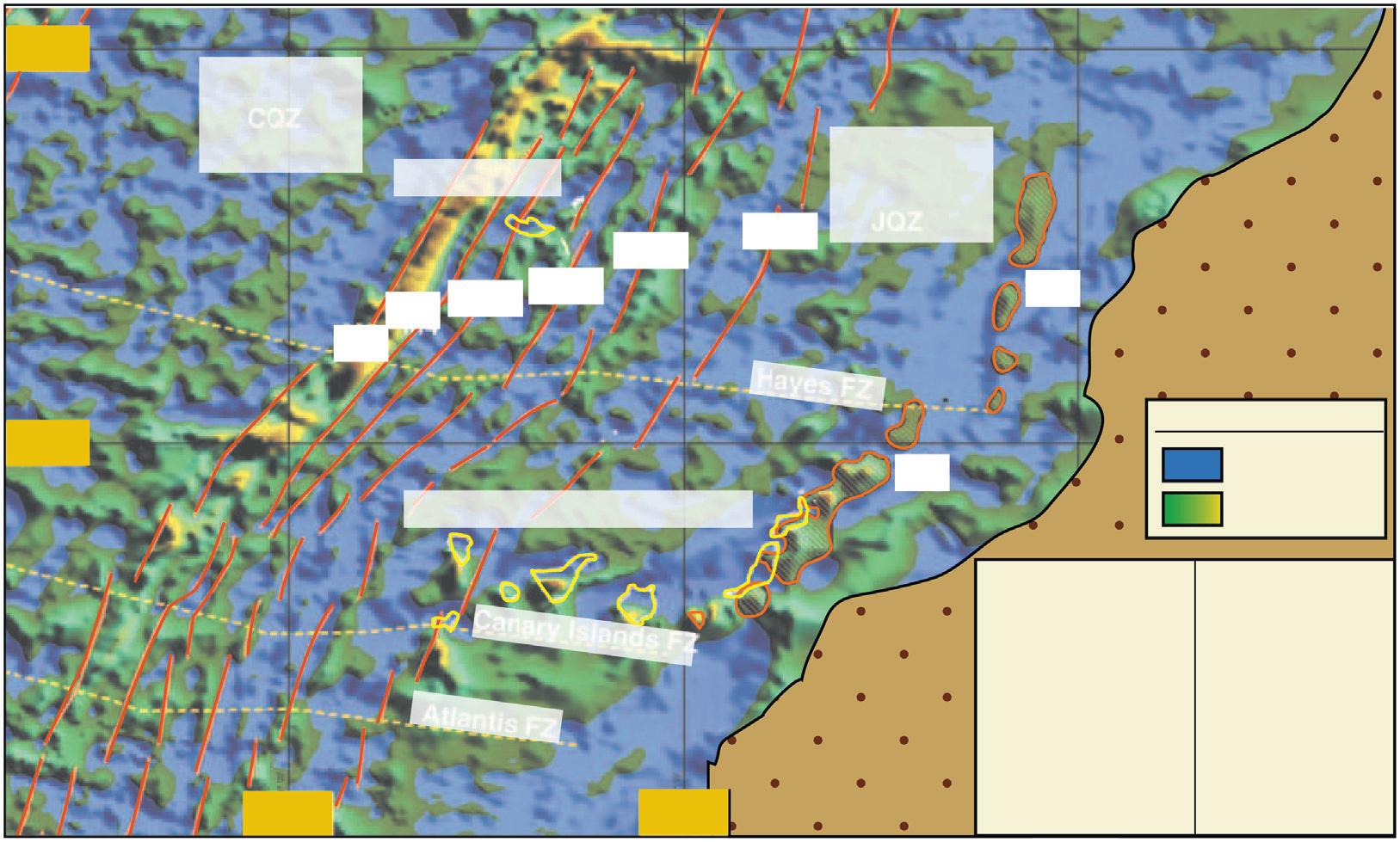
FIGURE1.5
MagneticanomalymapoftheEasternCentralAtlantic(courtesyoftheUSNationalGeophysicalDataCenter, 1993).TheCanaryIslandslieonoceaniccrustcreatedbetweenanomaliesS1(175Ma)andM25(158Ma), indicatingthatthedriftbetweenAfricaandNorthAmericawasinitiatedapproximately180millionyearsago. Thepolarityoftheanomaliesandtheiragesareshownintheinset.TheislandsoftheCanaryVolcanicProvince themselveswerecreatedmuchlaterbyanupwellingmantleplumeat65Maorless,aprocessthatiseffectively independentofthedynamicsoftheoceaniccrustonwhichtheislandsrest.
Acorollaryofthedescribedgeologicalsettingistheprobableexistenceofoilofftheeastern CanaryIslands,inthebasinbetweentheeaste rnislandsandthecoastofMorocco,whereupto 10kmofsedimentshaveaccumulated( Fig.1.6 ).Portionsofthesewered epositedinaveryshallow seaattheinitialstagesofrifting;thus,theyarelik elytocontainorganiccomponents.Afterdecades ofexplorationinthearea,thephaseofprospect inganddrillinghasrecentlybegun.Thetopicforms thecoreofaheatedpublicdebateontheislandsatthetimeofwriting,andlikelyformanymore yearstocome.
THECANARYVOLCANICPROVINCE SEAMOUNTS
TheearlyhistoryoftheCentralAtlanticOceanbasinisreceivingnewinterestintheformofrecent 40Ar/39ArdatesofseamountsscatteredintheCentralAtlantic(eg,southoftheCanaries) (Fig.1.7A).TheseoldersubmarineconesandridgesofCretaceousagesincludeHenryseamount
CANARY ISLANDS Hayes FZ
Canary Islands FZ Atlantis FZ
andpartofthesouthernridgeofElHierro(Klugeletal.,2011;vandenBogaard,2013).These mucholderseamountsdonotdirectlybelongtotheCanaryVolcanicProvincebecausetheirages arescatteredandtheirbroadtrendisatanangletothatoftheCanaryIslands(Fig.1.7A)but parallelsthemagneticoceanflooranomalyM25(Fig.1.5).
TherearemanyvolcanoesintheCentralAtlanticthatremainhiddenundertheseasurface. Theseso-calledseamountsareolderislandsthathavebeenerodedbacktobelowtheseasurface, orconesthatwerearrestedduringtheirgrowthandneverreachedtheseasurface,oryoung volcanoescurrentlyinanactivephaseofgrowth,whereonlyfutureactivitywilldecidewhether theywillemerge.Inthisgeodynamiccontext,theCretaceousalkalineseamountsofvanden Bogaard(2013)andKlu ¨ geletal.(2011)seemunrelatedtoCAMPtholeiiticvolcanismand,most likely,theyalsodevelopedindependentlyoftheseamountsandislandsthatformthepresent-day CanarianVolcanicProvince(CVP).
Forexample,theclusterofseamountssouthwestofthearchipelago( Fig.1.7A)weredatedby vandenBogaard(2013)andfoundtorangefrom91to142millionyearsinage.WhiletheseamountstothenortheastoftheCanaryIslandsshowasystematicdistributionoftheirages(those fartherawaybeingolder),theseamountstotheso uthwestarescatteredwithrespecttotheirage distribution,characteristicoff racture-controlledvolcanism.Sofar,noisotopicfingerprintinghas beenperformedonsamplesfromtheseseamounts ;therefore,itremains unclearforthemoment whethertheseCretaceousseamountsrepresentanearlymagmaticmanifestationoftheCanary Islands.However,anassumptionthatvolcanicseamountsandislandsthatarelocatedinthe greaterareaoftheCana riesmusthaveoriginatedfromthesamesourcethroughthepast140Ma islikelyoversimplified.Itmaywellbethatanearlierepisodeofmagmatismproducedolderseamountsinthisarea,whereaslaterCanaryIsland magmatismwasthensuperimposed(eg,Zazcek etal.,2015).
IntheCanaries,thereexistatleastfivelargeseamountsthatarelocatednortheastofthearchipelagoandarecomplementedbymanysmalleronesinbetween(Figs.1.7Band1.8).Inthiscluster ofseamounts,thosethatarefartherawayfromthearchipelagoaresystematicallyolderthanthe closerones,uptoanageof68MafortheLars/Essaouiraseamount(Geldmacheretal.,2005;van denBogaard,2013).Isotopicfingerprinting,atechniqueusedforidentifyingtheoriginalsourceof amagmaticrockintheEarth’smantle,yieldsverysimilardatafortheolderseamountsalongthe Canarytrend(totheNorth)tothefingerprintsoftherocksfromtheemergedCanaryIslands (Geldmacheretal.,2005).Thismeansthattheseparticularseamountshavemostlikelyoriginated fromthesamesourceintheEarth’smantlethatfeedstheCanaryIslandstoday.Asaresult,they arethoughttobeapartoftheCVP,alongwiththeCanaryIslandsthemselves.
TwoseamountslocatedinandaroundtheCanaryIslandsarerepeatedlyreportedasbeingyoung andactive,andthusarepotentialcandidatesfortheformationoffuturesubaerialislands.Thefirst oneis LasHijas (TheDaughters)tothesouthwestofElHierro(Fig.1.9A).Rihmetal.(1998) foundonlylittlesedimentdepositedonthesurfaceofthisseamountandthereforeinterpretedLas Hijastohaveayoungage.Incontrast,atrachytesampledredgedfromtheflanksofLasHijasgave aradiometricageof133Ma(vandenBogaard,2013),whichpromptedtheauthortosuggestanew name, LasBisabuelas (thegreat-grandmothers),forthisseamount.Becausesamplingatgreat depthsisdifficult,theoriginof LasHijas isnotwellconstrainedatthemoment.Itmaywellbe thatbothstudiescomplementeachother,withoneshowingastructurecontinuouslyresurfacedby newactivity(hence,littlesedimentcover),whereastheotherhappenedtosampleveryoldportions
Ageoftheislands
Althoughtherearedistinctprocessesinvolvedwhencomparingsubmarineeruptionstosubaerial ones,byandlarge,eruptionsproducematerialthatisdepositedaroundaneruptivevent,thereby addinglayersonlayersofmaterialontooldereruptiveproductsand,bydoingso,increasinglyaddingheighttoavolcano.Matureislandsareusuallytheresultofseveralsmallervolcanoesorvolcanicepisodessuperimposedononeanotherinspaceandtime.
Theprogressivewest-to-eastageincreaseinthearchipelagohasbeendeterminedbymeansof radioisotopicandpaleomagneticdatingoftheoldestemergedvolcanicrocks(Fig.1.10A).Marine geologystudieshaveshownthateachislandissurroundedbyloosefragmentedvolcanicmaterial producedinslumpsandlandslidesderivedfromtheflanksoftheinsularedificesthatformextensiveapronsaroundtheislands.Theseapronsareprogressivelyonlappingontoeachotherina northeast-southwestdirection(Fig.1.10B),unequivocallycorroboratingtheageprogressioninthe archipelagodeterminedbyradiometricdatingandimplyingthatahotspothasgeneratedtheislands (eg,Carracedoetal.,1998;Urgel ´ esetal.,1998).
GENESISOFTHECANARYVOLCANICPROVINCES
Volcanisminthis800 3 400kmvolcanicbeltprogressivelydecreasedinagefromthe68-millionyear-oldLarsSeamountintheNortheasttothe1.2-million-year-oldislandofElHierrointhe Southeast(Fig.1.10A).Thissequenceiswidelyinterpretedasoriginatingfromahotspot (Carracedoetal.,1998;Carracedo,1999;Geldmacheretal.,2005).
TheCVPrestsonoceaniccrustofJurassicage(150 170millionyears)thatformedduring theinitialstagesoftheopeningoftheCentralAtlanticandthatrepresentssomeoftheoldest crustsintheoceanicbasinsoftheglobewithmagneticanomaliesthatparallelthecontinental margin.TheCanaryalignment,inturn,follows atrendparalleltothatoftheVolcanicProvince ofMadeira(Fig.1.11 ).Althoughthehotspotsarelikelyunrelatedbecausetheirdifferentisotopic compositionsindicateindepende ntmagmaticsources,theparallel islandchainsdemonstratethe relativemovementoftheAfrican Plateduringthistimeinterval. Theparallelcurvedpathofboth volcanicalignmentsisnotablyunrelatedtotheAtlanticfracturezones,andthesimultaneousvolcanismoverthepast70millionyears,coupledwithasimilarageprogressionforbotharchipelagos,canonlybeadequatelyexplainedbythehotspotorfixedmantleplumemodel(eg,Troll etal.,2015).
THECANARIANHOTSPOT
Awidevarietyofmodelshavebeenproposedfo rtheoriginoftheCanaryIslands,including fracturesthatgiverisetovolcanismoncuttingt hroughthelithosphere,generatingfusionby decompression,suchasapotentialfracturep ropagatingfromtheAtlasfault(Anguitaand Hern ´ an,1975,2000).Thepropagatingfracturemodelopposesthehotspotmodelandhasbeen maintainedbysomescientistsforaconsiderab letime.However,thefracturehasneverbeen located,evenwithmoderndetailedgeophysicals tudies(eg,duetoextensivehydrocarbonprospection).Itisthereforecompellingthatthe paralleltrendandtheco incidingagesofthe
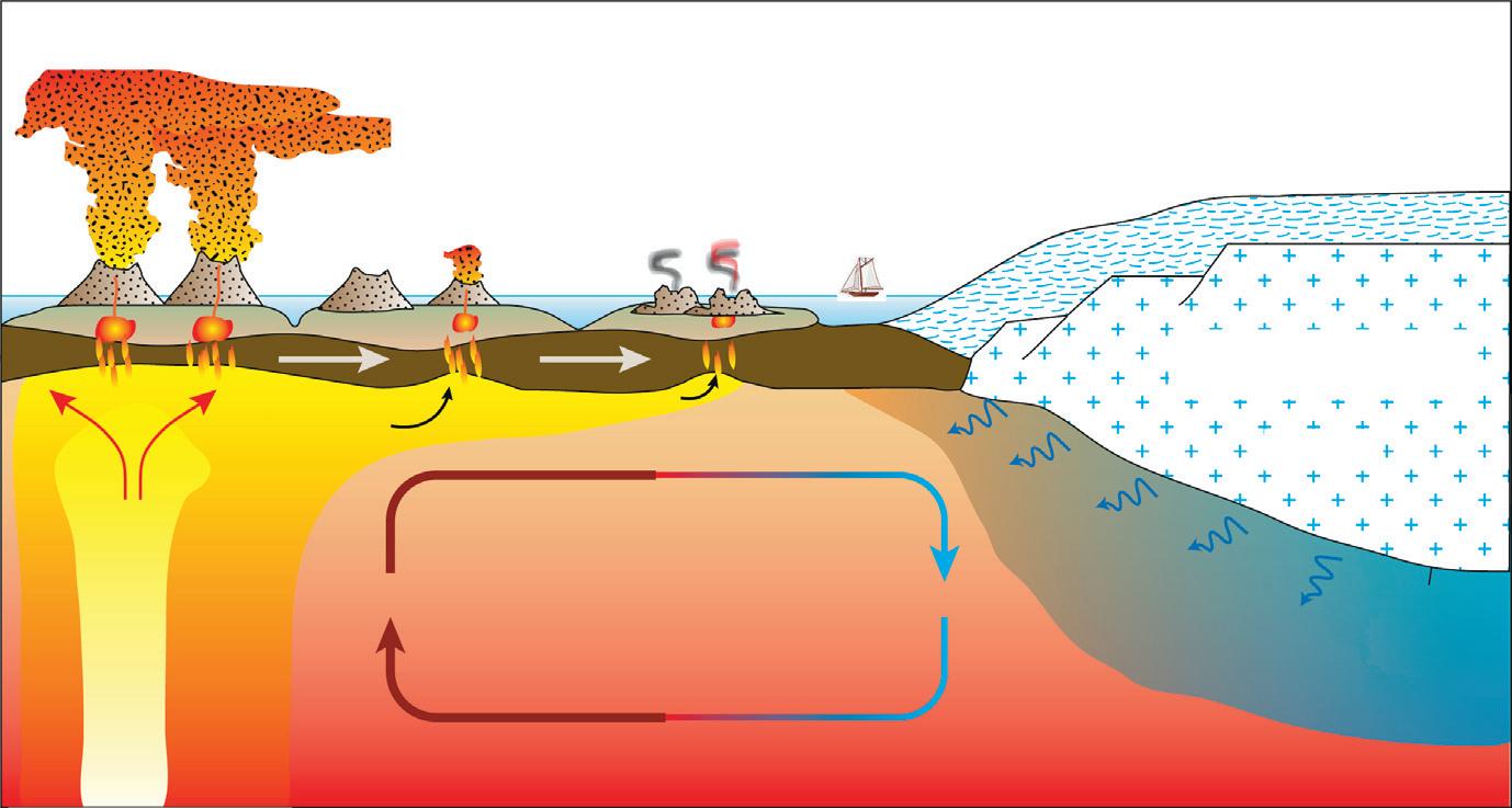
Amantleplumecanexplainthelinearyoungingdirectionalonganortheast-southwest orientedpathforthe CanaryIslands(Carracedoetal.,1998),althoughtheconventionalhotspotmodelcannotreadilyexplainthe occurrenceofrecentvolcanisminLanzarote,oppositetotheinferredlocationofthepresenthotspot.Apossible explanationmaybethesmall-scaleuppermantleconvectionattheedgeoftheAfricancratonthatisinteracting withtheCanarymantleplume,whichmayleadtolocaleruptiveanomalies.SynthesizedafterCarracedo(1999), Geldmacheretal.(2005),King(2007),Gurenkoetal.(2010).
levelsandspatialdistributionoftheCanaryIslandsthatcanonlybereasonablyexplainedwitha hotspottypeofmodelforthearchipelago(eg,Carracedoetal.,1998).
ArgumentsagainstasimpleHawaiian-typehotspotmodel,suchasthelongvolcanichistoryof theislandsandthefactthatvolcanismpersistsevenintheolderislandsofthearchipelago(eg, Lanzarote),haverecentlybeenexplainedbyedge-drivenmantleconvection(King,2007;Gurenko etal.,2010),whichcreatesacontactofhotasthenospherewithcolderpassivesub-continentalmantledomains,inthiscasefromtheAfricancraton.Theconvectioncellsgeneratedwouldmovehot andrisingplumematerialtowardtheeastandnortheastalso,thusreachingLanzaroteandhence producingthesporadiceruptionsthathavetakenplaceintheEasternCanariesinrecenttimes. Moreover,HoernleandSchmincke(1993)proposeda“blobmodel”fortheCanarianhotspot. Accordingtotheseauthors,themulticycleevolutionofislandvolcanismandthetemporalvariationsinchemistryandmeltproductionwithineachcyclerepresentdynamicdecompressionmelting ofdiscretemantle“blobs”ofplumematerialbeneatheachisland.
Newfinite-frequencytomographicimagesfromseismicwavevelocitiesnowconfirmtheexistence ofdeepmantleplumesbelowalargenumberofknownislandclustersandchains,includingthe Canaries(Fig.1.13).ThethreeMacaronesianplumes(Canaries,Azores,andCapeVerde)arerobust deepmantlefeaturesappearingasisolatedanomaliesdownto .1000kmdepth,andthustheyare likelysourcedfromtheverydeepmantleoffthecoastofAfrica(Montellietal.,2004,2006).
Notably,additionalevidenceinfavorofamantleplumecomesfromcalcareousnannofossilsrecentlyrecoveredfromxeno-pumiceeruptedduringthe2011submarineeventsoffElHierro
Hot asthenosphere
Cooler asthenosphere
Edge-driven convection
Young islands (Intense volcanism)
Older islands (Declining volcanism)
Mantle plume (Cool)
Continental crust (African Craton )
Lithosphere
Thermal boundary
FIGURE1.12
Schematiccross-sectionthroughtheCanaryarchipelagoandtheAfricancontinentalmargin(thicknessesof sedimentarylayersnottoscale).NannofossilsinElHierroeruptivesnowdemonstrate,inagreementwith availableradiometricagesoftheoldestsubaeriallavas,thatprogressivelyyoungerpre-volcanicsedimentsare presentinthewestofthearchipelago,whichsupportsthepreviouslyestablishedonshoreageprogressionand thusprovidesfurtherevidenceinfavorofthemantleplumehypothesis(fromZaczeketal.,2015).
oceaniccrustandthelargevolume(weight)oftheislandscausesthemtosubsideintothesubstrate.Forexample,MaunaLoaisestimatedtocompriseapproximately80,000km 3 ofbasalt,a masssogreatthatitwilldepresstheunderlyingandcomparativelyyoungPacificcrust.Thus, volcanicgrowthduetolavaaccumulationintheHawaiianIslandsiscompensatedbysubsidence andlandsliding.Thisprocessaccountsforthef actthattheoldestislandofthe600-km-long Hawaiianarchipelago(Kauai)isonly5.1millionyearsold,whereasFuerteventuraismorethan 20Ma.MostofthesubsidenceintheHawaiianIslandsisduetoanincreaseindensityofthe rocksastheycoolandtheconcentrationofhigh- densitymaterialattheirdepth,andbecausethe islandedificemovesofftheswellcausedbythehotspot,andthereforetheplume’sdynamic supportcomestoanend.
OnecrucialfactorintheCanariesisthevelocityofplatemotion,whichisconsiderablyhigher forthePacific(approximately7cm/year)thanfortheAtlantic(approximately2cm/year)plate. Thesevelocitiesarerelatedtoplatemovementaroundapoleofrotation(Eulerpole),whichis approximately13,000kmfromtheHawaiianislandsandwithinthePacificplate,butonly 3,800kmfromtheCanaries,andlocatedontheAtlanticplate(eg,Trolletal.,2015).
Forexample,inHawaii,islandsareelevate dbyapproximately1000mduringtheiractive volcanicperiod.Thisswelliscausedbythebuoyancyofthelessdensematerialofthehotspot underneaththeoceaniccrust.Additionally,an dimportantly,theoceaniccrustunderneaththe Hawaiianarchipelagoisapproximately95Maand,thus,youngerthantheoceancrustbeneath theeasternCanaries(. 170Ma).Furthermore,itisalsohotterthantheoldoceaniccrustof JurassicageunderneaththeCanaries.TherelativelyyoungoceaniccrustunderHawaiiisthus muchthinnerandmoreflexiblethanthecrustundertheCanariesandflexesapproximately
Basaltic oceanic crustPalaeogeneCretaceousJurassicAfrican cont. platform Neogene
FIGURE1.14
FIGURE1.16
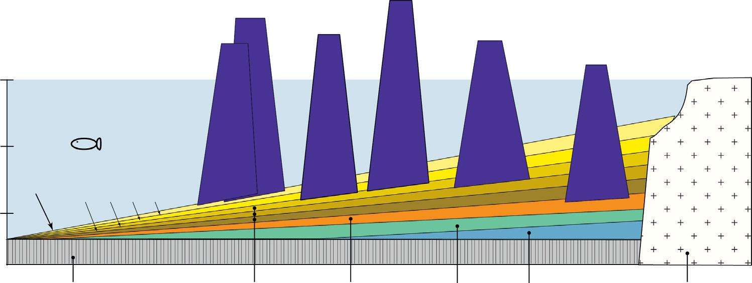
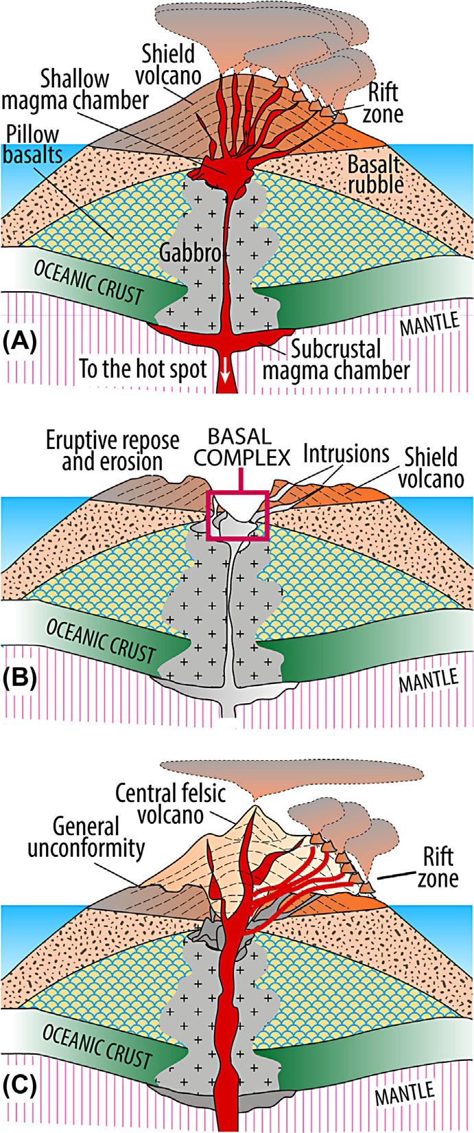
CartoonillustratingthemainstagesofgrowthofaCanaryisland.(A)Ashortbuthigh-productivitybasaltic shieldstageisfollowedby (B) aphaseoferuptiverepose,inwhicherosionmayexhumethesubmarinepartof theedificeand (C) alongposterosivestage,whichisinterruptedbysporadicpulsesofsmall-scalevolcanic rejuvenationsthatcanproducefelsicandmoreexplosivevolcanismintheformofstratovolcano-typeedifices.
Canaries,thatis,the“Old”SeriesofLaPalmaorElHierrowerefoundtobeconsiderablyyounger thansomeunitsofthe“Recent”SeriesofFuerteventura,Lanzarote,orGranCanaria.Thisproblem wasresolvedoncethemaingrowthstagesofoceanicvolcanoes,asdefinedintheHawaiian Islands,wereappliedtotheCanariesalso(see,eg,Carracedoetal.,1998andreferencestherein).
THESEAMOUNTSTAGE
Notethatseamountsarenotonlyveryyoungvolcanoesthataregrowingtoreachtheseasurface butalsooldones,whicheithernevermadeitabovetheseasurfaceorhavealreadybeeneroded backorsunkentobelowsealevel(Fig.1.17).However,forthedescriptionofislandevolution,the termseamountisusedheretorepresentayoungandgrowingsubmarinevolcano.
Theseamountstagecombinesallmagmaticactivitythatoccursbeforethegrowingsubmarine islandbreaksthesurfaceofthesea(seechapters:TheGeologyofLaPalmaandTheGeologyof Fuerteventura).Fromeruptingthefirstmagmaticmaterialontotheseafloortoreachingthesea surface,aseamountmayreachaverticalheightsimilartolargestratovolcanoesonland.Inthe Canaries,theseafloorrangesfromadepthofapproximately1000mfortheeasternmostislands, LanzaroteandFuerteventura,toapproximately3500mforthewesternmostislands,LaPalmaand ElHierro(CanalesandDanobeitia,1998).Byvolume,rocksfromtheseamountstagethusrepresentthebulkofanyvolcanicisland,eventhoughtheserocksremainlargelyinaccessible (Fig.1.18).
Theseamountstage,usuallycoveredbysubsequentvolcanism,onlycropsoutonFuerteventura andLaPalma,twoislandsthathavebeendeeplyerodedthroughmajorincisionscausedbygiant landslidesandsubsequenterosion.OntheislandofLaPalma,onehastherareopportunityto inspecttheserocksintheoutcrop,becausetheseamounthasbeenexposedintheCalderade Taburiente,wheretheupliftedandtiltedsubmarinevolcanoreaches1500mabovesealevel (Fig.1.19).Here,asequenceofhyaloclastiticrocksandpillowlavasisexposed,togetherwitha
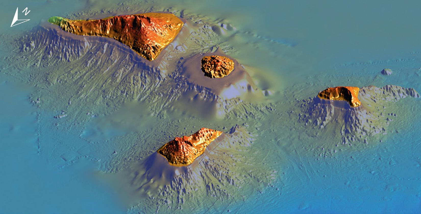
BathymetryandtopographyofLaPalma,LaGomera,andElHierroviewedfromthenorth.Themainlandslides areindicatedwitharrowsinthisshadedreliefimage(fromMassonetal.,2002).Notethelargevolumesofthe islandedificesbeneathsealevelandtheextensivesedimentaryapronstoalltheislands.
TENERIFE (~12 MA)
LA GOMERA (~10 MA)
LA PALMA (~2 MA)
EL HIERRO (~1 MA)
HENRY SMT. (126 MA)
EL HIERRO RIDGE (133 MA)
FIGURE1.17