Slave
Traders by Invitation
West Africa’s Slave Coast in the Precolonial Era
Oxford University Press is a department of the University of Oxford. It furthers the University’s objective of excellence in research, scholarship, and education by publishing worldwide. Oxford is a registered trade mark of Oxford University Press in the UK and certain other countries.
Published in the United States of America by Oxford University Press 198 Madison Avenue, New York, NY 10016, United States of America.
© Oxford University Press 2018
All rights reserved. No part of this publication may be reproduced, stored in a retrieval system, or transmitted, in any form or by any means, without the prior permission in writing of Oxford University Press, or as expressly permitted by law, by license, or under terms agreed with the appropriate reproduction rights organization. Inquiries concerning reproduction outside the scope of the above should be sent to the Rights Department, Oxford University Press, at the address above.
You must not circulate this work in any other form and you must impose this same condition on any acquirer.
Library of Congress Cataloging-in-Publication Data
Names: Finn Fuglestad.
Title: Slave Traders by Invitation: West Africa’s Slave Coast in the Precolonial Era / Finn Fuglestad
Description: Oxford [UK]; New York: Oxford University Press, [2018]
ISBN 9780190876104 (print)
ISBN 9780190934750 (updf)
ISBN 9780190934972 (epub)
Dedicated to the memory of Stephen Ellis (1953–2015)
Y para Elisa Pérez-González de la Barreda
ACKNOWLEDGEMENTS
The author of the present manuscript written in English is a Norwegian whose first foreign language is French, and who took up residence in Spain many years ago. The implication is that if the manuscript has become at all readable, it is thanks to the toiling of my good friend Ms Juliet Wrightson who has done a tremendous job in correcting my English. My debt and gratitude to her are beyond words. Juliet agreed to take over after her sister, the late Penelope Wrightson, who had offered to help me out with my English, was struck down by a terminal disease.
Another friend of mine who has left us is Selena Axelrod Winsnes, with whom I have had many inspiring conversations, and who provided me with many hints and suggestions with regard to the Danish sources especially. After completing the first version of the present manuscript, I most fortunately succeeded in persuading fellow-Africanists Adam Jones and Edna G. Bay into reading parts of it: the former read the Introduction, the latter the Introduction and Part A. Those two sections contain the ideas and viewpoints developed in the rest of the manuscript. Ms Bay in particular has saved me from some embarrassing misinterpretations, plus a number of errors. Her endeavour is all the more admirable since she and I continue to part company on certain fundamental matters, as will become clear later on.
I have also had the honour and pleasure to discuss some of the ideas expressed in the following with the legendary Professor John Donnelly Fage (1921–2002). I still hear his voice.
I would like finally to express my gratitude to all those archivists and librarians in many countries and on three continents who assisted me during my research, which I initiated, if my memory does not fail me, nearly forty years ago.
ACKNOWLEDGEMENTS
If these acknowledgements are unusually short, it is because the present manuscript belongs, for many reasons, to the “in-spite-of” category, rather than the “thanks-to” one.
As for the rest, the usual disclaimers pertain.
LIST OF ILLUSTRATIONS
Figure 1: European lodges in the inland town of Savi, then the capital of Hueda and hub of the local slave trade (17th century). From the Des Marchais archive, British Library
Figure 2: Map of the Slave Coast before 1724. From the Des Marchais archive, British Library
Figure 3: Restored main building of Ouidah’s Portuguese “fort” (2010). Photograph by Finn Fuglestad
Figure 4: V iew of the River Weme at Porto Novo (1980s). Photograph by Finn Fuglestad
LIST OF ABBREVIATIONS
AAP/EB or Anais Anais/Annaes do Archivo Público/do Arquivo do Estado da Bahia (Salvador da Bahia, Brazil)1
AAR African Archaeological Review
AD Archives Départementales
ADM Admiralty
AEH African Economic History
AHR American Historical Review
AHU Arquivo Histórico Ultramarino, Lisbon
AM Archives Municipales
AN Archives Nationales, Paris
APEB Arquivo (Público) do Estado da Bahia
BCEHSAOF Bulletin du Comité d’Études Historiques et Scientifiques de l’Afrique Occidentale Française (predecessor of BIFAN)
BIFAN Bulletin de l’Institut Français/Fondamental d’Afrique Noire
BNE Biblioteca Nacional de España
BT Board of Trade (UK)
CAOM-DFC Centre des Archives d’Outre-Mer, Aix-en-Provence Dépôt des Fortifications des Colonies, Côtes d’Afrique
CÉA Cahiers d’Études Africaines
CO Colonial Office records
CUP Cambridge University Press
ÉD Études Dahoméennes
EHR
ABBREVIATIONS
Economic History Review
HA History in Africa. A Journal of Method
HAHR Hispanic American Historical Review
IAI International African Institute
IFAN Institut Français/Fondamental d’Afrique Noire
IJAHS International Journal of African Historical Studies
JAH Journal of African History
JHSN Journal of the Historical Society of Nigeria
NA The National Archives (formerly Public Record Office), Kew
NS Nouvelle série/New series
OR Ordens régias/regiaes2
O.s. Old style (to 1751)3
PRO Public Record Office, Chancery Lane (later renamed The National Archives and transferred to Kew)
RAC
Royal African Company
SA Slavery and Abolition
SFHOM Société Française d’Histoire d’Outre-Mer
T (as for instance T70) Treasury records in NA
THSG Transactions of the Historical Society of the Gold Coast and Togoland/of Ghana
UP University Press
WIC Generaele/Geoctroyeerde West-Indische Compagnie
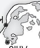
© S.Ballard (2017)
Lagos
Ouidah
Anlo
.Volta
Allada Abomey
Lake Nokoué
Lake Ahemé
Grand Popo
Jakin
Keta
Tado
Glidji / Little Popo
Lake Togo
Offra
Aja-Mono plateau Coastal forest
Gold Coast
Bight of Benin
Zoumbodji
Ouidah
Ahozon
Agbanzin Pouta
Aouandji
Ouidah
beach
Lagoon
swampland
To ho Lagoon
Lagoon
B ight of Benin
© S.Ballard (2017)
INTRODUCTION
Common sense may tell us that trade on a significant scale cannot flourish for long on a heavily surf-ridden beach without any permanent human settlement. But if so, common sense turns out to be a poor guide to the past of that part of the coast of Guinea that we call the Slave Coast. In fact, the Slave Coast, whose shore line corresponds to the description above, was the site of a considerable trade for more than 240 years, between around 1616 and 1850/51, before it petered out during the next 12–13 years. This was a very special trade, a trade in human beings, a slave trade.1
Indeed, the 320 km long beach between the River Volta and Lagos known as the Slave Coast, and especially the central part around the towns of Ouidah and Offra, ranks as one of the major epicentres of the Atlantic slave trade, and as the leading West African centre. The Slave Coast “exported”, according to the best available estimates (but veering probably on the low side), some two million slaves: that is, about sixteen per cent of the (probably) twelve and a half million human beings (or more) sent from Africa to America in the era of the Trans-Atlantic slave trade. It means that on average some 20 slaves were embarked from the Slave Coast each and every day for more than two centuries. Of those two million, probably more than half transited at one single spot, the beach south of Ouidah2 – an open roadstead with no port facilities whatsoever. Note that the figures above refer to the slaves who were alive by the time the ships set sail, and who had survived the notorious loading and waiting time, of which more later.
The paradox then is that this large-scale trade in human beings took place in a particularly inhospitable, even dangerous environment. To quote an employee of the company in charge of the upkeep of the English forts,
Justly Watson, who went ashore on the beach south of Ouidah on 20 December 1755:
The landing is the worst I ever saw, and I believe one of the worst in the whole world (yet we arrived in the best season). I was informed, sometimes ships have been four or five weeks before anybody could get ashore, or any boat go off to them. There is a bar before the shore, in which the sea breaks prodigiously, & the canoes frequently overset in what is called good weather. After one gets ashore there are several rivers to pass over, which makes it very tiresome & dangerous3
to reach the town of Ouidah, Watson’s destination, some four kilometres inland.
Watson was certainly not exaggerating, quite the contrary. In fact, he noticed only one bar, whereas there were actually two moving underwater sandbars which ran parallel to the coast, implying that the surf broke three times during most seasons, the third time over the shoreline itself.4 It has been described by other visitors as a wall of water, with waves reaching truly impressive heights, altogether not bereft of majesty.5 It has also been described as a dangerous belt of death owing to the frequent capsizing of canoes and the presence of man-eating and reputedly enormous and “gluttonous” sharks, sharks that there is every reason to believe were well fed in the era of the slave trade.6 It is claimed that during certain periods human lives, and not exclusively slave lives, were lost nearly every day.7 As for the average loss of goods (other than slaves, who were regarded as goods), it has been estimated at five per cent of the cargo by Patrick Manning.8
We can deduce from the existence of the exceptionally heavy surf and the sandbars that the European ocean-going ships could not go anywhere near the coast in what were also shallow waters. In fact, they always had to stand 2–3 km off the coast9 in what was called the “roads”, for example, the Ouidah road.
The references and quotations listed above have been chosen at random from many available sources. The forbidding conditions under which the slave trade was conducted on the Slave Coast loom in fact large in our sources.10 Obviously, those conditions functioned as an effective barrier against intruders coming from the sea, which was where the Europeans came from in our period. But there was an additional barrier inland south of Ouidah behind the kilometre-deep beach – a natural moat in the shape of a lagoon. Its width varied according to the season, but was never less than two to three hundred metres at Ouidah. The lagoon ran parallel to the coast for several hundred kilometres. It was mostly shallow, generally less than one metre, but in several
places reached a depth of three to four metres, and hence was not always possible to ford.11 Behind the lagoon there were wetlands, swampy grounds and streams (Watson’s “rivers”) whose extension obviously also varied according to the seasons. As for the town of Ouidah and the region of permanent human settlement, that is, the area of permanently dry and therefore cultivable land, that, as can be deduced from the above, was some three kilometres north of the lagoon.12
So there was a total of a distance of seven to eight kilometres between the ships and Ouidah. One question is how it was possible to drive unwilling and underfed slaves from Ouidah town, the centre of the slave trade, to the beach via the lagoon, where no bridge existed, and then out to the waiting ships. Another is how it was possible to carry goods in the opposite direction, and the Europeans in both – Europeans who usually travelled in hammocks once on shore,13 in this country where no wheeled carriage existed and where horses were few, small and condemned to an early death due to trypanosomiasis borne by the tsetse fly14 (horses were reserved in theory for the king and the Europeans).15 As for the canoe crossings between the ships and the beach, it goes without saying that one was almost guaranteed to reach one’s destination soaking wet. Thus many Europeans confronted the surf wearing only the minimum.16 But then, if we are to believe a local proverb, even the water is dry in Guinea.17
Actually, what we have described above is the situation that came to prevail after about 1727 and the famous but long drawn-out Dahomean conquest of the coast (in fact the beginning of a long, chaotic period, as we shall see). However, before 1727 the slaves were gathered together not at Ouidah, but at Savi, some nine kilometres further north (about 16–17 km from the ships), and driven from thence down to the shore and the ships. Savi was the palatial capital of the pre-1727 and rather Lilliputian polity (“kingdom”) of Hueda.18
As for the question of how the slaves arrived at Savi, later at Ouidah, in the first place, it is formally outside the scope of this book, but will nevertheless be touched upon later.
We do not really need any sources to convey to us the near-absurdity of it all. Anyone who has set foot on the small melancholy backwater town of Ouidah19 before the (modest) transformations of the 1990s (about which more in the Epilogue), and who made at that time the short but difficult journey – still no road then, although there was a bridge – down to the absolutely desolate and empty but imposing beach, would have had considerable difficulty in imagining that he found himself right in the middle
of the old epicentre of the slave trade in West Africa. That is especially true if he had been to the Gold Coast and contemplated the many imposing European forts that grace its seashore, forts that were not constructed originally for the purpose of the slave trade. On the Slave Coast he would have encountered only what is presented as one of the original three, the not very impressive Portuguese fort as it now stands (the present layout dating from 1865, that is, long after the end of the slave trade).20 He would have wondered anyway what that fort was doing some four kilometres inland. The point is that what some call “visible memory” is near-absent from the Slave Coast. Given all this, our visitor must be forgiven for expressing incredulity when told that Ouidah was often, and frequently still is, referred to as a port in the literature.21
But apart from the “how-was-it-possible” question, here we must draw a number of preliminary conclusions. The first is that although the local conditions functioned as an efficient barrier against foreign intruders, they also functioned as a barrier in the opposite direction. We have explained then why the local people turned their back on the ocean, why they never developed a maritime tradition. They did not have to, since the lagoon and the extensive wetlands were overflowing with not only fish and other aquatic animals, but also all sorts of wildlife, even big game.22 The lagoon is in fact part of a vast inland aquatic ecosystem. The paradox here is that the locals’ lack of navigational skills contributed to guarantee, in a sense, the success of the slave trade.
The next and really crucial point is that for a slave trade, or for that matter any sort of trade over time on a substantial scale to develop between the Africans and the Europeans in this very special environment, one basic requisite had to be met: a strong determination on the part of the former to overcome the natural barrier that protected them against the latter, that is, a strong determination to enter into contact with the Europeans, and to maintain that contact. The locals also needed to guarantee the safety of the European slave traders to a certain extent. The conclusion is that the Europeans could not and would not have got anywhere without the very active collaboration of the locals (not that they ever tried), without having been invited ashore, so to speak.23 Indeed, the Europeans were and remained totally dependent on the local inhabitants: that is, the few Europeans stationed on the Slave Coast, no more than a hundred most of the time and frequently far less. The hostility that Joseph Inikori believes characterized the inhabitants of the coast towards the Europeans24 is nowhere evident on the Slave Coast.
The Europeans erected all told, and long after the beginning of the slave trade, three forts grouped together within a short distance of each other in Ouidah town,25 that is, we repeat, about four kilometres inland (from the English William’s fort one could at least glimpse the sea, because of the downsloping configuration of the land).26 This is to be contrasted with the situation on the Gold Coast where there were some 26–27 forts, all built with solid material (not the case in Ouidah), and all situated on the seashore or close to it.27 The Europeans began constructing those forts some two centuries before the first emerged from the ground at Ouidah. The implication is that the Slave Coast forts, as opposed to those on the Gold Coast, were out of artillery range of the European ships. The implication is also that they could not command the landing places for their own supplies, which in turn meant that they could be starved to surrender any time if the local population so decided. In fact, the Slave Coast forts, constructed of dried earth28 – it was said that not a single pebble could be found on the Slave Coast – and with thatched roofs, were simply indefensible, as the Europeans knew full well (the forts also caught fire easily and were constantly in need of repair). This was true even though they may have looked imposing enough in the local context: two-storey quadrangular buildings of considerable size (100 by 80 metres) surrounded by dry moats, across which were moveable bridges of boards in the manner of their medieval predecessors in Europe, and provided with a number of cannon.29 But if they were not defendable, the cannon notwithstanding, what then exactly was their purpose? We suggest that they may have served as embassies of sort, plus information centres – and finally as social clubs for the captains and officers of the ships in the roads.30 Or, if one prefers, forts served the function of facilitating contacts and organizing services for visiting traders and to some extent also as warehouses, or barracoons for slaves.31
But the forts may also have been considered valuable markers for the various companies’ ongoing trade at particular places on the African coast. That is, they may have been built to defend and to maintain the interests of those who constructed them against European competitors.32 That being said, the forts turned out to perform, unexpectedly, a crucial, even strategic, role in many circumstances from especially 1727 onwards, as a result of wars between Africans, serving for instance as refuges. Ouidah became, as we shall see, the object of a long drawn out local internecine war with the Europeans caught in the middle not always knowing which party to support.
We add however that there could also be at any time a number of factories or lodges (the difference between the two, if any, is not clear – the French
word is comptoirs); these were much less imposing edifices, unfortified, and in many cases simply temporary installations. For instance, the Dutch never had forts on the Slave Coast, but they were very much present nevertheless until the 1750s, thanks in part to their factories33 (the same also applies, but to a far lesser extent, to the Danes and the Germans of Brandenburg-Prussia).
In any case, many Europeans began early to question the usefulness of forts or even of factories, that is, of permanent land bases.34 The point is that land bases were not a necessary requisite for trade. Many Europeans did without, especially the private traders, those we call interlopers in the period of the monopolistic companies.
To return to the main track, the active collaboration of the locals was not enough. Somehow some people would have to be able to go through the surf both ways. And since the European light boats were totally inadequate for the purpose, and the locals had, as noted, no maritime tradition, the question was where to find such people. They were recruited from two of the three known maritime communities along the coast of Guinea: the Ga and especially the Fante of the neighbouring and very different Gold Coast west of the river Volta (the third such community were the Kru of Liberia).35 But although the coastal Fante people did have a tradition of venturing into the open sea, it must have taken the first generations of them quite some time, and a considerable number of casualties, to master the surf, the likes of which they cannot have been familiar with from home. What is certain is that they had to be, and became in fact, accomplished athletes, and especially excellent swimmers and divers.36
That, then, is the short answer. However, it begs a number of unanswerable questions. The central one is simply why the Fante canoemen volunteered at all. But more generally, those canoemen, the famous remaderos or remidors of the sources,37 present us with a problem of some magnitude: we know next to nothing about them. We are well informed about the ethnic group we call Fante, but not about the Fante (also called Mina) canoemen. The latter have been severely neglected by historians, formally for the same reason that there remain so many other blanks in the past of the Slave Coast: the dearth of sources. But even so, the very fact that historians (the present author included) have not even given it a try calls for attention. As it is, we can only state the obvious, that the Fante and their occasionally enormous flat-bottomed dugout canoes, manned by from seven up to over 30 paddlers,38 were absolutely indispensable. In fact, the Europeans had no alternative but to entrust them with all that they needed,39 and indeed with their very lives,40 which
incidentally not a few of the Europeans lost in the venture.41 The bitter complaints that the Europeans occasionally lodged in their reports in the early days42 against the canoemen obviously served no practical purpose.
The only certain information that the present author has been able to glean about the Fante canoemen is, first, that they were very religious43 – as everyone was, but obviously it was very understandable in their case since they put their lives on the line on each and every trip; second, that the best and most expensive were from the region of Shama;44 and third, that some of them (probably a minority) were formally slaves,45 a fact which does not make much sense, although we presume they would have been very privileged slaves. Fourth, and finally, since many Fante canoemen settled down on the Slave Coast, it seems legitimate to speak of a sort of Fante colonization of the coast east of the Volta.46
Were the Fante canoemen ever conscious of their power and what they were actually doing? To give an idea of that power, here is a quotation from the famous slave trader Thomas Phillips, who wrote in the 1690s:
the canoes frequently over-setting, but the canoe-men are such excellent divers & swimmers, that they preserve the lives of those they have any kindness for, but such as they have any displeasure to…(so) very prudent for all commanders to be kind & obliging to them, their lives lying in their hands, which they can make them lose at pleasure, & impute all to accident, and they could not help it.47
Another European, the Portuguese Father Vicente Ferreira Pires, claimed a century later that the canoemen were occasionally paid by Europeans to get rid of fellow Europeans.48
If more proof were needed of the Europeans’ total dependence on the local population and on the Fante canoemen, we can turn to the period of the so-called illegal slave trade after 1807/8, that is, after Europeans, principally the British, abolished and then tried to stop the slave trade. And here the point is that the Commodore of no less a force than the anti-slave-trade squadron of the Royal Navy, amounting to one-tenth of British warships on active service, found it impossible to bring the main slave-trading mart, Ouidah and its beach, under his control.49 Britannia never ruled the waves off Ouidah. The reason was that the local population was opposed to abolition, and the Fante canoemen were uncooperative.
Since the picture drawn above refers primarily to the region of Ouidah, we need to add a few qualifications. The first is that, in order to avoid any misunderstanding, the slave trade did not get under way first at Ouidah, but
some 30 kilometres further east, at Offra in the kingdom of Allada. However, Ouidah (in the kingdom of Hueda) took over very quickly as the leading emporium.50 Furthermore, if we are correct in believing, as most do, that Offra, which has disappeared as such, corresponds to modern Godomey, then it was situated slightly further away from the sea than Ouidah, and with equally forbidding landing conditions. There were other centres on the Slave Coast which were situated closer to the coastline, and several, such as Little Popo-Aneho and Keta (or Kitto), even on the shore itself. But they were always statistically insignificant compared with Offra, and later Ouidah, as far as the slave trade is concerned.
Our second qualification is that the surf was not uniformly as strong as implied above all the year round or even on the whole of the Slave Coast. The best period seems to have been between January and March, that is, towards the end of the dry season51 (our source Watson was wrong, he arrived not in the best season, but slightly too early). But the surf could be formidable even in calm weather (see below).
There is in any case no doubt that the worst surf-ridden part of the Slave Coast was precisely and surprisingly that of Offra-Ouidah,52 that is, the Central Slave Coast, where it really happened.
Our next qualification is that the figures above refer, strictly speaking, to the export of slaves from the Bight of Benin, of which in geographical terms the Slave Coast constitutes only the small western part. But there is reason to believe, as we shall see, that during the period we are interested in the export of slaves from the rest of the Bight of Benin, that is, east of the Slave Coast, was close to negligible.
Let us add finally that the beach was certainly not empty all along the coast, as the previously mentioned examples of Little Popo-Aneho and Keta indicate. In the more general case of Anlo in the west, the beach was at places much larger in depth than at Ouidah (but in others actually smaller), and in fact inhabited far in the past.53 But again, the slave trade from Anlo, and from the Western Slave Coast generally, was on a modest scale compared with what went on further east.
* * *
It is important to bear in mind what we have hinted at already, namely that the Slave Coast was (and is) unique compared with the other coasts of Guinea, and in particular with that of the neighbouring Gold Coast (now Ghana). About the Gold Coast we need to know first that, as its name indicates, it was