SeismicImagingMethods andApplicationsforOiland GasExploration
YASIRBASHIR
SchoolofPhysics,GeophysicsSection,UniversitiSainsMalaysia,Gelugor,Penang,Malaysia; DepartmentofGeosciences,UniversitiTeknologiPETRONAS,SeriIskandar,Malaysia
AMIRABBASBABASAFARI
CenterforPetroleumStudies,StateUniversityofCampinas,Campinas,Brazil;Department ofGeosciences, UniversitiTeknologiPETRONAS,SeriIskandar,Malaysia
ABDULRAHIMMDARSHAD
DepartmentofGeosciences,UniversitiTeknologiPETRONAS,SeriIskandar,Malaysia
SEYEDYASERMOUSSAVIALASHLOO
InstituteofGeophysics,PolishAcademyofSciences,Warsaw,Poland;DepartmentofGeosciences, UniversitiTeknologiPETRONAS,SeriIskandar,Malaysia
ABDULHALIMABDULLATIFF
DepartmentofGeosciences,UniversitiTeknologiPETRONAS,SeriIskandar,Malaysia
ROSITAHAMIDI
DepartmentofGeosciences,UniversitiTeknologiPETRONAS,SeriIskandar,Malaysia
SHIBAREZAEI
DepartmentofGeosciences,UniversitiTeknologiPETRONAS,SeriIskandar,Malaysia
TERESARATNAM
DepartmentofGeosciences,UniversitiTeknologiPETRONAS,SeriIskandar,Malaysia
CHICOSAMBO
DepartmentofPetroleumEngineering,LouisianaStateUniversity,BatonRouge,LA,UnitedStates
DEVAPRASADGHOSH
DepartmentofGeosciences,UniversitiTeknologiPETRONAS,SeriIskandar,Malaysia
Elsevier
Radarweg29,POBox211,1000AEAmsterdam,Netherlands
TheBoulevard,LangfordLane,Kidlington,OxfordOX51GB,UnitedKingdom 50HampshireStreet,5thFloor,Cambridge,MA02139,UnitedStates
Copyright©2022ElsevierInc.Allrightsreserved.
Nopartofthispublicationmaybereproducedortransmittedinanyformorbyanymeans, electronicormechanical,includingphotocopying,recording,oranyinformationstorageand retrievalsystem,withoutpermissioninwritingfromthepublisher.Detailsonhowtoseek permission,furtherinformationaboutthePublisher’spermissionspoliciesandour arrangementswithorganizationssuchastheCopyrightClearanceCenterandtheCopyright LicensingAgency,canbefoundatourwebsite: www.elsevier.com/permissions
Thisbookandtheindividualcontributionscontainedinitareprotectedundercopyrightby thePublisher(otherthanasmaybenotedherein).
Notices
Knowledgeandbestpracticeinthisfieldareconstantlychanging.Asnewresearchand experiencebroadenourunderstanding,changesinresearchmethods,professionalpractices, ormedicaltreatmentmaybecomenecessary.
Practitionersandresearchersmustalwaysrelyontheirownexperienceandknowledgein evaluatingandusinganyinformation,methods,compounds,orexperimentsdescribed herein.Inusingsuchinformationormethodstheyshouldbemindfuloftheirownsafety andthesafetyofothers,includingpartiesforwhomtheyhaveaprofessionalresponsibility.
Tothefullestextentofthelaw,neitherthePublishernortheauthors,contributors,or editors,assumeanyliabilityforanyinjuryand/ordamagetopersonsorpropertyasamatter ofproductsliability,negligenceorotherwise,orfromanyuseoroperationofanymethods, products,instructions,orideascontainedinthematerialherein.
ISBN:978-0-323-91946-3
ForInformationonallElsevierpublications visitourwebsiteat https://www.elsevier.com/books-and-journals
Publisher: CandiceJanco
AcquisitionsEditor: AmyShapiro
EditorialProjectManager: NaomiRobertson
ProductionProjectManager: SruthiSatheesh
CoverDesigner: VictoriaPearson
TypesetbyMPSLimited,Chennai,India
1.Seismicdataacquisitionincludingsurveydesignandfactors affectingseismicacquisition1
AbdulRahimMdArshad,AbdulHalimAbdulLatiffandYasirBashir
1.1 Introduction1
1.2 Geophysicalfactorsaffectingseismicacquisition1
1.3 Surveydesign2
1.4 Land,marine,transitionzone,andboreholeseismicdataacquisition4
1.5 Oceanbottomcableandoceanbottomnode7
1.6 Landandmarinesourcesandreceivers9
1.7 2Dversus3Dseismic14
1.8 Advancesinseismicdataacquisition15
1.8.1 Marineseismicvibrator15
1.9 Conclusions15 References16
2.Seismicdataprocessing19
AbdulRahimMdArshad,RositaHamidiandYasirBashir
2.1 Introduction19
2.1.1 Fouriertransform19
2.2 Short-timeFouriertransform22
2.3 Wavelettransform25
2.3.1 One-dimensionalwavelettransform25
2.3.2 Empiricalwavelettransform35
2.4 Factorsaffectingseismicreflectionamplitude38
2.5 Acquisitionfootprint39
2.6 Wavefielddivergencecorrections39
2.7 Absorptioncorrection(anelasticattenuation)39
2.8 Groundrollandlinearnoiseattenuation41
2.9 Swellnoiseattenuation43
2.10 Deconvolution44
2.11 Velocityanalysis45 v
2.12 Multipleattenuation50
2.12.1 Introductiontomultiple50
2.12.2 Multipleeliminationmethods50
2.13 Advancesinseismicdataprocessing52
2.13.1 Modifiedclose-loopSRME52
2.13.2 Jointmigrationinversion52
2.14 Conclusions54 References54
3.Seismicwavemodelingandhigh-resolutionimaging57 YasirBashir,SeyedYaserMoussaviAlashlooandDevaPrasadGhosh
3.1 Introduction58
3.2 Wavefrontsandhuygensprinciple59
3.3 Geometricalaspectofmigration59
3.4 Theoryandpracticeofseismicdiffraction62
3.5 Diffractionmodeling65
3.6 Reasoningbehinddiffraction65
3.7 Logicalexplanationofdiffraction67
3.8 Amplitudeinterpretation68
3.9 Constructiveanddestructiveinterference73
3.10 2D/3Dbehaviorofdiffractioncurves73
3.11 Imagingin2Dor3D78
3.12 Seismicimaging/migrationalgorithm81
3.13 Diffractionseparationalgorithms84
3.13.1 Dipfrequencyfiltering85
3.13.2 Plane-wavedestruction87
3.13.3 Slopeestimation89
3.14 Developedworkflowsfordiffractionseparationandimaging90
3.15 Effectoffrequencyandmigrationapertureonseismic diffractionimaging92
3.15.1 Velocitymodelbuilding92
3.15.2 Frequency-dependentmodelingandapertureformigration94
3.16 Importanceofseismicdiffractionforfractureimaging98
3.17 Algorithmfordiffractionpreservationseparationmethods101
3.17.1 ComparisonofPWDandDFFresults104
3.18 2Dsyntheticdataexample:thecomplexMarmousimodel104
3.19 Effectofoffsetondiffractionhyperbola107
3.20 Effectofanglestackondiffractionamplitude108
3.21 Applicationonrealfielddata108
3.22 Anewalgorithmforadvancewavemodelingandhigh-resolution diffractionimaging111
3.22.1 Acomplexfracturedmodel:Marmousi117
3.23 Fullwave-equationfinitedifferencemodeling121
3.24 Low-rankapproximation122
3.24.1 Theoryofwaveextrapolation124
3.24.2 Low-rankapproximation126
3.24.3 Explodingreflectormodeling126
3.25 Discussionandconclusion128
References130
4.Anisotropicmodelingandimaging133
SeyedYaserMoussaviAlashloo,YasirBashirandDevaPrasadGhosh
4.1 Introduction133
4.2 Theory:weakelasticanisotropyapproximationforVTImedia139
4.3 Numericalexamples:weakanisotropy143
4.4 TheoryofTTIpseudo-acousticwaveequation144
4.5 Numericalexamples:pseudo-acousticwavesimulationinaTTImedia147
4.6 VTItraveltimesforprestackdepthimaging153
4.7 Numericalexamples:PDMusingVTIfast-marchingtraveltimes155
4.7.1 Syntheticdata155
4.7.2 Prestackdepthmigrationonrealdata162 References175
Furtherreading178
5.Geologicalreservoirmodelingandseismicreservoirmonitoring179
AmirAbbasBabasafari,DevaPrasadGhosh,TeresaRatnam, ShibaRezaeiandChicoSambo
5.1 Introduction180
5.1.1 Petroleumgeology181
5.1.2 Platetectonicanalysis182
5.1.3 Geologicalstructure183
5.1.4 Depositionalenvironment184
5.1.5 Petrophysicsandrockphysicsforreservoircharacterization186
5.1.6 Reservoirgeophysics188
5.2 Staticreservoirmodeling191
5.2.1 Preliminaryreservoiranalysis192
5.2.2 Structuralmodeling195
5.2.3 Rockandfluidpropertymodeling200
5.3 Reserveestimationanduncertaintyanalysis223
5.4 Dynamicreservoirmodeling227
5.4.1 Pressure volume temperaturedata229
5.4.2 Reservoirsimulationmodelsinitialization229
5.4.3 Historymatching232
5.4.4 Productionforecasting233
5.5 4Dseismicmonitoringandreservoirsurveillance234
5.5.1 Introduction234
5.5.2 Significanceof4Dseismic235
5.5.3 4Dfeasibilitystudy238
5.5.4 Acquisitionandprocessing240
5.5.5 Dataconditioning241
5.5.6 Seismicinversion242
5.5.7 4Dseismicqualitativeandquantitativeinterpretation246
5.5.8 4Dseismichistorymatching251
5.5.9 Impedancedomain258
5.5.10 Watersaturation/pressuredomain259
5.5.11 4Dseismicmonitoringinimprovedoilrecoveryfields261
5.5.12 Application265
5.6 Drillingoptimization265
5.7 Economicevaluation266
5.8 Complementaryaspectsinreservoircharacterizationandmodeling267
5.8.1 Broadbandmarineseismic(high-resolutionseismic)268
5.8.2 Wavelettransformation269
5.8.3 SeismicanalysisinanVTI/TTIanisotropicmedium269
5.8.4 Fracturecharacterizationusingseismicdata271
5.8.5 JointprobabilityclassificationusingBayesTheorem273
5.8.6 SeismicjointwithEM(nonseismic)method275
5.8.7 Porepressurepredictionandgeomechanicsassessment275
5.9 Conclusion278
References279 Index 287
Abouttheauthors
YashirBashir isanassistantprofessoratthe SchoolofPhysics,GeophysicsSection,Universiti SainsMalaysia,Penang.HeearnedhisPhDin PetroleumGeosciencesfromUniversitiTeknologi PETRONAS,Malaysia,andmaster’sinComputer ScienceaswellasinGeophysicsfromQuaid-eAzamUniversity,Islamabad,Pakistan.Heworked asaresearchscientistatUniversitiTeknologi PETRONASfor5yearsandwithoil&gasdevelopmentcompanylimited(ODGCL),Pakistanasa geophysicist.Dr.Bashir ’ stechnicalbackgroundincludesaspectsof developingalgorithmsincludingmachinelearningforseismicdataprocessing,imaging,anddevelopingworkflowsforseismicinversionand prospectevaluationtogetherwith hands-onpractice.Hehasparticipatedasateammemberandleaderinseveralresearchprojectsfrom PETRONAS,Hitachi,UTP,andOGDCLbasedontopicssuchas seismicanisotropyimaging,seismic computingresearch,imagepreprocessinganddiffractionimaging,prestacktimemigration(PSTM),prestack depthmigration(PSDM),andquantita tiveinterpretation.Hisresearch outcomeshavebeenrecognizedandpresentedininternationalconferences[TheSocietyofExploratio nGeophysicists(SEG),European AssociationofGeoscientistsan dEngineers(EAGE),Offshore TechnologyConference(OTC),Inte rnationalPetroleum&Technology Conference(IPTC),andAsianPetroleumGeoscienceConference& Exhibition(APGCE)]andjournalspublications.Hehasdesignedproblemsolverswithstrengthsinworkflowdevelopmentandqualitycontrol. Hehaseffectiveleadershipskillsinmixed-genderandmultiethnic groups.HehasastrongacademicbackgroundwithPETRONAS InstituteofTechnology,Malays ia.HeisamemberofSEG,EAGE, PGN,GSM,andPAPG.
AmirAbbasBabasafari isareservoirgeophysicistwithover10yearsofexperienceinoilandgas industry.HereceivedhisBS(2006)inmining explorationandMS(2008)ingeophysics(explorationseismology).Afterthat,heworkedasageophysicistintheoilandgasindustryfrom2008to 2017inIranandgotinvolvedinseveralexplorationaswellasfielddevelopmentmegaprojects. Hismainexpertiseisseismicdatainterpretation andreservoircharacterizationwhereheachievedinvaluableexperiencesin clasticandcarbonatereservoirs.HehasrecentlyobtainedhisPhDdegree inpetroleumgeoscience(seismicexploration)atUniversitiTeknologi PETRONAS,Malaysia(January2020).Hisinterestsrangewidelyfrom seismicdataprocessingtointerpretation.However,heismoreinterestedin seismicdatainterpretation,velocitymodelbuilding,rockphysicsmodeling, seismicdatainversion,anisotropicAVOanalysis,machinelearningtechniquesforpetrophysicalpropertiespredictionandlithofaciesclassification, seismicfracturestudy,porepressureprediction,and4D(time-lapse)studies. HeiscurrentlyapostdoctoralresearchfellowatTheCenterforPetroleum StudiesofCampinasUniversity,Brazil.Heiseagertolearnanddiscover newaspectsofexplorationandsharehisexperienceswithothers.
AbdulRahimMdArshad receivedhisB.Sc.in GeophysicsfromtheUniversityofWesternOntario, London,Canadain1987.From1989to2001,he wasageophysicistwithPETRONASResearchand ScientificServicesSdnBhdworkingonspecialized seismicprocessingprojectsthatincludevelocity modelbuilding,depthmigration,andAVOanalysis. In2001hejoinedVeritasDGCSdnBhdasa ProcessingManager.CGGmergedwithVeritasin 2007.AbdulRahimremainedwithCGGuntil2016 whenheleftthecompanyasaGeophysicalSupervisor.Hewasanadjunct lecturerwiththeDepartmentofGeosciences,UniversitiTeknologi PETRONAS(UTP)from2014to2016.AbdulRahimiscurrentlypursuingaPhDwithUTP.Hisresearchinterestsincludedemultiple,nonlinear imaging,velocitymodeling,andMarchenkoredatuming.Heisanactive memberofSEGsince2001andamemberofEAGEsince2006. x Abouttheauthors
SeyedYaserMoussaviAlashloo isanassistant professorattheInstituteofGeophysics,Polish AcademyofSciences.HeworkedasapostdoctoralresearchfellowattheCentreofSeismic Imaging(CSI),UniversitiTeknologiPETRONAS (UTP)for2years.HeobtainedhisPhDinpetroleumgeosciencesfromUTPin2017,withafocus onseismicimaging,seismicanisotropy,andwave propagation.HereceivedhisMScinappliedgeophysicsfromUniversitiSainsMalaysia.Hecollaboratedwiththe PETONASR&Ddepartmentondifferentprojectstodevelopanisotropic wavemodelingandanisotropictravel timecomputingalgorithmstoimprove theresolutionandimagingcapabilities.Hiscurrentresearchdealswiththe wavepropagationandwavefieldcontinuationimagingtechniques,andapplicationofleastsquaresreversetimemigration(RTM)innearsurfaceand complexcrustalscalegeologies.HeisamemberofEAGE,SEG,andEGU.
AbdulHalimAbdulLatiff iscurrentlyleadingthe CentreforSubsurfaceSeismicImaging(CSI),an oilandgasindustry-orientedresearchcenterat UniversitiTeknologiPETRONAS(UTP).He obtainedhisMScandPhDfromUTPandUniversiti SainsMalaysia(USM),respectively,withaspecial interestinseismicacquisitionanddeep-earthseismology.Hismainareaofexpertiseisinseismicprocessing andimaging,bothforactiveandpassiveseismic (includingearthquakeseismology).WithseveralyearsasanindustrypractitionerwithCGGMalaysiaaswellasaresearcherandanacademicianwith UTP,Halimisonamissiontospreadtheknowledgeingeosciencesand nurturemoreearthscientistsforasustainableandbetterfuture.
RositaHamidi isresearchgeophysicistatthe CenterofSubsurfaceImaging(CSI),Universiti TeknologiPETRONAS(UTP).Hamidi’sresearchis mainlyfocusedonthedevelopmentofdeep learning-basedalgorithmsinseismicdataanalysis. Withabackgroundinseismicattributesstudiesand reservoircharacterization,sheimplementsdeepneural networkarchitecturesforseismicautointerpretation
andpropertyprediction.Theresultsattainedthroughherstudieshavebeen presentedinseveralinternationaljournals,conferences,andmeetings. Dr.HamidireceivedherPhDinPetroleumEngineering Explorationfrom AmirkabirUniversityofTechnology(TehranPolytechnic).Priortojoining UTP,sheworkedattheNationalIranianOilCompany(NIOC)asan explorationengineerandwasinvolvedintheexplorationactivitiesinoffshore andonshoreprospectsinIran.
ShibaRezaei isanexplorationgeophysicistand receivedherBTechandMScdegreesin PetroleumGeosciencefromUniversitiTeknologi PETRONASin2017and2020,respectively.She hasworkedasaninternatPETRONASCarigali priortocompletingherundergraduatestudies whereshefocusedonreservoirstaticmodeling project.Duringhermaster ’ sprogram,sheserved asagraduateresearchassistantattheCentreof SeismicImaging(CSI),whereshewasresponsible for “Time-lapseseismicreservoirmonitoringforporepressureand watersaturationestimation ” project.Hercurrentresearchinterestsare time-lapseseismicreservoirmonitoring,seismicdataanalysisandinversion,andartificialintelligencefiel d,whichmotivatehertopursueher studiesinearthsciences.
TeresaRatnam obtainedaBachelorof EngineeringinPetroleumEngineeringmajoringinReservoirEngineeringfromUniversiti TeknologiPETRONAS(UTP).Shethen obtainedhermaster ’ sinPetroleumGeoscience. Herresearchencompassesthetopicsofreservoir modeling,seismicinversion,andmachine learning.
ChicoSambo isaPhDcandidateinpetroleum engineeringatLouisianaStateUniversity,United States.Hecompletedhismaster’sattheUniversity ofLouisianaatLafayette,UnitedStates.Hegraduatedin2017withabachelor ’sdegreefromthe UniversityTechnology PETRONAS,Malaysia. HeworkedattheCenterofSeismicand HydrocarbonPredictionformorethan2yearsas aresearchofficer.Hisresearchinterestincludes theapplicationofmachinelearningand artificialintelligencetechnology inoilandgasindustry.Hehaspublishedmorethan10international conferencesandpeerreviewarticles.Currently,heservesasaneditorof the InternationalJournalofAdvancesinGeo-Energy (AGER)andservesasa reviewertothe JournalofNaturalGasScienceandEngineering,Petroleum ScienceandEngineering .
LateDevaPrasadGhosh wasaprofessorin GeophysicsatUniversitiTeknologiPETRONAS, appointedin2011andtaughttheundergraduate andpostgraduatecourseingeophysics.Hewas appointedastheHeadoftheCentreofSeismic Imaging(CSI),whereinnov ativeresearchinseismicity,anddevelopmentofstate-of-the-artalgorithmsareundertakenforusebytheindustry, particularlyPETRONAS.Hiscenterhasproduced todate10PhDandseveralmastersstudentsby research.Priortothat,hewasacustodianofgeophysicsandresearchadvisorforPETRONASresearch.Dr.Ghoshinhisearlyyears(1974 99)was withShellInternationalworkinginEurope,theUnitedStates,andWest Africainvarioustechnologicalandmanagementpositions.Heearnedhis bachelor’sandmaster’sdegreesfromBanarasUniversityIndiaandhisPhD fromDelftUniversity,Holland.HewasbothEAGEandSEGhonorary lecturer.
Preface
Dr.YasirBashir ChiefEditor
AllpraisesforalmightyAllah,themostbeneficial,compassionate,and thecreatoroftheuniversewhoblessedmewiththeknowledgeand enabledmetocompletethisbook,withouttheblessingofwhom,Icould nothavebeenabletocompleteallworkandtobeinsuchaplace.All respectstoholyprophetMuhammad(PBUH),whoappearedandblossomedasamodelforwholehumanity.
Thisbookhasexpandedtheseismicmethodsincludingseismicdata acquisitionandprocessing,leadingtoadvanceseismicimagingandreservoirmodeling.Theaimofthisbookistohelpgraduatestudentsandoil andgasindustrystartersingeophysicstounderstandseismicmethodsand advanceprocessingforcomplexsubsurfacedelineation.Inadditionto thedevelopmentsinallaspectsofconventionalprocessing,thisvolume representsacomprehensiveandcompletecoverageofthemoderntrends intheseismicindustry fromisotropytoanisotropydepthimagingwhich leadtothecharacterizationofreservoirs.
Itisagreatpleasuretothankthosewhomadethisbookpossible, suchasmyever-supportingcolleaguesandfriends.Iamheartilythankful tolateProf.DevaPrasadGhosh,whoseencouragement,supervision,and supportfromthepreliminarytotheconcludinglevelenabledmeto completethebook.Iwouldliketomakespecialthankstomycoauthors incompletingthewriteupatweekendsandduringthenight.Aspecial thanksgoestomydepartmentcolleagues,whoalwaysagreedtoreview
ourbookchaptersandprovidedkindsuggestionstoimprovetheresearch andbook,thoseincludebutarenotlimitedtoProf.AbdulGhani, Dr.AhmedSalim,A.P.LoShyh-Zung,Dr.Hassan,Dr.Suhaili, Dr.Ghareb,A.P.WanIsmail,Dr.KhairulAriffin,Dr.AbdulHalim, Dr.SitiNurFathiyah,andDr.LuluanLubis.Iwouldalsoliketothank mycolleaguesintheCentreforSeismicImaging(CSI),whoassistedand supportedmeinthecompletionofthisprojectincludingDr.Sajid, Dr.Iftikhar,Dr.Maman,Dr.Hammad,Dr.Annur,Dr.Liu,Siti Naqsyah,andtoallCSImembers.Manythanksforthediscussionsand sharingvaluableknowledge.
YasirBashir
CHAPTER1
Seismicdataacquisition
includingsurveydesignand factorsaffectingseismic acquisition
AbdulRahimMdArshad1,AbdulHalimAbdulLatiff1 and YasirBashir1,2
1DepartmentofGeosciences,UniversitiTeknologiPETRONAS,SeriIskandar,Malaysia
2SchoolofPhysics,GeophysicsSection,UniversitiSainsMalaysia,Gelugor,Penang,Malaysia
Contents
1.1 Introduction1
1.2 Geophysicalfactorsaffectingseismicacquisition1
1.3 Surveydesign2
1.4 Land,marine,transitionzone,andboreholeseismicdataacquisition4
1.5 Oceanbottomcableandoceanbottomnode7
1.6 Landandmarinesourcesandreceivers9
1.7 2Dversus3Dseismic14
1.8 Advancesinseismicdataacquisition15
1.8.1 Marineseismicvibrator15
1.9 Conclusions15 References16
1.1Introduction
Inseismicexplorationactivity,seismicdataacquisitionistheelementwith thelargestcost.Acquisitionparametersfundamentallydetermine,among others,resolutionanddataquality.
1.2Geophysicalfactorsaffectingseismicacquisition
Thefollowinggeophysicalfactorsthataffectseismicacquisitionmustbe knownforasuccessful2D/3Dseismicdataacquisition:
1. Therealextentofthetargetobjectivedeterminesthesurveyand recordingspreadsize.
SeismicImagingMethodsandApplicationsforOilandGasExploration DOI: https://doi.org/10.1016/B978-0-323-91946-3.00006-7
©2022ElsevierInc. Allrightsreserved.
2 SeismicImagingMethodsandApplicationsforOilandGasExploration
Table1.1 Acquisitionparametersdefiningseismicresolutionanddataquality.
SeismicacquisitionparametersSeismicacquisition
ResolutionImagingS/NCost
Sampling(shot,receiver, andlinespacing)
Fold
Cable/spreadlength
Source-hydrophone/tow
depth
Multisource
Multistreamer
Finer
Shallower
2. Trapandreservoirvelocitiesdeterminetherecordlength,verticaland spatialresolution,andshotandgroupintervals.
3. Depthtotargetsandtargetsvelocities determinethemaximumoffset andtherecordlength.Aruleofthumb,maximumoffset xmax isat leastequaltothedeepesttarget, zmax.
4. Therespectivedominantfrequenciesofshallowestdepthofinterest andtargetintervaldeterminethesourceparameters.
5. Structuraldipsdeterminethedirectionofshootingandrecording spreadlayout.
6. Structuralinterpretation,stratigraphicinterpretation,reservoircharacterization,ortimelapserequirementsdetermineresolutionandsignalto-noise(S/N)ratio.
7. Informationonlegacydatasuchasvelocity,multiples,scatterers,and noisehelpindesigninganoptimumsurvey.
Table1.1 encapsulatesthekeyseismicacquisitionparametersthat affecttheresolutionandthequalityofseismicdata.Thesinglevariable thatcontrolsresolutionthemostisthespatialsamplingparameter. Traditionally,marinedataarewellsampledintheinlinedirection. Crosslinesampling,ontheotherhand,maynotbesufficientbecauseof costconsideration.
1.3Surveydesign
Allsurveydesignsbeginwiththesubsurfaceimagingobjectivesandtheseismicresolutionrequirements.Forcost-effective,timely,andhigh-quality
3 Seismicdataacquisitionincludingsurveydesignandfactorsaffectingseismicacquisition
seismicsurveys,severaloilcompanieshaveconductedsurveydesignstudies. Naturally,complexstructuresandreservoirsrequirehigherresolutionand hencehavehighcostassociatedwiththem.Eventually,acompromisehas tobemadebetweenaccuracy,resolution,andcost.Thefollowingsubsectionsdiscusssomeofthesurveymethodsthatareusedtohelpwiththe decision.
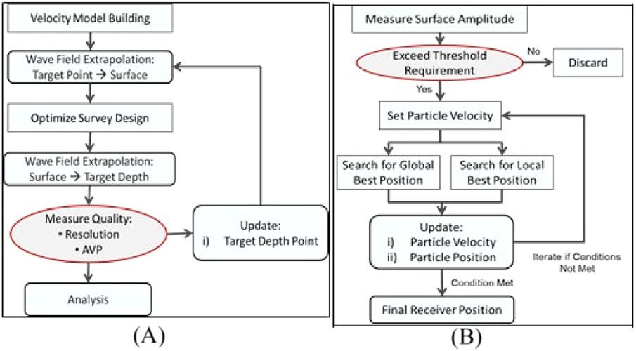
Acquisitionofgeophysicalparameterscanbemodeledforquality controlonthedesiredilluminationandresolution.Universiti TeknologiPETRONASdevelopedatechniqueforevaluatingasurvey design.Thistechniqueisbasedo ntheparticleswarmoptimization (PSO)methodtodeterminethebestreceiverpositionsforamarine acquisitioninashallowgascloudsituation( Latiff,Ghosh,&Latiff, 2017 ).PSOisanonlinearfunctionconceptwherethealgorithmtries tosimulatereal-lifemovementlikeparticleswarmingorbirdflocking andsolvesproblemsbyminimizingormaximizingparametersinvolved withinaclosedenvironment.Thisi sbasedonadefinedcostfunction. ThePSOsimulationprocessisderivedinaheuristicnature.Thesolutionobtainedhasanadvantageoveranexactmethod(exhaustive search)byutilizingtheknowledgeandexperienceofallothermembersofthecommunity.
ThePSOmethodologyiscarriedoutintwoparts:(1)wavefield extrapolationincorporatingthefocalbeammethod(Volker,Blacquière, Berkhout,&Ongkiehong,2002; Fig.1.1A)and(2)receiverlocationoptimizationbasedonthePSOapproach(Fig.1.1B). Figs.1.2 1.5 illustrate theresultsoftheseismicilluminationanalysiswork.
Figure1.1 (A)Step(1) Wavefieldextrapolationbyfocalbeam.(B)Step(2) PSO methodtosearchforthebestreceiverpositions.
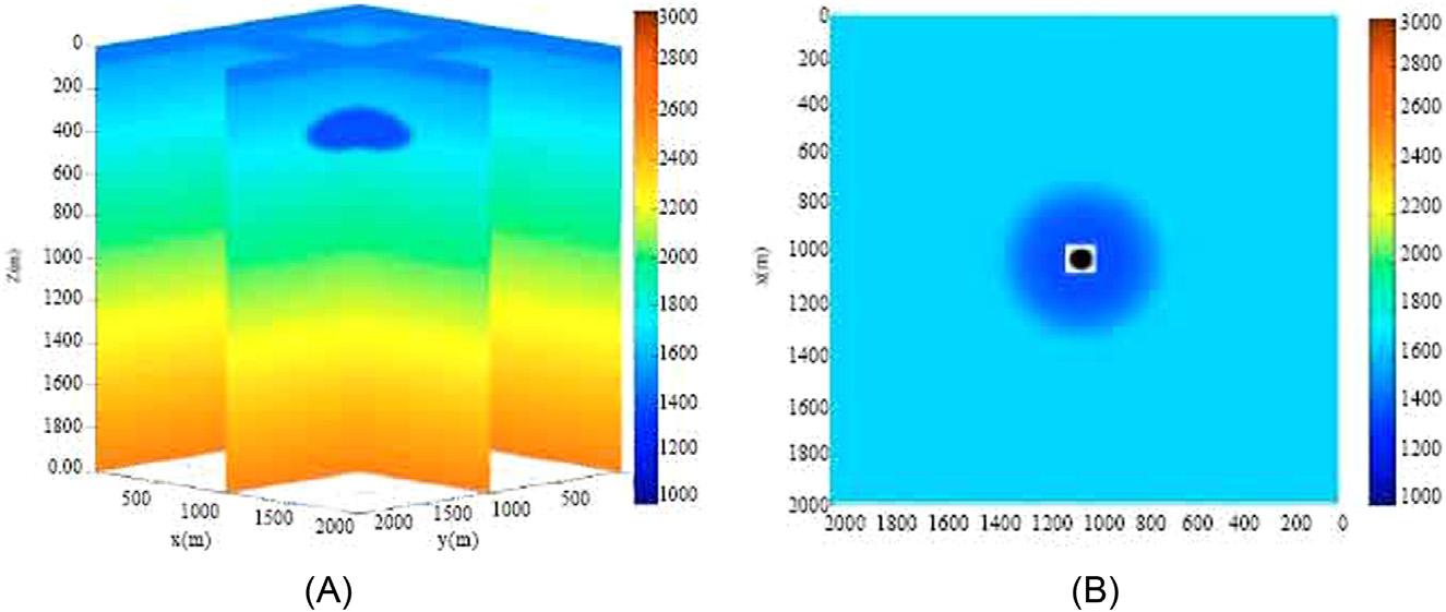
Figure1.2 (A)VelocitymodelusedintheUTPstudy.Thelowvelocityatabout 400mrepresentsashallowgasanomaly.(B)Velocitydepthsliceat300m.Theblack circleisthetargetlocation.
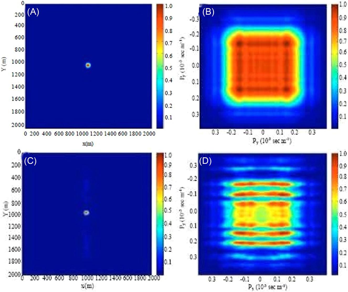
Figure1.3 (A).Full3Dgeometry(sourceinterval 5 receiverinterval 5 10min x and y directions)versus(B)aconventionalsinglesource,eight-cable3Dgeometry. Sourceinterval 5 10min x directionand800min y direction.Receiverinterval 5 10min x directionand100min y direction.
1.4Land,marine,transitionzone,andboreholeseismic dataacquisition
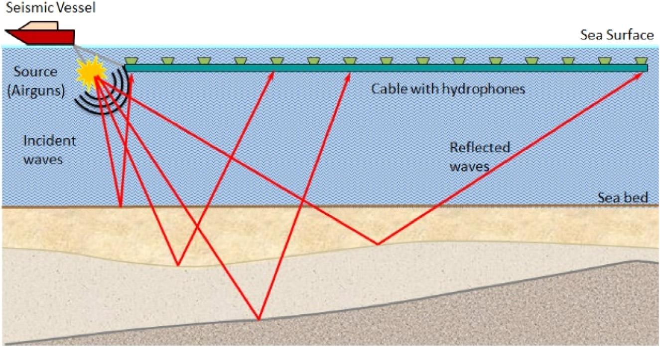
Marinesurveys,conductedinwaterdepthgreaterthan10m,towing longstreamersbehindashiparethetypicalnarrowazimuth(NAZ) marinedataacquisitionsetup( Fig.1.5 ).Traditionally,evenfora3D marineseismicdataacquisition,sei smicvesselwouldsailinastraight,
Figure1.4 (A).Full3Dresolutionfunctionversus (C)aconventional3Dresolutionfunction.Theresolutionfunctionisalmostperfectatthetargetlocationandzeroelsewhere. Ontheotherhand,theresolutionfunctionfortheconventional3Dhassidelobesenergy alongtheydirection.(B)and(D)arefull3Damplitudeversusrayparameter(AVP)versus conventional3DAVP.TheconventionalAVPfunctionhasverystrongacquisitionfootprint.
Figure1.5 A2DmarineNAZseismicdataacquisition.
Table1.2 Azimuthacquisitiongeometries(SEGWiki,2019).
TermMeaningRemarks
NAZNarrow-azimuthOnevesseltowinganarrayofstreamersand source(s)
MAZMultiazimuthThreeormorecoincidentNAZsurveyswith differentsurveyazimuthscombinedin processing;dual-azimuthcombines acquisitionintwodirections
WAZWide-azimuthTypicallytwoormorevesselsused simultaneouslytoincreasetherangeof azimuthsandoffsetsavailableforeachshot gatherinprocessing
WATSWide-azimuth towedstreamer
AparticularflavorofWAZpioneeredby BritishPetroleum(BP)
RAZRich-azimuthTypicallyacombinationofMAZandWAZ designedtoyieldthemostcontinuous distributionofazimuthsandoffsetspossible withtowedstreamer
FAZFull-azimuthPerfectazimuthandoffsetdistributionatevery pointinthesurvey.Possibleonlyinpractice whenthesourceandreceiverscanbe physicallydecoupledfromthereceiver spread,suchaslandorOceanbottomcable (OBC)3Dseismic
parallellinesoverasurveyarea.Assuch,althoughthesourcewavefrontpropagatesinalldirections,onlyasmallproportionofthe reflectedwavefrontiscaptured.Inordertoimprovecoverageorillumination,seismicdatahastobea cquiredinamultiazimuthway. Table1.2 enumeratesthevariousazimuthofseismicacquisition geometries.
Transitionzonesarecoastalareasthatconnectmarineandonshore.They canincludeland,fresh-andsaltwatermarshandswamp,nearshoreline,surf andtidalzones,lagoons,andshallow offshorecoralreefs.Theyareusually withinwaterdepthof0 10m.Seismicdataacquisitioninthesezonesare expensiveastheyrequiredifferentcombinationsofvariousenergysources suchasairgun,dynamite,vibroseisandvariousreceiverssuchashydrophones,geophones,andmarshphones. Differentcombinationsofvarious energysourcesandreceiversresultedinamplitudeandphasedistortions, whichrequirespecialprocessingtogeneratecontinuousandwell-matched seismicsectionsacrossthetransitionareas.
7 Seismicdataacquisitionincludingsurveydesignandfactorsaffectingseismicacquisition
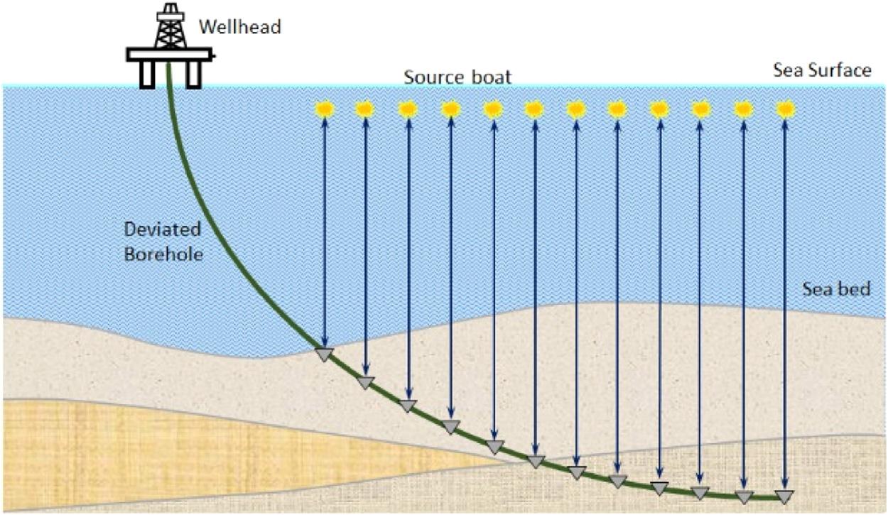
Boreholeseismicdataisacquiredfromaboreholebyplacinggeophonewithinawell-boretorelateb oreholemeasurementstosurfacederivedseismicmeasurements.Therearetwotypesofboreholeseismic techniques.Thefirstinvolvesmeasuringonlythefirstarrivaltimesata relativelywidersamplingintervaltocomputeverticaltraveltimecalled acheck-shotsurvey( Fig.1.6 ).Thesecondinvolvesmeasuringtheentire signalwavetrainatcloseintervalstoobtainaverticalseismicprofile (VSP).VSPisatechniqueofseismicmeasurementsusedforcorrelation withsurfaceseismicdata.ThedefiningcharacteristicofaVSP(ofwhich therearemanytypes)isthateithertheenergysource,orthedetectors (orsometimesboth)areinaborehole.Inthemostcommontypeof VSP,hydrophones,ormoreoftengeophonesoraccelerometers,inthe boreholerecordreflectedseismicenergyoriginatingfromaseismic sourceatthesurface.
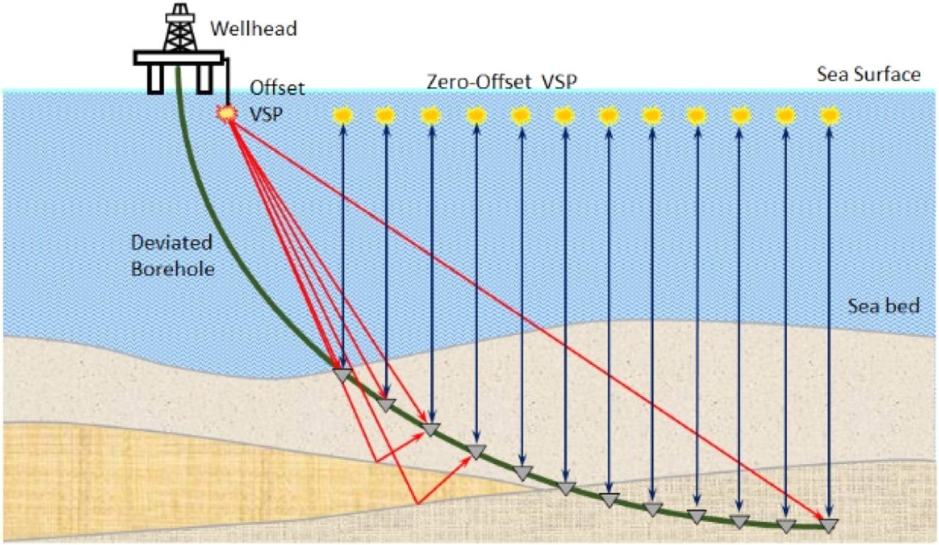
TherearenumerousmethodsforacquiringaVSP.Zero-offsetVSP havesourcesdirectlyabovereceivers.Meanwhile,offsetVSPhavesources atsomedistancefromthereceiversinthewellbore(Fig.1.7).
1.5Oceanbottomcableandoceanbottomnode OBC,introducedin1984isamarineseismicdataacquisitiontechnique thatstartedwithlayingofcablesofhydrophonesontheoceanfloorto
Figure1.6 Acheck-shotsurveymeasuresthetimerequiredforasourcewaveletto traveltoaknowndepthwhereaseismicreceiverispositionedinthewell.
measureandrecordseismicdata.Thiscablewasfirstdesignedmainlyfor useinareaswithstrongcurrentsornavigationalobstacles,suchasrigs, whereconventionalstreamersordragcablesarenoteffective.Avessel pullsthecablesintoplaceinawaterdepthoflessthan150m.Tensionis appliedattheendofthecabletokeepitstraightandinthedesiredposition.Anothervesselwouldactastheseismicsourcebyfiringanarrayof airgunacrossthesurveygrid.
In2004oceanbottomnode(OBN)wasintroducedasanalternative toOBC.OBNsarelaidoutusingremotelyoperatedvehicles(ROV)and thuscanbedeployedindeepwaters.Inaddition,someoilandgasfields haveseabedfacilitiessuchpipelines,wellheads,anchors,andchains.For suchobstacles,ROV-deployedOBNaremorepracticalthanOBC.
Often,adual-sensorsystemwithbothhydrophonesand3-Cgeophoneswouldbeinstalled.ThisinstallationmeasuresandrecordsPandS wavesthatarereflectedandrefractedofftheseafloorandthesubsequent layersbelowit.Thehydrophoneandgeophonedatacanbecombinedto performghostcancellationandde-reverberationfromtherecordedseismicdata.
Acomparisonbetweena3Dseismictowedstreamerversusa3DseismicOBCisafollows.A3Dtowedstreamersurveypassesthroughaplatformthattraditionallyrequiresexpensiveundershootingoftowed
Figure1.7 Zero-offsetVSPandoffsetVSPmeasuretheentiresignalwavetrainat closeintervalsforcorrelationwithasurfaceseismic.
9 Seismicdataacquisitionincludingsurveydesignandfactorsaffectingseismicacquisition
streamerandpoorimagingofshallowtargets.Fortunately,thealternative istoshootadual-ormulticomponentOBCsurveywithoptionsto acquireMAZdataandmuchmorereliable4Dseismicowingtothesame receiversatfixedposition.Furthermore,withOBC,thereareno towed-streamerrelatednoise,betterpositioninginformation,avoidanceof strongcurrents,andauniformpatternforacquisition.
Swavesarenotaffectedbyporefluidswhentheypropagatethrough therockmatrix.Assuch,Swavecouldbeusedtoimagegasreservoirs clearlyandreduceddrillingrisksinP-wavegas-cloudimagingproblems.
1.6Landandmarinesourcesandreceivers
Aseismicsourceisdefinedasanydevicethatreleasesenergyintothe earthintheformofseismicwave(Sheriff,2002).Therearetwotypesof seismicsources:landsourcesandmarinesources.Thechoiceforwhich typeofsourcesandreceiverstousedependsongeophysicalobjectives, cost,andenvironmentalconstraints.
Themostbasicseismicsourceisasledgehammer,commonlyusedby universitiesorsiteinvestigationcompaniesforshallowseismicrefraction surveys.Sledgehammeristypicallyusedbystrikingametalplateonthe groundtocreateanimpulsivesource.
Anoldandrelativelycheapandimpulsivesourceonlandforthe seismicexplorationindustryisexplosives.Intheearlydaysofseismic exploration,explosivesweretheuniversallyacceptedseismicsource becausetheyworkinmostclimatesandfieldconditions,andtheyare cheapandrelativelyeasytotransportindifficultterrain.Explosivesalso requirenoregularmaintenance.For seismicuse,nitroglycerinand/or nitrocellulosearetheactiveingredients.Intheirpurestate,theseare extremelydangerousandhighlyvolatile.Fortunately,whennitroglycerinand/ornitrocelluloseareabsorbedbyporousmaterialssuchas woodpulp,powderedchalk,orroastedflour,theyarequitesafeto transport.Intheseismicexplorationindustry,themostwidelyused explosivesaregelatindynamites.Generally,dynamitesareplaced between6and76m(20and250ft.)belowground.Ashotholeis drilledusingdedicateddrillingequipment.Thetypesofdrillusedmay beassimpleasahand-heldaugeroralargetruck-mountedhammer drillsdependingontheterrain.Productionratesforseismicexploration dependalmostentirelyontherateatwhichtheholescanbedrilled.