Listofacronyms
AATSR AdvancedAlongTrackScanningRadiometer
ABDC AccesstoBiologicalCollectionData
ADP ArcticDataPortal
ADU AssociatedDataUnit
AfReMaS AfricanRegisterofMarineSpecies
AIS AutomaticIdentificationSystem
ALA AtlasofLivingAustralia
AniBOS AnimalBorneOceanSensors
AODN AustralianOceanDataNetwork
AOML AtlanticOceanographicandMeteorologicalLaboratory
API ApplicationProgramInterface
APM ApplicationPerformanceMatrix
ASCII AmericanStandardCodeforInformationInterchange
ATSR AlongTrackScanningRadiometer
AVHRR AdvancedVeryHighResolutionRadiometer
BAMS BulletinoftheAmericanMeteorologicalSociety
BGC-Argo BioGeoChemicalArgo
BHL BiodiversityHeritageLibrary
BODC BritishOceanographicDataCentre
BOLD BarcodeofLifeDataSystem
BOOS BalticOperationalOceanographicSystem
C3S CopernicusClimateChangeService
CAFF ConservationofArcticFloraandFauna
CAMS CopernicusAtmosphericService
CBD ConventiononBiologicalDiversity
CCHDO CarbonHydrographicDataOffice
CCI ClimateChangeInitiative
CDI CommonDataIndex
CDS ClimateDataStore
CEC CommissionoftheEuropeanCommunities
CETAF ConsortiumofEuropeanTaxonomicFacilities
CF ClimateandForecast
CIMR CopernicusImagingMicrowaveRadiometer
CLMS CopernicusLandService
CMEMS CopernicusMarineEnvironmentMonitoringService
CO2 CarbonDioxide
CODATA CommitteeonData
CoL CatalogueofLife
COL-PLUS InnovatingtheCatalogueofLifeSystems
CoML CensusofMarineLife
COP ConferenceoftheParties
CPR ContinuousPlanktonRecorder
CRM CertifiedReferenceMaterials
CRS CoordinateReferenceSystem
CSIRO CommonwealthScientificandIndustrialResearchOrganization
CSR CruiseSummaryReports
CSV CommaSeparatedValues
CTD ConductivityTemperatureDepthsonde
CV CurriculumVitae
D4Science Datainfrastructureforscience
DAB DiscoveryandAccessBroker
DATAMEQ DataManagement,ExchangeandQuality
DataONE DataObservationNetworkforEarth
DBCP DataBuoyCooperationPanel
DCDB DataCentreforDigitalBathymetry
DGMARE Directorate-GeneralforMaritimeAffairsandFisheries
DG DirectorateGeneral
DGPM DirectorateGeneralforMaritimePolicy(Portugal)
DIAS DataandInformationAccessServices
DIC DissolvedInorganicCarbon
DIGITWIN digitaltwin “ arealisticdigitalrepresentationofassets,processesor systemsinthebuiltornaturalenvironment” (“TheGeminiPrinciples” (PDF). www.cdbb.cam.ac.uk.CentreforDigitalBuiltBritain. 2018.Retrieved2020-01-01.)
DIKW Data-Information-Knowledge-Wisdom
DiSSCo DistributedSystemofScienti ficCollections
DIVA Data-InterpolatingVariationalAnalysis
DIVAnd Data-InterpolatingVariationalAnalysisinndimensions
DM DelayedMode
DMP DataManagementPlan
DOI DigitalObjectIdentifier
DPSIR Driver-Pressure-State-Impact-Response
DQ DataQuality
DSA DataSealofApproval
DTM DigitalTerrainModel
DTO DigitalTwinoftheOcean
EBSA EcologicallyorBiologicallySignificantArea
EBV EssentialBiodiversityVariables
EBWBL EMODnetBathymetryreleasedaWorldBaseLayerService
EC EuropeanCommission
ECV EssentialClimateVariables
EDIOS EuropeanDIrectoryoftheOceanObservingSystems
EDMED EuropeanDirectoryofMarineEnvironmentalData
EDMERP EuropeanDirectoryofMarineEnvironmentalResearchProjects
EDMO EuropeanDirectoryofMarineOrganizations
EEA EuropeanEnvironmentAgency
EEI Earth’sEnergyImbalance
EGO Everyone’sGlidingObservatories
EIONET EuropeanEnvironmentInformationandObservationNetwork
ELIXIR EuropeanLife-ScienceInfrastructure
eLTER EuropeanpartoftheglobalLong-TermEcosystemResearch
EMB EuropeanMarineBoard
EBMI InhacaMarineBiologyResearchStation
EMBRC EuropeanMarineBiologicalResearchCentre
EMODnet EuropeanMarineObservationandDataNetwork
EMSO EuropeanMultidisciplinarySeafloorandwatercolumnObservatory
ENA EuropeanNucleotideArchive
ENSO ElNino-SouthernOscillation
ENVRI ENVironmentalResearchInfrastructure
EO EarthObservation
EoL EncyclopaediaofLife
EOSC EuropeanOpenScienceCloud
EOV EssentialOceanVariables
ERDAPP EnvironmentalResearchDivision’sDataAccessProgram
ERIC EuropeanResearchInfrastructureConsortium
ERMS EuropeanRegisterofMarineSpecies
ESA EuropeanSpaceAgency
ESFRI EuropeanStrategyForumonResearchInfrastructures
ESIP EarthScienceInformationPartners
EU EuropeanUnion
EUDAT pan-Europeannetworkofresearchorganizations,dataand computingcenters.
EUMETSAT EuropeanOrganizationfortheExp loitationofMeteorological Satellites
EUNIS EuropeanNatureInformationSystem
EuroArgo EuropeancomponentofArgoprogram
EuroBioImaging- EuropeanResearchInfrastructureforImagingTechnologiesinBiologicalandBiomedicalSciences
EurOBIS EuropeanOceanBiodiversityInformationSystem
EuroFLEETS AnallianceofEuropeanmarineresearchinfrastructuretomeetthe evolvingneedsoftheresearchandindustrialcommunities
EuroGOOS EuropeancomponentofGOOS
EuroSEA EuropeanOceanObservingandForecastingSystem
Eurostat EuropeanStatisticalOffice
EUSeaMap SeabedhabitatmapforEurope
EV EssentialVariables
FAIRPrinciples Findable,Accessible,Interoperable,andReusable
FAO FoodandAgricultureOrganization
FGDC FederalGeographicDataCommittee
G7 GroupofSeven,IntergovernmentalOrganization
GACS GlobalAllianceofContinuousplanktonrecorderSurveys
GBIF GlobalBiodiversityInformationFacility-Aninternationalbody dedicatedtoprovidingfreeaccesstobiodiversitydata
GCI GEOSScommoninfrastructure
GCMD GlobalChangeMasterDirectory
GCOS GlobalClimateObservingSystem
GDAC GlobalDataAssemblyCentre
GEBCO GeneralBathymetricChartoftheOceans
GEF GlobalEnvironmentFacility
GEO GlobalEnvironmentOutlook
GEOBON GrouponEarthObservationsBiodiversityObservationNetwork
GEO GroupofEarthObservation
GEOMAR HelmholtzCentreforOceanResearchKiel
GEOSS GlobalEarthObservationSystemofSystems
GEOTRACES Internationalprogramwhichaimstoimprovetheunderstandingof biogeochemicalcyclesandlarge-scaledistributionoftraceelements andtheirisotopesinthemarineenvironment.
GES GoodEnvironmentalStatus
GGBN GlobalGenomeBiodiversityNetwork
GHRSST GroupforHighResolutionSST
GIS GeographicInformationSystem
Globe GLobalOceanographicBathymetryExplorer
GLODAP GlobalOceanDataAnalysisProject
GLOSS GlobalSeaLevelObservingSystem
GO-SHIP GlobalOceanShip-BasedHydrographicInvestigationsProgram
GODAR GlobalOceanographicDataArcheologyandRescue
GOMON GlobalOceanMacroalgalObservingNetwork
GOOS GlobalOceanObservingSystem
GOSUD GlobalOceanSurfaceUnderwayData
GRA GOOSRegionalAlliances
GTS GlobalTelecommunicationSystem
GTSPP GlobalTemperatureandSalinityProfileProgram
HadISST HadleyCenterSeaIceandSeaSurfaceTemperature
HarmoNIA HarmonizationandNetworkingforcontaminantassessmentinthe IonianandAdriaticSeas
HELCOM HELsinkiCOMmission
HF HighFrequency
HFR HighFrequencyRadar
HMAP HistoryofMarineAnimalPopulations
HTML HyperTextMarkupLanguage
IAPB InternationalArcticBuoyProgram
IAPSO InternationalAssociationforthePhysicalSciencesoftheOceans
IBI-ROOS IrelandBiscayIberianRegionalOperationalOceanographicSystem
ICEDIG Innovationandconsolidationforlargescaledigitizationofnatural heritage
ICES InternationalCouncilfortheExplorationoftheSea
ICOS IntegratedCarbonObservationSystem
ICSU InternationalCouncilforScience
ICSU-WDS ICSUWorldDataSystem
ICZM IntegratedCoastalZoneManagement
ID InputData(set)
iDigBio IntegratedDigitizedBiocollections
IDOE InternationalDecadeofOceanExploration
IGY InternationalGeophysicalYear
IHO InternationalHydrographicOrganization
IJI InternationalJointInitiatives
IK IndigenousKnowledge
IMIS IntegratedMarineInformationSystem
IMOS Australia’sIntegratedMarineObservingSystem
INSPIRE INfrastructureforSPatialInformationintheeuRopEanCommunity
InSTAC InSituThematicAssemblingCentre
IOC IntergovernmentalOceanographicCommissionofUNESCO
IOC-ODIS OceanDataandInformationSystem
IOCCp InternationalOceanCarbonCoordinationProject
IODE InternationalOceanographicDataandinformationExchange
IOOS USIntegratedOceanObservingSystem
IPBES IntergovernmentalScience-Pol icyPlatformonBiodiversityand EcosystemServices
IPCC IntergovernmentalPanelonClimateChange
IQuOD InternationalQualityControlledOceanDatabase
ISC InternationalScienceCouncil
ISO InternationalOrganizationforStandardization
ISSC InternationalSocialScienceCouncil
IT InformationTechnology
ITIS- IntegratedTaxonomicInformationSystem
IUBS InternationalUnionofBiologicalSciences
JAVA class-based,object-orientedprogramminglanguage
JCOMM JointtechnicalCommissionforOceanographyandMarine Meteorology
JCOMMOPS
JERICO
JointWMO-IOCCentreforinsituOceanandMarineMeteorologicalObservingProgramSupport
JointEuropeanResearchInfrastructureofCoastalObservatories
JERICOS3 JointEuropeanResearchInfrastructureofCoastalObservatoriesScience,Service,Sustainability
JGOFS JointGlobalOceanFluxStudy
JRC JointResearchCenter
JSON JavaScriptObjectNotation
KBP Kenya-BelgiumProject
KMFRI KenyaMarineandFisheriesResearchInstitute
LAT LowestAstronomicalTide
LEO LocalEnvironmentalObserver
LifeWatch EuropeanAgroEcologyLivingLabandResearchInfrastructure Network
LSID LifeScienceIdentifier
LTER Long-TermEcosystemResearch
MacroBen Integrateddatabaseonsoft-bottombenthos
MANUELA MeiobenthicandNematodebiodiversityUnravellingEcologicaland LatitudinalAspects
MAP MediterraneanActionPlan
MARBEF MarineBiodiversityandEcosystemFunctioning
MARPOL InternationalConventionforthePreventionofPollutionfromShips
MASDEA MarineSpeciesDatabaseforEasternAfrica
MAT BinaryMATLAB file
MBA MarineBiologicalAssociation
MBON MarineBiodiversityObservationNetwork
MCDS MarineClimateDataSystem
MDT MeanDynamicTopography
MEDAR MEditerraneanoceanographicDataArcheologyandRescue
MedAtlas MediterraneanAtlas
MEDI
MarineEnvironmentalDataInformationReferralCatalogue
MEDPOL MarinepollutionassessmentandcontrolcomponentofMAP
MEOP MarineMammalsExploringtheOceansPoletoPole
MFC MonitoringandForecastingCenter
MHHW MeanHigherHighWater
MIxS MinimumInformationaboutany(x)Sequence
MLLT MeanLowerLowTide
MODB MediterraneanOceanographicDataBase
MONGOOS MediterraneanOperationalNetworkfortheGlobalOcean ObservingSystem
MSFD MarineStrategyFrameworkDirective
MSP MarineSpatialPlanning
NaGISA NaturalGeographyinShoreAreas
NASA NationalAeronauticsandSpaceAdministration
NASA-CMR NASACommonMetadataRepository
NASA-GCMD NASAGlobalChangeMasterDirectory
NCEAS NationalCenterforEcologicalAnalysisandSynthesis
NCEI NOAA’sNationalCentersforEnvironmentalInformation
NDBC USNationalDataBuoyCenter
NERC NaturalEnvironmentResearchCouncil
NESDIS NationalEnvironmentalSatellite,Data,andInformationService
NetCDF NetworkCommonDataForm
NOAA NationalOceanographicandAtmosphericAdministration
NODC NationalOceanographicDataCenter
NoE NetworkofExcellence
NOOS NorthSeaOperationalOceanographicSystem
NRT NearRealTime
NSBP NorthSeaBenthosProject
NSBS NorthSeaBenthosSurvey
NVS NERCVocabularyServer
O&M ObservationsandMeasurements
O2 Oxygen
OAI OpenArchivesInitiative
OBIS OceanBiodiversityInformationSystem
OBPS OceanBestPracticesSystem OceanOPS OceanObservationsProgramsSupport
OceanSITES internationalsystemoflong-term,open-oceanreferencestations
OCG ObservationsCoordinationGroup
ODINAFRICA OceanDataandInformationNetworkforAfrica
ODIP OceanDataInteroperabilityPlatform
ODIS OceanDataandInformationSystem
ODSBPP OceanDataStandardsandBestPracticesProject
ODV OceanDataView
OECD OrganizationforEconomicCo-operationandDevelopment
OGC OpenGeospatialConsortium-De fi nestandardsforsharing geographicaldata
OGDMTT OceanGliderDataManagementTaskTeam
OISST OptimumInterpolationSeaSurfaceTemperature
OMB OfficeofManagementandBudget
OOPC OceanObservationsPhysicsandClimatePanel
OOPS OperationalOceanographicProductsandServices
OPeNDAP Open-sourceProjectforaNetworkDataAccessProtocol
ORCID OpenResearcherandContributorID
OSGeo OpenSourceGEOspatialfoundation
OSPAR OSlo-PARisConventionfortheProtectionoftheMarineEnvironmentoftheNorth-EastAtlantic
OSSE ObservingSystemSimulationExperiments
OSTIA OperationalSeaSurfaceTemperatureandIceAnalysis
OSTP OfficeofScienceandTechnologyPolicy
P2P PoletoPole
PACE PArtnershipforChinaandEurope
PANGAEA DataPublisherforEarthandEnvironmentalScience
pCO2 Partialpressureofcarbondioxide
pH PowerofHydrogen
PID PersonalIdentifiableData
PIDoc ProductInformationDocument
PIRATA PredIctionandResearchmooredArrayinTheAtlantic
POP PersistentOrganicPollutant
PSMSL PermanentServiceforMeanSeaLevel
QA QualityAssurance
QAS QualityAssuranceStrategy
QC QualityControl
QF QualityFlag
QI QualityIndicator
RAMA ResearchmooredArrayforAfrican-Asian-AustralianMonsoon Analysisandprediction
RDA ResearchDataAlliance
RDLF ResearchDataLifeCycle
RECOSCIX-WIO RegionalCooperationinScienti fi cInformationExchangeinthe WestIndianOcean
RI ResearchInfrastructures
RMP ResponsiveModePrograms
RMSD RootMeanSquareDifference
ROC RegionalDispatchCentre
ROOS RegionalOperationalOceanographicSystem
RT RealTime
RTD ResearchandTechnologicalDevelopment
SARCE SouthAmericanResearchGrouponCoastalEcosystems
SBSTTA SubsidiaryBodyonScientific,TechnicalandTechnologicalAdvice
SCOR ScientificCommitteeonOceanicResearch
SD SustainableDevelopment
SDG SustainableDevelopmentGoals
SDN SeaDataNet
SeaDataCloud AdvancedSeaDataNetservices
SeaDataNet Pan-EuropeanInfrastructureforOceanandMarineData Management
sensorML StandardmodelsandanXMLencodingfordescribinganyprocess
SI SystemeInternationaleorInternationalSystem
SKOS SimpleKnowledgeOrganizationSystem
SLS IOCSeaLevelStationMonitoring(SLS)
SLSTR SeaandLandSurfaceTemperatureRadiometer
SMM SystemMaturityMatrix
SOAP SimpleObjectAccessProtocol
SOCAT SurfaceOceanCO2 ATlas
SONEL Systemed’ObservationduNiveaudesEauxLitorales
SOOP ShipofOpportunityProgram
SOOS SouthernOceansObservingSystem
SOP StandardOperatingProcedures
SOS SensorObservationService
SPARQL SparqlProtocolAndRdfQueryLanguage
SST SeaSurfaceTemperature
SWE SensorWebEnablement
SYNTHESIS SynthesisofSystematicResources
TAC ThematicAssemblingCenter
TAO TropicalAtmosphereOcean
Tb BrightnessTemperature
TDS THREDDSDataServer
TDWG Biodiversityinformationstandards(formallyTaxonomicDatabases WorkingGroup)
TG-ML MSFDTechnicalGrouponMarineLitter
THREDDS ThematicReal-timeEnvironmentalDistributedDataServices
TKIP TraditionalKnowledgeInformationPortal
TRITON TRIangleTrans-OceanbuoyNetwork
TRUST Transparency-Responsibility-Usercommunity-Sustainability Technology
TXT TeXT
UD UpstreamData(set)
UHSLC UniversityofHawaiiSeaLevelCenter
UN UnitedNations
UNDP UnitedNationsDevelopmentProgram
UNEP UnitedNationsEnvironmentProgram
UNESCO UnitedNationsEducationalScientificandCulturalOrganization
UNFCCC UnitedNationsFrameworkConventiononClimateChange
UNSD UnitedNationsSustainableDevelopment
URI UniversalResourceIdentifier
URMO UNESCO-IOCRegisterofMarineOrganisms
US UnitedStates
VLIZ FlandersMarineInstitute
VOS VoluntaryObservingShip
VRE
VirtualResearchEnvironment
VTS VesselTrafficServices
W3C
WorldWideWebConsortium
WAF WebAccessibleFolder
WCS WebCoverageService
WDC WorldDataCentre
webODV onlineOceanDataView
WEkEO CopernicusDIASservice
WFD WaterFrameworkDirective-EUProjecttoprovidecleanerfresh waterinEurope
WFS WebFeatureService
WG WorkingGroup
WIPO
WorldIntellectualPropertyOrganization
WISE WaterInformationSystemforEurope(alsoWISE-Marineforthe marinespecificbit)
WMO WorldMeteorologicalOrganization
WMS WebMapService
WMTS WebMapTileService
WOA WorldOceanAssessment
WOA WorldOceanAtlas
WOCE WorldOceanCirculationExperiment
WOD WorldOceanDatabase
WoRMS WorldRegisterofMarineSpecies
WxS W3CxmlSchema
XBT eXpendableBathyThermograph
Contributors
A.Barth
UniversityofLiege,Liege,Belgium
JoanaBeja
FlandersMarineInstitute(VLIZ),Oostende,Belgium
AbigailBenson
U.S.GeologicalSurvey,Lakewood,CO,UnitedStates
T.Boyer
NationalCentersforEnvironmentalInformation,NationalOceanicandAtmospheric Administration,Asheville,NC,UnitedStates
Jan-BartCalewaert
SeascapeBelgiumbvba,Brussels,Belgium;EuropeanMarineObservationandData Network(EMODnet)Secretariat,Ostend,Belgium
C.Coatanoan
IfremerCentredeBretagne,Plouzané,Brest,France
TimCollart
SeascapeBelgiumbvba,Brussels,Belgium;EuropeanMarineObservationandData Network(EMODnet)Secretariat,Ostend,Belgium
ConorDelaney
SeascapeBelgiumbvba,Brussels,Belgium;EuropeanMarineObservationandData Network(EMODnet)Secretariat,Ostend,Belgium
DaphnisDePooter
CommissionfortheConservationofAntarcticMarineLivingResources,(CCAMLR), Hobart,TAS,Australia
FedericoDeStrobel
TheHistoricalOceanographySociety,LaSpezia,Italy
S.Diggs
ScrippsInstitutionofOceanography,UniversityofCaliforniaSanDiego,LaJolla,CA, UnitedStates
WilliamEmery
UniversityofColorado,Boulder,CO,UnitedStates
MicheleFichaut
IFREMER/SISMER,Brest,France
VasilisGerovasileiou
HellenicCentreforMarineResearch(HCMR),InstituteofMarineBiology, BiotechnologyandAquaculture(IMBBC),Heraklion,Greece
KateE.Larkin
SeascapeBelgiumbvba,Brussels,Belgium;EuropeanMarineObservationandData Network(EMODnet)Secretariat,Ostend,Belgium
DanLear
MarineBiologicalAssociation,Plymouth,UnitedKingdom
HelenLillis
JointNatureConservationCommittee(JNCC),Peterborough,UnitedKingdom
M.Lipizer
IstitutoNazionalediOceanografiaediGeofisicaSperimentale OGS,Trieste,Italy
EleonoraManca
JointNatureConservationCommittee(JNCC),Peterborough,UnitedKingdom
GiuseppeM.R.Manzella
TheHistoricalOceanographySociety,LaSpezia,Italy;OceanHisSrL,Torino,Italy
Andrée-AnneMarsan
SeascapeBelgiumbvba,Brussels,Belgium;EuropeanMarineObservationandData Network(EMODnet)Secretariat,Ostend,Belgium
PatriciaMiloslavich
ScientificCommitteeonOceanicResearch(SCOR),UniversityofDelaware,Collegeof Earth,OceanandEnvironment,Newark,DE,UnitedStates;DepartamentodeEstudios Ambientales,UniversidadSimonBolívar,Caracas,Miranda,Venezuela
GwenaëlleMoncoiffé
BritishOceanographicDataCentre,NationalOceanographyCentre,Liverpool,United Kingdom
V.Myroshnychenko
MiddleEastTechnicalUniversity,InstituteofMarineSciences,Erdemli-Mersin,Turkey
JohnNicholls
NorfishProject,CentreforEnvironmentalHumanities,TrinityCollegeDublin,Dublin, Ireland
AntonioNovellino ETTSpA,Genova,Italy
NadiaPinardi
TheHistoricalOceanographySociety,LaSpezia,Italy;DepartmentofPhysicsand Astronomy,UniversitadiBologna,Bologna,Italy
A.Pisano
ConsiglioNazionaledelleRicerche-IstitutodiScienzeMarine(CNR-ISMAR),Rome, Italy
A.Pititto
COGEA,Rome,Italy
DickM.A.Schaap
MarieneInformatieServiceMARISB.V.,Nootdorp,theNetherlands
R.Schlitzer
AlfredWegenerInstitute,Bremerhaven,Germany
S.Simoncelli
IstitutoNazionalediGeofisicaeVulcanologia,SezionediBologna,Italy
A.Storto
ConsiglioNazionaledelleRicerche-IstitutodiScienzeMarine(CNR-ISMAR),Rome, Italy
NathalieTonné
SeascapeBelgiumbvba,Brussels,Belgium;EuropeanMarineObservationandData Network(EMODnet)Secretariat,Ostend,Belgium
C.Troupin
UniversityofLiege,Liege,Belgium
LeenVandepitte
FlandersMarineInstitute(VLIZ),Oostende,Belgium
AntonVandePutte
RoyalBelgianInstituteforNaturalSciences,Brussels,Belgium;UniversitéLibrede Bruxelles,Brussels,Belgium
NathalieVanIsacker
SeascapeBelgiumbvba,Brussels,Belgium;EuropeanMarineObservationandData Network(EMODnet)Secretariat,Ostend,Belgium
MickaëlVasquez
Ifremer,Brest,France
NinaWambiji
KenyaMarineandFisheriesResearchInstitute,Mombasa,Kenya
Biographies
GiuseppeManzella receivedadegreeinphysicsfromtheDepartmentof Physics,UniversityofRome “LaSapienza.” Aftersomefellowships,and attendanceofspecializationcoursesinEurope,he firstworkedatNational ResearchCouncil(1982 92)andthenwasemployedasresearchmanager inENEA(1992 2013).From1978hehasbeenactiveinnational,European,andinternationalprogramsinoceanography.Hehasworkedasexpert onmarineecosystemfortheItalianMinistryofResearch,andtheItalian representativetoWMO-IOCJointCommitteeforMarineMeteorology (JCOMM).HehaschairedtheItalianOceanographicCommissionfrom January2009toJune2014.HeischairingtheHistoricalOceanographySociety.Heisauthor/co-authorof50refereedpaperspublishedininternationaljournals,co-editoroftwobookspublished,andtheTopicEditorof theJournal EarthSystemScienceData
AntonioNovellino receivedaPhDinBiotechnologyandBioengineering andaMScinBiomedicalEngineering.From2008to2010,heservedon theEuropeanCommission,JRC IHCP,asaseniorresearcher.Heis theETTResearchManagerwherehecoordinatesR&Dactivities(www. ettsolutions.com).HeservedontheBoardofDirectorsofConsortium Si4Life(www.si4life.com)andontheboardofConsortiumTecnomar (SMEsworkingonmaritimeandenvironmenttechnology, www. consorziotecnomar.com ).Heisservingonthetechno-scienti ficboardof theLigurianClusterofMarineTechnologyDLTM(www.dltm.it);the boardofConsortiumTRAIN(innovationinenergyandtransportmanagement, www.consorziotrain.org);EMODnetSteeringCommitteeand TechnicalWorkingGroup;ExpertTeamonWISCentres(ET-WISC); andSouthernOceanObservingSystemDataManagementteam(SOOS DMSC).HeisamemberoftheEuroGOOSDATAMEQgroupfor advisingonoperationaloceanographydatamanagementprocedures.He istheEMODnetphysicscoordinator(www.emodnet-physics.eu)and CMEMSDisseminationUnit(CMEMSDU)deputycoordinator.
Anarrativeofhistorical, methodological,and technologicalobservationsin
marinescience
GiuseppeM.R.Manzella1, 4,FedericoDeStrobel1,NadiaPinardi1, 2 , WilliamEmery3
1TheHistoricalOceanographySociety,LaSpezia,Italy
2DepartmentofPhysicsandAstronomy,UniversitadiBologna,Bologna,Italy
3UniversityofColorado,Boulder,CO,UnitedStates
4OceanHisSrL,Torino,Italy
Introduction
Ourplanetisinvestedwithtwogreatoceans;onevisible,theotherinvisible; oneunderfoot,theotheroverhead;oneentirelyenvelopsit,theothercovers abouttwothirdsofitssurface.
MatthewFontaineMaury, ThePhysicalGeographyoftheSeaandItsMeteorology,1855
TheearlieststudiesoftheoceansdatebacktoAristotle(384BC 322 BC),butatruemethodologicalapproachonlybeganabouttwomillennia afterhisdeath.Initially,oceansciencederivedfromthepracticalartsof navigationandcartography( Henry,2008).Duringthe15thcentury, logbooksandannotatednavigationmapsbegantobecollectedsystematically.Unfortunately,fewearlytravelrecordshavesurvivedduetophysical deterioration,lossoflogbooksorprivacypolicies(Petersonetal.,1996 ). WiththePortugueseexplorationofnewlandsandseas,important advancesweremadeinonebranchofscienceinparticular:thegeography ofthesea.
OceanScienceData
ISBN:978-0-12-823427-3
https://doi.org/10.1016/B978-0-12-823427-3.00004-9
The firstmethodologicalandtechnologicalapproachtoobservingthe seawasestablishedatthemeetingoftheRoyalSocietyofLondonon June14,1661.Thedocument PropositionsofSomeExperimentstoBeMade bytheEarlofSandwichinHisPresentVoyage (Birch,1760)definedtheguidelinesfordatacollection.
“Diligentobservations” wererequiredbyGalilei(1564 1642)andwere thebasisofhisexperimentalmethod.Theconceptwasunderlined,interalia, inthe “ForthDay” chapter,discussingthecausesofthetides,inthefamous book DialogueontheTwoChiefWorldSystems (Galilei,1632).The “Propositions” wereaskingfor “diligentobservations” andtheirrecommendations weresubsequentlyincludedinthe DirectionsfortheObservationsandExperimentstoBeMadebyMastersofShips, Pilots, andOtherFitPersonsonTheir Sea-Voyages by MurrayandHooke(1667) onbehalfoftheRoyalSociety. Seafarerswereaskedto -Observethedeclinationandvariationsofthecompassorneedlefromthe meridianexactly,inasmanyplacesastheycan,andinthesameplace, everyseveralvoyage, -Carrydipping-needleswiththem, -Markcarefullythe flowingsandebbingsofthesea,inasmanyplacesas maybe,
-Soundthedeepestseaswithoutaline, . -Keeparegisterofallchangesofwindandweather , -Observeandrecordallextraordinarymeteors,lightnings,thunders, . -Carrywiththemgoodscalesandglass-violsofapintorso,withvery narrowmouths,whicharetobe filledwithseawaterindifferentdegrees oflatitude,andtheweightoftheviolfullofwatertakenexactlyatevery time,andrecorded;markingwithalthedegreesoflatitudeandlongitude oftheplace,andthedayofthemonth,andthetemperatureofthe weather:andaswellofwaternearthetop,asatagreaterdepth, -Fetchupwaterfromanydepthofthesea.
The “Directions” wereaccompaniedbyinstructionsontheuseof methodsandinstruments.Theoretically,theyconstitutedasystematization ofageneralrequestbyseveralEuropeanscientistsmadeexplicitbyVincenzo Viviani(apupilofGalileoGalilei),onbehalfoftheAccademiadelCimento togatherknowledgeofthevariabilityofoceancirculationbymeansof “diligent” observationsofthesea(see Pinardietal.,2018).Itisworthwhileto mentionthattheAccademiadelCimentomottowas “bytryingandtrying again” (e.g., Magalotti,1667).
Afurthersteptowardamore “diligent” observationalmethodologywas madebyFerdinandoMarsili(1658 1730)withhisfamoustreatise “OsservazioniintornoalBosforoTracio” (Marsili,1681).Forthe firsttime,an appropriateobservationstrategywasdefinedinordertounderstandtheeffectsofdensitydifferencesonthecirculationofwatermasses(Pinardietal., 2018; Petersonetal.,1996; Deacon,1971).
TheeffortsoftheRoyalSocietytogaingreaterknowledgeofthephysicalcharacteristicsoftheseametwithlittlesuccess.However,animportant contributioncamefromWilliamDampier(1651 1715),whowasthe first persontocircumnavigatetheglobethreetimes(Dampier,2012).InDampier’srecords,datawerenotreportedasrequestedinthe “Directions,” but containedsubstantialinformationonwindsandcurrents.Theessay “A NewVoyageRoundtheWorld” (Dampier,1703)wassenttotheRoyal Societywiththeaimtopromote “usefulknowledge,andofanythingthat mayneversoremotelytendtomyCountriesadvantage.” Duringhisvoyages,Dampierfoundthatcurrentsintheequatorialregionweredrivenby thetradewinds(Deacon,1971).
Thewestwardcurrentsinthenorthequatorialregionwereusedduring thediscoveryofAmericaandwereassociatedwiththeAristotelianconceptionofseamotion.Inactualfact,Aristotleneverspokeofawestwardsea flow,butthiswasthescholarlyinterpretationofapassageinthesecond bookof Meteorologica (e.g., Aristotle,1952):
ThewholeMediterranean flowsaccordingtothedepthofthesea-bedandthe volumeoftherivers.ForLakeMaeotis (AzovSea) flowsintothePontusand thusintotheAegean Intheseasmentionedit (the flow) takesplacebecause oftherivers formorerivers flowintotheEuxineandLakeMaeotisthaninto otherareasmanytimestheirsize andbecauseoftheirshallowness.Forthe seaseemtogetdeeperanddeeperthanLakeMaeotis,theAegeandeeperthan thePontusandtheSicilianSeadeeperthantheAegean,whiletheSardinian andTyrrhenianarethedeepestofall.ThewateroutsidethepillarsofHeracles isshallowbecauseofthemudbutcalmbecausethesealiesinahollow.
Thewestward flowofthesurfacecurrentsinthenorthequatorial regionwasnotedbyPietroMartired’Angera(1457 1526)inDeOrbe Novo,3rd “Decade,” Book4oftheEnglishtranslationbyMacNutt(Martyr d’Anghiera,1912):
Itwasintheyearofsalvation1502onthesixthdayoftheidesofMaythat ColumbussailedfromCadizwithasquadronoffourvesselsoffrom fiftytosixty tonsburthen,mannedbyonehundredandseventymen.Fivedaysoffavourable
weatherbroughthimtotheCanaries;seventeendays’ sailingbroughthimtothe islandofDomingo,thehomeoftheCaribs,andfromthencehereachedHispaniolain fivedaysmore,sothattheentirecrossingfromSpaintoHispaniolaoccupiedtwenty-sixdays,thankstofavourablewindsandcurrents,whichsetfromthe easttowardsthewest.Accordingtothemariners’ reportthedistanceistwelve hundredleagues.
PietroMartired’Angerainthesame “Decade” (fromLatin “decas” groupof10)analyzedtheconsequencesofthis flowintermsoftheconservationofwatermassesandwroteexplicitlyinBook6:
Thetimehascome,MostHolyFather,tophilosophisealittle,leavingcosmographytoseekthecausesofNature’ssecrets.Theoceancurrentsinthoseregionsrun towardsthewest,astorrentsrushingdownamountainside.Uponthispointthe testimonyisunanimous.Thus,I findmyselfuncertainwhenaskedwherethese watersgowhich flowinacircularandcontinuousmovementfromeastto west,nevertoreturntotheirstarting-place;andhowithappensthatthewest isnotconsequentlyoverwhelmedbythesewaters,northeeastemptied.Ifitbe truethatthesewatersaredrawntowardsthecentreoftheearth,asisthecase withallheavyobjects,andthatthiscentre,assomepeopleaffirm,isattheequinoctialline,whatcanbethecentralreservoircapableofholdingsuchamassof waters?Andwhatwillbethecircumference filledwithwater,whichwillyetbe discovered?Theexplorersofthesecoastsoffernoconvincingexplanation.There areotherauthorswhothinkthatalargestraitexistsattheextremityofthe gulfformedbythisvastcontinentandwhich,wehavealreadysaid,iseighttimes largerthantheocean.ThisstraitmaylietothewestofCuba,andwouldconduct theseragingwaterstothewest,fromwhencetheywouldagainreturntooureast. Somelearnedmenthinkthegulfformedbythisvastcontinentisanenclosedsea, whosecoastsbendinanortherlydirectionbehindCuba,insuchwisethatthe continentwouldextendunbrokenlytothenorthernlandsbeneaththepolarcircle bathedbytheglacialsea.Thewaters,drivenbackbytheextentofland,aredrawn intoacircle,asmaybeseeninriverswhoseoppositebanksprovokewhirlpools; butthistheorydoesnotaccordwiththefacts.Theexplorersofthenorthernpassages,whoalwayssailedwestwards,affirmthatthewatersarealwaysdrawnin thatdirection,nothoweverwithviolence,butbyalonganduninterruptedmovement.AmongsttheexplorersoftheglacialregionacertainSebastianoCabotto,of Venetianorigin,butbroughtbyhisparentsinhisinfancytoEngland,iscited.It commonlyhappensthatVenetiansvisiteverypartoftheuniverse,forpurposes ofcommerce.CabottoequippedtwovesselsinEngland,athisowncost,and first sailedwiththreehundredmentowardsthenorth,tosuchadistancethathe foundnumerousmassesof floatingiceinthemiddleofthemonthofJuly. Daylightlastednearlytwenty-fourhours,andastheicehadmelted,theland wasfree.Accordingtohisstoryhewasobligedtotackandtakethedirection ofwest-by-south.ThecoastbenttoaboutthedegreeofthestraitofGibraltar.
CabottodidnotsailwestwarduntilhehadarrivedabreastofCuba,whichlayon hisleft.Infollowingthiscoast-linewhichhecalledBacallaos,hesaysthatherecognisedthesamemaritimecurrents flowingtothewestthattheCastiliansnoted whentheysailedinsouthernregionsbelongingtothem.Itisnotmerelyprobable, therefore,butbecomesevennecessarytoconcludethatbetweenthesetwohithertounknowncontinentsthereextendlargeopeningsthroughwhichthewater flowsfromeasttowest.Ithinkthesewaters flowallroundtheworldinacircle, obedientlytotheDivineLaw,andthattheyarenotspewedforthandafterwards absorbedbysomepantingDemogorgon.Thistheorywould,uptoacertainpoint, furnishanexplanationoftheebband flow.
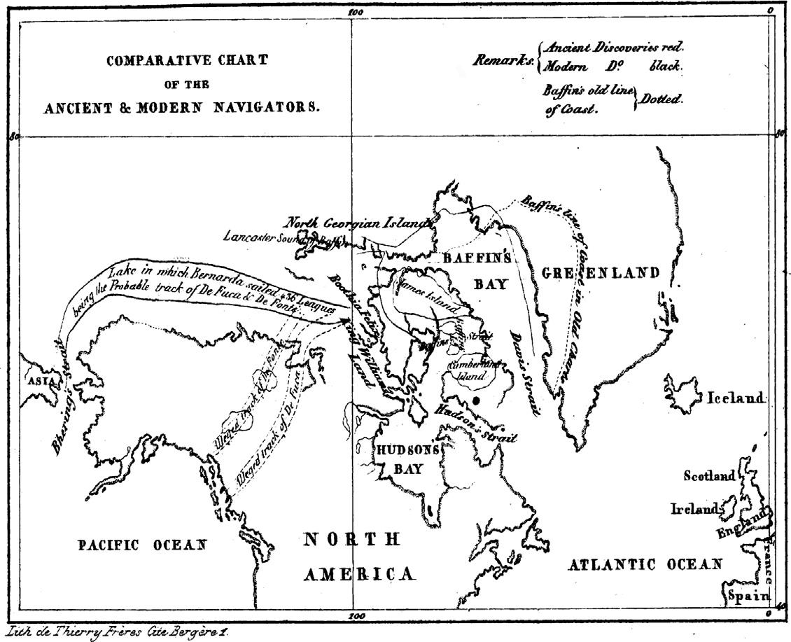
Soonafterthediscoveryofthenewlandmassnamed “America”,oneof themostexcitingandtragicadventuresinthehistoryofseafaringbegan:the searchforthepassagefromtheAtlantictothePacific.MartireD’Angera hypothesizedthatthispassagewasinCentralAmerica,buttheideaofa “ passagetotheEastIndiesbytheNorthPolewassuggestedasearlyastheyear 1527byRobertThorn,merchant,ofBristol” (Phipps,1774,seealso McConnell,1982).ThepolarpassagewouldhaveallowedEnglandto shortenthetraveltimetotheSpiceIslands,comparedtothecircumnavigationofSouthAmericathroughtheStraitofMagellanorSouthAfrica aroundtheCapeofGoodHope.Achronologicalhistoryoftraveltothe ArcticregionsandthepolarpassagebetweentheAtlanticandPacificOceans wasgivenby Barrow(1818) Ross(1835) (Fig.1.1)providedamapshowing thepossiblelocationofthenorth-westpassage.
Thischaptershowshowobservationtechnologiesandmethodologies areimportantforunderstandingoceanicphenomena.Itprovidesageneral overviewoftheconsequencesoftherapidevolutionofknowledge andtechnology’simpactonworkpractices.Ourknowledgeofocean scienceisbasedonscienti fi cdebatesthatbegancenturiesago,acultural aspectthatshouldnotbeoverlookedandshouldbeincludedinacademic courses.
MargaretDeacon(1971) inher ScientistsandtheSea wrote:Oceanographyisadescriptiveandenvironmentalscience;assuchitdepends foritsexistenceontheapplicationofknowledgealreadygainedin physicalandothersciences.However,observationsintheseaarevery dif fi cultandexpensive,andthedatacollectedcannotbereproduced. Technologicalandmethodologicaladvanceswerekeypointsofprogress inoceanscience.
Figure1.1 Thepossiblelocationofthenorth-westpassagefromAtlantictoPacificasin thebookof JohnRoss(1835).
TheRenaissancebroughtaboutanepochalchangeinhumanthinking thatresultedintheriseofahumanisticcultureandmajorscientificdiscoveries.TheexperimentalmethodinitiatedbyGalileorequiredaprocedural systematizationwhichbegantotakeshapeinthe17thcentury.Important culturalandscientificinstitutionswerefoundedfortheadvancementof thoughtandtodebatemethodologiesandtechnologies.Florence’sAccademiadelCimentowasfoundedin1657andtheRoyalSocietyofLondonin 1660;bothwereincubatorsofideasonnaturalsciences.
Methodologiesandtechnologiesdevelopedduringthe17thto19th centuriesarepresentedwithparticularattentiontotheirapplications inthenorthernpolarregions.Theseextremeareas,onaccountoftheir oceanographicandmeteorologicalpeculiarities,representinterestingcase studiesforthevalidityofthosemethodologiesandtechnologies.
Thischapterprovidessomeimportanthistoricalelementsondatacollectionmethodsandtechnologiesfromthe17thcenturytothebeginningof the20thcenturyinthesciencelaterknownasoceanography.Inorderto evaluateandcomparepastandpresenttechnologiesandmethods,thedata collectedinparticularareasoftheArcticSeaarepresented.
17thcentury: Summumfrigidum
Showusthesensibleexperience,thattheebband flowoftheseawaterisnota swelling,orshrinkingofthepartsofitelement,similartowhatweseetaking placeinthewaterplacedintheheatofthe fire,whileitforvehementheat becomesrarefied,andrises,andinreducingitselftonaturalColdnessit reunites,andlowers;butintheSeasthereisatruelocalmotion,andsotospeak progressive,sometimetowardsone,sometimetowardstheotherextremeterm oftheSinusoftheSea,withoutanyalterationofthiselement,comingfrom otheraccidentthanfromLocalMutation.
GalileoGalilei’sspeechovertheebband flowofthesea,1616;Actsand unpublishedmemoirsoftheAccademiadelCimento,1780
Speculationonthepropertiesoftheoceansduringthe17thcenturywas providedbymanyskilledpeople(“virtuosi”). Galileo’sstudies(1638) on fallingbodieswerethebasisofmany “inquiries” relatingtosurveysofthe sea.Boyle(1627 1691)andHooke(1635 1703)spentconsiderabletime testingandapplyingtheconceptof “gravitation” tooceanstudies.
Boyleaskednavigatorstoexplorethedifferentaspectsoftheoceans: withregardtothewateraretobeconsideredthesea,itsdepth,specificgravity,differenceofsaltnessindifferentplaces,theplants,insects,and fishesto befoundinit,tides,withrespecttotheadjacentlands,currents,whirlpools, &c(Shaw,1738).Therequirementsfortheseobservationswereexplainedin detailinthe “Directionsfortheobservationsandexperimentstobemadeby mastersofships,pilots,andother fitpersonsintheirsea-voyages” thatalso containedinformationontheinstrumentsthatshouldbeusedroutinely forthecollectionofgeographical,atmospheric,oceanographic,andbiologicaldata.
The “Directions” werethe firststepinthecreationofadataqualitymanagementsystem:
• essentialinformationdescribingthesensorsandplatforms,
• measurementposition,
• measurementunits,
• processing,dateandtimeinformation.
Duringthe17thcentury,scientistsbegantodefinesomespecific inquiriesonnaturalphenomena(e.g.,tides,currents,winds).Thediverse
interpretationsofobservationsorresultsof “experiments” madeitnecessary toadoptpreciseexperimentalmethodologies.Theconceptofstandards agreeduponbythescientificcommunityandnowadoptedineveryday practicedidnotexistthen.The “bestpractices” weredefinedbyoneor morehighlyreputablepeople(personsofgreatrepute),oneofwhomwas RobertHooke,whopresentedthe “MethodofMakingExperiments” to theRoyalSociety(Derham,1726).Hooke’sexperimentalmethodincluded somespecificrecommendations:
-After finishingtheExperiment,todiscourse,argue,defend,andfurther explain,suchCircumstancesandEffectsintheprecedingExperiments,as mayseemdubious “ordifficult”:andtopropoundwhatnewDifficulties andQueriesdooccur,thatrequireotherTrialsandExperimentstobe made,inordertotheirclearingandanswering:Andfarther,toraisesuch Axioms.andPropositions,asaretherebyplainlydemonstratedand proved.
-ToregisterthewholeProcessoftheProposal,Design,Experiment, Success,orFailure:theObjectionsandObjectors,theExplanationand Explainers,theProposalsandPropoundedofnewandfartherTrials;the TheoriesandAxioms,andtheirAuthors;and,inaWord,theHistoryof everyThingandPerson,thatismaterialandcircumstantialinthewhole EntertainmentofthesaidSocietywhichshallbepreparedandmade ready,fairlywritteninaboundBook,tobereadattheBeginningofthe SittingofthesaidSociety.
Sounding: NuntiusInanimatus, EsploratorDistantiae
Oneofthemajorproblemsofthe17thcenturywasthelackofgoodmaps withmarinetopographyforuseinthe ArtofNavigation, oneofthemostuseful intheWorld (Derham,1726).
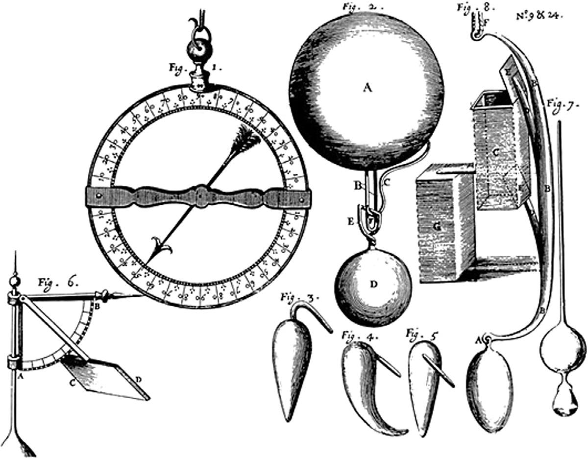
Thesoundinginstrumentillustratedinthe “Directions” wasaballmade ofwaterproofedlightwood(e.g.,maple),towhichanironorstoneweight wastied.Whenittouchedtheseabed,thewoodenballcameoffandroseto thesurface(Fig.1.2).Thedepthwascalculatedwithtablesonthebasisofthe timetakenbytheballtodescendandascend.The “Directions” provided warningsontheweightsanddimensionsofthedifferentpartsofthe apparatus.
Hookegavepreciseindicationsonthedifferentcomponentsof “instrumentsforsoundingthegreatdepthofthesea”,andhighlightedtwopossible technologicalsourcesoferrors:The firstwas,that “itwasnecessarytomake
Figure1.2 Instrumentsformeasurementstobedoneduringvoyages,asfrom “Directions” by MurrayandHooke(1667):Dipping-needle(Fig.1),Deepseasoundingwithout aline(Fig.2)withdifferentformsofweights(Fig.3,Fig.4,Fig.5)substitutingtheball DinFig.2,Instrumentmeasuringwindstrength(Fig.6),watersampler(Fig.7).The soundingprinciplewasverysimple:abuoyantobjectattachedtoaweightthat cameoffincontactwiththeseabed.
theWeight,thatwastosinktheBall,ofacertainSizeandFigure,soproportionedtotheBall,asthattheVelocityofthem,downwards,whenunited, shouldbeequaltotheVelocityoftheBallalone,whenitascendedinits Return;inOrdertowhich,itrequiredtobepreparedwithCare,and requiredalsosomeCharge,itbeingalmostnecessarytomakeitofLead, ofacertainWeightandFigure.Theotherwas,theDifficultyofdiscovering theBallatthe firstMomentofitsReturn,whichwaslikewiseofabsolute Necessity;anditwaslikewisenecessarytokeeptheTimemostexactlyof itsStay,orContinuance,undertheSurfaceoftheWater,bytheVibrations ofaPendulum,heldinone’sHand ” (Derham,1726).
WhileHookeacknowledgedtheerrorintroducediftheballwas notdetectedimmediatelyuponreachingthesurface,hedidnotrealizethe difficultyofdoingsoinanythingbutatotallycalmsea.Manywere thecomplaintsastothedifficultiesinlocatingtheballuponitsreturnto thesurface.
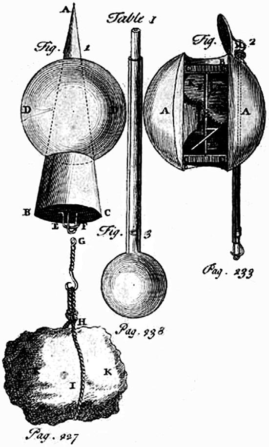
Hookewasawareoftheerrorsassociatedwithcalculationsofdescent andascentspeedsandoftheneedtoconsiderthebuoyancyofthematerials usedforthevariouscomponentsofthesoundingapparatus.Onthecontrary,hewasconfidentoftheuseofthe “pendulumclock” describedin “PhilosophicalExperiments” (Derham,1726).Toavoidproblems,he proposedacone-shapedsoundingmachine(Fig.1.3)withasmallholeto receivewaterbasedonexternalpressure(NuntiusInanimatus or Explorator Distantiae).InHooke’sidea,theincreasingpressureofseawateratdepth would fillthesoundingmachineinproportiontotheactualdepth.Therefore,byweighingthecontentofthewaterinitafteritreturnedtothe surface,itwouldbepossibletohaveameasurementofthedepthof thewater.
Whatevertheoperationofthis Nuntius,Hookewassurethatthesea temperaturewouldinfluencetheresults,astheheatorthecoldcaused theaircontainedinthemachinetoexpandorcontract.Forthisreason, hethoughtofaddingatemperaturesensitiveapparatus.However,there wasanotherimportantquestiontoanswerbeforeevaluatingtheresultsof asoundingapparatus, thatis, “WhethertheGravitation,towardstheCenter oftheEarth,docontinuethesame,atanyDepth;orwhetheritdoincrease
Figure1.3 The NuntiusInanimatus (ontheleft)and ExploratorProfunditatis (onthe right)proposedbyHooke(Derham,1726).