IntroducingLargeRivers
AvijitGupta
SchoolofEarth,AtmosphericandLifeSciences UniversityofWollongong
Australia
Withcontributionsfrom OlavSlaymaker DepartmentofGeography
TheUniversityofBritishColumbia
Vancouver
Canada
WolfgangJ.Junk
NationalInstituteofScienceandTechnologyofWetlands(INCT-INAU)
FederalUniversityofMatoGrosso(UFMT)
Cuiabá
Brazil
Thiseditionfirstpublished2020
©2020JohnWiley&SonsLtd
Allrightsreserved.Nopartofthispublicationmaybereproduced,storedinaretrievalsystem,or transmitted,inanyformorbyanymeans,electronic,mechanical,photocopying,recordingorotherwise, exceptaspermittedbylaw.Adviceonhowtoobtainpermissiontoreusematerialfromthistitleisavailable athttp://www.wiley.com/go/permissions.
TherightofAvijitGuptatobeidentifiedastheauthorofthisworkhasbeenassertedinaccordancewithlaw.
RegisteredOffice
JohnWiley&SonsLtd,TheAtrium,SouthernGate,Chichester,WestSussex,PO198SQ,UK
EditorialOffice
TheAtrium,SouthernGate,Chichester,WestSussex,PO198SQ,UK
Fordetailsofourglobaleditorialoffices,customerservices,andmoreinformationaboutWileyproducts visitusatwww.wiley.com.
Wileyalsopublishesitsbooksinavarietyofelectronicformatsandbyprint-on-demand.Somecontentthat appearsinstandardprintversionsofthisbookmaynotbeavailableinotherformats.
LimitofLiability/DisclaimerofWarranty
Whilethepublisherandauthorshaveusedtheirbesteffortsinpreparingthiswork,theymakeno representationsorwarrantieswithrespecttotheaccuracyorcompletenessofthecontentsofthisworkand specificallydisclaimallwarranties,includingwithoutlimitationanyimpliedwarrantiesofmerchantabilityor fitnessforaparticularpurpose.Nowarrantymaybecreatedorextendedbysalesrepresentatives,written salesmaterialsorpromotionalstatementsforthiswork.Thefactthatanorganization,website,orproductis referredtointhisworkasacitationand/orpotentialsourceoffurtherinformationdoesnotmeanthatthe publisherandauthorsendorsetheinformationorservicestheorganization,website,orproductmayprovide orrecommendationsitmaymake.Thisworkissoldwiththeunderstandingthatthepublisherisnotengaged inrenderingprofessionalservices.Theadviceandstrategiescontainedhereinmaynotbesuitableforyour situation.Youshouldconsultwithaspecialistwhereappropriate.Further,readersshouldbeawarethat websiteslistedinthisworkmayhavechangedordisappearedbetweenwhenthisworkwaswrittenandwhen itisread.Neitherthepublishernorauthorsshallbeliableforanylossofprofitoranyothercommercial damages,includingbutnotlimitedtospecial,incidental,consequential,orotherdamages.
LibraryofCongressCataloging-in-PublicationData
Name:Gupta,Avijit,author.
Title:Introducinglargerivers/byAvijitGupta.
Description:Firstedition.|Hoboken,NJ:JohnWiley&Sons,Inc.,2020. |Includesbibliographicreferencesandindex.
Identifiers:LCCN2019032032(print)|LCCN2019032033(ebook)|ISBN 9781118451403(paperback)|ISBN9781118451427(adobepdf)|ISBN 9781118451434(epub)
Subjects:LCSH:Rivers–Environmentalaspects–Research.|Fluvial geomorphology–Environmentalaspects–Research. Classification:LCCGB1205.G862020(print)|LCCGB1205(ebook)|DDC 551.48/3–dc23
LCrecordavailableathttps://lccn.loc.gov/2019032032
LCebookrecordavailableathttps://lccn.loc.gov/2019032033
CoverDesign:Wiley
CoverImage:©guenterguni/GettyImages
Setin10/12ptWarnockProbySPiGlobal,Chennai,India 10987654321
ToMiraandMae
Contents
Preface xiii
1Introduction 1
1.1LargeRivers 1
1.2ABookonLargeRivers 3 References 6
2GeologicalFrameworkofLargeRivers 7
2.1Introduction 7
2.2TheGeologicalFramework:ElevatedLandandaLargeCatchment 8
2.3SmallerTectonicMovements 9
2.4TheSubsurfaceAlluvialFillofLargeRivers 10
2.5GeologicalHistoryofLargeRivers 12
2.6Conclusion 14 Questions 14 References 14
3WaterandSedimentinLargeRivers 17
3.1Introduction 17
3.2DischargeoflargeRivers 17
3.3GlobalPatternofPrecipitation 18
3.4LargeRiverDischarge:AnnualPatternandLong-TermVariability 21
3.5SedimentinLargeRivers 26
3.6Conclusion 32 Questions 32 References 33
4MorphologyofLargeRivers 35
4.1Introduction 35
4.2LargeRiversfromSourcetoSink 35
4.3TheAmazonRiver 38
4.3.1TheSetting 39
4.3.2Hydrology 39
4.3.3SedimentLoad 39
4.3.4Morphology 42
4.4TheGangaRiver 44
4.4.1TheSetting 44
4.4.2Hydrology 46
4.4.3SedimentLoad 46
4.4.4Morphology 47
4.5MorphologyofLargeRivers:CommonalityandVariations 48
4.6Conclusion 52 Questions 52 References 52
5LargeRiversandtheirFloodplains:Structures,Functions, EvolutionaryTraitsandManagementwithSpecialReferencetothe BrazilianRivers 55 WolfgangJ.Junk,FlorianWittmann,JochenSchöngart,MariaTeresaF.Piedadeand CatiaNunesdaCunha
5.1Introduction 55
5.2OriginandAgeofRiversandFloodplains 57
5.3ScientificConceptsandtheirImplicationsforRiversandFloodplains 59
5.4WaterChemistryandHydrologyofMajorBrazilianRiversandtheir Floodplains 60
5.5EcologicalCharacterisationofFloodplainsandtheirMacrohabitats 62
5.6EcologicalResponsesofOrganismstoFlood-PulsingConditions 64
5.6.1Trees 65
5.6.2HerbaceousPlants 66
5.6.3Invertebrates 66
5.6.4Fish 67
5.6.5OtherVertebrates 68
5.7Biodiversity 68
5.7.1HigherVegetation 69
5.7.2AnimalBiodiversity 71
5.8TheRoleofRiversandtheirFloodplainsforSpeciationandSpecies DistributionofTrees 71
5.9BiogeochemicalCyclesinFloodplains 73
5.9.1BiomassandNetPrimaryProduction 73
5.9.1.1Algae 73
5.9.1.2HerbaceousPlants 74
5.9.1.3TreesoftheFloodedForest 75
5.9.2Decomposition 76
5.9.3TheNitrogenCycle 77
5.9.4NutrientTransferBetweentheTerrestrialandAquaticPhases 78
5.9.5FoodWebs 79
5.10ManagementofAmazonianRiverFloodplains 80
5.10.1AmazonianRiverFloodplains 80
5.10.2SavannaFloodplains 82
5.11PoliciesinBrazilianWetlands 82
5.12DiscussionandConclusion 84 Acknowledgements 89 References 89
6LargeRiverDeltas 103
6.1Introduction 103
6.2LargeRiverDeltas:TheDistribution 104
6.3FormationofDeltas 104
6.4DeltaMorphologyandSediment 110
6.5TheGanga-BrahmaputraDelta:AnExampleofaMajorDeltaic Accumulation 112
6.5.1TheBackground 112
6.5.2MorphologyoftheDelta 113
6.5.3LateGlacialandHoloceneEvolutionoftheDelta 114
6.6Conclusion 115 Questions 115 References 116
7GeologicalHistoryofLargeRiverSystems 119
7.1TheAgeofLargeRivers 119
7.2RiversintheQuaternary 121
7.2.1TheTimePeriod 121
7.2.2TheNatureofGeomorphicChanges 123
7.2.3ThePleistoceneandLargeRivers 124
7.2.3.1TheGlacialStage 124
7.2.3.2TheTransition 125
7.2.3.3TheInterglacialStage 127
7.3ChangesDuringtheHolocene 127
7.4EvolutionandDevelopmentoftheMississippiRiver 128
7.5TheGanga-BrahmaputraSystem 133
7.6EvolutionoftheCurrentAmazon 137
7.7EvolutionaryAdjustmentofLargeRivers 141 Questions 142 References 142
8AnthropogenicAlterationsofLargeRiversandDrainageBasins 147
8.1Introduction 147
8.2EarlyHistoryofAnthropogenicAlterations 148
8.3TheMississippiRiver:ModificationsbeforeBigDams 149
8.4TheArrivalofLargeDams 151
8.5EvaluatingtheImpactofAnthropogenicChanges 156
8.5.1LandUseandLandCoverChanges 157
8.5.2ChannelImpoundments 159
8.6EffectofImpoundmentsonAlluvialRivers 161
8.7EffectofImpoundmentsonRiversinRock 163
8.8Large-scaleTransferofRiverWater 166
8.9Conclusion 167 Questions 168 References 169
x Contents
9ManagementofLargeRivers 173
9.1Introduction 173
9.2BiophysicalManagement 177
9.3SocialandPoliticalManagement 178
9.3.1ValuesandObjectivesinRiverManagement 179
9.3.2InternationalBasinArrangements 180
9.4TheImportanceoftheChannel,Floodplain,andDrainageBasin 180
9.5IntegratedWaterResourcesManagement 182
9.6TechniquesforManagingLargeRiverBasins 183
9.7AdministeringtheNile 184
9.8Conclusion 188 Questions 189 References 190
10TheMekong:ACaseStudyonMorphologyandManagement 193
10.1Introduction 193
10.2PhysicalCharacteristicsoftheMekongBasin 194
10.2.1GeologyandLandforms 194
10.2.2Hydrology 196
10.2.3LandUse 197
10.3TheMekong:SourcetoSea 199
10.3.1TheUpperMekonginChina 199
10.3.2TheLowerMekongSouthofChina 199
10.4Erosion,SedimentStorageandSedimentTransferintheMekong 202
10.5ManagementoftheMekonganditsBasin 204
10.5.1ImpoundmentsontheMekong 204
10.5.2AnthropogenicModificationofErosionandSedimentationonSlopes 206
10.5.3DegradationoftheAquaticLife 207
10.6Conclusion 208 Questions 208 References 209
11LargeArcticRivers 211
OlavSlaymaker
11.1Introduction 211
11.1.1TheFiveLargestArcticRiverBasins 213
11.1.2ClimateChangeintheFiveLargeArcticBasins 213
11.1.3RiverBasinZones 214
11.2PhysiographyandQuaternaryLegacy 216
11.2.1PhysiographicRegions 216
11.2.1.1ActiveMountainBeltsandMajorMountainBeltswithAccretedTerranes (Zone1) 216
11.2.1.2InteriorPlains,Lowlands,andPlateaux(Zone2) 217
11.2.1.3ArcticLowlands(Zone3) 218
11.2.2IceSheetsandTheirInfluenceonDrainageRearrangement 218
11.2.3IntenseMassMovementonGlaciallyOver-steepenedSlopes 218
11.3HydroclimateandBiomes 220
11.3.1ClimateRegions 220
11.3.2Biomes 220
11.3.3Wetlands 224
11.4Permafrost 224
11.4.1PermafrostDistribution 224
11.4.2PermafrostandSurficialMaterials 226
11.4.3ContemporaryWarming 226
11.5AnthropogenicEffects 228
11.5.1DevelopmentandPopulation 228
11.5.2AgricultureandExtractiveIndustry 228
11.5.3Urbanisation:TheCaseofSiberia 228
11.6DischargeofLargeArcticRivers 229
11.6.1ProblemsinDischargeMeasurement 229
11.6.2WaterFluxes 229
11.6.3WaterBudget 231
11.6.4NivalRiverRegime 232
11.6.5LakesandGlaciers 234
11.6.6RiverIce:FreezeandBreakUp 236
11.6.7ScaleEffects 237
11.6.8EffectsofRiverRegulation 238
11.6.9HistoricalChanges 238
11.7SedimentFluxes 239
11.7.1ComplicationsinDeterminingSedimentFluxesBothWithinArcticBasins andtotheArcticOcean 239
11.7.2FluxofSuspendedSedimentandDissolvedSolids 240
11.7.3HistoricalChangesinWaterandSedimentDischargeintheSiberian Rivers 240
11.7.4SuspendedSedimentSourcesandSinksintheMackenzieBasin 242
11.7.4.1SedimentYieldintheMackenzieBasin 242
11.7.4.2WestBankTributarySources 243
11.7.4.3BedandBankSources 245
11.8NutrientsandContaminants 249
11.8.1SupplyofNutrients 249
11.8.2TransportofContaminants 250
11.9Mackenzie,YukonandLenaDeltas 253
11.9.1MackenzieDelta 253
11.9.2LenaDelta 253
11.9.3Yukon–KuskokwimDelta 256
11.10SignificanceofLargeArcticRivers 256 Acknowledgment 258 Questions 259 References 259
12ClimateChangeandLargeRivers 265
12.1Introduction 265
12.2GlobalWarming:BasicConcept 266
Contents
12.3ASummaryofFutureChangesinClimate 270
12.4ImpactofClimateChangeonLargeRivers 271
12.5ClimateChangeandaTypicalLargeRiveroftheFuture 273
12.6Conclusion 277 Questions 277 References 278 Index 281
Preface
Aneditedanthologyongeomorphologyandmanagementoflargeriverswaspublished in2007.1 Thebookfilledagapinourknowledgeaboutlargeriversasfluvialgeomorphologyusedtobebasedmoreonsmallerstreamsofmanageabledimensions.Weneededto extendourstudytobigriverswhichshapeasignificantpartoftheglobalphysiography, carryahighvolumeofwaterandsedimenttothecoastalwaters,andsupportavery largenumberofpeoplewholiveontheirfloodplainsanddeltas.Thatwasanadvanced treatise.Thisvolumeiswrittenprimarilyasatextbookonlargerivers,introducingsuch aspects.Anumberoflinedrawingsandphotographsillustratethetext,andasetofquestionsattheendofthechaptersencouragethereadertoexplorevariousissuesregarding largerivers.
Thebookintroducestheenvironmentalcharacteristicsofriverbasinsandformsand functionsofchannelscommonlyseenamongthelargeriversoftheworld.Specificdiscussionscovertheircomplexgeology,water,andsediment.Thegreatlengthsofthese riversstretchacrossarangeofdifferentenvironments.TheMekong,forexample,flows onbothrockandalluviumwithvaryingformandbehaviour.Thegeologicalframework ofalargeriverisbasedprimarilyonlarge-scaletectonicscommonlyderivedbyplate movements.Anupliftedzone,theprimarysourceofsedimentintheriver,andanearly subcontinental-scalewatercatchmentareaarenecessary.Arangeofmorphologyexists inlargerivers,andtheassociatedfloodplainsandfloodpulsesareecologicallyimportant.Largeriverscouldbegeologicallylong-lived.Infuture,theirformsmaychangeand theirfunctionsmayalter,followingconstructionofengineeringstructuresandclimate change.
Thequalityofthebookhasbeenenhancedbydetailedandwell-illustrateddiscussions ontwoimportanttopics:(i)largeriversandtheirfloodplains:structures,functions, evolutionarytraitsandmanagementwithspecialreferencetotheBrazilianriversby W.J.Junk etal .(Chapter5),and(ii)largearcticriversbyO.Slaymaker(Chapter11). Iamgratefultoalloftheauthorsofthesetwochaptersfortheirin-depthdiscussionon thesetopics.Lastly,thebookindicatesthattheexistingriverspossiblyareundergoing dynamicadjustmentsinaworldwithachangingclimate.Riverschangewithtime,and weusuallyknowalargeriveronlyataparticularpointinitsexistence.
CompletionofthebookhasbeenademandingtaskandIamgratefultotheeditorial andproductionteamsofJohnWiley&Sons,Ltdfortheirremarkablepatience,editorial assistance,andcontinuousencouragement.IwouldliketothankAthiraMenonand 1Gupta,A.(Ed.)(2007). LargeRivers:GeomorphologyandManagement .Wiley:Chichester.
xiv Preface
JosephVimaliforguidingmethroughtheintricaciesofbookproduction.LeeLiKheng hasproducedmanyofthediagramsfrommyroughsketches.Ihavetremendously benefitedfromthecriticalreadingsbyColinMurray-WallaceofChapter7onpast riversandbyColinWoodroffeofChapter6onlargeriverdeltasandadiscussionon climatechangewithJohnMorrison.
Wollongong,Australia,June2019
AvijitGupta
1.1LargeRivers
Wehaveanintuitiverecognitionoflargeriversalthoughaproperdefinitioniselusive. Eventhoughitisdifficulttodefinealargeriver,wewouldprobablyselectthesame15 or20riversasthebiggestintheworld.Potteridentifiedfourcharacteristicproperties oflargerivers:theydrainbigbasins;theyareverylong;theycarryalargevolumeof water;andtheytransferaconsiderableamountofsediment(Potter1978).Itis,however, difficulttoattributequantitativethresholdstothese,andnotallbigriversexhibitthese fourcharacteristics.Weassociatelargeriverswithhighdischargeandsedimenttransfer, butbothwaterandsedimentvaryovertimeandspaceandtheirdataaredifficultto acquire.Itiseasiertoidentifylargeriversbythesizeoftheirdrainagebasinsandtheir lengths;bothareeasiertomeasure.
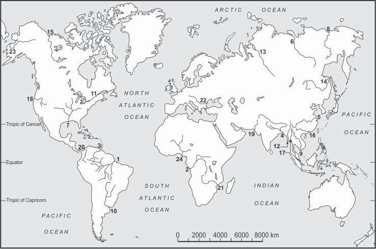
Basedonthearealextentoftheirdrainagebasin,Potter(1978)examined50ofthe world’slargestrivers,rankedbyInmanandNordstrom(1971),startingwiththeAmazon.Allbutoneoftheseriversaremorethan103 kmlong,andthesmallestdrainage basinisabout105 km2 .These50riverscollectivelydrainabout47%ofthelandmass, excludingGreenlandandAntarctica.TheAmazonalonedrainsabout5%ofthecontinentalarea.Theseriversalsohavemodifiedthephysiographyofalargepartofthe world.Table1.1liststhetop24largerivers(Figure1.1),rankedaccordingtotheiraverageannualwaterdischarge.Theirrankswouldchangeiftheriverswerelistedaccording toanyoftheotherthreeproperties.
Thereareotherlists.Hovius(1998)tabulatedthemorphometric,climatic,hydrologic,transport,anddenudationdatafor97riverbasins,allofwhichmeasuredabove 2.5 × 10⁴ km2 .Meade(1996)rankedthetop25riverstwice:first,accordingtotheirdischarge;andsecond,accordingtotheirsuspendedsedimentload.Thetwolistsdonot matchwell.Forexample,largeriverssuchastheZambeziorLenacarryalargewater dischargebutalowsedimentload.Impoundmentstoohavedrasticallyreducedtheonce highsedimentloadofmanyriverssuchastheMississippi-Missouri.Overapproximately thelast100years,manyrivershavebeenmodifiedbyengineeringstructuressuchas damsandreservoirs.TheColoradoortheHuanghe(YellowRiver)atpresentmaynot flowtothesearoundtheyear.Suchchangeshavealsoreducedtheamountofsediment thatpassesfromthelandtothecoastalwaters.LargeriverssuchastheNileorIndus havebeenassociatedwithhumancivilisationforthousandsofyearsandshowexpected modifications.
Table1.1 Selectedcharacteristicsof24largerivers.
River
Averageannual water discharge(106 m3 )
(km) Drainage basinarea (km2 )
Current averageannual suspendedsediment discharge(106 t)
1.Amazon630060005.91000–1300
2.Congo125043703.7543
3.Orinoco12007701.1150
4.Ganga-Brahmaputra970B-2900 G-2525 1.06(B-0.63)900–1200
5.Changjiang90063001.9480
6.Yenisey63059402.625
7.Mississippi53060003.22210
8.Lena51043002.4911
9.Mekong47048800.79150–170
10.Parana -Uruguay47039652.6100
11.St.Lawrence45031001.023
12.Irrawaddy43020100.41260
13.Ob400 >55702.7716
14.Amur32540602.0552
15.MacKenzie31042002.00100
16.Zhujiang30021970.4180
17.Salween30028200.27About100
18.Columbia25022000.668
19.Indus24030000.9750
20.Magdalena24015400.26220
21.Zambezi22025751.3220
22.Danube21028600.8240
23.Yukon19532000.8360
24.Niger19041002.2740
Thesefiguresvarybetweensources,althoughperhapsgiventhedimensions,suchvariationsare proportionallynegligible.DischargeandsedimentfiguresarefromMeade(1996)andGupta(2007)and referencestherein.Drainageareasareroundedoffto106 kmtoreducediscrepanciesbetweenvarious sources.TheNileisnotlisted,eventhoughitis6500kmlong.Itdoesnotqualifyforthistableasitswater andsedimentdischargesarerelativelylow.
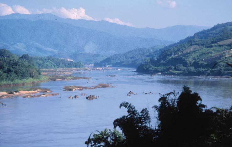
Thegreatlengthsoftheseriversallowthemtoflowacrossarangeofenvironments. TheMekong,forexample,flowsonbothrockandalluvium,lookingdifferent (Figure1.2).Theendpartoftheriverneedstoadjusttoallsuchenvironmental variationsplustheQuaternarychangesinsealevel. Fluvialgeomorphologygenerallyisbasedonsmallandlogisticallymanageable streams.Astudyoflargeriversisnecessary,althoughdifficult,formultiplereasons. Largeriversformandmodifysubcontinental-scalelandformsandgeomorphological
Figure1.1 Asketchmapshowingthelocationof24largeriversintheworld:1,Amazon;2,Congo;3, Orinoco;4,Ganga-Brahmaputra;5,Changjiang;6,Yenisei;7,Mississippi;8,Lena;9,Mekong;10, Parana-Uruguay;11,St.Lawrence;12,Irrawaddy;13,Ob;14,Amur;15,Mackenzie;16,Zhujiang;17, Salween;18,Columbia;19,Indus;20,Magdalena;21,Zambezi;22,Danube;23,Yukon;24,Niger.
processes.Ahighnumberofthemconveyanddischargealargevolumeofwater andsedimenttothecoastalseas.Anunderstandingofmodernlargerivershelpsus toexplainpastsedimentarydeposits.Largerivers,suchastheAmazon(Mertesand Dunne2007),andtheirdepositsmayrevealbasinalandregionaltectonics,pastand presentclimate,andsea-levelfluctuations.Managementofthewaterresourcesofa largeriverisoftenanessentialsteptowardthesupplyofwaterandpowertoalarge numberofpeople.Weneedtostudylargeriversformanysuchreasons.
1.2ABookonLargeRivers
Anumberofindividuallargerivershavebeenstudiedandsuchstudiespublisheddiscretely.Acollectionofadvancedessaysonthegeneralcharacteristicsoflargerivers, theirselectedcasestudies,andtheirutilisationandmanagementisalsoavailable(Gupta 2007).Incomparison,thisvolumeisprimarilyanintegratedtextbookonlargerivers andintroducesthereadertothemorphologyandmanagementofthesehugeconduits onwhichboththegeneralphysiographyofthebasinsandutilisationoftheresourcesof theriversdepend.
Thediscussiononlargeriversstartswithanaccountoftheirgeologicalframework (Chapter2)thatdetermineswheretheycanbelocatedandalsowhattheirphysical characteristicswouldbe.Thegeologicalframeworkofalargeriverisbasedprimarilyon large-scaletectonicscommonlydrivenbyplatemovements.Anupliftedzoneandthe
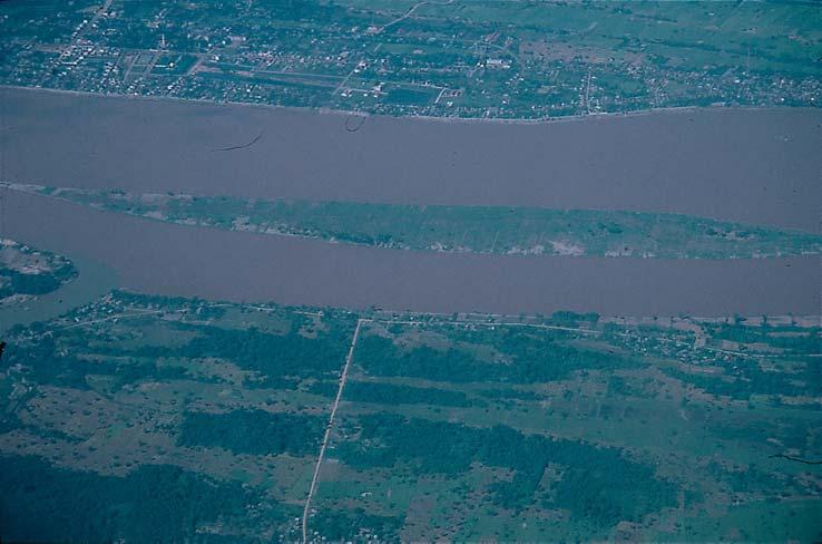
Figure1.2 TheMekong.(a)Onrock,downstreamofChiangSaen,northernThailand.(b)Onalluvium nearSavanakhet,LaoPDR,photographedfromtheair.Notethedifferenceinformandbehaviour betweenthetworeaches.Largeriverscommonlyareacombinationofanumberofsimilarvariations. Source:A.Gupta.
(a)
(b)
adjoiningsubcontinental-scalewatercatchmentareaarenecessaryrequirementsfora bigriver.Smallertectonicmovementsmayfurthermodifythebasinandthechannel andexplaintheirdetailedmorphologicalcharacteristics.
Theregionalgeologyshouldcreateadrainagebasinlargeenoughtoaccumulate enoughprecipitationtosupportandmaintainthebigriver.Chapter3discussesthe natureofwaterandsedimentinalargeriver.Thedischargeinalargeriverisdetermined byvariousclimaticcriteriadependingonitslocation:annualrainfall,seasonalityin rainfall,andhighepisodicrainfromsynopticdisturbancessuchastropicalcyclones. Thesupplyofwatertolargeriverscouldbefromalmostallpartsofthewatershed butthesedimentsupplygenerallyisassociatedselectivelywithhighmountains.For example,thedischargeoftheOrinocoiscollectedfrommostofthebasin,irrespective ofgeologyorrelief,butitssedimentsupplyisonlyfromtheAndesMountainsandthe alluvialLlanosplainsformedneartheAndeanfoothills.Incertaincases,severallarge riversflowthrougharidlandscapeswithoutidentifiableadditiontotheirdischargebut managetosustaintheirflowbecauseofthehighdischargearrivingfromtheupper non-aridpartsoftheirdrainagebasins.Sedimentinfloodmovesinlargeriversbothin downstreamandlateraldirectionsiflargefloodplainsarepresent.Thesedimentgrains travelalongdistancetoreachtheseaand,intheprocess,becomematureandsorted.
Largerivershavebeenaptlydescribedasmassiveconveyancesystemsthatmovedetritalsedimentanddissolvedmatterovertranscontinentaldistances(Meade2007).Their morphologyisdependentonregionalgeology,dischargeandsedimentflux,andmay changeseveraltimesbetweentheheadwatersandthesea(Chapter4).Morphologically alargeriverusuallyhasachannelflankedbybars,floodplain,andterracefragments. Thechannelpatterndependsonthegradientoftheriverandthenatureofwaterand sedimentittransports,andthepatternvariesamongdifferentriversastheyadjustto thelocalphysicalenvironment.Floodplainsoflargeriversareimportantnotonlyfor theiroriginandagebutalsofortheirecologywhichsupportsawidevarietyofspecies, andtheireconomicutilisationbypeople.Theroleoffloodpulsesinthemaintenanceof thefloodplainsanditsecologyiscrucial.ThisisdiscussedindetailbyJunk etal .,inone ofthetwoinvitedchaptersinthisbook(Chapter5).Thehugedischargeofwaterand sedimentthatisdepositedbyabigriverintheseamaycreatealargedelta.Deltasare morphologicallyfragileandchangeovertime(Chapter6).Deltasofmanylargerivers supportalargepopulation,andhenceareofimportance.
Largeriverscouldbegeologicallylong-livedriverssuchastheMississippiortheNile. Ariverthatexistsforalongtimehasahistory.Tectonicprocessescommonlyinfluencetheorigin,geographicallocation,andmodificationofmajorrivers.Understanding ofsuchriversrequiresknowledgeoftheirhistoryasrivershavechangedepisodically throughtectonicmovements,andespeciallythroughclimateandsea-levelchangesin theQuaternary(Chapter7).
Largeriversareausefulresourcetopeople.Aproperutilisation(Chapter8)andmanagement(Chapter9)oflargeriversisimportant.Thelanduseoftheirbasinsandtheuse oftheirwaterhavemodifiedtheenvironmentoveryearsofhumancivilisation.Thishas ledtoalterationoflargeriversandtheirbasinsatvariouslevels,especiallyoverthelast hundredyears.Theformandbehaviourofmanyofthepresentlargerivershavebeen modifiedmainlyduetoconstructionoflargedamsandreservoirs.Thepresentstateof alargeriverisconditionedbyboththeoriginalphysicalenvironmentofthebasinand anthropogenicalterationsimposedonthechannel.
Thisrequirespropermanagementoftheriverssothatbasinaleconomicdevelopment andenvironmentaldegradationcanbebalancedinasustainableway.Amanagement procedurewhichsimultaneouslyallowsbotheconomicdevelopmentandenvironmentalsustenanceneedstobechosen.Asalargeriverusuallyflowsacrossmultiplecountries,eachwithdifferentexpectationsandvaryingabilityofresourceutilisation,thereis alsoapoliticalaspectoflargerivermanagement.
Chapter10dealsexclusivelywiththeMekongRiverasacasestudytoillustratethe techniquesandproblemsofmanagingamultistateriverinacomplexphysicalenvironment.Itillustratestherealityofrivermanagementwhichinvolvesdealingwiththe complexityofthephysicalcharacteristicsofabigriver,meetingthedifferentexpectanciesofmultiplestakeholdersoftheriverbasin,andmaintainingthequalityoftheriver forfuturegenerations,allatthesametime.
Chapter11isonthespecialcaseofmajorriversinthearctic.Itdealsmainlywiththe Lena,YeniseiandObinSiberiaandtheMackenzieandYukoninNorthAmerica.These riversflowthroughauniqueenvironmentandareexpectedtogothroughlargechanges inthenearfutureduetoglobalwarming.ThisdiscussiononarcticriversbySlaymaker isthesecondinvitedcontributioninthisbook.
Thelastchapterdealswiththepossiblemodificationsoflargeriversinthenearfuture. Theymayundergosignificantchangesfollowingclimatechangeandconstructionof large-scaleengineeringstructures.Thegeneraltenetsofclimatechangeareknownand accepted,butwehavelimitedknowledgeregardingitsimpactonlargerivers.We,however,needtoconsiderthefutureforunderstandingandmanagementofpresentlarge rivers,assuchchangeswouldimpactthelifestylesofaverylargenumberofpeople,as theriversofthefuturearelikelytobedifferent.
References
Gupta,A.(ed.)(2007). LargeRivers:GeomorphologyandManagement ,689.Chichester: Wiley.
Hovius,N.(1998).Controlofsedimentsupplybylargeriver.In: RelativeRoleofEustasy, Climate,andTectonisminContinentalRocks,vol.59(eds.K.W.ShanleyandP.C. McCabe),3–16.Tulsa:SocietyforSedimentaryPetrologySpecialPublication. Inman,D.L.andNordstrom,C.E.(1971).Onthetectonicandmorphologicalclassification ofcoasts. JournalofGeology 79:1–21.
Meade,R.H.(1996).River-sedimentinputstomajordeltas.In: Sea-LevelRiseandCoastal Subsidence:Causes,ConsequencesandStrategies (eds.J.D.MillimanandB.H.Haq), 63–85.Dordrecht:Kluwer.
Meade,R.H.(2007).Transcontinentalmovingandstorage:theOrinocoandAmazonrivers transfertheAndestotheAtlantic.In: LargeRivers:GeomorphologyandManagement (ed.A.Gupta),45–63.Chichester:Wiley. Mertes,L.andDunne,T.(2007).Effectsoftectonism,climatechange,andsea-levelchange ontheformandbehaviourofthemodernAmazonRiveranditsfloodplain.In: Large Rivers:GeomorphologyandManagement (ed.A.Gupta),112–144.Chichester:Wiley. Potter,P.E.(1978).Significanceandoriginofbigrivers. JournalofGeology 86:13–35.
GeologicalFrameworkofLargeRivers
2.1Introduction
Alargeriverisalongriverwhichdrainsanextensivebasin,carriesabigdischarge, andusually,butnotalways,transportsahugequantityofsediment(Potter1978). Itpossessesasuitablethree-dimensionalgeologicalframeworkforachievingthese characteristics.Alineardepressioninrockofconsiderablelengthcommonlyliesbelow theriver.Asedimentaryfillofvaryingdepthrestsonthisdepressedrocksurface, andalongwithbedrockconstitutesthematerialbelowthechanneloftheriver.The fillhasbeendepositedbythemainriveranditsancestors,andsomeofitssedimentis contributedbytributarystreams.Onthesurface,thelongtrunkrivercrossesarange ofphysicalenvironmentsandchangesformandbehaviourseveraltimes.Forexample, theIrrawaddy,NarmadaandDanubeflowinandoutofnarrowrockyvalleysandwide alluvialbasins.Thebasinofalargerivercommonlyisanaccumulationofseveral sub-basinswithdifferentcharacter,exhibitingapolyzonalformandbehaviour.Theend partofthemainriverneedstoadjusttoallsuchvariationsinthelargebasin,plusany changeinsealevel.
Thegeologicalframeworkofalargeriverisformedprimarilybypastlarge-scaletectonics.Itsbasinshouldalsobebigenoughtocollectsufficientprecipitationtoform andsupportamajorriversystem.Conditionsvaryspatiallywithinthebasinofthe largeriver,anddifferentpartsofthebasincontributewaterandsedimentinvarying fashiontothemainstream.Themainriverusuallyreceiveswaterfrommultipleparts ofthebasin,butalmostallofitssedimentisusuallyderivedfromhighertectonicparts ofthecatchment,anareaofhighreliefanddisintegratedrocks(Meade2007;Milliman andSyvitski1992).Usually,thesedimentisderivedfromsuchareasbyglaciation,slope failures,anderodingheadstreamsoftheriver.
Inbrief,thephysicalcharacteristicsofalargeriverdependonitsstructuralframework,itsgeologicalhistory,anditspatternofwaterandsedimentsupply.Suchcharacteristicsformandmaintaintheriveranditsbasin.Theirnatureismodifiedovertime followingchangesintectonicsandclimate,andincurrenttimesalsobyanthropogenic alterationsoftheriveranditsbasin.
2.2TheGeologicalFramework:ElevatedLandandaLarge Catchment
Manyoftheexistinglargeriversstartatanelevatedorogeniczone,draina subcontinental-scalearea,andflowtotheoceanthroughamajordelta.Theorogeny isusuallycreatedbyconvergenceoftwotectonicplates.Thecourseoftherivermay bedeterminedbyalarge-scalegeofracturewhichitfollows,anditsmouthmaybe positionedbyarockbasinatthetrailingmarginofoneoftheplates.TheAmazonis anexcellentexample.AnotherexampleisthatofthepresentLowerMississippi,still locatedoveraCretaceoussub-surfacerockembaymentnearitspresentconfluence withtheOhio.Ithasbeensuggestedthatthisembaymentunderneaththesedimentof theriverisrelatedtoareactivatedriftwhosehistorymayhavestartedmuchearlierin thelatePrecambrian(ErvinandMcGinnis1975;Potter1978;Knox2007).
Anupliftedzone,oftenformedbyplatecollisions,andanadjoininguplifted sub-continental-scalecatchmentareaarethenecessaryrequirementsforamajorriver (TandonandSinha2007).Theseconditionsexistforatimelongenoughtocreate andsustaintheriversystem.Thepresentcontinentallandmassesarelargeenough tosupportthecurrentbigrivers,butthesizeofthelandmasseshasnotalwaysbeen thesame.Anexistingdrainagecanbemodifiedovertimeduetochangesintectonic, geomorphic,andhydrologicsystems.RiverslargerthanthoseofthepresenttimeprobablyexistedduringthesupercontinentsoftheWilsoncycle(PangeaandRhodinia). Incontrast,veryearlyriversonEarthprobablydidnotbecomelargeduetolimited hydrologicsupportandrestrictedbasinareaonland(Potter1978).Tectonicmovementsandthefollowinggeomorphicprocessesdeterminetherequireddevelopmentof thebasintopographymarkedbyelevatedboundariesandaregionalslope.Continental platetectonicsdeterminethebasinframeworkandtroughoftheriver,andregional disruptionsvaryitscharacter,locally.
Onfeweroccasions,anewtopographyandaconfinedriveriscreatedbyrifting,as shownbytheRioGrande,whichisapull-apartsystemthatbeganintheearlyMiocene anddevelopedfromseparateshallowbasinstoanintegratedsystem.Thefailedarmat aplatetectonicstriplejunctionalsomaygiverisetoriftingwhichmaycarryabigriver thatoccupiesthelong,narrow,deeplyfilleddepressionextendingintoacraton.Atthe otherendofthelineardepression,theriverbuildsadeltaattheplateboundarymarking theedgeofthecontinent.TheNigerisanexample.AnotherexampleistheBlueNile whichriseswithintheriftsystemofEthiopiatoflowthroughadeepgorgeforabouthalf ofitslength.
Anewtopographyandamodifiedrivermayalsobeformedoffamantleplume(Cox 1989)whenitrisestocreateanextensivedomalsurfacewithhighelevation,ashappened inseveralpartsoftheEarthduringtheLateCretaceous.Certainareaswereupliftedby domingandmagmaticunderplating,givingrisetotopographichighsandnewdrainage systems.TheOrangeandpartoftheZambeziRiverareexamples.
Notalllargeriversfallintosuchclearlygeneralisedclasses.Somedonotrisefrom currentlyactiveorogenicbeltsbutdrainpartsofoldmountainsthathavesomeelevationorareonlyslightlyactivetectonically.TandonandSinha(2007)describedsuch riversaslocatedincratonicsettingsasthesedrainmajorcratons.Examplesofthistype aretheMississippi,Yukon,Yenisei,Lena,andOb.Potter(1978)statedthatfourmajor morphologicalpatternsmaycoverthemajorityoflargerivers.Thesecanbedescribedas:
(1)Mostsedimentderivedfrommountainsmarginaltoalargecraton(theAmazon).
(2)Theriverflowingmarginalandparalleltoafoldbelt(theGanga).
(3)Abigriverflowingalongthestrikeofamountainrange(theMekong).
(4)Ariversuperimposedacrossmultiplemountainchains(theDanube).
Potterproposedafifthpossibilitywhichmayhaveoccurredinthepast:ariverona largecratonwithoutborderingmountains(Potter1978).
2.3SmallerTectonicMovements
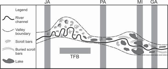
Thebasinandthechannelofabigriverarefurthermodifiedbysmallertectonic disturbances.Forexample,theLowerAmazoncrossesseveraltransversestructures initscourse(Figure2.1).InthedownstreamdirectionthesearetheIquitosArch, JutaiArch,PurusArch,MontAlegreIntrusionandRidge,andGurupaArch.When theAmazoncrossessuchstructuralhighs,certaingeomorphicfeaturescharacterise theriver(MertesandDunne2007).Thechannelrunsstraight,itsfloodplainremains relativelynarrow,scrollbarsarefoundonlynearchannelmargins,andmigrationof thechannelislimited.Incontrast,widefloodplainswithsignificantrivermovement, scrollbarsandanabranchesdistinguishtheriverflowingonalowgradientbetween theupwarps.Evenwhencoveredbyanalluvialfill,theseupwarpsaffecttheriver.The morphologyofalargeriverthereforevariesalongitscourse.
Large-scalefracturesalsoregionallyaffectthetributarynetworkintheAmazonBasin. Deep-seatedbasementfracturingappearstohavedisturbedtheoverlyingsedimentary rocksthataffectthedrainagenet,orientedinnortheastandnorthwestdirections(Potter 1978,Figure8andreferencestherein;MertesandDunne2007).Thealignmentofthe LowerNegro,oneofthemajornorthbanktributariesoftheAmazon,hasbeeninterpretedascontrolledbyaNW-SEtectoniclineament(FranzinelliandIgreja2002).Here sunkencrustalblocksanddepressionsoccuralongahalf-graben,submergedtoapproximately20mwithawidthofupto20km.Thiscontrolsthepatternofriverislands,bars, andthelocationofsedimentstorageintheriver.
Figure2.1 Schematicillustrationoftherelationbetweenstructureandmorphology,theLower AmazonValley.Theverticalbarsshowtheapproximatelocationofarchesandatiltedblockwhichare structuralhighs:JA,JutaiArch;PA,PurusArch;MI,MonteAllegroIntrusionandRidge;GA,Gurupa Arch;TFB,approximatelocationofatiltedfaultblock.Source:MertesandDunne2007andreferences therein.
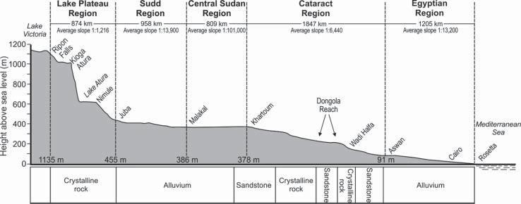
Figure2.2 LongitudinalprofileoftheNileovervaryingregionalstructuresandlithology.Source: Woodwardetal.2007,fromSaid1994.
Anumberofriversflowalongthestructuralgrainsofafoldedmountainbeltalmostto theirmouths.TheMekongandSalweenaregoodexamples.TheMekongflowsforabout 80%ofitslengthinanarrowvalleyflankedbyridges(Figure1.2a)whereastheSalween flowsthroughaseriesofgorges.ThelowerIrrawaddycrossesthreegorgesinrockseparatedbywiderbasinsinalluvium,andthemorphologyandbehaviouroftheriverchange betweenthegorgesandbasins.Theentryandexittothegorgesshowadjustmentofthe riveroverashortdistance.TheIrrawaddyfinallycontinuesthroughaflatlowland,dischargingintotheGulfofMartabanthroughalargedelta.Theentireriveristhusasum ofitsdifferentparts.Themorphologyandstructuralunderpinningoflargeriversare furtherdiscussedinChapter4.
Largeriversdifferintheirformandfunction,andformanyriverstheunderstanding ofsuchdifferencesisachievedviaahistoryofcontinentalplatetectonicsandlesser tectonicmovements.Thelongitudinalprofileoflargeriversgenerallyreflectsacombinationoftheirtectonicsettings,basinlithology,anderosionalhistoryastheirgradient changes(Figure2.2).Theprofileofalargeriveroveralongdistancethusmaybea combinationofdifferentsections.Geologicalstructureandlithologytendtocontrol thebasiccharacteristicsoftherivers.
2.4TheSubsurfaceAlluvialFillofLargeRivers
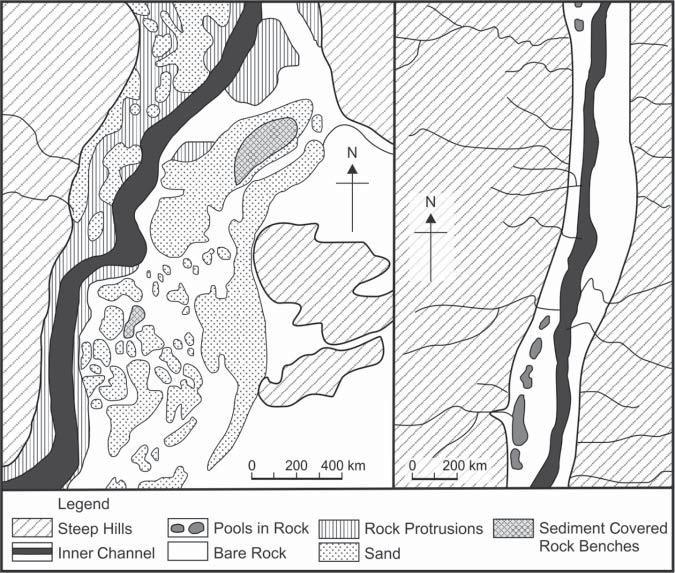
Therocksurfaceunderlyingthealluvialvalley-fillofalargerivergenerallyisnot smoothbutmarkedbyirregularitiessuchasribs,furrows,scourholes,etc.Schumm, forexample,discussedthevariablethicknessoftheMississippiValleyalluviumat EastSt.Louis,Missouriasreportedintheliterature.Thethicknessofthealluvium reachesapproximately35–50minplaces(Schumm1977).Thedepthofthealluvium anditsnatureareexhibitedinboreholes,butacompletemappingisverydifficult. Detailedthree-dimensionalstudieshavebeencarriedoutonseveralrivers(Fielding 2007).Constructionofdamsoverlargeriversalsoexposessurfacemorphology.The sectionatHooverDamontheColoradoRiverdisclosedaninnerchannelflanked bybedrockterraces.About200kmofthechanneloftheChangjiangweremapped betweenNovember1978andMay1979nearthesitechosenlaterfortheconstruction
2.4TheSubsurfaceAlluvialFillofLargeRivers 11 oftheThreeGorgesDam.Morethan90troughswerefoundatthebottomoftheriver, cumulativelycovering45%ofthetotallengthoftherivermapped.Allthetroughswere morethan40mbelowthelowestriverlevel(Yangetal.2001).Thecross-sectionof thechanneloftheUpperMekongistrapezoidal,orhasadeepinnerchannelbounded byrockbenches,orawidescabland-likesectionwithrockribsandpilesrisingfrom thebed(Figure2.3).Scourpoolsandrockprotrusionsoccurontherockbenches andtheflooroftheinnerchannel(Gupta2007).Thefinalbedofabigriverthusisa compositeresultofstructureandlithologyatvariousscales.
Thetextureoftheriver-depositedfilloverrockisnotuniform.Ingeneral,thecoarsest sedimentisfoundatthebaseofthevalley-fillandthefinesttowardsthetop(Schumm 1977).Sedimentalsotendstobecomefinerinthedownstreamdirection.However, sedimentationisalsolikelytoindicate:(i)interrupteddeposition;(ii)variationsalong themainchannelduetodifferentialcontributionbytributaries;and(iii)variationsfrom ageneralfining-upwardsequenceprobablycausedbyclimatechangeandtectonics. However,wheretheavailablesedimentisofsimilartexture,thefilltendstobetexturally ratheruniform.
Valleyscanbefilledlongitudinallyinthreeways.First,basinclimatechangeoruplift ofthesourceareamayresultinprogressiveaggradationofrelativelycoarsematerial depositedalongthevalley,downfillingthechannel.Secondly,sedimentfromtributaries joiningthetrunkstreammayverticallyfillthevalleyrelativelyuniformlyoverariver
Figure2.3 Diagrammaticsketchesofcross-sectionsoftheMekongRiverinrock,LaoPDR. Source:Gupta2004.
reach.Thirdly,ariseinbaselevelmayreducethegradientoverthelowerpartsofthe valley,initiatingprogressivebackfilling(Schumm1977).
TandonandSinha(2007)summarisedsedimentationintheGangaRiver.Risingfrom theHimalayaMountains,theriverdescendstotheplainsandflowsparalleltothemountainsforaconsiderablepartofitscourse.ItthenerodesthroughtheigneousRajmahal Hills;turnssouthtobuildpartofamajordelta;andfinallyflowsintotheBayofBengal. Theupper20kmoftheriverdownstreambelowthemountainfrontcarriesnumerous gravelbars,theriverinealluviumconsistingmainlyofseveralmetresofgravel.Coarse sand,correspondingtoabraidedchannelbelt,replacesgravelsdownstream(Shukla etal.2001).Thisisfolloweddownstreambythemeanderingandbraidedmiddlesection ofGangathatdepositsmostlyfinetoveryfinesandsonmediumtocoarsesandsofolder deposits.Thefinesandsareseparatedbyunitsoffloodplainclay,severalmetresthick andpedogenicallyaltered,characteristicsofamobileriver.ConsiderablevolumeofsedimentalsoarrivestotheGangaasfan-depositsofthemajorHimalayantributariessuch astheGandakorKosi.Thedepositsofthesemegafansrangefromthemountainfront totheGangainzones,fromgravellysandtofinesandandmud.Thesemegafansconsist ofgravelbedsintheupperareas,butmostofthefanismadeofmultistoriedsandsheets interbeddedwithoverbankmuddylayers(Singhetal.1993).
Interpretationofbothtectonicstructuresandsubsurfacefillisrequiredtodetermine thegeologicalbackgroundofalargeriverandexplainitssurfaceconfiguration.Natural sedimentationinalargeriversuchastheGangaiscontrolledprimarilybytectonics, climateandsealevel.Bothtectonicsandclimatecontrolthenatureofthesediment nearthemountains,theeffectoftheclimatedominatesfurtherdownstreamalongwith thesedimentsuppliedbybothtributaryfansfromthemountainsandsedimentfrom cratons,andtheeffectofthechangingsealevelinfluencesthelowerpartofthevalley.
2.5GeologicalHistoryofLargeRivers
Themorphologyandbehaviourofalargeriver,asdiscussed,reflectstructuralcontrol atseverallevels.Thelocationandoriginofthebasinarecommonlydeterminedbycreationofanewsurfacebyplatecollisionorriftingordoming.Thecourseoftherivermay followanoldergeofractureorbefixedinplaceswhereitpassesovercontrolssuchasa structuralembayment.Thecharacteroftheriverchangeswhereitcrossesanupwarp transversetoitscourseoraregionalpatternoffaultsasseeninthecentralpartofthe AmazonBasinnearManaus.Thedimensionsofamajorriveralsochangewhenitpasses throughsteepgorgesseparatedbylow-gradientalluvialbasins.Thesevariationsnot onlymodifythebedrockchanneloftherivers,buttheyalsoinfluencevalleysedimentationandgiverisetovariableriverinemorphology,barforms,andpresenceorabsence offloodplainsatthesurface.Furthermore,inallcases,thenewdrainagebasinneeds tobelargeenoughtomaintainamajorriverandbelocatedinasuitablehydrologic environment.
Largeriversvaryintheirsizeandage.Mobilityofcontinentalplatesmayresultinplate destructionandsizereductionorslowpassageoftheplatetoadrierpartoftheEarth. Suchdevelopmentsmodifyormayevendestroyamajorriver.Incontrast,platesmay increaseindimensionsorreachmorehumidareasovertime.Potter(1978)suggested
thatverybigriversmayhavebeenformeddraininganenormouslandmassconsisting ofweldedcratonicblockswhichcarriedatleastonesystemoffoldmountainsandwas well-watered.
Thegeologicalhistoryofamajorriverthereforehasabeginningandanend.The MississippiisrecognisedtohavebeeninexistencesinceatleasttheCretaceousbecause ofasubsurfacerockembaymentlocatednearitspresentconfluencewiththeOhio Rivermentionedearlier.TheembaymentisrelatedtolaterMississippiRiverfillsand sedimentoftheMississippi,datingbacktotheJurassicperiod,hasbeenfoundin theGulfofMexico.TheembaymenthasbeendatedtolatePrecambrian(Ervinand McGinnis1975).Alargeriverthereforehasbeenapproximatelyinaplacefornearly 300millionyearsorabout1/16thofthehistoryoftheEarth(Potter1978).Itisanold river,soareseveralotherssuchastheNile.TheancestralNilehasbeenassociatedwith theancientPan-Africanorogeniceventsofabout550millionyearsagoorearlier.The riverhasbeenmodifiedovertimetoitspresentappearance(Woodwardetal.2007and referencestherein).
Notallmajorrivershaveasimilarlonghistory.ThepresentAmazoncameintoexistenceaftertheriseoftheAndesintheMiocene.Therewasanolderdrainagesystem earlier,flowingwestwardandprobablyrelatedtotheAfricanPlatebeforetheopening oftheSouthAtlantic.TheGangaandBrahmaputra,twomajorHimalayanrivers,probablycameintoexistenceintheMioceneaftertheformationoftheHimalayaMountains followingthecollisionoftheIndianPlatewiththeEurasianPlate.Theremayhavebeen anearlierdrainagesystem,butithasbeendrasticallymodified,andthepresentdrainage networkhasevolvedovertime.Forexample,thedrainageofthewesternHimalayawas modifiedthroughasetofrivercaptures,changingthedirectionofflowofthetributaries oftheGangaandIndus(Burbank1992;CliftandBlusztajn2005).Itisbelievedthat earliertheSôngHóng(RedRiver)drainagenetincludedtheformerupperChangjiang (Yangtze),Mekong,SalweenandTsanpo.TheearlierupperdrainageoftheSôngHóng thendisintegratedtoformtheheadwatersoftheseseparatemajorrivers(Brookfield 1998).Robinsonetal.(2014)haveopinedthatthepresentBrahmaputrasystemhas changedfromtheoldYarlungTsanpo–Brahmaputra–Irrawaddylinkagetothepresent drainageviarivercaptureandtectonicmovements,around18Maago,andfinallywas capturedbytheBayofBengalsystemoftheUpperBrahmaputrabytheLohitandnewer Himalayanrivers(LichtandGiosanacceptedforpublication).
Ariversystemmaybeterminatedbyothereventssuchasalarge-scalemarine invasion,anewtectonicdeformation,outpouringoflavaorcontinentalglaciation (Potter1978).Tectonic,geomorphicandclimaticprocessesmayalsomodifyanearlier drainage.ThecollisionoftheIndianandEurasianPlatesresultedincrustalshortening, differentialshearandrotationassociatedwiththeriseoftheHimalaya.Anexistingriver maydisappearthroughrivercapture,climatechangeresultinginadrierenvironment, ordeformationduetoplatetectonics.Thechangemayaffectalmosttheentirebasin oronlypartofthedrainagesystem.Potter(1978)hasdescribedriverswhichwere anassemblageofpartsashavingacompositeage.Someriversmaypersistinspiteof majorinterruptionstoexperienceoveralongexistence.Themajorrivers,theirdeltas, andoffshoretrenchesunderwentmultiplechangesduringthePleistocene.Goodbred Jr(2003)hastracedtheseriesofmodificationsthattheGangaRiverunderwentsince MarineIsotopeStage3(MIS3,58000yearsago),mainlyduetoclimatechange.