ILLUSTRATIONS
1.1 The Stonehenge environs, showing prehistoric sites and features of different dates 2
1.2 Plan of the stone settings of Stonehenge with each stone numbered 3
1.3 Plan of Stonehenge today, showing the line of the grassed-over A344 road 5
1.4 Location of Stonehenge and a selection of other Neolithic sites in Britain 15
2.1 Distribution of Mesolithic findspots (8000–4000 bc ) in the environs of Stonehenge 20
2.2 The Early Neolithic pit at Coneybury (3760–3700 bc ): (top) plan of its feasting debris; (middle) profile through its deposits; (bottom) its location in relation to the Late Neolithic Coneybury henge 23
2.3 Distribution of earlier Neolithic monuments on Salisbury Plain 25
2.4 Reconstructions of earlier Neolithic pottery from the Stonehenge environs: (top) Carinated Bowl ware (c. 4000–3800 bc ); (middle) Southwestern Bowl ware (c. 3800–3400 bc ); (bottom) Peterborough Ware (c. 3400–3000 bc ) 28
2.5 Distribution of likely Middle Neolithic henges (c. 3400–3000 bc ) and related monuments around the future site of Stonehenge 29
3.1 Plan of Stonehenge Stage 1 (c. 2950 bc ) showing the bank and ditch, the Aubrey Holes, other stoneholes and postholes 35
3.2 Alternative land and sea routes for taking the bluestones to Stonehenge 37
3.3 Chris Casswell and Hugo Anderson-Whymark at Aubrey Hole 7 during excavation in 2008, viewed from the east 45
3.4 Late Neolithic decorated chalk plaques from east of Stonehenge (top and middle) and from Butterfield Down 47
3.5 Earlier forms of Late Neolithic Grooved Ware pottery from the Stonehenge environs: (top) Woodlands sub-style; (bottom) Clacton sub-style 49
4.1 Plan of Stonehenge Stage 2 (c. 2500 bc ) showing the sarsen circle and trilithons and the bluestones arranged in the Q & R Holes 52
4.2 Alternative possible routes for taking the sarsen stones to Stonehenge, either via Marden (new route) or via Patrick Hill’s proposed route along the Avon valley 54
4.3 Late Neolithic Grooved Ware pottery from Durrington Walls, in the Durrington Walls sub-style 58
4.4 Location of Stonehenge and nearby Late Neolithic sites 59
4.5 Plan of houses (grey, with central hearths in black) within the east entrance of Durrington Walls 62
5.1 Plan of Stonehenge Stage 3 (c. 2300 bc ) showing the large pit against the Great Trilithon and a bluestone circle in the centre of the monument 68
5.2 Reconstruction of the second phase (c. 2470 bc ) of the timber Southern Circle at Durrington Walls, viewed from the west 70
5.3 The grave of the Amesbury Archer showing his various grave goods 73
5.4 Distribution of Early Beaker burials (c. 2450–2250 bc ; large dots) in the Stonehenge landscape and the ring of large pits (small dots) around Durrington Walls 75
6.1 Plan of Stonehenge Stage 4 (c. 2100 bc ) showing the bluestones reorganized as a circle and an inner horseshoe or oval 82
6.2 Reconstructions of later Beaker pots from the Stonehenge environs 85
6.3 Distribution of later Beaker burials (shown as black dots; c. 2250–1950 bc ) in the Stonehenge landscape 87
6.4 Areas of Early Bronze Age settlement (shaded in grey) to the west of Stonehenge 88
7.1 Plan of Stonehenge Stage 5 (c. 1700 bc ) showing the Y and Z Holes 90
7.2 Locations of axehead and dagger carvings on the sarsen stones of Stonehenge 93
7.3 Carvings of two daggers and multiple axeheads on the inside face of Stone 53 94
7.4 Reconstruction of the burial in Bush Barrow: (1) fragments of bronze dagger; (2) bronze axehead; (3) two bronze daggers with gold-studded hilts and a gold belt hook cover; (4) bronze knife; (5) gold lozengeshaped plaque; (6) mace with small gold lozenge-shaped plaque 97
8.1 Field systems of the Bronze Age and later in the Stonehenge landscape 104
8.2 The Palisade Ditch complex enclosing Stonehenge and the round barrow cemeteries on Normanton Down and King Barrow Ridge 106
8.3 The Iron Age carved chalk pig from a child’s burial in the Palisade Ditch 107
8.4 Distribution of Iron Age (grey) and Roman (black) sites and findspots within the Stonehenge landscape 111
8.5 Locations of Iron Age–medieval burials (black) at Stonehenge, with Late Neolithic cremations and the Stonehenge Archer (1978) shown in grey 113
9.1 Plan of Stonehenge showing which stones still lie fallen and which have been re-erected, removed and re-set, and straightened in the twentieth century 122
9.2 John Aubrey’s 1666 plan of Stonehenge with north to the bottom right 124
9.3 William Stukeley’s 1722 drawing of Stonehenge viewed from the north 125
9.4 William Gowland re-setting Stone 56 in 1901 129
9.5 Richard Atkinson and Stuart Piggott (seated) excavating at Stonehenge prior to re-erection of a trilithon (Stones 57, 58 and 158) in 1958 131
10.1 Druids gathering outside the midwinter sunrise entrance at Stonehenge on 24 August 1905, viewed from the southeast 136
Illustrations
10.2 Druids gathering in the same spot a century later than in Figure 10.1 138
10.3 Festival-goers attend the midsummer Free Festival at Stonehenge in 1984 140
10.4 King Arthur Pendragon attends a Stonehenge Alliance demonstration outside the Royal Courts of Justice in London during the judicial review of the A303 Stonehenge tunnel scheme 142
10.5 Plan of the proposed A303 road scheme, showing the location of the proposed tunnel (dashed) and its east and west portals within the Stonehenge World Heritage Site 146
11.1 William Stukeley hypothesized that Stonehenge was a prehistoric temple for the ancient druids. In this illustration he drew himself as a druid 152
11.2 The directions of the solstices (sun) and standstills (moon) on the horizon for an observer in southern Britain 154
11.3 Malagasy archaeologist Ramilisonina, originator of the ‘Stonehenge for the ancestors’ hypothesis, excavating at Bluestonehenge, West Amesbury in 2009 155
11.4 The Stonehenge for the Ancestors hypothesis (Parker Pearson and Ramilisonina 1998), showing the proposed relationship between Stonehenge, its Avenue, the River Avon, and Durrington Walls and Woodhenge in the Late Neolithic 156
STONEHENGE:
HOW WE KNOW WHAT WE KNOW
Stonehenge is one of our most intriguing prehistoric monuments. For centuries, people have asked who built it, how, when and why. At 30 metres in diameter and 8 metres tall, Stonehenge is more impressive than many other stone circles in Britain but it seems diminutively small when compared with the colossal bulk of the Great Pyramids or ancient cities such as Ur or Machu Picchu. Yet this stone circle has grown in the public imagination to become an icon of the ancient past, an enigmatic relic of the sophisticated prehistoric civilization that built it.
The questions surrounding Stonehenge may never all be solved, and for some that is how it should be: we live at a time when the enchantment of the world around us has perhaps diminished in the face of accelerating understanding about who we are and where we came from. The quest for knowledge requires questions without answers –such questions rouse our curiosity and feed our urge to explore the unknown. And solving one puzzle invariably raises new questions and reveals new horizons for investigation. We are lucky to live in an age in which archaeologists can draw upon a treasure-store of methods to examine the many strands of evidence that can now be recovered, from the molecular and microscopic to the megalithic and monumental.
This chapter introduces the extensive toolkit to which archaeologists now have access, from astronomy to zooarchaeology, and shows how these approaches are used to research Stonehenge and the people who built it. The twenty-first century has witnessed a sea change in our knowledge thanks to these many new techniques and the ground-breaking projects, both in the field and in the lab, that have employed them. But first, what can be seen today at Stonehenge?
Stonehenge today
For thousands of years, travellers on foot, on horseback and, in recent times, in cars driving across Salisbury Plain have passed Stonehenge, its stones surrounded by a sea of grassland. That experience of encountering it on a journey may well be lost in the coming years because of plans to bore a tunnel past the monument to bury the current road, the A303, to try to restore the monument’s tranquility to something like it was before the advent of the motor car. Even if the tunnel is built, Stonehenge will still periodically be a place of huge and noisy gatherings, as tens of thousands come every year for the midsummer solstice sunrise on the morning of the longest day, as well as for other significant moments in the Pagan calendar such as the midwinter solstice and the equinoxes. Owned by the
Stonehenge: A Brief History
nation and conserved as part of the world heritage of humankind, Stonehenge is also the most significant generator of income for English Heritage, the charity charged with preserving and presenting those ancient monuments and historic buildings that are in the nation’s care.
The landscape surrounding Stonehenge is filled with hundreds of prehistoric monuments (Figure 1.1), many of them lying within the boundaries of the Stonehenge and Avebury World Heritage Site (WHS), designated by UNESCO (United Nations Educational, Scientific and Cultural Organization) and encompassing land owned variously by English Heritage, the National Trust (a UK property-owning charity) and private landowners.1
Figure 1.1 The Stonehenge environs, showing prehistoric sites and features of different dates. The black blobs are Bronze Age round barrows (drawn by Josh Pollard).
To understand Stonehenge in prehistory therefore requires study not just of the monument itself but of its ancient landscape extending miles in all directions, as well as its wider context – the archaeology of prehistoric Britain and Ireland, and of regions across the Channel in continental Europe. It demands research at all of these geographical scales simultaneously while taking into account the chronological framework – the thousands of years during which Stonehenge was used and successively re-built.
Today Stonehenge is a ruined structure of upright stones, some of them crowned by stone lintels (Figure 1.2). The larger uprights and the lintels are of sarsen, a local type of silcrete (a naturally concreted sandstone), which can be found both on Salisbury Plain and in the area 15 miles and more to the north, towards Avebury, Britain’s largest stone circle. Stonehenge’s incomplete outer circle of tall, dressed (shaped) standing stones supports six sarsen lintels, and the remains of another two lintels lie on the ground.
Figure 1.2 Plan of the stone settings of Stonehenge with each stone numbered. The paler stones are bluestones and the darker ones are sarsens (from Richards 2017 © Historic England).
Archaeologists think this outer circle originally consisted of thirty upright sarsens but only seventeen are still standing. Nine fallen stones are visible on the ground and it seems four stones from the original circle are entirely missing.
Inside the sarsen circle, more sarsens stand in a horseshoe-shaped arrangement, open to the northeast. This ‘horseshoe’ was originally formed of five pairs of standing stones, each pair topped by a stone lintel. These are called trilithons, ‘three stones’ in ancient Greek. Three of them are complete but the other two have collapsed, each leaving only a single upright still standing. One of these collapsed trilithons is the Great Trilithon, the largest of them all; one of its stones still stands at the southwest end or apex of the horseshoe arrangement but the other stone and its lintel have fallen into the inside of the horseshoe.
The single standing upright of the Great Trilithon weighs about 28 tons and is topped by a protruding knob or tenon. Its fallen companion’s tenon has been largely chipped away by souvenir hunters in recent centuries but when both uprights were standing, they supported a lintel, which now lies on the ground nearby. Like the other sarsen lintels at Stonehenge, it was originally fixed on top of the two uprights by a joint formed by sockets or mortises carved into the lintel into which the tenons slotted. The uprights of the sarsen circle have this same mortise-and-tenon jointing, except that each upright possesses two tenons, not one, so as to support the ends of two lintels. The ends of some of the lintels were also shaped so that the convex end of one would fit snugly against the concave end of the next in a kind of dovetail joint.
Between the sarsen circle and the horseshoe of sarsen trilithons sits a ruined circle of much smaller stones. These are the bluestones, a variety of pillars in different sizes and shapes, some still standing and others fallen. The bluestone pillars are of various types of rock that originated in and around the Preseli hills near the coast of west Wales, 170 miles to the west of Salisbury Plain.
Two of the fallen bluestone pillars in this outer circle have pairs of mortises, revealing that they were once lintels: these stones were first used horizontally on the top of other stones before they were then set vertically in the ground. A couple of full-standing bluestones have the remains of destroyed tenons on their tops, indicating that they once supported lintels. We do not know how or when these bluestones were originally used as uprights and lintels but they may have been components of mini-trilithons, erected either in an early period of construction at Stonehenge or at a dismantled stone circle called Bluestonehenge, which lies just over a mile away beside the River Avon. Unlike other bluestones in this outer circle at Stonehenge, these two lintels have been carefully shaped (dressed). Stone-dressing is also evident on fourteen surviving bluestones – all of dolerite – that stand in a horseshoe arrangement at the centre of Stonehenge, nested within the horseshoe of sarsen trilithons. Four of these inner bluestones, like ten of the stones in the outer bluestone circle, are buried under the grass today and are not visible above ground.
Within the centre of Stonehenge, just 5 metres northeast of where the Great Trilithon once stood, lies the Altar Stone, a 5 metre-long pillar of sandstone that is pinned flat beneath the trilithon’s fallen upright and lintel and is aligned approximately towards
midwinter sunrise. At 5 tons, it is heavier than the bluestones. How the Altar Stone ended up in this position is unknown, though the chances of its having been originally an upright pillar knocked over when the Great Trilithon collapsed are extremely small. Its position and orientation accord best with its having been laid deliberately in this altarlike position in front of the Great Trilithon. There is no evidence at all that this stone was an ‘altar’ but it was given this name many years ago and the name has stuck.
Views of Stonehenge tend to focus on these various sarsens and bluestones within the great stone circle and the central arrangements of stones. Yet four other stones are arranged at various locations outside the sarsen circle, all but one of which lie within the large circular ditched enclosure – the Stonehenge Bank and Ditch, 110 metres in diameter – that surrounds the stones and is visible today as a low earthwork (Figure 1.3). This type of circular ditched enclosure is called a ‘henge’; Stonehenge is one of the earlier types,
Figure 1.3 Plan of Stonehenge today, showing the line of the grassed-over A344 road. The Aubrey Holes, Y Holes and Z Holes as well as the stones around the perimeter are numbered (from Cleal et al. 1995 © Historic England).
Stonehenge: A Brief History
known as formative henges, in which the bank is inside the ditch, whereas later henges (after 2900 bc ) have the bank outside the ditch.
There were originally just two entrances through the Stonehenge Ditch, a wide one to the northeast and a smaller entrance on the south side. The northeast entrance is the start (or end, depending where one starts) of a long prehistoric structure called the Stonehenge Avenue. The Avenue is not easy to spot today because it has no stones – it is made up of two parallel ditches, about 21 metres apart, lined by a pair of parallel earth banks. The Avenue is almost 2 miles long – it cuts through the landscape from Stonehenge’s northeast entrance all the way to the River Avon to the east. The part of the Avenue nearest to Stonehenge is aligned on the midsummer sunrise.
Just inside the northeast entrance into Stonehenge lies the Slaughter Stone, a fallen upright. Because of its prone position, some over-imaginative antiquarians thought this must be a block on which ancient sacrifices were carried out. Just as for the Altar Stone, there is no evidence for any sort of sacrifice, but people like the name. Further out, beyond the northeast entrance and surrounded by its own small, circular ditch, is the Heel Stone, so-called because it was imagined to bear the imprint of a friar’s heel. The story goes that a friar interrupted the Devil as he was building Stonehenge and the Devil, in his fury, hurled this stone at him, hitting his heel and leaving an imprint in the stone. This and other indentations in the Heel Stone were all caused by natural processes and it is one of just two sarsens at Stonehenge that have not been dressed or shaped in any way.
The other undressed sarsen is Stone 91, a small, fallen stone which lies close to the earth bank inside the enclosure ditch in the southeast. This is one of the two surviving Station Stones, the other being Stone 93 in a similar position on the west side. Originally there were four Station Stones. Each of the two missing Station Stones stood inside a small, roughly circular earthwork: the South Barrow just east of the enclosure’s south entrance, and the North Barrow close to the enclosure bank on the north side.
Investigating Stonehenge
The first written record of Stonehenge that we know of is by Henry of Huntingdon, one of Britain’s first historians, and dates to about ad 1130. Around six years later, a cleric named Geoffrey of Monmouth included a lengthy explanation of Stonehenge’s construction in his History of the Kings of Britain. According to this pseudo-history, Stonehenge was built as a monument to Britons treacherously murdered by Saxons (the peoples who invaded Britain in the fifth century ad ). Geoffrey says the stones were brought from Ireland by the wizard Merlin, who dismantled and carried off to Amesbury (the village nearest to Stonehenge) a stone circle with magical properties.
In the seventeenth and eighteenth centuries, antiquarians and others began to map, sketch and dig at and around Stonehenge, the two most important being John Aubrey and William Stukeley. Nineteenth-century excavators of Stonehenge included the barrow-diggers Richard Colt Hoare and William Cunnington as well as the naturalist
Charles Darwin but the Antrobus family, who owned Stonehenge for most of that century, managed to limit further digging.
Archaeologists have been excavating within Stonehenge since the beginning of the twentieth century, many of them hoping to discover its purpose. The man who dug out most of Stonehenge, excavating almost half of it between 1919 and 1926, was Colonel William Hawley. When he finally finished working at Stonehenge, he said he was as baffled as he had been when he started. What Hawley did not fully appreciate was that Stonehenge could yield many of its secrets if it were studied in its wider context, through its relationship to the surrounding landscape and to other prehistoric remains across Britain and western Europe.
Of course, Hawley had no inkling of the huge range of methods and skills that would become available to modern archaeologists. He and other early twentieth-century researchers could draw on knowledge of astronomy, engineering and geology but there was little appreciation of just how much archaeology would be able to borrow and adapt from the sciences in the years to come.
The first modern excavation at Stonehenge, shortly before Hawley’s time, was carried out in 1901 by William Gowland, a professor of geology who had excavated ancient tombs in Japan and knew how to systematically record the locations and comparative positions of his finds in three dimensions. At the time Gowland started work, the lone standing upright of the Great Trilithon was leaning perilously so Gowland’s task was to excavate around its base before it was re-set vertically. He was able to show how the huge holes for the stones had been dug and to suggest how the stones might have been erected. Gowland also found evidence of how the Great Trilithon and other stones had been dressed: in his excavations he found many hammerstones – bashed lumps of hard sarsen and flint – and he worked out how these simple tools had been used to shape and smooth the great stones.
Two decades later, Hawley’s excavations also accompanied restoration work, investigating stoneholes of other sarsen uprights as they were lifted out by crane before being re-set in concrete. Hawley also dug within the sarsen circle to reveal stoneholes from earlier phases of the monument. Outside the circle, he discovered three circles of pits. The outermost of these is a ring of fifty-six pits, known as the Aubrey Holes because five of them were first found by the antiquarian John Aubrey. Between this outer circle of pits and the sarsen stone circle, Hawley labelled another two concentric rings of pits as the Y Holes and the Z Holes. He also excavated the southern and eastern half of Stonehenge’s enclosing ditch, recovering many finds from the soil that fills it. Hawley’s excavations in and beyond the northeast entrance revealed that more stones once stood there, alongside the Slaughter Stone and the Heel Stone, and here he found multiple rows of holes that once held long-vanished wooden posts. Hawley found many more holes for such long-vanished wooden posts within the interior of Stonehenge and, just inside the south entrance, he excavated what appears to have been a prehistoric house.
Between 1950 and 1964, Richard Atkinson, Stuart Piggott and J. F. S. Stone carried out further excavations at Stonehenge, with the aim of reporting fully on Hawley’s largely unpublished results and to answer further questions about Stonehenge’s sequence of
construction. Atkinson’s results enabled him to start making sense of Stonehenge’s chronological sequence: Atkinson divided it into three periods of activity, with the encircling ditch built during the earliest of these, followed by the circle of Aubrey Holes and then the standing stones. Radiocarbon dating was not yet perfected at this time, so the date of Stonehenge could only be guessed at – wrongly, as it turned out.
Atkinson, like Hawley, did not manage to publish a detailed account of his excavations and discoveries. Small-scale excavations were carried out around the site between the 1960s and the 1980s but it was only in 1995 that the results of the 1919–26 and 1950–78 excavations were fully published (Cleal et al. 1995). By then, the precision and reliability of radiocarbon dating had improved dramatically so bones and antlers dug up in these twentieth-century excavations and stored carefully ever since, mainly in Salisbury Museum, were sampled to obtain reliable dates for establishing Stonehenge’s chronology.
The report on these twentieth-century excavations at Stonehenge by Ros Cleal and her colleagues was the first to present the true date of Stonehenge’s encircling ditch: the antler picks used to dig it out were dated to 3020–2910 bc (later refined to 2995–2900 bc ), far earlier than anyone had thought. Cleal’s team were able to propose a new, more detailed sequence for the monument’s construction. Statistical modelling of multiple dates by application of Bayes’ Theorem has more recently allowed even closer resolution for dating the different stages of Stonehenge. Although Cleal’s sequence has subsequently been modified by later observations in the twenty-first century, this has been possible largely because of the detailed results presented in the 1995 report. Those results also included analyses of all the various finds – notably pottery, flint and other stone tools, chalk artefacts, animal bone, deer antler and human bones. These detailed studies of all the finds from Stonehenge have allowed its prehistoric material culture to be compared with discoveries from other prehistoric sites in Britain and beyond.
Excavations at Stonehenge in 2008 led to further refinement of its sequence, with five constructional stages defined (Darvill et al. 2012a; Parker Pearson et al. 2020). The first stage includes the beginning of the practice of burying cremated human remains within Stonehenge; this use of the monument as a cremation cemetery continued for some 500 to 600 years, ending shortly after the erection of the sarsen circle and sarsen trilithons (Stage 2) around 2500 bc . The Aubrey Holes are also dated to Stage 1 and are now thought to have held bluestones. Aubrey Hole 7, re-excavated in 2008, provided further evidence that it had held an upright stone. Stonehenge’s initial construction in the decades after 3000 bc also tallies with radiocarbon dates from bluestone quarries in Wales. Overall, the evidence indicates that bluestones were erected in the Aubrey Holes at the beginning of the sequence, in Stage 1. The bluestones were then rearranged several times during Stages 2 to 4 (Parker Pearson et al. 2020).
In Stage 2, around 2500 bc , the bluestones were arranged in an arc or incomplete circle between the sarsen trilithons and the sarsen circle. They remained in this formation in Stage 3 (around 2300 bc ) but appear to have been joined by a new, inner circle of bluestones at the centre of the monument. The stones of this inner circle may have been brought to Stonehenge from the dismantled stone circle known as Bluestonehenge at
the end of the Stonehenge Avenue. The Avenue itself was in use in Stage 3 but it might possibly have been built earlier, in Stage 2. During Stage 3, someone dug a large pit against the base of the Great Trilithon. Whether this was done as an act of desecration is unknown but this was a time of social upheaval with the settling of Continental migrants in Britain. In Stage 4 (around 2100 bc ), the bluestones were rearranged again, into an inner horseshoe or oval and an outer circle. The sequence of construction ended with Stage 5 (around 1700 bc ), when two concentric rings of pits (the Y and Z Holes) were dug around the outside of the sarsen circle but were left unfilled.
Engineering experiments in the 1990s explored some of the ways in which Stonehenge’s megaliths might have been moved and erected, using concrete replicas to test various theories (Richards and Whitby 1997). The large sarsens would have been most easily dragged by being loaded onto wooden sledges and pulled along timbers laid as rails in the direction of movement. People often picture the stones being pulled along wooden rollers, laid horizontally across the direction of travel, but this would not have worked: rollers would have been prone to jamming or sinking into the turf under the 10–20-ton weight of the sarsen stones. Carvings and paintings of large statues being moved in ancient Egypt and Mesopotamia, as well as modern-day traditions of megalith-moving in Indonesia and elsewhere, show the rail method to have been used widely in ancient as well as modern times (Harris 2018).
Whatever methods the builders used, they would have needed ropes. These were probably made of twisted fibres. A rope made of twisted honeysuckle was found still attached to a huge timber stump in the centre of Seahenge, a prehistoric timber circle on the Norfolk coast dating to 2049 bc (Brennand and Taylor 2003). Other materials for making ropes could have included lime bast (the fibrous layer beneath the bark of the lime tree).
Modern megalith-building in Indonesia and Madagascar provides interesting insights into the vast number of people involved in moving big stones, as well as the large quantities of ropes and timbers needed. At such events, megalith-pulling teams can number in the many hundreds, enlisted by kinship obligations and the promise of a feast when the work is done, and watched by huge crowds drawn to the spectacle from far and wide. Problems can arise because there are too many people, not because there are too few. This surfeit of labour is something that is not always appreciated by inventive engineering enthusiasts, who regularly devise cunning labour-saving solutions for how to move a big stone with the least number of people. One common suggestion is that Stonehenge’s stones might have been slid with minimal friction along Neolithic iceroads but this is highly improbable: such a method would have required long-term icy winters, and the climate evidence suggests conditions during the building of Stonehenge were almost as mild as they are now.
Laser-scanning of Stonehenge’s stones has made a huge contribution to our knowledge of how they were dressed using hammerstones. All but two of the sarsens and just under half of the bluestones at Stonehenge received various kinds of dressing, longitudinal (along the vertical length of the stone) and transverse (across the horizontal width of the stone; Abbott and Anderson-Whymark 2012).
Where the sarsen stones were dressed was revealed to archaeologists by moles. Molehills in the area just to the north of Stonehenge, outside its northeast entrance, are full of tiny sarsen chippings. Colin Richards’ excavations here revealed an area covered in chippings and broken and discarded hammerstones: this was the ‘dressing floor’ where people worked on a giant sarsen before it was erected (Parker Pearson et al. 2020). Many of the hammerstones are fist-sized but they come in a range of sizes, from enormous mauls to small cobbles, the use of different sizes resulting in different degrees of fineness in the tooling on the sarsens. Many of Stonehenge’s stones are covered in tiny pockmarks resulting from this fine tooling using the smaller hammerstones.
Almost a thousand years after the sarsens had been put up in the mid-third millennium bc in Stage 2, the sarsens were decorated with carvings of daggers and axeheads in Stage 5 during the Early Bronze Age, c. 1700 bc . But no other carvings were found during the highly detailed laser-scanning. The laser-scanning thus dispelled claims that there are carvings of mother-goddesses and enormous genitalia on the sarsens – all these ‘carvings’ have been created in the minds of the beholders from the appearance of the natural sarsens’ sometimes gnarly surfaces.
Knowledge of the geology of Stonehenge’s stones has been slowly accumulating since the Welsh origins of its bluestones were first recognized over a century ago, but it has only been since 2010 that geologists have been able to pinpoint precise sources. Similarly, successful results for geochemical detection of the source of Stonehenge’s sarsens were announced in 2020. All but two of the sarsens can be matched to a scatter of natural sarsens at West Woods, 15 miles to the north; the source of the other two (Stones 26 and 160) has not yet been identified (Nash et al. 2020; 2021).
All the Stonehenge bluestones can be sourced broadly to the Preseli hills of west Wales and their environs, and the place of origin of some of the stones has been located very exactly. The main source of the spotted dolerites is the outcrop of Carn Goedog on the hills’ northern slope (Bevins et al. 2014). One of the types of rhyolite (sheet lava) at Stonehenge has been sourced to an outcrop a little further north, at Craig Rhos-y-felin (Ixer and Bevins 2011). Other Stonehenge bluestones of sandstone, volcanic tuff, rhyolite, andesite, dacite and dolerite are less precisely sourced but probably derive from within the same general area (Bevins et al. 2017; Ixer et al. 2017). Our excavations at Craig Rhos-y-felin and Carn Goedog have recovered quarrying tools such as stone wedges and other evidence of quarrying dating to the centuries before and around the time of Stonehenge’s Stage 1 (Parker Pearson et al. 2015b; 2019b). Finally, the sandstone Altar Stone is a long-distance traveller, though not from the Preseli region. Currently its place of origin remains a mystery but it may have originated somewhere in the Welsh borders.
Stonehenge in its landscape
The busy landscape of prehistoric remains around Stonehenge has been investigated for over 400 years, with mapping and digging of burial mounds (long barrows and round barrows) in the sixteenth to twentieth centuries, more careful archaeological excavations
How We Know What We Know
in the twentieth to twenty-first centuries and various types of prospecting survey in the late twentieth to twenty-first centuries.
One of the most informative surveys was carried out in the early 1980s by Julian Richards as part of his Stonehenge Environs Project. By systematically plotting and collecting flint artefacts and other archaeological finds from the surfaces of ploughed fields around Stonehenge, his team were able to map the different uses of the Stonehenge landscape over thousands of years, from the beginning of the Neolithic to the medieval period. While some areas yielded remarkable densities of finds, others – including the area immediately around Stonehenge itself – were strangely sparse, suggesting distinct patterns of land use lasting in some cases for millennia.
Modern methods of prospecting include LiDAR (Light Detection and Ranging) to detect very slight earthworks and contours in the ground surface, geophysical surveys measuring variations in the soil’s magnetism, electrical resistance and electroconductivity to identify buried features such as pits and ditches, and ground-penetrating radar to locate small voids and buried stonework. Several research teams have used these methods to explore extensive parts of the Stonehenge World Heritage Site (e.g. David and Payne 1997; Darvill et al. 2012b; Gaffney et al. 2020; Welham et al. in Parker Pearson et al. 2020). While surveys using all these methods help archaeologists to locate and identify areas and locations (known in geophysics as ‘anomalies’) of potential interest, only archaeological excavation can properly identify what these ‘anomalies’ are, how old they are, and what they contain in terms of artefacts and environmental evidence.
Research excavations have identified a major and long-lived Mesolithic huntergatherer settlement of the eighth to the fifth millennia bc , predating Stonehenge, at nearby Blick Mead, close to the River Avon (Jacques et al. 2018) as well as a variety of Neolithic and Copper Age sites including henges at Woodhenge (Cunnington 1929), Coneybury (Richards 1990) and West Amesbury (Parker Pearson et al. 2020). Yet it is the excavations carried out in advance of housing development, road-building and other forms of destruction that have produced the greater part of recent evidence.
Development during and after the inter-war years included the Stonehenge visitors’ car park, beneath which were found Mesolithic pits, and damage to part of the Stonehenge Avenue, which was cut through when the A303 road was enlarged. In 1966–68, a huge excavation was carried out in advance of a new roadline for the A345, which runs right through the middle of the henge of Durrington Walls (Wainwright with Longworth 1971), reckoned to be Britain’s largest henge. The 5.50 metre depth of this henge’s enclosing ditch and the traces of two timber circles that once stood inside it proved to be a revelation.
Forty years later, a group of colleagues and I returned to Durrington Walls, to carry out research excavations at this extraordinary henge. We discovered the preserved floors of Neolithic houses that once formed part of a huge settlement, and an avenue linking the henge to the River Avon (Parker Pearson 2007; Thomas 2007). A further excavation beneath the henge bank of Durrington Walls in 2016 explored huge postholes that are part of a timber circle that once stood there. This huge circle of giant posts was about 440 metres in diameter and was erected and then dismantled in the interval between the settlement
Stonehenge: A Brief History
going out of use and the construction of the great henge bank and ditch (Parker Pearson and Gaffney 2016). Durrington Walls’ exceptional character was further documented in 2020 when geophysical survey, combined with drilling of cores, identified an 800 metrewide circle of 10 metre-wide, 5 metre-deep pits encircling the henge (Gaffney et al. 2020).
Astronomy has been key to understanding Stonehenge. The monument’s well-known axis alignment with midsummer sunrise on the longest day of the year – the summer solstice – extends along its Avenue to the northeast. In the opposite direction, towards the southwest, the midwinter solstice sunset was originally observable through the centre of the Great Trilithon before its collapse. Other astronomical orientations at Stonehenge include the extremes of moonrise and moonset. For example, the northeast entrance of Stonehenge and the lines of posts that once stood in and beyond the entrance were aligned on northern major moonrise (see Figure 11.2 for directions of major moonrise and moonset).
Although impressive claims have been made that Stonehenge was an observatory capable of predicting complex astronomical phenomena such as lunar eclipses (Hawkins with White 1965; Hoyle 1977; North 1996), the consensus is that the only alignments at Stonehenge that we can be certain of are just those linked to the solstices and the extremes of moonrise and moonset, and no others (Ruggles 1997). Furthermore, world-renowned archaeo-astronomer Clive Ruggles has noted that these alignments are generally precise only to within a degree or two; he concludes that Stonehenge was not a prehistoric observatory for calendrical calculations but a monument where the marking of these extremes of the solar and lunar cycles was only ever intended to be symbolic and representational.
Within the landscape around Stonehenge, four other monuments have solstitial alignments. The Stonehenge Avenue and Woodhenge are oriented towards midwinter sunset/midsummer sunrise whereas the Southern Circle at Durrington Walls faces towards midwinter sunrise. Finally, the avenue which runs between Durrington Walls and the River Avon is oriented towards midsummer sunset. This remarkable concentration of solstice-oriented monuments is unparalleled anywhere else in Britain, especially when considering that other henge and stone circle complexes such as Avebury possess not a single notable astronomical alignment. This suggests that solstice alignments were a defining feature specifically of the Stonehenge landscape.
In 2008, our excavations during the Stonehenge Riverside Project revealed that the initial stretch of the solstice-aligned Avenue, just beyond Stonehenge, was constructed on top of a natural landform which coincidentally shares this axis: its two parallel chalk ridges, against the outsides of which the Avenue’s ditches were dug, enclose several parallel natural gullies formed in a previous Ice Age. Thanks to geomorphological analysis, it was possible to identify these ridges and gullies as a natural landform and to appreciate the significance that it held for Neolithic people, who built Stonehenge’s circular enclosure at one end of it (Parker Pearson et al. 2020).
Stonehenge’s astronomical orientations can be appreciated today because its surroundings are free of trees. We know that this was also the case when Stonehenge was built, thanks to analysis of pollen (palynology) and of land snails (conchology) from
buried deposits. Some snails can occupy only very specific habitats and snail shells retrieved from soils buried beneath burial mounds can reveal whether these locales were wooded or under grassland when the mounds were built. The snail evidence shows that the nearby Neolithic long barrow named Amesbury 42, dating to around 3500 bc , long before Stonehenge, was built in an area devoid of woodland. Similarly, pollen grains from prehistoric sediments within ancient river channels in the floodplain of the River Avon east of Stonehenge reveal significant loss of woodland by 3000 bc , after some 800 years or more of tree clearance by Neolithic farmers (Scaife in Parker Pearson et al. 2020).
Changes in vegetation occurred alongside changes in subsistence. Neolithic farmers settling in Britain introduced their crops of wheat and barley as well as domesticated sheep, goats, pigs and cattle. Yet this mixed farming package did not endure. Archaeobotanists have shown that, whilst wheat and barley were staples for these first farmers, within 600 years (by 3400 bc ) the cultivation of cereals was in decline in southern Britain (Colledge et al. 2019). Similarly, the analysis of animal bones excavated from Neolithic sites reveals that sheep and goats became less of a feature in the pastoral economy. The bones of livestock that accompanied people coming to live and celebrate at the Durrington Walls settlement around 2500 bc are almost entirely those of pigs and cattle (Albarella and Serjeantson 2002).
We do not think that Durrington Walls was inhabited permanently: the evidence suggests that large groups of people gathered here intermittently. They killed most of their pigs when the animals were around nine months old, in the autumn and winter, consistent with feasting on pork at and around the midwinter solstice. Chemical analysis of the interiors of broken pots, discarded on the immense middens (rubbish heaps) within the Durrington Walls settlement, shows that people ate pork, beef and dairy products (Craig et al. 2015). This may have been just milk or possibly its by-products of curds and whey.
We can reconstruct other aspects of Neolithic diet and cuisine, which included pork and beef boiled in cooking pots or roasted on outdoor barbecues. Not only are some of the ends of the pigs’ leg bones scorched from roasting over a fire but some pig bones have the broken-off tips of flint arrowheads still embedded in them, which reveals that sport was had by shooting the pigs before the feasts. Roasted and boiled pork and beef were consumed at Durrington Walls both inside people’s houses and outside in public spaces such as in front of a huge timber circle, where animals were probably barbecued over a large fire pit. Soil micromorphological analysis (study of the micro-structure of soils) of the thin plaster floors of the Durrington Walls houses reveals repeated plastering. Analysis of soil chemistry within the houses, combined with spatial study of tiny remains (micro-debris) distributed across the floor, allows archaeologists to work out where people cooked and slept within these houses. Ceramic petrography – study of the rock fragments in the clay of the pots – has even established where the cooking pots were made: most were made locally but some were brought here from as far away as Kimmeridge, 50 miles to the south.
Isotope analysis of the teeth of the Durrington Walls pigs and cattle has produced an extraordinary picture of their varied and distant origins within Britain. Many of the
domestic animals did not grow up anywhere near Salisbury Plain: they were brought here from far away, especially from western Britain, showing that people from a huge catchment area brought their herds to Durrington Walls at the time that Stonehenge’s sarsens were erected.
Beyond the Stonehenge landscape
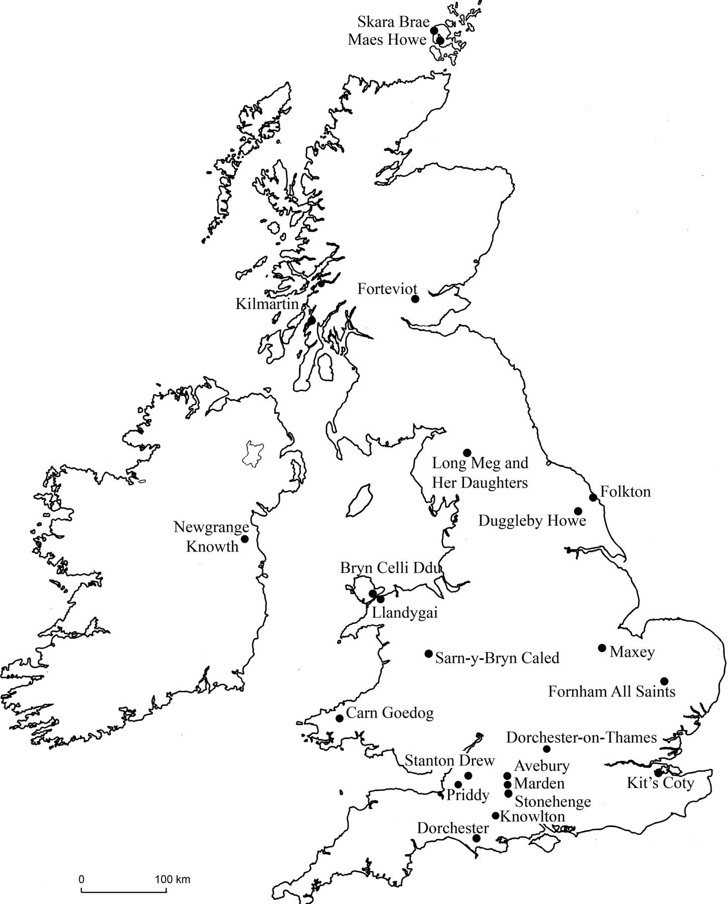
Archaeological sites in Britain and Ireland as well as across the Channel in continental Europe provide important comparisons and contrasts for Stonehenge and its landscape. Stonehenge and Durrington Walls together form one of five similar monument complexes located on the Wessex chalklands between the Thames valley and the south coast of England: the others are Avebury, Marden, Knowlton and Dorchester. These are among the largest of the more than fifty Neolithic complexes that have been found throughout Britain, from Orkney to Wales, East Anglia and southwest England (Figure 1.4). Other Neolithic sites consisting of smaller monuments or pits, spreads of artefacts and sometimes house foundations, number in the thousands.
The bluestones’ origins in west Wales reveal that the people of Stonehenge had longdistance links with communities hundreds of miles away. Strontium isotope analysis of the cremated remains of people buried at Stonehenge reveals that 40 per cent of them had not been living on the Wessex chalklands and were thus incomers to this area (Snoeck et al. 2018). Among the first to be buried at Stonehenge were people who had grown up on geology consistent with that found in Wales, so it seems likely that they came with the bluestones. Like Neolithic people buried in other parts of Britain, they experienced the short lifespan, poor dental hygiene and arthritic diseases that palaeopathologists have identified as characteristic of prehistoric societies.
As mentioned above, many of the pigs and cattle feasted on at Durrington Walls also had distant origins, brought here either on foot or by boat from many different regions of Britain (Evans et al. 2019; Madgwick et al. 2019; 2021). Similar patterns of longdistance procurement of animals have been identified at other great Wessex henge complexes, and statistical modelling of dates allows us to see the waxing and waning of popularity between these competing ceremonial centres. Stonehenge, with its unique architecture, may have been the most significant, but it was one among many and was eventually eclipsed by Avebury around 2400 bc when the huge artificial mound of Silbury Hill was built.
Studying prehistoric mobility and migration has been transformed by geneticists’ ability to extract ancient DNA from prehistoric skeletons. Recovery of sizeable proportions of whole genomes has enabled the research scientists to identify continentalscale movements of populations as well as localized patterns of genetic relatedness. The ancestors of the Neolithic farmers of Britain and Ireland, and thus the builders of Stonehenge Stages 1 and 2, had their origins in Anatolia and the Middle East – where farming began – and moved into Europe by way of the Mediterranean (Brace et al. 2019). By the time that Stonehenge Stage 3 was built, a new wave of migrants had settled in
Britain and, within sixteen generations, their descendants would largely replace the earliest farmers. These later arrivals are called the Beaker people, named after the very distinctive pots that they buried with their dead, and they had ancestries deriving from a mix of Continental Neolithic farmers and more distant migrants from the Pontic steppe east of the Black Sea (Olalde et al. 2018).
Figure 1.4 Location of Stonehenge and a selection of other Neolithic sites in Britain (drawn by Mike Parker Pearson).


