
https://ebookmass.com/product/geological-controls-for-gashydrates-and-unconventionals-1st-edition-sanjeev-rajput/

https://ebookmass.com/product/geological-controls-for-gashydrates-and-unconventionals-1st-edition-sanjeev-rajput/
https://ebookmass.com/product/ruthless-vow-flawless-book-6-roxysloane/
ebookmass.com

Baker Hughes, Kuala Lumpur, Malaysia
Council of Scientific and Industrial Research, New Delhi, India
Dr. Sanjeev Rajput is a Principal Advisor Geophysics, Oil and Gas Development with Baker Hughes, Malaysia and has 15 years of diverse experience in oil and gas industry. He obtained a B.Sc in Physics and Mathematics in 1998 from M.J.P. Rohilkhand University, India and a Master of Technology (M.Tech) in Applied Geophysics in 2001 from Kurukshetra University, Kurukshetra, India. In 2007, he graduated with a Ph.D. from Kurukshetra University, Kurukshetra, India, specializing in 4C seismic data analysis and quantitative interpretation. Sanjeev began his career as a Marine Geophysicist with CGG International before going for his post-doctorate fellowship with University of Texas at Austin, USA. As a Reservoir Geophysicist with Schlumberger in 2007 he was involved in Full Field Review, Mature Field development, and Quantitative Interpretation of Geophysical data. He joined CSIRO Australia in 2009 as a Senior Research Scientist and moved on as Principal Scientist. His consulting work was focused on geophysical data analysis and quantitative interpretation of oil and gas fields. Sanjeev joined Baker Hughes in 2013 in Kuala Lumpur, Malaysia. His work is primarily on Mature Oil and Gas field development, Unconventional hydrocarbon exploration and development, and Quantitative Interpretation and production enhancement. He is a member of SEG, EAGE, and SPE. He has authored more than 50 international publications.
Dr. Naresh Kumar Thakur Received his Masters in 1970 from Osmania University, Hyderabad, India and Ph.D. from Bombay University, Bombay in 1984. With more than 40 years of research experience in diversified geological and geophysical experimentations, he is presently focusing his research on unconventional hydrocarbon exploration. He has more than 70 peer reviewed papers and two US patents in his credit. He served as a member of United Nations Convention on the Law of the Sea (UNCLOS) and elect representative for five years.
The influence of science and technology on our everyday life and on our society as a whole is immense. Technology advancements are also helping us to generate new opportunities for innovation and growth. The petroleum industry has not remained untouched in this regard. Progressive development of energy resources and their conversion technologies has been bringing benefits to mankind since the mid-18th century, longer than almost any other scientific discipline. In the past decade or so, we have noticed some monumental changes to the energy landscape. Our ability to drill, extract, and produce hydrocarbons from different unconventional resources through technological innovations has played a major role in assisting us to access more affordable energy.
Geological Controls for Gas Hydrates and Unconventionals has been written to tell the story of unconventional hydrocarbon resources, especially: gas hydrates, tight gas, shale gas, liquid-rich shale, and shale oil to future generations. It is also a unique tribute to the scientific fraternity engaged in unravelling the intricacies associated with these complex resources. Every chapter abounds with the enthusiasm of the authors: my friend Sanjeev Rajput and Naresh Kumar Thakur, who manage to convey the intellectual fascination of unconventional oil and gas, along with their associated complexity and challenges in a very intriguing and visually appealing way. I strongly believe this book will become a cornerstone in the pursuit to augment our understanding of these unconventional hydrocarbon reservoirs.
Unconventional reservoirs have proven challenging, as these reservoirs are typically composed of complex geological systems of rocks, fluids, and organic material embedded in heterogeneous facies due to changes in stress, pressure, and temperature states over geological time. The authors have done a marvellous job to maintain an approach throughout the book that addresses some of these complex processes through simple descriptions and anecdotes. And we all know: simple is hard.
The book covers not only the geologic processes that give rise to these reservoirs but also describes how to better understand the rock properties through application of multidisciplinary techniques, as well as to address difficulties in understanding fluid flows in these play types. It then elaborates on the critical importance of characterizing the unconventional reservoirs, associated challenges in better understanding the reservoir performances, and how it impacts value creation through cost optimization during development of these resources. Moreover, the authors from their experience and knowledge also define a holistic approach that can be adopted for modeling such reservoirs. The book also highlights the operational part associated with unconventional resource development and ends with an incise insight on the way forward for the industry in this regard.
Blending geology, geophysics, geomechanics, petrophysics, and reservoir engineering, it explains, in simple language, the scientific concepts that are necessary for unconventional hydrocarbon-related studies. Although the emphasis of this book is on geological controls, it contains much that will be of interest to those outside this field and to the students of hydrocarbon resource exploration, development, and production; indeed to anyone with a fascination with the world of “Unconventionals.” In their approach, the authors have chosen major stages of an oil and gas field development project that includes discovery, data evaluation, full-field development, production, and abandonment, along with a vivid description on the worldwide occurrence of unconventional hydrocarbons.
We derived an unexpected amount of enjoyment in writing this book and we wish the readers to experience the same. We have had many adventures in science and all of them relied on the efforts of many talented people. We have been able to directly benefit from their wisdom, integrity, and creativity, and indirectly from the contributions of the generations of great scientists who came before them. We would like to express our gratitude to the many people who saw us through this book; to all those who provided support, talked things over, read, wrote, offered comments, allowed us to quote their remarks and assisted in the editing, proofreading and design.
This book quite literally would not have been possible without the unparalleled vision, ambition, encouragements and support of Mr. Martin S. Craighead, Chairman, Chief Executive Officer and President of Baker Hughes and Scott Reeves, President - Reservoir Development Services, Baker Hughes. It’s a privilege to learn under their leadership.
Very special thanks to Shikha and Arav for their unconditional love, prayers and good wishes throughout this project.
We would like to thank Marisa LaFleur, editorial project manager from Elsevier for design, continuous support at every stage of the project, and many fruitful suggestions. Without her this book would never find its way to the readers.
Similarly, we have once again been aided and abetted by Monica Ronghe, as an external editor, who in addition to her helpful edits contributed some valuable comments.
We thank S. Bordolai, M. Ring, Dr. Mohammed N. Alfaraj, Prof. Anand Joshi, and D. O. Timko for writing foreword for this book.
We express sincere thanks to Professor Dinesh Kumar, Professor S. S. Teotia, Dr. Nader Dutta, Dr. V. K. Gahalaut, John Tinnin, Jonathan E.F. Stearn and Ludovic Le Gurun for coaching and encouragements. We deeply value their guidance.
Although, we have been working on this project for some time, the spark of inspiration that helped us organize our thoughts and drafts into a book was provided by the ‘The Black Swan’ event of vanishing the concept of ‘Peak Oil’ and beginning of the era of “unconventional hydrocarbon resources driven economy’ in 2014.
Last and not least: we beg forgiveness of all those who have been with us over the course of the years and whose names we have failed to mention.”
Dr. Sanjeev Rajput and Dr. Naresh Kumar Thakur
“The sea is only the embodiment of a supernatural and wonderful existence.”
Jules Verne
The earth is one of the most dynamic elements in our planetary system, where landmasses are created and destroyed. In recent times it has been recognized that geological processes are far more dynamic and on a larger spatial scale than previously thought. Lithological, geochemical and physical properties distinguish the most fundamental elements: the continents and the oceans on the earth’s surface. The difference in elevation between the continents and the ocean floor reflects the fundamental difference between the densities (lithological properties) of the continental and oceanic crust and their isostatic response. The ocean floor is divided into three major topographic provinces: the continental margins, the ocean basin floor and the major oceanic ridges. In addition to these major features, secondary topographical features such as rises and plateaus tend to break up the oceans into separate basins. The maximum difference in elevation between the continent and the ocean floor occurs closer to the outer edge of the margin as mid-oceanic ridges occur in the central part of most oceans. The present seas, which cover about 71% of the earth’s surface, are relatively young features in the history of the earth. Their evolution is governed by the lithosphere, the outermost rigid part of the earth which is composed of several plates moving relative to each other. When the plates break up, melt from the interior arrives at the surface where it solidifies and gradually moves sideways, cools and subsides, forming new ocean floor by continuous steady state processes of seafloor spreading at the mid-oceanic ridges. The process
In contrast to the continental shelf, the continental slope is generally narrow in width, ranging from 10 to 100 km. Relatively steeper than the shelf, the slope angles down to the ocean basin at an average of 4°; in some areas, the angle may be as much as 25°. The steepness of a slope often reflects the steepness of the nearby coastal area. Slopes along mountainous coasts are steeper than those along flat coasts. In general, the steepest slopes tend to be found in the Pacific Ocean and the least steep ones in the Atlantic and Indian Oceans. Continental shelves and slopes, although covered by water, are part of the continental crust.
At the base of some continental slopes is a gently sloping, smooth-surfaced thick accumulation of sediment from land that has been transported to the shelf and then down the slope. This transition between the continental slope and the ocean basin is known as the continental rise and can be 100–1000 km wide. Some sources include the continental rise as being a major section of the continental margin, along with the shelf and the slope. Since it does not occur on all continental margins around the planet, it is best considered a characteristic of the margin in some areas. Continental rises are well developed around Antarctica and in the Atlantic and Indian Oceans but are hardly present in the Pacific Ocean.
The continental rise lies between the slope and deep ocean basin and varies in width from 100 to 1000 km with gentle gradients (1:100 to 1:700) and low local relief. Many margins do not have a continental rise for a variety of tectonic and depositional reasons. Although the continental rise is a geomorphic term it is really used to describe the depositional feature caused by the accumulation of sediments largely derived from continents and transported both down and along the slope. It also represents the geophysical characteristic of being the sediment apron at the base of a slope. The same processes that create the rise also create the abyssal plain seawards of the continental rise. Abyssal plains result from the pounding of turbidity current deposits in the last stages of deposition; only a small fraction of clastic sediments that reach the continental rise are carried forward and deposited on the adjacent abyssal plain. Even on the Atlantic-type margin, the simple configuration shelf slope and rise is relatively uncommon due to the presence of complex slope-associated areas of low gradient, which are referred to as “terraces” or “plateaus.” Also, margins may have poorly developed rises and sometimes are not characterized as having a rise. The total area of the continental rise is difficult to estimate but the area of this ocean margin may be equal to the total area of the continental slope. The sediment thickness of the continental rise is often so great that seismic systems are incapable of recording reflections from areas of the greatest sediment accumulations.
During the entire evolutionary process of the earth, continents have been evolving through geological time periods; five major episodes of clustering and fragmentation have been observed over this period. Continents episodically cluster together into a supercontinent and eventually break up with intense magmatic activity. Random motion of the continental blocks probably led to the cyclic formation of supercontinents every 350−400 Ma. During the present cycle, the breaking apart of the supercontinent of Pangaea was initiated during the Mesozoic Era (Early-Middle Jurassic) due to the episodic geodynamic event that began as early as 200 Ma. The emplacement of the largest known continental basalts accompanied the break up of Pangaea. Initially the supercontinent contained segments of passive margin from Northwest Africa to Northern Australia on a small segment on the eastern flank of the active oceanic subduction margin circumventing the remaining periphery of the continent (Fig. 1.2).
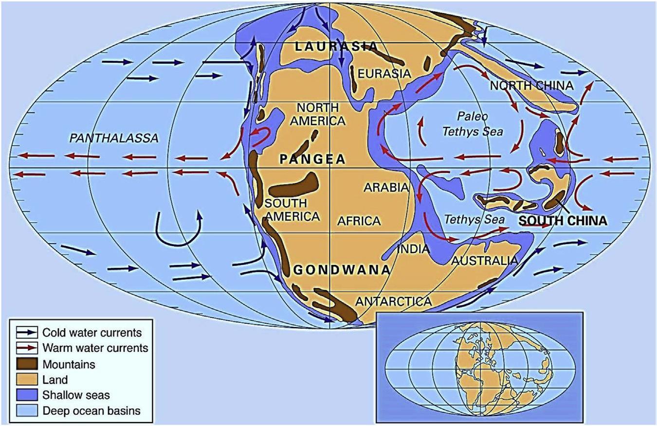
Distribution of landmasses, mountainous regions, shallow seas, and deep ocean basins during the early Triassic period. Included in the paleogeographic reconstruction are cold and warm ocean currents. The present day coastlines and tectonic boundaries of the configured continents are shown in the inset at the lower right. (Adapted from Scotese CR. The university of Texas at Arlington. http://www.britannica.com/media/full/604667/146753)
The history of the breaking apart of Pangaea is well documented. However, the mechanism of the breaking up of the supercontinent is still being debated. Most of the divergent continental margins evolved during the break up of Pangaea in the early Mesozoic Era (Dietz and Holden, 1970). It is not fully understood whether the mantle convection source (Anderson, 1994; Coltice et al., 2007) or mantle plume heat source (Morgan, 1983) was responsible for separating the constituents of the supercontinent or whether the excessive thickening of the upper rigid part of the lithosphere was responsible for its instability and subsequent breaking into different segments along the weak zones. Vink et al. (1984) suggested that the lithosphere becomes progressively weaker as the crust thickens and some rifting is undoubtedly associated with a thick crust (Morgan and Burke, 1985). Thermomechanical processes govern rifting and subsequent breaking up of continents. Owing to the differences in rheological and thermal properties in the earth’s subsurface, the continental and oceanic lithospheres exhibit different deformational responses to applied stresses. The continental parts, being more rigid, are not easily deformed. Owing to their thickness continents preclude heat diffusion thus making the continental lithosphere weaker and susceptible to rupture. The mobile belts (young orogeny/suture zones) surrounding the rigid continental part have lower mechanical strength and are likely to deform when stresses are applied. These zones retain the memory of old active faults for longer periods of time and are most suitable for deformation and breaking apart. Weakened mechanical strength over the preexisting crustal discontinuities plays a major role in the localization and distribution of crustal strain, leading to deformation (Corti et al., 2003). Preexisting mechanically weak zones in the lithosphere may emerge as a “diffuse plate boundary,” to constitute zones of deformation with lateral dimensions on the
1.4
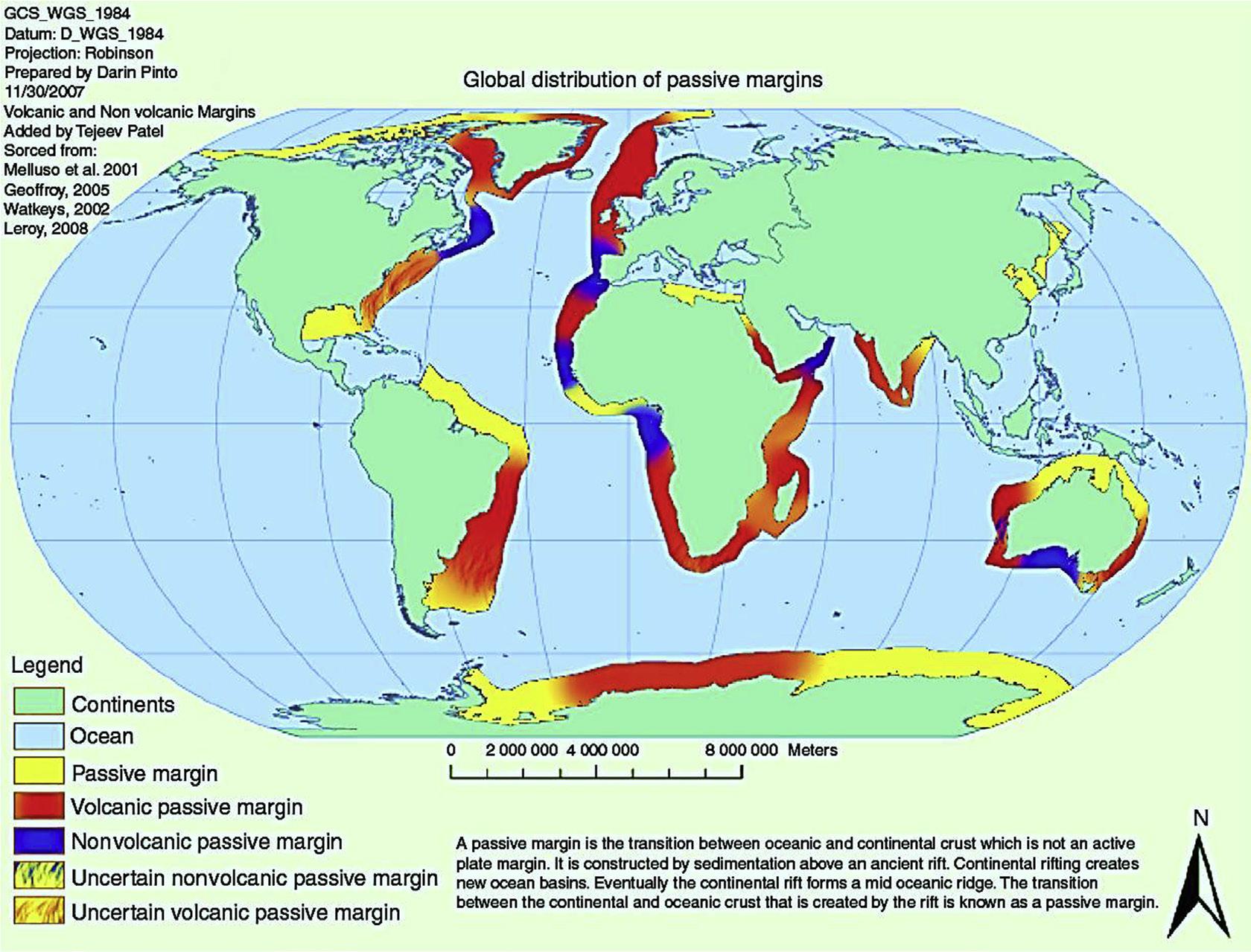
Global distribution of nonvolcanic and volcanic passive margins of the world. About 70% of the world’s passive margins are characterized as volcanic passive margins. (From http://commons.wikimedia.org/wiki/File:Globald.png)
strength (Kusznir and Park, 1987). The strength of the continental lithosphere decreases in the presence of weak zones (old faulting) and increases in volatile content in the mantle and increased lateral heterogeneity within the crust (Meissner, 1986; Pollack, 1986; Dewey, 1986).
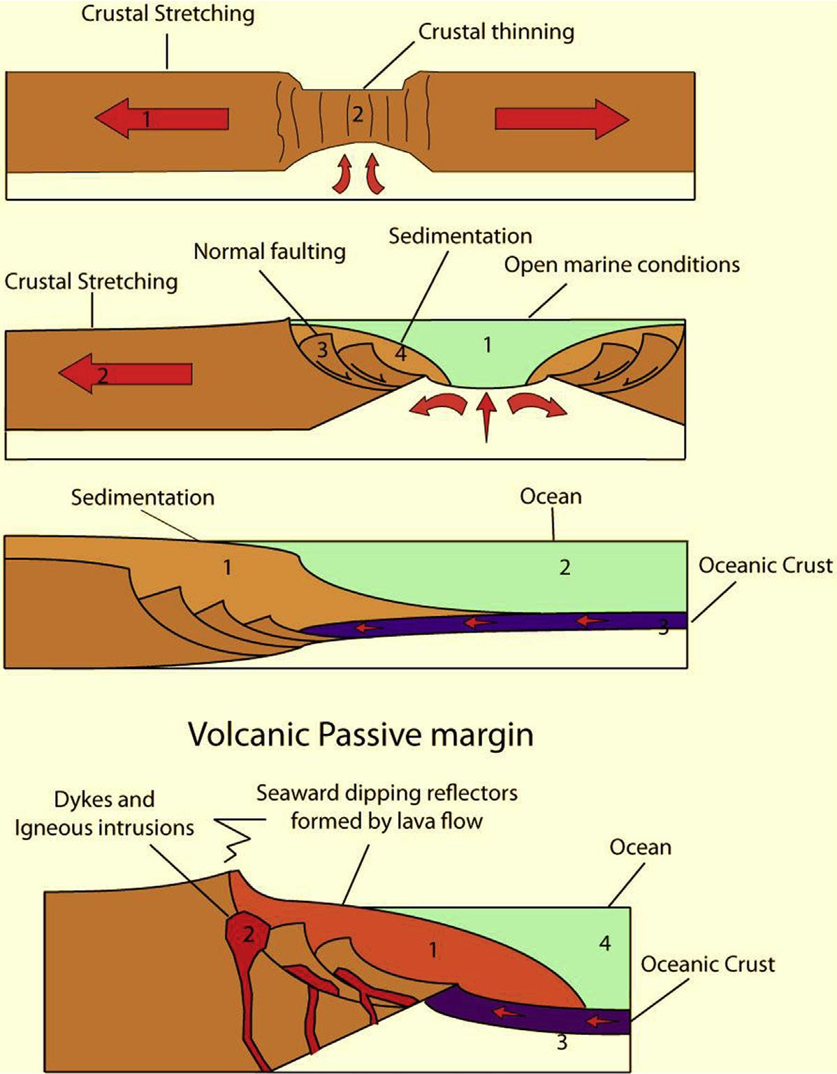
Intracontinental rifts evolve into continental margins when two segments across the rift are subjected to extensional forces leading to seafloor spreading and the creation of new oceanic floor and a new plate boundary (Symonds et al., 2002). The continental margin marks the zone where active divergent plate tectonics commences and the ocean begins to grow. Evolution of continental margins can be classified into three primary stages sometimes referred to as the initial (preexisting weak zone, rifting, subduction), youth (rupture and breakage) and maturity (subsidence, erosion, deposition) stages (Kennettt, 1982). Thus the margins may reflect the complex sequence of geological events caused by the
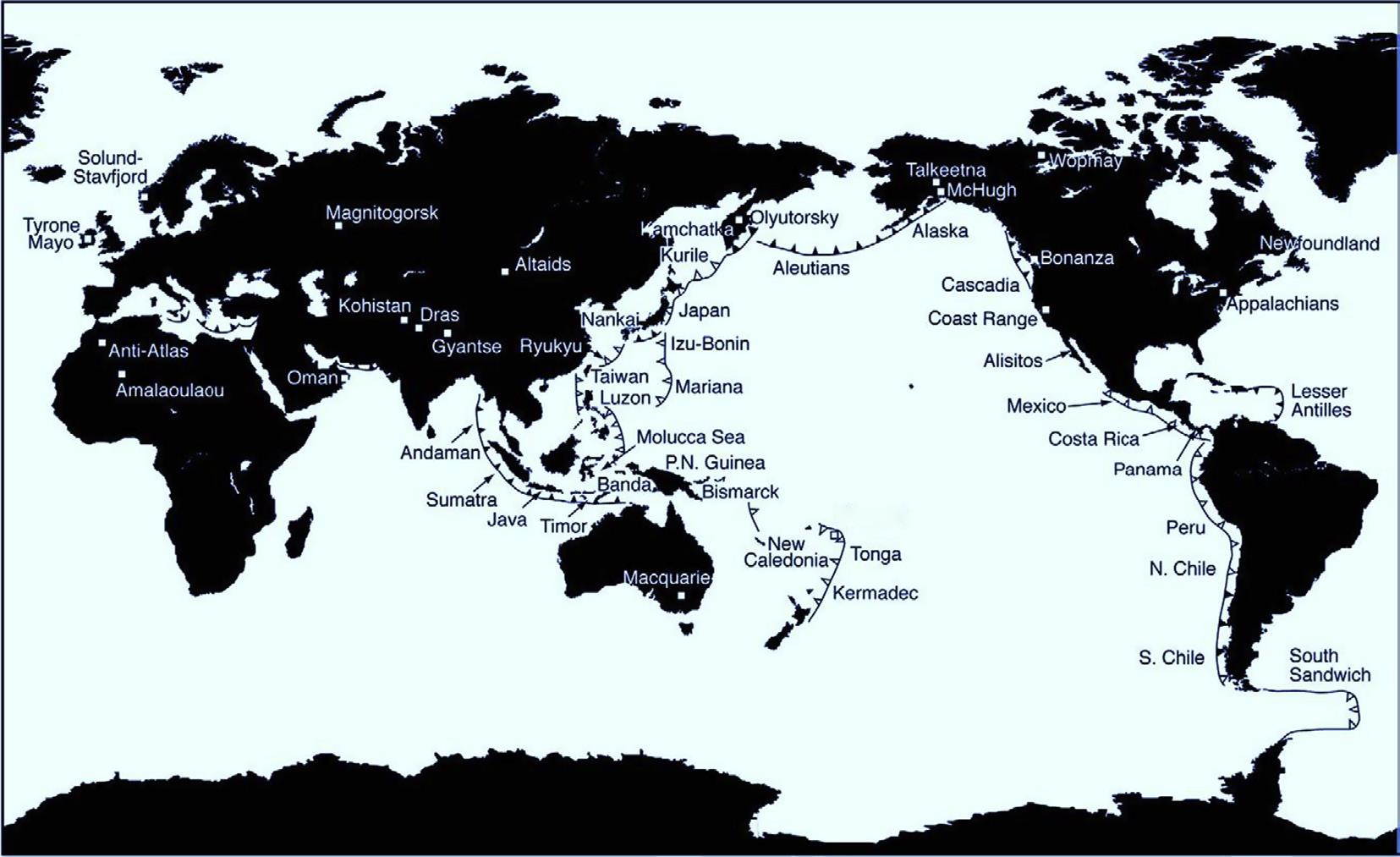
FIGURE 1.5
Map showing active global subduction zones and the ancient arc systems referenced in the text. Accretionary plate margins are shown with solid triangular marks along the plate boundary, and tectonically erosive margins are indicated by open triangles. (From Draut and Clift, 2013.)
interacting magmatic, tectonic and depositional processes (Eldholm and Tsikalas, 2004). Divergent continental margins undergo predominantly vertical tectonic development. Plate tectonics emphasizes horizontal movement of the lithosphere which also induce vertical movement due to changes in thickness and thermal character (geothermal gradients) of the crust.
The continental rifting process is usually the first event (initial stage) in the formation of a major ocean basin. Lithospheric extension due to the extensional stresses at the plate edges precedes rifting in about 20–25 Ma. Preexisting weak zones and episodes of previous extensions undergone by the plate are characteristic of each continental margin. Two types of models have been proposed to explain the rifting process. In passive rifting, the extension forces at the plate edges result in thinning of the lithosphere and passive upwelling of the asthenosphere (Fig. 1.6). Passive upwelling brings mantle material into a lower temperature or/ pressure regime resulting in partial melting (Foucher et al., 1982). The melt is spread under the stretched continental crust (underplating) and preserved as thin plutonic crust. New ocean floor is generated at the diverging boundary, and the edges of the now-split continents get farther apart. The now fully developed mid-ocean ridge is the site of hot new ocean floor, and so it floats high on the asthenosphere beneath. Divergent margins include both the shallow water deposition on the continental shelf and the deep water deposition on the continental rise below.
In the active mode of rifting, the thermal upwelling of the asthenosphere induces tensional stresses in the crust leading to rifting (Spohn and Schubert, 1983). In fact, both types of margins appear similar
processes (Holbrook and Keleman, 1993; King and Anderson, 1995). The amount of melt generated by passive stretching and thinning of the lithosphere during the rifting is significantly lower when compared to models for volcanic margins. Seismic studies suggest that transition from continental to oceanic crust is abrupt in the case of volcanic margins. Lateral temperature differences in the lithosphere evoked by the rifting and upwelling of the asthenosphere drive convection in the upper mantle (Mutter et al., 1988), which transports a large volume of igneous material into the crust making the igneous crust thicker, as seen in many volcanic margins like Iceland.
Rifts are considered unequally deep all along their length as continental crust gets thinner on a series of subplanar listric faults with a throw of several kilometers. Active rift zones are initially elevated above the sea level; syn-rift sediments are continental or lagoonal and strongly influenced by syn-rift volcanism.
Volcanic arc volcanic margins are associated with high-velocity (7.2–7.7 km/s), thicker, lower crust, seaward dipping reflectors and volcanic activity (Vøring Plateau). The extrusive magmatic bodies overlying intrusive bodies are identified in the geophysical signature as seaward dipping reflectors and are suggestive of extensive volcanism. In some regions this geophysical signature is found to be missing, even in cases of extensive magmatism. The Great African Rift, the Rhine Valley Graben and the Rio Grande Rift are believed to exemplify this basic rifting process, which sometimes leads to formation of an ocean.
Continental rifting is followed by plate separation (break up) and onset of seafloor spreading. The youthful stages of margin formation relate to the breaking up of the continent and spreading of the continental blocks, presently preserved in the Red Sea, and last about 50 Ma (Kennett, 1982). Little is known about the character of changes from rifting to spreading phases. The timing of transition from the rifting phase to spreading phase is not spontaneous, may take millions of years and may differ from margin to margin. The most recent period of rifting and the break up event is accompanied by magmatic activity manifested by intrusion or extrusion in the crust and volcanic eruption at the surface. The intensity and volume of magma production may vary between margins and individual margin segments. The volume of magmatism varies from a thin plutonic layer to a 20-km-thick layer. Following the rifting, mafic magma intrudes the continental crust as dyke swarms; sills and oceanic crust begin to accrete at the edges of the separate blocks. The magma penetration and thermal erosion of the lower part of the adjoining continental lithosphere results in its thinning and attenuation (Fig. 1.8).
Overlapping and underlapping (intermixing) of the continental crust and the oceanic crust causes their physical characteristics to change and makes them hybrids, leading to the formation of quasicontinental crust. The modified continental crust constitutes a high-velocity underplated magmatic layer at its base. With intense melt production in the process of volcanic rifting, the underplated magmatic layer is considerably thicker when compared to nonvolcanic margins where melt generation is substantially lower.
Kinsman (1975) suggested that the width of the attenuated continental crust seaward of the rift shoulder (rim) is relatively narrow (60–80 km) and others have suggested that larger attenuated margins are common (Lister et al., 1986). Further seaward, the intrusion rather than the extrusion of basaltic magma under the high rate of sedimentation results in the quasi-oceanic layer (Keen and Beaumont, 1990). It is suggested that this part of the crust is formed by subaerial lava flow on the thinned continental crust and might have evolved during the early phase of seafloor spreading (Mutter et al., 1982). The region is characterized by lower crustal thickness with thinning of the magmatic layer and seaward dipping reflectors in the upper part. This region is limited on the seaward side by uncontaminated
1.8
Development of passive continental margin after the initial phase of rifting. (1) In the first stage a continental rift is established due to stretching and thinning of the crust and lithosphere by plate movement. (2) Second stage leads to the formation of an oceanic basin. (3) The last stage of formation happens only when crustal stretching ceases and transitional crust and lithosphere subsides as a result of thermal subsidence. (From https://en.wikipedia.org/wiki/passive_margin)
oceanic crust. Rift shoulders persist until the decay of diffused extension of the lithosphere and the shoulders subside below sea level once extension ceases; this is the culmination of the proto-oceanic phase. Accretion of oceanic crust to the continental crust may form the initial phase of the continent breaking and spreading. The imprint of break-up volcanism is presently buried by the thick sedimentary sequence and observed along many passive margins.
The change from rifting to accretion marks a major change in the thermal regime of the margin. Thermal contraction of the lithosphere leads to its subsidence. During rifting, the heat source remains beneath the rift axis but the continental margin becomes successively remote from the heat source allowing it to cool and subside (maturity stage). The initial line of spreading is not necessarily located within the zone of initial rifting. The continuous thermal subsidence increases the rigidity of the oceanic crust resulting in flexural bending of the continental and young oceanic crust. The onset of breaking coincides with combining of the quasi-continental and quasi-oceanic to regulate formation of the transition crust underlying the subsiding continental crust. Erosion of the uplifted shoulder leads to sedimentation at the flanks of the rift valley. A zone of syn-rift sediments are deposited into the rift system prior to its break up and is overlain by a broad zone of post rift and post break-up sediments deposited following the initiation of seafloor spreading. The rate of thermal subsidence declines with time as the margins become remote from the spreading ridge. The formation of continental terraces and rises are direct consequences of continental rifting (Bond et al., 1995). The modified shape of the continental margin following the rifting and breakup is primarily controlled by sedimentation and sea level oscillations. Sedimentation of the terrace and rise begins after rifting and commencement of seafloor spreading. Pitman (1978) modeled the seawards thickening of the sedimentary wedge of the shelf and slope (terrace) forms in response to the combined effect of tilting along the hinge line (slope–slope transition). Repeated sea-level advances and retreats or transgression and regression have been instrumental in shaping continental shelves especially during the low-sea-level stands when the shelf is exposed to subaerial processes. The shelf would be closer to the shoreline during periods of sea level fall (glaciations) or in the area of high sedimentation. These cyclic patterns have been very effective in producing flat surfaces on the shelves coinciding with deposition of alluvium, and this coincided with the late Cenozoic glacial maximum epoch. Erosion became the dominant process over the surface of the shelf. The broad flat characteristic of the shelf has resulted from erosional activity related to transgression and regression. Both erosion and sedimentation are concentrated in the near shore areas and repeated sea level migrations have leveled the margin forming the present-day shelf surface.
As sedimentation proceeds the troughs and tectonic basins formed as a result of the faulting fill up. The onward distribution of sediments is restricted by barriers created by the marginal basement high, coral reefs and diapirs. The progressive seaward tilting of the continental edge and flexural bending of the lithosphere under the growing sedimentary load may lead to further subsidence and sediment deposition. Further seaward with the increase in relief due to tilting, most of the sediments are deposited in the slope, ie, towards the seaward side of the terrace, where the sediment deposition could be the thickest. A continental rise is a broad wedge-shaped apron where the sediment thickness tapers off towards the abyssal plane. Most of the rise is covered with sediment deposition due to turbidity currents but final distribution deposition may be due to contour currents (Kennett, 1982). At this stage, terrace (shelf slope) and rise morphology is mostly developed.
The sediment deposition pattern on the rifted continental margin depends on the geology of the hinterland and the erosion processes. Large river systems transport sediment loads several kilometers into the ocean, leading to the formation of submarine levees. When the sediment deposition is faster and overcome subsidence and the removal of deposits by offshore drift leads to formation of progradation deltas front occurs. Delta formation is more common or well developed in semienclosed or enclosed sea regions (Kennett, 1982). During the low sea level stand, rivers will incise the convex up topography creating channels through which the turbidity currents feed voluminous sediment to the submarine fan
seawards over the oceanic crust and older pelagic sediments. Most of the major rivers such as Ganges, Amazon erode elevated continental landmass and transport the sediments loads to deeper parts of the sea, thereby producing submarine fans, which are characterized by high sediment thicknesses.
Plate tectonic forces drive continental plates to diverge or converge leading to creation or destruction of land masses at the plate edges or boundaries. Divergent margins develop as consequences of the extensional stresses whereas compression dominates the processes in the formation of convergent margins. When two plates converge, the surface expression on the ocean floor is deep-sea trenches. Unlike divergent margins, the convergent margins and adjacent seafloor belong to different tectonic plates. When two plates with different physical or geological characteristics interact the result is their deformation and consumption by convergent processes. The various types of convergent plate boundaries are sometimes defined as active or seismic margins because they are often marked by shallow to deep earthquake as well as volcanism, crustal deformation and metamorphism. They form much of the margin around the Pacific Ocean as well as parts of the southern Atlantic Ocean, the Northeast Indian Ocean and the Southwest Pacific region. Convergent margins are sites of subduction (the consumption of one segment of lithosphere beneath another adjacent segment) of the ocean and continental crust characterized by deep-sea trenches at their seaward (forearc) margin. Most of them have a volcanic arc and many have rifted backarc basins behind the volcanic arc. A variety of crustal interactions may occur resulting in the complex, structural configuration of the convergent margin (Fig. 1.9).
Depending on the density contrast and morphological configuration, one of the incoming plates is tectonically inserted or subducted under the other plate, which mostly has a terrestrial crust.
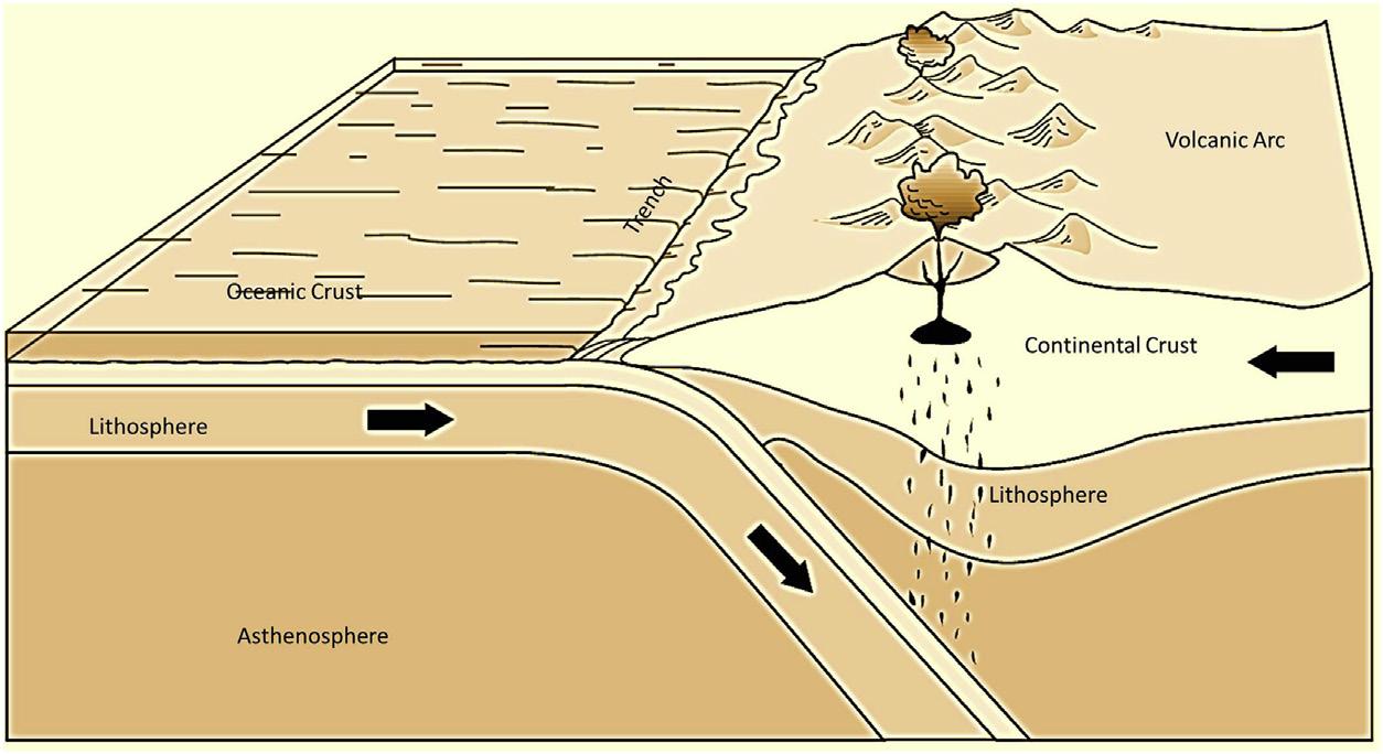
FIGURE 1.9
Figure shows that oceanic lithosphere is being subducted beneath the edge of a continent. The sediments from the ocean floor and pieces of the oceanic crust are scraped from the descending oceanic plate and plastered against the edge of the overriding continent. (From united States Geological Survey.)
Nankai and Makran, are choked with terrigenous sediments, and are shallow (3000–5000 m) and wide (>10 km). Accretionary trenches with less terrigenous sediment deposition, such as the Northern Chilean and Peru trenches, have intermediate depths of 5000 to 7000 m and widths of 5–10 km.
Forearc regions adjacent to the continents generally have significant sediment fill in the trench or in the incoming oceanic plate and exhibit large, wedge-shaped bodies that have been accreted. The overall width of forearc regions between the volcanic arc and the trench can be greater than 300 km. The entire forearc basin should be considered part of the continental shelf (or slope or rise) on the basis of sediment thickness, basement type and morphology. Although most of the oceanic lithosphere is subducted into the mantle, large components of sedimentary cover and fragments of the basement high in the down-going plate are retained in the crust by mechanical transfer to the overriding plate (Underwood and Moore, 1995). In most cases, the ocean plate sediments are dominated by pelagic ooze and hemipelagic mud of the abyssal plain, although turbidites and submarine fan deposits are also possible. Normally the abyssal plain deposits are subsequentlyburied by the considerable thickness of terrigenous trench wedge turbidites as the down-going plate enters the subduction zone.
Accretion is the process in which material from the outer plate and trench (during the periods of discontinuous subduction) is removed and added to the outer continental margin or by other mechanisms such as imbricate thrusting or a combination of folding and thrusting (Karig, 1974; Karig and Sherman, 1975). Between the zone of uplift (frontal arc) and the trench axis is a 50- to 400-km-wide accretionary prism or the arc trench gap. The accretionary prism is made up of arcward-dipping, wedgeshaped, thrust-bound packets characterized internally by complex, trench-verging folds (Kennett, 1982). A well-developed accretionary prism is called an accretionary trench system, whereas those that lack a prism are called nonaccretionary trench systems. Davis and Hyndman (1989) infer that some of the truly massive accretionary bodies may have achieved their exceptional size because of factors that favor the efficient scrapping off of the subducting plate operating at these margins, for example, slow rate of convergence speeds and thick (2–6 km plus) incoming section of relatively coarse-grained (silty and sandy) terrigenous beds. The prism typically grows in width as successive increments are added by underthrusting at the trench, but it also increases in height because of compression to become a positive feature such as an island chain or uplands such as the Mentawai Islands off Sumatra and Middleton Island off Aleutian. Uyeda and Kanamori (1979) suggested that tectonic-controlled prisms are well developed when the trench lies in the vicinity of a continent (such as Chile) providing proper mechanical coupling between the upper and lower plates. In contrast, the prisms are not well developed when the trench interacts with the island arcs (Mariana).
In some cases, such as eastern Japan, where there is subsidence of the accretionary prism rather than uplift, the operating mechanism for such a configuration may be quite different. The accretionary prism displays rugged and irregular seafloor morphology due to the complex pattern of folding and faulting creating tectonic ridge-like features. The slopes of the accretionary prism (Fig. 1.10) are usually low and contain small basins near the toe of the slope (trench slope basin) that are filled with slope sediments. The inner slope (landward trench slope) of the trench is a major feature of the forearc system and its morphology reflects the subduction and accretionary processes. The shape and internal structure of the prism are also influenced by the geometry of its backstop (buttress), which is formed by the edge of the rifted continent or the older compacted accretionary body (Byrne et al., 1993) dipping towards the trench (Silver et al., 1985; Westbrook et al., 1988). The prism may be simple as in the case of oceanic regions of low sedimentation, such as the Mariana and Tonga arc, or may be subdivided into the upper and seaward lower (inner slope) trench slope. These two slopes are separated by