Dedications
KristaMerry:ForPhil.Thankyouforyourpatience.
PeteBettinger:ToKelly.
MichaelCrosby:Foragrandfatherthattoldmefromaveryearlyagetolearncomputers.To amazingparentsthatencouragedmetogotoschoolandforgottotellmetostop.ForMemaw andourSaturdayconversations.Inmemoryoffamilyandfriendswhohavegoneon.Tomy brothers,sisters,aunts,uncles,cousins,andfriendsthatremindmemysupportnetworkis legion.Tomycolleaguesthatletmeworkwiththemonverycoolandexcitingprojects.For LaurenandAidanthatpushmetopushmyselfineveryaspectoflife.ToeveryteacherI’ve everhad,withaspecialdedicationtoMrs.KathySmithafourthgradeteacherinEllisville,MS, thatsaidI’dwriteabooksomeday(thisismaybenotwhatyoumeantbutI’veneverforgotten thatearlyfaithinme).Tothestudentsthathavesufferedmyattemptsinhoningthecraftof teachingandthosethatmightbenefitfromthisworkintothefuture.Thankyouall,thisisfor allofyou.
Preface
Geographicinformationsystems(GIS)arepowerfultoolscomprisedofhardwareandsoftwarecomponentsthatallowforthecollection,visualization,andanalysisofspatialdata.GIS iscommonlyusedbyforestryandnaturalresourcemanagementprofessionalstoanswer questionsaboutlandscapechanges,wildlife,recreation,water,andanythingwitha geographiclocationontheEarth.Usingspatialdatabases,suchasvectorandrasterdata models,GIScananswerquestionsincluding Whereisthebestlocationforanewtrail?How closeisthissilviculturetreatmenttoananimalden?Whatproportionofthisstandfallswithin astreamsidemanagementzone? andmanyothers.Further,GISallowsforthecreationof maps,theintroductionofremotelysenseddataintoanalysis,andtheimplementationof spatialanalysisusingspatialdatabases.
KristaMerrywasfirstintroducedtoGISduringherundergraduateeducationingeography.SoftwarethatallowedforGISprocessingincludedabasicgraphicaluserinterface (GUI)butcommonlyrequiredworkingwithinthecommandlineforcertainprocessing features.FollowingthefrustrationofworkingwithearlyGISsoftwareprograms,shesworeoff makingGISthefocusofhereducationalandcareerpursuits.However,laterexposureto remotesensingandadvancedGISprocessing,alongwithimprovementsincommercialGIS software,illustratedtoherhowGISis,atitscore,aproblemsolvingtool.GISbroughttogether herabilitytounderstandandvisualizespatialrelationshipswiththeuseofGISdatabasesto answerquestions.Now,herinterestsfocusonprojectsusingGIStomodellandcoverchange acrossvariouslandscapes,identifypotentialforestedareasimpactedbyhurricanes,assess accuracyofsmartphoneGPSreceivers,andothers.
PeteBettingerwasintroducedtoGISinthe1980s,whenthe oldform ofGISwas prevalent.Inthissystem,apersondrewamapbyhandandthenassociatedfeaturesonthe mapwithatabular(printed)reportthatcontainedforeststandconditions(volumes,densities,etc.)thatweredevelopedwiththeassistanceofacalculator.Overthenextdecade,he gainedfirst-handexperienceintheimplementationofGISinforestry,asforestorganizations attemptedtodevelopbothcentralizedanddistributedGISprograms.Inthelate1990s,he begantoteachGIStoforestrystudents,knowingthatitwouldbecomeastandardskillneeded bynaturalresourcemanagementprofessionalswhichcouldincreaseboththeaccuracyand efficiencyofforestmanagementendeavors.Today,hecontinuestouseGISforanumberof purposesmainlyinvolvinginstructiontoresearch,andinmanycaseshisstudentsandcolleaguesareteachinghimnewwaystousethetechnology.
KevinBostonhasbeenusingGISsincethemid-1980sinavarietyofforestryandnatural resourcesprojectsincorporatingGISintoconservationandproductionmanagementprojects fromaroundtheworld.GIShasbeentheinformationcoreforsolvingtheseproblemsasit maintainsspatialandnonspatialdata.Hefindsitusefulfordisplayingboththeproblemsand possiblesolutionsthatleadtodiscussionsandimprovementsinthedecisionmakingprocessesthatsupportimprovednaturalresourcemanagement.
MichaelCrosbyserendipitous,yetfrustrating,introductiontoGISinthespringof2005. Sparingthereaderhumorousandhead-scratchinganecdotes,hehadapatientprofessorand labinstructornavigatingEsri’sArcView3andArcGISsomewhereinthe8.2releaseofthe
software.Inthesummerof2005,hefoundhimselfworkingattheNavalOceanographicOffice andwasallowedtoworkonincorporatingGISintooceanmodelingandmappingefforts.It washerehebegantolearnmoreaboutremotesensingcapabilitiesandapplicationsand continuedhisgraduateeducationinforestrybeginningin2007.Therehelearnedtoapply spatialtechnologiestoforestinventorydesignandanalysisandtransitionedintomodeling impactsofextremeweathereventsonforestedecosystems.Hecontinueshiseducationtoday teachingandlearningfromstudentsandincorporatinghigh-resolutiondatasetsintotreeand forestecosystemassessmentandchange.
GISisarapidlychangingdisciplineadvancingfromsimplymakingamaporviewingan imagetotheincorporationofnewer,finerresolutionsourcesofspatialinformationthatallow forthedevelopmentofthree-dimensionalmodelsoflandscapefeaturesorthecreationofGIS databasessimplyusinganapplication(app)onasmartphone.Theseadvances,alongwiththe valueofestablishedGISprocesses,makeGISadynamicfieldthatisimportantforearlycareer orseasonedprofessionalsinforestryandnaturalresourcestohavecomprehensiveknowledge ofandbasicskillsetstoimplementanalysisinaGISenvironment.
ThisbookseekstointroducereaderstoseveralaspectsofGISincludingcomponentsof GISandspatialanalysis,GISdatamodelsandtypesofgeographicdata,coordinatesystems andtheroleofreferencesystemsinGIS,mapping,creating,collecting,andmanagingGIS data,processingdifferentGISdatamodels,remotesensing,andprofessionalethicsand practicesassociatedwiththeuseofGIS.Additionally,weprovideseveralcasestudiesthat focusonhowGIScanbeusedtoanswerquestionsinanaturalresourcescontext.Through discussionofthesetopics,wehopetoencouragereaderstothinkpastbasicGISconceptsand considermoredeeplythefunctionalityandimplicationsassociatedwithGISandGIS processes.
Wehopetoengagereadersandinspiremorein-depthconsiderationoftopicspresented inthisbookthroughexercisesdistributedacrosseachchapterreferredtoas“reflections, diversions,inspections,andtranslations.” Reflections encouragereaderstothinkaboutideas orconcepts,usuallyfromapersonalperspective,andtoorganizetheirthoughtsintoa cohesive,shortsummary.Forexample,fromChapter2wefindthisreflection:
Reflection2.1
ImaginethatyouhaverecentlybeenhiredasaforesterfortheU.S.ForestService,andthat youwillworkontheOcalaNationalForestinFlorida.WhattypesofGISdatabaseswouldthe foresthave,orcouldtheforestdevelop,thatwouldrequiretheuseofpointdata?
Diversions askreaderstotakeabreakfromreadingthebookandusecriticalthinkingto solveaproblem.Thesemaybeassimpleasabasicspatialanalysisquestion.Forexample, readersmaybeencouragedtoorganizedataanddeterminetheappropriatespatialanalysis processtofindasolution.Often,thepurposeofadiversionistodevelopaplanforanswering aquestion.Asanexampleofadiversion,theonenotedbelowcanbefoundinChapter5.
Diversion5.4
Useyourcellularphoneandanapplication(app)suchasAvenzaMapstomarkthelocation ofafewtreesoutsideyourhomeoroffice.FindawaytosavethesepointpositionsasaGIS databasethatcanbeopenedinGISsoftwareorGoogleEarth.Ingeneralterms,howaccurate (spatially)arethepointsthatrepresentthetrees?
Inspections encouragereaderstoanalyzeaGISdatabaseoraresultofaspatialanalysis functionandassessitsquality.Withinspections,wedirectreaderstomorespecificdatabases ormapsavailablethroughtheInternet,includingonthisbook’swebsite(gis-book.uga.edu). Inspectionsencouragereaderstocompareconceptspresentedinthebooktoreal-world applications.AnexampleofaninspectionfromChapter3involvesaccessingacommon typeofmapusedintheUnitedStates.
Inspection3.3
AccessthePlacitas(NewMexico)quadranglemapthatisavailableonthebook’swebsite (gis-book.uga.edu).Alternatively,thismapcanbeaccessedthroughtopoView,aservice hostedbytheUSGS.ThePlacitasareaisnortheastofAlbuquerque.Inwhichtownshipand section,wouldyoufind RanchosdePlacitas?
Thepurposeofa translation istothinkabouthypotheticalsituationsreadersmay encounterafterbeingprovidedwithbackgroundonaspecificsubjectinthetext.For example,readersmightbeaskedtoconciselydescribeaGISprocesstoapersonintheirlife whohaslittletonounderstandingofthetopic.Forexample,fromChapter7,wefindthis translationexercise:
Translation7.1
ImagineyouareexplainingGIStoyourparentsorsiblings.Ingeneralterms,describefor themtheconceptof selectingfeatures,andthevariouswaysthatthiscanbeaccomplished.
GeneralGISandGISanalysistopicsareimportantindevelopingknowledgeandskills forthelifelonguseofGIS.Manyareincorporatedintothisbook.Ourgoalistopromoteskills andanalyticalcapabilitiesinthereadersofthisbook.Throughthetopicspresentedacrossthe elevenchapters,wehopetoimprovethereader’sabilitytounderstandGISdatasources, identifyGISdatatypesandquality,performcommonspatialanalysisprocesses,createGIS databases,produceamap,anddeveloptheskillsnecessarytouseGIStoanalyzereal-world questionsrelatedtoforestryandnaturalresources.
Geographicinformationsystems
Introduction
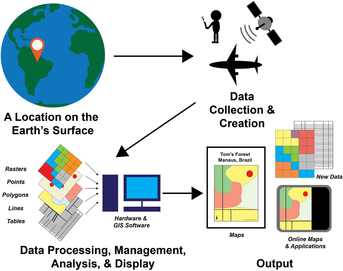
Ageographicinformationsystem(GIS),initsmostbasicsense,isacomputermapping programthatintegratesspatialdata(points,lines,polygons,gridcellsthathavea geographicassignment)andtabulardata(numbers,text,codesthatdescribethefeatures)andallowssophisticatedgeographicalanalysestooccur.ThepowerofaGISrests inthefactthatitcanbeusedformanymorepurposesthantosimplymakeamap.More broadly,aGISisanentityforcollecting,managing,analyzing,anddisplayinggeographic information(Fig.1.1).AGISis geographic inthesensethattheworkoneconductswithit generallyrelatestoplacesofinterest,whetheronEarth,onMars,underwater,orinside thehumanbrain.Iftheplacesofinterestcanbeassociatedwithacoordinatesystem, thoserulesfordefiningthepositionsofthings,thentheyaregeographicinnature.AGIS allowsonetomakeaconnectionbetweenphysicallydrawnfeaturesandtheirassociated attributes,andthisfacilitatesthedevelopmentofknowledgeabouttheshape,size, location,andcharacterofthephysicallydrawnfeatures.Thisinformationcanbeofgreat valueinunderstandingtheconditionofthelandscapeorwaterbodytowhichthedata refers.AGISisconsidereda system becauseitiscollectivelyagroupofitems(hardware andsoftware)thatformanorganizedentity.Aswasnotedinthethirdsentenceofthis chapter,formaldefinitionsofGISoftensuggestthattheyarecapableofgathering, organizing,andstoringdata,thattheyprovidetheopportunityforpeopletomanipulate andmanagethisdata,thattheyhavegreatcapacityforcomplexanalysis,andthatthey physicallyconsistofthenecessaryhardware,software,people(humancapital),and communicationprocessestoaccomplishsomeofthemostsophisticatedgeographical analysesonecouldimagine(Bolstad,2012; JensenandJensen,2013; Chang,2019).A synthesizedcombinationoftheseideasformsaworkingdefinitionofGISasasystem thatallowsfortheorganization,management,analysis,andvisualizationofspatialdata. InsearchingwidelyforpublishedworksonGIS,onemayfindinstanceswhen geographic informationsystems and geographicinformationsciences areusedsynonymously. However,geographicinformationsciencesfocusontheoreticaladvancesinthefield madethroughnovelacademicresearchandindustrialapplications(Yuan,2017; Goodchild,2018).Therefore,forthepurposesofthisbook,theseconceptswillbetreated asseparateideas.Here,weconcentratemainlyonthecomputer-basedmethodsand meanstostore,access,analyze,manipulate,andvisualizespatialandnonspatialdata (Fig.1.2),orbasic geographicinformationsystems. GeographicInformationSystemSkillsforForestersandNaturalResourceManagers. https://doi.org/10.1016/B978-0-323-90519-0.00007-8
Copyright © 2023ElsevierInc.Allrightsreserved.
FIGURE1.1 ThegeneralprocessesassociatedwithcreatingGISdatabasesandmapsthatdescribealocationon Earth.
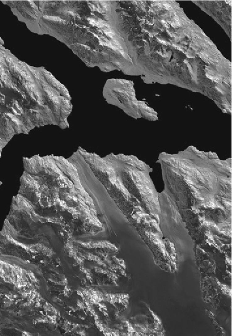
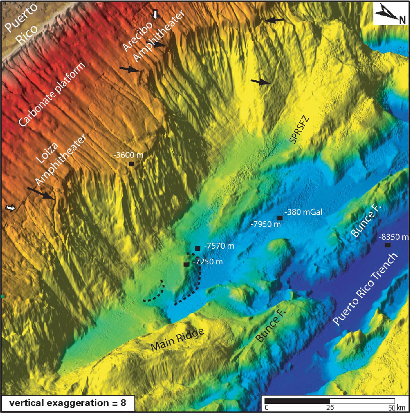
WhenGISisusedforforestryandnaturalresourcemanagementpurposes,itinherentlyinvolvesmappingelementsoflandscapesandwaterbodies.Thesefeaturescould includestreams,inventoryplots,wildlifehabitatpatches,recreationareas,ortimber stands,andtheyallarereferencedtoaplaceonEarth.Perhapsaerialorsatelliteimagery assistinthedevelopmentofdatabasesandinthetwo-dimensionaldisplayofthevarious resourcesofinterest.Perhapsevenglobalpositioningsystems(GPS)orphysicallydrawn featuresassistinthedevelopmentanddisplayoftheresourcesofinterest.Regardlessof howthedataweredeveloped,aGIScanbeusedinmanyinterestingways,suchasfor representingthethree-dimensionalaspectofabove-ground,underground,orunderwaterresources(Figs.1.3and1.4)orforassistinginconstructionandmaintenance operations(Huangetal.,2021).TheTitanicMappingProject,forexample,whichconcernedtheRMSTitanic,ashiplostin1912,usedGIStomaptheunderwaterlocationof recoveredartifactsandtolinktheselocationstodetailedprofilesoftheship’sfeatures (Vranaetal.,2012).Similarlyinforestryandnaturalresourcemanagement,onemight useGIStoorganizeandcatalogimportantfeaturessuchaswildlifenestlocations, propertycorners,andhikingtrails.Ofcourse,therearemanyotherapplicationsofGIS thatcanhelpdevelopknowledge,addressmanagementconcerns,andinvestigateissues thathaveaninherentgeographicalcontext(Chenetal.,2015).

FIGURE1.2 YearoforiginforforestedareasofasmallportionoftheFrancisMarion SumterNationalForest, SouthCarolina,USA. Credit:Vegetationdatafromthe U.S.DepartmentofAgriculture,ForestService(2021b)
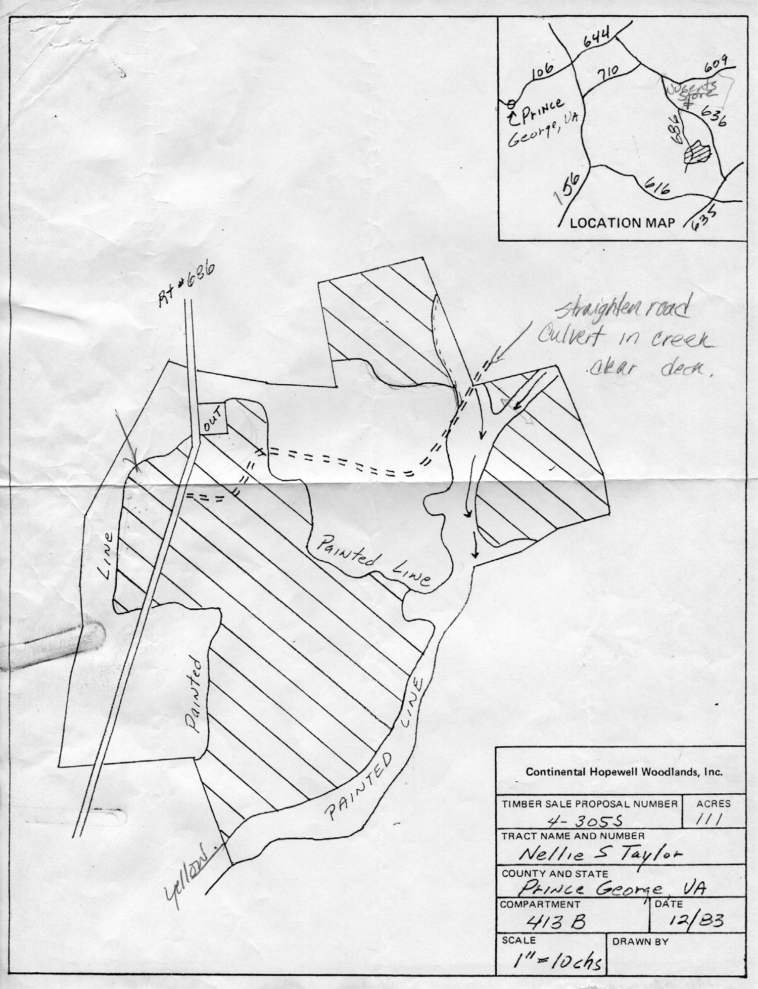
However,eventodaywiththewidespreadavailabilityofcomputersandGISprograms,somemapsarestilldrawnbyhand.Therearemanyreasonswhypeoplestilldo this(convenience,cost,training),buttheseshouldnotdiminishthefactthatawelldevelopedmapcanbeofvaluetothepurposeforwhichitwasdesigned.Forperspective,40yearsago,nearlyallforestmanagementmapswerehanddrawn(Fig.1.5).GIS wasbeginningtomatureinthe1970and1980s,andadoptionofthetechnologybyforest managementorganizationsasastandardwayofmakingmapsreallybegantotakehold inthe1990s.Today,likelyallofthelargerforestryandnaturalresourcemanagement organizationsutilizesometypeofcomputerizedmappingprogram.Fortunately,there aremanybenefitsassociatedwithusingcomputerizedsystemsformapdevelopment:
Thesymbology(symbols,colors,text)ofamapcanbeadjustedeasily.
Errorswithinmapscanbeidentifiedandcorrectedquickly. Mapscanbereprintedorsavedindigitalform.
FIGURE1.3 A3-dimensionalradarimageofGlacierBayNationalPark,Alaska,USA,2012. Credit: U.S.Department oftheInterior,GeologicalSurvey(2012)
Computer-generatedmapsoftenhaveamoreprofessionalappearancethanhanddrawnmaps.
Mapfilescanbesharedwithotherpeoplewhousethesamesoftware.
Mapscanbesavedinvariousgraphicsformatswithouthavingtoscanthem. Withinanorganization,mapscanbedevelopedusingconsistentdatamanagement protocolsandtemplates.
Employersofforestryandnaturalresourcemanagementprofessionalsgenerally expectnewemployeesandrecentgraduatestoknowhowtouseGIS,andtopossess somebasicknowledgeandskillswithrespecttocomputerizedmappingtechnologies (Merryetal.,2007, 2016).Ifoneweretoexaminejobannouncementsrelatedtoentrylevelforestrypositions,onemightfurtherunderstandtheimportanceofthesetechnologiesfromanemployer’sperspective.Tworecentstudiesofjobadvertisementsfor entry-levelforestrypositionsintheUnitedStatessuggestalargepercentageofentrylevelpositionsrequireyoungprofessionalstohavebasicknowledge,experience,or skillintheuseofGIS,alongwithabasicabilitytoreadandinterpretmaps(Bettinger etal.,2016; BettingerandMerry,2018).
Inspection1.1
UsingtheInternet,visitthe OccupationalOutlookHandbook hostedbytheU.S. BureauofLaborStatisticsandreviewthedutiesthatconservationscientistsand foresterscommonlyperform(throughthe WhatTheyDo tab).Whileyourexposure tothetypeofworkthatconservationscientistsandforestersdomayjustbebeginning,trytomakealistofthetypesofmapsthatmightsupporttheseduties.Then, compareyourlisttothelistsofotherswhohavealsoattemptedthistask.
FIGURE1.4 Asea floormapofthePuertoRicoTrench. Credit: U.S.DepartmentoftheInterior,GeologicalSurvey (2006)
FIGURE1.5 Handdrawntimbersalemapfrom1983.
Intoday’scontemporaryresourcemanagementenvironment,itisreasonabletofind thatahighpercentageofforestryandnaturalresourcemanagementprofessionalsuse GIStosupporttheirnormalworkactivities.InonesurveyofsouthernUnitedStates
foresters,nearly60%ofthepeoplesurveyedacknowledgedthattheyusedGIStwoor moredaysperweek,oftentonavigateacrossthelandscapeandtomaptheboundaries oredgesofpropertiesorrecentmanagementactivities(Bettingeretal.,2019).Forestry andnaturalresourcemanagementcareersarenotuniqueinthisregard,asothersimilar naturalresourcemanagementcareers,suchasthoseinvolvinglanduseplanning,may alsorequireprofessionalstofrequentlyuseGIS(Merryetal.,2008).However,natural resourceprofessionalswhoengageincomputerizedmappingeffortsneednotbe computerexperts.Ontheotherhand,employersareincreasinglyinneedofproblem solvers,peoplewhocanbereliedupontoaccessadequateandaccuratedataandmake timelymanagementdecisionsbasedontheiruseandonananalysisofspatialdata. Therefore,somefamiliaritywithspatialtechnology,boththetheoryandtheassociated technicalskills,ispartoftheroutineeducationandtrainingofnaturalresourceprofessionals.Educationalinstitutionsattempttoinstillthisknowledgeanddevelopthese skillsintheirstudentsthroughGIScourses.
Althoughitissuggestedthatnaturalresourceprofessionalsneednotbecomputer programmers,knowledgeofcertainbasictechnicalaspectsofGISmightbeexpectedof peoplewhouseGISfrequentlyaspartoftheirjob.Forexample,itwouldbehighly beneficialforprofessionalstounderstandthedifferencesamongdatamodels,types,and formatsassociatedwithGIS,howlandscapeandwaterfeaturesarereferencedusing coordinatesystems,howtoobtain,edit,andmanagegeographicdata,howtoemploy basicspatialanalysisfunctionsandspatialstatistics,andhowtoeffectivelycommunicateamessagetootherpeopleusingmaps.Likely,fewpeopleemployedinaforestryand naturalresourcemanagementorganizationwillhaveextensiveknowledgeorskillinall oftheseareas,butsomeunderstandingoftheseconceptsbyeveryoneemployedis important.Thegoalofthisbookisthereforetoprovideinsightsintothebuildingblocks ofGISandhelpdeveloptheskillscommonlyusedinnaturalresourcemanagement.As one’scareerinforestryornaturalresourcemanagementprogresses,additionalresponsibilities(managingpersonnel,resources,etc.)arelikelytofollow.AnunderstandingofthebuildingblocksofGISandtheskillscommonlyusedinnaturalresource managementareofgreatvalueevenwhenothersaretheonesconductingthespatial analysesandmakingthemaps.Forexample,onemayfindthemselvesaspartofateam responsibleforschedulingmanagementactivitiesonseveral100,000acresofforest lands,andalmostcertainlyinthiscase,utilizingacollectionofspatialdatabasesto addresstheassociatedtasks(CrosbyandBooth,2011).Oronemayfindthemselves needingtopresentinformationonsubjectssuchasbiomassortimberavailabilityduring ameetingwithcolleagues,andalmostcertainlyinthiscasetoo,utilizingacollectionof spatialdatabasestoaddresstheassociatedquestions(Wulderetal.,2008). Understandinghowthefinalproduct(theplan,thereport,theestimate)isdevelopedis importantevenifthetechnicalanalysesandprocedureswereconductedbyothers.
Inmanagingcomputerizedmaps,forestersandnaturalresourceprofessionalsoften edittheshapeorlocationoffeatures(timberstands,roads,etc.),querytheassociated databasestoanswerquestions(Whichstandsareofanagethatcanbethinned?),and
regularlymanipulateandupdategraphicfeaturestoillustratemanagementactivities andconcerns.Editingspatialfeatures,editingassociatedattributetables,anddigitizing landscapefeaturesarecommontasksforforestryandnaturalresourcemanagement professionals(Merryetal.,2007, 2016).Inonesurveyoftheseprofessionals,themost frequentlydevelopedmapsincludedbasicmapsindicatingthelocationofastandof treesandspecificmapsindicatingareasscheduledforharvest.Inassociationwiththese products,ownershipboundaries,roads,streams,andmanagementunitswerethemost frequentlyusedtypesofGISdatabases(Merryetal.,2016).
Withtime,forestersandnaturalresourcemanagerswillrealizethattheyneed reliableaccesstoamyriadofdatabasesinordertomakerapid,accurate,actionable decisionsandtodisseminatetheoutcomes andimplicationsofthesedecisionsto others.Toaccomplishthis,manypeopleuti lizeGIS,ifnotforthetypesofanalyses thatarepossible,butatleastasaclearinghousewithinwhichthedatacanbe accessedanddisplayed.AGIScanbeus edtoplanandstoreinventorydata( K ӧ hl etal.,2006 ),tointegratedatacollectedwithGPS( McConnelletal.,2020 ),toplan forestoperations( BettingerandSessions,2003 ; Grigolatoetal.,2017 )andtoanalyze remotelysenseddataformanagemen torwildlifehabitatassessments( Wulderetal., 2005 ; McDermidetal.,2009 ).AGIScanhelpaddressmanylandmanagementissues thatareofinteresttosociety,toresearch,andtopractice.GIShasbecomeso ubiquitousinnaturalresourcesfieldsover thelastfewdecades,thatwhenaskedwhat datamightbeneededtodetermineforeste dareasinneedofathinningtreatment, one’sfirstinclinationmaybetoturnonthe computerandaccessavegetation-related GISdatabase.
Reflection1.1
Imagineyouhavebeenaskedbyyouremployertodeterminewhatforestedarea(s) shouldbethinnedinthenextyearortwo.Thinkaboutwhatinformationyou wouldneedtoaddressthisrequest.Forexample,whatassumptionswould youdevelopaboutareasthatcouldbethinned,andwhatGISdatabasesmightyou need?Whatwouldyouneedtodowiththedata,intermsofanalysis,toarriveata reasonableestimateofforestareastobethinnedforyouremployer?Developa shortsummaryofhowyouwouldrespondtothisrequest,onethatpointsdirectly tothespecificquestionsnotedhereinthisreflectionexercise.
BriefhistoryofthedevelopmentofGIS
Althoughanincrediblyenticingtechnology foryoungprofessionalstoinvestigate,the structuresandunderpinningsofGISweredevelopedover50yearsago.Oneofthe earlyeffortstoenabletheanalysisoflandscapefeaturesthroughtheuseofcomputers involvedcomprehensivelyclassifyinglandi nCanadaanddetailingthecapabilitiesof landsforbothactivemanagementandconservation(Goodchild,2018 ).Infact,the veryhistoryofGISistiedtothedevelopmentofcomputersystemsandthe
managementofnaturalresources,asevidencedbytheearlyworkofRoger Tomlinson’steamatIBM(Tomlinson,1968 )creatingasystemthatgathered,stored, andanalyzeddatarelatedtolandcoverandinventoryinCanada.Alongwiththiseffort camethecreationoftheacronym GIS ( Yuan,2017 ).EarlyGISprogramswereconstrainedbytheprocessingspeed,availab lestorage,andpowerofthecomputersystemsthatwereavailable;therefore,theuseofGISwasrelegatedtospecialistsand researchersinmathematicsandstatistics,geography,cartography,andcomputer sciencefields( Goodchild,2018 ; CoppockandRhind,1991 ).However,GISbyitsnature isinterdisciplinary,andasadvancement sincomputingcapabilitiesweremade,more peoplewithwidelydiverginginterestsbegan toincorporateGISintoscience,business, andeducation.Otherinterestingdevelop mentsfollowed:Chicago’stransportation systemwasexaminedthroughworkatNort hwesternUniversity,theU.S.Census Bureaubegantospatiallyreferenceaddresses,andtheU.S.GeologicalSurveyintegratedtheirclassic7.5-minutetopographic mapswithcomputersystems.Fromthese efforts,thepromiseofGISbecameevidentforfieldsspanningthespectrumofplanning,geology,demography,cartography,n aturalresourcemanagement,andothers ( CoppockandRhind,1991 ).InthetimesinceTomlinsonbeganhiswork,localand nationalgovernments,naturalresourcesor ganizationsinthepublicandprivatesectors,andindividualshaveembracedtheopportunitiesGISandspatialtechnologies present.
Diversion1.1
Eitheralone,orasaninformalteamofyourclassmatesorcolleagues,searchthe InternettolearnhowthefollowingpeoplehavebeeninfluentialinthedevelopmentofGISasweknowittoday:CynthiaBrewer,JackDangermond,Howard Fisher,MichaelGoodchild,GerardusMercator,Ptolemy,RogerTomlinson,and DawnWright.Then,developashortsummaryofthecontributionsofoneormore ofthesepeopletothedevelopmentofGIS.
Inforestry,thepushtoenablefieldforesterstouseGISfortheirdailymapping needsbeganinthemid-1990s(Bettinger,1999).Today,digitalmappingthrough smartphoneapplicationsandInternet-basedmappingprogramspromotestheuseof GISbynearlyeveryone(Teixeira,2018)bymakingthetechnologymuchmoreaccessible.Greatadvanceshavebeenmadeincomputingsystemsoverthelast2decades, yetGISmaystillbelimitedtodaybylegacydecisionsenactedearlyinitsdevelopment, suchasusingaplanar(flat)surfaceasthebasisfordisplay,development,andanalysis (asitiswithpapermaps)ratherthanthecurvedsurfaceoftheEarth(Goodchild,2018). Evenso,anumberoftechnologicaladvancesinthe1990senabledGIStobeaccessible throughWindows-basedoperatingsystems(ratherthancommand-linesystems,where onewouldtypealongstringofcodestotellaGISsystemtoperformanoperation)and throughcomputersequippedwithincreasingcentralprocessingunit(CPU)speedand random-accessmemory(RAM).Societyisincreasinglydemandingreal-time,locationbasedservices;thus,recentprogressintheevolutionofGISinvolvesexploringthe
abilitytoaccommodateBigData(definedbyitsvolume,velocity(frequencyofavailability),orvariety)andthevariousopportunitiesthatmightbeaccommodatedby crowd-sourceddata(Wilson,2015).Ascomputersystems,andourknowledgeofthe worldingeneraladvance,wearebeginningtoacknowledgethatforestryandnatural resourcemanagementGISdatacanbecollectedandanalyzedatincreasinglyfiner scales,givingrisetotheterm precisionforestry.Computerprocessingspeedanddata accessareimprovingwithcloud-basedplatforms;therefore,GISandspatialanalysis arepoisedtoplayanevengreaterroleinthemanagementofnaturalresourcesinthe future.
Translation1.1
Imaginethatyouaregatheredwithagroupoffriendsfromhighschool,andthey areinterestedinwhatyouarelearningincollege.Youmentionprecisionforestry, andtheybecomeintrigued.Developashort,100-word(orso)summaryofthefield ofprecisionforestry.Writeitinamannerthatyouwouldofferittoyourhigh schoolfriends.
Ingeneral,aGISprovidesanefficientmean sforcollecting,managing,andsharing data.GISallowsfortheclassificationofman agementareasbyaccessibilityandstatus ( Stinsonetal.,2019 ),andbyownership,forestage,dominantspecies,andsoon ( Bettingeretal.,2017).Innaturalresourcemanagement,manytypesofGISdatabases arebeneficialinaddressingimmediateand longer-termmanagementissues.Someof thesewillbedescribedingreaterdetail laterinthisbook.Asbriefexamplesofdata availabilityintheUnitedStates,detailedforestdatafornationalforestscanbeobtainedfromtheU.S.ForestService( Fig.1.6 ),soilsdatacanbeobtainedfromtheU.S. NaturalResourcesConservationService,wi ldlifehabitatinformationcanbeobtained fromvariousfishandwildlifeagencies,andcurrentandhistoricalweatherand climatedatacanbeobtainedfromtheNationalOceanicandAtmospheric Administration(NOAA).Thesedatabasesareallfreelyandreadilyavailabletothe public,andseveralofthesewillbereferencedthroughoutthisbook.Providedalsowill beexamplesofhowthesedatacansuppo rtforestmanagementandplanning. However,sometypesofdata(e.g.,forestt ypes)maybeunavailableforprivately ownedlands.Inthesecases,GISdatabasesmayneedtobecreated.Therefore,expectationsoftheoutcomesofamappingprojectshouldbeinformedthroughan assessmentoftheneedsoftheprojecta ndanassessmentofdataavailable(and associatedquality).Further,dependingu ponwhereoneworks,forestersornatural resourceprofessionalsmayuseaproprietaryGISsystem,commercialGISsoftware,a free,open-sourceGISsystem,orsomecom binationofthesetoconducttheirwork. Someuniquenuancescanbefoundintheuseofthesesystems,butthecoreconcepts (thetheory)shouldbesimilar.Therefore ,expectationsoftheoutcomesofamapping projectshouldalsobeinformedthroughanassessmentofthecapabilitiesoftheGIS softwareprogrambeingused.

FIGURE1.6 Thelocationofaspen(Populus spp.)standsintheChippewaNationalForest,Minnesota,USA. Credit: Vegetationdatafromthe U.S.DepartmentofAgriculture,ForestService(2021a)
SeveralcriticalcomponentsarenecessarytomaintainafunctioningGISprogram.As hasbeennoted,dataisparamounttoGIS,asarethepeoplewhoperformthetasks, managethedatabases,makethemaps,ensurescripts(computerprograms)arerunning, andsoon.TwoothercriticalcomponentsofGIS hardwareandsoftware canhavea multitudeofoptions,attimesmakingthemseemdizzyinglycomplex.
GIShardware
Hardwarerefersto,essentially,thephysicalpiecesofequipmentthatdefineacomputer (e.g., Fig.1.7).Thesecomponentsinclude,butmaynotbelimitedtothefollowing:
Computerboxorcase
Internalharddrives
RAMmodules
Externalstoragedevices
Motherboard
Graphicscard
Soundcard
Monitor(s)
Wiring
USBandotherports
CD,DVD,andotherdrives
Speaker(s)
Microphone
Camera
Mouse
Keyboard
Printerandplotter
Scanner
Externalpowersupplyoradapter
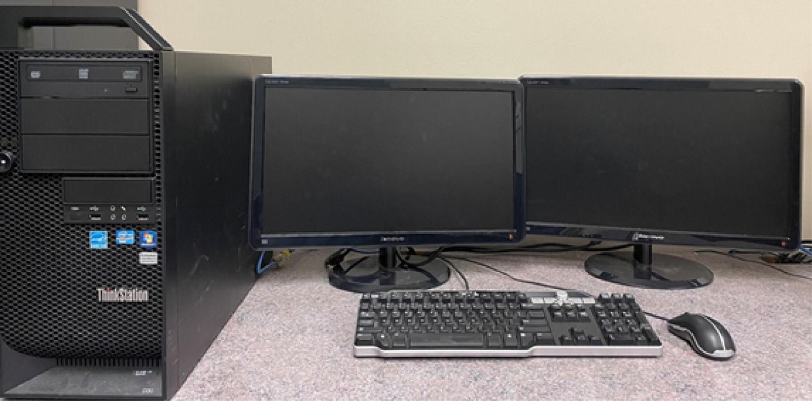
FIGURE1.7 Adesktopcomputer centralprocessingunit(CPU),dualmonitors,keyboard,andmouse.
ManyofthesecomponentsofGISarethesameasthecomponentsofatypical personalcomputingsystemfoundinanofficeenvironment.Inthecaseofalaptop personalcomputer,manyofthesecomponents(e.g.,monitor,case,keyboard,camera, speaker,etc.)arecloselyintegrated.IntheearlystagesofthedevelopmentofGIS, physicalmapsweretransferredtoacomputerusingdigitizingtablesorboards.Scanners were,andstillare,necessaryforconvertinghardcopymapstoadigitalformat.Aplotter mightberequiredforprintinglargemaps,andadditionalstorage(externalorinternal harddrives,orcloudstorage)maybenecessarytohostthedata.Whilewenowuse cloud-basedorInternetservicestohostandshareGISdata,insomeinstances,GISdata isstillsharedorstoredusingremovablemediasuchasaCD(compactdisc),DVD(digital videodisc),USBflashdrive,orothertypesofmemorydevices.Therefore,theabilityto accommodatethesethroughvariousdrivesorportsmanybeimportant.Thehardware neededtouseGISwilldependontheprojectordatamanagementgoals,whichmay evolveasGISskillsgrowandthescopeofprojectsbecomesmorecomplex.Insome instancesofemployment,suchasalandmanagementorganizationoreducational institutionthathasaninformationtechnology(IT)group,manyofthehardwaredecisionsmayalreadyhavebeenmade.However,ifthisisnotthecase,andoneneedsto obtainadesktopcomputerorlaptoptouseGIS,onethathasplentyofspeedand memorywilllikelybenecessary.
GISsoftware
TheothermaincomponentofGIS,software,includesmanyoptionsandopensmany debatesregardingtheiradvantagesanddisadvantages.Anorganization’ssoftwareneeds canbeinfluencedbyanumberofdifferentissues(Bettingeretal.,2010):
Thecostsrelatedtothesoftware(purchasecostandannuallicenses).
Theamountandcostoftrainingthatisneeded. Whetherthesoftwareiswell-documented.
Whetherthesoftwareisuser-friendlyandintuitive. Whetherassistanceisavailablefromthedeveloperorfromotheronlinehelp platforms.
Whetherdatarequirementsarecompatiblewiththedatayoualreadydeveloped. Thespeedofthesoftwareonanewcomputer.
Whetherthenecessaryspatialanalysistoolsareavailable. Whetheranetworkkeyisneeded,orwhetherthesoftwarecanbeinstalledlocally.
ManyGISsoftwareprogramsofferagraphicaluserinterface(GUI)thatconsistsof tools,buttonsandicons,andmenustonavigatethearrayofprocessestheycontain. Othersoftwareprogramsarecommand-orcode-drivenandusersarerequiredtowrite computerprogrammingcodeoruseprewrittenprogramsormodulestoexecuteoperationsandprocessdata.Regardlessoftheinterface,manysoftwareprogramscontain
functionsthatallowausertowritescriptsorcodesenablingcomplex,butrepeatable tasks.Aswenotedearlier,understandingthebasicconceptsforanalyzingdatainGIS willallowonetomoreeasilyadaptworkprocessesacrossdifferentsoftwareprogram. Withinthisbookandtheaccompanyingwebsite(gis-book.uga.edu),somehelpand guidancewillbeavailableforconductingvariousanalyticaltasksusingdifferentsoftware programs.However,theinterestedandmotivatedprofessionalcanfindGIStutorials bothonlineandviapaidservices.Thesecanhelponeobtainadditionalskillsordelve moredeeplyintoaspecificsoftwareprogram.
Thefollowingoffersanoverviewofbothcommercialandopen-sourceGISprograms withaccompanyinglinkstoeach.Nopartofthefollowingdiscussionconstitutesan endorsementofanyparticularsoftwareprogramoveranother.
Commercialoff-the-shelfsoftware
Thefirstsoftwarecompanieswereestablishedinthelate1960sandweresoonproducing softwareproductsfortheinterestedandcapableuser.Commercialsoftwareis commonlyreferredtoas off-the-shelf orprogramsthatrequireanexchangeoffunds (money)toobtainalicense.TherearemanyGISsoftwareprogramoptionsavailablethat workwithindesktoporlaptoppersonalcomputing,enterprise,andcloud-basedenvironments.Eachoftheseoptionsshouldbeevaluateddependingupontheneedsand infrastructureofanorganizationorinstitution.Forexample,asmallconsultingcompanymightonlyneedasingledesktopGISprogramlicensetomeettheneedsoftheir organization,althoughthismayallowonlyasingleusertousethesoftwareatanyone time.Alargecorporationwillalmostcertainlyneedamulti-userdatabaseorenterprise license,andperhapscloud-basedsoftwareprogramsthatarededicatedtoGIS operations.
CommercialGISsoftwareprogramswidelyacceptedinforestryandnaturalresource management,typicallyhavelongtrackrecordsofuseanddevelopment,andoftenoffer robusttraining,support,andeducationalmaterials.Further,thesesoftwareprograms oftenofferdifferentlicensinglevels,add-onsandextensions,andfunctionalitythatcan affecttheircost.Whilesomeoftheserequireanadditionalcost,theseadditionaltools oftenaddsignificantdepthtothecapabilitiesofferedbytheGISsoftwareprogram. Examplesofcommercialoff-the-shelfGISsoftwareincludeESRI’sArcGISandArcPro, Geomedia,IDRISI,andothers(Table1.1).
Open-sourcesoftware
Open-sourceGISsoftwareprogramsarefreetotheuserandcontainsourcecodethatis alsomodifiable.However,peoplewhomakemodificationstothesesoftwareprograms oftendonothavetheabilitytolicensethemodifications.Theintroductionoffreely availableGISsoftwareprogramsbeganinthe1980swiththeintroductionofthe GeographicalResourcesAnalysisSupportSystem(GRASS)(Neteleretal.,2012).The proliferationoftheInternetexpandedtheavailabilityandcapabilityofopen-sourceGIS
Table1.1 Commonlyusedcommercialandopen-sourcesoftwareoptionsforGIS/ spatialanalysis.
SoftwareLink
CommercialArcGIS desktop
https://www.esri.com/en-us/arcgis/ about-arcgis/overview
ArcGISPro https://www.esri.com/en-us/arcgis/ products/arcgis-pro/overview
Maptitude https://www.caliper.com/maptitude/ solutions/forestry-gis-mappingsoftware.htm
Operating systemSpecifications
Windows4GBRAM(8GBfor ArcGlobe),4GBstorage
Windows8GBRAM,32GBstorage
Windows4GBRAM,10GBstorage
IDRISI/TerrSet https://clarklabs.org/terrset/idrisi-gis/ Windows8GBRAM,9GBstorage
GeoMedia https://www.hexagongeospatial.com/ products/power-portfolio/geomedia Windows4GBRam,10GBstorage
OpensourceQGIS https://www.qgis.org/en/site/ Windows,Linux, macOS 2GBRAM, w1.5GB storage
R https://www.r-project.org/ Windows,Linux, Unix,macOS Aslittleas1.5GBRAM,
GoogleEarth Engine https://earthengine.google.com/ Online
GRASS https://grass.osgeo.org/ Windows,Linux, macOS 800MBdiskspace
SAGA http://www.saga-gis.org/en/ index.html Windows,LinuxNonelisted
softwarepackages.UniversityofMinnesotaresearchers(acollaborationbetweenthe MinnesotaDepartmentofNaturalResourcesandNationalAeronauticsandSpace Administration(NASA))createdMapServerinthe1990s.MapServerprovidesonline mappingapplicationsalongwithadatapublicationplatformeventhoughMapServer wasnotdevelopedtobeacompleteGISprogram(i.e.,itdidnotprovidestandardGIS processingandanalysisfunctions).OnemightthinkofMapServerasaprecursorto GoogleEarth,servingmapsthatausercanzoominandoutof,andpanacrossspace (Lime,2008).Asof2022,bothplatformsarestillfunctionalandhaveevolvedtoallow userstotakeadvantageoftheopen-sourcenatureoftheirsourcecodes(storedinpublic repositories)todevelopnewtools,scripts,plugins,andmaintainingthebasicprogram sourcecode(Neteleretal.,2012).Otheropen-sourceGISsoftwareprogramsavailable todayincludeQGIS,R,GoogleEarthEngine,andSAGA(Table1.1).
Nonproprietaryopen-sourceGISsoftwareprogramsallowausertodevelopandshare theirownapplicationsandenhanceasoftware’scapabilitiesandfunctionalitytomeet specificneeds.Oftenopen-sourceGISsoftwareprogramsaredevelopedusingcommon computinglanguageslikeC,Cþþ,Java,andPythonfurtherincreasingtheiradaptability andflexibility(McInernyandKempeneers,2015).Suchdevelopmentsrequireaperson
tohavesoftwareprogrammingknowledge,whichisbeyondthescopeofthisbook,butis importantwhenweighingtheadvantagesanddisadvantagesofusinganopen-source GISsoftwareprogramversusacommercialoff-the-shelfprogram.Itshouldbenoted thatextendingGISsoftwareprogramcapabilitiesthroughcustomized,codedapplicationsisnotuniquetoopen-sourceGISsoftwareprograms.SomecommercialGISsoftwarecanalsobecustomizedusingscriptsandtoolsthathavebeendeveloped specificallytoworkwithintheparametersofthecommercialGISsoftwareprogram.
Open-sourceGISsoftwarepackagesmayalsohaveGUIsthataresimilartothose foundincommercialGISprograminterfaces,whereuserscanaccessvariousroutines andfunctionsthroughmenusorbuttons,orbyusingkeyboard-enabledcommandsor selectionsfacilitatedbyacomputermouse.Withinopen-sourceGISsoftwareprograms, theresultsofvariousspatialanalysisprocesses,menuitemactions,ormouseclicks mightalsobevisualizedwithinatypicalsoftwarewindow.However,someopen-source GISsoftwareprogramfunctionsmayonlybeaccessiblethroughcommandline-driven functionsorAPIs(applicationprogramminginterfaces)(McInernyandKempeneers, 2015).Inthisregard,usingopen-sourceGISsoftwaremayrequireabitmoretechnical prowessthansimilaruseswithinacommercialGISsoftwareprogram,butifauser understandsthefundamentalsofGIS,theyshouldbeabletolearnhowtoeffectively interactwithopen-sourceGISprograminterfaces.Today’sopen-sourceGISsoftware programsoftenhaveadvancedfunctionsthatarecomparabletocommercialGISsoftwareprograms,includingfunctionsthatfacilitatenetworkanalysis,UAV(unmanned aerialvehicles)andsatelliteimageryprocessing,andLiDAR(lightdetectionandranging) dataprocessing.
Diversion1.2
ImaginethatyouhavebeenhiredbyalocalforestryconsultantastheGISmanagerandanalyst.Further,assumethattheconsultantrecentlycreatedthisposition basedonaperceivedneedfortheseservicesbytheirclients.Inotherwords,you arethefirstGISmanagerandanalysttoworkinthiscompany.Listingindividual itemsexplicitly,developabudgettodescribewhatitwouldcosttoacquirethe technologytoperformGISanalysis.Provideapriceforallofthehardwareand softwareyoumightneed,developatotalcost,andinashortmemorandum, communicateyourbudgetaryneedstotheownerofthecompany.
Conductingspatialanalyses
Inourdynamicworld,events(plannedorrandom)occursomewhere,atsomepointin time,andatsomedistancefromresourcesthatmaybeofgreatinterestorimpactedby theevent.Ofimportancetoforestersandnaturalresourcemanagersarethe who, what, when, where, how,and why ofeachproblemorissue.Conceptually,thisistheframework fordefining spatialanalysis,oneofthemostpowerfulfunctionsofGIS.Simplyput, spatialanalysisconductedwithinGISprovidespeoplewithrationaleandlogictohelp
themunderstandthespatialdistributionofeventsandassociatedoutcomes(Lu etal., 2019).Onefundamentalconceptbehindspatialanalysisispartiallyexplainedthrough Tobler’sFirstLawofGeography,whichsuggeststhat"everythingisrelatedtoeverything else,butnearthingsaremorerelatedthandistantthings”(Tobler,1970).Theinterconnectednessofnaturalormanagedphenomenaandtheirlocation,andthefactors thatinfluencethecharacteristicsofthephenomenacanbebetterunderstoodthrough spatialanalysis.Threegeneralsetsofquestionshelpputtheseintoperspective.
1. Problemorissue
a. Who proposedtheproblemorissue?
b. Why isamaporanswerneeded?
c. How couldGISassistinaddressingtheproblemorissue?
2. Place
a. Where isthelocationoftheareaofinterest?
b. What attributesareneededtodescribetheareaofinterest?
c. Howmuch otherlandorwateraroundtheareaofinterestshouldbeincluded?
d. What geographicsystemandorientationareneeded?
3. Desiredoutcome
a. Who isthecustomeroftheoutcome?
b. What isthedesiredoutcome amap,adatabase,orsimplyananswer?
c. What otherspecificoutcomescanbedevelopedtoassistinmeetingtheneeds ofthecustomer?
d. What format(scale,imagetype,mapsize,table,etc.)isrequiredofthe outcome?
e. When dotheyneedtheoutcome?
Theproblemorissueneedstoexistingeographicspace.Thismightinvolveacity,a county,aforest,awaterbody,aforeststand,ananimalden,ormanyotherresourcesof interest.Attheonsetofaspatialanalysisormappingeffort,perhapsasupervisoror colleaguerequiresinformationonnaturalresourcesthatareundertheircontrol, promptingworkthatinvolvesGIS.Perhapsthisworkwillassistinthedevelopmentofa contract,plan,report,orpublication.Iftheinformationdesiredcouldbedevelopedinan alternativefashionwithouttheassistanceofGIS,thentrade-offsmightbeconsidered (timerequired,qualityofendproduct).Alongtheselines,onemightalsoaskwhetherthe problemorissueisreallyimportant,andwhetherthetimeandenergyrequiredto conducttheGISanalysisisworththeeffort.Ifsomeoneissimplycuriousaboutthe extentordistributionofaresource,yetseveralhoursofworkarerequiredtosatisfytheir curiosity,thenperhapsthereisnoneedforactioninvolvingGIS.
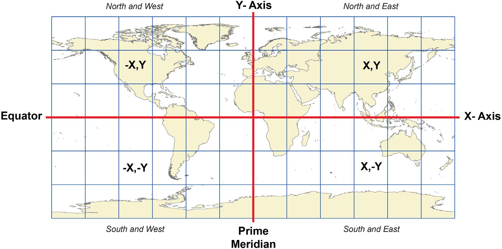
Thegeographiclocationorplaceinspacewheregeographicphenomenaexistare commonlydefinedbyasetof X,Ypairs alsocalled coordinates X,Y pairsarebestunderstoodbyimaginingagridthatspansthesurfaceoftheEarth(Fig.1.8).Eachpoint alongthegridhasavalueassociatedwithitspositionalongan X and Y axis.Manypeople commonlyknowthatlinesoflatitude(the Y axis)runeasttowestacrosstheglobeand
FIGURE1.8 Graphicalrepresentationof X (longitude)and Y (latitude)valuesforlocationsonEarth.
providetheabilitytoreferencealocationnorthorsouthoftheEquator.Linesof longitude(the X axis)runnorthtosouthandprovidetheabilitytoidentifyalocationeast orwestofaPrime(standard)Meridian.Wheretheselinesintersectdefinesthevalues associatedwith X,Y coordinates.Othersystemsthathavebaselines(east-westlines)and meridians(north-southlines),suchasthePublicLandSurveySystemortheStatePlane systemsintheUnitedStates,ortheDominionLandSurveyinCanada,canalsoprovidea setof X,Y pairsorcoordinatesidentifyingwheregeographicphenomenaexists.
Diversion1.3
Tobetterunderstandlocationand X,Y coordinates,openyourpreferredInternet browserandnavigatetoaweb-basedmappingapplication,GoogleEarth,for example.Navigatetothefollowinglongitude(X)andlatitude(Y)coordinates.What landmarkshaveyounavigatedto?
a. 27 100 30.1000 N,78 020 31.6700 E
b. 51 300 05.2700 N,0 080 30.9100 W
c. 33 510 24.2800 S,151 120 55.0700 E
Inadditiontophysicalspace,geographicphenomenaoccurin(andoftenacross) temporalspace.Forexample,aGISdatabasecontaininginformationconcerningforest standsisaliteralsnapshotintimeoftheforest.InGISandspatialanalysis,theissueof when isnearlyasimportantas where.Whilethelocationofaplaceinspacemaybe knownanditscharacteristicsdescribable,withouttemporalinformationitcanbe difficulttodetermineifthecharacteroftheplacerepresentscurrentorhistoricalconditions.Somecharacteristicsaboutaplacethathelpdeciphertheissueof when,for
example,includebackgroundknowledgeoftheplaceorimagerycapturedoftheplace. ButconsiderusingaGISdatabasethatdescribesforeststands,andincludestheageof thestand,thetimesinceitwaslastburned,andsoonasattributesofeachstand,butno datetoidentifywhenthedatawerecollectedorupdated.Whilethisdatabasecouldlikely garnersomeinformationabouteachstand,itmaybedifficulttodeterminewhenthat informationdescribedthestand. Theageofthestandwhen?Thetimesincethelastfirein relationtowhen? NowconsideraseriesofGISdatabasesofthatsameforeststandthat spanacross50years,wherethedatewheneachGISdatabasewascreatedorupdatedis known.Withthisdataseries,characterizationsoftheconditionofeachstandthrough timecanbemadebyidentifyingchangesthathaveoccurred,andthisinformationcan helpinformmanagementdecisions.
How and why questionsfocusonthereasonsanddriversassociatedwithaspatial phenomenonoccurringatalocation.Forexample,assumethereisinterestinidentifying theideallocationforestablishingamultiuseforestrecreationarea.Onewouldlookfor anareawithenoughspeciesdiversitytosupportwildlifehabitats,anareathatmight supporthikingtrialsorotherformsofoutdoorrecreation,and(perhaps)anareathat mightbemanagedfortimberproduction.Factorslikeannualprecipitation,soilmoisture,andgroundslopemaybeofvalueindetermininghowandwhydifferentplantand animalspeciesarepresentorabsentinthislandscape.Changesinanyonefactormay leadtochangesinwhereaspeciesislocated,howorwhyitislocatedthere,andwhere elseitmightbelocated.SpatialanalysisandtheGISprocessesassociatedwithspatial analysisthusprovideafoundationforaddressingthe how and why questionsrelatedto themanagementofnaturalresources.
Tofurtherillustratethevalueofspatialanalysisinnaturalresources,spatialanalysis isoftenconductedinanevaluationofthet radeoffsbetweeneconomicandenvironmentaldevelopmentopportunities.Inthec aseofnaturalresourcemanagement,this mayinvolvethedeterminationofwheretobuildaforestproductssawmill( Jonesetal., 2010).Potentialinvestorswouldneedtoknowwhatforestresourceswereavailable, wheretheseresourcesarelocated(within somedistanceofthemilllocation),and whentheseresourceswouldbeavailable(e.g.,basedonstandagesandotherfactors). Othernecessaryinformationthatwould informthisanalysismightincludeaGIS databaseoftheroadnetwork,otherGISdatabasesillustratingthelocationofmunicipalities,waterresources,andpotentialwildlifehabitatareas,andinformation regardinglocalseverancetaxes.Thisin formationcanbeanalyzedwithinGISto determinethebestlocationwithinabroadlandscapeforasawmill.CommonprocessesforconductingspatialanalysiswithinaGISprogramincludebuffering, querying,andintersectingGISdatabases.Theseandmanyotheranalysistechniques willbecoveredinmoredetailthroughoutthebook.