The Difference Between Cognitive and Behavioral Theories 40
The A-B-Cs of Learning 44
What Is the Role of Observational Learning? 45
Modeling 45
What Is Reinforcement? 46
Positive Reinforcement 46
Negative Reinforcement 47
What Is Extinction? 51
What Is Punishment? 53
Positive Punishment 53
Negative Punishment 54
How Do We Distinguish Between Reinforcers and Punishers? 55
How Are Reinforcers and Punishers Learned? 55
Primary and Secondary Positive Reinforcers 55
Primary and Secondary Aversives 58
Deprivation and Satiation States 60
What Is Stimulus Control? 61
What Is Shaping? 62
What Is Chaining? 63
Total or Whole Task Chaining 64
Forward Chaining 64
Backward Chaining 64
What Are Schedules of Reinforcement? 65
Continuous Reinforcement Schedule 65
Intermittent Reinforcement Schedules 66
Extinction 68
Vignette Revisited 69
Summary 70
Key Terms 70
Discussion Questions 71
Chapter Objectives 74
Vignette 75
Overview 75
What Are the Considerations We Must Make Prior to Implementing an Individualized Behavior Support Plan? 76
How Do We Define Behavior and Develop Goals and Objectives? 77
Defining Behavior 78
Goals 80
Behavioral Objectives 81
How Do We Record Behaviors? 83
Permanent Products 84
Event or Frequency Recording 84
Duration and Latency Recording 85
Interval Recording 85
How Do We Develop Recording Instruments? 87
What Is Interobserver Agreement? 92
Permanent Products 92
Event or Frequency Recording 93
Duration and Latency Recording 94
Interval Recording 94
What Factors Influence Interobserver Agreement? 95
Reactivity 96
Observer Drift 96
Complexity of the Measurement System 96
Observer Expectations 96
What Are Single-Case Experimental Designs? 97
A-B Design 97
Withdrawal Design 99
Multiple-Baseline Designs 100
Changing-Criterion Design 103
Alternating Treatments Design 105
Vignette Revisited 107
Summary 107
Key Terms 108
Discussion Questions 108
4. Functional Behavior Assessments and Behavior Support Plans 110
Chapter Objectives 110
Vignette 111
Overview 111
What Are the Assumptions of Behavior Support? 113
Contextual Behavior 113
Functions of Behavior 113
Other Assumptions 116
Why Is It Important to Know About Functional Behavior Assessments? 116
What Are the Types of Functional Behavior Assessments? 117
Indirect Assessments 118
Descriptive Analyses 124
Functional Analyses 134
When to Use Each Type of Assessment 134
How Do We Develop a Behavior Support Plan? 136
Building the Behavior Support Plan 137
Writing the Behavior Support Plan 139
Assessing the Fidelity of the Behavior Support Plan 142
Vignette Revisited 143
Summary 143
Key Terms 145
Discussion Questions 145
5. Increasing Desirable Behaviors 146
Chapter Objectives 146
Vignette 147
Overview 147
How Can Challenging Behavior Be Decreased by Increasing Appropriate Behavior? 148
How Can Prompting Strategies Be Used to Increase Desirable Behaviors? 148
Antecedent Prompt and Test Procedure 148
Most-to-Least Prompting 149
Antecedent Prompt and Fade Procedure 149
Least-to-Most Prompting 150
Graduated Guidance 150
Time Delay 151
What Is Shaping? 152
What Are the Premack Principle and the Response Deprivation Hypothesis? 152
Premack Principle 152
Response Deprivation Hypothesis 153
What Is Behavioral Momentum? 154
What Are Self-Management Procedures? 155
Reasons for a Lack of Self-Control 155
Reasons for Teaching Self-Management 156
Types of Self-Management Skills 157
The Need for Consequences 166
What Is Preference and Choice? 168
What Is Correspondence Training? 168
What Are Behavioral Contracts? 169
What Are Token Economy Systems? 171
How Do We Produce Generalization of Behavior Change? 172
Response Generalization 172
Stimulus Generalization 173
How Is Consequence-Imposed Behavior Change Maintained? 175
Intermittent Reinforcement Schedules 175
Use of Naturally Occurring Reinforcers 175
Use of Self-Management Procedures 177
What Is the Planning Process for Generalization and Maintenance? 177
Vignette Revisited 178
Summary 178
Key Terms 179
Discussion Questions 180
6. Decreasing Undesirable Behaviors 181
Chapter Objectives 181
Vignette 182
Overview 182
What Are the Least Restrictive, Least Intrusive, and Most Effective Alternatives for Reducing Unwanted Behavior? 183
Restrictiveness 183
Intrusiveness 183
Effectiveness 183
Cautions With the Use of Restrictive or Intrusive Procedures 184
Conclusion 185
What Are Informal Procedures? 185
Situational Inducement 185
Redirection 186
Chain Stopping 186
Proximity Control 188
What Are Behavior Reduction Procedures? 189
Level I Procedures (Presentation of Reinforcement) 190
Level II Procedure (Removal of Source of Reinforcement) 196
What Are Aversive-Based Procedures? 198
Negative Side Effects 198
Level III Procedures (Contingent Removal of Reinforcing Stimuli) 199
Level IV Procedures (Presentation of Aversive Stimuli) 203
How Do We Decide Which Procedure to Use? 206
How Is Consequence-Imposed Behavior Change Generalized? 207
How Is Consequence-Imposed Behavior Change Maintained? 207
Vignette Revisited 207
Summary 208
Key Terms 208
Discussion Questions 209
7. Preliminary Considerations
Chapter Objectives 212
Vignette 213
Overview 213
Why Is Classroom Management Critical? 215
What Are Effective Classroom Arrangements? 217
What Are Nonverbal Communication Methods? 219
How Do We Set Effective Classroom Rules? 220
Developing Effective Classroom Rules 222
How Do We Establish Routines? 224
What Is Precorrection? 225
What Are Social Skills? 229
What Are Group-Oriented Management Approaches? 230
Dependent Group Management 230
Interdependent Group Management 231
Independent Group Management 232
What Are the Advantages and Disadvantages of Each Group-Oriented Management Approach? 240
Dependent Group Management 240
Interdependent Group Management 240
Independent Group Management 241
What Are Important Considerations When Using Group-Oriented Management Approaches? 241
Teachers Should Avoid Negative Traps 241
Teachers Should Actively Practice Positive Interaction Skills 243
Teachers Should Use a Teaching Interaction Strategy When Attempting to Correct Unwanted Behavior 243
Vignette Revisited 243
Summary 244
Key Terms 244
Discussion Questions 245
8. Instructional Variables 246
Chapter Objectives 246
Vignette 247
Overview 247
What Are the Levels of Time? 249
Available Time 249
Allocated Time 250
Engaged Time 252
Academic Learning Time 253
What Is the Importance of Curriculum and Lesson Pacing? 254
How Do We Plan for Transitions? 255
What Is Effective Instruction? 258
What Are Teaching Functions? 258
Daily Reviews 259
Presentation of New Content 260
Guided Practice 260
Independent Practice 261 Weekly and Monthly Reviews 262
What Are the Stages of Learning? 262
Acquisition Stage 262
Proficiency Stage 263
Maintenance Stage 263
Generalization Stage 263
Adaptation Stage 264
What Are Response Prompting Strategies? 264
Antecedent Prompt and Test Procedure 264
Most-to-Least Prompting 265
Antecedent Prompt and Fade Procedure 265
Least-to-Most Prompting 265
Graduated Guidance 266
Time Delay 266
What Is an Effective Lesson Plan Format? 267
What Are Three Critical Components for Providing Effective Instruction in the Classroom? 268
Organization of Instruction 268
Program Design 268
Teacher Presentation Techniques 269
What Is Mastery? 270
What Is Differentiated Instruction? 271
What Are Three Teaching Behaviors That Can Help Reduce Behavior Problems in the Classroom? 272
Appropriate Instructions 272
Specific Praise 272
Appropriate Error Corrections 273
What Is an Academic Functional Assessment? 273
What Are Evidence-Based Practices? 274
Key Features of Effective Programs 274
Direct Instruction 275
Key Features of Effective Instructional Practices 275
Other Resources 276
Vignette Revisited 277
Summary 277
Key Terms 278
Discussion Questions 279
Are Schools Safe? 284
School-Related Violent Deaths 284
Weapons Possession and Physical Fights in Schools 286
Students’ Perceptions of Personal Safety at School and Away From School 288
Bullying at School and Cyber-Bullying Anywhere 288
Teacher Reports on Student Misbehavior, Tardiness, and Class Cutting 289
Safety and Security Measures Taken by Schools 290
Profiling Students at Risk of Targeted Violence 290
How Do We Conduct a Fact-Based Threat Assessment? 296
Key Concepts 296
Four-Pronged Threat Assessment Approach 299
Vignette Revisited 305
Summary 306
Key Terms 307
Discussion Questions 307
10. Schoolwide Positive Behavior Intervention and Support 308
Chapter Objectives 308
Vignette 309
Overview 309
What Is Schoolwide Positive Behavior Intervention and Support? 310
Goals 312
Key Elements 313
What Are the Organizational Systems Within a SWPBIS Program? 314
Leadership Organizational System 315
Schoolwide Organizational System 317
Nonclassroom Organizational System 318
Classroom Organizational System 322
Individual Organizational System 324
Academic Support System 326
What Is the School-wide Evaluation Tool? 328
What Are the Benchmarks for Advanced Tiers? 331
Vignette Revisited 334
Summary 335
Key Terms 336
Discussion Questions 337
11. Evidence-Based Interventions and Programs 338
Chapter Objectives 338
Vignette 338
Overview 339
What Are a Strategy, an Intervention, and a Program? 340
Strategy 341
Intervention 341
Program 343
What Are the Criteria for Being Defined as an Evidence-Based Intervention? 344
The Intervention Is Operationally Defined 344
The Qualifications of People Who May Use the Intervention With Success Are Defined 345
The Outcomes That May Be Expected From Using the Intervention Are Defined 345
The Settings (or Contexts) in Which the Intervention Is Expected to Be Effective Are Defined 346
The Target Population or Populations for Whom the Intervention Is Effective Are Defined 346
The Conceptual Theory and Basic Mechanisms Framing the Intervention Are Defined 346
How Do Schools Identify Evidence-Based Interventions? 346
Step 1. Is the Intervention Backed by Strong Evidence of Effectiveness? 347
Step 2. If the Intervention Is Not Backed by Strong Evidence, Is It Backed by Possible Evidence of Effectiveness? 349
Step 3. If the Answer to the Questions in Steps 1 and 2 Is No, One May Conclude the Intervention Is Not Supported by Meaningful Evidence 351
How Do Schools Assess the Magnitude of the Effects of an Intervention? 352
Statistical Significance 352
Effect Size 352
Where Can Schools Find Evidence-Based Interventions? 354
How Do Schools Develop the Capacity to Implement Interventions? 355
Human Capacity 355
Technical Capacity 356
Physical Capacity 356
Funding Capacity 357
How Do Schools Implement and Sustain Interventions? 357
How Do Schools Evaluate Interventions and Programs? 359
Process Evaluations 360
Outcome Evaluations 361
Vignette Revisited 362
Summary 363
Key Terms 364
Discussion Questions 364
12. Response to Intervention (RTI) and SWPBIS Models 365
Chapter Objectives 365
Vignette 366
Overview 366
Where Did RTI and Multitiered Intervention Models Originate? 367
What Are the Expected Effects of RTI Intervention Models? 370
What Are Some Conceptual Issues That Arise Within RTI Intervention Models? 371
Problem Solving and Standard Protocol 372
Response to Intervention and Resistance to Intervention 372
Response to Intervention and Responsiveness to Intervention 373
Instruction and Intervention 373
What Are the Key Elements of RTI Intervention Models? 373
Universal Screening 374
Data-Based Problem-Solving Process 375
Continuum of Scientifically Based Interventions 375
Progress Monitoring 375
What Is the Link Between RTI and Schoolwide Positive Behavior
Intervention and Support (SWPBIS)? 378
Primary (Tier 1) 379
Secondary (Tier 2) 382
Tertiary (Tier 3) 389
Vignette Revisited 389
Summary 390
Terms 391
391
Preface
Purpose
One of the most critical issues facing teachers and related-services personnel today is behavior management. Behavior management consistently ranks as the most concerning issue in surveys completed by school personnel. Unfortunately, most do not feel well equipped to deal with the multitude of behavior problems they see every day in the schools. We wrote this textbook with these individuals in mind. It is critical for teachers and related personnel to receive high-quality training in behavior management; a solid textbook written by experts in the field that incorporates evidence-based best practices is an important foundational aspect of this training.
This textbook is designed differently from other management texts. We wrote this textbook to aid teachers and related-services personnel in the planning processes that must take place when preventing or responding to behavior management issues. We see this planning as occurring across three levels of support—individualized, classroom, and schoolwide. Other textbooks do not provide the balanced coverage of these levels of support as is done in this text. For example, many textbooks provide extensive coverage of classroom management supports but provide little, if any, coverage of schoolwide or individualized supports. Other texts provide extensive coverage of individualized supports but provide little, if any, coverage of schoolwide and classroom supports. Therefore, our goal is to provide extensive coverage of all three levels of support to help teachers and related-services personnel to plan for and respond to behavior management issues effectively.
This textbook can be used with undergraduate or graduate students in general education, special education, and educational and school psychology. Instructors teaching courses on behavior management, the principles of behavior, applied learning theory, and the classroom applications of educational psychology will find this textbook helpful.
Additionally, consultants and administrators can use this textbook as a foundational text for those receiving inservice training on individualized, classroom, and schoolwide support planning. Target audiences include teachers and related-services personnel (e.g., school psychologists, counselors, social workers, behavior specialists, and instructional assistants).
Major Features and Pedagogical Aides
There are several major features of this textbook.
First, important aspects of behavior management (i.e., working with parents and families, ethics and the law, diversity, and data collection) are infused in chapters throughout the book.
Second, every chapter includes objectives that provide a clear overview of what will be covered in the chapter.
Third, all chapters have a vignette at the beginning that highlights an important issue covered in the chapter. This vignette is revisited at the end, showing how the issue was addressed.
Fourth, chapter headings are phrased as questions to facilitate easier note taking and discussion.
Fifth, several tables and figures are evident in every chapter to aid in the understanding of key concepts.
Sixth, discussion questions are found at the end of each chapter to test student understanding of the content. Answers to these questions are provided in the instructor’s manual.
Finally, an extensive index and glossary are included to aid in the location and definition of key terms.
Changes Made From the First Edition
We made several changes and additions to this second edition.
Changes Throughout the Book
First, we added a new author, Dr. Mark O’Reilly, from the University of Texas at Austin. Dr. O’Reilly brings specific expertise in individualized behavior management approaches including functional behavior assessments and behavior support plans. He also has a long and successful record in applied behavior analysis.
Second, we changed the title of the textbook to reflect the trend of addressing behavior management support as a comprehensive issue rather than an individual one. This comprehensive approach incorporates individual, classroom (including instructional), and schoolwide supports (including those for nonclassroom settings such as the cafeteria, playground, and hallways).
Third, the sequence of the chapters was changed to reflect how the material is most frequently taught in college classes. In the current edition, the chapter sequence in Part I remains the same. In Part II, individualized supports are described (this content was covered in Part IV of the first edition). Classroom supports continue to be addressed in Part III. Part IV contains information on schoolwide supports (this information was covered in Part II in the first edition). Finally, the term supports replaces organizational systems in the title of chapters to better reflect current terminology in the field.
Finally, all chapters were updated with current research, corresponding citations, additional tables and figures, and rewritten pedagogical features.
Chapter-Specific Changes
Significant changes were made to several chapters.
Chapter 1. New information was added to this chapter on the best practices in behavior management, and the section on ethics was expanded to include a statement on seclusion and restraint.
Chapter 5. Discussion of preference and choice, as well as of prompting strategies related to behavior issues, was added to this chapter.
Chapter 7. The material from the Think Time® chapter (Chapter 8) in the first edition was edited and integrated into this chapter.
Chapter 10. Information on the “school evaluation rubric” was removed and coverage of the School-wide Evaluation Tool (SET) and the Benchmarks for Advanced Tiers (BAT) was added to this chapter.
Chapter 11. This chapter was previously Chapter 5 in the first edition, and was rewritten to focus on what makes a program evidence based. It now includes coverage of the criteria for being defined as an evidence-based intervention and how schools assess the magnitude of the effects of an intervention.
Chapter 12. This new chapter provides coverage of the response to intervention (RTI) approach and how to integrate multitiered intervention models such as RTI with the schoolwide positive behavior intervention and support model (SWPBIS).
Ancillaries for Instructors
Additional ancillary materials further support and enhance the learning goals of the second edition of Comprehensive Behavior Management: Individualized, Classroom, and Schoolwide. These ancillary materials include the following:
Password Protected Instructor Teaching Site
This password-protected site (www.sagepub.com/martella) offers instructors a variety of resources that supplement the book material, including the following:
• Test Bank (Word): This Word test bank offers a diverse set of test questions and answers for each chapter of the book. Multiple-choice and short-answer/essay questions for every chapter help instructors assess students’ progress and understanding.
• PowerPoint Slides: Chapter-specific slide presentations offer assistance with lecture and review preparation by highlighting essential content, features, and artwork from the book.
• SAGE Journal Articles: A “Learning From SAGE Journal Articles” feature provides access to recent, relevant full-text articles from SAGE’s leading research journals.
Each article supports and expands on the concepts presented in the chapter. This feature also provides discussion questions to focus and guide student interpretation.
• Web Resources: These links to relevant websites direct instructors to additional resources for further research on important chapter topics.
• Lecture Notes: These lecture notes summarize key concepts on a chapter-by-chapter basis to help instructors prepare for lectures and class discussions.
• Answers to In-Text Questions: The site provides answers to the chapter discussion questions found at the end of each chapter.
• Course Syllabi: Sample syllabi—for semester, quarter, and online classes—provide suggested models for instructors to use when creating the syllabi for their courses.
We believe the changes and additions made to this second edition have significantly improved the quality of the textbook. We are confident the new information will be regarded as an important addition to the understanding of comprehensive and evidence-based behavior management supports.
SAGE would like to gratefully acknowledge the following peer reviewers for their editorial insight and guidance:
Robert L. Michels
Santa Clara University
Su-Je Cho
Fordham University
Graduate School of Education
Judith E. Terpstra
Southern Connecticut State University
DeAnn Lechtenberger
Texas Tech University
Suzanne McQuillan Jimenez
George Mason University
Karen Coughenour
Francis Marion University
Gholam Kibria
Delaware State University
Another random document with no related content on Scribd:
Loch Avon and Ben-Macdhui
4. Surface, Soil and General Features.
From what has been already said of the contour of the county it may be inferred that its surface is extremely varied. Every variety of highland and lowland country is to be found within its limits. Near the sea-board the land is gently undulating, never quite flat but not rising to any great height till Benachie (1440) is reached. From that point onwards, whether up Deveronside or Donside or Deeside, the mountains rise higher and higher till the Cairngorms, which comprise some of the loftiest mountains in the kingdom, are reached. At that point we are more than half-way across Scotland, and in reality are nearer to the Atlantic than to the North Sea. Less than half the land is under cultivation. Woods and plantations occupy barely a sixth part of the uncultivated area. The rest is mountain and moor, yielding a scanty pasturage for sheep and red-deer, and on the lower elevations for cattle.
In the fringe round the sea-board no trees will grow. It is only when several miles removed from exposure to the fierce blasts that come from the North Sea that they begin to thrive, but the whole Buchan district is conspicuously treeless. Almost every acre is cultivated and the succession of fields covered with oats, turnips and grass, which fill up the landscape as with a great patchwork, is broken only here and there by belts of trees round some manor-house or farmsteading. Except in a few places the scenery of this lowland portion is devoid of picturesque interest, yet the woods of Pitfour and of Strichen, the policies of Haddo House near Methlick, the quiet silvan beauty of Fyvie, which more resembles an English than a Scotch village, the wooded ridge that overlooks the Ythan at the Castle of Gight, are charming spots that serve by contrast to accentuate the general tameness of this lower area.
In the higher region, the south-western portions of the county, agriculture is, to some extent, practised, but it is necessarily
confined to narrow strips in the valleys of the rivers. The hills, which are rarely wooded, and that only up to fifteen hundred feet above sea-level, are rounded in shape, not sharp and jagged. They are, where composed of granite, invariably clothed in heather and are occasionally utilised for the grazing of sheep, but this is becoming less common, and year by year larger areas are depleted of sheep for the better protection of grouse. All the heathery hills up to 2000 feet are grouse moors. Throughout the summer these display the characteristic brown tint of the heather—a tint which gives place in early August to a rich purple when the heather breaks into flower. Long strips of the heather-mantle are systematically burned to the ground every spring. Such blackened patches scoring with their irregular outlines the sides of the hills in April and May give a certain amount of variety to the prevailing tint of brown. They serve a very useful purpose. The young grouse shelter in the long and unburnt heather but frequent the cleared areas for the purpose of feeding on the tender young shoots which spring up from the blackened roots of the burned plants.
Further inland still, where the hills rise to a greater height, they become deer-forests. As a rule these forests are without trees and are often rockstrewn, bare and grassless. It is only in the sheltered corries or by the sides of some sparkling burn, that natural grasses spring up in sufficient breadth to provide summer pasturage for the red-deer, which are carefully protected for sporting purposes. Here too the ptarmigan breed in considerable numbers. The grouse moors command higher rents than would be profitable for a sheep-farmer to give for the grazing, and every year prior to the 12th of August, when grouse-shooting begins, there is an influx of sportsmen from the south, to enjoy this particular form of sport. The red grouse is indigenous to Scotland; it seems to find its natural habitat amongst the heather, where in spite of occasional failures in the nesting season, and in spite of many weeks’ incessant shooting, it thrives and multiplies. Deer-stalking begins somewhat later; in a warm and favourable summer, the stags are in condition early in September. This sport is confined to a comparative few.
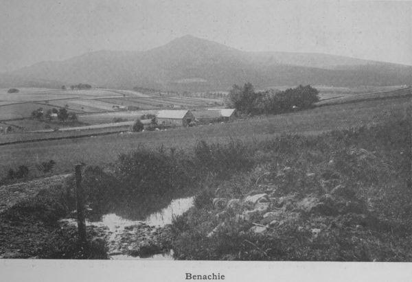
The highest mountain in the Braemar district is Ben-Macdhui (4296 feet). A few others are over 4000—Brae-riach and Cairntoul. Ben-naBuird and Ben-Avon, which last is notable for the numerous tors or warty knots along its sky-line, are just under 4000 feet. Loch-na-gar, a few miles to the east and a conspicuous background to Balmoral Castle, is 3789. Byron called it “the most sublime and picturesque of the Caledonian Alps,” and Queen Victoria writing from Balmoral in 1850 described it as “the jewel of all the mountains here.” Its contour lines, which are somewhat more sharply curved than is usual in the Deeside hills, and the well-balanced distribution of its great mass make it easily recognised from a wide distance. This partly explains the pre-eminence which notwithstanding its inferiority of height it undoubtedly possesses. Due north from Ballater are Morven (2880) and Culblean, and due south is Mount Keen; a little east and on the boundary line of three counties is Mount Battock. Perhaps the most prominent hill, and the one most frequently visible to the great majority of Aberdeenshire folks, is Benachie, which stands as a fitting outpost of the vast regiment of hills. It stands apart and although only 1440 feet in height is an unfailing landmark from all parts of Buchan, from Aberdeen, from Donside, and even from Deveronside. Its well-defined outline and projecting “mither tap” render it an object of interest from far and near, while the presence or absence of cloud on its head and shoulders serves as a barometric index to the state of the weather.
Benachie
5. Watershed. Rivers. Lochs.
As we have already pointed out, the watershed coincides to a large extent with the boundary line of the county. The lean of Aberdeenshire is from west to east so that all the rivers flow in an easterly direction to the North Sea. On the west and north-west of the highest mountain ridges, the slope of the land is to the northeast, and the Spey with its several tributaries carries the rainfall to the heart of the Moray Firth.
The chief river of the county is the Dee. It is the longest, the fullestbodied, the most picturesque of all Aberdeenshire waters. Taking its rise in two small streams which drain the slopes of Brae-riach, it grows in volume and breadth, till, after an easterly course of nearly 100 miles, it reaches the sea at Aberdeen. The head-stream is the Garrachorry burn, which flows through the cleft between Brae-riach and Cairntoul. A more romantic spot for the cradle of a mighty river could hardly be found. The mountain masses rise steep, grim and imposing—on one side Cairntoul conical in shape, on the other Braeriach broad and massive, a picture of solidity and immobility. The Dee well is 4060 feet above sea-level and 1300 above the stream which drains the eastern side of the Larig—the high pass to Strathspey. As it emerges from the Larig, it is a mere mountain torrent but presently it is joined at right angles by the Geldie from the south-west, and the united waters move eastward through a wild glen of rough and rugged slopes
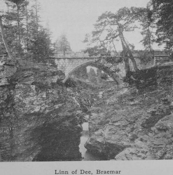
Linn of Dee, Braemar
and ragged, gnarled Scots firs to the Linn of Dee, 6-3/4 miles above Braemar. There is no great fall at the Linn, but here the channel of the river becomes suddenly contracted by great masses of rock and the water rushes through a narrow gorge only four feet wide. The pool below is deep and black and much overhung with rocks. For 300 yards stretches this natural sluice, formed by rocks with rugged sides and jagged bottom, the water racing past in small cascades.
The river is here spanned by a handsome granite bridge opened in 1857 by Queen Victoria.
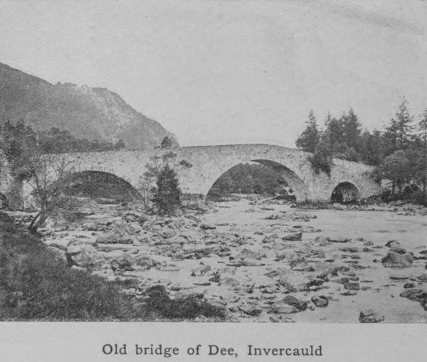
Old bridge of Dee, Invercauld
As the river descends to Braemar, the glen gradually widens out, and the open, gravelly, and sinuous character of the bed, which is a feature from this point onwards, is very marked. Pool and stream, stream and pool succeed one another in shingly bends, clean, sparkling and beautiful. At Braemar the bed is 1066 feet above sealevel. Below Invercauld the river is crossed by the picturesque old bridge built by General Wade, when he made his well-known roads through the Highlands after the rebellion of 1745. Here the Garrawalt, a rough and obstructed
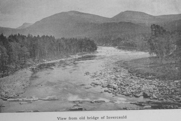
View from old bridge of Invercauld
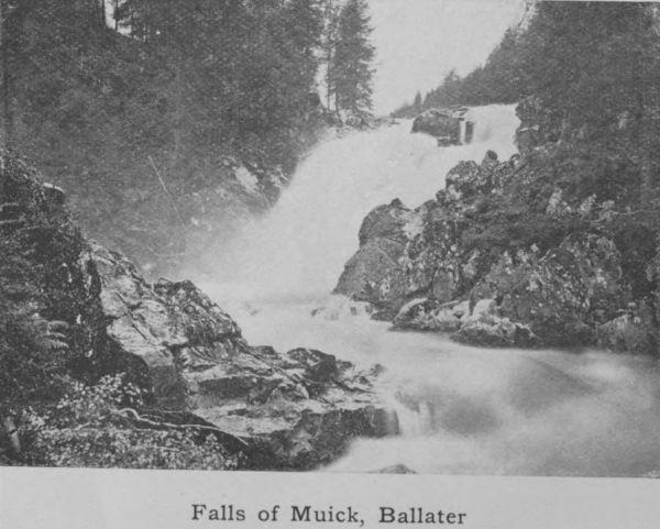
Falls of Muick, Ballater
tributary, joins the main river. From Invercauld past Balmoral Castle to Ballater is sixteen miles. Here the bottom is at times rocky, at times filled with big rough stones, at other times shingly but never deep. The average depth is only four feet, and the normal pace under ordinary conditions 3-1/2 miles an hour. From Ballater, where the river is joined by the Gairn and the Muick, the Dee maintains the same character to Aboyne and Banchory, where it is joined by the Feugh from the forest of Birse. Just above Banchory is Cairnton, where the water supply for the town of Aberdeen, amounting on an average to 7 or 8 million gallons a day, is taken off. The course of the river near the mouth was diverted some 40 years ago to the south, at great expense, by the Town Council, and in this way a considerable area of land was reclaimed for feuing purposes. The
spanning of the river at this point by the Victoria bridge, which superseded a ferry-boat, has led to the rise of a moderately sized town (Torry) on the south or Kincardine side of the river.
The scenery of Deeside, all the way from the Cairngorms to the old Bridge of Dee, two miles west of the centre of the city, is varied and attractive. It is well-wooded throughout; in the upper parts the birch, which would seem to be indigenous in the district, adds to the beauty of the hill-sides, while the clean pebbly bed of the river and its swift, dashing flow delight the eyes of those who are familiar only with sluggish and mud-stained waters. It is not surprising therefore that the district has attained the vogue it now enjoys.
The Don runs parallel to the Dee for a great part of its course, but it is a much shorter river, measuring only 78 miles. It rises at the very edge of the county close to the point where the Avon emerges from Glen Avon and turns north to join the Spey. It drains a valley which is only ten or fifteen miles separated from the valley of the larger river. In its upper reaches it somewhat resembles Deeside, being quite highland in character; but lower down the river loses its rapidity, becoming sluggish and winding. Strathdon, as the upper area is called, is undoubtedly picturesque, but it lacks the bolder features of Deeside, being less wooded and graced with few hills on the grand scale. It has not, therefore, become a popular
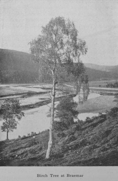
Birch Tree at Braemar
summer resort, but its banks form the richest alluvial agricultural land in the county
A mile o’ Don’s worth twa o’ Dee
Except for salmon, stone and tree.
This old couplet is so far correct. The Dee is a great salmon river, providing more first-class salmon angling than any other river of Scotland, while the Don, though owing to its muddy bottom a stream excellent beyond measure and unsurpassed for brown trout,
is not now, partly owing to obstruction and pollution, a great salmon river. But the agricultural land on Donside, which for the most part is rich deep loam, about Kintore, Inverurie and the vale of Alford is much more kindly to the farmer than the light gravelly soil of Deeside, which is so apt to be burnt up in a droughty summer. In the matter of stone, things have changed since the couplet took shape. The granite quarries of Donside are now superior to any on the Dee; but the trees of Deeside still hold their own, the Scots firs of Ballochbuie forest, west of Balmoral, being the finest specimens of their kind in the north.
The nether-Don has been utilised for more than a century as a driving power for paper and wool mills. Of these there is a regular succession for several miles of the river’s course, from Bucksburn to within a mile of Old Aberdeen. After heavy rains or a spring thaw the lower reaches of the river, especially from Kintore downwards, are apt to be flooded, and in spite of embankments which have been erected along the river’s course, few years pass without serious damage being done to the
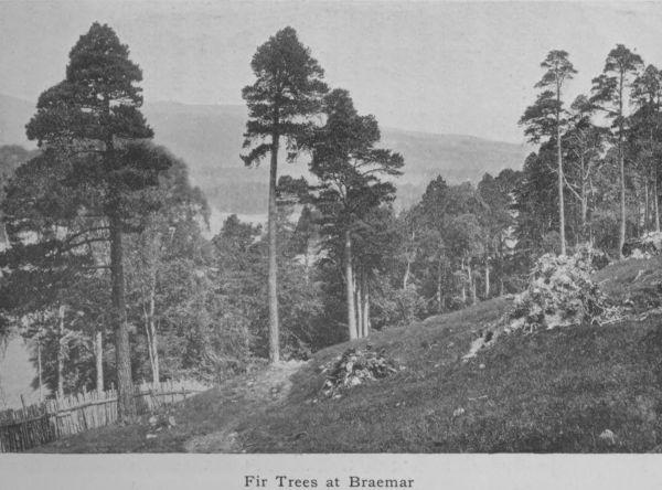
Fir Trees at Braemar
crops in low-lying fields. Some parts of Donside scenery, notably at Monymusk (called Paradise), and at Seaton House just below the Cathedral of Old Aberdeen, and before the river passes through the single Gothic arch of the ancient and historical bridge of Balgownie, are very fine—wooded and picturesque, and beloved of more than one famous artist.
The next river is the Ythan, which, rising in the low hills of the Culsalmond district and flowing through the parish of Auchterless and past the charming hamlet of Fyvie, creeps somewhat sluggishly through Methlick and Lord Aberdeen’s estates to Ellon. A few miles below Ellon it forms a large tidal estuary four miles in length—a notable haunt of sea-trout, the most notable on the east coast. The river is only 37 miles long. It is slow and winding with deep pools and few rushing streams; moreover its waters have never the clear,
sparkling quality of the silvery Dee. Yet at Fyvie and at Gight it has picturesque reaches that redeem it from a uniformity of tameness.
The Ugie, a small stream of 20 miles in length, is the only other river worthy of mention. It joins the sea north of the town of Peterhead. In character it closely resembles the Ythan, having the same kind of deep pools and the same sedge-grown banks.
The Deveron is more particularly a Banffshire river, yet in the Huntly district, it and its important tributary the Bogie (which gives its name to the well-known historic region called Strathbogie) are wholly in Aberdeenshire.
The Don, looking towards St Machar Cathedral
The Deveron partakes of the character of the Dee and the character of the Don. It is neither so sparkling and rapid as the one nor so slow and muddy as the other. Around Huntly and in the locality of Turriff and Eden, where it is the boundary between the counties, it
has some charmingly beautiful reaches. Along its banks is a succession of stately manor-houses, embosomed in trees, and these highly embellished demesnes enhance its natural charms.
Brig o’ Balgownie, Aberdeen
Lakes are few in Aberdeenshire, and such as exist are not specially remarkable. The most interesting historically are the Deeside Lochs Kinnord and Davan which are held by antiquarians to be the seat of an ancient city Devana—the town of the two lakes. In pre-historic times there dwelt on the shores of these lakes as also in the valleys that converge upon them a tribe of people who built forts, and lake retreats, made oak canoes, and by means of palisades of the same
material created artificial islands. The canoes which have been recovered from the bed of the loch are hollowed logs thirty feet in length. Other relics—a bronze vessel and a bronze spearhead, together with many beams of oak—have been fished up, all proving the existence of an early Pictish settlement.
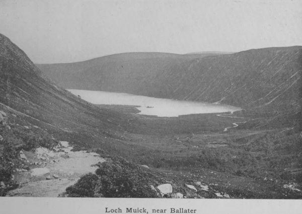
Loch Muick, near Ballater
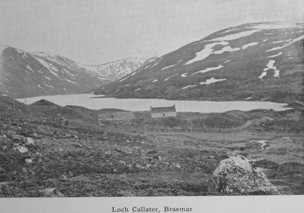
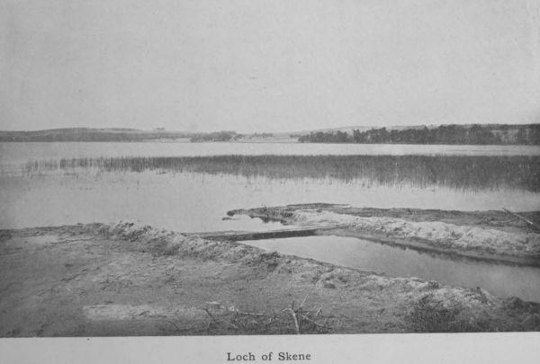
Besides these, there is in the same district—but south-east of Lochna-gar, another and larger lake called Loch Muick. From it flows the small river Muick—a tributary of the Dee, which it joins above Ballater. South-west of Loch-na-gar is Loch Callater, which drains into the Clunie, another Dee tributary, which joins the main river at Castleton of Braemar. On the lower reaches of the Dee are the Loch of Park or Drum, and the Loch of Skene, both of which drain into the Dee. Both are much frequented by water-fowl of various kinds.
The Loch of Strathbeg, which lies on the east coast not far from Rattray Head, is a brackish loch of some interest. Two hundred years ago, we are told, it was in direct communication with the sea and small vessels were able to enter it. In a single night a furious easterly gale blew away a sand-hill between the Castle-hill of Rattray and the sea, with the result that the wind-driven sand formed a sand-bar where formerly there was a clear
Loch Callater, Braemar
water-way. Since that day the loch has been land-locked and though still slightly brackish may be regarded as an inland loch.
6. Geology.
Geology is the study of the rocks or the substances of which the earthy crust of a district is composed. Rocks are of two sorts: (1) those due to the action of heat, called igneous, (2) those formed and deposited by water, called aqueous. When the earth was a molten ball, it cooled at the surface, but every now and again liquid portions were ejected from cracks and weak places. The same process is seen in the eruptions of Mount Vesuvius, which sends out streams of liquid lava that gradually cools and forms hard rock. Such are igneousrocks. But all the forces of nature are constantly at work disintegrating the solid land; frost, rain, the action of rivers and the atmosphere wear down the rocks; and the tiny particles are carried during floods to the sea, where they are deposited as mud or sandbeds laid flat one on the top of the other like sheets of paper. These are _aqueous_ rocks. The layers are afterwards apt to be tilted up on end or at various angles owing to the contortions of the earth’s crust, through pressure in particular directions. When so tilted they may rise above water and immediately the same process that made them now begins to unmake them. They too may in time be so worn away that only fragments of them are left whereby we may interpret their history.
Loch of Skene
To these may be added a third kind of rock called metamorphic, or rocks so altered by the heat and pressure of other rocks intruding upon them, that they lose their original character and become metamorphosed. They may be either sedimentary, laid down originally by water, or they may be igneous, but in both cases they are entirely changed or modified in appearance and structure by the treatment they have suffered.
The geology of Aberdeenshire is almost entirely concerned with igneous and metamorphic rocks. The whole backbone of the county is granite which has to some extent been rubbed smooth by glacial action; but in a great part of the county the granite gives place to metamorphic rocks, gneiss, schist, and quartzite. A young geologist viewing a deep cutting in the soil about Aberdeen finds that the material consists of layers of sand, gravel, clay, which are loosely piled together all the way down to the solid granite. This is the glacial drift, or boulder clay, a much later formation than the granite
and a legacy of what is called the great Ice Age. Far back in a time before the dawn of history all the north-east of Scotland was buried deep under a vast snow-sheet. The snow consolidated into glaciers just as in Switzerland to-day, and the glaciers thus formed worked their way down the valleys, carrying a great quantity of loose material along with them. When a warmer time came, the ice melted and all the sand and boulders mixed up in the ice were liberated and sank as loose deposits on the land. This is the boulder clay which in and around Aberdeen is the usual subsoil. It consists of rough, halfrounded pebbles, large and small, of clay, sand, and shingle, and makes a very cold and unkindly soil, being difficult to drain properly and slow to take in warmth.
Below this boulder clay are the fundamental rocks. At Aberdeen these are pure granite; but in other parts of the county they are, as we have said, metamorphic, that is, they have been altered by powerful forces, heat and pressure. Whether they were originally sedimentary, before they were altered, is doubtful; some geologists think the crystalline rocks round Fraserburgh and Peterhead were aqueous. Mormond Hill was once a sandstone, and the schists of Cruden Bay and Collieston were clay. The same beds traced to the south are found to pass gradually into sedimentary rocks that are little altered. Whether they were aqueous or igneous originally, they have to-day lost all their original character. No fossils are found in them. These rocks are the oldest and lowest in Aberdeenshire. After their formation, they were invaded from below by intrusive masses of molten igneous rock, which in many parts of the county is now near the surface. This is the granite already referred to. Its presence throughout the county has materially influenced the character and the industry of the people.
Wherever granite enters, it tears its irregular way through the opposing rocks, and sends veins through cracks where such occur. The result of its forcible entrance in a molten condition is that the contiguous rocks are melted, blistered, and baked by the intrusive matter. Why granite should differ from the lava we see exuding from active volcanoes is explained by the fact that it is formed deep below
the surface where there is no outlet for its gases. It cools slowly and under great pressure and this gives it its special character. If found, therefore, at the surface, as it is in Aberdeen, this is because the rocks once high above it, concealing its presence have been worn away, which gives some idea of the great age of the district. One large granitic mass is at Peterhead, where it covers an area of 46 square miles, and forms the rocky coast for eight miles; but the whole valley of the Dee as far as Ben Macdhui, and a great part of Donside, consist of this intrusive granite. It varies in colour and quality, being in some districts reddish in tint as at Sterling Hill near Peterhead, at Hill of Fare, and Corennie; in other parts it is light grey in various shades.
The succession in the order of sedimentary rocks is definitely settled, and although this has little application to Aberdeenshire, an outline may be given. The oldest are the Palaeozoic which includes—in order of age—
Cambrian, Silurian, Old Red Sandstone or Devonian, Carboniferous, Permian.
Of these the only one represented in Aberdeenshire is the Old Red Sandstone, which occupies a considerable strip on the coast from Aberdour to Gardenstown, and runs inland to Fyvie and Auchterless and even as far as Kildrummy and Auchindoir. The deposit is 1300 feet thick. A visitor to the town of Turriff is struck by the red colour of many of the houses there, a most unusual variant upon the bluegrey whinstone of the surrounding districts. The explanation is that a convenient quarry of Old Red Sandstone exists between Turriff and Cuminestown. Kildrummy Castle, one of the finest and most ancient ruins in the county, is not like the majority of the old castles built of granite but of a sandstone in the vicinity. The same band extends across country to Auchindoir, where it is still quarried.
The next geological group of Rocks, the Secondary or Mesozoic, includes—in order of age—
Triassic, Jurassic, Cretaceous.
These are not at all or but barely represented. A patch of clay at Plaidy, which was laid bare in cutting the railway track, belongs to the Jurassic system and contains ammonites and other fossils characteristic of that period. Over a ridge of high ground stretching from Sterling Hill south-eastwards are found numbers of rolled flints belonging to the Cretaceous or chalk period, but the probability is that they have been transported from elsewhere by moving ice and are not in their natural place.
The Tertiary epoch is just as meagrely represented as the Secondary. Yet this is the period which in other parts of the world possesses records of the most ample kind. The Alps, the Caucasus, the Himalayas were all upheaved in Tertiary times; but of any corresponding activity in the north-east of Scotland, there is no trace. It is only when the Tertiary merges in the Quaternary period that the history is resumed. The deposits of the Ice Age, when Scotland was under the grip of an arctic climate, are much in evidence all over the county and have already been referred to. It is necessary to treat the subject in some detail.
During the glacial period, the snow and ice accumulated on the west side of the country, and overflowed into Aberdeenshire. There were several invasions owing to the recurrence of periods of more genial temperature when the ice-sheet dwindled. One of the earlier inroads probably brought with it the chalk flints now found west of Buchan Ness; another brought boulders from the district of Moray. South of Peterhead a drift of a different character took place. Most of Slains and Cruden as well as Ellon, Foveran, and Belhelvie are covered with a reddish clay with round red pebbles like those of the Old Red Sandstone. This points to an invasion of the ice-sheet from Kincardine, where such deposits are rife. Dark blue clay came from
the west, red clay from the south, and in some parts they met and intermixed as at St Fergus. A probable third source of glacial remains is Scandinavia. In the Ice Age Britain was part of the continental mainland, the shallow North Sea having been formed at a subsequent period. The low-lying land at the north-east of the county was the hollow to which the glaciers gravitated from west and south and east, leaving their débrison the surface when the ice disappeared. So much is this a feature of Buchan that one wellknown geologist has humorously described it as the riddling heap of creation.
Both the red and the blue clay are often buried under the coarse earthy matter and rough stones that formed the residuum of the last sheet of ice. This has greatly increased the difficulty of clearing the land for cultivation. Moreover a clay subsoil of this kind, which forms a hard bottom pan that water cannot percolate through, is not conducive to successful farming. Drainage is difficult but absolutely necessary before good crops will be produced. Both difficulties have been successfully overcome by the Aberdeenshire agriculturist, but only by dint of great expenditure of time and labour and money.
The district of the clays is associated with peat beds. There is peat, or rather there was once peat all over Aberdeenshire, but the depth and extent of the beds are greatest where the clay bottom exists. A climate that is moist without being too cold favours the growth of peat and the Buchan district, projecting so far into the North Sea and being subject to somewhat less sunshine than other parts of the county, provides the favouring conditions. The rainfall is only moderate but it is distributed at frequent intervals, and the clay bottom helps to retain the moisture and thus promotes the growth of those mosses which after many years become beds of peat. These peat beds for long provided the fuel of the population. In recent years they are all but exhausted, and the facility with which coals are transported by sea and by rail is gradually putting an end to the “casting” and drying of peats.
Moraines of rough gravel—the wreckage of dwindling glaciers—are found in various parts of the Dee valley. The soil of Deeside has little intermixture of clay and is thin and highly porous. It follows that in a dry season the crops are short and meagre. The Scots fir, however, is partial to such a soil, and its ready growth helps with the aid of the natural birches to embellish the Deeside landscape.
In the Cairngorms brown and yellow varieties of quartz called “cairngorms” are found either embedded in cavities of the granite or in the detritusthat accumulates from the decomposition of exposed rocks. The stones, which are really crystals, are much prized for jewellery, and are of various colours, pale yellow (citrine), brown or smoky, and black and almost opaque. When well cut and set in silver, either as brooches or as an adornment to the handles of dirks, they have a brilliant effect. Time was when they were systematically dug and searched for, and certain persons made a living by their finds on the hill-sides; but now they are more rare and come upon only by accident.
7. Natural History.
As we have seen in dealing with the glacial movements, Britain was at one time part of the continent and there was no North Sea. At the best it is a shallow sea, and a very trifling elevation of its floor would re-connect Scotland with Europe. It follows that our country was inhabited by the same kind of animals as inhabited Western Europe. Many of them are now extinct, cave-bears, hyaenas and sabretoothed tigers. All these were starved out of existence by the inroads of the ice. After the ice disappeared this country remained joined to the continent, and as long as the connection was maintained the land-animals of Europe were able to cross over and occupy the ground; if the connection had not been severed, there would have been no difference between our fauna and the animals of Northern France and Belgium. But the land sank, and the North Sea filled up the hollow, creating a barrier before all the species in Northern Europe had been able to effect a footing in our country. This applies both to plants and animals. While Germany has nearly ninety species of land animals, Great Britain has barely forty. All the mammals, reptiles and amphibians that we have, are found on the continent besides a great many that we do not possess. Still Scotland can boast of its red grouse, which is not seen on the continent.
With every variety of situation, from exposed sea-board to sheltered valley and lofty mountain, the flora of Aberdeenshire shows a pleasing and interesting variety. The plants of the sea-shore, of the waysides, of the river-banks, and of the lowland peat-mosses are necessarily different in many respects from those of the great mountain heights. It is impossible here to do more than indicate one or two of the leading features. The sandy tracts north of the Ythan mouth have characteristic plants, wild rue, sea-thrift, rock-rose, grass of Parnassus, catch-fly (Silene maritima). The waysides are brilliant with blue-bells, speedwell, thistles, yarrow and violas. The peat-mosses show patches of louse-wort, sundew, St John’s wort,
cotton-grass, butterwort and ragged robin. The pine-woods display an undergrowth of blae-berries, galliums, winter-green, veronicas and geraniums. The Linnaea borealis is exceedingly rare, but has a few localities known to enterprising botanists. The whin and the broom in May and June add conspicuous colouring to the landscape while a different tint of yellow shines in the oat-fields, which are throughout the county more or less crowded with wild mustard or charlock. The granitic hills are all mantled with heather (common ling, Callunaerica) up to 3000 feet, brown in winter and spring but taking on a rich purple hue when it breaks into flower in early August. The purple bell-heather does not rise beyond 2000 feet and flowers much earlier. Through the heather trails the stag-moss, and the pyrola and the genista thrust their blossoms above the sea of purple. The cranberry, the crow-berry and the whortle-berry, and more rarely the cloudberry or Avron (Rubus chamaemorus) are found on all the Cairngorms. The Alpine rock-cress is there also, as well as the mountain violet (Viola lutea), which takes the place of the hearts-ease of the lowlands. The moss-campion spreads its cushions on the highest mountains; saxifrages of various species haunt every moist spot of the hill-sides and the Alpine lady’s mantle, the Alpine scurvy-grass, the Alpine speedwell, the trailing azalea, the dwarf cornel (Cornus suecica), and many other varieties are to be found by those who care to look for them.
As we have said, no trees thrive near the coast. The easterly and northerly winds make their growth precarious, and where they have been planted they look as if shorn with a mighty scythe, so decisive is the slope of their branches away from the direction of the cold blasts. Their growth too in thickness of bole is painfully slow, even a period of twenty years making no appreciable addition to the circumference of the stem. Convincing evidence exists that in ancient times the county was closely wooded. In peat-bogs are found the root-stems of Scots fir and oak trees of much larger bulk than we are familiar with now. The resinous roots of the fir trees, dug up and split into long strips, were the fir-candles of a century ago, the only artificial light of the time.
The district is not exceptional or peculiar in its fauna. The grey or brown rat, which has entirely displaced the smaller black rat, is very common and proves destructive to farm crops—a result partially due to the eradication of birds of prey, as well as of stoats and weasels, by gamekeepers in the interest of game. The prolific rabbit is in certain districts far too numerous and plays havoc with the farmer’s turnips and other growing crops. Brown hares are fairly plentiful but less numerous than they were in the days of their protection. Every farmer has now the right to kill ground game (hares and rabbits) on his farm and this helps to keep the stock low. The white or Alpine hare is plentiful in the hilly tracts and is shot along with the grouse on the grouse moors. The otter is occasionally trapped on the rivers, and a few foxes
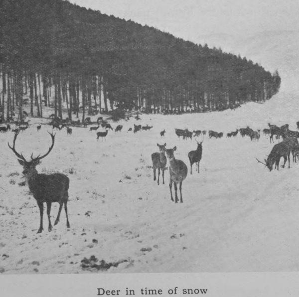
Deer in time of snow
are shot on the hills. The mole is in evidence everywhere up to the 1500 feet level, by the mole-heaps he leaves in every field, and the mole-catcher is a familiar character in most parishes. The squirrel has worked his way north during the last sixty years, and is now to be found in every fir-wood. The graceful roedeer is also a denizen of the pine-woods, whence he makes forays on the oat-fields. The reddeer is abundant on the higher and more remote hills, and deerstalking is perhaps the most exciting as it certainly is the most exacting of all forms of Scottish sport. The pole-cat is rarely seen; he
is best known to the present generation in the half-domesticated breed called the ferret. The hedge-hog, the common shrew, and the water-vole are all common.
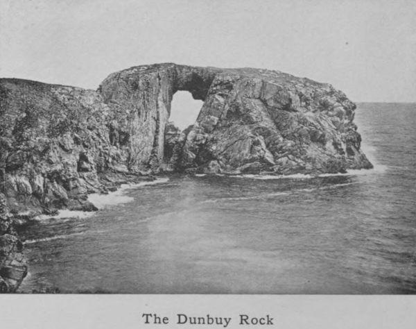
The Dunbuy Rock
The birds are numerous and full of interest. The coast is frequented by vast flocks of sea-gulls, guillemots, and cormorants, while the estuary of the Ythan has many visitants such as the ringed plover, the eider-duck, the shelduck, the oyster-catcher, redshank, and tern. On the north bank of this river the triangular area of sand-dunes between Newburgh and Collieston is a favourite nesting-place for eider-duck and terns. The nests of the eider-duck, with their five large olive-green eggs embedded in the soft down drawn from the mother’s breast, are found in great numbers amongst the grassy