Introduction
It was a hot July afternoon when my plane landed at Dehong Mangshi Airport. Mangshi is a small border city in Southwest China’s Yunnan province, close to Myanmar. It is the capital city of Dehong Dai and Jingpo Autonomous Prefecture and about an hour’s flight from Kunming. At the airport, I was greeted by two men in their late twenties; their mission was to take me across the border to Laiza, Myanmar,1 the headquarters of the Kachin Independence Organization (KIO) and its military arm, the Kachin Independence Army (KIA). The year was 2013, and only a few months earlier several military clashes between the Myanmar military (Tatmadaw) and the KIA ravaged this borderland area. Both of the men worked for the KIO. One, whom I will call Maung, is a Kachin from Myanmar who speaks excellent English but not much Chinese, while the other, Ahua, is a Jingpo (the Chinese name for the Kachin) from the Chinese side of the border who speaks perfect Mandarin.
I got in a car with them and they drove toward the border, which is about 200 kilometers away from Mangshi airport. The highway from the airport was relatively new, fast, and smooth, thanks to the modernization of China’s infrastructure. Before long, we arrived in Yingjiang, where we had a quick dinner before continuing toward the border, after dark. In the car, Maung told me that since military confrontations escalated a few months before, a Chinese military checkpoint had been set up on the way to the border, but usually the soldiers did not come out at night. Although I have a Chinese ID card, I am not from the local area, so I do not have the right paper (bianminzheng or “border people ID”) to cross the border officially. So, it was better to go after dark, and in the unlikely event the car was stopped, I was told to say I was a businessman from Zhejiang looking for commercial opportunities in Nabang, the small town across the border from Laiza. Before long, it started raining, and the smooth highway changed to a winding mountain road that went through a dense, eerily dark forest, and also made me feel carsick. Sure enough, the checkpoint was not staffed, so the car passed quickly through. Suddenly, another car appeared ahead of us,
flashing its headlights. Ahua stopped the car and we got out. He told me that in order to cross the border secretly, they could not take a car with Chinese license plates. So, we changed cars and soon turned off from the main road to a narrow muddy, side road, arriving in Laiza fifteen minutes later.
Laiza is under the de facto control of the KIA, and the Myanmar central government does not have any presence in the town itself. Even the official border crossing is manned by the People’s Liberation Army (PLA) on the Chinese side, with the KIA soldiers on the Kachin side. Architecturally, the town resembles a nondescript Chinese town, although street signs are in Kachin and Burmese as well as Chinese. Here, the main currency in circulation is the Chinese renminbi yuan (RMB), and the mobile phone networks are also Chinese. KIA soldiers patrol the town with their rifles hanging loosely from their backs, while many of the shops are run by migrants from China. Certainly, although Laiza is officially part of Myanmar territory, and all maps indisputably would put it within the sovereign boundaries of the Myanmar state, in practice the Myanmar state’s sovereignty does not reach it.
Along the long border between China and Myanmar, totaling more than 2,000 kilometers, there are quite a few territories like Laiza, where Myanmar’s sovereignty is fragmented, although to varying degrees. In both the Kachin and Shan states, many ethnic rebel groups continue to hold pieces of territory where they maintain direct administration. This is also the case along the border between Myanmar and Thailand, although to a lesser extent. Some of these groups, such as the KIA, are still fighting the Myanmar military. Fighting started between the KIA, who refused to be disarmed, and the Myanmar military in June 2011 and occurred sporadically into 2013, when ceasefire talks resumed. Fighting intensified in December 2012 and January 2013, when the Myanmar military made heavy use of airstrikes and artillery against KIA positions around Laiza.2
Similarly, a few years before the Kachin conflict, the Kokang rebels’ Myanmar National Democratic Alliance Army (MNDAA) was attacked by the Myanmar military, which effectively ousted the rebel army from its base. However, fighting erupted again in Kokang when Peng Jiasheng, the head of MNDAA, came back with his troops, supported by several other ethnic rebel armies.3 In February 2015, the MNDAA attacked Myanmar government posts around Laugai (Laojie), the capital city of Kokang. Fighting lasted until May, when the Myanmar government seized the MNDAA’s last stronghold.4 In addition to the KIA and MNDAA, there are several other ethnic rebel groups, such as the United Wa State Army
(UWSA), the National Democratic Alliance Army (NDAA), the Shan State Army (SSA), and numerous others, as well as many militias, which still maintain high levels of autonomy for territories along the Kachin and Shan borderland areas.
Today, when we look at the areas along Myanmar’s borders with China and Thailand, we see that both China and Thailand have clearly consolidated sovereign control in their respective borderlands, while at the same time projecting economic and cultural influence across the border into adjacent areas of Myanmar. Relatedly, both China and Thailand have carried out nation building with some success, in that ethnic minorities in the borderland area have increasingly come to identify themselves as either Chinese or Thai nationals while retaining their own ethnic identification, although certainly in different formats. On the other hand, the Myanmar government continues to face resistance from ethnic rebels opposing its own state consolidation efforts. In addition, its nation-building process has not been successful, as we can see from the various ethnic rebels who aim to maintain their autonomy, administratively but also culturally, from the Myanmar government’s vision of national belonging. So how do we explain such variations in state and nation building across this common borderland territory? Why could the Myanmar state not have a monopoly on the control of violence, in a Weberian sense, within its own territory? How did such fragmentation of the state along its borderland areas come about? Why did such fragmentation not occur in China or Thailand, where state consolidation has been mostly complete? How do we explain such variations of state building and consolidation of the borderland area among the three countries?
In The Art of Not Being Governed, James Scott provides a rather romantic account of the stateless spaces of upland Southeast Asia spanning across mainland Southeast Asia and Southwest China. Termed “Zomia” for this part of the Himalayan and Southeast Asian Massif, this stretch of territories is mountainous, sparsely populated, and ethnically diverse.5 Turning the conventional accounts upside down, Scott rejected the notion of the lowland valley agrarian states as the bearers of civilization and the upland nomadic slash-and-burn people as barbarians. Instead, Scott’s interpretation of the anarchist nature of these “free and mobile” upland people emphasizes how they escaped the restrictive political control by the “civilized” valley states.6 Therefore, it is not that these people remain “uncivilized’ by centralized states; rather, they intentionally escaped from the states in search of freedom and mobility.
However, such free spaces, which were difficult to reach during premodern periods thanks to geographical barriers such as mountainous terrain, have become possible targets of modern state penetration since the first half of the twentieth century.7 The combination of technological prowess and sovereign ambitions, both modernization as well as state and nation building, has significantly compromised these erstwhile stateless spaces for the benefit of the valley states. As a result, the Zomia territories have since become disintegrated parts of several modern nation-states that all tried to reach and consolidate their presence in those remote mountainous areas and make the people living there “legible.”8 Yet, the story of how these processes of modernization and state and nation building unfolded has not been comprehensively examined. Indeed, little attention has been paid to comparatively analyzing how the uneven process of state and nation building occurred in the borderlands of upland Southeast Asia and the reasons for the variations. This book is an attempt to fill this void.
This book presents a comparative historical account of the state and nationbuilding process in an “organic” upland area that shares lots of similarities in terms of geography and ethnic diversity, yet has become increasingly incorporated into a set of neighboring modern states. In an attempt to explain variations in state and nation building by these neighboring states, the book aims to achieve two main goals. One is to shed light on a theoretical question of how state and nation building should be conceptualized as interactive processes across national boundaries. Departing from existing approaches that look at such processes mainly from the angle of singular, bounded territorial states, the book argues that a more fruitful approach is to see how state and nation building in one country can influence, and be influenced by, the same processes across borders. For example, Daron Acemoglu and James Robinson, in their popular book Why Nations Fail, argue some countries are richer than others because they were founded on better political institutions.9 Yet they fail to comprehend that, in many instances, the failure of some nations is precisely the result of others’ success. One way to understand this interactive relation is to look at Angus Deaton’s treatment of global inequality as a consequence of progress.10 In The Great Escape, Deaton argues that in many instances “progress in one country was at the expense of another” (original emphasis by author).11 In his analysis, the Industrial Revolution benefited Europe tremendously, yet European nations’ progress also meant those “who were conquered and plundered in Asia, Latin America, and the Caribbean were not only harmed at the time but in many cases saddled with economic and political institutions that condemned them to centuries of continuing poverty and inequality.”12 Drawing inspiration from such an
approach, this book argues that we should also explain variations in state and nation building across national borders as mutually interactive processes. Thus, the success or failure of one country’s state and nation building can depend upon factors beyond its national borders in neighboring states. For this, the book proposes a “neighborhood effect” as a theoretical lens to consider state and nation building.
The other goal of the book is to present a rich and detailed account of the modern history of state and nation building in the borderland between China, Myanmar, and Thailand. Pushing through existing boundaries set up arbitrarily in area studies, with China studies separate from Southeast Asian studies,13 this book aims to tear down those barriers. The empirical chapters in the book thus put a strong emphasis on how deeply intertwined China is with Southeast Asia. Therefore, unlike existing accounts of state and nation building in these three countries that tend to focus on each country alone, this book looks at all three together while focusing on a common borderland territory.
Before delving deeper, some conceptual clarification is in order. What do I mean by state and nation building in this book? Although conceptually different, empirically nation and state building often happen hand in hand. This is particularly true with regard to a multi-ethnic border region where consolidation of state control and building of state institutions often require simultaneously developing a sense of national belonging.14 For these reasons, I tend to treat state and nation building as symbiotic and part of a holistic project. That said, state and nation building are often measured empirically using different indicators. For state building, the focus is on measuring how state institutions become established and embedded in a fixed territorial space, where a Weberian state in which legitimate control of violence is monopolized by the central government, and where economic sovereignty has been attempted.15 For nation building, the emphasis is often on the making of a common people, who are bounded by an inter-subjective understanding of mutual belonging.16 This is often achieved through projects that aim to teach the people a common language and indoctrinate them with a nationalist ideology. Paying attention to these differences between state and nation building, this book covers both processes in the empirical chapters, while noting the deeply interrelated nature of the two.
Geography, History, and People
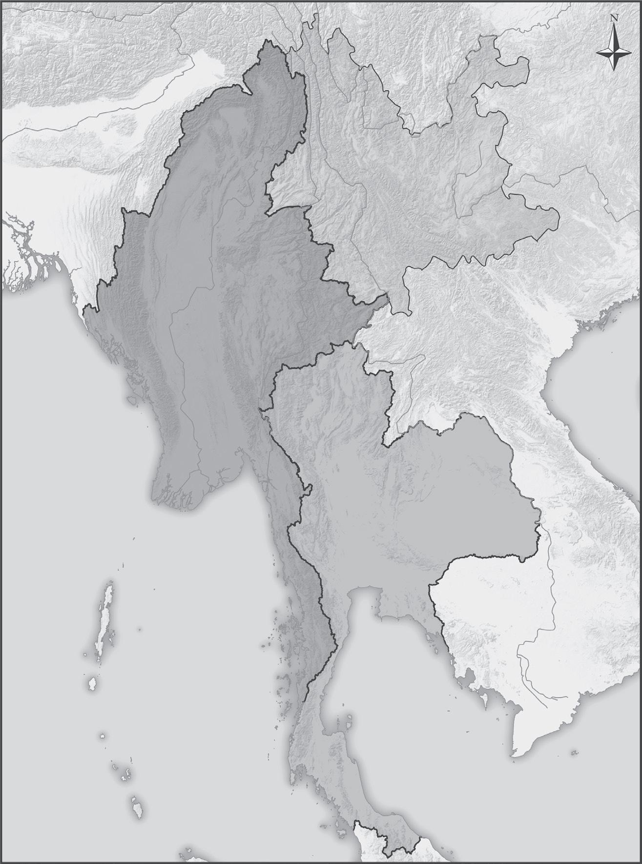
The geographic focus of the book is on a stretch of borderland area along the China-Myanmar-Thailand border. Broadly speaking, it covers southern
Yunnan province in China, Kachin and Shan states in Myanmar, and the northern provinces in Thailand that border Myanmar (see maps 1.1 and 1.2). At the same time, these are the territories that fall along the Mekong and Salween rivers shared by the three countries and are characterized by
THAILAN D
M YANMA R
C HIN A YUNNAN PROVINCE
Map 1.1 Myanmar, Thailand, and Yunnan (China)
Phek
60 Kilometers 30 0 0 30
KACHIN
Myitkyina
60 Miles
Dehong Hkamti
Mawlek
SAGAING
Baoshan Nujiang Lisu Katha
Bhamo
Kalaemyo
Kalaemyo
Shwebo
Monywa
Pyin-Oo-Lwin Mandalay
Kyaukme
Dali Bai
Laogai
Muse
C HINA
Lincang
YUNNAN
Lashio Kunlong
Pu’er
MYANMA R
Myingyan
Kyaukse Pakokku
Taunggyi
MAGWAY MANDALAY
Magwe Minbu Meiktila Sagaing
Yamethin
Minbu Naypyidaw
NAYPYIDAW
Loikaw
KAYAH KAYIN
Bawlakhe Taungoo Pyay Kawkarek
BAGO
SHAN
Loilen
Kengtung Mongsat Tachileik
Xishuangbanna Mongphat
CHIANG RAI
THAILAND
MAE HONG SON
CHIANG MAI
PHAYAO
NAN
LAMPANG
Map 1.2 Borderland Territories between China, Myanmar, and Thailand
mountainous terrain and deep river valleys that are difficult to cross. This region also includes the notorious Golden Triangle, which since the Cold War, has been a center of opium production and drug trafficking in Southeast Asia.17
The historical circumstances in which these areas were incorporated into the lowland states vary slightly. Southwest China was significantly subjected
to tight centralized control in the mid-eighteenth century with the replacement of many local ethnic chieftains (tusi) by magistrates appointed by Beijing.18 However, in southern Yunnan, many chieftains coexisted with the Qing and republican bureaucracies well into the mid-1950s, when the incoming communist regime formally abolished the chieftain system.19 Many of the chieftains in the Shan and Kachin states maintained dual tributary relations with the Konbaung Dynasty in Burma as well as with Qing China.20 After the British colonized the whole of Burma in 1885, the Kachin and Shan states were ruled separately by the British as frontier areas; Burma proper was ruled as ministerial Burma, while the country as a whole was incorporated as a province of British India.21 When Burma achieved independence from Britain in 1948, the frontier areas were united with Burma proper, yet unification very quickly translated into a prolonged civil war that has lasted ever since.22 For northern Thailand, the Nan kingdom used to pay tribute to both Burma and the Kingdom of Siam. After the mid-eighteenth century, it became a vassal of the Chakri Dynasty based in Bangkok. Extraterritoriality was granted to European companies, mostly British but also Danish, to exploit the profitable teak trade in northern Thailand. Eventually it was incorporated into Siam as part of the centralization that occurred during the reign of Rama V Chulalongkorn in 1899.23
Indeed, we can see differences at the macro level between the three cases in that only Burma was officially colonized by the British Empire. However, it suffices to say that no direct centralization in the modern sense was possible in China in the first half of the twentieth century, when the country was devastated by warlordism, the Japanese invasion, and the civil war.24 In Thailand, European extraterritoriality was revoked in the early twentieth century, and the modern bureaucratic state only started to increase its presence then. Even though the historical incorporation of these areas into these three states varies slightly in terms of the historical context, modern nation states only started to emerge after in the mid-twentieth century, with the People’s Republic of China (PRC) founded in 1949, Burma winning independence in 1948, and the 1947 military coup in Thailand.
At the same time, this borderland area covers a diverse set of ethnic groups that share strong linguistic and cultural ties across state borders.25 Yunnan, for example, officially recognizes 25 ethnic groups in the province, which account for 34% of the total population.26 Thailand officially does not recognize ethnic minority status, insisting everyone living within its borders is Thai, and many ethnic minority groups, especially the highlanders (hill tribes),
remain stateless.27 In Myanmar, the Kachin and Shan states are extremely diverse, although Myanmar has not released any census data about the states’ ethnic compositions. Ethnic demographic data from the most recent census, in 2014, have not yet been released. However, it is generally understood that the ethnic-majority Bamar only account for about 68% of the whole population. This means ethnic minorities should account for a high percentage of the population in the borderland area, which can also be inferred from the persistence of ethnic rebel groups and the inability of Myanmar’s government to impose state-building projects there. For some of the larger ethnic groups, estimates and distributions are available. There are about 1.2 million Dai in China and about 5–6 million Shan in Myanmar, both sharing strong linguistic and religious ties with northern Thailand. There are about 400,000 Wa in China and about 800,000 in Myanmar. For Kachin people, there are about 1 million in Myanmar and 150,000 in China, where they are known as Jingpo. China is home to 720,000 Lahu people, while Myanmar is home to 150,000, and Thailand 100,000. There are also 730,000 Lisu in China, 600,000 in Myanmar, and 50,000 in Thailand. Additionally, Miao (Hmong) and Yao (Iu-mien) live in the borderland area.
Interrelated Arguments
In order to explain the variations in state and nation building across the borderland area between China, Myanmar, and Thailand, the book makes two interrelated arguments. First, departing from existing literature on state building, this book proposes a novel theoretical approach that looks beyond the confines of state borders. Instead of looking at state building as a process predominantly determined by domestic factors, such as war making and preparation, political institutions, and geographic and demographic variables, the book proposes that we should look beyond the constraints of national borders. It argues that we should conceptualize state building as an interactive process heavily influenced by a “neighborhood effect” and look at how state building in one country can be influenced by the same process in the neighboring states. The book probes the conditions under which this neighborhood effect might take place. It argues that such an effect is more likely to occur in situations where there is power asymmetry between neighboring states, and its effect is further conditioned upon the nature of relations among these states. When a state borders a much stronger neighbor that is
also adversarial, then the latter would have the capacity and intention to politically and militarily meddle in the mutual borderland area, which would lead to the fragmentation of the former’s state building efforts in the area. If the bilateral relationship were more amicable, then the economically more powerful state would still exert significant influence on the other’s borderland area. If the two neighboring states were of similar power balance and adversarial, then we would expect a mutually militarized borderland region. Finally, if such states were friendly neighbors to each other, then there would not be a “neighborhood” effect of state building.
Fashioned in a similar way concerning nation building, the book also contends that cross-border dynamics can heavily influence that process, domestically. Specifically, it looks at two ways that a neighborhood effect of nation building can occur. One is for ethnic groups that straddle national borders but have linkages with powerful ethnic-kin homeland countries that claim rights to protect them. With such external support and monitoring, these ethnic groups would have more resources and cultural repertoires to resist the nation-building projects imposed on them by the majority ethnic group in the country they inhabit. This line of argument is drawn from Rogers Brubaker’s theorization of how external ethnic linkages and the support they offer for ethnic groups can fundamentally change the dynamics of nationalist politics within a country.28 The other way concerns ethnic groups that straddle national borders but are minorities in both countries. Here, the book argues that these ethnic groups compare different nationalist ideologies to which they are subject under the neighboring nation-building projects, which influence how they perceive their own living conditions and determine which side is preferable. Thus, if they perceive their external kin groups in neighboring countries as receiving better treatment than themselves, then they are more likely to develop a grievance toward the country they inhabit. This argument was developed in my previous book on ethnic group mobilization in China, and here I am applying it to this transnational context.29
Thus, taken together, when the borderland area between China, Myanmar, and Thailand is concerned, the book argues that the failure of the Myanmar state to consolidate its control over its borderland area is partly due to the political and military meddling by its two more powerful neighbors during the Cold War. Furthermore, both China and Thailand, being more economically advanced than Myanmar, have exerted heavy economic influence on the borderland area at the cost of Myanmar’s economic sovereignty. These
two dimensions explain the variation of state building across the borderland among these three countries. Meanwhile, the Myanmar state’s failure in nation building can also be explained in this way. For the Shan, because of their close ethnic ties to the Thai, historically Thailand has attempted to support their self-determination movements, while at the same time providing strong cultural capital for the Shan to resist the Burmanization process in Myanmar. For ethnic minority groups across the Sino-Myanmar border, such as the Kachin, Wa, and others, their double-minority status meant that they would compare the situations in China and Myanmar in their nationalist ideologies and policies. The more benign treatment they receive in China only feeds into their further alienation from the Myanmar state.
Methodology
The book adopts a comparative historical approach that pays attention to the interactive dynamics of state and nation building across this borderland area since the end of the second world war (WWII). In terms of examining comparative state building, it focuses on two major dimensions to measure such processes. The first is political and military and measures how states have attempted to consolidate their physical control, their varying results, and the reasons for these variations. Indeed, the book treats this dimension as the most fundamental, as it sets up the foundations of later state building efforts. The second dimension of state building is economic. Here the emphasis is on different states’ efforts to achieve their economic sovereignty and implications across the borderland area when there are disparities of economic power. In terms of examination of comparative nation building, the book looks at how different models of nationalist ideology and their applications have resulted in the different responses of ethnic groups scattered across this common area.
The empirical materials of the book come from a variety of sources. Materials in English, Chinese, Burmese, and Thai have been consulted and utilized, although the weight varies depending on the amount of materials available. A majority of archival materials come from the United States National Archive II (US NAII) in College Park, Maryland, and the British National Archives (BNA) in Kew. These archives contain a plethora of internal reports on the borderland area from the US State Department and the
British Foreign Office, sent by their embassies and consulates in Rangoon, Mandalay, Bangkok, and Chiang Mai. The book also utilizes extensive Chinese-language materials published in Taiwan and the PRC, in the form of memoirs, gazetteers, newspapers, and local historical accounts in Yunnan province. It engages books and journal articles published in Thai on the Chinese Nationalist Party (Kuomintang, KMT) in northern Thailand, the Thai communist insurgency, and Shan nationalist movements. The book also uses materials published in Burmese. Additionally, three major journals published by the Burmese government in the immediate postindependence period—Burma, Guardian, and Forward were consulted. Some materials at the National Archives in Yangon, which are currently made public for the period before 1953, have been utilized. Statistical books from China, Myanmar, and Thailand have also been consulted. In addition, interviews have been carried out with key informants in China, Myanmar, Thailand, and Taiwan.
Chapter Outlines
The book comprises a total of nine chapters, including the introduction and conclusion. After this introductory chapter, which lays out the book’s structure, the second chapter establishes its empirical and theoretical foundations. The third chapter is a historical account of the borderland that traces the pattern of relations between valley states and upland people before the midtwentieth century. Then the book delves into five empirical chapters that each look at different aspects of the complex state and nation building along the borderland area. Chapters 4 and 5 discuss two major political and military episodes since the start of the Cold War—the KMT troops in Burma and Thailand and communist insurgencies in the borderland—and their implications for the three states’ attempts to consolidate their control over their respective borderland areas. Chapter 6 then portrays the dynamics of borderland economy and the dominance of both China and Thailand on Myanmar’s borderland territory. In chapter 7, the book proceeds to a discussion of the comparative nation building among the three states and the implications for the ethnic minority groups and their national identities. Chapter 8 then analyzes the current ethnic politics along Myanmar’s restive borderland with its ongoing conflict and peace negotiation process. More detailed sketches of the chapters follow.
Chapter 2: The Neighborhood Effect of State and Nation Building
The second chapter establishes both the empirical and theoretical foundations for the book. For illustrative purpose, it provides comparative statistics of how state and nation building in the borderland area differs among the three states. For state building, it offers a set of indicators, such as taxation, education, and health provisions, to measure how we can conceptualize the differences in each state’s ability to provide for its citizens along the borderland area. It then offers a sketch of how nationbuilding efforts in the three states in the borderland area also differ from one another in both style and substance. The chapter goes on to discuss, in general, different existing theoretical approaches and proposes a novel theoretical framework that looks at state and nation building as an interactive process dependent on power balances and the nature of relations among neighboring states.
Chapter 3: The Historical Pattern of State Formation in Upland Southeast Asia
This chapter introduces readers to the historical background of the upland Southeast Asia borderland area. It analyzes how the upland area and its people were perceived by valley states, as well as attempts made by those states to approach them militarily and politically. It examines existing historiographies that originated from the perspectives of the Chinese, Myanmar, and Thai states, paying attention to how they used a variety of means—military, political, and economic—in their efforts to deal with the mosaic of people living in the upland area. At the same time, it pays attention to perspectives of the upland people themselves in terms of how they viewed their relations with those valley states, if such accounts are available. The purpose of the chapter is to put this common borderland area in a historical perspective, while emphasizing the overall lack of state and national consolidation of the territories and people there before the modern period. It thus sets up the stage for the series of major political and military upheavals that fundamentally transformed the logic of political relations in this upland area. The first of these historical events was the end of the Chinese civil war in 1949, resulting
in the founding of the PRC, and the war’s spillover into Burma and Thailand after the KMT’s intrusion into the Shan State.
Chapter 4: Spillover of the Chinese Civil War and the Militarization of the Borderland
After the PRC’s establishment, a section of the KMT army crossed the border into Burma and occupied parts of the Shan State.30 Supported by the United States, the Republic of China in Taiwan, as well as Thailand, the KMT troops militarily destabilized the borderland area of China, Burma, and Thailand for several decades. This chapter analyzes the legacy of the KMT in the borderland area in terms of its impact on state building in the three countries.
In Burma, the KMT presence strengthened the military relative to the civilian government, which paved the way for decades of military rule in the country.31 More directly relevant for the borderland is the militarization of many of the ethnic minority groups in the area, which led to the formation of many ethnic rebel groups fighting for independence or more autonomy from Burma.32 Thus, the intrusion of the KMT into Burma played a sizable role in the fragmentation of that country in the peripheries, and also indirectly set in motion the militarized confrontation between the Burmese army and many of the estranged ethnic groups.
After the gradual relocation of the KMT to Thailand since the early 1960s, the Thai government recruited them for border patrol against communist infiltration. The legacy of the KMT episode for Thailand should be understood first in the context of the broader security alliance Thailand formed with the United States. By actively supporting US anti-communist activities, including the KMT, clandestine activities in Laos, and later the war in Vietnam, Thailand received large sums of economic and military aid from the United States. Later on, when Thailand faced its own communist insurgency, the KMT remnant troops also proved instrumental in Thai counter-insurgency campaigns.33
In the case of China, the KMT’s presence in Burma presented an external threat for the new communist government. Although the KMT only managed to invade Yunnan a couple of times, in 1951 and 1952, and were easily repelled by the PLA, this nevertheless provided the rationale for militarization of the border region on the Chinese side. The communist government carried out ruthless counter-insurgency campaigns against the KMT
remnants as well as other ethnic and local rebellions occurring in mountainous areas that resisted the communist regime’s consolidation of power. Campaigns were also carried out to subdue the population in the name of suppressing counter-revolutionaries.34 By the mid-1950s, however, much of the southwestern borderland area was securely under Beijing’s control.
Chapter 5: Communist Revolutions at the Borderland
Chapter 5 traces the other major source of instability in the borderland area: China’s support for communist insurgencies in Burma and Thailand. The domestic political radicalization in China in the mid-1960s manifested internationally in Mao’s push to support the “People’s War” in many Third World countries, which was also related to the PRC’s competition with the Soviet Union to become leader of the international communist movement.35 In Burma’s case, it meant the PRC ramped up its support for the Communist Party of Burma’s (CPB) military insurrection in 1967.36
The legacies of the CPB insurgency for Myanmar are profound. It meant the fundamental failure of Myanmar’s state building and consolidation over the borderland territories that it claims as its own. The setup of the stable base area along the Sino-Myanmar border by the CPB prevented the Myanmar central government from accessing this area until the mid-1990s, after the collapse of the CPB in 1989 and the signing of a series of ceasefire treaties with various legacy ethnic rebel groups.37 The most significant legacy of the CPB is the further militarization of various ethnic minority groups along the border area. Although the CPB leadership predominately comprised ethnic Bamar (the main ethnic group in the country), many of its foot soldiers were heavily recruited from local ethnic minorities in the borderland area. Therefore, after the collapse of the CPB, ethnic insurgencies continued because various ethnic rebels formed their own militant organizations.
The CCP also offered support for the Communist Party of Thailand’s (CPT) insurgency starting in 1965.38 Although the CPT also recruited heavily from various ethnic minority groups in the mountains, the Thai state was better equipped with more resources and international support for its counterinsurgency work.39 Heavily funded by the United States, Thailand carried out military campaigns against the CPT, but also undertook many nation-building projects targeting the ethnic minority “hill tribes” in an effort to assimilate them into the Thai nation-state.40 Thus, for Thailand, the
CPT insurgency instilled a strong sense of urgency, which led to a counteractive campaign of state and nation building by the government, with US support. The Thai nationalist emphasis on nation, king, religion, and the image of royal benevolence was imposed, and as a result, spread throughout the area.41
In China’s own case, the initiation of the Cultural Revolution resulted in large numbers of urban Red Guards being sent to the borderland areas in Yunnan.42 Through the settlement of Han Chinese youth in the borderland area, the Chinese state somehow created a human dimension in its consolidation of the border region. It was during this period that direct interpersonal contact occurred between various ethnic minority groups and the dominant Han Chinese, which also coincided with an education system being set up to teach the Chinese language to minorities.43 Violence unleashed through the Cultural Revolution empowered the Chinese state to penetrate deeply into the most remote areas in Yunnan, on the one hand, while at the same time, the Han Chinese “sent-down” youth unwittingly became agents for the cultural consolidation of the borderland.
Chapter 6: Dynamics of Transboundary Economic Flows
After discussing the two main political and military incidents that set in motion the interactive dynamics of state building in the borderland area in chapter 5, chapter 6 goes on to discuss the economic logic of cross-border relations. To illustrate the economic dynamics of borderland state building as a result of economic asymmetry between Myanmar and its two more powerful neighbors, this chapter mainly examines two inter-related processes.
The first process examined is cross-border movement of goods and people between China, Myanmar, and Thailand and specifically, the phenomenon of labor migration from Myanmar to Thailand,44 as well as the integrated trade networks across the borderland.45 As a result of the economic disparity and political chaos in Myanmar, Thailand has been the most popular destination for Myanmar migrants, especially ethnic Shan—about one-third of the 1.5 million Myanmar migrants in Thailand come from the Shan State.46 Meanwhile, trade networks also link China with Myanmar and Thailand. Goods made in China and Thailand go to Myanmar, and natural resource products from Myanmar flow in the other direction. Indeed, the business network in the borderland area is an organic one that is oriented toward both
the Chinese and the Thai sides of the border. Border cities such as Mai Sai in Thailand and Ruili in China are centers for the cross-border movement of people and goods. More importantly, the economic gaps between China and Myanmar mean that Chinese businesspeople have started to penetrate and dominate the Myanmar market.
The chapter also discusses cross-border resource development dominated by Chinese as well as Thai capital in Myanmar. Here, it mainly looks at agribusiness as well as investment in the hydropower, lumber, and mining sectors in Myanmar’s Kachin and Shan states.47 The purpose of the chapter is to illustrate the centrifugal forces across the borderlands that reorient the local economy toward northern Thailand and southern Yunnan province in China and away from Myanmar. Thus, Myanmar’s lack of economic sovereignty along the border can be attributed, to a great extent, to the economic imbalance between it and its two more developed neighbors.
Chapter 7: Comparative Nation Building across the Borderland Area
After discussing the phenomenon of state building as a neighborhood effect, chapter 7 shifts attention to nation building and specifically, to how different nationalist ideologies in these three countries have affected the politics of national identity among various ethnic minority groups living along the borders. The Chinese government recognizes 56 ethnic groups with provision of “nominal” ethnic autonomy. So, the Chinese state, at least on paper, allows for the institutional provision of autonomous government, minority language education, religious and cultural expression, and so forth.48 The Thai national discourse, on the other hand, claims everyone living within the territorial boundaries of Thailand is Thai and does not officially recognizing ethnic minorities who live on the kingdom’s peripheries. At the same time, at certain points in history, Thailand has made irredentist claims to pan-Tai ethnic groups in Myanmar as well as in China.49 The Myanmar government officially recognizes 135 ethnic groups and established 7 ethnic states. However, the long history of military rule in the country meant that ethnic cultural expression has been highly restricted, and ethnic schools are still banned. More significantly, the state has heavily repressed its ethnic-minority groups in their fight for self-determination.50
The chapter then examines how close ethnic linkages between the Shan and Thai manifest in Thailand’s interest in supporting the Shan nationalist movements as part of its pan-Tai sentiment.51 Although Thailand has forfeited all its claims to other Tai territories in neighboring states since the end of WWII, it continues to heavily influence them culturally and religiously. In the Myanmar Shan State, this manifests itself in the way in which the Shan are culturally oriented toward Thailand. Shan monasteries and monks have close ties to their counterparts in Thailand, and Thai pop music is popular among the Shan.52 Additionally, support by the Thai government and public, although mainly symbolic, is crucial for maintaining Shan nationalism against Myanmar.53
The chapter then compares the implications of different nationalist ideologies and practices for common cross-border ethnic minorities between China and Myanmar. Compared with China, Myanmar’s treatment of its ethnic minorities has been much more brutal as the country has been engulfed in more than half a century of civil war. The military campaigns against various ethnic rebel organizations have intensified repression against ethnic minorities in the Kachin and Shan states.54 During the past three or more decades, the contrast across the China-Myanmar borderland area has been evident in the stability and economic prosperity found on the Chinese side of the border. Many ethnic minority groups across the border see China as the place where ethnic minorities are better treated than in Myanmar. Relative depravation explains this very well.
Chapter 8: Continual Contestation at the China-Myanmar Border
Chapter 8 looks at the ongoing ethnic conflicts along the Sino-Myanmar borderland area and explores ways in which these conflicts continue to implicate Myanmar’s state and nation-building process. It first discusses the ceasefires in Myanmar since the late 1980s between the central government and various ethic rebel groups. Specifically, the chapter examines three prominent ethnic rebel groups: the KIA, with which the Myanmar national army has ongoing military clashes; the MNDAA, the Kokang rebel group that the Myanmar central military has defeated twice, in 2009 and 2015, solidifying its control over the Kokang area in northern Shan State; and the United Wa State Army, which despite a 2011 break in the ceasefire between it and the
Myanmar central government, has so far not faced direct military pressure and continues to maintain a high level of political and cultural autonomy. Altogether, the chapter offers a more up-to-date analysis of the challenges facing Myanmar’s state and nation-building process and its implications for bilateral relations with China and Thailand.
Chapter 9: Conclusion
The book concludes with some theoretical reflection on the neighborhood effect of state and nation building. More pertinent to the borderland area examined in this book, it also looks at recent developments in China’s push for more regional economic integration and their implications for both Myanmar and Thailand.
The Neighborhood Effect of State and Nation Building
After half an hour on a bumpy road, the car took me to one of the largest camps for internally displaced persons (IDP) in the KIA-controlled area. It was the summer of 2013, and several thousand people who had lost their homes due to the fighting between the KIA and the Myanmar military were housed here. Throughout Kachin State, as a result of the ongoing military clashes, there were many temporary IDP camps, where after years of internal conflict, large sections of the ethnic population in the borderland area have been forced to live in those makeshift dwellings with only very basic shelter. The camp had a very limited supply of electricity, and even that was through a connection with the Chinese side of the border, across from a little creek. There were limited economic activities, and many people crossed the border to China to find temporary labor. One small school with only a couple of teachers provided very basic education for the children.
In Laiza, there are a total of seven schools, including one high school, set up by the KIO, the civilian counterpart of the KIA. Since the area is under the de facto control of the KIA, its school curricula are in both the Burmese and Kachin languages. In fact, it is only in the KIA-controlled area that the Kachin language is taught in the school system; in other parts of Kachin State under Myanmar government control, such bilingual education is banned in the state school system. Thus, ordinary Kachin people who want to learn their own language cannot do so in the state school system, except in KIAcontrolled areas or informally in some Kachin churches.
Indeed, this prohibition of ethnic language education is a common practice throughout the ethnic states in Myanmar. In the neighboring Shan State, people can only learn Shan languages in monasteries or in private schools set up by Shan nationalists. In the outskirts of Kengtung, in the center of eastern Shan State, my friend Duwan, a Shan monk, once took me on a tour at a local Shan (Tai-Kuen) school with a loose connection to the SSA, where about a hundred pupils were studying. The school is a primary school built
on a hilltop in the compound of a Shan monastery. Here children of school age learn three languages—Burmese, English, and Shan—and teachers in the school print their own education materials in Shan. However, due to the lack of funding and facilities, the level of education is very basic, and they run the risk of the children’s education background not being recognized by the Myanmar state school system.
This chapter introduces some general descriptions of various state and nation-building efforts along the borders of China, Myanmar, and Thailand and provides a set of statistics commonly utilized to measure state and nation building. It engages with existing political science literature in general, and then proposes an alternative perspective on how state and nation building in one country can be related to events and circumstances in neighboring countries, that is, the neighborhood effect of state and nation building.
Variations in State and Nation Building across the Borderland
When we look at the three neighboring states of China, Myanmar, and Thailand, we can see that they vary significantly in terms of state capacity at the national level. One of the most commonly used indicators of this is state tax revenue as a percentage of Gross Domestic Product (GDP), which is the conventional gauge of a state’s extractive capacity.1 The tax ratio reflects its ability to extract resources from both individuals and corporate actors. As figure 2.1 shows, for a selected number of years, Myanmar’s state extractive capacity has been much lower than that of either Thailand or China.2 In 2004, only about 3% of Myanmar’s GDP came from tax revenue. That same year, close to 9% of China’s GDP came from tax revenue, while in Thailand the figure was 16%. Although the most recent data are not available, it is certain that, overall, Myanmar’s capacity is not in the same league as its two more powerful neighbors.
From figure 2.2, we can also see that China and Thailand have become much richer than Myanmar. According to World Bank Development Indicators, Myanmar’s GDP per capita barely exceeded US$1,000, while Thailand’s was close to US$6,000, and China’s almost US$8,000 by 2014. A few other indicators of human development in terms of education and health reveal similar differences, as we can see from table 2.1. Although Myanmar’s adult literacy rate has mostly caught up with both China and
Tax Revenue as Percentage of GDP
Figure 2.1 Tax Revenue as Percentage of GDP
GDP Per Capita, in Current US Dollars
Figure 2.2 GDP per Capita, in Current US Dollars
Thailand—all three countries are in the ninetieth percentile of adult literacy at the national level—there are still discrepancies in the overall provision of education. For example, 51% of students entered secondary school in Myanmar, compared with 86% in Thailand and 96% in China. This indicates that Myanmar’s education level overall is still very rudimentary, and the state has not been able to provide more than a very basic level of education. In terms of health, the infant mortality rate is much higher in Myanmar than in China or Thailand. Life expectancy is likewise much lower in Myanmar than in the other two countries. Thus, at the national level there is strong evidence
Table 2.1 Additional Indicators of Human Development in China, Myanmar, and Thailand in Selected Years
Secondary School Enrollment Rate (%)
(2013)
Infant Mortality Rate (%) 0.92 (2015) 3.95 (2015) 1.05 (2015)
Life Expectancy (years) 76 (2014) 66 (2014) 74 (2014)
World Bank Development Indicators, bracketed numbers indicate the years most recent data are available.
showing the discrepancy in terms of state capacity and how much each state has been able to provide for its own citizens.
However, these data are at the national level and by no means represent the same levels of state building in the borderland area. There are lots of reasons to suspect that at the remote borderland territories the presence of the state might be much less evident. Especially in more remote mountainous areas that characterize the borderland among the three countries, the geographical barriers the state must overcome to penetrate society and provide for citizens can be quite formidable. However, data at the local level are very limited and inconsistent, especially in the Myanmar case. Certainly, it might be that the Myanmar government does not want to publish comprehensive data, but the more likely explanation is that for much of the borderland area discussed in this book, the central government lacks the capacity even to make its presence known—as we have already discussed in the previous chapter—let alone to provide basic infrastructure for the people living there. As a result, the data presented here are simply for illustration purposes and by no means represent a valid across-the-board comparison of state building in the borderland area.
There are other indicators to measure such differences, such as the 2009–2010 UNICEF Multiple Indicator Cluster Survey (MICS), which measures and records the situations of children and women in Myanmar, including data on the Kachin and Shan states.3 From figure 2.3, we can see that several of the key basic development indicators, which highly correlate with state capacity, are overwhelmingly unsatisfactory. The primary school enrollment rate in Shan State is much lower than the Myanmar national average or that
Select Indicators of Development in Kachin and Shan States in Myanmar, 2009–2010
School Enrollment %
Nutrition: Stunting %
Figure 2.3 Select Indicators of Development in Kachin and Shan States in Myanmar, 2009–2010
of Kachin State. Especially in Shan State North, where it borders China, and Shan State East, where it borders China, Thailand, and Laos, enrollment rates are significantly lower. In addition, primary school completion rates are much lower overall, which indicates the rudimentary level of education in the borderland area in Myanmar. In terms of health provision for children, the conditions are quite abysmal. At the national level, about 35% of Myanmar’s children are stunted. However, in northern Shan State almost 50% are. As for underweight children, the northern Shan State data indicate a higher rate there than the national average, at 24.1%.
For comparison, the UNICEF MICS of 2012 reported a much higher level of development in northern Thailand.4 As we can see in figure 2.4, although the reported data vary slightly in terms of the measurement index, some of the comparable ones can be utilized. For example, in northern Thailand only 7.8% of children are underweight, much fewer than in Shan State. In addition, almost 98% of children in Northern Thailand are vaccinated against measles. Primary school attendance is also higher than in Shan State. But more striking is the higher rate of secondary school attendance in northern Thailand, at more than 80%. Such indicators suggest that as the level of economic development has increased in northern Thailand, the capacity of the Thai state has also improved, in its ability to provide more comprehensive education and health care for its population in the borderland area.
No such comparable MICS data are available for China. Instead, data in table 2.2 are collected from statistical yearbooks from China’s Yunnan
Kachin State Shan State North Shan State East Shan State South Myanmar National Average
Figure 2.4 Select Indicators of Development in Northern Thailand
Table 2.2 Yunnan Province School Enrollment Rate
Statistical Yearbook, Yunnan Province, http://www.chinadataonline.com/
province in recent years. The Chinese government has, overall, provided comprehensive education for its citizens in the borderland area. In 2013, for example, 99.5% of children were enrolled in primary school. The enrollment rate for middle school is actually higher than 100%, which means there is migration from other parts of China to this borderland area. The same can also be said of the health care and social welfare provisions. All such indicators
point to the fact that China has a much higher level of state capacity than Myanmar, especially in the borderland area between the two countries.
In terms of nation building, however, comparable data to show the variations of “nation-ness” across the borderland area are much more difficult to obtain. One possible proxy is through the reach of state education, which itself is highly correlated with state capacity. Conventional literature on nation building shows that specific nationalist ideologies can be propagated among the population through state education systems.5 While empirical data to measure the effectiveness of such nationalist education are lacking, the variations in school enrollment among the three neighboring states in the borderland can be a rough proxy measurement of its reach.
The other way to get a sense of the discrepancy in nation building is to look at existing ethnonationalist movements across the borderland. Here the only active groups are in Myanmar, where along the borderland there are still several ethnic rebel groups with varying degrees of ethnonationalist claims. Many have established special regions and vague ceasefire agreements with the Myanmar government.6 For example, there are a few special regions along the borderland area between China, Myanmar, and Thailand, where different ethnic rebels have been holding varying degrees of autonomous control. Before August 2009, when Kokang was taken over by the Myanmar military, it was the Shan State Special Region No. 1, where the MNDAA under the leadership of Peng Jiasheng used to administer the area with strong Chinese influence. More prominent than Kokang is the Wa State, or the socalled Special Region No. 2, where the UWSA claims to be the largest nongovernment military force, administering two separate pieces of territory, one close to the Chinese border and the other adjacent to the Thai border.7 There are also various Shan nationalist armed groups, such as the SSA-North and the SSA-South, who sometimes collaborate with government forces and other times clash with them. Then there is also the KIA, which has very strong Kachin nationalist claims against the Myanmar central government.8 On top of that, several other smaller ethnic rebel groups roam the borderland area. Although it is difficult to gauge the strength of these rebel groups’ ethnonationalist claims, it is reasonable to argue that various ethnic groups along the border have consistently opposed Myanmar nationalist ideology.9 Although China is also home to prominent ethnonationalist groups that demand more autonomy or independence, such as the Tibetans and the Uyghurs, the ethnic minority groups along its border with Myanmar are nonetheless politically inactive while reporting high levels of assimilation
into the Han Chinese-dominated mainstream. In the early years after the CCP came into power, policies providing local ethnic autonomy encouraged some ethnic minority elites to join the Chinese government. During periods of political instability and repression, such as the Cultural Revolution, many ethnic minorities along the border opted to cross it and seek refuge in Burma rather than take up arms against the Chinese state. China’s greater capacity to suppress such military activities thus highly restricted how much ethnic minority nationalist mobilization could occur. Ultimately, the Chinese state has been more successful in implementing its nation-building policies in southern Yunnan.
For Thailand, the only prominent ethnonationalist groups that have consistently challenged the Thai government’s version of nation-building efforts are the separatist movements in the southern provinces of Pattani, Songkra, and Yala.10 The northern ethnic minorities, which the Thai government refers to as “hill tribes” or “highland population,” have been relatively successfully incorporated into the Thai nation-state for the past few decades. Except during the time of communist insurgency in the mid-1960s when some ethnic minority groups, such as the Meo/Hmong, joined the armed resistance, the highland development project sponsored by the Thai government and monarchy has made a substantial impact on incorporating the peripheral ethnic minority people into the Thai nation-state through its strong emphasis on education in the Thai language.11 Today, in northern Thailand, there are no active ethnonationalist groups who mobilize against the state. Thus over the past few decades, China and Thailand have been more successful in their respective nation-building projects in the borderland area than Myanmar. In conjunction with the variation in state building just discussed, how does one explain such variation in nation building?
Theories of State and Nation Building
Existing literature on state building comes from different strands. The most prominent one, the so-called bellicist theory pioneered by Charles Tilly and others, looks at state building as a historical process that emerged symbiotically with war making, and has consistently emphasized the crucial role war played in the development of the European state system.12 As Tilly argues, “To the extent that they are successful in subduing their rivals outside or inside the territory they claim, the wielders of coercion find themselves obliged
to administer the lands, goods, and people they acquire; they become involved in extraction of resources, distribution of goods, services, and income, and adjudication of disputes.”13 Thus, in order to effectively fund the war making enterprise, European rulers became more efficient in their revenue collection, improved civil administration in exchange for civilian cooperation, and established nationalist symbols to unify the population they governed. In such processes, the foundations of the modern bureaucratic state were built. As the famous saying goes, “States make war, and war makes the state.”14
The successful development of the European state system has invariably been compared with the rest of the world, where scholars have sought to explain variations in state formation. In Latin America, for example, scholars have pointed out how the lack of interstate total wars historically stunted the growth of bureaucratic states there.15 Lacking the need for mass mobilization for total wars, “Limited wars rarely leave positive institutional legacies and often have long-term costs,” such as fiscal or debt crisis, professional military rather than popular participation, alienation from patriotic symbols, and economic downturn.16 Thus, in contrast with the European experience, strong states did not form in Latin America due to the lack of need for mass mobilization, and the easy availability of international financing also made state rulers more willing to borrow money to fund their war-making efforts rather than tax their own populations. Subsequently many Latin American governments became heavily indebted yet did not penetrate deeply into their respective societies.
Similar to Latin America, post-independence Africa has also lacked overall the total wars that Europe experienced.17 The state system that African countries inherited from European colonization, with its fixed boundaries, meant they faced little existential pressure.18 As Jeffrey Herbst points out, “The system that has preserved the continent’s boundaries has not been significantly tested because most leaders considered it obvious that they were better off with their inherited boundaries than they would be in a chaotic war situation where sovereignty or considerable territory might be lost.”19 Instead, much of the warfare in Africa has tended to be internal and interethnic, and the African states have more difficulty building uniform national identities.20 Furthermore, the weak bureaucracies meant insufficient capacity to extract revenue from people; instead, many governments rely on taxation of foreign goods, thus further diminishing the prospect of building strong institutions to connect the population with the state.21
In contrast with the Latin American and African experiences, East Asia (including both Northeast and Southeast Asia) as a region has suffered perennial devastation by both interstate and civil wars.22 During the modern period, it has been devastated by Japanese aggression during WWII, the Chinese Civil War, the Korean War, wars in Indochina, and ethnonationalist and ideological civil insurgencies throughout Southeast Asia during and after the Cold War. With such widespread warfare in the region, both in terms of preparation for war and wars that have actually broken out, it is no wonder that quite a few strong states emerged in the region, such as several East Asian countries. Richard Stubbs, in his study of the relationship between war preparation and economic development in East Asia, points out “[Nowhere] has this lack of attention to the economic consequences of war and preparation for war detracted more from our understanding of events than in East and Southeast Asia.”23 Similarly, Doner, Ritchie, and Slater compared several Northeast and Southeast Asian states, pointing out that successful developmental states with impressive capabilities, such as South Korea, Taiwan, and Singapore, “emerged from the challenges of delivering side payments to restive popular sectors under conditions of extreme geopolitical insecurity.”24
Other than this bellicist approach to understanding systematic development and underdevelopment in state building around the world, there is also significant scholarship on domestic factors that might facilitate or hinder state capacity building. Factors such as geography and regime types have been theorized to explain such variations. In the African context, the historically low population density meant that in much of sub-Saharan Africa, the political logic of power projection was totally different from that in either Europe or Asia. Even though many African states have made significant progress after independence, the large, sparsely populated open spaces have continued to deter effective physical control.25 The role of political geography has also featured prominently in the civil war literature.26 As the antithesis of state building, studies on civil wars have consistently examined factors that might facilitate the outbreak of civil wars or hinder effective consolidation efforts by the central state. For example, scholars have emphasized that rough, mountainous terrain can significantly deter the state’s capacity to project centralized power, thus creating conditions conducive to civil war.27 Furthermore, there are studies that link regime types to civil conflicts. Authoritarian systems are overall more likely to experience civil conflict than democracies.28
Closely intertwined with state building, nation building has also been explained through similar approaches. For example, war has a symbiotic relationship with nationalist indoctrination. Interstate wars often have a strong impact domestically on the populace, which then often creates a “rally behind the flag” effect.29 Wartime mobilization typically has a strong dose of nationalist indoctrination. War against an external other can substantially improve internal solidarity and thus can help domestic nation building.30 This is why wars against foreign aggression often feature prominently in nationalist education.
Regarding domestic factors, ethnic diversity and demographic patterns have been noted as crucial factors in whether nation building is successful or not. An ethnically diverse country, by its very nature, finds it more difficult to create an overarching nationalist ideology that incorporates every ethnic group without one dominating another. Thus, ethnic fragmentation and, especially, polarization have been noted as barriers to nation-building efforts to establish a uniform citizenry.31 Similarly, ethnic demographic distribution, such as ethnic group concentration, is a crucial factor that might hinder national consolidation.32 Economic horizontal inequality between diverse ethnic groups has also been noted as conducive for ethnic strife, leading those ethnic groups to rebel against the state.33 Exclusion of ethnic minorities from the political process has often been noted as detrimental to nation building.34
The Neighborhood Effect of State and Nation Building
However, all these explanations tend to consider state building as purely confined within the territorial boundaries of states. It seems that the reasons why some states are more successful than others in state building have overall been attributed to their war making capacity, geographical features, or particular ethnic population distribution. Certainly, such factors matter a great deal, as we have already seen in the vast literature that supports such arguments. However, these approaches have generally missed out an important dimension of how states undertake their state-building projects, which is the effect from neighboring states. Indeed, not many countries in the world are isolated island states, and most share borders with other states. It is not