ANTARCTICA
WHATEVERYONENEEDSTOKNOW®
DAVIDDAY
OxfordUniversityPressisadepartmentoftheUniversityofOxford ItfurtherstheUniversity’sobjectiveofexcellenceinresearch,scholarship,and educationbypublishingworldwide OxfordisaregisteredtrademarkofOxfordUniversityPressintheUKandcertainothercountries “WhatEveryoneNeedstoKnow”isaregisteredtrademarkof OxfordUniversityPress
PublishedintheUnitedStatesofAmericabyOxfordUniversityPress 198MadisonAvenue,NewYork,NY10016,UnitedStatesofAmerica ©DavidDay2019
Allrightsreserved Nopartofthispublicationmaybereproduced,storedinaretrievalsystem,ortransmitted,inanyformorbyanymeans,withoutthe priorpermissioninwritingofOxfordUniversityPress,orasexpresslypermittedbylaw,bylicense,orundertermsagreedwiththeappropriate reproductionrightsorganization.InquiriesconcerningreproductionoutsidethescopeoftheaboveshouldbesenttotheRightsDepartment,Oxford UniversityPress,attheaddressabove
Youmustnotcirculatethisworkinanyotherformandyoumustimposethissameconditiononanyacquirer
LibraryofCongressCataloging-in-PublicationData
Names:Day,David,1949–author
Title:Antarctica/DavidDay
Description:NewYork,NY:OxfordUniversityPress,2019 | Series:WhatEveryoneNeedstoKnow
Identifiers:LCCN2019004677|ISBN9780190641313(paperback)| ISBN9780190641320(hardback)|ISBN9780190641344(epub) Subjects:LCSH:Antarctica–History |BISAC:HISTORY/PolarRegions | SCIENCE/EarthSciences/Geography
Classification:LCCG870 D2952019|DDC91989 dc23 LCrecordavailableathttps://lccnlocgov/2019004677
OVERVIEW
1 FirstContact
HowdidAntarcticabecomethedesolate,ice-cloakedcontinentweknowtoday?
HowwasAntarcticadepictedpriortoitsdiscovery?
WhydidnationsaspiretodiscovertheSouthPole?
WhofirstdiscoveredAntarctica?
WhyisthedebateastowhodiscoveredAntarcticastillrelevant?
WhowasthefirsttoactuallystepoutontotheAntarcticcontinent?
HowdidtheearliestexplorersreacttoAntarctica?
WhatwasthenatureoftheSouthernOceansealingtrade?
Whyweretheearlysealersunableorunwillingtocreateasustainableindustry?
Whatwastheconnectionbetweensealingandterritorialaspirations?
Whywasthecontinentitselfleftlargelyuntouchedandunexploredforsolong?
WhydidittakesolongforwhalingtobegininearnestinAntarctica?
HowdidpeoplecometobelievetheHollowEarththeory?
Whydidthepaceofexplorationaccelerateinthe1830s?
Whatscientificquestionsdidtheseearlyexplorersanswer?
Whywastheburstofexplorationactivityinthe1840sfollowedbyhalfacenturyofrelativedisinterest?
2 TheRaceforAntarcticaintheTwentiethCentury
WhatcausedaboominAntarcticwhalinginthelatenineteenthcentury?
HowdidtheBritishandNorwegianscometodominateAntarcticwhaling?
WhydidtheAntarcticbegintotakeonastrategicsignificanceduringtheearlypartofthetwentiethcentury?
WhydidtheincreasedwhalingactivityleadtorenewedinterestinAntarcticexploration?
Whatothernaturalresourceswereregardedasbeingofpotentialvalue?
WhatdroveexplorerstotheAntarcticduringtheearlypartofthetwentiethcentury?
WhydidthepublicbecomesocaptivatedbythefeatsoftheAntarcticexplorers?
WhydidRoaldAmundsensucceedwhereothersfailed?
AlthoughAmundsenbeatScotttotheSouthPole,whydidScottneverthelessemergeastheimmortalAntarctic hero?
WhoweretheotherAntarcticexplorersoftheheroicageandwhyhavetheybeenlargelylosttohistory?
Howdidtheuseofaircraftchangetheequation?
WhendidpeopleknowbeyonddoubtthatAntarcticawasasinglecontinentratherthantwoormorelarge islands?
3 ImperialRivalry
Howdidnationsjustifytheirclaimtoterritoriestheywerenotoccupying?
WhatweretheeffectsofRichardByrd’sflights?
WhatwasBritain’sclaim?
HowdidothernationsreacttotheBritishclaim?
Whatwastheso-calledsectorprincipleandhowdiditaffectterritorialclaims?
Howdidtheuseofaircraftaffecttheclaimingofterritory?
HowdidtheUnitedStatescometodominateAntarcticexplorationduringtheinterwarperiod?
Whywastherearesurgenceinthehuntingofwhalesduringtheinterwarperiod?
Whywerenationsunabletoagreeonasustainablewayofharvestingwhales?
4 WarontheIce
WhydidNaziGermanysendanexpeditiontoAntarctica?
WhatwasthereasoningbehindtheUnitedStatesAntarcticServiceExpeditionof1939?
HowwastheideaofapplyingtheMonroeDoctrinetoAntarcticareceivedbyothernations?
Howwasthehistoricalrecordofexplorationusedtobuttressterritorialclaims?
WhatwasOperationHighjump?
WhatweretheeffectsofOperationHighjump?
WhatwasOperationTabarinanditsconsequences?
HowseriouswastheriskofarmedconflictinAntarcticaatthestartoftheColdWar?
Howwereconflictsoverplacenamesresolved?
WhatpartdiduraniumplayinthedrivetoseizeandoccupyAntarctica?
HowdidtheColdWarcontinuetoplayoutintheAntarctic?
5 ScienceandDiscovery
WhatrolehasscienceplayedinthediscoveryandfateoftheAntarctic?
WhendidscientistsrealizeAntarcticawasoncepartofamuchlargercontinent?
IsallofAntarcticasnow-covered?
Whyhavepermanentbasesbeensohardtoestablish?
HowwastheholeintheozoneleveloverAntarcticadiscovered?
Whatsurprisingdiscoveriesdidscientistsfindbeneaththeicecap?
WhatimpactdidtheadventofsatelliteshaveonAntarcticscience?
6 CommercialActivityinPostwarAntarctica
Whydidpostwarwhalingpeteroutsoquickly?
WhydidJapanresumewhalinginAntarcticaandwhywastheworldunabletostopitfromdoingso?
Whatiskrillandwhydidnationsexpecttobenefitfromharvestingit?
Howvulnerableisthekrillfisherytooverfishing?
Whydidtheinvestigationofoilreservestakesolongtoinitiate?
WhathaspreventedtheexploitationofAntarctica’soffshorereservesofoil?
HowvaluableistheAntarcticfisheryandhowcantheworldhopetoregulateit?
7 TheAntarcticTreatyof1959
WhyweretheRussiansandotherclaimantssuddenlypreparedinthelate1950storeachagreementonthe governanceofAntarctica?
HowdidtheAntarcticTreatycomeaboutandwhatwereitsmainprovisions?
HastheAntarcticTreatysystemeverbeenseriouslychallenged?
Althoughthetreatyisasuccess,whydidtheproposedminingconventionfail?
Howhavenationscontinuedtoestablishandreinforcetheirterritorialclaims?
HowopenistheAntarctictotourismandadventurers?
HowhavenonstateactorsusedtheAntarcticTreatytoasserttheirownclaims?
HowsuccessfulhastheAntarcticTreatybeen?
DoesanyonestillseeastrategicvalueintryingtoexercisesovereigntyintheAntarctic?
8 GlobalWarming
HowvulnerabletoclimatechangeareAntarctica’sfauna?
Howfastistheicecapmeltingandwhateffectisithavingonthesealevel?
Whyisglobalwarmingaffectingpartsofthecontinentindramaticallydifferentways?
HowisclimatechangeaffectingAntarctica’secology?
HowwillthechangesintheSouthernOceanaffecttheAntarcticecosystem?
9 TheFutureofAntarctica
WhatagreementsareinplacefortheprotectionofAntarcticmarinelife?
DoesmasstourismposeathreattoAntarctica?
InwhatwayshasthepopularviewofAntarcticachangedinrecenttimes?
DoesanythingaboutAntarcticaremaintobediscovered?
WilltheAntarcticremaininarelativelypristinestate?
WilltheAntarcticTreatyanditsassociatedagreementscontinuetogovernhumanactivityinAntarctica?
CanwestopAntarcticafrommelting?
WilltheAntarcticicecapevermeltcompletely?
NOTES INDEX
FIRSTCONTACT
HowdidAntarcticabecomethedesolate,ice-cloakedcontinentweknowtoday?
Hundreds of millions of years ago, Antarctica was part of a much bigger continent Dubbed “Gondwana” or “Gondwanaland” by the Austrian geologist Eduard Suess, different parts of the continent broke away and gradually moved north to form the other continents of the southern hemisphere The movement occurred over tens of millions ofyears,beginningwithjustafewmillimetersayearaseachlandmassslowlyseparated.
Around 30 million years ago, after Australia had drifted away, Antarctica became a separate continent But Antarctica was a very different continent and world than it is today. It was a much more temperate place, with dinosaurs grazing in grasslands or hunting for prey in woodlands Fossil discoveries have shown that small animals, like the marsupials of present-day Australia and South America, were also found in Antarctica, along with trees and otherplantsthatstillthriveinothercontinentsbuthavelongbeenabsentfromAntarctica
The disappearance of animals and plants was caused by a succession of ice ages. In a process that began 1–2 million years ago, the Earth cooled to such an extent that no animals or plants could survive in the interior of the Antarctic continent. Today, it is only on the coast that some species of penguins, birds, and seals can survive, while much smaller life forms can be found on the few areas of exposed rock or in the waters of several unfrozen lakes, includingthosethathavebeendiscoveredbeneaththeicecap.
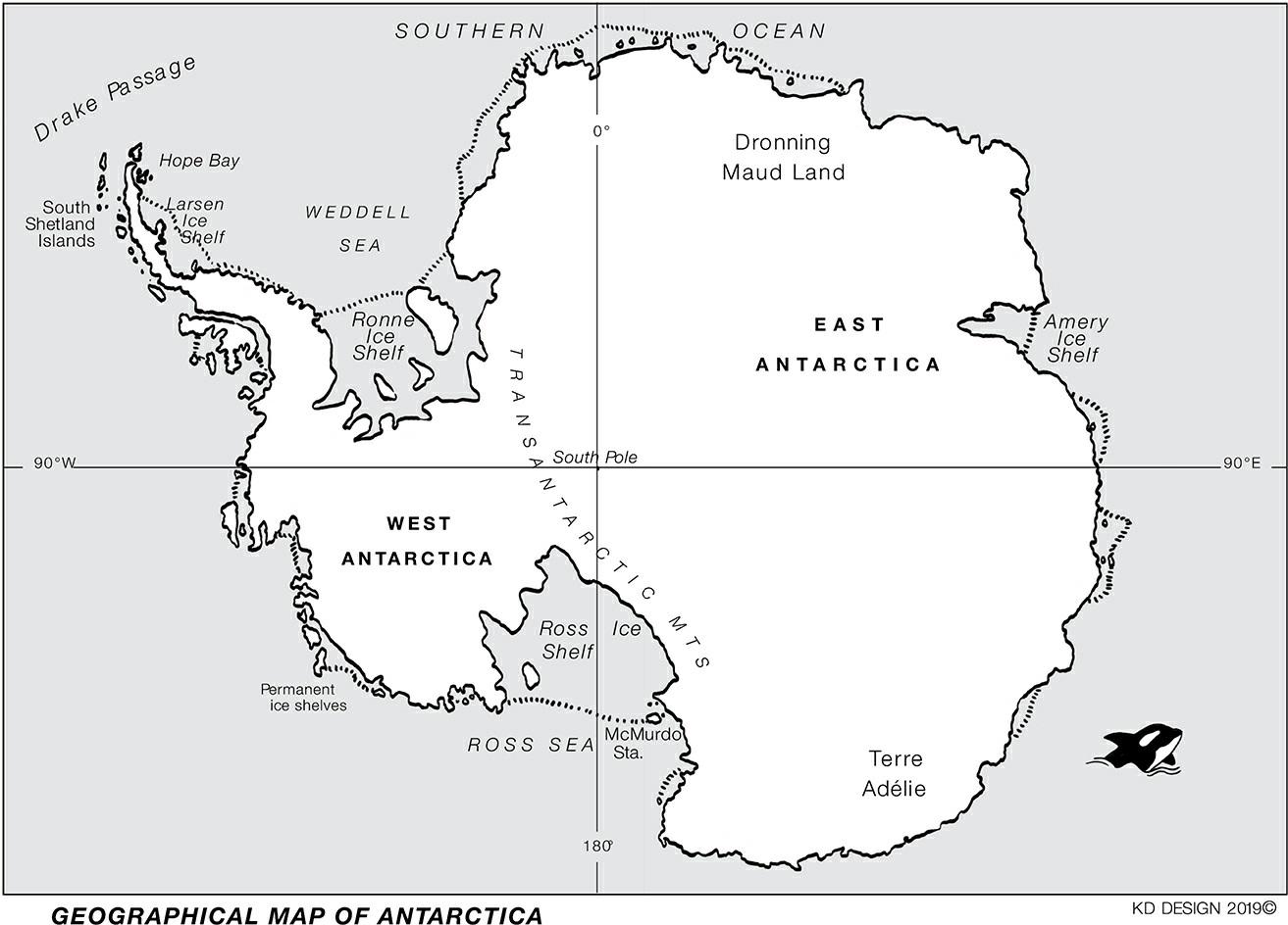
Although mountain ranges straddle Antarctica, most of the mountains are hidden beneath the ice cap While the bedrock of the South Pole is only 30 meters above sea level, it is covered by an ice sheet that is nearly 5 kilometers (3 miles) deep in one place and averages more than 2 kilometers (12 miles) deep across the continent (nearly 3 kilometers of ice). This ice cap is the result of snow being deposited and compressed into ice over many millennia and inching inexorably toward the surrounding ocean before breaking off into gigantic icebergs It was the impressive size of these icebergs that convinced the first sailors who ventured into the Southern Ocean that a large land mass must lie beyond their view Indeed, some icebergs were so big that they were mistaken for the unseen continentitself
Although it once had a temperate climate, Antarctica has never had any permanent human inhabitants. For as long as humans have been on Earth, the Antarctic environment has been so severe and dangerous that it has discouraged any thought of people living out their lives there. It is the coldest, windiest, and driest continent on Earth,withkatabatic(downslope)windsoftenreachinghurricaneforceastheysweepdownfromtheicecaptoward the coast. Antarctica has been kept in its frozen state by the Antarctic Circumpolar Current that continually circles the continent in a clockwise direction The current is driven by prevailing westerly winds that cause the freezing waters to block any warmer surface waters from moderating Antarctica’s climate. It was the action of this current thatoriginallycementedinplacethecontinent’sicecap,keepingthecontinentinitsfrozenstateandminimizingthe effects of global warming. That is fortunate for humanity, since 90 percent of the world’s fresh water is locked within Antarctica’s icy embrace Unfortunately, there are signs that even Antarctica cannot remain immune to the effectsofglobalwarming.
HowwasAntarcticadepictedpriortoitsdiscovery?
The ancient Greeks rarely strayed beyond the lands around the Mediterranean, but that didn’t prevent them from having ideas about what might lie beyond the ends of their world Aristotle argued that there must be a massive undiscovered continent far to the south. Otherwise, he said, the weight of the continents in the northern hemisphere would prevent the Earth from maintaining its regular movement through space The Greeks could not imagine a worldthatwascomposedlargelyofoceansratherthancontinents.
The geographer Claudius Ptolemy from the city of Alexandria agreed with Aristotle’s view and proceeded to draw a map of the known world based upon existing Roman knowledge. Ptolemy wanted to use all the sources that were available in the Great Library of Alexandria to concoct a complete world map It included a massive continent
dominating the southern hemisphere Ptolemy’s depiction of a “Great South Land” that was much bigger than Antarcticabecameagenerallyacceptedfact,onethatwouldtakecenturiestorefute
From the late 1400s onward, as printing developed, European geographers created and disseminated vivid representations of Ptolemy’s imagined land on their maps and globes These depictions were regarded as so authoritative that even Christopher Columbus took a copy of the map on his voyage across the Atlantic in 1492 Although geographers often called the land Terra Australis Nondum Cognita (Latin for “the southern land not yet known”), their maps included images of fantastical animals The center of the supposed continent was the South Pole.Curiously,thecontinentwasusuallydepictedbytheseimaginativemapmakersasbeingfreeofice.
Since their representation was meant to balance the great continents of the northern hemisphere, the mapmakers showed the southern continent as enormous, often stretching north until it almost reached the equator. In their imagination, the continent was suitable for human settlement and abounded in valuable resources Whether people alreadylivedtherehadtoremainamatterofconjectureuntilexplorerswereabletoventurethatfarsouth.
WhydidnationsaspiretodiscovertheSouthPole?
Once Spanish explorers began returning from the Americas in the sixteenth century with their ships laden with gold and silver, there was a rush by rival European nations to find other undiscovered lands They particularly wanted to find the mysterious Great South Land that loomed so large on medieval maps. If the Spanish and Portuguese could reap such riches from Central and South America, as well as from the newly discovered lands of the Indian and Pacific Oceans, surely there must be similar riches to be won from the continent in the southern hemisphere. It wouldtakecenturiesbeforetheseassumptionswereshowntobemistaken
European explorers gradually began to realize from their voyages in the seventeenth and eighteenth centuries that the Great South Land could not be as great as the early geographers had portrayed it As they criss-crossed the oceans, these explorers encountered mostly water and a few scattered islands. In the 1700s, the Dutch and Portuguese blundered into the north and west coasts of what they imagined must be the southern continent But further exploration by the Dutch explorer Abel Tasman in 1642 and the English explorer James Cook in 1770 revealed that it was an island continent and much smaller than the mapmakers imagined At first sight, it also seemed to lack the riches that other continents had in abundance. It was variously named “New Holland” or “Terra Australis,” and later the name was changed by the British to “Australia” Many were convinced that there must be another, larger continent waiting to be discovered, one that would likely stretch all the way to the South Pole and havetherichesthatappearedtobeplainlyabsentinAustralia
Itwasn’tjustgoldandsilverthatEuropeanswanted.Therewasalsowealthtobefoundinspicesaswellasinthe furs of the sea otters and seals that Chinese traders were anxious to exchange for the tea that had become so popular in Europe As trade shifted eastward into the Pacific and Indian Oceans, the discovery of a southern continent could also have great strategic significance for any empire that wanted to control the lands that abutted those distant oceans Explorers and sealers searched further and further south for the land they were certain must be there But it wasn’t until the early nineteenth century that they finally found it and realized how different it was from to the imaginedlanddepictedonmedievalmapsandglobes
WhofirstdiscoveredAntarctica?
Six of the seven continents were peopled in the centuries after modern humans emerged from Africa at least 70,000 yearsago.Sincethereisnowrittenrecordoftheirdiscovery,wecannotknowtheidentityofthefirstpeopletowalk on those continents or to land on their shores The last continent to be found was Antarctica Even though it was discoveredinmoderntimes,theidentityofitsdiscovererremainsamatterofsomedispute.
The Maori people of New Zealand believe one of their ancestors sailed so far south that he encountered the ice cliffs of Antarctica. The story of such a voyage is part of their oral history. Over the centuries, Polynesian people had indeed made many long voyages across the vast distances of the Pacific, during which far-flung islands were discovered and settled. An enterprising Maori mariner might well have ventured south one summer, guided by the stars, before returning with stories of an ice-covered land However, it is impossible to know for certain whether an adventurous Maori explorer was the first to sight Antarctica, or whether he was misled by a cloud bank or merely sawalargeicebergthathaddriftednorthtowardNewZealand EuropeanshipsweremoreequippedtofacetheroughwatersoftheSouthernOcean,andEuropeansusuallykept scrupulous written records of their voyages Their logbooks should have allowed the name of the continent’s first discoverer to be beyond doubt. However, American and British whalers and sealers were often secretive about their travelsforfearoflettingrivalsknowaboutrichsealinggroundsorwatersthatwereabundantinwhales Althoughit
is possible that one of their vessels may have ventured sufficiently south in the late seventeenth or early eighteenth centurytoseetheAntarcticcontinent,nowrittenrecordofsuchasightinghassofarsurfaced
This brings us to Captain James Cook, who sailed three times into the Southern Ocean looking for the Great South Land On his second voyage, from 1772 to 1775, Cook came close to finding it but pack ice prevented him Although he claimed an island off the Antarctic Peninsula for England, mistakenly believing that it was part of the fabled southern continent, he quickly realized his mistake. He consoled himself with the thought that the elusive continent was not worth the trouble of discovering, arguing that its harsh climate and icy defenses would make it a uselessacquisition.
It was nearly half a century later that the continent was finally sighted The identity of its discoverer remains a matter of some contention. There are three claimants for the honor. One was an American sealer, Nathaniel Palmer, whosesearchforsealstookhimtotheislandsoffthetipofSouthAmerica ThesecondwasaBritishsealer,William Smith,whohadspottedsomeofthesesameislandsandbelievedthemtobecontinentalinsize.Excitedbythenews, the Royal Navy sent him back to confirm his discovery, with his ship placed under the command of naval officer Edward Bransfield. The third claimant was the Prussian-born explorer Captain Gottlieb von Bellingshausen, who wassentsouthin1819byTsarAlexanderIaspartoftheRussianEmpire’sexpansionintothePacific
It is extraordinary that all three explorers happened to converge on Antarctica in 1819–1820, with their voyages allowing each to claim they had been the first to discover Antarctica Bransfield and Smith caught sight of the Antarctic Peninsula on January 30, 1820, and thought it could be part of a continent. The sea conditions were too dangerous to find out for sure, and they made no attempt to step ashore and claim it for Britain as they had done on some islands discovered earlier. Nevertheless, their sighting allowed British historians to claim that Bransfield shouldbecreditedwiththediscoveryofthecontinent
American historians have been just as vociferous in supporting Palmer, who may have seen the Antarctic Peninsula from a high point on nearby Deception Island and even sailed there to check out whether there were seals on its shores. Although an American writer would later publish an account that purported to describe a meeting on Deception Island between Palmer and Bellingshausen, during which Palmer supposedly told the Russian of having seen the continent, no documentary evidence has been found to support this claim. In particular, there is no mention ofitinPalmer’slogbook
As for Bellingshausen, there is convincing evidence that the Russian explorer sighted the coast of Antarctica on January28,1820,justtwodaysbeforeBransfieldsawlandontheothersideofthecontinent.Moreover,accountsby Bellingshausen and his officers make clear that they were aware it was a continent rather than just a frozen sea In a letter to the Russian Minister for the Navy, Bellingshausen described seeing “continuous ice, at whose edges were pieces piled one upon another, and with ice mountains seen at different places in a southerly direction.”1 Nonetheless,debatesabouttherealdiscovererofthecontinentenduredformorethanacentury
WhyisthedebateastowhodiscoveredAntarcticastillrelevant?
Although as noted the historical evidence points toward Bellingshausen as having been the first to discover Antarctica, the Russian claim was long disputed. Bellingshausen did not help his own cause by being tardy in publishinghisaccountofthehistoricvoyage ARussianeditionofhisjournaldidnotappearuntiltenyearsafterthe voyage. His recognition was further delayed by the absence of an English edition until 1945. When the account was publishedinEnglish,thetranslationwassopoorthatitcreatedconsiderabledoubtastowhetherBellingshausenhad seentheactualcontinentormerelyglimpsedaniceshelfthatwasperhapsnotevenattachedtoAntarctica.
The assumption that it was either Palmer or Bransfield who should be honored as the discoverer of Antarctica endured for than a century. The issue was of more than just academic interest since a definitive answer would reinforce the respective British and American territorial claims over Antarctica. From the 1920s onward, both the US State Department and the British Foreign Office sponsored mapping work and historical research that was designed to support the claims of Palmer and Bransfield respectively. The American and British governments were trying to buttress the territorial claims being made by their current explorers, and they accused each other of fabricatingevidence.
Amid the ongoing furor, the Russian claim was disregarded due to the relative lack of supporting evidence It was only in 1951, after a newly translated account of his voyage was published along with other supporting documentation, that Bellingshausen was gradually acknowledged by most British and American historians as being the first. The question would become less important once the Antarctic Treaty of 1959 set aside territorial claims that had been vigorously prosecuted for several decades Even now, a few historians continue to doubt Bellingshausen’s claim, suggesting that he had only seen an ice shelf without realizing it was of continental extent.
While the argument about who was first to sight Antarctica might persist, there is less argument about who was first tostepashoreontoitscoastline
WhowasthefirsttoactuallystepoutontotheAntarcticcontinent?
ThehonorofbeingthefirstashoredidnotgotoanexplorerbuttoanAmericansealerwhowaslookingfornewseal colonies to exploit after those on nearby islands had been wiped out. In February 1821 Captain John Davis of the schooner Celia cautiously threaded his way through icebergs and tricky currents toward the land that had been sighted the previous year by Bransfield and named as “Trinity Land” It was part of what we now know as the Antarctic Peninsula. Today it has become one of the most keenly contested lands on Earth though it didn’t seem worth contesting when Davis saw it He was hoping to find seals, but there were no seal colonies on the land where hiscrewcouldmakeaquickkilling.
After the crew had gone ashore and returned through an enveloping snowstorm with nothing in their boat, Davis had to be content with noting in his logbook that he had seen “a Large Body of Land” that was “high and covered entirely with snow.”2 Davis had seen the offshore islands and sailed around them, but this sighting seemed different He could see no end to it and wrote, “I think this Southern Land to be a Continent” Of course, he had no way of knowing from his brief foray that he had landed on a tongue of land that was joined to a continent covering the South Pole and stretching across the Southern Ocean for thousands of miles All Davis knew was that it seemed larger than the string of nearby islands. His feat was slow to be recognized by the world. It was not until the 1950s that an American historian chanced upon the logbook of the Celia and wrote about their role in the discovery of the continent
HowdidtheearliestexplorersreacttoAntarctica?
Sailing south until they encountered massive icebergs, some eighteenth-century sailors, such as Cook, were led to think that the long-searched-for continent was within sight. The combination of sea mist and white clouds ballooningabovetheicepackgavetheimpressionofmountainsonthefarhorizon Oneofthescientificmembersof Cook’s second voyage in 1772 reported the excitement when an officer clambered down from the masthead early onemorning,claimingtohaveseenlandinthedistance Onhearingthecommotion,allaboardcameupfrombelow deck to see a vast field of ice with what they took to be mountains in the distance. But there was no land there, as Cook himself discovered when he sailed over the same route three years later and found there wasn’t even any ice Thesailorshadsimplymoldedcloudsintomountains.Theyhadseenwhattheyexpectedtobethere.
The Great South Land of the European imagination was also supposed to be peopled by members of a civilized society. Cook’s three voyages, as well as those of other explorers, showed that any land to be found was situated muchfurthersouththanmedievalmapmakershadsupposed Consequently,therewaslittlelikelihoodoffindingany inhabitants, and certainly not the sort of civilized societies that the Spanish and Portuguese had encountered in the Americas Instead, there were penguins, seals, and whales along with a multitude of birds Mapmakers had suggested that more fantastical animals would be found, but these were extraordinary enough. Specimens of those animals that could be caught or killed were collected for the entertainment and wonder of European audiences or merely to provide a welcome change from barrels of salted meat for the sailors. As a crewman on one of Cook’s ships recorded in 1775, “several of the gentlemen in both ships diverted themselves in shooting penguins, and the sailorshadnolesspleasureineatingthem,thanthegentlemenhadinkillingthem.”3
The earliest explorers had a tendency to invest penguins with human characteristics Indeed, when seen standing uprighton a distantice floe, their shape and coloring meantthatthey were sometimes mistaken for humans. Itis not surprising that the largest of the penguins was called the “emperor penguin,” while a slightly smaller species was called the “king penguin.” There was even a sense of their being the original and rightful occupiers of the place. When the French explorer Jules Dumont d’Urville landed on a rocky islet off the Antarctic coast and proceeded to claim the region for France, the occupying penguins were unceremoniously shoved aside to make way for the new owners
The Antarctic icebergs lent some credence to these anthropomorphic fantasies. The early explorers had expected to find a previously unknown civilization, as Columbus had done in the Caribbean, and the shapes of the icebergs appeared to resemble the ruins of some great empire. Dumont d’Urville had explored the remains of ancient Mediterranean empires and likened the icebergs to a great city reduced to ruins by an earthquake Indeed, it was common for sailors to think they were looking upon the remains of human constructions. These men were not only thefirstexplorersofAntarcticabutalsoimaginedthemselvestheconquerorsofit
WhatwasthenatureoftheSouthernOceansealingtrade?
The explorers certainly were conquerors of the animal population Although Cook had disparaged the idea of Antarctica being of any value, his voyages of discovery lit a fuse that exploded into a burst of activity. When mariners read his reports of numerous whales and seals off the tip of South America, vessels were soon sent on speculative voyages to see what could be gleaned from those tumultuous seas. Sealers and whalers were not concerned with claiming the lands but with exploitation of their marine life It was all about whales and seals Although penguins had been seen in vast numbers, there was no money to be made from them, other than having severalstuffedascuriositiesformuseumsandcollectorsorhavingthembutcheredasfood
Mostofthe whalespeciesthatfrequentedAntarcticwaters proveddifficulttokillandhaulin withmethodsused in the eighteenth century Whalers in rowboats were no match for the fast-swimming, deep-diving humpback and blue whales and other similar species, which tended to sink to the bottom when they were killed. And there were stillplentyoftheslower-movingbowheadwhalestobecaughtinthenorthernhemisphere
The seals were a much easier proposition. The large colonies of elephant and fur seals had lived undisturbed on the rocky shores of the remote sub-Antarctic islands Crowded together, and relatively defenseless, the lumbering elephant seals were easy to kill with guns, swords, or clubs. The males grew up to 6 meters or nearly 20 feet long and weighed up to 3,000 kilograms (over 3 tons) Thick blubber was cut from their massive carcasses and boiled downincast-irontrypotsuntiltheoilcouldbepouredoffintobarrels.Theoilhadamultitudeofuses,fromlighting tolubrication
Fur seals were more agile, but they were in much larger numbers and proved just as easy to slaughter. They weren’trich in blubber but their skins were highly valued for making hats and coats If sailors were prepared to face the dangers, there was a fortune waiting to be made by those who were willing to venture so far south. The English were the first to do so, but they were soon followed by American whalers and sealers from New England and by a few enterprising Argentinians The ships returned with their holds filled with barrels of oil and salted skins that foundareadymarketonthewharvesofNewYorkandLondon.
South Georgia was one of the major centers of their activity Set in the South Atlantic some 1,500 kilometers (900 miles) northeast of the Antarctic Peninsula, the large uninhabited island had been discovered by Cook in 1775. Justover160 kilometers (75 miles) long, its untouched state was soon destroyed by the arrival of hundreds and then thousands of sealers who established their camps on its shores. Their massive try pots were kept boiling on the beaches with the blubber of elephant seals, while the surf ran red with the blood from the hapless creatures and the carcasses of the skinned fur seals. By the early 1820s, both fur seals and elephant seals were close to extinction, and therewerenofortuneslefttobemadeonthesesub-Antarcticislands Itremainedtobeseenwhethertherewereseal coloniesyettobefoundonlandsfurthersouth.
Whyweretheearlysealersunableorunwillingtocreateasustainableindustry?
The sealing trade could have kept hundreds of American and British ships and thousands of sailors in work and also prevented the almost complete annihilation of their quarry However, that was never a realistic possibility It has been estimated that on the island of South Georgia alone, 250,000 seals were slaughtered by about 1820. By the end of the decade, some 7 million sealskins had reached American ports It would take many decades for the seal coloniestorecover,notjustonSouthGeorgiabutonalltheislandsofthefarsouththatwerechanceduponbythose sailingtheoceansinthewakeofCookandthewhalers
It might have been different had there been some oversight of the industry, but the sealers plied their trade far beyondthereachofgovernments Anyway,theybelievedthattheworldwastheirstobeplundered Afterall,hadn’t the Bible told them to “be fruitful and multiply, and replenish the earth, and subdue it: and have dominion over the fishofthesea,andoverthefowloftheair,andovereverylivingthingthatmovethupontheearth”?
Practically speaking, no agreement to limit the killing could ever have been enforced in the early nineteenth century when the rewards were so great And nobody was going to exploit seals sustainably when they knew that everyone else was going to kill without regard in the following season. Instead of perceiving the seals as a finite resource whose killing had to be managed, they treated a newly discovered seal colony like a gold mine to be emptied of its riches before someone else took it from them. Once the slaughter was done, the search for a new colonycouldbegin Foratimethereseemedtobenoendtonewsealcolonies
When the beaches and islands of South America were cleared of seals, the search went further afield to the islands of the Pacific, to Africa, and to the south. Although an increasing number of sealing vessels returned to their ports with their holds only partially filled, sufficient new seal colonies were found, keeping the hopes of sailors and theircorporatesupportersalive.AndtherewasstillmuchtodiscoverinthefurthestreachesoftheSouthernOcean.
Whatwastheconnectionbetweensealingandterritorialaspirations?
TheEnglishwerethefirsttomaketerritorialclaimsintheAntarctic AlthoughCookdidnotlanduponthecontinent or even sight it, he did lay claim to several nearby islands and named them in honor of King George III, as well as his patrons at the Admiralty and in Parliament With much ceremony, Cook would raise the English flag and fire a volleyofshotsonlandsthathethoughtmightcomprisepartoftheSouthernContinent.Hewasalwaysdisappointed to discover that the supposed continent was merely an island, albeit sometimes an extensive one He concluded his search for the Southern Continent with the consoling thought that its ice-cloaked location would make it not worth owning Theseals,alongwiththeimperialswingfromtheAtlantictothePacific,changedallthat
The seas off the tip of South America offered a strategic passage between the Atlantic and Pacific. Whichever nation controlled those seas would enjoy greater control over the Pacific and the growing commerce that passed between the two oceans. By the early nineteenth century, the British, Spanish, French, Russians, and Americans all harbored some desire to dominate the Pacific And the wealth to be made from whales and seals gave greater force totheargumentsofimperialpropagandistswhowantedtheirnationstolayclaimtotheSouthPole.
It would have been easier for Britain and America had their sealers and whalers been inclined to establish permanent settlements at the places where they landed. But their camps tended to last no longer than a summer. When the supply of seals was exhausted, they would leave for another killing field, with the signs of their fleeting presencebeinggraduallylosttotheravagesofweather.AlthoughanoccasionalBritishsealerwouldgotothebother of formally making a territorial claim when they encountered a new island, American sealers showed no such interest.
MostsealerswhosailedamongtheislandsofftheAntarcticPeninsula,andoccasionallyhuntedsealsalongother parts of the Antarctic coast, did leave evidence of their presence in the form of the maps they made and the names they might bestow on certain geographical features, such as Bransfield calling an island “New South Britain” However, that wasn’t a sufficient basis for a nation to make a territorial claim, which would require an officially sanctioned expedition with authority to conduct a formal claiming ceremony, preferably on the lands of which they purported to take possession Once the sealing trade declined in the early 1820s, the rationale for making territorial claimsbecamelesscompellingfromacommercialpointofview.
Whywasthecontinentitselfleftlargelyuntouchedandunexploredforsolong?
The further south the sealers ventured in the late eighteenth and early nineteenth centuries, the more difficult and dangerous it became There was the possibility of their ship being crushed by the ice pack or being caught fast in a quickly freezing sea. Either would mean almost certain death. There were dangers, too, from unknown currents, hiddenshoals,shiftingicebergs,andfog-shroudedcoastlines Asifthatwasnotenoughtonegotiate,captainshadto deal with the ever-present threat of crews that could turn mutinous if the conditions became unbearable or the catch was insufficient to ensure a good payoff at the end of the voyage These considerations meant that captains were cautiousaboutventuringtoofarintotheunknown.
One who did go further south than his counterparts was James Weddell, captain of a sealing vessel, the Jane, which was sent by its owners in 1822 to search for new sealing grounds. Weddell headed deep into the South Atlantic, steering the Jane to the east of the South Shetlands, believing from Cook’s report that he would find the GreatSouthLandthere.Buttherewasonlyopensea.Hepressedon,going320kilometers(about200miles)further south than Cook had done He could have gone even further into what would later become known as the Weddell Sea, as there was no ice that year to impede his passage. However, he could not see any coast on which seals might be found, and his sailors were becoming restless at the likely lack of profit It would be another century before the ice conditions would allow Weddell’s voyage to be replicated. Until then, all those who tried to follow his chart encounteredimpenetrablepackice
It might have been different had there been definite reports of multiple seal colonies on the shores of the Antarctic continent However, the few sealers and explorers who sighted various parts of the coastline confirmed Cook’s conclusion and returned with reports of a land largely devoid of exploitable life. Much of the coast was surrounded by ice pack or hemmed in by impossibly tall cliffs of ice that denied access to both humans and the animals they sought. There were indeed few ice-free shores to be found around the entire coastline of Antarctica on which seals could establish their colonies As a result, the continent largely escaped the attention of man for another century.
WhydidittakesolongforwhalingtobegininearnestinAntarctica?
Whalers had been scouring the oceans of the northern hemisphere for centuries, looking for the tell-tale blow of a whale pod as the animals surfaced and expelled air before diving down again into the depths or as their fins curved across the surface. Sperm whales have been recorded diving down to 3,000 meters (about 10,000 feet) and can remain below the surface for more than two hours As the whalers’ methods became more sophisticated by the end of the eighteenth century, and the demand for whale oil increased, the whales became more difficult to find in the NorthAtlantic.Undaunted,thewhalersofEnglandandthoseofthenewlyindependentUnitedStatesbegantorange further afield, seeking their quarry in the Pacific, where the pleasant climate and often welcoming islanders compensatedformuchlongervoyages.
Migrating whales would leave their summer feeding grounds in the Antarctic to breed over winter in the midPacific, which is where many whalers would search them out. It wasn’t unusualfor whaling ships to circumnavigate the globe, taking advantage of the prevailing winds in the southern hemisphere to speed their passage The winds were stronger and more constant the further south they went. Once Australia was claimed by the English in 1788, the island continent became another center of whaling activity Several whaling stations were established along the Australian east coast to prey upon whales migrating to the tropics and on those whales calving in its shallow bays, whilewhale-catchingforaysalsoextendedtothesub-AntarcticislandsoffAustraliaandNewZealand
Sailors would get particularly excited when they came across the so-called right whales, which had baleens for filtering small prey rather than teeth Right whales have a thicker layer of blubber than some other whales, which means they produce more oil and would float when killed rather than sinking to the depths. Apart from the oil, the flexiblebaleenswerealsovaluedfortheiruseinthehoopeddressesoffashionablewomen Aslongaswhalescould be found in sufficient numbers in warmer waters, there was no incentive for whalers to chance their lives and their shipsinthemuchmorehazardouswatersoftheAntarctic
Theregionwashazardousbecausemostofitremainedunseenandunmapped.ThisgavetheAntarcticasenseof mystery, which fascinated people and led some to make all sorts of wild speculations as to what might lie at the bottom of the Earth. One of the wildest theories was proposed by the American John Cleves Symmes, who helped inspiretheUnitedStatestosendagreatexploringexpeditiontothesouthernseas
HowdidpeoplecometobelievetheHollowEarththeory?
Until well into the nineteenth century, the world still knew little about Antarctica As noted earlier, a few points on its coast had been seen by the Russian explorer Bellingshausen and the British explorer Bransfield, and sealers like Palmer may have seen the Antarctic Peninsula None of them had seen anything that would encourage others to risk their lives in search of the South Pole. The ice and snow ensured that there were no precious metals visible. It also ensured that there were few places for seals to establish their colonies That did not prevent some people from speculatingwildlyaboutwhatmightlieatthebaseoftheglobe
BritainanditsEuropeanrivalshadallestablishedoverseasempiresandwerestillacquiringnewcolonies.Ofthe major powers, the United States was almost alone in not having an empire, other than its steadily expanding continental one (mainly at the expense of the indigenous populations). While Americans mostly eschewed acquiring anoverseasempireinthemanneroftheirformerEnglishoverlord,theAntarcticofferedthepossibilityofgainingan overseas territory without the complicating factor of controlling a native population. It also offered the possibility of answering one of the last great geographical puzzles of the modern world: What exactly did lie at the North and SouthPoles?
There were all sorts of theories Some thought it might be just a frozen ocean, while others argued that the ancient Greeks were right in postulating the existence of a Great Southern Continent. One American went much further by suggesting in 1818 that the North and South Poles were entrances, thousands of miles across, to the interior of the Earth. Symmes, a former army officer, claimed that the entrance at the North Pole explained the origins of Native Americans as well as the annual appearance of great herds of migrating caribou and other animals, which had also emerged from this supposedly lush and temperate interior. He even constructed a wooden model of hishollowworldtoconvinceAmericanaudiencesofhisvision
Symmes wanted to organize an expedition by reindeer-drawn sleigh from Siberia to find the northern opening, but no one was willing to accompany him or to finance the journey It might have ended there had he not caught the attention of the crusading journalist Jeremiah Reynolds, who helped Symmes reach a wider audience before gradually making the Hollow Earth theory his own From 1825, the pair toured the towns and cities of America’s Eastern seaboard, lecturing about the wonders that might exist at the poles. It was the South Pole, rather than the North, that particularly interested Reynolds, who proved much more convincing than Symmes and attracted considerablepublicsupport.
By 1828, having ditched Symmes and his theory, Reynolds called on Congress to support an expedition to the
South Pole for the cause of science and commerce. He argued that it would be a great achievement for the new nation to discover what lay at the South Pole, bringing great profit to the nation from seals and other lucrative furbearing animals that must surely exist there. The prospect of profit proved persuasive to the congressmen and PresidentJohnQuincyAdams
The Americans were not the only ones interested in exploring the Antarctic The British government sent a scientificexpeditiontherein1828totakeastronomicalobservationsthatmighthelpcalculatetheprecisedimensions oftheEarth LedbyCaptainHenryFosterasastronomer,theexpeditionnotonlytookobservationsbutalsoclaimed possessionofpartoftheAntarcticPeninsulainthenameofKingGeorgeIV.ThenewsoftheBritishexpeditionlent urgency to the American plan, which was approved by Congress in May 1828, only to be scuppered later that year bytheelectionofthemoreskepticalPresidentAndrewJackson.
Undaunted, Reynolds pressed ahead, gaining support instead from Captain Edmund Fanning, a sealer based in the New England port of Stonington (in Connecticut). Fanning’s support saw the expedition being called the “South Sea Fur Company and Exploring Expedition” As the name suggested, it would have more to do with sealing than exploring. Three sealing vessels set off in October 1829, with the experienced explorer Palmer as one of the captains Although styled as a scientific expedition that would try to push as far south as possible, it was soon overtaken by the profit-making imperative and concentrated instead on finding seals around the southern coasts and islands of South America No new discoveries were made, and only a paltry haul of sealskins was stowed away in barrels for the return journey. Once again, whatever lay at the South Pole remained undisturbed and Symmes’s theoryofitprovidinganentrancetothecenteroftheEarthremaineduntested
Whydidthepaceofexplorationaccelerateinthe1830s?
The failure of America’s private expedition to get anywhere near the South Pole only increased Reynolds and Fanning’sdesiretodoso,andtodoitthenexttimewithgovernmentsupport.Farbetterfortaxpayerstofootthebill and bear the risk in the hope that any discoveries would boost American commerce and prestige Sealers could safely exploit any discoveries after they had been made and mapped. With this in mind, Reynolds and Fanning presentedWashingtonwithanewplan
While the Americans were considering their options, a British sealing company sent two ships under the command of former naval officer Captain John Biscoe to search for new sealing grounds For a decade the trading company owned by the Enderby brothers of London had reaped a handsome harvest from trading in sealskins, only to find their supply dwindling due to overexploitation Reports of possible new islands at the South Pole prompted them to send Biscoe south in 1830. Despite a two-and-a-half-year search, Biscoe barely filled a single barrel with salted sealskins However, he did sight a mountainous, snow-covered land far to the south of southern Africa and chanceduponnewislandsoffthecoastoftheAntarcticPeninsula BiscoegaveallhisdiscoveriesBritishnamesand even stepped ashore on the Antarctic Peninsula to claim it for Britain, naming it “Graham Land” after Sir James Graham, Britain’s First Lord of the Admiralty He suggested in his log that it was part of a much larger continent It was the first time that any part of Antarctica had been formally claimed. The United States was now on notice, particularly as Graham Land was known to the Americans as “Palmer Land,” in honor of its supposed discoverer, Nathaniel Palmer. If Washington didn’t respond with an expedition of its own, whatever lay at the South Pole was likelytobecomeBritishbydefault
The pressure for an American expedition intensified in early 1836, when Reynolds addressed a meeting of congressmen during which he sketched out a grand plan for an expedition focused upon discovery “No spot of untrodden earth” should go unexplored, declared Reynolds, who held out the prospect of the Stars and Stripes being unfurled to fly over the South Pole With both the British and the French dispatching official expeditions of their own, the United States would have to move quickly if it was going to proclaim America’s right to rule the Southern andPacificOceans,whereitshundredsofwhalingshipswereconstantlyonthehunt
The tantalizing prospect of reaching and possessing the South Pole found much support in the American capital, at least initially Although the expedition was approved, some congressmen began to fear that the expedition was being sent to prove Reynolds’s crackpot Hollow Earth theory. In the face of their skepticism, the focus of the expedition was shifted to the more temperate climes of the Pacific and was put under the command of the wellconnected surveyor, Lieutenant Charles Wilkes, who ensured that Reynolds would not accompany, let alone lead, this new expedition Delays in fitting out the ships, now totaling six vessels in all, meant that the expedition did not leave the United States until August 1838. The delayed departure meant that Wilkes was following in the wake of theFrenchexplorerandnavalofficerDumontd’Urville,whohadalreadyexploredtheSouthPacific
Like the American, the French expedition was meant to be focused mainly on the trading and imperial possibilities of the Pacific But when Dumont d’Urville headed south in 1837, his mind was set on making a name
for himself. His first attempt at reaching the South Pole by penetrating the ice pack of the Weddell Sea was unsuccessful He tried again and again and was repelled by the ice each time Undeterred, he set sail for Australia, determinedtostrikesouthfromHobartthefollowingsummerandattacktheAntarcticfromtheoppositeside.
Before leaving Hobart in January 1840, Dumont d’Urville learnt that the Wilkes expedition had reached Sydney and was presumably intent on also heading for Antarctica This gave added urgency to his voyage In the Great Game of exploration, there is no honor in coming in second. Dumont d’Urville was relieved to come in sight of the Antarctica coastline on the evening of January 19, 1840, but he was disconcerted to find an imposing ice cliff that stretched as far as he could see in both directions. It kept him from going further south or even from landing ashore. Dumont d’Urville had to be content with landing on a rocky islet offshore, where his men dispossessed the penguin inhabitants and raised the French Tricolour as a sign of them being the new owners of the islet and the adjacent Antarcticcoastline Dumontd’UrvillenamedtheterritoryAdélieLandinhonorofhislong-sufferingwife
Itwasnotamomenttoosoon.OnJanuary30,oneofWilkes’sshipsappearedoutoftheAntarcticmistandraced past, its sails fully set No communication passed between the rival ships Several of Wilkes’s vessels had been sailing in sight of the Antarctic coastline, but the American officers were often unsure as to what they were seeing. Whatlookedlikelandfrequentlyturnedouttobelowcloudsoralargeiceberg ThevariousAmericanlogsmakeno claim of a definite sighting of land until January 30, 1840, when Wilkes saw an elevated area with mountains beyond and noted in his journal: “Antarctic Land discovered beyond cavil”4 He’d sailed along the coast for 1,300 kilometers (about 800 miles) and had seen enough to be sure it was of continental extent. Naming it “Antarctica,” based on the ancient Greek word for the land at the opposite end of the world to the Arctic, he set sail for Sydney wherehelearnedthatDumontd’UrvillehadarrivedinHobartandwasclaimingtohaveseenthesupposedcontinent on the evening of January 19 With the American consul looking on approvingly, Wilkes wrote a statement for the Sydney press, declaring that his expedition had first seen the continent on the morning of January 19, thereby trumpingtheFrenchmanbyhalfaday
TheBritishexplorerJamesClarkeRosswasalatecomertotheparty.HavinglocatedtheNorthMagneticPolein 1831, he had been sent by the British Admiralty to determine the position of its southern counterpart The magnetic polesarelocatedseparatelyfromthegeographicalpolesandtheirpositionsarealwaysslowlyshiftingwiththeeverchanging magnetic field of the Earth Near the equator, the difference between the geographical and magnetic poles is inconsequential for captains steering their ships with the aid of a magnetic compass. However, the further they venture south or north from the equator, the more crucial it becomes to know the difference between the two poles sothattheycanaccuratelyascertaintheirpositiononamap.Manyshipwrecksandmuchlossoflifehasbeencaused by captains not adjusting their position according to that vital difference in bearing between the two poles, which canresultinshipsbeingoutbymiles.
Ross arrived in Hobart while Dumont d’Urville was still there He was aware that his American and French rivals had beaten him to that previously unseen stretch of Antarctic coastline south of Tasmania. They’d also made theirownestimatesoftheSouthMagneticPole’sposition,whichthreatenedtothwartRoss’sambitiontobethefirst to locate both the North and South Magnetic Poles. However, Ross hoped to outdo his rivals by going further south and thereby getting a more accurate estimation of the pole’s location, and also by exploring in an easterly direction ratherthanheadingwestasWilkesandDumontd’Urvillehaddone.HebelieveditwouldbedemeaningforaBritish explorer to follow in the tracks of an explorer from another nation One of Enderby’s sealers had reported sighting anopenseafartothesouthofNewZealand SothatiswhereRossheadedwithhistwosturdyships
AlthoughRosswasintentoncalculatingthepositionoftheSouthMagneticPole,hewasalsoinstructedtoclaim any new territory he might discover and to reaffirm the claims of Antarctic territories that had already been discovered and claimed by British explorers. Unlike Wilkes and Dumont d’Urville, his passage was unimpeded by an ice cliff and he found the entrance to the promised open sea Landing on offshore islands, Ross claimed the adjacent stretches of continental coastline as he went further and further south into what would later be named after himasthe“RossSea”
After reaching 78° S, which was much further south than any other explorer had managed to go, he encountered twovolcanoes,whichhenamedafterhistwoships ErebusandTerror HehadwantedtoplanttheBritishflagatthe SouthMagneticPole,butthatwouldhaverequiredanexpeditionacrosstheiceandsnow.Hehadtobecontentwith going further south than anyone else, gaining a more precise location for the South Magnetic Pole, and confirming on the return voyage that the part of the Antarctic continent that Wilkes had claimed to have seen was actually open ocean
Whatscientificquestionsdidtheseearlyexplorersanswer?
The most obvious aim of the earliest explorers was a geographical one: to fill in the huge blank at the bottom of the world where the Great South Land was meant to lie For more than a century, ships had sallied forth from Europe in search of the mysterious Southern Continent. Many thought they had found it, including the Spanish explorer Fernandez de Quiros, who encountered an island near New Guinea in the early 1600s and mistakenly thought it was a continent bigger than Europe, and the Dutch explorer Abel Tasman, who chanced upon the west coast of the New Zealand islands in 1642 and thought that it was part of the sought-after continent. Cook proved that New Zealand was not a continent when he circumnavigated both islands in 1770 Yet when he discovered various islands on his three voyages and thought for a time that they might be part of the Antarctic continent, he was similarly mistaken, albeitbriefly
Explorers hoped that the elusive continent would prove as bountiful as Columbus’s West Indies had been. Because of the cold climate, explorers knew they were unlikely to find the sort of valuable plants that had been discovered in warmer parts of the world, whether it was tea and tobacco or cloves and cinnamon. But any botanical specimens they found could still be collected and brought back to Europe or America for classification This in turn might help to answer some of the great scientific questions of the time. For instance, if some of the plants were the same as those found on other continents, it would suggest that the continents had once been linked and later separated according to the theory of continental drift first propounded in 1596 by the Dutch mapmaker Abraham Ortelius However, the ice and snow that was encountered on those parts of the Antarctic continent that were discoveredintheearly1800ssuggestedthattherewerenoplantsatalltobefoundonthisfrozencontinent.
What they did find was fossils of plants The expedition of Fanning and Reynolds in 1829 included a four-man scientific corps led by Dr. James Eights from Albany’s Lyceum of Natural History. It was poorly equipped for the work that Eights had hoped to undertake, and it never got close to the Antarctic continent But the vessels did visit the South Shetlands and other sub-Antarctic islands, where Eights gathered scientific specimens while the sailors triedtoturn aprofitby killingwhateverseals theycouldcatch AlthoughEightswasdisappointed withhisscientific haul,andtheexpeditionwasafinancialfailure,hedidreturnwithfossilsfromtheSouthShetlandsthatprovedthose treelessislandshadonceharboredlushforests
ThediscoveryofAntarcticanimalsmightalsohavehelpedtoanswerthedebateovercontinentaldrift.Ifanimals that were present in Australia or South America were also found in the Antarctic, there surely must have been some sort of connection between them in the distant past. However, there were no land animals to be found on these islands and none to be seen on those parts of the Antarctic coast that had been scanned by explorers through their telescopes Neither were there any of the valuable sea otters that had been found in abundance in the North Pacific Therewerepenguinsaplenty,andsomewerekilled,skinned,andstuffedforexhibitionbackhome,buttheywereno longersuchacuriositybythelate1820s
Collecting rocks from Antarctica might also have answered questions about the origins of the continents, but the rocks gathered by Eights and others came from the islands rather than from the continent Moreover, explorers were more intent on discovering gold and silver, and there were no precious metals to be found. It might have been the Age of Scientific Discovery, and people might have spoken loftily about the value of science, but the value of gold and silver was more highly prized. When they stepped ashore, explorers and the scientists who accompanied them had their eyes on the ground, looking for the valuable and the unusual Some also had their eyes on the skies, using astronomy to calculate the exact dimensions of the world. This was a valuable tool of knowledge for empires that wereintentonmeasuringtheworldandcarvingitup
There was another reason why empires aspired to pursue scientific objectives in the Antarctic. There was prestige to be gained in making hard-won scientific discoveries and announcing them to the world European countries competed among themselves to be regarded as the fount of scientific knowledge. The United States was drivenbyasimilarimperative Itscitizenshaddreamsofgreatnessfortheirexpandingnationandregardedscientific discovery in the Antarctic as one way in which they might measure up against the old empires and proclaim their stature to the world Commerce, science, and national prestige had become natural companions, and they would remainsoinsubsequentcenturies.
Whywastheburstofexplorationactivityinthe1840sfollowedbyhalfacenturyofrelative disinterest?
The voyages of Wilkes, Dumont d’Urville, and Ross, as well as the occasional forays by sealers, had filled in great swaths of the map Thousands of miles of coastline south of Australia and New Zealand had been explored, and partsoftheAntarcticPeninsula and its nearby islands had been charted. However, these activities were mostly done in a rudimentary way by explorers in sailing ships whose captains and crews were sensibly cautious about venturing tooclosetoacoastthatwasguardedbyicebergs,shiftingpackice,strongcurrents,andhiddenrocks.
Despite sporadic attempts over the seventy years since Cook had first sailed south, no explorer had managed to findapassage thatwouldtaketheirshipsto theSouthPole itself Bythe early1840s,explorersand sealershadonly seen small stretches of coastline. Although Wilkes had called his sightings “Antarctica,” he had no idea how big his continentmightbe Moreover,Rosshadshownthatpartofthe“land”thatWilkeshadclaimedtohaveseenwasjust open sea Nineteenth-century mapmakers still had no way of knowing how to fill in the most southerly parts of the worldandwereforcedtousedottedorstraightlinestoconnectthestretchesofknowncoastline.
The continuing uncertainty about the South Pole might have been expected to spark a rush of polar explorers intentondeterminingwhethertherereallywasacontinentorjustascatteringoflargeislandsandwhatthenatureof any land mass might be However, the Wilkes expedition had ended in recriminations between its officers and a court-martial for the hapless and high-handed Wilkes, while the failure of Ross to reach the South Magnetic Pole minimizedtheinterestinBritain
The impetus for further exploration was also muted by the continuing failure to find anything of sufficient commercial value to help justify the considerable cost of dispatching an expedition Science was simply not sufficient justification by itself. The formidable ice cliff that stretched along the coastline seen by Wilkes, Dumont d’Urville, and Bellingshausen was a barrier to seals as well as to man Not even the penguins could ascend its heights.Assuch, itwasdifficulttodrumup financial support for a polar expedition that would only have science as itsobjective
Polar explorers were also distracted during the latter half of the nineteenth century by the quest to find a Northwest Passage across the Arctic, which would link the North Atlantic and North Pacific Oceans and provide a searoutebetweenEuropeandtheburgeoningmarketsofEastAsia.ThesearchhadbeenbegunbytheEnglishinthe late fifteenth century and would take more than four centuries before meeting with limited success When a British expedition led by Sir John Franklin disappeared in the Arctic in 1845, there were several attempts over subsequent decades to find some trace of his two ships Although the remains of some of the crew were found in the 1850s, it was not until 2014 that one of the sunken ships was finally discovered near King William Island off the north coast of Canada, while the second ship was discovered nearby in 2016 The fruitless searches for Franklin’s ships in the second half of the nineteenth century had focused public and government attention on the North Pole rather than the South
TherewerealsoattemptstoreachtheNorthPoleinthe1890s.ThemostnotablewasmountedbytheNorwegian explorerFridtjofNansenin1893.Hesailedhissmallvessel Fram intotheArcticOceanwiththeintentionofhaving it caught by the ice and taken by the current sufficiently close to the North Pole for him to reach it on foot with the assistanceofdogs.Thebraveplanalmostworked.Theice-boundshipdriftedinthedesireddirectionbutdidnotget quite close enough for Nansen then to reach the North Pole on foot Itremained as a tantalizing questthattransfixed polar explorers for fifteen years, until two American expeditions claimed to have raised the American flag at the North Pole Frederick Cook declared he’d done it in 1908 and Robert Peary said he’d achieved the goal in 1909 AlthoughmostobserversatthetimesupportedPeary,researchershavesincediscreditedboththeirclaims.
The exploitation of whales in Antarctic waters would have given a boost to exploration, but whalers stayed clear ofAntarcticaformostofthenineteenthcentury.Therewerestillsufficientwhalesinthenorthernhemisphereandin the warmer parts of the southern hemisphere, where the dangers of the hunt were fewer than in the far south ChasingandharpooningawhaleamidtheAntarcticicepack,whileperchedontheprowofanopenrowboat,would have been a particularly perilous job It took the invention of explosive harpoons and steamships before whalers returnedtotheAntarctic,andafreshbevyofexplorerssailedintheirwake.
THERACEFORANTARCTICAINTHETWENTIETHCENTURY
WhatcausedaboominAntarcticwhalinginthelatenineteenthcentury?
The 1860s and 1870s saw a decline in whaling when kerosene largely replaced whale oil for heating and lighting The resulting drop in profits caused fewer whaling fleets to set out to sea. The American whaling fleet was also hard-hitbytheCivilWar,andbythe1880stherewerehardlyanyAmericanwhalingshipsleft Britishwhalerswere also much reduced in number. Their place was partly taken by the Norwegians, who had a long history of whaling and were well placed to benefit when serious money again started to be made from whaling in the last two decades ofthenineteenthcentury.
There were several reasons for the reversals of fortune, which effectively removed the sanctuary that whales had enjoyed in Antarctic waters. The development of ships with ice-strengthened wooden hulls, which were driven by steam engines, helped tip the balance against the whales Previously, sail-driven whaling ships had launched open rowboats when whales were sighted. With the sailors heaving on their oars, and with one man standing at the prow with his hand-thrown harpoon at the ready, the whales would be chased down and harpooned whenever they surfacedwithinreach.Itwasdifficult,dangerous,andoftenunsuccessfulwork,particularlyifalargewhaledivedto thedepthswithaharpoonlodgedinitsflankorifitsimplysankwhenitdied
That all changed when fast and maneuverable whaling ships were able to chase down their quarries and shoot them with harpoon guns of increasing sophistication The targets were not only the right whales but also the faster rorqual whales, such as humpbacks and fin whales. By the 1870s, whaling ships were being fitted with a harpoon gun on their bow that could fire a harpoon with an explosive head The harpoon gun had been invented in the late 1860s by the Norwegian Svend Foyn, and its design gave the harpoonist a much greater success rate, particularly since steam-driven ships could outpace the faster whales The ships had other important advances, since they used a steam-driven winch to drag the dead whales to the side of the ship, where a compressor injected air into the carcassestokeepthemafloat
The development of new killing methods coincided with the development of new uses for whale oil, which saw the price once again reach stratospheric heights. The most important new use was for explosives after dynamite was invented by the Norwegian Alfred Nobel in 1867 Glycerine from whale oil was a core component Gelignite, cordite, and other nitroglycerin-based explosives soon followed. This caused a surge in the killing of whales in the North Atlantic, which led to a steep decline in whale numbers and forced whalers to look for new hunting grounds Bythe1890s,whalersbeganturningtheirattentiontotheAntarctic.
The wealth from whales increased even more in the early 1900s after a German chemist discovered a way of treating the strong-tasting whale oil to remove its taint. The successful hydrogenation of whale oil allowed it to be used for margarine and saw it quickly adopted as an ingredient for baking and other culinary purposes Together withitsuseinexplosives,whaleoilonceagainbecameahighlyprizedproductwhosecontrolwaseagerlysoughtby the major nations of the world As a result, the curtain of indifference that had hidden Antarctica for half a century wassweptawaybythepursuersofprofitandnationalglory.
HowdidtheBritishandNorwegianscometodominateAntarcticwhaling?
Britain sent a scientific expedition to the Antarctic in 1870 as part of an investigation of the world’s ocean depths. With six scientists aboard, the steam-and-sail-powered HMS Challenger called at several sub-Antarctic islands before making a brief survey along the Antarctic coastline south of India. By dredging the ocean floor at regular points in the Southern Ocean, the scientists retrieved rocks that had dropped to the depths from melting icebergs The nature of the rocks, which corresponded to rocks from other continents, suggested the existence of an Antarctic continent But the rocks could not prove whether there was a single large continent or, as some suspected, two continents separated by an open channel. It was in this imaginary channel that whales were supposed to be in abundance
Not to be outdone by the British, the Germans sent an expedition with the aim of looking for whales and seals and surveying some of the partly charted seas In 1873, the German Polar Navigation Society dispatched the steamdriven whaling ship Grönland under the command of Eduard Dallmann. Heading for the Antarctic Peninsula, Dallmann hoped to find right whales and fur seals While some useful survey work was done on the coastline and islands, Dallmann didn’t encounter any right whales or find fur seals in commercial quantities Consequently, there wasnofollow-upvoyagebyGermanwhalers.
By the time whalers ventured south in the 1890s, the whalers of England and the United States had been surpassed by the Norwegians, who had maintained a strong whaling industry and whose ships were built for polar seas The Scots also maintained a small whaling fleet out of Dundee, where whale oil was used mainly for softening jute for rope. With steam-driven ships now in ascendance, there was little appetite in America for the massive investment that was required to restart its whaling industry The old whaling men and their financiers had left the industry, and there were few men left in the ports of New England with the expertise or desire to set off to distant seastohuntforwhales
It was mainly therefore the enterprising Scots and Norwegians who mounted a serious investigation of Antarctic seas In 1892, a Dundee whaling company sent four of its wooden sailing ships to the Weddell Sea, with auxiliary engines to help them work amid the ice-choked waters. The Norwegians responded with a smaller expedition of their own, with the Sandefjord-based whaler Christen Christensen dispatching his double-masted sailing boat Jason in pursuit. Under the command of Carl Larsen, the Jason was equipped to hunt for the slow-moving right whales. But neither the Scots nor the Norwegians found anything but the faster-moving rorquals, which they were ill equippedtokill.Neitherdidtheirshipsreturnwithcommercialquantitiesofsealskinsandoil.
Undeterred, both the Scots and the Norwegians tried again the following year Again, they were unsuccessful Another Norwegian expedition set sail in late 1893, hoping that they might find the lucrative right whales in the seldom-visitedRossSea FinancedbythenowelderlySvendFoyn,theexpeditionshipAntarcticsearchedfruitlessly for the whales that Ross had reported were there in vast numbers half a century earlier. There were plenty of other whales, but they were too fast to be caught Despite this, the expedition was notable for landing seven of its men on the shore at Cape Adare in 1895, where thousands of bemused penguins watched the interlopers erect a Norwegian flag Theirfeatshowedthatitwaseasytogoashoreandestablishabaseforexploringtheunknownterritory
These successive expeditions did not fail because there were no whales to be found. They were present in great numbers, but they were the faster blue, fin, sei, and humpback whales that couldn’t be caught with slow sailing vessels Although coal-fired vessels were used to pursue whales close to the North Sea ports of Norway and Scotland,theyweretoosmalltocarrysufficientcoaltotheAntarctic.Norwerethereanywhalingstationswherethe carcasses could be dragged ashore for boiling down Unfortunately for the whales, that didn’t mean that the whalers abandoned their hunt in the Antarctic. They just adjusted their methods to suit the challenges posed by the faster whales
WhydidtheAntarcticbegintotakeonastrategicsignificanceduringtheearlypartofthe twentiethcentury?
In 1900, most of the Antarctic remained beyond the reach of whalers, whose hunting activity was limited by the need to tow freshly killed whales for processing at shore stations on the islands off the Antarctic Peninsula. They hadtobeflensedoftheirblubberasfastaspossibletopreservethequalityoftheoilproducedfromboilingitdown The longer it took for processing to begin, the lower the quality of the oil and hence the price it could fetch. The introduction of factory ships changed all that Instead of having to hunt within two or three days’ sailing distance fromashorestation,whalerswereabletohuntoveramuchwiderarea.Workingtogether,afactoryshipcouldeven range as far as the Ross Sea, so that its fleet of small, steam-driven whale chasers could hunt in those more distant anddifficultwaters.Thedeadanimalswouldbebroughttothefactoryshipforprocessing,withthefactoryshipalso providing food and coal to replenish the whale chasers As wireless sets were gradually adopted from about 1910, shipscouldkeepincontactwitheachotherandhuntwithevengreaterfreedom.
It wasn’t just about whales The intensifying imperial rivalry, which would eventually erupt in the Great War of 1914–1918, was also felt in Antarctica. Even though the exact outline of the continent remained unclear, Antarctica was assuming a strategic significance for the Great Powers of Europe The use of whale oil for explosives and food ensured that the Antarctic whaling industry was of vital interest to the rival empires. So, too, was the control of the islands that lay athwart the Drake Passage that connected the Pacific and Atlantic Oceans With their separate colonies in the southern hemisphere, and with the growing rivalry between their navies, both Germany and Britain were anxious to ensure access through the passage for their ships Britain was better placed to do so It had whaling stationsonSouthGeorgia,controlledtheFalklandIslands,andhadterritorialclaimstoothersub-Antarcticislands.
WhydidtheincreasedwhalingactivityleadtorenewedinterestinAntarcticexploration?
On board one of the four Dundee whaling ships dispatched south in 1892 was a young doctor, William Bruce, who went as an amateur scientist and returned “ravenous” as he put it for further voyages to the Southern Continent. He wanted to do it for the sake of science and empire If Britain wasn’t willing, he proposed that Scotland should mount an expedition of its own. Norwegian expeditions also went hunting for whales in the 1890s and likewise returnedwithreportsofthescientificbootythatcouldbefoundthere
One of the Norwegian crew members was Carsten Borchgrevink, who rushed back to London so that he could attend the 1895 International Geographical Congress and argue for further expeditions to the Antarctic The congress was presided over by a former British naval officer, Clement Markham, who didn’t need much convincing about the need for more expeditions to the Antarctic Under Markham’s chairmanship, the congress called for them to be sent before the coming end of the century. Mounting purely scientific expeditions would bring prestige to nationsandempires,whiletheirgeographicaldiscoverieswouldassistwhalersplanningfurtherspeculativeventures inAntarcticseas.
In the event, the British and German geographers were beaten by the upstart Belgians, who sent a mostly private expedition to Antarctica in 1897. Led by the naval lieutenant Adrien de Gerlache, the expedition used a former Norwegian whaling ship, renamed Belgica, and a crew of mixed nationalities, including Roald Amundsen, who would eventually launch his own expedition, and the American doctor Frederick Cook, who would also later mount an expedition of his own to the North Pole and falsely claim to have reached it Exploring the western coast of the AntarcticPeninsula,theBelgica wascaughtbytheiceandheldfastforthirteenmonthsbeforeachannelwasfinally cutthroughtheicetothesea Theirperilousexperiencemighthavedissuadedotherexplorershadtheexpeditionnot returnedwitharichscientifichaulandstoriesofhavingseencountlesspenguins,seals,andfinwhales.Theseresults whetted the appetites of whalers, scientists, and adventurers, who each had their own motives for wanting to head southinsearchofprofit,science,orfame
Whatothernaturalresourceswereregardedasbeingofpotentialvalue?
It wasn’t just whales that were sought in the Antarctic. After being almost exterminated by the 1820s, seal numbers had recovered to such an extent that they were again being regarded as a resource ripe for exploitation. In his account of the Belgica expedition, Frederick Cook claimed to have seen large numbers of seals, penguins, and cormorants.Indeed,thepenguinshadprovidedmuch-neededfoodwhentheshipwasstuckintheiceformorethana year Cookbelievedthattheycouldsimilarlyprovidefoodforworkersinafurindustryonthesub-Antarcticislands, suggesting that Inuit people could be sent from the Arctic to the South Shetland Islands to manage a fur industry basedonArcticanimalssuchaspolarbearsandfoxes Hisvisionwasneverimplemented
There was also another possibility that excited visions of easy wealth. The discovery of gold in Alaska in the 1890ssuggestedthatsimilarvaluablemetalsorpreciousstonesmightbefoundintheAntarctic TheBritishexplorer Ernest Shackleton certainly thought so and had that firmly in mind when he embarked on his expedition in 1907. Earlier thoughts of Antarctica being a useless wasteland were set aside in favor of frantic speculation about the wealththatthepartlydiscoveredAntarcticmightcontain.
WhatdroveexplorerstotheAntarcticduringtheearlypartofthetwentiethcentury?
As we’ve seen, the arrival of whalers toward the end of the nineteenth century reminded the world that there was still much to be discovered So much was unknown that some atlases still showed Antarctica as two land masses withalarge seaseparatingthem. Therewasmuch tobedone beforetheAntarctic wouldbeknownin allitssublime majesty Attracted by the challenge, geographical societies, newspapers, and governments began turning their attentiontowardtheSouthPole.Thatmighthaveledtosober,carefullyplannedprogramsofexplorationbasedupon cooperation between different nations However, the increasing imperial rivalry in the early twentieth century led instead to a frenzy of competing expeditions. Explorers and their supporters wanted to make their own separate, nationalmarksonthecontinent,whichwouldculminateintheracetobethefirsttotheSouthPole
The English led the way. The reputation of their empire had been tarnished by the poor performance of the British army in the Boer War at the turn of the twentieth century, and they wanted to prove their prowess, courage, and masculinity to the world. Clement Markham, now the president of the Royal Geographical Society, was England’sforemostadvocateforanAntarcticexpedition Asanavalofficer,Markhamhadbeenaboardtheshipthat had scoured the Arctic in 1850, looking for Franklin’s lost expedition. By the 1890s, Markham had become an indefatigable campaigner for Britain to lead the world in uncovering new lands in the Antarctic He said he was
doing it to uphold his nation’s naval leadership As he explained in his memoirs, he wanted the exploration done by up-and-coming naval officers, who would be able to gain experience and test their courage and resourcefulness However,hestruggledtoconvincetheBritishgovernmenttoprovidefundingfortheventure.
TherewereotherwaysoffinancingAntarcticexploration Thewhalersandsealershadlongbeenattheforefront of discovery, while the newspaper magnate Sir George Newnes had also shown how an expedition could boost the profitsofa popularnewspaper.In 1898,Newneshad thrownhissupportbehindanexpeditionled bytheNorwegian CarstenBorchgrevink,whosailedtheshipSouthernCrosstoCapeAdareontheRossSea Hehadgoneashorethere several years before, and this time erected two huts, above which he flew the British flag. The men spent the winter on the ice, collecting whatever scientific specimens they could find While Borchgrevink likened it to a “pioneer settlement,” one of his gloomier companions described the Antarctic as being “enveloped in an atmosphere of universaldeath.”1
When the Southern Cross returned in 1900 to collect him, Borchgrevink could hardly claim his expedition had been much of a success. Although he had shown that it was possible to winter on the ice, he wanted to announce a greaterachievement Todoso,hesailedthe SouthernCross tothesouthernextremityoftheRossSea,whereheand a party landed ashore with a sledge and a team of dogs Making a brief push south to 78° 50ꞌ S, he declared that his expedition had outdone the 1840 expedition of James Clark Ross by venturing further south than anyone had done before Unfortunately for Borchgrevink and Newnes, the outbreak of the Boer War in 1899 overshadowed the news from Antarctica. Nevertheless, the Southern Cross expedition showed how private philanthropy and newspapers could provide vital financing for future expeditions Borchgrevink also pointed to the South Pole as the goal to whichthoseexpeditionsshouldaim.
TheGermanswerenotinterestedinracingtotheSouthPolefromtheRossSea,anareainwhichasuccessionof British expeditions had already made their mark. Far better, they thought, to head for a relatively untouched area where new scientific and geographical discoveries might be made It would be a feather in the cap of the rising German empire if its expedition could show its scientific superiority and its men could display their prowess by exploring an entirely new area of the Antarctic, from where they might also be able to launch a bid for the South Pole.
More importantly, by concentrating their attention elsewhere, the German explorers might be able to answer a great question that still confounded geographers, as to whether or not the Antarctic was a single continent. The explorer Karl Fricker argued that Germany would thereby confirm to the world that it was the “Nation of Thinkers and Investigators.”2 The task was entrusted to the Arctic explorer and professor of geography at the University of BerlinErichvonDrygalski,whobelievedtheexplorationofAntarcticawasamatterofnationalhonor
Under Drygalski’s leadership, the German ship Gauss headed south in 1901 with a crew of scientists and naval officers, aiming for that unseen part of the Antarctic coastline that lay roughly south of India It was there that Drygalski hoped that he might be able to discover whether there was a strait separating Antarctica into two land masses He couldn’t find one What was worse, the Gauss was caught by the sea ice about 90 kilometers (40 miles) from the coast and remained stuck throughout the winter of 1902. Despite their predicament, the Germans made numerous observations and collected sufficient specimens to fill twenty scientific volumes Still, they didn’t return withanyresultstograbtheattentionoftheworld.
After the expeditions of Ross and then Borchgrevink, the British regarded the Ross Sea region as their own and planned a very different venture from other expeditions. Rather than a voyage of discovery, they would take up the challenge set by Borchgrevink: to spend a winter housed on the ice before setting out overland to reach the South Pole and/or the South Magnetic Pole. Their success would be measured in the size and number of their newspaper headlinesratherthaninthenumberofscientificvolumestheycouldcompileontheirreturn
With the mostly privately funded expedition being cast in the context of Anglo-German rivalry, a reluctant British government finally provided some financial support The leadership was entrusted to a young naval officer, Robert Falcon Scott, who was lauded by Markham in his memoirs as a perfect gentleman. Scott’s ship Discovery left London’s docks in July 1901, with Ernest Shackleton aboard as one of the junior officers It would be the beginningofabitterrivalrybetweenthetwoBritishexplorers.
WhydidthepublicbecomesocaptivatedbythefeatsoftheAntarcticexplorers?
It was the start of a new century and the last of the world’s undiscovered wonders, the location of the South Pole, was going to be revealed in a race between the Germans and the British In the event, neither expedition got anywhereneartheSouthPole.WhileDrygalski’sshipwascaughtbytheicefaroffshore,the(infact)better-situated Scott and Shackleton expedition failed even to get off the Ross Ice Shelf with their dog-drawn sledges By the time
theyendedtheirattempt,starvationandscurvyhadnearlykilledthem.
Scott had gone further south than anyone else before, reaching just beyond 82° S, but he was still about 800 kilometers(500miles)fromtheSouthPole.Althoughheremainedforanotheryearandledafurthersledgejourney, Scott headed more than 550 kilometers (300 miles) southwest rather than trying again to go south toward the South Pole Thistime,Shackletondidn’taccompanyhim Relationsbetweenthetwomenhadbrokendownduringthefirst sledge journey, and Scott sent Shackleton home on the relief ship. It was ostensibly for health reasons, but Shackletonregardeditasaslightandanembarrassment Theirrelationshipneverrecovered
Although Scott got nowhere near the South Pole on his first expedition, the expedition had made him the preeminent English explorer of the Edwardian era However, he would have to do much more if he was going to cement his reputation and achieve promotion to the rank of admiral, which he craved. Inevitably, that meant he would have to launch an assault on the South Pole before another expedition got there first To Scott’s chagrin, it wastheupstartShackletonwhowasthefirsttoattemptit.
Havingfailedtocreateanalternativecareerforhimself,Shackletonannouncedin1907thathewouldleadanew expedition that would attempt to reach both the South Pole and the South Magnetic Pole. Without support from Scott or Markham, the money Shackleton raised was barely enough to cover basic costs He hoped that success would bring him both fame and fortune, telling his long-suffering wife that it would bring “ample money . . . for us to live our lives as we wish” Instead of relying upon dogs, as Scott had done, he would take horses as well as a car thatheintendedtouseontherelativelysmoothRossIceShelf.Shackletonbelievedthathorseswouldbeabletopull a greater weight than dogs and provide more food when their job was done However, as he would find out, they alsorequiredmorefoodtokeepthemgoing,whilethecarbrokedowninthecold.
Shackleton paid little attention to science Success would be measured instead on his impecunious expedition reaching the poles. That’s what would delight the public and the British government alike. And he came close to doing so Setting out from McMurdo Sound in late 1908, he succeeded in crossing the Ross Ice Shelf and finding a way up the treacherous Beardmore Glacier, where the last of his horses fell to its death down a crevasse. The remainder of the 1,200-kilometer (750-mile) journey across the polar plateau to the South Pole would have to be donebyman-haulingthesledges.
By sheer force of will, Shackleton and his companions almost reached their goal It was only their dwindling food supplies that finally forced Shackleton to concede on January 4, 1909, that the South Pole was beyond them. Pushing on in a last desperate dash to get as close as possible, Shackleton claimed to have gotten just 97 miles from hisobjective Thentheyheadedback Asdifficultasthedecisionhadbeen,theirlivesdependedonit AsShackleton laterexplainedtohiswife,itwasbettertobealivedonkeythanadeadlion.
His expedition’s simultaneous attempt to reach the South Magnetic Pole also fell short The three-man team, including the Australian geologist Douglas Mawson, had to trek their way along the Ross Sea coastline before striking westward to where the South Magnetic Pole was estimated to be As with Shackleton’s journey, it failed to reach its objective. Shortness of food caused the party to head back to the coast before they could determine the preciselocationoftheMagneticPole Theytookaphotographofthemselvesanyway,claimingtohavereachedit
Although they had not reached the South Magnetic Pole, their 2,000-kilometer (1,200-mile) trek would remain for decades as the longest unassisted journey across the Antarctic ice It also made a hero of the hitherto unknown Mawson, which gave him an opportunity to later mount an expedition of his own. As for Shackleton, he had blazed apathalmosttotheSouthPoleandwouldhavetowatchinfrustrationasotherexplorersfollowedinhisfootsteps
With the British public captivated by the prospect of another assault on the South Pole, and wanting a British expedition to get there first, Scott could raise ample support for a renewed attempt When some commentators criticized his new expedition for being a mere “pole-hunting exercise,” which didn’t merit the spending of public money,Scottrespondedbytakingtenscientistswithhim Itwasthegreatestnumberofscientiststhathadevergone on an expedition to the Antarctic. Rather than dogs, Scott would follow Shackleton’s example and take horses for thefirstpartofthejourneybeforerelyingonthebrawnofhismentohaulthesledgesuptheBeardmoreGlacierand across the gently rising expanse of the polar plateau. When Scott’s ship, the Terra Nova, left London in May 1910, the assembled guests were told that the expedition would “prove once again that the manhood of the nation is not dead.”3 Such sentiments excited great public interest, which turned into frenzy when the Norwegian explorer Roald Amundsen declared that he was also heading for the South Pole and would also launch his attempt from the Ross Sea.
Itwasn’tjustatwo-expeditionrace TherewerealsoGermanandJapaneseexpeditionssettingtheirsightsonthe South Pole, making it also a race between the representatives of the aging British Empire and the upcoming empires of Germany and Japan There was a further threat to Scott’s ambitions in the person of Douglas Mawson, who declined an invitation to be a scientist on Scott’s expedition and chose instead to lead an expedition that would have science,ratherthan“polechasing,”asitsraisond’être
It was the experienced polar explorer Amundsen whom Scott most feared. He didn’t learn of the Norwegian challenge until just before he left New Zealand for Antarctica It had come as a shock, since most of the world had believed that Amundsen had been aiming for the North Pole. Only when he was at sea in the mid-Atlantic did the Norwegian announce that he was heading south Unlike Scott, he would rely on skis and more than a hundred dogs tohaulhissledgesbeforekillingthemforfoodonthereturnjourney
With the lightly equipped Amundsen hot on his heels, Scott pinned his hopes on three motorized sledges with caterpillar tracks to get him across the several hundred miles of the Ross Ice Shelf to the start of the Beardmore Glacier.Ifhecouldgetontothepolarplateaufirst,Scottthoughthewouldhavetheadvantage.However,Amundsen landed on the edge of the Ross Ice Shelf nearly 100 kilometers (60 miles) closer to the South Pole than Scott And hefoundanotherglaciertoprovideaccessontotheplateau.
Leaving nearly three weeks earlier than Scott, and with the help of the dogs, Amundsen and his four skiing companionsmadequickprogress.Killingthedogsonebyoneandfeedingtheircarcassestotheremainingones,the Norwegians reached the South Pole by mid-December 1911 Leaving behind a tent, above which flew a Norwegian flag, Amundsen headed back triumphantly. The expedition had been so well organized that they arrived back fatter thanwhentheyhadbegunandwithelevendogsstillabletopulltheirsledges
From start to finish it was a race in which neither side ever caught sight of the other. But there was no mistaking the taunting sight of the Norwegian flag that the exhausted Scott and his four companions saw as they approached the South Pole a month after the Norwegians had left it. “Great God!,” wrote Scott, “this is an awful place and terrible enough for us to have laboured to it without the reward of priority”4 Scott still thought he might rescue something from the ruins of his expedition if he could get back first to Hobart in Tasmania and radio his achievement to the world, complete with photographs to prove it Instead, he and his four companions died from starvation and the intense cold of the worsening weather on the return journey. The news of their terrible fate would take months to reach the world, while Amundsen returned to revel in the plaudits of the public, although they would begrudginglygiveninBritain.
WhydidRoaldAmundsensucceedwhereothersfailed?
With Shackleton having shown the way, it shouldn’t have been difficult for Scott to follow in his footsteps and get to the South Pole first However, Scott had made some fateful decisions that would weigh down his expedition and doom its members. One of the three motorized sledges was lost as it was being landed on the ice, and it plunged to the depths below It wouldn’t have made much difference Operating the sledges, with their newfangled internal combustion engines, proved too difficult in the extreme cold, where temperatures could descend to below -50°C. Thetwosurvivingmachineswereabandonedwithin80kilometers(50miles)ofthebasecamp
Thechoiceofhorsesratherthandogsalsoprovedafatefuldecision.ItwaspromptedpartlybyanEnglishdislike of having to kill dogs for food, but also because it was believed that the horses would perform better at hauling the heavy loads that were required to establish food stores at designated distances across the Ross Ice Shelf. To Scott’s dismay,thehorsesstruggledtomaketheirwaythroughtheheavysnow,andaswithShackleton’searlierexperience, they weren’t able to climb their way up the crevasse-ridden glacier to the polar plateau. Although the horses could be killed and their flesh eaten, they couldn’t be fed to each other, as dogs could, and much of the space on the sledgeshadtobetakenupwiththeirbulkyfood.
Scott had another reason for not taking dogs on the trek to the South Pole Even though his expedition had taken some dogs, Scott left them behind and chose instead to man-haul the sledges up the glacier, which rose for more than 160 kilometers (90 miles) until it reached the relative flatness of the polar plateau about 10,000 feet above sea level. He believed that it was the manly thing to do once the horses had died or otherwise been dispensed with. Rather than skiing alongside dog-drawn sledges, as the lightly equipped Amundsen had done, Scott and his companions were forced to put on harnesses and drag the heavily laden sledges Strapped into their leather harnesses, they were like pit ponies, with the terrible effort of hauling proving a fatal disadvantage. It required the mentohaveamuchlargercalorieintakethantheirdwindlingfoodsupplyallowed
By leaving for the South Pole much later than Amundsen, Scott loaded himself with an impossible burden. It meant that the Norwegians were almost back at their base camp when Scott had only just reached the pole As a result of leaving later, Scott’s return journey would see his party experiencing much colder weather conditions, includingfierceblizzardsthatwouldkeepthemconfinedtotheirtentfordays Scottstillfeltimpelledtodivertfora day to collect 14 kilograms of rocks from a distant outcrop poking above the snow. The party not only lost time collecting the rocks but also weighed down their sledges with them It may not have caused the tragic outcome, but itliterallyweightedtheoddsagainstsuccess.