1 Introduction
Tis area is truly world-famous for its many and varied geological and palaeontological resources. Tese resources have played a fundamental role, historically, in the development of basic concepts of earth history and in documenting past life. Te region under consideration has been under continuous investigation for more than two centuries. Tere remains still more, much more, that the . . . Dorset and East Devon Coast has to ofer Earth scientists. . . . Te more an area is studied and published on, the more it becomes a reference to future generations of investigators.
Professor Zofa Kielan-Jaworowska (1925–2015), Polish Academy of Sciences
Te purpose of this book is to recount the lives and achievements of some of the great geologists and geomorphologists who have studied the Jurassic Coast, England’s only natural World Heritage Site, and have made it the Mecca that it has become for all those interested in Earth Science since the late seventeenth century. We classify these individuals into six groups: the earliest investigators, the fossil collectors, the geologists of the so-called Golden Age, the geological mappers, gifed stratigraphers and palaeontologists, and remarkable amateurs and some other stars. Tis is not a perfect classifcation, and, for example, Marie Stopes, while remarkable, was perhaps as much a professional as an amateur.
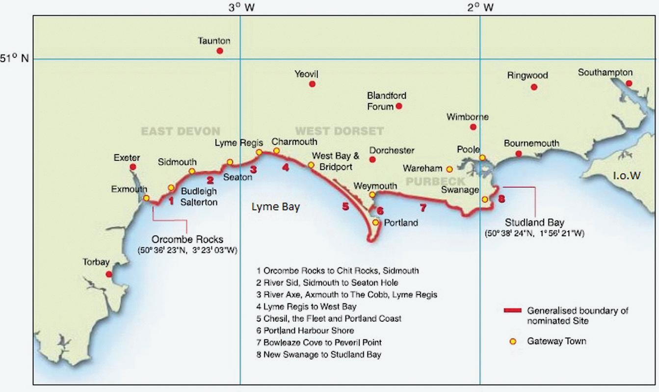
Te Jurassic Coast includes approximately 155 kilometres of coastline between Orcombe Rocks, at the mouth of the River Exe in Devon, and the geological boundary between the Cretaceous and later strata in Studland Bay in east Dorset (Figure 1.1). It embraces the towns of Budleigh Salterton, Sidmouth, Seaton, Lyme Regis, Charmouth, West Bay, Portland, Weymouth, and Swanage. Te Dorset and East Devon Coast was inscribed on the World Heritage List in Helsinki on 13 December 2001. Te site was granted World
Geological Pioneers of the Jurassic Coast. Andrew S. Goudie and Denys Brunsden, Oxford University Press.
© Oxford University Press 2023. DOI: 10.1093/oso/9780197638088.003.0001
Figure 1.1 Map of the Jurassic Coast.
From © Dorset County Council, Nomination Document, fgure 2. With permission of the Jurassic Coast Trust.
Heritage status under UNESCO’s criterion viii—Earth’s history and geological features—which indicated that its geology and geomorphology were of Outstanding Universal Value. It is currently managed by the Jurassic Coast Trust, an independent charity.
Te Geological Backdrop
In this brief section, before moving on to our consideration of the great individuals who have studied the Jurassic Coast, we provide a short introduction to the geology and geomorphology of the area. Tis provides a necessary backdrop within which the work of these scientists can be placed.
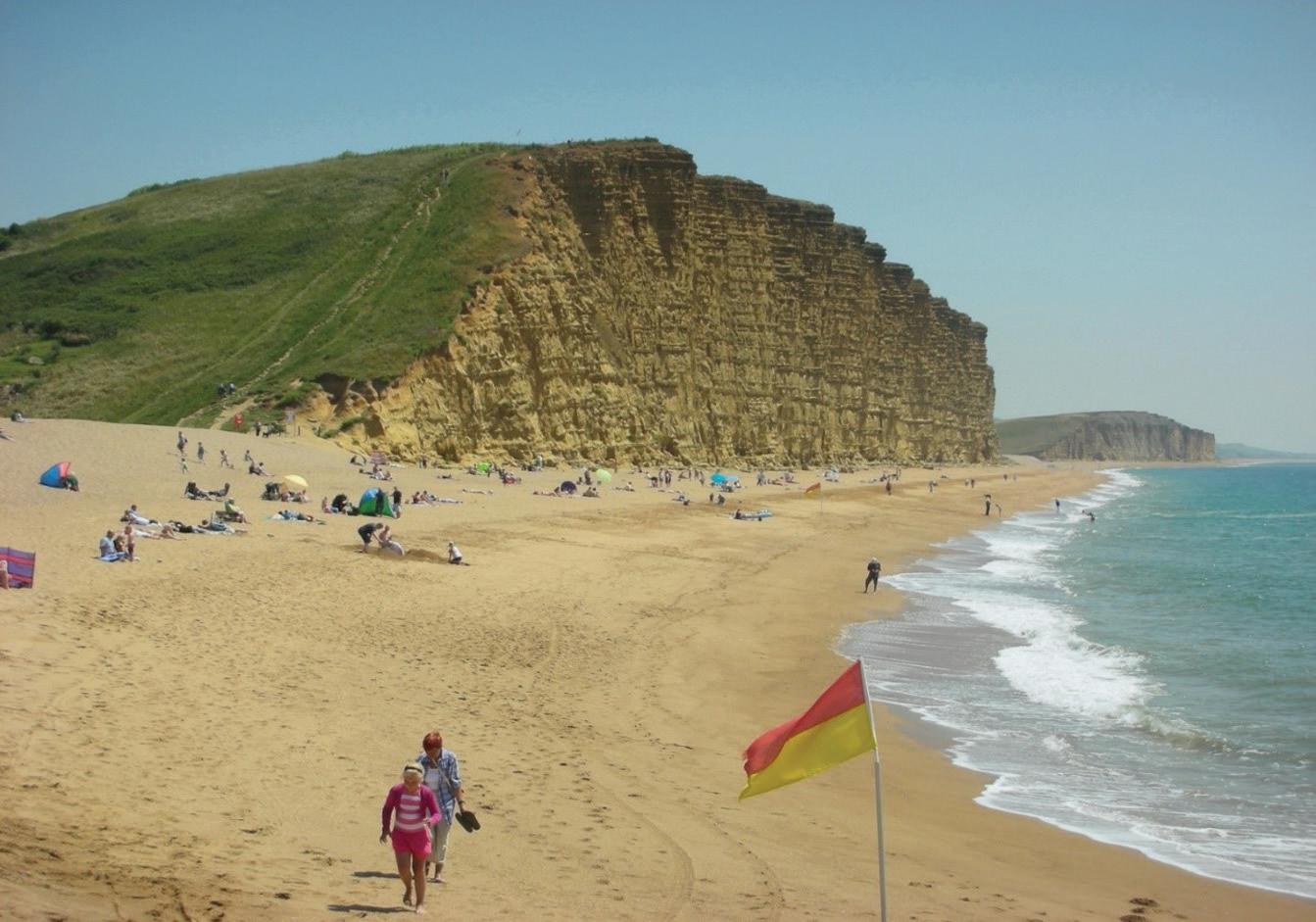
East Devon and Dorset have been known since the early days of geology as providing one of the world’s fnest sequences of strata from the Triassic of East Devon to the Cretaceous rocks in the East of Dorset (Figure 1.2). Tey range from the red Triassic rocks of East Devon between Exmouth and Seaton, to the dark grey Lower Jurassic Lias, just west of Lyme Regis, to the yellowish sandstones of West Bay (Figure 1.3), to the great white limestones of Portland, and to a near complete sequence of Cretaceous rocks from the headland of White Nothe (Figure 1.4), through to Old Harry Rocks near
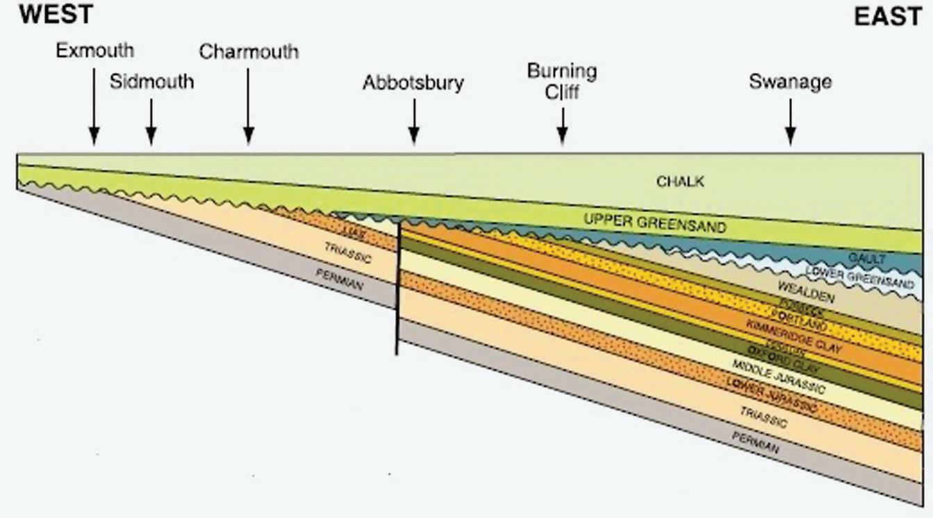
Figure 1.2 Geological cross-section of the Jurassic Coast from West to East (from © Dorset County Council, 2000, Nomination Document, fgure 5). In general, the strata dip gently to the east. Te oldest rocks are therefore found in the west, with progressively younger strata outcropping to the east. As a direct result, most parts of the succession are readily accessible in sequential order within the clifs and foreshore. With permission of the Jurassic Coast Trust.
Figure 1.3 Te yellowish early Jurassic Bridport Sand clifs of West Bay (ASG).
Swanage. Further to the east, just outside the area of the Jurassic Coast, there are also Paleogene beds, laid down between 66 and 23 million years ago. Hart’s book (2009) provides a beautifully illustrated guide to the geology and landscapes of the region (also see Box 1.1).
Te coastline’s rocks are displayed in a magnifcent series of clif exposures. Along with such places as Whitby in Yorkshire and Solnhofen in Germany, the area has played a fundamental role in understanding the palaeontology of this period of geological time.
Box 1.1 S ome Key Literature
Te Special Memoir of the British Geological Survey (Barton et al. 2011) gives a full account of the whole coast’s geology, as does John Cope’s (2016) Geology of the Dorset Coast. Ian West’s remarkable website, Te Geology of the Wessex Coast of Southern England—the World Heritage Jurassic Coast and more (http://www.southampton.ac.uk/~imw/westpubl.htm), provides a comprehensive bibliography of the Jurassic Coast. Updated information on the area is provided in a special issue of the Proceedings of the Geologists’ Association of London, which appeared in 2019. Details of important sources on both the general geology of the area and individual geologists are given in the references at the end of this book.
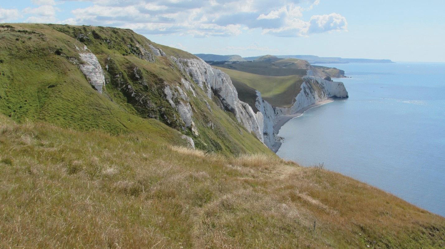
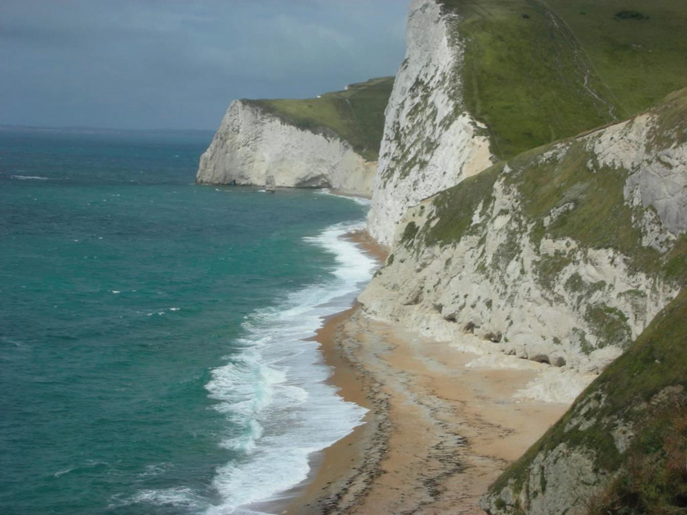
Figure 1.4 Te chalk clifs east of White Nothe (ASG).
Te rocks, in almost unbroken succession, have combined to make the exposures of the Devon and Dorset coasts a key training ground for geologists. Te frst published recognition of their geological value was recorded by the naturalist John Ray (Essex man, pastor/naturalist, and Fellow of the Royal Society, 1627–1705) who in 1673 (p. 115) noted, very much in passing, ‘Lyme in Dorsetshire’ as a source of ‘serpent-stones’ gathered by himself and friends. Ever since, many of the founding scientists of the subject have cut their teeth on these sections or been trained on them. British and world museums are full of high-quality material collected from the coast. Many new fossils have been named from fossils found in the region, and, for example, Lyme Regis itself has yielded type specimens of at least 50 species of fossil fsh and of 14 fossil reptiles (Dinely and Metcalf 1999; Benton and Spencer 1995).
Te rock strata exposed along the Jurassic Coast provide an almost unbroken record of Earth history between 251 and 66 million years ago in relatively un-deformed sediments, representing a remarkable range of past environments. Te structure of the coast displays its geological interest superbly. In general, the strata dip gently to the east into the Wessex Basin. Te oldest rocks are therefore found in the west, with progressively younger strata outcropping to the east. As a direct result, most parts of the succession are readily accessible in sequential order within the clifs and foreshore, while the ongoing processes of coastal erosion mean that the exposures are constantly refreshed and new material is brought to light. As it has been said, a walk along the coast is a walk through deep time (see Brunsden [2003] for a general introduction).
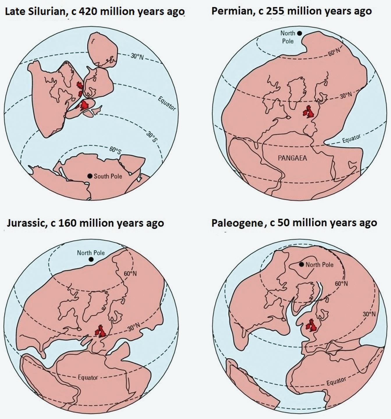
Te nature of the rocks encountered has depended in part on the latitudinal position of the British Isles. Tis has changed as the positions of the Earth’s plates, continents, and oceans have changed through time (Figure 1.5).
Taking the oldest rock frst, the Permian-Triassic boundary, which has always been the subject of some diversity of views (Gallois 2019), is now drawn at the base of the Budleigh Salterton Pebble Beds, making the Aylesbeare Mudstone Group Permian in age. Te Aylesbeare Mudstone Group covers the Capitanian and Wuchiapingian stages of the Permian. Te Budleigh Salterton Pebble beds are now ofcially named the Chester Formation, and the Otter Sandstone is the Helsby Sandstone Formation.
Te Triassic succession (Figure 1.6) is a virtually continuous exposure of c. 1,100 metres of sediments representing most of the Triassic period (c. 251–201 million years ago). It consists of continental, terrestrial red-beds and,
Figure 1.5 Te changing latitudinal position of the British Isles (shown in red) through geological time (ASG).
near the top of the sequence, a shallow marine facies. Tese exposures record evidence of (i) the gradual destruction and denudation of mountains formed in the Variscan orogeny (a mountain-building event at c. 290 million years ago) caused by Late Palaeozoic continental collision between Euramerica (Laurussia) and Gondwana to form the supercontinent of Pangaea at 330–280 million years ago and (ii) the establishment of a widespread marine environment within a Jurassic basin formed during the opening of the Atlantic Ocean. At the time of deposition, this area was located 10–15° N of the Equator. Te Mid-Triassic Otter Sandstone Formation (now known as the Helsby Sandstone Formation) at High Peak and Otterton Point in East Devon has yielded species of reptiles, fsh, and amphibians (Hart 2014).
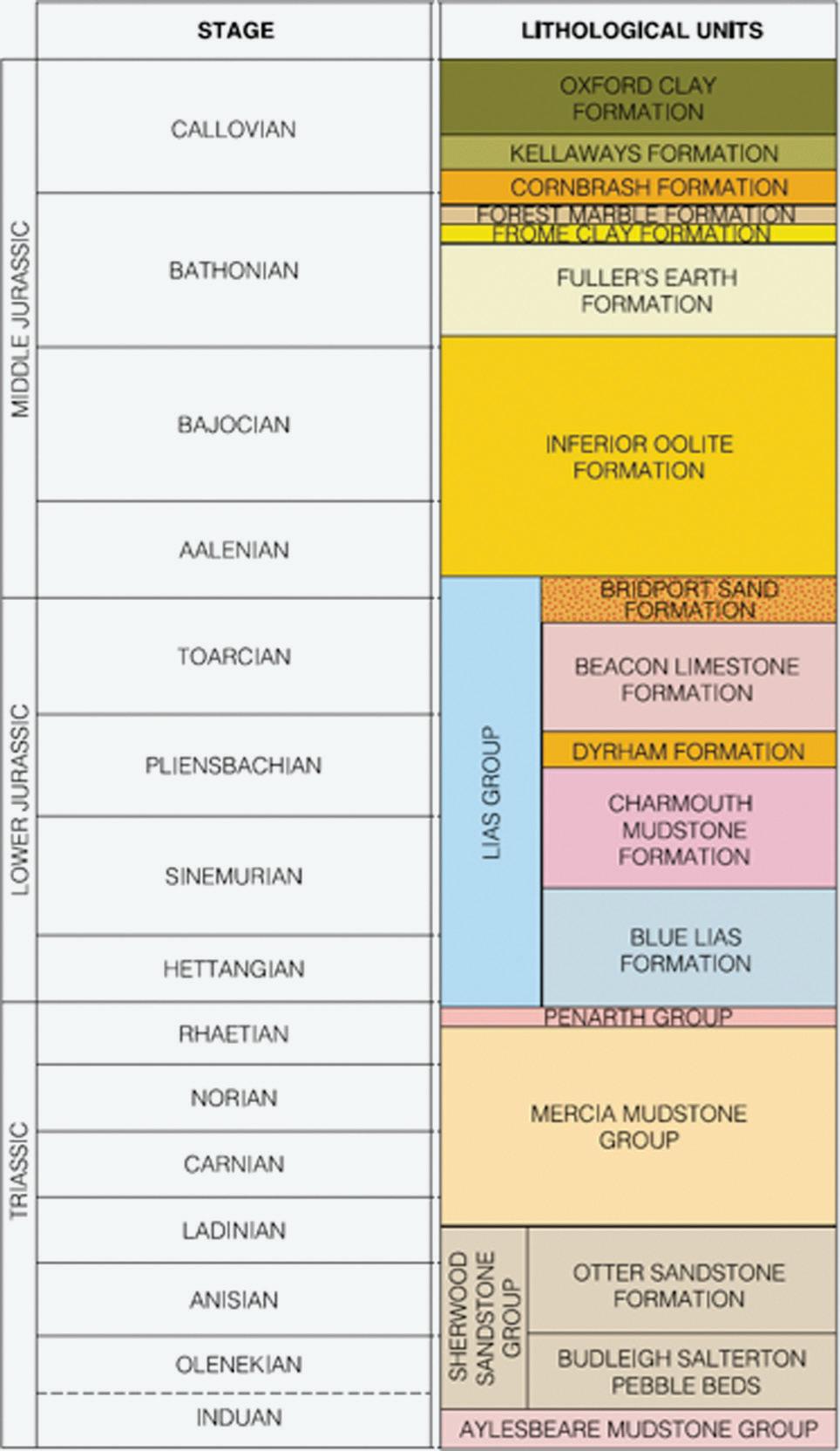
Figure 1.6 Generalised geological succession from the Triassic upwards (modifed from © Dorset County Council, 2000, Nomination Document, fgure 4). Tis fgure shows the boundaries and nomenclature at the time of the document. See the text for more recent divisions. With permission of the Jurassic Coast Trust.
It has a lower part formed of aeolian sands, and these pass upwards into a series of river channel deposits. Tese river channels, which are best seen between the mouth of the River Otter and Ladram Bay, contain a series of classic fuvial facies, such as erosive channel bases, braided stream features, and channel lag deposits. Tese are magnifcently exposed, along approximately 10 kilometres of sea clifs and intertidal foreshore ledges extending
eastwards from Budleigh Salterton to just east of Sidmouth (Coram et al. 2019). Edwards (2008) provides an excellent introduction to the geology and landforms of ‘Te Red Coast’ between Exmouth and Lyme Regis, while Campbell (2006) provides a guide to the underclifs of the Axmouth to Lyme Regis Nature Reserve.
Te rocks along the Jurassic Coast provide one of the fnest marine sequences of this age anywhere in the world: every stage of the Jurassic is represented (Figure 1.7). Te succession provides excellent evidence of the history of the Earth between c. 200 and 146 million years ago, recording six major cycles of sea level change represented by repeated rhythms passing from clay to sandstone and then limestone. Tese sections have played a key role in the establishment of modern stratigraphy and of biostratigraphic studies. Te Liassic vertebrates of Lyme Regis are world famous.
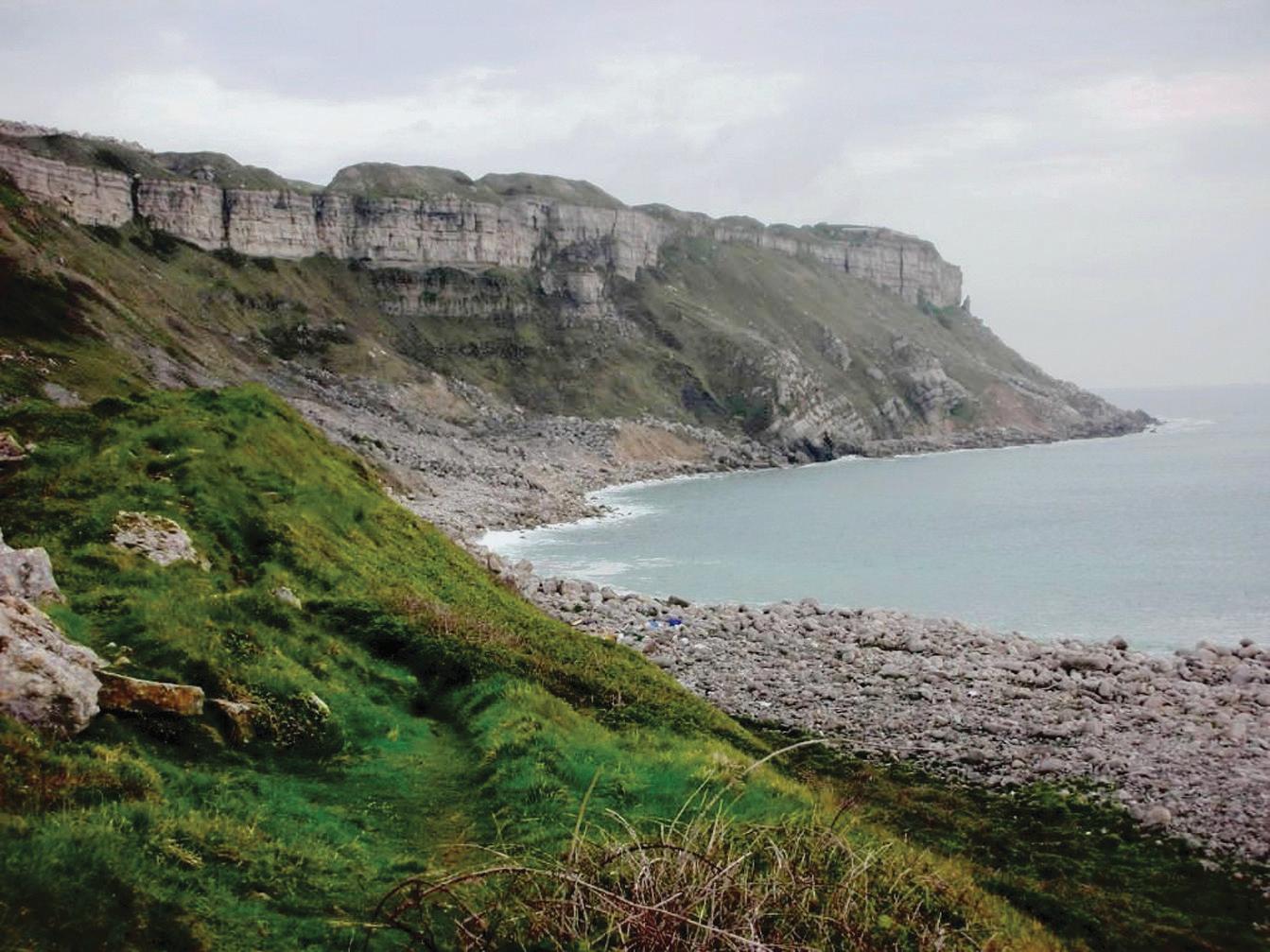
Te Lower Jurassic Lias succession of the Jurassic Coast is the bestexposed in Europe (see Lord and Davis [2010] for a discussion of the fossils). It is exposed in an almost continuous clif section extending from Pinhay Bay to the west of Lyme Regis to Burton Bradstock approximately 15 kilometres to the east. Equally, the Kimmeridge-Portlandian succession along the Dorset coast is possibly the best continuous exposure of rocks of this age in the world. In Kimmeridge, the remarkable Etches Collection shows of a wonderful collection of fossils from that area. Te Isle of Portland (Figure 1.8) is the type locality for the Portlandinan (Tithonian Stage), and the clif sections contain magnifcent sections of international importance for stratigraphy, palaeontology, and facies analysis. Portland Stone has been much quarried (and now mined) and has been used all over the world (Hackman 2014; Godden 2016; Butler-Warke and Warke 2012).
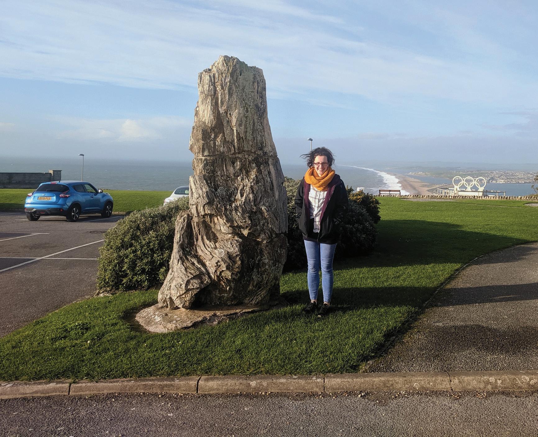
Te boundary between the Jurassic and Cretaceous probably lies within the lowest beds of the Purbeck Group (Ensom 2007). Te Purbeck Group on the Isle of Purbeck (including those rocks that straddle the Jurassic-Cretaceous boundary) contains an exceptional assemblage of vertebrate fossils. Fish remains are locally and exceptionally well preserved. Tere are also superb remains of Late Jurassic fossil forests exposed on the Isle of Portland (Figure 1.9) and the coast of Purbeck. Tese forests once grew on the margins of a large hypersaline lagoon, or sabkha, which existed 140 million years ago. It is a uniquely complete record of a forest of this age and contains large trees, sometimes in situ, with associated algal burrs, which formed around the bases of the trees, and fossilised soils (the so-called dirt beds) and pollen. Te wood is exceptionally well preserved in silica, displaying microscopic details
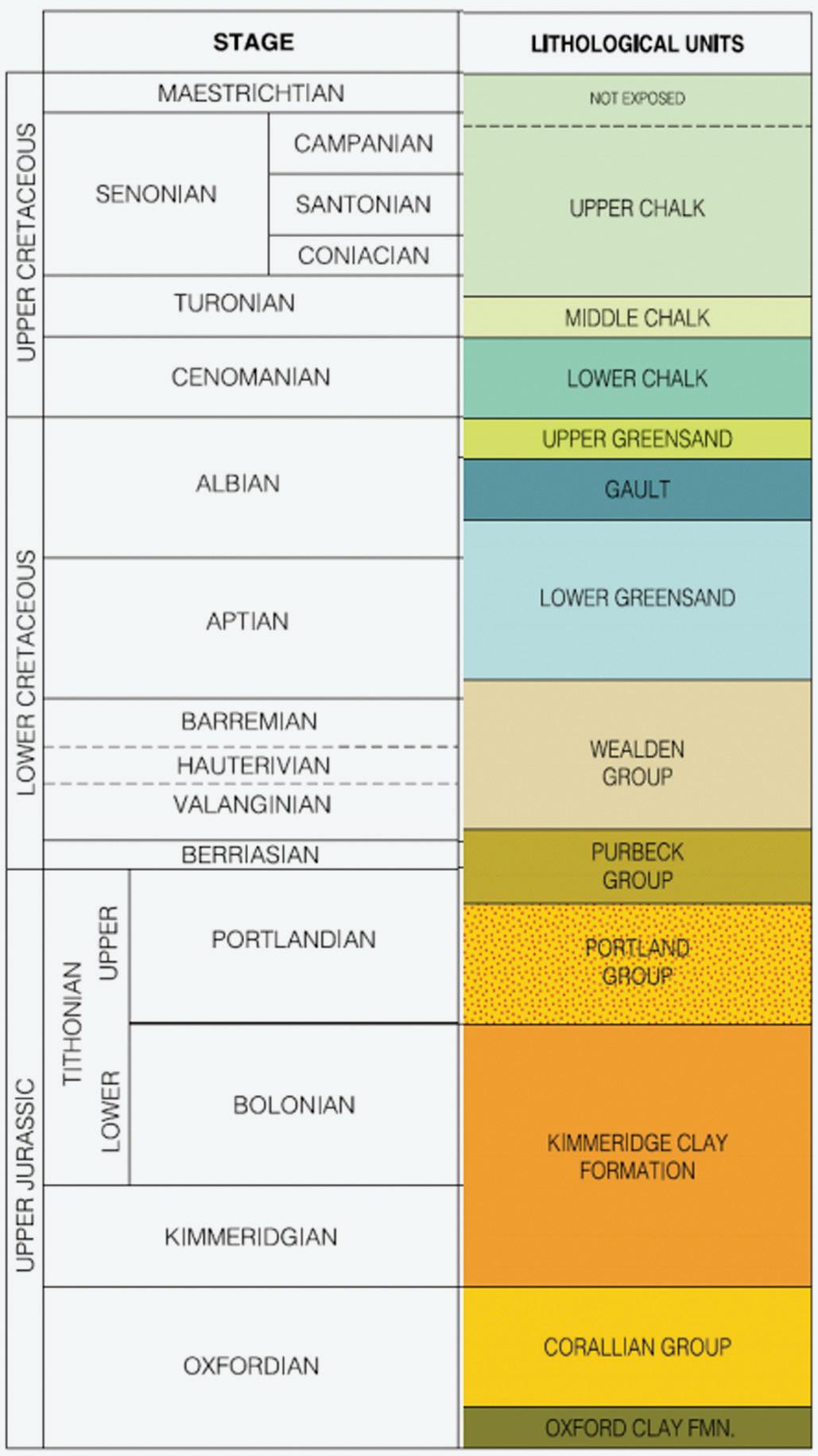
Figure 1.7 Generalised geological section from the Upper Jurassic upwards (modifed from © Dorset County Council, 2000, Nomination Document, fgure 4). Tis fgure shows the boundaries and nomenclature at the time of the document. See the text for more recent divisions. With permission of the Jurassic Coast Trust.
Figure 1.8 Te West Weares of the Isle of Portland showing the Portland Beds (ASG).
Figure 1.9 Fossil tree trunk from the basal Lulworth Formation of the Purbeck Group at the Portland Heights. Amy Beasley (nee Goudie), for scale (ASG).
of the structure, including preserved growth rings which allow a detailed assessment of the climate of the time. Te Purbeck Group Fossil Forest is one of the most complete examples of a fossil forest of any age and, unlike many others, preserves in situ trees with soils.
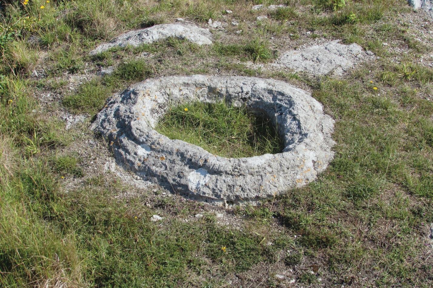
Te fossil forest at Lulworth and on Portland is a very primitive-looking landscape of thrombolites (Figure 1.10). Tese thrombolites (Bosence and Gallois 2021), formed by bacteria, look like rock doughnuts bored through with deep craters where trees were once rooted. Tey were formed when a forest of trees akin to cypresses was growing in a swamp on the edge of a warm lagoon or saline lake in a Mediterranean-type, semi-arid environment. Te forest was later drowned by the sea, and, over many millions of years, its remains were preserved within layers of limestone that were deposited on the seabed and then compressed. Tere are some logs and trunks which were fossilised, but, for the most part, the trees rotted away, leaving just the hollow mounds of the algae (stromatolites) that had formed around their trunks.
Te overlying Wealden Group (Penn et al. 2020), along with that on the Isle of Wight, is one of the most complete sequences of this age available at a single site in north-west Europe. Durlston Bay near Swanage yields the richest assemblage of Lower Cretaceous insects, fsh, early mammals, and
Figure 1.10 A thrombolite from King Barrow (Kingsbarrow) Quarry, at the north end of Portland. It is about 1 metre across. Te central hole once contained a tree stump, rooted in the Great Dirt Bed palaeosol below (ASG).
reptiles known anywhere on Earth. Tese were made famous through the researches of Samuel Beckles and Peter Brodie. Te succession within the Jurassic Coast includes rocks of all stages of the Cretaceous period, with the exception of the uppermost one. Te Cretaceous Chalk is well exposed (Mortimore 2019), particularly in the clifs in the east of the area between Weymouth and Lulworth, and at Ballard Down. Te old division of the Chalk into lower, middle, and upper has been replaced by the following formations in Dorset. From oldest to youngest these are Basement Bed, Zig Zag Chalk Formation, Holywell Nodular Chalk Formation, New Pit Chalk Formation, Lewes Nodular Chalk Formation, Seaford Chalk Formation, Newhaven Chalk Formation, Culver Chalk Formation, Portsdown Chalk Formation, and Studland Chalk Formation.
Also important are the Upper (Gallois and Owen 2019) and Lower Greensands (Rufell and Batten 1994). Te former plays an important role in landslide development, has in places been karstifed, and has generated much chert debris that mantles slopes (Gallois 2005).
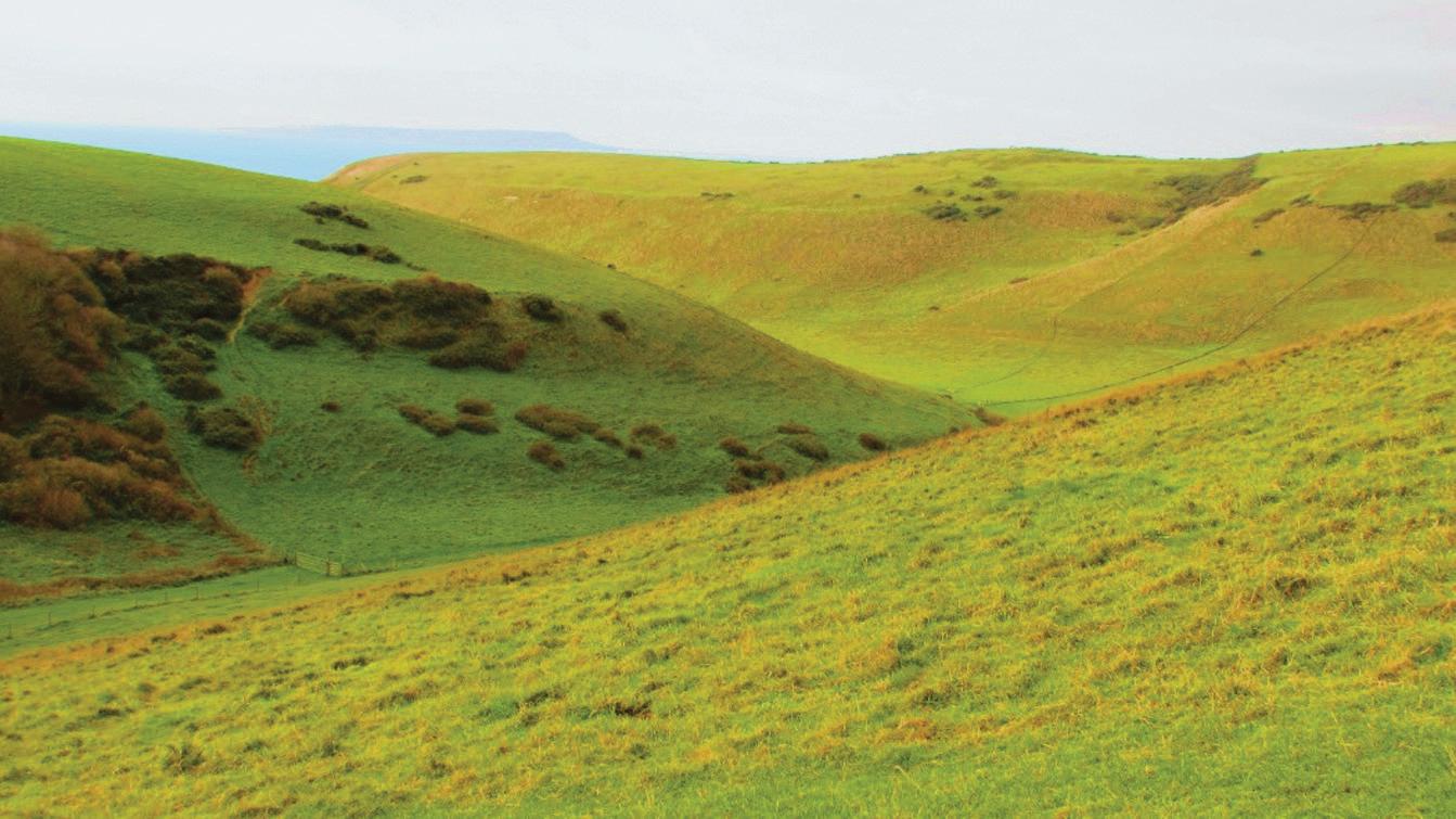
Locally in the area there are deposits of Paleogene or Neogene age, including Eocene gravels, sarsen stones, solution hollow (doline) inflls, and the like. Tere are also some major sites of Pleistocene age, including the famous raised beach at Portland Bill, although this area lay beyond the southern limits of the Quaternary ice sheets and thus was subjected to periglacial rather than glacial conditions. Dry valleys (Figure 1.11) in the Chalk (notably Scratchy Bottom to the west of Lulworth; Figure 1.12), which no longer have fowing water, may have been active during these cold conditions. Sea level rise of over 120 metres followed the end of the last Ice Age (from around 20,000 years ago), occurring from the late Pleistocene and through the most recent period of geological time, the Holocene. Tis brought the coastline to its present position and drowned an extensive ofshore landscape.
Te Jurassic Coast was inscribed by the World Heritage organisation of UNESCO, not only for its geological sequence and fossils, but also for the quality, variety, and signifcance of the landforms and ongoing geomorphological processes (Goudie and Migoń 2020; Allison 2020). Tis derives mainly from the interaction of oceanic and atmospheric controls on the continuous variation of the lithology of the eastwardly dipping strata. Some of the landforms are amongst the most frequently quoted examples in textbooks.
Te coast is iconic for the study of landslides, with a huge variety of forms and dramatic changes. Famous landslides include the Hooken slide, near Bere, of 1790; the Southwell topple of 1734 on Portland (Dykes and
Figure 1.11 Te Cretaceous chalk clifs of the Dorset coast west of Durdle Door, serrated by dry valleys (ASG).
Figure 1.12 Scratchy Bottom, near Lulworth. A great dry valley excavated into the Chalk under periglacial conditions (ASG).
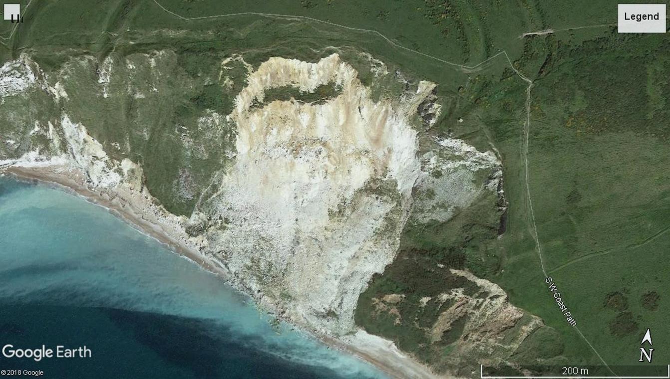
Bromhead 2021); the East Weares slide on Portland in 1792; and the Bindon slide of 1839 in East Devon. Te last of these was made famous by the work of Dean William Conybeare and Dean William Buckland (see Lincoln in https:// www.lyme regi smus eum.co.uk/ lrm/ wp- cont ent/ uplo ads/ 2017/ 02/ 10_views_final_version_-21_-June_-2021.pdf ). Te Axmouth to Lyme Regis underclif is the only landslide National Nature Reserve in the United Kingdom (Pitts 1979, 1983). Tis piece of the coast has been the subject of considerable research in the past 50 years, with many innovative advances in image interpretation and monitoring. Landslips have occurred near Sidmouth (Gallois 2011) and Salcombe Regis (Gallois 2007). Te landslip complexes between Lyme and Charmouth include Black Ven and the Spittles (Gallois 2014), while to the east of Charmouth lies Stonebarrow (May 2003a). Tere is a large landslide complex between Ringstead and White Nothe, and large mudfows have occurred at Osmington. Mass movements have also occurred elsewhere: for example, Burton Bradstock, in July 2012; St Oswald’s Bay near Durdle Door, in May 2013; Bowleaze Cove near Weymouth, in April 2016; Worbarrow Bay, in May 2017 (Figure 1.13); West Bay, in March 2019; Eype, in November 2020; Hive Beach, in December 2020; and between Seatown and Eype, in April 2021.
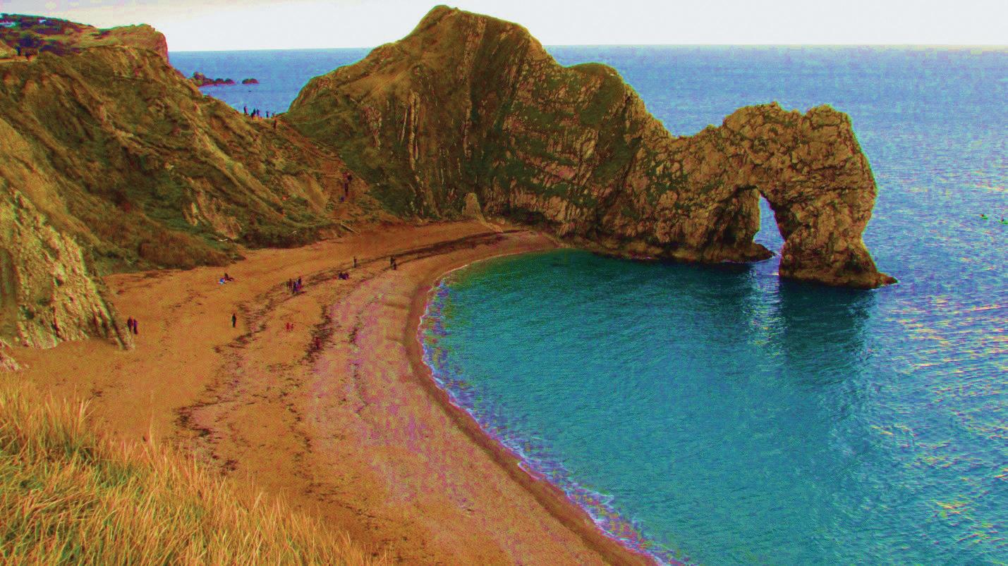
Te Isle of Portland is one of the most instructive places in the world to demonstrate the infuence of geological structures on clif processes and forms (Goudie 2020; Figure 1.14). In 1836 (p. 226), W. H. Fitton, an eminent gentleman geologist wrote: ‘Few places, it is probable in the world, exhibit with such distinctness and in so small a place, phenomena of more extraordinary interest, or of greater importance to theory.’ Indeed, the whole Jurassic Coast has dramatic and very beautiful clifs of national scenic importance. More than 80% of the length of the East Devon and Dorset coast is composed of clifs developed in sedimentary rocks. Stacks and arches at Ladram Bay, Stair Hole, Durdle Door (Figure 1.15), and Old Harry Rocks, and arcuate bays like Lulworth Cove (Nowell 1998), Worbarrow Bay (Nowell 2000), and Chapman’s Pool, all feature in most guidebooks and school texts. Te Purbeck coast perfectly illustrates the principles of concordant and discordant coastline evolution models.
At the foot of many clifs are striking examples of shore platforms, as at Charmouth/Lyme, Portland Bill, Newton’s Cove (Weymouth), and Kimmeridge.
Te area is one where the power of humans to change coastal processes and erosion rates can be demonstrated. Tis is the case, for example, at Sidmouth
Figure 1.13 A great landslide at Worbarrow Bay, in May 2017.
Source: © Google Earth (2018).
Figure 1.14 Te West Weare clifs of Portland taken from the Cove House Inn (Alice Goudie); a superb place to see the infuence of rock characteristics and structures on clif forms.
(Gallois 2011) and at West Bay, where harbour works have upset the natural pattern of erosion and deposition.
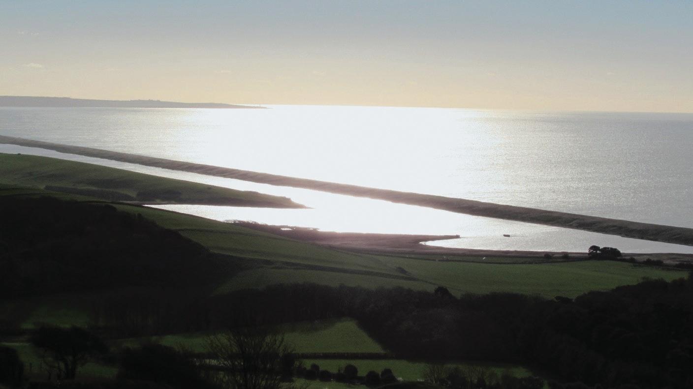
Te beaches vary in composition, from the red quartzite pebbles at Budleigh Salterton, to the cherts and fints of West Dorset or the sands of Weymouth and Swanage. Te sediment budgets for the coast of West Dorset have been analysed by Bray (1996). Chesil Beach (Figure 1.16), studied by Sir John Coode, extends for 28 kilometres from Bridport Harbour to Portland,
Figure 1.15 Durdle Door, one of the iconic landforms of the Jurassic Coast (ASG).
Figure 1.16 Chesil Beach and the Fleet in the evening sun (ASG).
becoming steeper and higher from west to east (May 2003b). It is separated from the mainland by the Fleet, which contains important sediments recording the sea level and climatic changes of the past 7,000 years. Tis is also Europe’s largest coastal lagoon, while the beach is famous worldwide for the volume, type, and size-grading of its pebbles. Papers concerning the origin and processes of the beach have been written for more than 200 years and are still controversial.
Te of-shore submarine geomorphology is an area of burgeoning interest and contains some remarkable features, including circular structures, sand accumulations, and ancient river-courses (May 2019).
Box 1.2 The Role of Women at This Time
One matter of interest that has arisen from writing this book has been the role of women. Most reviews and contemporary comments on the contributions of women to the Earth Sciences suggest that, following the mores of society in the nineteenth century, they were ofen born into infuential, scientifc, and well-of families where the man of the house had independent means and training, employment, or amateur interests, usually in botany, astronomy, or palaeontology. Tis allowed, or ensured, that many women worked voluntarily with no recognised status or salary. Tey were ofen described as assistants, preparators, illustrators, curators, or secretaries. Although many women discovered specimens or made fundamental insights and original scientifc observations, they generally received little scientifc credit. Men who worked with women—ofen their wives, sisters, or daughters—were described as ‘extraordinarily enlightened’.
Many women who were mothers, governesses, or teachers concentrated on education for young people, other women, and for the general public. Some wrote academic papers, but it was more common to write in popular texts, such as Every Girl’s Magazine. Tey also wrote biographies of the men with whom they were associated and completed their works posthumously. At the same time, their own work was ofen anonymous, with their substantive work appearing under a man’s name. Te discoveries of Mary Anning, such as the plesiosaur, written by William Conybeare, is the most startling example.
Te nineteenth century is noted for the development of secondary and university education for ladies. Te London Collegiate School, Cheltenham’s Ladies College, Queens College, and the Girl’s Public Day School Trust (1871–1878) are important milestones. Girton and Newnham in Cambridge, Somerville and Lady Margaret Hall in Oxford, and Birkbeck University and King’s College in London all played a distinguished role. In geology two academics stand out: Catherine Raisin at Bedford and Gertrude Elles at Newnham, but neither is associated with the Jurassic Coast.
Te scientifc community did not support women. Learned societies, such as the Royal Society and the Geological Society, did not admit women as Fellows until 1917, by law. Fortunately, local or regional groups, such as the natural history, scientifc, and literature societies of the country, were more liberal, particularly if they were based on outdoor learning and collecting, which also might include collecting and observation by children and healthy pursuits. Tis was because botany was seen as suitable for children and ladies.
Te value of natural history and outdoor pursuits is perhaps why the Geologists’ Association, based on amateur scientists, had equal rights from its foundation in 1858. Te Geographical Association, developed mainly by teachers, had a similar history at a time when Fellowship of the Royal Geographical Society, under the leadership of Lord Curzon, was strongly against female membership.
Even then, however, the situation was patronising although wellintentioned. Men were widely regarded as superior and better able to understand science, be objective, and to reason. As Tomas Jones, FRS (1819–1911), President of the Geologists’ Association, said in his opening address to the 1880–1881 session,
Women as well as men, can be Geologists as far as their strength for travel and opportunities among domestic afairs will allow. Doubtless for many ladies it is hard to tramp about on Geological Excursions over rough roads, hillsides, hedges, ditches and seaside rocks and shingle. . . .
Let special Excursion lines be planned so that we may have the pleasure and advantage of female society. . . .
Tey have ofen graced the outings with their presence. . . .
In the meetings of the Association the female element is an adornment and a social pleasure . . . how greatly would the scientifc meetings and outings lose if the ladies were absent! . . .
Who requires to be reminded of the intellectual powers and persistent energy of the well-educated woman?
Although many of these women are still described as ‘unusual for their time’ and were certainly few in number, the picture for the Jurassic Coast is unusual, perhaps because Mary Anning stands out as an independent fgure in the history of science. Her discoveries were reported and scientifcally described by men. She resented this, but later they acknowledged her abilities and contribution. Some supported her fnancially and, afer her death, subscribed to a memorial in her name, the stained-glass window in Lyme Regis Parish Church. Sir Henry De la Beche, founder of the Geological Survey of Great Britain, wrote a fulsome obituary. In Lyme Regis, the Philpot sisters were also great collectors, and the town’s museum bears their name. Tere are a few important other fgures that we have reported here, including Mary Buckland, Marie Stopes, Eleanor Coade, and Muriel Arber.
Box 1.3 Local Museum Resources
Readers of this book should visit some of the excellent museums along the coast that have fossil displays. Tese include Sidmouth Museum, Seaton Jurassic, Lyme Regis Museum, the Charmouth Heritage Coast Centre, Bridport Museum, Portland Museum, Te Etches Collection Museum of Jurassic Marine Life in Kimmeridge, and the Swanage Museum and Heritage Centre. Also containing important material from the coast are the Dorset County Museum in Dorchester and the Royal Albert Memorial Museum in Exeter. Te Charmouth centre was awarded the R. H. Worth award of the Geological Society of London, in 2019, for its outreach, public engagement, and role in education.
Box 1.4 What is Geomorphology?
Te authors are both geomorphologists. Te word ‘geomorphology’, which means literally to write about (Greek logos) the shape or form