Great Clarendon Street, Oxford, OX2 6DP, United Kingdom
Oxford University Press is a department of the University of Oxford. It furthers the University’s objective of excellence in research, scholarship, and education by publishing worldwide. Oxford is a registered trade mark of Oxford University Press in the UK and in certain other countries
All rights reserved. No part of this publication may be reproduced, stored in a retrieval system, or transmitted, in any form or by any means, without the prior permission in writing of Oxford University Press, or as expressly permitted by law, by licence or under terms agreed with the appropriate reprographics rights organization. Enquiries concerning reproduction outside the scope of the above should be sent to the Rights Department, Oxford University Press, at the address above
You must not circulate this work in any other form and you must impose this same condition on any acquirer
Published in the United States of America by Oxford University Press 198 Madison Avenue, New York, NY 10016, United States of America
British Library Cataloguing in Publication Data
Data available
Library of Congress Control Number: 2022941521
ISBN 978–0–19–286539–7
ebook ISBN 978–0–19–268899–6
DOI: 10.1093/oso/9780192865397.001.0001
Printed and bound by CPI Group (UK) Ltd, Croydon, CR0 4YY
Links to third party websites are provided by Oxford in good faith and for information only. Oxford disclaims any responsibility for the materials contained in any third party website referenced in this work.
Preface Purpose, Sources, and References
Nazareth—today a small city in the Galilee region of northern Israel —is most famous, of course, for being where the Gospels say that Jesus Christ grew up and lived in the early first century AD. It might be imagined that this would have attracted many archaeologists to work in Nazareth. But, in fact, Nazareth was largely neglected by archaeologists between the early 1970s and the start of my own work on its archaeology in 2004.
This book is written to explain what, after eighteen years of research, I think we know, or can reasonably figure out, about early first-century Nazareth and its immediate vicinity. Almost all of the information we have about this subject, outside of the Gospels, is from archaeology, hence the book’s title.
It is more specifically designed to answer the most frequent questions about my work on Nazareth that I have been asked by people who aren’t archaeologists. It is also intended to clear up some misunderstandings about it, deriving mostly from media reports.
As such, although it contains new interpretations which may be of interest to professional archaeologists, historians, and experts in biblical studies, the primary purpose of this book is to explain, to readers other than archaeologists, research that has so far been published mainly in an academic manner. Hopefully, this will lead to a new understanding of what archaeology really shows us about early first-century Nazareth (‘Jesus’ Nazareth’).
For that reason, the present book brings together information from three of my earlier academic publications. Chapter 2 is based on my 2020 book Roman-period and Byzantine Nazareth and its Hinterland, and the remainder is based on my book The Sisters of NazarethConvent, published the following year, and my 2016 Henry Myers Lecture to the Royal Anthropological Institute, ‘Returning to the Caves of Mystery’. This was also published in 2020 in the academic archaeology journal Strata.
My two earlier books cover a much wider time span than the present work. Here only evidence concerning the first century AD—or, although later, evidence that is of significance to understanding firstcentury Nazareth—is discussed. Anyone interested in Byzantine— that is, fifth- to seventh-century AD—or later Nazareth and its immediately surrounding landscape may consult those two books.
It is an indication of how little archaeological attention has been paid to Nazareth since the fieldwork on which my two earlier books were based that there are only five more recent publications, and five brief online reports of Israel Antiquities Authority fieldwork given in the References section—relevant to this book.
Three of the publications establish that limestone vessels—like pottery cups and other containers, but made out of stone—were manufactured for longer in the Roman period than previously thought. These don’t affect the arguments and interpretation in my earlier books or those given here.
The very interesting recent paper on the ‘Nazareth Inscription’ shows that I and others were almost certainly right in supposing that it has nothing to do with Nazareth. It is discussed at the appropriate point in Chapter 2.
David Fiensy’s book, written from the perspective of a biblical scholar, is less directly relevant to Nazareth but includes a few examples drawn from Nazareth’s archaeology (for example, the photo—Figure 4.7—on page 96). It offers an interesting context into which to put the interpretations discussed in Chapter 6 here, and is worth reading for anyone seeking information about the first-century Holy Land.
The References section includes full references to my three earlier publications and these more recent works. It also contains books which help to put my own work in the context of other studies of Nazareth’s archaeology and that of the region of Galilee (also called ‘the Galilee’) in which Nazareth is situated.
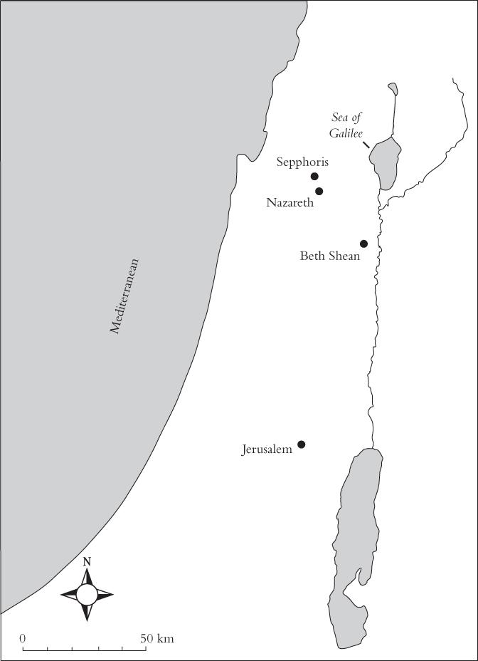
Figure 0.1. Map of the Holy Land, with the principal places mentioned in this book indicated. From The Sisters of Nazareth convent. A Roman-period, Byzantine and Crusader site in central Nazareth, 1st ed., by Ken Dark, copyright 2021 by Imprint; reproduced by permission of Taylor & Francis Group.
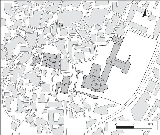
Figure 0.2. The city centre of Nazareth, showing: A = Sisters of Nazareth convent; B = Church of the Annunciation complex; C = Casa Nova hostel; D = Synagogue Church; E = Anglican church.
Drawn by Ifan Edwards for the Nazareth Archaeological Project, based on the city of Nazareth map of the Israel National Survey. From The Sisters of Nazareth convent. A Roman-period, Byzantine and Crusader site in central Nazareth, 1st ed., by Ken Dark, copyright 2021 by Imprint. Reproduced by permission of Taylor & Francis Group.
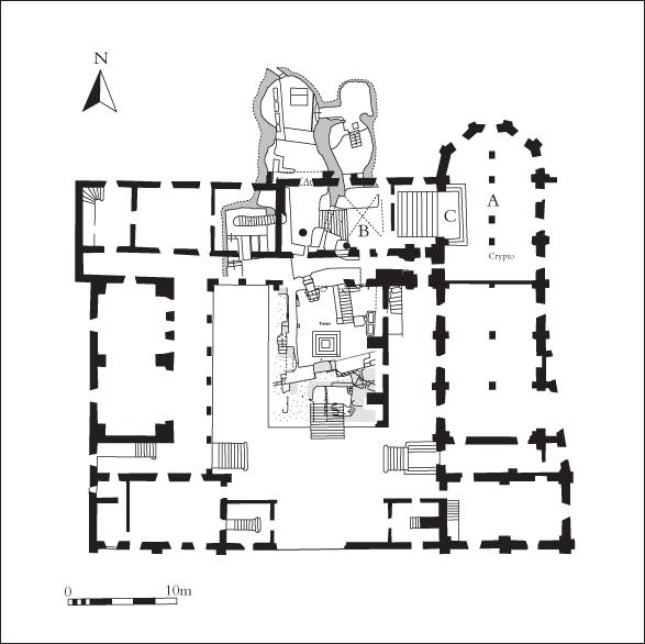
Figure 0.3. Convent plan and location of its ‘Cellar’. A = convent chapel; B = convent museum; C = modern stairway to Cellar. Drawn by Ifan Edwards for the Nazareth Archaeological Project. From The Sisters of Nazareth convent. A Roman-period, Byzantine and Crusader site in central Nazareth, 1st ed., by Ken Dark, copyright 2021 by Imprint; reproduced by permission of Taylor & Francis Group.
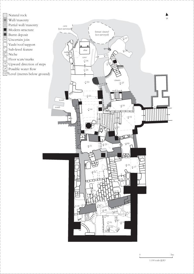
Figure 0.4. Plan of the Cellar at Sisters of Nazareth convent. Drawn by Mitchell Pollington for the Nazareth Archaeological Project. From The Sisters of Nazareth convent. A Roman-period, Byzantine and Crusader site in central Nazareth, 1st ed., by Ken Dark, copyright 2021 by Imprint; reproduced by permission of Taylor & Francis Group.
Acknowledgements
My work in, and near, Nazareth was only possible with permission and help of the Israel Antiquities Authority (IAA). Thanks are also, of course, due to the Sisters of Nazareth for permission to work at the convent and for all their help, especially the convent superior in 2006, Sister Margherita, and her successor, Sister Stefania.
Ifan Edwards was responsible for most of the drawings in this book, assisted in the field by Helen Robertson. Mitchell Pollington made the detailed plans of the Sisters of Nazareth ‘Cellar’ and the quarry reproduced here.
I am also, of course, grateful for the help provided in Nazareth by other members of the British survey team, who are individually acknowledged in my two previous books, as are the many friends and colleagues who have discussed the archaeology of Nazareth with me. My fieldwork discussed here was funded by the Palestine Exploration Fund and the Late Antiquity Research Group, both secular, non-political, British academic archaeological organizations.
(Scales in all the photographs are in 10 centimetre divisions.)
Map of the Holy Land, with the principal places mentioned in this book indicated
The city centre of Nazareth
Convent plan and location of its ‘Cellar’
Plan of the Cellar at Sisters of Nazareth convent
The valley between Nazareth and Sepphoris, looking north
The valley between Nazareth and Sepphoris, looking east
Roman-period quarrying in the valley between Nazareth and Sepphoris
Roman-period and Byzantine sites in the valley between Nazareth and Sepphoris
Roman-period quarrying in the valley between Nazareth and Sepphoris
Survey of Roman-period quarry site in the valley
The Sisters of Nazareth convent seen from the street
Tomb 1
The two convent superiors during the twenty-first-century fieldwork
The Large Cave
Schematic plan of the Cellar at the Sisters of Nazareth site
The ‘house’ Structure 1
The convent museum
The modern reconstruction of Mary’s Well
The present Church of the Annunciation in Nazareth
One of the first-century artificial caves at the Church of the Annunciation site
2.4.
Analytical outline plan of the first-century rock-cut spaces at the Church of the Annunciation site
2.5.
Plan showing what is known about Roman-period and Byzantine Nazareth from archaeology
3.1.
3.2. 3.3.
3.4.
3.5.
3.6.
3.7.
3.8. 3.9.
3.10. 3.11. 3.12. 4.1. 4.2. 4.3. 4.4. 5.1.
5.2. 5.3. 5.4. 5.5. 5.6. 5.7. 5.8.
5.9.
5.10.
The cross-vaulted room, looking south
The cut-down remnant of Tomb 2
The ‘light well’ in the Large Cave
Roman-period loculifrom Tomb 2
The Crusader lamp
The rock-cut door leading from the Large Cave
The ‘well’ in the cross-vaulted room
The passage leading south from the cross-vaulted room
The south of the present Cellar
The Crusader chapel next to Tomb 1
Roman-period loculifrom Tomb 1
A general view of the south of Structure 1 (‘the house’)
An anonymous photograph of Henri Senès
The Chambre Obscure, showing the blocked Byzantine niche in its west wall
Simplified plan of the south of the Cellar
Senès’ excavation exposed in the restoration of the Cellar floor
Mitchell Pollington surveying with a Total Station in the Cellar
Ifan Edwards drawing a section through Wall M4
Plan of the area inside Structure 1, and section showing the north face of the paving
The floor of Structure 1 seen from the south
The floor of Structure 1 seen from the north
Structure 1 looking from the south-east
Roman-period spindle whorl from Structure 1
The Small Cave
The rock-cut wall, with adjacent ‘wall-tumble’, just south of Structure 1
Wall 2, seen from the west
5.11.
6.1.
6.2.
6.3.
6.4.
6.5.
The Crusader stairway partially overlying the rock-cut stairway of Structure 1
A glass phial for perfume
A house reconstructed at Nazareth Village
Detail of the reconstructed house
Inside the reconstructed house
A reconstruction of a first-century woman spinning wool
Terminology andTimescales
In accordance with the normal conventions of British—and most other European—studies of Roman archaeology, dating is given using the AD/BC system, rather than the CE/BCE system widely used in American and Israeli archaeology. If you prefer the CE/BCE system, it is easy to convert these dates, because 1 CE is equivalent to AD 1; 1 BCE to 1 BC. For convenience, the region today encompassed within modern Israel and the Palestinian territories is called here ‘the Holy Land’.
The main historical periods with which this book is concerned are the Hellenistic period, from the fourth century BC until the Roman conquest, the Roman period which in Galilee is from the late first century BC until the end of the fourth century AD—and the Byzantine period, which in this region dates from the fifth century AD until the seventh century. The Byzantine period was interrupted near its end by a Persian invasion in the early seventh century, and followed by the Muslim conquest later in the seventh century. Muslim control of Nazareth ceased when the European Crusaders took the city in 1099. The Crusaders lost Nazareth in 1187, but effective Crusader control of the town was restored between 1250 and 1263, after which it again came under Muslim control.
It will also be convenient to divide the Roman period into two. The Early Roman period is considered here to last until the mid-third century; the Late Roman period, to comprise the later third century until the end of the fourth century. In the early fourth century, the Roman Empire’s policy towards Christianity dramatically shifted from a mixture of persecution and indifference to active support.
A few other archaeological terms may benefit from clarification: ‘archaeological fieldwork’—often just ‘fieldwork’ for short—is conventionally used as the term for scientific excavation, archaeological survey, or both. ‘Section’ is used in archaeology for a vertical face of soil, such as that visible at the edges of a scientific excavation; ‘elevation’ is used for the vertical face of a wall. Likewise, a ‘plan’ is a horizontal map of a surface exposed by archaeological excavation or recorded by survey. Fragments of pottery are called ‘sherds’; fragments of glass termed ‘shards’.
The concept of stratigraphy is fundamental to dating archaeological excavations. According to this concept, any layer (a layer being an approximately horizontal deposit of soil) on top of another must be later than that below it. Likewise, a feature (a cut down into the surface of a layer, or of the underlying natural rock, or alternatively something, such as a wall, built up from the surface of a layer) must be later than any layer or other feature which it cuts into or overlies. This concept enables the archaeologist to understand the sequence in which layers and features developed, and thereby understand the sequence of human activity on a site.
Dating archaeological layers and features depends on two other concepts. The stratigraphical law of terminuspostquem states that a layer must be the same date or later than the latest ‘sealed’ object which is found in it. ‘Sealed’ in this sense means that the object cannot be shown to have got into the layer later, pushed down through animal burrows or plant roots, for example. A layer containing a sealed sherd of Roman pottery, therefore, must date from the Roman period or later.
This has to be combined with another stratigraphical law, the law of terminus ante quem. This states that if the date of a layer or feature is absolutely known—for example, due to an inscription giving a calendar date or due to distinctive characteristics of its construction—then any layer or feature below it, or cut by it, must be that date or earlier. Consequently, if a wall certainly dates to the first century, because it incorporates an inscription giving it that date
or because of its constructional style, any layer or feature below it or cut by it must be first century or earlier.
Of course, sometimes in archaeological work we can use laboratory science to provide other forms of dating—such as radiocarbon dates—but these methods, as we shall see, have played very little role in the archaeology of first-century Nazareth.
It might be useful to explain a few other terms used in this book which may be unfamiliar to some readers. Archaeology, like most academic disciplines, uses a lot of specialized language—what might be called ‘technical terms’. Overall, I have avoided these when something can be explained in ordinary English.
For example, the characteristic rock-cut storage pits found in Roman-period Nazareth, with their pear-shaped profiles, are termed here ‘storage pits’ or ‘rock-cut storage pits’, rather than ‘silos’ or ‘piriform silos’—which they are called in most of the academic descriptions of Nazareth’s archaeology.
Of course, it is sometimes necessary to describe something of which the meaning—although it isn’t specific to archaeology—might be unfamiliar to some readers, but well known to others. In this context, it may be useful to consider the following terms.
When describing a church, it is conventional to call the congregational space, where most people stand or sit during worship, the ‘nave’, and the curved end of the church, where the altar is, the ‘apse’.
The ceremonies that take place during Christian worship are called the ‘liturgy’, and those parts of the church used especially in them—for example, the altar are, therefore, sometimes described as the church’s ‘liturgical fittings’. They are also called ‘church furniture’ in some publications, but that term is so confusing—to me its sounds like the pews where people sit—that it isn’t used here. Likewise, a ‘cathedral’ is the bishop’s principal church, usually larger than all the others in an urban centre. Following colloquial English usage, one can call any urban place with a cathedral a city.
When describing farming practices in Galilee, an ‘olive press’ is an installation for the production of olive oil by crushing olives, and a
‘wine press’ the equivalent for producing wine by crushing grapes. An ‘agricultural terrace’ is a piece of ground on a slope, such as a hillside, made approximately flat for farming purposes.
Other frequently used terms specific to the archaeology of Nazareth:
Wall 1—the main north–south rock-cut wall of Structure 1 at the Sisters of Nazareth site and its continuation to form the south wall of the Chambre Obscure.
Wall 2—the built wall to the east of Wall 1.
Chambre Obscure—the small rock-cut room immediately north of Wall 1.
Structure 1—the partly rock-cut room formed by Wall 1 and, perhaps, the original version of Wall 2, and the Chambre Obscure.
M4—the large medieval built wall running east–west across the Cellar at the Sisters of Nazareth site, slightly curving northward to support a vaulted ceiling once covering the areas between Wall 1 and Wall 2.
Nahal Zippori—the broad valley between Nazareth and the Roman town of Sepphoris to its north.
Church of the Nutrition—a modern name for the church built by the Byzantines where they believed the house in which Jesus was brought up by Mary and Joseph had once stood.
Structure ofthe Book
It may help at this point to outline the structure of the book. Chapter 1 tells the story of how I came to be involved in the archaeology of Nazareth. Chapter 2 describes what is known about the archaeology of first-century Nazareth in general.
Chapters 3 to 5 concern the fascinating Sisters of Nazareth site, the focus of my own work in the centre of the modern city. This is the site with the famous ‘House of Jesus’—probably a genuine firstcentury domestic structure (that is, what might be called a ‘house’) —claimed since the nineteenth century to be the place where Jesus was brought up by Mary and Joseph.
Chapter 3 discusses the excavations by nineteenth-century nuns at the site—one of the earliest examples worldwide of an archaeological excavation being initiated, undertaken, and directed by women. Then Chapter 4 recounts the lifelong, but unfulfilled, quest of a Catholic priest to discover the truth about the site.
Chapter 5 describes my own study of the Sisters of Nazareth site, which examined and interpreted it according to the latest archaeological methods and concepts. This gets as close as we can at present to knowing what was actually found at the site.
Finally, Chapter 6 brings all of this together to consider what we really know about first-century Nazareth as a place, what it was like to live there, and where the Sisters of Nazareth site fits in. The book ends by briefly discussing what all this might mean for understanding the Gospels.
1An accidental biblical archaeologist?
The fact is that I didn’t come to Nazareth to search for Jesus’ village. Nor was I in Nazareth as a ‘biblical archaeologist’, studying what archaeological research can tell us about the Bible. That subdiscipline barely exists in twenty-first-century Britain.
Instead, I came to Nazareth to examine archaeological evidence for its role as a Byzantine pilgrimage centre. Discovering new evidence about the first-century settlement during that work led me to reconsider the archaeology of first-century Nazareth as a whole. This is how it happened.
I was a university-based professional archaeologist, specializing in the first millennium AD in Europe and the Middle East. Much of my work had been on what might be called secular (non-religious) topics—especially the collapse of the Roman Empire, the kingdoms which replaced it in Western Europe, and its continuation in the eastern Mediterranean as the Byzantine state. An important motivation of my research on this subject was trying to understand the dynamics of states and societies over very long periods of time. That research led me to do archaeological work in the centre of Istanbul, which—as the city of Constantinople—had been the capital of the Byzantine Empire. In 2004, having finished seven years of archaeological work there, I was looking for a contrasting rural location to continue my research on the Roman and Byzantine archaeology of the Middle East. What I wanted to do next was to examine the rise of a Late Roman—fourth-century AD Christian
pilgrimage centre against the background of its Roman landscape. This would feed into wider debates about the role of Christianity in the transformation of the Roman Empire into the medieval world.
There were many questions to answer, and the answers could have implications beyond any single place. When a pilgrimage centre was established, did local people get richer? Was the landscape more multicultural after the pilgrims arrived? How many of the local population actually converted to Christianity?
That is, to what extent did the emergence of Late Roman pilgrimage centres cause a major shift in the way people lived? Or was it just another chapter in a long story of gradual transition from the Roman to post-Roman world?
What I needed to look at was a place which became a Christian pilgrimage site in the Late Roman period and then flourished in the Early Byzantine period, the fifth to seventh centuries. Then it would be possible to use conventional archaeological methods to investigate the site itself and its surrounding landscape to assess its origins and impact.
If possible, this would be based on archaeological survey, which is cheaper, easier to set up, and for which it is usually easier to get permission, than digging holes. Today, archaeological survey methods can answer a lot of the questions that only excavation could address in earlier generations.
More specifically, it might be possible to identify a pattern of Roman-period farms and villages, and trace how they changed over time, looking for indicators of wealth and cultural and religious identity. Other studies had found such indicators elsewhere, so this seemed fairly straightforward as an archaeological project. The question was, where to do it?
Initial enquiries produced various possibilities in Egypt, Greece, and Syria. All were attractive in different ways, but when the opportunity came up to conduct my project in Israel, I knew that this would be the best option. Christianity, of course, began there, and it was there also that the earliest Christian pilgrimage centres were located.
In the course of discussion with the archaeological authorities in Israel, they sent a long list of possible areas for which permission might be given. When I saw that one of these was ‘Nazareth’, that was it my project was going to be on Nazareth. After all, where better to look at the long-term consequences of a place becoming a Christian pilgrimage site than Jesus’ ‘home town’?
After a certain amount of the usual bureaucratic form-filling and other official processes, fortunately permission was given to begin work in and around Nazareth the same year. This led to two years of identifying and mapping surface features and fieldwalking. The latter is literally systematically walking across ploughed fields, recording the pieces of broken pottery (sherds) and other objects exposed by farming, construction, and even natural erosion.
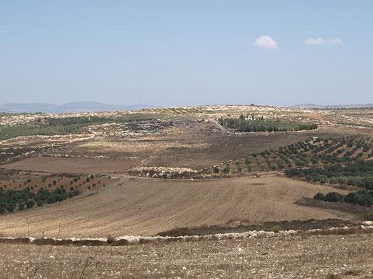
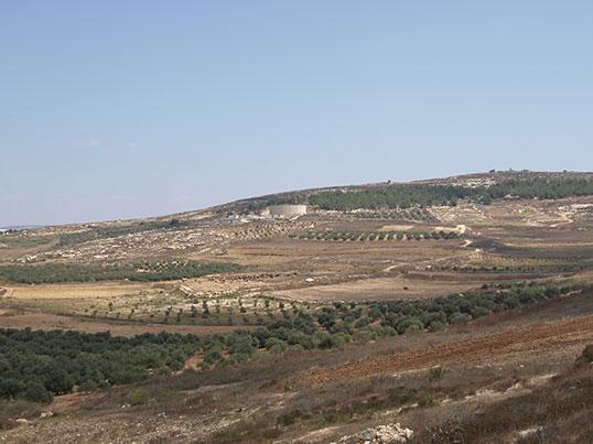
Elsewhere in what was once the Roman Empire, fieldwalking has proved remarkably effective at recognizing farms or villages across whole landscapes. Nahal Zippori, the valley between modern Nazareth and the excavated ruins of the Roman town of Sepphoris 6 kilometres to its north, is perfect for this technique: large, open fields easily accessed by modern roads and tracks. (See Figures 1.1 and 1.2.) Almost all the fields were either ploughed or used for olive trees, with the soil between the trees exposed or even ploughed. They could be surveyed quickly by a small team.
Figure 1.1. The valley between Nazareth and Sepphoris, looking north. Photo: Ken Dark.
Figure 1.2. The valley between Nazareth and Sepphoris, looking east. Photo: Ken Dark.
The land falls sharply to the south of the modern city of Nazareth. So the valley to its north and the area beneath the modern city were probably where the agricultural land of ancient Nazareth was located.
Fieldwalking in the valley was a hot and dusty business. The landscape is hilly, rocky, and exposed—and we were working in the full heat of the Middle Eastern summer. The only shelter from the sun was in the olive plantations.
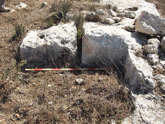
This soon produced exciting new information. The valley turned out to be full of previously undiscovered Roman-period sites. There were at least twenty-three in a single 5 by 3 kilometre strip. The reason that they had been missed by previous archaeologists was probably that most were visible on the surface of the ground only as concentrations of pottery sherds in the fields. A few also had
evidence of small-scale quarrying of the local limestone—unfinished building blocks could still be seen partly cut out. (See Figure 1.3.)
Figure 1.3. Roman-period quarrying in the valley between Nazareth and Sepphoris showing cuts to extract blocks. Photo: Ken Dark.
Judging from the pottery and other ancient objects found on the surface, these were Roman-period farms and very small villages, with no evidence of great wealth or specialized functions.
It is easy to explain why there were so many farms in the valley: the area around Nazareth is especially agriculturally fertile, with good, well-watered soils. Compared to most of the region there is high rainfall—it is said that the annual rainfall in Nazareth today is approximately the same as that in London! Because of this, a wide range of crops can be grown, including the staples of the ancient Mediterranean diet: wheat, grapes, and olives.