World and Hour in Roman Minds
Exploratory Essays
RICHARD J. A. TALBERT
Oxford University Press is a department of the University of Oxford. It furthers the University’s objective of excellence in research, scholarship, and education by publishing worldwide. Oxford is a registered trade mark of Oxford University Press in the UK and certain other countries.
Published in the United States of America by Oxford University Press 198 Madison Avenue, New York, NY 10016, United States of America.
© Oxford University Press 2023
All rights reserved. No part of this publication may be reproduced, stored in a retrieval system, or transmitted, in any form or by any means, without the prior permission in writing of Oxford University Press, or as expressly permitted by law, by license, or under terms agreed with the appropriate reproduction rights organization. Inquiries concerning reproduction outside the scope of the above should be sent to the Rights Department, Oxford University Press, at the address above.
You must not circulate this work in any other form and you must impose this same condition on any acquirer.
Library of Congress Cataloging-in-Publication Data
Names: Talbert, Richard J. A., 1947– author.
Title: World and hour in Roman minds : exploratory essays / Richard J.A. Talbert. Description: New York : Oxford University Press, [2023] | Includes bibliographical references and index.
Identifiers: LCCN 2022027369 (print) | LCCN 2022027370 (ebook) | ISBN 9780197606346 (hardback) | ISBN 9780197606360 (epub)
Subjects: LCSH: Rome—Maps. | Rome—Historical geography. | Cartography—Rome—History. | Roads, Roman. | Time perception—Rome. | Rome—Geography. | Geographical perception—Rome. | Rome—Civilization. Classification: LCC DG31 .T35 2023 (print) | LCC DG31 (ebook) | DDC 911/.3—dc23/eng/20220629
LC record available at https://lccn.loc.gov/2022027369
LC ebook record available at https://lccn.loc.gov/2022027370
DOI: 10.1093/oso/9780197606346.001.0001
1 3 5 7 9 8 6 4 2
Printed by Integrated Books International, United States of America
Dedicated
with love and optimism to my grandchildren
Isla Lazslo Luisa
Alastair
4. Trevor Murphy’s Pliny the Elder’s Natural History: The Empire in the Encyclopedia (2004)
5. An English Translation of Pliny’s Geographical Books for the Twenty-First
Author, Audience, and the Roman Empire in the Antonine Itinerary
10. John Matthews’ The Journey of Theophanes: Travel, Business, and Daily Life in the Roman East (2006)
Preface and Acknowledgments
This collection fulfills a long-standing wish to offer a match for my earlier one, Challenges of Mapping the Classical World, handsomely published by Routledge in 2019. Covid accelerated the preparation this time, after diversions demanding travel and access to libraries were blocked from spring 2020 onward. Even so, the need for extensive help remained, and I am more than grateful to those who provided it in difficult circumstances. Once again, Peter Raleigh ably converted printed texts to formats that could be edited, and Lindsay Holman at the Ancient World Mapping Center proved the most skilled manipulator of files and images. In Chapel Hill’s Davis Library, the tireless efficiency of the Inter-Library Borrowing office headed by Sellers Lawrence has been especially appreciated. The University of North Carolina was generous in meeting the considerable expense of fees for the reproduction of certain images.
The thanks to colleagues whose help I acknowledged at the time of original publication are of course retained and reaffirmed in the fresh presentation of each text. There are now further debts to record, due to others who either permitted the reproduction of one of the additional images, or specially helped to secure the necessary authorizations for their inclusion. While naming Hatice Pamir first for her provision of the splendid jacket image (in color) and frontispiece, I also thank heartily: Işık Adak Adıbelli, Aït Allek Chafiaa, Nacéra Benseddik, Claude Briant-Ponsard, Katherine Dunbabin, Lien Foubert, Francisco González Ponce, Ekaterina Ilyushechkina, Anne Kolb, Sergei Maslikov, Ma Menglong, Fatih Onur, Tom Parker, Jesús Rodríguez Morales, Benet Salway, Zhongxiao Wang, and Juping Yang.
This is the third book of mine brought to publication with Stefan Vranka’s shrewd and supportive guidance as editor. I thank Stefan and his colleagues at Oxford University Press, as well as the experts recruited by him to referee the manuscript. The final tribute goes to the kindness of my wife Zandra: this book is my first that had to be prepared entirely at home, never on campus as usual—a demanding intruder therefore, accommodated with equanimity. We shall both be glad to see its successful launch.
Chapel Hill, North Carolina August 2021
Essays originally published in:
1 JRS 77 (1987), 210–12
2 Studies in Chinese and Western Classical Civilizations: Essays in Honour of Professor Lin Zhi-Chun on His Ninetieth Birthday (1999), 413–24. Changchun: Jilin People’s Publishing House
3 K. A. Raaflaub, ed., trans., The Landmark Julius Caesar (2017), Web Essay W. New York: Pantheon
4 BMCR 2004.12.23
5 Shagi/Steps 6.1 (2020), 214–28
6 Caesarodunum 39 (2005), 93–101
7 Luuk De Ligt, E. A. Hemelrijk, and H. W. Singor, eds., Roman Rule and Civic Life: Local and Regional Perspectives (2004), 21–37. Amsterdam: Gieben
8 Klaus Geus and Michael Rathmann, eds., Vermessung der Oikumene (2013), 163–70. Berlin: de Gruyter
9 Rudolf Haensch and Johannes Heinrichs, eds., Herrschen und Verwalten: Der Alltag der römischen Administration in der Hohen Kaiserzeit (2007), 256–70 [Festschrift Werner Eck] Cologne: Böhlau
10 BMCR 2007.02.31
11 Claudio Gallazzi, Bärbel Kramer, and Salvatore Settis, eds., Intorno al Papiro di Artemidoro, II. Geografia e Cartografia (2012), 185–96. Milan: LED
12 F. J. González Ponce, F. J. Gómez Espelosín, and A. L. Chávez Reino, eds., La Letra y La Carta: Descripción Verbal y Representación Gráfica en los Diseños Terrestres Grecolatinas (2016), 313–20. [Festschrift Pietro Janni] Sevilla: Universidad de Sevilla, Universidad de Alcala
13 Richard Talbert and Kai Brodersen, eds., Space in the Roman World: Its Perception and Representation (2004), 113–31. Münster: LIT
14 Michael Rathmann, ed., Wahrnehmung und Erfassung geographischer Räume in der Antike (2007), 221–30. Mainz: von Zabern
15 Unpublished (conference presentation 2019)
16 S. E. Alcock, John Bodel, and R. J. A. Talbert, eds., Highways, Byways, and Road Systems in the Pre-modern World (2012), 235–54. Malden, MA: Wiley-Blackwell
17 Anne Kolb, ed., Roman Roads: New Evidence—New Perspectives (2019), 22–34. Berlin: de Gruyter
Preface and Acknowledgments
18 F. S. Naiden and R. J. A. Talbert, eds., Mercury’s Wings: Exploring Modes of Communication in the Ancient World (2017), 340–62. Oxford: Oxford University Press
19 Alexey Belousov and Ekaterina Ilyushechkina, eds., Homo Omnium Horarum: Symbolae ad Anniuersarium Septuagesimum Professoris
Alexandri Podosinov Dedicatae (2020), 534–55. Moscow: Academia Pozharskiana
Figures and Tables Figures
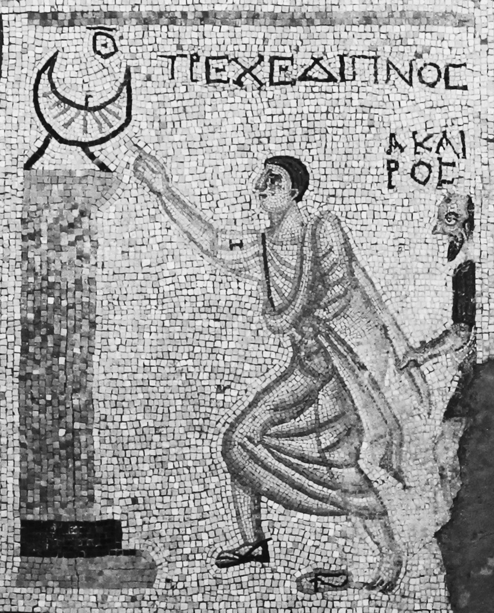
Frontispiece “Dasher to Dinner” mosaic from Syrian Antioch
2.1 Fangmatan map 1A
2.2 Fangmatan map 3A
2.3 Mawangdui topographic map
2.4 Mawangdui military map
2.5a, b (a) Pattern of Roman centuriation in the Po valley plain. (b) Fragments from an official plan of centuriated subdivisions at Arausio
4.1a, b Inscribed miniature silver beaker found at Vicarello
5.1 Pliny’s coverage by continent in Natural History, books 3–6
6.1a, b Stone marking the boundary between the territories of Aquileia and Emona
6.2 Aquileia–Emona region at 1:1,000,000 scale, oriented North
7.1 Provinces of the Roman empire around 200 CE
7.2 Inscription on a Roman milestone west of Corduba
7.3 Notices about boundaries on the Madaba Map
7.4a, b Coins of Hadrian with regions or provinces personified on the reverse
8.1 Diploma issued to an auxiliary soldier in Britain
8.2a, b Diploma issued to an auxiliary soldier in Dacia, with his origo altered
9.1 Map of Aurelius Gaius’ circuit of the Roman empire
10.1 Stages of Theophanes’ outward land journey to Antioch recorded on papyrus
10.2 Map of Theophanes’ outward journey
11.1 Outline sketch of the Artemidorus papyrus map
11.2 ‘Plano’ for urbanizing the mission and village of Arispe, Mexico, 1780
13.1 Right-hand end of Peutinger map parchment 2
13.2 Left-hand end of Peutinger map parchment 1
13.3 Spread of the Peutinger map’s parchments on a modern map
13.4 Rome at the presumed center of the Peutinger map
13.5 ‘Persian Gulf’ on Peutinger map parchment 10 155
13.6 Linework and symbols on part of Peutinger map parchment 2 157
13.7 Relative placement of Pergamum and Alexandria on Peutinger map parchment 8 159
13.8 Three routes from Trapezvnte on Peutinger map parchment 9 160
13.9 Peutinger map’s route Troesmis–Tomis 160
13.10a, b Constantius II and Gallus as consuls in the Calendar of 354 163
14.1 Symbols and route stretches on Peutinger map parchment 4 166
14.2 Spread of Peutinger map’s parchments 168 14.3 “Dura Shield” map 172
14.4 Sardinia on Peutinger map parchments 2–3 174
14.5 Sicily on Peutinger map parchments 5–6 174
14.6 Bosporus and Asia Minor to the end of Peutinger map parchment 8 178
14.7 Routes on Peutinger map parchment 10 182
15.1 Detail from Peutinger map parchments 5–6 188
15.2a, b, c Three city-symbols altered or dropped on Peutinger map parchments 8–9 189
15.3 Saint-Sever Beatus map 191
15.4a, b Details from two early 16th century sample copies of the Peutinger map’s left-hand end 194
15.5 Detail from left-hand end of the Peutinger map copy drawn for Marcus Welser 195
15.6 Detail from left-hand end of the Peutinger map copy drawn for Franz Christoph von Scheyb 196
15.7a–f Avgvsta Tavrinor(vm)–Eporedia area on the Peutinger map, and as drawn by five copyists between 1598 and 1888 198
16.1 Roman empire’s highways on a modern map 204
16.2a, b (a) Paved Roman highway: the Via Egnatia in northern Greece. (b) Unpaved Roman road in Egypt’s Eastern Desert 205
16.3 Milestone 79 between Beneventum and Brundisium 207
16.4 Routes as listed on the pillar at Patara traced in modern format 209
16.5 Three-dimensional rendering of the pillar at Patara 210
16.6 Arch erected to Augustus at Ariminum 211
16.7 Coin reverse celebrating Augustus’ construction and repair of roads 212
16.8a, b (a) Coin reverse with female figure personifying a road. (b) Panel with female figure personifying a road
17.1 Inca empire’s highways
17.2 Trabzon region, Turkey, on Ottoman Public Debt Administration map
17.3 Gokaidô highway network, Japan
18.1 Official plan of centuriated subdivisions at Arausio reconstructed
18.2 Wall on which Rome’s Marble Plan was mounted
18.3 Viewers’ perspective of the Marble Plan imagined
18.4a, b Marble Plan fragments
18.5 Globe-map image imagined within the apse of a Late Roman aula
18.6 Names on portable sundial from Memphis, Egypt, on a modern map
18.7a, b Portable sundial disc from Memphis, Egypt (obverse and reverse)
18.8 Portable sundial disc reverse from Aphrodisias
18.9 Names on portable sundial from Aphrodisias mapped with route
18.10 Names on portable sundial from Vignacourt on a modern map
19.1 “Ninth has passed” mosaic from near Antioch, Syria
19.2 Memorable features of Puteoli engraved on a glass flask
19.3 Inscribed record from Tibur of individuals’ rights to draw water
19.4 Inscribed record from Rome of individuals’ rights to draw water
19.5a, b Inscribed record from Lamasba of individuals’ rights to draw water
19.6 “You have come past the hour” mosaic from Tarsus
19.7a, b Wadokei clock (Japanese copy of a European clock)
Tables
18.1 Names inscribed in Greek on four portable sundials
18.2 Names inscribed in Latin on five portable sundials
Abbreviations
AE L’Année Epigraphique
AntAf Antiquités Africaines
ArhVest Arheološki Vestnik
BAtlas R. J. A. Talbert, ed., Barrington Atlas of the Greek and Roman World and Map-by-Map Directory (Princeton, NJ: Princeton University Press, 2000)
BMCR Bryn Mawr Classical Review
BNP Brill’s New Pauly
CAH2 The Cambridge Ancient History (2nd ed.)
CIL Corpus Inscriptionum Latinarum
CQ Classical Quarterly
CR Classical Review
DarSag Charles Daremberg and Edmond Saglio, eds., Dictionnaire des Antiquités Grecques et Romaines (Paris: Hachette, 1875–1919)
FIRA2 Fontes Iuris Romani Antejustiniani (2nd ed.)
FGrHist Felix Jacoby et al., eds., Die Fragmente der griechischen Historiker
FRHist T. J. Cornell, ed., The Fragments of the Roman Historians (Oxford: Oxford University Press, 2013)
G&R Greece and Rome
GLM Alexander Riese, ed., Geographi Latini Minores (Heilbronn: Henninger, 1878)
IK Inschriften griechischer Städte aus Kleinasien
ILBulg Inscriptiones Latinae in Bulgaria Repertae
ILS Inscriptiones Latinae Selectae
IScM Inscriptiones Scythiae Minoris Graecae et Latinae
JHS Journal of Hellenic Studies
JRA Journal of Roman Archaeology
JRS Journal of Roman Studies
LTUR E. M. Steinby, ed., Lexicon Topographicum Urbis Romae (Rome: Quasar, 1993–2001)
MDAI(R) Mitteilungen des deutschen archäologischen Instituts: Römische Abteilung
MEFRA Mélanges d’archéologie et d’histoire de l’Ecole Française de Rome
OBO Oxford Bibliographies Online
OCD Oxford Classical Dictionary
ODCC Oxford Dictionary of the Christian Church
ODLA Oxford Dictionary of Late Antiquity
xviii Abbreviations
OLD Oxford Latin Dictionary
Peut. Peutinger map as presented online at www.cambridge.org/978052 1764803: Map A (photographed in color); Map B (photographed in monochrome, 1888). See further Talbert (2010), 8–9, 196–98
PIR2 Prosopographia Imperii Romani (2nd ed.)
PL Patrologia Latina
P.Lond. Greek Papyri in the British Museum
P.Oxy. Oxyrhynchus Papyri
P.Ryl. Greek Papyri in the John Rylands Library
RE Real-Enyclopädie der classischen Altertumswissenschaft
SEG Supplementum Epigraphicum Graecum
TAVO Tübinger Atlas des Vorderen Orients
TLL Thesaurus Linguae Latinae
TLS Times Literary Supplement
ZPE Zeitschrift für Papyrologie und Epigraphik
Introduction
This collection of nineteen varied writings, or “essays,” records stages of an ongoing intellectual journey into uncharted territory. It presents in three parts a “world” quest launched during the 1980s by no more than a succession of accidents. Yet the explorations that they prompted in various directions turned out surprisingly rewarding and cohesive. Eventually, from these expanding ventures—written up as progress was made—a further “hour” path emerged. Its new direction I have only recently begun to follow. So there is good reason to pause at this point and to draw together the main findings to date.
The two essays placed first were indeed the earliest in the collection to be written, and four of the final five are among the latest. In between, however, the order is loosely by topic rather than by date of writing. Each essay was intended to be self-standing without thought of a collection being made, so they can be browsed at random; but to read them in order should add to their value and impact. I have in any case frequently added pointers to themes that link them. Because several of the nineteen have only appeared in publications with limited circulation, I expect few potential readers to be already familiar with them all, and obviously not with the one essay published here for the first time (essay 15). Here and there, passages have been cut to eliminate repetition or dense technical detail. On some aspects, brief reference is now made to more recent scholarship. Various slips have been quietly corrected. Most often, the welcome opportunity has been taken to insert illustrations or maps that for one reason or other could not be used originally. Some of these additions are reproduced from publications of mine not selected for inclusion.
In retrospect, a random encounter at a conference reception in 1981 can be seen as the initial accident to trigger my “world” quest, the focus of the first part World and Empire in Mind’s Eye. Here I met Richard Stoneman, a talented editor seeking to expand his classics list, who soon afterward (and quite unexpectedly) invited me to produce an atlas of classical history. This modest textbook—for which I recruited twenty-four collaborators, all in
the British Isles—appeared from Croom Helm in 1985. With it in mind presumably, the following year John North, Journal of Roman Studies review editor, approached me to tackle Oswald Dilke’s new book Greek and Roman Maps. My work for the atlas hardly matched Dilke’s focus, but North was no doubt at a loss given the general lack of interest in ancient cartography at that date, and his request was for merely a 350-word notice. In the event, after I accepted and awoke to the value of a far lengthier appraisal, he generously granted my plea for ten times as many words. For all the book’s merits, Dilke in the traditional way took it for granted that Greeks and Romans perceived the world and used maps as modern Westerners do. My review (essay 1) begged to differ, daring to question the nature and degree of map consciousness in classical antiquity. I urged rather that alternative ways of perceiving and organizing geographical space mattered more, and that wideranging investigation of such elusive “mental mapping” or “informal geography” should be attempted.
A remarkable feature of this review that has become apparent with time is the extent to which it envisages lines of inquiry subsequently pursued by myself and others. In fact one colleague in Russia (Alexander Podossinov) and another in Italy (Pietro Janni) had already made a start, although at that date I was barely aware of the latter’s efforts, and not at all of the former’s. So years later, and now better informed, I especially appreciated invitations to contribute an essay to volumes in honor of each, included as essays 19 and 12 here. Earlier, however, my own efforts were slowed by a call from the American Philological Association in 1988 to rethink and restart its ambitious, but stillborn, plan for a definitive classical atlas. The major international collaborative project that I developed in response, and its fulfillment with publication of the Barrington Atlas in 2000, are explained elsewhere in another collection of writings, Challenges of Mapping the Classical World (2019). The one line of inquiry I could at least embark upon was some crosscultural comparison of Roman and ancient Chinese mapping and awareness of space. A paper on this revealing topic made a timely contribution to China’s first-ever conference of Chinese and Western ancient historians, held at Nankai University, Tianjin, in 1993, included here as essay 2.
Essays 3 and 4 seek to identify and appraise the approaches taken by two very different prominent Romans who both confront the world without (it seems) recourse to maps: Julius Caesar at the head of an army intent upon conquering Gaul and possibly even Britain; Pliny the encyclopedist daring in books 3–6 of his Natural History to encompass physical, ethnic, and political
geography on a global scale from the novel perspective of Rome as centerpoint. This geographical record lays the foundation on which Pliny’s entire monumental work rests. It was the inspiring study by Trevor Murphy reviewed in essay 4 which prompted me to observe how long overdue the sole (in effect) English translation of Pliny’s geographical books is for replacement. At the time this was not at all a challenge I envisaged undertaking myself, but a decade or so later the invitation from a former pupil, Brian Turner, to join him in meeting it—even extending the scope to book 2 on the universe, as well as further geographical passages—proved irresistible. Essay 5 analyzes the missteps and shortcomings of the previous translation, and then explains the principles that Turner and I formulated for our rendering of this exceptionally important and influential Roman account of the world. We aim for a translation that is accurate, scholarly, and above all accessible to nonspecialist readers who will never refer to the original Latin: in short, a taxing combination of goals, but attainable ones.
In the next four essays (6–9) the focus turns to noncartographic means by which Romans visibly demarcated space and mentally perceived it. Essay 6 calls for scholars’ preoccupation with the nature of the Roman empire’s external boundaries to be balanced by matching consideration of the reality that in its interior there were boundaries everywhere demarcating provinces, communities, individuals’ landholdings, and more. The frequent occurrence of boundary disputes and their tendency to become protracted can only have heightened awareness of these lines crisscrossing the landscape. An investigation of the surprisingly neglected category of boundaries between Roman provinces follows in essay 7. The question of whether a traveler would be made aware of leaving one province and entering another, and by what means, had evidently never been raised. Still less had thought been given to how far, if at all, provinces might become units in the Roman imagination that were visualized in order to comprehend the broad spatial relationships of the empire’s territories to one another as well as to Italy and the Mediterranean—on the pattern of today’s jigsaws where the counties of England, say, or Canada’s provinces or US states are to be pieced together.
Essay 8 tests the visualization just outlined—a plausible one in my view— by making a novel attempt to penetrate the worldview of long-serving noncitizen soldiers and naval crew in the first to third centuries CE, a large, distinct group with minimal education. I contend that glimpses of these men’s outlook may be captured from a type of standard document inscribed on bronze that has been found in increasing numbers ever since metal detectors came
into widespread use around 1990. Because in each instance the man’s name and his “origin” are recorded, every such document is by definition unique and personal. Each also includes a record of the province where the document was issued, often somewhere distant from the recipient’s place of origin (be it province, city, village, people, or more than one of these). The reaction offered by Michael A. Speidel (2017) that my inferences may be rash deserves attention, but still the attempt itself provides an example of exploratory method that bears repeating. As will emerge, essay 18 outlines a further effort on my part to gain insight into geographical awareness by again exploiting overlooked evidence (from portable sundials) not tapped hitherto for the purpose.
The springboard for writing essay 7 was to caution against the claim— originating with Pietro Janni, but later articulated more sweepingly by Charles (Dick) Whittaker—that Romans’ conception of space was merely linear, one molded in particular by a distinctive habit, the compilation and use of itineraries for journeys along the empire’s highways. However, closer reading of the many surviving itineraries finds references to provinces, seas, rivers, and mountain ranges. Tangential these references may be, but they still point to an awareness by no means one-dimensional. My engagement with this material gave rise to basic questions posed in essay 9 about the largest ancient collection, the so-called Antonine Itinerary: does it deserve the immense respect paid to it ever since the Middle Ages? Is it well organized, as well as genuinely useful to ancient travelers on the ground? Having reached negative conclusions about each of these aspects, I proceed to inquire further what kind of individual would make such a defective compilation, and with what audience in mind, if any, especially if the work fits no established genre. In my revisionist opinion, the compiler is no educated intellectual but instead middle-ranking at most, a purely self-centered hobbyist who never intended to put his patchy, unedited assemblage into circulation. To be sure, since antiquity it has become a precious, even evocative, chance survival, but its genesis and place in contemporary context still call for the more rigorous assessment that essay 9 puts forward. It was written for a conference on the Roman empire’s day-to-day administration.
There follows (essay 10) a review of John Matthews’ book about one of classical antiquity’s most meticulously recorded journeys: a return trip by Theophanes—a high-ranking lawyer—and his entourage, made in the 320s CE by Nile riverboat and then overland between Egypt and Syria. Not only do itineraries for it written on papyri by unnamed staff survive, but also
ledgers sufficiently detailed to reconstruct the meals prepared day by day, thus furnishing insight into diet and expenditures. It is clear too that, after a two-and-a-half-month stay in Syrian Antioch, an “agreement” was made and written up on specially purchased papyrus, but otherwise—ironically—there is no clue to the trip’s purpose, let alone to the worth of its outcome. In terms of method, the value of this study lies in its creative attention to hitherto ignored minutiae of cultural and social history, and in its ability to tease out information and draw instructive conclusions from the most rebarbative of documents. These—again in exemplary fashion—Matthews translates into English, thereby opening them to nonspecialists for the first time in the way mentioned above for books by Pliny.
In the second part Maps for Whom and Why, the next five essays (11–15) address issues relating to Romans’ production and use of maps; attention here centers on the single substantial surviving Roman map with more than localized scope. Once I began to follow Dilke’s lead in order to master the various dimensions of this large topic, the mass of difficulties became only too plain. Above all, evidence for use of a map is seldom to be found in any kind of source, and the single substantial map just mentioned—the so-called Peutinger map—survives only as an incomplete medieval copy. How well this copy reproduces the original drawn centuries earlier, without being unduly impaired or altered by successive copyists’ slips and modifications, is a fundamental but uncomfortable dilemma laid out in essay 15 (written for a 2019 conference mentioned further below). I use the adjective “uncomfortable” quite deliberately, because anyone with an interest in Roman maps is predisposed to resist endorsing the suspicion that our sole copy may have become too much changed to be regarded as Roman work any longer. Be that as it may, possible reasons for reaching this extreme conclusion (which I do not), so damaging for the study of Roman mapping, ought at least to be considered, and the exceptional difficulties of making an accurate copy of the Peutinger map better appreciated. Even copies made as late as the nineteenth century, and claimed to be flawless, are demonstrably not perfect.
However, despite the many causes for frustration, I am confident that rewarding avenues to insight can be found. Essay 12 identifies an overlooked instance of the use of a map in Roman public life, an initiative by the emperor Claudius to illustrate a speech to the senate with a visual aid. The identification rests on adopting a neglected perspective to interpret allusions in the much-studied verbatim text of the speech. An untypical instance it may be in some respects, but still credible and suggestive. More excitingly,
during the 1990s tangible fresh testimony surfaced in the form of an actual map: it is the subject of essay 11, one of several components on a papyrus roll reckoned to date to the first century CE. Because the papyrus also includes—adjacent to the map—text about the Iberian peninsula attributable to the geographer Artemidorus around 100 BCE, it has been named after him. Even so, for all that the map is a unique and thrilling find, initial expectations about its value must be tempered by the multiple obstacles to interpreting it with confidence. In general, expert opinion still remains divided on whether the contents of the papyrus are ancient at all (as I take them to be) or instead the work of a forger in, say, the nineteenth century. More specifically, the map gives the impression (false perhaps) of having been abandoned unfinished for no obvious reason. For certain, it lacks color and lettering, and its puzzling linework and symbology are hard to relate convincingly to an outline of the Iberian peninsula in whole or in part; but clues to where else it may represent, and at what scale, seem absent. At least its present state does illuminate the stages by which the mapmaker or copyist proceeded; there may be useful pointers here to how the Peutinger map was produced.
In struggling to understand this fundamental aspect of both the Artemidorus and Peutinger maps, I came to appreciate the value of experience gained in designing the Barrington Atlas, work undertaken around 1990 when no stage of mapmaking was yet a digital process. In addition, Barrington’s comprehensive, uniform, and relatively detailed coverage of the entire Roman empire and far beyond to the East was to prove an indispensable resource for understanding the Peutinger map, given that both atlas and map have comparable scope (and, as it happens, North orientation). When a grasp of the map became my goal around 2000, no classical atlas of Barrington’s caliber had appeared since the 1870s, nor had any comprehensive study of the map since World War I. To the end of the twentieth century, scholarship on it remained almost exclusively preoccupied with the routes shown, a conspicuous and important feature without doubt, but in fact only one of many. Even so, the map was commonly categorized as a route diagram, with its other landscape features quickly dismissed as mere accompanying decoration. In addition, its remarkable shape was liable to be ridiculed: a “ribbon” only just over 30 cm tall, but approaching seven meters in width even with the western end lost. Minimal thought was given to its design and production, and the information it offers was described as “hopelessly crowded” (Whittaker [2002], 102).
Having been recently so preoccupied with both these aspects of mapmaking, I was struck by the persistent failure of scholars (Dilke among them) to consider this map seriously from a contemporary Roman perspective rather than judging it by largely irrelevant modern standards and ignoring how it was produced. Just why should its scope so ambitiously span the Atlantic to Sri Lanka, albeit with marked unevenness of scale? And why should so extreme a shape be chosen, for what context? Altogether what is featured and named, and how? Equally, what is omitted and why? Who are the map’s intended viewers? Since answers to these and many other related questions can only be deduced from the map itself, speculation is unavoidable and much will have to remain obscure. Nonetheless a thoughtful approach of this type ought surely to be ventured rather than left untried for fear of provoking ridicule.
An invaluable aid to study that I commissioned was one out of reach before the twenty-first century: an online full-size image of the map reassembled as the single piece it was designed to be. The eleven successive parchments on which the surviving copy (in Vienna) was produced had been separated in 1863. The color photographs of all eleven published in 1976 could at least be joined, it is true, but there would then loom the problem of securing use of a table long enough to inspect the single piece. Not even the great map room of the New York Public Library had one; nor was one found for the extraordinary occasion in 2019 when the entire map was displayed to participants in a conference about it held at the Austrian National Library—the only time I have ever enjoyed the privilege of seeing its eleven segments together. Needless to stress, the ability to move through the map at will on a computer screen, to pan, zoom, create removable layers, link to a database, and more, is transformative for study purposes.
My full reappraisal of the map was published as the book Rome’s World: The Peutinger Map Reconsidered, together with extensive materials online (2010). However, an advance statement of my main avenues of approach appeared earlier as they were being developed. This is essay 13 here. An equally fundamental advance publication follows (essay 14): it identifies the choices that I envisage were made to create the map’s entire basis, namely its physical landscape, and considers the reasoning. Elaboration of my provocative conclusion that the map’s main purpose was hardly cartographic at all, but rather a triumphalist celebration of Roman imperial reach, power and values, is postponed to essay 18, which includes a wider-ranging discussion of ancient propagandistic maps.
In the third part From Space to Time, essay 16 builds on my observation that the Peutinger map is exceptional for the prominence it accords roads almost everywhere in the empire and beyond to the East. Otherwise, in surviving source material of all types, Romans in general and the imperial authorities in particular are seldom found opting to draw attention to them. The essay explores the resulting puzzle: does such a low profile indicate that emperors deliberately restrained themselves from publicizing this huge asset both for their own control of the empire and for enemies’ penetration overland? In addition, or instead, are we to infer that Romans’ spatial perception lacked the capacity or the interest to conceive their roads as an interconnected system at all, let alone one with formidable strategic potential? Here again it proves advantageous to inquire whether there is useful insight to be gained from comparing Romans’ attitudes with what may be learned of typical thinking in other premodern states likewise well known for their roads, such as Achaemenid Persia, China, Japan, and the Abbasid caliphate. A conference I proposed as a stimulus to such comparative thinking more than fulfilled its potential, moreover striking almost all participants as a novel approach.
Essay 17, a keynote address to a later conference inviting new evidence and perspectives on Roman roads, exploits this approach further with reference to the Inca empire, China, and Japan. These comparisons throw into sharp relief the superior qualities of Roman roads and the minimal restrictions on their use. Rome built for wheeled traffic, funded major bridges and viaducts, and normally permitted almost all free persons to travel at will without charge on every road. Such generosity or indifference emerges as far from typical elsewhere. The address closes with a plea for more efficient integrated dissemination of Roman milestone data, online rather than in print, and with commentary in a widely understood modern language rather than in Latin— still used for the definitive series in which milestones are currently published. In this subfield too, it should become a priority to offer nonspecialists fuller access.
Cross-cultural comparison remains relevant in essay 18, written as a chapter on Roman maps in a pathbreaking volume I coedited with F. S. Naiden which explores modes of communication in the ancient world. This essay rates Roman society as unmatched there for its imaginative recasting of factual, scientific maps (made and used only by intellectuals and some officials) into arresting artwork for the communication of Rome’s might to a wide, less educated public. As already noted, I elaborate here upon my
view that the Peutinger map was designed primarily for such promotion, and I also contend that the same may be claimed for the gigantic “Marble Plan” of the city of Rome erected there around 200 CE. Its generous scale permitted the incorporation of astonishing details—even individual pillars, steps, doorways—yet the map was positioned too far above floor-level for viewers to distinguish them.
Again as already noted, this essay introduces a further instance where I seek to gain insight into awareness of geography, and perhaps maps, by exploiting overlooked evidence. This data is inscribed on small portable sundials, and comprehension of it has been immensely improved in recent years by use of Reflectance Transformation Imaging to recover linework and lettering invisible to the naked eye. Roman users understood that in order to establish the hour in any location satisfactorily, the instrument had to be adjusted to take account of the latitude (a Greek concept) and the time of year. Hence each portable sundial incorporates a list of cities and regions for reference, each with its latitude figure in the form devised by Ptolemy in the mid-second century CE. Because the choice of locations seems typically to be that of a particular designer or owner rather than some workshop’s standard selection, there opens up a means to penetrate individuals’ worldviews and compare them. It is intriguing that in some lists the names are arranged by latitude, while in others they evidently outline a long-distance journey, albeit perhaps one only in the imagination. Also apparent is spatial perception of the Roman empire on the jigsaw model proposed in essay 7 above. Attachment to these remarkable gadgets as status symbols can be suspected too. Regardless of the patent flaws in design or data on some, all were enviable possessions which boosted the owner’s sense of superiority as well as (again) Roman might and Romans’ freedom to travel. The enthusiasm which such “scientific” sundials aroused had some potential—we might think—to overcome Romans’ disinterest in maps, but no such intellectual shift would occur. When my full findings on the cultural and social significance of this data were published in the book Roman Portable Sundials: The Empire in Your Hand (2017), disappointment was expressed that I had declined to extend its scope—deliberately confined to geography and worldview—into consideration of Romans’ related interest in the time of day (always a twelvehour period from sunrise to sunset, hours consequently varying in length according to season). Essay 19, which opens up my new “hour” path of exploration emerging from essay 18, is my initial response. This path proves promising, in part because recent scholarship has focused mainly on periods
longer than the day. To be sure, this imbalance is now changing, as is well demonstrated, for example, by the volume Down to the Hour: Short Time in the Ancient Mediterranean and Near East, edited by Kassandra Miller and Sarah Symons (2020), which appeared too late for me to take into account. At least its contributors are not inclined to minimize the Roman concern to know the hour—a misjudgment in my view, although still expressed—but fuller recognition of the epigraphic and material evidence may be called for. I find cause for enlisting social psychology to explain not only why Roman society at all levels became more concerned than any other in the ancient Mediterranean and Near East to know the hour, but also why it maintained this fixation for centuries. It is one that at least can be seen to match Roman concern for well-defined boundaries, as well as for marking mile-intervals on roads, and for recording the length of journeys even to the nearest halfmile. Cross-cultural comparison with the attention paid to similar seasonal hours in Japan—persisting into the 1870s—could prove another rewarding new approach.
By its very nature, a collection of the present type demonstrates the contribution that a single individual has made to penetrating an area of inquiry and shaping it further. Even so, in the present case I trust it is repeatedly apparent that my pioneering ventures have by no means been pursued in isolation. Rather, at every stage I have gained invaluable stimulus from interchange with generous colleagues worldwide, as well as with the participants in four memorable series of seminars I cotaught with Hugo Meyer, Michael Maas, Grant Parker, and Patrick Gautier Dalché, respectively, in Princeton, Rome, Chapel Hill, and Paris between 1997 and 2011. I hope to have enlarged the thinking of all, as they have enlarged mine. Many colleagues—Kai Brodersen, James Akerman, Kurt Raaflaub, Elizabeth Wolfram Thill, and Richard Unger especially—have been my collaborators in initiatives of various kinds, several of these extending far beyond classical antiquity in space and time. I am equally indebted to the experts—in particular Tom Elliott, Ryan Horne, and Daryn Lehoux—who have so ably applied digital techniques and tools to questions and materials I have sought to investigate. These novel resources have opened up approaches that were out of reach, not to say out of mind, back in the 1980s. Their creative potential will again prove vital post-Covid, when my immediate aim is to rethink Romans’ use of water-clocks. From this next phase, too, of the exploratory journey I anticipate revealing insights. Here, however, its unfolding course to date is encapsulated, beginning over thirty years ago with my review of Oswald Dilke’s Greek and Roman Maps.