1 generaL geography
introduCtion
Geography is a science that deals with all the elements found on the surface of the Earth. It also studies the distribution and arrangements of such elements. The term geography was first used by the Greek scholar Eratosthenes in the second century BC. The word means ‘Earth description’. Topics such as the environment of the Earth’s surface and the relationship of humans to this environment are included in the realm of geographic study. These may include both physical and cultural geographic features.
Geographic Features
The climate of the Earth, land and water, and plant and animal life are included under the physical geographical features. Therefore, geography deals with the Earth’s surface features and their relationship with one another and forms meaningful spatial or regional patterns. It also considers those factors and the processes, which bring changes into these features, and their spatial patterns. Moreover, it deals with the implications of these changes for human beings and on the activities that they go through.
BranChes of geography
We can divide geography into two main branches, i.e. systematic geography and regional geography. Systematic geography deals with the Earth’s individual physical and cultural elements, while regional geography is associated with different areas of the Earth, especially the distinctive combinations of physical and cultural features that each region has and which differentiate one region from another. Both the branches of geography are applied together and are interdependent on each other as the division is merely based on approach. We further divide each branch into different fields that specialise in specific geographical aspect.
Analysing Geographic Information
When mathematics or statistics are used in techniques to analyse data, the techniques applied are referred to as quantitative methods. The quantitative methods facilitate geographers
to deal with a large amount of data and a large number of variables objectively. Geographers, occasionally, gather data and propound a theory to explain what they have observed. They apply quantitative methods to verify their theories. The theories may be expressed as mathematical statements known as models. However, in geography, we do not expect theories to be universally applicable.
Systematic Geography
Physical Geography
Below given fields are included in the scope of physical geography:
Geomorphology: It studies the form and structure of the surface of the Earth.
Climatology: It makes use of meteorology and deals with climatic conditions.
Biogeography: It makes use of biology and is associated with the distribution of plant and animal life.
Soils geography: It deals with the distribution of soil.
Hydrography: It deals with the distribution of seas, lakes, rivers, and streams, and with their uses.
Oceanography: It studies the waves, tides, and currents of oceans and the ocean floor.
Cartography: It is the art of map making using graphic representation and measurement of the earth’s surface.
Cultural Geography
It is also known as human geography because it involves human social life in relation to the physical Earth. One aspect of cultural geography is concerned with the industrial use of the geographic environment, and is known as economic geography. We study natural resources like mineral and oil deposits, forests, grazing lands and farmlands, in relation to their position, productivity and potential uses. Geographic studies help the manufacturing sector by providing information regarding raw materials, sources of labour, distribution of goods, etc. Marketing studies involve plant locations and the sales potentials also rely on geographic studies. Moreover, the creation of transportation facilities, trade routes and resort areas also depend heavily on geographic studies.
Cultural geography also makes use of political geography, an application of political science. Political geography is concerned with human social activities in relation to the locations and boundaries of cities, nations and groups of nations. Military geography facilitates military commanders by providing information regarding areas of their operations. Ethnography, historical geography, urban geography, demography and linguistic geography are some other areas of cultural geography.
Regional Geography
Regional geography deals with the differences and similarities among the different areas of the Earth. This subdivision of geography looks for factors for the variety among places by examining the distinct combination of factors that differentiate these regions. Regional geographers also apply micro geography to study the development of a small area such as a city. They can also concentrate on regions, known as macrodivisions, such as the Polar region, or an entire continent. Regional geographers distinguish between macro-divisions depending on their cultural characteristics. Regional geographers may divide macro-divisions into many smaller areas that share specific characteristics. For instance they may take into account the language, the kind of agriculture or economy, its population practices, terrain, etc.
Methods of studying geography
The main objective of a geographer is to explain the human environment on Earth. He has to gather geographical data,
record the results of geographic studies and examine the information to achieve his aim. Geographers use different techniques and tools to achieve these objectives.
Collecting Data
Geographers can gather data in the field or from some other sources, such as censuses, statistical surveys, maps, etc. Much advancement has been made in the field of aerial photography since the end of the Second World War. The use of special films and techniques for getting 3D views of the landscape aerially has helped geographers in performing more comprehensive studies of the Earth. Geographers also use radar, artificial satellites, underwater craft called bathyspheres, and deep drilling into the Earth’s crust. These instruments help them in getting information about the features of the Earth.
Mapping
The map is a vital tool of geography which may be used to record both simple data and a complicated geographic study. Apart from providing rich factual information, the map allows visual comparison between areas as it may be designed to show the location as well as the characteristics of geographic features of a region. A standard pattern of map symbols has been developed by the geographers. These symbols are helpful in identifying cultural features, such as homes, factories, and churches; dams, bridges, and tunnels; railways, highways, and travel routes; and mines, farms, and grazing lands.
KnoWLedge aBout the earth
The Earth is one of the planets of the solar system. It is in the third position from the sun and the fifth largest planet in the solar system. The mean distance of the Earth from the sun is 149.6 million. An oxygen-rich and protective atmosphere, moderate temperatures, abundant water, and varied chemical composition allow Earth to support life; it is the only planet to do so. The slightly oblate planet is composed of rock and metal, which are present in molten form beneath its surface. It is the only planet known to support life, although some of the other planets have atmospheres and contain water.
spheres of the earth’s surfaCe
The surface of the Earth has four distinct spheres, they are (a) Lithosphere The top crust consists of the crust and the upper mantle, and it includes the land surface and the
ocean floors. The term lithosphere is derived from Greek and means ‘rock layer’. The lithosphere is approximately 70–100 km (44–62 mi) thick and lies above the layer known as the asthenosphere, which consists of softer, less rigid, rocky material. Geologists regard the lithosphere as the relatively cool, outermost layer of the planet and view it as a rigid shell. Although the rock compositions of the crust and the upper mantle differ, geologists prefer to view the two parts as a single unit because both are brittle and they behave as a single mass in the motion of the rocky plates that make up the Earth’s surface layer.
(b) Hydrosphere The water surface, which includes oceans, seas, rivers, and lakes, the hydrosphere is the region of water at or near the Earth’s surface. It is distinguished from the lithosphere (rocks), the biosphere (living things), and the atmosphere (air). The total volume of water in the hydrosphere is approximately 1.5 billion kilometres (350 million mi), 99 per cent of which
is contained in the continuous waters of the oceans and seas. The remaining part is divided among groundwater, glaciers and ice sheets, freshwater lakes, water vapour, and rivers and streams. The Earth’s water circulates and interacts in the hydrologic cycle, whereby the water falling as rain runs off as rivers into the oceans and evaporates back into the atmosphere.
(c) Atmosphere The cover of air that envelopes the Earth’s surface, the atmosphere, is nearly the transparent envelope of gases and suspended particles that surrounds the Earth. It profoundly influences the environmental conditions on the planet’s surface. Without chemical processes involving several of the atmospheric gases, life could not exist. The physical processes that operate in the atmosphere are also of vital importance because they are responsible for the Earth’s varied climates.
(d) Biosphere The sphere where life exists, and is spread over all the above three spheres, the Earth’s biosphere, the zone capable of supporting and sustaining life, is a thin envelope extending 8–10 km above the planet’s surface and, in general, a few metres below it into the soil. (In fact, micro-organism have been found to exist at depths of several hundred metres beyond this, in sedimentary materials, but scientists have now only begun to study this strange ecosystem in detail.) All the Earth’s organisms eventually owe their existence to the Sun’s energy and its interactions with the elements and compounds of the biosphere. The Earth’s average air temperature permits reactions essential for life to take place. The patterns of growth in various areas of the Earth are determined by such things as water, light, altitude and soil composition. Different patterns form large units called biomes.
shape of the earth
The diameter of the Earth, measured around the equator, is about 12,742 km. The Earth is an oblate spheroid (ball flattened at the poles), that is, almost spherical, flattened a little at the poles with a slight bulge at the centre (equator). Hence, it is flat at the poles. Because of this flattening, the diameter of the Earth measured around the north pole and the south pole is about 12,713–43 km less than the equatorial diameter.
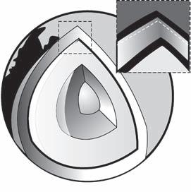
struCture of the earth
The Earth is made up of a number of concentric layers of material as in the bulb of an onion. These series of layers were formed early in the planet’s history, as heavier material gravitated towards the centre and lighter material floated to the surface. The dense, solid, inner core of iron is surrounded by a liquid, iron-rich metallic alloy outer core. The lower mantle consists of molten rock, partially molten rock in the asthenosphere and solid rock in the upper mantle and crust. There are chemical or structural changes that form discontinuities between crust, mantle and core. Lighter
elements, such as silicon, aluminium, calcium, potassium, sodium, and oxygen, comprise the outer crust. The layers are (i) the crust, (ii) the upper mantle, (iii) the lower mantle, (iv) the outer core, and (v) the inner core. There is the Mohorovicic discontinuity between the crust and the upper mantle; the transition zone between the upper mantle and the lower mantle; and the Gutenberg discontinuity between the lower mantle and the outer core. Each layer has its own characteristics and chemical composition.
Internal Heat Flow
Intense heat from the inner core is continually radiated outward, through the several concentric shells that form the solid portion of the planet. The source of this heat is thought to be energy released by the radioactive decay of uranium and other radioactive elements. Convection currents within the mantle transfer most of this heat energy from deep within the Earth to the surface and are the driving force behind continental drift. Convective flow supplies hot, molten rock to the worldwide system of mid-ocean ridges and feeds the lava that erupts from volcanoes on land.
Earth’s Magnetic Field
Earth’s core is the source of the planet’s magnetic field. Most scientists believe that the motion of several convection cells (large blobs moved by energy, such as heat and gravity) in the molten, iron-rich material of the outer core generates and maintains the Earth’s magnetism. These convection cells are also affected by the Earth’s rotation on its axis. As the iron moves in the convection cells, it interacts with the magnetic field. This interaction results in an electric current, which generates its own magnetic field. The magnetic field round the Earth proves that the interior of the Earth should be composed of the magnetic material like Iron and Nickel.
The Crust
The crust is the outermost layer of the Earth. It is solid and relatively thin layer, and it lies below both landmasses and oceans. The average thickness of the solid crust of the Earth varies as beneath the ocean, the crust has an average thickness of only 8 km, whereas beneath the continents the thickness average is more than 3 times as much the oceans. The dry land of Earth’s surface is called the continental crust. It is about 30–50 km thick. The oceanic crust is thinner than the continental crust. Its average thickness is 5–10 km. The crust is very thin in relation to the rest of the Earth. If a trip to the centre of the Earth at 100 km/h were possible, it would take 64 h, of which only the first 15–45 min would be in the crust.
Altogether, the crust makes up less than 1 per cent of the Earth’s volume and about 0.4 per cent of the Earth’s weight.
Discontinuities in Earth’s Structure
There are sudden changes of the physical properties of various layers of the Earth, and the physical properties of various layers do not change imperceptibly. The sudden change of physical properties between the layers of the Earth is known as discontinuity. Some of the well-known discontinuities are:
Conard discontinuity lies between the outer and the inner crusts.
Mohorovicic Discontinuity lies between the crust and the mantle.
Repetti Discontinuity lies between the outer mantle and the inner mantle.
Gutenbern-Wiechert (or simply the Gutenberg) Discontunity lies between the mantle and the core of the Earth.
Transition Discontinuity lies between the outer and inner core.
Mohorovicic Discontinuity
The crust has a definite boundary. This boundary, called the Mohorovicic discontinuity, or simply the Moho, after the Croatian geologist Andrija Mohorovicic, separates the crust from the underlying upper mantle. Mohorovicic discovered the boundary in 1909, when he observed that earthquake waves do not pass through the Earth’s interior in a straight line but change course at a certain depth below the surface. He believed that the point at which these waves change course marked the boundary between the crust and the mantle. He deduced that earthquake was centred in an outer layer of the Earth’s crust and that the fast waves had travelled through an inner layer, the mantle.
Gutenberg Discontinuity
The mantle is separated from the crust by the Mohorovicic discontinuity and from the core by another sharp boundary known as the Gutenberg discontinuity. This boundary is named after the German-born American seismologist Beno Gutenberg. The Gutenberg discontinuity lies at a depth of about 2,900 km. Both boundaries were discovered by using the fact that when an earthquake or seismic wave reaches a sharp boundary between two materials with different densities or elastic properties, some of the wave’s energy bounces, or reflects, off the surface. In addition, seismic waves may bend, or refract, as they cross a boundary.
Upper Mantle
Below the crust is the mantle, composed of several layers, which is about 2,900 km in thickness. It is a shell of red-hot rocks composed of silicate materials, rich in magnesium and iron. The mantle is partly fluid. The Earth’s inner core is believed to be solid and is of a depth of about 1,370 km. It is made up of iron and nickel, which accounts for the Earth’s magnetism. The upper part of the mantle is called the asthenosphere, which is about 250 km thick. The rocks
contained in the asthenosphere are partially molten. And it is on this part that the top crust of the Earth carrying the continents and oceans rests. Large scale deformation of the mantle results in plate tectonics at the surface and the related phenomenon of earthquakes and volcanoes.
Transition Zone
The zone at a depth of about from 400 to 670 km is known as the transition zone. In the transition zone, the minerals that make up the upper mantle undergo a process called phase transition, in which they change in structure and form other atomic arrangements. The pressures at these depths compress the minerals into more compact forms. For example, olivine is compressed into the mineral spinel, in which the atoms are packed closer together. By the bottom of the transition zone, the spinel has undergone another phase transition to the mineral perovskite. With each phase transition, the rock becomes denser and seismic waves travel through it faster. This transition at 670 km also corresponds to the lowest depths at which earthquakes have been recorded.
Lower Mantle
The mantle below 670 km is called the lower mantle. The lower mantle may consist of magnesium, silicon and iron. Unlike the upper mantle, this region does not change much in composition or phase as it gets deeper. It is more dense than the upper mantle because of the increase in pressure. Knowledge of the mantle remains partial, but much has been learned from overthrust fragments of oceanic crust in the mountains around the Pacific margin, for example, the Coast Ranges of California. It is the single largest uniform region of the interior.
The Inner and Outer Core
The core is the innermost part of the Earth. It extends from beneath the mantle to the very centre of the planet. The radius of the core is approximately 3,500 km (2,200 mi). This radius is larger than the radius of the planet Mars. The core forms approximately one-third of the Earth’s total mass and about one-sixth of its volume. At the earliest stages of its formation, the Earth was basically a mixture of
FIG. 1.1(A) An Outline of the Internal Structure of the Earth
FIG. 1.1(B) Internal Structure of the Earth gas and dust. Over millions of years, the planet took shape and solidified. At some point, as more material accumulated, the whole planet reached extremely high temperatures and changed into a liquid. Geologists believe that at this time the different elements in the planet separated. In the process of separation, the heavier elements (such as iron and nickel) sank to the centre, and the lighter elements (such silicon and aluminium) rose to the surface.
Important Data About The Earth
Diameter : At the equator (12,755 km) At the poles (12,712 km)
Mean diameter : 12,734 km
Circumference : At the equator (40,075 km) At the poles—Meridianal (40,024 km)
Equatorial radius : 6,377 km
Total surface area : 51,01,00,500 km
Total land area (29.08%) : 14,89,50,800 km2
Total water area (70.92%) : 36,11,49,700 km
Total mass of the Earth : 5,880 × 1021 tonnes
Total volume of the Earth : 10,83,20,88,40,000 km3
Mean depth of hydrosphere : 3,554 m
Mean distance from the Sun : 14,94,07,000 km
Approximate age of the Earth : 4,600 million years
Time of rotation on its own axis : 23 h 56 min and 4.09 s
Period of revolution : 365 days 6 h 9 min and round the Sun 9.54 s
Highest point : Mt Everest (8,848 m above mean sea level)
Lowest point : Shores of Dead Sea (on the Earth’s surface) (Israel, Jordan) 396 m below sea level
Deepest part in the ocean : Challenger Deep (Pacific Ocean) in the ‘Mariana’s Trench’, east of the Philippines, 10,900 m below sea level
Scientists have learned about the core by measuring seismic waves. Seismic waves originate in earthquakes. The way these waves travel through the interior of the Earth reveals the nature of materials inside the planet, including in the core. The principle behind using seismic waves to study the internal structure of the Earth is similar to using X-rays to study the human body. A detailed view of the human body can be obtained using modern CAT (computerised axial tomography) scanning machines, which transmit X-rays while rotating around the body. A CAT scan, thus, yields a three-dimensional image of the inside of a person’s body. Geologists use a similar approach in obtaining images of the interior of the Earth using seismic tomography. Scientists collect data from thousands of recording stations that are sensitive to earthquakes. The recorded seismic data is analysed and combined by a computer to produce images of the Earth’s interior. This technology has provided scientists with a picture of the Earth’s interior. Seismic studies indicate that the core consists of two parts: a solid inner core and a molten outer core. The outer core extends from about 2,900 to 5,200 km below the surface. The inner core extends from about 5,200 km to the centre of the Earth, at a depth of about 6,400 km. The Earth’s core experiences pressures that are millions of times greater and temperatures that are thousands of degrees higher than those at the surface. Core temperatures range from 4,000°C to 5,000°C. Scientists cannot retrieve samples from the core because the temperatures and pressures are so high. However, scientists believe that the core consists primarily of heavy elements such as iron and nickel. This composition of the core is believed to be similar to that of stony meteorites, which geologists think may have provided the material for the Earth’s core. Scientists estimate that the core is extremely dense—about 13.5 times as dense as water. A high concentration of iron in the core is believed to account for the high density and magnetism of the Earth.
The core and the mantle are about equal in thickness, the core actually forms only 15 per cent of the Earth’s volume, whereas the mantle occupies 84 per cent. The crust makes up remaining 1 per cent of the Earth’s volume.
Nife, Sima and Sial
Based on the relative density of rocks the geographers divide the Earth into three main layers:
(i) Core: The central region of the Earth, has rocks that are composed of Nickle and Iron (or Ferrous) known as Nife, and the relative densities of these rocks are the highest.
(ii) Middle Layer: It is all around the core and has rocks that are made of Silicon and Magnesium known as Sima, and has a lower density (between 2.90 and 4.75). Basalt is an example of Sima
(iii) Outer Layer: It surrounds the middle layer, and rocks in this layer are made of Silicon and Aluminium, known as Sial, and have a relative density between 2.75 and 2.90 only). Granite is an example of Sial.
CoMposition of the earth
The rocks of the lithosphere have an average density of 2.7 g/cm3 and are mainly made up of 11 elements, which together account for about 99.5 per cent of its mass. Titanium, hydrogen, and phosphorus (totalling less than 1 per cent) are the other three elements. In addition, 11 other elements are present in trace amounts of 0.1–0.02 per cent. These elements, in order of abundance, are carbon, manganese, sulphur, barium, chlorine, chromium, fluorine, zirconium, nickel, strontium and vanadium. The elements are present in the lithosphere almost entirely in the form of compounds rather than in their free state. These compounds exist almost entirely in the crystalline state, so they are, by definition, minerals.
Earth’s Crust Composition
This pie chart shows percentages of the most abundant elements in the Earth’s crust.
(a) Oxygen—46.6% (f) Sodium—2.83%
(b) Silicon—27.72% (g) Potassium—2.59%
(c) Aluminium—8.13% (h) Magnesium—2.09%
(d) Iron—5.0% (i) Other elements—1.41%
(e) Calcium—3.63%
Minerals
A mineral is a natural, homogeneous, inorganic solid with a crystalline atomic structure. Crystallinity implies that a mineral has a definite and limited range of composition, and that the composition is expressible as a chemical formula. Some substances that do not satisfy all these conditions, such as metallic liquid mercury, are commonly considered in the realm of minerals but should more properly be designated as mineraloids. The word ‘mineral’ may have different meanings in non-mineralogical sciences. In nutrition, it may mean any non-organic element. In
economics and economic geology, minerals may be practically anything of value extracted from the Earth, including petroleum and natural gas (which are not minerals according to the above geological definition, being neither inorganic nor solid). Minerals comprise the vast majority of the material of the solid Earth. Aside from air, water and organic matter, practically the only non-minerals in Earth, as a whole, are molten rocks (magmas) and their solid glassy equivalents. Crystalline rocks themselves, and even soils for the most part, consist of aggregates of minerals. Almost all inorganic substances that are used by or of value to humans are derived from minerals. Over 4900 [(with about 4660) these approved by the International Mineral Organization(IMO)] minerals are currently known, and about 50 new ones are discovered each year. Most gems are minerals, though some, such as opal, are mineraloids.
geoLogiCaL history of the earth
Geological Time
One of the most important discoveries of modern science has been the age of the Earth and the vast length of time encompassed by its history. Geological history of the Earth refers to the evolutionary sequence in which the geological events occurred since the evolution of planet Earth. Long before geologists could date rocks, they were able to make a time-scale of the Earth’s history in which they divided time periods into various years, periods and epochs. The scale of this history, in the millions and billions of years, is recognised as geologic time. The largest division of geologic time is called an eon. Eons are divided into eras, which are divided into periods. An epoch, the next division, is further divided into stages. Earlier, the timings of main geological events in the Earth’s evolution could only be guessed, but now many events can be assigned dates obtained by studying radioactivity. The Earth is believed to have originated some 4.54 billion years ago.

Epochs of the Tertiary Period
(a) The Paleocene Epoch is the lowermost and oldest epoch of the Tertiary Period of geologic time. It began 65 million years ago, at the end of the Cretaceous Period and the Mesozoic era and ended 54.8 million years ago at the beginning of the Eocene Epoch, lasting a total of 10.2 million years.
(b) The Eocene Epoch is the second oldest division of the Tertiary Period. It is the middle period of the Paleogene Period, a term used by some geologists for the lower of two subdivisions of the Tertiary Period. The Eocene Epoch began 54.8 million years ago and ended 33.7 million years ago, lasting 21.1 million years; it was the longest epoch of the tertiary. In India, the Kutch, Rajasthan, eastern Puducherry, and Gujarat show some deposits of the Eocene Epoch.
(c) The Oligocene Epoch is the middle epoch of the geologic time in the Tertiary Period. It is also the uppermost epoch of the Paleogene Period. It began 33.7 million years ago, at the end of the Eocene Epoch, and ended 23.8 million years ago at the beginning of the Miocene Epoch, lasting for a total of 9.9 million years.
(d) The Miocene Epoch is the second-youngest epoch of the geologic time in the Tertiary Period. It is also the lowermost epoch of the Neogene Period. It began 23.8 million years ago, at the end of the Oligocene Epoch, and ended 5.3 million years ago, at the beginning of the Pliocene Epoch, thus, lasting for about 18.5 million years.
(e) The Pliocene Epoch is the uppermost subdivision of the Tertiary Period of geologic time. It is also the uppermost epoch of the Neogene Period. It began 5.3 million years ago, at the end of the Miocene Epoch, and ended 1.8 million years ago, at the beginning of the Pleistocene Epoch of the Quaternary Period, lasting a total of 3.5 million years. The Pliocene encompasses a relatively short interval of time, but as it is more recent, it provides a more complete record of events than do more ancient periods or epochs.
Relative Time Scale
The relative time scale comprises four major intervals, called eras. During the late nineteenth and early twentieth centuries, scientists, in an attempt to determine the Earth’s age, measured the present rates of physical processes and tried to extrapolate these rates to the past. Estimates based on the yearly addition of salt to the oceans yielded ages of about 90 million years, whereas others based on the rate of accumulation of sedimentary rock ranged from 3 to 500 million years. These methods were fraught with uncertainties and unproved assumptions. Thus, the English physicist Lord Kelvin resurrected Buffon’s methods and, using better data, calculated that the Earth had existed for 25–100 million years. Kelvin also reasoned that the Earth and the sun had been formed at the same time, and that, given conventional energy sources, the Sun could have emitted energy at its present rate for only about 40 million years. Geologists and biologists familiar with the geologic and fossil records regarded these figures as being far too low, but they lacked the quantitative data necessary to refute Kelvin. Since then, the timings of the main geological events in the Earth’s history can be categorised as follows:
pre-CaMBrian era This era marks the origin of the Earth some 4,600 million years ago and ends 570 million years ago, as shown in the Figure 1.2. The various events that occurred in this era include formation of crust, continents and oceans; birth of the oldest known rock (3,900 million years old); origin of life (about 3,300 million years ago); and formation of the present day atmosphere. This is the longest era in the classification of the history of the Earth.
paLeoZoiC era Pre-Cambrian era ends around 570 million years ago and from there starts Paleozoic era. This era lasts till 225 million years time-mark (as shown in the Fig. 1.2).
Pre-Cambrian 5’3
Paleozoicer a Mesozoicer a
Tertiary period
Quarternary period
Ordovican
Devonian
Carboniferous
Permian
Triassic Period
Jurassic Period
Cretaceous Period
Paleocene
Eocene
Oligocene
Miocene
Pliocene
Pleistocene
Holocene (Recent)
The Paleozoic era contains six time-periods: (i) Cambrian period, (ii) Ordovician period, (iii) Silurian period, (iv) Devonian period, (v) Carboniferous period, and (vi) Permian period. The geological events of importance are life comes ashore, Caledonian mountains rise, Appalachians and Central European mountains come up, etc.
MesoZoiC era This era started about 225 million years ago and concluded about 65 million years ago. This includes three main periods: (i) Triassic period, (ii) Jurassic period and (iii) Cretaceous period. The main events can be listed as Urals rise up, Pangaea starts to break up (200–180 million years ago) and North Atlantic starts to open up, South Atlantic starts to open up (140–135 million years ago) and India splits from Antarctica (100 million years ago).
CenoZoiC era This era is the last in the classification and it starts its assigned date about 65 million years ago, after the Mesozoic era. Geologists are most concerned with the epochs of the Cenozoic era, which is the most recent era. Earlier geologic eras often include epochs, but only the epochs of the Cenozoic era provide enough evidence to separate them from each other distinctly. This era is made up of two periods: (i) the Tertiary Period and (ii) the Quaternary Period. In this era, the periods were further divided into epochs of significance.
(a) The Tertiary Period contains the following five epochs: (i) Paleocene, (ii) Eocene, (iii) Oligocence, (iv) Miocence, and (v) Pliocene.
(b) The Quaternary period can be divided into two epochs: (i) Pleistocene and (ii) Holocene.
Cenozoicera
FIG. 1.2 Geological History of Earth (4,600 million years ago)
The current time can be put into the Cenozoic era, Quaternary Period and Holocene Epoch. The main developments in this era are formation of the Rockies; Australia splits away from Antarctica; India collides with Asia and formation of the Himalayas; and the Alps.
(a) The Tertiary Period is the older of two periods in the Cenozoic era of geologic time. The period began 65 million years ago, at the close of the Cretaceous Period of the Mesozoic era. It ended 1.8 million years ago, with the beginning of the Pleistocene Epoch of the Quaternary Period. Because of their relative youth, fewer tertiary rocks have been eroded away than rocks of other periods. Thus, tertiary rocks cover one-third of the Earth’s surface presently occupied by Phanerozoic sedimentary rocks, more than the rocks of any other system. They make up 20.2 per cent of the total volume of sedimentary rocks, twice as great as the volume of sedimentary rocks of any other geological period in the Phanerozoic era.
(b) The Quaternary is the current period of geologic time. This period began approximately 1.7 million years ago and is still on. As originally defined (1829) by Jules Pierre Francois, the term embraced a heterogeneous assemblage of rocks and essentially corresponded to the Miocene, Pliocene, Pleistocene, and Recent epochs of the modern era. The Quaternary subsequently came to connote deposits of the most recent ice ages, but this definition has been shown to be superfluous, as most glacial deposits date well back into the preceding Tertiary Period, at least on the continent of Antarctica. The Quaternary is now customarily subdivided into a Pleistocene Epoch and a postglacial Holocene or Recent Epoch; the boundary between these two epochs lies at approximately 10,000 (radiocarbon) years ago. During the Quaternary Period, the Earth has experienced numerous glacial-interglacial cycles and witnessed the evolution of modern Homo sapiens from protohuman hominid ancestors, as well as the relatively recent extinction of a large number of mammal species.

Epochs of the Quarternary Period
(a) The Pleistocene Epoch which began about 1.7 million years ago, and the Recent Epoch together comprise the Quaternary Period. The boundary between these epochs lies about 10,000 years ago, at the beginning of the interval of warming after the last Pleistocene glaciation.
(b) The Recent Epoch comprises events that have taken place in the recent past, and thus the materials that have been deposited during the past 10,000 years. It is the uppermost epoch of the Quaternary Period in the Tertiary Period and immediately follows the end of the Pleistocene Epoch. The beginning of the Recent Epoch was established in 1969 as 10,000 years ago in radiocarbon years by the International Association for Quaternary Research. This is now usually taken to mean 10,000 years before the present, with the ‘present’ defined as year 1950. Most geologists now accept this boundary.
earth’s MoveMents
The planet Earth exhibits a number of different motions. The most familiar of these are its rotation, or spinning on an axis, and its revolution, or passage around the sun. The Earth’s rotation is a daily motion, whereas revolution is an annual motion, that is, the Earth takes 1 day to turn once on its axis and 1 year to complete one orbit around the sun.
Rotation
The Earth spins on its own imaginary axis from west to east once in 24 h (in precisely 23 h 56 min and 40.91 s). It is also called diurnal or daily motion. The axis is an imaginary line that runs from north to south and passes through the centre of the Earth. It always remains inclined at an angle of 66½° to the plane of the Earth’s orbit.
one day A day is a period of 24 h. The length of the hours is determined by the length of the day, and the length of the day is defined in astronomical terms. That is, the time interval from when the Sun or a given star passes directly overhead to when it next passes directly overhead, is defined as one solar day or one sidereal day, respectively. Because of the Earth’s orbital motion, the sun appears to move eastward nearly 1° (about 0.986°) each day, on an average, with respect to the stars. This means that the apparent solar day averages about 3 min 56 s longer than the sidereal day. Apparent solar days are not of equal length on the Earth, however, because of the tilt of the Earth’s axis and its variable orbital speed. Two successive apparent solar days can vary by as much as 30 s. For that reason, when clocks and watches came into general use, mean solar time was introduced for civil purposes. A mean solar day has the average length of all the apparent solar days that make up a year. The difference between apparent and mean solar time, known as the equation of time, reaches a maximum of about 16.3 min on or about November 1. In common usage, day, as distinct from night, is the period of natural light between dawn and dusk. The period of daylight, most nearly constant near the equator, varies with the latitude and the season, reaching a maximum of 24 h in the polar zones in summer, a phenomenon known as the midnight sun.
Vertical Axis
Plane of Ecliptic
FIG. 1.3 Inclination of Earth’s Axis
effeCts of rotation (i) Formation of day and night; (ii) the position of a place on the Earth can be fixed; (iii) change in the direction of wind and ocean currents.
Longest Day and Night
■ Longest day (shortest night) June 21 (northern hemisphere), December 22 (southern hemisphere)
■ Shortest day (longest night) December 21 (northern hemisphere), June 21 (southern hemisphere)
Revolution
While rotating on its axis, the Earth also revolves around the sun along an almost circular path (elliptical) called its orbit. This journey of the Earth around the sun is called a revolution. It is also called annual motion or yearly motion because it takes one solar year to complete the journey, that is, 365¼ days or 365 days 6 h 49 min and 9.54 s.
one year A year is a division of time defined basically by the period of revolution by the Earth about the sun. Various kinds of astronomical years and calendar years have been defined. The astronomical year of chief importance is the tropical year, which is the time interval between successive occurrences of the spring equinox. Its length is now about 365.2422 mean solar or civil days, the number decreasing very slowly as a result of small, progressive changes in the Earth’s rotational speed and its orbit about the sun. The seasons repeat, on the average, in this interval. The sidereal year, determined by the Earth’s position with respect to the stars, is 365.25636 mean solar days. It is longer than the tropical year because it is not subject to the shortening effects of precession. The Gregorian solar calendar contains 365 days in a common year and 366 in a leap year; the average is 365.2425. Attempts to establish a better leap-year rule than the Gregorian are of little value because of uncertain changes in the Earth’s speed of rotation. The number of days in a year in a religious calendar may vary widely. The Jewish lunar-solar calendar has days from 353 to 355 in a common year and 383 to 385 in a leap year, in a 19-year cycle. The Islamic lunar calendar, which does not have leap years, has either 354 or 355 days in a year. About 33.5 Islamic years equals 32.5 Gregorian years.
of the Earth facing the Sun
December 22 Winter Solstice Winter in the Northern Hemisphere
effeCts of revoLution The Earth’s revolution causes a change in seasons. Seasons are one of the four divisions of the year, defined by the position of the Earth in its orbit around the sun. The seasons—winter, spring, summer, and autumn or fall—are characterised by differences in average temperature and in the amount of timethat the sun is in the sky each day.
Causes of Change in seasons (i) Revolution of the Earth around the sun; (ii) A fixed inclination (tilt) of the Earth’s axis at 66½° to the plane of its orbit.
Equal Days and Nights
Days and nights are equal at the equator throughout the year, because the circle of illumination always divides the equator into two equal parts.
Days and Nights in India Longer days and shorter nights in June; shorter days and longer nights in December.
The Four Seasons The annual motion of the Earth together with its inclined axis, therefore, causes the four seasons of spring, summer, autumn and winter.
(a) Spring On March 21, the sun is directly overhead the equator. This is the season of spring in the north temperate zone.
(b) Summer On June 21, the sun is directly overhead the Tropic of Cancer. Thus, the north temperate zone experiences summer.
(c) Autumn On September 23, the sun returns to the equator, and the north temperate zone experiences the season of autumn.
(d) Winter On December 21, the sun is at the Tropic of Capricorn, and the north temperate zone experiences winter. In the south temperate zone, the seasons are the reverse of those mentioned above, at the same time of the year.
How Seasons Change?
The Earth’s axis is inclined at an angle of 66½° to the plane of its orbit. As a result of this, the Earth is in different positions while revolving round the sun. During the first half of the year the northern hemisphere tilts towards the sun, resulting in longer days and the season of summer in the region. During this period the southern hemisphere experiences winter. During the second half of the year the southern hemisphere tilts towards the sun, and thus experiences summer and the northern hemisphere experiences winter during this period. If the Earth’s axis was not tilted, each night and day everywhere on the Earth would always be 12 h long and there would be no seasons. The axis of the planet Mars is also tilted with respect to the plane of Mars’s orbit around the sun, so Mars experiences seasons much like those of the Earth.
Equinoxes and Solstices
September 23
Equinox Part of the Earth turned away from the Sun
FIG. 1.4 Revolution: Seasons in the Northern Hemisphere
eQuinoXes Equinoxes are the two points of intersection between the ecliptic (the sun’s apparent annual path) and the celestial equator (the equator of the celestial sphere). The
two moments in the year when the sun is exactly over the equator, and day and night are, hence, of equal length, are the times of these equinoxes. In the northern hemisphere, the vernal, or spring, equinox occurs about March 21, and the autumnal equinox occurs about September 23. In the southern hemisphere, the seasons are reversed.
soLstiCe The time of the year when the difference between the length of days and the length of nights is the largest is referred to as solstice. During these days, the sun shines vertically over a tropic. On or around June 21, the north pole tilts towards the sun and it shines directly over the Tropic of Cancer. This is called summer solstice. On or around December 22, the Earth is at the opposite end of its orbit. The south pole tilts towards the sun and the north pole away from it. This is called winter solstice. In the northern hemisphere, days are longer and nights are shorter during the summer solstice, and alternately the days are shorter and nights are longer during the winter solstice, whereas it is reverse in the case of the southern hemisphere. The hemisphere, most tilted towards the sun on the solstice, experiences its longest day of sunlight and its shortest night. The other hemisphere experiences its shortest day of sunlight and its longest night. The seasons have an unequal number of days because the Earth’s orbit is slightly elliptical, or oval shaped, and the sun is not exactly at the centre of the orbit. The Earth moves slightly faster when it is close to the sun than when it is farther away, so the seasons that occur when the Earth is close to the sun pass more quickly. The Earth is closest to the sun in January and farthest away in July, so the summer is longer than the winter in the northern hemisphere. In the southern hemisphere, the winter is longer than the summer.
Length of Day and Temperature
The changes in temperature and in the length of daylight that accompany the seasons differ greatly at different latitudes. At the poles, summer is 3 months of daylight and winter is 3 months of darkness. Near the equator, however, days and nights remain about 12 h long throughout the year. The Arctic and Antarctic circles, at latitude 66½° N and 66½° S, respectively, mark the farthest points from the poles at which there can be 24 h of daylight or 24 h of darkness. Midway between the poles and the equator, the length of daylight varies from about 8 h in winter to about 16 h in summer. The days when the sun is near the summer solstice are not the hottest days of the year, even though the hemisphere experiencing summer receives the greatest amount of radiation from the sun then. The temperature depends not only on the amount of heat that the atmosphere receives, but also on the amount of heat that the atmosphere loses through absorption by water and ground or through reflection.
The Celestial Sphere
It is an imaginary sphere surrounding the Earth, on which the stars seem to be placed and which seems to rotate from east to west. Ancient astronomers believed this to be the case, with the stars as crystal studs, or distant holes through
FIG. 1.5 Northern Summer and Southern Summer
FIG. 1.6 Earth at the Equinoxes
FIG. 1.7 Earth at the Solstices
which fire is observed. The distance to the celestial sphere is immaterial, although it is convenient to think of it as very great. Usually, the Earth is put at its centre forming the so-called geocentric celestial sphere, the basis for the standard coordinate system in astronomy and astrophysics. The axis of rotation of the Earth extends to meet this sphere in the north and south celestial poles. The celestial equator (or equinoctial) is the great circle midway between the poles. The yearly path of the sun across the celestial sphere is a great circle called the ecliptic. The points in the ecliptic farthest north and south of the celestial equator are called the summer and winter solstices. The points where the sun crosses the equator, moving north or south, are called the vernal or autumnal equinoxes. Because of the Earth’s rotation, the celestial sphere appears to rotate once every sidereal day. This is about 4 min shorter than the mean solar day, because of the sun’s motion.
said to be in the gibbous phase. This phase comes when three quarters of the moon appears illuminated, about 111/4 days after the new moon. The moon is said to be waning when it progresses from full to new, and to be waxing as it proceeds again to full. During the remaining 29 days synodic month, the same phases of the moon are repeated. Temperatures on the surface of the moon are extreme, ranging from a maximum of 127°C at lunar noon to a minimum of −173°C just before lunar dawn.
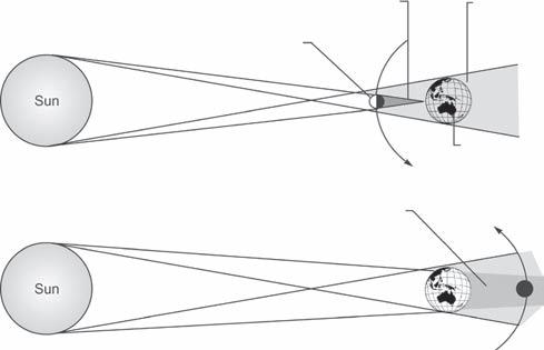
eCLipses and phases of the Moon Eclipses
Eclipse is defined as the obscuring of one celestial body by another, particularly that of the sun or a planetary satellite. When the light of the sun or the moon is obscured by another body, the sun or the moon is said to be in eclipse. Two kinds of eclipses involve the Earth: those of the moon, or lunar eclipses; and those of the sun, or solar eclipses.
Lunar eCLipse The moon is said to be in eclipse when the Earth comes between the moon and the sun, and this is called a lunar eclipse. The shadow cast by the Earth on the moon is called an eclipse. Lunar eclipse occurs only on a full moon day. However, it does not occur on every full moon day because the moon is not in the same position in relation to the Earth and the sun on every full moon day.
soLar eCLipse The sun is said to be in eclipse when the moon comes between the sun and the Earth. This is called solar eclipse. There is either a partial or total obstruction of the sun’s light when viewed from the Earth. A solar eclipse occurs on a new moon day when the moon is in line with the sun. However, owing to the inclination of the moon’s orbit, a solar eclipse does not occur on every new moon day.
Movement of the Moon Along Its Orbit Around the Earth
The moon shows progressively different phases as it moves along its orbit around Earth. Half the moon is always in sunlight, just as half of the Earth has day, whereas the other half has night. The phases of the moon depend on how much of the sunlit half can be seen at any one time. In the phase called the new moon, the face is completely in shadow. It is followed by the crescent moon, for about 3¼ days 6 h, when a thin crescent is visible. About a week later (7 days 12 h), the moon is in first quarter, resembling a luminous half-circle; another week later (after 14 days 8 h), the full moon shows its fully lighted surface; a week afterward, in its last quarter, the moon appears again as a half-circle. The entire cycle is repeated each lunar month. The moon is full when it is farther away from the sun than the Earth; it is new when it is closer. When it is more than half illuminated, it is
partiaL and totaL eCLipse A partial solar eclipse can be seen when part of the Earth is within the penumbra, or the
235° Y
North Ecliptic Pole
South Ecliptic Pole
Celestial Equator
Winter Solstice Vernal Equinox
Ecliptic
Summer Solstice Autumnal Equinox
South Celestial Pole
North Celestial Pole
FIG. 1.8 The Celestial Sphere
outer portion of the moon’s shadow. The inner portion, the umbra, is formed by tangents to the sun and moon; and the outer portion, the penumbra, is formed by the tangents that intersect between the sun and the moon. These geometric regions occur because light travels in straight lines and casts shadows even at great distances. A partial lunar eclipse occurs when only a part of the moon enters the umbra of the Earth’s shadow, leaving a portion of the moon in total darkness. The extent of a partial lunar eclipse can range from near totality, when most of the moon is obscured, to a slight or minor eclipse, when only a small portion of the Earth’s shadow is seen on passing moon.
totaL eCLipse During a total solar eclipse, the moon completely blocks out the sun for as long as 7–8 min. This type of eclipse is visible from the area on the Earth within the umbra, the inner part of the moon’s shadow. The diameter of the umbra is never greater than 268.7 km (167 mi), where it touches the surface of the Earth. As a result, the area in which a total solar eclipse is visible from the Earth is never wider, and it is usually considerably narrower. Observed from either side of this area, a part of the sun remains visible and the eclipse will be partial.
Ecliptic Circle
Ecliptic is the apparent great-circle annual path of the sun in the celestial sphere, as seen from the Earth. It is so named because eclipses occur only when the moon is on or near this path. The plane of this path, called the plane of the ecliptic, intersects the celestial equator (the projection of the Earth’s equator on the celestial sphere) at an angle of about 23°27’. This angle is known as the obliquity of the ecliptic and is approximately constant over a period of millions of years, although at present it is decreasing at the rate of 48 s of arc in each century and will decrease for several millenniums until it reaches 22°54’, after which it will again increase. The two points at which the ecliptic intersects the celestial equator are called nodes or equinoxes. The sun is at the vernal equinox about March 21, and at the autumnal equinox about September 23. Halfway on the ecliptic between the equinoxes are the summer and winter solstices. The sun arrives at these points about June 21 and December 22, respectively. The names of the four points correspond to the seasons beginning in the northern hemisphere on these dates. The equinoxes do not occur at the same points of the ecliptic every year, for the plane of the ecliptic and the plane of the equator revolve in opposite directions. The two planes

Total Lunar Eclipse
Total Solar Eclipse Moon
Umbra Penumbra
Umbra Penumbra Earth
FIG. 1.11
Total Eclipses
Waning Crescent
Last Quarter
FIG. 1.12 Phases of the Moon
FIG. 1.10 Partial Eclipse
make a complete revolution with respect to each other once every 25,868 years. The movement of the equinoxes along the ecliptic is called the precession of the equinoxes. A correction for precession must be applied to celestial charts to find the true position of the stars at any given time.
Altazimuth system One of the ways astronomers give the position of a celestial object is by specifying its altitude and its azimuth. This coordinate system is called the altazimuth system. The altitude of an object is equal to its angle, in degrees, above the horizon. An object at the horizon would have an altitude of 0°, and an object directly overhead would have an altitude of 90°. The azimuth of an object is equal to its angle in the horizontal direction, with north at 0°, east at 90°, south at 180°, and west at 270°. For example, if an astronomer were looking for an object at 23° altitude and 87° azimuth, the astronomer would know to look fairly low in the sky and almost directly east.
Equatorial coordinate system It is a coordinate system fixed in the sky. In this system, a star keeps the same coordinates no matter what the time is or where the observer is located. The equatorial coordinate system is based on the celestial sphere. The celestial sphere is a giant imaginary globe surrounding the Earth. This sphere has north and south celestial poles directly above Earth’s north and south poles. It has a celestial equator, directly above the Earth’s equator. Another important part of the celestial sphere is the line that marks the movement of the sun, with respect to the stars, throughout the year. This path is called the ecliptic. Because the Earth is tilted with respect to its orbit around the sun, the ecliptic is not the same as the celestial equator. The ecliptic is tilted 23.5° to the celestial equator and crosses the celestial equator at two points on opposite sides of the celestial sphere. The crossing points are called the vernal (or spring) equinox and the autumnal equinox. The vernal equinox and autumnal equinox mark the beginning of spring and fall, respectively. The points at which the ecliptic and celestial equator are farthest apart are called the summer solstice and the winter solstice, which mark the beginning of summer and winter, respectively.


Phases of the Moon
One revolution of the moon around Earth takes a little over 27 days 7 h. The moon rotates on its axis in this same period of time, so the same face of the moon is always presented to the Earth. Over a period a little longer than 29 days 12 h, the moon goes through a series of phases, in which the amount of the lighted half of the moon we see from the Earth changes. These phases are caused by the changing angle of sunlight hitting the moon. (The period of phases is longer than the period of revolution of the moon, because the motion of the Earth around the sun changes the angle at which the sun’s light hits the moon from night to night.) At any one time, an observer can see only 50 per cent of the moon’s entire surface. However, an additional 9 per cent can be seen from time to time around the apparent edge because of the relative motion called libration. This is due to the slightly different angles of view from the Earth, and the different relative positions of the moon along its inclined elliptical orbit. A synodic month begins when the sun and the moon are in conjunction.
Harvest Moon
This is the full moon at harvest time in the north temperate zone, or more exactly, the full moon occurring closest to the autumnal equinox, at about September 23. During this season the moon rises at a point opposite to the sun, or close to the exact eastern point of the horizon. Moreover, the moon rises only a few minutes later each night, affording, on several successive evenings, an attractive moonrise close to sunset time and strong moonlight almost all night if the sky is not clouded. The continuance of the moonlight after sunset is useful to farmers who are then harvesting their crops in northern latitudes. The full moon following the harvest moon, which exhibits the same phenomena in a lesser degree, is called the hunter’s moon. A similar phenomenon to the harvest moon is observed in southern latitudes at the spring equinox, at about March 21.
understanding the gLoBe
A globe is a spherical model of Earth. Geographic grids are intersecting lines drawn on maps and globes. They are used to help, locate, and describe specific areas. Two sets of lines encircle the globe: lines of latitude and lines of longitude.
Location
Location can be defined in terms of absolute or relative location. The intersection of a line of longitude with a line of latitude provides a unique, or absolute, location for any place on the Earth. Relative location is the position of a place in relation to other places. Any location on the globe can also be described in terms of its angular distance from the reference points of the equator (0° latitude) and the prime meridian (0° longitude).
Latitude
Latitude measures the angular distance—expressed in degrees—of a point on the Earth’s surface north or south of the equator. Imaginary lines of latitude, called parallels can be written separately, run parallel to the equator in an east–west direction around the globe. The equator is at 0° latitude, the north pole is at 90° N, and the south pole is at 90° S.
Longitude
Longitude measures the angular distance—expressed in degrees—of a point on the Earth’s surface, east or west of prime meridian.
North and south poles are the northernmost and southernmost geographical points on the Earth.
Equator
Equator is an imaginary line of latitude that circles the globe in an east–west direction, exactly halfway between the north and south poles. It forms a plane that runs perpendicular to the Earth’s axis, dividing the globe into
two equal parts: the northern hemisphere and the southern hemisphere. The latitude of the equator is 0°, and it is the point from which all other latitudes are measured.
Prime Meridian
Prime meridian is an arbitrarily selected line from which all of the other meridians are measured.
Meridians
Meridians are imaginary lines of longitudes that run from pole to pole in a north–south direction around the globe. The prime meridian is 0° longitude. Points can reach up to 180° longitude. The line of longitude at 180° W coincides with the line of longitude at 180° E.
Antarctic Circle
Antarctic circle is the parallel of latitude located 66°30′ S of the equator. The Antarctic circle marks the boundary of the zone where the sun never sets during the December solstice and never rises during the June solstice.
Continent
A continent is one of the seven major landmasses on the Earth’s surface. Africa, Antarctica, Asia, Australia, Europe, North America, and South America are continents.
Hemisphere
A hemisphere is half of a sphere and usually refers to half of the Earth. The northern and southern hemispheres are divided by the equator. The eastern and western hemispheres are divided by the meridians 20º W and 160º E, respectively.
Great Circle
A great circle is a theoretical circle, such as the equator, formed by the intersection of the Earth’s surface and an imaginary plane that passes through the centre of the Earth and divides it into two equal parts. Navigators use great circles to find the shortest distance between any two points on the Earth’s surface.
Tropic of Cancer
Tropic of cancer is the parallel of latitude located 23°27′ N of the equator. This line marks the northernmost point at which the sun appears directly overhead during the ‘June solstice’.
Tropic of Capricorn
Tropic of capricorn is the parallel of latitude located 23°27′ S of the equator. This line marks the southernmost point at which the sun appears directly overhead during the ‘December solstice’.
Arctic Circle
Arctic circle is the parallel of latitude located approximately 66°30′ N of equator. Portions of Alaska, Canada, Greenland, Russia, and the Arctic Ocean lie within the Arctic Circle. The Arctic Circle marks the boundary of the zone where the sun never sets during the June solstice and never rises during December solstice.
Ecliptic System
Ecliptic system is the fundamental circle for a system of coordinates by which celestial latitude is measured north and south of the ecliptic; celestial longitude is measured east and west of the vernal equinox. In astrology, the ecliptic is divided into 12 arcs of 30° each, called the signs of the zodiac. These signs, or ‘houses of heaven’, are named after the constellations through which the ecliptic passes.
Constellations of the Zodiac
Ancient astronomers noted that the sun makes a yearly journey across the celestial sphere. The ancient astronomers associated dates with the constellations in
North Pole (90° North Latitude)
Equator (0°Latitude)
Meridians
Prime Meridian (0° Latitude)
Parallels
FIG. 1.13 A Globe
FIG. 1.14 Examples of Great Circles
this narrow belt (which is known as the zodiac), assigning each constellation of stars the dates when the sun was in the same region of the celestial sphere as the constellation. The 12 zodiac signs for these constellations were named by the second century astronomer Ptolemy, as follows: Aries (ram), Taurus (bull), Gemini (twins), Cancer (crab), Leo (lion), Virgo (virgin), Libra (balance), Scorpio (scorpion), Sagittarius (archer), Capricorn (goat), Aquarius (water bearer), and Pisces (fishes).
Ascension, Declination, and Prime Meridian
The equivalent of longitude on the celestial sphere is called right ascension and the equivalent of latitude is declination. Specifying the right ascension of a star is equivalent to measuring the east–west distance from a line called the prime meridian that runs through Greenwich, England, for any place on the Earth. Right ascension starts at the vernal equinox. Longitude on the Earth is given in degrees, but right ascension is given in units of time—hours, minutes and seconds. This is because the celestial equator is divided into 24 equal parts—each called an hour of right ascension instead of 15°. Each hour is made up of 60 min, each of which is equal to 60 s. Measuring right ascension in units of time is used in determining the best time for astronomers to easily observe an object. A particular line of right ascension will be at its highest point in the sky above a particular place on the Earth, 4 min earlier each day, so keeping track of the movement of the celestial sphere with an ordinary clock would be complicated. Astronomers have special clocks that keep sidereal time (24 sidereal hours are equal to 23 h 56 min of the more familiar solar time). Astronomers compare the current sidereal time to the right ascension of the object they wish to view. The object will be highest in the sky when the sidereal time equals the right ascension of the object.

width. The 0° longitude line, or meridian, was defined as a line running through the old Greenwich Observatory in Greenwich, England. The time in each of the 12 zones, east of Greenwich increases by 1 h for each zone, whereas it decreases by 1 h, west of Greenwich.
earth and Moon
The Moon
Moon is the name given to the natural satellite of the Earth, and is sometimes applied to the satellites of the other planets in the solar system. The diameter of Earth’s moon is about 3,480 km (about 2,160 mi), or about onefourth that of Earth, and the moon’s volume is about onefiftieth that of Earth. The mass of Earth is 81 times greater than the mass of the moon. Thus, the average density of the moon is only three-fifths, and the gravitational pull at the lunar surface only one-sixth that of the Earth. The moon has no liquid water and essentially no atmosphere, so no weather exists to change its surface; yet it is not totally inert.
Astronomical Data on the Moon
Greenwich Mean Time (GMT)
GMT is the UK standard time. It is based on the local time of the meridian passing through Greenwich, near London. As the Earth rotates 15° of longitude per hour, the Earth’s 360° were divided into 24 zones, each measuring about 15° in

The moon moves around the Earth in an elliptical orbit of small eccentricity, inclined by 58°43"4' to the plane in which the Earth revolves around the sun. Its distance from Earth varies between 3,56,000 and 4,07,000 km in the course of each month; the average distance is 3,84,400 km, which is less than 1 per cent of the distance to Venus and Mars, even at the time of their closest approach. The lunar globe appears in the sky as a disc of a little over half a degree (31°5"2') in apparent diameter. The period in which the moon completes an orbit around the Earth and returns to the same position in the sky—the sidereal month—is 27 days, 7 h, 43 min and 11.6 s. Because the Earth is moving in its orbit around the sun in the same direction as the moon, the time needed to return to the same phase—the synodic month—is longer: 29 days, 12 h, 44 min and 2.8 s. This period—for example, the time interval that elapses between two successive full moons— was known within a second even in ancient times. The moon’s mean angular velocity in the sky is about 33 min of arc per hour, a little greater than the apparent diameter of the moon. In addition to its motion through space, the moon also rotates about its axis in a period of one sidereal month, so that it keeps approximately the same side towards the Earth at all times. Non-uniformities in its orbital motion, however, together with the inclination of the orbit to the ecliptic, cause ‘optical librations’ that allow 59 per cent of the entire lunar surface to be seen from the Earth at one time or another. The remaining 41 per cent was hidden until the Soviet Luna 3 spacecraft photographed the far side in October 1959. The moon has since been thoroughly mapped.
FIG. 1.15 Meridians
Moon and Tides
The waters of the oceans are held on the Earth by the force of gravity. But there are other bodies besides the Earth, which are trying to draw all things towards themselves. The most important of them are the moon and the sun. Tides or the rise and fall in the level of the oceans and seas are due to the gravitational pull of the moon and the sun. A rise in the water level is called high tide and a fall is called low or ebb tide. The tide produced as a consequence of the moon and the sun pulling the Earth in the same direction, is called spring tide. It is the tide of maximum rise, occurring at the new or full moon of each month. The tide produced when the moon and the sun are at right angles to the Earth and they pull in opposite directions is called a neap tide. It is the tide of minimum rise, occurring during the first and third quarter of the moon. Its amplitude is less than that of the spring tide.
Role of Rotation of Earth and Moon to Cause Tides
Another factor that causes tides, in addition to the gravitational pull of the sun and the moon, is the rotation of the Earth and the moon. When a body rotates on its axis, loose objects tend to break away from the surface. In other words, a centrifugal force is set up by the rotation of the Earth. But the moon is at the same time revolving round the Earth and so the real cause of the tides may be said to be the centrifugal force set up by the rotation of the Earth and the moon round their common centres. The sun also helps cause tides. When the sun lies in the same straight line as the moon, we get big tides (spring tides); when it pulls in the opposite direction, that is, at right angles tothe moon, we get smaller tides (neap tides).
zone immediately to the west. Each time zone is defined by its distance east or west of Greenwich, England. Until the late 1800s, most towns and cities set clocks based upon the rising and setting of the sun. Because of the Earth’s rotation, dawn and dusk occur at different times at different places, but time differences between distant locations were barely noticeable because of long travel times and the lack of long distance communications. The time in any given time zone or country may shift by 1 h for certain periods of the year to gain maximum daylight hours and balance these hours from morning to evening. One such system is Daylight Savings Time in the United States.
Local Time
Meridians of longitude determine the time at a place. Local time is 12 noon when the sun is exactly overhead. Local time varies from Greenwich Time (London) at the rate of 4 min/degree of longitude. The time of a place depends on whether it lies east or west of Greenwich. As the Earth rotates from west to east, places that lie to the east of Greenwich are the first to receive sunlight. The Earth rotates through 360° in 24 h or 15° in 1 h or 1° in 4 min. Therefore, the local time varies at the rate of 4 min/degree of longitude from Greenwich Time. For example, Kolkata is approximately 90° E of Greenwich. So Kolkata will be 6 h ahead of the time in London.
Standard Time
Standard time is the uniform time fixed by each country. As the local time is found to vary constantly from one plain to another, there is an arrangement by which all places in a certain region agree to use the same time. It is the uniform time fixed in relation to the mean time of a certain meridian that passes through it. For this purpose, the Earth is divided into 24 longitudinal zones, each being 15° or 1 h apart in time. The zero is at Greenwich (London) which gives us the Greenwich Mean Time (GMT). The 12th zone is divided by the 180th meridian, the International Date Line. The zones to the east of this line are numbered from 1 to 12 with the prefix minus (−) indicating the number of hours to be subtracted to obtain the Greenwich Time. The zones to the west are also numbered 1–12 with the prefix plus (+), which means the number of hours that must be added to get Greenwich Time.
International Date Line
tiMe
Time Zones
A time zone is any of the 24 geographic areas into which the Earth is divided for the purpose of maintaining a standard time system. Clocks within a given time zone are set to the same time, which is generally 1 h later than the
The 180° E meridian and 180° W meridian are the same line running over the Pacific ocean, deviating at Fiji, Samoa, and Gilbert Islands. The International Date Line roughly corresponds to the 180° EW meridian of longitude, which falls on the opposite side of the Greenwich meridian. The International Date Line lies at the 180° meridian on the opposite side of the Earth from Greenwich and divides the eastern and western time zones. The time difference between
FIG. 1.16 Formation of Tides
each side of the International Date Line is 24 h. Thus, a traveller heading west across the date line loses 1 day while a traveller headed east gains a day. When one crosses the Date Line from east to west, the date has to be advanced by 1 day. Similarly, when one crosses the Date Line from west to east, the date is to be set back by 1 day. When the sun is directly over the 45° E meridian (i.e. it is 12 noon at 45° E), let us say a Monday, it will be 9a.m. at Greenwich, and at a place 170° W of Greenwich it will be 4 min past 9 on Sunday
evening. If we go eastward from 45° E instead of westward, we find that at a place 90° E it is 3 p.m. on Monday. At a place 179° E of Greenwich it will be 4 min to 9 on Monday evening. When we reach 180° we find that it is 9 p.m. on Sunday, if we have calculated westwards from the Greenwich, but 9 p.m. on Monday if we have calculated eastwards from Greenwich. So we have to draw a line somewhere near the meridian of 180° and agree to say that it is Sunday on one side and Monday on the other.
atMosphere
introduCtion
The atmosphere is a gaseous envelope that surrounds a celestial body. The atmosphere is the nearly transparent envelope of gases and suspended particles that surrounds the Earth, profoundly influencing environmental conditions on the planet’s surface. The terrestrial atmosphere, by nature of its composition, control of temperature, and shielding effect against solar radiation, makes life possible on Earth. It covers both land and water surface. Without chemical processes involving several of the atmospheric gases, life could not exist. The physical processes that operate in the atmosphere are also of vital importance because they are responsible for Earth’s varied climates. It is bound to Earth by the gravitational pull of the Earth.
Composition of the Atmosphere
The composition of the atmosphere changes as we go higher from the Earth’s surface. Up to about a height of 50 km from the Earth, the atmosphere is composed of nitrogen (78.09 per cent), oxygen (20.95 per cent), argon (0.93 per cent), minor gases (0.03 per cent), which includes carbon dioxide, hydrogen, neon, helium, methane, xenon, krypton, etc. After a height of 50 km above the Earth’s surface the atmosphere is made up of atomic oxygen (O1), ozone (O3), helium, and hydrogen. The mixture of gases in the air today has had 4.54 billion years in which to evolve. The earliest atmosphere must have consisted of volcanic emanations alone. Gases that erupt from volcanoes today, however, are mostly a mixture of water vapour, carbon dioxide, sulphur dioxide, and nitrogen, with almost no oxygen. If this is the
FIG. 1.17 Time Zones of the World
same mixture that existed in the early atmosphere, then various processes would have had to operate to produce the mixture we have today. One of these processes was condensation. As it cooled, much of the volcanic water vapour condensed to fill the earliest oceans. Chemical reactions would also have occurred. Some carbon dioxide would have reacted with the rocks of Earth’s crust to form carbonate minerals, and some would have dissolved in the new oceans. Later, as primitive life capable of photosynthesis evolved in the oceans, new marine organisms began producing oxygen. Almost all the free oxygen in the air today is believed to have formed by a photosynthetic combination of carbon dioxide and water. About 570 million years ago, the oxygen content of the atmosphere and oceans became high enough to permit marine life capable of respiration. Later, some 400 million years ago, the atmosphere contained enough oxygen for the evolution of air-breathing land animals.
The Water Cycle
The exchange and movement of water between the Earth and atmosphere is called the water cycle. The cycle, which occurs in the troposphere, begins as the sun evaporates large amounts of water from the Earth’s surface and the moisture is transported to other regions by the wind. As air rises, expands and cools, water vapour condenses and clouds develop. When liquid or solid water particles grow large enough in size, they fall towards the Earth as precipitation. The type of precipitation that reaches the ground, be it rain, snow, sleet or freezing rain, depends upon the temperature of the air through which it falls.
Atmospheric Pressure
Atmospheric pressure refers to the weight of the entire air column over a given point. A litre of air weighs about 1.3 g. At the sea level, the air pressure is around 1,033.6 g cm2 This is referred to as one atmosphere. Air is held to the Earth by gravity. This strong invisible force pulls the air downwards, giving air molecules weight. The weight of the air molecules exerts a force upon the Earth and everything on it. The amount of force exerted on a unit surface area (a surface that is one unit in length and one unit in width) is called atmospheric pressure or air pressure. The air pressure at any level in the atmosphere can be expressed as the total weight of air above a unit surface area at that level in the atmosphere. Higher in the atmosphere, there are fewer air molecules pressing down from above. Consequently, air pressure always decreases with increasing height above the ground. Because air can be compressed, the density of the air (the mass of the air molecules in a given volume) is normally greatest at the ground and decreases at higher altitudes.
Relation Between Air Pressure and Air Density
In reality, the atmosphere is compressible, that is, density (mass per unit volume) is proportional to pressure. This relationship, called Boyle’s law, implies that density decreases with height in the atmosphere: as height increases, less mass remains above a given point; therefore, less pressure is exerted. Both pressure and density decrease by about a factor of 10 for every 16 km increase in altitude. The density of dry air at sea level is about 1/800 the density of water; at higher altitudes it decreases rapidly, being proportional to the pressure and inversely proportional to the temperature. Pressure is measured by a barometer and is expressed in torrs (or millibars), which are related to the height of a column of mercury that the air pressure will support; 1 torr = 1 mm of mercury. Normal atmospheric pressure at sea level is 760 torrs, that is, 760 mm of mercury. At about 5.6 km, it is 380 torrs; half of all the air in the atmosphere lies below this level. The pressure is again approximately halved for each additional increase of 5.6 km in altitude. At 80 km, the pressure is 0.007. The air pressure is also indicative of the general weather and a sudden fall in the barometer indicates stormy weather conditions.

struCture of the atMosphere
The atmosphere is broadly divided into two parts: homosphere and heterosphere. The homosphere extends up to the height of 90 km and is further divided into troposphere, stratosphere and mesosphere. Each of these layers is separated by a thin transition zone called ‘pause’. Above homosphere starts heterosphere, which has a layered structure of nitrogen, oxygen, helium and hydrogen. As the name suggests, the homosphere has a uniform or homogeneous chemical composition, whereas the heterosphere is characterised by a heterogeneous chemical composition. The altitude of various sub-layers are Homosphere [Troposphere (0–16 km at equator, 0–10 km at the poles), Tropopause (10 km at poles to 16 km at equator), Stratosphere (10–16 to 50 km), Stratopause (50 km), Mesosphere (50–85 km),aMesopause (85–90 km)] and Heterosphere [Thermosphere (90+ km), Ionosphere (Nitrogen layer—200 km, Oxygen layer—1,110 km, Helium Layer— 1,700 km, Hydrogen layer—2,600 km), Exosphere and Magnetosphere (9,600 km)].
TABle 1.1 Layers of Atmosphere
Broad layers Name of Sub–layers
Altitude (km)
Homosphere Troposphere 0–16 (at the equator), 0–10 (at the poles)
Tropopause 10 (at poles) to 16 (at equator)
Stratosphere 10–16 to 50
Stratopause 50
Mesosphere 50–85
Mesopause 85–90
Broad layers
Heterosphere
Name of Sub–layers
Thermosphere
Ionosphere
Altitude (km)
90+
Nitrogen layer 200
Oxygen layer 1,100
Helium layer 1,700
Hydrogen layer 2,600
Exosphere 9,600
Magnetosphere
Atmospheric Layers
There are layers of air that lie above the Earth’s surface. The atmosphere of the Earth is arranged into four layers and three pauses. In the order of increasing elevation these are the troposphere, the stratosphere, the mesosphere and the thermosphere.
troposphere The troposphere is the layer nearest to the Earth’s surface and extends from sea level to a height of about 15 km. This region is the densest of all the atmospheric layers and contains water vapour, moisture and dust. In this region, the temperature decreases as the height from the Earth increases. The temperature of the troposphere is warmest in the tropical (latitude about 0º–30º N and S) and the subtropical (latitude about 30º–40º N and S) climatic zones and coldest at the polar climatic zones (latitude about 70º–90º N and S). Observations from weather balloons have shown that temperature decreases with height, at an average of 6.5ºC/1,000 m, reaching about −80ºC above the tropical regions and about −50ºC (about −60ºF) above the polar regions. The troposphere contains 75 per cent of the atmosphere’s mass—on an average day the weight of the molecules in air is 1.03 kg/cm2 (14.7 lb/in2)—and most of the atmosphere’s water vapour. Water vapour concentration varies from trace amounts in the polar regions to nearly 4 per cent in the tropics. The most prevalent gases are nitrogen (78 per cent) and oxygen (21 per cent), with the remaining 1 per cent consisting of argon (0.9 per cent) and traces of hydrogen, ozone, methane and other constituents. Carbon dioxide is present in small amounts, but its concentration has nearly doubled since 1900. The global annual mean concentration of Carbon dioxide (CO2) during Industrial Revolution was 280 ppm, and that has become 400 ppm by August 2015. It is observed that the current rate of rise in concentration of CO2 in atmosphere is about 2 ppm/year. The uneven heating of the regions of the troposphere by the sun (the sun warms the air at the equator more than the air at the poles) causes convection currents, large scale patterns of winds that move heat and moisture around the globe. A common feature of the troposphere of densely populated areas is smog.
[Thermosphere (90+km); Ionosphere (Nitrogen layer—200 km; Oxygen layer—110 km; Helium Layer—1,700 km; Hydrogen layer—2,600 km); Exosphere and Magnetosphere (9,600 km)]
tropopause Tropopause is the layer that separates the troposphere (lowest layer) from the stratosphere (upper layer). It is the boundary between the troposphere and stratosphere.
Thermosphere
60 º N Summer
30º N Summer
Thermosphere
Mesopause
Mesosphere
Stratopause
Stratosphere
Tropopause Troposphere
It lies about 15–20 km above the Earth in the tropics and about 10 km high in the polar areas. In the troposphere the temperature generally decreases with height, whereas above the tropopause the temperature no longer decreases. In some instances it remains constant, and at other times or places it increases with height. The tropopause is relatively cold because it is situated far from the two nearest good partial absorbers of sunlight—the Earth’s surface and the ozone layer.
stratosphere It is the second lowest of the four atmospheric layers. Its lower boundary is called the tropopause and upper boundary, the stratopause. This is the region of uniform temperature, extending from an altitude of about 15 km above the Earth to a height of about 50 km. It is free from water vapour, clouds and dust. In contrast, temperatures in the stratosphere remain the same or even increase with increasing height, which indicates vertical stability. The stratospheric air flow is mainly horizontal. Ultraviolet absorption by the ozone layer causes the high temperatures of the stratopause, which is usually between 48 and 53 km (30 and 33 mi) above the Earth’s surface.
Signi cance of Carbon Dioxide and Ozone
Carbon dioxide makes up only a few hundred parts per million of the atmosphere, by volume, but it is vital in maintaining the Earth’s atmosphere system’s heat balance because it strongly absorbs infrared (thermal) radiation. Water vapour, present in highly variable quantities ranging from 0 to 4 per cent by
FIG. 1.18 Structure of the Atmosphere
volume, also absorbs considerable infrared radiation and, additionally, is an essential link in the hydrologic cycle. Another important trace gas is the triatomic form of oxygen, ozone (O3), which is concentrated in a layer centred at about 25 km above the surface. Although present in concentrations of only about 12 ppm, ozone absorbs radiation in the ultraviolet region of the spectrum so effectively that the ozone layer can almost completely shield life on Earth from harmful ultraviolet light.
Mesosphere This is a very cold region and lies above the ozone-rich layer of the stratosphere. It extends from 50 to 80 km above the Earth’s surface. It lies between a lower region of the atmosphere called the stratosphere and an upper region, the thermosphere. The temperature of the mesosphere decreases from about 0°C at its lower boundary, called the stratopause, to about –90°C at its upper boundary, called the mesopause. The mesosphere is the coldest layer of the atmosphere. Above the mesosphere lies the hot thermosphere, where air temperatures can exceed 1,000°C, primarily because of oxygen absorbing the sun’s energetic rays. Below the mesosphere the energy of incoming solar radiation is absorbed by both the Earth’s surface and the ozone layer. As air parcels rise in the mesosphere, they retain their total heat energy, but expand and grow cooler; there is hence the drop in temperature with altitude. Solar absorption apparently does not take place near the mesopause. Wavelike windstorms of continental size were observed in the mesosphere in 1991 by a satellite launched from the US Space Shuttle Discovery. The wind waves arise in the lower atmosphere but become larger and break into huge windstorms as they rise upward. The mesopause separates the mesosphere from the next layer, the ionosphere.
ionosphere The ionosphere is the part of the Earth’s upper atmosphere, where ions and electrons are present in quantities sufficient to affect the propagation of radio waves. Such a region was first theorised in 1902, independently, by the British physicist Oliver Heaviside (1850 to 1925) and by the American electrical engineer Arthur Edwin Kennelly (1861 to 1949), following Guglielmo Marconi’s success in sending a radio signal across the Atlantic Ocean on 12 December 1901. The ionosphere lies immediately above the mesosphere and extends from 60 to 400 km above the Earth’s surface. This layer contains ionised (or electrically charged) air that protects the Earth from the falling meteorites (shooting stars), as most of them burn out in this region. It also protects the Earth from the harmful radiation of the sun. The ionosphere consists of ‘D’, ‘E’ and ‘F’ layers and includes the thermosphere and exosphere.

Such refracted waves, however, reach the Earth only at certain definite distances from the transmitter; the distance depends on the angle of refraction and the altitude. Hence, a radio signal may be inaudible at 100 km from the transmitter but audible at 500 km. This phenomenon is known as skip. In certain other areas, the ground-wave signals and the refracted signals from the ionosphere may reach the receiver and interfere with each other, producing the phenomenon known as fading. The amount of refraction in the ionosphere decreases with an increase in frequency and for very high frequencies is almost non-existent. Therefore, long distance transmission of high-frequency radio waves is limited to the line of sight. Both television and frequency modulation (FM) radio use high-frequency waves having very long wavelength. Long distance transmission can be achieved only in a direct line, such as between the Earth and a communications satellite; the signal may then be relayed from the satellite to a distant point on the Earth.


Regions of Ionosphere
The ionosphere has been classically subdivided into several regions. The D region, which disappears at night, is between 60 and 85 km of altitude. The E region, formerly known as the Kennelly-Heaviside layer, is between 85 and 140 km. The F1 and F2 regions occur above 140 km and merge at night. Together they were formerly known as the Appleton layer. The D and E regions primarily contain molecular ionisation. The F region is characterised primarily by atomic ionisation, which produces equal numbers of electrons and atomic positive ions. Ionospheric recorders stationed at the Earth’s surface give excellent information on the electron profile (the concentration of electrons as a function of height) of the lower ionospheric half. A surface recorder can provide no information on the upper half, because a surface signal is reflected either by a level below the maximum electron concentration or not at all. However, the upper half is now better known than the lower, because of the placing of ionospheric recorders on satellites, beginning with the Canadian Alouette satellite.
Use of Ionosphere
The ionosphere exerts a great influence on the propagation of radio signals. Energy that is radiated from a transmitter upwards, towards the ionosphere is in part absorbed by the ionised air and in part refracted, or bent downward again, towards the surface of the Earth. The bending effect makes it possible to receive radio signals at distances much greater than would be possible for waves that travelled along the surface of the Earth.
therMosphere The thermosphere is the highest and largest of the four atmospheric layers. Its lower boundary is the mesopause, about 80 km above sea level, where the average temperature is a low of about −80°C. Its upper limit is the thermopause, about 600 km above sea level. At the thermopause, the temperature may reach 225°C at night during a period of minimum solar activity, and 1,475°C in the daytime during a period of maximum solar activity. The upper part of the thermosphere is warm because it readily absorbs solar ultraviolet radiation. The thermosphere is the only heterogeneous atmospheric layer. Vertical mixing takes place in the lowest 80 km of the thermosphere, sometimes called the homosphere. Above this height, however, gravity pulls the heavier gases, oxygen and nitrogen, towards the bottom of the thermosphere. Thus, the predominant gas molecules in the upper thermosphere become those of helium and hydrogen.
eXosphere The region beyond the thermosphere is called the exosphere, which extends to about 9,600 km, the outer limit of the atmosphere. It is the uppermost region of the ionosphere and makes up the outer limits of the atmosphere. Here, the
gravity of the Earth is exceedingly weak. The magnetic belt of the Earth, which is known as magnetosphere, extends to about 64,000 km above the Earth’s surface. Magnetosphere is the region above the Earth’s surface in which charged particles are affected by the Earth’s magnetic field. The exosphere is now considered as part of the magnetosphere. The outer boundary of the magnetosphere or the final boundary between the Earth and outer space is known its magnetopause.
pLanetary and CeLestiaL atMosphere
Difference Among Planets
The atmospheres of terrestrial planets are remarkably diverse. For example, the atmospheres of Venus and Mars are dominated by carbon dioxide. In contrast, nitrogen, oxygen and water vapour, which are rare in the atmospheres of the other planets, dominate the atmosphere of the Earth. There is also great diversity in surface pressure. For example, the atmospheric pressure at the surface of Venus is 90 times greater than that at the surface of the Earth, yet the atmospheric pressure at the surface of Mars is 150 times less than the atmospheric pressure at the surface of the Earth. Mercury, the smallest and innermost terrestrial planet, has almost no atmosphere, and most of its thin, gaseous envelope is made of solar wind particles that are temporarily trapped by its weak gravitational field.
Probability of Life on Other Planets
Life elsewhere in the universe might also form near a star like our sun. The sun is an average star, bright and hot enough to warm the inner planets but calm and cool enough that the Earth is relatively safe from some forms of destructive radiation. Most importantly, our sun has been stable for billions of years. Life would also benefit from a planet like Earth, which is large enough to provide the gravitational force to hold an atmosphere. The atmosphere protects the surface against radiation and rapid temperature changes, and holds elements that may be important to sustaining life. The combination of a suitable star and planet might be vital to the formation of life.
Atmospheric Extinction
The Earth’s atmosphere does not affect the light of distant stars as much as interstellar dust does, but the light of the sun is noticeably scattered in the atmosphere. Molecules in the atmosphere scatter shorter (bluer) wavelengths more than longer (redder) ones. When the sun is overhead, sunlight passes through less of the atmosphere, and is scattered less, than when the sun is at the horizon. The sun appears white or yellow when overhead, but appears to have a red or orange tint when it is near the horizon. Absorption is not as great in the atmosphere as it is in interstellar space. Almost all visible light passes through the Earth’s atmosphere without being absorbed.
iMportant phenoMena of atMosphere
Radiation Belts
Radiation belts are zones in space around the Earth, and the planets Jupiter and Saturn, containing high-energy protons and electrons. A Geiger counter (detector of charged particles) installed in the first US satellite, Explorer 1, launched on 31 January 1958, gave the first evidence that the Earth is surrounded by regions containing charged particles of high energy. These regions were then called the Van Allen radiation belts, after James A Van Allen of the University of Iowa, who was head of the team of scientists that conducted the experiments.
haZards of radiation BeLts Electronic circuits and solar cells of spacecraft deteriorate when exposed for long periods to fast protons, which can penetrate several millimetres of metal. The very intense radiation belts around Jupiter, especially, required the effective protection of the electronic circuitry of the Pioneer and Voyager spacecrafts. For living organisms, the radiation has the general detrimental effects of ionising radiation, so the space missions are generally planned in such a way as to minimise exposure of the astronauts to the most intense regions of the radiation belts.
Structure and Constitution of Radiation Belts
Around the Earth, the radiation belts consist of electrons and protons that are trapped in a doughnut shaped region centred around the magnetic equator. This region extends from a few hundred kilometres above the Earth to 48,000–64,000 km. The electrons and protons are supplied by cosmic rays and by the solar wind, a continuous stream of charged particles—mainly electrons and protons—emanating from the sun. The particles are forced into spiralling paths about the magnetic field lines of the geomagnetic field by the Lorentz force (the force exerted on moving, charged particles, perpendicular both to the direction of motion and to the magnetic field lines). Because the magnetic field increases near the poles of the Earth—that is, the field lines become denser—the particles are reflected and travel back and forth on spiralling paths between the north and south poles of the Earth. Most of the highenergy protons (more than 10 MeV) are found in an inner belt, at an altitude of 3,200 km; electrons are more concentrated in an outer belt that extends many Earth radii into space.
Magnetic Storms
The transient variations of the magnetic field of the Earth, which may last from a few hours to 10 days, are called geomagnetic disturbances or, when severe, magnetic storms. These variations occur because a part of the magnetic field of the Earth originates from complicated electric current systems set up by the interaction between the solar wind and the Earth’s magnetic field. These systems are located on the surface and inside the magnetosphere,