A Field Guide to British Rivers
George Heritage
Dynamic Rivers Consultants, Birmingham, UK
Andy Large
Newcastle University, Newcastle upon Tyne, UK
David Milan
University of Hull, Hull, UK
This edition first published 2022 © 2022 John Wiley & Sons Ltd
All rights reserved. No part of this publication may be reproduced, stored in a retrieval system, or transmitted, in any form or by any means, electronic, mechanical, photocopying, recording or otherwise, except as permitted by law. Advice on how to obtain permission to reuse material from this title is available at http://www.wiley.com/go/permissions.
The right of George Heritage, Andy Large and David Milan to be identified as the authors of this work has been asserted in accordance with law.
Registered Offices
John Wiley & Sons, Inc., 111 River Street, Hoboken, NJ 07030, USA
John Wiley & Sons Ltd, The Atrium, Southern Gate, Chichester, West Sussex, PO19 8SQ, UK
Editorial Office
9600 Garsington Road, Oxford, OX4 2DQ, UK
For details of our global editorial offices, customer services, and more information about Wiley products visit us at www.wiley.com.
Wiley also publishes its books in a variety of electronic formats and by print-on-demand. Some content that appears in standard print versions of this book may not be available in other formats.
Limit of Liability/Disclaimer of Warranty
While the publisher and authors have used their best efforts in preparing this work, they make no representations or warranties with respect to the accuracy or completeness of the contents of this work and specifically disclaim all warranties, including without limitation any implied warranties of merchantability or fitness for a particular purpose. No warranty may be created or extended by sales representatives, written sales materials or promotional statements for this work. The fact that an organization, website, or product is referred to in this work as a citation and/or potential source of further information does not mean that the publisher and authors endorse the information or services the organization, website, or product may provide or recommendations it may make. This work is sold with the understanding that the publisher is not engaged in rendering professional services. The advice and strategies contained herein may not be suitable for your situation. You should consult with a specialist where appropriate. Further, readers should be aware that websites listed in this work may have changed or disappeared between when this work was written and when it is read. Neither the publisher nor authors shall be liable for any loss of profit or any other commercial damages, including but not limited to special, incidental, consequential, or other damages.
Library of Congress Cataloging-in-Publication Data
Names: Heritage, G. L. (George Leonard), author. | Large, Andrew R. G., author. | Milan, David, author.
Title: A field guide to British rivers / George Heritage, Andy Large, David Milan.
Description: Hoboken, NJ : Wiley-Blackwell, 2021. | Includes bibliographical references and index.
Identifiers: LCCN 2021028304 (print) | LCCN 2021028305 (ebook) | ISBN 9781118487983 (cloth) | ISBN 9781118488003 (adobe pdf) | ISBN 9781118488027 (epub)
Subjects: LCSH: Rivers–Great Britain. | Stream health–Great Britain. | Stream conservation–Great Britain.
Classification: LCC GB1283 .H47 2021 (print) | LCC GB1283 (ebook) | DDC 551.48/30941–dc23
LC record available at https://lccn.loc.gov/2021028304
LC ebook record available at https://lccn.loc.gov/2021028305
Cover Design: Wiley
Cover Image: © George Heritage (Swindale Beck)
Set in 9.5/12.5pt StixTwoText by Straive, Pondicherry, India
In memory of Martin Charlton (1957–2021)
An unassuming academic with a brilliant mind, indubitable character and unbounded enthusiasm for his work and students. Martin will be missed by all who knew him. His influence will live on well beyond his short life.
Foreword
Temperate rivers are influenced by many factors including geology, climate, soils, sediment type, flow and human activity. The complex interactions of the nonanthropogenic controlling factors have led to a wonderful variety of river form in the British Isles. Sadly, however, almost all temperate rivers in the United Kingdom have suffered significant and long-lasting modification and management that has all but destroyed this variety, instead creating simplified conduits for water and sediment designed primarily to drain the land and reduce flood risk. This book is intended to illustrate this variety, highlighting the many forms that temperate river systems take in the United Kingdom. In this volume, we cover upland and lowland channel types and include the full range of substrate conditions from bedrock through boulder, cobble and gravel through to silt-dominated systems. In doing this, the authors describe examples gathered from over 30 years each of research and practical experience working with rivers and set these in the context of the current scientific knowledge to illustrate the natural functioning of temperate river types. We hope this will act as a practical, context-sensitive and more sustainable template for the restoration and re-naturalisation of degraded channels in the United Kingdom and as a working set of guidelines for those interested in understanding more about the rich variety of temperate river types. In doing this, we know other examples exist (e.g. the practical guides from the UK River Restoration Centre), and so we intend this volume with its balance between science and practicalities of river management to compliment these other approaches but essentially to act as a standalone guide.
It is interesting to reflect on the reasons behind the present degraded state of temperate British rivers and the common acceptance that this current state is “how a river should be”. Significant, almost wholesale, channel and floodplain modification occurred throughout the Agricultural and Industrial Revolutions as valley
bottomlands were exploited for food production and industrialists sought to utilise the power of rivers for energy for manufacturing activities. River channels were moved, straightened, embanked, and deepened, and the new channels had their banks protected with wood and stone. While large extents of natural wooded vegetation were removed as part of this activity, trees were planted along bank margins to prevent them moving from their designated route. Floodplains and later uplands were drained to improve land for crops and grazing, and urban rivers were completely channelised to prevent flooding. Successive generations have now grown up with these modified rivers, and as a result, we have now accepted that they are somehow “natural”. Our own limited experience of rivers has led to the widespread belief that rivers are liquid ribbons in the landscape; static systems, immovable in the landscape and not part of the surrounding floodplain fields and meadows. We talk of rivers “bursting their banks” – a negative term implying that overspilling to occupy the floodplain temporarily is somehow unnatural. Increasingly, as management of temperate rivers reduces on the part of national agencies, requests are made to “fix” rivers by “repairing” banks, dredging sediment, and removing wood and other vegetation to recreate the “neat” channels people remember from days gone by. Such perceptions are not aided by the current teaching of river science in schools. Geography and environmental lessons in schools perpetuate outdated concepts; for example, textbooks concentrate on meandering systems and pool-riffle sequences and decades-old river typologies that, despite rivers being continua, divide catchments into upper, mid-reach and lowland meandering sections – ignoring the irony that the latter are rarely permitted to be mobile nowadays.
All these modifications have not just altered the physical form of temperate British rivers and valley bottoms they have also fundamentally impacted on the flow regime and the way in which river systems erode,
transport and store sediment. As such, we are left with systems that are a neutered shadow of their former selves, where both natural processes and natural form are severely impacted resulting in a highly degraded river channel and valley bottom. The simple singlethread channel, often featureless and constrained, dominates our riverine landscapes with many other river types now all but extinct. Many rivers also now experience more extreme flows across the year, with winter flood extremes testing flood defences to their limits and spring and summer low flows that border on drought conditions. Whilst both extremes may have their origins in wider climate change, there is no doubt that they have been exacerbated by inappropriate upland drainage management impacting on the flow paths and speed of water once it has hit the ground.
Such a situation should not be allowed to continue and fortunately several factors are presently operating that provide encouragement that more natural river and floodplain systems can make a resurgence. The first is the current reluctance amongst statutory bodies to continue with the intensive management of watercourses due to their routine maintenance budgets being significantly reduced from those of a decade or two ago. This is giving many rivers a chance to begin to erode and deposit sediment once again; however, channel response is often highly localised and more extreme than would occur naturally as failing protection creates “hotspots of change”. Alongside this, there is an increasing recognition that impacted flood regimes require addressing at source rather than just at flooding hotspots, and Natural Flood Management approaches to slow flood flows and store flood water are gaining traction in terms of catchment-oriented efforts to restore river and floodplain connectivity and channel dynamism. More recently, it has been recognised that degraded sediment transport regimes are also influencing the potential for flooding with heightened levels of gravels accumulating in urban areas because of disconnected storage in the catchment and altered sediment transport efficiencies in upstream rivers. Natural Sediment Management whereby sediment storage zones are reconnected and channel form naturalised to a more storage friendly configuration can help reduce flood sediment inputs to vulnerable areas whilst restoring natural form and processes to the fluvial system upstream. Finally, the trend amongst owners of large estates to re-wild the landscape and reintroduce extinct species is also improving larger and larger areas, often with valley bottom land being encouraged to naturalise through light touch interventions that act as the precursor for wider river-driven
landscape change. The recent efforts to reintroduce ecosystem engineers such as beaver also points to greater willingness in UK river managers to turn back the clock and allow greater space for nature.
The natural environment is now rising in value with an increasing recognition of the role that natural system dynamics can play in climate change, biodiversity, as well as ecosystem regulation and buffering, and there appears to be a growing political will in the United Kingdom to instigate change, with new government stewardship schemes likely to place a very strong emphasis on environmental functionality, helping push the river restoration agenda forward. In all cases, this can only be achieved successfully with the appropriate river-based understanding. During the time we have been writing this book, Britain has left the European Union, and so it remains to be seen what trajectory environmental protection will take post departure, but initial statements from government indicate a willingness to legislate for more protection, not less. What is key is that any range of protection methods should ensure a place for enhanced dynamism, not less.
Future sustainable management of our rivers and floodplains therefore requires a fuller understanding of river form and function to ensure that opportunities are fully exploited, and our perception of rivers is changed towards more naturally functioning dynamic systems. We have written this book deliberately as an illustrated field guide to maximise the practical examples of river types and to highlight the pressures they experience and their often parlous condition. This book is intended to better inform both river management approaches and policy necessary to achieve this. It will hopefully stimulate a desire to bring back the diversity and dynamism associated with naturally functioning temperate fluvial systems in the United Kingdom. The ethos of the book is to inspire the river scientist in us all, by providing a holistic picture of the variety of temperate river forms in Britain and linking this explicitly to functional controls within the catchment. Fundamentally, we seek to demonstrate and evidence how the hydrological, geomorphological, and ecological functions of rivers integrate to generate and maintain the dynamic whole. If those who have read this book find themselves questioning what they see each time they encounter a river and its floodplain, this volume will have served its purpose.
George Heritage
Andy Large
David Milan July 2021
British Rivers: Status and Condition
1.1 Introduction
Rivers in the Britain are an important component of the natural and social environment. Humans have long influenced valley bottom ecosystems, with impacts recorded consistently across Europe since the Bronze Age (Brown et al. 2018). Through the historic period, there has been a near-consistent alteration of system character and functionality with ecosystem dynamics suppressed to facilitate human exploitation of watercourses and valley bottoms. Landscape-scale disturbance across regimes that sustain habitats and biotic communities have resulted in a permanent loss of environmental heterogeneity and biodiversity (Warren and Liss 1980).
1.2 The Importance of River and Floodplains
Dynamic landscapes exhibit high spatial and temporal environmental heterogeneity and strong speciosity (Connell 1978) and naturally functioning fluvial systems represent some of the most dynamic landscapes on the planet. This is reflected in their very high conservation value (Ratcliffe 1977). They also display some of the highest biological productivity and ecosystem diversity on Earth (Tockner and Stanford 2002), principally due to their dynamic behaviour and their transitional nature as they form an ecotone, or transitional boundary, between terrestrial and aquatic environments. Mitsch and Gosselink (2000) estimated that, globally, floodplains cover approximately 1.4% of the planet’s land surface (0.8 × 10⁶ km2 to 2 × 10⁶ km2); however, they contribute around 25% of all terrestrial ecosystem services (Tockner and Stanford 2002). When the natural dynamics of river and floodplain systems are subdued or lost; however, the system becomes dysfunctional and the loss of dynamism results in environmental homogeneity and stasis. Diversity is reduced under such
conditions with the landscape becoming dominated by a few dominant species best adapted to the imposed conditions (Stanford et al. 1996). Flood-controlled disturbances, occurring as part of the natural flow regime, stimulate geomorphic processes and promote vegetative succession (Amoros and Roux 1988; Junk et al. 1989). As a result, natural floodplains display complex dynamic spatial vegetation mosaics controlled by the morphology and the associated surface and subsurface hydrological regime (Thoms 2003). The features and vegetation present are often also a reflection of both present and past geomorphological activity associated with the fluvial system (Nanson and Croke, 1992) with features developing ecologically as connectivity with the main river alters over time.
The preponderance of a near homogenous fluvial landscape, where natural processes are almost completely suppressed and continue to be suppressed through active management, offers little hope of any return to a more natural, dynamic, and diverse system unless current land use practices, not just on floodplains but also across the wider catchment, are fundamentally altered. Small-scale restoration may partially restore some river and floodplain features and processes, but in the absence of re-wilding will mean that ecological gains remain highly localised and fundamentally unsustainable into the long term.
Longitudinal and lateral fragmentation of large river systems, linked principally to human activities, has also contributed to severe and widespread floodplain degradation, and this is threatening the integrity of running water ecosystems (Dynesius and Nilsson 1994; Schiemer 1999). This degradation is closely linked to a rapid decline in freshwater biodiversity, principally due to habitat alteration through altered land use and flow patterns, flood control, pollution and to invasive species. Tockner and Stanford (2002) provide the stark statistic that in Europe and North America, up to 90% of floodplains are already “cultivated” and therefore functionally extinct.
1.3 River and Floodplain Degradation
In England and Wales, watercourse and, to a lesser degree, floodplain alteration and degradation has been quantified as part of the European Water Framework Directive (WFD) with water bodies classified based on their degree of alteration; labelled as artificial, heavily modified and near natural (non-designated). Statistics provided by the UK Joint Nature Conservation Committee (Figure 1.1) illustrate the generally poor state of UK rivers, with only around 30% of water bodies achieving the required good ecological status/potential and experiencing virtually no improvement in status level throughout the first cycle period of operation of the EU Directive.
This generally poor state of river system form and function was noted by Seager et al. (2012) who conducted a stratified random sample of 4849 River Habitat Survey sites across England and Wales in 1995–1996 and again in 2007–2008 to assess the general physical character of rivers and streams. From these data, they estimated that only 11% of river length had a “near-natural” channel form, with a further 14% classed as predominantly unmodified. A single river study by Bentley et al. (2016) found a similar picture of hydromorphic diversity reduction along an engineered reach of the River Wharfe, suggesting that engineering-driven changes to morphology, which are common on UK watercourses, result in severely degraded system form and function. Both studies paint an overly positive picture of fluvial system health as they omitted floodplain character and its almost ubiquitously degraded condition.
Newbold (1998) estimated there were originally some 2 000 000 ha of lowland floodplain in the UK; this had been reduced by 86% to 274 000 ha by the turn of the century. This degradation was aided by post–World War II land drainage grants which saw 84 000 ha drained with no measurable increase in agricultural yield (Purseglove 1988). Further insight into wider modification to floodplain areas was reported by Heritage et al. (2016a) in their analysis of floodplain connectivity and land use on eight Site of Special Scientific Interest (SSSI) rivers in England and Wales. They found that even these SSSI watercourses have been significantly impacted by current and former engineering and management of the river and valley bottoms. Floodplains along all eight watercourses exhibited a loss of geomorphic functionality and natural habitat due to land use changes. Publication of the 2015 land cover mapping for England allowed Entwistle et al. (2019a) to further investigate floodplain habitat change in England by analysing floodplain habitat composition over time to chart recent historic degradation. Data from 1990 showed that intensive agriculture occupied around 38% of floodplain zones, expanding to 53% by 2000 before the rate of expansion slowed slightly to cover 62% in 2007. Between 2007 and 2015, this statistic remained relatively static (64%) with some suggestion that arable areas were being transformed to pasture. Wetland areas in the form of fen, marsh, swamp, and bog are key indicators of natural floodplain functioning, and these have been devastated over recent historic time with data sets indicating that these fundamental floodplain units have been all but lost. Upland and lowland
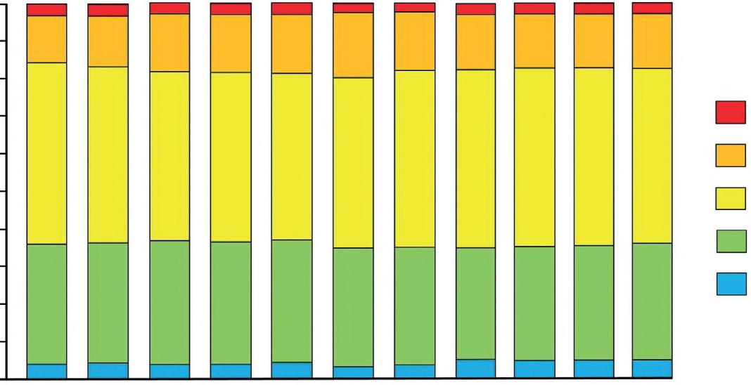
Figure 1.1 Status classification of UK surface water bodies from 2009 to 2019 as defined under the Water Framework Directive, showing little improvement over a decade. Data from JNCC (2021).
areas have both been severely impacted with a near ubiquitous loss of natural floodplain functioning.
Such statistics relating to river and floodplain degradation are repeated across other temperate areas. In Europe, fifteen years after the Water Framework Directive came into force, achieving its objectives remains a challenge; in 2012, the European Commission predicted that 47% of EU surface waters would not attain "good ecological status“ by the first cycle census date of 2015 (European Commission 2012). During the first WFD cycle, which operated from 2009 to 2015, the number of surface water bodies in “good” state only increased by 10% (van Rijswick and Backes 2015). Interestingly, of the natural systems failing to achieve good ecological status, the primary reason in 40% of cases was hydromorphological pressure. UK government statistics associated with the assessment of hydromorphological degradation suggest that the primary reason for in-channel issues is engineering modification (Figure 1.2). These figures deserve further consideration as they only reflect what has been audited. Diffuse catchment pressures are also significantly impacting watercourse form and function but were simply not considered in the Water Framework Directive assessment process.
These statistics, although stark, should not come as a surprise. From a snap-shot baseline sample of more than 5600 RHS reference sites across the UK and Isle of
Man, Purseglove (1988) noted the following key points about the then physical state of the 85 000 km of rivers and streams:
1) Very few pristine lowland channels flowing through semi-natural landscapes remained;
2) Only 13.6% of lowland sites in England and Wales, 28% in Scotland, and 10.1% in Northern Ireland had an entirely unaltered channel;
3) 3.7% of lowland sites in England and Wales, 1.7% in Scotland, and 5% in Northern Ireland were classified as having severely modified channels;
4) Land drainage, flood defence, intensive agriculture, and urban development had significantly altered the channel shape and river landscape of many sites in the lowlands;
5) Extensive reinforcement and re-sectioning of riverbanks, and channel impoundment had caused a significant reduction in habitat diversity;
6) Only 4.2% of sites below 50 m above sea level, with adjacent floodplain, had extensive wetlands, reflecting historical land drainage and current land-use pressures already affecting many river corridors.
Broad estimates are that some 80–90% of Europe’s river floodplains are now cultivated intensively compared to figures of 46% for North America (excluding northern Canada and Alaska) and 11% for African Rivers (Tockner and Stanford 2002). As such floodplain
Figure 1.2 Cause of hydromorphic degradation in the UK. Source: www. riverhabitatsurvey.org/wp-content/ uploads/2012/07/RHS.pdf
UK upland
UK lowland
England & Wales uplandScotland upland
England & Wales lowland Scotland lowland
condition and functionality has been reported as being in a critical situation across Europe (Wenger et al. 1990; Klimo and Hager 2001). Tockner and Stanford (2002) note that in Europe and North America, up to 90% of floodplains are already “cultivated” and therefore functionally extinct; this figure is likely an underestimate for British rivers, given only 3.3% of the total river network of Britain is fully connected (Jones et al. 2019). Post-war land drainage grants ceased in the 1980s, but loss of wetland has continued to the present-day and current attempts to improve watercourse form and function through restoration is having little or no measurable impact on floodplains.
It is interesting to review the figures above against the Water Framework Directive measure of river health currently being used across Europe. Entwistle et al. (2019a) used floodplain land-use data for 2017 broken down according to current water body status generating 2975 auditable units. Water bodies presently at good status were selected (n = 375), arable and horticulture covers in excess of 50% of the floodplain area on around 15% of good status water bodies, this increases to around 50% for area under improved grassland and when the two are considered together between 70 and 75% of good tatus water bodies are covered by at least 50% farmland. Around half of these water bodies are utilised over 90% by farming.
River Types: A Brief Overview
2.1
Introduction
The pattern and features of any watercourse are influenced by the river type and its sediment load, as well as by the environment through which the stream flows (its catchment). Furthermore, the form of a channel both influences and reflects the processes active in the stream system. As such, the classification of channel form can help those concerned with river management to understand the hydraulic and sediment processes acting on a watercourse and how the physical nature of the watercourse modifies local processes (Rosgen 1994). An appropriate river typology is thus a valuable tool when trying to understand and work with a watercourse and can facilitate interventions in rivers and across floodplains which work with current and restored processes to provide sustainable systems for the future. This short chapter reviews a wide variety of classifications developed for rivers.
2.2 Classification
River and floodplain systems exist on a continuum between bedrock and fully alluvial states resulting in a myriad of channel forms across the world. Many river classification systems have been developed to try to categorise watercourse types; initial attempts were primarily based on planform pattern. Straight, sinuous (often referred to as meandering), and braided patterns were distinguished by Leopold and Wolman (1957), and this typology was strongly linked to the slope-discharge character identified at the same time by Lane (1957). This tripartite division for alluvial rivers has since been further developed, and Church and Rood (1983) provided an excellent précis of this research, extending it to other channel types. It was not until the early 1990s however, that the first combined river and floodplain classification was published (Nanson and Croke 1992), recognising the interlinked functionality of these two components of the wider system.
Despite these earlier research efforts, it often remains difficult to specifically categorise a watercourse. Rosgen (1994) noted this when matching observed characteristics to those anticipated from theory and described how this poses significant problems when trying to understand and manage our river systems, while Kondolf and Downs (1996) have criticised regional classifications as providing little link to, or understanding of, river processes, river condition, or potential change trajectories. Increasingly, the understanding of river and floodplain systems from a morphological perspective has facilitated development of hierarchical classification systems (e.g. Newson 1992; Montgomery and Buffington 1993; Sear 1994; Brierley 1999). In common these classifications impart heightened understanding of the interaction between the physical template of a system, dominant processes, and the ecosystems which develop as a result of these (Newson 1992; Maddock 1999). Incorporation of the knowledge that river form and process both interact and evolve simultaneously means that a functional classification system linked to channel morphology allows the user to predict behaviour from appearance, forecast the magnitude and directional nature of driving hydraulic and sediment controls. It also provides a frame of reference against which to judge degraded systems and allows development of a common framework for understanding rivers.
2.3 Functional Classifications
As has already been noted, rivers display a diverse continuum of channel patterns and forms. This continuum results from complex processes of flow-induced sediment erosion, transport, and deposition operating within the constraints imposed by the geology and terrain of the catchment landscape. River channel typologies provide a basis for ordering physical features and processes into groups based on common characteristics associated with
these process controls. The Scottish Environmental Protection Agency’s (SEPA) 2012 morphological river typology (Figure 2.1) is based on Montgomery and Buffington’s 1993 and 1997 typologies for montane streams in North America. This has been modified by SEPA to include lower gradient channels found in the UK. The typology is process-based, i.e. channel sub-types are grouped together according to the similar morphological processes present. As such, the channels in each of the groupings have similar sensitivity to external morphological pressures such as channel modifications. Other key features are that the types are considered “natural,” i.e. they assume the channel is unmodified and that types exist at a reach scale, with individual reaches varying considerably in length. This section briefly reviews the most common fluvial classification systems currently in use and for a variety of purposes.
2.3.1 Channel Type Change with Gradient, Sedimentology and Discharge
Church (2002) differentiated alluvial channel types based on the controlling variables of discharge and
gradient (Figure 2.2). Three classic channel types were recognised: meandering, wandering, and braided. The thresholds defining shifts between these channel types were observed to be mainly dependent on the calibre of the bed material present in the channel with braiding occurring at lower gradient/discharge values than gravel systems.
2.3.2 Process-Based Classification of Montgomery and Buffington (1997)
The 1997 classification identifies eight functional river types based on discriminatory values of degree of confinement, system gradient, bedform types and spacing, bed material, reactivity, and sediment source and storage character (Table 2.1). It should be noted that the channel types and control variable limits defined in both Montgomery and Buffington and in Leopold and Wolman (above) are by no means universal, and this is illustrated in Table 2.2 which summarises several other typologies developed for alluvial channels.
Figure 2.2 Channel type change with river gradient, sedimentology, and discharge. Based upon Church (2002). © John Wiley & Sons.
Figure 2.1 River types on the sediment supply continuum.
Table 2.1 River types identified by Montgomery and Buffington (1997) along with their key attributes.
Attribute Channel type Braided Regime Pool-riffle Plane-bedStep-pool Cascade BedrockColluvial
Typical bed material VariableSand Gravel Gravel cobbleCobble boulderBouldern/a Variable
Bedform pattern Lateral oscillationMulti layeredLateral oscillationNone Vertical oscillationNone Variable Reach type ResponseResponse Response ResponseTransportTransportTransportSource
Dominant roughness elements
Dominant sediment sources
Bedforms (bars, pools) Sinuosity bedforms (dunes, ripples, bars) Banks
Fluvial Bank failure Debris flows
Fluvial Bank failure Inactive channel
Bedforms (bars, pools) Grains Large wood Sinuosity Banks
Fluvial Bank failure Inactive channel Debris flows
Grains, BanksBedforms (steps, pools) Grains Large wood Banks Grains BanksBoundaries (bed, banks) Grains Large wood
Fluvial Bank failure Debris flows
Sediment storage elements Overbank bedforms Overbank bedforms inactive channel Overbank bedforms inactive channel Overbank inactive channel
Typical slope <0.03 <0.001 0.001>
Fluvial, Hillslope Debris flows
Fluvial Hillslope Debris flows
Fluvial Hillslope Debris flows
Hillslope Debris flows
BedformsLee and stoss sides of obstructions Bed
<0.3Variable>0.2 Typical confinement UnconfinedUnconfinedUnconfined VariableConfinedConfinedConfinedConfined
Pool
Source: Modified from Montgomery and Buffington (1997). © John Wiley & Sons.
Table 2.2 Additional river types to those listed in Table 2.1, with channel slope as a discriminator.
Reference
Bisson et al. (1988)
Sullivan (1986) S < 0.01 S > 0.01 S
Grant et al. (1990)
Wood-Smith and Buffington (1996) Closed
Montgomery and Buffington (1997)
Confined valley
bedrock, boulder, gravel, sand bedrock, boulder, gravel pools, riffles, glides, runs, islands cascades, rapids, boulder bars
cascades, rapids, boulder bars GORGE STEEP HEADWATER
OCCASIONAL FLOODPLAIN POCKET
Partially confined valley
Laterally unconfined valley
BEDROCK
Figure 2.3 The River Styles typology (Source: Based on Brierley and Fryirs (2005). © John Wiley & Sons).
2.3.3 River Styles Framework
The River Styles framework (Brierley and Fryirs 2005) develops a more holistic view of fluvial systems, providing a geomorphic template upon which biophysical processes are assessed within a catchment context. The River Styles methodology reflects both river character and behaviour. As such the framework also provides a basis for assessing geomorphic river condition and recovery potential, framed in terms of evolutionary pathways for each channel type. The River Styles typology is summarised in Figure 2.3.
2.3.4 Extended River Typology
The Extended River Typology developed by Rinaldi et al. (2015) identified 22 morphological types (Figure 2.4) classified by confinement (confined, partly confined, and unconfined), dominant bed material calibre (bedrock, boulder, cobble, gravel, sand, and silt), and planform (straight-sinuous, meandering, pseudo-meandering, wandering, braided, island-braided, and anabranching).
2.3.5 Scottish Environment Protection Agency (SEPA) Classification
As mentioned above, SEPA (2012) proposed a river classification system for Scottish rivers based on and developing the Montgomery and Buffington (1997)
Figure 2.4 The Extended River typology. Source: Modified from Rinaldi et al. (2015). © John Wiley & Sons.
typology. Twelve channel systems have been distinguished by SEPA, and these have been amalgamated into six functional channel types distinguished based on their geology (bedrock or alluvial), slope, and gross sinuosity (Table 2.3). The SEPA hierarchical classification provides a useful summary of the character of each river type proposed (Table 2.4).
Table 2.3 Functional channel types defined by SEPA (2012).
Geology Slope
2.4 River Classification Framework Used in This Book
It is clear from the short review above that there is little consensus regarding a robust typology for fluvial systems. This situation reflects the difficulty in classifying across a continuum from bedrock to alluvial forms, each
SinuosityRiver type
Bedrock Any Any Bedrock, Cascade Not bedrock>0.1 Any Bedrock, Cascade
0.03> <0.1 Any Step-pool, Plane bed
0.005> <0.03<1.1
>1.1
Step-pool, Plane bed
Plane riffle, Braided, Wandering 0.001> <0.005 Any Plane riffle, Braided, Wandering 0.0005> <0.001<1.4
>1.4
Plane riffle, Braided, Wandering Active meandering
0.001> <0.005 Any Active meandering <0.0001 Any Passive meandering
Source: Based on SEPA (2012). © John Wiley & Sons.
Table 2.4 General character of functional channel types as defined by SEPA (2012).
Channel typeDescription
Bedrock channels
Most found in upland areas, though bedrock lined reaches can occur in certain lowland environments. They generally have little if any bed sediment and have limited hydraulic connection with the riparian zone. Channel gradients tend to be high, resulting in a high transport capacity but limited sediment supply. These factors, together with the high degree of bank strength, result in quite stable channels.
CascadesRestricted to upland areas with steep slopes and are characterised by disorganised bed material typically consisting of cobbles and boulders constrained by confining valley walls. The riparian zone is usually extremely small in extent and interactions with the channel are limited. The large size of bed and bank material, together with high levels of energy dissipation due to the bed roughness, dictates that the largest bed load only becomes mobile in extreme floods (circa > 25-year return interval). Bedrock outcrops are common and small pools may be present among the boulders.
Step-pool channels
Plane bed channels
Have a steep gradient and consists of large boulder splays which form discrete sediment accumulations across the channel, forming a series of “steps” which are separated by intervening pools containing finer sediment (typical spacing 1–4 channel widths). The stepped channel morphology results in zones of turbulence interspersed by more tranquil flows. As with cascade reaches, the high degree of channel roughness and large sediment on the channel bed and banks results in stable channels that respond only in very large flood events. The stream is generally confined by the valley sides, and there is limited development of terraces or floodplains.
Generally moderate gradient streams with relatively featureless gravel/cobble beds, but which include units ranging from glides, riffles, and rapids. Sediment size and channel gradients are smaller than step-pool channels and deeper pool sections tend to be lacking. The riverbed is generally armoured and thus mobilized only in larger floods. Although channels are typically stable, they are more prone to channel change than any of the preceding channel types. With relatively more frequent bedload movement they represent transitional channels between the more stable types listed above and the following more dynamic types of channel. Channels are generally straight and may be confined or unconfined by the valley sides. However, the banks – which generally comprise material resistant to lateral migration – constrain the channel from migrating laterally and developing alternate bars or riffles.
(Continued)
(Continued)
Channel typeDescription
Pool-riffle and Plane-riffle channels
Braided channels
Meandering and unconfined channel that during low flows are characterised by lateral oscillating sequences of bars, pools, and rifles, resulting from oscillations in hydraulic conditions from convergent (erosive) to divergent (depositional) flow environments (typical spacing 5–7 channel widths). The gradient of such channels is low to moderate, and the width-to-depth ratio high. The bed is predominantly gravel with occasional patches of cobbles and sand. Accumulation of sediments in gravel bars indicates increasingly transport-limited conditions, though most large floods will produce some bedload movement on an annual basis, thus reducing the stability of the channel. In such channels, interactions between the stream and the riparian zone become more obvious with extensive over-bank flood flows and wetland areas often characterising the riparian zone. The banks are typically resistant to erosion, and lateral migration of the channel is limited, resulting in relatively narrow and intermittently deep channels. Plane-riffle channels form an intermediate channel type between those of plane-bed and pool-riffle channels. They retain many of the attributes of pool-riffle channels; however, they generally have less defined pools, coarser (armoured) substrate, and less-extensive bar features. They are a common channel form in the UK, although it is unclear whether their presence is natural or whether they represent a degraded form of the pool-riffle channel. For management purposes, it is suggested that they are treated as a pool-riffle channel type.
Braided reaches can occur in a variety of settings. They are characterised by relatively high gradients (but ones that are less than upstream reaches) and/or abundant bedload. Sediment transport is usually limited under most conditions and the channel splits into several threads around instream bars. Nevertheless, poor bank strength renders them highly dynamic and channels will generally change even in relatively small flood events.
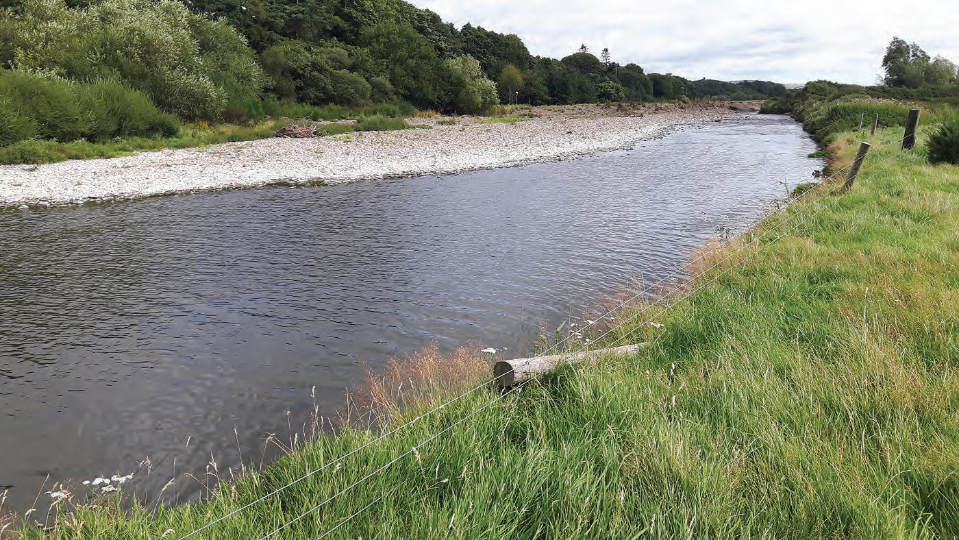
Wandering channel These reaches exhibit characteristics of braided and meandering channels and typically switch between divided and undivided channel types. Wandering channels may also be susceptible to channel avulsions during high-flow events, where the channel switches to a historical planform. Wandering channels typically occur where a reduction of bed material size and channel slope is combined with a widening of the valley floor. In sediment transport terms such reaches are bedload channels, but the number of competent transport events in any year will vary greatly according to bed material size and the associated entrainment function. Generally, they can be viewed as a transition channel type between braided and lowland meandering channels.
Low-gradient actively meandering
Groundwaterdominated channels
Unconfined low-gradient meandering channels with a bedload dominated by sand and fine gravel; hence, the channel bed has marked fine sediment accumulations that are mobile in most flood events. These occur in higher-order (i.e. typically lowland) channels exhibiting more laminar flow hydraulics, with turbulent flows being uncommon. The fine bed sediment, erodible banks, and unconfined settings means that such channels are dynamic and prone to change. They also often have extensive riparian zones and floodplains which are linked to the channel. Bars and pools may be present and are associated with bends and crossing of the meander pattern.
Groundwater-dominated rivers have low-gradient channels and are characterised by a stable flow regime, although limestone rivers with cave systems may display hydrological characteristics like freshet rivers. This stable regime is a product of the permeable catchment geology and consequent reduction in overland flow that characterises groundwater-dominated streams. Bed movement is infrequent, and sediments are predominantly transported in suspension. Typically, sediments are derived from catchment sources, although large macrophyte beds provide a source of in-stream organic detritus. As bed disturbance is infrequent, deposited sediments may remain in the gravel for extended periods, promoting the accumulation of large quantities of fine sediment. Substrate generally comprises gravels, pebbles and sands, and glides and runs are the dominant flow types. Localised areas of riffle habitat may be present particularly where woody debris is available.
Low-gradient passively meandering
These channels are typically found at lower extremities of the channel system. Generally, they flow through high-resistant materials, for instance clays and coarse deposits. They are generally sinuous; however, as the banks comprise materials that are resistant to erosion, they typically display “fixed” planform geometry. Thus, these channels are often incised and display low width-to-depth ratios. The beds typically comprise fine sedimentary materials (sands and silts), although pockets of gravel can be present, particularly in poorly formed bar deposits. These channels are typically deep, and flows are dominated by glides, although runs may be associated with meander bends. Riparian vegetation is influenced by clay soils and is often sparser than in other channel types, comprising grasses shrubbery and smaller pockets of woody growth. Primary production is strong in these channels and coupled with stable beds and extensive growth of macrophyte vegetation.
Source: Based on SEPA (2012). © John Wiley & Sons.
Table 2.4
influenced by a spatially and temporally variable set of controlling parameters. The result is that each published classification throws up issues when used as a general tool for determining a river type. The work of Leopold and Wolman (1957), for instance, concentrated only on a relatively narrow range of low to moderate energy alluvial systems, so failing to cover steep upland channel types, whereas Montgomery and Buffington (1997) and SEPA (2012) do extend their typology to steep channels and to channels where bedrock dominates over alluvium.
A key issue arises when discussing the scale over which any classification system is applied. In Scotland, pool- riffle units appear to have been subsumed into an “active meandering channel type” by SEPA (2012), whilst remaining explicit in many other classifications. Similarly, rapids and associated morphologic units become difficult to
classify. Anabranching or anastomosed channels, which are often rare across temperate regions where the majority of the classifications have been developed, are also under- represented in typologies with only the River Styles framework (Brierley and Fryirs 2005) explicitly considering this channel type, illustrating how geography has influenced the typologies.
Recognising the above and the absence of a “one size fits all” methodology, this book follows Montgomery and Buffington’s well-established (1997) fluvial framework, expanding it where necessary to include rarer, but nonetheless important, river types encountered across the UK. We use this it is fundamentally based around characteristic process controls (Table 2.5) and morphological assemblages which are summarised in Figure 2.5 and Tables 2.6 and 2.7 all of which are described in greater detail in Chapter 3.
Table 2.5 Basic character and processes operating in the channel types used in this book.
Channel type Processes
Diffuse uplandChannels are characteristically small with steep organic or fine sediment bank profiles. The channel bed may be organic or fine sediment with occasional bedrock or boulder steps separating long pools upstream. Seasonal channels may be vegetated and generally are less well defined promoting diffuse surface flow.
Bedrock Bedrock channels are most associated with mountain areas but can occur almost anywhere along a watercourse. They are morphologically robust and have a high flood competence. Valley bottom area is often narrow. Bedrock and/or boulder step pool sequences dominate with the steps acting to moderate gradient providing stable channel conditions. The pools often contain limited finer sediments due to the low-energy conditions created by the backwater effects of the steps.
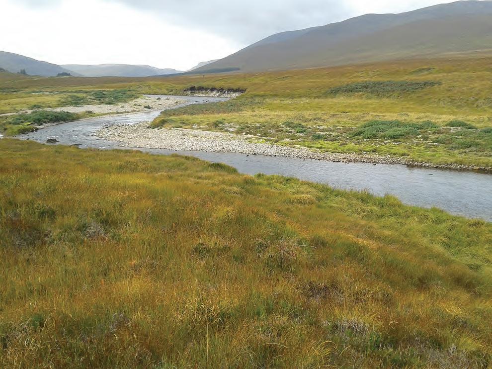
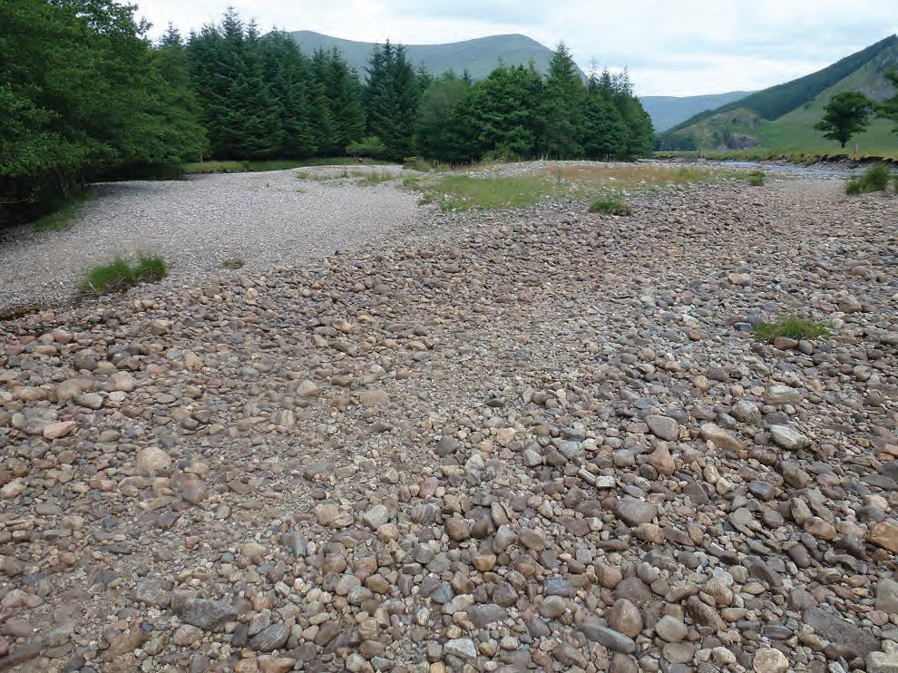
Wandering Wandering channel types are associated with upland zones. They are often found flowing across an extended valley floor in moderate-to-high gradient systems where sediment loads are high. Often, they are associated with relict fluvio-glacial valley bottom material with the river forming several channels through a mix of sediment dominated by large material rarely mobilised by the contemporary channel. They are highly responsive and dynamic rivers that can change significantly following a flood event. Depositional features are often large and floodplain connectivity is characteristically high.
AnabranchingAnabranching channels are rare but can be found across upland, hilly, and lowland zones. They develop a multi-thread channel network separated by stable islands, bars, and berms. Floodplain connectivity is often excellent and different channels are activated at different flow levels, spreading flow energy over a wide area, creating stable channel conditions. The dominant bed material is dependent on energy levels with gravels dominating in upland zones and fines prevalent. Wet woodland often develops across the floodplain further enhancing overall stability.
Active single thread
Passive single thread
This type of channel is associated with hilly terrains and some upland zones. They generally flow over a relatively low-to-moderate gradient. Sediment loads are moderate and has a large fine component. Lateral movement is progressive linked to outer bank erosion and inner bank deposition. Typical bar features include point, mid channel, and lateral bars and riffles. Occasionally, over-supply of bedload can lead to the development of a plane bed.
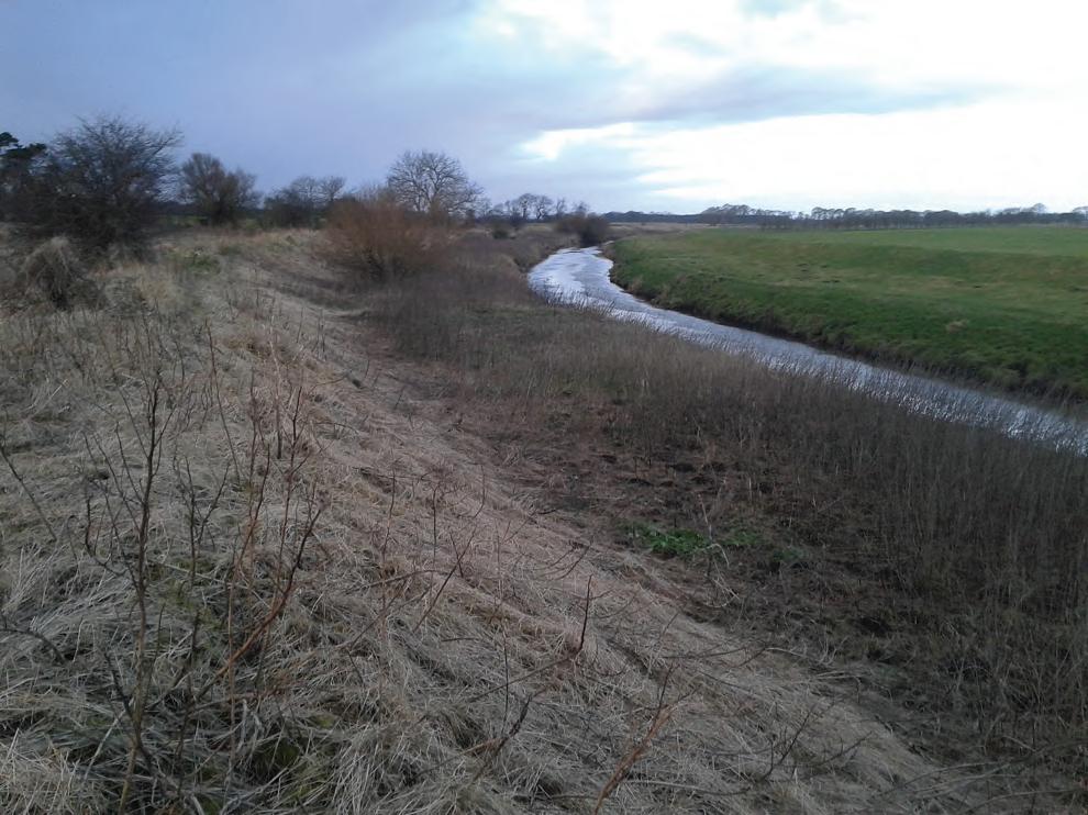
These are generally found in lowland areas flowing over low gradients. Bed material is generally dominant by finer sediment (e.g. sands and silts), and gravel features are uncommon or poorly developed if present. These channels are often heavily modified restricting lateral movement.
fine anastomosed
passive single thread
active single-thread plane bed
active single-thread pool-riffle
active single-thread pool-riffle - point bar
coarse anastomosed anabranching
Diffuse upland
Table 2.6 Typical in-channel morphologic assemblages by river type.
Bedrock cascade URRR
Bedrock controlled rapidURRR
Bedrock influenced poolURRR
Hydraulically controlled rapidCCCC
Obstruction induced rapidOOOO
Coarse sediment pool OCCC
Waterfall CORR
Plunge pool bar OCOO
Boulder cascade CCUU
Bedrock step URRR
Boulder step CCOO
Bedrock pool URRR
Isolated boulder
Lateral bar
Lee bar
boulder cobble
gravel sand silt
bedrock
Figure 2.5 Temperate river typology used in this volume.
Table 2.6 (Continued)
Morphologic
Chute channel RRUURCCC
Chute channel bar RRUU CCC
Lateral bar OOUCOCCCC
Mid-channel bar OOUCORRRO
Transverse bar O UC OOO
Alluvial pool RUUUOUUU
Riffle R CC UUUO
Rapid ROUU
Vertical eroding banks (river cliffs) RRUU OOCR
U = Ubiquitous, C = Common, O = Occasional, R = Rare, BC = Bedrock cascade, SP = Step pool channel, BCPR = Boulder and cobble pool-rapid, PBR = Plane bed rapid, B = Braided, W = Wandering, A = Anastomosed, PLR = Plane-riffle, POR = pool-riffle, PRBR = Pool-riffle point bar, IST = Inactive single thread.
Table 2.7 Typical valley bottom morphologic assemblages by river type.
Morphologic unit
Silt/Boulder berm RRRCCCCC
Boulder splay ROOO
Slumped valley side depositsOOOORRROOOR
Terrace ROOOOOOOO
Inactive floodplain RCCCCCCU
Active floodplain RUUOOOO
Inset berm ROOOOCCCC
Palaeo-channel UCOOOO
Avulsion driven cut-off UC OOO
Chute cut-off channel UC OOO
Gravel splay RUU OOO
U = Ubiquitous, C = Common, O = Occasional, R = Rare, BC = Bedrock cascade, SP = Step pool channel, BCPR = Boulder and cobble pool-rapid, PBR = Plane bed rapid, B = Braided, W = Wandering, A = Anastomosed, PLR = Plane-riffle, POR = pool-riffle, PRBR = Pool-riffle point bar, IST = Inactive single thread.
River Types: Observations and Theory
This chapter contains succinct descriptions of the most common morphologic units associated with the river types discussed earlier. These are accompanied by aerial and oblique imagery illustrating each unit. When using this chapter, it should be noted that the classification system adopted is artificial. Rivers exist across a continuum rather than fitting neatly into discrete channel types and shorter reaches of larger channel types may exhibit features and dynamics more characteristic of other channel types in the classification. As a practical guide, the reader is advised to look at the range of features present which may span several river types and to use Tables 2.6 and 2.7 to best classify any reach under investigation. The general sediment character of the channel types is summarised throughout, together with an indication of general confinement linked to floodplain development. System activity and morphologic
variability suggest that wandering channel types are most sensitive to external variables and exhibit the most rapid morphologic change. Higher gradient and more confined channel types have a greater variety of morphologic units and often display a better-connected valley bottom/floodplain less impacted by human intervention and management.
Figure 3.1 illustrates the potential routes for change based on the principal channel types reviewed in this chapter. At present, most channel types are robust and have not altered significantly in the historic past. There is, however, evidence of channel-type sensitivity for the pool-riffle, plane bed-riffle, wandering systems. In addition, there are several wandering channel types that are developing into more stable well-vegetated anastomosed systems where valley bottom management facilitates natural vegetation succession.
Bedrock influenced cascade pool-rapid
Figure 3.1 and the following sections in Chapter 3 illustrate that channel type information is broadly organised in the downstream direction, beginning with poorly differentiated diffuse upland channels before amalgamating and steepening to form bedrock channels and bedrock influenced step-pool channels. As the bedrock influence declines, pool-rapid channels begin to dominate before they too give way to lower-
3.1 Diffuse Upland Channels
Key Characteristics
gradient less-confined wandering, plane-bed and riffle-pool channels exhibiting in-channel and floodplain morphologic units strongly associated with the degree of sinuosity of the channel. Upland and lowland anastomosing channels are also reviewed together with passive systems. For simplicity, each channel is introduced with a brief bullet-point summary of its key characteristics.
● Low-gradient, low-energy stable environment
● Common across moorland
● Flow often diffuse
● Pools and glides common where flows coalesce and channel is better defined
● Small bedrock/boulder outcrops control local gradient
● Bed material most often relict glacial sediment
● Capacity for adjustment is low
3.1.1
Background Research on Diffuse
Upland Channels
Channel head morphological units are the farthest upstream-most element for water flow and sediment transport in the fluvial system. Channel heads are initiated in locations where surface or subsurface flow concentrates and persists long enough to create a channel head. The loci of channel heads may vary through time in response to changes in water and sediment supply. They exhibit definable banks (Montgomery and Dietrich 1988, 1989) and represent the transition from diffusive hillslope to channel processes (Dietrich and Dunne 1993). The identification of some channel heads can be subjective due to their diffuse nature, whilst others are easily identifiable as a head-cut erosion feature (Dietrich and Dunne 1993;
Montgomery and Dietrich 1994). The channel head does not always coincide with the stream head (Figure 3.2), which is the furthest upstream-most extent of perennial flow within a river (Jaeger et al. 2007; Shaw 2016). Channel heads typically occur within hillslope concavities that facilitate water and sediment accumulation, delivered via sheetwash, although they can also occur on planar slopes (Wohl 2018). The channel downstream from the head may contain bedforms, armoured bed surface sediment, and show evidence of high-water marks (Dietrich and Dunne 1993).
Channel heads are important as follows:
1) They are the formal start of the channel network and represent the location of process thresholds between hillslope and fluvial process domains (Montgomery 1999);
2) The location and character of channel heads reflect the interacting processes occurring in the drainage area upstream of their locations (Wohl 2018);
3) Stream ordering systems (e.g. Strahler 1952) rely on the correct identification of channel heads to delineate first-order streams. Stream ordering is important for a variety of reasons, including habitat mapping, and nutrient modelling;
4) Channel heads are important in a regulatory context, ephemeral erosional features that may have a defined channel bank, are not always included as forming part of the drainage network in the United States, for example (Wohl 2018).
3.1.1.1 Processes: Water and Sediment
Wohl (2018) highlights overland flow to be a key process that delivers water into channel heads. This can take two forms - either infiltration excess overland flow (Horton 1945) or saturation excess overland flow. The former tends to occur when the rainfall intensity is greater than the infiltration rate of the soil and is often enhanced by compaction of the surface and is more common in semiarid catchments (Abrahams et al. 1986). In the UK, saturation excess overland flow is more common in the uplands (e.g. Holden and Burt 2003a, b). Emergence of water at the slope surface is dependent upon factors such
as the position of the water table, the location of topographic breaks, permeability contrasts, geologic structures, and the presence of frozen soil at depth. Saturation overland flow initially tends to occur towards the bottom of a hillslope and then expands upslope (Dunne 1978; Holden and Burt 2003b).
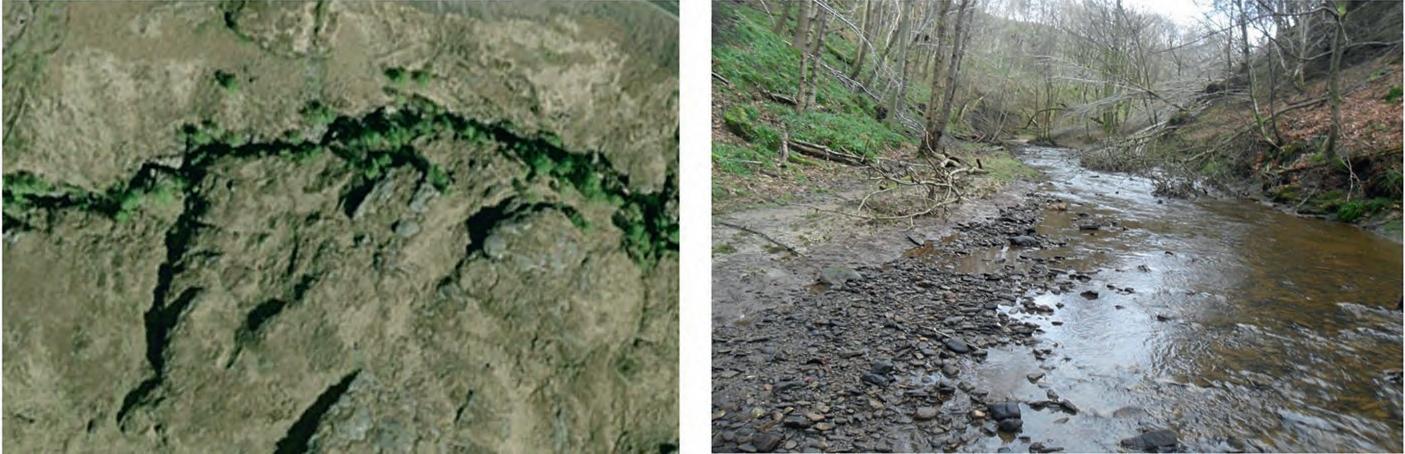
Water may also flow through the sub-surface, through soil pores downslope in the unsaturated zone, or as groundwater in the saturated zone beneath. Water may also flow through macropores (Holden 2009) and larger pipes (Figure 3.3). In the UK, pipes have been reported to measure between a few centimetres to hundreds of metres in length, and from a few centimetres to 0.7 metres in diameter (Anderson and Burt 1982; Jones 1982). Pipes have been reported at depths of between 5 and 80 cm from the surface (Jones 1982), and often form at the interface between the soil and a less-permeable layer beneath, e.g. till (Figure 3.3a). Pipes are known to be responsible for contributing up to nearly half of the discharge during a flood event (Jones 2010).
Rain-splash is an important process in the detachment of sediment particles from the slope surface, which may subsequently be mobilised by overland flow. However, mass movements (slides and flows) play a more important role in the transfer of the majority of sediment to or along low-order streams and can occur frequently in many high relief settings (Jacobson et al. 1993; Guthrie and Evans 2007), and can influence channel head position and morphology. Movement of individual clasts through colluvial processes and accumulation in the channel head zone at the foot of a slope occurs through a process known as “dry ravel” (Rice 1982). In moderate-to-steep topography, both colluvial and fluvial channels may co-exist. The sediment transport processes in colluvial channels may include non-Newtonian flow whereby sediment is mobilised as a debris flow (Coussot and Meunier 1994).
3.1.1.2 Predicting and Mapping Channel Head Locations
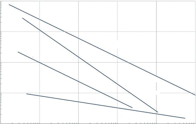
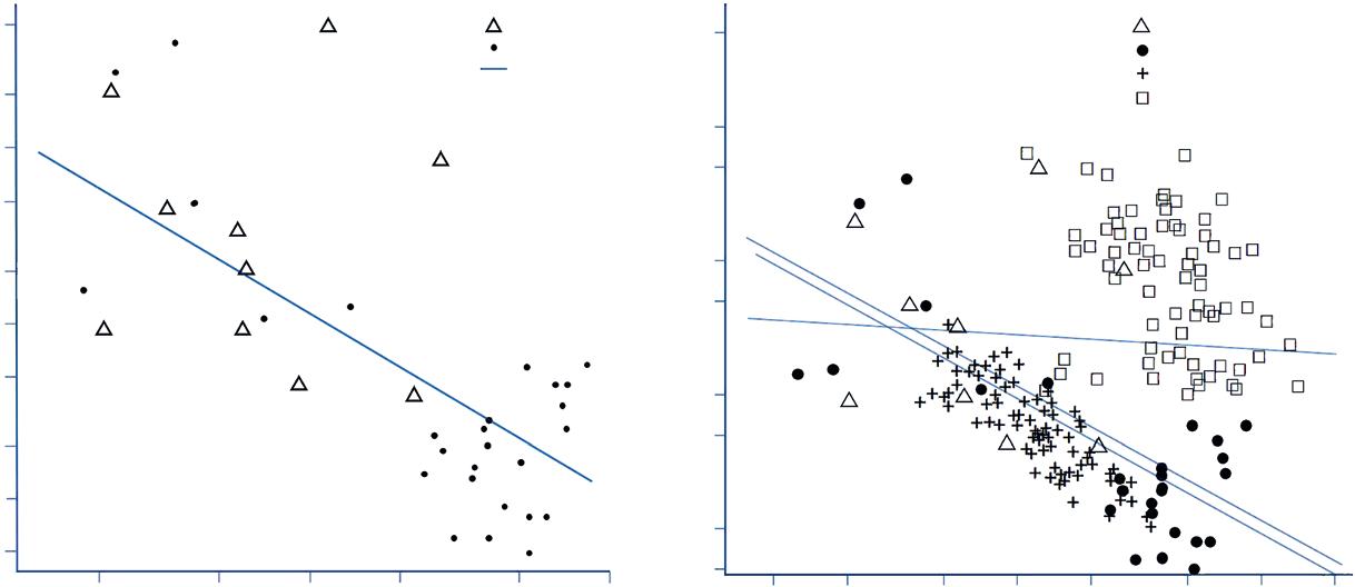
Much of the research into channel heads has been devoted to the mapping and prediction of channel head locations (see Wohl 2018 for a review). The location of channel heads is of significance for hydrological modelling of river networks, hillslopes, and landscape evolution. Identifying channel head loci is also important for catchment management purposes, for water resources and for river network jurisdiction (Wohl 2018). For work conducted in western Colorado, significant differences were found in the relationship between channel gradient and contributing catchment area upstream for surface and subsurface sites (Figure 3.4a) and no significant
Figure 3.2 Stream head, Thinhope Burn, South Tyne, UK.
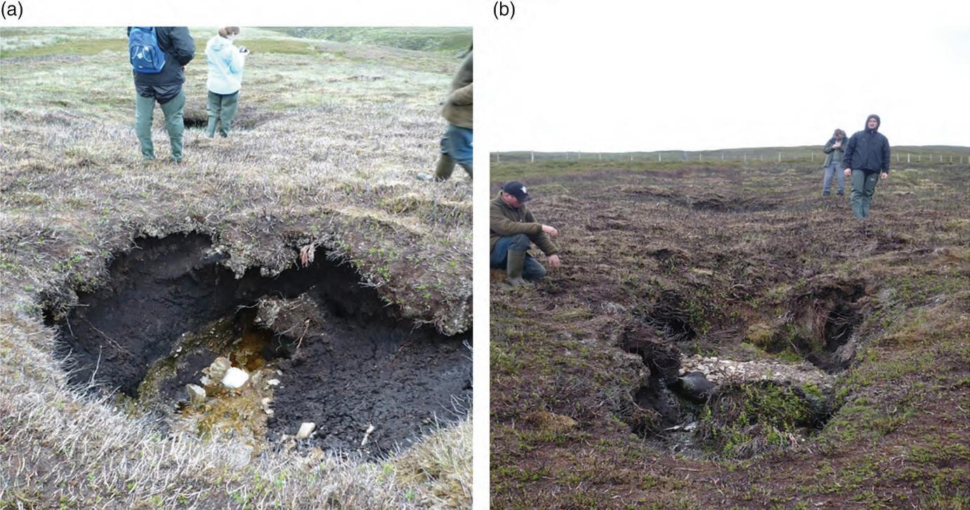
Figure 3.3 Subsurface hydrology in the headwaters of Thinhope Burn catchment, UK. (a) Collapsed soil pipe showing peat overlaying the lighter coloured till beneath, (b) recently collapsed roof of soil pipe, following an extreme event in summer 2007 reported in Milan (2012).
differences in area-slope relationships for a wider range of sites (Figure 3.4b). Where surface run off dominates, channel head locations may be predicted with some accuracy. However, locations are much less predictable where subsurface drainage dominates head formation.
3.1.2 Valley Bottom Morphology
3.1.2.1 Moorland Seepage Zone
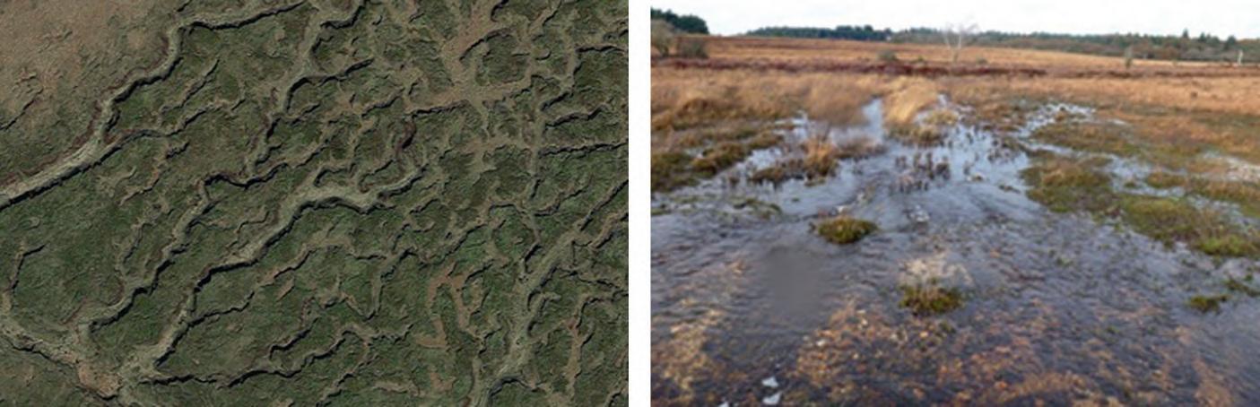
This zone typically occurs as wide, shallow-sloped flow convergence areas across upland moorland characterised by a variety of Sphagnum species, sedge, and grass communities mildly dissected by numerous seepage
Figure 3.4 (a) Relationships between catchment areas and local channel head slope with surface (black circles) or subsurface (white triangles) initiation. The solid line is the regression for the whole data set (r2 = 0.525) (b) relationship between catchment area and channel head slope for multiple sites, with the relationships for Western Colorado surface (black circles), subsurface (white triangles), and for all Western Colorado sites are indicated by the solid regression lines (Source: Adapted from Wohl (2018). © John Wiley & Sons).
channels (Figure 3.5). Sediments are typically organic or fine inorganic, including peat. The flow network converges and steepens, often flowing abruptly into an upland confined headwater channel type at a head-cut waterfall.
3.1.3 In-channel Morphology
Channels are formed through peat or across areas of glacial and fluvio-glacial infill and are characteristically small (<0.5 m wide, <0.5 m to bank top) with steep
3.1 iiifse
organic or fine sediment bank profiles. The channel bed may be organic or fine sediment with occasional bedrock or boulder steps with long pools upstream. Seasonal channels may be vegetated and generally are less welldefined promoting diffuse surface flow.
3.1.3.1
Bedrock Step
Exposed area of bedrock in the bed of the channel creating a vertical or near vertical drop in the flow profile (Figure 3.6). They occur randomly linked to the local geological variability.
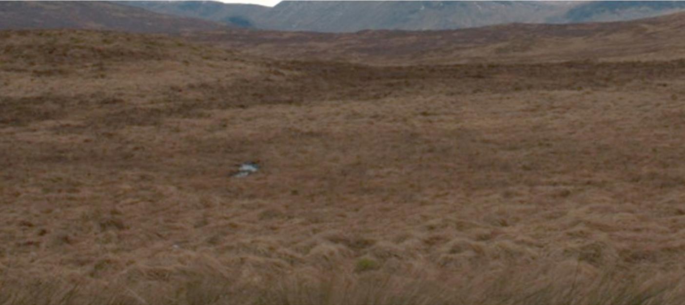
Figure 3.5 Moorland seepage zone on the Lagrae Burn, a tributary of the River Nith near Kirkconnell, Scotland.
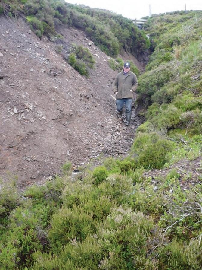
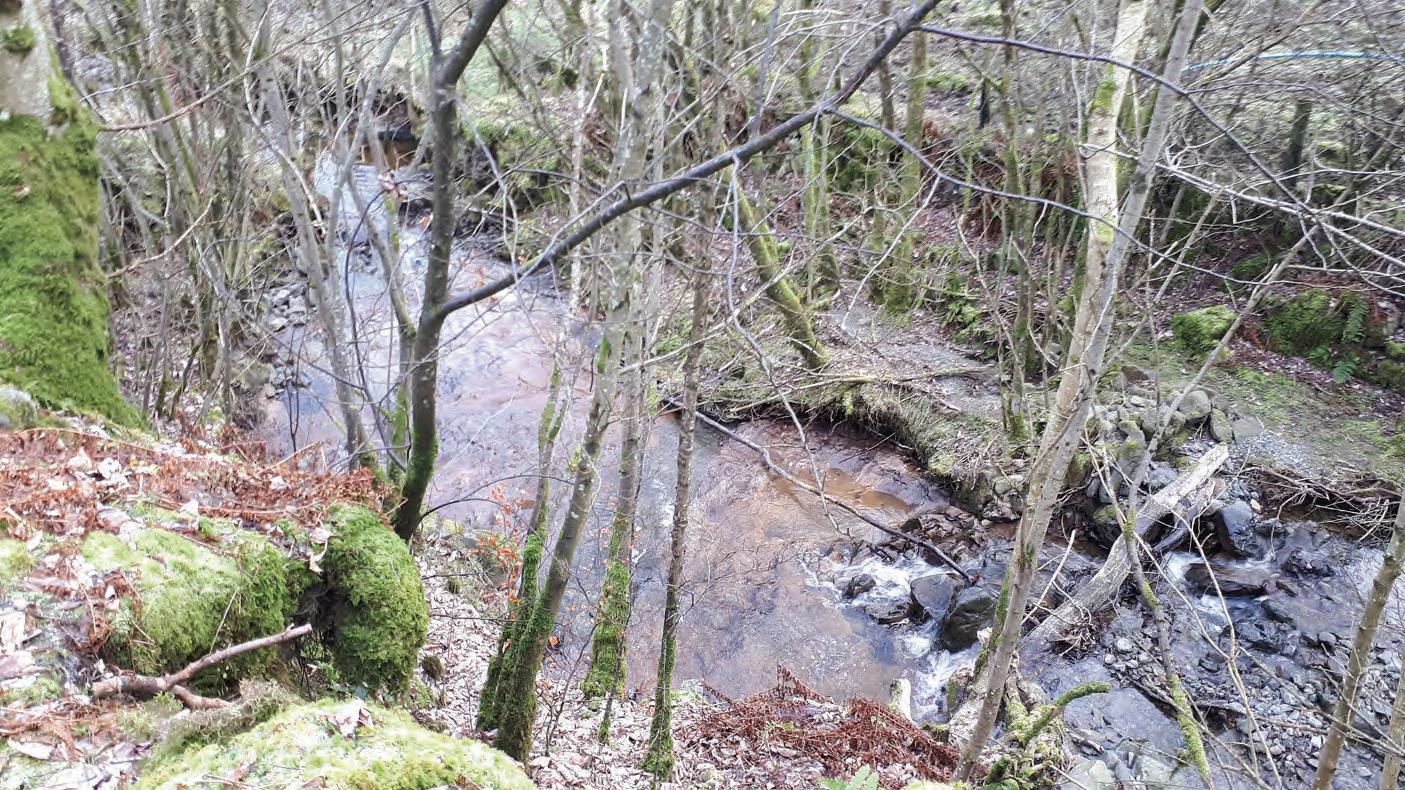
Figure 3.6 Bedrock step on the upper River Wharfe, Buckden, North Yorkshire.
3.1.3.2 Boulder Step
Most commonly a single boulder extending across the channel and/or, less frequently, multiple smaller clasts that often become interlocked to form a coherent structure (Figure 3.7).
3.1.3.3 Pool
The step structure impounds water in the upstream channel reach to form a uniform glide/pool area largely free of sediment due to a limited local supply (Figure 3.8).
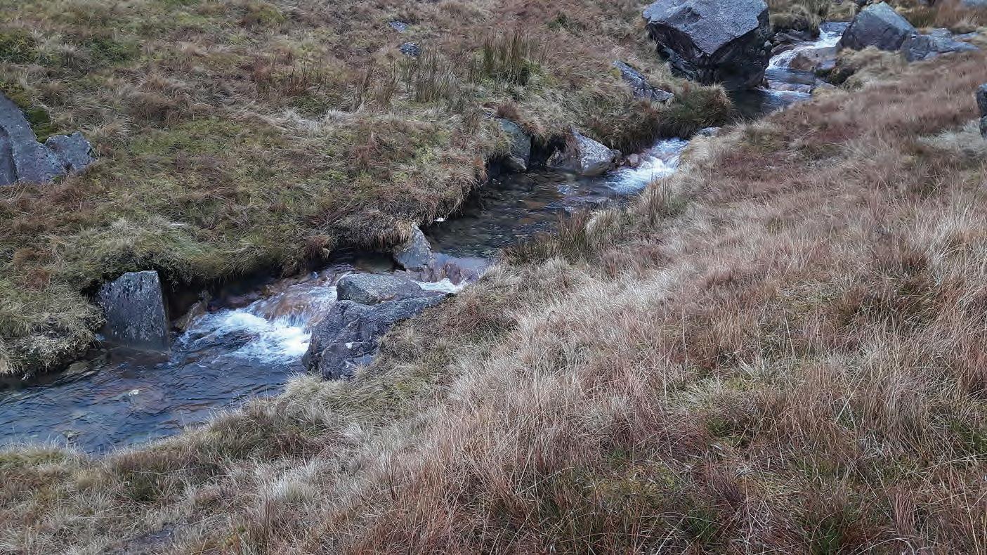
Figure 3.7 Boulder step reach of the Church Beck, above Coniston, Lake District, England.
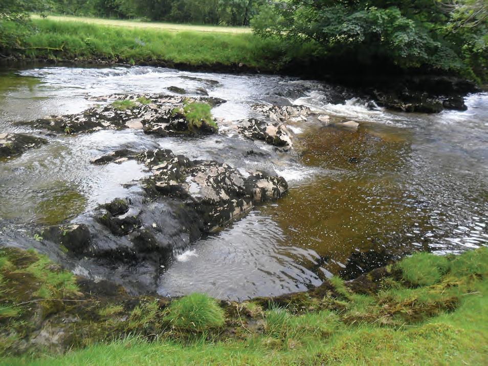
Figure 3.8 Bedrock pool reach on the Brockle Beck, which flows into Derwentwater, Lake District, England.
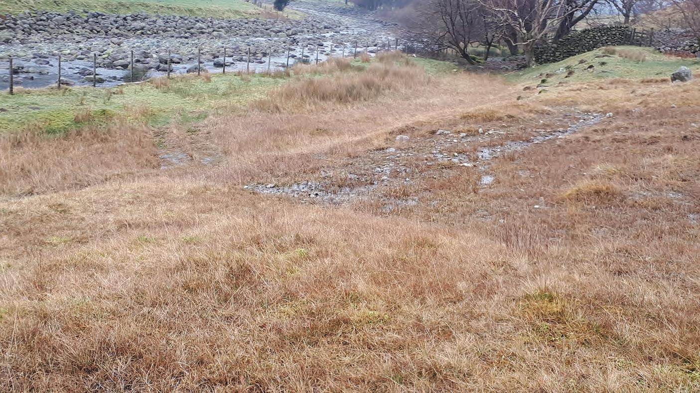
3.1.3.4 Overland Flow Channel
Areas subject to seasonal drying display a diffuse network of first- order channels with a shallow,
wide profile flowing over a vegetated surface (Figure 3.9).
3.2 Bedrock Channels:
Background Research
Key Characteristics
● Generally, a very high-energy environment but quite stable due to erosive resistance of the channel.
● Common in upland areas.
● Also seen where resistant bedrock outcrops in lowland areas (e.g. gorges).
● Often very steep (particularly cascade reaches) 8–30%.
● Acts to transfer coarse sediment downstream, very little, if any, sand and gravel bed material present.
● Frequent exposed rock on the channel bed and banks.
● Cascade channels are dominated by large cobbles and boulders on the channel bed and banks.
● Limited floodplain.
Figure 3.9 Overland flow channel, Stonethwaite Beck, Borrowdale, Lake District, England.