The Publisher and Editors cannot be held responsible for errors or any consequences arising from the use of information contained in this journal; the views and opinions expressed do not necessarily re ect those of the Publisher and Editors, neither does the publication of advertisements constitute any endorsement by the Publisher and Editors of the products advertised.
Journal Customer Services
For ordering information, claims and any enquiry concerning your journal subscription please go to www.wileycustomerhelp .com/ask or contact your nearest of ce.
Americas
E: cs-journals@wiley.com
T: +1 781 388 8598 or +1 800 835 6770 (toll free in the USA & Canada)
Europe, Middle East and Africa
E: cs-journals@wiley.com
T: +44 (0)1865 778315
Asia Paci c E: cs-journals@wiley.com
T: +65 6511 8000
Japan (for Japanesespeaking support)
E: cs-japan@wiley.com
T: +65 6511 8010 or 005 316 50 480 (toll-free)
Visit our Online Customer Help available in 7 languages at www.wileycustomerhelp .com/ask
Print ISSN: 0003-8504
Online ISSN: 1554-2769
Prices are for six issues and include postage and handling charges. Individualrate subscriptions must be paid by personal cheque or credit card. Individual-rate subscriptions may not be resold or used as library copies.
All prices are subject to change without notice.
Identi cation Statement
Periodicals Postage paid at Rahway, NJ 07065. Air freight and mailing in the USA by Mercury Media Processing, 1850 Elizabeth Avenue, Suite C, Rahway, NJ 07065, USA.
USA Postmaster
Please send address changes to Architectural Design, John Wiley & Sons Inc., c/o The Sheridan Press, PO Box 465, Hanover, PA 17331, USA
Rights and Permissions
Requests to the Publisher should be addressed to: Permissions Department
John Wiley & Sons Ltd The Atrium Southern Gate Chichester West Sussex PO19 8SQ UK
F: +44 (0)1243 770 620
E: Permissions@wiley.com
All Rights Reserved. No part of this publication may be reproduced, stored in a retrieval system or transmitted in any form or by any means, electronic, mechanical, photocopying, recording, scanning or otherwise, except under the terms of the Copyright, Designs and Patents Act 1988 or under the terms of a licence issued by the Copyright Licensing Agency Ltd, Barnard’s Inn, 86 Fetter Lane, London EC4A 1EN, UK, without the permission in writing of the Publisher.
Subscribe to 1 2 is published bimonthly and is available to purchase on both a subscription basis and as individual volumes at the following prices.
Prices
Individual copies: £29.99 / US$45.00
Individual issues on 2 App for iPad: £9.99 / US$13.99
Mailing fees for print may apply
Annual Subscription Rates
Student: £90 / US$137 print only
Personal: £136 / US$215 print and iPad access
Institutional: £310 / US$580 print or online
Institutional: £388 / US$725 combined print and online
6-issue subscription on 2 App for iPad: £44.99 / US$64.99
Ed Wall is Academic Portfolio Lead for Landscape Architecture and Urbanism at the University of Greenwich in London. He is also a visiting professor in the Department of Architecture and Urban Studies at the Polytechnic University of Milan, and in 2017 was City of Vienna Visiting Professor for urban culture, public space and the future – urban equity and the global agenda at the Interdisciplinary Centre for Urban Culture and Public Space (SKuOR) at the Vienna University of Technology (TU Wien). He completed a PhD in the Cities Programme at the London School of Economics (LSE), exploring relations between different ways that public spaces are made and remade in the context of London’s urban development, and he trained in landscape architecture at Manchester Metropolitan University, and in urban design at the City College of New York. His work focuses on processes of landscapes and cities – with a particular emphasis on the production of collective and public spaces. Through critical research and speculative design practice he explores the uneven relations through which contemporary landscapes are constituted and the issues at stake as they are constructed.
Recent publications include Landscape and Agency: Critical Essays (with Tim Waterman, published by Routledge, 2017), and he is currently co-editing two further collections of essays, focusing on landscape citizenships, with colleagues at the Bartlett School of Architecture, University College London (UCL) and the University of Toronto, and unsettled urban routines, temporalities and contestations, with colleagues at TU Wien. He has also written widely, including for the OASE Journal of Architecture; Landscape: The Journal of the Landscape Institute; and Topos. He is co-founder and editor of Testing-Ground: Journal of Landscapes, Cities and Territories, a publication that brings established artists, designers and writers together with younger academics to debate contemporary landscape concerns.
Ed has co-organised several cross-institutional interdisciplinary conferences including ‘Landscape and Critical Agency’ at the Bartlett School of Architecture (2012); ‘Unsettled: Urban Routines, Temporalities and Contestations’ at TU Wien (2017); ‘Design Agency within Earth Systems’ at the Architectural Association (AA) in London (2018); and ‘Landscape Citizenships’ at Conway Hall (2018), also in London. He has also presented his research internationally, at the Radcliffe Institute for Advanced Study at Harvard University, and at Columbia University, Beijing Forestry University and the University of Edinburgh, among others.
Ed is the founder of Project Studio, a collaborative design platform for exploring processes of landscapes and cities. Experimental projects, such as Park Works, Lubricity and Roaming Forest, have been exhibited at the Van Alen Institute in New York; International Biennale of Landscape Urbanism in Bat Yam, Israel; Des Moines Art Center in Iowa; and the Building Centre, Garden Museum, Stephen Lawrence Gallery, Architecture Foundation and Royal Academy of Arts in London, and published internationally in the Guardian, Architects’ Journal, Building Design, Abitare and ArchDaily.
INTRODUCTION
ED WALL
LES PAYSAGISTES EXPANDING, PRODUCING, CONTESTED FIELDS OF LANDSCAPE
The landscape is never inert, people engage with it, re-work it, appropriate it and contest it.
—
Barbara Bender, Landscape: Politics and Perspectives, 19931
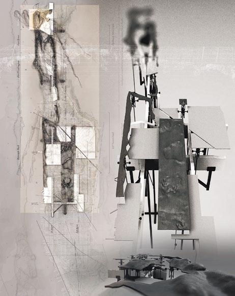
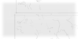
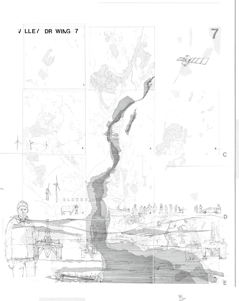
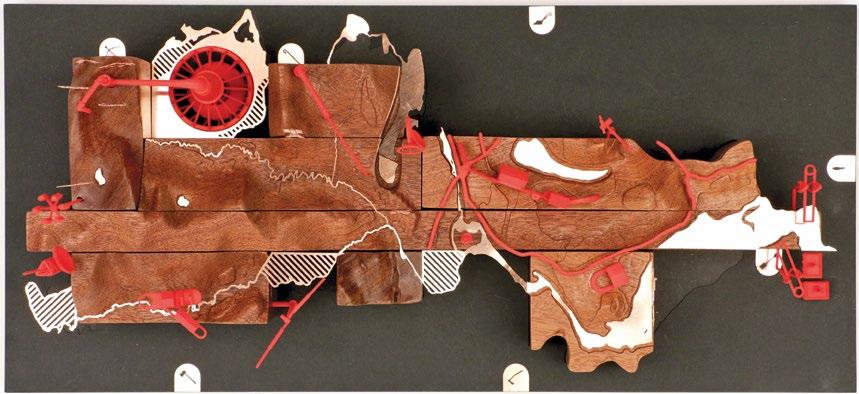
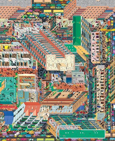
Ed Wall / Project Studio, Drawing 7, Valley Project, 2019
The complex of interactions across the valley are complicated by contemporary technologies, landscape processes and work practices. Drawing 7 represents these entangled relations, including historical accounts and future imaginaries, across a valley region in the north of Scotland.
From the perspective of architectural design, the framing of landscapes tends towards physical geographies that have the potential to be reimagined, and visual representations that are constructed to explore and design them. Material territories are surveyed, drawn, reconsidered and reconstructed. Landscape drawings (including photography, visualisations and animations) are the means through which landscape futures are claimed and projected, and in the contemporary Western world they frequently adopt ego-centred scenographic traditions of landscape painting. This issue of 2, however, presents many other relations of landscape. In the opening essay to her book Landscape: Politics and Perspectives (1993), the anthropologist Barbara Bender reminds us that ‘Landscapes are created by people – through their experience and engagement with the world around them’.2 This issue highlights the work of a group of geographers and artists, architects and theorists – and of course, landscape architects – and their ways of making and remaking what Bender terms ‘other landscapes’.3 These complex and often con icting landscapes are entanglements of places, subjectivities, actions and bodies – migrant, citizen, traveller, resident and indigenous populations.
From house bands to murals and from industrial sites to imagined futures, landscapes are created, transformed and frequently contested as people situate themselves in their surroundings and in relation to each other. Practices of working, commuting, eating, drawing, imagining and dismantling, in addition to more disruptive occupations, resistances and strikes, all have the potential to produce landscapes. But while it can be argued that everyone creates landscapes, there are some individuals, communities and organisations that actively engage in relations of landscape to further its agency: exposing political agendas behind territorial claims; working with contradictions in border territories; addressing ecological challenges of climate change; exploring potentials of other worlds; critiquing processes of urbanisation; and experimenting with visual representations. These engagements are less focused on disciplinary claims to landscape as tightly de ned practices of art, architecture, geography or ecology, and more part of an expanding eld that is contesting, reframing and producing. Landscape is often described as a ‘way of seeing’,4 as Denis Cosgrove quotes the art critic John Berger – a Western tradition of visually dominated perspectives of the land. But as this 2 reveals, landscape is not just a visual medium; it can also be understood as ways of thinking, ways of working and ways of being. If we are all landscapes – material forms of daily traditions inseparable from designs for the future –then seeking to make explicit the many ways from which landscapes are constituted becomes essential.
Relations Between
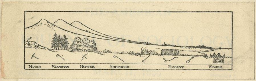
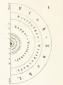
To investigate relations of landscape is to question practices of how landscapes are produced, imagined, situated and lived. Patrick Geddes’s Valley Section drawings, longitudinal sections that typically follow the course of a river from its source to the sea that were rst published in 1909, remain a useful point of departure in understanding work practices and their associated tools in relation to different physical geographies. While historical accounts of Geddes’s work are well documented, in particular through the research of historian Volker M Welter,5 closer readings of his many Valley Section drawings in the contexts of contemporary urbanisation and an expanding frame of landscape, highlight the potential of new and critical perspectives.
In his 1909 Valley Section, Geddes presents the regional relations between settlements of cities and villages, productive landscapes of agricultural elds and forestry, and resources from shing and mining. Subsequent drawings describe relations along streets, include different occupations and tools, and are situated within speci c geographic contexts, such as Edinburgh. Geddes experimented over decades with different combinations, categorisations and representations. He approached his Valley Section drawings as Christina Leigh Geros (see her article on pp 14–21 of this issue) considers landscape architecture, as an ecology of practices.
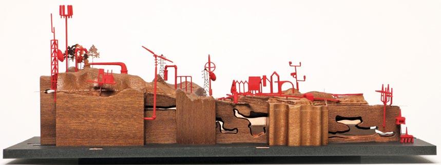
Ed Wall and Emma Colthurst / Project Studio, Model 1, Valley Project, 2019
The Valley Project critically unpacks Geddes’s model within the context of contemporary urbanisation to explore new landscapes, varying practices of work and their associated tools, in addition to the products of the landscape and the potential of other forms of representation. Model 1 relates the conditions of making and the tastes of whisky to a speci c contemporary section across Scotland.
Patrick Geddes, Valley Section, 1909
opposite top: Patrick Geddes studied botany and later applied his understanding of plants and animals to develop a regional model that he named the Valley Section. What became a series of investigations illustrates the complex relations between social occupations of humans and the environments in which these are practised.
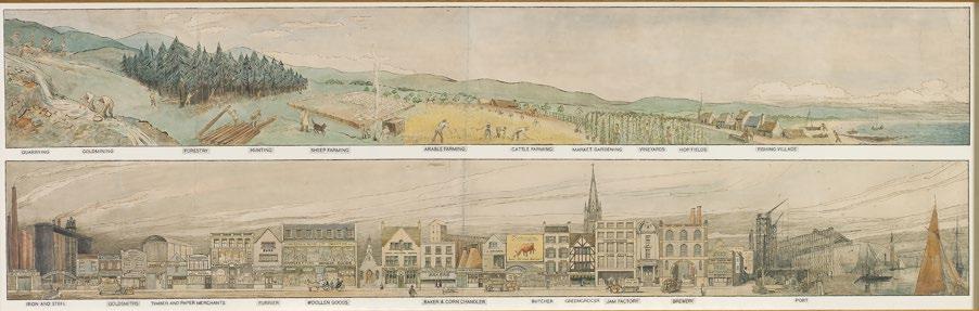
Patrick Geddes, Valley Section, 1925
opposite bottom: Geddes developed many different Valley Section drawings, that included contrasting landscape types, such as the high street, and varying occupations and tools. The illustration here shows social types in their native habitats and in their parallel urban manifestations.
The contributors to this issue seek to answer a number of recurring questions that re ect the trajectory of Geddes’s investigation: What are the contemporary and future landscape relations that necessitate greater scrutiny? What are the changing techniques and emergent technologies that inform them? How can we understand these landscapes as always in process? What is at stake as they are produced? How can we work with the partial knowledge of landscapes that are constantly made and remade?
Latest Landscapes
In recent decades, changing processes of urbanisation have transformed landscapes around the world and reframed our conceptualisation of them. New infrastructures, contrasting approaches to their provision and varying patterns of growth have further complicated Geddes’s regional adjacencies of mountains to forests, to elds, to cities, to oceans. As informal settlements intersect with river systems, as governments reinforce national borders, and as design practices invent new urban forms to address growing ecological crises, rereading the physical environments of the past and questioning those of the future has become a necessary task. Tensions between landscape relations, processes of growth, decay, building, occupation, abandonment and erosion require closer critique. Such concerns are the focus of both Luis Callejas and Charlotte Hansson, who examine a series of disputed island territories (pp 46–53), and the discussion of design projects confronting climate crises described by Kate Orff (pp 94–9). The role of design is core in imagining future forms of landscapes, whether as speculative design narratives in Tiago Torres-Campos’s exploration of Manhattan’s geological conditions (pp 38–45) or the experimental pedagogies of Advanced Landscape and Urbanism at the University of Greenwich in London (pp 54–61).
Technological Practices
Historical work practices – miner, woodsman, hunter, shepherd, peasant, sher – and their associated tools have also evolved. Since Geddes’s investigations of the Valley Section, different technologies have transformed ways, places and routines of work. Flexible working patterns and digital devices that uncouple social activities from speci c landscape types, and blur online and physical realms, have become new landscape tools (see Tim Waterman’s article on pp 80–87). Machines for observing and recording, satellites communicating from earth’s orbit, and the means to survey street spaces and activities also continue to be advanced. Contrasting ways of reading landscapes are the focus of Richard Mosse’s photography, which, as on the cover of this 2, highlights the lived experience of refugees through the use of a thermal video camera. Different methods are also key to collaborations across disciplines, such as the aerial photography of Alex McLean and corresponding collages constructed by James Corner, who read the Jefferson grid from the road. The resultant publication, Taking Measures Across the American Landscape (1996),6 provides a point of re ection for Corner in his description in this issue of different measures of contemporary urban landscapes (pp 88–93). Infrastructural forms and technologies are also the focus of DESIGN EARTH (Rania Ghosn and El Hadi Jazairy) who visualise narratives of waste infrastructures through their Trash Peaks project (pp 32–7) to create new understandings and approaches to landscape.
In Process
Growth, decay, production and waste are bound up with all landscapes. As Bender explains, and as illustrated by Archigram in their section drawings of Instant City (1970), they are always ‘in process of construction and reconstruction’.7 In the context of less tangible relations between people and their surroundings, and slower-moving
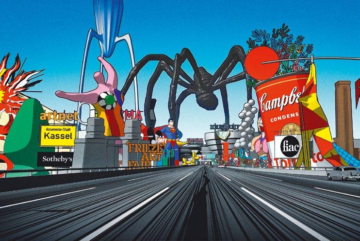
H5, My Generation, 2018
My Generation is a short animated lm by H5, a creative studio based in Paris. Building on the acclaim of their earlier short lm Logorama, an animation that critiqued consumer culture and its impact on global warming, in My Generation H5 address landscapes of nance, politics, sex, religion, sport, data and art culture in the context of growing populist rhetoric.
changes such as localised weathering and impacts of global warming, as investigated, for example, by Studio Folder in the Italian Alps, landscapes can seem frustratingly illusive and impossible to represent. However, the geographer Doreen Massey reminds us that in addition to a conceptual understanding of landscapes as processes, we also encounter them as material objects: ‘Of course, in the practical conduct of the world we do encounter “entities”, there is on occasion harmony and balance; there are (temporary) stabilisations; there are territories and borders’.8 Registering the physicality of landscapes in the context of the nonhuman processes from which they are produced, and human practices by which they are constituted, brings complex considerations of landscape into close proximity. The quarry situated in the mountains, the minerals extracted, the individual workers, the corporate owners and the tools employed are inextricably connected with planned factory towns, pollution of local rivers, commodities consumed and landscapes of waste and reuse. Such messy associations, further complicated by our individual and collective experiences, de ne all landscapes, as Harry Bix describes of East Anglia Records’ interconnectedness of quotidian musical performances, drawings and poetry (pp 62–5), and as Gareth Doherty and Pol Fité Matamoros (pp 100–105) and Teddy Cruz and Fonna Forman (pp 114–19) illustrate in their research of border landscapes.
Uneven Sections
The equal division of the Geddes Valley Sections across landscape types and their associated occupations fails to represent uneven processes of production that result
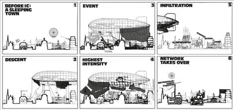
Peter Cook, Instant City Airships, sequence of effect on a typical English town, 1970
This series of sectional drawings of Instant City emphasises both the temporality of the proposal as well as its longer-term impact on the potential to make. Comprising many drawings and models by the avant-garde architecture group Archigram, the project works across a range of scales demonstrating site-speci c considerations from architectural forms to regional- and national-scale networks.
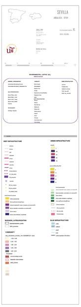
Valentina Galiulo, Protocol map of Environmental Justice (Seville), TELLme project, Department of Architecture and Urban Studies, Polytechnic University of Milan, 2019
The complexity of creating mapping systems that are suf ciently adaptable for different geographic contexts while adequately consistent to provide for comparison is at the core of the EU-funded TELLme project led by Professor Antonella Contin at the Polytechnic University of Milan. In this speci c map, the concept of environmental justice is combined with social cohesion, referring to the people who inhabit urban space and the relationships established between individuals and the territory.
in intensities of investment in some areas and lack of infrastructure in others. Furthermore, the absence of certain work activities and the invisibility of landowners, planners, developers and politicians, individuals and organisations that make political decisions and inform economic agendas, ignore the imbalances of power across contemporary landscapes. While the sectional projections employed in Geddes’s drawings offer a relational understanding of the region, their diagrammatic qualities also deny the subtleties and complexities of landscapes in change. Neither do they represent the unequal distribution of risks endured by some people and the bene ts gained by others. In this issue, Pierre Bélanger (pp 120–27) identi es con ict between indigenous cultures and Western practices, as techniques and languages are simultaneously appropriated and denied their historical signi cance, while Matthew Gandy (pp 106–13) identi es subtle contradictions within urbanisation practices in his research into Park am Gleisdreieck in Berlin that may suggest more signi cant intertwinings of urban change. The speci city of processes of change that unfold in different places is highlighted in Toya Peal’s description of the site-speci c works of Berlin-based artist Larissa Fassler (pp 66–73) who aims in her work to represent the lives and concerns of people inhabiting the city.
Incomplete Landscapes
In ‘Situated Knowledges: The Science Question in Feminism and the Privilege of Partial Perspective’ (1988), Donna Haraway states that the ‘view of in nite vision’, provided by the technological enhancements of human sight through surveillance systems, video displays, graphic manipulation and mapping, ‘are an illusion’.9 While not explicitly claimed by Geddes, his Valley Section drawings imply a distanced, impartial and total view of landscapes. By recognising the selective and limited vision provided by satellites, cameras and surveying equipment along with the partial understanding of ourselves and limited knowledge of our environments, we can appreciate an incompleteness in all landscapes. Totalising vision can mistakenly suggest a comprehensiveness of order and control of what makes up the relations of geographies, practices and tools.
The suggestion of the valley as a contained system also denies wider global relations that are essential to practices addressing ecological destruction and anthropogenic climate change. Reconsiderations of the Valley Section, as explored in the recent work of Project Studio – a platform for design and research collaborations focused on landscapes and cities – must address the relationships between planetary scales of urbanisation and other lives, spaces and processes, including what Neil Brenner and Nikos Katsikis term ‘operational landscapes’ (pp 22–31). Haraway states: ‘The moral is simple: only partial perspective promises objective vision’.10 She advocates adopting viewpoints from below, from positions of the subjugated: ‘there is good reason to believe vision is better from below the brilliant space platforms of the powerful’.11 However, mediating between perspectives, interrogating the structures of power as they manifest in speci c situations, provides a more focused approach. To understand the relations between landscapes of geopolitical decisions and global economic agendas and how they come
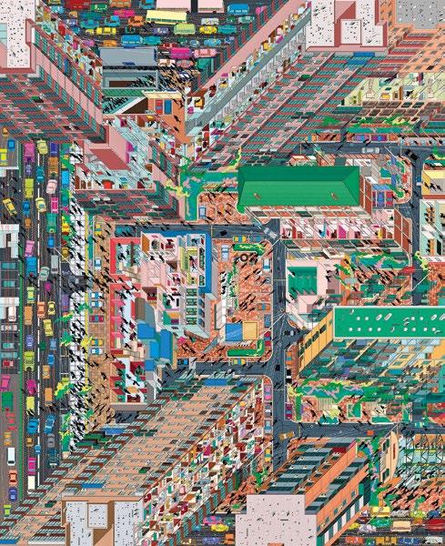
Architecture
Vividly depicting the daily life of a neighbourhood through exploring different drawing techniques, the sectional projections of buildings combined with the opportunity for the viewer to simultaneously read different projections challenges conventional representational methods and offers a particular relational perspective of this urban landscape. The drawing describes the complexity of relations between people living their lives, the urban environment in which they live, and the audience.
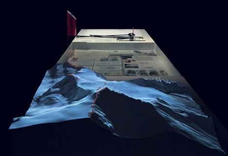
Studio Folder, Italian Limes, 2019
Italian Limes is a research project led by Studio Folder (Marco Ferrari, Elisa Pasqual, Alessandro Busi and Aaron Gillett) and an interactive art installation that explores remote Alpine regions, where national borders drift as glaciers move and change. The researchers monitor Austrian-Italian watersheds to look at relationships between borders and environmental change.
Drawing
Studio, Tuan Jie Hu Panorama, Beijing, 2014
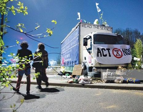
to bear on speci c places, lives and practices requires a range of strategies, representations and actions – as seen in the environmental protests of Extinction Rebellion. The consideration of multiple, less xed positions from which different and collective approaches can be considered are key in challenging the ego-centred landscapes that Bender critiques.12
The Landscapists
Who and what de ne landscapes? Which practices are employed as landscapes are formed? What is at stake in their production? The landscapes of this issue of 2 are contrasting unstable urban ecologies, creative environments and contested territories, connected through re ecting and situating the processes and practices from which they are constituted. As Bender describes: ‘Each individual holds many landscapes in tension’.13 This 2 exposes such con icts, evidencing divergent ideas, provoking contradictions and forming moments of connection within and between. Critical urban and landscape theory can be uncomfortable bedfellows with contemporary design practices, as the role that architectural practice has in contributing to gentri cation and ecological damage is questioned or as theoretical writing is tested by the pragmatics of client briefs, nancial ambitions and site constraints. Furthermore, landscape does not sit neatly in a line-up of disciplinary silos. As Bender insists, landscape ‘has to be an area of study that blows apart the conventional boundaries between disciplines’.14 This need to continually unpack, reconsider and reconstitute the professional frame of working with landscape is highlighted by Charles Waldheim as he recalls historical struggles for the naming of the disciplines.15 He describes the French term ‘paysagiste’ that has been used to refer to those undertaking a range of landscape practices. However, he explains that in contemporary Paris landscape architects have reappropriated the word as less formal than the conventional term for landscape architect, ‘architecte-paysagiste’: ‘The translation of the term into English,’ he explains, ‘offers itself readily as simply “landscapist”’.16
Notes
1. Barbara Bender, Landscape: Politics and Perspectives, Berg (Oxford), 1993, p 3.
2. Ibid, p 1.
3. Ibid, p 2.
4. See Denis Cosgrove, ‘Prospect, Perspective and the Evolution of the Landscape Idea’, Transactions of the Institute of British Geographers, 10 (1), 1985, pp 45–62, and John Berger, Ways of Seeing, Penguin (London), 1972.
5. Volker M Welter, Biopolis: Patrick Geddes and the City of Life, MIT Press (Cambridge, MA), 2002.
6. James Corner and Alex McLean, Taking Measures Across the American Landscape, Yale University Press (New Haven, CT). 1996.
7. Bender, op cit, p 3.
8. Doreen Massey, ‘Landscape as a Provocation: Re ections on Moving Mountains’, Journal of Material Culture, 11 (1/2), 2006, p 40.
9. Donna Haraway, ‘Situated Knowledges: The Science Question in Feminism and the Privilege of Partial Perspective’, Feminist Studies, 14 (3), Autumn 1988, p 582.
10. Ibid, p 583.
11. Ibid.
week-long occupation of London’s Waterloo Bridge by the environmental activist group Extinction Rebellion created a new landscape in the capital in order to provoke political and economic action to address the ongoing ecological and climate crisis. Increasing awareness of the relation between human actions and planetary ecologies establishes speci c global-scale landscapes.
12. See Ed Wall, ‘Post-landscape or the Potential of Other Relations with the Land’, in Ed Wall and Tim Waterman (eds), Landscape and Agency: Critical Essays, Routledge (Abingdon), 2017, pp 144–163.
13. Bender, op cit, p 2.
14. Ibid, p 3.
15. Charles Waldheim, Landscape as Urbanism: A General Theory, Princeton University Press (Princeton, NJ), 2016, pp 171.
Extinction Rebellion protest, Waterloo Bridge, London, 18 April 2019
The
Christina Leigh Geros
SITE, MOME DESIG
MEDIA AS
Christina Leigh Geros, The Global Monsoon, Monsoon Assemblages, University of Westminster, London, 2019
PRACTICE, NTUMS NING
An experimental exploration of the cartographically constructed world through the annual cycles of the monsoon’s atmospheric centres of action, produced through data and research of the monsoon that has been compiled since 1875. In its action, the monsoon brings only certain corners of the globe into focus.
LANDSCAPE
Christina Leigh Geros believes that landscape is more than the land, and that landscape architecture is a process of designing and reconciling disparate ‘momentums’. A tutor in the MA Environmental Architecture programme at the Royal College of Art, research fellow for Monsoon
Assemblages at the University of Westminster, and design research strategist for PetaBencana.id, here she explores the expanding of the definition of ‘landscape’ through wider analysis of contemporary media, site and practice.
To be concerned with and about the environment is to imagine a practice of being and a way of seeing, inhabiting and designing momentums. Landscape architecture is well positioned to explore environmental concerns by de-centering the human through an expanded acknowledgment of shifting relationships to others and their transformations. In the context of two current design-led research projects – The Orang-orang and the Hutan, within the Royal College of Art’s MA Environmental Architecture Programme; and Monsoon Assemblages, led by Lindsay Bremner at the University of Westminster, both in London – the place of the designer and the moment of design are reimagined in the search for knowledge, its formation and infrastructure.1 At the core of both projects, landscape architecture is considered as an ecology of practice which aims to address questions of who is designing, with whom and to what end. Each project begins from an understanding that ‘landscape’ is no longer a-thing-out-of, nor is it a-space-within our built environments; rather, we are landscape – our thoughts, actions and inactions enmeshed within ecologies. Engaged in both ‘field’ and archival research, each project aims to build itself from within conversations, drawing out questions that offer opportunities for realignment and growth able to produce material and political change capable of mobilising energies, human and nonhuman, into action.
To begin, it is necessary to provide some contextual framework for the practice of landscape architecture, as both projects are multidisciplinary. To accommodate the identification of ‘landscape as site’ and the emergence of ‘landscape as practice’ within different conceptual frameworks, both projects acknowledge landscape as both a territory of human–ecological entanglements and as a means to uncover and engage with sources of degradation and renewal. Additionally, both projects are long-term applied research endeavours and, as such, are inprogress – continually redefining both objectives and methods as they mediate between ‘field’ and ‘archive’.
Landscape as Site
Borneo, in particular the carbon-rich soils that construct the biologically diverse ecosystems of the tropical peatland, as a site of investigation and intervention requires human activity to be addressed within geological processes of accumulation and extraction. The natural structure of the peat bog provides deep pockets of oxygenated organic matter that produces long, smouldering fires. These fires restructure soil nutrients and water-holding capacities into more stable matter capable of a full index of fertility. Over thousands of years these assemblages of human–forest relations, or anthrosols, have transformed pockets of nutrient-poor soils into highly productive lands. The ‘site’ of The Orang-orang and the Hutan transcends the surface, engaging with micro-characteristics produced by and productive of human activity.
An architect of time and space around the globe, the monsoon constructs ecologies, customs and cultures –environments – within and across landscapes. Itself an assembling of earth-system dynamics, it is experienced differently, at different scales, around the globe; yet has become synonymous with South Asia. Focused around the Bay of Bengal – from Chennai, India to Dhaka, Bangladesh and Yangon, Myanmar – Monsoon Assemblages engages with the ‘site’ of the monsoon as both a material and cultural construct embedded within social environments, both human and nonhuman.
Acknowledging that landscape is more than land requires a shift in focus. The terms ‘land’ and ‘landscape’ carry connotations of the natural, the aesthetic and the agricultural along with histories of legal and territorial ideas of national politics and cultural identities. As Kenneth Olwig suggests, ‘customs and culture defined a Land, not physical geographical characteristics’;2 thus, landscape is not bound to land, but is held within an environment.
Landscape as Practice
A situated understanding of landscape as a moment within and amongst environments – a constellation of relational consistencies of coexistence – bears in mind that any landscape must be horizenless, ever evolving, and always becoming. Approaching this as a site of investigation necessitates an expanding field of practices which can be utilised within landscape architecture and considered ‘a tool for thinking through what is happening’.3 For centuries, the spatial arts have operated as interrelated ways of articulating, sharing and shaping culture4 – performing as non-neutral tools for seeing and making. Working across disciplines and within ever-evolving ‘sites’, the interventive nature of design often finds itself in the articulation of questions which may mobilise momentums towards previously unimagined environments.
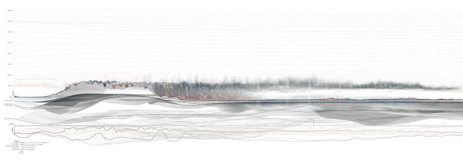
Kaiwen Yu, Discrepant Cartographies: Central Kalimantan, Borneo, Indonesia, The Orang-orang and the Hutan, MA Environmental Architecture, Royal College of Art (RCA), London, January 2019
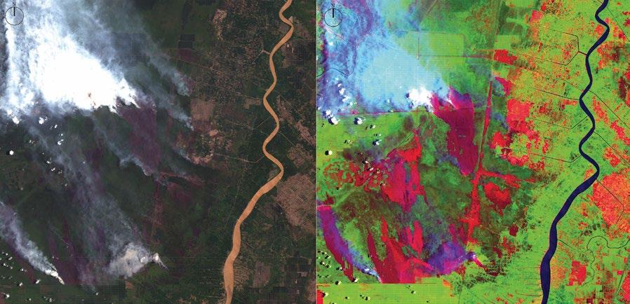
opposite: Working with satellite imagery and GIS software, MA student Yu experimented with colour band combinations (6, 5 and 2) to expose patterns of active burn and historical char in the detection of fire activity in peatlands.
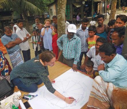
Monsoon Assemblages is a fi ve-year research project funded by the European Research Council (ERC) under the European Union’s Horizon 2020 research and innovation programme (Grant Agreement No. 679873) and begun in 2016. While multidisciplinary, it is a design-led project that focuses a critical lens on established and changing relationships between the people, lands and cities of the monsoon through novel approaches to materialisms, cartographies and narratives. In the ‘field’, photography, film, drawing and interviews are used to uncover ways of knowing and living with the monsoon that may elude mainstream narratives. Often these techniques capture large- and small-scale narratives that present challenges inherent to processes of combining qualitative and quantitative data of different timescales and mediums –yet are essential to drawing out changing relations to staid notions of climate. For example, with the Bede – or ‘river gypsies’ – of Louhajong, Bangladesh, conversations with individuals quickly grew to large, animated meetings with the community and a drawing of a ‘monsoon calendar’ constructed around patterns of seasonal movement timed with river allowances afforded by monsoonal flows from the Tibetan Plateau. Upon return to London, these accounts try to find resolution within the ‘archive’ of monsoonal time and space.
Dr Beth Cullen, drawing monsoon calendars in Louhajong, Bangladesh, Monsoon Assemblages, University of Westminster, London, 2018
In the ‘field’, Beth Cullen anthropologist for Monsoon Assemblages, draws a version of a monsoon calendar as it emerges from conversations with the Bede community; while Christina Leigh Geros documents the process with video and photographic footage.
The Orang-orang and the Hutan began in 2019 as a fouryear studio research project. Framed within the academic studio, it engages design students with local environmental activists, geographers, farmers, filmmakers and researchers in Borneo to address trans-scalar concerns, from the soils that bear them to the airs that carry them. Born from extractive agricultural practices, conflicts over indigenous lands and rights of inhabitation converge through knowledge and production of soils. In the ‘field’, students work in collaboration with residents – of different genders, ages, occupations and land tenures – to uncover knowledge about these soils, passed from person to person, generation to generation, that may offer material proof of occupation. On a recent trip to Mantangai in Central Kalimantan, residents and students used drones to follow a centuries-old boundary between one village and another. Once marked by the periodic placement of vertical posts, the acidic waters of the peat swamp had dissolved evidence of the path’s intentional placement; yet seen from the air, the path’s dimensions and geometry – a clear departure from its surroundings –could clearly be traced. This boundary was not a marker of property, but of soil knowledge – each side of the line productive of a particular crop – proof of cohabitation and soil production long preceding the government’s claim to land. In the studio, students continue to collaborate with their co-conspirators in Borneo to find ways to map this knowledge and construct an authoritative ‘archive’ of the unseen and erased.
Kaiwen Yu, Discrepant Cartographies: Mantangai, Central Kalimantan, Borneo, Indonesia, The Orang-orang and the Hutan, MA Environmental Architecture, Royal College of Art (RCA), London, January 2019
Yu worked with local residents and environmental activists from WALHI in Central Kalimantan to begin mapping ‘hidden’ markers of indigenous land tracts using aerial footage enabled by drone imagery.
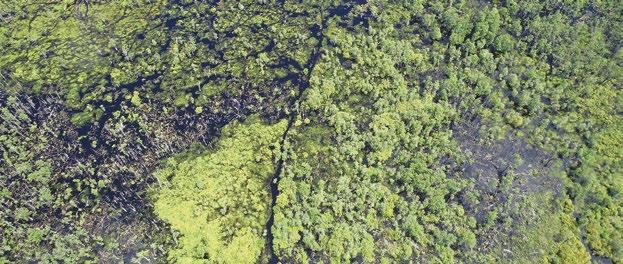
Seeking remnants of lost boundaries in Mantangai, Central Kalimantan, Borneo, Indonesia, The Orang-orang and the Hutan, MA Environmental Architecture, Royal College of Art (RCA), London, January 2019
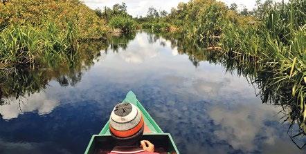
In the ‘field’ of Central Kalimantan, students explored the canals of Borneo’s peatlands with environmental activists from Indian NGO WALHI and local residents, in search of methods of representation of nearly lost historical boundaries.
Ecologies of Media
Expanding landscape ‘site’ and ‘practice’ also questions the medium and collaboration of design. Monsoon Assemblages and The Orang-orang and the Hutan both propose ‘sites’ that are cultural and institutional constructions of social and scientific media. Both projects aim to be interventive and impactful, while driven by process and not geared towards solutionist propositions and final outputs; but what does that mean for design? Towards design imaginaries for projects that are in progress, it is useful to engage with another project that probes ‘site’ and ‘practice’, allowing a process of engagement to perform as ‘media’ and ‘collaboration’ that is generative towards landscape and design.
Lying within monsoonal territory and home to more than 30 million residents, built atop a deltaic plain traversed by 13 rivers, Jakarta, Indonesia is affected by regular and significant flooding. However, in a tangle of concrete roadways and high-rise buildings, the river network – the actual pumping heart of the city – is often obscured from view and unable to mediate the city’s inundation. Working across disciplines including design, geography, computer science and philosophy, and employing a diverse set of methods for research, PetaBencana.id has created an online monitoring and coordination platform that allows residents to help one another during flood events.5 Based on ethnographic research, the design of the platform learns from the residents of the city and expands the already existing epistemological network of river knowledge into an online geospatial conversation –
publicly built and accessible – drawing the river back into the city’s consciousness. Inhabiting the riverbanks and bearing the highest levels of risk, the city’s urban poor acknowledge a ‘belonging’ with the river; while the city’s more affluent residents often neglect to recognise themselves as sharing the same urban ecology. In mapping conversations about flooding, the resultant image draws the river and the city together – into shared belonging and shared care.
Like PetaBencana.id, Monsoon Assemblages and The Orang-orang and the Hutan work between the ‘field’ and the ‘archive’ to create media that enable a continued learning process – a collaboration – with their environments. Beyond illustrative imaging, these new constructions of knowledge aim to be instructive of new questions, new engagements and new momentums.
Archival research of the monsoon reveals an evolution of cartographic constructions since the 17th century. Processes of ‘unfolding potential’, these cartographies ‘enable, rather than depict’ the spaces and relationships of the monsoon through particular moments of social and institutional construction.6 Most often constructed as revenue-building infrastructure or weather-induced risk, today’s changing monsoon now asks to be reconceived of as landscape – a moment of mediation between two horizons and a site within which the built environment is entangled. From policy to design, the enabled imaginary of a kinetic site is a question of landscape architecture at the very edges of its practice. How might the world appear through the lens of the monsoon?
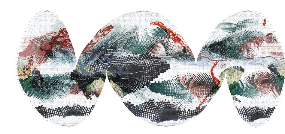
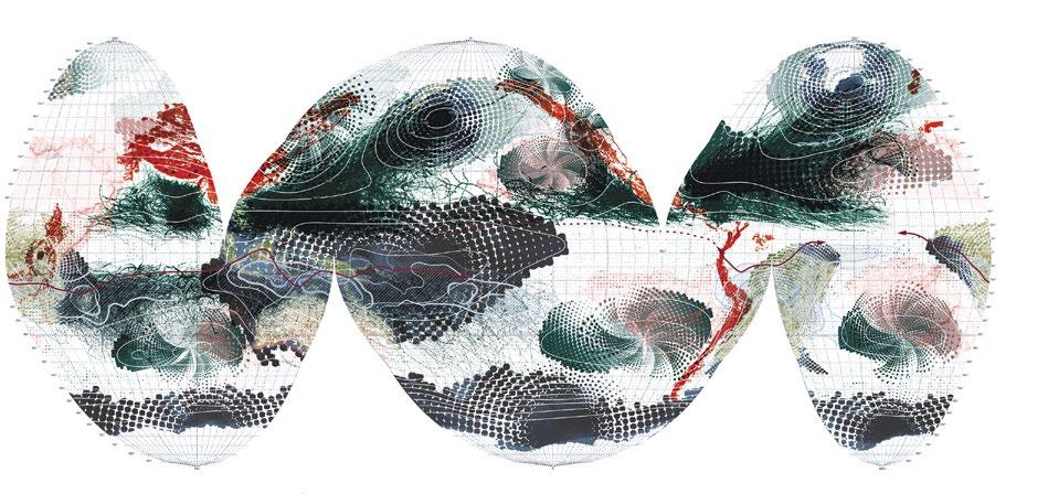
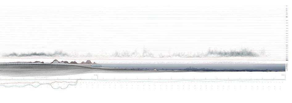
Taken along longitude 77.5 E and using mean data from June to August of 2016, this section through the subcontinental monsoon extends the landscape into the atmosphere. In a particular moment of shifting monsoon habitats, the sectional view experiments with addressing the kinetic landscape.
Lying within monsoonal territory and home to more than 30 million residents, built atop a deltaic plain traversed by 13 rivers, Jakarta, Indonesia is affected by regular and significant flooding
John Cook, Section Through the Subcontinental Monsoon, Monsoon Assemblages, University of Westminster, London, 2019
From hyper-micro to extra-macro, the human and nonhuman actors constituent within the local and global reach of this environment must be considered as designers of a landscape
Kaiwen Yu, Discrepant Cartographies, The Orang-orang and the Hutan, MA Environmental Architecture, Royal College of Art (RCA), London, 2019
Yu begins his investigation into the ‘discrepant cartographies’ of Borneo’s peatlands – asking what can be seen, from what distance, with what ‘eye’, and what can be known from it?
By contrast, the soils of the Bornean peatland lack representation and their terra-nullius status constructs their vulnerability. Exposing the epistemological frameworks that have produced these soils through centuries of cohabitation may enable these soils to voice themselves within their environments. Detailed knowledge of specific plant species, the colour of the smoke released from burning grounds and the response of soil to the sole of a boot can build an atlas of knowledge about the horizontal and vertical dimensions of a peat bog. The generation of media to collect, collate and represent this knowledge has the potential to intercede within the current crisis produced by the industrial commodification of under-represented soils. From hyper-micro to extra-macro, the human and nonhuman actors constituent within the local and global reach of this environment must be considered as designers of a landscape. In the performance of due diligence, shouldn’t one ask: What is the cost of one cubic hectare of carbon? And who will pay the price?
Media of Landscape
Whether representing existing epistemologies or attempting to weave themselves into these networks, both projects aim to produce new ontologies within shared neuro-ecological landscapes. As each participates in a hyper-sensed and recorded world, a continual process of engagement allows opportunities of material, political and social change to emerge through interactive landscapes. An active evolution of landscape architecture – always at the edge of bounded discipline – allows it to attend to shifting environments; while designing shifts through and towards engaged landscapes that place the environment as the object of concern and cooperation. As long-term engagements of interventive experiment addressing questions of environmental representation, these projects operate as disciplinary probes – processes of questioning and redefining partnerships and methods of design action. 1
Notes
1. Christina Leigh Geros, Studio 2: The Orang-orang and the Hutan, Royal College of Art: https://www.rca.ac.uk/schools/school-of-architecture/ environmental-architecture/studio-descriptors-201819/studio-2-orang-orangand-hutan/; Lindsay Bremner, The Research Project, Monsoon Assemblages: http://www.monass.org/project/.
2. Kenneth Olwig, Landscape, Nature, and the Body Politic: From Britain’s Renaissance to America’s New World, University of Wisconsin Press, Madison (WI), 2002, p 19.
3. Isabelle Stengers, ‘Introductory Notes on an Ecology of Practices’, Cultural Studies Review, 11 (1), 2005.
4. David Leatherbarrow, ‘Is Landscape Architecture?’, in Gareth Doherty and Charles Waldheim (eds), Is Landscape … ? Essays on the Identity of Landscape, Routledge (Oxford and New York), 2016, p 641.
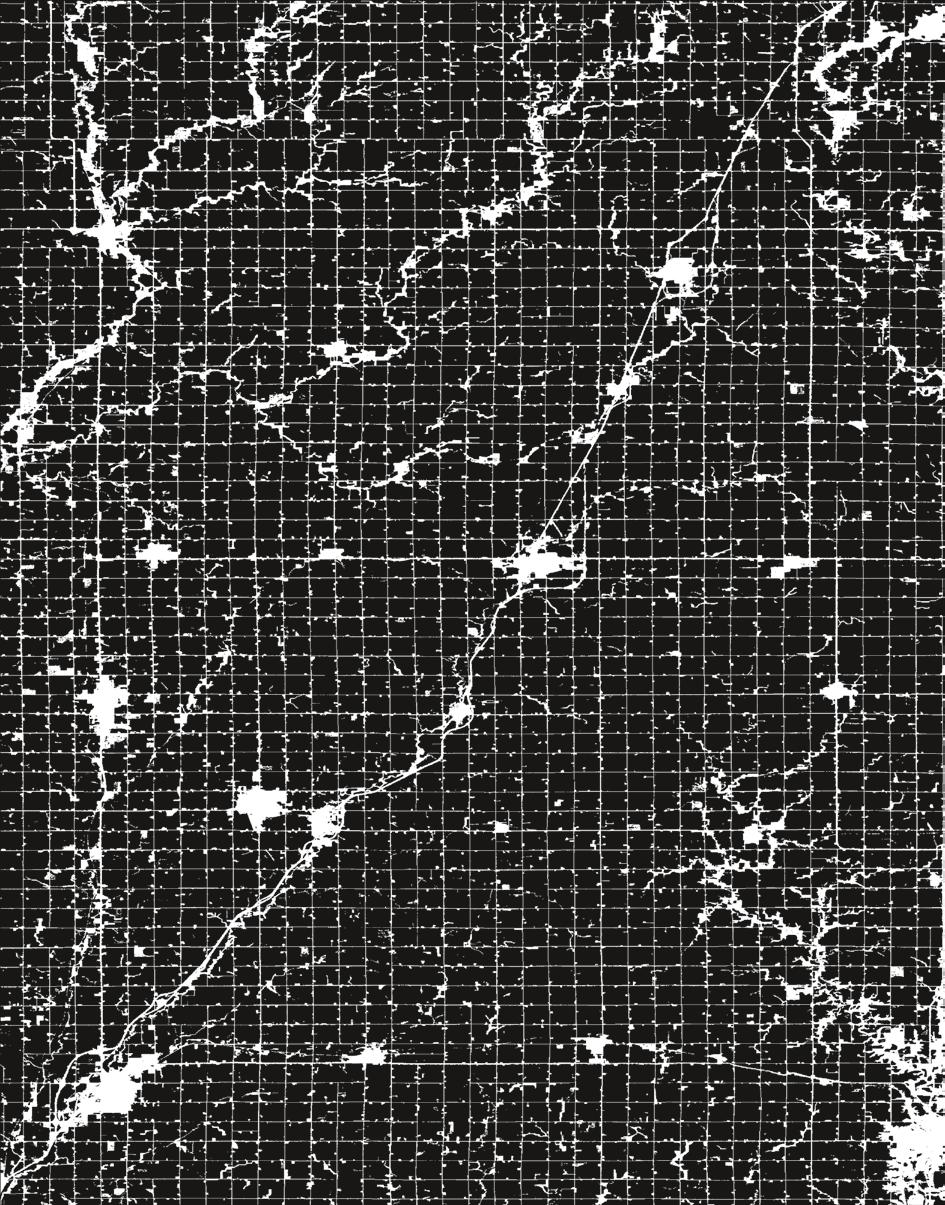
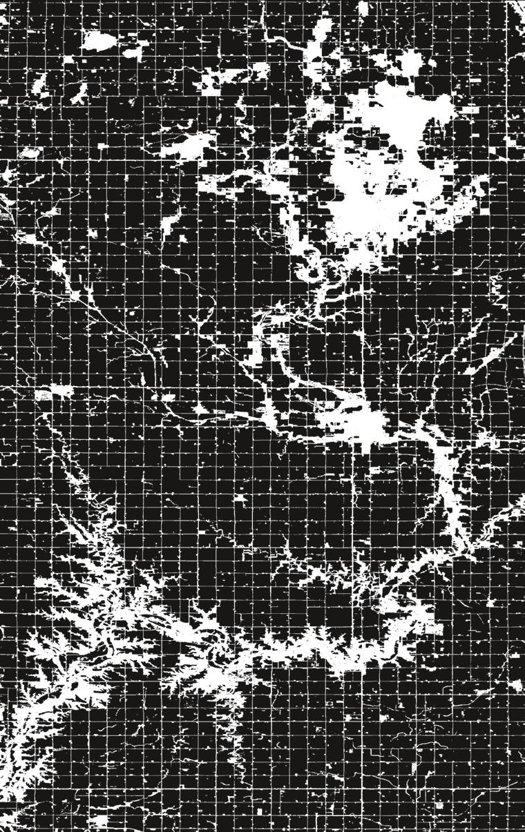
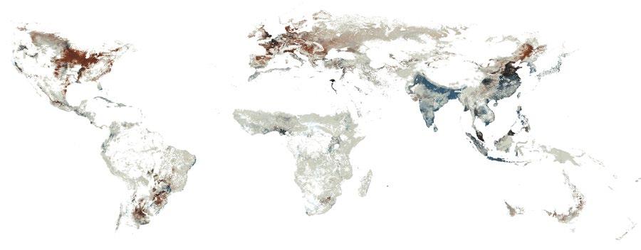
Neil Brenner and Nikos Katsikis, Map visualisation of the US Corn Belt, 2018
Capital-intensive, highly industrialised and densely equipped landscapes of cash-crop monocultures dominate the Corn Belt, where more than 80 per cent of all land (depicted in black) is dedicated to the cultivation of corn and soya beans. The zone is configured among 1-mile (1.6-km) tiles within a Jeffersonian grid pattern. This permits the maximally efficient operation of agroindustrial machinery. Beneath this terrestrial surface is an extensive subterranean drainage system that supports soil tilling. Data source: USDA National Agricultural Statistics Service Cropland Data Layer (2018), published cropspecific data layer, available at https://nassgeodata.gmu.edu/ CropScape/.
In recent decades, the field of urban studies has neglected the question of the hinterland: the city’s complex, changing relations to the diverse noncity landscapes
that support urban life. Neil Brenner and Nikos Katsikis of the Urban Theory Lab at the Harvard Graduate School of Design argue that this ‘hinterland question’ remains essential, but must also be radically reimagined under contemporary conditions.
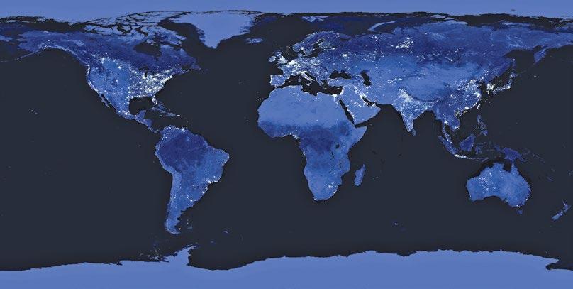
NASA ‘Nighttime lights of the world’ visualisation, 2010
Few images have had a greater impact on contemporary metanarratives of global urbanisation than the ‘nighttime lights of the world’ series, initially synthesised during the 1990s in the National Geophysical Data Center (NGDC) in Boulder, Colorado, and subsequently improved through NASA’s remote sensing networks. Data source: VIIRS DNB Nighttime Lights Composites, NOAA National Center for Environmental Information (NCEI).
What role do spaces beyond the city play in urbanisation, and how are they transformed through this process? Citybuilding is a process of sociospatial concentration, but its preconditions and consequences are not confined to the city’s immediate environs. The term ‘hinterland’ is used here to demarcate the variegated non-city spaces that are swept into the maelstrom of urbanisation, whether as supply zones, impact zones, sacrifice zones, logistics corridors or otherwise. Such spaces include diverse types of settlements (towns, villages, hamlets), land-use configurations (industrial, agrarian, extractive, energetic, logistical) and ecologies (terrestrial, oceanic, subterranean, atmospheric). We refer to explorations of such spaces, and their role in urbanisation processes, as engagements with ‘the hinterland question’. Across the urban social sciences and design disciplines, the hinterland question is today considered secondary or even irrelevant to the study of urbanisation; the city, its dense socioeconomic networks and its powerful agglomeration economies occupy centre stage. In the age of planetary urbanisation, this position is untenable: city/ hinterland relations lie at the heart of the contemporary urban problematique. And yet, these relations are today undergoing mutations that necessitate not only a repositioning of the hinterland question into the core of urban research and practice, but its radical reconceptualisation.
Cities Without Hinterlands?
Prior to the 1970s, the field of urban studies devoted extensive attention to the role of non-city landscapes in the urbanisation process. From Johann Heinrich von Thünen’s early 19thcentury model of the relationship between an isolated city and land-use differentiation in its agrarian hinterland, through the early 20th-century writings of Patrick Geddes, Lewis Mumford and Benton MacKaye on ecological regionalism, up through post-Second World War explorations of central place hierarchies and polarised regional development, city/ hinterland relations were widely regarded as constitutive dimensions of the urban problematique.1
During the last half-century, the hinterland has largely disappeared from urban theoretical discourse, or has been relegated to mere background status. Under conditions of accelerated geo-economic integration, splintering national economies, the rollout of neoliberal austerity programmes, cascading social, financial and ecological crises, and proliferating local growth initiatives, cities are increasingly viewed as self-propelled economic engines. Within this post1980s approach to the urban question, the major emphasis is on the internal preconditions, dynamics and consequences of agglomeration. Urbanisation is understood as city growth tout court – in effect, as cityisation – rather than as a process that is actively supported by non-city spaces.2
The empty, desolate and isolated condition to which the planet’s hinterlands are thereby consigned is starkly illustrated in the image of the world’s night-time lights, in which brightness is treated as a proxy for cityness. This excision of the hinterland’s role in urbanisation is even more starkly spatialised in the influential concept of the ‘spiky world’ developed by urbanist Richard Florida.3 Here, cities are viewed as the nodal concentration points of global GDP. In both visualisations, non-city spaces appear as barren, depopulated, shapeless voids.
While the roots of this conceptualisation predate the 1970s, it was consolidated into a broadly shared episteme of urban studies following the erosion of Fordist-Keynesian, nationaldevelopmentalist capitalism. Debates on industrial clusters in the 1980s, global cities in the 1990s, postcolonial cities in the 2000s, and more recent assertions of a majority-urban world or ‘urban age’ represent but variations on an underlying vision of cities without hinterlands.
Counterpoint: Metabolic Urbanisation
The major contemporary counterpoints to this hegemonic, city-centric approach to urban studies are associated with various streams of urban ecological thought. Despite their otherwise divergent agendas, these dissident approaches conceive urbanisation as a sociometabolic process. From this point of view, cities are supported by diverse metabolic inputs (labour, materials, fuel, water and food) and engender a range of metabolic byproducts (waste, pollution, carbon), the vast majority of which are produced within and, eventually, absorbed back into non-city zones. Such approaches articulate a multiscalar understanding of urbanisation that encompasses not only cities and metropolitan regions, but extended landscapes of primary commodity production, logistics and waste management. Metabolic approaches to urbanisation thus seek to connect the dynamics of agglomeration to a panoply of non-city geographies – for instance, of land enclosure, population displacement, deforestation, industrial agriculture, extraction, energetics, logistics, waste processing and ecological load displacement. The most significant streams of this literature include, among others, historical investigations of city/ hinterland relations, such as William Cronon’s study of Chicago and the US Midwest in Nature’s Metropolis, or Gray Brechin’s investigation of urbanising California in Imperial San Francisco; approaches to materials flow analysis by Marina Fischer-Kowalski, Helmut Haberl and their colleagues in the Institute of Social Ecology at Klagenfurt University; the investigation of ‘teleconnections’ through which landuse transformations in cities impact land-use change elsewhere developed by Karen Seto and her colleagues at Yale University; and the analysis of urban ecological footprints developed by William Rees and his colleagues at the University of British Columbia.4
The contemporary vibrancy of metabolic approaches to urbanisation underscores the continued centrality of hinterland questions to early 21st-century urban studies. These research traditions have contributed fundamental insights that unsettle the myopic narrowing of urban investigations to cities and intercity relations, while illuminating the myriad sociomaterial processes through which city development is supported by, and actively coevolves with, non-city spaces. Thus understood, cities are not self-propelled. The urban process is materialised
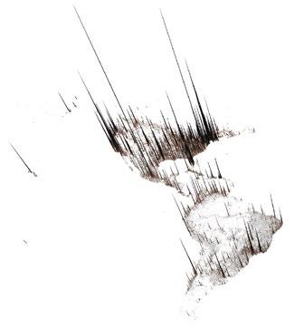
Based on a disaggregation of national GDP data for the year 2010, this visualisation uses the approach popularised by Richard Florida in his article ‘The World is Spiky’ (The Atlantic Monthly, October 2005, pp 48 – 51). Hinterlands – the world’s non-city spaces – are correspondingly represented as empty, barren and, by implication, economically marginal. Data source: UNEP – United Nations Environment Programme, 2012.
Neil Brenner and Nikos Katsikis, Visualisation representing cities and metropolitan regions as the ‘spiky’ concentration points for economic activities, 2010
within city spaces while invariably exceeding them.5 City and non-city landscapes are thus dialectically co-produced under modern capitalism. The urban problematique can only be deciphered adequately through an approach that systematically connects them, at once in social, political, material, infrastructural and ecological terms.
The Hinterland Enigma
Despite its role in offering powerful scholarly counterpoints to the ideology of the self-propelled city, the bulk of contemporary urban ecological scholarship has confronted the hinterland question only indirectly. While studies of urban metabolism have exhaustively quantified the material and energetic flows that mediate city/hinterland relations, they have tended to bypass the question of how noncity spaces are reconfigured through these mediations. Consequently, the hinterland itself has remained something of a ‘black box’: metabolic flows move in and out, but what actually happens ‘inside’ the box, and how the latter has itself evolved, are not interrogated. The hinterland’s internal political-economic operations, land-use matrices, property relations, spatiotemporal dynamics and socioecological crisis-tendencies thus remain enigmatic.
Many contemporary urban researchers appear to presuppose a conception of the hinterland that is derived from the mercantile period of capitalist development in which von Thünen constructed his famous account of the ‘isolated state’ (1826).6 Here, the hinterland is territorially contiguous with and directly linked to the city, which in turn serves as its market outlet and its manufacturing centre. Although commodity production is generalised, there is no structural impulsion to enhance labour productivity or to maximise crop yields. In this model, the non-city zone is, by definition, nonindustrial; land-use sorting occurs due to differential transport costs.
Johann Heinrich von Thünen, Model of city/hinterland relations under mercantile capitalism, 1826
Published in his Der isolierte Staat in Beziehung auf Landwirtschaft und Nationalökonomie (Friedrich Perthes, Hamburg, 1826), von Thünen’s model shaped many subsequent generations of scholarship in urban economic geography. However, except in a few limit-cases of continued, dense metabolic interchange between settlements and their immediately contiguous supply zones, its basic assumptions have been superseded through the forward-motion of capitalist industrialisation.
The point here is not to assert that contemporary urbanists self-consciously embrace von Thünen’s conception of a contiguous, nonindustrial hinterland, but to suggest that some version of this 19th-century model continues to shape our collective imagination of non-city landscapes, which are thereby reduced to an amorphous ‘ghost acreage’ of ‘emptied spaces, homogeneous blanks yet to be inscribed by human history’.7 As a result, scholars have only rarely sought to decipher the specific patterns and pathways through which hinterlands have been creatively destroyed since the 1850s, even though such transformations have been as far-reaching as those that are commonly ascribed to the crisis-riven remaking of cities’ own built environments during the same period. Investigating such mutations will require new conceptualisations of city/hinterland matrices in relation to emergent geographies and ecologies of planetary urbanisation.8
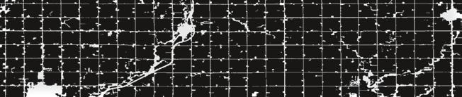
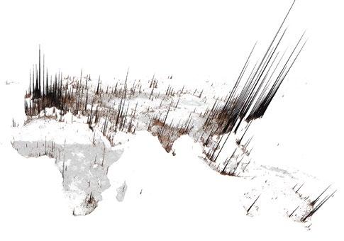
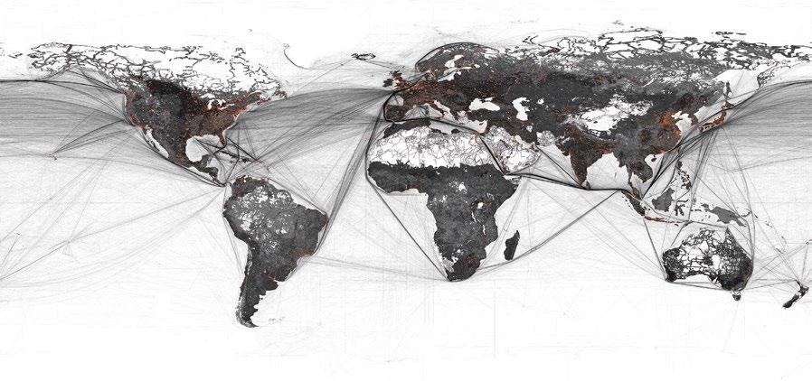
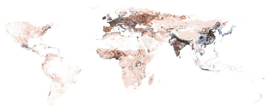
Neil Brenner and Nikos Katsikis, Map visualisation juxtaposing a demarcation of the world’s metropolitan agglomerations onto a rendering of the entire planet’s total ‘used area’ at the beginning of the 21st century
Metropolitan agglomerations are shown in red and the planet’s ‘used area’ is shown in black and grey. Agglomeration zones constitute only a miniscule percentage of the planet’s operationalised landscapes, which are mostly devoted to primary commodity production (agricultural cultivation, grazing, forestry), resource extraction, logistics and waste disposal. Data sources: European Commission Joint Research Center, 2016, Global Human Settlement Layer; K-H Erb, V Gaube, F Krausmann, C Plutzar, A Bondeau and H Haberl, ‘A Comprehensive Global 5 Min Resolution Land-Use Dataset for the Year 2000 Consistent with National Census Data’, Journal of Land Use Science 2 (3), 2007, pp 191– 224; and Vector Map Level 0 (VMap0) dataset released by the National Imagery and Mapping Agency (NIMA), 1997.
Hinterlands of the Capitalocene
How, then, to conceptualise the role of hinterlands in supporting and buffering the metabolic dynamics, rifts and crisis-tendencies of urbanisation under capitalism? This challenge is, on the one hand, a conceptual one insofar as it requires us to rethink the very nature of hinterlands in the age of capital, or ‘Capitalocene’.9 It is, equally, one that will require critical appropriations of newly available sources of geospatial data, which may offer a powerful basis for investigating the contemporary rearticulation of land uses, built and unbuilt environments, and political ecologies around the world.10
It is not sufficient to posit that such non-city ‘outsides’ are constitutively important for city-building processes, or to focus on measuring the role of such spaces as ‘taps’ and ‘sinks’ for the metabolic dynamics of capitalist urbanisation. While this vast planetary hinterland covers nearly 70 per cent of the earth’s terrestrial surface, and is densely layered with productive, extractive, circulatory and informational infrastructure, it has remained an obscure background to the study of contemporary urbanisation. It is precisely in this sense that the ‘black box’ of the hinterland must be opened and systematically rearticulated to the central agendas of urban studies. What is required is a framework that can connect historically and geographically specific forms of city and non-city space as coproduced, coevolving moments within the combined, uneven, variegated and crisis-riven world-ecologies of capitalist urbanisation.
The development of such a framework requires systematic elaboration elsewhere. Here, it must suffice to offer some initial generalisations regarding four key mutations of city/ hinterland relations that have been particularly pronounced during the last half-century. These relatively abstract propositions are not intended to foreclose more contextually embedded lines of enquiry, but to stimulate further reflection, investigation and debate regarding the restlessly churning dynamics of planetary urbanisation.
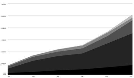
Neil Brenner and Nikos Katsikis, Visualisation of global trade of basic materials, 1960–2010
Over the last decades, the global trade in primary commodities – such as agricultural and forestry products (biomass), fossil fuels, industrial minerals, metals and construction materials –has increased more than threefold. This reflects the increasing globalisation of hinterland economies. Data source: F Krausmann, S Gingrich, N Eisenmenger, K-H Erb, H Haberl and M Fischer-Kowalski, ‘Growth in Global Materials Use, GDP and Population During the 20th Century’, Ecological Economics, 68 (10), 2009, pp 2696–705.
Neil Brenner and Nikos Katsikis, Map visualisation of the geographical distribution of production sites for the five most globally traded agricultural commodities, 2000
The overlaying gradients on the map correspond to production areas for corn (orange), soya beans (yellow), wheat (blue), palm oil (dark green) and cotton (light green) as of the year 2000. Data source: C Monfreda, N Ramankutty and J Foley, ‘Farming the Planet 2: Geographic Distribution of Crop Areas, Yields, Physiological Types, and Net Primary Production in the Year 2000’, Global Biogeochemical Cycles, 22 (1), 2009, p GB1022.
Distanciation and Infrastructuralisation
First, primary commodity production has been globalised and specialised, causing local, contiguous hinterlands to be enmeshed within specialised, export-oriented transnational production networks. Contiguous hinterlands remain important, but are no longer the norm, either in the older industrialised world or in most Southern megacities. This implosion-explosion of hinterland zones has been animated by capital’s drive to increase labour productivity and extend interspatial connectivity, both of which entail the construction of large-scale infrastructural configurations.11 While such strategies may temporarily boost profits, they also increase the organic composition of capital, as living labour is replaced by machinery, equipment and infrastructure. This leads to the precipitous decline of the non-city workforce (‘depeasantisation’), accompanied by the social and cultural hollowing-out of rural regions, the establishment of robotised, monofunctional landscapes, and massive ecological devastation as parts of the countryside become ‘sacrifice zones’ for capital.
Hinterlands of Hinterlands
Second, as they are embedded within global supply chains, hinterlands lose their articulation to specific zones of direct consumption, urban or otherwise. The linear directionality of von Thünen’s classic model – in which each hinterland has ‘its’ city, and each city ‘its’ own hinterland – is thus no longer a reliable guide. The point is not simply that contemporary cities’ hinterlands are more distantiated than previously, but that their operational logics, infrastructural configuration, metabolic relays and developmental dynamics have been qualitatively transformed. On the one hand, most of the world’s most productive, specialised and exportoriented hinterlands circulate their outputs to a multitude of metropolitan agglomerations, or across the global metropolitan network as a whole. Just as importantly, many zones of primary commodity production are now most directly articulated not to major cities and metropolitan regions, but to other productive landscapes of cultivation, extraction, processing and distribution, which are in turn embedded and intermeshed within an intercontinental logistics space. This situation is exemplified in the monocrop soya-bean landscapes of Amazonia, whose outputs are mostly exported as cattle feed to Chinese livestock hinterlands; in the export of phosphate fertiliser from Central Florida to Brazilian agroindustrial hinterlands; or in the use of hydroelectric dams to power the extractive hinterlands of northern Chile.
From Formal to Real Subsumption
Third, most forms of primary commodity production have remained heavily contingent upon the extrahuman geographies of the earth system (for instance, soil and weather conditions, water availability, or resource deposits) which can only be modified through significant industrial investment (for instance, in fertiliser, greenhouses, irrigation systems and other sociotechnical ‘fixes’). Historically, therefore, the industrial operationalisation of hinterland spaces has occurred through strategies to establish new resource frontiers and, as the latter are exhausted, through compensatory efforts to intensify techno-extractive logics.
In both moments of this process, new industrial infrastructures are established and intensively operationalised before being superseded through capital’s restless sociotechnical dynamism. Many contemporary hinterlands, therefore, are no longer zones of mere ‘formal subsumption’ in which inherited socioecological resources are appropriated as commodities for external market exchange. Insofar as the geographies and ecologies of non-city zones have themselves been systematically redesigned in order to intensify and accelerate capital’s turnover time, a ‘real subsumption’ of hinterland spaces appears to be under way.12 In this manner, many erstwhile hinterlands, or parts thereof, are transformed into configurations of large-scale territorialecological machinery: mechanised assemblages of human and nonhuman infrastructure oriented towards capital accumulation within a planet-encompassing profit-matrix.
Metabolic Rifts and Cycles of Creative Destruction
Fourth, the proliferation of specialised, capital-intensive, infrastructurally elaborate and globally interdependent zones of primary commodity production reveals not only the ways in which inherited human and nonhuman landscapes have been commodified, but the progressive exhaustion of their capacity to contribute ‘ecological surpluses’ to sustain and stimulate the accumulation process.13 The proliferation of such metabolic rifts further accelerates capital’s drive to mechanise hinterland geographies, at once through the substitution of manufactured inputs into the production process and through the construction of colossal techno-infrastructural configurations.14 The hinterlands of the Capitalocene are, therefore, chronically unstable.
As ecological surpluses are exhausted, the resultant metabolic rifts severely destabilise prevalent regimes of accumulation. Consequently, established hinterland infrastructures are rendered obsolete, even though their sociotechnical capacities may have been only partially amortised. This leads to intense struggles over the choreography, form, social impacts, ecological costs and future pathways of landscape and territorial transformation.
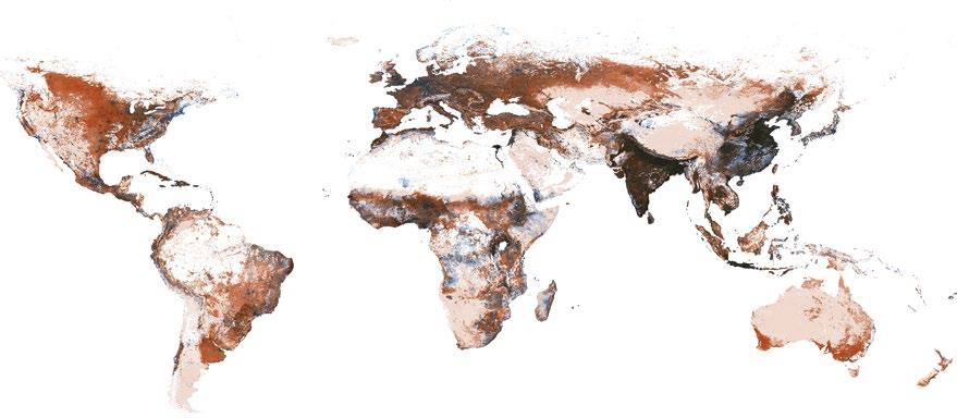
Neil Brenner and Nikos Katsikis, Map visualisation of food, feed and biofuel cropland areas, 2000
opposite top: The overlaying gradients on this composite map correspond to cropland areas dedicated to food production (blue) and to feed or non-food uses, such as energy and industrial inputs (red) as of the year 2000. Insofar as they supply specific industrial inputs to other hinterlands (for example, cattle feed to livestock production zones, or biofuel to the energy sector), the red zones represent hinterlands of hinterlands. Data source: E Cassidy, P West, J Gerber and J Foley, ‘Redefining Agricultural Yields: From Tonnes to People Nourished Per Hectare’, Environmental Research Letters, 8 (3), 2013, p 034015.
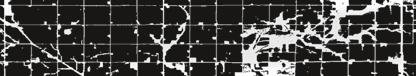
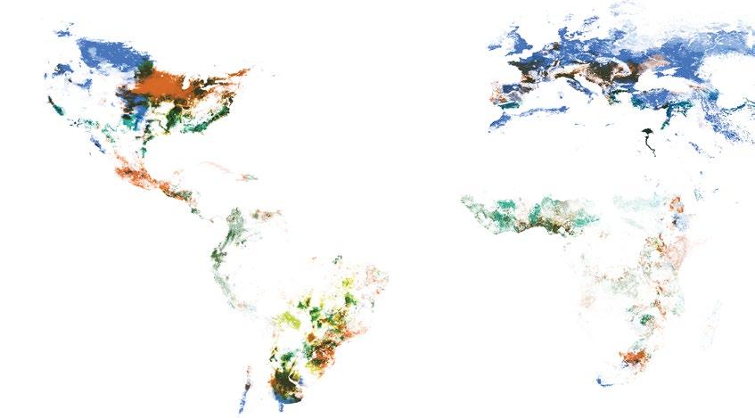
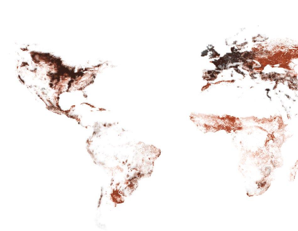
Neil Brenner and Nikos Katsikis, Map visualisation of population densities and expansion of agricultural production zones, 1800 and 2000
opposite middle and bottom: The overlaying gradients on this composite map depict worldwide population densities (blue) and the distribution of agricultural production zones (red) between the years 1800 (top) and 2000 (bottom). Data source: HYDE 3.1 Spatially Explicit Database of Human Induced Land Use Change Over the Past 12,000 Years (2011).
As ecological surpluses are exhausted, the resultant metabolic rifts severely destabilise prevalent regimes of accumulation
Will the violent, profitdriven illogics of planetary urbanisation continue to degrade, erode and destroy the fabric of social, political and ecological existence?
For this reason, any contemporary approach to the hinterland question must consider the systemic vulnerabilities of those non-city spaces that have been forged to support the globalising, profit-maximising dynamics of supply-chain capitalism.
The Hinterland Question, Reframed
Under contemporary conditions, there is no singular hinterland of ‘the’ city. Instead, non-city productive landscapes have become more specialised, infrastructurally dense and industrially intensive, and they are intermeshed with one another through extended material, operational and informational linkages, as well as through their continuous but largely indirect exchanges with (strategic nodes within) the global metropolitan network. However, the operational landscapes of planetary urbanisation are hardly a stable foundation for territorial development, social reproduction or ecological security. Indeed, even as they support enhanced industrial productivity and the