HISTORY AND CONCEPT OF BOUNDARIES
1.1 INTRODUCTION
The history and location of boundaries are steeped in the history of the world from the time before records were kept to today. These boundaries are a result of actions of individuals and nations and law. Boundaries can be related to the areas of history, politics, surveying, and law. Both boundaries of an international nature and those between individuals have caused problems that have been fought, are still being fought, and will continue to be fought in the future over their locations between nations, states, and individual parcels of land within “Happy Acres” subdivisions. In recent years, both local and international judicial tribunals have had to apply old, proven doctrines and have created new legal doctrines to resolve boundary issues. One cannot pick up a newspaper or a magazine without reading about some individual or nation with a boundary issue that is new or that has been festering for many years.
Wars have been fought both on an international scale and in local neighborhoods, and people have been killed over boundary disputes of an inconsequential nature involving pieces of land that have ranged from hundreds of miles to a fraction of a foot or meter. Boundaries are personal in nature, and people have been and will continue to be protective about the misidentification or misalignment of a known or perceived boundary infringement. The surveyor may become the common factor in a boundary problem, as a result of, for example, preparing an erroneous map showing the boundary between two or more nations or the erroneous depiction of a single line between two landowners.
Even after modern boundary issues have been, seemingly, resolved, members of both the legal profession and the surveying profession may question the results,
asking incredulously, “How could the court do that?” Both the trial attorney and the testifying survey expert could not believe the Court disregarded the case law on the subject.
In the primeval forest, particularly in the plant kingdom, there are no known boundaries between living things. Although some horticulturists dispute this, we accept the fact that plants do not create boundaries to separate themselves. Animals— especially humans—do create boundaries. We like to think that only humans create and appreciate boundaries, but it has been observed in nature that most mammals, some reptiles, and a few fish create, identify, mark, and defend boundaries.
In this book, we discuss the creation, identification, description, and recovery of boundaries among people. We do not include the recovery and interpretation of the evidence of once-created boundaries; rather, we examine how boundaries are created, how they are described, and the technical legal and ethical ramifications of such boundaries that separate rights, both real and perceived, in real property.
Some boundaries are created in a random manner, whereas others are created according to preconceived plans, identified by any manner of a written description(s), and then litigated according to common law, case law, or statute law.1 Although it is not our intent in this book to dwell on the creation of boundaries by the lower forms of animal life, their actions in creating boundaries should be examined, because certain principles are similar. Many of these boundaries humans create remain for generations and, when they are retraced by modern methods and with a modern approach, may cause technical and legal problems for today’s surveyors and courts.
Field examinations and studies by naturalists have revealed that most animals really don’t create boundaries per se. However, it is recognized that they usually create terminal points (corners) and then identify the boundaries between these points,2 although lower forms of animals may create boundaries that are not necessarily of a permanent nature.
Humans usually create boundaries in several ways. For the sake of simplicity, these may be placed in the following categories:
1. By action. Physical acts create a line and points on the ground. This is followed by placing actual monuments at the corner points and identifying these points (corners) and line objects. The lines and objects are then described and may be identified on plats or in field notes. This evidence created and left “on the ground” becomes the proof of the original work and lines and becomes the legal controlling factor in conducting retracements.
2. By writings. The written word becomes the method of creation when a person describes corners and/or lines in a deed and then conveys to these described lines, prior to the completion of a survey. The problem is created when what the surveyor places on the ground is and then fails to create a solid paper trail.
3. By law. Ancient common and modern statutes are relied on to create, modify, and relocate many modern boundaries.
The following principles are introduced in this chapter and discussed in detail in later chapters:
principle 1. Boundaries enjoy a long history in both mythology and JudaicChristian history.
principle 2. A surveyor creates land boundaries. These created lines, which are separate and distinct from property lines, are determined by legal principles and law.
principle 3. A described closed boundary identifies a claim of right to any property interest for which any person can make a claim of possession through a claim of title. These boundaries may be either macro or micro in nature.
principle 4. A person or landowner can legally convey only the quality and quantity of interest in land to which he or she has title.
principle 5. In most instances, there are no federal laws describing real property rights.
principle 6. Although there are no federal laws of real property, property rights are identified by the state laws and are protected under the U.S. Constitution.
principle 7. Real property rights are determined according to the laws in effect in the particular locale where the land is located. English common law is the predominant law, and it is described as the lex loci.
principle 8. Once boundary lines are created, the contiguous lines may, by law or by the actions of landowners who have vested rights, be changed or altered.
principle 9. Law does not provide for two original descriptions of the same parcel.
principle 10. Multiple boundary descriptions may exist for the same parcel, but only one is controlling.
principle 11. There can be only one original boundary survey and description; all subsequent ones are retracements.
principle 12. A resurvey can be conducted only by the entity who conducted the original survey. The law provides for resurveys of parcels, but only on a limited basis and under certain restrictions, the main one being that the bona fide property rights granted under the previous survey are not jeopardized.
1.2 SIGNIFICANCE OF BOUNDARIES
The description of property by surveys and landmarks and by reference to boundaries is very ancient. Basically, property interests are separated by boundaries. From precolonial times in the United States, many wars, both local and regional, have been
fought and people have been killed as a result of disputed boundaries. This problem was probably inherited from the European continent when the United States adopted English common law as the basis of its common law.
In Great Britain and in Europe, territorial boundaries have, for the most part, generally been stable because the lines were etched in antiquity. Once parish boundaries were established in England—many during Roman times—they formed invisible webs or lines around families and bound them into communities, and ultimately separated communities from one another. This historical background was passed on to the United States, and these distinctions exist today as a result of this influence.
Stories abound in both the United States and Great Britain in which boundaries have affected people’s lives. Individuals and groups go to extremes over boundaries, for a boundary can have political ramifications in areas such as citizenship and jurisdiction in legal matters. A tale from colonial times tells of the decision of surveyors who were engaged to run the boundary line between Kentucky and Tennessee to place a jog in the line when a landowner placed a jug of rum near his property and told the surveyors that it was theirs if they found it to be in Kentucky. They did. Naturally, the line has a jog in it. One of the authors of this book, Walt Robillard, remembers that when he was a young boy growing up near the Canadian border, his grandfather would take him to a tavern that straddled the U.S.–Canadian border. On the U.S. side of the bar, the serving of drinks stopped at midnight and was “never on Sunday”; however, on the Canadian side, the drinking continued. At the stroke of midnight and on Sundays, all drinks were served on the Canadian side. The bar patrons would move physically from the United States into Canada.
In 1870, the Reverend Francis Kilvert, an Anglican priest in Wales, related how one of his parishioners occupied a house that straddled the border in Wales on the edge of Brilly Parish. It was suggested that it would be more desirable for this parishioner to give birth to her child in his parish. The line between the parishes was indicated by a notch on the chimney. To ensure that the child would be born in the proper parish, the midwife had the mother give birth standing up in a corner on the appropriate side of the parish line.
People take boundaries seriously. Yet what they really are saying is, “I want the rights that I am entitled to in this property” or “I want those rights in that parcel of land.” Boundaries do not determine rights in land, but they identify the limits of any rights a person or group of people may have created or identified and now claim.
1.3 BOUNDARY REFERENCES
Principle 1. Boundaries enjoy a long history in both mythology and JudaicChristian history.
Historically, the English language, using actual occurrences, developed certain terms that depicted and/or identified boundary problems. Until the advent of published maps, boundary identification and the resulting problems and discrepancies were passed from generation to generation by word of mouth.
It was not until mapping became a part of everyday living that boundaries were identified to such a degree of certainty that they no longer relied on the spoken word. In all probability, many of the boundaries on modern maps were placed there based on the testimony of people who identified them at an earlier time. There are many place names that indicate evidence of boundaries. The Old English term maere translates to “boundary.” An examination of modern British Ordnance Survey maps or maps produced by the U.S. Geological Survey indicate names like “Merebrook” and “Merebeck,” indicating that certain streams were considered boundaries. Once boundaries were established and identified, they would be of no value if society could not ensure them with a degree of certainty. Once again, the gods and society were called on for guidance. The ancient Greeks ensured that boundaries would be sacrosanct. They “appointed” the goddess Terminus to be the protector of boundaries. This system was inherited by the Normans and Saxons in England in two ways: first, by the manner in which boundary stones were originally marked, and second, by the practice of beating the bounds.
The historic practice of beating the bounds consisted of the ritual of selecting children from the locality (usually boys), who, accompanied by a member of the town, a clergyman, and the parties to the land transfer, would walk, or perambulate, the boundaries. At each corner, one of the boys would be suspended by his feet and his head would strike the monument. Then, in the event of a future dispute, the boy would go to the corner marking the boundary and point out its location, as he remembered it.
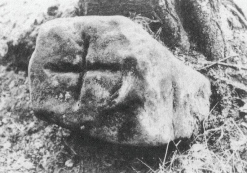
For centuries, surveyors have marked boundary stones (corners) by cutting crosses into rock monuments (see Figure 1.1). This practice was probably brought
Figure 1.1 Boundary stone marked with a + of medieval origin. (Courtesy of Prof. Angus Winchester.)
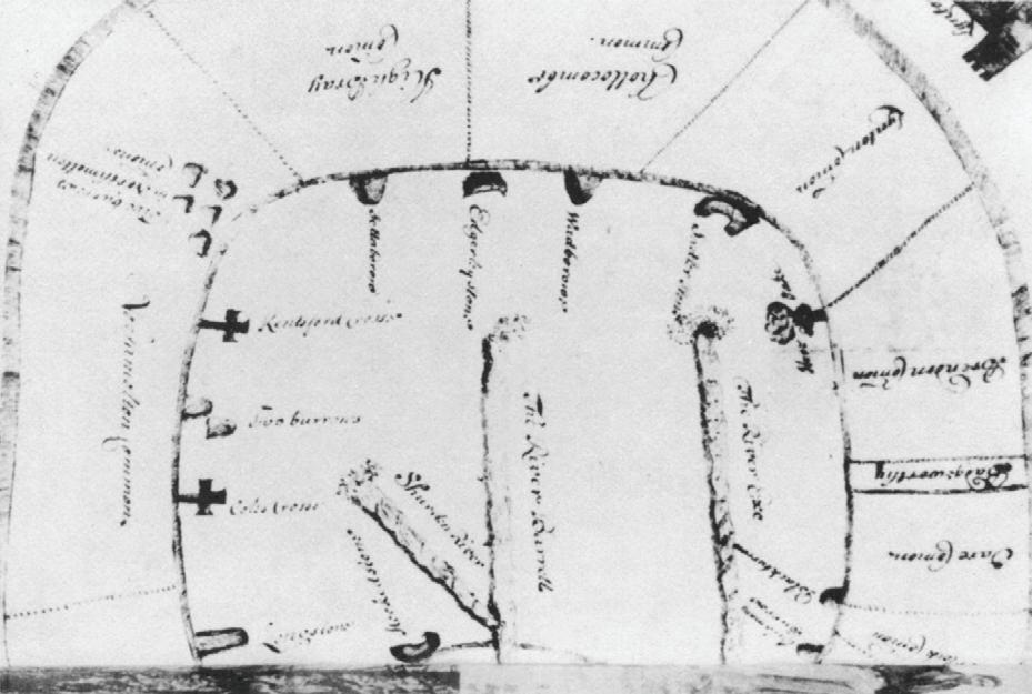
Figure 1.2 1675 Map of Exmoor Forest, Devon. Note crosses at some corners. (Courtesy of Public Records Office, London.)
to America by early English surveyors, who used the same practice in their home country. An examination of early survey and mapping practices indicates that early English surveyors would cut a cross into the monument as protection or to indicate the bounds of a religious holding. They then indicated these beacons (monuments) on maps in the form of crosses (see Figure 1.2). In all probability, these crosses were cut into the stone and then shown on maps in hopes that the Christian God would protect them as Terminus had protected Greek boundary stones.
1.4 TERMINUS: THE GOD (OR GODDESS) OF BOUNDARIES
Following the Greeks, Terminus was designated by the ancient Romans as the god of boundaries. Some believe that this god evolved from the ancient Greek goddess Terminus. Today, surveyors, real estate attorneys, and judges who must make legal determination on land matters should consult the wisdom of this ancient god(dess). There are numerous references in the Old and New Testaments concerning boundary stones, markers, landmarks, and boundaries. Ovid, the Roman poet, wrote: “O Terminus, whether thou art a stone or a stump buried in the field, thou hast been deified from days of yore . . . thou dost set bounds to peoples and cities and vast kingdoms; without thee every field would be a root of wrangling. Thou courtest no favour, thou art bribed by no gold; the lands entrusted to thee thou dost guard in loyal good faith.”3
To show faith in such a god and with the hopes that a favorable response from the god would bring peace to a community and stability to its boundaries, a festival called Terminalia was held on February 23. During this annual festival, landowners would meet at their common boundary stones. Each would place a garland of flowers, and the ceremony would culminate with a minor feast of cakes and honey and toasting with wine. Then an animal, usually a pig or a lamb, would be sacrificed and the bones and blood deposited near the site.
Titus Livy wrote in his History of Rome that the Romans showed such favor to Terminus that at Rome’s founding a temple was erected to the god on one of the seven hills, and his domain was never questioned. To show that all of the gods of Rome looked to Terminus, Livy wrote: “The gods are said to have exerted their power to show the magnitude of this mighty empire. . . . The fact that the seat of Terminus was not moved, and that of all the gods he alone was not called away from that place consecrated to him, meant that the whole kingdom would be firm and steadfast.”4
1.5 DISPUTES AND BOUNDARIES
Principle 2. A surveyor creates land boundaries. These created lines, which are separate and distinct from property lines, are determined by legal principles and law, predicated on law.
Disputes as to boundary location and/or boundary line identification predate recorded history. Until the development of modern maps at scales that permit adequate and positive identification of boundaries, individuals and communities depended on the spoken word to “seal” the location of boundaries and possession to maintain them. One historical method of identifying boundaries is beating the bounds. This practice was possibly a vestigial reminder of what had been a quasireligious practice first used to identify parish boundaries between religious orders (see Figure 1.3). Today, this method is still referred to as “beating the bounds” and is still practiced on a very limited scale in a few states.
Disputes over boundaries were frequent between communities and between church lands. The ancient ritual of beating the bounds was usually carried out during Rogation Week, the period between the fifth Sunday after Easter and Ascension Sunday. On the day selected, the parson, the constable of the townships, and the steward of the court (clerk) of the manors, accompanied by townspeople both young and old, would take ample supplies of food and drink and perambulate the boundaries to be identified. In this manner they sealed in the memories of the townspeople boundaries that had never been committed to writing or placed on a map. To enhance the memory, young boys were selected and given an unforgettable experience at each of the beacons (corner monuments). Trials over disputed boundaries and depositions in many shire (county) courts have left us with excellent accounts of some of the rituals that helped the young people remember the disputed boundaries. Some are related as follows.

Figure 1.3 Beating the bounds of Edgmond Parish, Shropshire, about 1933. (Courtesy of Local Studies Department, Shropshire County Library.)
In 1687, an elderly man, William Gregory, testified that, as a child of seven in 1601, in a boundary dispute of a line in Exmore (Somerset), he had assisted in a perambulation of Exford Parish. As the group passed one of the boundary stones, one of the older gentlemen called to the boy, “William, put your finger on the meerestone, for it is soe hot it would scald him.” William related “that in doing so he layd hold on my hand and did wring one of my fingers sorely so that for the present it did greive me very much.” William then recalled that the person stated: “Remember that this is a boundary stone and it is a boundary to the parish of Exford.”
Not to be outdone, in 1635, Robert Fidler testified in the matter of a boundary dispute that as a boy he “had his eares pulled and was set on his head upon a mearestone neere to a newe ditch of Ormisirke Moore and had his head knocked to the said stone to the end to make him better remember that the same stone was a boundary stone.”
The ritual of perambulation, or beating the bounds, can still be found in some communities. Although antiquated, it nevertheless incorporates sound legal purposes and principles. During colonial times, it was required that owners of adjoining land walk and inspect their common boundaries yearly. The law also stipulated a penalty for those who failed to comply. More recently, in New England, municipalities are required to inspect and renew their bounds periodically. This remains the law in several states, although most do not carry out the “letter of the law.” Some towns still undertake this job faithfully by surveying and marking their boundaries, and with new technology they are placing coordinates and global positioning system (GPS) values on monuments and corners. This ancient practice ensures landowners and others of the “true and correct” bounds and helps relieve surveyors of possible future surveying costs that are necessary to determine such lines when they are coincident with private boundaries. Yet disputes still arise when surveyors apply modern technology to ancient boundary descriptions. The practice of beating the bounds
was replaced in 1677 by the enactment of the Statute to Prevent Fraud (Statute of Frauds) that required a written document be presented in order to have a cause of action for certain legal problems and to transfer an interest in land.
An examination of many early English maps and names reveals that some disputes were centuries old when William the Conqueror arrived to turn the AngloSaxon world into turmoil. Here is a selection of some of the names on present-day maps in the United Kingdom:
• calenge (Middle English): challenge, dispute
• ceast (Old English): strife, contention
• erioch (Gaelic): boundary
• devise (Old French): division, boundary
• flit (Old English): strife, dispute
• fyn (Welsh): end, boundary
• grima (Old Norse): marker boundary blaze on a tree
• ra’ (Old Norse): landmark boundary, settlement on a boundary
• skial (Old Danish): boundary, boundary creek
• terfyn (Welsh): boundary
• threap (Old English): dispute
Few of these names were adopted in the United States or carried into American English and indicated on our maps when English common law was accepted, but we have developed our own words to describe the problems that result from boundary disputes.
The historical result of this ancient practice is that today in England the number of land surveyors who practice land boundary surveys to settle boundary disputes is probably less than 100 for the entire country.
1.6 ROLE OF THE SURVEYOR IN BOUNDARIES
Principle 3. A described closed boundary identifies a claim of right to any property interest for which any person can make a claim of possession through a claim of title. These boundaries may be either macro or micro in nature.
The surveyor should be able to make a distinction between the types or classes of boundaries that may be encountered. There are boundaries—and then there are boundaries. One will find both macro and micro boundaries. A macro boundary may be an international boundary between nations or between subdivisions of nations; a micro boundary is a boundary on a local level, such as between land grants or, possibly, between individual parcels of land. Surveyors can become involved with boundaries in two separate and distinct ways: those that represent major proportions or areas, which are macro boundaries, and others that are smaller and parochial
in nature, which are micro boundaries (see Section 3.2). Few surveyors have the opportunity to create or retrace macro boundaries, but most surveyors are intimately involved with micro boundaries. Few retracing surveyors are asked to create or retrace international boundaries, state boundaries, or country boundaries that may be disputed; however, many of the boundaries they create or retrace will be of small parcels of a single lot or subdivision. A list of possible distinctions between macro and micro boundaries is provided in Section 3.2.
Although the methodology of creating macro and micro boundaries may be similar, the application of law may be entirely different when retracing these boundaries. The surveyor creates these invisible boundaries, which are a product of the work of the instruments used, the capabilities of the surveyor, and the methods employed in conducting the work.
Usually, the original surveyor creates the boundaries of land parcels through actions and/or words and according to the law. Once an original boundary is created and described, that description remains in effect forever, legally. According to federal statutes as well as common/case law, those lines remain fixed in perpetuity, from the time the first property rights are conveyed in reliance on the lines and corners described. Subsequently, the same surveyor or another surveyor or surveyors are the individuals who retrace the boundaries that were originally created and who may create new evidence for future surveyors to search for.
The first belief that any surveyor should have when entering the area of boundaries is that any boundary dispute can be resolved with the help of knowledgeable experts and with reasonable people as clients. The only problem one may encounter is that some disputes may take longer to resolve than others. One person stated that it required the death of the original parties to resolve a boundary dispute. Some disputes may be prolonged for generations, even to the point that they are identified on maps and become sealed in history. At that point, the origins of disputes become lost in history. One of the longest historical disputes in America was the Hatfield and McCoy feud, which crossed the state line between West Virginia and Ohio. What started as a simple timber trespass by Hatfields on McCoy lands, over the state lines, escalated to killing pigs and then scores of people in the two clans. The dispute lasted for over 100 years.
In examining British Ordnance Survey maps, one sees names such as Threapwood and Threapmuir. Threapwood is found in Wales near Wrexham, a tract of disputed land that belonged to no county, parish, or township. The residents were found to be paying no taxes and were subject to no local courts. It was a true no-man’s-land. The boundaries had been disputed for centuries, and no county had ever gained authority over the people and the land. Similar situations exist in all U.S. states, in both public land surveys and in state-surveyed areas. As recently as 1994, surveyors in Louisiana discovered a “lost” strip of land between two federal townships that resulted in many legal problems for many occupants who had been residing and transferring the land without benefit of an original patent; in 2002, two parishes were still disputing their common boundary.
Many other macro boundaries are being disputed between countries and counties. Today, the states of Connecticut and Rhode Island are disputing a common
boundary that was created in the 1700s. Recently, what should have been a simple described line between the states of Georgia and South Carolina was settled by the U.S. Supreme Court when it determined that the original definitive boundary— namely, the center of the river, with all of the islands belonging to Georgia—had been changed by estoppel. The most recent boundary problem faced by Georgia is the north boundary with the state of Tennessee. The original charter calls for the “parallel 35 degrees.” In 1811, the creating surveyor told the commissioners that his equipment could obtain a precision of only plus or minus 1 mile. The line was run and monumented. Recent precise measurements place the run boundary 1 mile south of the parallel. Georgia, facing a serious water shortage, now wants to change the boundary 1 mile north so that it hits the Tennessee River, which would give the state the ability to extract water from the river.
In a major boundary problem between England and Scotland, the dispute over the Threpelands was settled in 1552 by digging a ditch and giving half to each of the disputing parties. The ditch, called Scots Dyke, is still in existence. Here in the United States we do not have that flexibility.
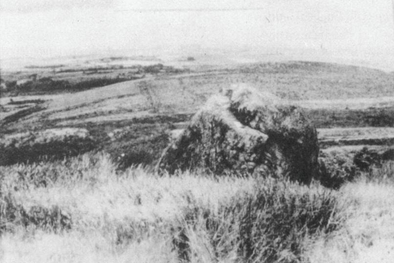
The British left us with a legacy of boundary disputes but also with one of attempting to make permanent those important markers that identify land boundaries. A reference to today’s Ordnance Survey maps will indicate such boundary landmarks as the Navelin Stone, which was established in 1200. This stone, also called the Avellan Stone, is identified in the charter established in 1210 depicting the boundaries of Cumberland in England (see Figures 1.4 and 1.5).
In other early attempts to resolve boundary disputes by legislative and legal means, the English tried to rely on boundaries identified by the centerlines of roads.
Figure 1.4 The Navelin Stone, marking the boundary between Brisco and Cleator, Cumberland, established in 1200. (Courtesy of Prof. Angus Winchester.)