OF RELATED INTEREST
The Archaeology and Architecture of Farm Buildings at Saumarez Station, Armidale, New South Wales
Graham Connah
BAR International Series 3067 | 2021
Who Came to Tea at the Old Kinchega Homestead?
Tablewares, Teawares and Social Interaction at an Australian Outback Pastoral Homestead
Penelope M. Allison and Virginia Esposito
BAR International Series 2964 | 2020
Henry’s Mill: The Historical Archaeology of a Forest Community Life around a timber mill in south-west Victoria, Australia, in the early twentieth century
Peter Davies
BAR International Series 1558 | 2006
A Critical Exploration of Frameworks for Assessing the Significance of New Zealand’s Historic Heritage
Sara Donaghey
BAR International Series 1836 | 2008
The Same under a Different Sky?
A country estate in nineteenth-century New South Wales
Graham Connah
BAR International Series 1625 | 2007
Imperialist Archaeology in the Canary Islands
French and German Studies on Prehistoric Colonization at the End of the 19th Century
A.José Farrujia de la Rosa
BAR International Series 1333 | 2005
Archaeological Excavations at the Uxbridge Almshouse Burial Ground in Uxbridge, Massachusetts
Edited by Ricardo J. Elia and Al B. Wesolowsky
BAR International Series 564 | 1991
Birds of a Feather
Osteological and archaeological papers from the South Pacific in honour of R.J. Scarlett
Edited by Atholl Anderson
BAR International Series 62 | 1979
For more information, or to purchase these titles, please visit www.barpublishing.com
Acknowledgements
Funding for this excavation was provided by a Grant-in-Aid from the Department of Anatomy, University of Otago, and further analysis has been paid for under a Royal Society of New Zealand Marsden Fund Grant. We are grateful to Wayne Stevenson for the donation of his time and use of his digger. This project is a collaboration between many individuals and groups. The TP60 group who instigated the work at St. Johns Cemetery and provided a vast amount of background research are Robert Findlay, Kath Croy, Isobel Michelle, Mary-Anne Miller and Rev. Vivienne Galletly. Bishop Kelvin Wright has supported the project wholeheartedly, and provided his permission for the excavation to be undertaken. Megan Callaghan, the Health Protection Officer at Public Health South guided us through the disinterment licence process. Rachel Wesley provided Māori cultural guidance, and participated in the excavation. Jane Batcheller of the university of Alberta carried out the fabric analysis, and Rod Wallace of Auckland performed the coffin timber identifications. Richard Walter and Phil Latham of the Department of Archaeology and Anthropology provided much of the excavation and field equipment. Grant Love, who farms the area surrounding the cemetery, has put up with several years of disruptions. Dudley Finch provided material assistance and loaned the A&P show medal.
The field crew were: Baylee Smith, Alana Kelly, Caitlin Hyde, Teina Tutaki, Eleanor Moore, Shar Briden, Stacey Ward, Lori Bowers, Anna-Claire Barker, Rebecca Adam, Naomi Woods, Koreana Wesley-Evans, Sarah McDonald, Gail Elliot, Kath Croy, Anna Willis, Rebecca Kinaston, Greg Hil, Jonny Geber, Rachel Wesley, Nyssa Mildwaters, Jenni Lane, Holly Brinsdon, Jitlada Innanchai, Charlotte King, Kate Domett, Peter Petchey, Hallie Buckley.
Table of Contents
5.4.1. Burial 3a (Context No. 10006)
5.4.2. Burial 3b (Context No. 10016) ...................................................................................................................
5.5. Burial 4 (Context No. 10018) .............................................................................................................................
5.6. Burial 5 (Context No. 10012) .............................................................................................................................
5.7.
6 (Context No. 10016) .............................................................................................................................
5.8. Burial 7 (Context No. 10014)
5.9. Burial 8 (Context No. 10058)
5.10. Burial 9 (Context No. 10015)
5.11. Burial 10 (Context No. 10028)
5.12. Burial 11 (Context No. 10029)
5.13. Burial 12
5.14. Burial 13 (Context No. 10026)
5.15. Burial 14 (Context No. 10027)
5.16. Burial 15 (Context No. 10042)
5.17. Burial 16 (Context No. 10043)
5.18. Burial 17 (Context No. 10041) .........................................................................................................................
5.19. Burial 18 (Context No. 10044) .........................................................................................................................
5.20. Burial 19 (Context No. 10045) .........................................................................................................................
5.21. Burials 20a (Context No. 10046) and 20b (Context No. 10059) ......................................................................
5.21.1. Burial 20a (Context No. 10046)
5.21.2. Burial 20b (Context No. 10059)
5.22. Burial 21 (Context No. 10047)
5.23. Burial 22 (Context No. 10048)
5.24. Burial 23 (Context No. 10049)
5.25. Burial 24
5.26. Burial 25
5.27. Burial 26
5.28. Burial 27 (Context No. 10053)
5.29. Burial 28 (Context No. 10056)
5.30. Burial 29 (Context No. 10057) .........................................................................................................................
7.6.1.
8.2.
8.2.1.
List of figures
Fig. 1.1. A contemporary cartoon showing the idealised vision of life in the colonies compared with life in the British cities. This was the promise that brought many settlers to New Zealand 1
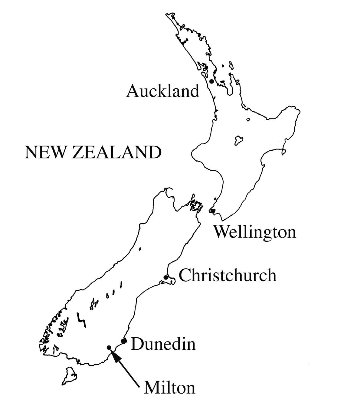
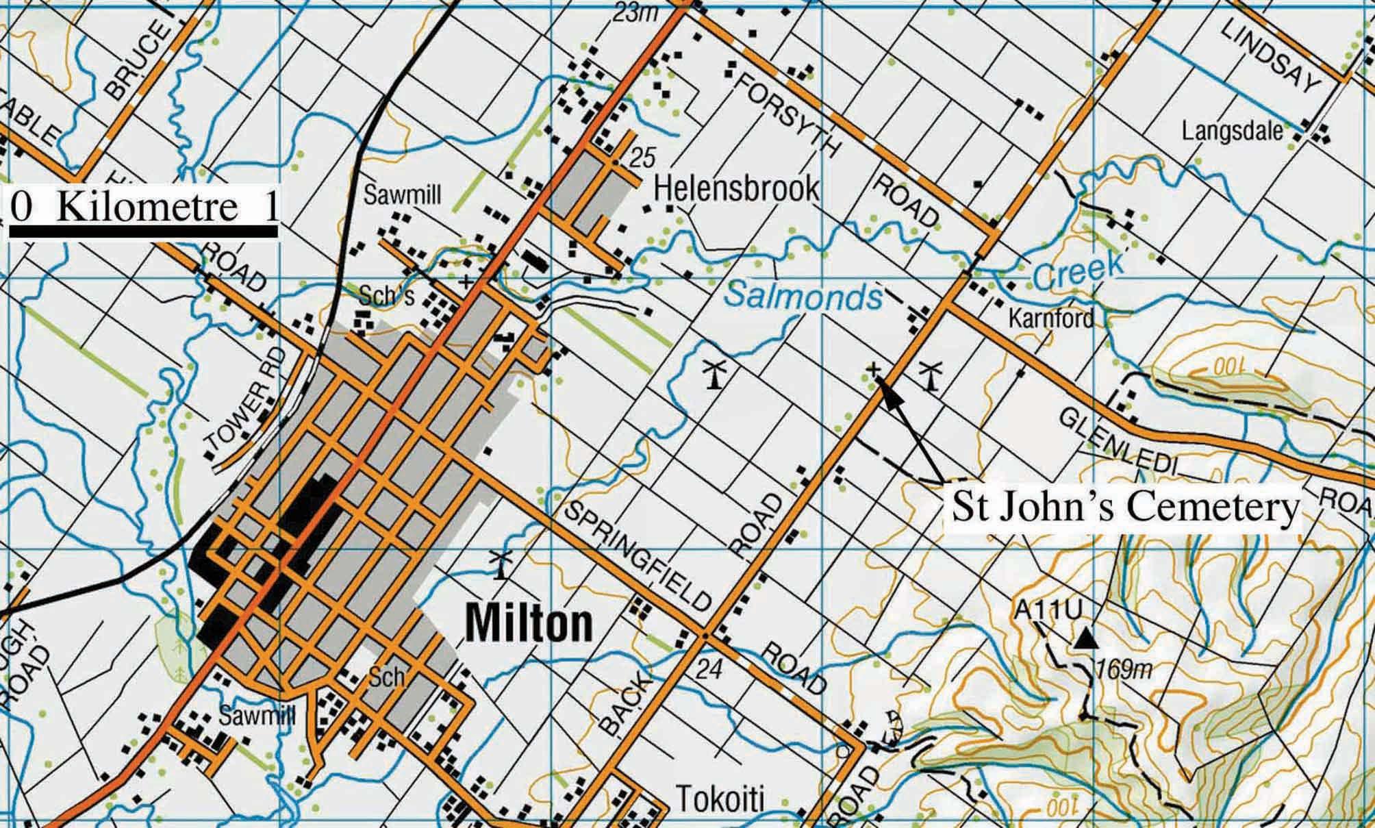
Fig. 1.2. The location of Milton in South Otago 2
Fig. 1.3. The location of the St. John’s Cemetery on Back Road near Milton .................................................................... 3
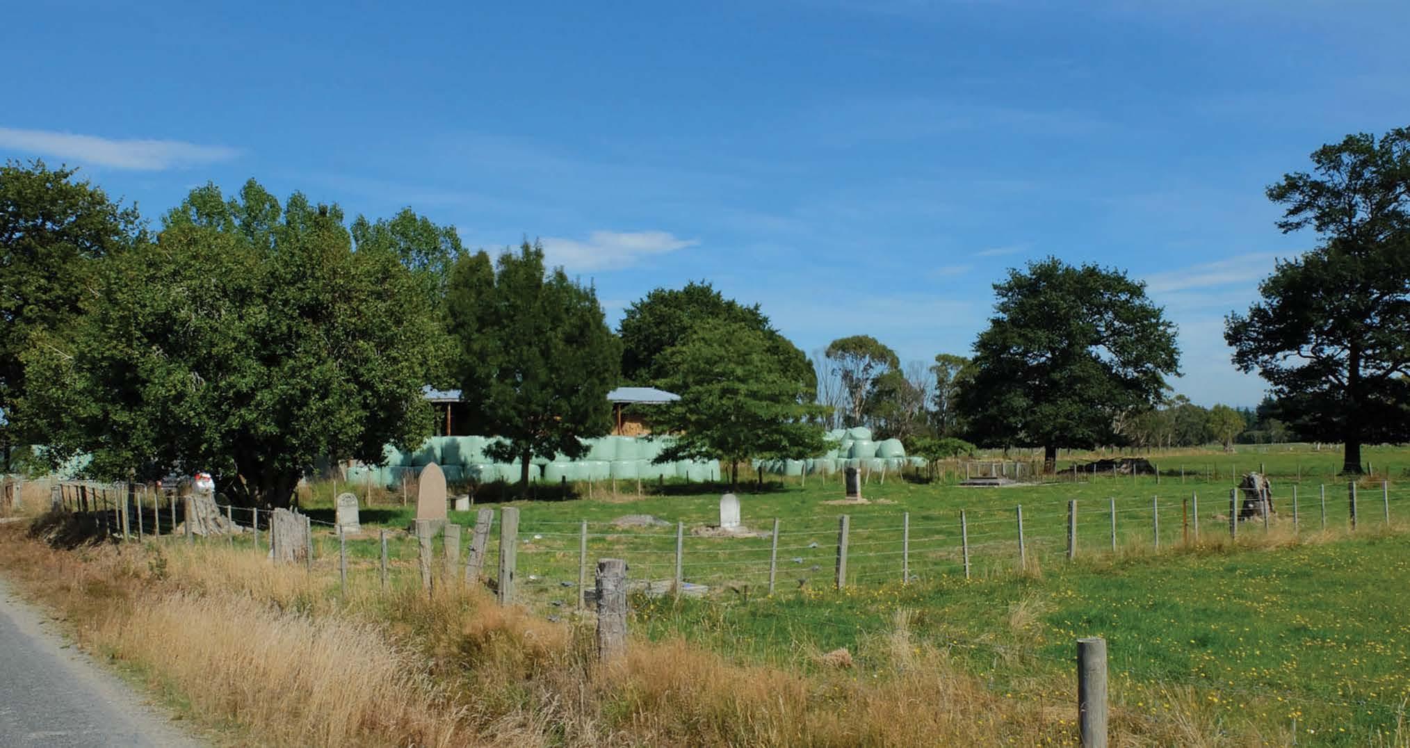
Fig. 1.4. The St. Johns Cemetery seen from Back Road in 2016 3
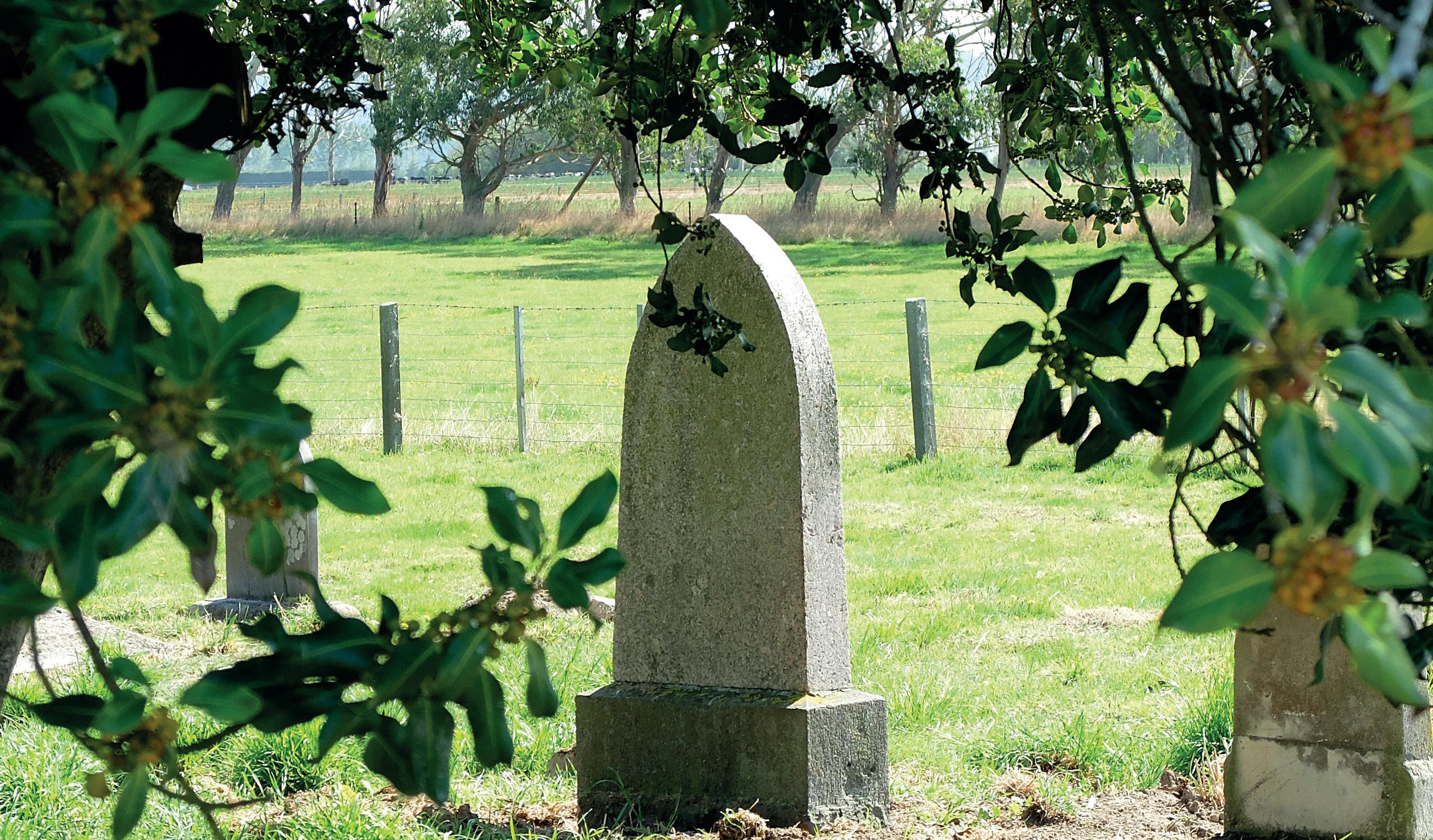
Fig. 1.5. Some of the gravestones in the St. John’s Cemetery in 2016. No marked graves were investigated during the archaeological excavations 4
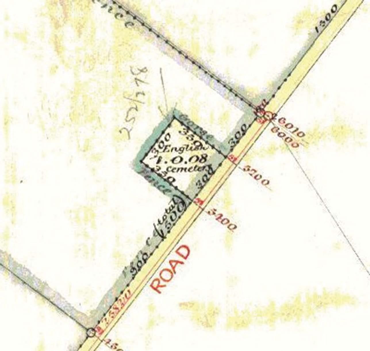
Fig. 3.1. Detail from an 1880 map of part of Block XI Tokomairiro District by surveyor Alexander Adam. This shows the ‘English Cemetery’ on Back Road, with an area of just over one acre 8
Fig. 3.2. The old Church of England Parsonage near the St. Johns Cemetery 8
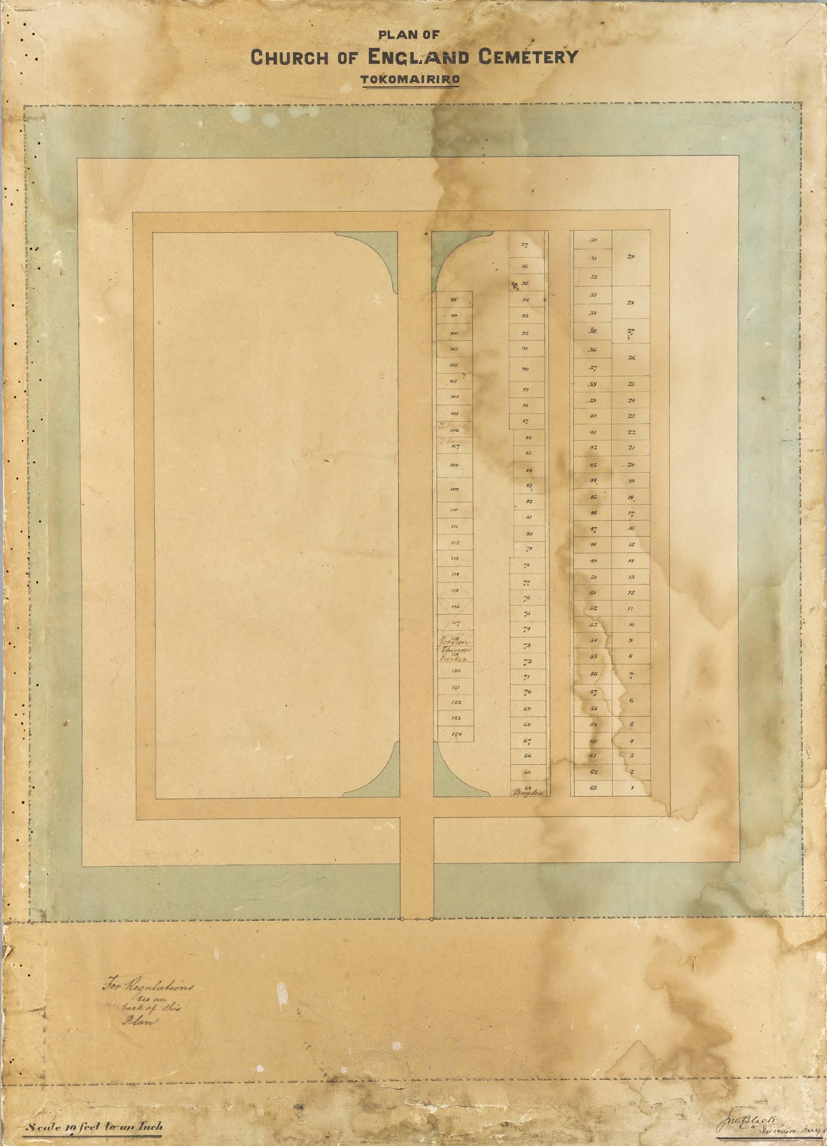
Fig. 3.3. The only surviving layout plan for the St. John’s Cemetery. It has only seven names written in plots. The unoccupied left hand side of the cemetery is where the chapel stood 10
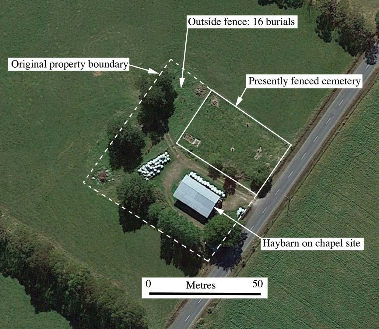
Fig. 4.1. The St. John’s Cemetery site, showing the approximate original boundary, the present fenceline and the haybarn that stands approximately where the chapel original stood 11
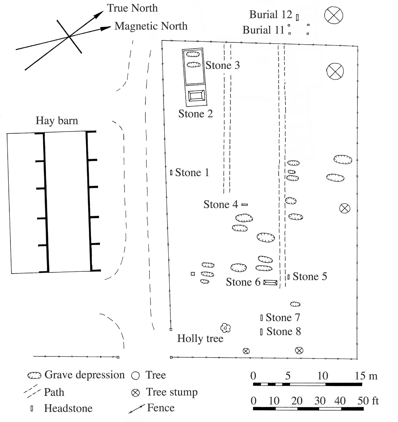
Fig. 4.2. Plan of marked graves in St. John’s Cemetery. Note that the locations of Burials 11 and 12 were only found during the archaeological investigations; previously a fragment of the Burial 12 headstone was lying on the surface nearby
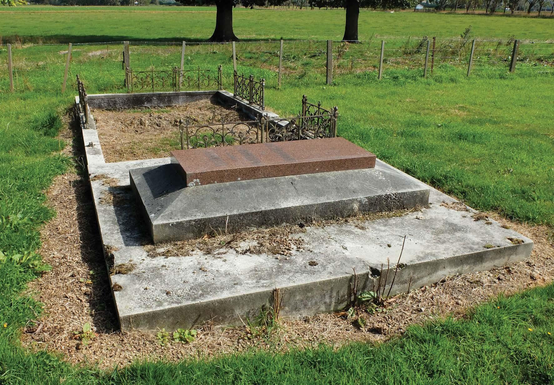
Fig. 4.3. The horizontal slab for the Finch family members (front, Stone 2), and the un-named enclosure (rear, Stone 3) 13
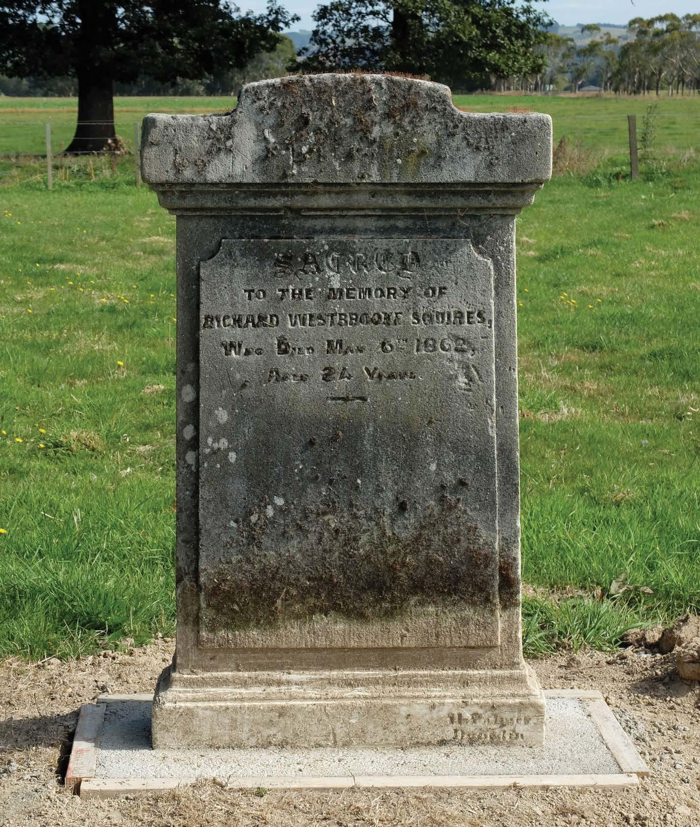
Fig. 4.4. The gravestone for Richard Westbrooke Squires who died in 1862 aged 24 years (Stone 4) ............................. 13
Fig. 4.5.
Fig. 4.6. Henry Pim’s headstone being held in place by Alana Kelly and Teina Tutaki after it was found during topsoil stripping. Prior to the discovery of this headstone there was no record of Pim having been buried in this cemetery. He died in 1872 at the age of just 34. The grave was recorded as Burial 12, but was not further investigated in 2016 14
Fig. 5.1. Careful excavation of the Burial 9 coffin plate (Robert Rowley Thompson) on 2 December 2016. Timber boards were used alongside the excavations to prevent the sides collapsing 17
Fig. 5.2. Plan of St. John’s Cemetery, showing the results of the 2016 archaeological investigation. The fenced cemetery area is shown bottom right, and the areas that were stripped by machine are indicated. The burials extended 14 metres beyond the existing back fence 18
Fig. 5.3. Burial 1 after the coffin outline was exposed. The distortion due to tree root damage is clear. The channel at the top of the image was dug to drain the rising groundwater 20
Fig. 5.4. Burial 2 after the top of the coffin was exposed
Fig. 5.5. Burial 3a in the ground prior to the lid being lifted 21
Fig. 5.6. Burial 3a after the coffin lid was lifted off. The femora and tibiae were the best-preserved elements of the skeleton, and can be seen centre left 21
Fig. 5.7. Burial 3b showing the reasonably preserved coffin fabric
Fig. 5.8. Burial 4 (Dr. Weber, to the right) and Burial 6 (Flora Weber, to the left)
Fig. 5.9. Burial 5 after the coffin lid was removed (but with the coffin plate over the abdomen still in place) 22
Fig. 5.10. Burial 6, Flora Weber, with the coffin outline and coffin plate exposed
Fig. 5.11. Full length view of Burial 7, with the coffin plates along the top of the coffin exposed ...................................
Fig. 5.12. Burial 8. The outline of the coffin was clear, but the human remains were poorly preserved. The legs of the infant can be seen to the left of centre. The scale is 0.5m long
Fig. 5.13. Robert Rowley Thompson’s (Burial 9) head and chest plates
Fig. 5.14. Burial 10. The scale is 0.5m long ......................................................................................................................
Fig. 5.15. Burial 11. The scale is 0.5m long
Fig. 5.16. Burial 13 upper body, showing the large coffin plate over the chest area .........................................................
Fig. 5.17. Burial 14, showing the mass of tree roots where the coffin once existed
Fig. 5.18. Burial 15. The rectangular outline of the grave cut was very clear in the clay, but the coffin and individual were poorly preserved
Fig. 5.19. Burial 16 grave cut and coffin. The coffin fabric was preserved in a cross across the chest, showing where lead/tin embossed metal strip had been placed. The scale is 0.5m long
Fig. 5.20. Burial 16, showing the preserved hair and teeth of the young child
Fig. 5.21. Burial 17, with the shadow outline of the coffin left standing, but nothing was found of the individual
Fig. 5.22. Burial 18. The coffin wood was reasonably well preserved, but the human remains consisted only of hair and teeth. The scale is 0.5m long
Fig. 5.23. Burial 19. The coffin outline was well defined, but the human remains consisted only of hair and teeth
Fig. 5.24. The Burial 20a coffin sitting within the Burial 20b coffin, as a result of the two collapsing together. The scale is 0.5m long 29
Fig. 5.25. The Burial 20b coffin after Burial 20a had been removed
Fig. 5.26. Burial 21, showing how the skeleton was disarticulated. The scale is 0.5m long 30
Fig. 5.27. Burial 22. The outline of the skeleton was reasonably clear, but the bones were very poorly preserved 31
Fig. 5.28. Burial 23, showing the intact limbs, but the torso was very poorly preserved. The scale is 0.5m long ............ 31
Fig. 5.29. Burial 27, showing the wet clay into which the grave was dug. The scale is 0.5m long
Fig. 5.30. Burial 28, with the infant skeleton partially intact within the wooden coffin ...................................................
Fig. 5.31. Burial 29, showing the well-preserved skeleton. The scale is 0.5m long
Fig. 7.1. Rough sawn kauri in the lid of the Burial 6 coffin (Flora Weber). The pencil line visible across the board marked out the shoulder break
Fig. 7.2. Coffin nails from Burial 17. On left 2 ¼ inch wrought iron nails, on right 1 ¾ inch nails .................................
Fig. 7.3. Coffin nails from Burial 23. All are cut wrought iron nails, varying in length from 1 to 2 inches
Fig. 7.4. Screw from the coffin of Burial 18 ......................................................................................................................
Fig. 7.5. Detail of fragment from Burial 3b coffin, showing the nails that attached the coffin sides (right) to the coffin base (left). It can be seen that the coffin sides were not vertical, but were splayed out from the base..............
Fig. 7.6. The coffin lid from Burial 3a. This infant’s lid was the best-preserved coffin lid found in 2016
Fig. 7.7. The underside of the Burial 3a coffin lid, showing how the fabric was simply wrapped around the wooden lid and tacked on
Fig. 7.8. A fragment of fabric from the coffin lid of Burial 21 (William Toogood) with what was once an ornate painted design ....................................................................................................................................................................
Fig. 7.9. Enlargement of the plain weave woollen coffin cloth cover from Burial 19 48
Fig. 7.10. Enlargement of the coffin cloth from Burial 10. This is an example of a wool/ cotton mix in a 2/1 twill: the horizontal warp fibres are wool while the vertical weft fibres are cotton
Fig. 7.11. Burial 1 trim. This was 1 1/8 inch (28.5mm) wide, and had a pattern of a double row of raised circles
Fig. 7.12. The trim on the corner of Burial 2 coffin, showing how the thin metallic strip was folded to turn the corner. The corroded heads of the iron tacks used to fix the strip are also visible. The strip was 7/8 inch (22.5mm) wide, with a pattern of a double row of diamond shapes
Fig. 7.13. Burial B3a trim. This trim strip was 7/8 inch (22.5mm) wide
Fig. 7.14. Burial 4 coffin trim. This trim was 1 ½ inches (38mm) wide, with a double row of a cursive (foliage?) pattern. It was poorly preserved
Fig. 7.15. Embossed metal trim on the lid of Burial 6 (Flora Weber). This strip was 1 ½ inches (38mm) wide, with a double row of raised ovals pattern
Fig. 7.16. Embossed metal trim on the Burial 9 (Robert Rowley Thomson) coffin. This strip was 1 ½ inches (38mm) wide, and appears to be identical to Burial 6 (Flora Weber)
Fig. 7.17. The black enamelled embossed metal ribbon used to embellish the coffin of Burial 10. This strip was 3 inches (76mm) wide, with a double row of stars and cursive surrounds. This was the only black-coloured trim strip found at SJM
Fig. 7.18. Embossed metal trip strip obtained from Trademe in 2019. This is an exact match for an archaeological example from Lawrence Burial G1 (following Figure). This strip is a maximum of 2 inches (50mm) wide and was supplied in 12 inch (305mm) lengths
Fig. 7.19. The coffin strip on Burial G1 from the Gabriel Street Cemetery in Lawrence. This is exactly the same pattern as in Figure 7.18 above, and illustrates the difference between the original appearance and the degraded appearance of the archaeological samples
Fig. 7.20. The Burial 9 coffin plate after careful cleaning. The name ‘Robt. R. Thompson’ is legible .............................
Fig. 7.21. The angel headplate on Robert Rowley Thompson’s coffin (Burial 9)
Fig. 7.22. Burial 4 coffin plate (Augustus Weber)
Fig. 7.23. Detail showing the text on the Burial 6 Coffin Plate for Flora Weber
Fig. 7.24. The Burial 5 coffin plate. Traces of gold paint could be seen, but the name of the deceased could not be determined. This is an example of a simpler shield form, with garlands around the sides rather than flanking angels as seen in larger plates ............................................................................................................................................
Fig. 7.25. The main coffin plates on Burial 7. The best-preserved was the main chest plate, shown in more detail in the following Figure
Fig. 7.26. Detail view of the main chest plate on the Burial 7 coffin. A figure with radiance above stands atop the urn-shaped area where the deceased’s name would have been painted
Fig. 7.27. Burial 13 showing the large coffin plate over the chest. The outline of the plate could be determined, but most internal detail was lost in the mass of corrosion
Fig. 7.28. Burial 4 coffin handle, uncleaned. This was one of the handles on Gustav Weber’s coffin, and is typical of the plain cast iron handles found at St. Johns Cemetery
Fig. 7.29. Burial 4 coffin handle x-ray, showing the original form of the handle without cleaning being required
Fig. 7.30. Burial 21 coffin handle. Handle from William Toogood’s coffin
Fig. 7.31. X-ray of Burial 21 coffin handles, showing how the iron had corroded until there was only a thin core of metal
Fig. 7.32. Burial 23 coffin handle after mechanical cleaning in the laboratory
Fig. 7.33. Coffin handle from Burial 7, with the right half cleaned to expose the decorative iron casting, and the bail and lug separated. This handle was still sound and solid, as can be seen from the intact swivel pins
48
50
51
51
52
52
52
52
52
52
54
54
54
54
55
55
56
56
57
57
57
57
57
58
Life and Death in Early Rural Otago
Fig. 7.34. Burial 7 coffin handle x-ray. The thinner metal through the centre of the handle can be seen (darker grey area): the handle was cast with a semi-hollow back. A section of the decoration on the escutcheon plate can also be seen (the semi-circular row of dots within the area enclosed by the handle) ...............................................................
Fig. 7.35. One of the ornate cast iron handles from the coffin of Burial 10. These handles were ornate but the cast iron was heavily corroded, and details of the design were degraded. The handles had a face in the centre
Fig. 7.36. Burial 10 coffin handle x-ray. Extensive areas of deep corrosion of the iron can be seen (darker areas)
Fig. 7.37. Burial 29 coffin handle, cleaned and with one hinge open to show the hinge pin. This cast iron handle was still in sound condition................................................................................................................................................
Fig. 7.38. Burial 29 coffin handle x-ray, showing that the handle is intact and the iron is in sound condition
Fig. 7.39. Reconstruction of the appearances of the coffins of Burials 3a, 3b and 9 (Robert Rowley Thompson) from St John’s Milton, based on archaeological evidence. Adult, child and baby coffins all followed the same basic fashion, with complexity increasing with physical size and (presumably) wealth
58
58
58
58
58
60
Fig. 7.40. The mass grave for the Brunner Mine Disaster victims, 1896. Although this funeral occurred 20 years after most of the known SJM burials, it can be seen that the style of coffin decoration was almost identical 61
Fig. 7.41. A fragment of woollen cloth that has been heavily fulled and napped, with a ½ inch pressed iron button, from Burial 7. The scale is in 0.5mm increments 62
Fig. 7.42. The piece of woollen fabric tape from Burial 7.
Fig. 7.43. Magnified image of fulled woollen cloth from Burial 9
Fig. 7.44. Bow tied in silk ribbon from Burial 21..............................................................................................................
Fig. 7.45. Enlargement of the silk braid of the ribbon from Burial 21 63
Fig. 7.46. Three ½ inch diameter fabric covered buttons found over the chest of Burial 13 63
Fig. 7.47. A metal (probably copper alloy) ring from a fabric covered button from Burial 16. Traces of a finely woven fabric (probably cotton) have been preserved where they touched the metal. The scale increments are 0.5mm 63
Fig. 7.48. Four rings with surviving traces of fine cotton fabric from Burial 29 ...............................................................
63
Fig. 8.1. Harbinger of the modern world. Wayne Stevenson’s 1886 McLaren traction engine (McLaren No. 221) that now resides near Waihola but spent its early working life in Southland. The 1860s saw the first appearance in the Tokomairiro area of steam-powered traction engines, which could haul loads on the road, pull ploughs and power machinery such as threashers and chaff cutters. This signalled the beginning of the end for horse and animal power, although it would be the internal combustion engine of the twentieth century that sealed this fate 66
Fig. 8.2. A medal awarded to James Drinnan at the 1886 Tokomairiro A&P Show (courtesy Dudley Finch). The annual show was established in 1866, and is still held annually. It is highly likely that the individuals that were investigated for this research attended the show in the 1870s, as we did during the excavations 150 years later
66
Fig. 8.3. Excavators from the SJM project Anna Willis, Teina Tutaki, Greg Hil and Baylee Smith at the 151st Tokomairiro A&P Show, 10th December 2016 67
Fig. 8.4. Canada Reef in 2020. The landscape has changed considerably since the nineteenth century: farm development work in the 1970s and 1980s saw all of the more gently sloping land ploughed for pasture, and most of the old mine workings were filled in. Old macrocarpa and pine trees still mark where miner ’s houses and gardens once stood (right fore-ground and left mid-ground). The hills on the far side of the Tokomairiro River were planted in exotic forest in the 1970s (background) ................................................................................................... 68
Fig. 8.5. Parts of the machinery of a quartz stamping battery. This was probably the mortar box of the original Canada Quartz Reef Company of 1866, which was later taken over by the Table Hill Company. It was driven by a 39 feet diameter water wheel. Joseph Higgins would been involved in the operation of this machinery in the early 1870s, when he was mining the Ocean View Reef
69
Fig. 8.6. Plan of the Canada Reef Battery site made during the initial archaeological site survey in October 2020 (Archaeological site H45/92) ............................................................................................................................................. 70
Fig. 8.7. A detail from an 1897 mining plan showing a scatter of huts and a house at Canada Reef. The 1 acre Residence Application (RA) in the middle of the view contained house in an enclosure, and is shown as it appears today in the following Figure ............................................................................................................................... 71
Fig. 8.8. The house site at Canada Reef shown in the previous Figure. The trees mark the site of a house on a one acre Residence Application, a form of legal tenure to allow for a miner to occupy an area of land for a house and garden. The system was administered by the Goldfields Wardens Courts ........................................................................ 72
Fig. 8.9. The site of the farmstead at Abel Kerr’s property at Canada Reef in 2021, now marked by a terrace and enclosure of trees (site H45/94). This is probably where the concert and ball was held in October 1876 to celebrate the establishment of the Lodge Crystal Fountain of Canada Reef, Independent Order of Good Templars ...................... 72
Fig. 8.10. An open adit at Canada Reef in 2020. This is one of the few remaining open tunnels at Canada reef: while not the drive where Joseph Higgins was killed, it shows the nature of the workings that he was in when the accident happened .............................................................................................................................................................. 73
Fig. 8.11. A mine shaft at Canada Reef in 2020. Most of the old workings have been filled in, but a few shafts and drives remain open: this one has been fenced off to prevent stock from falling in.....................................................
Fig. 8.12. The advertisement in the Bruce Herald (18 December 1877) for the benefit concert for Mary Ann Higgins and her children, who was left destitute after the death of Joseph Higgins 75
Fig. 8.13. A detail from a 1909 plan, showing the Helensbrook area at the north end of Milton. The cottage that was William Toogood’s is indicated by the arrow
Fig. 8.14. The house that now stands at 341 Union Street (State Highway 1) at Helensbrook just north of Milton. William Toogood bought this ½ acre property in 1869, and he died here in 1873. His cottage was replaced by the present house in the early twentieth century
Fig. 8.15. A detail of an Ancient Order of Foresters ceremonial sash. This would have been worn at AOF meetings and events
Fig. 8.16. James Wallace’s advertisement in the Bruce Herald of 30 June 1869 ..............................................................
List of tables
Table 3.1. Names on the plan of the Church of England Cemetery, Tokomairiro
Table 3.2. St. John’s Parish Burial Register 1st page. The place of interment was not recorded
Table 4.1. Headstones and marked graves. TP60 numbering is used for the standing stones (‘Stone’ numbers), and 2016 Burial numbers are used for marked graves identified during the archaeological excavation...........................
Table 5.1. Summary of burials investigated at St. John’s Cemetery, Milton, in
Table 6.1. Details of adults excavated at SJM. B=Burial, A=Age, S=Sex, ID=Identified, Stat=Stature
Table 6.2. Details of all subadults excavated at SJM. B=Burial, A=Age, S=Sex, ID=Identified, Stat=Stature
Table 6.3. Summary of cause of death details for infants and children buried at St. Johns Cemetery
Table 6.4. Summary of causes of death for adults buried at St. Johns Cemetery (A to O).
Table 6.5. Summary of cause of death details for adults buried at St. Johns Cemetery (P to W)
Table 7.1. Summary of coffin construction, decoration and dimensions. Note in the Form column ‘SB’ indicates a single-break shape, ‘P’ indicates parallel sides, and ‘T’ indicates a taper. All dimensions are only correct to 1 or 2 inches, due to poor coffin preservation. Coffin timber identifications by Rod Wallace
Table 7.2. Coffin covering fabric
Table 7.3. Coffin plates found at St. John’s Cemetery in 2016. Plates marked as ‘fragments’ were too
Table A.1. Identification of the fabric structures, yarn structures and fibre contents of archaeological textile fragments from Milton Cemetery
Table A.2. Images of fabric structures (warp yarns oriented vertically in most instances) and fibres present in warp and weft yarns
Abstract
In November-December 2016 the Southern Cemeteries Archaeological Project (a collaboration between the University of Otago and Southern Archaeology Ltd.) carried out an archaeological excavation at the St. John’s Cemetery near Milton in Otago, New Zealand. The purpose of this investigation was twofold: to assist a local community group with research into and management of the cemetery; and to investigate the lives, health and burial traditions of early European settlers in New Zealand.
The St. John’s Cemetery was established in 1860 by the Church of England to serve the local farming community, it was last used in 1926, and it was formally closed in 1971. In 2014 a local community group, Tokomairiro Project 60 (TP60), was formed with the intention to repair the remaining headstones, to identify the extent of graves (which were suspected to extend beyond the existing fenced area), and ultimately create a well-maintained lawn cemetery. The TP60 group contacted Peter Petchey and Hallie Buckley to seek assistance and the outcome was an opportunity to investigate an early farming community from archaeological and bioarchaeological perspectives.
One of the current themes in New Zealand historical archaeology is the examination of identity, and how this is expressed in the archaeological record. Recent work by historians has examined the British origins of many early settlers, and how they adapted to their new home. New Zealand was often portrayed as offering opportunities for a healthier and more prosperous future than life in Britain, but was this the experience of the early settlers on the Tokomairiro Plain? Were those born and raised in New Zealand healthier than their immigrant parents? The Southern Cemeteries Archaeological Project has sought to address these questions through a combination of historical research, archaeological investigation and bioarchaeological analysis.
The excavation at St Johns Cemetery exposed a total of 29 grave cuts and excavated 25 graves to recover the remains of 27 individuals. Of these four were identified, and this combined with the evidence of coffin style and decoration indicated that most of the individuals who were investigated were buried in the 1870s. All had been buried in wooden coffins, sharing a common basic fashion, with most covered in black fabric and edged with ‘coffin lace’ (an embossed lead/ tin alloy ribbon), and some also fitted with cast iron handles.
The preservation of the human remains was highly variable across the site, partly due to the variable ground conditions. The condition of the skeletons ranged from completely intact to nothing preserved but the dentition. However, a sufficient sample was retrieved to begin to consider this population in some detail. The breakdown of age and sex found was; 10 infants, 4 children (over 1 year of age and less than 15 years); 1 adolescent/young adult and 11 adults. Amongst the adults 5 were female, 5 were male and 2 could not be determined.
All of the adults had very poor dental health, with high rates of caries and loss of teeth prior to death, either from massive caries or periodontal disease, or both. Cavities were also observed in the teeth of some of the young children. Tuberculosis was common, and one individual that died from this infection was identified. Traumatic injuries were observed in three of the seven well-preserved adults. While the sample is small, this is a very high frequency of trauma. Most of these bone fractures occurred well before death, as shown by evidence of healing, although one individual appears to have died in a serious accident.
Overall the population sample appears to have brought much of their biosocial landscape to New Zealand with them, with both their general health and their funerary traditions reflecting their (mostly) British Isles origins. However, elements of an improving quality of life were also emerging: infant mortality rates in this period were slowly improving, ownership of smallholdings provided some security for some families, community organisations provided formal or informal safety nets, and no-one had an obvious ‘paupers burial.’
Introduction
Life in mid nineteenth century New Zealand was tough for many. Māori were experiencing a world of land dispossession and disease epidemics, while early European settlers were learning to live in a new land with unfamiliar geographical and environmental conditions where they had to carve out an existence for themselves and their families (Holland 2013; Petchey 2018; West 2017). Medical science was just beginning to become recognisably modern, as germ theory gradually replaced miasma theory only in the last decades of the nineteenth century. Mortality rates were high from diseases such as tuberculosis. Childbirth was dangerous for both mothers and babies and injury from accidents, especially on farms and in mines, was common. Drowning was known as the ‘New Zealand Death’ as it was so common (Ell and Ell 1995: 8). Life in New Zealand was promoted as being better than in the British Isles (Figure 1.1), with healthier
living and greater opportunities (Belich 1996: 297-312), but was this actually the case?
Historical sources can tell us much about the experiences of people in this period, but records were often only kept by the literate and those with time to spare or a world view to promote (Ballantyne 2012: 154; Campbell 2013: 2). To understand the lives of those who did not leave a record behind we must turn to the archaeological record, and the best way to understand many aspects of past lives is to look at the people themselves. Beginning in 2016, Peter Petchey and Hallie Buckley of the University of Otago have been directing a bioarchaeological research project that is studying early European burials in cemeteries in Otago: the Southern Cemeteries Archaeological Project. By using a combination of archaeological interpretation of the burial traditions and associated material culture,

Fig. 1.1. A contemporary cartoon showing the idealised vision of life in the colonies compared with life in the British cities. This was the promise that brought many settlers to New Zealand (Punch, 1850, Alexander Turnbull Library).
and analysis of the human remains (including osteological assessment of the remains and chemical and molecular analyses), a detailed picture can be built up of the lives of the individuals: an account of their ‘lived experiences.’ This integrated analysis can provide details of their origins, childhood and adult health, diet, trauma, exposure to environmental toxins, and in some cases the final cause of death. By building detailed osteobiographies of individual early settlers and combining these with archaeological and historical research we can begin to understand how they experienced the New Zealand of the mid nineteenth century both individually and at a wider scale as members of local communities and as part of an evolving colonial society.
In 2016 the Project carried out an archaeological excavation at the old St. John’s Cemetery on Back Road, near Milton in Otago (Figure 1.2, Figure 1.3). The site code used here is ‘SJM’ for ‘St John’s Milton.’ The excavations had a dual purpose: to collaborate with a local community group to assist in their efforts to research and restore the cemetery, and to undertake a bioarchaeological investigation into the past lives and health of this early European farming population.
St. John’s Cemetery is an historic Anglican cemetery (Archaeological site H45/56) that was formally established in 1860 but was probably in informal use three years earlier, has been disused since 1926, and was
officially closed in 1971. Records located to date indicate that at least 75 people have been buried there, but only eight headstones and marked graves remain today (Figure 1.4, Figure 1.5). By the second decade of the 21st century the cemetery had been in a state of disrepair for many years, and a number of descendants of those buried there formed a community group, the Tokomairiro Project 60 (TP60) with the intention of restoring the graveyard (the ‘60’ was a reference to the number of graves thought to be present when the group was first formed, a figure that soon increased as historical research progressed). One particular problem that the TP60 group faced was the uncertainty of the cemetery boundaries, as the existing fence had been installed in the 1950s or 1960s around the visible headstones, but it was suspected that there were unmarked graves outside of that area.
The intentions of the TP60 group were to repair the remaining headstones (which was completed with the help of the Historic Cemeteries Conservation Trust), to identify the extent of graves within the cemetery and ultimately create a well-maintained lawn cemetery. They also carried out extensive research into the history of the cemetery and those known to be buried there, which was collated into a single volume (Findlay et al 2015). The task of identifying the locations of unmarked graves, and in particular those suspected to be outside the cemetery fence, proved to be problematic as remote sensing options were too expensive for an unfunded community group,
Fig. 1.2. The location of Milton in South Otago
and the results of such surveys can be equivocal without some degree of ground-truthing (i.e. confirmation of the results by excavation).
To address this issue the group contacted Dr Petchey and Professor Buckley to seek assistance in defining the
actual cemetery boundary and finding ‘lost’ graves using archaeological methods. The outcome was a collaboration between the descendant community group and academic researchers that provided an opportunity to investigate an early farming community from archaeological, bioarchaeological and social history perspectives.
Fig. 1.3. The location of the St. John’s Cemetery on Back Road near Milton (NZTopo50 CF15 Milton, Toitū Te Whenua Land Information New Zealand).
Fig. 1.4. The St. Johns Cemetery seen from Back Road in 2016.

After extensive public consultation, an archaeological authority (No. 2017/171) from Heritage New Zealand and a disinterment licence (No. 17-2016/17) from the Ministry of Health were obtained, and the Anglican Church (still the landowner) gave its permission for the disinterments. The archaeological excavation of part of the cemetery took place between 28 November and 16 December 2016. The excavation was preceded by a brief blessing by Bishop Kelvin Wright and whakawātea by Rachel Wesley (Te Rūnanga o Ōtākou Ngāi Tahu) on 27 November, and closed by a blessing by the local Vicar, Rev. Vivienne Galletly, on 16 December. Each time a new burial was found (generally at the point where the top of the coffin was identified) Rev. Galletly gave a brief service at the graveside. In cases where individuals were not exhumed (generally due to very poor bone preservation) Rev. Galletly gave a burial service prior to the grave being backfilled. The traditional Anglican burial service, as these people would have known it was used (all burials that we could date were from the 1870s).
Fig. 1.5. Some of the gravestones in the St. John’s Cemetery in 2016. No marked graves were investigated during the archaeological excavations.
Research Questions
One current theme in New Zealand historical archaeology is the examination of identity, and how this is expressed in the archaeological record (Campbell and Furey 2013; Jones 2012; Petchey and Brosnahan 2016; Smith 2004, 2008, 2019). Given the status of New Zealand as a British colony after the signing of the Treaty of Waitangi in 1840 it is hardly surprising that the majority of immigrants settlers were of British Isles origin, and recent work by historians has examined these settlers and how they adapted to their new home (Andrews 2009; Fraser and McCarthy 2012; Holland 2013; Palenski 2012; Phillips and Hearn 2008; West 2017). Similarly, the overwhelming majority of archaeological material culture found in historic New Zealand sites has been of British origin, albeit with some material also coming from Australia, the US, Europe and China, reflecting the increasingly global trade networks of this period and the presence of Chinese miners in the goldfields from the mid-1860s (Bedford1986: 19-89; Petchey and Innanchai 2012; Prickett 1994: 38-85; Ritchie 1997: 120-123; Smith 2019: 263).
From the mid-nineteenth century entrepreneurial shipping and land companies promoted migration to New Zealand not only to the poor, but also to the middle classes (who had money to invest) with promises of land and opportunity. New Zealand was portrayed as offering opportunities for a healthier and more prosperous future than life in the British Isles (Belich 1996: 279, 297-312; Burns 1989; Harper 2012: 42; Phillips and Hearn 2008: 23-25; West 2017: 162), but was this the experience of the early settlers on the Tokomairiro Plain? Were those born and raised in New Zealand healthier than their immigrant parents? While historical research can answer some questions about the early settlers around Milton, historical records can be incomplete, misleading or simply incorrect (Ballantyne 2012: 154; Campbell 2013: 2), and many aspects of the early settlers’ origins, health, diet and family associations are better able to be addressed through a combination of historical research, archaeological investigation and bioarchaeological analysis.
Bioarchaeology is the analysis of human skeletal remains from archaeological sites, and is uniquely placed to address questions about the biological life histories of these early settlers. A variety of analytical techniques can be used to examine the lives of these individuals, including macroscopic examination of the bones and teeth integrated with chemical and molecular information on origins, diet and disease (Buikstra and Ubelaker 1994; Hillson 1996; Katzenberg and Saunders 2008; Larsen 2002; Price et al 2002). The exhumation of graves and analysis of human skeletal remains from historic cemeteries has been carried
out in Britain and Europe (e.g. Brickley and Buteux 2006; Miles and Connell 2012), the US and a small number in Australia (e.g. Anson and Henneberg 2004; Owen and Casey 2017; Owen, Casey and Pitt 2017; Donlon, Griffin and Casey 2017, Gurr et al. 2022). In the United Kingdom, where many of New Zealand’s colonial settlers originated, this work has established the biosocial context of lived experiences during the Industrial Revolution in urban and rural settings and compared the health effects of increasing industrialisation between the two contexts (e.g. Gowland et al. 2018a). Recurring themes are of increased hardship and detrimental health effects amongst the urban poor and a relatively ‘healthier’ lifestyle in rural settings (Roberts and Cox 2003). Families of higher social standing and greater wealth were afforded better access to state support, which resulted in better health and this may be reflected in the bioarchaeological record (Mays et al. 2009). Within this setting of industrialisation and marked social hierarchy there was a push for Empire-building involving immigration to new colonies, including New Zealand (Ballantyne 2012; Burns 1989). The 17th19th century colonial drive by Europeans to new lands already settled by Indigenous peoples had devastating consequences for those existing populations, some of which were intentional, such as marginalisation from ancestral lands, while others were unintentional such as the introduction of new infectious diseases (Pool 1991, 2015).
Examination of mortuary ritual, and in particular gravestone design, has been a fruitful subject for many years (e.g. Deed 2015, Deetz 1967, Mytum 2003). Above-ground study is reasonably straightforward, and there has been recent detailed research on New Zealand cemetery design and meaning (Deed 2015). Subsurface archaeological excavation of cemeteries is more involved and complex, and raises many ethical issues with regard to the disturbance of human remains. Work that has been done has allowed the buried trappings of Victorian funerary practice to be examined, and there is a growing international body of information about burial practice and coffin furniture (e.g. Brickley and Buteux 2006; Hoile 2018; Miles and Connell 2012), although until the present research was carried out there was very limited archaeological information regarding New Zealand practice. While bioarchaeological analysis may be able to determine the origins and health of the interred individuals, consideration of the funerary practices can also help shed light on their cultural identity and how this was expressed in a new home. In the present research only unmarked graves have been investigated, and so there is no headstone information; all archaeological evidence of funerary practices is from within the graves.
History of St. Johns Cemetery
The Otago settlement, in the south of New Zealand’s South Island, was a joint venture between the Lay Association of the Free Church of Scotland and the New Zealand Company, which acquired 144,600 acres of land in coastal Otago from Ngāi Tahu in 1844. The intention was to establish a Wakefield class settlement, where the community would be divided into a land-owning capitalist class, and a wage-earning working class (Hocken 1898; Olssen 1984; Schrader 2016). Land in the settlement was divided into urban, suburban and rural property, with the intention that agriculture would develop in the hinterland. In this period New Zealand was promoted as a land of plenty to encourage families to settle and develop the growing colony, and one of the attractions of schemes such as the Otago settlement was the opportunity to own land.
The first two ships carrying settlers, the John Wickliffe and the Philip Laing, arrived in March and April 1848 respectively, with 97 and 247 emigrants aboard (Hocken 1898:94; Olssen 1984:33). Initial growth was slow, and in October 1848 the Rev. Thomas Burns recorded the population of Dunedin and the surrounding areas as 444 Europeans and 166 Māori (Hocken 1898:106). But Dunedin’s fortunes changed in 1861 when the first of the major Otago gold rushes occurred at Gabriel’s Gully, followed by the larger Dunstan Rush in 1862 (Olssen 1984; Salmon 1963). These events brought a massive influx of people and capital to Dunedin, and the population rose from 2262 in 1859 to 15,790 in 1864 (McDonald 1965:44, 51). The gold mining powered a commercial boom in the city and wider province, but it was the establishment of farming that was essential for the long-term viability of settlement. The fledgling city of Dunedin needed a productive hinterland to provide food, and the easily won gold soon ran out leaving the miners two options: move on or settle down. The first settlers on the Tokomairiro Plain arrived there in 1850, by 1857 a flour mill was at work with a fledgling community growing up close by, and in 1860 this settlement was formally surveyed and named ‘Milton’ (Sumpter and Lewis 1949). Sumpter and Lewis (1949: 13) stated that most of the early settlers on the Tokomairiro were Scottish, but the English were always a notable presence in the early Otago settlement; tensions between the Presbyterian Scots and the Anglican English led to some of the latter being dubbed the ‘Little Enemy’ by the former (McDonald 1965: 19).
The local Resident Magistrate in the Tokomairiro district was John Dewe, who owned land at what would later be known as Jones Bush. It was at his home that the first Church of England services in the district were held in the late 1850s (Fraser 1941: 3; Sumpter and Lewis 1949: 52). The local Anglican community was clearly of some
size by this time, as Bishop Chitty-Harper of the Diocese of Christchurch (which at that time included a vast area, including Tokomairiro) visited in July 1858 and celebrated the Holy Communion to a congregation of 70 people, baptised three infants and confirmed six people (Fraser 1941: 3-4; Sumpter and Lewis 1949: 52).
A priority for early communities was the establishment of Churches of various denominations, but equally necessary for obvious pragmatic reasons were burial grounds (Deed 2015: 56). Not only did disease cause many fatalities, but there were many other hazards of colonial life including drowning (often termed the ‘New Zealand death’ due to the high rates of death at stream and river crossings in particular), and accidents with stock (in particular horse falls and kicks) (Bruce Herald 13 July 1865, 19 February 1868, 27 January 1874; Ell and Ell 1995:159; Lake County Press 31 December 1885; Otago Witness 1 February 1894). At Tokomairiro John Dewe donated an acre of land (Part section 93 Block XI Tokomairiro) to the Anglican Church for a cemetery and chapel, this being the St. Johns Cemetery that is the subject of this report. The first known burials there were in 1857 (an un-named child of William Henning Mansford) and 1859 (Alex Dudgeon McDonald, aged 55) (Tokomairiro Burial Records, Department of Internal Affairs). The Title Deed records the formal land transfer for the token sum of ten shillings in 1860 and the chapel and cemetery were consecrated by Bishop ChittyHarper on 9 March 1860 (Otago Deeds 4/491; Sumpter and Lewis 1949: 52).
The first cadastral survey of the wider area had been carried out in 1847 by Drake and Watts, contract surveyors (S.O. 80), and this does not show the cemetery (as it predates its use), but the cemetery does appear on an 1880 plan (D.P. 259) which shows the 1 acre 8 perches (4248 sq.m.) ‘English Cemetery’ on Back Road, surrounded by a gorse fence (Figure 3.1). The only known plan of the cemetery (Figure 3.3) is undated and contains only seven names handwritten into plots: the identities of early burials are discussed further below. The formal layout and presence of a chapel places the cemetery into what Deed (2015: 134) defines as ‘churchyard burial grounds,’ a rural colonial continuation of the British tradition of graveyard placement that had already been replaced in Britain by the development of large modern cemeteries and the legislated closure of church graveyards from the 1850s onwards.
At this stage the parish did not yet have a vicar, but it was felt that a Parsonage and glebe (a piece of land that was provided for a clergyman to provide support and income) would be essential to attract one. Bishop ChittyHarper purchased a 26 acre block of land (part of Section
3.1. Detail from an 1880 map of part of Block XI Tokomairiro District by surveyor Alexander Adam. This shows the ‘English Cemetery’ on Back Road, with an area of just over one acre (Otago DP 259, Crown Copyright, Toitū Te Whenua Land Information New Zealand).

86 Block X Tokomairiro Dictrict) on the opposite side of Back Road from the cemetery from James Crane for £250 (Otago Deeds 29/232) (ownership passed to the Dunedin Diocesan Trust Board in 1885). John Dewe was again instrumental in raising funds for the erection of a house on this land, and in 1859 the Church of England Parsonage Fund was raising money for this purpose (Otago Witness 26 February 1859). The missing element was still a minister, and money was also raised to pay for the passage from England for the Reverend R.L. Standford, late junior curate at St. Michael’s, Coventry, who arrived in Milton in November 1864 (Fraser 1941: 5). His new home was a weatherboard house set well back from the road on the 26 acre glebe: the only known photographs of the house show it after additions were made in 1869, by which time it was a two storey timber weatherboard building with six windows and a veranda to the front (Figure 3.2). The
St. Johns Parish Burial Register records that John Dewe officiated at most interments up until late 1864, and the first burial ceremony performed by the Rev. Standford was on Christmas Day 1864, the month after he arrived in Milton (Burial Register, entry no. 20, Caroline Webb).
However, at the same time as the Church of England cemetery was established a public cemetery was also opened nearby at Fairfax (Cemetery Reserves Ordinance 1864). Only a few years later the Anglican chapel became redundant after the Otago gold rushes of the early 1860s drew the road traffic away from Back Road and along the more direct route through Milton. By the time the Rev. Standford, arrived in 1864 the parishioners were already planning to build a new church in the township. After issues with site suitability (the first site selected would have required expensive foundations) and costs (the first design selected through a competition was too expensive to build) a new brick church was erected in the township in 1866, with John Dewe laying the foundation stone in January that year (Fraser 1941: 7; Sumpter and Lewis 1949: 52). The exact fate of the old Back Road chapel is difficult to determine: it was probably sold for removal from the cemetery site, and later destroyed by fire. Fraser (1941: 16) stated: ‘according to the minute book of the Vestry it was sold to Mr. Hare for £7 in 1883, the old harmonium being brought to Milton for Sunday School use. It was later destroyed by fire.’ Another source states that it was removed to Clarendon in about 1868 (Findlay et al 2015).
Fig.
Fig. 3.2. The old Church of England Parsonage near the St. Johns Cemetery (Sumpter and Lewis 1949).
The use of the old St. John’s Cemetery had also declined in favour of the Fairfax Cemetery, and by 1898 the cemetery trust was requesting that it be closed. According to the St John’s Parish Burial Register only five burials were undertaken after 1900. The last known burial was of John Moore in 1926, and the cemetery ground fell into disrepair and the boundaries were lost. The cemetery was formally closed in 1971 and the control and management was vested to the Dunedin Diocesan Trust Board. The area of marked graves was fenced off (although as the archaeological investigations would prove, unmarked graves were present over a wider area), and the balance of the land was leased to a local farmer, who built a hayshed where the chapel had stood.
Distance from Milton also determined the fate of the old Parsonage. By the 1870s it had become clear that it was too far away from the town and the new church, and the Vicar (by then the Rev. Richard Coffey) moved into Milton: one account states that he simply refused to live in the old Parsonage. The old house was rented out, the income being used to offset the Vicar’s accommodation
expenses (Fraser 1941: 14; Mackintosh 1966: 8). A new Vicarage was designed by Rev. Geoffrey Fynnes Clinton and built beside the St. John’s Church in Milton in 1886 (Fraser 1941: 18; Mackintosh 1966: 9), which continued to be used for its intended purpose until the retirement of the Rev. Vivienne Galletly in 2017, and it was sold in 2019. By 1966 the old Parsonage was described as derelict (Mackintosh 1966: 4), and it was later demolished and a new farmhouse built just beside where the old house had stood.
3.1. St. John’s Cemetery: Early Interments
There are no surviving detailed records of who is buried in the St. John’s Cemetery. The TP60 group have been endeavouring to create a complete list (Findlay et al 2015), but there are many uncertainties. The 2016 archaeological investigation found the broken headstone for Henry Pim who died in 1872, and for whom there is no record of his having been buried at St. Johns. There are three extant relevant sources: the undated burial plot plan of the cemetery, the Parish Burial Register (both held by the Hocken Archives), and the Tokomairiro Death Registers (Department of Internal Affairs). None are comprehensive, especially for the earliest years. The plan of the cemetery has only seven names written in (Table 3.1), and the Parish Register (Table 3.2) covers a number of cemeteries in the wider area, and early entries do not stipulate which burial was in which cemetery.
B (?)
B (?)
B (?)
Jordon
Thomas Parker
There are 124 surveyed plots shown on the cemetery plan (Figure 3.3), and there are estimates of ‘about 200 burials’ in the graveyard (as stated by the cemetery trustees in 1928, quoted in Findlay et al 2015). As the 2016 archaeological excavations found there are burials outside the 124 surveyed plots, as at least one more row of graves exists along the northern side of the cemetery than is shown in the plan. The TP60 group has found records of 68 burials of known people, yet only seven graves remained marked with headstones in 2016 (Table 4.1).
11
12
Table 3.1. Names on the plan of the Church of England Cemetery, Tokomairiro.
Table 3.2. St. John’s Parish Burial Register 1st page. The place of interment was not recorded.
3.3. The only surviving layout plan for the St. John’s Cemetery. It has only seven names written in plots. The unoccupied left hand side of the cemetery is where the chapel stood (and is now occupied by a hay barn) (Hocken Archives, Uare Taoka o Hākena, MS-1875-007).
Fig.
St Johns Cemetery, Site Description
The St. John’s Cemetery is situated on Back Road, 1.3km to the east of Milton in Otago, on the edge of the Tokomairiro Plain. The surrounding land is flat open pasture, rising to the coastal hills to the east. The original Church property was a square area of just over one acre beside the road (Figure 3.1 above), and as of 2022 this still remains the property of the Anglican Church. The NE half of the property was laid out in grave plots (Figure 3.3), and a chapel was erected on the SW side, but as described above this was moved after only a few years use. The chapel side of the cemetery property was later leased to the farmer who owned the surrounding land, and in the late 1960s he built the concrete and iron haybarn that still stands approximately where the chapel had stood.
The site as it appeared by the late 2010s is shown in Figure 4.1. A post and wire fence enclosed a slightly irregular area of approximately 26 metres by 45 metres, which contained all of the visible gravestones and unmarked grave depressions. However, this fenceline did not extend to the full extent of the legal cemetery boundary, which was approximately indicated by a partial enclosure of large trees and old stumps. As is described in this report, during
the 2016 archaeological investigation a further 16 burials were found in the area outside the fenced enclosure. A farm track ran through the middle of the property from a gate on Back Road, and the haybarn stood on the opposite side of the track from the fenced graveyard.
There were eight headstones/marked graves still present prior to the 2016 excavations (Figure 4.3, Figure 4.4, Figure 4.5), and during the investigation one further broken and buried stone (Figure 4.6) and the footings for a timber grave enclosure were found. The surviving stones are a mixture of standing tablets and horizontal slabs. The TP60 Group in collaboration with the Historic Cemeteries Conservation Trust has repaired much of the damage to the stones (apart from the one found in 2016). These marked graves were given ‘stone’ numbers by Findlay et al (2015), and their numbering is repeated here (Table 4.1), with the two additional marked graves identified by their Burial numbers in the Archaeological excavation sequence (Table 4.1).
The layout of burials as suggested by the extant gravestones and the grave shaft depressions that were visible in the ground (Figure 4.2), and as confirmed by the
Fig. 4.1. The St. John’s Cemetery site, showing the approximate original boundary, the present fenceline and the haybarn that stands approximately where the chapel original stood (Map data: Google Earth, with annotations).
Table 4.1. Headstones and marked graves. TP60 numbering is used for the standing stones (‘Stone’ numbers), and 2016 Burial numbers are used for marked graves identified during the archaeological excavation.
Marker No. Name and date Description
Stone 1 Fanny Fynes-Clinton, 1888
Stone 2 John Finch, 1897, Elizabeth Finch, 1875, William Finch, 1875
Stone 3 No name
Stone 4 Richard Westbrook Squires, 1862
Stone 5 Robert Miller, 1863
Stone 6 Richard Pilkington, 1877
Celtic cross tablet.
Polished red granite slab set in concrete base (prob. Not original stone).
Concrete perimeter low wall with cast iron fence (damaged)
Limestone tablet.
White marble tablet.
Limestone slab.
Stone 7 Joseph Clegg, 1877, Mary Clegg, 1880 Pink granite tablet.
Stone 8 John Clegg, 1876
Burial 11
Unknown, but suspected to be Joseph Higgins, 1877
Burial 12 Henry Pim, 1872
Limestone tablet.
Four timber post butts for grave enclosure found in 2016. No headstone.
Limestone tablet (broken) found in 2016.
Fig. 4.2. Plan of marked graves in St. John’s Cemetery. Note that the locations of Burials 11 and 12 were only found during the archaeological investigations; previously a fragment of the Burial 12 headstone was lying on the surface nearby.
St Johns Cemetery, Site Description
Fig. 4.3. The horizontal slab for the Finch family members (front, Stone 2), and the un-named enclosure (rear, Stone 3).
Fig. 4.4. The gravestone for Richard Westbrooke Squires who died in 1862 aged 24 years (Stone 4).