8.4 Obtaining Data from External Sources (Data Transfer) 187
8.4.1 Geographic Data Formats 189
8.5 Capturing Attribute Data 190
8.6 Citizen-Centric Web-Based Data Collection 190
8.7 Managing a Data Collection Project 191
Questions for Further Study 193 Further Reading 193
9 Creating and Maintaining Geographic Databases
194
9.1 Introduction 194
9.2 Database Management Systems 195
9.2.1 Types of DBMSs 196
9.2.2 Geographic DBMS Extensions 197
9.3 Storing Data in DBMS Tables 198
9.4 SQL 201
9.5 Geographic Database Types and Functions 202
9.6 Geographic Database Design 205
9.6.1 The Database Design Process 205
9.7 Structuring Geographic Information 206
9.7.1 Topology Creation 206
9.7.2 Indexing 208
9.8 Editing and Data Maintenance 212
9.9 Multiuser Editing of Continuous Databases 213
9.9.1 Transactions 213
9.9.2 Versioning 213
9.10 Conclusion 214
Questions for Further Study 216 Further Reading 216
10 The GeoWeb 217
10.1 Introduction 217
10.2 Distributing the Data 222
10.2.1 Object-Level Metadata 223
10.2.2 Geolibraries and Geoportals 225
10.3 The Mobile User 227
10.3.1 Virtual Reality and Augmented Reality 228
10.3.2 Location-Based Services 230
10.3.3 Issues in Mobile GIS 232
10.4 Distributing the Software: GI Services 233
10.4.1 Service-Oriented Architecture 234
10.5 Prospects 235
Questions for Further Study 236 Further Reading 236
3 Analysis
11 Cartography and Map Production 237
11.1 Introduction 237
11.2 Maps and Cartography 241
11.2.1 Maps and Media 245
11.3 Principles of Map Design 246
11.3.1 Map Composition 247
11.3.2 Map Symbolization 248
11.4 Map Series 257
11.5 Applications 261
11.6 Conclusion 265
Questions for Further Study 265 Further Reading 265
12 Geovisualization 266
12.1 Introduction: Uses, Users, Messages, and Media 266
12.2 Geovisualization, Spatial Query, and User Interaction 268
12.2.1 Overview 268
12.2.2 Spatial Query Online and the Geoweb 271
12.3 Geovisualization and Transformation 274
12.3.1 Overview 274
12.3.2 Cartograms 276
12.3.3 Remodeling Spatial Distributions as Dasymetric Maps 278
12.4 Participation, Interaction, Augmentation, and Dynamic Representation 280
12.4.1 Public Participation and Participatory GI Systems (PPGIS) 280
12.4.2 User Interaction and Representation in 2.5-D and 3-D 282
12.4.3 Handheld Computing and Augmented Reality 284
12.4.4 Visualizing Geotemporal Dynamics 285
12.5 Consolidation 288 Questions for Further Study 289 Further Reading 289
13 Spatial Data Analysis 290
13.1 Introduction: What Is Spatial Analysis? 290
13.1.1 Examples 292
13.2 Analysis Based on Location 295
13.2.1 Analysis of Attribute Tables 296
13.2.2 Spatial Joins 299
13.2.3 The Point-in-Polygon Operation 300
13.2.4 Polygon Overlay 301
13.2.5 Raster Analysis 303
13.3 Analysis Based on Distance 304
13.3.1 Measuring Distance and Length 304
13.3.2 Buffering 306
13.3.3 Cluster Detection 308
13.3.4 Dependence at a Distance 309
13.3.5 Density Estimation 310
13.3.6 Spatial Interpolation 313
13.4 Conclusion 317 Questions for Further Study 318 Further Reading 318
14 Spatial Analysis and Inference 319
14.1 The Purpose of Area-Based Analyses 319
14.1.1 Measurement of Area 319
14.1.2 Measurement of Shape 320
14.2 Centrality 321
14.2.1 Centers 322
14.2.2 Dispersion 324
14.3 Analysis of Surfaces 324
14.3.1 Slope and Aspect 324
14.3.2 Modeling Travel on a Surface 326
14.3.3 Computing Watersheds and Channels 327
14.3.4 Computing Visibility 328
14.4 Design 329
14.4.1 Point Location 330
14.4.2 Routing Problems 332
14.5 Hypothesis Testing 334
14.5.1 Hypothesis Tests on Geographic Data 335
14.6 Conclusion 337 Questions for Further Study 338 Further Reading 338
15 Spatial Modeling with GI Systems 339
15.1 Introduction 339
15.1.1 Why Model? 341
15.1.2 To Analyze or to Model? 342
15.2 Types of Models 343
15.2.1 Static Models and Indicators 343
15.2.2 Individual and Aggregate Models 343
15.2.3 Cellular Models 347
15.2.4 Cartographic Modeling and Map Algebra 349
15.3 Technology for Modeling 351
15.3.1 Operationalizing Models in GI Systems 351
15.3.2 Model Coupling 351
15.3.3 Cataloging and Sharing Models 352
15.4 Multicriteria Methods 352
15.5 Accuracy and Validity: Testing the Model 354
15.6 Conclusion 356 Questions for Further Study 357 Further Reading 357
4 Policy, Management, and Action
16 Managing GI Systems 358
16.1 Introduction 359
16.2 Managing Risk 359
16.3 The Case for the GI System: ROI 360
16.4 The Process of Developing a Sustainable GI System 366
16.4.1 Choosing a GI System: The Classical Acquisition Model 368
16.4.2 Implementing a GI System 373
16.4.3 Managing a Sustainable, Operational GI System 375
16.5 Sustaining a GI System—The People and Their Competences 378
16.5.1 GI System Staff and the Teams Involved 378
16.5.2 Project Managers 379
16.5.3 Coping with Uncertainty 379
16.6 Conclusions 380 Questions for Further Study 380 Further Reading 380
17 Information and Decision Making 381
17.1 Why We Need Information 381
17.1.1 Trade-Offs, Uncertainty, and Risk 383
17.1.2 Organizational Drivers 383
17.2 Information as Infrastructure 386
17.2.1 Information for Management 387
17.3 Different Forms of GI 391
17.3.1 GI about Individuals 394
17.3.2 More Novel Forms of GI 402
17.3.3 The Changing World of GI 402
17.4 Open Data and Open Government 404
17.4.1 The Metadata Issue 405
17.5 Example of an Information Infrastructure: The Military 406
17.5.1 Technological Change and the Military 406
17.5.2 The Military Information Infrastructure 407
17.5.3 Civilian Spin-Offs 408
17.6 Conclusions 409 Questions for Further Study 410 Further Reading 410
18 Navigating the Risks 411
18.1 Clashes Between Scientists and the Judiciary 412
18.2 Business Models for GI-Related Enterprises 412
18.3 Legal and Regulatory Constraints 414
18.3.1 Geography and the Law 414
18.3.2 Three Aspects of the Law and GI 415
18.4 Privacy and GI Systems 421
18.4.1 Preserving Privacy without Losing the Use of Personal Information 422
18.5 Public Trust, Ethics, and Coping with the Media 424
18.5.1 Public Trust 424
18.5.2 Ethics 425
18.5.3 Coping with the Media 426
18.6 Partnerships, Up-Scaling Activities, and Risk Mitigation 426
18.6.1 Spatial Data Infrastructures: The U.S. Experience 427
18.6.2 INSPIRE 429
18.6.3 UN Initiative on Global Geospatial Information Management 430
18.6.4 Have SDIs Worked? 430
18.7 Coping with Spatial Stupidity 432
18.8 Conclusions 433 Questions for Further Study 434 Further Reading 434
19 Epilog: GISS in the Service of Humanity
435
19.1 GISS, the Active Citizen, and Citizen Scientists 435
19.1.1 Who Can Help? 436
19.1.2 Areas Where GISS Contributes 437
19.2 Context: Our Differentiated World 437
19.3 Context: Our Interdependent World 440
19.4 The Process 441
19.4.1 Stage 1: Defining and Describing the Issue 442
19.4.2 Stage 2: Analyzing and Modeling Spatial Interrelationships 442
19.4.3 Stage 3: Devising Possible Solutions 442
19.4.4 Communicating Results and Possible Solutions to Decision Makers 443
19.4.5 Stage 5: Reflect, Learn, and Educate 443
19.5 The Grand Challenges 443
19.6 Grand Challenges Whose Effects We Can Help to Ameliorate 445
19.6.1 Population Growth 445
19.6.2 Poverty and Hunger 446
19.6.3 Human Health 448
19.6.4 Access to Food, Potable Water, and Boundary Disputes 452
19.6.5 Coping with Natural Disasters 453
19.6.6 Coping with Terrorism, Crime, and Warfare 456
19.6.7 Environmental Sustainability 456
19.7 Conclusions 459
Questions For Further Study 460 Further Reading 460
INDEX 461
FOREWORD
Joe Lobley here, again.
This is the fourth time the “Gang of Four” authors have asked me to write an introduction to their textbook. I was flattered, so again said yes. Now I know why they keep on doing this: I heard from a Wiley insider that market research shows that my stuff is the most read section of the book! And who can resist having his great thoughts read by 80,000 purchasers (so far) of the book? But next time I’ll charge the Gang.
Looking at publisher’s blurb for the fourth edition, the first thing my eagle eyes picked up was the “science and systems” goof right there on the front cover— rather than the other way round used previously. I know you won’t pulp the print run just because of this, but y’know the new title might just be a blessing in disguise. If you Google “GIS,” I’ve noticed that references to my general infantrymen colleagues keep popping up on the list, so perhaps the term doesn’t denote the sunrise industry it once was. Today’s bright young wannabes (and old tight-fisted cheapskates like me) are more likely to patch together free and open software than toe the corporate software line. At the end of the day, I buy the line the Gang have spun since I first started helping them write, namely that science is more exciting than this month’s favorite software release. Which brings me to my news. Those who have followed my “most read” contributions will know that life in the GI “system garden” has not always been smooth for me. I’ve tried all sorts of roles, worked in many countries as a consultant, started businesses, smooched with governments, and got marooned on a desert island for my pains. Despite all my entrepreneurial activities, I’m still not rich. In fact, I’m broke. I’m living in a battered caravan in an alcohol-free Islamic country. Because I worked for the U.S. military for a time, where I am had better be secret ’til I raise enough cash to move on.
me on the fast track from the start, and they accepted my successful patent filing for the Lobley Precisional Adjustment to differential GPS instead of a dissertation. The only problem was the huge fee I had to pay an agent to get certified as having passed everything. There have been so many big legal cases of late between Apple, Samsung, Google, and the rest over infringement of patents that I must be able to make it big in the “law and GIS” domain. If I had done it a bit earlier I could have sued one of the street data providers on behalf of users of their error-prone mapping. All I would have needed is for the families of a few people drowned after driving into a river by following these maps to ask me to act for them. OK, timing is everything.
So I’ve been rethinking what’s gone wrong, despite my unrivalled experience and scientific skills. Partly it’s the structure of our industry. I’ve noticed that almost all the job adverts are for relatively lowly paid technical roles, and there are not many highly paid employees that are data bashers. I want to be one of the top guys, not a technician—I’m too old to keep up with techie college graduates when the GIS world is changing so rapidly. If putting science before systems presents new market opportunities, count me in, guys.
But at the end of the day, science just isn’t where the real action is. When Calvin Coolidge was President, he said that “the business of America is business.” So I’ve retrained: I’ve used my GIS to acquire a three-month Masters in intellectual property law from a respected online learning provider—my life-experience credits put
x Foreword
I can only see one problem with GIS and law. It comes, as you might guess, from government. In the United States, government—apart from the military— mostly and until recently hasn’t seen data as an asset to be treasured, protected, and exploited (I could help them). Worse, this plague is spreading. Can you believe that 60 or so national governments—including some serious ones (but not yet China or India, and Russia changed its mind)—have signed up to something called the Open Government Partnership? The idea is to flagellate themselves by making public commitments to reform government, foster innovation, and make everything transparent. Making almost all government data free seems to be the way that they will enable armchair auditors to keep watch on their government and politicians. This madness could be a serious barrier to my wealth creation if everything everywhere is free. But hey, maybe I could become a super-auditor, identifying fraud through use of GIS to bring data together. It would need to include lots of personal data, but privacy is an outdated concept anyway. My ex-wife Lolita found that out when I tracked her philandering throughout Lincolnshire some years ago.
All this, of course, is about Big Data—another fashion. We GIS folk have been doing it for years but no one has listened to us. As is normal with new fashions, big consultancies have proclaimed they are experts in it and can change the world. I could try giving them the benefit of my experience. But my best hope is to work for the U.S. National Security Agency or another country’s version of it. Those guys—as Snowden pointed out—are focused, with clear aims, limited accountability, and lots of money. My kind of folk in fact. The bad guys have to live somewhere so the good guys need GIS. . . .
Joe Lobley
DEDICATION
We dedicate this fourth edition to Roger Tomlinson (1933–2014). Often called the “Father of GIS,” Roger devoted most of his adult life to promoting the systems, technology, and science of geographic information (GI), as an integral part of the discipline of geography. In the 1960s he was the prime instigator behind the Canada Geographic Information System, a federal–provincial project to automate the measurement of Canada’s land resource. In the 1970s he argued forcefully for a single, integrated technology for handling geographic information, completed a PhD at University College London, organized groundbreaking conferences through the aegis of the International Geographical Union, and founded a consulting practice to advise government agencies on the adoption of GI systems. His approach is ably detailed in his book, Thinking about GIS: Geographic Information System Planning for Managers (Esri Press), which is now in its fifth edition, and in the executive seminars he has led at the Esri International User Conference for many years.
Roger was an unflagging promoter of GI systems, which he saw as an essential part of humanity’s interaction with its environment and the key to the solution of many of humanity’s problems. He will be remembered for the force of his personality, his wit and charm, and his passionate support of the field, which he did more than perhaps anyone else to establish and support.
PREFACE
It is an old but true adage that everything that happens, happens somewhere. Throughout the history of humankind, geography has played a central role in many types of decision-making, some of which have life or death, or at least major strategic, impacts. In the past 50 years decision-making has benefited enormously, and in very many ways, from access to geographic information (GI), the science that underpins it, and the systems technology that enables it.
The previous edition of this textbook was published in 2011. Since then our world has changed, in some respects dramatically. Many of our interactions with information now occur through mobile devices rather than desktops, laptops, or paper. Location- (i.e., geographic-) based services have been estimated to be worth between $150bn and $270bn annually. Open Data, Open Software, and Open Science have been developing rapidly. The emergence of Big Data—where our community has pioneered many developments—has been hailed by some as obviating many past constraints (such as ensuring that samples are representative of a known population). Virtually all data are now collected in digital form rather than on paper; it is claimed that more data are now collected every two years than in the whole of previous human history. Crowdsourcing has produced many new datasets and changes in the way we tackle some tasks—such as scanning satellite images of a huge area of the South Indian Ocean for wreckage from Malaysian Airlines MH370 flight, a project organized by DigitalGlobe using imagery from its Worldview-2 system. Many governments are at last disgorging the information they hold for general use. And social media data are providing the fuel for real-time analysis of the geotemporal activity patterns of hundreds of millions of citizens. Given all that, this edition attempts to identify, explain, and evaluate the key changes and portray a snapshot of the contemporary world of geographic information, GI science, and GI systems.
science. Here we deal with principles, many of which have endured in changing guises ever since the first edition of this book appeared in 2001. Where they exist, we deal with laws akin to those in the physical sciences, but also address the statistical generalizations of the social and environmental sciences. The third driving force of our Gang of Four is geographic information itself: we need to know its many characteristics, including quality, if we are to accommodate the inevitable uncertainty that arises when we admix different data using a variety of algorithms.
The New Vision
Reflecting this emerging GI ecosystem, we have made a subtle change of title in this, the fourth edition. The internal structure and content of the book reflects the change. After an introductory chapter, we develop a section on principles. This encompasses the nature of geographic data and information, representing geography, georeferencing, and uncertainty. We follow this with the “how”—a section on techniques, dealing with GI system software, data modeling, data collection, creating and maintaining geographic databases, and the Geoweb. The fourth section on analysis covers cartography, geovisualization, spatial data analysis, inferential spatial analysis, and spatial modeling. The fifth section covers human factors in relation to what we now term geographic information science and systems (GISS). It deals with information and decision-making, and with navigating the legal, ethical, and many other risks that GISS practitioners face. The concluding chapter—the Epilog—looks ahead. But it does this not by seeking to assess technological change, important as that is. Rather, it seeks to identify where we can use our GISS understanding, knowledge, skills, and tools to tackle major problems.
In times past we wrote about geographic information systems, or GIS. The world has moved on. Except where we are quoting from others, we no longer use the abbreviation GIS. GI systems continue to evolve rapidly in their functions, ease of use, and number and spread of their users. They continue to provide the tools to describe and analyze the physical or human environments, bringing together data and converting them into information and even evidence (see Section 1.2). But underpinning that use of dazzling new technologies is a rapidly developing GI
Throughout the book we emphasize the commonalities and the differences between groups of GI system users. Thus those in business, in governments at a variety of levels, in academia, and in notfor-profit organizations have overlapping concerns but some different drivers. This extends to differences between national and subnational cultures (and even between individuals), where our value systems and preferred modes of operating vary greatly. We have tried to give due credence to these similarities and differences.
Throughout the book we use examples and descriptions of luminaries whom we judge to have
made a substantial contribution. We have tried throughout the text to provide detail because “the devil is in the detail” while also trying to highlight key points (such as through use of short tweet-like “factoids” that appear in bold), further reading, and a set of questions at the end of each chapter to test how much the student has gained from it and whether the student can develop new ideas or practice.
Online Supplementary Materials
This fourth edition is available both in print and online. In addition to the full content of the print edition, the online Web site includes significant supplementary material:
for the future. This book seeks to tell you why and convince you to join us.
Acknowledgments
● A detailed discussion of four examples of GI system application, chosen to illustrate both the breadth of applications of GI technology, and the importance of the scientific principles elaborated throughout the book.
● Powerpoint slides for each of the chapters of the book, designed to be used as the basis for a course of lectures on the book’s contents.
● An Instructor’s Manual, giving pointers to the most effective ways to use the book in courses.
The Best of Times
In short, we are in the most exciting of times. Human ingenuity is transforming the way we can describe, analyze, and communicate what is occurring on the face of the Earth (and beyond). We have good enough science, information, and tools to make a real impact in improving societies, business performance, and much else—at all levels from the very local to the global. Central to all this is geographic variation and the awareness and skills to cope with it or even to reshape it. We authors are excited by what GISS practitioners have already achieved and by the prospects
We take complete responsibility for all the material contained herein. But we have drawn on contributions made by many others from across the world, which have helped us create this edition. We especially thank Muhammad Adnan, Stuart Ashfield, Brian Baker, Lawrence Ball, Sir John Beddington, Ann Blake, James Borrell, Peter Benton, Budhu Bhaduri, Paul Boyle, Alisdair Calder, Folke Carlsson, Tao Cheng, James Cheshire, Keith Clarke, Steve Coast, David Cowen, Max Craglia, Jack Dangermond, Keith Dugmore, Sarah Elwood, Ryan Flahive, Chris Gale, Vishal Gaudhar, Paul Hancock, David Hand, Stuart Houghton, Liz Hughes, Indy Hurt, Pete Jones, Jens Kandt, Milan Konecny, Kira Kowalska, Guy Lansley, Vanessa Lawrence, Alistair Leak, Dan Lewis, Antonio Lima, Yu Liu, Ross Maciejewski, Sara McLafferty, Mirco Musolesi, Tomoki Nakaya, Ollie O’Brien, Giles Pavey, Joyce Poh, Marian Provenzano, Denise Pumain, Muttukrishnan “Raj” Rajarajan, Jonathan Rhind, Doug Richardson, James Russiello, Matt Sims, Alex Singleton, Karen Slaght, Carl Steinitz, Lynn Usery, Ruth Wembridge, Roy Wood, Michael Worboys, Bradley Williams, Qingling Wu, and Keiji Yano. We sincerely apologize to anyone else whose contribution we may have overlooked.
Many others have contributed to the content of previous editions; we reiterate our thanks to them.
Paul Longley, University College London
Michael Goodchild, Emeritus Professor, University of California, Santa Barbara David Maguire, University of Greenwich
David Rhind, Emeritus Professor, City University London
List of Acronyms and Abbreviations
AAG Association of American Geographers
ABM agent-based model
AEGIS Advanced Emergency Geographic Information System
AHP Analytical Hierarchy Process
AJAX Asynchronous Javascript and XML
ALSM airborne laser swath mapping
AM/FM automated mapping/facilities management
AOL America On-Line
API application programming interface
AR augmented reality
ARPANET Advanced Research Projects Agency Network
ASCII American Standard Code for Information Interchange
TIGER Topologically Integrated Geographic Encoding and Referencing
TIN triangulated irregular network
TOID topographic identifier
TSP traveling-salesperson problem
TV television
UAM Metropolitan Autonomous University (Mexico)
UAV unmanned aerial vehicle
UCAS University of the Chinese Academy of Sciences
UCGIS University Consortium for Geographic Information Science (US)
UK United Kingdom (of Great Britain and Northern Ireland)
UML Unified Modeling Language
UN United Nations
UNAM National Autonomous University of Mexico
UNIGIS University GIS Consortium
URI uniform resource identifier
URL uniform resource locator
US United States (of America)
USA United States of America
USGS United States Geological Survey
USLE Universal Soil Loss Equation
UTM Universal Transverse Mercator projection
VACCINE Visual Analytics for Command, Control, and Interoperability Environments (Purdue University)
VBA Visual Basic for Applications
VfM value for money
VGA video graphics array
VGI volunteered geographic information
VR virtual reality
W3C World Wide Web Consortium
WAN wide-area network
WCS Web Coverage Service
WFS Web Feature Service
WGS84 World Geodetic System of 1984
WHO World Health Organization
WIMP windows, icons, menus, pointers
WMS Web Map Service
WTO World Trade Organization
WWF World Wide Fund for Nature
WWW World Wide Web
WYSIWYG what you see is what you get
XML Extensible Markup Language
XSEDE Extreme Science and Engineering Discovery Environment
Geographic Information: Science, Systems, and Society 1
This chapter sets the conceptual framework for and summarizes the content of the book by addressing several major questions:
● What exactly is geographic information (GI), and why is it important? What is special about it?
● What new technological developments are changing the world of GI?
● How do GI systems affect the lives of average citizens?
● What kinds of decisions make use of geographic information?
● What is a geographic information system (GI system), and how would you recognize one?
● What is geographic information science (GI science), and why is it important to GI systems?
● How do scientists and governments use GI systems, and why do they find them helpful?
● How do companies make money from GI systems?
1.1 Introduction: What Are GI Science and Systems, and Why Do They Matter?
Almost everything that happens, happens somewhere. We humans confine our activities largely to the surface and near-surface of the Earth. We travel over it and through the lower levels of its atmosphere, and we go through tunnels dug just below the surface. We dig ditches and bury pipelines and cables, construct mines to get at mineral deposits, and drill wells to access oil and gas. We reside on the Earth and interact with others through work, leisure, and family
LEARNING OBJECTIVES
After studying this chapter you will:
● Know definitions of many of the terms used throughout the book.
● Be familiar with a brief history of GI science and GI systems.
● Recognize the sometimes invisible roles of GI systems in everyday life, business, and government.
● Understand the significance of GI science and how it relates to GI systems.
● Understand the many impacts that GI systems and its underpinning science are having on society and the need to study those impacts.
pursuits. Keeping track of all this activity is important, and knowing where it occurs can be the most convenient basis for tracking. Knowing where something happens is of critical importance if we want to go there ourselves or send someone there, to find more information about the same place, or to inform people who live nearby. In addition, geography shapes the range of options that we have to address things that happen, and once they are made, decisions have geographic consequences. For example, deciding the route of a new high-speed railroad may be shaped by topographic and environmental considerations, and the chosen route will create geographic winners and losers in terms of access. Therefore geographic
location is an important component of activities, policies, strategies, and plans.
Almost everything that happens, happens somewhere. Knowing where something happens can be critically important.
The focus of this book is on geographic information, that is, information that records where as well as what and perhaps also when. We use the abbreviation GI throughout the book. GI systems were originally conceived as something separate from the world they represent—a special kind of information system, often located on a user’s desk, dedicated to performing special kinds of operations related to location. But today such information pervades the Internet, can be accessed by our smartphones and other personal devices, and is fundamental to the services provided by governments, corporations, and even individuals. Locations are routinely attached to health records, to Twitter feeds and photographs uploaded to Flickr, and to the movements of mobile phone users and vehicles. In a sense, then, the whole digital world has become one vast, interconnected GI system. This book builds on what users of this system already know—that use of GI services is integral to many of our interactions through the Internet. Later chapters will describe, for example, how storage and management of more and more data entail use of the Cloud, how Big Data and Open Data have become ubiquitous (but not necessarily useful), and how Web-based GI systems have become a fact of life.
Underlying these changes are certain fundamentals, however, and these have a way of persisting despite advances in technology. We describe them with the term GI science, which we define as the general knowledge and important discoveries that have made GI systems possible. GI science provides the structure for this book because as educators we believe that knowledge of principles and fundamentals—knowledge that will still be valid many years from now—is more important than knowledge of the technical details of today’s versions of GI technology. We use the acronym GISS—geographic information science and systems—at various points in this book to acknowledge the interdependence between the underpinning science and the technology of problem solving.
At the outset, we also observe that GI science is also fundamentally concerned with solving applied problems in a world where business practices, or the realpolitik of government decision making, are important considerations. We also discuss the practices of science and social science that, although governed by clearly defined scientific principles, are imperfectly coupled in some fast-developing areas of citizen science.
1.1.1 The Importance of Location
Because location is so important, it is an issue in many of the problems society must solve. Some of these problems are so routine that we almost fail to notice them—the daily question of which route to take to and from work, for example. Others are quite extraordinary and require rapid, concerted, and coordinated responses by a wide range of individuals and organizations—such as responding to the major emergencies created by hurricanes or earthquakes (see Box 1.1). Virtually all aspects of human life involve location. Environmental and social scientists recognize the importance of recording location when collecting data; major information companies such as Google recognize the importance of providing mapping and driving directions and prioritizing searches based on the user’s location; and citizens are increasingly familiar with services that map the current positions of their friends. Here are some examples of major decisions that have a strong geographic element and require GI:
● Health-care managers decide where to locate new clinics and hospitals.
● Online shopping companies decide the routes and schedules of their vehicles, often on a daily basis.
● Transportation authorities select routes for new highways and anticipate their impacts.
● Retailers assess the performance of their outlets and recommend how to expand or rationalize store networks.
● Forestry companies determine how best to manage forests, where to cut trees, where to locate roads, and where to plant new trees.
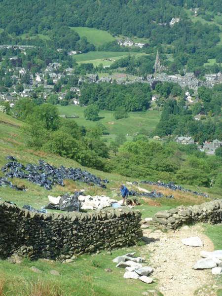
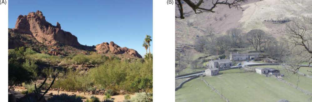
● National park authorities schedule recreational path creation, maintenance, and improvement (Figure 1.1).
● Governments decide how to allocate funds for building sea defenses.
● Travelers and tourists give and receive driving directions, select hotels in unfamiliar cities, and find their way around theme parks (Figure 1.2).
● Farmers employ new GI technology to make better decisions about the amounts of fertilizer and pesticides to apply to different parts of their fields.
If location and GI are important to the solution of so many problems, what distinguishes those problems from each other? Here are three bases for classifying problems. First, there is the question of scale, or level of geographic detail. The architectural design of a building involves GI, but only at a very detailed or local scale. The information needed to service the building is also local—the size and shape of the
parcel, the vertical and subterranean extent of the building, the slope of the land, and its accessibility using normal and emergency infrastructure. At the other end of the scale range, the global diffusion of epidemics and the propagation of tsunamis across the Pacific Ocean (Box 1.1) are phenomena at a much broader and coarser scale.
Scale or level of geographic detail is an essential property of any project.
Second, problems can be distinguished on the basis of intent, or purpose. Some problems are strictly practical in nature—they must often be solved as quickly as possible and at minimum cost to achieve such practical objectives as saving lives in an emergency, avoiding fines by regulators, or responding to civil disorder. Others are better characterized as driven by human curiosity. When GI is used to verify the theory of continental drift, to map distributions of glacial deposits, or to analyze the historic movements of people in anthropological or biosocial research (see Box 1.2 and Figure 1.5), there is no sense of an immediate problem that needs to be solved. Rather, the intent is to advance human understanding of the world, which we often recognize as the intent of science.
Although science and practical problem solving can be thought of as distinct human activities, it is
often argued that there is no longer any effective distinction between their methods. Many of the tools and methods used by a retail analyst seeking a site for a new store are essentially the same as those used by a scientist in a government agency to ensure the protection of an endangered species, or a transport planner trying to ameliorate peak-hour traffic congestion in a city. Each requires the most accurate measurement devices, employs terms whose meanings have been widely shared and agreed on, produces results that are replicable by others, and in general follows all the principles of science that have evolved over the past centuries. The knowledge-exchange activities carried out between research organizations and the government and business sectors can be used to apply many of the results of curiosity-driven science to the practical world of problem solving.
The use of GI systems in support of science, routine application, and knowledge exchange reinforces the idea that science and practical problem solving are no longer distinct in their methods, as we will discuss later. As a consequence, GI systems are used widely in all kinds of organizations, from academic institutions to government agencies, not-for-profit organizations, and corporations. The use of similar tools and methods across so much of science and problem solving is part of a shift from the pursuit of curiosity within traditional academic disciplines to solution-centered, interdisciplinary teamwork.
Nevertheless, in this book we distinguish between uses of GI systems that focus on applications such as inventory or resource management, or so-called normative uses, and uses that advance science, or so-called positive uses (a rather confusing meaning of that term, unfortunately, but the one commonly used by philosophers of science—its use implies that science confirms theories by finding positive evidence in support of them and rejects theories when negative
Figure 1.2 Navigating tourist destinations is a geographic problem.
Figure 1.1 Maintaining and improving footpaths in national parks is a geographic problem.
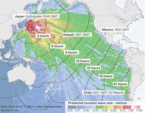
The 2011 To¯hoku Earthquake and Tsunami Applications Box 1.1
At 14.46 local time (05.56 GMT) on March 11, 2011, an undersea earthquake measuring 9.0 on the Richter scale occurred approximately 43 miles (70 kilometers) east of the Japanese coast of To¯hoku. This was the most powerful earthquake ever to have been scientifically documented in Japan, and the fifth most powerful earthquake in the world since modern record-keeping began in c. 1900. The earthquake moved Honshu (the main island of Japan) 2.4 m (8 ft) east and shifted the Earth on its axis by estimates of between 10 cm (4 in) and 25 cm (10 in). Of more immediate significance, the earthquake caused severe earth tremors on the main islands of Japan and triggered powerful tsunami waves that reached heights of up to 40.5 meters (133 ft) in To¯hoku Prefecture and traveled up to 10 km (6 mi) inland in Sendai.
Directly or indirectly, the earthquake led to at least 15,883 deaths and the partial or total collapse of over
380,000 buildings. It also caused extensive and severe structural damage in northeastern Japan (Figure 1.3B), including heavy damage to roads and railways, as well as fires in many areas and a dam collapse. In its immediate aftermath, 4.4 million households in northeastern Japan were left without electricity and 1.5 million without water. In the following days, the tsunami set in action events that led to cooling system failures, explosions, and major meltdowns at three reactors of the Fukushima Daiichi Nuclear Power Plant and the associated evacuation of hundreds of thousands of residents. The World Bank estimated the economic cost at US$235 billion, making it the costliest natural disaster in world history.
All of this happened to a very advanced economy in an earthquake-prone region, which was almost certainly the best prepared in the world for a natural disaster of this kind. GI systems had been used to assemble information on a full range of spatially distributed
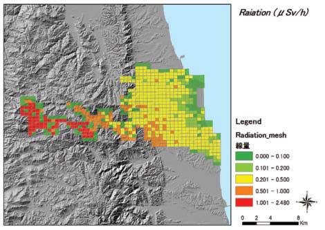
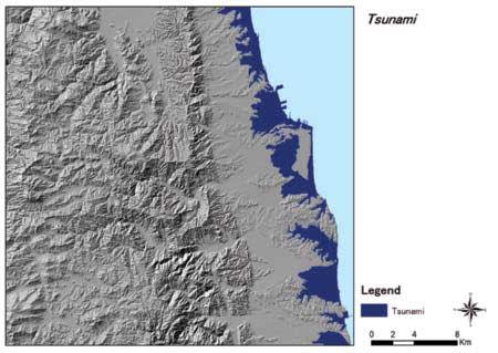
Figure 1.3 (A) The passage of the tsunami arising out of the Great East Japan (To¯hoku) earthquake of March 11, 2011. It had subsequent effects on Soma City in terms of (B) radiation (measured in mSv/h (micro Sievert per hour) and (C) tsunami inundation.
(A)
Source: NOAA Radiation
Source: Soma City and courtesy of Keiji Yano (C)
Source: PASCO Corporation and courtesy of Keiji Yano
phenomena—including the human population, the built environment, and transportation infrastructure—in preparation for a major earthquake disaster and protection against many of its foreseeable consequences.
Yet the science of predicting the location, timing, and intensity of earthquakes has made little progress over the past century. A magnitude-9.0 earthquake is a very rare event and so did not fall within any disastermanagement scenario prior to the event. For example, the Fukushima reactors had been built to withstand a magnitude-8.6 earthquake on the basis of historic occurrences plus a safety margin: but not an event of magnitude 9.0. However, even when major events are unforeseen, GI science and systems are integral to response and recovery in the short term (e.g., alerting populations to the imminent arrival of a tsunami, coordinating citizen
evidence is found). Finding new locations for retailers, with its focus on design, is an example of a normative application of GI systems. But to predict how consumers will respond to new locations, it is necessary for retailers to analyze and model the actual patterns of behavior they exhibit. Therefore, the models they use will be grounded in observations of messy reality that have been tested in a positive manner.
Design is concerned with improving the world— with decisions that when implemented achieve certain desired objectives, such as constructing new housing subdivisions, developing conservation plans, or defining sales territories. In recent years the term geodesign has become a popular way of referring to design decisions at geographic scales, supported by GI systems. All of us would like to design improvements to the world, and GI systems are valuable tools for doing so. Although most work with GI systems is considerably more mundane, it is always good to bear its grander potential in mind. As we show in Section 14.4, geodesign combines two important functions of GI systems—the ability to capture new ideas through sketching (creating/editing new features) and the ability to evaluate them and assess their impacts. A user might sketch a design for a new development, for example, and ask the GI system to predict its impacts on transportation, groundwater, and air pollution.
With a single collection of tools, GI systems are able to bridge the gap between curiositydriven science and practical problem solving
The third way in which problems can be distinguished is on the basis of their time scale, ranging in human
reports of how localities have been affected, and organizing evacuation), the medium term (e.g., managing the disruption to industrial supply chains), and the long term (e.g., prioritizing repair and replacement of damaged transport infrastructure). All these actions take place in an organizational context. Early warning systems are very much an international effort. In terms of addressing effects after the event, the To¯hoku earthquake raised issues that were best addressed at the national level, whereas much of the implementation was best effected at local levels.
The three Ps of disaster management are prevention, preparedness, and protection. GI science and systems are integral to each of them.
terms from the dynastic (perhaps thousands of years; see Box 1.2) to the diurnal, but very much longer with respect to understanding geological or geomorphological change. At one end of the human time spectrum, some decisions are operational and are required for the smooth day-to-day functioning of an organization, such as how to control electricity inputs into grids that experience daily surges and troughs in usage. At slightly longer timescales, tactical decisions might include where to cut trees in next year’s forest harvesting plan. Still other decisions are more infrequent and strategic in nature, such as those required to give an organization long-term direction, as when a retailer decides to expand or rationalize its store network (Figure 1.4). At the far end of the human time spectrum, Box 1.2 describes how the geographic
Figure 1.4 Many store location principles are generic across different retail markets, as with Tesco’s investment in Ostrava, Czech Republic.
distributions of family names, past and present, can be used to indicate how settled (or otherwise) is the population of different places, and even the geography of the DNA of long-settled residents consequent on population movements in early human history (see Box 1.4).
Although humans like to classify time frames into hours, days, years, centuries, and epochs, the real world is somewhat more complex than this, and these distinctions may blur—what is theoretically and statistically a 1000-year flood in a river system influences strategic and tactical considerations, but may arrive a year after the previous one! Other problems that interest geophysicists, geologists, or evolutionary biologists may occur on timescales that are much longer than a human lifetime, but are still geographic in nature, such as predictions about the future physical environment of Japan or about the animal populations of Africa. GI databases are often transactional (see Section 9.9.1), meaning that they are constantly being updated as new information arrives, unlike paper maps, which stay the same once printed.
Applications are discussed to illustrate particular principles, techniques, analytic methods, and management practices (such as risk minimization) as these arise throughout the book.
1.1.2 Spatial Is Special
The adjective geographic refers to the Earth’s surface and near surface, at scales from the architectural to the global. This defi nes the subject matter of this book, but other terms have similar meaning. Spatial refers to any space, not only the space of the Earth’s surface; this term is used frequently in the book, almost always with the same meaning as geographic . But many of the methods used in GI systems are also applicable to other nongeographic spaces, including the surfaces of other planets, the space of the cosmos, and the space of the human body that is captured by medical images. Techniques that are integral to GI systems have even been applied to the analysis of genome sequences on DNA. So the discussion of analysis
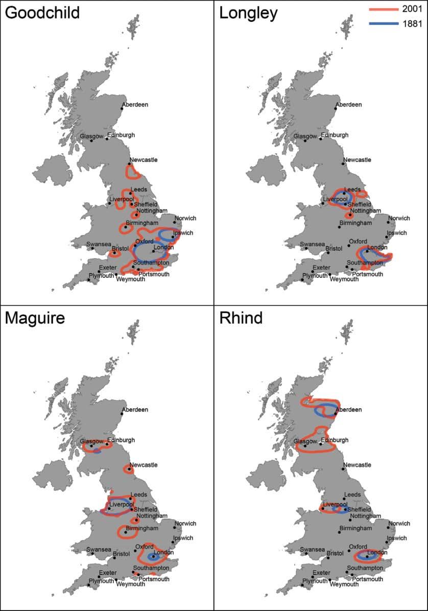
As individuals, many of us are interested in where, in general terms, we came from at different points in recorded human history—for example, whether we are of Irish, Spanish, or Italian descent. More specific locational information can provide clues about the work and other lifestyle characteristics of our ancestors. Some of the best clues to our ancestry may come from our surnames (family names) because many surnames indicate geographic origins to greater or lesser degrees of precision (such clues are less important in some Eastern societies, where family histories are generally much better documented). Research at University College London uses GI systems to analyze historic and present-day lists of names to investigate the changing local and regional geographies of surnames across the world. Figure 1.5 illustrates how the bearers of four selected Anglo-Saxon names in Great Britain (the ancestors of the authors of this book) have mostly stayed put in those parts of the island where the names first came into common parlance at some point between the 12th and 14th centuries—although some have evidently migrated to urban centers.
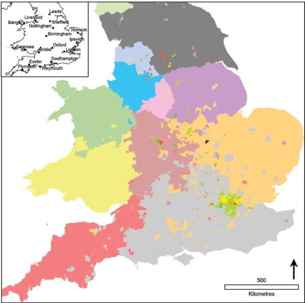
It also turns out that the mix of names with similar geographic origins in any given area can provide a good indication of regional identity. Figure 1.6, derived from the PhD thesis of Jens Kandt, presents a regionalization of Great Britain on the basis of the present-day
residences of bearers of different surnames. (This is essentially a geography of rural Britain. Note that the major urban areas have been excluded because they are characterized by mixes of names arising from urban–rural, interregional, and international migration over the last 200 or so years).
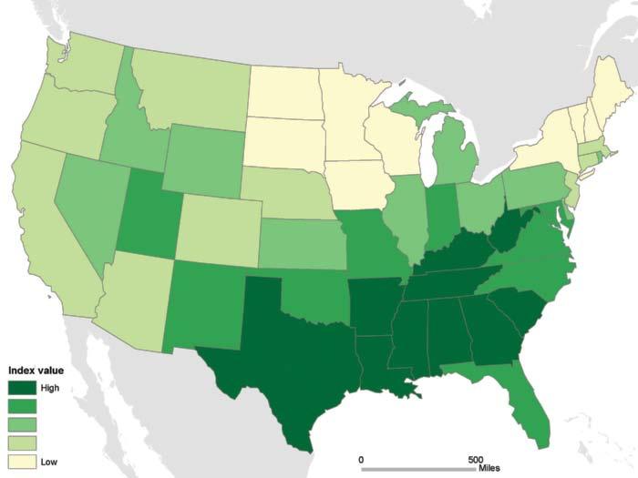
All of this is most obviously evident for Great Britain and many of the countries of Europe, where populations have remained settled close to the locations at which their names were first coined. But there is also evidence to suggest that the spatial patterning of names in former colonies, such as North America, Australia, and New Zealand, is far from random. Figure 1.7 illustrates this for the surname Singleton, which can be used to build evidence about the migration patterns of bearers of this name from their documented origins in northwest England.
Fundamentally, this is curiosity-driven research, driven by the desire among amateur genealogists to discover their roots. But the same techniques can be used to represent the nature and depth of affiliation that people feel toward the places in which they live. Moreover, the work of Sir Walter Bodmer and colleagues (Box 1.4) is highlighting probable links between surnames and genetics, rendering this curiosity-driven research relevant to the development of drug and lifestyle interventions.
Courtesy: James Cheshire
Figure 1.5 The Great Britain Geography of the Longleys, Goodchilds, Maguires, and Rhinds. In each case the shorter (blue) line delineates the smallest possible area within which 95% of name bearers reside, based on 1881 Census of Population figures, and the outer (red) line encloses the smallest area that accommodates the same proportion of adult name bearers according to a recent address register.
Figure 1.6 A regionalization based on the coincidence of distinctive patterns of surnames, showing the southern part of Great Britain. Major urban areas do not fit into this regional pattern because their residents are drawn from a wide range of national and international origins.
Figure 1.7 The Singleton family name derives from a place in northwest England, and understandably the greatest concentration of this name today still occurs in this region. But why should the name be disproportionately concentrated in the south and west of the United States?
Geographical analysis of the global pattern of family names can help us to hypothesize about the historic migrations of families, communities, and cultural groups.
Courtesy: Jens Kandt
Courtesy: Alex Singleton
Technical Box 1.3
Some Technical Reasons Why Geographic Information Is Special and Why GI Science and Systems Have Developed
● It is multidimensional, because two coordinates must be specified to define a location, whether they be x and y or latitude and longitude; and a third coordinate is needed when elevation is important.
● It is voluminous because a geographic database can easily reach a terabyte in size (see Table 1.2).
● It may be collected by citizens, governments, or other organizations, and it may prove useful to pool information from these diverse sources.
● It may be represented at different levels of spatial resolution, for example, by using a representation
equivalent to a 1:1 million-scale map or a 1:24,000-scale one (see Section 3.7).
in this book is of spatial analysis (see Chapters 13 and 14), not geographic analysis, to emphasize this versatility.
Another term that has been growing in usage in recent years is geospatial —implying a subset of spatial applied specifi cally to the Earth’s surface and near surface. In this book we have tended to avoid geospatial, preferring geographic , and we use spatial where we need to emphasize generality.
Although there are subtle distinctions between the terms geographic(al), spatial, and geospatial, for many practical purposes they can be used interchangeably.
People who encounter GI for the fi rst time are sometimes driven to ask why geography is so important; why, they ask, is spatial special? After all, there is plenty of information around about geriatrics, for example, and in principle one could create a geriatric information system. So why has GI spawned an entire industry, if geriatric information has not done so to anything like the same extent? Why are there unlikely to be courses in universities specifi cally in geriatric information science and systems? Part of the answer should be clear already: almost all human activities and decisions involve a location component, and the location component is important. Another reason will become apparent in Chapter 2, where we will see that working with GI involves complex and diffi cult choices that are also largely unique. Other, more technical reasons will
● It may be represented in different ways inside a computer (see Chapter 3), and how this is done can strongly influence the ease of analysis and the end results.
● It must often be projected onto a flat surface, for reasons identified in Section 4.8.
● It requires many special methods for its analysis (see Chapters 13 and 14).
● It may be transformed to present different views of the world, for example, to aid interpretation.
become clear in later chapters and are briefl y summarized in Box 1.3.
1.2 Data, Information, Evidence, Knowledge, and Wisdom
Information systems help us to manage what we know, by making it easy to organize and store, access and retrieve, manipulate and synthesize, and apply to the solution of problems. We use a variety of terms to describe what we know, including the five that head this section and that are shown in Table 1.1. There are no universally agreed-on definitions of these terms. Nevertheless it is worth trying to come to grips with their various meanings because the differences between them can often be significant, and what follows draws on many sources and thus provides the basis for the use of these terms throughout the book. Data clearly refers to the most mundane kind of information and wisdom to the most substantive. Data consist of numbers, text, or symbols, which are in some sense neutral and almost context-free. Raw geographic facts, such as sensor measurements of temperature at a specific time and location, are examples of data. When data are transmitted, they are treated as a stream of bits; a crucial requirement is to preserve the integrity of the data set. The internal meaning of the data is irrelevant in such considerations. Data (the noun is the plural of datum) are assembled together in a
Table 1.1 A ranking of the support infrastructure for decision making.
Decision-making support
Ease of sharing with infrastructure everyone GIS example
Wisdom Impossible Policies developed and accepted by stakeholders
Knowledge Difficult, especially tacit knowledge
Evidence Often not easy
Information Easy
Data Easy
database (see Chapter 9), and the volumes of data that are required for some typical applications are shown in Table 1.2.
The term information can be used either narrowly or broadly (and we use both in this book). In a narrow sense, information can be treated as devoid of meaning and therefore as essentially synonymous with data as defined in the previous paragraph. Others define information as anything that can be digitized, that is, represented in digital form (see Chapter 3), but also argue that information is differentiated from data by implying some degree of selection, organization, and preparation for particular purposes—information is data serving some purpose or data that have been given some degree of interpretation. Information is often costly to produce, but once digitized, it is cheap to reproduce and distribute. Geographic data sets, for example, may be very expensive to collect and assemble, but very cheap to copy and disseminate. One other characteristic of information is that it is easy to add value to it through processing and through merger with other information. GI systems are very useful for
Personal knowledge about places and issues
Results of GIS analysis of many data sets or scenarios
Contents of a database assembled from raw facts
Raw geographic facts
doing the latter because of the tools they provide for combining information from different sources.
GI systems do a better job of sharing data and information than knowledge, which is more difficult to detach from the knower.
Knowledge does not arise simply from having access to large amounts of information. It can be considered as information to which value has been added by interpretation based on a particular context, experience, and purpose. Put simply, the information available in a book or on the Internet or on a map becomes knowledge only when it has been read and understood, as when an experienced hiker chooses not to set off into unfamiliar terrain having read about it and taken stock of the weather forecast. How the information is interpreted and used will be different for different readers depending on their previous experience, expertise, and needs. It is important to distinguish two types of knowledge: codified and tacit. Knowledge is codifiable if it can be written down and transferred relatively easily to others. Tacit
Table 1.2 Potential GI database volumes in bytes for some typical applications (volumes estimated to the nearest order of magnitude). Strictly, bytes are counted in powers of 2—1 kilobyte is 1024 bytes, not 1000.
1 megabyte 1 000 000 (220)
Single data set in a small project database
1 gigabyte 1 000 000 000 (230) Entire street network of a large city or small country
1 terabyte 1 000 000 000 000 (240) Elevation of entire Earth surface recorded at 30 m intervals
1 petabyte 1 000 000 000 000 000 (250)
Satellite image of entire Earth surface at 1 m resolution
1 exabyte 1 000 000 000 000 000 000 (260) A possible 3-D representation of the entire Earth at 10 m resolution
1 zettabyte 1 000 000 000 000 000 000 000 (270)
One-fifth of the capacity (in 2013) of U.S. National Security Agency Utah Data Center
knowledge is often slow to acquire and much more difficult to transfer. Examples include the knowledge built up during an apprenticeship, understanding of how a particular market works, or familiarity with using a particular technology or language. This difference in transferability means that codified and tacit knowledge need to be managed and rewarded quite differently. Because of its nature, tacit knowledge is often a source of competitive advantage.
Some have argued that knowledge and information are fundamentally different in at least three important respects:
● Knowledge entails a knower. Information exists independently, but knowledge is intimately related to people.
● Knowledge is harder to detach from the knower than information; shipping, receiving, transferring it between people, or quantifying it are all much more difficult than for information.
● Knowledge requires much more assimilation—we digest it rather than hold it. We may hold conflicting information, but we rarely hold conflicting knowledge.
Evidence is considered a halfway house between information and knowledge. It seems best to regard it as a multiplicity of information from different sources, related to specific problems, and with a consistency that has been validated. Major attempts have been made in medicine to extract evidence from a welter of sometimes contradictory sets of information, drawn from different geographic settings, in what is known as meta-analysis, or the comparative analysis of the results of many previous studies.
Wisdom is even more elusive to define than the other terms. Normally, it is used in the context of decisions made or advice given, which is disinterested, based on all the evidence and knowledge available. It is given with some understanding of the likely consequences of various actions and assessment of which is or are most beneficial. Almost invariably, knowledge is highly individualized rather than being easy to create and share within a group. Wisdom is in a sense the top level of a hierarchy of decision-making infrastructure.
1.3 GI Science and Systems
GI systems are computer-based tools for collecting, storing, processing, analyzing, and visualizing geographic information. They are tools that improve the efficiency and effectiveness of handling information about objects and events located in geographic space. They can be used to carry out many useful tasks, including storing vast amounts of GI in data-
bases, conducting analytical operations in a fraction of the time they would take to do by hand, and automating the process of making useful maps. GI systems also process information, but there are limits to the kinds of procedures and practices that can be automated when turning data into useful information.
The question of whether and how such selectivity and preparation for purpose actually adds value, or whether the results add insight to interpretation in geographic applications, falls into the realm of GI science. This rapidly developing field is concerned with the concepts, principles, and methods that are put into practice using the tools and techniques of GI systems. It provides sound principles for the sample designs used to create data and the ways in which data can be turned into information that is representative of a study area. GI science also provides a framework within which new evidence, knowledge, and ultimately wisdom about the Earth can be created, in ways that are efficient, effective, and safe to use.
Like all sciences, an essential requirement of GI science is a method for discovering new knowledge. The GI scientific method must support:
● Transparency of assumptions and methods so that other GI scientists can determine how previous knowledge has been discovered and how they might themselves add to the existing body of knowledge
● Best attempts to attain objectivity through a detached and independent perspective that avoids or accommodates bias (unintended or otherwise)
● The ability of any other qualified scientist to reproduce the results of an analysis
● Methods of validation using the results of the analysis (internal validation) or other information sources (external validation)
● Generalization from partial representations that are developed for analytical purposes to the wider objective reality that they purport to represent
How, then, are problems solved using a scientifi c method, and are geographic problems solved in ways different from other kinds of problems? We humans have accumulated a vast storehouse of knowledge about the world, including information both on how it looks —that is, its forms —and how it works —that is, its dynamic processes. Some of those processes are natural and built into the design of the planet, such as the processes of tectonic movement that lead to earthquakes and the processes of atmospheric circulation that lead to hurricanes. Others are human in origin, refl ecting the increasing infl uence that we have on ecosystems,
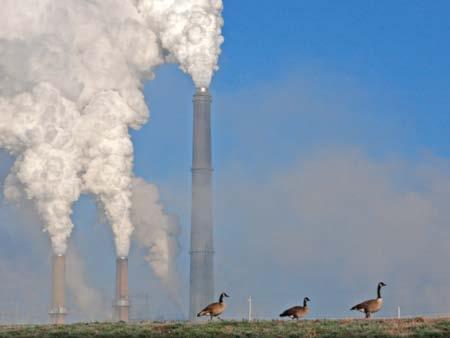
through the burning of fossil fuels, the felling of forests, and the cultivation of crops (Figure 1.8). Still others are imposed by us, in the form of laws, regulations, and practices: for example, zoning regulations affect the ways in which specifi c parcels of land can be used.
Knowledge about how the world works is more valuable than knowledge about how it looks. This is because knowledge about how it works can be used to predict.
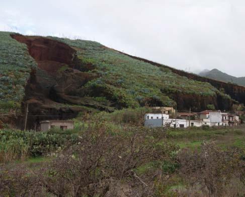
These two types of information differ markedly in their degree of generality. Form varies geographically, and the Earth’s surface looks dramatically different in different places; compare the settled landscape of northern England with the deserts of the U.S. Southwest (Figure 1.9). But processes can be very general. The ways in which the burning of fossil fuels affects the atmosphere are essentially the same in China as in Europe, although the two land-
scapes look very different. Science has always valued such general knowledge over knowledge of the specific, and hence has valued process knowledge over knowledge of form. Geographers in particular have witnessed a long-standing debate, lasting centuries, between the competing needs of idiographic geography, which focuses on the description of form and emphasizes the unique characteristics of places, and nomothetic geography, which seeks to discover general processes. Both are essential, of course, because knowledge of general process is useful in solving specific problems only if it can be combined effectively with knowledge of form. For example, we can only assess the risk of roadside landslip if we know both how slope stability is generally affected by such factors as shallow subsurface characteristics and porosity and where slopes at risk are located (Figure 1.10).
One of the most important merits of a GI system as a problem-solving tool lies in its ability to combine the general with the specific, as in this example. A GI system designed to solve this problem would contain knowledge of local slopes, in the form of computerized maps, and the programs executed by the GI system would reflect general knowledge of how slopes affect the probability of mass movement under extreme weather conditions. The software of a GI system captures and implements general knowledge, whereas the database of a GI system represents specific information. In that sense, a GI system resolves the long-standing debate between nomothetic and idiographic camps by accommodating both.
GI systems solve the ancient problem of combining general scientific knowledge with specific information and give practical value to both.
Figure 1.8 Social processes, such as carbon dioxide emissions, modify the Earth’s environment independent of location.
Figure 1.9 The form of the Earth’s surface shows enormous variability, for example, between (A) the deserts of the southwest United States and (B) the settled landscape of Northern England.
This perspective is consistent with our understanding of places in the world as sites at which unique relations develop among people and the locations that they occupy and the accumulated effects of these relations over time. GI systems provide ways of generalizing about and between places, albeit in ways that acknowledge differences between them. Place-based methods in GI systems make it possible to think of geography as repetitive (where in the world is like this place?) while at the same time remaining sensitive to the unique context of unique places.
General knowledge about unique places comes in many forms. Classification is perhaps the simplest and most rudimentary and is widely used in problem solving. In many parts of the United States and other countries, efforts have been made to limit the development of wetlands in the interest of preserving them as natural habitats and avoiding excessive impact on water resources. To support these efforts, resources have been invested in mapping wetlands, largely from aerial photography and satellite imagery. These maps simply classify land, using established rules that define what is and what is not a wetland (Figure 1.11).
More sophisticated forms of knowledge include rule sets—for example, rules that determine what use can be made of wetlands, or what areas in a forest can be legally logged. The U.S. Forest Service has rules to define wilderness and to impose associated regulations regarding the use of wilderness, including prohibition on logging and road construction. Such rules can be captured in the data model of a GI database (see Chapter 7).
Much of the knowledge gathered by the activities of scientists suggests the term law. The work of
Sir Isaac Newton established the Laws of Motion, according to which all matter behaves in ways that can be perfectly predicted. From Newton’s Laws we are able to predict the motions of the planets almost perfectly, although Einstein later showed that certain observed deviations from the predictions of the Laws could be explained with his Theory of Relativity. Laws of this level of predictive quality are few and far between in the geographic world of the Earth’s surface. The real world is the only laboratory that is available for understanding the effects of many factors on unique places in the social and environmental sciences, and considerable uncertainty is generated when we are unable to control for all conditions. These problems are compounded in the social realm, where the role of human agency makes it almost inevitable that any attempt to develop rigid laws will be frustrated by isolated exceptions. Thus, whereas market researchers use spatial interaction models, in conjunction with GI systems, to predict how many people will shop at each shopping center in a city, substantial errors will occur in the predictions— because people are in significant part autonomous agents. Nevertheless, the results are of great value in developing location strategies for retailing. The Universal Soil Loss Equation, used by soil scientists in conjunction with GI systems to predict soil erosion, is similar in its rather low predictive power, but again the results are sufficiently accurate to be very useful in the right circumstances. “Good” usually means “good enough for this specific application” in GI systems applications.
Solving problems involves several distinct components and stages. First, there must be an objective , or a goal that the problem solver wishes
Figure 1.11 A classified Landsat image (at 30-meter resolution) of part of the Amazon region of Brazil.
Courtesy: National Institute for Space Research INPE Brazil
Figure 1.10 Predicting landslides requires general knowledge of processes and specific knowledge of the area—both can be brought together in a GI system.
to achieve. Often this is a desire to maximize or minimize—fi nd the solution of least cost, shortest distance, least time, greatest profi t or make the most accurate prediction possible. These objectives are all expressed in tangible form; that is, they can be measured on some well-defi ned scale. Others are said to be intangible and involve objectives that are much harder, if not impossible, to measure. They include maximizing quality of life and satisfaction and minimizing environmental impact . Sometimes the only way to work with such intangible objectives is to involve human subjects, through surveys or focus groups, by asking them to express a preference among alternatives. A large body of knowledge has been acquired about such human-subjects research, and much of it has been employed in connection with the design of GI systems. For discussion of the use of such mixed objectives see Section 15.4. This topic is taken up again in Chapter 16 in the context of estimating the return on investment of GI systems.
Often a problem will have multiple objectives, each of which is measured in a different way. For example, a company providing a mobile snack service to construction sites will want to maximize the number of sites that can be visited during a daily operating schedule and will also want to maximize the expected returns by visiting the most lucrative sites. An agency charged with locating a corridor for a new power transmission line may decide to minimize cost, while at the same time seeking to minimize environmental impact. Such problems employ methods known as multicriteria decision making (MCDM).
Many geographic problems involve multiple goals and objectives, which often cannot be expressed in commensurate terms.
1.4 The
Technology of Problem Solving
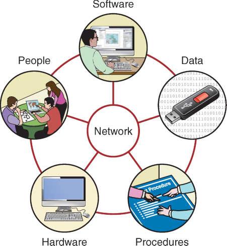
Today it is a truism to refl ect that geographic information is everywhere and that we access and divulge it from many different sources and in many different contexts. A system is usually thought of as a bounded set of components, and in a world in which geographic information is transmitted and shared across physical, public/private, political, and institutional networks , it hardly seems to make sense to think in terms of bounded systems at all. However, although geographic information may be pervasive and ubiquitous, the notion of a networked system remains useful in understanding the compo-
nents of the tools that in turn underpin GI science (Figure 1.12).
Today, almost all GI software products are designed as components of a network. Cloud computing (see Chapter 10) is a colloquial expression that is widely used in business to describe the supply of hosted services to industry and commerce, using computer infrastructure that is located remotely. Networks of large numbers of computers in different locations may be used for collection, storage, and analysis of data in real time. Cloud computing makes it possible to gain convenient, ondemand network access to a shared pool of computer hardware, software, data storage, and other services. Many of these components were previously colocated prior to the innovations of fast wide-area networks; powerful, inexpensive server computers; and high-performance virtualization of computer hardware.
In terms of hardware, the user’s device is the client, connected through the network to a server, or a server farm in the Cloud, that is designed to handle many other user clients simultaneously. The client may be thick , if it performs a large part of the work locally, or thin if it does little more than link the user to the server (as with a mobile phone application, for example). In Cloud computing applications, most or all of the computation is performed remotely.
Uptake and use of the Internet to link computers has been remarkably quick, diffusion being considerably faster than almost all comparable innovations (for
Figure 1.12 The six component parts of a GI system.
example, the radio, the telephone, and the television). RealTimeStatistics.org estimated that in 2013 some 2.4 billion of the world’s 7 billion population were Internet users, although stark variations in Internet availability and usage remain—see Table 1.3.
Many of the early Internet applications of GI systems remain in use, in updated form, today. They range from using GI systems on the Internet to disseminate information on the location of businesses (e.g., www.yell.com), to consolidated lists of available goods and services, to direct revenue generation through subscription services, to helping members of the public to participate in important local, regional, and national debates. The Internet has become very popular as a vehicle for delivering business GI system applications for several reasons. It provides an established, widely used platfor m and accepted standards for interacting with information of many types. It also offers a cost-effective way of linking distributed users (for example, telecommuters and office workers, customers and suppliers, students and teachers). From the early days onward, the interactive and exploratory nature of navigating linked information became a great hit with users.
Internet-enabled devices became portable in the early 2000s (see Section 10.3) with the wide diffusion of location-aware smartphones and other handheld devices and the availability of wireless networks in public places such as airports and railway stations. The subsequent innovation of 3G and 4G mobile broadband now routinely allows portable and invehicle devices to deliver location-based services (see Section 10.3.2) to users on the move. Users receive real-time geographic services such as mapping, routing, traffic congestion, and geographic yellow pages. These services are usually funded directly or indirectly
through advertising, with Google perhaps the most obvious exponent of understanding the importance of location in delivering targeted advertising.
We now turn to consider the other components of a GI system. First, the user’s hardware is the device that the user interacts with directly in carrying out GI system operations, by typing, pointing, clicking, or speaking, and that returns information by displaying it on the device’s screen or generating meaningful sounds. Traditionally, this device sat on an office desktop, but today’s user has more options and much more freedom because GI system functions can also be delivered through smartphones, notebooks, and in-vehicle devices.
The second component is the software programs that represent the world by running locally in the user’s machine or remotely in the Cloud. Increasing numbers of users manipulate geographic information using executable open-source software code that is often freely available for download across the Web. Users can execute this code and also modify it if they wish. Other open software is also available for use as linked executable files, although the computer code that was used to generate it is not made available by its authors and so cannot be modified by other users. Both of these types of software may be made available by their authors in the interests of solving particular problems, or they may be made available as part of larger linked software libraries, such as the R project for statistical computing and graphics (www.r-project.org/). Some open software libraries have a focus on geographic problem solving and as such are described as GI systems—with the Quantum GIS Project (www.qgis.org/) providing perhaps the best contemporary example. The inter national “Geo for All” initiative (www.geoforall.org/) seeks