8.4 Obtaining Data from External Sources (Data Transfer) 187
8.4.1 Geographic Data Formats 189
8.5 Capturing Attribute Data 190
8.6 Citizen-Centric Web-Based Data Collection 190
8.7 Managing a Data Collection Project 191
Questions for Further Study 193 Further Reading 193
9 Creating and Maintaining Geographic Databases
194
9.1 Introduction 194
9.2 Database Management Systems 195
9.2.1 Types of DBMSs 196
9.2.2 Geographic DBMS Extensions 197
9.3 Storing Data in DBMS Tables 198
9.4 SQL 201
9.5 Geographic Database Types and Functions 202
9.6 Geographic Database Design 205
9.6.1 The Database Design Process 205
9.7 Structuring Geographic Information 206
9.7.1 Topology Creation 206
9.7.2 Indexing 208
9.8 Editing and Data Maintenance 212
9.9 Multiuser Editing of Continuous Databases 213
9.9.1 Transactions 213
9.9.2 Versioning 213
9.10 Conclusion 214
Questions for Further Study 216 Further Reading 216
10 The GeoWeb 217
10.1 Introduction 217
10.2 Distributing the Data 222
10.2.1 Object-Level Metadata 223
10.2.2 Geolibraries and Geoportals 225
10.3 The Mobile User 227
10.3.1 Virtual Reality and Augmented Reality 228
10.3.2 Location-Based Services 230
10.3.3 Issues in Mobile GIS 232
10.4 Distributing the Software: GI Services 233
10.4.1 Service-Oriented Architecture 234
10.5 Prospects 235
Questions for Further Study 236 Further Reading 236
3 Analysis
11 Cartography and Map Production 237
11.1 Introduction 237
11.2 Maps and Cartography 241
11.2.1 Maps and Media 245
11.3 Principles of Map Design 246
11.3.1 Map Composition 247
11.3.2 Map Symbolization 248
11.4 Map Series 257
11.5 Applications 261
11.6 Conclusion 265
Questions for Further Study 265 Further Reading 265
12 Geovisualization 266
12.1 Introduction: Uses, Users, Messages, and Media 266
12.2 Geovisualization, Spatial Query, and User Interaction 268
12.2.1 Overview 268
12.2.2 Spatial Query Online and the Geoweb 271
12.3 Geovisualization and Transformation 274
12.3.1 Overview 274
12.3.2 Cartograms 276
12.3.3 Remodeling Spatial Distributions as Dasymetric Maps 278
12.4 Participation, Interaction, Augmentation, and Dynamic Representation 280
12.4.1 Public Participation and Participatory GI Systems (PPGIS) 280
12.4.2 User Interaction and Representation in 2.5-D and 3-D 282
12.4.3 Handheld Computing and Augmented Reality 284
12.4.4 Visualizing Geotemporal Dynamics 285
12.5 Consolidation 288 Questions for Further Study 289 Further Reading 289
13 Spatial Data Analysis 290
13.1 Introduction: What Is Spatial Analysis? 290
13.1.1 Examples 292
13.2 Analysis Based on Location 295
13.2.1 Analysis of Attribute Tables 296
13.2.2 Spatial Joins 299
13.2.3 The Point-in-Polygon Operation 300
13.2.4 Polygon Overlay 301
13.2.5 Raster Analysis 303
13.3 Analysis Based on Distance 304
13.3.1 Measuring Distance and Length 304
13.3.2 Buffering 306
13.3.3 Cluster Detection 308
13.3.4 Dependence at a Distance 309
13.3.5 Density Estimation 310
13.3.6 Spatial Interpolation 313
13.4 Conclusion 317 Questions for Further Study 318 Further Reading 318
14 Spatial Analysis and Inference 319
14.1 The Purpose of Area-Based Analyses 319
14.1.1 Measurement of Area 319
14.1.2 Measurement of Shape 320
14.2 Centrality 321
14.2.1 Centers 322
14.2.2 Dispersion 324
14.3 Analysis of Surfaces 324
14.3.1 Slope and Aspect 324
14.3.2 Modeling Travel on a Surface 326
14.3.3 Computing Watersheds and Channels 327
14.3.4 Computing Visibility 328
14.4 Design 329
14.4.1 Point Location 330
14.4.2 Routing Problems 332
14.5 Hypothesis Testing 334
14.5.1 Hypothesis Tests on Geographic Data 335
14.6 Conclusion 337 Questions for Further Study 338 Further Reading 338
15 Spatial Modeling with GI Systems 339
15.1 Introduction 339
15.1.1 Why Model? 341
15.1.2 To Analyze or to Model? 342
15.2 Types of Models 343
15.2.1 Static Models and Indicators 343
15.2.2 Individual and Aggregate Models 343
15.2.3 Cellular Models 347
15.2.4 Cartographic Modeling and Map Algebra 349
15.3 Technology for Modeling 351
15.3.1 Operationalizing Models in GI Systems 351
15.3.2 Model Coupling 351
15.3.3 Cataloging and Sharing Models 352
15.4 Multicriteria Methods 352
15.5 Accuracy and Validity: Testing the Model 354
15.6 Conclusion 356 Questions for Further Study 357 Further Reading 357
4 Policy, Management, and Action
16 Managing GI Systems 358
16.1 Introduction 359
16.2 Managing Risk 359
16.3 The Case for the GI System: ROI 360
16.4 The Process of Developing a Sustainable GI System 366
16.4.1 Choosing a GI System: The Classical Acquisition Model 368
16.4.2 Implementing a GI System 373
16.4.3 Managing a Sustainable, Operational GI System 375
16.5 Sustaining a GI System—The People and Their Competences 378
16.5.1 GI System Staff and the Teams Involved 378
16.5.2 Project Managers 379
16.5.3 Coping with Uncertainty 379
16.6 Conclusions 380 Questions for Further Study 380 Further Reading 380
17 Information and Decision Making 381
17.1 Why We Need Information 381
17.1.1 Trade-Offs, Uncertainty, and Risk 383
17.1.2 Organizational Drivers 383
17.2 Information as Infrastructure 386
17.2.1 Information for Management 387
17.3 Different Forms of GI 391
17.3.1 GI about Individuals 394
17.3.2 More Novel Forms of GI 402
17.3.3 The Changing World of GI 402
17.4 Open Data and Open Government 404
17.4.1 The Metadata Issue 405
17.5 Example of an Information Infrastructure: The Military 406
17.5.1 Technological Change and the Military 406
17.5.2 The Military Information Infrastructure 407
17.5.3 Civilian Spin-Offs 408
17.6 Conclusions 409 Questions for Further Study 410 Further Reading 410
18 Navigating the Risks 411
18.1 Clashes Between Scientists and the Judiciary 412
18.2 Business Models for GI-Related Enterprises 412
18.3 Legal and Regulatory Constraints 414
18.3.1 Geography and the Law 414
18.3.2 Three Aspects of the Law and GI 415
18.4 Privacy and GI Systems 421
18.4.1 Preserving Privacy without Losing the Use of Personal Information 422
18.5 Public Trust, Ethics, and Coping with the Media 424
18.5.1 Public Trust 424
18.5.2 Ethics 425
18.5.3 Coping with the Media 426
18.6 Partnerships, Up-Scaling Activities, and Risk Mitigation 426
18.6.1 Spatial Data Infrastructures: The U.S. Experience 427
18.6.2 INSPIRE 429
18.6.3 UN Initiative on Global Geospatial Information Management 430
18.6.4 Have SDIs Worked? 430
18.7 Coping with Spatial Stupidity 432
18.8 Conclusions 433 Questions for Further Study 434 Further Reading 434
19 Epilog: GISS in the Service of Humanity
435
19.1 GISS, the Active Citizen, and Citizen Scientists 435
19.1.1 Who Can Help? 436
19.1.2 Areas Where GISS Contributes 437
19.2 Context: Our Differentiated World 437
19.3 Context: Our Interdependent World 440
19.4 The Process 441
19.4.1 Stage 1: Defining and Describing the Issue 442
19.4.2 Stage 2: Analyzing and Modeling Spatial Interrelationships 442
19.4.3 Stage 3: Devising Possible Solutions 442
19.4.4 Communicating Results and Possible Solutions to Decision Makers 443
19.4.5 Stage 5: Reflect, Learn, and Educate 443
19.5 The Grand Challenges 443
19.6 Grand Challenges Whose Effects We Can Help to Ameliorate 445
19.6.1 Population Growth 445
19.6.2 Poverty and Hunger 446
19.6.3 Human Health 448
19.6.4 Access to Food, Potable Water, and Boundary Disputes 452
19.6.5 Coping with Natural Disasters 453
19.6.6 Coping with Terrorism, Crime, and Warfare 456
19.6.7 Environmental Sustainability 456
19.7 Conclusions 459
Questions For Further Study 460 Further Reading 460
INDEX 461
FOREWORD
Joe Lobley here, again.
This is the fourth time the “Gang of Four” authors have asked me to write an introduction to their textbook. I was flattered, so again said yes. Now I know why they keep on doing this: I heard from a Wiley insider that market research shows that my stuff is the most read section of the book! And who can resist having his great thoughts read by 80,000 purchasers (so far) of the book? But next time I’ll charge the Gang.
Looking at publisher’s blurb for the fourth edition, the first thing my eagle eyes picked up was the “science and systems” goof right there on the front cover— rather than the other way round used previously. I know you won’t pulp the print run just because of this, but y’know the new title might just be a blessing in disguise. If you Google “GIS,” I’ve noticed that references to my general infantrymen colleagues keep popping up on the list, so perhaps the term doesn’t denote the sunrise industry it once was. Today’s bright young wannabes (and old tight-fisted cheapskates like me) are more likely to patch together free and open software than toe the corporate software line. At the end of the day, I buy the line the Gang have spun since I first started helping them write, namely that science is more exciting than this month’s favorite software release. Which brings me to my news. Those who have followed my “most read” contributions will know that life in the GI “system garden” has not always been smooth for me. I’ve tried all sorts of roles, worked in many countries as a consultant, started businesses, smooched with governments, and got marooned on a desert island for my pains. Despite all my entrepreneurial activities, I’m still not rich. In fact, I’m broke. I’m living in a battered caravan in an alcohol-free Islamic country. Because I worked for the U.S. military for a time, where I am had better be secret ’til I raise enough cash to move on.
me on the fast track from the start, and they accepted my successful patent filing for the Lobley Precisional Adjustment to differential GPS instead of a dissertation. The only problem was the huge fee I had to pay an agent to get certified as having passed everything. There have been so many big legal cases of late between Apple, Samsung, Google, and the rest over infringement of patents that I must be able to make it big in the “law and GIS” domain. If I had done it a bit earlier I could have sued one of the street data providers on behalf of users of their error-prone mapping. All I would have needed is for the families of a few people drowned after driving into a river by following these maps to ask me to act for them. OK, timing is everything.
So I’ve been rethinking what’s gone wrong, despite my unrivalled experience and scientific skills. Partly it’s the structure of our industry. I’ve noticed that almost all the job adverts are for relatively lowly paid technical roles, and there are not many highly paid employees that are data bashers. I want to be one of the top guys, not a technician—I’m too old to keep up with techie college graduates when the GIS world is changing so rapidly. If putting science before systems presents new market opportunities, count me in, guys.
But at the end of the day, science just isn’t where the real action is. When Calvin Coolidge was President, he said that “the business of America is business.” So I’ve retrained: I’ve used my GIS to acquire a three-month Masters in intellectual property law from a respected online learning provider—my life-experience credits put
x Foreword
I can only see one problem with GIS and law. It comes, as you might guess, from government. In the United States, government—apart from the military— mostly and until recently hasn’t seen data as an asset to be treasured, protected, and exploited (I could help them). Worse, this plague is spreading. Can you believe that 60 or so national governments—including some serious ones (but not yet China or India, and Russia changed its mind)—have signed up to something called the Open Government Partnership? The idea is to flagellate themselves by making public commitments to reform government, foster innovation, and make everything transparent. Making almost all government data free seems to be the way that they will enable armchair auditors to keep watch on their government and politicians. This madness could be a serious barrier to my wealth creation if everything everywhere is free. But hey, maybe I could become a super-auditor, identifying fraud through use of GIS to bring data together. It would need to include lots of personal data, but privacy is an outdated concept anyway. My ex-wife Lolita found that out when I tracked her philandering throughout Lincolnshire some years ago.
All this, of course, is about Big Data—another fashion. We GIS folk have been doing it for years but no one has listened to us. As is normal with new fashions, big consultancies have proclaimed they are experts in it and can change the world. I could try giving them the benefit of my experience. But my best hope is to work for the U.S. National Security Agency or another country’s version of it. Those guys—as Snowden pointed out—are focused, with clear aims, limited accountability, and lots of money. My kind of folk in fact. The bad guys have to live somewhere so the good guys need GIS. . . .
Joe Lobley
DEDICATION
We dedicate this fourth edition to Roger Tomlinson (1933–2014). Often called the “Father of GIS,” Roger devoted most of his adult life to promoting the systems, technology, and science of geographic information (GI), as an integral part of the discipline of geography. In the 1960s he was the prime instigator behind the Canada Geographic Information System, a federal–provincial project to automate the measurement of Canada’s land resource. In the 1970s he argued forcefully for a single, integrated technology for handling geographic information, completed a PhD at University College London, organized groundbreaking conferences through the aegis of the International Geographical Union, and founded a consulting practice to advise government agencies on the adoption of GI systems. His approach is ably detailed in his book, Thinking about GIS: Geographic Information System Planning for Managers (Esri Press), which is now in its fifth edition, and in the executive seminars he has led at the Esri International User Conference for many years.
Roger was an unflagging promoter of GI systems, which he saw as an essential part of humanity’s interaction with its environment and the key to the solution of many of humanity’s problems. He will be remembered for the force of his personality, his wit and charm, and his passionate support of the field, which he did more than perhaps anyone else to establish and support.
PREFACE
It is an old but true adage that everything that happens, happens somewhere. Throughout the history of humankind, geography has played a central role in many types of decision-making, some of which have life or death, or at least major strategic, impacts. In the past 50 years decision-making has benefited enormously, and in very many ways, from access to geographic information (GI), the science that underpins it, and the systems technology that enables it.
The previous edition of this textbook was published in 2011. Since then our world has changed, in some respects dramatically. Many of our interactions with information now occur through mobile devices rather than desktops, laptops, or paper. Location- (i.e., geographic-) based services have been estimated to be worth between $150bn and $270bn annually. Open Data, Open Software, and Open Science have been developing rapidly. The emergence of Big Data—where our community has pioneered many developments—has been hailed by some as obviating many past constraints (such as ensuring that samples are representative of a known population). Virtually all data are now collected in digital form rather than on paper; it is claimed that more data are now collected every two years than in the whole of previous human history. Crowdsourcing has produced many new datasets and changes in the way we tackle some tasks—such as scanning satellite images of a huge area of the South Indian Ocean for wreckage from Malaysian Airlines MH370 flight, a project organized by DigitalGlobe using imagery from its Worldview-2 system. Many governments are at last disgorging the information they hold for general use. And social media data are providing the fuel for real-time analysis of the geotemporal activity patterns of hundreds of millions of citizens. Given all that, this edition attempts to identify, explain, and evaluate the key changes and portray a snapshot of the contemporary world of geographic information, GI science, and GI systems.
science. Here we deal with principles, many of which have endured in changing guises ever since the first edition of this book appeared in 2001. Where they exist, we deal with laws akin to those in the physical sciences, but also address the statistical generalizations of the social and environmental sciences. The third driving force of our Gang of Four is geographic information itself: we need to know its many characteristics, including quality, if we are to accommodate the inevitable uncertainty that arises when we admix different data using a variety of algorithms.
The New Vision
Reflecting this emerging GI ecosystem, we have made a subtle change of title in this, the fourth edition. The internal structure and content of the book reflects the change. After an introductory chapter, we develop a section on principles. This encompasses the nature of geographic data and information, representing geography, georeferencing, and uncertainty. We follow this with the “how”—a section on techniques, dealing with GI system software, data modeling, data collection, creating and maintaining geographic databases, and the Geoweb. The fourth section on analysis covers cartography, geovisualization, spatial data analysis, inferential spatial analysis, and spatial modeling. The fifth section covers human factors in relation to what we now term geographic information science and systems (GISS). It deals with information and decision-making, and with navigating the legal, ethical, and many other risks that GISS practitioners face. The concluding chapter—the Epilog—looks ahead. But it does this not by seeking to assess technological change, important as that is. Rather, it seeks to identify where we can use our GISS understanding, knowledge, skills, and tools to tackle major problems.
In times past we wrote about geographic information systems, or GIS. The world has moved on. Except where we are quoting from others, we no longer use the abbreviation GIS. GI systems continue to evolve rapidly in their functions, ease of use, and number and spread of their users. They continue to provide the tools to describe and analyze the physical or human environments, bringing together data and converting them into information and even evidence (see Section 1.2). But underpinning that use of dazzling new technologies is a rapidly developing GI
Throughout the book we emphasize the commonalities and the differences between groups of GI system users. Thus those in business, in governments at a variety of levels, in academia, and in notfor-profit organizations have overlapping concerns but some different drivers. This extends to differences between national and subnational cultures (and even between individuals), where our value systems and preferred modes of operating vary greatly. We have tried to give due credence to these similarities and differences.
Throughout the book we use examples and descriptions of luminaries whom we judge to have
made a substantial contribution. We have tried throughout the text to provide detail because “the devil is in the detail” while also trying to highlight key points (such as through use of short tweet-like “factoids” that appear in bold), further reading, and a set of questions at the end of each chapter to test how much the student has gained from it and whether the student can develop new ideas or practice.
Online Supplementary Materials
This fourth edition is available both in print and online. In addition to the full content of the print edition, the online Web site includes significant supplementary material:
for the future. This book seeks to tell you why and convince you to join us.
Acknowledgments
● A detailed discussion of four examples of GI system application, chosen to illustrate both the breadth of applications of GI technology, and the importance of the scientific principles elaborated throughout the book.
● Powerpoint slides for each of the chapters of the book, designed to be used as the basis for a course of lectures on the book’s contents.
● An Instructor’s Manual, giving pointers to the most effective ways to use the book in courses.
The Best of Times
In short, we are in the most exciting of times. Human ingenuity is transforming the way we can describe, analyze, and communicate what is occurring on the face of the Earth (and beyond). We have good enough science, information, and tools to make a real impact in improving societies, business performance, and much else—at all levels from the very local to the global. Central to all this is geographic variation and the awareness and skills to cope with it or even to reshape it. We authors are excited by what GISS practitioners have already achieved and by the prospects
We take complete responsibility for all the material contained herein. But we have drawn on contributions made by many others from across the world, which have helped us create this edition. We especially thank Muhammad Adnan, Stuart Ashfield, Brian Baker, Lawrence Ball, Sir John Beddington, Ann Blake, James Borrell, Peter Benton, Budhu Bhaduri, Paul Boyle, Alisdair Calder, Folke Carlsson, Tao Cheng, James Cheshire, Keith Clarke, Steve Coast, David Cowen, Max Craglia, Jack Dangermond, Keith Dugmore, Sarah Elwood, Ryan Flahive, Chris Gale, Vishal Gaudhar, Paul Hancock, David Hand, Stuart Houghton, Liz Hughes, Indy Hurt, Pete Jones, Jens Kandt, Milan Konecny, Kira Kowalska, Guy Lansley, Vanessa Lawrence, Alistair Leak, Dan Lewis, Antonio Lima, Yu Liu, Ross Maciejewski, Sara McLafferty, Mirco Musolesi, Tomoki Nakaya, Ollie O’Brien, Giles Pavey, Joyce Poh, Marian Provenzano, Denise Pumain, Muttukrishnan “Raj” Rajarajan, Jonathan Rhind, Doug Richardson, James Russiello, Matt Sims, Alex Singleton, Karen Slaght, Carl Steinitz, Lynn Usery, Ruth Wembridge, Roy Wood, Michael Worboys, Bradley Williams, Qingling Wu, and Keiji Yano. We sincerely apologize to anyone else whose contribution we may have overlooked.
Many others have contributed to the content of previous editions; we reiterate our thanks to them.
Paul Longley, University College London
Michael Goodchild, Emeritus Professor, University of California, Santa Barbara David Maguire, University of Greenwich
David Rhind, Emeritus Professor, City University London
List of Acronyms and Abbreviations
AAG Association of American Geographers
ABM agent-based model
AEGIS Advanced Emergency Geographic Information System
AHP Analytical Hierarchy Process
AJAX Asynchronous Javascript and XML
ALSM airborne laser swath mapping
AM/FM automated mapping/facilities management
AOL America On-Line
API application programming interface
AR augmented reality
ARPANET Advanced Research Projects Agency Network
ASCII American Standard Code for Information Interchange
TIGER Topologically Integrated Geographic Encoding and Referencing
TIN triangulated irregular network
TOID topographic identifier
TSP traveling-salesperson problem
TV television
UAM Metropolitan Autonomous University (Mexico)
UAV unmanned aerial vehicle
UCAS University of the Chinese Academy of Sciences
UCGIS University Consortium for Geographic Information Science (US)
UK United Kingdom (of Great Britain and Northern Ireland)
UML Unified Modeling Language
UN United Nations
UNAM National Autonomous University of Mexico
UNIGIS University GIS Consortium
URI uniform resource identifier
URL uniform resource locator
US United States (of America)
USA United States of America
USGS United States Geological Survey
USLE Universal Soil Loss Equation
UTM Universal Transverse Mercator projection
VACCINE Visual Analytics for Command, Control, and Interoperability Environments (Purdue University)
VBA Visual Basic for Applications
VfM value for money
VGA video graphics array
VGI volunteered geographic information
VR virtual reality
W3C World Wide Web Consortium
WAN wide-area network
WCS Web Coverage Service
WFS Web Feature Service
WGS84 World Geodetic System of 1984
WHO World Health Organization
WIMP windows, icons, menus, pointers
WMS Web Map Service
WTO World Trade Organization
WWF World Wide Fund for Nature
WWW World Wide Web
WYSIWYG what you see is what you get
XML Extensible Markup Language
XSEDE Extreme Science and Engineering Discovery Environment
Geographic Information: Science, Systems, and Society 1
This chapter sets the conceptual framework for and summarizes the content of the book by addressing several major questions:
● What exactly is geographic information (GI), and why is it important? What is special about it?
● What new technological developments are changing the world of GI?
● How do GI systems affect the lives of average citizens?
● What kinds of decisions make use of geographic information?
● What is a geographic information system (GI system), and how would you recognize one?
● What is geographic information science (GI science), and why is it important to GI systems?
● How do scientists and governments use GI systems, and why do they find them helpful?
● How do companies make money from GI systems?
1.1 Introduction: What Are GI Science and Systems, and Why Do They Matter?
Almost everything that happens, happens somewhere. We humans confine our activities largely to the surface and near-surface of the Earth. We travel over it and through the lower levels of its atmosphere, and we go through tunnels dug just below the surface. We dig ditches and bury pipelines and cables, construct mines to get at mineral deposits, and drill wells to access oil and gas. We reside on the Earth and interact with others through work, leisure, and family
LEARNING OBJECTIVES
After studying this chapter you will:
● Know definitions of many of the terms used throughout the book.
● Be familiar with a brief history of GI science and GI systems.
● Recognize the sometimes invisible roles of GI systems in everyday life, business, and government.
● Understand the significance of GI science and how it relates to GI systems.
● Understand the many impacts that GI systems and its underpinning science are having on society and the need to study those impacts.
pursuits. Keeping track of all this activity is important, and knowing where it occurs can be the most convenient basis for tracking. Knowing where something happens is of critical importance if we want to go there ourselves or send someone there, to find more information about the same place, or to inform people who live nearby. In addition, geography shapes the range of options that we have to address things that happen, and once they are made, decisions have geographic consequences. For example, deciding the route of a new high-speed railroad may be shaped by topographic and environmental considerations, and the chosen route will create geographic winners and losers in terms of access. Therefore geographic
location is an important component of activities, policies, strategies, and plans.
Almost everything that happens, happens somewhere. Knowing where something happens can be critically important.
The focus of this book is on geographic information, that is, information that records where as well as what and perhaps also when. We use the abbreviation GI throughout the book. GI systems were originally conceived as something separate from the world they represent—a special kind of information system, often located on a user’s desk, dedicated to performing special kinds of operations related to location. But today such information pervades the Internet, can be accessed by our smartphones and other personal devices, and is fundamental to the services provided by governments, corporations, and even individuals. Locations are routinely attached to health records, to Twitter feeds and photographs uploaded to Flickr, and to the movements of mobile phone users and vehicles. In a sense, then, the whole digital world has become one vast, interconnected GI system. This book builds on what users of this system already know—that use of GI services is integral to many of our interactions through the Internet. Later chapters will describe, for example, how storage and management of more and more data entail use of the Cloud, how Big Data and Open Data have become ubiquitous (but not necessarily useful), and how Web-based GI systems have become a fact of life.
Underlying these changes are certain fundamentals, however, and these have a way of persisting despite advances in technology. We describe them with the term GI science, which we define as the general knowledge and important discoveries that have made GI systems possible. GI science provides the structure for this book because as educators we believe that knowledge of principles and fundamentals—knowledge that will still be valid many years from now—is more important than knowledge of the technical details of today’s versions of GI technology. We use the acronym GISS—geographic information science and systems—at various points in this book to acknowledge the interdependence between the underpinning science and the technology of problem solving.
At the outset, we also observe that GI science is also fundamentally concerned with solving applied problems in a world where business practices, or the realpolitik of government decision making, are important considerations. We also discuss the practices of science and social science that, although governed by clearly defined scientific principles, are imperfectly coupled in some fast-developing areas of citizen science.
1.1.1 The Importance of Location
Because location is so important, it is an issue in many of the problems society must solve. Some of these problems are so routine that we almost fail to notice them—the daily question of which route to take to and from work, for example. Others are quite extraordinary and require rapid, concerted, and coordinated responses by a wide range of individuals and organizations—such as responding to the major emergencies created by hurricanes or earthquakes (see Box 1.1). Virtually all aspects of human life involve location. Environmental and social scientists recognize the importance of recording location when collecting data; major information companies such as Google recognize the importance of providing mapping and driving directions and prioritizing searches based on the user’s location; and citizens are increasingly familiar with services that map the current positions of their friends. Here are some examples of major decisions that have a strong geographic element and require GI:
● Health-care managers decide where to locate new clinics and hospitals.
● Online shopping companies decide the routes and schedules of their vehicles, often on a daily basis.
● Transportation authorities select routes for new highways and anticipate their impacts.
● Retailers assess the performance of their outlets and recommend how to expand or rationalize store networks.
● Forestry companies determine how best to manage forests, where to cut trees, where to locate roads, and where to plant new trees.
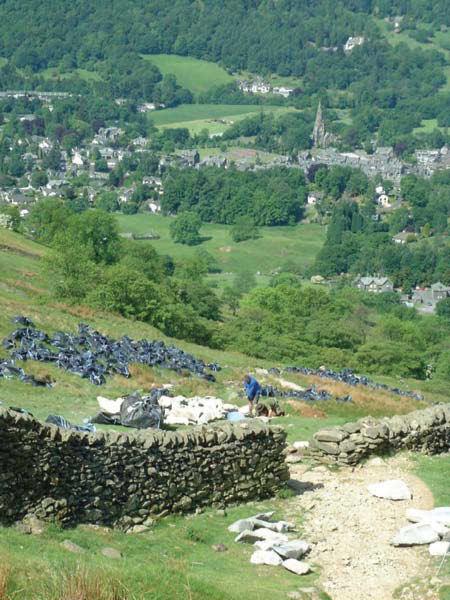
● National park authorities schedule recreational path creation, maintenance, and improvement (Figure 1.1).
● Governments decide how to allocate funds for building sea defenses.
● Travelers and tourists give and receive driving directions, select hotels in unfamiliar cities, and find their way around theme parks (Figure 1.2).
● Farmers employ new GI technology to make better decisions about the amounts of fertilizer and pesticides to apply to different parts of their fields.
If location and GI are important to the solution of so many problems, what distinguishes those problems from each other? Here are three bases for classifying problems. First, there is the question of scale, or level of geographic detail. The architectural design of a building involves GI, but only at a very detailed or local scale. The information needed to service the building is also local—the size and shape of the
parcel, the vertical and subterranean extent of the building, the slope of the land, and its accessibility using normal and emergency infrastructure. At the other end of the scale range, the global diffusion of epidemics and the propagation of tsunamis across the Pacific Ocean (Box 1.1) are phenomena at a much broader and coarser scale.
Scale or level of geographic detail is an essential property of any project.
Second, problems can be distinguished on the basis of intent, or purpose. Some problems are strictly practical in nature—they must often be solved as quickly as possible and at minimum cost to achieve such practical objectives as saving lives in an emergency, avoiding fines by regulators, or responding to civil disorder. Others are better characterized as driven by human curiosity. When GI is used to verify the theory of continental drift, to map distributions of glacial deposits, or to analyze the historic movements of people in anthropological or biosocial research (see Box 1.2 and Figure 1.5), there is no sense of an immediate problem that needs to be solved. Rather, the intent is to advance human understanding of the world, which we often recognize as the intent of science.
Although science and practical problem solving can be thought of as distinct human activities, it is
often argued that there is no longer any effective distinction between their methods. Many of the tools and methods used by a retail analyst seeking a site for a new store are essentially the same as those used by a scientist in a government agency to ensure the protection of an endangered species, or a transport planner trying to ameliorate peak-hour traffic congestion in a city. Each requires the most accurate measurement devices, employs terms whose meanings have been widely shared and agreed on, produces results that are replicable by others, and in general follows all the principles of science that have evolved over the past centuries. The knowledge-exchange activities carried out between research organizations and the government and business sectors can be used to apply many of the results of curiosity-driven science to the practical world of problem solving.
The use of GI systems in support of science, routine application, and knowledge exchange reinforces the idea that science and practical problem solving are no longer distinct in their methods, as we will discuss later. As a consequence, GI systems are used widely in all kinds of organizations, from academic institutions to government agencies, not-for-profit organizations, and corporations. The use of similar tools and methods across so much of science and problem solving is part of a shift from the pursuit of curiosity within traditional academic disciplines to solution-centered, interdisciplinary teamwork.
Nevertheless, in this book we distinguish between uses of GI systems that focus on applications such as inventory or resource management, or so-called normative uses, and uses that advance science, or so-called positive uses (a rather confusing meaning of that term, unfortunately, but the one commonly used by philosophers of science—its use implies that science confirms theories by finding positive evidence in support of them and rejects theories when negative
Figure 1.2 Navigating tourist destinations is a geographic problem.
Figure 1.1 Maintaining and improving footpaths in national parks is a geographic problem.
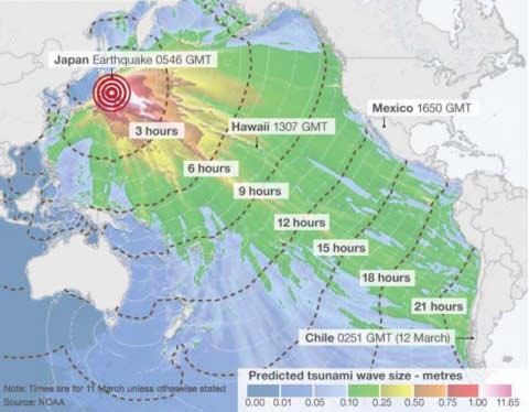
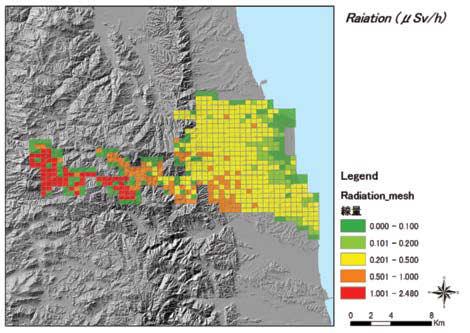
The 2011 To¯hoku Earthquake and Tsunami Applications Box 1.1
At 14.46 local time (05.56 GMT) on March 11, 2011, an undersea earthquake measuring 9.0 on the Richter scale occurred approximately 43 miles (70 kilometers) east of the Japanese coast of To¯hoku. This was the most powerful earthquake ever to have been scientifically documented in Japan, and the fifth most powerful earthquake in the world since modern record-keeping began in c. 1900. The earthquake moved Honshu (the main island of Japan) 2.4 m (8 ft) east and shifted the Earth on its axis by estimates of between 10 cm (4 in) and 25 cm (10 in). Of more immediate significance, the earthquake caused severe earth tremors on the main islands of Japan and triggered powerful tsunami waves that reached heights of up to 40.5 meters (133 ft) in To¯hoku Prefecture and traveled up to 10 km (6 mi) inland in Sendai.
Directly or indirectly, the earthquake led to at least 15,883 deaths and the partial or total collapse of over
380,000 buildings. It also caused extensive and severe structural damage in northeastern Japan (Figure 1.3B), including heavy damage to roads and railways, as well as fires in many areas and a dam collapse. In its immediate aftermath, 4.4 million households in northeastern Japan were left without electricity and 1.5 million without water. In the following days, the tsunami set in action events that led to cooling system failures, explosions, and major meltdowns at three reactors of the Fukushima Daiichi Nuclear Power Plant and the associated evacuation of hundreds of thousands of residents. The World Bank estimated the economic cost at US$235 billion, making it the costliest natural disaster in world history.
All of this happened to a very advanced economy in an earthquake-prone region, which was almost certainly the best prepared in the world for a natural disaster of this kind. GI systems had been used to assemble information on a full range of spatially distributed
Figure 1.3 (A) The passage of the tsunami arising out of the Great East Japan (To¯hoku) earthquake of March 11, 2011. It had subsequent effects on Soma City in terms of (B) radiation (measured in mSv/h (micro Sievert per hour) and (C) tsunami inundation.
(A)
Source: NOAA Radiation
Source: Soma City and courtesy of Keiji Yano (C)
Source: PASCO Corporation and courtesy of Keiji Yano
Another random document with no related content on Scribd:
credit card donations. To donate, please visit: www.gutenberg.org/donate.
Section 5. General Information About Project Gutenberg™ electronic works
Professor Michael S. Hart was the originator of the Project Gutenberg™ concept of a library of electronic works that could be freely shared with anyone. For forty years, he produced and distributed Project Gutenberg™ eBooks with only a loose network of volunteer support.
Project Gutenberg™ eBooks are often created from several printed editions, all of which are confirmed as not protected by copyright in the U.S. unless a copyright notice is included. Thus, we do not necessarily keep eBooks in compliance with any particular paper edition.
Most people start at our website which has the main PG search facility: www.gutenberg.org.
This website includes information about Project Gutenberg™, including how to make donations to the Project Gutenberg Literary Archive Foundation, how to help produce our new eBooks, and how to subscribe to our email newsletter to hear about new eBooks.