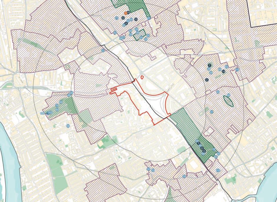
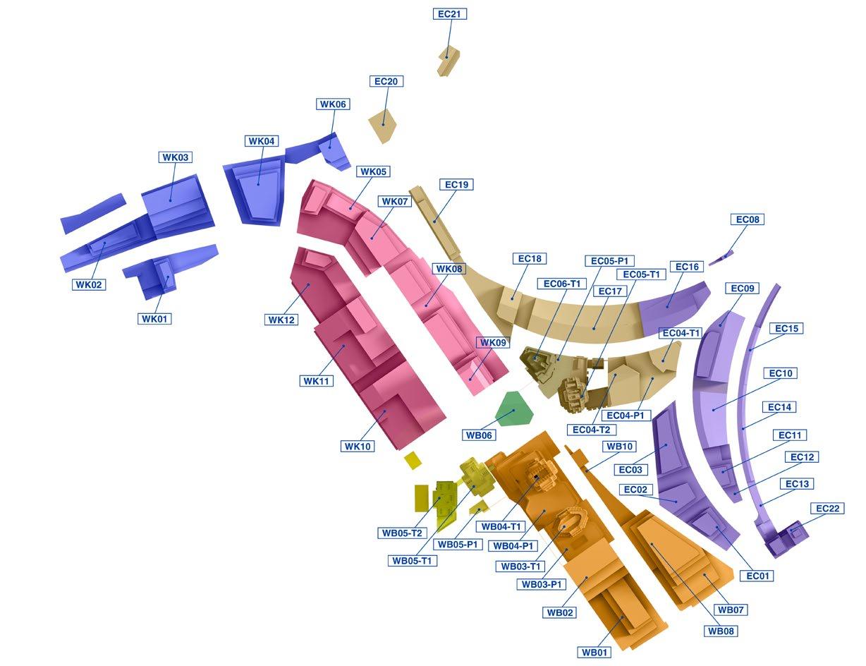
Technical Appendix 1A.2A: Maps of Heritage Study Area
Technical Appendix 1A.3A: Amended Map of Heritage Study Area Overlaid with Zone of Theoretical Visibility
Technical Appendix 1A.6A: Maps of Heritage Assets Scoped in for Assessment
Chapter 2A: Townscape and Visual
Technical Appendix 2A.IN: Updated Verified and Non-Verified Views.
1A BUILT HERITAGE
Introduction
1.1 This chapter of the 2025 ES Addendum reports on the likely built heritage effects of the Amended Proposed Development. The assessment considers whether the Amended Proposed Development would result in additional or different significant environmental effects to those presented in the built heritage assessment of the July 2024 ES for the Proposed Development. In particular, the assessment considers the proposed amendments to the building footprint and height of the Amended Detailed Component; the development zone maximum vertical and horizontal parameters and design codes of the Amended Outline Component of the Amended Proposed Development
1.2 This chapter should be read in conjunction with Volume 2, Chapter 1: Built Heritage and associated technical appendices 1.1-1.6 of the July 2024 ES. The majority of these documents remain unchanged for the Amended Proposed Development but have been updated, where required. In respect of the chapter, context and validation text are shown in black, updated text in blue and new text in green Where select amendments have been made to tables and figures, titles have been denoted by the letter suffix ‘A’ (e.g. Table 1A.1A) for the table /figure to be read in conjunction with the original; where material updates have been required, titles have been denoted by the letter suffix ‘R’ (e.g. Table 1A.1R) for the original table/figure to be replaced/disregarded; and where entirely new tables and figures have been required, these have been denoted by the letter suffix ‘N’ (e.g. Table 1A.1N).
1.3 In respect of technical appendices, the following addendum appendices have been prepared to reflect the proposed amendments:
• Technical Appendix 1A.2A: Maps of Heritage Study Area;
• Technical Appendix 1A.3A: Amended Map of Heritage Study Area Overlaid with Zone of Theoretical Visibility; and
• Technical Appendix 1A.6A: Maps of Heritage Assets Scoped in for Assessment.
1.4 The chapter should be read together with:
• Volume 1A: Main Environmental Statement Report Addendum –
ES Chapter 1A: Introduction;
ES Chapter 2A: EIA Process and Methodology;
ES Chapter 3A: Alternatives and Design Evolution;
ES Chapter 4A: Amended Proposed Development Description;
ES Chapter 5A: Amended Demolition and Construction Description;
• ES Volume 2A: Built Heritage, Townscape and Visual Assessment Addendum, Chapter 2A: Townscape and Visual; and
• ES Volume 3A: Technical Appendices Addendum, associated with relevant Chapters of ES Volume 1A.
1.5 The introduction as presented in Chapter 1 of July 2024 ES Volume 2 remains valid for the Amended Proposed Development.
Methodology
1.6 In respect of national legislation, policy and guidance, the NPPF was updated in December 2024 with further minor revisions made in February 20251 The updated NPPF contains no changes that are relevant to the built heritage assessment.
1.7 In respect of regional policy and guidance, the documents presented within the July 2024 ES remain valid.
1.8 In respect of local policy, the RBKC New Local Plan (2024)2 was adopted on 24 July 2024. The July 2024 ES had regard to RBKC New Local Plan emerging policy at the time of undertaking the assessment.
1 Ministry of Housing, Communities and Local Government, February 2025. National Planning Policy Framework. London. HMSO.
1.9 Site allocation Policy SA2: Earl’s Court Exhibition Centre is now adopted and part Q3 is relevant to the built heritage assessment: “The development should not compete or coalesce with the Brompton Cemetery cupola seen in views northwards from the Great Circle; the cupola should remain the prominent vertical high point within the view along the axis of the cemetery”. This does not change the methodology or assessment of the heritage receptors comprising Brompton Cemetery in the July 2024 ES, however, because part Q3 of Policy SA2 reflects the objectives of national and local policies for heritage receptors and the understanding of the significance and appreciation of the receptors comprising the cemetery. Part Q6 of Policy SA2 is likewise consistent with the legislation and policies that were considered in the July 2024 ES and would not change the built heritage assessment.
1.10 In respect of topic specific guidance and industry standards, the documents presented within the July 2024 ES remain valid for the Amended Proposed Development
Consultation
1.11 The consultation process presented in the July 2024 ES relates to the pre-application submission stage including the formal EIA Scoping process, which remains valid.
1.12 Following submission of the July 2024 ES, post-application submission review comments were provided by RBKC, LBHF and Waterman (see Technical Appendix 2A.10N ES Volume 3A for responses to these comments).
1.13 In response to the comments of the RBKC Senior Design and Heritage Officer the following has been undertaken:
• An assessment of the following four heritage receptors, which were originally scoped out of the EIA as part of the EIA Scoping process for the July 2024 ES:
9-18, 11A and 18A Collingham Gardens; Grade II* listed building;
1-8 Collingham Gardens, Grade II* listed building; Cheyne Conservation Area; and Royal Hospital Conservation Area;
1.14 It is noted that the RBKC Senior Design and Heritage Officer requested an additional assessment of diurnal effects on heritage receptors. A diurnal assessment is not considered necessary because any effect at dusk or at night-time would result from new tall and modern buildings being visible in the setting of the heritage asset. The new buildings would be identifiable because of their lighting. This is the same impact as the impact in daytime, i.e. the visibility of new and tall modern buildings in the setting of the receptors and the daytime effects would be the worst-case scenario
1.15 It is acknowledged that the Historic England setting guidance draws attention to diurnal effects, but these are not relevant to all settings. This consideration is most relevant to landscape settings, where there are dark night skies.
1.16 In urban situations, there are many light sources, and in an evening street scene the pupils of the eyes dilate relative to the nearest bright light source, which are usually streetlights, shop signs and commercial development, as well as advertisements, or internal residential lighting close to the street. Lighting in tall buildings is, in this context, generally not noticeable or even perceptible (because of the way our eyes work in an urban as opposed to an open landscape environment).
1.17 Stakeholder comments were provided by the GLA, Historic England and The Royal Parks and have been responded to under separate cover. None of these comments have necessitated changes to the built heritage assessment in the July 2024 ES.
Assessment Scope
1.18 The assessment scope presented in the July 2024 ES remains valid for the Amended Proposed Development.
2 Royal Borough of Kensington and Chelsea, 2024. New Local Plan Review Available at: https://www.rbkc.gov.uk/planning-and-building-control/planning-policy/local-plan [accessed 11 June 2025]
Volume 2A: Built Heritage, Townscape and Visual Assessment Addendum
Chapter 1A: Built Heritage
1.19 The scope of the addendum considers:
• the additional four heritage receptors identified by RBKC in their consultation response; and
• whether there would be additional or different effects on built heritage receptors because of the Amended Proposed Development.
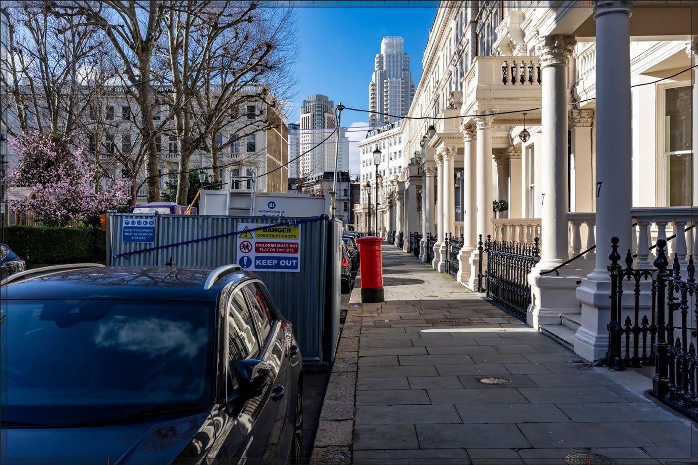
1.20 A selection (13) of assessment views in the Townscape and Visual assessment (July 2024 ES Volume 2, Chapter 2: Townscape and Visual, Technical Appendix H) have been updated to reflect the proposed amendments and to inform the heritage, townscape and visual assessments of the Amended Proposed Development. The 13 updated assessment views are presented in ES Volume 2A: ES Chapter 2A: Townscape and Visual, Technical Appendix I.
1.21 The proposed amendments are very minor in terms of the setting effects of the Amended Proposed Development on the built heritage receptors assessed in the July 2024 ES. The relevant amendments are listed below, i.e. those which affect the massing and appearance of the Amended Proposed Development and how it would appear in the setting of the built heritage receptors:
• Amended Detailed Component:
Amendments to appearance of lower levels of Plot EC05 (updates to fenestration to suit revised unit layouts, Table Park entrance adjusted, two new balconies added at Level 01 and 02 and a terrace at Level 07);
Amendments to the building footprint of Plot EC06 (extended to south-east to accommodate enlarged core) by 0.8 m, and amendments to fenestration of the ground floor to accommodate additional plant requirements; Amendments to the building footprints of Plots WB04 and WB05 by approximately 0.1 m and approximately 0.3 m respectively;
• Amended Outline Component:
Addition of limits of deviation (plus/minus 2-2.8) at Development Zones A, B and C;
Reduction in maximum height of Development Zone F (Plot EC03) from 71.3 m AOD to 67.8 m AOD (3.5 m reduction);
Setback of Development Zone X (Plot WK02) upper level massing to the north (23.2 m AOD by 0.5 m; 28.1 m AOD by 4.5 m; 31.4 m AOD by 3.6 m);
Amendments to design codes in respect of Development Zone E (Plot EC10) to enhance built form articulation in response to townscape and heritage setting from key views; and
Addition of built form design codes to enhance articulation of built form and respond to finer urban grain where plots have the potential to present a monolithic form from key views. A summary is provided in 2025 ES Volume 2A: Chapter 2A Townscape and Visual Assessment.
1.22 While there would be a reduction in height at Plot EC03, the overarching principle of taller massing and the composition of the Amended Proposed Development would remain the same, and how the Amended Proposed Development would change the setting of heritage receptors in the surrounding area would remain the same
1.23 Similarly, while there would be intervisibility with Plot WB04 across a larger area, the proposed amendments are de minimis in terms of the setting impacts because they are minor amendments to the architectural design of the proposed building.
1.24 In accordance with the proportionate approach set out at paragraph 207 of the NPPF and given the nature of the proposed amendments, it is not necessary to reconsider all the 93 heritage receptors that were assessed in the July 2024 ES as there would be no new or different significant environmental effects.
1.25 In addition to the four additional heritage receptors identified by RBKC, however, 13 of the heritage receptors assessed in the July 2024 ES which are either the most sensitive or likely to experience the greatest effects from the Amended Proposed Development, have been considered in this Addendum.
1.26 The 13 built heritage receptors have been identified based on the following considerations:
• Where a receptor was concluded as likely to experience adverse effects in the July 2024 ES; and/or
• Where a receptor was identified by RBKC and LBHF in post-application submission feedback as likely to experience harmful effects; and/or
• Where one of the updated 13 TVA views selected for update to reflect the proposed amendments (see ES Chapter 2A of this Volume 2A), include a heritage receptor.
Baseline Characterisation Method
1.27 The baseline characterisation methods presented in the July 2024 ES remains valid for the Amended Proposed Development
1.28 The change to the redline boundary as outlined in ES Volume 1A, Chapter 1A: Introduction, is considered de-minimis in terms of the Site area and description. Accordingly, in the interest of proportionality, figures presented in the July 2024 ES have not been updated.
Assessment Method
1.29 The assessment method presented in the July 2024 ES remains valid for the Amended Proposed Development However, the assessment presented in this addendum has been based on the Amended Proposed Development as presented in ES Chapter 4A: Amended Proposed Development Description and ES Chapter 5A: Amended Demolition and Construction Description of ES Volume 1A.
1.30 In respect of built heritage, the list of cumulative schemes considered in July 2024 ES remains valid other than the addition of the following relevant scheme which has been considered qualitatively in the cumulative effects section:
• Mund Street School site scheme.
1.31 Updated AVRs of the 13 TVA views are presented in ES Volume 2A, Chapter 2A, Technical Appendix I
Assessment Criteria
1.32 The assessment criteria presented in the July 2024 ES remains valid for the Amended Proposed Development.
Assumptions and Limitations
1.33 The assumptions and limitations presented in the July 2024 ES remain valid for the Amended Proposed Development.
Baseline Conditions
Existing Baseline
1.34 Whilst it is noted that a new meanwhile use has been introduced on-site, the baseline conditions as described in the July 2024 ES remain materially valid. This is because the meanwhile use utilises the existing infrastructure on-site and no new infrastructure has been built.
1.35 The on-site and off-site baseline conditions and sensitive receptors presented in the July 2024 ES, remain materially valid in respect of built heritage
1.36 Up-to-date Greater London Historic Environment Record (GLHER) data is presented in the 2025 DBA Addendum (see Technical Appendix 6A.1A, ESVolume 3A: Technical Appendices Addendum) forcompleteness. The up-to-date GLHER data does not identify any new or different built heritage receptors within the Site or the study area.
1.37 The baseline heritage value of the four additional heritage receptors identified by the RBKC in their consultation response is provided in the following paragraphs
Off-Site Heritage Receptors
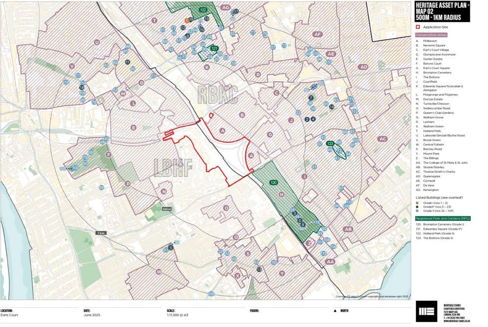
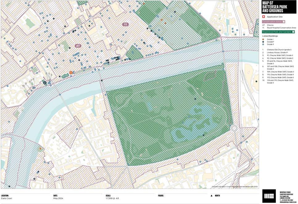
1.38 This section describes the heritage value of the four additional heritage receptors. The location of the additional heritage receptors is presented on the amended Scoped Heritage Asset Plan Maps 02 and 07 (Figures 1A.14A and 1A.19A) (see also Technical Appendix 1A.6A)
1.39 The amendments to the Scoped Heritage Asset Plan Maps 02 and 07 at Figures 1A.14A and 1A.19A comprise the following:
• The addition of receptors nos. 2 and 4 to Scoped Heritage Asset Plan Map 02 which are the additional heritage receptors on Collingham Gardens; and
• The addition of receptor AT and 11 on Map 07 to identify the additional receptors at Cheyne Conservation Area and Royal Hospital Conservation Area respectively.
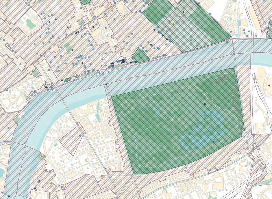
Figure 1A.14A: Updated Off-Site Heritage Receptors – Mid-Distance (500 m – 1 km) – Plan 02
RAMBOLL
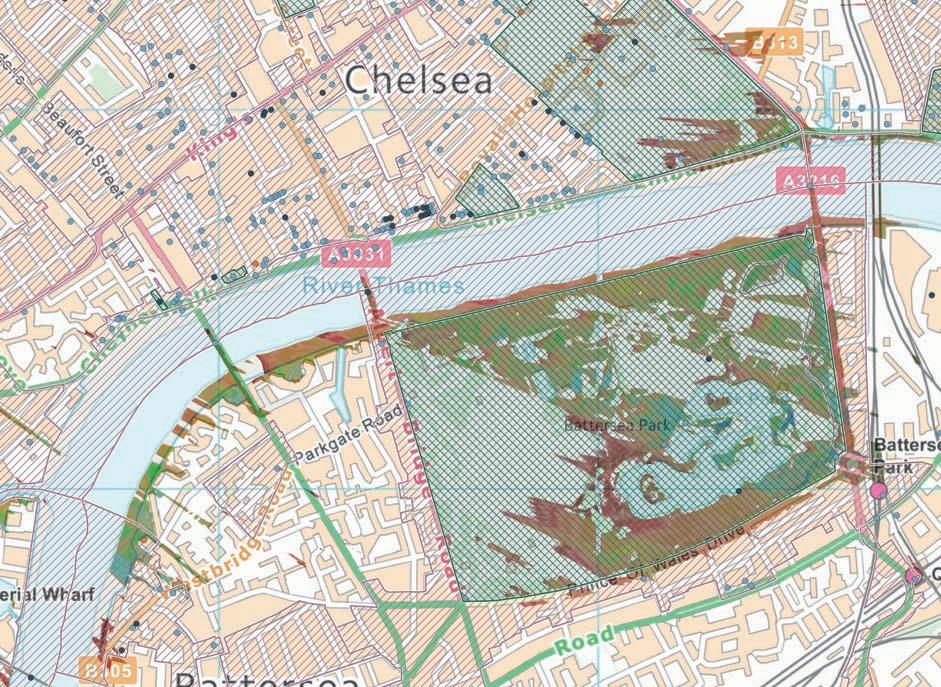
Figure 1A.19A: Updated Off-Site Heritage Receptors – Battersea Park and Grounds – Plan 07
9-18, 11A and 18A Collingham Gardens, Grade II* Listed Building (RBKC)
1.40 9-18, 11A and 18A Collingham Gardens were designated as Grade II listed buildings in April 1969. The heritage receptor is located approximately 640 m east of the Site. It is receptor no. 2 on Scoped Heritage Asset Plan Map 02 (see Figure 1A.14A and Technical Appendix 1A.6A).
1.41 The heritage designation recognises 10 houses that were designed by Ernest George and built in 1881-4. The houses are very large and terraced, in a Queen Anne style in red brick with Dutch and Tudor influences. They are between two and three storeys with accommodation in the tall, pitched roofs with dormers. The heritage value of the listed buildings are derived from the historic and architectural interest as a group of late Victorian houses by George, a well-known architect. They have group value with the buildings at 1-8 Collingham Gardens which are also Grade II* listed and together they form a set piece on either side of Collingham Gardens, a private residential garden in the centre of the urban block.
1.42 Heritage value: Very High
Contribution of Setting to Heritage Value
1.43 The setting of 9-18, 11A and 18A Collingham Gardens is the area of Victorian residential development recognised by the Courtfield Conservation Area designation. The immediate setting, captured by the conservation area, makes a positive contribution to the historic and architectural interest of the listed building because it represents their original context. The private residential gardens to the east of listed building and the Grade II* listed houses that enclose the opposite side of the gardens are also important original features of the town planning that led to the speculative residential development. The listed buildings are best appreciated from Collingham Gardens, the street to the south.
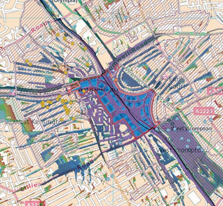
1.44 The listed building has been identified for assessment because of the potential visibility of the Amended Proposed Development in views from Wetherby Gardens and Harrington Gardens that may include the listed building. Wetherby Gardens and Collingham Gardens are parallel streets, and the Grade II* listed terrace connects them on the north-south axis. An extract from the overlay of Heritage Asset Plan 02 and the ZVI is produced at Figure 1A.1N to help illustrate the potential impact.
1.45 On Figure 1A.1N, the location of 1-8 Collingham Gardens is represented by the map location at no. 2. The blue shading to the south of the terrace and the green shading to the north indicates that the Amended Proposed Development would be visible along the axial streets. There is also visibility indicated from Bramham Gardens to the south in the blue and green tones. The different colours on the ZVI indicate what part of the Amended Proposed Development, and a key is provided in Figure 1A.19A
1.46 In the views from Wetherby Gardens and Harrington Gardens, Nos. 9 and 18 Collingham Gardens appear obliquely in the long views looking west. There are mature street trees which screen the built form and the scale and architectural detailing of the listed group of eight properties is not readily appreciated in the views, until arriving at the junction with Collingham Gardens looking north and not in the direction of the Site The long views from the east on Wetherby Gardens and Collingham Gardens do not therefore make an important contribution to the appreciation of the heritage value of the listed building.
1.47 Directly opposite the listed building to the south and extending to the west is the private residential Bramham Gardens. The mature trees mean that views of the listed building at 9-18, 11A and 18A Collingham Gardens are filtered, and it is not a location where the heritage interests can be best appreciated.
1-8, Collingham Gardens SW5, Grade II* Listed Building (RBKC)
1.48 1-8 Collingham Gardens was designated as a Grade II* listed building in April 1969. The heritage receptor is located approximately 640 m east of the Site. It is receptor no. 4 on Scoped Heritage Asset Plan Map 02 (see Figure 1A.14A and Technical Appendix 1A 6A).
1.49 The heritage designation recognises eight houses that were designed by Ernest George (1839-1922) and built in 18814. The houses are very large and terraced, in a Queen Anne style in red brick with Dutch and Tudor influences. They are between two and three storeys with accommodation in the tall, pitched roofs with dormers. The heritage value of the listed building is derived from the historic and architectural interest as a group of late Victorian houses by George, a well-known architect. They have group value with the buildings at Nos. 9-18a Collingham Gardens which are also Grade II* listed and together they form a set piece on either side of Collingham Gardens, a private residential garden in the centre of the urban block.
1.50 Heritage value: Very High
Contribution of Setting to Heritage Value
1.51 The setting of 1-8 Collingham Gardens is the area of Victorian residential development recognised by the Courtfield Conservation Area designation. The immediate setting, captured by the conservation area, makes a positive contribution to the historic and architectural interest of the listed building because it represents their original context. The private residential gardens to the west of listed building and the Grade II* listed houses that enclose the opposite side of the gardens are also important original features of the town planning that led to the speculative residential development. The listed buildings are best appreciated from Collingham Gardens, the street to the north.
1.52 The listed building has been identified for assessment because of the potential visibility of the Amended Proposed Development in views from Wetherby Gardens and Harrington Gardens that may include the listed building. Wetherby Gardens and Collingham Gardens are parallel streets, and the Grade II* listed terrace connects them on the north-south axis. An extract from the overlay of Heritage Asset Plan 02 and the Zone of Visual Influence (ZVI) is produced at Figure 1A.1N to help illustrate the potential impact.
1.53 On Figure 1A.1N, the location of 1-8 Collingham Gardens is represented by the map location at no. 4. The blue shading to the south of the terrace and the green shading to the north indicates that the Amended Proposed Development would be visible along the axial streets. There is also visibility indicated from Wetherby Gardens to the east in the green, yellow and red tones. The different colours on the ZVI indicate what part of the Amended Proposed Development, and a key is provided in Figure 1A.19A
1.54 In the views from Wetherby Gardens and Harrington Gardens, 1 and 8 Collingham Gardens appear obliquely in the long views looking west. There are mature street trees which screen the built form and the scale and architectural detailing of the listed group of eight properties is not readily appreciated in the views, until arriving at the junction with Collingham Gardens looking north and not in the direction of the Site. The long views from the east on Wetherby Gardens and Collingham Gardens do not therefore make an important contribution to the appreciation of the heritage value of the listed building.
1.55 Directly opposite the listed building and extending to the east is the private residential garden for Wetherby Gardens. The mature trees mean that views of the listed building at 1-9 Collingham Gardens are filtered, and it is not a location where the heritage interests can be best appreciated.
Figure 1A.1N: Extract from Technical Appendix 1A.3A
Cheyne Conservation Area (RBKC)
1.56 The Cheyne Conservation Area was first designed by the RBKC in 1969 and extended over various dates. A conservation area appraisal3 was adopted in January 2017. The conservation area is located approximately 1.5 km south-east of the Site at the nearest point. It is map reference AT on Heritage Asset Map 07 (see Figure 1A.19A and Technical Appendix 1A 6A)
1.57 The Cheyne Conservation Area is located on the north side of the River Thames between Battersea Bridge and Albert Bridge. The conservation area boundary extends to the east of Albert Bridge to the boundary with the Royal Hospital Conservation Area. The land comprising the conservation area has a long history of development dating back to Henry VIII’s palaces. There are no surviving features of the palaces, and today the conservation area is defined by Georgian speculative residential development of high historic and architectural quality. The residential development is laid out on streets which broadly run on a north-south axis. The embankment along the river is the main east-west route. There is some later Victorian development comprising mansion flats and artists’ studios. The Conservation Area Appraisal has the following description of the urban form: “Cheyne is a conservation area with a varied townscape due to its long period of development and redevelopment. The most common urban form throughout the area is the terrace of uniform houses with matching features and palace fronts in some Victorian terraces. The terraces have open ‘areas’ (or lightwells) to the front and either small gardens to the rear or sometimes none at all”
1.58 The heritage value of the conservation area is derived from the historic and evidential interest of the area as one of the longest areas of development in the borough. The residential development from the 18th century onward has very high historic and architectural interest.
1.59 Heritage value: High
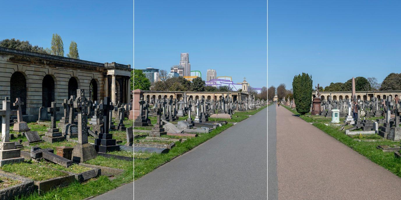
Contribution of Setting to Heritage Value
1.60 The setting of the conservation area on the north side of the River Thames comprises other historic residential areas that contribute positively to the overall historic interest of the Cheyne Conservation Area as part of the historic city. The buildings within the Cheyne Conservation Area have a positive relationship to the River Thames. The Conservation Area Appraisal states: “The river creates a particularly special environment that prevents development in front of Cheyne Walk and Chelsea Embankment and allows them to be viewed from the river and from land further away to the south”
1.61 The Cheyne Conservation Area is being assessed because of the views of the conservation area from Battersea Park and the south bank of the River Thames. The ZVI overlay of Heritage Asset Map 07 at Technical Appendix 1A.3A demonstrates that there would otherwise be no other visibility of the Amended Proposed Development or change to the contribution that setting makes to the heritage value of the receptor.
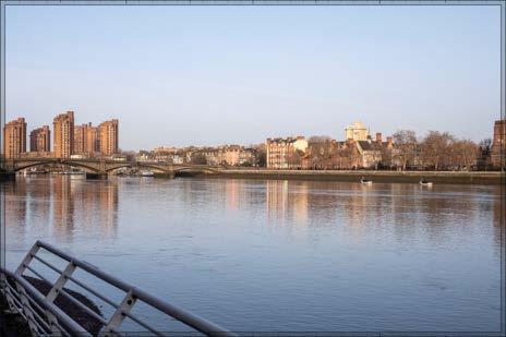
1.62 The views from the south bank of the River Thames are represented by verified view nos. 5 and 6 in the Townscape and Visual Impact Assessment at ES Volume 2: Chapter 2A and the existing AVRs are reproduced here at Figures 1A.2N and 1A.3N.
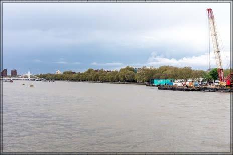
1.63 The existing photography at Figures 1A.2N and 1A.3N demonstrates that the residential development within the Cheyne Conservation Area cannot be readily appreciated in the views from the south bank of the river and one would be unaware of the main aspects of its character and appearance in these views. The aspects of the conservation that may be appreciated are the embankment and buildings that line the riverside. The tower of Chelsea Old Church (All Saints) is also visible as a skyline feature.
1.64 In the views of the conservation area from the south bank of the River Thames, the river provides a panoramic view and taller and modern buildings are part of the wider context.
3 RBKC, 2017. Cheyne Conservation Area Appraisal. Available at: https://www.rbkc.gov.uk/planning-and-building-control/heritage-and-conservation/conservation-areas0/conservation-area-appraisals-and-proposal-statements [accessed 10 June 2025]
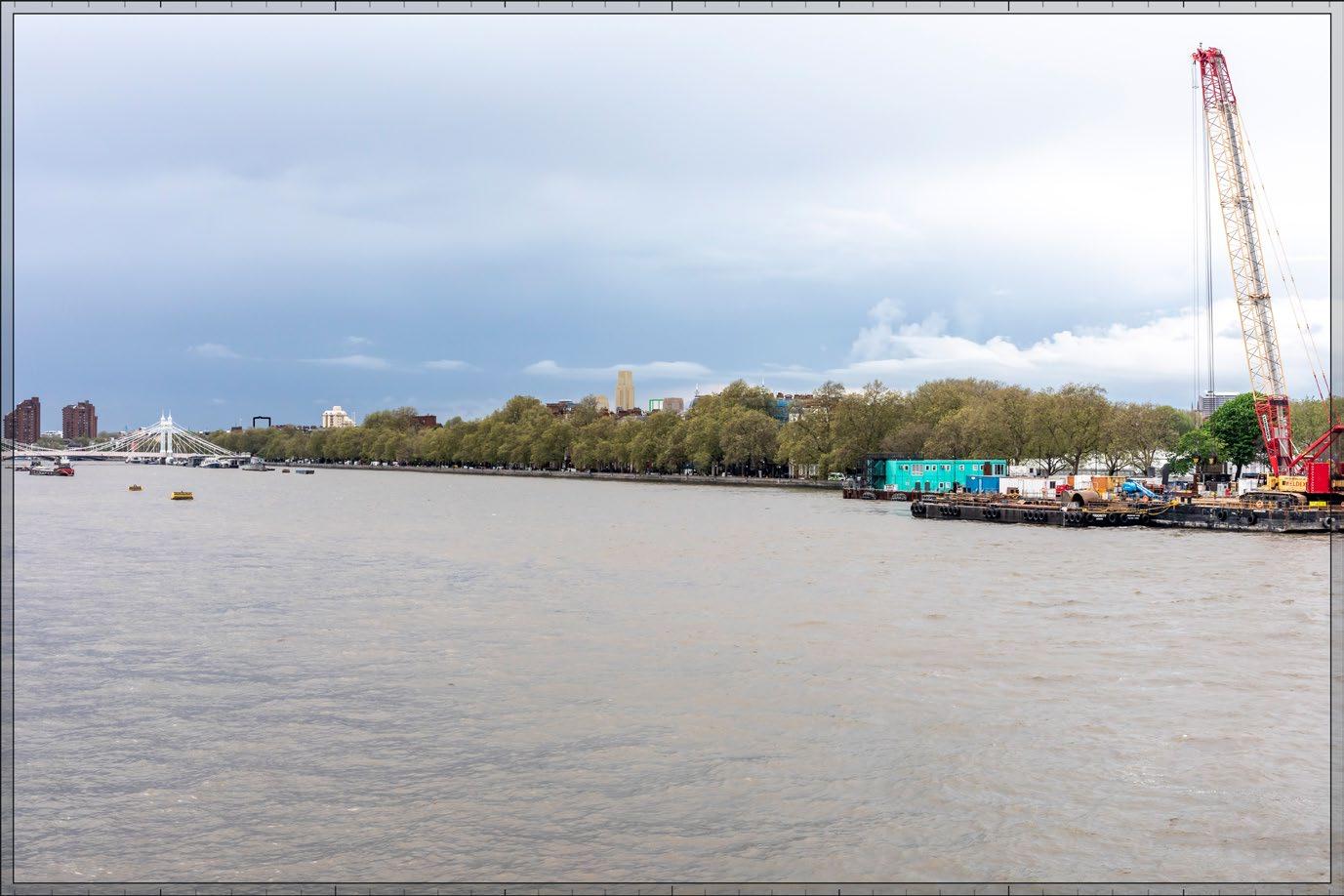
Figure 1A.2N: Existing TVA View 5
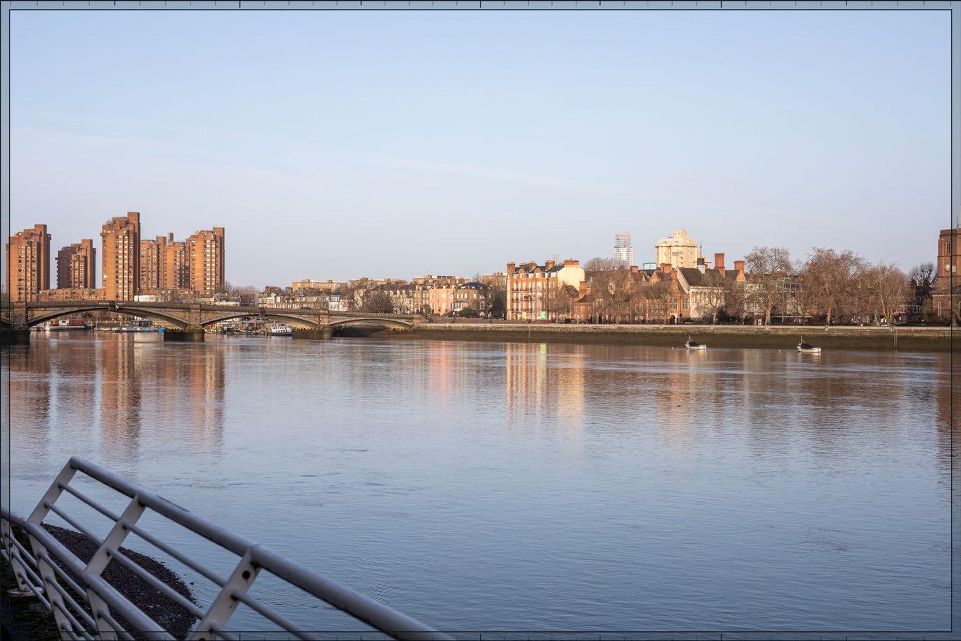
Figure 1A.3N: Existing TVA View 6
Royal Hospital Conservation Area (RBKC)
1.65 The Royal Hospital Conservation Area was first designated by the RBKC in 1969 and extended. A conservation area appraisal4 was adopted in March 2016. The conservation area is located over 1.5 km south-east of the Site at the nearest point. It has been added as map reference 07.11 on the Heritage Asset Map 07 at Figure 1A.19A and Technical Appendix 1A.6A
1.66 The conservation area designation recognises the Royal Hospital at Chelsea and residential development to the north and west of the hospital complex. The other significant group of buildings are found within the grounds of the Duke of York’s Headquarters positioned to the north-east of Burton’s Court. The special interest of the conservation area is summarised in the appraisal as follows: “The conservation area comprises a high quality built environment that is residential in character, with the Royal Hospital, an internationally renowned group of buildings, sitting at its heart. The surrounding residential streets form an interesting array of predominantly single family houses illustrating the 18th and 19th centuries and housing developments of the 1930s and 1950s which are all set in a comfortable residential atmosphere with mature green spaces”
1.67 Heritage value: High
Contribution of Setting to Heritage Value
1.68 The setting of the conservation area on the north side of the River Thames comprises other historic residential areas that contribute positively to the overall historic interest of the Royal Hospital Conservation Area as part of the historic city. There has also been a historic and function relationship to the River Thames to the south which also contributes positively to its heritage value.
1.69 The Royal Hospital Conservation Area is being assessed because of the views of the conservation area from Battersea Park and the south bank of the River Thames. The ZVI overlay of Heritage Asset Map 07 at Technical Appendix 1A.3A demonstrates that there would otherwise be no other visibility of the Amended Proposed Development or change to the contribution that setting makes to the heritage value of the receptor.
1.70 It is noted, additionally, that views from the south bank of the River Thames looking north across to the conservation are not identified as ‘views of townscape merit’ in the Conservation Area Appraisal. Notwithstanding, they are considered below in response to comments received from the RBKC in post-submission comments.
1.71 The views from the south bank of the River Thames are represented by verified view no. 5 in the Townscape and Visual Impact Assessment at ES Volume 2: Chapter 2 and they are presented in ES Volume 2A, Chapter 2A, Technical Appendix I.
1.72 The existing photography at Figure 1A.2N demonstrates that the residential development within the Royal Hospital Conservation Area cannot be readily appreciated in the views from the south bank of the river and one would be unaware of the main aspects of its character and appearance in these views. The awareness is of the open space in the Royal Hospital indicated by the tree coverage, and trees provide screening of the built form on the opposite side of the river within the conservation area. It is agreed with the conservation area appraisal that the views from the south bank of the river are not important to understanding the special interest of the conservation area or its character and appearance.
1.73 In the views of the conservation area from the south bank of the River Thames, the river provides a panoramic view and taller and modern buildings are part of the wider context.
Summary of Heritage Value
1.74 The summary of heritage value presented in the July 2024 ES remains valid. Table 1A.8A presents a summary of the additional four heritage receptors considered in this Addendum. The map references are related to the maps presented at Figures 1A.14A and 1A.19A (see also Technical Appendix 1A.6A).
Table 1A.8A: Updated Summary of Additional Built Heritage Baseline
Map Ref. Receptor Grade (if applicable) Heritage Value RBKC
02.2 9-18, 11A and 18A Collingham Gardens (listed building) II* Very High
02.4 1-8 Collingham Gardens SW5 (listed building) II* Very
AT Cheyne Conservation Area N/A
07.11 Royal Hospital Conservation Area N/A
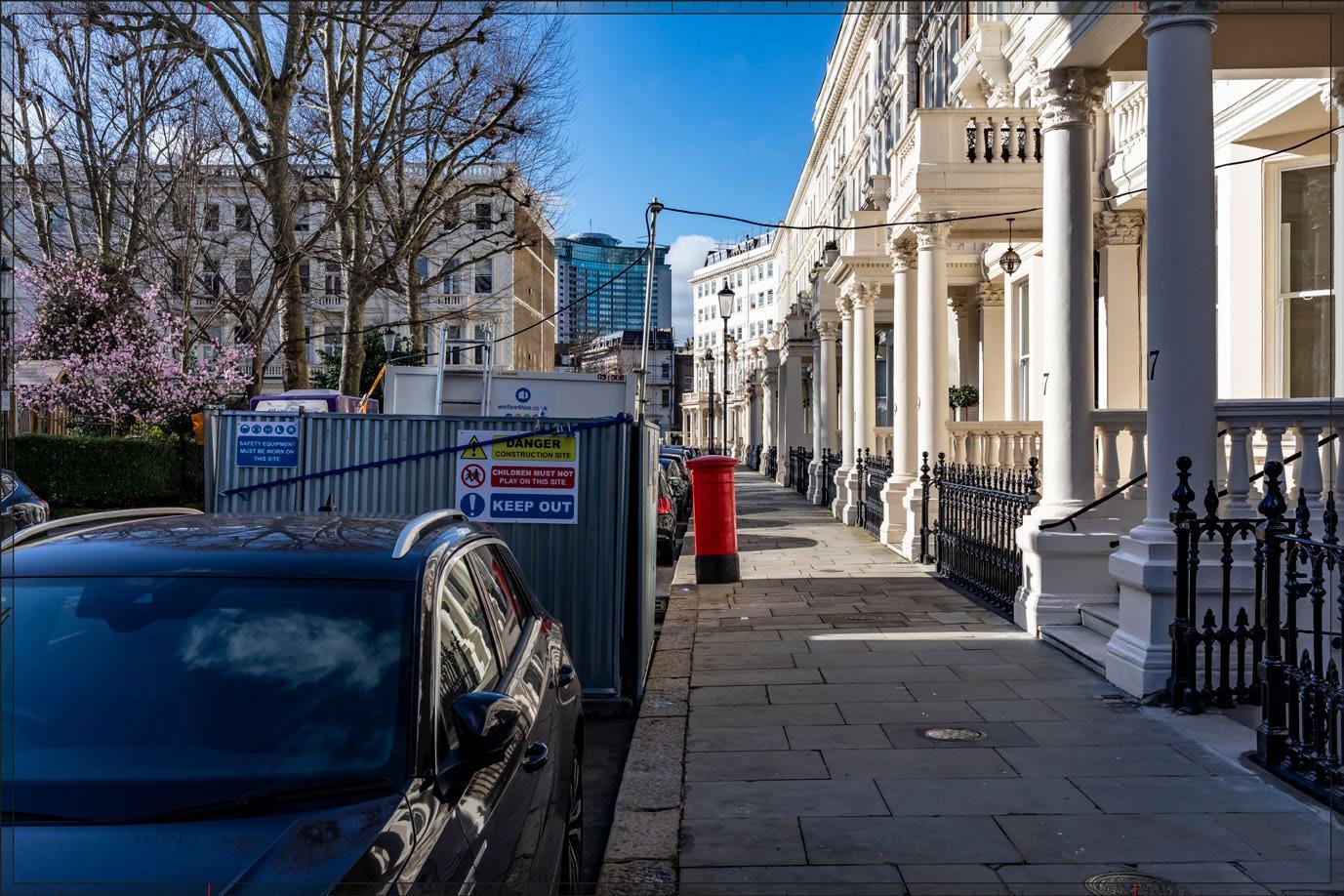
Future Baseline
1.75 The future baseline as presented in the July 2024 ES remains valid for the Amended Proposed Development.
Sensitive Receptors
1.76 The sensitive receptors presented in the July 2024 ES remains valid for the Amended Proposed Development
1.77 The four additional heritage receptors are considered in the following paragraphs.
Off-Site Heritage Sensitivity
9-18, 11A and 18A Collingham Gardens, Grade II* Listed Building (RBKC)
1.78 The Amended Proposed Development has the potential to affect the contribution that setting makes to the heritage value of 9-18, 11A and 18A Collingham Gardens because of visibility of Plot WB04 and Development Zone E in the east-west views from Wetherby Gardens and Harrington Gardens. The listed building has a Low susceptibility to this type of change introduced by the Amended Proposed Development because the intrinsic historic and architectural interests and immediate setting would be unaffected and there is a considerable separating distance. Furthermore, the locations where the ZVI indicates there would be intervisibility do not make an important contribution to the appreciation of the listed buildings. The sensitivity is therefore Medium
1.79 Susceptibility: Low
1.80 Sensitivity: Medium
1-8, Collingham Gardens SW5, Grade II* Listed Building (RBKC)
1.81 The Amended Proposed Development would have the potential to affect the contribution that setting makes to the heritage value of 1-8 Collingham Gardens because of visibility of Plot WB04 and Development Zone E in the east-west views from Wetherby Gardens and Harrington Gardens. The listed building has a Low susceptibility to this type of change introduced by the Amended Proposed Development because the intrinsic historic and architectural interests and immediate setting would be unaffected and there is a considerable separating distance. Furthermore, the locations where the ZVI indicates there would be intervisibility, do not make an important contribution to the appreciation of the listed buildings. The sensitivity is therefore Medium
1.82 Susceptibility: Low
1.83 Sensitivity: Medium
Cheyne Conservation Area (RBKC)
1.84 The Amended Proposed Development has the potential to affect the contribution that setting makes to the heritage value of the Cheyne Conservation Area because of visibility of Plot WB04 appearing on the skyline in the views of the conservation area from the south bank of the River Thames. The intrinsic interests of the conservation area would be unaffected and Plot WB04 would be seenover a considerable separating distance. It would not interact with the tower of the Chelsea Old Church (All Saints) and the wider and distant context includes modern and tall buildings. Therefore, the susceptibility is Low and the sensitivity is Medium
1.85 Susceptibility: Low
4 RBKC, 2016. Royal Hospital Conservation Area Appraisal. Available at: https://www.rbkc.gov.uk/planning-and-building-control/heritage-and-conservation/conservation-areas0/conservation-area-appraisals-and-proposal-statements [accessed 10 June 2025]
Volume 2A: Built Heritage, Townscape and Visual Assessment Addendum
Chapter 1A: Built Heritage
1.86 Sensitivity: Medium
Royal Hospital Conservation Area (RBKC)
1.87 The Amended Proposed Development has the potential to affect the contribution that setting makes to the heritage value of the Cheyne Conservation Area because of visibility of Plot WB04 appearing on the skyline in the views of the conservation area from the south bank of the River Thames. The intrinsic interests of the conservation area would be unaffected and Plot WB04 would be seen over a considerable separating distance. The views from the south bank of the river are not important to appreciate the special interest of the conservation area, and the wider and distant context includes modern and tall buildings. Therefore, the susceptibility is Low and the sensitivity is Medium
1.88 Susceptibility: Low
1.89 Sensitivity: Medium
Summary of Sensitive Receptors
1.90 The summary sensitivity of heritage receptors presented in the July 2024 ES remains valid.
1.91 Table 1A.9A presents a summary of the additional four heritage receptors considered in this Addendum.
Table 1A.9A: Updated Summary of Additional Sensitive Receptors
Map Ref. Receptor Heritage Value Susceptibility Sensitivity RBKC
02.2 9-18,
Assessment of Effects
Early Phases
1.92 The demolition and construction works for the Amended Proposed Development are presented in ES Volume 1A: Chapter 5A: Amended Demolition and Construction Description.
Demolition and Construction Effects
1.93 The demolition and construction of the Early Phases would not result in new or different likely effects on the built heritage receptors assessed in the July 2024 ES. This is because the proposed amendments to the Detailed Component and Outline Components would be de minimis, and the nature of construction activities and their visibility in the setting of the heritage receptors would not change.
1.94 The demolition and construction effects on the four additional heritage receptors is assessed in the following paragraphs 9-18, 11A and 18A Collingham Gardens, Grade II* Listed Building (RBKC)
1.95 The construction of Plot WB04 and EC10 would be visible in the long views looking west along Bolton Gardens (TVA view 19) that include 9 and 18 Collingham Gardens. The separating distance and interposing development mean that the demolition and construction activities that would be visible would be high-level equipment such as cranes and the gradual emergence of the new buildings.
1.96 The views from along Bolton Gardens do not make an important contribution to the appreciation of the heritage receptor, which comprises the 10 large properties on Collingham Gardens. It is not possible to see all the properties in the listed group in these long axial views until you are at the road junction and close-up to them.
1.97 The demolition and construction activities would be seen over a considerable distance; however, the visibility of equipment and the emerging built form of the new buildings would not interfere with any appreciation of the historic or architectural interest of the listed buildings in their immediate historic townscape setting. Furthermore, street trees would provide screening, and it is unlikely that the demolition and construction activity would be noticeable in the setting of the
receptor. It would be understood that the demolition and construction activities are temporary, and they are not uncommon in an urban environment.
1.98 It is noted that the listed building is oriented west and when admiring the front elevations from publicly accessible locations, the Early Phases would be behind the observer. There would be no visual attachment between the Early Phases and the listed building. The ability to appreciate the heritage value of the listed building would be preserved and the effect would therefore be neutral.
1-8, Collingham Gardens SW5, Grade II* Listed Building (RBKC)
1.101 The construction of Plot WB04 and EC10 would be visible in the long views provided by Wetherby Gardens and Harrington Gardens that include 1 and 8 Collingham Gardens. The separating distance and interposing development mean that the construction activities that would be visible would be high-level equipment such as cranes and the gradual emergence of the new buildings. Demolition works would not be visible.
1.102 The views from Wetherby Gardens and Harrington Gardens do not make an important contribution to the appreciation of the heritage receptor, which comprises the eight large properties on Collingham Gardens. It is not possible to see all the properties in the listed group from Wetherby Gardens and Harrington Gardens until the observer is at the road junction and close-up to them.
1.103 The construction activities would be seen over a considerable distance; however, the visibility of equipment and the emerging built form of the new buildings would not affect any appreciation of the historic or architectural interest of the listed buildings in their immediate historic townscape setting. Furthermore, street trees would provide screening, and it is unlikely that the construction activities would be noticeable in the setting of the receptor. It would be understood that the construction activities are temporary, and they are not uncommon in an urban environment. The ability to appreciate the heritage value of the listed building would be preserved and the effect would therefore be neutral.
1.106 Demolition works would not be visible. The construction of Plot WB04 would introduce cranes and the gradual emergence of the tall building in the backdrop of the conservation area in the views from the south bank of the River Thames which are identified as important views in the conservation area appraisal. The important views are represented by updated TVA views 5 and 6 to help understand where on the horizon the construction activity would appear (see Figures 1A.6N and 1A.7N).
1.107 The construction activity would be seen over a considerable distance, over 1.3 km in the background of the Amended Proposed Development comprising the conservation area in the foreground. It would be understood as a separate, modern object and it would not draw the eye. Construction activity is not uncommon to urban contexts, and cranes are lightweight features that would not disturb any appreciation of buildings or tree-cover in the middle-ground comprising the conservation area. Furthermore, there would be no interaction between the construction activity and the tower of Chelsea Old Church.
1.108 The ability to appreciate the heritage value of the conservation area would be unaffected by the construction of the Early Phases. The magnitude of impact would be Very Low and therefore the scale of effect would be Negligible. The ability to appreciate the heritage value of the listed building would be preserved and the effect would therefore be neutral.
1.111 Demolition works would not be visible. The construction of Plot WB04 would introduce cranes and the gradual emergence of the tall building in the backdrop of the conservation area in the views across to the Royal Hospital from the south bank of the River Thames. The views are represented by updated TVA view 5 to help understand where on the horizon the construction activity would appear (see Figures 1A.6N and 1A.7N).
1.112
The construction activity would be seen over a considerable distance, over 1.8 km in the background of the development comprising the conservation area in the foreground. It would be understood as a separate, modern object and it would not draw the eye. Construction activity is not uncommon to urban contexts, and cranes are lightweight features that would not disturb any appreciation the development or tree-cover in the middle-ground comprising the conservation area.
1.113 Importantly however, the views from the south bank of the River Thames are not identified as important views in the conservation area appraisal and it is not possible to meaningfully appreciate the heritage interests of the conservation area in these views.
1.114 Therefore, visibility of the construction activity for the Amended Proposed Development would have no effect on the ability to appreciate the heritage value of the conservation area, and the magnitude of impact would be Nil and the likely effect would be None.
1.115 Magnitude of impact: Nil
1.116 Likely effect: None
Completed Development Effects
1.117 The heritage receptors assessed in the July 2024 ES that may experience new or different likely effects because of the Early Phases of the Amended Proposed Development are as follows:
• RBKC
Brompton Cemetery RPG (updated TVA views 7 and 8);
Brompton Cemetery Conservation Area (updated TVA views 7 and 8);
Arcade Forming North West Quarter of Circle and Avenue, Grade II* listed building (updated TVA views 7 and 8);
Arcade Forming North East Quarter of Circle and Avenue, Grade II* listed building (updated TVA views 7 and 8);
Church of England Chapel, Grade II* listed building (updated TVA views 7 and 8);
Nevern Square Conservation Area (updated TVA view 23);
Holland Park Conservation Area (updated TVA view 3);
Chelsea Old Church, Grade I listed building (updated TVA view 6);
• LBHF:
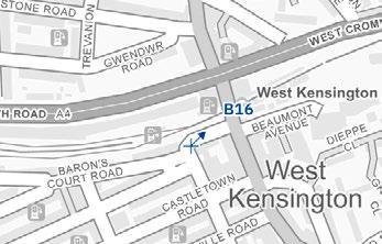
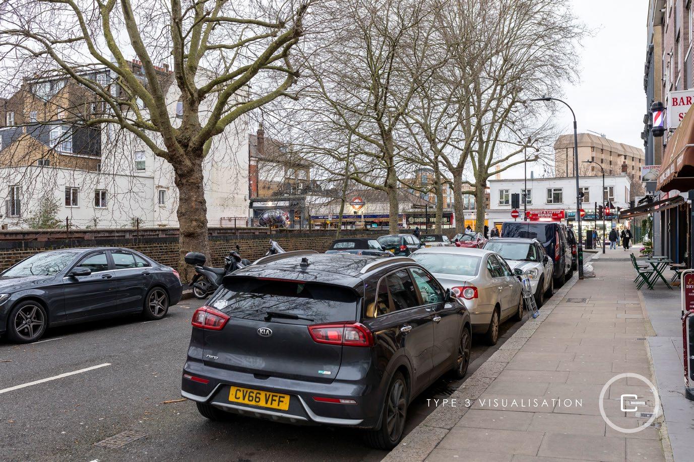
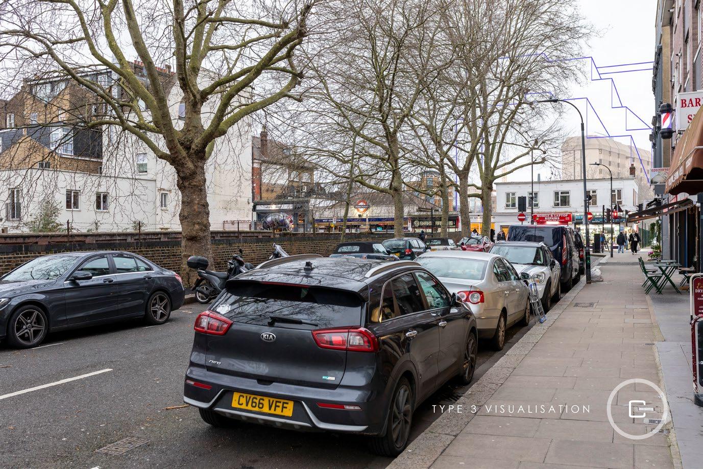
Barons Court Conservation Area (updated TVA view B16);
Queen’s Club Gardens Conservation Area (updated TVA view 51); and
The Mall Conservation Area (updated TVA view 31)
1.118 The likely effects of the Early Phases of the Amended Proposed Development have been assessed for these receptors in the following paragraphs
1.119 An assessment of the four additional heritage receptors is also provided.
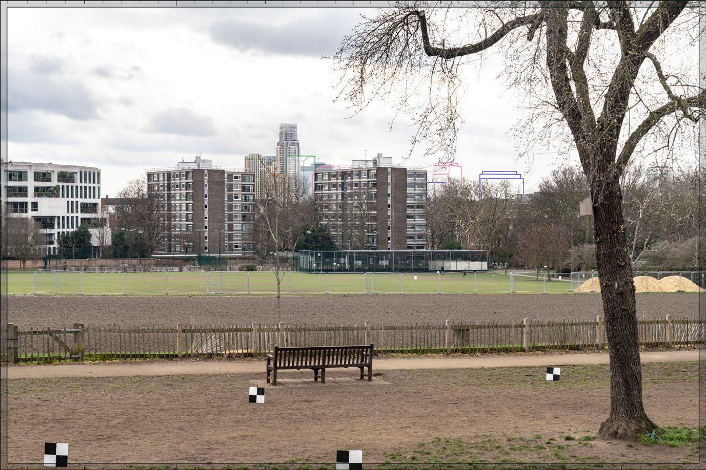
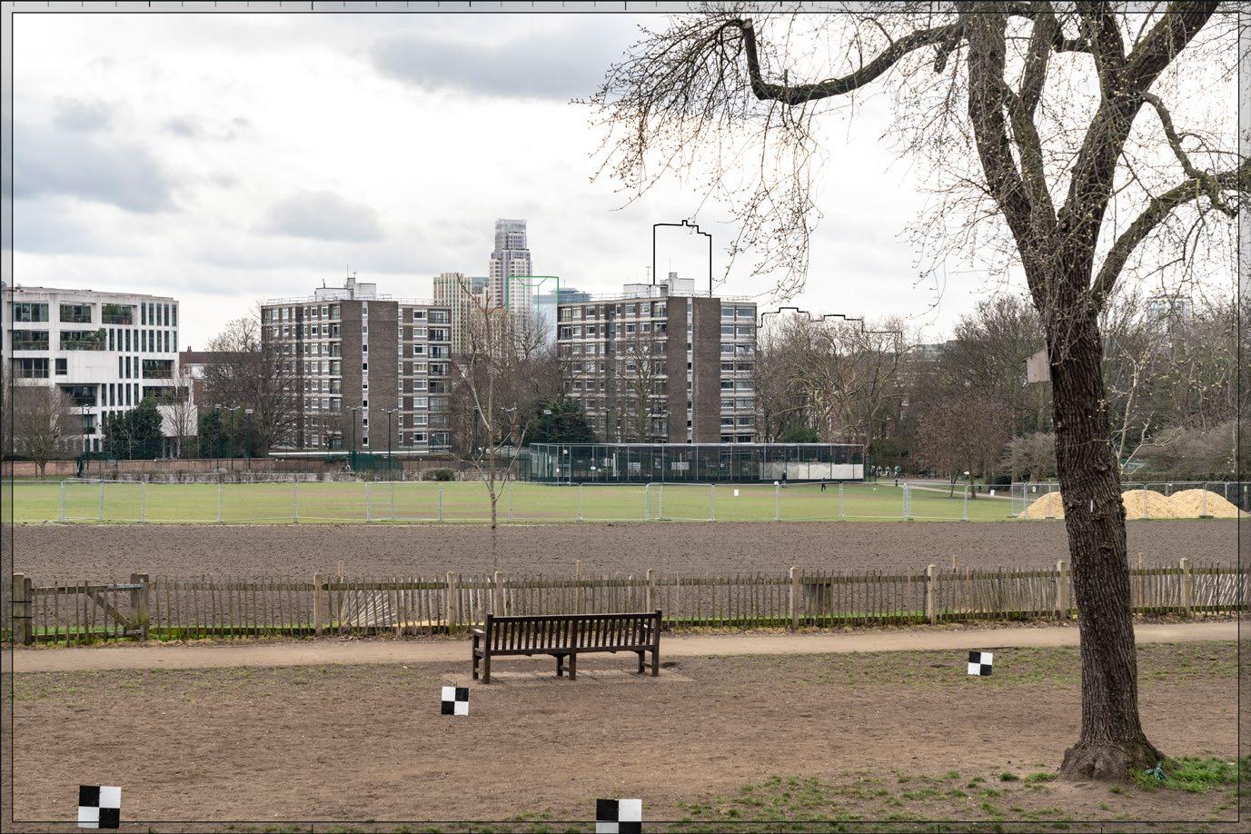
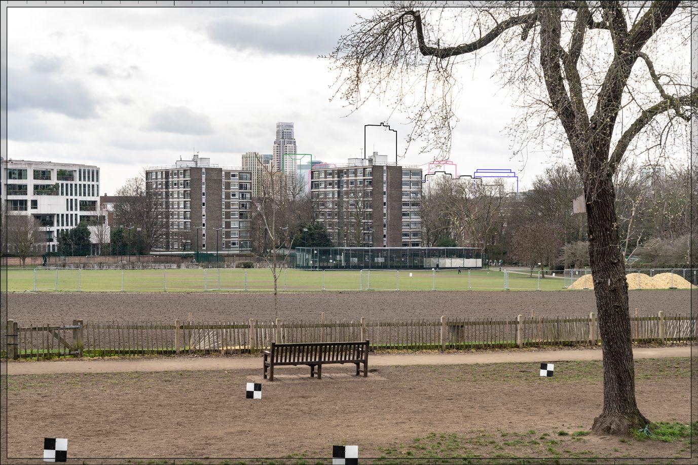
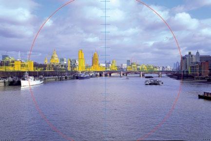
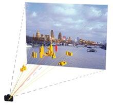
Brompton Cemetery, Grade I Registered Park and Garden (RBKC)
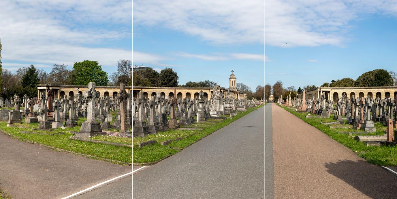
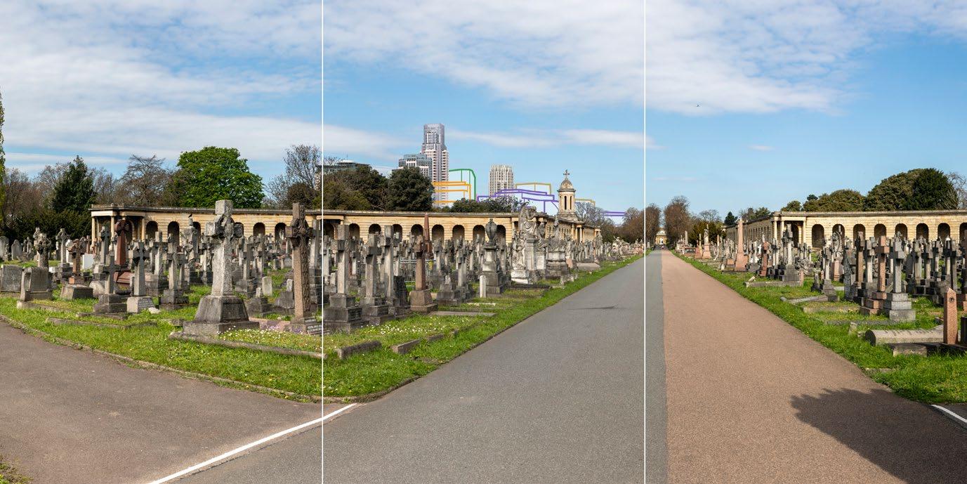
1.120 The updated TVA views 7 and 8 are presented at Figures 1A.42A and 1A.43A. The updated views represent how the Early Phases of Amended Proposed Development would appear in the views looking north in Brompton Cemetery.
1.121 The Amended Proposed Development would reduce the maximum parameter heights of Plot EC03 which would appear in conjunction with the cupola in the north-west arcade on the skyline in the important views looking north on the central axis, and from other locations within the cemetery. The reduction in the volume of development seen in the view would be very slight, although there would be a betterment from reducing the scale of Plot EC03 and amended Design Code for Plot EC10 seen against the cupola and the amended Design Codes for EC10. The Amended Proposed Development would not change the assessment of the effect on Brompton Cemetery in the July 2024 ES, and the overall magnitude of impact of the Early Phases and the likely effect would remain the same.
1.122 The amendments to the architectural treatment of the detailed plots and the maximum parameter envelope of Plot EC03 would be de minimis in terms of the visual impact of the Early Phases on the heritage receptor.
Arcade Forming North West Quarter of Circle and Avenue, Grade II* Listed Building (RBKC)
1.128 The qualitative assessment of the effect of the Early Phases on the Arcade Forming North West Quarter of Circle and Avenue s presented in Technical Appendix 1.1 of the July 2024 ES Volume 2, Chapter 1
1.129 The updated TVA views 7 and 8 are presented at Figures 1A.42A and 1A.43A and they represent how the Early Phases of the Amended Proposed Development would appear in the views looking north in Brompton Cemetery that contain the arcade.
1.130 The Amended Proposed Development would reduce the maximum parameter heights of Plot EC03 which would appear in conjunction with the cupola in the north-west arcade on the skyline in the important views looking north on the central axis, and from other locations within the cemetery. The reduction in the volume of development seen in the view would be very slight, although there would be a betterment from reducing the scale of Plot EC03 seen against the cupola. The Amended Proposed Development would not change the assessment of the effect on the listed building in the July 2024 ES, and the overall magnitude of impact of the Early Phases and the likely effect would remain the same.
1.131 The amendments to the architectural treatment of the detailed plots and the maximum parameter envelope of Plot EC03 would be de minimis in terms of the visual impact of the Early Phases on the listed building.
1.132 Magnitude of impact: Low
1.133 Likely effect: Minor Adverse (not significant)
Arcade Forming North East Quarter of Circle and Avenue, Grade II* Listed Building (RBKC)
1.134 The qualitative assessment of the effect of the Early Phases on the Arcade Forming North East Quarter of Circle and Avenue s presented in Technical Appendix 1.1 of the July 2024 ES Volume 2, Chapter 1
1.135 The updated TVA views 7 and 8 are presented at Figures 1A.42A and 1A.43A and they represent how the Early Phases of the Amended Proposed Development would appear in the views looking north in Brompton Cemetery that contain the arcade.
1.136 The Amended Proposed Development would reduce the maximum parameter heights of Plot EC03 which would appear in conjunction with the arcade in the important views looking north on the central axis, and from other locations within the cemetery. The reduction in the volume of development seen in the view would be very slight, although there would be a small betterment from reducing the scale of Plot EC03 seen against the cupola. The Amended Proposed Development would not change the assessment of the effect on the listed building in the July 2024 ES, and the overall magnitude of impact of the Early Phases and the likely effect would remain the same.
1.137 The amendments to the architectural treatment of the detailed plots and the maximum parameter envelope of Plot EC03 would be de minimis in terms of the visual impact of the Early Phases on the listed building.
1.138 Magnitude of impact: Low
1.139 Likely effect: Minor Adverse (not significant)
Church of England Chapel, Grade II* Listed Building (RBKC)
1.140 The qualitative assessment of the effect of the Early Phases on the Church of England Chapel in Brompton Cemetery is presented in Technical Appendix 1,1 of the July 2024 ES Volume 2, Chapter 1.
Volume 2A: Built Heritage, Townscape and Visual Assessment Addendum
1.141 The updated TVA views 7 and 8 are presented at Figures 1A.40A and 1A.41A and they represent how the Early Phases of the Amended Proposed Development would appear in the views looking north in Brompton Cemetery which comprises the setting of the Chapel. The Early Phases are seen together with the Chapel in views from the south in the cemetery (see TVA view 11 from the July 2024 ES). The amendments would de minimis in terms of the impact on the Chapel and the assessment would be unchanged from the July 2024 ES.
1.144 The updated TVA view 23 is presented at Figure 1A.44A
Figure 1A.40A: Updated TVA View 7 Amended Proposed Development Early Phases
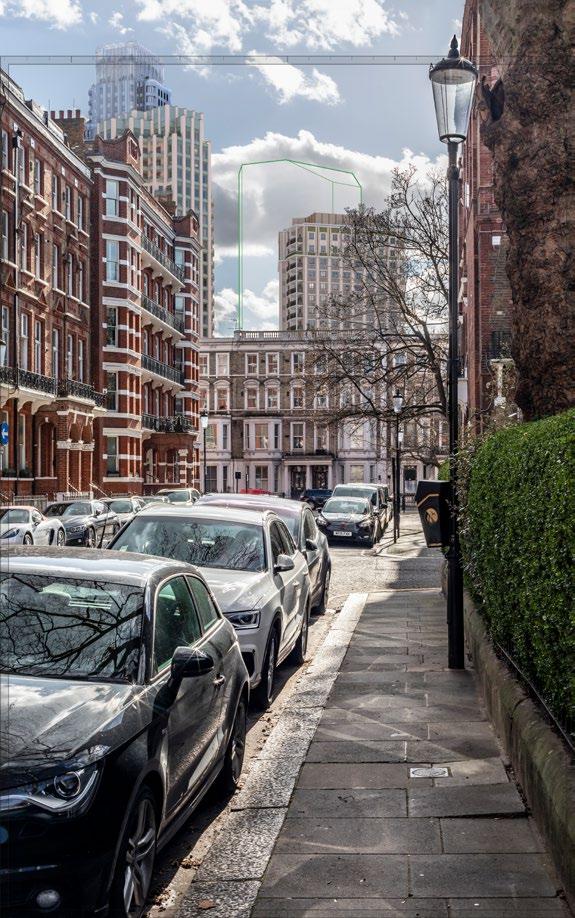
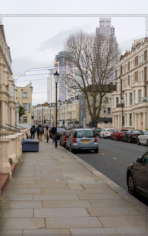
Figure 1A.41A: Updated TVA View 8 Amended Proposed Development Early Phases Nevern Square Conservation Area (RBKC)
Figure 1A.44A: Updated TVA View 23 Amended Proposed Development Early Phases
1.145 The updated verified views represent how the Early Phases of the Amended Proposed Development would appear in the views looking west from the Nevern Square Conservation Area. The proposed amendments that would appear in the setting of the conservation area would be on the architectural design of Plot WB04. The proposed amendments would be de minimis in terms of the effect on the conservation area because the impact is caused by the height and scale of the Early Phases and the modern residential architecture. The assessment in the July 2024 ES therefore remains valid.
1.146 Magnitude of impact: Low
1.147 Likely effect: Minor Adverse (not significant)
Earl’s Court Square Conservation Area (RBKC)
1.148 The updated TVA views 29 and A17 are presented at Figure 1A.4N and 1A.3N. The updated verified views represent how the Early Phases of the Amended Proposed Development would appear in the views looking west from the Earl’s Court Square Conservation Area.
1.149 The proposed amendments that would appear in the setting of the conservation area are to the maximum outline parameters of EC03, the architectural design of Plot WB04 and the Design Codes for EC10. The proposed amendments would be de minimis in terms of the effect on the conservation area because the impact is caused by the height and scale of the Early Phases and the modern residential architecture. The assessment in the July 2024 ES therefore remains valid.
Figure 1A.3N: Updated TVA View A17 Amended Proposed Development Early Phases
Figure 1A.4N: Updated TVA View 29 Amended Proposed Development Early Phases
Volume 2A: Built Heritage, Townscape and Visual Assessment Addendum
1A:
Holland
Park, Grade II Registered Park and Garden (RBKC)
1.152 The qualitative assessment of the effect of the Early Phases on the Holland Park Registered Park and Garden is presented in Technical Appendix 1.1 of the July 2024 ES Volume 2, Chapter 1. The updated TVA view 3 is presented at Figure 1A.5N. The updated verified view represents how the Amended Proposed Development for the Early Phases would appear in the views looking south-west from Holland Park.
1.153 The proposed amendments that would appear in the setting of the Registered Park and Garden are to the architectural design of Plot WB04. The proposed amendments would be de minimis in terms of the effect on the conservation area because the impact is caused by the height and scale of the Early Phases and the modern residential architecture. The assessment in the July 2024 ES therefore remains valid.
1.154 Magnitude of impact for ES: Very Low
1.155 Likely effect for ES: Negligible Neutral (not significant)
Holland Park Conservation Area (RBKC)
1.156 Please refer to assessment for Holland Park RPG. The assessment in the July 2024 ES remains valid.
caused by the height and scale of the Early Phases and the modern residential architecture. The assessment in the July 2024 ES therefore remains valid.
9-18, 11A and 18A Collingham Gardens, Grade II* Listed Building (RBKC)
1.163 The Early Phases of the Amended Proposed Development would appear together with the listed building in the linear views looking west provided by Bolton Gardens and Bramham Gardens. This is illustrated in AVR 19 which has not been updated for the purposesof the ES Addendum as there is no visual change In views, 9 and 18 Collingham Gardens appear obliquely as part of the historic residential development that contains the streets. It is not possible to appreciate the group of listed buildings in their full extent in these views and mature street trees provide screening and containment in the views. Plot WB04 and Development Zone E would be seen over a considerable distance, approximately 940 m, and interposing development between the north and south end of the listed building and the Early Phases.
1.164 The immediate surroundings that contribute to the heritage value of the receptor would be unaffected by the Early Phases and distant visibility in kinetic views where the full extent of the listed building cannot be appreciated is not considered to cause harm to their heritage value. There would be no interaction between Plot WB04 and the listed building in publicly accessible street views because of the orientation of the listed buildings which face west, and the Early Phases would be behind the observer. The separating distance and interposing development mean that any view of the Early Phases from Bramham Gardens to the south of the listed building would be peripheral and not disturb the understanding of the immediate historic, planned context. Therefore, the heritage value of the listed building would be preserved.
1-8, Collingham Gardens SW5, Grade II* Listed Building (RBKC)
1.167 The Early Phases of the Amended Proposed Development would appear together with the listed building in the linear views looking west provided by Harrington Gardens and Wetherby Gardens. In these views, 1 and 8 Collingham Gardens appear obliquely as part of the historic residential development that contains the streets. It is not possible to appreciate the group of listed buildings in their full extent in these views and mature street trees provide screening and containment in the views. Plot WB04 and Development Zone E would be seen over a considerable distance, approximately 945 m, and interposing development between the north and south end of the listed building and the Early Phases.
1.168 The immediate surroundings that contribute to the heritage value of the receptor would be unaffected by the Early Phases and distant visibility in kinetic views where the full extent of the listed building cannot be appreciated is not considered to cause harm to their heritage value. There would be no interaction between Plot WB04 and the listed building in publicly accessible street views, and any views from Wetherby Gardens would be screened by trees and there would be no change to how the architectural interest of the listed building within a wider set piece of historic townscape is understood.
1.169 Therefore, the heritage value of the listed building would be preserved.
1.159 The qualitative assessment of the effect of the Early Phases on the Chelsea Old Church is presented in Technical Appendix 1.1 of the July 2024 ES Volume 2, Chapter 1. The updated TVA view 6 is presented at Figure 1A.7N. The updated verified view represents how the Amended Proposed Development for the Early Phases would appear in the views of Chelsea Old Church from the south bank of the River Thames.
1.160 The proposed amendments that would appear in the setting of the listed building are to the architectural design of Plot WB04. The proposed amendments would be de minimis in terms of the effect on the church because the impact is
1.172 The Cheyne Conservation Area is located approximately 1.6 km south-east of the Early Phases Site at the nearest point. This assessment considers the potential impact on the conservation area because of Plot WB04 appearing in views of the conservation area from the south bank of the River Thames, which are identified as important views in the conservation area appraisal.
1.173 The updated TVA views 5 and 6 at Figures 1A.6N and 1A.7N show how the Early Phases would appear as a distant feature on the horizon in the views from the south bank of the river. In these views, the development in the conservation area that may be appreciated is the embankment which has a lot of tree cover and the listed and historic buildings at the northern bridgehead of Battersea Bridge. The listed buildings have been assessed in the July 2024 ES.
Figure 1A.5N: Updated TVA View 3 Amended Proposed Development Early Phases
Chelsea Old Church, Grade I Listed Building (RBKC)
1.174 The Early Phases would introduce a new modern feature to the views and the distant skyline. They would be understood as distant objects and entirely separate from the historic development in the foreground. There would be no change to the appreciation of the relationship between the embankment within the conservation area and the river, and the historic roofscape and architectural interest of the historic buildings which are visible at the water’s edge would remain legible. The background and periphery of the conservation area are already influenced by taller and modern developments, and the conservation area is understood as part of a wider, urban context.
1.175 The intrinsic interests of the conservation area would be unaffected and there would be no visibility of the Early Phases from within the conservation area itself. The underlying and fundamental characteristics of the conservation area’s riverside and the relationship to the river would be unchanged in the fore- and middle-ground of views from the south bank, and the horizon backdrop already includes buildings of different scales. The tower of Chelsea Old Church, which is the main vertical building to punctuate the skyline, would be unimpeded by Plot WB04 and remain a focal point. In summary, the heritage interests of the conservation area would be unharmed in the views from the river and the conservation area would be preserved. The magnitude of impact would be Very Low and the likely effect would be Negligible Neutral.
1.178 In the Early Phases of the Amended Proposed Development, Plot WB04 would appear in the backdrop of the conservation area in the views across to the Royal Hospital from the south bank of the River Thames. The views are represented by updated TVA view 5 to help understand where on the horizon the Early Phases would appear (see Figure 1A.6N).
1.179 Plot WB04 would be seen over a considerable distance, approximately 2.1 km, in the background of the development comprising the conservation area in the foreground. It would be understood as a separate, modern object and it would not draw the eye. Importantly, the views from the south bank of the River Thames are not identified as important views in the conservation area appraisal and it is not possible to meaningfully appreciate the heritage interests of the conservation area in these views. Therefore, visibility of the Early Phases would have no effect on the ability to appreciate the heritage value of the conservation area.
1.180 Magnitude of impact: Nil
1.181 Likely effect: None
Barons Court Conservation Area (LBHF)
1.182 The updated TVA view B16 is presented at Figure 1A.8N. The updated verified view represents how the Amended Proposed Development for the Early Phases would appear in views from Barons Court Conservation Area. The amendments would not change the effects of the Early Phases and the assessment in the July 2024 ES therefore remains valid.
Figure 1A.6N: Updated TVA View 5 Amended Proposed Development Early Phases
Figure 1A.7N: Updated TVA View 6 Amended Proposed Development Early Phases
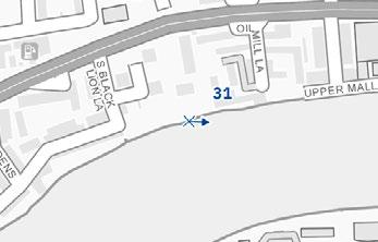
Royal Hospital Conservation Area (RBKC)
Proposed Development Early Phases
Queen’s Club Gardens Conservation Area (LBHF)
1.185 The updated TVA view 51 is presented at Figure 1A.52A. The updated verified views represent how the Amended Proposed Development for the Early Phases would appear in the views looking west from the Queen’s Club Gardens Conservation Area.
1.186 The proposed amendments that would appear in the setting of the conservation area are to the architectural design of Plot WB04. The proposed amendments would be de minimis in terms of the effect on the conservation area because the impact is caused by the height and scale of the Early Phases and the modern residential architecture. The assessment in the July 2024 ES therefore remains valid.
1.187 Magnitude of impact: Low
1.188 Likely effect: Minor/Moderate Adverse (not significant) The Mall Conservation Area (LBHF)
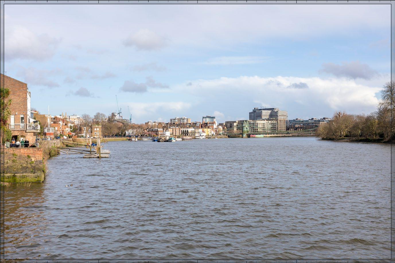
1.189 The updated TVA view 31 is presented at Figure 1A.9N. The updated verified view represents how the Amended Proposed Development for the Early Phases would appear in the views looking west from The Mall Conservation Area.
1.190 The proposed amendments that would appear in the setting of the conservation area comprise the architectural design of Plot WB04. The proposed amendments would be de minimis in terms of the effect on the conservation area because the impact is caused by the height and scale of the Early Phases and the modern residential architecture. The assessment in the July 2024 ES therefore remains valid.
Figure 1A.52A: Updated TVA View 51 Amended Proposed Development Early Phases
Figure 1A.9N: TVA View 31 Amended Proposed Development Early Phases
Summary of All Receptors – Early Phases
1.193 The assessment of the Early Phases of the Amended Proposed Development on 13 built heritage receptors considered in the July 2024 ES, has confirmed that the conclusions of the July 2024 ES, and therefore the summary presented in Table 1.10, remain valid. 1.194 Table 1A.10A presents a summary of the additional four built heritage receptor effects
Table 1A.10A: Early Phases – Summary of Effects on Additional Heritage Receptors
Ref. Receptor
02.2 9-18, 11A and 18A Collingham Gardens
02.4 1-8, Collingham Gardens SW5
All Phases
Demolition and Construction Effects
1.195 The demolition and construction of the All Phases would not result in new or different likely effects on the built heritage receptors assessed in the July 2024 ES. This is because the proposed amendments to the detailed Plots and maximum outline parameters in the Amended Proposed Development are de minimis, and the nature of construction activities and their visibility in the setting of the heritage receptors would not change.
1.196 The likely effect of the demolition and construction stage of the All Phases on 1-8 Collingham Gardens (Grade II*), 918, 11A and 18A Collingham Gardens (Grade II*), Cheyne Conservation Area and the Royal Hospital Conservation Area would be the same as the Early Phases because it is the same Plots and Development Zones that would appear in the setting of the built heritage receptors.
Summary of All Receptors – All Phases
Completed Development Effects
1.197 The likely effect of the completed development stage of the All Phases on the built heritage receptors assessed in the July 2024 ES would be the same as the Early Phases because it is the same Plots and Development Zones that would appear in the setting of the built heritage receptors. The All Phases of the Amended Proposed Development would not result in new or different likely effects on built heritage.
1.198 The likely effect of the completed development stage of the All Phases on 1-8 Collingham Gardens (Grade II*), 9-18, 11A and 18A Collingham Gardens (Grade II*), Cheyne Conservation Area and the Royal Hospital Conservation Area would be the same as the Early Phases because it is the same Plots and Development Zones that would appear in the setting of the built heritage receptors.
1.199 The assessment of the All Phases of the Amended Proposed Development on 13 built heritage receptors considered in the July 2024 ES, has confirmed that the conclusions of the July 2024 ES, and therefore the summary presented in Table 1.10, remain valid.
1.200 Table 1A.11A presents a summary of the additional four built heritage receptor effects.
Table 1A.11A: All Phases – Summary of Effects on Additional Heritage Receptors Map Ref. Receptor
Assessment of Residual Effects
Early Phases
1.201 No additional mitigation is required and no enhancement measures are relevant for the Amended Proposed Development. Accordingly, the July 2024 ES remains valid for the Early Phases development scenario of the Amended Proposed Development
All Phases
1.202 No additional mitigation is required and no enhancement measures are relevant for the Amended Proposed Development. Accordingly, the July 2024 ES remains valid for the All Phases development scenario of the Amended Proposed Development
Summary of Residual Effects
1.203 The summary of residual effects as presented in the July 2024 ES remains valid for the Amended Proposed Development with the exception of the four additional receptors as presented in Table 1A.12A
Table 1A.12A: Summary of Additional Residual Built Heritage Effects
Receptor Description of Residual Effect Additional Mitigation
Visibility of All Phases demolition and construction activity in the setting of the heritage receptor.
Visibility of All Phases demolition and construction activity in the setting of the heritage receptor.
(not significant)
Negligible (not significant)
Negligible (not significant)
Negligible (not significant)
Cheyne Conservation Area Visibility of All Phases demolition and construction activity in the setting of the heritage receptor. None Negligible (not significant)
Royal Hospital Conservation Area
Visibility of All Phases demolition and construction activity in the setting of the heritage receptor.
Visibility of the All Phases in the setting of the heritage receptor.
Visibility of the All Phases in the setting of the heritage receptor.
Visibility of the All Phases in the setting of the heritage receptor.
Visibility of the All Phases in the setting of the heritage receptor.
Negligible (not significant)
Negligible (not significant)
(not significant)
(not significant)
Notes:
* - = Adverse/ + = Beneficial/ +/- = Neutral; D = Direct/ I = Indirect; P = Permanent/ T = Temporary; R=Reversible/ IR= Irreversible; St = Short-term/ Mt =Medium-term/ Lt=Long-term.
**Negligible/Minor/Moderate/Major
Cumulative Effects
Intra-Project Effects
1.204 The intra-project cumulative effects as previously reported in the July 2024 ES remains valid for the Amended Proposed Development and are considered in Chapter 18A: Cumulative Effects.
Inter-Project Effects
1.205 The inter-project effects presented in the July 2024 ES remain valid for the Amended Proposed Development.
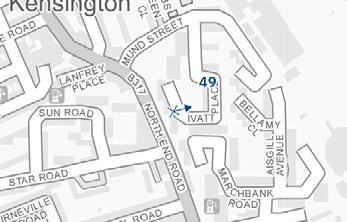
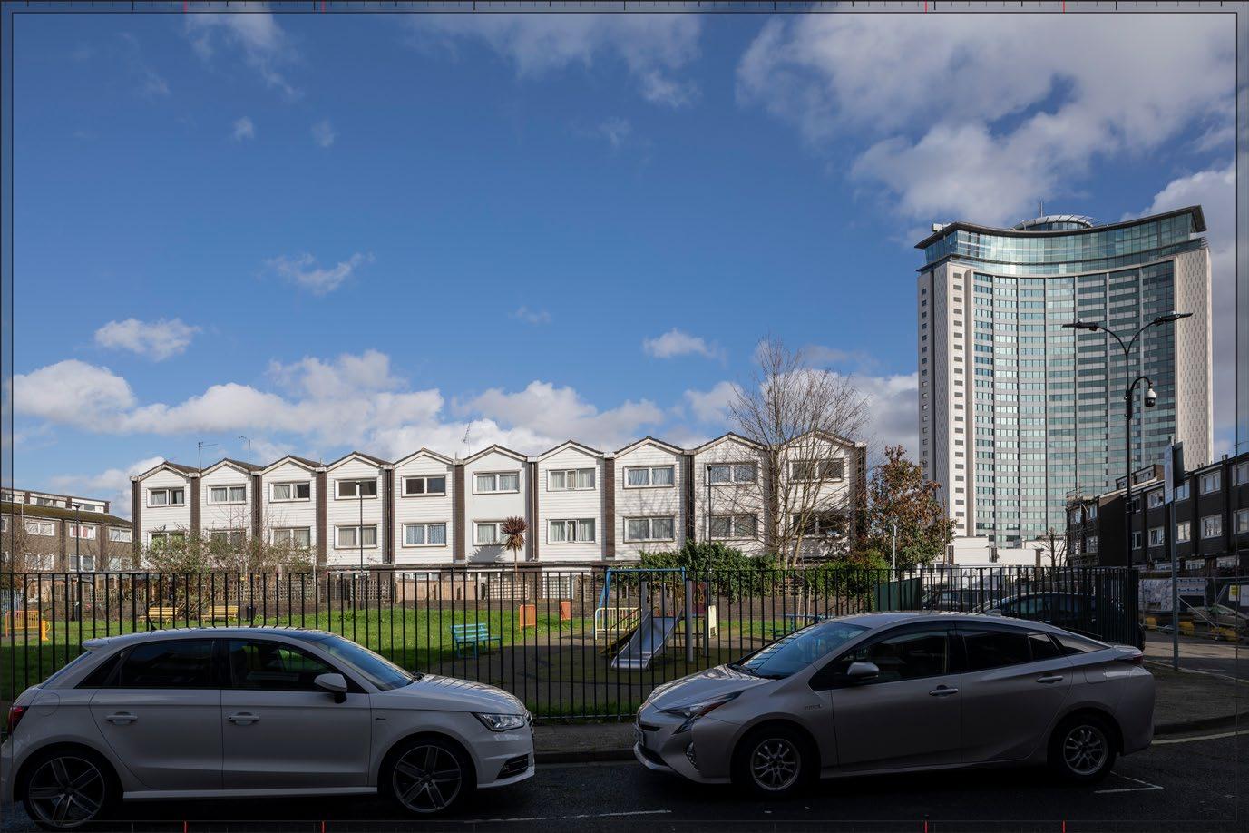
1.206 The ES Addendum has considered whether there would be new or different cumulative effects because of the Mund Street School site scheme. The Mund Street School site scheme is located immediately adjacent to the western boundary of the Site in the LBHF. The proposals are likely to comprise the introduction of five new residential blocks ranging from one to 11 storeys The 11 storey block would be on the north-east corner of the school site, nearest to the boundary with the Site. The only potential new or different cumulative effects would be in the All Phases scenario because of the position of the Mund Street School site scheme relative to the Site and the Amended Proposed Development.
1.207 The Mund Street School site scheme is not within a conservation area and there are no built heritage receptors within or in proximity to the scheme. The only built heritage receptor which may be potentially affected by the Mund Street School site scheme is the Barons Court Conservation Area which is approximately 170 m west of the school scheme site at the nearest point and there are axial views towards the Site that may include the school Mund Street School site scheme. It is only the 11 storey block that would appear in the views from the conservation area because the remaining blocks are lower rise and would be screened by interposing development.
1.208 The Mund Street School site scheme would not change the magnitude of impact or likely effect of the Amended Proposed Development where seen together in the views from the conservation area on the east-west orientated streets (refer to TVA view A30 in the July 2024 ES). This is because of the separating distances between the conservation area and the Site and the Mund Street School site scheme, interposing development, and the scale of the proposals for the Mund Street School site scheme The Mund Street School site scheme would not materially occlude the Amended Proposed Development.
1.209 The inter-project cumulative effects on built heritage receptors previously reported in the July 2024 ES therefore remain valid for the Amended Proposed Development.
Summary of Assessment
Post-Application Submission
1.210 Following the July 2024 ES submission, RBKC, LBHF and Waterman post-submission review comments have required assessment of the following four additional heritage receptors:
• 1-8 Collingham Gardens (Grade II* listed);
• 9-18, 11A and 18A Collingham Gardens (Grade II* listed);
• The Cheyne Conservation Area; and
• The Royal Hospital Conservation Area.
1.211 An assessment of the Amended Proposed Development was also undertaken. In particular, consideration was given to proposed amendments to the building footprint and height of the Amended Detailed Component; the development zone maximum vertical and horizontal parameters and design codes of the Amended Outline Component of the Amended Proposed Development.
1.212 In respect of baseline conditions, on-site conditions have not changed for built heritage receptors.
1.213 The assessment has reached the following conclusions with regard to the receptors assessed in the July 2024 ES:
• The demolition and construction effects of the Early Phases and All Phases remain unchanged;
• The completed development effects of the Early Phases and All Phases remain unchanged; and
• The cumulative assessment conclusions remain unchanged.
1.214 The assessment has reached the following conclusions with regard to the four additional receptors:
• There would be no significant effects to the four new receptors in the demolition and construction stage of the Early Phases and All Phases and the heritage value of the receptors would be preserved. The effects range from Negligible to None;
• There would be no significant effects to the four new receptors in the completed development stage of the Early Phases and All Phases and the heritage value of the receptors would be preserved. The effects range from Negligible to None; and
• There would be no change to the likely additional cumulative effects as a result of cumulative schemes.
1.215 In respect of the Mund Street School site scheme, the cumulative assessment conclusions would not be altered.
1.216 Accordingly no additional or different significant built heritage effects have been identified for the Amended Proposed Development.
1.217 Of the 97 heritage receptors assessed (93 in the July 2024 ES and four additional receptors assessed in this report), there would be no significant built heritage effects.
Technical Appendix 1A.2A: Maps of Heritage Study Area
House 7. 62-68, Lillie Road SW6
8. West Brompton Station including Booking Hall and Train Shed and Staircases and Retaining Wall 9. Tomb of Benjamin Golding, Tomb of Henry Pettit, Burnside Monument, and Mausoleum of James Mcdonald, Brompton
Earls Court
30-52, Earls Court Square Sw5
Prince of Teck Public
Mausoleum of Colonel William Meyrick, Mausoleum of Harvey Lewis, Tomb of Herbert Fitch, and Tomb of George Godwin, Brompton Cemetery
16. K2 Telephone Kiosk Near Earls Court Square
17. St Andrews Fulham Fields
18. Gate Piers To No 282
19. Tomb of Peter Borthwick and Family, Brompton Cemetery
282, North End Road
Guards Memorial North West of Circle No 4 at The Brompton Cemetery 22. Tomb of Alfred Mellon, Tomb of Joseph Bonomi, Tomb of Clement Family, Tomb of Barbe Marie Theresa Sangiorgi, Tomb Chest of Valentine Cameron Prinsep, and Tomb of Elizabeth Moffat, Brompton Cemetery
23. Entrance Arch From Bolton Gardens
24. 24-32, Pembroke Square W8
25. Pembroke Studios, and Pillar Box Outside No 27
26. Church of St Luke
27. Tomb of John Jackson
Technical Appendix 1A.3A: Amended Map of Heritage Study Area Overlaid with Zone of Theoretical Visibility
Technical Appendix 1A.6A: Maps of Heritage Assets Scoped in for Assessment
HERITAGE ASSET PLAN -
40. 135-149 Talgarth Road W6
42. 36-39, and 40,41-46, Addison Road W14
43. Bousfield School, including Water Tower
44. Brass Family Tomb, and Tomb of Blanche Roosevelt Macchetta, Brompton Cemetery
46. Barons Court Underground Station
53. 14, Holland Park Road W14
56. Tomb of Percy Lambert, Brompton Cemetery
58. Church of St Alban
62. 10 and 10a, Holland Park Road
64. 16, 18 and 18a, Melbury Road W14
65. 24 and 26, Harrington Gardens SW7
66. 1-8, The Boltons SW10
67. Gateway Opposite Earls Court Road
68. Reception House, Hammersmith Cemetery, and 17, St Dunstan's Road W6, and Street Wall, Railings and Gates to Number 17
74. Monument to S L Sotheby and Tomb of Robert Coombes, Brompton Cemetery
76. Sir Oswald Stoll Foundation Southern Block, Gates, Gate Piers, Wing Walls and Railings Facing Fulham Road
77. East House, and West House
79. Blake's Munitions War Memorial, Margravine Cemetery
80. Tomb of George Broad approx160 metres East of West Gate, Hammersmith Cemetery
83. 20 and 22, Harrington Gardens SW7
91. 308-328, Fulham Road SW10
92. Brompton Cemetery Ironwork Piers, Gates and Screen on Fulham Road, Westernmost K2 Telephone Kiosk and Easternmost K2 Telephone Kiosk Outside Brompton Cemetery
102. Tombs of Abraham Smith, and Frederick Harold Young, Hammersmith Cemetery
105. J Lyons and Company First World War Memorial, Margravine Cemetery
111. 27-35, Hereford Square SW7
115. Original School Building and Chapel at Former College of St Mark and St John
2A TOWNSCAPE AND VISUAL
Introduction
2.1 This chapter of the 2025 ES Addendum reports on the likely townscape and visual effects of the Amended Proposed Development. The assessment examines whether the Amended Proposed Development would result in additional or different significant environmental effects to those of the townscape and visual assessment presented in the July 2024 ES for the Proposed Development. In particular, the assessment considers the proposed amendments to the building footprint and height of the Amended Detailed Component; the development zone maximum vertical and horizontal parameters and design codes of the Amended Outline Component of the Amended Proposed Development
2.2 The chapter should be read in conjunction with Volume 2, Chapter 2: Townscape and Visual Assessment and associated Technical Appendices A-H of the July 2024 ES. The majority of these documents remain unchanged for the Amended Proposed Development but have been updated, where required In respect of the chapter, context and validation text are shown in black, updated text in blue and new text in green Where select amendments have been made to tables and figures, titles have been denoted by the letter suffix ‘A’ (e.g. Table 1A.1A) for the table /figure to be read in conjunction with the original; where material updates have been required, titles have been denoted by the letter suffix ‘R’ (e.g. Table 1A.1R) for the original table/figure to be replaced/disregarded; and where entirely new tables and figures have been required, these have been denoted by the letter suffix ‘N’ (e.g. Table 1A.1N).
2.3 In respect of the technical appendices, 13 views which were previously assessed in the July 2024 ES have been updated to reflect the proposed amendments. Of these 13 views, 10 were individually assessed in the July 2024 ES and are verified views, while three were not individually assessed and were provided in Appendices C and D of the July 2024 ES (of which two were verified and one non-verified). The updated 13 views are presented in:
• Appendix 2A.IN: Updated Verified and Non-Verified Views
2.4 The chapter should be read together with:
• Volume 1A: Main Environmental Statement Report Addendum –
ES Chapter 1A: Introduction;
ES Chapter 2A: EIA Process and Methodology;
ES Chapter 3A: Alternatives and Design Evolution;
ES Chapter 4A: Amended Proposed Development;
ES Chapter 5A: Amended Demolition and Construction Description;
• ES Volume 2A: Built Heritage, Townscape and Visual Assessment Addendum, Chapter 1A: Built Heritage; and
• ES Volume 3A: Technical Appendices Addendum, associated with relevant Chapters of ES Volume 1A.
2.5 The introduction as presented in Chapter 2 of July 2024 ES Volume 2 remains valid for the Amended Proposed Development.
Methodology
2.6 There have been no changes to relevant legislation, policy and guidance since submission of the July 2024 ES, with the exception of the NPPF, which was updated most recently in December 2024 and February 20251 and the RBKC New Local Plan which was adopted in July 2024
2.7 The changes to the NPPF do not affect the assessment of townscape and visual effects.
2.8 In respect of regional policy and guidance, the documents presented within the July 2024 ES remain valid.
2.9 In respect of local policy, the RBKC New Local Plan was adopted on 24 July 20242. The July 2024 ES had regard to RBKC New Local Plan emerging policy at the time of undertaking the assessment. The adopted RBKC New Local Plan contains no changes of relevance to the townscape and visual impact assessment. There have been some minor changes to wording and policy numbering in the adopted RBKC New Local Plan (July 2024) compared to the draft documents. For completeness the updated numbering is as follows:
• ‘GB15 - Parks, Gardens and Open Spaces’;
• ‘CD1 - Context and Character’;
• ‘CD2 - Design Quality, Character and Growth’;
• ‘CD8 - Tall Buildings’;
• ‘CD15 - Views’; and
• ‘TR4 - Streetscape’
2.10 In respect of topic specific guidance and industry standards, the documents presented in the July 2024 ES remain valid.
Consultation
2.11 The consultation process presented in the July 2024 ES relates to the pre-application submission stage including the formal EIA Scoping process, which remains valid.
2.12 Following submission of the July 2024 ES, post-application submission review comments were provided by RBKC, LBHF and Waterman. The full set of review comments and responses are presented in Technical Appendix 2A.10N in ES Volume 3A. None of these comments have necessitated changes to the assessment.
Assessment Scope
2.13 There has been no change to the scope of the townscape and visual assessments, including the technical, spatial and temporal scopes and the scenarios considered for both the demolition and construction stage and the completed development stage, as a result of the proposed amendments. The assessment scope presented in the July 2024 ES therefore remains valid.
2.14 The assessment presented in this addendum has been based on the Amended Proposed Development as presented in ES Chapter 4A: Amended Proposed Development Description and ES Chapter 5A: Amended Demolition and Construction Description of ES Volume 1A.
2.15 In total, 13 of the views presented in the July 2024 ES have been updated to reflect the proposed amendments (including ten that were individually assessed in the July 2024 ES and three supplementary views that were provided in Appendices C and D). These were specifically selected, on the basis of professional judgement, as views where the proposed amendments would be most visible and as providing views from a range of distances and directions from the Site, so that the overall effect of the proposed amendments on all other views presented in the July 2024 ES could be inferred. An assessment of all 59 of the previously assessed views is accordingly provided on this basis, using professional judgement where the views have not been updated, at Table 2A.2N of this Addendum. The updated views, provided in Appendix 2A.IN, are as follows:
• View 3 - Holland Park;
• View 5 - Chelsea Bridge;
• View 6 - Albert Bridge;
• View 7 - Brompton Cemetery, Central Avenue, southern end outside chapel;
• View 8 - Brompton Cemetery, Central Avenue, southern end of Arcade;
• View 23 - Nevern Square, south side;
• View 29 - Penywern Road;
1 Ministry of Housing, Communities and Local Government, February 2025. National Planning Policy Framework. London. HMSO.
2 Royal Borough of Kensington and Chelsea, 2024. New Local Plan Review. Available at: https://www.rbkc.gov.uk/planning-and-building-control/planning-policy/local-plan [accessed June 2025
Volume 2A: Built Heritage, Townscape and Visual Assessment Addendum
and Visual
• View 31 - Thames Path west of Hammersmith Bridge;
• View 49 - Ivatt Place;
• View 51 - Greyhound Road;
• View A17 - Earls Court Square, north side;
• View A18 - Old Brompton Road, junction with Finborough Road; and
• View B16 - Barons Court Road
Baseline Characterisation Method
2.16 The baseline characterisation method presented in the July 2024 ES remains valid for the Amended Proposed Development
2.17 The change to the redline boundary as outlined in ES Volume 1A, Chapter 1A: Introduction, is considered de-minimis in terms of the Site area and description Accordingly, in the interest of proportionality, figures presented in the July 2024 ES have not been updated.
Townscape Assessment Method
2.18 The townscape assessment method presented in the July 2024 ES remains valid for the Amended Proposed Development.
2.19 The assessment method presented in the July 2024 ES remains valid for the Amended Proposed Development. However, the assessment presented in this addendum has been based on the Amended Proposed Development as presented in ES Chapter 4A: Amended Proposed Development Description and ES Chapter 5A: Amended Demolition and Construction Description of ES Volume 1A.
2.20 In respect of townscape character, the list of cumulative schemes remains valid other than the addition of the following relevant scheme which has been considered qualitatively in the cumulative effects section:
• Mund Street School site scheme.
Visual Assessment Method
2.21 The visual assessment method presented in the July 2024 ES remains valid for the Amended Proposed Development.
2.22 The assessment method presented in the July 2024 ES remains valid for the Amended Proposed Development. However, the assessment presented in this addendum has been based on the Amended Proposed Development as presented in ES Chapter 4A: Amended Proposed Development Description and ES Chapter 5A: Amended Demolition and Construction Description of ES Volume 1A.
2.23 In respect of visual amenity, the list of cumulative schemes remains valid for the Amended Proposed Development other than the addition of the following relevant scheme which has been considered qualitatively in the cumulative effects section:
• Mund Street School site scheme
Assumptions and Limitations
2.24 The assumptions and limitations presented in the July 2024 ES remain valid for the Amended Proposed Development.
Baseline Conditions
2.25 Whilst it is noted that a new meanwhile use has been introduced on-site, the baseline conditions as described in the July 2024 ES remain materially valid. This is because the meanwhile use utilises the existing infrastructure on-site and no new infrastructure has been built.
Assessment of Effects
Introduction - Early Phases and All Phases Description
2.26 The descriptions of the Early Phases Site and the All Phases Site in their existing state in terms of townscape, visual amenity and urban design as presented in the July 2024 ES remain valid for the Amended Proposed Development
2.27 The description of the relevant aspects of the Early Phases and All Phases and of the embedded mitigation of the Proposed Development as set out in the July 2024 ES, remain valid subject to the following proposed amendments which are considered relevant to the townscape and visual assessment and have been taken into account in the assessments in this Addendum where relevant
• Amended Detailed Component:
Amendments to appearance of lower levels of Plot EC05 (updates to fenestration to suit revised unit layouts, Table Park entrance adjusted, two new balconies added at Level 01 and 02 and a terrace at Level 07);
Amendments to the building footprint of Plot EC06 (extended to south-east to accommodate enlarged core) by 0.8 m, and amendments to fenestration of the ground floor to accommodate additional plant requirements; and
Amendments to the building footprints of Plots WB04 and WB05 by approximately 0.1 m and approximately 0.3 m respectively;
• Amended Outline Component:
Addition of limits of deviation (plus/minus 2-2.8) at Development Zones A, B and C;
Reduction in maximum height of Development Zone F (Plot EC03) from 71.3 mAOD to 67.8 mAOD (3.5 m reduction);
Setback of Development Zone X (Plot WK02) upper level massing to the north (23.2 mAOD by 0.5 m; 28.1 mAOD by 4.5 m; 31.4 mAOD by 3.6 m);
Amendments to the Design Code:
o General amends to reflect or clarify updates to Parameter Plans;
o Amended and new West Brompton Square design codes to enhance the synergy between active frontages and architectural elements (e.g. types of frontages / spill out space);
o Additional West Brompton Square design codes to ensure that the landscaping enhances the ecological corridor and respond to and aligns with Brompton Cemetery's character;
o Amended design codes in respect of Development Zone E (Plot EC10) to enhance built form articulation in response to townscape and heritage setting from key views;
o New design code for potential Cluny Mews pedestrian and cycle connection;
o Amended Cluny Mews built form design codes to clarify how buildings along Cluny Mews are articulated to create a synergy with the context, including the adjacent Cluny Mews development and St. Cuthbert's Church;
o Additional built form design codes to enhance articulation of built form and respond to finer urban grain where plots have the potential to present a monolithic form from key views;
o New West Kensington Square design codes to provide design principle for a potential new Square outside West Kensington Station; and
o Amended flexible land use design codes to provide clarity on design principles in the context of flexible use capacity. The following detailed descriptions of proposed design code amendments are most relevant to the townscape and visual assessment:
o Addition of new text under amended Design Code WB.B.31, Expression of building top, in respect of Plots EC03/09/10 as follows: “Proposed buildings particularly in the foreground of the view (Plot EC10) should also be further refined to create a sense of vertical rhythm and massing variation. This could be achieved by introducing breaks or set backs at the top of the perceived building volume ”;
o Addition of new Design Code EP.B.14, Complementing local character, which states that: “Buildings within plots WB07/08 (Development Zone B) should respond to and complement the grain, materiality and typologies of existing buildings in the immediate street context. They should avoid creating a visual distraction and mediate between shorter buildings in the foreground, and taller buildings behind.”;
o Revision of Amended Design Code WK.B.40, Façade Breaks, to state as follows: “Façade expression within Plots WK03/04 (Development Zone X) should express a regular grain broken down with features such as expression of architectural componentry and/or, articulation of datums, set back and building tops, and/ or contrasts in materiality ”; and
o Addition of new Design Code SW.B.23, Length of Facades, which states that: “Where developments zones contain multiple connected plots or where plot frontages are exceptionally long compared to the existing urban grain, these should be carefully articulated to break up the bulk and massing of the block. This could be achieved through composition and architectural expression such as articulating breaks between the plots (full or partial height), introducing steps or setbacks in the built form, change in materiality or vertical façade articulation.”
2.28 As a result of the proposed amendments to the Design Code, the numbering of some of the design codes referenced in the July 2024 ES has changed. In addition, a number of inconsistencies in the numbering of the design codes have been identified in the July 2024 ES, together with two erroneous design codes references. One of these relates to a mistaken reference to Design Code SW.B.61, which was superseded by other codes, and the other relates to some views assessment text mistakenly referring to ‘tripartite composition (WK.B.26)’, which should be disregarded For completeness, Table 2A.1N presents a summary of the amendments and corrections as necessary. The views assessment text to which the updates apply are also provided in the table. None of these amendments and corrections alter any assessments as presented in the July 2024 ES.
Table 2A.1N: July 2024 Design Code Corrections and 2025 Amended Design Codes
LS.B.42 - Breaks or steps in massing LS.B.40 – Breaks or steps in massing Philbeach Gardens Sequence, paragraph 2.272
LS.B.45 - Complement local character LS.B.44 – Complement local character View 47
LS.B.48 - Calmed background
LS.B.46 – Calmed background View 47
LS.B.49 - Expression of building top LS.B.47 – Expression of building top View 47
Early Phases
Demolition and Construction Effects
2.29 The demolition and construction works as presented in the July 2024 ES, remain valid for the Amended Proposed Development. Information on the amended proposed demolition and construction works is presented in ES Volume 1A, Chapter 5A: Amended Demolition and Construction Description.
2.30 The assessment of Early Phases demolition and construction effects in respect of townscape and visual effects would not be affected by the proposed amendments. The assessment and conclusions of the July 2024 ES remains valid
Completed Development Effects
Visual Effects
2.31 The assessment of the visual effects of the Early Phases development scenario has been assessed in light of the proposed amendments and amended cumulative schemes as set out in the methodology section of this chapter This assessment has been based on a selection of ten updated verified views which were individually assessed in the July 2024 ES and three updated verified or unverified supplementary views. The 13 updated views have been chosen to represent visibility of the proposed amendments at a range of distances from the Site and from a range of directions.
2.32 The 13 updated views have been used to assess the overall effect of the proposed amendments on all other views assessed in the July 2024 ES. In the interest of proportionality, the full assessment is presented in Table 2A.2N. In summary, the proposed amendments and Amended Proposed Development as a whole would not alter any assessments of visual effects.
2.33 Accordingly, the assessment conclusions as presented in the July 2024 ES remain valid for the Amended Proposed Development
Townscape Effects
2.34 The Amended Proposed Development would be very slightly different overall in townscape terms compared to the Proposed Development assessed in the July 2024 ES (as demonstrated by the updated 13 views at Appendix 2A.IN) and would not change the assessment or scale of effects as reported for the Early Phases development scenario in respect of townscape character Therefore, effects in respect of both overall RBKC townscape character and LBHF townscape character and individual townscape character areas (TCAs) would not be affected by the proposed amendments and the Amended Proposed Development as a whole
2.35 Accordingly, the townscape assessment conclusions as presented in Table 2.13 of the July 2024 ES remain valid for the Amended Proposed Development.
All Phases
Demolition and Construction Effects
2.36 The demolition and construction works as presented in the July 2024 ES remain valid for the Amended Proposed Development. Information on the amended proposed demolition and construction works is presented in ES Volume 1A, Chapter 5A: Amended Demolition and Construction Description.
2.37 The assessment of All Phases demolition and construction effects in respect of townscape and visual effects would not be affected by the proposed amendments. The assessment and conclusions of the July 2024 ES remain valid for the Amended Proposed Development
Completed Development Effects
Visual
Effects
2.38 The assessment of the visual effects of the All Phases development scenario has been assessed in light of the proposed amendments and amended cumulative schemes set out in the methodology section of this Addendum chapter This assessment has been based on a selection of ten updated verified views which were individually assessed in the July 2024 ES and three updated verified or unverified supplementary views. The 13 updated views have been chosen to represent visibility of the proposed amendments at a range of distances from the Site and from a range of directions.
2.39 The 13 updated views have been used to assess the overall effect of the proposed amendments on all other views assessed in the July 2024 ES. In the interest of proportionality, the full assessment is presented in Table 2A.2N. In summary, the proposed amendments and the Amended Proposed Development as whole would not alter any assessments of visual effects.
2.40 Accordingly, the assessment conclusions as presented in the July 2024 ES remain valid for the Amended Proposed Development
Townscape Effects
2.41 The Amended Proposed Development would be very slightly different overall in townscape terms compared to the Proposed Development assessed in the July 2024 ES (as demonstrated by the updated views at Appendix 2A.IN) and would not change the assessment or scale of effects as reported for All Phases development scenario in respect of townscape character Therefore, the assessment of All Phases Townscape Effects in respect of both overall RBKC townscape character and LBHF townscape character and individual TCAs would not be affected by the proposed amendments and the Amended Proposed Development as a whole
2.42 Accordingly, the assessment conclusions as presented in Table 2.13 of the July 2024 ES remain valid for the Amended Proposed Development
Assessment of Visual Effects
2.43 There has been no change to the presentation style of the AVRs due to the proposed amendments or to the location of the views or the views data. The text presented in the July 2024 ES remains valid
2.44 Figures of the amended 3D Model that has formed the basis of the updated 13 views (Development Key and Proposed Development Plot Key presented on pages 36 and 37 of the July 2024 ES) have been updated and are provided in Appendix 2A.IN for completeness.
2.45 The appearance of the Amended Proposed Development would differ from the Proposed Development as shown in the July 2024 ES in a number of views. As noted previously, a selection of 13 updated views are provided in Appendix 2A.IN. The 13 views have been chosen to represent visibility of the proposed amendments at a range of distances from the Site and from a range of directions and including those views in which the proposed amendments are likely to be most visible
2.46 The assessment of the effects of the Amended Proposed Development on individually assessed views as presented in the July 2024 ES have been reconsidered in light of the proposed amendments, informed by the updated 13 views and amendments to the Design Codes. Table 2A.2N indicates whether the assessment of effect in each case would be altered by the Amended Proposed Development or would remain unaltered
Table 2A.2N: Amended Proposed Development Visual Assessment
View Early Phases (including proposed amendments) –change compared to July 2024 ES
View 1 - LVMF
14A.1 Blackfriars Bridge upstream
View 2 - Barn Elms Playing Fields
None of the proposed amendments would be visible in the view.
No change to assessment of effect – no effect.
The amended Plots WB04, EC05 and EC06 would be visible in this view. The amendments to Plot EC05 would be at lower levels and not visible in this view. The proposed amendments to the other plots would not be perceptible
No change to assessment of effect – Minor in scale, Neutral in nature.
View 3 – Holland Park
(updated view – see Appendix 2A.IN)
The amended Plots WB04, EC05 and EC06 would be visible in this view. The amendments to Plot EC05 would be at lower levels and not visible in this view. The proposed amendments to the other plots would not be perceptible.
No change to assessment of effect – Moderate in scale, Neutral in nature
View 4 – The Round Pond, Kensington Gardens
The amended Plots WB04 and EC05 would be visible in this view. The amendments to Plot EC05 would be at lower levels and not visible in this view. The proposed amendments to Plot WB04 would not be perceptible.
No change to assessment of effect – Moderate in scale, Neutral in nature
View 5 – Chelsea Bridge (updated view – see Appendix 2A.IN)
The amended Plots WB04 and EC05 would be visible in this view. The amendments to Plot EC05 would be at lower levels and not visible in this view. The proposed amendments to Plot WB04 would not be perceptible.
No change to assessment of effect – Moderate in scale, Neutral in nature
View 6 - Albert Bridge
(updated view – see Appendix 2A.IN)
The amended Plot WB04 would be visible in this view. The proposed amendments to this Plot would not be perceptible
No change to assessment of effect – Minor-moderate in scale, Neutral in nature
View 6N - Albert Bridge (dusk)
The amended Plot WB04 would be visible in this view. The proposed amendments to this Plot would not be perceptible.
No change to assessment of effect – Minor-moderate in scale, Neutral in nature
All Phases (including proposed amendments) – change compared to July 2024 ES
None of the proposed amendments would be visible in the view.
No change to assessment of effect – no effect.
The amended Plots WB04, EC05 and EC06 would be visible in this view. The amendments to Plot EC05 would be at lower levels and not visible in this view. The proposed amendments to the other plots would not be perceptible
No change to assessment of effect – Minor in scale, Neutral in nature.
The amended Plots WB04, EC05 and EC06 would be visible in this view. The amendments to Plot EC05 would be at lower levels and not visible in this view. The proposed amendments to the other Plots would not be perceptible.
No change to assessment of effect – Moderate in scale, Neutral in nature
The amended Plots WB04 and EC05 would be visible in this view. The amendments to Plot EC05 would be at lower levels and not visible in this view. The proposed amendments to Plot WB04 would not be perceptible.
No change to assessment of effect – Moderate in scale, Neutral in nature
The amended Plots WB04 and EC05 would be visible in this view. The amendments to Plot EC05 would be at lower levels and not visible in this view. The proposed amendments to Plot WB04 would not be perceptible.
No change to assessment of effect – Moderate in scale, Neutral in nature
The amended Plot WB04 would be visible in this view. The proposed amendments to this Plot would not be perceptible
No change to assessment of effect – Minor-moderate in scale, Neutral in nature
The amended Plot WB04 would be visible in this view. The proposed amendments to this Plot would not be perceptible.
No change to assessment of effect – Minor-moderate in scale, Neutral in nature
Early Phases (including proposed amendments) and Amended Cumulative Schemes – change compared to July 2024 ES
There would be no change due to amended cumulative schemes.
No change to assessment of effect – no effect.
There would be no change due to amended cumulative schemes. The proposed amendments remain as set out for the Early Phases considered in isolation.
No change to assessment of effect – Minor in scale, Neutral in nature.
There would be no change due to amended cumulative schemes. The proposed amendments remain as set out for the Early Phases considered in isolation.
No change to assessment of effect –Moderate in scale, Neutral in nature
There would be no change due to amended cumulative schemes. The proposed amendments remain as set out for the Early Phases considered in isolation.
No change to assessment of effect – Moderate in scale, Neutral in nature
There would be no change due to amended cumulative schemes. The proposed amendments remain as set out for the Early Phases considered in isolation.
No change to assessment of effect – Moderate in scale, Neutral in nature
There would be no change due to amended cumulative schemes. The proposed amendments remain as set out for the Early Phases considered in isolation.
No change to assessment of effect – Minormoderate in scale, Neutral in nature
There would be no change due to amended cumulative schemes. The proposed amendments remain as set out for the Early Phases considered in isolation.
No change to assessment of effect – Minormoderate in scale, Neutral in nature
All Phases (including proposed amendments) and Amended Cumulative Schemes – change compared to July 2024 ES
There would be no change due to amended cumulative schemes.
No change to assessment of effect – no effect.
There would be no change due to amended cumulative schemes. The proposed amendments remain as set out for the All Phases considered in isolation.
No change to assessment of effect – Minor in scale, Neutral in nature.
There would be no change due to amended cumulative schemes. The proposed amendments remain as set out for the All Phases considered in isolation.
No change to assessment of effect –Moderate in scale, Neutral in nature
There would be no change due to amended cumulative schemes. The proposed amendments remain as set out for the All Phases considered in isolation.
No change to assessment of effect – Moderate in scale, Neutral in nature
There would be no change due to amended cumulative schemes. The proposed amendments remain as set out for the All Phases considered in isolation.
No change to assessment of effect – Moderate in scale, Neutral in nature
There would be no change due to amended cumulative schemes. The proposed amendments remain as set out for the All Phases considered in isolation.
No change to assessment of effect – Minor-moderate in scale, Neutral in nature
There would be no change due to amended cumulative schemes. The proposed amendments remain as set out for the All Phases considered in isolation.
No change to assessment of effect – Minor-moderate in scale, Neutral in nature
View 7 - Brompton Cemetery, Central Avenue, southern end outside chapel
(updated view – see Appendix 2A.IN)
The amended Plots WB04, EC05 and EC03 would be visible in this view. The proposed amendments to Plot EC05 would be at lower levels and not visible in this view. The proposed amendments to Plot WB04 would not be perceptible. The reduction in height of Plot EC03 would form a small but noticeable change, lowering it on the skyline to the left of the foreground bell tower and revealing more of Plot EC04 behind
The amended Plots WB04, EC05 and EC03 would be visible in this view. The proposed amendments to Plot EC05 would be at lower levels and not visible in this view. The proposed amendments to Plot WB04 would not be perceptible. The reduction in height of Plot EC03 would form a small but noticeable change, lowering it on the skyline to the left of the foreground bell tower and revealing more of Plot EC04 behind.
There would be no change due to amended cumulative schemes. The proposed amendments remain as set out for the Early Phases considered in isolation.
No change to assessment of effect – Major in scale, Neutral in nature
There would be no change due to amended cumulative schemes. The proposed amendments remain as set out for the All Phases considered in isolation.
No change to assessment of effect – Major in scale, Neutral in nature
Table 2A.2N: Amended Proposed Development Visual Assessment
View Early Phases (including proposed amendments) –change compared to July 2024 ES
Amendments to the design codes in respect of Plot EC10, stating that it should ‘…be further refined to create a sense of vertical rhythm and massing variation’, would also be relevant to this view (Design Code WB.B.31). This would result in the stronger vertical articulation of the broad mass of Plot EC10 so that it would become a less dominant horizontal form on the skyline to the left of the foreground bell tower
The proposed amendments would further mitigate the visual impact of the Amended Proposed Development on the openness of the main axial route through the cemetery and on the appreciation of the foreground bell tower as a landmark skyline feature along the formal Central Avenue. There would be very slight but noticeable differences to the view as a result of the proposed amendments but this would not alter the assessment of effect which would remain major in scale and neutral in nature.
No change to assessment of effect – Major in scale, Neutral in nature
View 8 - Brompton Cemetery, Central Avenue, southern end of Arcade (updated view – see Appendix 2A.IN)
The amended Plots WB04, EC05 and EC03 would be visible in this view. The amendments to Plot EC05 would be at lower levels and not visible in this view. The proposed amendments to Plot WB04 would not be perceptible. The reduction in height of Plot EC03 would form a small but noticeable change, lowering it on the skyline to the left of the foreground bell tower and revealing more of Plot EC04 behind.
Amendments to the design codes in respect of Plot EC10, stating that it should ‘…be further refined to create a sense of rhythm and massing variation’, would also be relevant to this view (Design Code WB.B.31). This would result in the stronger vertical articulation of the broad mass of Plot EC10 so that it would become a less dominant horizontal form on the skyline behind the foreground bell tower.
The proposed amendments would further mitigate the visual impact of the Amended Proposed Development on the openness of the main axial route through the cemetery and on the appreciation of the foreground bell tower as a landmark skyline feature along the formal Central Avenue There would be very slight but noticeable differences to the view as a result of the proposed amendments but this would not alter the assessment of effect which would remain major in scale and neutral in nature.
No change to assessment of effect – Major in scale, Neutral in nature
All Phases (including proposed amendments) – change compared to July 2024 ES
Amendments to the design codes in respect of Plot EC10, stating that it should ‘…be further refined to create a sense of vertical rhythm and massing variation’ would also be relevant to this view (Design Code WB. B.31). This would result in the stronger vertical articulation of the broad mass of Plot EC10 so that it would become a less dominant horizontal form on the skyline to the left of the foreground bell tower.
The proposed amendments would further mitigate the visual impact of the Amended Proposed Development on the openness of the main axial route through the cemetery and on the appreciation of the foreground bell tower as a landmark skyline feature along the formal Central Avenue There would be very slight but noticeable differences to the view as a result of the proposed amendments but this would not alter the assessment of effect which would remain major in scale and neutral in nature.
No change to assessment of effect – Major in scale, Neutral in nature
The amended Plots WB04, EC05 and EC03 would be visible in this view. The amendments to Plot EC05 would be at lower levels and not visible in this view. The proposed amendments to Plot WB04 would not be perceptible. The reduction in height of Plot EC03 would form a small but noticeable change, lowering it on the skyline to the left of the foreground bell tower and revealing more of Plot EC04 behind.
Amendments to the design codes in respect of Plot EC10, stating that it should ‘…be further refined to create a sense of rhythm and massing variation’, would also be relevant to this view (Design Code WB.B.31). This would result in the stronger vertical articulation of the broad mass of Plot EC10 so that it would become a less dominant horizontal form on the skyline behind the foreground bell tower.
The proposed amendments would further mitigate the visual impact of the Amended Proposed Development on the openness of the main axial route through the cemetery and on the appreciation of the foreground bell tower as a landmark skyline feature along the formal Central Avenue. There would be very slight but noticeable differences to the view as a result of the proposed amendments but this would not alter the assessment of effect which would remain major in scale and neutral in nature.
No change to assessment of effect – Major in scale, Neutral in nature
Early Phases (including proposed amendments) and Amended Cumulative Schemes – change compared to July 2024 ES
All Phases (including proposed amendments) and Amended Cumulative Schemes – change compared to July 2024 ES
There would be no change due to amended cumulative schemes. The proposed amendments remain as set out for the Early Phases considered in isolation.
No change to assessment of effect – Major in scale, Neutral in nature
There would be no change due to amended cumulative schemes. The proposed amendments remain as set out for the All Phases considered in isolation.
No change to assessment of effect – Major in scale, Neutral in nature
9 - Brompton
The amended Plots WB04, EC05 and EC03 would be visible in this view. The amendments to Plot EC05 would be at lower levels and not visible in this view. The proposed amendments to Plot WB04 would not be perceptible. The reduction in height of Plot EC03 would form a small but noticeable change, lowering it on the skyline behind the bell tower and revealing more of Plot EC04 behind
The amended Plots WB04, EC05 and EC03 would be visible in this view. The amendments to Plot EC05 would be at lower levels and not visible in this view. The proposed amendments to Plot WB04 would not be perceptible. The reduction in height of Plot EC03 would form a small but noticeable change, lowering it on the skyline behind the bell tower and revealing more of Plot EC04 behind.
There would be no change due to amended cumulative schemes. The proposed amendments remain as set out for the Early Phases considered in isolation.
No change to assessment of effect – Major in scale, Neutral in nature
There would be no change due to amended cumulative schemes. The proposed amendments remain as set out for the All Phases considered in isolation.
No change to assessment of effect – Major in scale, Neutral in nature
View
Cemetery, Central Avenue, centre of Arcade
Table 2A.2N: Amended Proposed Development Visual Assessment
View Early Phases (including proposed amendments) –change compared to July 2024 ES
Amendments to the design codes in respect of Plot EC10, stating that it should ‘…be further refined to create a sense of rhythm and massing variation’, would also be relevant to this view (Design Code WB.B.31). This would result in the stronger vertical articulation of the broad mass of Plot EC10 so that it would become more visually broken up within the treeline to the right of the foreground bell tower.
The proposed amendments would further mitigate the visual impact of the Amended Proposed Development on the openness of the main axial route through the cemetery and on the appreciation of its formal layout. There would be very slight but noticeable differences to the view as a result of the proposed amendments but this would not alter the assessment of effect which would remain major in scale and neutral in nature.
No change to assessment of effect – Major in scale, Neutral in nature
View 10 - Brompton Cemetery, Central Avenue, north of Arcade position 3
The amended Plots WB04, EC05 and EC03 would be visible in this view. The amendments to Plot EC05 would be at lower levels and not visible in this view. The proposed amendments to Plot WB04 would not be perceptible. The reduction in height of Plot EC03 would form a small but noticeable change.
Amendments to the design codes in respect of Plot EC10, stating that it should ‘…be further refined to create a sense of rhythm and massing variation’, would also be relevant to this view (Design Code WB.B.31).
The proposed amendments would not alter the assessment of effect.
No change to assessment of effect – Negligible (spring, summer, autumn) to Moderate (winter) in scale, Neutral in nature
The amended Plots WB04, EC05 and EC03 would be visible in this view. The amendments to Plot EC05 would be at lower levels and not visible in this view. The proposed amendments to Plot WB04 would not be perceptible. The reduction in height of Plot EC03 would form a small but noticeable change, decreasing the visibility of EC03 beyond the shoulder of the Anglican Chapel, and would slightly reduce the high level of contrast in scale and form between the Amended Proposed Development and the historic townscape in the foreground. There would be very slight but noticeable differences to the view as a result of the proposed amendments but this would not alter the assessment of effect.
No change to assessment of effect – Major in scale, Adverse in nature
The amended Plot WB04 would be visible in this view. The proposed amendments would not be perceptible.
No change to assessment of effect – Minor-moderate in scale, Neutral in nature
All Phases (including proposed amendments) – change compared to July 2024 ES
Amendments to the design codes in respect of Plot EC10, stating that it should ‘…be further refined to create a sense of rhythm and massing variation’, would also be relevant to this view (Design Code WB.B.31). This would result in the stronger vertical articulation of the broad mass of Plot EC10 so that it would become more visually broken up within the treeline to the right of the foreground bell tower.
The proposed amendments would further mitigate the visual impact of the Amended Proposed Development on the openness of the main axial route through the cemetery and on the appreciation of its formal layout. There would be very slight but noticeable differences to the view as a result of the proposed amendments but this would not alter the assessment of effect which would remain major in scale and neutral in nature.
No change to assessment of effect – Major in scale, Neutral in nature
The amended Plots WB04, EC05 and EC03 would be visible in this view. The amendments to Plot EC05 would be at lower levels and not visible in this view. The proposed amendments to Plot WB04 would not be perceptible. The reduction in height of Plot EC03 would form a small but noticeable change.
Amendments to the design codes in respect of Plot EC10, stating that it should ‘…be further refined to create a sense of rhythm and massing variation’, would also be relevant to this view (Design Code WB.B.31).
The proposed amendments would not alter the assessment of effect.
No change to assessment of effect – Negligible (spring, summer, autumn) to Moderate (winter) in scale, Neutral in nature
The amended Plots WB04, EC05 and EC03 would be visible in this view. The amendments to Plot EC05 would be at lower levels and not visible in this view. The proposed amendments to Plot WB04 would not be perceptible. The reduction in height of Plot EC03 would form a small but noticeable change, decreasing the visibility of EC03 beyond the shoulder of the Anglican Chapel, and would slightly reduce the high level of contrast in scale and form between the Amended Proposed Development and the historic townscape in the foreground. There would be very slight but noticeable differences to the view as a result of the proposed amendments but this would not alter the assessment of effect.
No change to assessment of effect – Major in scale, Adverse in nature
The amended Plot WB04 would be visible in this view. The proposed amendments would not be perceptible.
No change to assessment of effect – Minor-moderate in scale, Neutral in nature
Early Phases (including proposed amendments) and Amended Cumulative Schemes – change compared to July 2024 ES
All Phases (including proposed amendments) and Amended Cumulative Schemes – change compared to July 2024 ES
There would be no change due to amended cumulative schemes. The proposed amendments remain as set out for the Early Phases considered in isolation.
No change to assessment of effect – Negligible (spring, summer, autumn) to Moderate (winter) in scale, Neutral in nature
There would be no change due to amended cumulative schemes. The proposed amendments remain as set out for the All Phases considered in isolation.
No change to assessment of effect – Negligible (spring, summer, autumn) to Moderate (winter) in scale, Neutral in nature
There would be no change due to amended cumulative schemes. The proposed amendments remain as set out for the Early Phases considered in isolation.
No change to assessment of effect – Major in scale, Adverse in nature
There would be no change due to amended cumulative schemes. The proposed amendments remain as set out for the All Phases considered in isolation.
No change to assessment of effect – Major in scale, Adverse in nature
There would be no change due to amended cumulative schemes. The proposed amendments remain as set out for the Early Phases considered in isolation.
There would be no change due to amended cumulative schemes. The proposed amendments remain as set out for the All Phases considered in isolation.
View 11 - Brompton Cemetery, south of the Anglican Chapel
View 12 - Royal Hospital Chelsea
Volume 2A: Built Heritage, Townscape and Visual Assessment Addendum Townscape and Visual
Table 2A.2N: Amended Proposed Development Visual Assessment
View Early Phases (including proposed amendments) –change compared to July 2024 ES
All Phases (including proposed amendments) – change compared to July 2024 ES
View 13 - Holland Park Avenue
The amended Plot WB04 would be visible in this view. The proposed amendments would not be perceptible.
No change to assessment of effect – Negligible (spring, summer, autumn) to Minor (winter), Neutral in nature.
View 14 - Edwardes Square
None of the proposed amendments would be visible in the view.
No change to assessment of effect – no effect.
View 15 - Cromwell Road, junction with Earls Court Road
View 16 - Kenway Road
View 17Collingham Place
None of the proposed amendments would be visible in the view.
No change to assessment of effect – no effect.
The amended Plots WB04 and EC05 would be visible in this view. The amendments to Plot EC05 would be at lower levels and not visible in this view. The proposed amendments to Plot WB04 would not be perceptible
No change to assessment of effect – Major in scale, Neutral in nature
The amended Plots WB04, EC05, EC06 and EC03 would be visible in this view. The amendments to Plot EC05 would be at lower levels and not visible in this view. The height reduction at Plot EC03 would be only partially visible in this view from the south pavement but would be seen more clearly from the north pavement of Collingham Place. The reduction in height would make Plot EC03 less visible beyond the foreground roofline from both pavements The proposed amendments to the other plots would not be noticeable There would therefore be a slight difference to the view arising from the proposed amendments but this would not alter the assessment of effect.
No change to assessment of effect - Major in scale, Neutral in nature
The amended Plots WB04 and EC03 would be visible in this view. The proposed amendments to Plot WB04 would not be perceptible The reduction in height at Plot EC03 would form a small but noticeable change, slightly reducing the contrast in scale between the Amended Proposed Development and the foreground townscape.
Amendments to the design codes in respect of Plot EC10, stating that it should ‘…be further refined to create a sense of rhythm and massing variation’, would also be relevant to this view (Design Code WB.B.31). This would result in the stronger vertical articulation of the broad mass of Plot EC10 so that it would mediate more between the foreground and middle ground of the view.
The amended Plot WB04 would be visible in this view. The proposed amendments would not be perceptible.
No change to assessment of effect – Negligible (spring, summer, autumn) to Minor (winter), Neutral in nature
Early Phases (including proposed amendments) and Amended Cumulative Schemes – change compared to July 2024 ES
No change to assessment of effect – Minormoderate in scale, Neutral in nature
There would be no change due to amended cumulative schemes. The proposed amendments remain as set out for the Early Phases considered in isolation, albeit much of Plot WB04 would be obscured by cumulative schemes
No change to assessment of effect – Negligible (spring, summer, autumn), Neutral in nature
None of the proposed amendments would be visible in the view.
No change to assessment of effect – no effect.
None of the proposed amendments would be visible in the view.
No change to assessment of effect – Minor-moderate in scale, Beneficial in nature
The amended Plots WB04 and EC05 would be visible in this view. The amendments to Plot EC05 would be at lower levels and not visible in this view. The proposed amendments to Plot WB04 would not be perceptible
No change to assessment of effect – Major in scale, Neutral in nature
The amended Plots WB04, EC05, EC06 and EC03 would be visible in this view. The amendments to Plot EC05 would be at lower levels and not visible in this view. The height reduction at Plot EC03 would be only partially visible in this view from the south pavement but would be seen more clearly from the north pavement of Collingham Place. The reduction in height would make Plot EC03 less visible beyond the foreground roofline from both pavements The proposed amendments to the other plots would not be noticeable There would therefore be a slight difference to the view arising from the proposed amendments but this would not alter the assessment of effect.
No change to assessment of effect - Major in scale, Neutral in nature
The amended Plots WB04 and EC03 would be visible in this view. The proposed amendments to Plots WB04 would not be perceptible. The reduction in height at Plot EC03 would form a small but noticeable change, slightly reducing the contrast in scale between the Amended Proposed Development and the foreground townscape.
Amendments to the design codes in respect of Plot EC10, stating that it should ‘…be further refined to create a sense of rhythm and massing variation’, would also be relevant to this view (Design Code WB.B.31). This would result in the stronger vertical articulation of the broad mass of Plot EC10 so that it would mediate more between the foreground and middle ground of the view.
There would be no change due to amended cumulative schemes.
No change to assessment of effect – no effect.
There would be no change due to amended cumulative schemes.
No change to assessment of effect – no effect.
There would be no change due to amended cumulative schemes. The proposed amendments remain as set out for the Early Phases considered in isolation.
No change to assessment of effect – Major in scale, Neutral in nature
There would be no change due to amended cumulative schemes. The proposed amendments remain as set out for the Early Phases considered in isolation.
No change to assessment of effect - Major in scale, Neutral in nature
All Phases (including proposed amendments) and Amended Cumulative Schemes – change compared to July 2024 ES
No change to assessment of effect – Minor-moderate in scale, Neutral in nature
There would be no change due to amended cumulative schemes. The proposed amendments remain as set out for the All Phases considered in isolation albeit much of Plot WB04 would be obscured by cumulative schemes
No change to assessment of effect – Negligible (spring, summer, autumn), Neutral in nature
There would be no change due to amended cumulative schemes.
No change to assessment of effect – no effect.
There would be no change due to amended cumulative schemes.
No change to assessment of effect – Minor-moderate in scale, Beneficial in nature
There would be no change due to amended cumulative schemes. The proposed amendments remain as set out for the All Phases considered in isolation.
No change to assessment of effect – Major in scale, Neutral in nature
There would be no change due to amended cumulative schemes. The proposed amendments remain as set out for the All Phases considered in isolation.
No change to assessment of effect – Major in scale, Neutral in nature
There would be no change due to amended cumulative schemes. The proposed amendments remain as set out for the Early Phases considered in isolation.
No change to assessment of effect - Negligible (spring, summer, autumn) to Major (winter) in scale, Neutral in nature
There would be no change due to amended cumulative schemes. The proposed amendments remain as set out for the All Phases considered in isolation.
No change to assessment of effect – Negligible (spring, summer, autumn) to Major (winter) in scale, Neutral in nature
View 18 - Bramham Gardens
Table 2A.2N: Amended Proposed Development Visual Assessment
View Early Phases (including proposed amendments) –change compared to July 2024 ES
There would be very slight differences to the view as a result of the proposed amendments but this would not alter the assessment of effect.
No change to assessment of effect – Negligible (spring, summer, autumn) to Major (winter) in scale, Neutral in nature
View 19 - Bolton Gardens The amended Plot WB04 would be visible in this view. The proposed amendments to this Plot would not be perceptible
No change to assessment of effect – Moderate in scale, Neutral in nature
View 20 - Harrington Gardens
The amended Plots WB04, EC05 and EC06 would be visible in this view. The amendments to Plot EC05 would be at lower levels and not visible in this view. The proposed amendments to the other Plots would not be perceptible
No change to assessment of effect – Minor (spring, summer, autumn) to Moderate (winter) in scale, Neutral in nature
View 21 - Longridge Road
None of the proposed amendments would be visible in the view.
No change to assessment of effect – Negligible (spring, summer, autumn) to Minor (winter) in scale, Neutral in nature
View 22 - Nevern Square, north-east corner
View 23 - Nevern Square, south side
(updated view – see Appendix 2A.IN)
The amended Plots WB04, EC05 and EC06 would be visible in this view. The amendments to Plot EC05 would be at lower levels and not visible in this view. The proposed amendments to the other Plots would not be perceptible
No change to assessment of effect – Major in scale, Neutral n nature
The amended Plots WB04, EC05 and EC06 would be visible in this view. The amendments to Plot EC05 would be at lower levels and not visible in this view. The increase in the footprint of Plot EC06 would not be noticeable. The proposed amendments to WB04 would not be perceptible
No change to assessment of effect – Major in scale, Adverse in nature
24
The amended Plots WB04, EC05 and EC06 would be visible in this view. The amendments to Plot EC05 would be at lower levels and not visible in this view. The proposed amendments to the other Plots would not be perceptible
No change to assessment of effect – Major in scale, Adverse in nature
The amended Plots WB04, EC05 and EC06 would be visible in this view. The amendments to Plot EC05 would be at lower levels and not visible in this view. The proposed amendments to the other Plots would not be perceptible
No change to assessment – Major in scale, Adverse in nature
All Phases (including proposed amendments) – change compared to July 2024 ES
There would be very slight differences to the view as a result of the proposed amendments but this would not alter the assessment of effect.
No change to assessment of effect – Negligible (spring, summer, autumn) to Major (winter) in scale, Neutral in nature
The amended Plot WB04 would be visible in this view. The proposed amendments to this Plot would not be perceptible.
No change to assessment of effect – Moderate in scale, Neutral in nature
The amended Plots WB04, EC05 and EC06 would be visible in this view. The amendments to Plot EC05 would be at lower levels and not visible in this view. The proposed amendments to the other Plots would not be perceptible
No change to assessment of effect – Minor (spring, summer, autumn) to Moderate (winter) in scale, Neutral in nature
None of the proposed amendments would be visible in the view.
No change to assessment of effect – Moderate (spring, summer, autumn) to Major (winter) in scale, Adverse in nature
The amended Plots WB04, EC05 and EC06 would be visible in this view. The amendments to Plot EC05 would be at lower levels and not visible in this view. The proposed amendments to the other Plots would not be perceptible
No change to assessment of effect – Major in scale, Neutral in nature
The amended Plots WB04, EC05 and EC06 would be visible in this view. The amendments to Plot EC05 would be at lower levels and not visible in this view. The increase in the footprint of Plot EC06 would not be noticeable. The proposed amendments to WB04 would not be perceptible.
No change to assessment of effect – Major in scale, Adverse in nature
The amended Plots WB04, EC05 and EC06 would be visible in this view. The amendments to Plot EC05 would be at lower levels and not visible in this view. The proposed amendments to the other Plots would not be perceptible
No change to assessment of effect – Major in scale, Adverse in nature
The amended Plots WB04, EC05 and EC06 would be visible in this view. The amendments to Plot EC05 would be at lower levels and not visible in this view. The proposed amendments to the other Plots would not be perceptible
No change to assessment – Major in scale, Adverse in nature
Early Phases (including proposed amendments) and Amended Cumulative Schemes – change compared to July 2024 ES
All Phases (including proposed amendments) and Amended Cumulative Schemes – change compared to July 2024 ES
There would be no change due to amended cumulative schemes. The proposed amendments remain as set out for the Early Phases considered in isolation.
No change to assessment of effect - Moderate in scale, Neutral in nature
There would be no change due to amended cumulative schemes. The proposed amendments remain as set out for the Early Phases considered in isolation.
No change to assessment of effect - Minor (spring, summer, autumn) to Moderate (winter) in scale, Neutral in nature
There would be no change due to amended cumulative schemes.
No change to assessment of effect – Negligible (spring, summer, autumn) to Minor (winter) in scale, Neutral in nature
There would be no change due to amended cumulative schemes The proposed amendments remain as set out for the Early Phases considered in isolation.
No change to assessment of effect – Major in scale, Neutral in nature
There would be no change due to amended cumulative schemes. The proposed amendments remain as set out for the Early Phases considered in isolation.
No change to assessment of effect – Major in scale, Adverse in nature
There would be no change due to amended cumulative schemes. The proposed amendments remain as set out for the Early Phases considered in isolation.
No change to assessment of effect – Major in scale, Adverse in nature
There would be no change due to amended cumulative schemes. The proposed amendments remain as set out for the Early Phases considered in isolation.
No change to assessment of effect – Major in scale, Adverse in nature
There would be no change due to amended cumulative schemes. The proposed amendments remain as set out for the All Phases considered in isolation.
No change to assessment of effect – Moderate in scale, Neutral in nature
There would be no change due to amended cumulative schemes. The proposed amendments remain as set out for the All Phases considered in isolation.
No change to assessment of effect – Minor (spring, summer, autumn) to Moderate (winter) in scale, Neutral in nature
There would be no change due to amended cumulative schemes.
No change to assessment of effect – Moderate (spring, summer, autumn) to Major (winter) in scale, Adverse in nature
There would be no change due to amended cumulative schemes. The proposed amendments remain as set out for the All Phases considered in isolation.
No change to assessment of effect – Major in scale, Neutral n nature
There would be no change due to amended cumulative schemes. The proposed amendments remain as set out for the All Phases considered in isolation.
No change to assessment of effect – Major in scale, Adverse in nature
There would be no change due to amended cumulative schemes. The proposed amendments remain as set out for the All Phases considered in isolation.
No change to assessment of effect – Major in scale, Adverse in nature
There would be no change due to amended cumulative schemes. The proposed amendments remain as set out for the All Phases considered in isolation.
No change to assessment of effect – Major in scale, Adverse in nature
View
- Trebivor Road
View 24N - Trebivor Road (dusk)
Volume 2A: Built Heritage, Townscape and Visual Assessment Addendum Townscape and Visual
Table 2A.2N: Amended Proposed Development Visual Assessment
View Early Phases (including proposed amendments) –change compared to July 2024 ES
View 25 - Philbeach Gardens, Outside No.65
The amended Plot EC06 would be partially visible in this view. The proposed amendments to this Plot would not be perceptible.
No change to assessment of effect – Minor in scale, Neutral in nature
View 26 - Philbeach Gardens, outside No.61
The amended Plots WB04 and EC06 would be visible in this view. The proposed amendments to these Plots would not be perceptible
No change to assessment of effect – Minor (spring, summer, autumn) to Major (winter) in scale, Adverse in nature
View 27 - Philbeach Gardens, south end junction with Warwick Road
The amended Plots WB04, EC05 and EC06 would be visible in this view. The proposed amendments to Plot EC05 would be at lower levels and not visible in this view. The increase in the footprint of Plot EC06 would not be noticeable. The proposed amendment to Plot WB04 would not be perceptible
No change to assessment – Minor (spring, summer, autumn) to Moderate (winter) in scale, Adverse in nature
View 28 - Eardley Crescent, junction with Warwick Road
The amended Plot EC03 would be partially visible in this view. The proposed reduction in height would not noticeably alter the view.
The addition of new Design Code EP.B.14, Complementing local character, would be relevant to assessment of this view and states that: ‘Buildings within plots WB07/08 (Development Zone B) should respond to and complement the grain, materiality and typologies of existing buildings in the immediate street context. They should avoid creating a visual distraction and mediate between shorter buildings in the foreground, and taller buildings behind.’ This would result in legible vertical articulation of the broad mass of Plots WB07/08 in the backdrop of Eardley Crescent, visually breaking up its perceived length to complement the historic townscape in the foreground.
There would be very slight differences to the view as a result of the proposed amendments and this would not alter the assessment of effect.
No change to assessment of effect – Minor-moderate in scale, Neutral in nature
All Phases (including proposed amendments) – change compared to July 2024 ES
None of the proposed amendments would be visible in the view.
No change to assessment of effect – Minor in scale (spring, summer, autumn) to Moderate -major in scale (winter), Neutral in nature
The amended Plots WB04 and EC06 would be visible in this view. The proposed amendments to these Plots would not be perceptible
No change to assessment of effect – Minor (spring, summer, autumn) to Major (winter) in scale, Adverse in nature
The amended Plots WB04, EC05 and EC06 would be visible in this view. The amendments to Plot EC05 would be at lower levels and not visible in this view. The increase in the footprint of Plot EC06 would not be noticeable. The proposed amendments to WB04 would not be perceptible.
No change to assessment – Minor (spring, summer, autumn) to Moderate (winter) in scale, Adverse in nature
The amended Plot EC03 would be partially visible in this view. The proposed reduction in height would not noticeably alter the view.
The addition of new Design Code EP.B.14, Complementing local character, would be relevant to assessment of this view and states that: ‘Buildings within plots WB07/08 (Development Zone B) should respond to and complement the grain, materiality and typologies of existing buildings in the immediate street context. They should avoid creating a visual distraction and mediate between shorter buildings in the foreground, and taller buildings behind.’ This would result in legible vertical articulation of the broad mass of Plots WB07/08 in the backdrop of Eardley Crescent, visually breaking up its perceived length to complement the historic townscape in the foreground.
There would be very slight differences to the view as a result of the proposed amendments and this would not alter the assessment of effect.
No change to assessment of effect – Minor-moderate in scale, Neutral in nature
Early Phases (including proposed amendments) and Amended Cumulative Schemes – change compared to July 2024 ES
There would be no change due to amended cumulative schemes. The proposed amendments remain as set out for the Early Phases considered in isolation.
No change to assessment of effect – Minor in scale, Neutral in nature
There would be no change due to amended cumulative schemes. The proposed amendments remain as set out for the Early Phases considered in isolation.
No change to assessment of effect – Minor (spring, summer, autumn) to Major (winter) in scale, Adverse in nature
There would be no change due to amended cumulative schemes. The proposed amendments remain as set out for the Early Phases considered in isolation.
No change to assessment of effect – Minor (spring, summer, autumn) to Moderate (winter) in scale, Adverse in nature
There would be no change due to amended cumulative schemes. The proposed amendments remain as set out for the Early Phases considered in isolation.
No change to assessment of effect – Minormoderate in scale, Neutral in nature
All Phases (including proposed amendments) and Amended Cumulative Schemes – change compared to July 2024 ES
There would be no change due to amended cumulative schemes.
No change to assessment of effect – Minor in scale (spring, summer, autumn) to Moderate -major in scale (winter), Neutral in nature
There would be no change due to amended cumulative schemes. The proposed amendments remain as set out for the All Phases considered in isolation.
No change to assessment of effect – Minor (spring, summer, autumn) to Major (winter) in scale, Adverse in nature
There would be no change due to amended cumulative schemes. The proposed amendments remain as set out for the All Phases considered in isolation.
No change to assessment of effect – Minor (spring, summer, autumn) to Moderate (winter) in scale, Adverse in nature
There would be no change due to amended cumulative schemes. The proposed amendments remain as set out for the All Phases considered in isolation.
No change to assessment of effect – Minor-moderate in scale, Neutral in nature
View
(updated view – see Appendix 2A.IN)
The amended Plots WB04, EC05 and EC03 would be visible in this view. The proposed amendments to Plot EC05 would be at lower levels and not visible in this view. The proposed amendments to Plot WB04 would not be perceptible The reduction in height at Plot EC03 would make a noticeable change to the view by relating its scale more comfortably to the foreground townscape and revealing more of the crown of Plot WB03 behind
The amended Plots WB04, EC05 and EC03 would be visible in this view. The proposed amendments to Plot EC05 would be at lower levels and not visible in this view. The proposed amendments to Plot WB04 would not be perceptible The reduction in height at Plot EC03 would make a noticeable change to the view by relating its scale more comfortably to the foreground townscape and revealing more of the crown of Plot WB03 behind.
There would be no change due to amended cumulative schemes. The proposed amendments remain as set out for Early Phases considered in isolation.
No change to assessment of effect – Major in scale, Adverse in nature
There would be no change due to amended cumulative schemes. The proposed amendments remain as set out for All Phases considered in isolation
No change to assessment of effect – Major in scale, Adverse in nature
29 – Penywern Road
Table 2A.2N: Amended Proposed Development Visual Assessment
View Early Phases (including proposed amendments) –change compared to July 2024 ES
Amendments to the design codes in respect of Plot EC10, stating that it should ‘…be further refined to create a sense of rhythm and massing variation’, would also be relevant to assessment of this view (Design Code WB.B.31). This would result in the stronger vertical articulation of the broad mass of Plot EC10 so that its length would be broken up and it would better mediate between the scale of the historic townscape in the foreground and the taller Plot EC03 beyond
The proposed amendments would enhance the sense of layering of the townscape and better manage the increase of scale within this aligned view. However, on balance, while there would be very slight differences to the view as a result of the proposed amendments, this would not alter the assessment of effect which would remain major in scale and adverse in nature. However, the extent to which the effect is adverse would be reduced by the proposed amendments.
No change to assessment of effect – Major in scale, Adverse in nature
View 30 – Outside No. 40 Earls Court Square
View 31 – Thames Path west of Hammersmith Bridge
(updated view – see Appendix 2A.IN)
View 31N – Thames Path west of Hammersmith Bridge (dusk)
View 32 –Hammersmith Bridge – middle of the bridge east pavement
View 33 – Putney Bridge, west pavement, southern end
The amended Plot WB04 would be visible in this view. The proposed amendments to this Plot would not be perceptible. No change to assessment of effect – Moderate in scale, Neutral in nature
The amended Plots WB04, EC05 and EC06 would be visible in this view. The amendments to Plot EC05 would be at lower levels and not visible in this view. The proposed amendments to the other Plots would not be perceptible.
No change to assessment of effect – Moderate in scale, Beneficial in nature
The amended Plots WB04, EC05 and EC06 would be visible in this view. The amendments to Plot EC05 would be at lower levels and not visible in this view. The proposed amendments to the other Plots would not be perceptible.
No change to assessment of effect – Moderate in scale, Beneficial in nature
The amended Plot WB04 would be visible in this view; however, the proposed amendments would not be perceptible
No change to assessment of effect – Minor in scale, Neutral in nature
The amended Plot WB04 would be visible in this view. The proposed amendments to this Plot would not be perceptible.
No change to assessment of effect – Minor-moderate in scale, Neutral in nature
All Phases (including proposed amendments) – change compared to July 2024 ES
Amendments to the design codes in respect of Plot EC10, stating that it should ‘…be further refined to create a sense of rhythm and massing variation’, would also be relevant to assessment of this view (Design Code WB.B.31). This would result in the stronger vertical articulation of the broad mass of Plot EC10 so that its length would be broken up and it would better mediate between the scale of the historic townscape in the foreground and the taller Plot EC03 beyond.
The proposed amendments would enhance the sense of layering of the townscape and better manage the increase of scale within this aligned view. However, on balance, while there would be very slight differences to the view as a result of the proposed amendments, this would not alter the assessment of effect which would remain major in scale and adverse in nature However, the extent to which the effect is adverse would be reduced by the proposed amendments.
No change to assessment of effect – Major in scale, Adverse in nature
The amended Plot WB04 would be visible in this view. The proposed amendments to this Plot would not be perceptible. No change to assessment of effect - Moderate in scale, Neutral in nature
The amended Plots WB04, EC05 and EC06 would be visible in this view. The amendments to Plot EC05 would be at lower levels and not visible in this view. The proposed amendments to the other Plots would not be perceptible
No change to assessment of effect – Moderate in scale, Beneficial in nature
The amended Plots WB04, EC05 and EC06 would be visible in this view. The amendments to Plot EC05 would be at lower levels and not visible in this view. The proposed amendments to the other Plots would not be perceptible.
No change to assessment of effect – Moderate in scale, Beneficial in nature
The amended Plot WB04 would be visible in this view; however, the proposed amendments would not be perceptible
No change to assessment of effect – Minor in scale, Neutral in nature
Early Phases (including proposed amendments) and Amended Cumulative Schemes – change compared to July 2024 ES
All Phases (including proposed amendments) and Amended Cumulative Schemes – change compared to July 2024 ES
The amended Plot WB04 would be visible in this view. The proposed amendments to this Plot would not be perceptible.
No change to assessment of effect – Minor-moderate in scale, Neutral in nature
There would be no change due to amended cumulative schemes. The proposed amendments remain as set out for Early Phases considered in isolation.
No change to assessment of effect - Moderate in scale, Neutral in nature
There would be no change due to amended cumulative schemes. The proposed amendments remain as set out for Early Phases considered in isolation.
No change to assessment of effect - Moderate in scale, Beneficial in nature
There would be no change due to amended cumulative schemes. The proposed amendments remain as set out for Early Phases considered in isolation.
No change to assessment of effect - Moderate in scale, Beneficial in nature
There would be no change due to amended cumulative schemes. The proposed amendments remain as set out for Early Phases considered in isolation.
No change to assessment of effect - Minor in scale, Neutral in nature
There would be no change due to amended cumulative schemes. The proposed amendments remain as set out for Early Phases considered in isolation.
No change to assessment of effect - Minormoderate in scale, Neutral in nature
There would be no change due to amended cumulative schemes. The proposed amendments remain as set out for the All Phases considered in isolation.
No change to assessment of effect - Moderate in scale, Neutral in nature
There would be no change due to amended cumulative schemes. The proposed amendments remain as set out for the All Phases considered in isolation.
No change to assessment of effect - Moderate in scale, Beneficial in nature
There would be no change due to amended cumulative schemes. The proposed amendments remain as set out for the All Phases considered in isolation.
No change to assessment of effect - Moderate in scale, Beneficial in nature
There would be no change due to amended cumulative schemes. The proposed amendments remain as set out for the All Phases considered in isolation.
No change to assessment of effect - Minor in scale, Neutral in nature
There would be no change due to amended cumulative schemes. The proposed amendments remain as set out for the All Phases considered in isolation.
No change to assessment of effect - Minor-moderate in scale, Neutral in nature
Volume 2A: Built Heritage, Townscape and Visual Assessment Addendum Townscape and Visual
Table 2A.2N: Amended Proposed Development Visual Assessment
View Early Phases (including proposed amendments) –change compared to July 2024 ES
View 34 – Lillie Road Recreation Ground
The amended Plots WB04, EC05 and EC06 would be visible in this view. The amendments to Plot EC05 would be at lower levels and not visible in this view. The proposed amendments to the other Plots would not be perceptible.
No change to assessment of effect – Negligible (spring, summer, autumn) to Minor (winter) in scale, Beneficial in nature
View 35 –
The amended Plot WB04 would be visible in this view. The proposed amendments to this Plot would not be perceptible
No change to assessment of effect – Negligible (spring, summer, autumn) to Minor (winter) in scale, Neutral in nature
All Phases (including proposed amendments) – change compared to July 2024 ES
The amended Plots WB04, EC05 and EC06 would be visible in this view. The amendments to Plot EC05 would be at lower levels and not visible in this view. The proposed amendments to the other Plots would not be perceptible.
No change to assessment of effect – Negligible (spring, summer, autumn) to Minor (winter) in scale, Beneficial in nature
The amended Plot WB04 would be visible in this view. The proposed amendments to this Plot would not be perceptible
No change to assessment of effect – Negligible (spring, summer, autumn) to Minor (winter) in scale, Neutral in nature
Early Phases (including proposed amendments) and Amended Cumulative Schemes – change compared to July 2024 ES
There would be no change due to amended cumulative schemes. The proposed amendments remain as set out for Early Phases considered in isolation.
No change to assessment of effect - Negligible (spring, summer, autumn) to Minor (winter) in scale, Beneficial in nature
There would be no change due to amended cumulative schemes. The proposed amendments remain as set out for Early Phases considered in isolation.
No change to assessment of effect - Negligible (spring, summer, autumn) to Minor (winter) in scale, Neutral in nature
All Phases (including proposed amendments) and Amended Cumulative Schemes – change compared to July 2024 ES
There would be no change due to amended cumulative schemes. The proposed amendments remain as set out for the All Phases considered in isolation.
No change to assessment of effect - Negligible (spring, summer, autumn) to Minor (winter) in scale, Beneficial in nature
There would be no change due to amended cumulative schemes. The proposed amendments remain as set out for the All Phases considered in isolation.
No change to assessment of effect - Negligible (spring, summer, autumn) to Minor (winter) in scale, Neutral in nature
View 36 – Fulham Palace Gardens
The amended Plot WB04 would be visible in this view. The proposed amendments to this Plot would not be perceptible
No change to assessment of effect – Minor in scale, Neutral in nature
View 37 – Filmer Road
The amended Plot WB04 would be visible in this view. The proposed amendments to this Plot would not be perceptible
No change to assessment of effect – Minor in scale, Neutral in nature
The amended Plot WB04 would be visible in this view. The proposed amendments to this Plot would not be perceptible
No change to assessment of effect – Minor in scale, Neutral in nature
There would be no change due to amended cumulative schemes. The proposed amendments remain as set out for Early Phases considered in isolation.
No change to assessment of effect - Minor in scale, Neutral in nature
The amended Plot WB04 would be visible in this view. The proposed amendments to this Plot would not be perceptible
No change to assessment of effect – Minor in scale, Neutral in nature
There would be no change due to amended cumulative schemes. The proposed amendments remain as set out for Early Phases considered in isolation, albeit much of Plot WB04 would be obscured by cumulative schemes
No change to assessment of effect - Minor in scale, Neutral in nature
There would be no change due to amended cumulative schemes. The proposed amendments remain as set out for the All Phases considered in isolation.
No change to assessment of effect - Minor in scale, Neutral in nature
There would be no change due to amended cumulative schemes. The proposed amendments remain as set out for the All Phases considered in isolation, albeit much of Plot WB04 would be obscured by cumulative schemes
No change to assessment of effect - Minor in scale, Neutral in nature
View 38 – Eel Brook Common
The amended Plots WB04 and EC05 would be visible in this view. The amendments to Plot EC05 would be at lower levels and not visible in this view. The proposed amendments to WB04 would not be perceptible
No change to assessment of effect – Minor (spring, summer, autumn) to Moderate (winter), Beneficial in nature
The amended Plot WB04 and EC05 would be visible in this view. The amendments to Plot EC05 would be at lower levels and not visible in this view. The proposed amendments to WB04 would not be perceptible
No change to assessment of effect – Minor (spring, summer, autumn) to Moderate (winter), Beneficial in nature
View 39 – Kings Road
The amended Plots WB04, EC05, EC06 and EC03 would be visible in this view. The amendments to Plot EC05 would be at lower levels and not visible in this view. The proposed amendments to the other Plots would not be perceptible.
No change to assessment of effect – Moderate in scale, Neutral in nature
View 40 – Avonmore Road The amended Plots WB04 and EC05 would be visible in this view. The amendments to Plot EC05 would be at lower levels and not visible in this view. The proposed amendments to Plot WB04 would not be perceptible.
No change to assessment of effect – Moderate in scale, Neural in nature
The amended Plots WB04, EC05, EC06 and EC03 would be visible in this view. The amendments to Plot EC05 would be at lower levels and not visible in this view. The proposed amendments to the other Plots would not be perceptible.
No change to assessment of effect – Moderate in scale, Neutral in nature
The amended Plots WB04 and EC05 would be visible in this view. The amendments to Plot EC05 would be at lower levels and not visible in this view. The proposed amendments to Plot WB04 would not be perceptible.
No change to assessment of effect – Moderate in scale, Neural in nature
There would be no change due to amended cumulative schemes. The proposed amendments remain as set out for Early Phases considered in isolation.
No change to assessment of effect - Minor (spring, summer, autumn) to Moderate (winter), Beneficial in nature
There would be no change due to amended cumulative schemes. The proposed amendments remain as set out for Early Phases considered in isolation.
No change to assessment of effect - Moderate in scale, Neutral in nature
There would be no change due to amended cumulative schemes. The proposed amendments remain as set out for Early Phases considered in isolation.
No change to assessment of effect - Moderate in scale, Neural in nature
There would be no change due to amended cumulative schemes. The proposed amendments remain as set out for the All Phases considered in isolation.
No change to assessment of effect - Minor (spring, summer, autumn) to Moderate (winter), Beneficial in nature
There would be no change due to amended cumulative schemes. The proposed amendments remain as set out for the All Phases considered in isolation.
No change to assessment of effect - Moderate in scale, Neutral in nature
There would be no change due to amended cumulative schemes. The proposed amendments remain as set out for the All Phases considered in isolation.
No change to assessment of effect - Moderate in scale, Neural in nature
Stevenage Road, junction with Kenyon Street
Table 2A.2N: Amended Proposed Development Visual Assessment
View Early Phases (including proposed amendments) –change compared to July 2024 ES
View 41 –Mornington Avenue
The amended Plot WB04 would be visible in this view. The proposed amendments to this Plot would not be perceptible
No change to assessment of effect – Minor in scale, Neutral in nature
View 42 – North End Road, near junction of Fitzjames Ave
The amended Plots WB04 and EC05 would be visible in this view. The amendments to Plot EC05 would be at lower levels and not visible in this view. The proposed amendments to Plot WB04 would not be perceptible.
No change to assessment of effect – Moderate in scale, Beneficial in nature
The amended Plot EC05 would be visible in this view. The amendments to Plot EC05 would be at lower levels and not visible in this view.
No change to assessment of effect – Negligible (spring, summer, autumn) to Minor (winter), Neutral in nature
View 44 – Talgarth Road, junction with Gliddon Road
The amended Plots WB04, EC05 and EC06 would be visible in this view. The amendments to Plot EC05 would be at lower levels and not visible in this view. The proposed amendments to the other Plots would not be perceptible.
No change to assessment of effect – Moderate in scale, Beneficial in nature
View 45 – Talgarth Road A4, junction with Trevanion Road
None of the proposed amendments would be visible in the view.
No change to assessment of effect – Negligible in scale, Neutral in nature
View 46 – Barons Court Road, west
View 47 – Palliser Road, junction with Comeragh Road
View 48 – North End Road, juncton with Mund Street
The amended Plots WB04, EC05 and EC06 would be visible in this view. The amendments to Plot EC05 would be at lower levels and not visible in this view. The proposed amendments to the other Plots would not be perceptible
No change to assessment of effect – Moderate in scale, Neutral in nature
None of the proposed amendments would be visible in the view.
No change to assessment of effect – No effect
None of the proposed amendments would be visible in the view.
No change to assessment of effect – Negligible in scale, Neutral in nature.
All Phases (including proposed amendments) – change compared to July 2024 ES
None of the proposed amendments would be visible in the view.
No change to assessment of effect – Moderate-major in scale, Beneficial in nature
The amended Plot WB04 would be visible in this view. The proposed amendments to Plot WB04 would not be perceptible.
No change to assessment of effect – Moderate in scale, Beneficial in nature
The amended Plot EC05 would be visible in this view. The amendments to Plot EC05 would be at lower levels and not visible in this view.
No change to assessment of effect – Negligible (spring, summer, autumn) to Moderate (winter), Neutral in nature
The amended Plots WB04, EC05 and EC06 would be visible in this view. The amendments to Plot EC05 would be at lower levels and not visible in this view. The proposed amendments to the other Plots would not be perceptible.
No change to assessment of effect – Moderate in scale, Beneficial in nature
None of the proposed amendments would be visible in the view.
No change to assessment of effect – Moderate-major in scale, Beneficial in nature
The amended Plots WB04, EC05 and EC06 would be visible in this view. The amendments to Plot EC05 would be at lower levels and not visible in this view. The proposed amendments to the other Plots would not be perceptible.
No change to assessment of effect – Moderate in scale, Neutral in nature
None of the proposed amendments would be visible in the view.
No change to assessment of effect – Major in scale, Adverse in nature
None of the proposed amendments would be visible in the view.
No change to assessment of effect – Moderate in scale, Beneficial in nature.
Early Phases (including proposed amendments) and Amended Cumulative Schemes – change compared to July 2024 ES
There would be no change due to amended cumulative schemes. The proposed amendments remain as set out for Early Phases considered in isolation.
No change to assessment of effect - Minor in scale, Neutral in nature
There would be no change due to amended cumulative schemes. The proposed amendments remain as set out for Early Phases considered in isolation.
No change to assessment of effect - Moderate in scale, Beneficial in nature
There would be no change due to amended cumulative schemes. The proposed amendments remain as set out for Early Phases considered in isolation.
No change to assessment of effect – Negligible (spring, summer, autumn) to Minor (winter), Neutral in nature
There would be no change due to amended cumulative schemes. The proposed amendments remain as set out for Early Phases considered in isolation.
No change to assessment of effect – Moderate in scale, Beneficial in nature
There would be no change due to amended cumulative schemes.
No change to assessment of effect – Negligible in scale, Neutral in nature
There would be no change due to amended cumulative schemes. The proposed amendments remain as set out for Early Phases considered in isolation.
No change to assessment of effect – Moderate in scale, Neutral in nature
There would be no change due to amended cumulative schemes.
No change to assessment of effect – No effect
The proposed Mund Street School scheme would be visible within the view. It would partially obscure visibility of the Early Phases. However, the overall effect on visibility of the Amended Proposed Development would be modest and would not alter the overall assessment of effect.
No change to assessment of effect – Negligible in scale, Neutral in nature.
All Phases (including proposed amendments) and Amended Cumulative Schemes – change compared to July 2024 ES
There would be no change due to amended cumulative schemes. None of the proposed amendments would be visible in the view.
No change to assessment of effect - Moderate-major in scale, Beneficial in nature
There would be no change due to amended cumulative schemes. The proposed amendments remain as set out for the All Phases considered in isolation.
No change to assessment of effect - Moderate in scale, Beneficial in nature
There would be no change due to amended cumulative schemes. The proposed amendments remain as set out for the All Phases considered in isolation.
No change to assessment of effect – Negligible (spring, summer, autumn) to Moderate (winter), Neutral in nature
There would be no change due to amended cumulative schemes. The proposed amendments remain as set out for the All Phases considered in isolation.
No change to assessment of effect - Moderate in scale, Beneficial in nature
There would be no change due to amended cumulative schemes.
No change to assessment of effect – Moderate-major in scale, Beneficial in nature
There would be no change due to amended cumulative schemes. The proposed amendments remain as set out for the All Phases considered in isolation.
No change to assessment of effect - Moderate in scale, Neutral in nature
There would be no change due to amended cumulative schemes.
No change to assessment of effect – Major in scale Adverse in nature
The proposed Mund Street School scheme would be visible within the view. It would partially obscure visibility of the All Phases. However, the overall effect on the visibility of the Amended Proposed Development would be modest and would not alter the overall assessment of effect.
No change to assessment of effect – Moderate in scale, Beneficial in nature.
Volume 2A: Built Heritage, Townscape and Visual Assessment Addendum Townscape and Visual
Table 2A.2N: Amended Proposed Development Visual Assessment
View Early Phases (including proposed amendments) –change compared to July 2024 ES
View 49 – Ivatt Place (updated view – see Appendix 2A.IN)
The amended Plots WB04, WB05, EC05 and EC06 would be visible in this view. The amendments to Plot EC05 would be at lower levels and not visible in this view. The proposed amendments to the other Plots, although seen at close range, would not be noticeable
No change to assessment of effect – Major in scale, Beneficial in nature
50 –
The amended Plot WB04 would be visible in this view. The proposed amendments to this Plot would not be perceptible
No change to assessment of effect – Moderate in scale, Neutral in nature
View 51 –Greyhound Road (updated view – see Appendix 2A.IN)
The amended Plots WB04, EC05 and EC06 would be visible in this view. The amendments to Plot EC05 would be at lower levels and not visible in this view. The proposed amendments to the other Plots would not be perceptible
No change to assessment of effect – Moderate in scale, Neutral in nature
View 51N –Greyhound Road (dusk)
View 52 – Queen’s Club Gardens, north side
The amended Plots WB04, EC05 and EC06 would be visible in this view. The amendments to Plot EC05 would be at lower levels and not visible in this view. The proposed amendments to the other Plots would not be perceptible.
No change to assessment of effect – Moderate in scale, Neutral in nature
The amended Plots WB04, WB05, EC05 and EC06 would be visible in this view. The amendments to Plot EC05 would be at lower levels and not visible in this view. The increased footprint of WB05 would not be noticeable. The proposed amendments to the other Plots would not be perceptible
No change to assessment of effect – Moderate (spring, summer, autumn) to Major (winter), Neutral in nature
View 53 – Archel Road
The amended Plot WB04 would be visible in this view. The proposed amendments to this Plot would not be perceptible
No change to assessment of effect – Minor (spring, summer, autumn) to Major in scale (winter), Beneficial in nature
All Phases (including proposed amendments) – change compared to July 2024 ES
The amended Plots WB04, WB05, EC05 and EC06 would be visible in this view. The amendments to Plot EC05 would be at lower levels and not visible in this view. The proposed amendments to the other Plots, although seen at close range, would not be noticeable.
No change to assessment of effect – Major in scale, Beneficial in nature
The amended Plot WB04 would be visible in this view. The proposed amendments to this Plot would not be perceptible
No change to assessment of effect – Moderate in scale, Neutral in nature
The amended Plots WB04, EC05 and EC06 would be visible in this view. The amendments to Plot EC05 would be at lower levels and not visible in this view. The proposed amendments to the other Plots would not be perceptible
No change to assessment of effect – Moderate in scale, Neutral in nature
The amended Plots WB04, EC05 and EC06 would be visible in this view. The amendments to Plot EC05 would be at lower levels and not visible in this view. The proposed amendments to the other Plots would not be perceptible.
No change to assessment of effect – Moderate in scale, Neutral in nature
The amended Plots WB04, WB05, EC05 and EC06 would be visible in this view. The amendments to Plot EC05 would be at lower levels and not visible in this view. The increased footprint of WB05 would not be noticeable. The proposed amendments to the other Plots would not be perceptible.
No change to assessment of effect – Moderate (spring, summer, autumn) to Major (winter), Neutral in nature
The amended Plot WB04 would be visible in this view. The proposed amendments to this Plot would not be perceptible
No change to assessment of effect – Minor (spring, summer, autumn) to Major in scale (winter), Beneficial in nature
Early Phases (including proposed amendments) and Amended Cumulative Schemes – change compared to July 2024 ES
There would be no change due to amended cumulative schemes. The proposed amendments remain as set out for Early Phases considered in isolation.
No change to assessment of effect – Major in scale, Beneficial in nature
There would be no change due to amended cumulative schemes. The proposed amendments remain as set out for Early Phases considered in isolation.
No change to assessment of effect – Moderate in scale, Neutral in nature
There would be no change due to amended cumulative schemes. The proposed amendments remain as set out for Early Phases considered in isolation.
No change to assessment of effect – Moderate in scale, Neutral in nature
There would be no change due to amended cumulative schemes. The proposed amendments remain as set out for Early Phases considered in isolation.
No change to assessment of effect – Moderate in scale, Neutral in nature
There would be no change due to amended cumulative schemes. The proposed amendments remain as set out for Early Phases considered in isolation.
No change to assessment of effect – Moderate (spring, summer, autumn) to Major (winter), Neutral in nature
There would be no change due to amended cumulative schemes. The proposed amendments remain as set out for Early Phases considered in isolation.
No change to assessment of effect – Minor (spring, summer, autumn) to Major in scale (winter), Beneficial in nature
All Phases (including proposed amendments) and Amended Cumulative Schemes – change compared to July 2024 ES
There would be no change due to amended cumulative schemes. The proposed amendments remain as set out for the All Phases considered in isolation.
No change to assessment of effect - Major in scale, Beneficial in nature
There would be no change due to amended cumulative schemes. The proposed amendments remain as set out for the All Phases considered in isolation.
No change to assessment of effect – Moderate in scale, Neutral in nature
There would be no change due to amended cumulative schemes. The proposed amendments remain as set out for the All Phases considered in isolation.
No change to assessment of effect – Moderate in scale, Neutral in nature
There would be no change due to amended cumulative schemes. The proposed amendments remain as set out for the All Phases considered in isolation.
No change to assessment of effect– Moderate in scale, Neutral in nature
There would be no change due to amended cumulative schemes. The proposed amendments remain as set out for the All Phases considered in isolation.
No change to assessment of effect – Moderate (spring, summer, autumn) to Major (winter), Neutral in nature
There would be no change due to amended cumulative schemes. The proposed amendments remain as set out for the All Phases considered in isolation.
No change to assessment of effect – Minor (spring, summer, autumn) to Major in scale (winter), Beneficial in nature
View 54 – Normand Park
The amended Plots WB04, WB05, EC05 and EC06 would be visible in this view. The amendments to Plot EC05 would be at lower levels and not visible in this view. The proposed amendments to the other Plots would not be perceptible
No change to assessment of effect – Minor (spring, summer, autumn) to Moderate (winter) in scale, Beneficial in nature
There would be no change due to amended cumulative schemes. The proposed amendments remain as set out for Early Phases considered in isolation.
No change to assessment of effect – Minor (spring, summer, autumn) to Moderate (winter) in scale, Beneficial in nature
There would be no change due to amended cumulative schemes. The proposed amendments remain as set out for the All Phases considered in isolation.
No change to assessment of effect – Minor (spring, summer, autumn) to Moderate (winter) in scale, Beneficial in nature
View
The Queens Club
Table 2A.2N: Amended Proposed Development Visual Assessment
View Early Phases (including proposed amendments) –change compared to July 2024 ES
View 55 – Lillie
56 – Lillie
The amended Plots WB04 and EC05 would be visible in this view. The amendments to Plot EC05 would be at lower levels and not visible in this view. The proposed amendments to Plot WB04 would not be perceptible.
No change to assessment of effect – Minor-moderate in scale, Beneficial in nature
The very top of amended Plot WB04 would be visible in this view. The proposed amendments to this Plot would not be perceptible
The addition of new Design Code SW.B.23, Length of Facades, would be relevant to this view and states that: Where developments zones contain multiple connected plots or where plot frontages are exceptionally long compared to the existing urban grain, these should be carefully articulated to break up the bulk and massing of the block. This could be achieved through composition and architectural expression such as articulating breaks between the plots (full or partial height), introduction steps or setbacks in the built form, change in materiality or vertical façade articulation.’ This would result in legible vertical articulation of the breadth of Plot WB01/02 in the backdrop of Lillie Road, visually breaking up its perceived length
No change to assessment of effect – Negligible (spring, summer, autumn) to Minor-moderate (winter) in scale, Beneficial in nature
View 57 – North End Road, junction with Dawes Road
The amended Plot WB04 would be visible in this view. The proposed amendments to this Plot would not be perceptible.
No change to assessment of effect – Negligible (spring, summer, autumn) to Minor (winter) in scale, Neutral in nature
All Phases (including proposed amendments) – change compared to July 2024 ES
The amended Plots WB04 and EC05 would be visible in this view. The amendments to Plot EC05 would be at lower levels and not visible in this view. The proposed amendments to Plot WB04 would not be perceptible.
No change to assessment of effect – Minor-moderate in scale, Beneficial in nature
The very top of amended Plot WB04 would be visible in this view. The proposed amendments to this Plot would not be perceptible
The addition of new Design Code SW.B.23, Length of Facades, would be relevant to this view and states that: Where developments zones contain multiple connected plots or where plot frontages are exceptionally long compared to the existing urban grain, these should be carefully articulated to break up the bulk and massing of the block. This could be achieved through composition and architectural expression such as articulating breaks between the plots (full or partial height), introduction steps or setbacks in the built form, change in materiality or vertical façade articulation.’ This would result in legible vertical articulation of the breadth of Plot WB01/02 in the backdrop of Lillie Road, visually breaking up its perceived length.
No change to assessment of effect – Negligible (spring, summer, autumn) to Minor-moderate (winter) in scale, Beneficial in nature
The amended Plot WB04 would be visible in this view. The proposed amendments to this Plot would not be perceptible.
No change to assessment of effect – Negligible (spring, summer, autumn) to Minor (winter) in scale, Neutral in nature
Early Phases (including proposed amendments) and Amended Cumulative Schemes – change compared to July 2024 ES
There would be no change due to amended cumulative schemes. The proposed amendments remain as set out for Early Phases considered in isolation.
No change to assessment of effect – Minormoderate in scale, Beneficial in nature
There would be no change due to amended cumulative schemes. The proposed amendments remain as set out for Early Phases considered in isolation, albeit Plot WB04 and much of Plot WB02 would be obscured by cumulative schemes
No change to assessment of effect – Negligible in scale, Beneficial in nature
All Phases (including proposed amendments) and Amended Cumulative Schemes – change compared to July 2024 ES
There would be no change due to amended cumulative schemes. The proposed amendments remain as set out for the All Phases considered in isolation.
No change to assessment of effect – Minor-moderate in scale, Beneficial in nature
There would be no change due to amended cumulative schemes. The proposed amendments remain as set out for the All Phases considered in isolation, albeit Plot WB04 and much of Plot WB02 would be obscured by cumulative schemes
No change to assessment of effect – Negligible in scale, Beneficial in nature
View 58 – Farm Lane
The amended Plot WB04 would be visible in this view. The proposed amendments to this Plot would not be perceptible
No change to assessment of effect – Moderate in scale, Beneficial in nature
View 59 – Ongar Road
The amended Plot WB04 would be visible in this view, and a very small part of amended Plot EC05 The amendments to Plot EC05 would be at lower levels and not visible in this view. The proposed amendments to Plot WB04 would not be perceptible
No change to assessment of effect – Minor (spring, summer, autumn) to Moderate (winter) in scale, Beneficial in nature
The amended Plot WB04 would be visible in this view. The proposed amendments to this Plot would not be perceptible
No change to assessment of effect – Moderate in scale, Beneficial in nature
The amended Plot WB04 would be visible in this view, and a very small part of amended Plot EC05 The amendments to Plot EC05 would be at lower levels and not visible in this view. The proposed amendments to Plot WB04 would not be perceptible
No change to assessment of effect – Minor (spring, summer, autumn) to Moderate (winter) in scale, Beneficial in nature
There would be no change due to amended cumulative schemes. The proposed amendments remain as set out for Early Phases considered in isolation.
No change to assessment of effect – Negligible (spring, summer, autumn) to Minor (winter) in scale, Neutral in nature
There would be no change due to amended cumulative schemes. The proposed amendments remain as set out for Early Phases considered in isolation.
No change to assessment of effect – Moderate in scale, Beneficial in nature
There would be no change due to amended cumulative schemes. The proposed amendments remain as set out for Early Phases considered in isolation.
No change to assessment of effect – Minor (spring, summer, autumn) to Moderate (winter) in scale, Beneficial in nature
There would be no change due to amended cumulative schemes. The proposed amendments remain as set out for the All Phases considered in isolation.
No change to assessment of effect – Negligible (spring, summer, autumn) to Minor (winter) in scale, Neutral in nature
There would be no change due to amended cumulative schemes. The proposed amendments remain as set out for the All Phases considered in isolation.
No change to assessment of effect – Moderate in scale, Beneficial in nature
There would be no change due to amended cumulative schemes. The proposed amendments remain as set out for the All Phases considered in isolation.
No change to assessment of effect – Minor (spring, summer, autumn) to Moderate (winter) in scale, Beneficial in nature
Road, west of North End Road
View
Road, outside Beaufort Court
Volume 2A: Built Heritage, Townscape and Visual Assessment Addendum
Townscape and Visual
Assessment of Residual Effects
Early Phases
2.47 No additional mitigation is required and no enhancement measures are relevant for the Amended Proposed Development. Accordingly, the July 2024 ES remains valid for the Early Phases development scenario of the Amended Proposed Development
All Phases
2.48 No additional mitigation is required and no enhancement measures are relevant for the Amended Proposed Development. Accordingly, the July 2024 ES remains valid for the All Phases development scenario of the Amended Proposed Development
Summary of Residual Effects
2.49 The summary of residual effects presented in the July 2024 ES remains valid for the Amended Proposed Development.
Cumulative Effects
Intra-Project Effects
2.50 The intra-project cumulative effects as previously reported in the July 2024 ES remain valid for the Amended Proposed Development and are considered in Chapter 18A: Cumulative Effects.
Inter-Project Effects
2.51 The inter-project effects presented in the July 2024 ES remain valid for the Amended Proposed Development However, there has been one addition to the potentially relevant cumulative schemes set out in the July 2024 ES:
• Mund Street School site scheme
2.52 As outlined in Volume 1, ES Chapter 2A: EIA Process and Methodology, a qualitative assessment has been undertaken of the Mund Street School site scheme in the following sections
Early Phases
2.53 The Mund Street School site scheme would lie in TCA 11 and while representing a sizable new built intervention within that TCA, it would not alter the townscape relationship between the TCA and the Amended Proposed Development during the demolition and construction stage.
2.54 The demolition and construction works associated with the Mund Street School site scheme would be visible to a limited extent in conjunction with the Early Phases from the other identified TCAs The Mund Street School site scheme would not alter the additive cumulative demolition and construction effect of the Amended Proposed Development on townscape character, due to the limited townscape interaction between the two Accordingly, the cumulative townscape effects for the Early Phases during the demolition and construction stage as presented in the July 2024 ES, would remain valid for the Amended Proposed Development.
Visual Effects
2.55 The demolition and construction works associated with the Mund Street School site scheme would be visible to a limited extent in conjunction with the Early Phases works. The Mund Street School site scheme would not alter the additive cumulative demolition and construction effect of the Amended Proposed Development on visual amenity, due to the limited visual interaction between the two. Accordingly, the cumulative visual effects for the Early Phases during the demolition and construction stage as presented in the July 2024 ES, would remain valid for the Amended Proposed Development.
Completed Development Cumulative Effects
Townscape Effects
2.56 The Mund Street School site scheme would lie in TCA 11 The introduction of taller buildings on the western Site boundary would add to the cumulative regeneration and townscape character change within that TCA and the study area more widely. The cumulative scheme would assist in the transitioning of building height from the Gibbs Green Estates. However, while representing a sizable new built intervention within TCA 11, it would not alter the townscape relationship between the TCA and the completed Amended Proposed Development. The Mund Street School site scheme would be visible to a limited extent in conjunction with the Early Phases from the other identified TCAs The Mund Street School site scheme would not alter the additive cumulative completed development effect of the Amended Proposed Development on townscape character, due to the limited townscape interaction between the two Accordingly, the cumulative townscape effects for the Early Phases during the completed development stage as presented in the July 2024 ES would remain valid for the Amended Proposed Development.
Visual Effects
2.57 The Mund Street School site scheme would be visible to a limited extent in conjunction with the Early Phases, given its location to the west of the Early Phases and its scale (up to 11 storeys in height). Of the views assessed in the July 2024, it is likely that it would only be seen in View 48, where it would obscure the Amended Proposed Development to a limited extent. Overall, the Mund Street School site scheme would not alter the additive cumulative completed development visual effects of the Amended Proposed Development due to the limited visual interaction between the two Accordingly, the cumulative visual effects for the Early Phases during the completed development stage as presented in the July 2024 ES would remain valid for the Amended Proposed Development.
All Phases
Demolition and Construction Cumulative Effects
Townscape Effects
2.58 The Mund Street School site scheme would lie in TCA 11 and while representing a sizable new built intervention within that TCA, it would not alter the townscape relationship between the TCA and the Amended Proposed Development during the demolition and construction stage.
2.59 The demolition and construction works associated with the Mund Street School site scheme would be visible to a limited extent in conjunction with the All Phases from the other identified TCAs. The Mund Street School site scheme would not alter the additive cumulative demolition and construction effect of the Amended Proposed Development on townscape character, due to the limited townscape interaction between the two. Accordingly, the cumulative townscape effects for the All Phases during the demolition and construction stage of the Proposed Development presented in the July 2024 ES would remain valid for the Amended Proposed Development.
Visual Effects
2.60 The demolition and construction works associated with the Mund Street School site scheme would be visible to a limited extent in conjunction with the All Phases works. The Mund Street School site scheme would not alter the additive cumulative demolition and construction effect of the Amended Proposed Development on visual amenity, due to the limited visual interaction between the two. Accordingly, the cumulative visual effects for the All Phases during the demolition and construction stage as presented in the July 2024 ES would remain valid for the Amended Proposed Development.
Completed Development Cumulative Effects
Townscape Effects
2.61 The Mund Street School site scheme would lie in TCA 11 The introduction of taller buildings on the western Site boundary would add to the cumulative regeneration and townscape character change within that TCA and the study area more widely. The cumulative scheme would assist in the transitioning of building height from the Gibbs Green Estates. However, while representing a sizable new built intervention within TCA 11, it would not alter the townscape relationship between the TCA and the completed Amended Proposed Development. The Mund Street School site scheme would be visible to a limited extent in conjunction with the All Phases from the other identified TCAs. It would
not alter the additive cumulative completed development effect of the Amended Proposed Development on townscape character, due to the limited townscape interaction between the two. Accordingly, the cumulative townscape effects for the All Phases during the completed development stage as presented in the July 2024 ES would remain valid for the Amended Proposed Development.
Visual Effects
2.62 The Mund Street School site scheme would be visible to a limited extent in conjunction with the All Phases, given its location to the west of the All Phases and its scale (up to 11 storeys in height). Of the views assessed in the July 2024, it is likely that it would only be seen in View 48, where it would obscure the Amended Proposed Development to a limited extent. Overall, the Mund Street School site scheme would not alter the additive cumulative completed development visual effects of the Amended Proposed Development on visual amenity, due to the limited visual interaction between the two. Accordingly, the cumulative visual effects for the All Phases during the completed development stage as presented in the July 2024 ES would remain valid for the Amended Proposed Development.
Summary of Assessment
Post-Application Submission
2.63 Following submission of the July 2024 ES, post-application submission review comments were provided by RBKC, LBHF, and Waterman. None of these comments have necessitated changes to the assessment.
2.64 An assessment of the Amended Proposed Development was undertaken. In particular, consideration was given to proposed amendments to the building footprint and height of the Amended Detailed Component; the development zone maximum vertical and horizontal parameters and design codes of the Amended Outline Component of the Amended Proposed Development.
2.65 In respect of baseline conditions, on-site conditions have not changed for townscape character and visual receptors.
2.66 The assessment of the Amended Proposed Development on 59 views previously assessed in the July 2024 ES has been based on professional judgement, informed by 13 views which have been updated to reflect the proposed amendments. These 13 views were selected on the basis of being those views where the proposed amendments would be most visible, and of providing views from a range of distances and directions from the Site, so that the overall effect of the proposed amendments on all other views presented in the July 2024 ES could be inferred. In the same manner, a re-assessment of the effect of the Amended Proposed Development on the Townscape Character Areas (TCAs) previously assessed in the July 2024 ES has been made.
2.67 The following conclusions have been reached for the Amended Proposed Development:
• The demolition and construction effects of the Early Phases and All Phases in respect of views and townscape would remain unchanged compared to the July 2024 ES;
• The completed development effects of the Early Phases and All Phases in respect of views and townscape would remain unchanged compared to the July 2024 ES; and
• The cumulative effect of the Early Phases and All Phases, at demolition and construction stage and for the completed development, would remain unchanged in respect of views and townscape compared to the July 2024 ES.
2.68 In respect of the previously assessed 59 views, in most cases the proposed amendments would not be perceptible. In some views, such as Views 7 - 11 from Brompton Cemetery and View 29 from Penywern Road, there would be noticeable differences to the view as a result of the proposed amendments; however, these differences would be very slight and they would not alter the scale or the nature of the effect in these or any other views, compared to those previously assessed in the July 2024 ES.
2.69 The Amended Proposed Development would be very slightly different in townscape terms compared to the Proposed Development assessed in the July 2024 ES, and would not change the assessment or scale of effects as reported for the Early Phases or All Phases scenarios in respect of the previously assessed TCAs
2.70 The additional cumulative scheme, Mund Street School, would represent a noticeable change within TCA 11 and would help transition building heights between the Amended Proposed Development and the Gibbs Green Estates but would not alter the townscape relationship between TCA 11 and the Amended Proposed Development, and the Mund Street School site scheme would be visible to a limited extent in conjunction with other TCAs. Owing to the limited townscape
interaction between the Mund Street School and the Amended Proposed Development, there would be no change to the townscape effects of the Amended Proposed Development in the cumulative scenario. In respect of views, the Mund Street School site scheme would be seen to a limited extent with the Amended Proposed Development and would likely be visible only in View 48 of the assessed views, where it would obscure the Amended Proposed Development to a limited extent Owing to the limited visual interaction between the Mund Street School site scheme and the Amended Proposed Development, there would be no change to the visual effects of the Amended Proposed Development in the cumulative scenario.
2.71 The assessment presented in this chapter has concluded that the July 2024 ES remains valid for the Amended Proposed Development and as a result of the additional cumulative scheme in respect of likely townscape and visual effects.
2.72 No additional or different significant townscape and visual effects have been identified for the Amended Proposed Development.
Consideration against Relevant Planning Policy
2.73 There have been no changes to the relevant legislation, planning policy and guidance at national, regional and local levels that would alter the considerations as presented in the July 2024 ES The NPPF was updated most recently in December 2024 and February 2025, and these changes do not affect the assessment of townscape and visual effects, The RBKC New Local Plan was adopted on 24 July 2024; this does not differ materially from the draft policies which were taken into account in the July 2024 ES.
2.74 Accordingly, the consideration against relevant planning policy as presented in the July 2024 ES would remain valid.
Technical Appendix 2A.IN: Updated Verified and Non-Verified Views
Appendix A: Remodeled Verified Views
Views modeled in the July 2024 TVIA
Views updated in this addendum
The Table
West Brompton
Empress Place
Warwick Crescent
Aisgill Gardens
Lillie Sidings
West Kensington
Holland Park
D27764x50 / 50mm / 06/03/23 / 10:30
Completed Development - Early Phases
Holland Park
D27764x50 / 50mm / 06/03/23 / 10:30
Completed Development - All Phases
Holland Park
D27764x50 / 50mm / 06/03/23 / 10:30
Completed DevelopmentEarly Phases and cumulative schemes
Holland Park
D27764x50 / 50mm / 06/03/23 / 10:30
Completed DevelopmentAll Phases and cumulative schemes
D28539x50 / 50mm / 09/05/23 / 16:54
Chelsea Bridge
D28539x50 / 50mm / 09/05/23 / 16:54
Completed Development - Early Phases
Chelsea Bridge
D28539x50 / 50mm / 09/05/23 / 16:54
Completed Development - All Phases
05
Chelsea Bridge
D28539x50 / 50mm / 09/05/23 / 16:54
Completed DevelopmentEarly Phases and cumulative schemes
05
Chelsea Bridge
D28539x50 / 50mm / 09/05/23 / 16:54
Completed DevelopmentAll Phases and cumulative schemes
D28145x50 / 50mm / 12/03/23 / 07:24
Bridge
D28145x50 / 50mm / 12/03/23 / 07:24
Completed Development - Early Phases
Albert
Bridge
D28145x50 / 50mm / 12/03/23 / 07:24
Completed Development - All Phases
Albert
Albert Bridge
D28145x50 / 50mm / 12/03/23 / 07:24
Completed DevelopmentEarly Phases and cumulative schemes
Albert Bridge
D28145x50 / 50mm / 12/03/23 / 07:24
Completed DevelopmentAll Phases and cumulative schemes
Brompton Cemetery, Central Avenue, southern end outside chapel
D29412x360 / 50mm PORTRAIT / 20/04/23 / 11:29
Proposed Development key
Kensington
Brompton Cemetery, Central Avenue, southern end outside chapel
D29412x360 / 50mm PORTRAIT / 20/04/23 / 11:29
Completed Development - Early Phases
Brompton Cemetery, Central Avenue, southern end outside chapel
D29412x360 / 50mm PORTRAIT / 20/04/23 / 11:29
Completed Development - All Phases
Brompton Cemetery, Central Avenue, southern end outside chapel
D29412x360 / 50mm PORTRAIT / 20/04/23 / 11:29
Completed DevelopmentEarly Phases and cumulative schemes
Brompton Cemetery, Central Avenue, southern end outside chapel
D29412x360 / 50mm PORTRAIT / 20/04/23 / 11:29
Completed DevelopmentAll Phases and cumulative schemes
Brompton Cemetery, Central Avenue, southern end of arcade
D29413x360 / 50mm PORTRAIT / 20/04/23 / 10:55
Proposed Development key
Kensington
Brompton Cemetery, Central Avenue, southern end of arcade
D29413x360 / 50mm PORTRAIT / 20/04/23 / 10:55
Completed Development - Early Phases
Brompton Cemetery, Central Avenue, southern end of arcade
D29413x360 / 50mm PORTRAIT / 20/04/23 / 10:55
Completed Development - All Phases
Brompton Cemetery, Central Avenue, southern end of arcade
D29413x360 / 50mm PORTRAIT / 20/04/23 / 10:55
Completed DevelopmentEarly Phases and cumulative schemes
Brompton Cemetery, Central Avenue, southern end of arcade
D29413x360 / 50mm PORTRAIT / 20/04/23 / 10:55
Completed DevelopmentAll Phases and cumulative schemes
Nevern Square, south side
D27719x50 / 50mm / 14/03/23 / 14:45
Nevern Square, south side
D27719x50 / 50mm / 14/03/23 / 14:45
Completed Development - Early Phases
Nevern Square, south side
D27719x50 / 50mm / 14/03/23 / 14:45
Completed Development - All Phases
Nevern
Square, south side
D27719x50 / 50mm / 14/03/23 / 14:45
Completed DevelopmentEarly Phases and cumulative schemes
Nevern Square, south side
D27719x50 / 50mm / 14/03/23 / 14:45
Completed DevelopmentAll Phases and cumulative schemes
D28237x50 / 50mm / 05/04/23 / 16:25
Penywern Road
D28237x50 / 50mm / 05/04/23 / 16:25
Completed Development - Early Phases
Penywern Road
D28237x50 / 50mm / 05/04/23 / 16:25
Completed Development - All Phases
Penywern Road
D28237x50 / 50mm / 05/04/23 / 16:25
Completed DevelopmentEarly Phases and cumulative schemes
Penywern Road
D28237x50 / 50mm / 05/04/23 / 16:25
Completed DevelopmentAll Phases and cumulative schemes
Thames Path west of Hammersmith Bridge
D29848x50 / 50mm / 01/03/24 / 15:22
Thames Path west of Hammersmith Bridge
D29848x50 / 50mm / 01/03/24 / 15:22
Completed Development - Early Phases
Thames Path west of Hammersmith Bridge
D29848x50 / 50mm / 01/03/24 / 15:22
Completed Development - All Phases
Thames Path west of Hammersmith Bridge
D29848x50 / 50mm / 01/03/24 / 15:22
Completed DevelopmentEarly Phases and cumulative schemes
Thames Path west of Hammersmith Bridge
D29848x50 / 50mm / 01/03/24 / 15:22
Completed DevelopmentAll Phases and cumulative schemes
/ 14:27
Ivatt Place
D29850 / 24mm / 04/03/24 / 14:27
Completed Development - Early Phases
Ivatt Place
D29850 / 24mm / 04/03/24 / 14:27
Completed Development - All Phases
Ivatt Place
D29850 / 24mm / 04/03/24 / 14:27
Completed DevelopmentEarly Phases and cumulative schemes
Ivatt Place
D29850 / 24mm / 04/03/24 / 14:27
Completed DevelopmentAll Phases and cumulative schemes
Greyhound Road D29849 / 24mm / 04/03/24 / 14:55
D29849 / 24mm / 04/03/24 / 14:55
Completed Development - Early Phases
D29849 / 24mm / 04/03/24 / 14:55
Completed Development - All Phases
Greyhound Road
D29849 / 24mm / 04/03/24 / 14:55
Completed DevelopmentEarly Phases and cumulative schemes
Greyhound Road
D29849 / 24mm / 04/03/24 / 14:55
Completed DevelopmentAll Phases and cumulative schemes
Earls Court Square, north side
Earls Court Square, north side
D29715x35 / 35mm / 16/02/24 / 11:01
Completed Development - Early Phases
Earls Court Square, north side
D29715x35 / 35mm / 16/02/24 / 11:01
Completed Development - All Phases
View A17
Earls Court Square, north side
D29715x35 / 35mm / 16/02/24 / 11:01
Completed DevelopmentEarly Phases and cumulative schemes
Earls Court Square, north side
D29715x35 / 35mm / 16/02/24 / 11:01
Completed DevelopmentAll Phases and cumulative schemes
View A18
Southeast corner of Finborough Road and Old Brompton Road
D29717x35 / 35mm / 16/02/24 / 10:41
View A18
Southeast corner of Finborough Road and Old Brompton Road
D29717x35 / 35mm / 16/02/24 / 10:41
Completed Development - Early Phases
View A18
Southeast corner of Finborough Road and Old Brompton Road
D29717x35 / 35mm / 16/02/24 / 10:41
Completed Development - All Phases
View A18
Southeast corner of Finborough Road and Old Brompton Road
D29717x35 / 35mm / 16/02/24 / 10:41
Completed DevelopmentEarly Phases and cumulative schemes
View A18
Southeast corner of Finborough Road and Old Brompton Road
D29717x35 / 35mm / 16/02/24 / 10:41
Completed DevelopmentAll Phases and cumulative schemes
Completed DevelopmentEarly Phases and cumulative schemes
Barons Court Road
D29817x35 / 35mm / 28/02/24 / 17:04
Completed DevelopmentAll Phases and cumulative schemes
B.0.0 Introduction
B.0.1 Methodology overview
The methodology applied by Cityscape Digital Limited to produce the ‘Type 4 Photomontages survey / scale verifiable’1 or views contained in this document are described below. In the drafting of this methodology and the production and presentation of the images, guidance has been taken from the ‘TGN 06/19 Visual Representation of development proposals’ (TGN06/19) from the Landscape Institute published on 17 September 2019 in support of GLVIA3.
The disciplines employed are of the highest possible levels of accuracy and photo-realism which are achievable with today’s standards of architectural photography and computer-generated models.
B.0.2 View selection
The viewpoints are selected through a process of consultation with relevant statutory consultees by townscape/heritage consultants and having regard to relevant planning policy and guidance.
B.1.0 Photography
B.1.1 Digital photography
High quality digital full frame sensor cameras are being utilised.
B.1.2 Lenses
In accordance with TGN 06/19, Cityscape balances the need to include the extent of the site and sufficient context with the stated preference for 50mm lenses. For local urban views a wide angle lens of 24mm or 35mm is generally used. For more open spaces the default is 50mm, intermediate distance views are photographed with a lens between 35mm to 70mm and occasionally long range views may be required with lens options ranging from 70mm to 1200mm.
As a guide, the following approach is used:
View Lens options
Relevant foreground, urban context or large site 24mm – 35mm
Open spaces, where proposed development can be included 50mm
800 to 5000 metres – intermediate 35mm – 70mm 5000+ metres – long 70mm – 1200mm
Examples of these views are shown in Figures B.1 and A.2.
B.1.3 TGN 06/19
States that:
“2.2 Baseline photography should: [...] include the extent of the site and sufficient context;”2
“1.1.7 If a 50mm FL lens cannot capture the view in landscape or portrait orientation (for example, if the highest point of the development is approaching 18° above horizontal) the use of widerangled prime lenses should be considered, working through the following sequence of fixed lenses in this order: 35mm FL > 28mm FL > 24mm FL > 24mm FL Tilt-Shift. Tilt-Shift Lenses are considered at Appendix 13. In these unusual situations, the reasoning for the choice and the approach used should be documented, and the agreement of the competent authority should be sought (see Appendix 10 Technical Methodology).”3 and
“Views should include the full context of the site / development and show the effect it has upon the receptor location.[...]”4
2 TGN 06/19 Visual Representation of development proposals.’
Available at: https://landscapewpstorage01.blob.core.windows.net/www-landscapeinstitute-org/2019/09/ LI_TGN-06-19_Visual_Representation.pdf
(Accessed: March 2022).pp. 5, Paragraph 2.2
3 TGN 06/19 Visual Representation of development proposals.’
Available at: https://landscapewpstorage01.blob.core.windows.net/www-landscapeinstitute-org/2019/09/ LI_TGN-06-19_Visual_Representation.pdf
(Accessed: March 2022).pp. 28, Paragraph 1.1.7
B.1.4 Digital camera
Cityscape uses high quality professional DSLR (digital single lens reflex) and DSLM (digital single lens mirrorless) cameras. The cameras utilise FFS (full frame sensors) so declared focal lengths require no conversion to be understood in line with TGN 06/19 guidelines.
Cityscape use high quality lenses that are matched to the resolution of the cameras to ensure high contrast and sharp rendition of the images.
B.1.5
Position, time and date recording
The photographer is provided with (i) an Ordnance Survey map or equivalent indicating the position of each viewpoint from which the required photographs are to be taken, and (ii) a digital mockup rendered with a context model of the desired view. For each viewpoint the camera is positioned at a height of 1.60 metres above the ground level which closely approximates the human eye altitude, and falls into the 1.5-1.65m range provided by TGN 06/195
If local conditions required a deviation to capture the view, the exact height can be found in the Table of Views. A point vertically beneath the entrance pupil of the lens is marked on the ground as a survey reference point and two digital reference photographs are taken of (i) the camera/tripod location and (ii) the survey reference point (as shown in Figures B.3 and A.4). The date and time of the photograph are recorded by the camera.
1 ‘TGN 06/19 Visual Representation of development proposals.’
Available at: https://landscapewpstorage01.blob.core.windows.net/wwwlandscapeinstitute-org/2019/09/LI_TGN-06-19_Visual_Representation.pdf
(Accessed: March 2022).pp. 21-2
4 ‘TGN 06/19 Visual Representation of development proposals.’
Available at: https://landscapewpstorage01.blob.core.windows.net/www-landscapeinstitute-org/2019/09/
LI_TGN-06-19_Visual_Representation.pdf
(Accessed: March 2022).pp. 35, Paragraph 4.1.5
5 ‘TGN 06/19 Visual Representation of development proposals.’ Available at: https://landscapewpstorage01.blob.core.windows.net/www-landscapeinstitute-org/2019/09/ LI_TGN-06-19_Visual_Representation.pdf (Accessed: March 2022).pp. 50
Figure B.1: Local view
Figure B.2: Intermediate view
Figure B.3: Camera location
Figure B.4: Survey reference point B.1.0 Photography (continued)
B.2.0 Digital image correction
B.2.1 Raw file conversion
Professional digital cameras produce a raw file format, which is then processed for both high detail and colour accuracy. The final image is saved as an 8 bit tiff6 file.
B.2.2 Digital image correction
The digital photographs were prepared for the next stage of camera matching (see Sections B.6 and B.7).
All lenses exhibit a degree of geometric distortion. The most common types are radially symmetrical along the principal axis of the lens, and tend to grow in size towards the perimeter of the image. The outer edges of the images are therefore not taken into consideration to reduce inaccuracies. Figure 5 illustrates the ‘safe’ or non-distortive area of an image which is marked by a red overlay.
The adjusted or corrected digital image, known as the ‘background plate’, is then saved ready for the camera matching process (see Sections B.6 and B.7). In preparation for the survey (see Section B.3.2) Cityscape indicates on each background plate the safe area and priority survey points, such as corners of buildings, retained elements and party walls for survey (see Figure B.6).
Figure B.6: Background plate highlighting critical survey points in green and secondary survey strings in red
Figure B.5: Area of interest to be surveyed
B.3.0 Type 4 visualisations
B.3.1
Type 4 visualisation
Unless otherwise specified visualisations are completed to TGN 06/197 Type 4 Photomontage / Photowire (survey / scale verifiable) standards.
B.3.2
Survey
An independent surveyor is contracted to undertake the survey of (i) each viewpoint as marked on the ground beneath the entrance pupil of the lens at the time the photograph is taken (and recorded by way of digital photograph (see Section B.1 above) and (ii) all the required points on buildings, hard landscape features or immobile permanent objects within the safe zone. The survey is coordinated onto the Ordnance Survey National Grid (OSGB36) by using GNSS (global navigation satellite system such as GPS8) equipment (see, for example, Figure B.7) and processing software. The Ordnance Survey National Grid (OSGB36) is chosen as it is the most widely used and because it also allows the captured data to be incorporated into other available digital products (such as Ordnance Survey maps). The height datum used is Ordnance Survey Newlyn Datum and is also derived using the GNSS.
Improvements to the real-time position of GNSS data is achieved by RTK (real time kinematic) compensation, which utilises a comparison between known base stations positions and their current position fix to produce correction data to the measurements. The required points on each building are surveyed using conventional survey techniques utilising an electronic theodolite and reflectorless laser technology (shown in Figure B.8). In certain circumstances, a viewpoint may need to be surveyed using conventional survey techniques as opposed to RTK, if, for example, the viewpoint is in a position where GNSS information cannot be received. B.3.3
3D modelling programs, unlike CAD/BIM programs, have inherent inaccuracies the further an object is away from the origin. Cityscape decide on and record a local, ‘false origin’ that is used to move the model closer to the origin. This alleviates the inaccuracies. The 3D model of the proposed development, consented scheme models, and survey data are all moved uniformly to this new false origin. When performing positioning checks (see Section B.5.2) the offset between false origin and OS are added back to the coordinates.
7 ‘TGN 06/19 Visual Representation of development proposals.’ Available at: https://landscapewpstorage01.blob.core.windows.net/www-landscapeinstitute-org/2019/09/
Figure B.8: Field survey being carried out, total station
Figure B.7: Field survey being carried out, GNSS receiver
B.4.0 Type 3 visualisations
B.4.1 Type 3 visualisation
These visualisations are as described in TGN 06/199 Type 3 Photomontage / Photowire (not survey / scale verifiable) standards. In contrast to Type 4, Type 3 visualisations rely on good quality data for camera matching, but are not relying on surveys as described in Section B.3.2. Data sources such as GPS, OS Maps, 3D City models, geo-referenced aerial photography, LiDAR or 3D models can be used.
The individual data source used is declared in an accompanying table. The possible angular shift of a 1m lateral displacement of the camera against its actual coordinate depends on the distance of the object from the camera10:
B.4.2 False origin
3D modelling programs, unlike CAD/BIM programs, have inherent inaccuracies the further an object is away from the origin. Cityscape decide on and record a local, ‘false origin’ that is used to move the model closer to the origin. This alleviates the inaccuracies. The 3D model of the proposed development, consented scheme models, and survey data are all moved uniformly to this new false origin. When performing positioning checks (see Section B.5.2) the offset between false origin and OS are added back to the coordinates.
B.5.0 Model positioning
Applies to Type 3 and Type 4 visualisation.
B.5.1 Model source
A wireframe 3D model of the proposed scheme if not provided is created by Cityscape from plans and elevations provided by the architects and from survey information of the ground levels on site and various other points on and around the site, such as the edge of adjacent roads and pavements etc. provided by the surveyor.
B.5.2 Proposed model position check
Cityscape also create 3D DSM (Digital Surface Model) models from publicly available data sources, such as Defra LiDAR scans from the Defra Data Services Platform. We always choose the newest data available at the highest possible resolution, typically at 1m resolution. The data is processed to coordinate onto Ordnance Survey National Grid (OSGB36), and converted to a Square Grid DSM. The square grid is then optimised into a TIN (Triangulated Irregular Network). The optimisation has been validated to produce no loss in usable information of the geometric mesh. This process follows the guidelines set out in ‘Guidance – Visual representation of wind farms – Feb 2017’11
Digital Surface Model (DSM) source data is typically the Defra LiDAR Composite DSM, 2020, resolution 1m.
The architect supplies a 3D model in OS coordinates that can be used ‘as is’ for position checks as described below (utilising the false origin as described in Section B.3.3). Alternatively, a non OS located model can be provided together with a floor plan that is positioned in an OS map. The model can then be positioned by way of setting it on the floor plan. Heights are either preserved from the original model if supplied in AOD, or taken from supplied elevations.
Once the model is positioned, confirmation of height and Easting/ Northing Coordinates is requested from the architect.
At least two clear reference points are agreed and used to confirm the placement of the model.
9 ‘TGN 06/19 Visual Representation of development proposals.’ Available at: https://landscapewpstorage01.blob.core.windows.net/www-landscapeinstitute-org/2019/09/ LI_TGN-06-19_Visual_Representation.pdf
(Accessed: March 2022).pp.11, Table2, pp 19-20.
10 ‘TGN 06/19 Visual Representation of development proposals.’
Available at: https://landscapewpstorage01.blob.core.windows.net/www-landscapeinstitute-org/2019/09/ LI_TGN-06-19_Visual_Representation.pdf
(Accessed: March 2022).pp 56-57
11 ‘Guidance – Visual representation of wind farms – Feb 2017’
Available at: https://www.nature.scot/sites/default/files/2019-09/Guidance%20-%20Visual%20 representation%20of%20wind%20farms%20-%20Feb%202017.pdf
(Accessed at March 2022). pp 8-9
Figure B.11: 1m resolution LiDAR GeoTIFF
Figure B.12: Resulting 3D TIN mesh
Figure B.13A: Proposed model position check
Figure B.13B: Proposed model position check
Figure B.13C: Proposed model position check
Figure B.13D: Proposed model position check
B.6.0 Camera matching – Type 4 visualisations
B.6.1 Cityscape Digital’s database
Cityscape Digital has built up a comprehensive database of survey information on buildings and locations in central London; the database contains both GNSS survey information and information regarding the dimensions and elevations of buildings gathered from architects and other sources.
The outlines of buildings are created by connecting the surveyed points or from the information obtained from architects’ drawings of particular buildings. By way of example of the high level of detail and accuracy, approximately 300 points have been GNSS surveyed on the dome of St. Paul’s.
The database ‘view’ (as shown in Figure B.14) is ‘verified’ as each building is positioned using coordinates acquired from GNSS surveys. In many instances, the various coordinates of a particular building featured in one of the background plates are already held by Cityscape as part of their database of London. In such cases the survey information of buildings and locations provided by the surveyor (see Section B.3.2) is used to cross-check and confirm the accuracy of these buildings. Where such information is not held by Cityscape, it is, where appropriate, used to add detail to Cityscape’s database.
The survey information provided by the surveyor is in all cases used in the verification process of camera matching.
B.6.2 Camera
matching process
The following information is required for the camera matching process:
Specific details of the camera and lens used to take the photograph and therefore the field of view (see Section 1);
The adjusted or corrected digital image i.e. the ‘background plate’ (see Section B.2);
∙ The GNSS surveyed viewpoint coordinates (see Section B.3.2);
The GNSS surveyed coordinates of points within the the background plate (see Section B.3.2);
∙ Selected models from Cityscape’s database (see Section B.6.1);
The GNSS surveyed coordinates of the site of the proposed scheme (see Section B.3.2);
The data is combined in a 3D software package and is then used to situate Cityscape’s virtual camera such that the 3D model aligns exactly over the background plate (as shown in Figures B.15, A.16 and A.17) (i.e. a ‘virtual viewer’ within the 3D model would therefore be standing exactly on the same viewpoint from which the original photograph was taken (Figure B.3). This is the camera matching process.
Selected GPS located models (yellow) from Cityscape’s database, situated on Cityscape’s London digital terrain model
Figure B.14:
Figure B.15: The background plate matched in the 3D GPS located models
Figure B.16: Background plate matched to the 3D GPS located models
Figure B.17: The camera matched background plate with an example of a proposed scheme included in red
Figure B.13F: Proposed model position check
B.7.0 Camera matching – Type 3 visualisations
B.7.1 Cityscape’s context models
Cityscape have purchased available 3D city models of large parts of London and other parts of the UK that are modelled to within 25cm accuracy. Where available this data is used to create camera matches for Type 3 visualisations, or additional data is purchased.
In addition, or where 3D city models are not available, DSM data is used for camera matching (see Section B.4).
B.7.2 Camera matching process
The following information is required for the camera matching process:
∙ Specific details of the camera and lens used to take the photograph and therefore the field of view (see Section B.1);
∙ The adjusted or corrected digital image i.e. the ‘background plate’ (see Section B.2);
3D city model and/or DSM context model (see Section B.4);
∙ Selected models from Cityscape’s database (see Section B.6.1);
∙ A 3D model of the proposed scheme (see Section B.5) The data is combined in a 3D software package and is then used to situate Cityscape’s virtual camera such that the 3D model/Digital Surface Model (DSM) aligns exactly over the background plate (as shown in Figure B.20) (i.e. a ‘virtual viewer’ within the 3D model would therefore be standing very close to the same viewpoint from which the original photograph was taken (Figure B.3). This is the camera matching process.
Figure B.20: Camera matching: the background plate matched in DSM TIN mesh
Figure B.18: Background plate: digital photograph, size and bank corrected as described in Section 2
Figure B.19: Render: DSM model render, camera matched
B.8.0 Rendering
B.8.1 Wireline image (AVR 0/1)
The proposed developments are shown using a constant thickness wireline. The line is generated from a computer rendering of the 3D model and follows an ‘inside stroke’ principle.
Rendering is a technical term referring to the process of creating a two dimensional output image from the 3D model. The ‘inside stroke’ principle is followed so that the outer edge of the line touches the outline of the render from the inside, fairly representing the maximum visibility.
The camera matching process is repeated for each view and a wireline image of the proposal from each viewpoint is then produced. The wireline image enables a quantitative analysis of the impact of the proposed scheme on views.
B.8.2 Rendered image (AVR 3)
In order to assist a more qualitative assessment of the proposals, the output image needs to be a photo-realistic reflection of what the proposed scheme would look like once constructed. This is called an AVR3.
B.8.3 Texturing
The process of transforming the wireframe 3D scheme model into one that can be used to create a photorealistic image is called texturing12
Prior to rendering, Cityscape requires details from the architect regarding the proposed materials (e.g. type of glass, steel, aluminium etc.) to be utilised.
Cityscape also use high resolution photographic imagery of real world material samples, supplied by the client or the manufacturer, to create accurate photorealistic textures for use in all our images. This information is used to produce the appearance and qualities in the image that most closely relates to the real materials to be used (as shown in Figure B.21).
B.8.4
Lighting and sun direction
The next stage is to light the 3D model to match the photographic environment. The date, time of the photograph and the latitude and longitude of the city are input (see Figure B.22) into the unbiased physically accurate render engine. Cityscape selects a ‘sky’ (e.g. clear blue, grey, overcast, varying cloud density, varying weather conditions) from the hundreds of ‘skies’ held within its database to resemble as closely as possible the sky in the background plate.
The 3D model of the proposed scheme is placed within the selected sky (see Figure B.23) and using the material properties also entered, the computer calculates the effects of the sky conditions (including the sun) on the appearance of the proposed scheme.
a proposed scheme highlighted in red within the selected sky and rendered onto the background plate
Figure B.22: Screenshot of environment information (time, date and year) entered to locate the sun correctly (see Section 7.
Figure B.21: Screenshot of some materials in the 3D rendering package.
Figure B.23: Example of
B.9.0 Post production
B.9.1 Post production
Finally, the rendered image of the scheme model is inserted and positioned against the camera matched background plate.
Once in position, the rendered images are edited using Adobe Photoshop®. Masks are created in Photoshop where the line of sight to the rendered image of the proposed scheme is interrupted by foreground buildings (as shown in Figure B.24).
The result is a verified image or view of the proposed scheme (as shown in Figure B.25).
Figure B.25: A photo-realistic verified image
Figure B.24: Process red area highlights the Photoshop mask that hides the unseen portion of the render
Ramboll EC.PA.12B-A July 2025
Chapter 1A: Built Heritage
Technical Appendix 1A.2A: Maps of Heritage Study Area
Technical Appendix 1A.3A: Amended Map of Heritage Study Area Overlaid with Zone of Theoretical Visibility
Technical Appendix 1A.6A: Maps of Heritage Assets Scoped in for Assessment
Chapter 2A: Townscape and Visual
Technical Appendix 2A.IN: Updated Verified and Non-Verified Views.
1A BUILT HERITAGE
Introduction
1.1 This chapter of the 2025 ES Addendum reports on the likely built heritage effects of the Amended Proposed Development. The assessment considers whether the Amended Proposed Development would result in additional or different significant environmental effects to those presented in the built heritage assessment of the July 2024 ES for the Proposed Development. In particular, the assessment considers the proposed amendments to the building footprint and height of the Amended Detailed Component; the development zone maximum vertical and horizontal parameters and design codes of the Amended Outline Component of the Amended Proposed Development
1.2 This chapter should be read in conjunction with Volume 2, Chapter 1: Built Heritage and associated technical appendices 1.1-1.6 of the July 2024 ES. The majority of these documents remain unchanged for the Amended Proposed Development but have been updated, where required. In respect of the chapter, context and validation text are shown in black, updated text in blue and new text in green Where select amendments have been made to tables and figures, titles have been denoted by the letter suffix ‘A’ (e.g. Table 1A.1A) for the table /figure to be read in conjunction with the original; where material updates have been required, titles have been denoted by the letter suffix ‘R’ (e.g. Table 1A.1R) for the original table/figure to be replaced/disregarded; and where entirely new tables and figures have been required, these have been denoted by the letter suffix ‘N’ (e.g. Table 1A.1N).
1.3 In respect of technical appendices, the following addendum appendices have been prepared to reflect the proposed amendments:
• Technical Appendix 1A.2A: Maps of Heritage Study Area;
• Technical Appendix 1A.3A: Amended Map of Heritage Study Area Overlaid with Zone of Theoretical Visibility; and
• Technical Appendix 1A.6A: Maps of Heritage Assets Scoped in for Assessment.
1.4 The chapter should be read together with:
• Volume 1A: Main Environmental Statement Report Addendum –
ES Chapter 1A: Introduction;
ES Chapter 2A: EIA Process and Methodology;
ES Chapter 3A: Alternatives and Design Evolution;
ES Chapter 4A: Amended Proposed Development Description;
ES Chapter 5A: Amended Demolition and Construction Description;
• ES Volume 2A: Built Heritage, Townscape and Visual Assessment Addendum, Chapter 2A: Townscape and Visual; and
• ES Volume 3A: Technical Appendices Addendum, associated with relevant Chapters of ES Volume 1A.
1.5 The introduction as presented in Chapter 1 of July 2024 ES Volume 2 remains valid for the Amended Proposed Development.
Methodology
1.6 In respect of national legislation, policy and guidance, the NPPF was updated in December 2024 with further minor revisions made in February 20251 The updated NPPF contains no changes that are relevant to the built heritage assessment.
1.7 In respect of regional policy and guidance, the documents presented within the July 2024 ES remain valid.
1.8 In respect of local policy, the RBKC New Local Plan (2024)2 was adopted on 24 July 2024. The July 2024 ES had regard to RBKC New Local Plan emerging policy at the time of undertaking the assessment.
1 Ministry of Housing, Communities and Local Government, February 2025. National Planning Policy Framework. London. HMSO.
1.9 Site allocation Policy SA2: Earl’s Court Exhibition Centre is now adopted and part Q3 is relevant to the built heritage assessment: “The development should not compete or coalesce with the Brompton Cemetery cupola seen in views northwards from the Great Circle; the cupola should remain the prominent vertical high point within the view along the axis of the cemetery”. This does not change the methodology or assessment of the heritage receptors comprising Brompton Cemetery in the July 2024 ES, however, because part Q3 of Policy SA2 reflects the objectives of national and local policies for heritage receptors and the understanding of the significance and appreciation of the receptors comprising the cemetery. Part Q6 of Policy SA2 is likewise consistent with the legislation and policies that were considered in the July 2024 ES and would not change the built heritage assessment.
1.10 In respect of topic specific guidance and industry standards, the documents presented within the July 2024 ES remain valid for the Amended Proposed Development
Consultation
1.11 The consultation process presented in the July 2024 ES relates to the pre-application submission stage including the formal EIA Scoping process, which remains valid.
1.12 Following submission of the July 2024 ES, post-application submission review comments were provided by RBKC, LBHF and Waterman (see Technical Appendix 2A.10N ES Volume 3A for responses to these comments).
1.13 In response to the comments of the RBKC Senior Design and Heritage Officer the following has been undertaken:
• An assessment of the following four heritage receptors, which were originally scoped out of the EIA as part of the EIA Scoping process for the July 2024 ES:
9-18, 11A and 18A Collingham Gardens; Grade II* listed building;
1-8 Collingham Gardens, Grade II* listed building; Cheyne Conservation Area; and Royal Hospital Conservation Area;
1.14 It is noted that the RBKC Senior Design and Heritage Officer requested an additional assessment of diurnal effects on heritage receptors. A diurnal assessment is not considered necessary because any effect at dusk or at night-time would result from new tall and modern buildings being visible in the setting of the heritage asset. The new buildings would be identifiable because of their lighting. This is the same impact as the impact in daytime, i.e. the visibility of new and tall modern buildings in the setting of the receptors and the daytime effects would be the worst-case scenario
1.15 It is acknowledged that the Historic England setting guidance draws attention to diurnal effects, but these are not relevant to all settings. This consideration is most relevant to landscape settings, where there are dark night skies.
1.16 In urban situations, there are many light sources, and in an evening street scene the pupils of the eyes dilate relative to the nearest bright light source, which are usually streetlights, shop signs and commercial development, as well as advertisements, or internal residential lighting close to the street. Lighting in tall buildings is, in this context, generally not noticeable or even perceptible (because of the way our eyes work in an urban as opposed to an open landscape environment).
1.17 Stakeholder comments were provided by the GLA, Historic England and The Royal Parks and have been responded to under separate cover. None of these comments have necessitated changes to the built heritage assessment in the July 2024 ES.
Assessment Scope
1.18 The assessment scope presented in the July 2024 ES remains valid for the Amended Proposed Development.
2 Royal Borough of Kensington and Chelsea, 2024. New Local Plan Review Available at: https://www.rbkc.gov.uk/planning-and-building-control/planning-policy/local-plan [accessed 11 June 2025]
Volume 2A: Built Heritage, Townscape and Visual Assessment Addendum
Chapter 1A: Built Heritage
1.19 The scope of the addendum considers:
• the additional four heritage receptors identified by RBKC in their consultation response; and
• whether there would be additional or different effects on built heritage receptors because of the Amended Proposed Development.
1.20 A selection (13) of assessment views in the Townscape and Visual assessment (July 2024 ES Volume 2, Chapter 2: Townscape and Visual, Technical Appendix H) have been updated to reflect the proposed amendments and to inform the heritage, townscape and visual assessments of the Amended Proposed Development. The 13 updated assessment views are presented in ES Volume 2A: ES Chapter 2A: Townscape and Visual, Technical Appendix I.
1.21 The proposed amendments are very minor in terms of the setting effects of the Amended Proposed Development on the built heritage receptors assessed in the July 2024 ES. The relevant amendments are listed below, i.e. those which affect the massing and appearance of the Amended Proposed Development and how it would appear in the setting of the built heritage receptors:
• Amended Detailed Component:
Amendments to appearance of lower levels of Plot EC05 (updates to fenestration to suit revised unit layouts, Table Park entrance adjusted, two new balconies added at Level 01 and 02 and a terrace at Level 07);
Amendments to the building footprint of Plot EC06 (extended to south-east to accommodate enlarged core) by 0.8 m, and amendments to fenestration of the ground floor to accommodate additional plant requirements; Amendments to the building footprints of Plots WB04 and WB05 by approximately 0.1 m and approximately 0.3 m respectively;
• Amended Outline Component:
Addition of limits of deviation (plus/minus 2-2.8) at Development Zones A, B and C;
Reduction in maximum height of Development Zone F (Plot EC03) from 71.3 m AOD to 67.8 m AOD (3.5 m reduction);
Setback of Development Zone X (Plot WK02) upper level massing to the north (23.2 m AOD by 0.5 m; 28.1 m AOD by 4.5 m; 31.4 m AOD by 3.6 m);
Amendments to design codes in respect of Development Zone E (Plot EC10) to enhance built form articulation in response to townscape and heritage setting from key views; and
Addition of built form design codes to enhance articulation of built form and respond to finer urban grain where plots have the potential to present a monolithic form from key views. A summary is provided in 2025 ES Volume 2A: Chapter 2A Townscape and Visual Assessment.
1.22 While there would be a reduction in height at Plot EC03, the overarching principle of taller massing and the composition of the Amended Proposed Development would remain the same, and how the Amended Proposed Development would change the setting of heritage receptors in the surrounding area would remain the same
1.23 Similarly, while there would be intervisibility with Plot WB04 across a larger area, the proposed amendments are de minimis in terms of the setting impacts because they are minor amendments to the architectural design of the proposed building.
1.24 In accordance with the proportionate approach set out at paragraph 207 of the NPPF and given the nature of the proposed amendments, it is not necessary to reconsider all the 93 heritage receptors that were assessed in the July 2024 ES as there would be no new or different significant environmental effects.
1.25 In addition to the four additional heritage receptors identified by RBKC, however, 13 of the heritage receptors assessed in the July 2024 ES which are either the most sensitive or likely to experience the greatest effects from the Amended Proposed Development, have been considered in this Addendum.
1.26 The 13 built heritage receptors have been identified based on the following considerations:
• Where a receptor was concluded as likely to experience adverse effects in the July 2024 ES; and/or
• Where a receptor was identified by RBKC and LBHF in post-application submission feedback as likely to experience harmful effects; and/or
• Where one of the updated 13 TVA views selected for update to reflect the proposed amendments (see ES Chapter 2A of this Volume 2A), include a heritage receptor.
Baseline Characterisation Method
1.27 The baseline characterisation methods presented in the July 2024 ES remains valid for the Amended Proposed Development
1.28 The change to the redline boundary as outlined in ES Volume 1A, Chapter 1A: Introduction, is considered de-minimis in terms of the Site area and description. Accordingly, in the interest of proportionality, figures presented in the July 2024 ES have not been updated.
Assessment Method
1.29 The assessment method presented in the July 2024 ES remains valid for the Amended Proposed Development However, the assessment presented in this addendum has been based on the Amended Proposed Development as presented in ES Chapter 4A: Amended Proposed Development Description and ES Chapter 5A: Amended Demolition and Construction Description of ES Volume 1A.
1.30 In respect of built heritage, the list of cumulative schemes considered in July 2024 ES remains valid other than the addition of the following relevant scheme which has been considered qualitatively in the cumulative effects section:
• Mund Street School site scheme.
1.31 Updated AVRs of the 13 TVA views are presented in ES Volume 2A, Chapter 2A, Technical Appendix I
Assessment Criteria
1.32 The assessment criteria presented in the July 2024 ES remains valid for the Amended Proposed Development.
Assumptions and Limitations
1.33 The assumptions and limitations presented in the July 2024 ES remain valid for the Amended Proposed Development.
Baseline Conditions
Existing Baseline
1.34 Whilst it is noted that a new meanwhile use has been introduced on-site, the baseline conditions as described in the July 2024 ES remain materially valid. This is because the meanwhile use utilises the existing infrastructure on-site and no new infrastructure has been built.
1.35 The on-site and off-site baseline conditions and sensitive receptors presented in the July 2024 ES, remain materially valid in respect of built heritage
1.36 Up-to-date Greater London Historic Environment Record (GLHER) data is presented in the 2025 DBA Addendum (see Technical Appendix 6A.1A, ESVolume 3A: Technical Appendices Addendum) forcompleteness. The up-to-date GLHER data does not identify any new or different built heritage receptors within the Site or the study area.
1.37 The baseline heritage value of the four additional heritage receptors identified by the RBKC in their consultation response is provided in the following paragraphs
Off-Site Heritage Receptors
1.38 This section describes the heritage value of the four additional heritage receptors. The location of the additional heritage receptors is presented on the amended Scoped Heritage Asset Plan Maps 02 and 07 (Figures 1A.14A and 1A.19A) (see also Technical Appendix 1A.6A)
1.39 The amendments to the Scoped Heritage Asset Plan Maps 02 and 07 at Figures 1A.14A and 1A.19A comprise the following:
• The addition of receptors nos. 2 and 4 to Scoped Heritage Asset Plan Map 02 which are the additional heritage receptors on Collingham Gardens; and
• The addition of receptor AT and 11 on Map 07 to identify the additional receptors at Cheyne Conservation Area and Royal Hospital Conservation Area respectively.
Figure 1A.14A: Updated Off-Site Heritage Receptors – Mid-Distance (500 m – 1 km) – Plan 02
RAMBOLL
Figure 1A.19A: Updated Off-Site Heritage Receptors – Battersea Park and Grounds – Plan 07
9-18, 11A and 18A Collingham Gardens, Grade II* Listed Building (RBKC)
1.40 9-18, 11A and 18A Collingham Gardens were designated as Grade II listed buildings in April 1969. The heritage receptor is located approximately 640 m east of the Site. It is receptor no. 2 on Scoped Heritage Asset Plan Map 02 (see Figure 1A.14A and Technical Appendix 1A.6A).
1.41 The heritage designation recognises 10 houses that were designed by Ernest George and built in 1881-4. The houses are very large and terraced, in a Queen Anne style in red brick with Dutch and Tudor influences. They are between two and three storeys with accommodation in the tall, pitched roofs with dormers. The heritage value of the listed buildings are derived from the historic and architectural interest as a group of late Victorian houses by George, a well-known architect. They have group value with the buildings at 1-8 Collingham Gardens which are also Grade II* listed and together they form a set piece on either side of Collingham Gardens, a private residential garden in the centre of the urban block.
1.42 Heritage value: Very High
Contribution of Setting to Heritage Value
1.43 The setting of 9-18, 11A and 18A Collingham Gardens is the area of Victorian residential development recognised by the Courtfield Conservation Area designation. The immediate setting, captured by the conservation area, makes a positive contribution to the historic and architectural interest of the listed building because it represents their original context. The private residential gardens to the east of listed building and the Grade II* listed houses that enclose the opposite side of the gardens are also important original features of the town planning that led to the speculative residential development. The listed buildings are best appreciated from Collingham Gardens, the street to the south.
1.44 The listed building has been identified for assessment because of the potential visibility of the Amended Proposed Development in views from Wetherby Gardens and Harrington Gardens that may include the listed building. Wetherby Gardens and Collingham Gardens are parallel streets, and the Grade II* listed terrace connects them on the north-south axis. An extract from the overlay of Heritage Asset Plan 02 and the ZVI is produced at Figure 1A.1N to help illustrate the potential impact.
1.45 On Figure 1A.1N, the location of 1-8 Collingham Gardens is represented by the map location at no. 2. The blue shading to the south of the terrace and the green shading to the north indicates that the Amended Proposed Development would be visible along the axial streets. There is also visibility indicated from Bramham Gardens to the south in the blue and green tones. The different colours on the ZVI indicate what part of the Amended Proposed Development, and a key is provided in Figure 1A.19A
1.46 In the views from Wetherby Gardens and Harrington Gardens, Nos. 9 and 18 Collingham Gardens appear obliquely in the long views looking west. There are mature street trees which screen the built form and the scale and architectural detailing of the listed group of eight properties is not readily appreciated in the views, until arriving at the junction with Collingham Gardens looking north and not in the direction of the Site The long views from the east on Wetherby Gardens and Collingham Gardens do not therefore make an important contribution to the appreciation of the heritage value of the listed building.
1.47 Directly opposite the listed building to the south and extending to the west is the private residential Bramham Gardens. The mature trees mean that views of the listed building at 9-18, 11A and 18A Collingham Gardens are filtered, and it is not a location where the heritage interests can be best appreciated.
1-8, Collingham Gardens SW5, Grade II* Listed Building (RBKC)
1.48 1-8 Collingham Gardens was designated as a Grade II* listed building in April 1969. The heritage receptor is located approximately 640 m east of the Site. It is receptor no. 4 on Scoped Heritage Asset Plan Map 02 (see Figure 1A.14A and Technical Appendix 1A 6A).
1.49 The heritage designation recognises eight houses that were designed by Ernest George (1839-1922) and built in 18814. The houses are very large and terraced, in a Queen Anne style in red brick with Dutch and Tudor influences. They are between two and three storeys with accommodation in the tall, pitched roofs with dormers. The heritage value of the listed building is derived from the historic and architectural interest as a group of late Victorian houses by George, a well-known architect. They have group value with the buildings at Nos. 9-18a Collingham Gardens which are also Grade II* listed and together they form a set piece on either side of Collingham Gardens, a private residential garden in the centre of the urban block.
1.50 Heritage value: Very High
Contribution of Setting to Heritage Value
1.51 The setting of 1-8 Collingham Gardens is the area of Victorian residential development recognised by the Courtfield Conservation Area designation. The immediate setting, captured by the conservation area, makes a positive contribution to the historic and architectural interest of the listed building because it represents their original context. The private residential gardens to the west of listed building and the Grade II* listed houses that enclose the opposite side of the gardens are also important original features of the town planning that led to the speculative residential development. The listed buildings are best appreciated from Collingham Gardens, the street to the north.
1.52 The listed building has been identified for assessment because of the potential visibility of the Amended Proposed Development in views from Wetherby Gardens and Harrington Gardens that may include the listed building. Wetherby Gardens and Collingham Gardens are parallel streets, and the Grade II* listed terrace connects them on the north-south axis. An extract from the overlay of Heritage Asset Plan 02 and the Zone of Visual Influence (ZVI) is produced at Figure 1A.1N to help illustrate the potential impact.
1.53 On Figure 1A.1N, the location of 1-8 Collingham Gardens is represented by the map location at no. 4. The blue shading to the south of the terrace and the green shading to the north indicates that the Amended Proposed Development would be visible along the axial streets. There is also visibility indicated from Wetherby Gardens to the east in the green, yellow and red tones. The different colours on the ZVI indicate what part of the Amended Proposed Development, and a key is provided in Figure 1A.19A
1.54 In the views from Wetherby Gardens and Harrington Gardens, 1 and 8 Collingham Gardens appear obliquely in the long views looking west. There are mature street trees which screen the built form and the scale and architectural detailing of the listed group of eight properties is not readily appreciated in the views, until arriving at the junction with Collingham Gardens looking north and not in the direction of the Site. The long views from the east on Wetherby Gardens and Collingham Gardens do not therefore make an important contribution to the appreciation of the heritage value of the listed building.
1.55 Directly opposite the listed building and extending to the east is the private residential garden for Wetherby Gardens. The mature trees mean that views of the listed building at 1-9 Collingham Gardens are filtered, and it is not a location where the heritage interests can be best appreciated.
Figure 1A.1N: Extract from Technical Appendix 1A.3A
Cheyne Conservation Area (RBKC)
1.56 The Cheyne Conservation Area was first designed by the RBKC in 1969 and extended over various dates. A conservation area appraisal3 was adopted in January 2017. The conservation area is located approximately 1.5 km south-east of the Site at the nearest point. It is map reference AT on Heritage Asset Map 07 (see Figure 1A.19A and Technical Appendix 1A 6A)
1.57 The Cheyne Conservation Area is located on the north side of the River Thames between Battersea Bridge and Albert Bridge. The conservation area boundary extends to the east of Albert Bridge to the boundary with the Royal Hospital Conservation Area. The land comprising the conservation area has a long history of development dating back to Henry VIII’s palaces. There are no surviving features of the palaces, and today the conservation area is defined by Georgian speculative residential development of high historic and architectural quality. The residential development is laid out on streets which broadly run on a north-south axis. The embankment along the river is the main east-west route. There is some later Victorian development comprising mansion flats and artists’ studios. The Conservation Area Appraisal has the following description of the urban form: “Cheyne is a conservation area with a varied townscape due to its long period of development and redevelopment. The most common urban form throughout the area is the terrace of uniform houses with matching features and palace fronts in some Victorian terraces. The terraces have open ‘areas’ (or lightwells) to the front and either small gardens to the rear or sometimes none at all”
1.58 The heritage value of the conservation area is derived from the historic and evidential interest of the area as one of the longest areas of development in the borough. The residential development from the 18th century onward has very high historic and architectural interest.
1.59 Heritage value: High
Contribution of Setting to Heritage Value
1.60 The setting of the conservation area on the north side of the River Thames comprises other historic residential areas that contribute positively to the overall historic interest of the Cheyne Conservation Area as part of the historic city. The buildings within the Cheyne Conservation Area have a positive relationship to the River Thames. The Conservation Area Appraisal states: “The river creates a particularly special environment that prevents development in front of Cheyne Walk and Chelsea Embankment and allows them to be viewed from the river and from land further away to the south”
1.61 The Cheyne Conservation Area is being assessed because of the views of the conservation area from Battersea Park and the south bank of the River Thames. The ZVI overlay of Heritage Asset Map 07 at Technical Appendix 1A.3A demonstrates that there would otherwise be no other visibility of the Amended Proposed Development or change to the contribution that setting makes to the heritage value of the receptor.
1.62 The views from the south bank of the River Thames are represented by verified view nos. 5 and 6 in the Townscape and Visual Impact Assessment at ES Volume 2: Chapter 2A and the existing AVRs are reproduced here at Figures 1A.2N and 1A.3N.
1.63 The existing photography at Figures 1A.2N and 1A.3N demonstrates that the residential development within the Cheyne Conservation Area cannot be readily appreciated in the views from the south bank of the river and one would be unaware of the main aspects of its character and appearance in these views. The aspects of the conservation that may be appreciated are the embankment and buildings that line the riverside. The tower of Chelsea Old Church (All Saints) is also visible as a skyline feature.
1.64 In the views of the conservation area from the south bank of the River Thames, the river provides a panoramic view and taller and modern buildings are part of the wider context.
3 RBKC, 2017. Cheyne Conservation Area Appraisal. Available at: https://www.rbkc.gov.uk/planning-and-building-control/heritage-and-conservation/conservation-areas0/conservation-area-appraisals-and-proposal-statements [accessed 10 June 2025]
Figure 1A.2N: Existing TVA View 5
Figure 1A.3N: Existing TVA View 6
Royal Hospital Conservation Area (RBKC)
1.65 The Royal Hospital Conservation Area was first designated by the RBKC in 1969 and extended. A conservation area appraisal4 was adopted in March 2016. The conservation area is located over 1.5 km south-east of the Site at the nearest point. It has been added as map reference 07.11 on the Heritage Asset Map 07 at Figure 1A.19A and Technical Appendix 1A.6A
1.66 The conservation area designation recognises the Royal Hospital at Chelsea and residential development to the north and west of the hospital complex. The other significant group of buildings are found within the grounds of the Duke of York’s Headquarters positioned to the north-east of Burton’s Court. The special interest of the conservation area is summarised in the appraisal as follows: “The conservation area comprises a high quality built environment that is residential in character, with the Royal Hospital, an internationally renowned group of buildings, sitting at its heart. The surrounding residential streets form an interesting array of predominantly single family houses illustrating the 18th and 19th centuries and housing developments of the 1930s and 1950s which are all set in a comfortable residential atmosphere with mature green spaces”
1.67 Heritage value: High
Contribution of Setting to Heritage Value
1.68 The setting of the conservation area on the north side of the River Thames comprises other historic residential areas that contribute positively to the overall historic interest of the Royal Hospital Conservation Area as part of the historic city. There has also been a historic and function relationship to the River Thames to the south which also contributes positively to its heritage value.
1.69 The Royal Hospital Conservation Area is being assessed because of the views of the conservation area from Battersea Park and the south bank of the River Thames. The ZVI overlay of Heritage Asset Map 07 at Technical Appendix 1A.3A demonstrates that there would otherwise be no other visibility of the Amended Proposed Development or change to the contribution that setting makes to the heritage value of the receptor.
1.70 It is noted, additionally, that views from the south bank of the River Thames looking north across to the conservation are not identified as ‘views of townscape merit’ in the Conservation Area Appraisal. Notwithstanding, they are considered below in response to comments received from the RBKC in post-submission comments.
1.71 The views from the south bank of the River Thames are represented by verified view no. 5 in the Townscape and Visual Impact Assessment at ES Volume 2: Chapter 2 and they are presented in ES Volume 2A, Chapter 2A, Technical Appendix I.
1.72 The existing photography at Figure 1A.2N demonstrates that the residential development within the Royal Hospital Conservation Area cannot be readily appreciated in the views from the south bank of the river and one would be unaware of the main aspects of its character and appearance in these views. The awareness is of the open space in the Royal Hospital indicated by the tree coverage, and trees provide screening of the built form on the opposite side of the river within the conservation area. It is agreed with the conservation area appraisal that the views from the south bank of the river are not important to understanding the special interest of the conservation area or its character and appearance.
1.73 In the views of the conservation area from the south bank of the River Thames, the river provides a panoramic view and taller and modern buildings are part of the wider context.
Summary of Heritage Value
1.74 The summary of heritage value presented in the July 2024 ES remains valid. Table 1A.8A presents a summary of the additional four heritage receptors considered in this Addendum. The map references are related to the maps presented at Figures 1A.14A and 1A.19A (see also Technical Appendix 1A.6A).
Table 1A.8A: Updated Summary of Additional Built Heritage Baseline
Map Ref. Receptor Grade (if applicable) Heritage Value RBKC
02.2 9-18, 11A and 18A Collingham Gardens (listed building) II* Very High
02.4 1-8 Collingham Gardens SW5 (listed building) II* Very
AT Cheyne Conservation Area N/A
07.11 Royal Hospital Conservation Area N/A
Future Baseline
1.75 The future baseline as presented in the July 2024 ES remains valid for the Amended Proposed Development.
Sensitive Receptors
1.76 The sensitive receptors presented in the July 2024 ES remains valid for the Amended Proposed Development
1.77 The four additional heritage receptors are considered in the following paragraphs.
Off-Site Heritage Sensitivity
9-18, 11A and 18A Collingham Gardens, Grade II* Listed Building (RBKC)
1.78 The Amended Proposed Development has the potential to affect the contribution that setting makes to the heritage value of 9-18, 11A and 18A Collingham Gardens because of visibility of Plot WB04 and Development Zone E in the east-west views from Wetherby Gardens and Harrington Gardens. The listed building has a Low susceptibility to this type of change introduced by the Amended Proposed Development because the intrinsic historic and architectural interests and immediate setting would be unaffected and there is a considerable separating distance. Furthermore, the locations where the ZVI indicates there would be intervisibility do not make an important contribution to the appreciation of the listed buildings. The sensitivity is therefore Medium
1.79 Susceptibility: Low
1.80 Sensitivity: Medium
1-8, Collingham Gardens SW5, Grade II* Listed Building (RBKC)
1.81 The Amended Proposed Development would have the potential to affect the contribution that setting makes to the heritage value of 1-8 Collingham Gardens because of visibility of Plot WB04 and Development Zone E in the east-west views from Wetherby Gardens and Harrington Gardens. The listed building has a Low susceptibility to this type of change introduced by the Amended Proposed Development because the intrinsic historic and architectural interests and immediate setting would be unaffected and there is a considerable separating distance. Furthermore, the locations where the ZVI indicates there would be intervisibility, do not make an important contribution to the appreciation of the listed buildings. The sensitivity is therefore Medium
1.82 Susceptibility: Low
1.83 Sensitivity: Medium
Cheyne Conservation Area (RBKC)
1.84 The Amended Proposed Development has the potential to affect the contribution that setting makes to the heritage value of the Cheyne Conservation Area because of visibility of Plot WB04 appearing on the skyline in the views of the conservation area from the south bank of the River Thames. The intrinsic interests of the conservation area would be unaffected and Plot WB04 would be seenover a considerable separating distance. It would not interact with the tower of the Chelsea Old Church (All Saints) and the wider and distant context includes modern and tall buildings. Therefore, the susceptibility is Low and the sensitivity is Medium
1.85 Susceptibility: Low
4 RBKC, 2016. Royal Hospital Conservation Area Appraisal. Available at: https://www.rbkc.gov.uk/planning-and-building-control/heritage-and-conservation/conservation-areas0/conservation-area-appraisals-and-proposal-statements [accessed 10 June 2025]
Volume 2A: Built Heritage, Townscape and Visual Assessment Addendum
Chapter 1A: Built Heritage
1.86 Sensitivity: Medium
Royal Hospital Conservation Area (RBKC)
1.87 The Amended Proposed Development has the potential to affect the contribution that setting makes to the heritage value of the Cheyne Conservation Area because of visibility of Plot WB04 appearing on the skyline in the views of the conservation area from the south bank of the River Thames. The intrinsic interests of the conservation area would be unaffected and Plot WB04 would be seen over a considerable separating distance. The views from the south bank of the river are not important to appreciate the special interest of the conservation area, and the wider and distant context includes modern and tall buildings. Therefore, the susceptibility is Low and the sensitivity is Medium
1.88 Susceptibility: Low
1.89 Sensitivity: Medium
Summary of Sensitive Receptors
1.90 The summary sensitivity of heritage receptors presented in the July 2024 ES remains valid.
1.91 Table 1A.9A presents a summary of the additional four heritage receptors considered in this Addendum.
Table 1A.9A: Updated Summary of Additional Sensitive Receptors
Map Ref. Receptor Heritage Value Susceptibility Sensitivity RBKC
02.2 9-18,
Assessment of Effects
Early Phases
1.92 The demolition and construction works for the Amended Proposed Development are presented in ES Volume 1A: Chapter 5A: Amended Demolition and Construction Description.
Demolition and Construction Effects
1.93 The demolition and construction of the Early Phases would not result in new or different likely effects on the built heritage receptors assessed in the July 2024 ES. This is because the proposed amendments to the Detailed Component and Outline Components would be de minimis, and the nature of construction activities and their visibility in the setting of the heritage receptors would not change.
1.94 The demolition and construction effects on the four additional heritage receptors is assessed in the following paragraphs 9-18, 11A and 18A Collingham Gardens, Grade II* Listed Building (RBKC)
1.95 The construction of Plot WB04 and EC10 would be visible in the long views looking west along Bolton Gardens (TVA view 19) that include 9 and 18 Collingham Gardens. The separating distance and interposing development mean that the demolition and construction activities that would be visible would be high-level equipment such as cranes and the gradual emergence of the new buildings.
1.96 The views from along Bolton Gardens do not make an important contribution to the appreciation of the heritage receptor, which comprises the 10 large properties on Collingham Gardens. It is not possible to see all the properties in the listed group in these long axial views until you are at the road junction and close-up to them.
1.97 The demolition and construction activities would be seen over a considerable distance; however, the visibility of equipment and the emerging built form of the new buildings would not interfere with any appreciation of the historic or architectural interest of the listed buildings in their immediate historic townscape setting. Furthermore, street trees would provide screening, and it is unlikely that the demolition and construction activity would be noticeable in the setting of the
receptor. It would be understood that the demolition and construction activities are temporary, and they are not uncommon in an urban environment.
1.98 It is noted that the listed building is oriented west and when admiring the front elevations from publicly accessible locations, the Early Phases would be behind the observer. There would be no visual attachment between the Early Phases and the listed building. The ability to appreciate the heritage value of the listed building would be preserved and the effect would therefore be neutral.
1-8, Collingham Gardens SW5, Grade II* Listed Building (RBKC)
1.101 The construction of Plot WB04 and EC10 would be visible in the long views provided by Wetherby Gardens and Harrington Gardens that include 1 and 8 Collingham Gardens. The separating distance and interposing development mean that the construction activities that would be visible would be high-level equipment such as cranes and the gradual emergence of the new buildings. Demolition works would not be visible.
1.102 The views from Wetherby Gardens and Harrington Gardens do not make an important contribution to the appreciation of the heritage receptor, which comprises the eight large properties on Collingham Gardens. It is not possible to see all the properties in the listed group from Wetherby Gardens and Harrington Gardens until the observer is at the road junction and close-up to them.
1.103 The construction activities would be seen over a considerable distance; however, the visibility of equipment and the emerging built form of the new buildings would not affect any appreciation of the historic or architectural interest of the listed buildings in their immediate historic townscape setting. Furthermore, street trees would provide screening, and it is unlikely that the construction activities would be noticeable in the setting of the receptor. It would be understood that the construction activities are temporary, and they are not uncommon in an urban environment. The ability to appreciate the heritage value of the listed building would be preserved and the effect would therefore be neutral.
1.106 Demolition works would not be visible. The construction of Plot WB04 would introduce cranes and the gradual emergence of the tall building in the backdrop of the conservation area in the views from the south bank of the River Thames which are identified as important views in the conservation area appraisal. The important views are represented by updated TVA views 5 and 6 to help understand where on the horizon the construction activity would appear (see Figures 1A.6N and 1A.7N).
1.107 The construction activity would be seen over a considerable distance, over 1.3 km in the background of the Amended Proposed Development comprising the conservation area in the foreground. It would be understood as a separate, modern object and it would not draw the eye. Construction activity is not uncommon to urban contexts, and cranes are lightweight features that would not disturb any appreciation of buildings or tree-cover in the middle-ground comprising the conservation area. Furthermore, there would be no interaction between the construction activity and the tower of Chelsea Old Church.
1.108 The ability to appreciate the heritage value of the conservation area would be unaffected by the construction of the Early Phases. The magnitude of impact would be Very Low and therefore the scale of effect would be Negligible. The ability to appreciate the heritage value of the listed building would be preserved and the effect would therefore be neutral.
1.111 Demolition works would not be visible. The construction of Plot WB04 would introduce cranes and the gradual emergence of the tall building in the backdrop of the conservation area in the views across to the Royal Hospital from the south bank of the River Thames. The views are represented by updated TVA view 5 to help understand where on the horizon the construction activity would appear (see Figures 1A.6N and 1A.7N).
1.112
The construction activity would be seen over a considerable distance, over 1.8 km in the background of the development comprising the conservation area in the foreground. It would be understood as a separate, modern object and it would not draw the eye. Construction activity is not uncommon to urban contexts, and cranes are lightweight features that would not disturb any appreciation the development or tree-cover in the middle-ground comprising the conservation area.
1.113 Importantly however, the views from the south bank of the River Thames are not identified as important views in the conservation area appraisal and it is not possible to meaningfully appreciate the heritage interests of the conservation area in these views.
1.114 Therefore, visibility of the construction activity for the Amended Proposed Development would have no effect on the ability to appreciate the heritage value of the conservation area, and the magnitude of impact would be Nil and the likely effect would be None.
1.115 Magnitude of impact: Nil
1.116 Likely effect: None
Completed Development Effects
1.117 The heritage receptors assessed in the July 2024 ES that may experience new or different likely effects because of the Early Phases of the Amended Proposed Development are as follows:
• RBKC
Brompton Cemetery RPG (updated TVA views 7 and 8);
Brompton Cemetery Conservation Area (updated TVA views 7 and 8);
Arcade Forming North West Quarter of Circle and Avenue, Grade II* listed building (updated TVA views 7 and 8);
Arcade Forming North East Quarter of Circle and Avenue, Grade II* listed building (updated TVA views 7 and 8);
Church of England Chapel, Grade II* listed building (updated TVA views 7 and 8);
Nevern Square Conservation Area (updated TVA view 23);
Holland Park Conservation Area (updated TVA view 3);
Chelsea Old Church, Grade I listed building (updated TVA view 6);
• LBHF:
Barons Court Conservation Area (updated TVA view B16);
Queen’s Club Gardens Conservation Area (updated TVA view 51); and
The Mall Conservation Area (updated TVA view 31)
1.118 The likely effects of the Early Phases of the Amended Proposed Development have been assessed for these receptors in the following paragraphs
1.119 An assessment of the four additional heritage receptors is also provided.
Brompton Cemetery, Grade I Registered Park and Garden (RBKC)
1.120 The updated TVA views 7 and 8 are presented at Figures 1A.42A and 1A.43A. The updated views represent how the Early Phases of Amended Proposed Development would appear in the views looking north in Brompton Cemetery.
1.121 The Amended Proposed Development would reduce the maximum parameter heights of Plot EC03 which would appear in conjunction with the cupola in the north-west arcade on the skyline in the important views looking north on the central axis, and from other locations within the cemetery. The reduction in the volume of development seen in the view would be very slight, although there would be a betterment from reducing the scale of Plot EC03 and amended Design Code for Plot EC10 seen against the cupola and the amended Design Codes for EC10. The Amended Proposed Development would not change the assessment of the effect on Brompton Cemetery in the July 2024 ES, and the overall magnitude of impact of the Early Phases and the likely effect would remain the same.
1.122 The amendments to the architectural treatment of the detailed plots and the maximum parameter envelope of Plot EC03 would be de minimis in terms of the visual impact of the Early Phases on the heritage receptor.
Arcade Forming North West Quarter of Circle and Avenue, Grade II* Listed Building (RBKC)
1.128 The qualitative assessment of the effect of the Early Phases on the Arcade Forming North West Quarter of Circle and Avenue s presented in Technical Appendix 1.1 of the July 2024 ES Volume 2, Chapter 1
1.129 The updated TVA views 7 and 8 are presented at Figures 1A.42A and 1A.43A and they represent how the Early Phases of the Amended Proposed Development would appear in the views looking north in Brompton Cemetery that contain the arcade.
1.130 The Amended Proposed Development would reduce the maximum parameter heights of Plot EC03 which would appear in conjunction with the cupola in the north-west arcade on the skyline in the important views looking north on the central axis, and from other locations within the cemetery. The reduction in the volume of development seen in the view would be very slight, although there would be a betterment from reducing the scale of Plot EC03 seen against the cupola. The Amended Proposed Development would not change the assessment of the effect on the listed building in the July 2024 ES, and the overall magnitude of impact of the Early Phases and the likely effect would remain the same.
1.131 The amendments to the architectural treatment of the detailed plots and the maximum parameter envelope of Plot EC03 would be de minimis in terms of the visual impact of the Early Phases on the listed building.
1.132 Magnitude of impact: Low
1.133 Likely effect: Minor Adverse (not significant)
Arcade Forming North East Quarter of Circle and Avenue, Grade II* Listed Building (RBKC)
1.134 The qualitative assessment of the effect of the Early Phases on the Arcade Forming North East Quarter of Circle and Avenue s presented in Technical Appendix 1.1 of the July 2024 ES Volume 2, Chapter 1
1.135 The updated TVA views 7 and 8 are presented at Figures 1A.42A and 1A.43A and they represent how the Early Phases of the Amended Proposed Development would appear in the views looking north in Brompton Cemetery that contain the arcade.
1.136 The Amended Proposed Development would reduce the maximum parameter heights of Plot EC03 which would appear in conjunction with the arcade in the important views looking north on the central axis, and from other locations within the cemetery. The reduction in the volume of development seen in the view would be very slight, although there would be a small betterment from reducing the scale of Plot EC03 seen against the cupola. The Amended Proposed Development would not change the assessment of the effect on the listed building in the July 2024 ES, and the overall magnitude of impact of the Early Phases and the likely effect would remain the same.
1.137 The amendments to the architectural treatment of the detailed plots and the maximum parameter envelope of Plot EC03 would be de minimis in terms of the visual impact of the Early Phases on the listed building.
1.138 Magnitude of impact: Low
1.139 Likely effect: Minor Adverse (not significant)
Church of England Chapel, Grade II* Listed Building (RBKC)
1.140 The qualitative assessment of the effect of the Early Phases on the Church of England Chapel in Brompton Cemetery is presented in Technical Appendix 1,1 of the July 2024 ES Volume 2, Chapter 1.
Volume 2A: Built Heritage, Townscape and Visual Assessment Addendum
1.141 The updated TVA views 7 and 8 are presented at Figures 1A.40A and 1A.41A and they represent how the Early Phases of the Amended Proposed Development would appear in the views looking north in Brompton Cemetery which comprises the setting of the Chapel. The Early Phases are seen together with the Chapel in views from the south in the cemetery (see TVA view 11 from the July 2024 ES). The amendments would de minimis in terms of the impact on the Chapel and the assessment would be unchanged from the July 2024 ES.
1.144 The updated TVA view 23 is presented at Figure 1A.44A
Figure 1A.40A: Updated TVA View 7 Amended Proposed Development Early Phases
Figure 1A.41A: Updated TVA View 8 Amended Proposed Development Early Phases Nevern Square Conservation Area (RBKC)
Figure 1A.44A: Updated TVA View 23 Amended Proposed Development Early Phases
1.145 The updated verified views represent how the Early Phases of the Amended Proposed Development would appear in the views looking west from the Nevern Square Conservation Area. The proposed amendments that would appear in the setting of the conservation area would be on the architectural design of Plot WB04. The proposed amendments would be de minimis in terms of the effect on the conservation area because the impact is caused by the height and scale of the Early Phases and the modern residential architecture. The assessment in the July 2024 ES therefore remains valid.
1.146 Magnitude of impact: Low
1.147 Likely effect: Minor Adverse (not significant)
Earl’s Court Square Conservation Area (RBKC)
1.148 The updated TVA views 29 and A17 are presented at Figure 1A.4N and 1A.3N. The updated verified views represent how the Early Phases of the Amended Proposed Development would appear in the views looking west from the Earl’s Court Square Conservation Area.
1.149 The proposed amendments that would appear in the setting of the conservation area are to the maximum outline parameters of EC03, the architectural design of Plot WB04 and the Design Codes for EC10. The proposed amendments would be de minimis in terms of the effect on the conservation area because the impact is caused by the height and scale of the Early Phases and the modern residential architecture. The assessment in the July 2024 ES therefore remains valid.
Figure 1A.3N: Updated TVA View A17 Amended Proposed Development Early Phases
Figure 1A.4N: Updated TVA View 29 Amended Proposed Development Early Phases
Volume 2A: Built Heritage, Townscape and Visual Assessment Addendum
1A:
Holland
Park, Grade II Registered Park and Garden (RBKC)
1.152 The qualitative assessment of the effect of the Early Phases on the Holland Park Registered Park and Garden is presented in Technical Appendix 1.1 of the July 2024 ES Volume 2, Chapter 1. The updated TVA view 3 is presented at Figure 1A.5N. The updated verified view represents how the Amended Proposed Development for the Early Phases would appear in the views looking south-west from Holland Park.
1.153 The proposed amendments that would appear in the setting of the Registered Park and Garden are to the architectural design of Plot WB04. The proposed amendments would be de minimis in terms of the effect on the conservation area because the impact is caused by the height and scale of the Early Phases and the modern residential architecture. The assessment in the July 2024 ES therefore remains valid.
1.154 Magnitude of impact for ES: Very Low
1.155 Likely effect for ES: Negligible Neutral (not significant)
Holland Park Conservation Area (RBKC)
1.156 Please refer to assessment for Holland Park RPG. The assessment in the July 2024 ES remains valid.
caused by the height and scale of the Early Phases and the modern residential architecture. The assessment in the July 2024 ES therefore remains valid.
9-18, 11A and 18A Collingham Gardens, Grade II* Listed Building (RBKC)
1.163 The Early Phases of the Amended Proposed Development would appear together with the listed building in the linear views looking west provided by Bolton Gardens and Bramham Gardens. This is illustrated in AVR 19 which has not been updated for the purposesof the ES Addendum as there is no visual change In views, 9 and 18 Collingham Gardens appear obliquely as part of the historic residential development that contains the streets. It is not possible to appreciate the group of listed buildings in their full extent in these views and mature street trees provide screening and containment in the views. Plot WB04 and Development Zone E would be seen over a considerable distance, approximately 940 m, and interposing development between the north and south end of the listed building and the Early Phases.
1.164 The immediate surroundings that contribute to the heritage value of the receptor would be unaffected by the Early Phases and distant visibility in kinetic views where the full extent of the listed building cannot be appreciated is not considered to cause harm to their heritage value. There would be no interaction between Plot WB04 and the listed building in publicly accessible street views because of the orientation of the listed buildings which face west, and the Early Phases would be behind the observer. The separating distance and interposing development mean that any view of the Early Phases from Bramham Gardens to the south of the listed building would be peripheral and not disturb the understanding of the immediate historic, planned context. Therefore, the heritage value of the listed building would be preserved.
1-8, Collingham Gardens SW5, Grade II* Listed Building (RBKC)
1.167 The Early Phases of the Amended Proposed Development would appear together with the listed building in the linear views looking west provided by Harrington Gardens and Wetherby Gardens. In these views, 1 and 8 Collingham Gardens appear obliquely as part of the historic residential development that contains the streets. It is not possible to appreciate the group of listed buildings in their full extent in these views and mature street trees provide screening and containment in the views. Plot WB04 and Development Zone E would be seen over a considerable distance, approximately 945 m, and interposing development between the north and south end of the listed building and the Early Phases.
1.168 The immediate surroundings that contribute to the heritage value of the receptor would be unaffected by the Early Phases and distant visibility in kinetic views where the full extent of the listed building cannot be appreciated is not considered to cause harm to their heritage value. There would be no interaction between Plot WB04 and the listed building in publicly accessible street views, and any views from Wetherby Gardens would be screened by trees and there would be no change to how the architectural interest of the listed building within a wider set piece of historic townscape is understood.
1.169 Therefore, the heritage value of the listed building would be preserved.
1.159 The qualitative assessment of the effect of the Early Phases on the Chelsea Old Church is presented in Technical Appendix 1.1 of the July 2024 ES Volume 2, Chapter 1. The updated TVA view 6 is presented at Figure 1A.7N. The updated verified view represents how the Amended Proposed Development for the Early Phases would appear in the views of Chelsea Old Church from the south bank of the River Thames.
1.160 The proposed amendments that would appear in the setting of the listed building are to the architectural design of Plot WB04. The proposed amendments would be de minimis in terms of the effect on the church because the impact is
1.172 The Cheyne Conservation Area is located approximately 1.6 km south-east of the Early Phases Site at the nearest point. This assessment considers the potential impact on the conservation area because of Plot WB04 appearing in views of the conservation area from the south bank of the River Thames, which are identified as important views in the conservation area appraisal.
1.173 The updated TVA views 5 and 6 at Figures 1A.6N and 1A.7N show how the Early Phases would appear as a distant feature on the horizon in the views from the south bank of the river. In these views, the development in the conservation area that may be appreciated is the embankment which has a lot of tree cover and the listed and historic buildings at the northern bridgehead of Battersea Bridge. The listed buildings have been assessed in the July 2024 ES.
Figure 1A.5N: Updated TVA View 3 Amended Proposed Development Early Phases
Chelsea Old Church, Grade I Listed Building (RBKC)
1.174 The Early Phases would introduce a new modern feature to the views and the distant skyline. They would be understood as distant objects and entirely separate from the historic development in the foreground. There would be no change to the appreciation of the relationship between the embankment within the conservation area and the river, and the historic roofscape and architectural interest of the historic buildings which are visible at the water’s edge would remain legible. The background and periphery of the conservation area are already influenced by taller and modern developments, and the conservation area is understood as part of a wider, urban context.
1.175 The intrinsic interests of the conservation area would be unaffected and there would be no visibility of the Early Phases from within the conservation area itself. The underlying and fundamental characteristics of the conservation area’s riverside and the relationship to the river would be unchanged in the fore- and middle-ground of views from the south bank, and the horizon backdrop already includes buildings of different scales. The tower of Chelsea Old Church, which is the main vertical building to punctuate the skyline, would be unimpeded by Plot WB04 and remain a focal point. In summary, the heritage interests of the conservation area would be unharmed in the views from the river and the conservation area would be preserved. The magnitude of impact would be Very Low and the likely effect would be Negligible Neutral.
1.178 In the Early Phases of the Amended Proposed Development, Plot WB04 would appear in the backdrop of the conservation area in the views across to the Royal Hospital from the south bank of the River Thames. The views are represented by updated TVA view 5 to help understand where on the horizon the Early Phases would appear (see Figure 1A.6N).
1.179 Plot WB04 would be seen over a considerable distance, approximately 2.1 km, in the background of the development comprising the conservation area in the foreground. It would be understood as a separate, modern object and it would not draw the eye. Importantly, the views from the south bank of the River Thames are not identified as important views in the conservation area appraisal and it is not possible to meaningfully appreciate the heritage interests of the conservation area in these views. Therefore, visibility of the Early Phases would have no effect on the ability to appreciate the heritage value of the conservation area.
1.180 Magnitude of impact: Nil
1.181 Likely effect: None
Barons Court Conservation Area (LBHF)
1.182 The updated TVA view B16 is presented at Figure 1A.8N. The updated verified view represents how the Amended Proposed Development for the Early Phases would appear in views from Barons Court Conservation Area. The amendments would not change the effects of the Early Phases and the assessment in the July 2024 ES therefore remains valid.
Figure 1A.6N: Updated TVA View 5 Amended Proposed Development Early Phases
Figure 1A.7N: Updated TVA View 6 Amended Proposed Development Early Phases
Royal Hospital Conservation Area (RBKC)
Proposed Development Early Phases
Queen’s Club Gardens Conservation Area (LBHF)
1.185 The updated TVA view 51 is presented at Figure 1A.52A. The updated verified views represent how the Amended Proposed Development for the Early Phases would appear in the views looking west from the Queen’s Club Gardens Conservation Area.
1.186 The proposed amendments that would appear in the setting of the conservation area are to the architectural design of Plot WB04. The proposed amendments would be de minimis in terms of the effect on the conservation area because the impact is caused by the height and scale of the Early Phases and the modern residential architecture. The assessment in the July 2024 ES therefore remains valid.
1.187 Magnitude of impact: Low
1.188 Likely effect: Minor/Moderate Adverse (not significant) The Mall Conservation Area (LBHF)
1.189 The updated TVA view 31 is presented at Figure 1A.9N. The updated verified view represents how the Amended Proposed Development for the Early Phases would appear in the views looking west from The Mall Conservation Area.
1.190 The proposed amendments that would appear in the setting of the conservation area comprise the architectural design of Plot WB04. The proposed amendments would be de minimis in terms of the effect on the conservation area because the impact is caused by the height and scale of the Early Phases and the modern residential architecture. The assessment in the July 2024 ES therefore remains valid.
Figure 1A.52A: Updated TVA View 51 Amended Proposed Development Early Phases
Figure 1A.9N: TVA View 31 Amended Proposed Development Early Phases
Summary of All Receptors – Early Phases
1.193 The assessment of the Early Phases of the Amended Proposed Development on 13 built heritage receptors considered in the July 2024 ES, has confirmed that the conclusions of the July 2024 ES, and therefore the summary presented in Table 1.10, remain valid. 1.194 Table 1A.10A presents a summary of the additional four built heritage receptor effects
Table 1A.10A: Early Phases – Summary of Effects on Additional Heritage Receptors
Ref. Receptor
02.2 9-18, 11A and 18A Collingham Gardens
02.4 1-8, Collingham Gardens SW5
All Phases
Demolition and Construction Effects
1.195 The demolition and construction of the All Phases would not result in new or different likely effects on the built heritage receptors assessed in the July 2024 ES. This is because the proposed amendments to the detailed Plots and maximum outline parameters in the Amended Proposed Development are de minimis, and the nature of construction activities and their visibility in the setting of the heritage receptors would not change.
1.196 The likely effect of the demolition and construction stage of the All Phases on 1-8 Collingham Gardens (Grade II*), 918, 11A and 18A Collingham Gardens (Grade II*), Cheyne Conservation Area and the Royal Hospital Conservation Area would be the same as the Early Phases because it is the same Plots and Development Zones that would appear in the setting of the built heritage receptors.
Summary of All Receptors – All Phases
Completed Development Effects
1.197 The likely effect of the completed development stage of the All Phases on the built heritage receptors assessed in the July 2024 ES would be the same as the Early Phases because it is the same Plots and Development Zones that would appear in the setting of the built heritage receptors. The All Phases of the Amended Proposed Development would not result in new or different likely effects on built heritage.
1.198 The likely effect of the completed development stage of the All Phases on 1-8 Collingham Gardens (Grade II*), 9-18, 11A and 18A Collingham Gardens (Grade II*), Cheyne Conservation Area and the Royal Hospital Conservation Area would be the same as the Early Phases because it is the same Plots and Development Zones that would appear in the setting of the built heritage receptors.
1.199 The assessment of the All Phases of the Amended Proposed Development on 13 built heritage receptors considered in the July 2024 ES, has confirmed that the conclusions of the July 2024 ES, and therefore the summary presented in Table 1.10, remain valid.
1.200 Table 1A.11A presents a summary of the additional four built heritage receptor effects.
Table 1A.11A: All Phases – Summary of Effects on Additional Heritage Receptors Map Ref. Receptor
Assessment of Residual Effects
Early Phases
1.201 No additional mitigation is required and no enhancement measures are relevant for the Amended Proposed Development. Accordingly, the July 2024 ES remains valid for the Early Phases development scenario of the Amended Proposed Development
All Phases
1.202 No additional mitigation is required and no enhancement measures are relevant for the Amended Proposed Development. Accordingly, the July 2024 ES remains valid for the All Phases development scenario of the Amended Proposed Development
Summary of Residual Effects
1.203 The summary of residual effects as presented in the July 2024 ES remains valid for the Amended Proposed Development with the exception of the four additional receptors as presented in Table 1A.12A
Table 1A.12A: Summary of Additional Residual Built Heritage Effects
Receptor Description of Residual Effect Additional Mitigation
Visibility of All Phases demolition and construction activity in the setting of the heritage receptor.
Visibility of All Phases demolition and construction activity in the setting of the heritage receptor.
(not significant)
Negligible (not significant)
Negligible (not significant)
Negligible (not significant)
Cheyne Conservation Area Visibility of All Phases demolition and construction activity in the setting of the heritage receptor. None Negligible (not significant)
Royal Hospital Conservation Area
Visibility of All Phases demolition and construction activity in the setting of the heritage receptor.
Visibility of the All Phases in the setting of the heritage receptor.
Visibility of the All Phases in the setting of the heritage receptor.
Visibility of the All Phases in the setting of the heritage receptor.
Visibility of the All Phases in the setting of the heritage receptor.
Negligible (not significant)
Negligible (not significant)
(not significant)
(not significant)
Notes:
* - = Adverse/ + = Beneficial/ +/- = Neutral; D = Direct/ I = Indirect; P = Permanent/ T = Temporary; R=Reversible/ IR= Irreversible; St = Short-term/ Mt =Medium-term/ Lt=Long-term.
**Negligible/Minor/Moderate/Major
Cumulative Effects
Intra-Project Effects
1.204 The intra-project cumulative effects as previously reported in the July 2024 ES remains valid for the Amended Proposed Development and are considered in Chapter 18A: Cumulative Effects.
Inter-Project Effects
1.205 The inter-project effects presented in the July 2024 ES remain valid for the Amended Proposed Development.
1.206 The ES Addendum has considered whether there would be new or different cumulative effects because of the Mund Street School site scheme. The Mund Street School site scheme is located immediately adjacent to the western boundary of the Site in the LBHF. The proposals are likely to comprise the introduction of five new residential blocks ranging from one to 11 storeys The 11 storey block would be on the north-east corner of the school site, nearest to the boundary with the Site. The only potential new or different cumulative effects would be in the All Phases scenario because of the position of the Mund Street School site scheme relative to the Site and the Amended Proposed Development.
1.207 The Mund Street School site scheme is not within a conservation area and there are no built heritage receptors within or in proximity to the scheme. The only built heritage receptor which may be potentially affected by the Mund Street School site scheme is the Barons Court Conservation Area which is approximately 170 m west of the school scheme site at the nearest point and there are axial views towards the Site that may include the school Mund Street School site scheme. It is only the 11 storey block that would appear in the views from the conservation area because the remaining blocks are lower rise and would be screened by interposing development.
1.208 The Mund Street School site scheme would not change the magnitude of impact or likely effect of the Amended Proposed Development where seen together in the views from the conservation area on the east-west orientated streets (refer to TVA view A30 in the July 2024 ES). This is because of the separating distances between the conservation area and the Site and the Mund Street School site scheme, interposing development, and the scale of the proposals for the Mund Street School site scheme The Mund Street School site scheme would not materially occlude the Amended Proposed Development.
1.209 The inter-project cumulative effects on built heritage receptors previously reported in the July 2024 ES therefore remain valid for the Amended Proposed Development.
Summary of Assessment
Post-Application Submission
1.210 Following the July 2024 ES submission, RBKC, LBHF and Waterman post-submission review comments have required assessment of the following four additional heritage receptors:
• 1-8 Collingham Gardens (Grade II* listed);
• 9-18, 11A and 18A Collingham Gardens (Grade II* listed);
• The Cheyne Conservation Area; and
• The Royal Hospital Conservation Area.
1.211 An assessment of the Amended Proposed Development was also undertaken. In particular, consideration was given to proposed amendments to the building footprint and height of the Amended Detailed Component; the development zone maximum vertical and horizontal parameters and design codes of the Amended Outline Component of the Amended Proposed Development.
1.212 In respect of baseline conditions, on-site conditions have not changed for built heritage receptors.
1.213 The assessment has reached the following conclusions with regard to the receptors assessed in the July 2024 ES:
• The demolition and construction effects of the Early Phases and All Phases remain unchanged;
• The completed development effects of the Early Phases and All Phases remain unchanged; and
• The cumulative assessment conclusions remain unchanged.
1.214 The assessment has reached the following conclusions with regard to the four additional receptors:
• There would be no significant effects to the four new receptors in the demolition and construction stage of the Early Phases and All Phases and the heritage value of the receptors would be preserved. The effects range from Negligible to None;
• There would be no significant effects to the four new receptors in the completed development stage of the Early Phases and All Phases and the heritage value of the receptors would be preserved. The effects range from Negligible to None; and
• There would be no change to the likely additional cumulative effects as a result of cumulative schemes.
1.215 In respect of the Mund Street School site scheme, the cumulative assessment conclusions would not be altered.
1.216 Accordingly no additional or different significant built heritage effects have been identified for the Amended Proposed Development.
1.217 Of the 97 heritage receptors assessed (93 in the July 2024 ES and four additional receptors assessed in this report), there would be no significant built heritage effects.
Technical Appendix 1A.2A: Maps of Heritage Study Area
House 7. 62-68, Lillie Road SW6
8. West Brompton Station including Booking Hall and Train Shed and Staircases and Retaining Wall 9. Tomb of Benjamin Golding, Tomb of Henry Pettit, Burnside Monument, and Mausoleum of James Mcdonald, Brompton
Earls Court
30-52, Earls Court Square Sw5
Prince of Teck Public
Mausoleum of Colonel William Meyrick, Mausoleum of Harvey Lewis, Tomb of Herbert Fitch, and Tomb of George Godwin, Brompton Cemetery
16. K2 Telephone Kiosk Near Earls Court Square
17. St Andrews Fulham Fields
18. Gate Piers To No 282
19. Tomb of Peter Borthwick and Family, Brompton Cemetery
282, North End Road
Guards Memorial North West of Circle No 4 at The Brompton Cemetery 22. Tomb of Alfred Mellon, Tomb of Joseph Bonomi, Tomb of Clement Family, Tomb of Barbe Marie Theresa Sangiorgi, Tomb Chest of Valentine Cameron Prinsep, and Tomb of Elizabeth Moffat, Brompton Cemetery
23. Entrance Arch From Bolton Gardens
24. 24-32, Pembroke Square W8
25. Pembroke Studios, and Pillar Box Outside No 27
26. Church of St Luke
27. Tomb of John Jackson
Technical Appendix 1A.3A: Amended Map of Heritage Study Area Overlaid with Zone of Theoretical Visibility
Technical Appendix 1A.6A: Maps of Heritage Assets Scoped in for Assessment
HERITAGE ASSET PLAN -
40. 135-149 Talgarth Road W6
42. 36-39, and 40,41-46, Addison Road W14
43. Bousfield School, including Water Tower
44. Brass Family Tomb, and Tomb of Blanche Roosevelt Macchetta, Brompton Cemetery
46. Barons Court Underground Station
53. 14, Holland Park Road W14
56. Tomb of Percy Lambert, Brompton Cemetery
58. Church of St Alban
62. 10 and 10a, Holland Park Road
64. 16, 18 and 18a, Melbury Road W14
65. 24 and 26, Harrington Gardens SW7
66. 1-8, The Boltons SW10
67. Gateway Opposite Earls Court Road
68. Reception House, Hammersmith Cemetery, and 17, St Dunstan's Road W6, and Street Wall, Railings and Gates to Number 17
74. Monument to S L Sotheby and Tomb of Robert Coombes, Brompton Cemetery
76. Sir Oswald Stoll Foundation Southern Block, Gates, Gate Piers, Wing Walls and Railings Facing Fulham Road
77. East House, and West House
79. Blake's Munitions War Memorial, Margravine Cemetery
80. Tomb of George Broad approx160 metres East of West Gate, Hammersmith Cemetery
83. 20 and 22, Harrington Gardens SW7
91. 308-328, Fulham Road SW10
92. Brompton Cemetery Ironwork Piers, Gates and Screen on Fulham Road, Westernmost K2 Telephone Kiosk and Easternmost K2 Telephone Kiosk Outside Brompton Cemetery
102. Tombs of Abraham Smith, and Frederick Harold Young, Hammersmith Cemetery
105. J Lyons and Company First World War Memorial, Margravine Cemetery
111. 27-35, Hereford Square SW7
115. Original School Building and Chapel at Former College of St Mark and St John
2A TOWNSCAPE AND VISUAL
Introduction
2.1 This chapter of the 2025 ES Addendum reports on the likely townscape and visual effects of the Amended Proposed Development. The assessment examines whether the Amended Proposed Development would result in additional or different significant environmental effects to those of the townscape and visual assessment presented in the July 2024 ES for the Proposed Development. In particular, the assessment considers the proposed amendments to the building footprint and height of the Amended Detailed Component; the development zone maximum vertical and horizontal parameters and design codes of the Amended Outline Component of the Amended Proposed Development
2.2 The chapter should be read in conjunction with Volume 2, Chapter 2: Townscape and Visual Assessment and associated Technical Appendices A-H of the July 2024 ES. The majority of these documents remain unchanged for the Amended Proposed Development but have been updated, where required In respect of the chapter, context and validation text are shown in black, updated text in blue and new text in green Where select amendments have been made to tables and figures, titles have been denoted by the letter suffix ‘A’ (e.g. Table 1A.1A) for the table /figure to be read in conjunction with the original; where material updates have been required, titles have been denoted by the letter suffix ‘R’ (e.g. Table 1A.1R) for the original table/figure to be replaced/disregarded; and where entirely new tables and figures have been required, these have been denoted by the letter suffix ‘N’ (e.g. Table 1A.1N).
2.3 In respect of the technical appendices, 13 views which were previously assessed in the July 2024 ES have been updated to reflect the proposed amendments. Of these 13 views, 10 were individually assessed in the July 2024 ES and are verified views, while three were not individually assessed and were provided in Appendices C and D of the July 2024 ES (of which two were verified and one non-verified). The updated 13 views are presented in:
• Appendix 2A.IN: Updated Verified and Non-Verified Views
2.4 The chapter should be read together with:
• Volume 1A: Main Environmental Statement Report Addendum –
ES Chapter 1A: Introduction;
ES Chapter 2A: EIA Process and Methodology;
ES Chapter 3A: Alternatives and Design Evolution;
ES Chapter 4A: Amended Proposed Development;
ES Chapter 5A: Amended Demolition and Construction Description;
• ES Volume 2A: Built Heritage, Townscape and Visual Assessment Addendum, Chapter 1A: Built Heritage; and
• ES Volume 3A: Technical Appendices Addendum, associated with relevant Chapters of ES Volume 1A.
2.5 The introduction as presented in Chapter 2 of July 2024 ES Volume 2 remains valid for the Amended Proposed Development.
Methodology
2.6 There have been no changes to relevant legislation, policy and guidance since submission of the July 2024 ES, with the exception of the NPPF, which was updated most recently in December 2024 and February 20251 and the RBKC New Local Plan which was adopted in July 2024
2.7 The changes to the NPPF do not affect the assessment of townscape and visual effects.
2.8 In respect of regional policy and guidance, the documents presented within the July 2024 ES remain valid.
2.9 In respect of local policy, the RBKC New Local Plan was adopted on 24 July 20242. The July 2024 ES had regard to RBKC New Local Plan emerging policy at the time of undertaking the assessment. The adopted RBKC New Local Plan contains no changes of relevance to the townscape and visual impact assessment. There have been some minor changes to wording and policy numbering in the adopted RBKC New Local Plan (July 2024) compared to the draft documents. For completeness the updated numbering is as follows:
• ‘GB15 - Parks, Gardens and Open Spaces’;
• ‘CD1 - Context and Character’;
• ‘CD2 - Design Quality, Character and Growth’;
• ‘CD8 - Tall Buildings’;
• ‘CD15 - Views’; and
• ‘TR4 - Streetscape’
2.10 In respect of topic specific guidance and industry standards, the documents presented in the July 2024 ES remain valid.
Consultation
2.11 The consultation process presented in the July 2024 ES relates to the pre-application submission stage including the formal EIA Scoping process, which remains valid.
2.12 Following submission of the July 2024 ES, post-application submission review comments were provided by RBKC, LBHF and Waterman. The full set of review comments and responses are presented in Technical Appendix 2A.10N in ES Volume 3A. None of these comments have necessitated changes to the assessment.
Assessment Scope
2.13 There has been no change to the scope of the townscape and visual assessments, including the technical, spatial and temporal scopes and the scenarios considered for both the demolition and construction stage and the completed development stage, as a result of the proposed amendments. The assessment scope presented in the July 2024 ES therefore remains valid.
2.14 The assessment presented in this addendum has been based on the Amended Proposed Development as presented in ES Chapter 4A: Amended Proposed Development Description and ES Chapter 5A: Amended Demolition and Construction Description of ES Volume 1A.
2.15 In total, 13 of the views presented in the July 2024 ES have been updated to reflect the proposed amendments (including ten that were individually assessed in the July 2024 ES and three supplementary views that were provided in Appendices C and D). These were specifically selected, on the basis of professional judgement, as views where the proposed amendments would be most visible and as providing views from a range of distances and directions from the Site, so that the overall effect of the proposed amendments on all other views presented in the July 2024 ES could be inferred. An assessment of all 59 of the previously assessed views is accordingly provided on this basis, using professional judgement where the views have not been updated, at Table 2A.2N of this Addendum. The updated views, provided in Appendix 2A.IN, are as follows:
• View 3 - Holland Park;
• View 5 - Chelsea Bridge;
• View 6 - Albert Bridge;
• View 7 - Brompton Cemetery, Central Avenue, southern end outside chapel;
• View 8 - Brompton Cemetery, Central Avenue, southern end of Arcade;
• View 23 - Nevern Square, south side;
• View 29 - Penywern Road;
1 Ministry of Housing, Communities and Local Government, February 2025. National Planning Policy Framework. London. HMSO.
2 Royal Borough of Kensington and Chelsea, 2024. New Local Plan Review. Available at: https://www.rbkc.gov.uk/planning-and-building-control/planning-policy/local-plan [accessed June 2025
Volume 2A: Built Heritage, Townscape and Visual Assessment Addendum
and Visual
• View 31 - Thames Path west of Hammersmith Bridge;
• View 49 - Ivatt Place;
• View 51 - Greyhound Road;
• View A17 - Earls Court Square, north side;
• View A18 - Old Brompton Road, junction with Finborough Road; and
• View B16 - Barons Court Road
Baseline Characterisation Method
2.16 The baseline characterisation method presented in the July 2024 ES remains valid for the Amended Proposed Development
2.17 The change to the redline boundary as outlined in ES Volume 1A, Chapter 1A: Introduction, is considered de-minimis in terms of the Site area and description Accordingly, in the interest of proportionality, figures presented in the July 2024 ES have not been updated.
Townscape Assessment Method
2.18 The townscape assessment method presented in the July 2024 ES remains valid for the Amended Proposed Development.
2.19 The assessment method presented in the July 2024 ES remains valid for the Amended Proposed Development. However, the assessment presented in this addendum has been based on the Amended Proposed Development as presented in ES Chapter 4A: Amended Proposed Development Description and ES Chapter 5A: Amended Demolition and Construction Description of ES Volume 1A.
2.20 In respect of townscape character, the list of cumulative schemes remains valid other than the addition of the following relevant scheme which has been considered qualitatively in the cumulative effects section:
• Mund Street School site scheme.
Visual Assessment Method
2.21 The visual assessment method presented in the July 2024 ES remains valid for the Amended Proposed Development.
2.22 The assessment method presented in the July 2024 ES remains valid for the Amended Proposed Development. However, the assessment presented in this addendum has been based on the Amended Proposed Development as presented in ES Chapter 4A: Amended Proposed Development Description and ES Chapter 5A: Amended Demolition and Construction Description of ES Volume 1A.
2.23 In respect of visual amenity, the list of cumulative schemes remains valid for the Amended Proposed Development other than the addition of the following relevant scheme which has been considered qualitatively in the cumulative effects section:
• Mund Street School site scheme
Assumptions and Limitations
2.24 The assumptions and limitations presented in the July 2024 ES remain valid for the Amended Proposed Development.
Baseline Conditions
2.25 Whilst it is noted that a new meanwhile use has been introduced on-site, the baseline conditions as described in the July 2024 ES remain materially valid. This is because the meanwhile use utilises the existing infrastructure on-site and no new infrastructure has been built.
Assessment of Effects
Introduction - Early Phases and All Phases Description
2.26 The descriptions of the Early Phases Site and the All Phases Site in their existing state in terms of townscape, visual amenity and urban design as presented in the July 2024 ES remain valid for the Amended Proposed Development
2.27 The description of the relevant aspects of the Early Phases and All Phases and of the embedded mitigation of the Proposed Development as set out in the July 2024 ES, remain valid subject to the following proposed amendments which are considered relevant to the townscape and visual assessment and have been taken into account in the assessments in this Addendum where relevant
• Amended Detailed Component:
Amendments to appearance of lower levels of Plot EC05 (updates to fenestration to suit revised unit layouts, Table Park entrance adjusted, two new balconies added at Level 01 and 02 and a terrace at Level 07);
Amendments to the building footprint of Plot EC06 (extended to south-east to accommodate enlarged core) by 0.8 m, and amendments to fenestration of the ground floor to accommodate additional plant requirements; and
Amendments to the building footprints of Plots WB04 and WB05 by approximately 0.1 m and approximately 0.3 m respectively;
• Amended Outline Component:
Addition of limits of deviation (plus/minus 2-2.8) at Development Zones A, B and C;
Reduction in maximum height of Development Zone F (Plot EC03) from 71.3 mAOD to 67.8 mAOD (3.5 m reduction);
Setback of Development Zone X (Plot WK02) upper level massing to the north (23.2 mAOD by 0.5 m; 28.1 mAOD by 4.5 m; 31.4 mAOD by 3.6 m);
Amendments to the Design Code:
o General amends to reflect or clarify updates to Parameter Plans;
o Amended and new West Brompton Square design codes to enhance the synergy between active frontages and architectural elements (e.g. types of frontages / spill out space);
o Additional West Brompton Square design codes to ensure that the landscaping enhances the ecological corridor and respond to and aligns with Brompton Cemetery's character;
o Amended design codes in respect of Development Zone E (Plot EC10) to enhance built form articulation in response to townscape and heritage setting from key views;
o New design code for potential Cluny Mews pedestrian and cycle connection;
o Amended Cluny Mews built form design codes to clarify how buildings along Cluny Mews are articulated to create a synergy with the context, including the adjacent Cluny Mews development and St. Cuthbert's Church;
o Additional built form design codes to enhance articulation of built form and respond to finer urban grain where plots have the potential to present a monolithic form from key views;
o New West Kensington Square design codes to provide design principle for a potential new Square outside West Kensington Station; and
o Amended flexible land use design codes to provide clarity on design principles in the context of flexible use capacity. The following detailed descriptions of proposed design code amendments are most relevant to the townscape and visual assessment:
o Addition of new text under amended Design Code WB.B.31, Expression of building top, in respect of Plots EC03/09/10 as follows: “Proposed buildings particularly in the foreground of the view (Plot EC10) should also be further refined to create a sense of vertical rhythm and massing variation. This could be achieved by introducing breaks or set backs at the top of the perceived building volume ”;
o Addition of new Design Code EP.B.14, Complementing local character, which states that: “Buildings within plots WB07/08 (Development Zone B) should respond to and complement the grain, materiality and typologies of existing buildings in the immediate street context. They should avoid creating a visual distraction and mediate between shorter buildings in the foreground, and taller buildings behind.”;
o Revision of Amended Design Code WK.B.40, Façade Breaks, to state as follows: “Façade expression within Plots WK03/04 (Development Zone X) should express a regular grain broken down with features such as expression of architectural componentry and/or, articulation of datums, set back and building tops, and/ or contrasts in materiality ”; and
o Addition of new Design Code SW.B.23, Length of Facades, which states that: “Where developments zones contain multiple connected plots or where plot frontages are exceptionally long compared to the existing urban grain, these should be carefully articulated to break up the bulk and massing of the block. This could be achieved through composition and architectural expression such as articulating breaks between the plots (full or partial height), introducing steps or setbacks in the built form, change in materiality or vertical façade articulation.”
2.28 As a result of the proposed amendments to the Design Code, the numbering of some of the design codes referenced in the July 2024 ES has changed. In addition, a number of inconsistencies in the numbering of the design codes have been identified in the July 2024 ES, together with two erroneous design codes references. One of these relates to a mistaken reference to Design Code SW.B.61, which was superseded by other codes, and the other relates to some views assessment text mistakenly referring to ‘tripartite composition (WK.B.26)’, which should be disregarded For completeness, Table 2A.1N presents a summary of the amendments and corrections as necessary. The views assessment text to which the updates apply are also provided in the table. None of these amendments and corrections alter any assessments as presented in the July 2024 ES.
Table 2A.1N: July 2024 Design Code Corrections and 2025 Amended Design Codes
LS.B.42 - Breaks or steps in massing LS.B.40 – Breaks or steps in massing Philbeach Gardens Sequence, paragraph 2.272
LS.B.45 - Complement local character LS.B.44 – Complement local character View 47
LS.B.48 - Calmed background
LS.B.46 – Calmed background View 47
LS.B.49 - Expression of building top LS.B.47 – Expression of building top View 47
Early Phases
Demolition and Construction Effects
2.29 The demolition and construction works as presented in the July 2024 ES, remain valid for the Amended Proposed Development. Information on the amended proposed demolition and construction works is presented in ES Volume 1A, Chapter 5A: Amended Demolition and Construction Description.
2.30 The assessment of Early Phases demolition and construction effects in respect of townscape and visual effects would not be affected by the proposed amendments. The assessment and conclusions of the July 2024 ES remains valid
Completed Development Effects
Visual Effects
2.31 The assessment of the visual effects of the Early Phases development scenario has been assessed in light of the proposed amendments and amended cumulative schemes as set out in the methodology section of this chapter This assessment has been based on a selection of ten updated verified views which were individually assessed in the July 2024 ES and three updated verified or unverified supplementary views. The 13 updated views have been chosen to represent visibility of the proposed amendments at a range of distances from the Site and from a range of directions.
2.32 The 13 updated views have been used to assess the overall effect of the proposed amendments on all other views assessed in the July 2024 ES. In the interest of proportionality, the full assessment is presented in Table 2A.2N. In summary, the proposed amendments and Amended Proposed Development as a whole would not alter any assessments of visual effects.
2.33 Accordingly, the assessment conclusions as presented in the July 2024 ES remain valid for the Amended Proposed Development
Townscape Effects
2.34 The Amended Proposed Development would be very slightly different overall in townscape terms compared to the Proposed Development assessed in the July 2024 ES (as demonstrated by the updated 13 views at Appendix 2A.IN) and would not change the assessment or scale of effects as reported for the Early Phases development scenario in respect of townscape character Therefore, effects in respect of both overall RBKC townscape character and LBHF townscape character and individual townscape character areas (TCAs) would not be affected by the proposed amendments and the Amended Proposed Development as a whole
2.35 Accordingly, the townscape assessment conclusions as presented in Table 2.13 of the July 2024 ES remain valid for the Amended Proposed Development.
All Phases
Demolition and Construction Effects
2.36 The demolition and construction works as presented in the July 2024 ES remain valid for the Amended Proposed Development. Information on the amended proposed demolition and construction works is presented in ES Volume 1A, Chapter 5A: Amended Demolition and Construction Description.
2.37 The assessment of All Phases demolition and construction effects in respect of townscape and visual effects would not be affected by the proposed amendments. The assessment and conclusions of the July 2024 ES remain valid for the Amended Proposed Development
Completed Development Effects
Visual
Effects
2.38 The assessment of the visual effects of the All Phases development scenario has been assessed in light of the proposed amendments and amended cumulative schemes set out in the methodology section of this Addendum chapter This assessment has been based on a selection of ten updated verified views which were individually assessed in the July 2024 ES and three updated verified or unverified supplementary views. The 13 updated views have been chosen to represent visibility of the proposed amendments at a range of distances from the Site and from a range of directions.
2.39 The 13 updated views have been used to assess the overall effect of the proposed amendments on all other views assessed in the July 2024 ES. In the interest of proportionality, the full assessment is presented in Table 2A.2N. In summary, the proposed amendments and the Amended Proposed Development as whole would not alter any assessments of visual effects.
2.40 Accordingly, the assessment conclusions as presented in the July 2024 ES remain valid for the Amended Proposed Development
Townscape Effects
2.41 The Amended Proposed Development would be very slightly different overall in townscape terms compared to the Proposed Development assessed in the July 2024 ES (as demonstrated by the updated views at Appendix 2A.IN) and would not change the assessment or scale of effects as reported for All Phases development scenario in respect of townscape character Therefore, the assessment of All Phases Townscape Effects in respect of both overall RBKC townscape character and LBHF townscape character and individual TCAs would not be affected by the proposed amendments and the Amended Proposed Development as a whole
2.42 Accordingly, the assessment conclusions as presented in Table 2.13 of the July 2024 ES remain valid for the Amended Proposed Development
Assessment of Visual Effects
2.43 There has been no change to the presentation style of the AVRs due to the proposed amendments or to the location of the views or the views data. The text presented in the July 2024 ES remains valid
2.44 Figures of the amended 3D Model that has formed the basis of the updated 13 views (Development Key and Proposed Development Plot Key presented on pages 36 and 37 of the July 2024 ES) have been updated and are provided in Appendix 2A.IN for completeness.
2.45 The appearance of the Amended Proposed Development would differ from the Proposed Development as shown in the July 2024 ES in a number of views. As noted previously, a selection of 13 updated views are provided in Appendix 2A.IN. The 13 views have been chosen to represent visibility of the proposed amendments at a range of distances from the Site and from a range of directions and including those views in which the proposed amendments are likely to be most visible
2.46 The assessment of the effects of the Amended Proposed Development on individually assessed views as presented in the July 2024 ES have been reconsidered in light of the proposed amendments, informed by the updated 13 views and amendments to the Design Codes. Table 2A.2N indicates whether the assessment of effect in each case would be altered by the Amended Proposed Development or would remain unaltered
Table 2A.2N: Amended Proposed Development Visual Assessment
View Early Phases (including proposed amendments) –change compared to July 2024 ES
View 1 - LVMF
14A.1 Blackfriars Bridge upstream
View 2 - Barn Elms Playing Fields
None of the proposed amendments would be visible in the view.
No change to assessment of effect – no effect.
The amended Plots WB04, EC05 and EC06 would be visible in this view. The amendments to Plot EC05 would be at lower levels and not visible in this view. The proposed amendments to the other plots would not be perceptible
No change to assessment of effect – Minor in scale, Neutral in nature.
View 3 – Holland Park
(updated view – see Appendix 2A.IN)
The amended Plots WB04, EC05 and EC06 would be visible in this view. The amendments to Plot EC05 would be at lower levels and not visible in this view. The proposed amendments to the other plots would not be perceptible.
No change to assessment of effect – Moderate in scale, Neutral in nature
View 4 – The Round Pond, Kensington Gardens
The amended Plots WB04 and EC05 would be visible in this view. The amendments to Plot EC05 would be at lower levels and not visible in this view. The proposed amendments to Plot WB04 would not be perceptible.
No change to assessment of effect – Moderate in scale, Neutral in nature
View 5 – Chelsea Bridge (updated view – see Appendix 2A.IN)
The amended Plots WB04 and EC05 would be visible in this view. The amendments to Plot EC05 would be at lower levels and not visible in this view. The proposed amendments to Plot WB04 would not be perceptible.
No change to assessment of effect – Moderate in scale, Neutral in nature
View 6 - Albert Bridge
(updated view – see Appendix 2A.IN)
The amended Plot WB04 would be visible in this view. The proposed amendments to this Plot would not be perceptible
No change to assessment of effect – Minor-moderate in scale, Neutral in nature
View 6N - Albert Bridge (dusk)
The amended Plot WB04 would be visible in this view. The proposed amendments to this Plot would not be perceptible.
No change to assessment of effect – Minor-moderate in scale, Neutral in nature
All Phases (including proposed amendments) – change compared to July 2024 ES
None of the proposed amendments would be visible in the view.
No change to assessment of effect – no effect.
The amended Plots WB04, EC05 and EC06 would be visible in this view. The amendments to Plot EC05 would be at lower levels and not visible in this view. The proposed amendments to the other plots would not be perceptible
No change to assessment of effect – Minor in scale, Neutral in nature.
The amended Plots WB04, EC05 and EC06 would be visible in this view. The amendments to Plot EC05 would be at lower levels and not visible in this view. The proposed amendments to the other Plots would not be perceptible.
No change to assessment of effect – Moderate in scale, Neutral in nature
The amended Plots WB04 and EC05 would be visible in this view. The amendments to Plot EC05 would be at lower levels and not visible in this view. The proposed amendments to Plot WB04 would not be perceptible.
No change to assessment of effect – Moderate in scale, Neutral in nature
The amended Plots WB04 and EC05 would be visible in this view. The amendments to Plot EC05 would be at lower levels and not visible in this view. The proposed amendments to Plot WB04 would not be perceptible.
No change to assessment of effect – Moderate in scale, Neutral in nature
The amended Plot WB04 would be visible in this view. The proposed amendments to this Plot would not be perceptible
No change to assessment of effect – Minor-moderate in scale, Neutral in nature
The amended Plot WB04 would be visible in this view. The proposed amendments to this Plot would not be perceptible.
No change to assessment of effect – Minor-moderate in scale, Neutral in nature
Early Phases (including proposed amendments) and Amended Cumulative Schemes – change compared to July 2024 ES
There would be no change due to amended cumulative schemes.
No change to assessment of effect – no effect.
There would be no change due to amended cumulative schemes. The proposed amendments remain as set out for the Early Phases considered in isolation.
No change to assessment of effect – Minor in scale, Neutral in nature.
There would be no change due to amended cumulative schemes. The proposed amendments remain as set out for the Early Phases considered in isolation.
No change to assessment of effect –Moderate in scale, Neutral in nature
There would be no change due to amended cumulative schemes. The proposed amendments remain as set out for the Early Phases considered in isolation.
No change to assessment of effect – Moderate in scale, Neutral in nature
There would be no change due to amended cumulative schemes. The proposed amendments remain as set out for the Early Phases considered in isolation.
No change to assessment of effect – Moderate in scale, Neutral in nature
There would be no change due to amended cumulative schemes. The proposed amendments remain as set out for the Early Phases considered in isolation.
No change to assessment of effect – Minormoderate in scale, Neutral in nature
There would be no change due to amended cumulative schemes. The proposed amendments remain as set out for the Early Phases considered in isolation.
No change to assessment of effect – Minormoderate in scale, Neutral in nature
All Phases (including proposed amendments) and Amended Cumulative Schemes – change compared to July 2024 ES
There would be no change due to amended cumulative schemes.
No change to assessment of effect – no effect.
There would be no change due to amended cumulative schemes. The proposed amendments remain as set out for the All Phases considered in isolation.
No change to assessment of effect – Minor in scale, Neutral in nature.
There would be no change due to amended cumulative schemes. The proposed amendments remain as set out for the All Phases considered in isolation.
No change to assessment of effect –Moderate in scale, Neutral in nature
There would be no change due to amended cumulative schemes. The proposed amendments remain as set out for the All Phases considered in isolation.
No change to assessment of effect – Moderate in scale, Neutral in nature
There would be no change due to amended cumulative schemes. The proposed amendments remain as set out for the All Phases considered in isolation.
No change to assessment of effect – Moderate in scale, Neutral in nature
There would be no change due to amended cumulative schemes. The proposed amendments remain as set out for the All Phases considered in isolation.
No change to assessment of effect – Minor-moderate in scale, Neutral in nature
There would be no change due to amended cumulative schemes. The proposed amendments remain as set out for the All Phases considered in isolation.
No change to assessment of effect – Minor-moderate in scale, Neutral in nature
View 7 - Brompton Cemetery, Central Avenue, southern end outside chapel
(updated view – see Appendix 2A.IN)
The amended Plots WB04, EC05 and EC03 would be visible in this view. The proposed amendments to Plot EC05 would be at lower levels and not visible in this view. The proposed amendments to Plot WB04 would not be perceptible. The reduction in height of Plot EC03 would form a small but noticeable change, lowering it on the skyline to the left of the foreground bell tower and revealing more of Plot EC04 behind
The amended Plots WB04, EC05 and EC03 would be visible in this view. The proposed amendments to Plot EC05 would be at lower levels and not visible in this view. The proposed amendments to Plot WB04 would not be perceptible. The reduction in height of Plot EC03 would form a small but noticeable change, lowering it on the skyline to the left of the foreground bell tower and revealing more of Plot EC04 behind.
There would be no change due to amended cumulative schemes. The proposed amendments remain as set out for the Early Phases considered in isolation.
No change to assessment of effect – Major in scale, Neutral in nature
There would be no change due to amended cumulative schemes. The proposed amendments remain as set out for the All Phases considered in isolation.
No change to assessment of effect – Major in scale, Neutral in nature
Table 2A.2N: Amended Proposed Development Visual Assessment
View Early Phases (including proposed amendments) –change compared to July 2024 ES
Amendments to the design codes in respect of Plot EC10, stating that it should ‘…be further refined to create a sense of vertical rhythm and massing variation’, would also be relevant to this view (Design Code WB.B.31). This would result in the stronger vertical articulation of the broad mass of Plot EC10 so that it would become a less dominant horizontal form on the skyline to the left of the foreground bell tower
The proposed amendments would further mitigate the visual impact of the Amended Proposed Development on the openness of the main axial route through the cemetery and on the appreciation of the foreground bell tower as a landmark skyline feature along the formal Central Avenue. There would be very slight but noticeable differences to the view as a result of the proposed amendments but this would not alter the assessment of effect which would remain major in scale and neutral in nature.
No change to assessment of effect – Major in scale, Neutral in nature
View 8 - Brompton Cemetery, Central Avenue, southern end of Arcade (updated view – see Appendix 2A.IN)
The amended Plots WB04, EC05 and EC03 would be visible in this view. The amendments to Plot EC05 would be at lower levels and not visible in this view. The proposed amendments to Plot WB04 would not be perceptible. The reduction in height of Plot EC03 would form a small but noticeable change, lowering it on the skyline to the left of the foreground bell tower and revealing more of Plot EC04 behind.
Amendments to the design codes in respect of Plot EC10, stating that it should ‘…be further refined to create a sense of rhythm and massing variation’, would also be relevant to this view (Design Code WB.B.31). This would result in the stronger vertical articulation of the broad mass of Plot EC10 so that it would become a less dominant horizontal form on the skyline behind the foreground bell tower.
The proposed amendments would further mitigate the visual impact of the Amended Proposed Development on the openness of the main axial route through the cemetery and on the appreciation of the foreground bell tower as a landmark skyline feature along the formal Central Avenue There would be very slight but noticeable differences to the view as a result of the proposed amendments but this would not alter the assessment of effect which would remain major in scale and neutral in nature.
No change to assessment of effect – Major in scale, Neutral in nature
All Phases (including proposed amendments) – change compared to July 2024 ES
Amendments to the design codes in respect of Plot EC10, stating that it should ‘…be further refined to create a sense of vertical rhythm and massing variation’ would also be relevant to this view (Design Code WB. B.31). This would result in the stronger vertical articulation of the broad mass of Plot EC10 so that it would become a less dominant horizontal form on the skyline to the left of the foreground bell tower.
The proposed amendments would further mitigate the visual impact of the Amended Proposed Development on the openness of the main axial route through the cemetery and on the appreciation of the foreground bell tower as a landmark skyline feature along the formal Central Avenue There would be very slight but noticeable differences to the view as a result of the proposed amendments but this would not alter the assessment of effect which would remain major in scale and neutral in nature.
No change to assessment of effect – Major in scale, Neutral in nature
The amended Plots WB04, EC05 and EC03 would be visible in this view. The amendments to Plot EC05 would be at lower levels and not visible in this view. The proposed amendments to Plot WB04 would not be perceptible. The reduction in height of Plot EC03 would form a small but noticeable change, lowering it on the skyline to the left of the foreground bell tower and revealing more of Plot EC04 behind.
Amendments to the design codes in respect of Plot EC10, stating that it should ‘…be further refined to create a sense of rhythm and massing variation’, would also be relevant to this view (Design Code WB.B.31). This would result in the stronger vertical articulation of the broad mass of Plot EC10 so that it would become a less dominant horizontal form on the skyline behind the foreground bell tower.
The proposed amendments would further mitigate the visual impact of the Amended Proposed Development on the openness of the main axial route through the cemetery and on the appreciation of the foreground bell tower as a landmark skyline feature along the formal Central Avenue. There would be very slight but noticeable differences to the view as a result of the proposed amendments but this would not alter the assessment of effect which would remain major in scale and neutral in nature.
No change to assessment of effect – Major in scale, Neutral in nature
Early Phases (including proposed amendments) and Amended Cumulative Schemes – change compared to July 2024 ES
All Phases (including proposed amendments) and Amended Cumulative Schemes – change compared to July 2024 ES
There would be no change due to amended cumulative schemes. The proposed amendments remain as set out for the Early Phases considered in isolation.
No change to assessment of effect – Major in scale, Neutral in nature
There would be no change due to amended cumulative schemes. The proposed amendments remain as set out for the All Phases considered in isolation.
No change to assessment of effect – Major in scale, Neutral in nature
9 - Brompton
The amended Plots WB04, EC05 and EC03 would be visible in this view. The amendments to Plot EC05 would be at lower levels and not visible in this view. The proposed amendments to Plot WB04 would not be perceptible. The reduction in height of Plot EC03 would form a small but noticeable change, lowering it on the skyline behind the bell tower and revealing more of Plot EC04 behind
The amended Plots WB04, EC05 and EC03 would be visible in this view. The amendments to Plot EC05 would be at lower levels and not visible in this view. The proposed amendments to Plot WB04 would not be perceptible. The reduction in height of Plot EC03 would form a small but noticeable change, lowering it on the skyline behind the bell tower and revealing more of Plot EC04 behind.
There would be no change due to amended cumulative schemes. The proposed amendments remain as set out for the Early Phases considered in isolation.
No change to assessment of effect – Major in scale, Neutral in nature
There would be no change due to amended cumulative schemes. The proposed amendments remain as set out for the All Phases considered in isolation.
No change to assessment of effect – Major in scale, Neutral in nature
View
Cemetery, Central Avenue, centre of Arcade
Table 2A.2N: Amended Proposed Development Visual Assessment
View Early Phases (including proposed amendments) –change compared to July 2024 ES
Amendments to the design codes in respect of Plot EC10, stating that it should ‘…be further refined to create a sense of rhythm and massing variation’, would also be relevant to this view (Design Code WB.B.31). This would result in the stronger vertical articulation of the broad mass of Plot EC10 so that it would become more visually broken up within the treeline to the right of the foreground bell tower.
The proposed amendments would further mitigate the visual impact of the Amended Proposed Development on the openness of the main axial route through the cemetery and on the appreciation of its formal layout. There would be very slight but noticeable differences to the view as a result of the proposed amendments but this would not alter the assessment of effect which would remain major in scale and neutral in nature.
No change to assessment of effect – Major in scale, Neutral in nature
View 10 - Brompton Cemetery, Central Avenue, north of Arcade position 3
The amended Plots WB04, EC05 and EC03 would be visible in this view. The amendments to Plot EC05 would be at lower levels and not visible in this view. The proposed amendments to Plot WB04 would not be perceptible. The reduction in height of Plot EC03 would form a small but noticeable change.
Amendments to the design codes in respect of Plot EC10, stating that it should ‘…be further refined to create a sense of rhythm and massing variation’, would also be relevant to this view (Design Code WB.B.31).
The proposed amendments would not alter the assessment of effect.
No change to assessment of effect – Negligible (spring, summer, autumn) to Moderate (winter) in scale, Neutral in nature
The amended Plots WB04, EC05 and EC03 would be visible in this view. The amendments to Plot EC05 would be at lower levels and not visible in this view. The proposed amendments to Plot WB04 would not be perceptible. The reduction in height of Plot EC03 would form a small but noticeable change, decreasing the visibility of EC03 beyond the shoulder of the Anglican Chapel, and would slightly reduce the high level of contrast in scale and form between the Amended Proposed Development and the historic townscape in the foreground. There would be very slight but noticeable differences to the view as a result of the proposed amendments but this would not alter the assessment of effect.
No change to assessment of effect – Major in scale, Adverse in nature
The amended Plot WB04 would be visible in this view. The proposed amendments would not be perceptible.
No change to assessment of effect – Minor-moderate in scale, Neutral in nature
All Phases (including proposed amendments) – change compared to July 2024 ES
Amendments to the design codes in respect of Plot EC10, stating that it should ‘…be further refined to create a sense of rhythm and massing variation’, would also be relevant to this view (Design Code WB.B.31). This would result in the stronger vertical articulation of the broad mass of Plot EC10 so that it would become more visually broken up within the treeline to the right of the foreground bell tower.
The proposed amendments would further mitigate the visual impact of the Amended Proposed Development on the openness of the main axial route through the cemetery and on the appreciation of its formal layout. There would be very slight but noticeable differences to the view as a result of the proposed amendments but this would not alter the assessment of effect which would remain major in scale and neutral in nature.
No change to assessment of effect – Major in scale, Neutral in nature
The amended Plots WB04, EC05 and EC03 would be visible in this view. The amendments to Plot EC05 would be at lower levels and not visible in this view. The proposed amendments to Plot WB04 would not be perceptible. The reduction in height of Plot EC03 would form a small but noticeable change.
Amendments to the design codes in respect of Plot EC10, stating that it should ‘…be further refined to create a sense of rhythm and massing variation’, would also be relevant to this view (Design Code WB.B.31).
The proposed amendments would not alter the assessment of effect.
No change to assessment of effect – Negligible (spring, summer, autumn) to Moderate (winter) in scale, Neutral in nature
The amended Plots WB04, EC05 and EC03 would be visible in this view. The amendments to Plot EC05 would be at lower levels and not visible in this view. The proposed amendments to Plot WB04 would not be perceptible. The reduction in height of Plot EC03 would form a small but noticeable change, decreasing the visibility of EC03 beyond the shoulder of the Anglican Chapel, and would slightly reduce the high level of contrast in scale and form between the Amended Proposed Development and the historic townscape in the foreground. There would be very slight but noticeable differences to the view as a result of the proposed amendments but this would not alter the assessment of effect.
No change to assessment of effect – Major in scale, Adverse in nature
The amended Plot WB04 would be visible in this view. The proposed amendments would not be perceptible.
No change to assessment of effect – Minor-moderate in scale, Neutral in nature
Early Phases (including proposed amendments) and Amended Cumulative Schemes – change compared to July 2024 ES
All Phases (including proposed amendments) and Amended Cumulative Schemes – change compared to July 2024 ES
There would be no change due to amended cumulative schemes. The proposed amendments remain as set out for the Early Phases considered in isolation.
No change to assessment of effect – Negligible (spring, summer, autumn) to Moderate (winter) in scale, Neutral in nature
There would be no change due to amended cumulative schemes. The proposed amendments remain as set out for the All Phases considered in isolation.
No change to assessment of effect – Negligible (spring, summer, autumn) to Moderate (winter) in scale, Neutral in nature
There would be no change due to amended cumulative schemes. The proposed amendments remain as set out for the Early Phases considered in isolation.
No change to assessment of effect – Major in scale, Adverse in nature
There would be no change due to amended cumulative schemes. The proposed amendments remain as set out for the All Phases considered in isolation.
No change to assessment of effect – Major in scale, Adverse in nature
There would be no change due to amended cumulative schemes. The proposed amendments remain as set out for the Early Phases considered in isolation.
There would be no change due to amended cumulative schemes. The proposed amendments remain as set out for the All Phases considered in isolation.
View 11 - Brompton Cemetery, south of the Anglican Chapel
View 12 - Royal Hospital Chelsea
Volume 2A: Built Heritage, Townscape and Visual Assessment Addendum Townscape and Visual
Table 2A.2N: Amended Proposed Development Visual Assessment
View Early Phases (including proposed amendments) –change compared to July 2024 ES
All Phases (including proposed amendments) – change compared to July 2024 ES
View 13 - Holland Park Avenue
The amended Plot WB04 would be visible in this view. The proposed amendments would not be perceptible.
No change to assessment of effect – Negligible (spring, summer, autumn) to Minor (winter), Neutral in nature.
View 14 - Edwardes Square
None of the proposed amendments would be visible in the view.
No change to assessment of effect – no effect.
View 15 - Cromwell Road, junction with Earls Court Road
View 16 - Kenway Road
View 17Collingham Place
None of the proposed amendments would be visible in the view.
No change to assessment of effect – no effect.
The amended Plots WB04 and EC05 would be visible in this view. The amendments to Plot EC05 would be at lower levels and not visible in this view. The proposed amendments to Plot WB04 would not be perceptible
No change to assessment of effect – Major in scale, Neutral in nature
The amended Plots WB04, EC05, EC06 and EC03 would be visible in this view. The amendments to Plot EC05 would be at lower levels and not visible in this view. The height reduction at Plot EC03 would be only partially visible in this view from the south pavement but would be seen more clearly from the north pavement of Collingham Place. The reduction in height would make Plot EC03 less visible beyond the foreground roofline from both pavements The proposed amendments to the other plots would not be noticeable There would therefore be a slight difference to the view arising from the proposed amendments but this would not alter the assessment of effect.
No change to assessment of effect - Major in scale, Neutral in nature
The amended Plots WB04 and EC03 would be visible in this view. The proposed amendments to Plot WB04 would not be perceptible The reduction in height at Plot EC03 would form a small but noticeable change, slightly reducing the contrast in scale between the Amended Proposed Development and the foreground townscape.
Amendments to the design codes in respect of Plot EC10, stating that it should ‘…be further refined to create a sense of rhythm and massing variation’, would also be relevant to this view (Design Code WB.B.31). This would result in the stronger vertical articulation of the broad mass of Plot EC10 so that it would mediate more between the foreground and middle ground of the view.
The amended Plot WB04 would be visible in this view. The proposed amendments would not be perceptible.
No change to assessment of effect – Negligible (spring, summer, autumn) to Minor (winter), Neutral in nature
Early Phases (including proposed amendments) and Amended Cumulative Schemes – change compared to July 2024 ES
No change to assessment of effect – Minormoderate in scale, Neutral in nature
There would be no change due to amended cumulative schemes. The proposed amendments remain as set out for the Early Phases considered in isolation, albeit much of Plot WB04 would be obscured by cumulative schemes
No change to assessment of effect – Negligible (spring, summer, autumn), Neutral in nature
None of the proposed amendments would be visible in the view.
No change to assessment of effect – no effect.
None of the proposed amendments would be visible in the view.
No change to assessment of effect – Minor-moderate in scale, Beneficial in nature
The amended Plots WB04 and EC05 would be visible in this view. The amendments to Plot EC05 would be at lower levels and not visible in this view. The proposed amendments to Plot WB04 would not be perceptible
No change to assessment of effect – Major in scale, Neutral in nature
The amended Plots WB04, EC05, EC06 and EC03 would be visible in this view. The amendments to Plot EC05 would be at lower levels and not visible in this view. The height reduction at Plot EC03 would be only partially visible in this view from the south pavement but would be seen more clearly from the north pavement of Collingham Place. The reduction in height would make Plot EC03 less visible beyond the foreground roofline from both pavements The proposed amendments to the other plots would not be noticeable There would therefore be a slight difference to the view arising from the proposed amendments but this would not alter the assessment of effect.
No change to assessment of effect - Major in scale, Neutral in nature
The amended Plots WB04 and EC03 would be visible in this view. The proposed amendments to Plots WB04 would not be perceptible. The reduction in height at Plot EC03 would form a small but noticeable change, slightly reducing the contrast in scale between the Amended Proposed Development and the foreground townscape.
Amendments to the design codes in respect of Plot EC10, stating that it should ‘…be further refined to create a sense of rhythm and massing variation’, would also be relevant to this view (Design Code WB.B.31). This would result in the stronger vertical articulation of the broad mass of Plot EC10 so that it would mediate more between the foreground and middle ground of the view.
There would be no change due to amended cumulative schemes.
No change to assessment of effect – no effect.
There would be no change due to amended cumulative schemes.
No change to assessment of effect – no effect.
There would be no change due to amended cumulative schemes. The proposed amendments remain as set out for the Early Phases considered in isolation.
No change to assessment of effect – Major in scale, Neutral in nature
There would be no change due to amended cumulative schemes. The proposed amendments remain as set out for the Early Phases considered in isolation.
No change to assessment of effect - Major in scale, Neutral in nature
All Phases (including proposed amendments) and Amended Cumulative Schemes – change compared to July 2024 ES
No change to assessment of effect – Minor-moderate in scale, Neutral in nature
There would be no change due to amended cumulative schemes. The proposed amendments remain as set out for the All Phases considered in isolation albeit much of Plot WB04 would be obscured by cumulative schemes
No change to assessment of effect – Negligible (spring, summer, autumn), Neutral in nature
There would be no change due to amended cumulative schemes.
No change to assessment of effect – no effect.
There would be no change due to amended cumulative schemes.
No change to assessment of effect – Minor-moderate in scale, Beneficial in nature
There would be no change due to amended cumulative schemes. The proposed amendments remain as set out for the All Phases considered in isolation.
No change to assessment of effect – Major in scale, Neutral in nature
There would be no change due to amended cumulative schemes. The proposed amendments remain as set out for the All Phases considered in isolation.
No change to assessment of effect – Major in scale, Neutral in nature
There would be no change due to amended cumulative schemes. The proposed amendments remain as set out for the Early Phases considered in isolation.
No change to assessment of effect - Negligible (spring, summer, autumn) to Major (winter) in scale, Neutral in nature
There would be no change due to amended cumulative schemes. The proposed amendments remain as set out for the All Phases considered in isolation.
No change to assessment of effect – Negligible (spring, summer, autumn) to Major (winter) in scale, Neutral in nature
View 18 - Bramham Gardens
Table 2A.2N: Amended Proposed Development Visual Assessment
View Early Phases (including proposed amendments) –change compared to July 2024 ES
There would be very slight differences to the view as a result of the proposed amendments but this would not alter the assessment of effect.
No change to assessment of effect – Negligible (spring, summer, autumn) to Major (winter) in scale, Neutral in nature
View 19 - Bolton Gardens The amended Plot WB04 would be visible in this view. The proposed amendments to this Plot would not be perceptible
No change to assessment of effect – Moderate in scale, Neutral in nature
View 20 - Harrington Gardens
The amended Plots WB04, EC05 and EC06 would be visible in this view. The amendments to Plot EC05 would be at lower levels and not visible in this view. The proposed amendments to the other Plots would not be perceptible
No change to assessment of effect – Minor (spring, summer, autumn) to Moderate (winter) in scale, Neutral in nature
View 21 - Longridge Road
None of the proposed amendments would be visible in the view.
No change to assessment of effect – Negligible (spring, summer, autumn) to Minor (winter) in scale, Neutral in nature
View 22 - Nevern Square, north-east corner
View 23 - Nevern Square, south side
(updated view – see Appendix 2A.IN)
The amended Plots WB04, EC05 and EC06 would be visible in this view. The amendments to Plot EC05 would be at lower levels and not visible in this view. The proposed amendments to the other Plots would not be perceptible
No change to assessment of effect – Major in scale, Neutral n nature
The amended Plots WB04, EC05 and EC06 would be visible in this view. The amendments to Plot EC05 would be at lower levels and not visible in this view. The increase in the footprint of Plot EC06 would not be noticeable. The proposed amendments to WB04 would not be perceptible
No change to assessment of effect – Major in scale, Adverse in nature
24
The amended Plots WB04, EC05 and EC06 would be visible in this view. The amendments to Plot EC05 would be at lower levels and not visible in this view. The proposed amendments to the other Plots would not be perceptible
No change to assessment of effect – Major in scale, Adverse in nature
The amended Plots WB04, EC05 and EC06 would be visible in this view. The amendments to Plot EC05 would be at lower levels and not visible in this view. The proposed amendments to the other Plots would not be perceptible
No change to assessment – Major in scale, Adverse in nature
All Phases (including proposed amendments) – change compared to July 2024 ES
There would be very slight differences to the view as a result of the proposed amendments but this would not alter the assessment of effect.
No change to assessment of effect – Negligible (spring, summer, autumn) to Major (winter) in scale, Neutral in nature
The amended Plot WB04 would be visible in this view. The proposed amendments to this Plot would not be perceptible.
No change to assessment of effect – Moderate in scale, Neutral in nature
The amended Plots WB04, EC05 and EC06 would be visible in this view. The amendments to Plot EC05 would be at lower levels and not visible in this view. The proposed amendments to the other Plots would not be perceptible
No change to assessment of effect – Minor (spring, summer, autumn) to Moderate (winter) in scale, Neutral in nature
None of the proposed amendments would be visible in the view.
No change to assessment of effect – Moderate (spring, summer, autumn) to Major (winter) in scale, Adverse in nature
The amended Plots WB04, EC05 and EC06 would be visible in this view. The amendments to Plot EC05 would be at lower levels and not visible in this view. The proposed amendments to the other Plots would not be perceptible
No change to assessment of effect – Major in scale, Neutral in nature
The amended Plots WB04, EC05 and EC06 would be visible in this view. The amendments to Plot EC05 would be at lower levels and not visible in this view. The increase in the footprint of Plot EC06 would not be noticeable. The proposed amendments to WB04 would not be perceptible.
No change to assessment of effect – Major in scale, Adverse in nature
The amended Plots WB04, EC05 and EC06 would be visible in this view. The amendments to Plot EC05 would be at lower levels and not visible in this view. The proposed amendments to the other Plots would not be perceptible
No change to assessment of effect – Major in scale, Adverse in nature
The amended Plots WB04, EC05 and EC06 would be visible in this view. The amendments to Plot EC05 would be at lower levels and not visible in this view. The proposed amendments to the other Plots would not be perceptible
No change to assessment – Major in scale, Adverse in nature
Early Phases (including proposed amendments) and Amended Cumulative Schemes – change compared to July 2024 ES
All Phases (including proposed amendments) and Amended Cumulative Schemes – change compared to July 2024 ES
There would be no change due to amended cumulative schemes. The proposed amendments remain as set out for the Early Phases considered in isolation.
No change to assessment of effect - Moderate in scale, Neutral in nature
There would be no change due to amended cumulative schemes. The proposed amendments remain as set out for the Early Phases considered in isolation.
No change to assessment of effect - Minor (spring, summer, autumn) to Moderate (winter) in scale, Neutral in nature
There would be no change due to amended cumulative schemes.
No change to assessment of effect – Negligible (spring, summer, autumn) to Minor (winter) in scale, Neutral in nature
There would be no change due to amended cumulative schemes The proposed amendments remain as set out for the Early Phases considered in isolation.
No change to assessment of effect – Major in scale, Neutral in nature
There would be no change due to amended cumulative schemes. The proposed amendments remain as set out for the Early Phases considered in isolation.
No change to assessment of effect – Major in scale, Adverse in nature
There would be no change due to amended cumulative schemes. The proposed amendments remain as set out for the Early Phases considered in isolation.
No change to assessment of effect – Major in scale, Adverse in nature
There would be no change due to amended cumulative schemes. The proposed amendments remain as set out for the Early Phases considered in isolation.
No change to assessment of effect – Major in scale, Adverse in nature
There would be no change due to amended cumulative schemes. The proposed amendments remain as set out for the All Phases considered in isolation.
No change to assessment of effect – Moderate in scale, Neutral in nature
There would be no change due to amended cumulative schemes. The proposed amendments remain as set out for the All Phases considered in isolation.
No change to assessment of effect – Minor (spring, summer, autumn) to Moderate (winter) in scale, Neutral in nature
There would be no change due to amended cumulative schemes.
No change to assessment of effect – Moderate (spring, summer, autumn) to Major (winter) in scale, Adverse in nature
There would be no change due to amended cumulative schemes. The proposed amendments remain as set out for the All Phases considered in isolation.
No change to assessment of effect – Major in scale, Neutral n nature
There would be no change due to amended cumulative schemes. The proposed amendments remain as set out for the All Phases considered in isolation.
No change to assessment of effect – Major in scale, Adverse in nature
There would be no change due to amended cumulative schemes. The proposed amendments remain as set out for the All Phases considered in isolation.
No change to assessment of effect – Major in scale, Adverse in nature
There would be no change due to amended cumulative schemes. The proposed amendments remain as set out for the All Phases considered in isolation.
No change to assessment of effect – Major in scale, Adverse in nature
View
- Trebivor Road
View 24N - Trebivor Road (dusk)
Volume 2A: Built Heritage, Townscape and Visual Assessment Addendum Townscape and Visual
Table 2A.2N: Amended Proposed Development Visual Assessment
View Early Phases (including proposed amendments) –change compared to July 2024 ES
View 25 - Philbeach Gardens, Outside No.65
The amended Plot EC06 would be partially visible in this view. The proposed amendments to this Plot would not be perceptible.
No change to assessment of effect – Minor in scale, Neutral in nature
View 26 - Philbeach Gardens, outside No.61
The amended Plots WB04 and EC06 would be visible in this view. The proposed amendments to these Plots would not be perceptible
No change to assessment of effect – Minor (spring, summer, autumn) to Major (winter) in scale, Adverse in nature
View 27 - Philbeach Gardens, south end junction with Warwick Road
The amended Plots WB04, EC05 and EC06 would be visible in this view. The proposed amendments to Plot EC05 would be at lower levels and not visible in this view. The increase in the footprint of Plot EC06 would not be noticeable. The proposed amendment to Plot WB04 would not be perceptible
No change to assessment – Minor (spring, summer, autumn) to Moderate (winter) in scale, Adverse in nature
View 28 - Eardley Crescent, junction with Warwick Road
The amended Plot EC03 would be partially visible in this view. The proposed reduction in height would not noticeably alter the view.
The addition of new Design Code EP.B.14, Complementing local character, would be relevant to assessment of this view and states that: ‘Buildings within plots WB07/08 (Development Zone B) should respond to and complement the grain, materiality and typologies of existing buildings in the immediate street context. They should avoid creating a visual distraction and mediate between shorter buildings in the foreground, and taller buildings behind.’ This would result in legible vertical articulation of the broad mass of Plots WB07/08 in the backdrop of Eardley Crescent, visually breaking up its perceived length to complement the historic townscape in the foreground.
There would be very slight differences to the view as a result of the proposed amendments and this would not alter the assessment of effect.
No change to assessment of effect – Minor-moderate in scale, Neutral in nature
All Phases (including proposed amendments) – change compared to July 2024 ES
None of the proposed amendments would be visible in the view.
No change to assessment of effect – Minor in scale (spring, summer, autumn) to Moderate -major in scale (winter), Neutral in nature
The amended Plots WB04 and EC06 would be visible in this view. The proposed amendments to these Plots would not be perceptible
No change to assessment of effect – Minor (spring, summer, autumn) to Major (winter) in scale, Adverse in nature
The amended Plots WB04, EC05 and EC06 would be visible in this view. The amendments to Plot EC05 would be at lower levels and not visible in this view. The increase in the footprint of Plot EC06 would not be noticeable. The proposed amendments to WB04 would not be perceptible.
No change to assessment – Minor (spring, summer, autumn) to Moderate (winter) in scale, Adverse in nature
The amended Plot EC03 would be partially visible in this view. The proposed reduction in height would not noticeably alter the view.
The addition of new Design Code EP.B.14, Complementing local character, would be relevant to assessment of this view and states that: ‘Buildings within plots WB07/08 (Development Zone B) should respond to and complement the grain, materiality and typologies of existing buildings in the immediate street context. They should avoid creating a visual distraction and mediate between shorter buildings in the foreground, and taller buildings behind.’ This would result in legible vertical articulation of the broad mass of Plots WB07/08 in the backdrop of Eardley Crescent, visually breaking up its perceived length to complement the historic townscape in the foreground.
There would be very slight differences to the view as a result of the proposed amendments and this would not alter the assessment of effect.
No change to assessment of effect – Minor-moderate in scale, Neutral in nature
Early Phases (including proposed amendments) and Amended Cumulative Schemes – change compared to July 2024 ES
There would be no change due to amended cumulative schemes. The proposed amendments remain as set out for the Early Phases considered in isolation.
No change to assessment of effect – Minor in scale, Neutral in nature
There would be no change due to amended cumulative schemes. The proposed amendments remain as set out for the Early Phases considered in isolation.
No change to assessment of effect – Minor (spring, summer, autumn) to Major (winter) in scale, Adverse in nature
There would be no change due to amended cumulative schemes. The proposed amendments remain as set out for the Early Phases considered in isolation.
No change to assessment of effect – Minor (spring, summer, autumn) to Moderate (winter) in scale, Adverse in nature
There would be no change due to amended cumulative schemes. The proposed amendments remain as set out for the Early Phases considered in isolation.
No change to assessment of effect – Minormoderate in scale, Neutral in nature
All Phases (including proposed amendments) and Amended Cumulative Schemes – change compared to July 2024 ES
There would be no change due to amended cumulative schemes.
No change to assessment of effect – Minor in scale (spring, summer, autumn) to Moderate -major in scale (winter), Neutral in nature
There would be no change due to amended cumulative schemes. The proposed amendments remain as set out for the All Phases considered in isolation.
No change to assessment of effect – Minor (spring, summer, autumn) to Major (winter) in scale, Adverse in nature
There would be no change due to amended cumulative schemes. The proposed amendments remain as set out for the All Phases considered in isolation.
No change to assessment of effect – Minor (spring, summer, autumn) to Moderate (winter) in scale, Adverse in nature
There would be no change due to amended cumulative schemes. The proposed amendments remain as set out for the All Phases considered in isolation.
No change to assessment of effect – Minor-moderate in scale, Neutral in nature
View
(updated view – see Appendix 2A.IN)
The amended Plots WB04, EC05 and EC03 would be visible in this view. The proposed amendments to Plot EC05 would be at lower levels and not visible in this view. The proposed amendments to Plot WB04 would not be perceptible The reduction in height at Plot EC03 would make a noticeable change to the view by relating its scale more comfortably to the foreground townscape and revealing more of the crown of Plot WB03 behind
The amended Plots WB04, EC05 and EC03 would be visible in this view. The proposed amendments to Plot EC05 would be at lower levels and not visible in this view. The proposed amendments to Plot WB04 would not be perceptible The reduction in height at Plot EC03 would make a noticeable change to the view by relating its scale more comfortably to the foreground townscape and revealing more of the crown of Plot WB03 behind.
There would be no change due to amended cumulative schemes. The proposed amendments remain as set out for Early Phases considered in isolation.
No change to assessment of effect – Major in scale, Adverse in nature
There would be no change due to amended cumulative schemes. The proposed amendments remain as set out for All Phases considered in isolation
No change to assessment of effect – Major in scale, Adverse in nature
29 – Penywern Road
Table 2A.2N: Amended Proposed Development Visual Assessment
View Early Phases (including proposed amendments) –change compared to July 2024 ES
Amendments to the design codes in respect of Plot EC10, stating that it should ‘…be further refined to create a sense of rhythm and massing variation’, would also be relevant to assessment of this view (Design Code WB.B.31). This would result in the stronger vertical articulation of the broad mass of Plot EC10 so that its length would be broken up and it would better mediate between the scale of the historic townscape in the foreground and the taller Plot EC03 beyond
The proposed amendments would enhance the sense of layering of the townscape and better manage the increase of scale within this aligned view. However, on balance, while there would be very slight differences to the view as a result of the proposed amendments, this would not alter the assessment of effect which would remain major in scale and adverse in nature. However, the extent to which the effect is adverse would be reduced by the proposed amendments.
No change to assessment of effect – Major in scale, Adverse in nature
View 30 – Outside No. 40 Earls Court Square
View 31 – Thames Path west of Hammersmith Bridge
(updated view – see Appendix 2A.IN)
View 31N – Thames Path west of Hammersmith Bridge (dusk)
View 32 –Hammersmith Bridge – middle of the bridge east pavement
View 33 – Putney Bridge, west pavement, southern end
The amended Plot WB04 would be visible in this view. The proposed amendments to this Plot would not be perceptible. No change to assessment of effect – Moderate in scale, Neutral in nature
The amended Plots WB04, EC05 and EC06 would be visible in this view. The amendments to Plot EC05 would be at lower levels and not visible in this view. The proposed amendments to the other Plots would not be perceptible.
No change to assessment of effect – Moderate in scale, Beneficial in nature
The amended Plots WB04, EC05 and EC06 would be visible in this view. The amendments to Plot EC05 would be at lower levels and not visible in this view. The proposed amendments to the other Plots would not be perceptible.
No change to assessment of effect – Moderate in scale, Beneficial in nature
The amended Plot WB04 would be visible in this view; however, the proposed amendments would not be perceptible
No change to assessment of effect – Minor in scale, Neutral in nature
The amended Plot WB04 would be visible in this view. The proposed amendments to this Plot would not be perceptible.
No change to assessment of effect – Minor-moderate in scale, Neutral in nature
All Phases (including proposed amendments) – change compared to July 2024 ES
Amendments to the design codes in respect of Plot EC10, stating that it should ‘…be further refined to create a sense of rhythm and massing variation’, would also be relevant to assessment of this view (Design Code WB.B.31). This would result in the stronger vertical articulation of the broad mass of Plot EC10 so that its length would be broken up and it would better mediate between the scale of the historic townscape in the foreground and the taller Plot EC03 beyond.
The proposed amendments would enhance the sense of layering of the townscape and better manage the increase of scale within this aligned view. However, on balance, while there would be very slight differences to the view as a result of the proposed amendments, this would not alter the assessment of effect which would remain major in scale and adverse in nature However, the extent to which the effect is adverse would be reduced by the proposed amendments.
No change to assessment of effect – Major in scale, Adverse in nature
The amended Plot WB04 would be visible in this view. The proposed amendments to this Plot would not be perceptible. No change to assessment of effect - Moderate in scale, Neutral in nature
The amended Plots WB04, EC05 and EC06 would be visible in this view. The amendments to Plot EC05 would be at lower levels and not visible in this view. The proposed amendments to the other Plots would not be perceptible
No change to assessment of effect – Moderate in scale, Beneficial in nature
The amended Plots WB04, EC05 and EC06 would be visible in this view. The amendments to Plot EC05 would be at lower levels and not visible in this view. The proposed amendments to the other Plots would not be perceptible.
No change to assessment of effect – Moderate in scale, Beneficial in nature
The amended Plot WB04 would be visible in this view; however, the proposed amendments would not be perceptible
No change to assessment of effect – Minor in scale, Neutral in nature
Early Phases (including proposed amendments) and Amended Cumulative Schemes – change compared to July 2024 ES
All Phases (including proposed amendments) and Amended Cumulative Schemes – change compared to July 2024 ES
The amended Plot WB04 would be visible in this view. The proposed amendments to this Plot would not be perceptible.
No change to assessment of effect – Minor-moderate in scale, Neutral in nature
There would be no change due to amended cumulative schemes. The proposed amendments remain as set out for Early Phases considered in isolation.
No change to assessment of effect - Moderate in scale, Neutral in nature
There would be no change due to amended cumulative schemes. The proposed amendments remain as set out for Early Phases considered in isolation.
No change to assessment of effect - Moderate in scale, Beneficial in nature
There would be no change due to amended cumulative schemes. The proposed amendments remain as set out for Early Phases considered in isolation.
No change to assessment of effect - Moderate in scale, Beneficial in nature
There would be no change due to amended cumulative schemes. The proposed amendments remain as set out for Early Phases considered in isolation.
No change to assessment of effect - Minor in scale, Neutral in nature
There would be no change due to amended cumulative schemes. The proposed amendments remain as set out for Early Phases considered in isolation.
No change to assessment of effect - Minormoderate in scale, Neutral in nature
There would be no change due to amended cumulative schemes. The proposed amendments remain as set out for the All Phases considered in isolation.
No change to assessment of effect - Moderate in scale, Neutral in nature
There would be no change due to amended cumulative schemes. The proposed amendments remain as set out for the All Phases considered in isolation.
No change to assessment of effect - Moderate in scale, Beneficial in nature
There would be no change due to amended cumulative schemes. The proposed amendments remain as set out for the All Phases considered in isolation.
No change to assessment of effect - Moderate in scale, Beneficial in nature
There would be no change due to amended cumulative schemes. The proposed amendments remain as set out for the All Phases considered in isolation.
No change to assessment of effect - Minor in scale, Neutral in nature
There would be no change due to amended cumulative schemes. The proposed amendments remain as set out for the All Phases considered in isolation.
No change to assessment of effect - Minor-moderate in scale, Neutral in nature
Volume 2A: Built Heritage, Townscape and Visual Assessment Addendum Townscape and Visual
Table 2A.2N: Amended Proposed Development Visual Assessment
View Early Phases (including proposed amendments) –change compared to July 2024 ES
View 34 – Lillie Road Recreation Ground
The amended Plots WB04, EC05 and EC06 would be visible in this view. The amendments to Plot EC05 would be at lower levels and not visible in this view. The proposed amendments to the other Plots would not be perceptible.
No change to assessment of effect – Negligible (spring, summer, autumn) to Minor (winter) in scale, Beneficial in nature
View 35 –
The amended Plot WB04 would be visible in this view. The proposed amendments to this Plot would not be perceptible
No change to assessment of effect – Negligible (spring, summer, autumn) to Minor (winter) in scale, Neutral in nature
All Phases (including proposed amendments) – change compared to July 2024 ES
The amended Plots WB04, EC05 and EC06 would be visible in this view. The amendments to Plot EC05 would be at lower levels and not visible in this view. The proposed amendments to the other Plots would not be perceptible.
No change to assessment of effect – Negligible (spring, summer, autumn) to Minor (winter) in scale, Beneficial in nature
The amended Plot WB04 would be visible in this view. The proposed amendments to this Plot would not be perceptible
No change to assessment of effect – Negligible (spring, summer, autumn) to Minor (winter) in scale, Neutral in nature
Early Phases (including proposed amendments) and Amended Cumulative Schemes – change compared to July 2024 ES
There would be no change due to amended cumulative schemes. The proposed amendments remain as set out for Early Phases considered in isolation.
No change to assessment of effect - Negligible (spring, summer, autumn) to Minor (winter) in scale, Beneficial in nature
There would be no change due to amended cumulative schemes. The proposed amendments remain as set out for Early Phases considered in isolation.
No change to assessment of effect - Negligible (spring, summer, autumn) to Minor (winter) in scale, Neutral in nature
All Phases (including proposed amendments) and Amended Cumulative Schemes – change compared to July 2024 ES
There would be no change due to amended cumulative schemes. The proposed amendments remain as set out for the All Phases considered in isolation.
No change to assessment of effect - Negligible (spring, summer, autumn) to Minor (winter) in scale, Beneficial in nature
There would be no change due to amended cumulative schemes. The proposed amendments remain as set out for the All Phases considered in isolation.
No change to assessment of effect - Negligible (spring, summer, autumn) to Minor (winter) in scale, Neutral in nature
View 36 – Fulham Palace Gardens
The amended Plot WB04 would be visible in this view. The proposed amendments to this Plot would not be perceptible
No change to assessment of effect – Minor in scale, Neutral in nature
View 37 – Filmer Road
The amended Plot WB04 would be visible in this view. The proposed amendments to this Plot would not be perceptible
No change to assessment of effect – Minor in scale, Neutral in nature
The amended Plot WB04 would be visible in this view. The proposed amendments to this Plot would not be perceptible
No change to assessment of effect – Minor in scale, Neutral in nature
There would be no change due to amended cumulative schemes. The proposed amendments remain as set out for Early Phases considered in isolation.
No change to assessment of effect - Minor in scale, Neutral in nature
The amended Plot WB04 would be visible in this view. The proposed amendments to this Plot would not be perceptible
No change to assessment of effect – Minor in scale, Neutral in nature
There would be no change due to amended cumulative schemes. The proposed amendments remain as set out for Early Phases considered in isolation, albeit much of Plot WB04 would be obscured by cumulative schemes
No change to assessment of effect - Minor in scale, Neutral in nature
There would be no change due to amended cumulative schemes. The proposed amendments remain as set out for the All Phases considered in isolation.
No change to assessment of effect - Minor in scale, Neutral in nature
There would be no change due to amended cumulative schemes. The proposed amendments remain as set out for the All Phases considered in isolation, albeit much of Plot WB04 would be obscured by cumulative schemes
No change to assessment of effect - Minor in scale, Neutral in nature
View 38 – Eel Brook Common
The amended Plots WB04 and EC05 would be visible in this view. The amendments to Plot EC05 would be at lower levels and not visible in this view. The proposed amendments to WB04 would not be perceptible
No change to assessment of effect – Minor (spring, summer, autumn) to Moderate (winter), Beneficial in nature
The amended Plot WB04 and EC05 would be visible in this view. The amendments to Plot EC05 would be at lower levels and not visible in this view. The proposed amendments to WB04 would not be perceptible
No change to assessment of effect – Minor (spring, summer, autumn) to Moderate (winter), Beneficial in nature
View 39 – Kings Road
The amended Plots WB04, EC05, EC06 and EC03 would be visible in this view. The amendments to Plot EC05 would be at lower levels and not visible in this view. The proposed amendments to the other Plots would not be perceptible.
No change to assessment of effect – Moderate in scale, Neutral in nature
View 40 – Avonmore Road The amended Plots WB04 and EC05 would be visible in this view. The amendments to Plot EC05 would be at lower levels and not visible in this view. The proposed amendments to Plot WB04 would not be perceptible.
No change to assessment of effect – Moderate in scale, Neural in nature
The amended Plots WB04, EC05, EC06 and EC03 would be visible in this view. The amendments to Plot EC05 would be at lower levels and not visible in this view. The proposed amendments to the other Plots would not be perceptible.
No change to assessment of effect – Moderate in scale, Neutral in nature
The amended Plots WB04 and EC05 would be visible in this view. The amendments to Plot EC05 would be at lower levels and not visible in this view. The proposed amendments to Plot WB04 would not be perceptible.
No change to assessment of effect – Moderate in scale, Neural in nature
There would be no change due to amended cumulative schemes. The proposed amendments remain as set out for Early Phases considered in isolation.
No change to assessment of effect - Minor (spring, summer, autumn) to Moderate (winter), Beneficial in nature
There would be no change due to amended cumulative schemes. The proposed amendments remain as set out for Early Phases considered in isolation.
No change to assessment of effect - Moderate in scale, Neutral in nature
There would be no change due to amended cumulative schemes. The proposed amendments remain as set out for Early Phases considered in isolation.
No change to assessment of effect - Moderate in scale, Neural in nature
There would be no change due to amended cumulative schemes. The proposed amendments remain as set out for the All Phases considered in isolation.
No change to assessment of effect - Minor (spring, summer, autumn) to Moderate (winter), Beneficial in nature
There would be no change due to amended cumulative schemes. The proposed amendments remain as set out for the All Phases considered in isolation.
No change to assessment of effect - Moderate in scale, Neutral in nature
There would be no change due to amended cumulative schemes. The proposed amendments remain as set out for the All Phases considered in isolation.
No change to assessment of effect - Moderate in scale, Neural in nature
Stevenage Road, junction with Kenyon Street
Table 2A.2N: Amended Proposed Development Visual Assessment
View Early Phases (including proposed amendments) –change compared to July 2024 ES
View 41 –Mornington Avenue
The amended Plot WB04 would be visible in this view. The proposed amendments to this Plot would not be perceptible
No change to assessment of effect – Minor in scale, Neutral in nature
View 42 – North End Road, near junction of Fitzjames Ave
The amended Plots WB04 and EC05 would be visible in this view. The amendments to Plot EC05 would be at lower levels and not visible in this view. The proposed amendments to Plot WB04 would not be perceptible.
No change to assessment of effect – Moderate in scale, Beneficial in nature
The amended Plot EC05 would be visible in this view. The amendments to Plot EC05 would be at lower levels and not visible in this view.
No change to assessment of effect – Negligible (spring, summer, autumn) to Minor (winter), Neutral in nature
View 44 – Talgarth Road, junction with Gliddon Road
The amended Plots WB04, EC05 and EC06 would be visible in this view. The amendments to Plot EC05 would be at lower levels and not visible in this view. The proposed amendments to the other Plots would not be perceptible.
No change to assessment of effect – Moderate in scale, Beneficial in nature
View 45 – Talgarth Road A4, junction with Trevanion Road
None of the proposed amendments would be visible in the view.
No change to assessment of effect – Negligible in scale, Neutral in nature
View 46 – Barons Court Road, west
View 47 – Palliser Road, junction with Comeragh Road
View 48 – North End Road, juncton with Mund Street
The amended Plots WB04, EC05 and EC06 would be visible in this view. The amendments to Plot EC05 would be at lower levels and not visible in this view. The proposed amendments to the other Plots would not be perceptible
No change to assessment of effect – Moderate in scale, Neutral in nature
None of the proposed amendments would be visible in the view.
No change to assessment of effect – No effect
None of the proposed amendments would be visible in the view.
No change to assessment of effect – Negligible in scale, Neutral in nature.
All Phases (including proposed amendments) – change compared to July 2024 ES
None of the proposed amendments would be visible in the view.
No change to assessment of effect – Moderate-major in scale, Beneficial in nature
The amended Plot WB04 would be visible in this view. The proposed amendments to Plot WB04 would not be perceptible.
No change to assessment of effect – Moderate in scale, Beneficial in nature
The amended Plot EC05 would be visible in this view. The amendments to Plot EC05 would be at lower levels and not visible in this view.
No change to assessment of effect – Negligible (spring, summer, autumn) to Moderate (winter), Neutral in nature
The amended Plots WB04, EC05 and EC06 would be visible in this view. The amendments to Plot EC05 would be at lower levels and not visible in this view. The proposed amendments to the other Plots would not be perceptible.
No change to assessment of effect – Moderate in scale, Beneficial in nature
None of the proposed amendments would be visible in the view.
No change to assessment of effect – Moderate-major in scale, Beneficial in nature
The amended Plots WB04, EC05 and EC06 would be visible in this view. The amendments to Plot EC05 would be at lower levels and not visible in this view. The proposed amendments to the other Plots would not be perceptible.
No change to assessment of effect – Moderate in scale, Neutral in nature
None of the proposed amendments would be visible in the view.
No change to assessment of effect – Major in scale, Adverse in nature
None of the proposed amendments would be visible in the view.
No change to assessment of effect – Moderate in scale, Beneficial in nature.
Early Phases (including proposed amendments) and Amended Cumulative Schemes – change compared to July 2024 ES
There would be no change due to amended cumulative schemes. The proposed amendments remain as set out for Early Phases considered in isolation.
No change to assessment of effect - Minor in scale, Neutral in nature
There would be no change due to amended cumulative schemes. The proposed amendments remain as set out for Early Phases considered in isolation.
No change to assessment of effect - Moderate in scale, Beneficial in nature
There would be no change due to amended cumulative schemes. The proposed amendments remain as set out for Early Phases considered in isolation.
No change to assessment of effect – Negligible (spring, summer, autumn) to Minor (winter), Neutral in nature
There would be no change due to amended cumulative schemes. The proposed amendments remain as set out for Early Phases considered in isolation.
No change to assessment of effect – Moderate in scale, Beneficial in nature
There would be no change due to amended cumulative schemes.
No change to assessment of effect – Negligible in scale, Neutral in nature
There would be no change due to amended cumulative schemes. The proposed amendments remain as set out for Early Phases considered in isolation.
No change to assessment of effect – Moderate in scale, Neutral in nature
There would be no change due to amended cumulative schemes.
No change to assessment of effect – No effect
The proposed Mund Street School scheme would be visible within the view. It would partially obscure visibility of the Early Phases. However, the overall effect on visibility of the Amended Proposed Development would be modest and would not alter the overall assessment of effect.
No change to assessment of effect – Negligible in scale, Neutral in nature.
All Phases (including proposed amendments) and Amended Cumulative Schemes – change compared to July 2024 ES
There would be no change due to amended cumulative schemes. None of the proposed amendments would be visible in the view.
No change to assessment of effect - Moderate-major in scale, Beneficial in nature
There would be no change due to amended cumulative schemes. The proposed amendments remain as set out for the All Phases considered in isolation.
No change to assessment of effect - Moderate in scale, Beneficial in nature
There would be no change due to amended cumulative schemes. The proposed amendments remain as set out for the All Phases considered in isolation.
No change to assessment of effect – Negligible (spring, summer, autumn) to Moderate (winter), Neutral in nature
There would be no change due to amended cumulative schemes. The proposed amendments remain as set out for the All Phases considered in isolation.
No change to assessment of effect - Moderate in scale, Beneficial in nature
There would be no change due to amended cumulative schemes.
No change to assessment of effect – Moderate-major in scale, Beneficial in nature
There would be no change due to amended cumulative schemes. The proposed amendments remain as set out for the All Phases considered in isolation.
No change to assessment of effect - Moderate in scale, Neutral in nature
There would be no change due to amended cumulative schemes.
No change to assessment of effect – Major in scale Adverse in nature
The proposed Mund Street School scheme would be visible within the view. It would partially obscure visibility of the All Phases. However, the overall effect on the visibility of the Amended Proposed Development would be modest and would not alter the overall assessment of effect.
No change to assessment of effect – Moderate in scale, Beneficial in nature.
Volume 2A: Built Heritage, Townscape and Visual Assessment Addendum Townscape and Visual
Table 2A.2N: Amended Proposed Development Visual Assessment
View Early Phases (including proposed amendments) –change compared to July 2024 ES
View 49 – Ivatt Place (updated view – see Appendix 2A.IN)
The amended Plots WB04, WB05, EC05 and EC06 would be visible in this view. The amendments to Plot EC05 would be at lower levels and not visible in this view. The proposed amendments to the other Plots, although seen at close range, would not be noticeable
No change to assessment of effect – Major in scale, Beneficial in nature
50 –
The amended Plot WB04 would be visible in this view. The proposed amendments to this Plot would not be perceptible
No change to assessment of effect – Moderate in scale, Neutral in nature
View 51 –Greyhound Road (updated view – see Appendix 2A.IN)
The amended Plots WB04, EC05 and EC06 would be visible in this view. The amendments to Plot EC05 would be at lower levels and not visible in this view. The proposed amendments to the other Plots would not be perceptible
No change to assessment of effect – Moderate in scale, Neutral in nature
View 51N –Greyhound Road (dusk)
View 52 – Queen’s Club Gardens, north side
The amended Plots WB04, EC05 and EC06 would be visible in this view. The amendments to Plot EC05 would be at lower levels and not visible in this view. The proposed amendments to the other Plots would not be perceptible.
No change to assessment of effect – Moderate in scale, Neutral in nature
The amended Plots WB04, WB05, EC05 and EC06 would be visible in this view. The amendments to Plot EC05 would be at lower levels and not visible in this view. The increased footprint of WB05 would not be noticeable. The proposed amendments to the other Plots would not be perceptible
No change to assessment of effect – Moderate (spring, summer, autumn) to Major (winter), Neutral in nature
View 53 – Archel Road
The amended Plot WB04 would be visible in this view. The proposed amendments to this Plot would not be perceptible
No change to assessment of effect – Minor (spring, summer, autumn) to Major in scale (winter), Beneficial in nature
All Phases (including proposed amendments) – change compared to July 2024 ES
The amended Plots WB04, WB05, EC05 and EC06 would be visible in this view. The amendments to Plot EC05 would be at lower levels and not visible in this view. The proposed amendments to the other Plots, although seen at close range, would not be noticeable.
No change to assessment of effect – Major in scale, Beneficial in nature
The amended Plot WB04 would be visible in this view. The proposed amendments to this Plot would not be perceptible
No change to assessment of effect – Moderate in scale, Neutral in nature
The amended Plots WB04, EC05 and EC06 would be visible in this view. The amendments to Plot EC05 would be at lower levels and not visible in this view. The proposed amendments to the other Plots would not be perceptible
No change to assessment of effect – Moderate in scale, Neutral in nature
The amended Plots WB04, EC05 and EC06 would be visible in this view. The amendments to Plot EC05 would be at lower levels and not visible in this view. The proposed amendments to the other Plots would not be perceptible.
No change to assessment of effect – Moderate in scale, Neutral in nature
The amended Plots WB04, WB05, EC05 and EC06 would be visible in this view. The amendments to Plot EC05 would be at lower levels and not visible in this view. The increased footprint of WB05 would not be noticeable. The proposed amendments to the other Plots would not be perceptible.
No change to assessment of effect – Moderate (spring, summer, autumn) to Major (winter), Neutral in nature
The amended Plot WB04 would be visible in this view. The proposed amendments to this Plot would not be perceptible
No change to assessment of effect – Minor (spring, summer, autumn) to Major in scale (winter), Beneficial in nature
Early Phases (including proposed amendments) and Amended Cumulative Schemes – change compared to July 2024 ES
There would be no change due to amended cumulative schemes. The proposed amendments remain as set out for Early Phases considered in isolation.
No change to assessment of effect – Major in scale, Beneficial in nature
There would be no change due to amended cumulative schemes. The proposed amendments remain as set out for Early Phases considered in isolation.
No change to assessment of effect – Moderate in scale, Neutral in nature
There would be no change due to amended cumulative schemes. The proposed amendments remain as set out for Early Phases considered in isolation.
No change to assessment of effect – Moderate in scale, Neutral in nature
There would be no change due to amended cumulative schemes. The proposed amendments remain as set out for Early Phases considered in isolation.
No change to assessment of effect – Moderate in scale, Neutral in nature
There would be no change due to amended cumulative schemes. The proposed amendments remain as set out for Early Phases considered in isolation.
No change to assessment of effect – Moderate (spring, summer, autumn) to Major (winter), Neutral in nature
There would be no change due to amended cumulative schemes. The proposed amendments remain as set out for Early Phases considered in isolation.
No change to assessment of effect – Minor (spring, summer, autumn) to Major in scale (winter), Beneficial in nature
All Phases (including proposed amendments) and Amended Cumulative Schemes – change compared to July 2024 ES
There would be no change due to amended cumulative schemes. The proposed amendments remain as set out for the All Phases considered in isolation.
No change to assessment of effect - Major in scale, Beneficial in nature
There would be no change due to amended cumulative schemes. The proposed amendments remain as set out for the All Phases considered in isolation.
No change to assessment of effect – Moderate in scale, Neutral in nature
There would be no change due to amended cumulative schemes. The proposed amendments remain as set out for the All Phases considered in isolation.
No change to assessment of effect – Moderate in scale, Neutral in nature
There would be no change due to amended cumulative schemes. The proposed amendments remain as set out for the All Phases considered in isolation.
No change to assessment of effect– Moderate in scale, Neutral in nature
There would be no change due to amended cumulative schemes. The proposed amendments remain as set out for the All Phases considered in isolation.
No change to assessment of effect – Moderate (spring, summer, autumn) to Major (winter), Neutral in nature
There would be no change due to amended cumulative schemes. The proposed amendments remain as set out for the All Phases considered in isolation.
No change to assessment of effect – Minor (spring, summer, autumn) to Major in scale (winter), Beneficial in nature
View 54 – Normand Park
The amended Plots WB04, WB05, EC05 and EC06 would be visible in this view. The amendments to Plot EC05 would be at lower levels and not visible in this view. The proposed amendments to the other Plots would not be perceptible
No change to assessment of effect – Minor (spring, summer, autumn) to Moderate (winter) in scale, Beneficial in nature
The amended Plots WB04, WB05, EC05 and EC06 would be visible in this view. The amendments to Plot EC05 would be at lower levels and not visible in this view. The proposed amendments to the other Plots would not be perceptible
No change to assessment of effect – Minor (spring, summer, autumn) to Moderate (winter) in scale, Beneficial in nature
There would be no change due to amended cumulative schemes. The proposed amendments remain as set out for Early Phases considered in isolation.
No change to assessment of effect – Minor (spring, summer, autumn) to Moderate (winter) in scale, Beneficial in nature
There would be no change due to amended cumulative schemes. The proposed amendments remain as set out for the All Phases considered in isolation.
No change to assessment of effect – Minor (spring, summer, autumn) to Moderate (winter) in scale, Beneficial in nature
View
The Queens Club
Table 2A.2N: Amended Proposed Development Visual Assessment
View Early Phases (including proposed amendments) –change compared to July 2024 ES
View 55 – Lillie
56 – Lillie
The amended Plots WB04 and EC05 would be visible in this view. The amendments to Plot EC05 would be at lower levels and not visible in this view. The proposed amendments to Plot WB04 would not be perceptible.
No change to assessment of effect – Minor-moderate in scale, Beneficial in nature
The very top of amended Plot WB04 would be visible in this view. The proposed amendments to this Plot would not be perceptible
The addition of new Design Code SW.B.23, Length of Facades, would be relevant to this view and states that: Where developments zones contain multiple connected plots or where plot frontages are exceptionally long compared to the existing urban grain, these should be carefully articulated to break up the bulk and massing of the block. This could be achieved through composition and architectural expression such as articulating breaks between the plots (full or partial height), introduction steps or setbacks in the built form, change in materiality or vertical façade articulation.’ This would result in legible vertical articulation of the breadth of Plot WB01/02 in the backdrop of Lillie Road, visually breaking up its perceived length
No change to assessment of effect – Negligible (spring, summer, autumn) to Minor-moderate (winter) in scale, Beneficial in nature
View 57 – North End Road, junction with Dawes Road
The amended Plot WB04 would be visible in this view. The proposed amendments to this Plot would not be perceptible.
No change to assessment of effect – Negligible (spring, summer, autumn) to Minor (winter) in scale, Neutral in nature
All Phases (including proposed amendments) – change compared to July 2024 ES
The amended Plots WB04 and EC05 would be visible in this view. The amendments to Plot EC05 would be at lower levels and not visible in this view. The proposed amendments to Plot WB04 would not be perceptible.
No change to assessment of effect – Minor-moderate in scale, Beneficial in nature
The very top of amended Plot WB04 would be visible in this view. The proposed amendments to this Plot would not be perceptible
The addition of new Design Code SW.B.23, Length of Facades, would be relevant to this view and states that: Where developments zones contain multiple connected plots or where plot frontages are exceptionally long compared to the existing urban grain, these should be carefully articulated to break up the bulk and massing of the block. This could be achieved through composition and architectural expression such as articulating breaks between the plots (full or partial height), introduction steps or setbacks in the built form, change in materiality or vertical façade articulation.’ This would result in legible vertical articulation of the breadth of Plot WB01/02 in the backdrop of Lillie Road, visually breaking up its perceived length.
No change to assessment of effect – Negligible (spring, summer, autumn) to Minor-moderate (winter) in scale, Beneficial in nature
The amended Plot WB04 would be visible in this view. The proposed amendments to this Plot would not be perceptible.
No change to assessment of effect – Negligible (spring, summer, autumn) to Minor (winter) in scale, Neutral in nature
Early Phases (including proposed amendments) and Amended Cumulative Schemes – change compared to July 2024 ES
There would be no change due to amended cumulative schemes. The proposed amendments remain as set out for Early Phases considered in isolation.
No change to assessment of effect – Minormoderate in scale, Beneficial in nature
There would be no change due to amended cumulative schemes. The proposed amendments remain as set out for Early Phases considered in isolation, albeit Plot WB04 and much of Plot WB02 would be obscured by cumulative schemes
No change to assessment of effect – Negligible in scale, Beneficial in nature
All Phases (including proposed amendments) and Amended Cumulative Schemes – change compared to July 2024 ES
There would be no change due to amended cumulative schemes. The proposed amendments remain as set out for the All Phases considered in isolation.
No change to assessment of effect – Minor-moderate in scale, Beneficial in nature
There would be no change due to amended cumulative schemes. The proposed amendments remain as set out for the All Phases considered in isolation, albeit Plot WB04 and much of Plot WB02 would be obscured by cumulative schemes
No change to assessment of effect – Negligible in scale, Beneficial in nature
View 58 – Farm Lane
The amended Plot WB04 would be visible in this view. The proposed amendments to this Plot would not be perceptible
No change to assessment of effect – Moderate in scale, Beneficial in nature
View 59 – Ongar Road
The amended Plot WB04 would be visible in this view, and a very small part of amended Plot EC05 The amendments to Plot EC05 would be at lower levels and not visible in this view. The proposed amendments to Plot WB04 would not be perceptible
No change to assessment of effect – Minor (spring, summer, autumn) to Moderate (winter) in scale, Beneficial in nature
The amended Plot WB04 would be visible in this view. The proposed amendments to this Plot would not be perceptible
No change to assessment of effect – Moderate in scale, Beneficial in nature
The amended Plot WB04 would be visible in this view, and a very small part of amended Plot EC05 The amendments to Plot EC05 would be at lower levels and not visible in this view. The proposed amendments to Plot WB04 would not be perceptible
No change to assessment of effect – Minor (spring, summer, autumn) to Moderate (winter) in scale, Beneficial in nature
There would be no change due to amended cumulative schemes. The proposed amendments remain as set out for Early Phases considered in isolation.
No change to assessment of effect – Negligible (spring, summer, autumn) to Minor (winter) in scale, Neutral in nature
There would be no change due to amended cumulative schemes. The proposed amendments remain as set out for Early Phases considered in isolation.
No change to assessment of effect – Moderate in scale, Beneficial in nature
There would be no change due to amended cumulative schemes. The proposed amendments remain as set out for Early Phases considered in isolation.
No change to assessment of effect – Minor (spring, summer, autumn) to Moderate (winter) in scale, Beneficial in nature
There would be no change due to amended cumulative schemes. The proposed amendments remain as set out for the All Phases considered in isolation.
No change to assessment of effect – Negligible (spring, summer, autumn) to Minor (winter) in scale, Neutral in nature
There would be no change due to amended cumulative schemes. The proposed amendments remain as set out for the All Phases considered in isolation.
No change to assessment of effect – Moderate in scale, Beneficial in nature
There would be no change due to amended cumulative schemes. The proposed amendments remain as set out for the All Phases considered in isolation.
No change to assessment of effect – Minor (spring, summer, autumn) to Moderate (winter) in scale, Beneficial in nature
Road, west of North End Road
View
Road, outside Beaufort Court
Volume 2A: Built Heritage, Townscape and Visual Assessment Addendum
Townscape and Visual
Assessment of Residual Effects
Early Phases
2.47 No additional mitigation is required and no enhancement measures are relevant for the Amended Proposed Development. Accordingly, the July 2024 ES remains valid for the Early Phases development scenario of the Amended Proposed Development
All Phases
2.48 No additional mitigation is required and no enhancement measures are relevant for the Amended Proposed Development. Accordingly, the July 2024 ES remains valid for the All Phases development scenario of the Amended Proposed Development
Summary of Residual Effects
2.49 The summary of residual effects presented in the July 2024 ES remains valid for the Amended Proposed Development.
Cumulative Effects
Intra-Project Effects
2.50 The intra-project cumulative effects as previously reported in the July 2024 ES remain valid for the Amended Proposed Development and are considered in Chapter 18A: Cumulative Effects.
Inter-Project Effects
2.51 The inter-project effects presented in the July 2024 ES remain valid for the Amended Proposed Development However, there has been one addition to the potentially relevant cumulative schemes set out in the July 2024 ES:
• Mund Street School site scheme
2.52 As outlined in Volume 1, ES Chapter 2A: EIA Process and Methodology, a qualitative assessment has been undertaken of the Mund Street School site scheme in the following sections
Early Phases
2.53 The Mund Street School site scheme would lie in TCA 11 and while representing a sizable new built intervention within that TCA, it would not alter the townscape relationship between the TCA and the Amended Proposed Development during the demolition and construction stage.
2.54 The demolition and construction works associated with the Mund Street School site scheme would be visible to a limited extent in conjunction with the Early Phases from the other identified TCAs The Mund Street School site scheme would not alter the additive cumulative demolition and construction effect of the Amended Proposed Development on townscape character, due to the limited townscape interaction between the two Accordingly, the cumulative townscape effects for the Early Phases during the demolition and construction stage as presented in the July 2024 ES, would remain valid for the Amended Proposed Development.
Visual Effects
2.55 The demolition and construction works associated with the Mund Street School site scheme would be visible to a limited extent in conjunction with the Early Phases works. The Mund Street School site scheme would not alter the additive cumulative demolition and construction effect of the Amended Proposed Development on visual amenity, due to the limited visual interaction between the two. Accordingly, the cumulative visual effects for the Early Phases during the demolition and construction stage as presented in the July 2024 ES, would remain valid for the Amended Proposed Development.
Completed Development Cumulative Effects
Townscape Effects
2.56 The Mund Street School site scheme would lie in TCA 11 The introduction of taller buildings on the western Site boundary would add to the cumulative regeneration and townscape character change within that TCA and the study area more widely. The cumulative scheme would assist in the transitioning of building height from the Gibbs Green Estates. However, while representing a sizable new built intervention within TCA 11, it would not alter the townscape relationship between the TCA and the completed Amended Proposed Development. The Mund Street School site scheme would be visible to a limited extent in conjunction with the Early Phases from the other identified TCAs The Mund Street School site scheme would not alter the additive cumulative completed development effect of the Amended Proposed Development on townscape character, due to the limited townscape interaction between the two Accordingly, the cumulative townscape effects for the Early Phases during the completed development stage as presented in the July 2024 ES would remain valid for the Amended Proposed Development.
Visual Effects
2.57 The Mund Street School site scheme would be visible to a limited extent in conjunction with the Early Phases, given its location to the west of the Early Phases and its scale (up to 11 storeys in height). Of the views assessed in the July 2024, it is likely that it would only be seen in View 48, where it would obscure the Amended Proposed Development to a limited extent. Overall, the Mund Street School site scheme would not alter the additive cumulative completed development visual effects of the Amended Proposed Development due to the limited visual interaction between the two Accordingly, the cumulative visual effects for the Early Phases during the completed development stage as presented in the July 2024 ES would remain valid for the Amended Proposed Development.
All Phases
Demolition and Construction Cumulative Effects
Townscape Effects
2.58 The Mund Street School site scheme would lie in TCA 11 and while representing a sizable new built intervention within that TCA, it would not alter the townscape relationship between the TCA and the Amended Proposed Development during the demolition and construction stage.
2.59 The demolition and construction works associated with the Mund Street School site scheme would be visible to a limited extent in conjunction with the All Phases from the other identified TCAs. The Mund Street School site scheme would not alter the additive cumulative demolition and construction effect of the Amended Proposed Development on townscape character, due to the limited townscape interaction between the two. Accordingly, the cumulative townscape effects for the All Phases during the demolition and construction stage of the Proposed Development presented in the July 2024 ES would remain valid for the Amended Proposed Development.
Visual Effects
2.60 The demolition and construction works associated with the Mund Street School site scheme would be visible to a limited extent in conjunction with the All Phases works. The Mund Street School site scheme would not alter the additive cumulative demolition and construction effect of the Amended Proposed Development on visual amenity, due to the limited visual interaction between the two. Accordingly, the cumulative visual effects for the All Phases during the demolition and construction stage as presented in the July 2024 ES would remain valid for the Amended Proposed Development.
Completed Development Cumulative Effects
Townscape Effects
2.61 The Mund Street School site scheme would lie in TCA 11 The introduction of taller buildings on the western Site boundary would add to the cumulative regeneration and townscape character change within that TCA and the study area more widely. The cumulative scheme would assist in the transitioning of building height from the Gibbs Green Estates. However, while representing a sizable new built intervention within TCA 11, it would not alter the townscape relationship between the TCA and the completed Amended Proposed Development. The Mund Street School site scheme would be visible to a limited extent in conjunction with the All Phases from the other identified TCAs. It would
not alter the additive cumulative completed development effect of the Amended Proposed Development on townscape character, due to the limited townscape interaction between the two. Accordingly, the cumulative townscape effects for the All Phases during the completed development stage as presented in the July 2024 ES would remain valid for the Amended Proposed Development.
Visual Effects
2.62 The Mund Street School site scheme would be visible to a limited extent in conjunction with the All Phases, given its location to the west of the All Phases and its scale (up to 11 storeys in height). Of the views assessed in the July 2024, it is likely that it would only be seen in View 48, where it would obscure the Amended Proposed Development to a limited extent. Overall, the Mund Street School site scheme would not alter the additive cumulative completed development visual effects of the Amended Proposed Development on visual amenity, due to the limited visual interaction between the two. Accordingly, the cumulative visual effects for the All Phases during the completed development stage as presented in the July 2024 ES would remain valid for the Amended Proposed Development.
Summary of Assessment
Post-Application Submission
2.63 Following submission of the July 2024 ES, post-application submission review comments were provided by RBKC, LBHF, and Waterman. None of these comments have necessitated changes to the assessment.
2.64 An assessment of the Amended Proposed Development was undertaken. In particular, consideration was given to proposed amendments to the building footprint and height of the Amended Detailed Component; the development zone maximum vertical and horizontal parameters and design codes of the Amended Outline Component of the Amended Proposed Development.
2.65 In respect of baseline conditions, on-site conditions have not changed for townscape character and visual receptors.
2.66 The assessment of the Amended Proposed Development on 59 views previously assessed in the July 2024 ES has been based on professional judgement, informed by 13 views which have been updated to reflect the proposed amendments. These 13 views were selected on the basis of being those views where the proposed amendments would be most visible, and of providing views from a range of distances and directions from the Site, so that the overall effect of the proposed amendments on all other views presented in the July 2024 ES could be inferred. In the same manner, a re-assessment of the effect of the Amended Proposed Development on the Townscape Character Areas (TCAs) previously assessed in the July 2024 ES has been made.
2.67 The following conclusions have been reached for the Amended Proposed Development:
• The demolition and construction effects of the Early Phases and All Phases in respect of views and townscape would remain unchanged compared to the July 2024 ES;
• The completed development effects of the Early Phases and All Phases in respect of views and townscape would remain unchanged compared to the July 2024 ES; and
• The cumulative effect of the Early Phases and All Phases, at demolition and construction stage and for the completed development, would remain unchanged in respect of views and townscape compared to the July 2024 ES.
2.68 In respect of the previously assessed 59 views, in most cases the proposed amendments would not be perceptible. In some views, such as Views 7 - 11 from Brompton Cemetery and View 29 from Penywern Road, there would be noticeable differences to the view as a result of the proposed amendments; however, these differences would be very slight and they would not alter the scale or the nature of the effect in these or any other views, compared to those previously assessed in the July 2024 ES.
2.69 The Amended Proposed Development would be very slightly different in townscape terms compared to the Proposed Development assessed in the July 2024 ES, and would not change the assessment or scale of effects as reported for the Early Phases or All Phases scenarios in respect of the previously assessed TCAs
2.70 The additional cumulative scheme, Mund Street School, would represent a noticeable change within TCA 11 and would help transition building heights between the Amended Proposed Development and the Gibbs Green Estates but would not alter the townscape relationship between TCA 11 and the Amended Proposed Development, and the Mund Street School site scheme would be visible to a limited extent in conjunction with other TCAs. Owing to the limited townscape
interaction between the Mund Street School and the Amended Proposed Development, there would be no change to the townscape effects of the Amended Proposed Development in the cumulative scenario. In respect of views, the Mund Street School site scheme would be seen to a limited extent with the Amended Proposed Development and would likely be visible only in View 48 of the assessed views, where it would obscure the Amended Proposed Development to a limited extent Owing to the limited visual interaction between the Mund Street School site scheme and the Amended Proposed Development, there would be no change to the visual effects of the Amended Proposed Development in the cumulative scenario.
2.71 The assessment presented in this chapter has concluded that the July 2024 ES remains valid for the Amended Proposed Development and as a result of the additional cumulative scheme in respect of likely townscape and visual effects.
2.72 No additional or different significant townscape and visual effects have been identified for the Amended Proposed Development.
Consideration against Relevant Planning Policy
2.73 There have been no changes to the relevant legislation, planning policy and guidance at national, regional and local levels that would alter the considerations as presented in the July 2024 ES The NPPF was updated most recently in December 2024 and February 2025, and these changes do not affect the assessment of townscape and visual effects, The RBKC New Local Plan was adopted on 24 July 2024; this does not differ materially from the draft policies which were taken into account in the July 2024 ES.
2.74 Accordingly, the consideration against relevant planning policy as presented in the July 2024 ES would remain valid.
Technical Appendix 2A.IN: Updated Verified and Non-Verified Views
Appendix A: Remodeled Verified Views
Views modeled in the July 2024 TVIA
Views updated in this addendum
The Table
West Brompton
Empress Place
Warwick Crescent
Aisgill Gardens
Lillie Sidings
West Kensington
Holland Park
D27764x50 / 50mm / 06/03/23 / 10:30
Completed Development - Early Phases
Holland Park
D27764x50 / 50mm / 06/03/23 / 10:30
Completed Development - All Phases
Holland Park
D27764x50 / 50mm / 06/03/23 / 10:30
Completed DevelopmentEarly Phases and cumulative schemes
Holland Park
D27764x50 / 50mm / 06/03/23 / 10:30
Completed DevelopmentAll Phases and cumulative schemes
D28539x50 / 50mm / 09/05/23 / 16:54
Chelsea Bridge
D28539x50 / 50mm / 09/05/23 / 16:54
Completed Development - Early Phases
Chelsea Bridge
D28539x50 / 50mm / 09/05/23 / 16:54
Completed Development - All Phases
05
Chelsea Bridge
D28539x50 / 50mm / 09/05/23 / 16:54
Completed DevelopmentEarly Phases and cumulative schemes
05
Chelsea Bridge
D28539x50 / 50mm / 09/05/23 / 16:54
Completed DevelopmentAll Phases and cumulative schemes
D28145x50 / 50mm / 12/03/23 / 07:24
Bridge
D28145x50 / 50mm / 12/03/23 / 07:24
Completed Development - Early Phases
Albert
Bridge
D28145x50 / 50mm / 12/03/23 / 07:24
Completed Development - All Phases
Albert
Albert Bridge
D28145x50 / 50mm / 12/03/23 / 07:24
Completed DevelopmentEarly Phases and cumulative schemes
Albert Bridge
D28145x50 / 50mm / 12/03/23 / 07:24
Completed DevelopmentAll Phases and cumulative schemes
Brompton Cemetery, Central Avenue, southern end outside chapel
D29412x360 / 50mm PORTRAIT / 20/04/23 / 11:29
Proposed Development key
Kensington
Brompton Cemetery, Central Avenue, southern end outside chapel
D29412x360 / 50mm PORTRAIT / 20/04/23 / 11:29
Completed Development - Early Phases
Brompton Cemetery, Central Avenue, southern end outside chapel
D29412x360 / 50mm PORTRAIT / 20/04/23 / 11:29
Completed Development - All Phases
Brompton Cemetery, Central Avenue, southern end outside chapel
D29412x360 / 50mm PORTRAIT / 20/04/23 / 11:29
Completed DevelopmentEarly Phases and cumulative schemes
Brompton Cemetery, Central Avenue, southern end outside chapel
D29412x360 / 50mm PORTRAIT / 20/04/23 / 11:29
Completed DevelopmentAll Phases and cumulative schemes
Brompton Cemetery, Central Avenue, southern end of arcade
D29413x360 / 50mm PORTRAIT / 20/04/23 / 10:55
Proposed Development key
Kensington
Brompton Cemetery, Central Avenue, southern end of arcade
D29413x360 / 50mm PORTRAIT / 20/04/23 / 10:55
Completed Development - Early Phases
Brompton Cemetery, Central Avenue, southern end of arcade
D29413x360 / 50mm PORTRAIT / 20/04/23 / 10:55
Completed Development - All Phases
Brompton Cemetery, Central Avenue, southern end of arcade
D29413x360 / 50mm PORTRAIT / 20/04/23 / 10:55
Completed DevelopmentEarly Phases and cumulative schemes
Brompton Cemetery, Central Avenue, southern end of arcade
D29413x360 / 50mm PORTRAIT / 20/04/23 / 10:55
Completed DevelopmentAll Phases and cumulative schemes
Nevern Square, south side
D27719x50 / 50mm / 14/03/23 / 14:45
Nevern Square, south side
D27719x50 / 50mm / 14/03/23 / 14:45
Completed Development - Early Phases
Nevern Square, south side
D27719x50 / 50mm / 14/03/23 / 14:45
Completed Development - All Phases
Nevern
Square, south side
D27719x50 / 50mm / 14/03/23 / 14:45
Completed DevelopmentEarly Phases and cumulative schemes
Nevern Square, south side
D27719x50 / 50mm / 14/03/23 / 14:45
Completed DevelopmentAll Phases and cumulative schemes
D28237x50 / 50mm / 05/04/23 / 16:25
Penywern Road
D28237x50 / 50mm / 05/04/23 / 16:25
Completed Development - Early Phases
Penywern Road
D28237x50 / 50mm / 05/04/23 / 16:25
Completed Development - All Phases
Penywern Road
D28237x50 / 50mm / 05/04/23 / 16:25
Completed DevelopmentEarly Phases and cumulative schemes
Penywern Road
D28237x50 / 50mm / 05/04/23 / 16:25
Completed DevelopmentAll Phases and cumulative schemes
Thames Path west of Hammersmith Bridge
D29848x50 / 50mm / 01/03/24 / 15:22
Thames Path west of Hammersmith Bridge
D29848x50 / 50mm / 01/03/24 / 15:22
Completed Development - Early Phases
Thames Path west of Hammersmith Bridge
D29848x50 / 50mm / 01/03/24 / 15:22
Completed Development - All Phases
Thames Path west of Hammersmith Bridge
D29848x50 / 50mm / 01/03/24 / 15:22
Completed DevelopmentEarly Phases and cumulative schemes
Thames Path west of Hammersmith Bridge
D29848x50 / 50mm / 01/03/24 / 15:22
Completed DevelopmentAll Phases and cumulative schemes
/ 14:27
Ivatt Place
D29850 / 24mm / 04/03/24 / 14:27
Completed Development - Early Phases
Ivatt Place
D29850 / 24mm / 04/03/24 / 14:27
Completed Development - All Phases
Ivatt Place
D29850 / 24mm / 04/03/24 / 14:27
Completed DevelopmentEarly Phases and cumulative schemes
Ivatt Place
D29850 / 24mm / 04/03/24 / 14:27
Completed DevelopmentAll Phases and cumulative schemes
Greyhound Road D29849 / 24mm / 04/03/24 / 14:55
D29849 / 24mm / 04/03/24 / 14:55
Completed Development - Early Phases
D29849 / 24mm / 04/03/24 / 14:55
Completed Development - All Phases
Greyhound Road
D29849 / 24mm / 04/03/24 / 14:55
Completed DevelopmentEarly Phases and cumulative schemes
Greyhound Road
D29849 / 24mm / 04/03/24 / 14:55
Completed DevelopmentAll Phases and cumulative schemes
Earls Court Square, north side
Earls Court Square, north side
D29715x35 / 35mm / 16/02/24 / 11:01
Completed Development - Early Phases
Earls Court Square, north side
D29715x35 / 35mm / 16/02/24 / 11:01
Completed Development - All Phases
View A17
Earls Court Square, north side
D29715x35 / 35mm / 16/02/24 / 11:01
Completed DevelopmentEarly Phases and cumulative schemes
Earls Court Square, north side
D29715x35 / 35mm / 16/02/24 / 11:01
Completed DevelopmentAll Phases and cumulative schemes
View A18
Southeast corner of Finborough Road and Old Brompton Road
D29717x35 / 35mm / 16/02/24 / 10:41
View A18
Southeast corner of Finborough Road and Old Brompton Road
D29717x35 / 35mm / 16/02/24 / 10:41
Completed Development - Early Phases
View A18
Southeast corner of Finborough Road and Old Brompton Road
D29717x35 / 35mm / 16/02/24 / 10:41
Completed Development - All Phases
View A18
Southeast corner of Finborough Road and Old Brompton Road
D29717x35 / 35mm / 16/02/24 / 10:41
Completed DevelopmentEarly Phases and cumulative schemes
View A18
Southeast corner of Finborough Road and Old Brompton Road
D29717x35 / 35mm / 16/02/24 / 10:41
Completed DevelopmentAll Phases and cumulative schemes
Completed DevelopmentEarly Phases and cumulative schemes
Barons Court Road
D29817x35 / 35mm / 28/02/24 / 17:04
Completed DevelopmentAll Phases and cumulative schemes
B.0.0 Introduction
B.0.1 Methodology overview
The methodology applied by Cityscape Digital Limited to produce the ‘Type 4 Photomontages survey / scale verifiable’1 or views contained in this document are described below. In the drafting of this methodology and the production and presentation of the images, guidance has been taken from the ‘TGN 06/19 Visual Representation of development proposals’ (TGN06/19) from the Landscape Institute published on 17 September 2019 in support of GLVIA3.
The disciplines employed are of the highest possible levels of accuracy and photo-realism which are achievable with today’s standards of architectural photography and computer-generated models.
B.0.2 View selection
The viewpoints are selected through a process of consultation with relevant statutory consultees by townscape/heritage consultants and having regard to relevant planning policy and guidance.
B.1.0 Photography
B.1.1 Digital photography
High quality digital full frame sensor cameras are being utilised.
B.1.2 Lenses
In accordance with TGN 06/19, Cityscape balances the need to include the extent of the site and sufficient context with the stated preference for 50mm lenses. For local urban views a wide angle lens of 24mm or 35mm is generally used. For more open spaces the default is 50mm, intermediate distance views are photographed with a lens between 35mm to 70mm and occasionally long range views may be required with lens options ranging from 70mm to 1200mm.
As a guide, the following approach is used:
View Lens options
Relevant foreground, urban context or large site 24mm – 35mm
Open spaces, where proposed development can be included 50mm
800 to 5000 metres – intermediate 35mm – 70mm 5000+ metres – long 70mm – 1200mm
Examples of these views are shown in Figures B.1 and A.2.
B.1.3 TGN 06/19
States that:
“2.2 Baseline photography should: [...] include the extent of the site and sufficient context;”2
“1.1.7 If a 50mm FL lens cannot capture the view in landscape or portrait orientation (for example, if the highest point of the development is approaching 18° above horizontal) the use of widerangled prime lenses should be considered, working through the following sequence of fixed lenses in this order: 35mm FL > 28mm FL > 24mm FL > 24mm FL Tilt-Shift. Tilt-Shift Lenses are considered at Appendix 13. In these unusual situations, the reasoning for the choice and the approach used should be documented, and the agreement of the competent authority should be sought (see Appendix 10 Technical Methodology).”3 and
“Views should include the full context of the site / development and show the effect it has upon the receptor location.[...]”4
2 TGN 06/19 Visual Representation of development proposals.’
Available at: https://landscapewpstorage01.blob.core.windows.net/www-landscapeinstitute-org/2019/09/ LI_TGN-06-19_Visual_Representation.pdf
(Accessed: March 2022).pp. 5, Paragraph 2.2
3 TGN 06/19 Visual Representation of development proposals.’
Available at: https://landscapewpstorage01.blob.core.windows.net/www-landscapeinstitute-org/2019/09/ LI_TGN-06-19_Visual_Representation.pdf
(Accessed: March 2022).pp. 28, Paragraph 1.1.7
B.1.4 Digital camera
Cityscape uses high quality professional DSLR (digital single lens reflex) and DSLM (digital single lens mirrorless) cameras. The cameras utilise FFS (full frame sensors) so declared focal lengths require no conversion to be understood in line with TGN 06/19 guidelines.
Cityscape use high quality lenses that are matched to the resolution of the cameras to ensure high contrast and sharp rendition of the images.
B.1.5
Position, time and date recording
The photographer is provided with (i) an Ordnance Survey map or equivalent indicating the position of each viewpoint from which the required photographs are to be taken, and (ii) a digital mockup rendered with a context model of the desired view. For each viewpoint the camera is positioned at a height of 1.60 metres above the ground level which closely approximates the human eye altitude, and falls into the 1.5-1.65m range provided by TGN 06/195
If local conditions required a deviation to capture the view, the exact height can be found in the Table of Views. A point vertically beneath the entrance pupil of the lens is marked on the ground as a survey reference point and two digital reference photographs are taken of (i) the camera/tripod location and (ii) the survey reference point (as shown in Figures B.3 and A.4). The date and time of the photograph are recorded by the camera.
1 ‘TGN 06/19 Visual Representation of development proposals.’
Available at: https://landscapewpstorage01.blob.core.windows.net/wwwlandscapeinstitute-org/2019/09/LI_TGN-06-19_Visual_Representation.pdf
(Accessed: March 2022).pp. 21-2
4 ‘TGN 06/19 Visual Representation of development proposals.’
Available at: https://landscapewpstorage01.blob.core.windows.net/www-landscapeinstitute-org/2019/09/
LI_TGN-06-19_Visual_Representation.pdf
(Accessed: March 2022).pp. 35, Paragraph 4.1.5
5 ‘TGN 06/19 Visual Representation of development proposals.’ Available at: https://landscapewpstorage01.blob.core.windows.net/www-landscapeinstitute-org/2019/09/ LI_TGN-06-19_Visual_Representation.pdf (Accessed: March 2022).pp. 50
Figure B.1: Local view
Figure B.2: Intermediate view
Figure B.3: Camera location
Figure B.4: Survey reference point B.1.0 Photography (continued)
B.2.0 Digital image correction
B.2.1 Raw file conversion
Professional digital cameras produce a raw file format, which is then processed for both high detail and colour accuracy. The final image is saved as an 8 bit tiff6 file.
B.2.2 Digital image correction
The digital photographs were prepared for the next stage of camera matching (see Sections B.6 and B.7).
All lenses exhibit a degree of geometric distortion. The most common types are radially symmetrical along the principal axis of the lens, and tend to grow in size towards the perimeter of the image. The outer edges of the images are therefore not taken into consideration to reduce inaccuracies. Figure 5 illustrates the ‘safe’ or non-distortive area of an image which is marked by a red overlay.
The adjusted or corrected digital image, known as the ‘background plate’, is then saved ready for the camera matching process (see Sections B.6 and B.7). In preparation for the survey (see Section B.3.2) Cityscape indicates on each background plate the safe area and priority survey points, such as corners of buildings, retained elements and party walls for survey (see Figure B.6).
Figure B.6: Background plate highlighting critical survey points in green and secondary survey strings in red
Figure B.5: Area of interest to be surveyed
B.3.0 Type 4 visualisations
B.3.1
Type 4 visualisation
Unless otherwise specified visualisations are completed to TGN 06/197 Type 4 Photomontage / Photowire (survey / scale verifiable) standards.
B.3.2
Survey
An independent surveyor is contracted to undertake the survey of (i) each viewpoint as marked on the ground beneath the entrance pupil of the lens at the time the photograph is taken (and recorded by way of digital photograph (see Section B.1 above) and (ii) all the required points on buildings, hard landscape features or immobile permanent objects within the safe zone. The survey is coordinated onto the Ordnance Survey National Grid (OSGB36) by using GNSS (global navigation satellite system such as GPS8) equipment (see, for example, Figure B.7) and processing software. The Ordnance Survey National Grid (OSGB36) is chosen as it is the most widely used and because it also allows the captured data to be incorporated into other available digital products (such as Ordnance Survey maps). The height datum used is Ordnance Survey Newlyn Datum and is also derived using the GNSS.
Improvements to the real-time position of GNSS data is achieved by RTK (real time kinematic) compensation, which utilises a comparison between known base stations positions and their current position fix to produce correction data to the measurements. The required points on each building are surveyed using conventional survey techniques utilising an electronic theodolite and reflectorless laser technology (shown in Figure B.8). In certain circumstances, a viewpoint may need to be surveyed using conventional survey techniques as opposed to RTK, if, for example, the viewpoint is in a position where GNSS information cannot be received. B.3.3
3D modelling programs, unlike CAD/BIM programs, have inherent inaccuracies the further an object is away from the origin. Cityscape decide on and record a local, ‘false origin’ that is used to move the model closer to the origin. This alleviates the inaccuracies. The 3D model of the proposed development, consented scheme models, and survey data are all moved uniformly to this new false origin. When performing positioning checks (see Section B.5.2) the offset between false origin and OS are added back to the coordinates.
7 ‘TGN 06/19 Visual Representation of development proposals.’ Available at: https://landscapewpstorage01.blob.core.windows.net/www-landscapeinstitute-org/2019/09/
Figure B.8: Field survey being carried out, total station
Figure B.7: Field survey being carried out, GNSS receiver
B.4.0 Type 3 visualisations
B.4.1 Type 3 visualisation
These visualisations are as described in TGN 06/199 Type 3 Photomontage / Photowire (not survey / scale verifiable) standards. In contrast to Type 4, Type 3 visualisations rely on good quality data for camera matching, but are not relying on surveys as described in Section B.3.2. Data sources such as GPS, OS Maps, 3D City models, geo-referenced aerial photography, LiDAR or 3D models can be used.
The individual data source used is declared in an accompanying table. The possible angular shift of a 1m lateral displacement of the camera against its actual coordinate depends on the distance of the object from the camera10:
B.4.2 False origin
3D modelling programs, unlike CAD/BIM programs, have inherent inaccuracies the further an object is away from the origin. Cityscape decide on and record a local, ‘false origin’ that is used to move the model closer to the origin. This alleviates the inaccuracies. The 3D model of the proposed development, consented scheme models, and survey data are all moved uniformly to this new false origin. When performing positioning checks (see Section B.5.2) the offset between false origin and OS are added back to the coordinates.
B.5.0 Model positioning
Applies to Type 3 and Type 4 visualisation.
B.5.1 Model source
A wireframe 3D model of the proposed scheme if not provided is created by Cityscape from plans and elevations provided by the architects and from survey information of the ground levels on site and various other points on and around the site, such as the edge of adjacent roads and pavements etc. provided by the surveyor.
B.5.2 Proposed model position check
Cityscape also create 3D DSM (Digital Surface Model) models from publicly available data sources, such as Defra LiDAR scans from the Defra Data Services Platform. We always choose the newest data available at the highest possible resolution, typically at 1m resolution. The data is processed to coordinate onto Ordnance Survey National Grid (OSGB36), and converted to a Square Grid DSM. The square grid is then optimised into a TIN (Triangulated Irregular Network). The optimisation has been validated to produce no loss in usable information of the geometric mesh. This process follows the guidelines set out in ‘Guidance – Visual representation of wind farms – Feb 2017’11
Digital Surface Model (DSM) source data is typically the Defra LiDAR Composite DSM, 2020, resolution 1m.
The architect supplies a 3D model in OS coordinates that can be used ‘as is’ for position checks as described below (utilising the false origin as described in Section B.3.3). Alternatively, a non OS located model can be provided together with a floor plan that is positioned in an OS map. The model can then be positioned by way of setting it on the floor plan. Heights are either preserved from the original model if supplied in AOD, or taken from supplied elevations.
Once the model is positioned, confirmation of height and Easting/ Northing Coordinates is requested from the architect.
At least two clear reference points are agreed and used to confirm the placement of the model.
9 ‘TGN 06/19 Visual Representation of development proposals.’ Available at: https://landscapewpstorage01.blob.core.windows.net/www-landscapeinstitute-org/2019/09/ LI_TGN-06-19_Visual_Representation.pdf
(Accessed: March 2022).pp.11, Table2, pp 19-20.
10 ‘TGN 06/19 Visual Representation of development proposals.’
Available at: https://landscapewpstorage01.blob.core.windows.net/www-landscapeinstitute-org/2019/09/ LI_TGN-06-19_Visual_Representation.pdf
(Accessed: March 2022).pp 56-57
11 ‘Guidance – Visual representation of wind farms – Feb 2017’
Available at: https://www.nature.scot/sites/default/files/2019-09/Guidance%20-%20Visual%20 representation%20of%20wind%20farms%20-%20Feb%202017.pdf
(Accessed at March 2022). pp 8-9
Figure B.11: 1m resolution LiDAR GeoTIFF
Figure B.12: Resulting 3D TIN mesh
Figure B.13A: Proposed model position check
Figure B.13B: Proposed model position check
Figure B.13C: Proposed model position check
Figure B.13D: Proposed model position check
B.6.0 Camera matching – Type 4 visualisations
B.6.1 Cityscape Digital’s database
Cityscape Digital has built up a comprehensive database of survey information on buildings and locations in central London; the database contains both GNSS survey information and information regarding the dimensions and elevations of buildings gathered from architects and other sources.
The outlines of buildings are created by connecting the surveyed points or from the information obtained from architects’ drawings of particular buildings. By way of example of the high level of detail and accuracy, approximately 300 points have been GNSS surveyed on the dome of St. Paul’s.
The database ‘view’ (as shown in Figure B.14) is ‘verified’ as each building is positioned using coordinates acquired from GNSS surveys. In many instances, the various coordinates of a particular building featured in one of the background plates are already held by Cityscape as part of their database of London. In such cases the survey information of buildings and locations provided by the surveyor (see Section B.3.2) is used to cross-check and confirm the accuracy of these buildings. Where such information is not held by Cityscape, it is, where appropriate, used to add detail to Cityscape’s database.
The survey information provided by the surveyor is in all cases used in the verification process of camera matching.
B.6.2 Camera
matching process
The following information is required for the camera matching process:
Specific details of the camera and lens used to take the photograph and therefore the field of view (see Section 1);
The adjusted or corrected digital image i.e. the ‘background plate’ (see Section B.2);
∙ The GNSS surveyed viewpoint coordinates (see Section B.3.2);
The GNSS surveyed coordinates of points within the the background plate (see Section B.3.2);
∙ Selected models from Cityscape’s database (see Section B.6.1);
The GNSS surveyed coordinates of the site of the proposed scheme (see Section B.3.2);
The data is combined in a 3D software package and is then used to situate Cityscape’s virtual camera such that the 3D model aligns exactly over the background plate (as shown in Figures B.15, A.16 and A.17) (i.e. a ‘virtual viewer’ within the 3D model would therefore be standing exactly on the same viewpoint from which the original photograph was taken (Figure B.3). This is the camera matching process.
Selected GPS located models (yellow) from Cityscape’s database, situated on Cityscape’s London digital terrain model
Figure B.14:
Figure B.15: The background plate matched in the 3D GPS located models
Figure B.16: Background plate matched to the 3D GPS located models
Figure B.17: The camera matched background plate with an example of a proposed scheme included in red
Figure B.13F: Proposed model position check
B.7.0 Camera matching – Type 3 visualisations
B.7.1 Cityscape’s context models
Cityscape have purchased available 3D city models of large parts of London and other parts of the UK that are modelled to within 25cm accuracy. Where available this data is used to create camera matches for Type 3 visualisations, or additional data is purchased.
In addition, or where 3D city models are not available, DSM data is used for camera matching (see Section B.4).
B.7.2 Camera matching process
The following information is required for the camera matching process:
∙ Specific details of the camera and lens used to take the photograph and therefore the field of view (see Section B.1);
∙ The adjusted or corrected digital image i.e. the ‘background plate’ (see Section B.2);
3D city model and/or DSM context model (see Section B.4);
∙ Selected models from Cityscape’s database (see Section B.6.1);
∙ A 3D model of the proposed scheme (see Section B.5) The data is combined in a 3D software package and is then used to situate Cityscape’s virtual camera such that the 3D model/Digital Surface Model (DSM) aligns exactly over the background plate (as shown in Figure B.20) (i.e. a ‘virtual viewer’ within the 3D model would therefore be standing very close to the same viewpoint from which the original photograph was taken (Figure B.3). This is the camera matching process.
Figure B.20: Camera matching: the background plate matched in DSM TIN mesh
Figure B.18: Background plate: digital photograph, size and bank corrected as described in Section 2
Figure B.19: Render: DSM model render, camera matched
B.8.0 Rendering
B.8.1 Wireline image (AVR 0/1)
The proposed developments are shown using a constant thickness wireline. The line is generated from a computer rendering of the 3D model and follows an ‘inside stroke’ principle.
Rendering is a technical term referring to the process of creating a two dimensional output image from the 3D model. The ‘inside stroke’ principle is followed so that the outer edge of the line touches the outline of the render from the inside, fairly representing the maximum visibility.
The camera matching process is repeated for each view and a wireline image of the proposal from each viewpoint is then produced. The wireline image enables a quantitative analysis of the impact of the proposed scheme on views.
B.8.2 Rendered image (AVR 3)
In order to assist a more qualitative assessment of the proposals, the output image needs to be a photo-realistic reflection of what the proposed scheme would look like once constructed. This is called an AVR3.
B.8.3 Texturing
The process of transforming the wireframe 3D scheme model into one that can be used to create a photorealistic image is called texturing12
Prior to rendering, Cityscape requires details from the architect regarding the proposed materials (e.g. type of glass, steel, aluminium etc.) to be utilised.
Cityscape also use high resolution photographic imagery of real world material samples, supplied by the client or the manufacturer, to create accurate photorealistic textures for use in all our images. This information is used to produce the appearance and qualities in the image that most closely relates to the real materials to be used (as shown in Figure B.21).
B.8.4
Lighting and sun direction
The next stage is to light the 3D model to match the photographic environment. The date, time of the photograph and the latitude and longitude of the city are input (see Figure B.22) into the unbiased physically accurate render engine. Cityscape selects a ‘sky’ (e.g. clear blue, grey, overcast, varying cloud density, varying weather conditions) from the hundreds of ‘skies’ held within its database to resemble as closely as possible the sky in the background plate.
The 3D model of the proposed scheme is placed within the selected sky (see Figure B.23) and using the material properties also entered, the computer calculates the effects of the sky conditions (including the sun) on the appearance of the proposed scheme.
a proposed scheme highlighted in red within the selected sky and rendered onto the background plate
Figure B.22: Screenshot of environment information (time, date and year) entered to locate the sun correctly (see Section 7.
Figure B.21: Screenshot of some materials in the 3D rendering package.
Figure B.23: Example of
B.9.0 Post production
B.9.1 Post production
Finally, the rendered image of the scheme model is inserted and positioned against the camera matched background plate.
Once in position, the rendered images are edited using Adobe Photoshop®. Masks are created in Photoshop where the line of sight to the rendered image of the proposed scheme is interrupted by foreground buildings (as shown in Figure B.24).
The result is a verified image or view of the proposed scheme (as shown in Figure B.25).
Figure B.25: A photo-realistic verified image
Figure B.24: Process red area highlights the Photoshop mask that hides the unseen portion of the render