Construction Method Statement (Basement Impact Assessment) EC05 & EC06 AppendixA- Site Location Plans
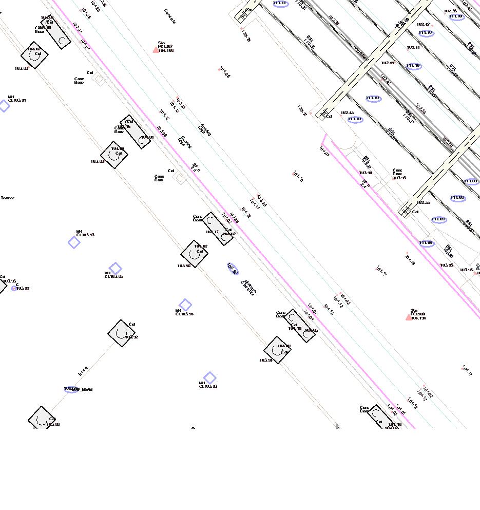
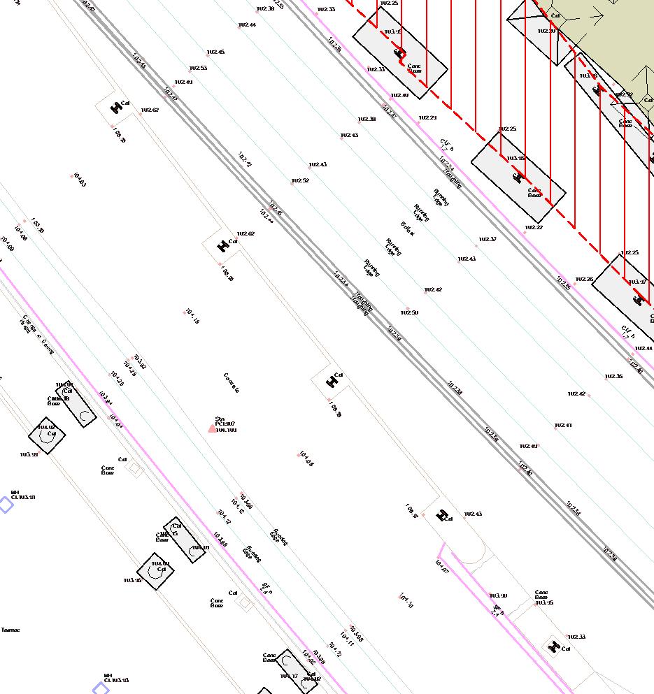
Appendix B - Topography Survey
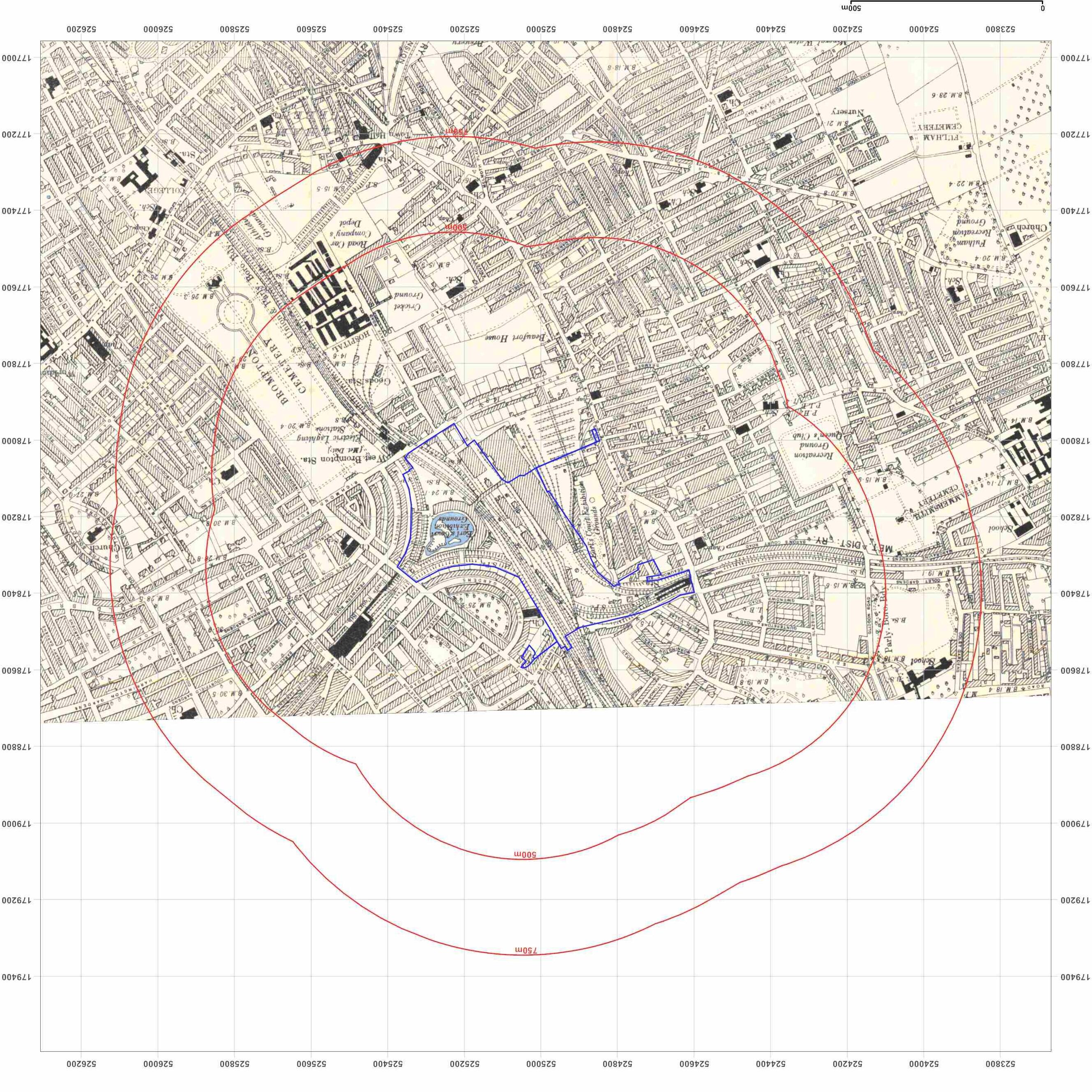
Appendix C - Historical Maps
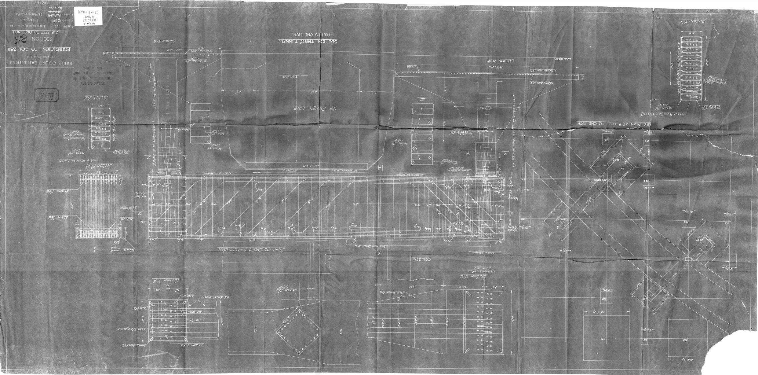
Appendix D - LUL Historical Drawings & Surveys
Appendix E - WLL Rail Deck Drawings
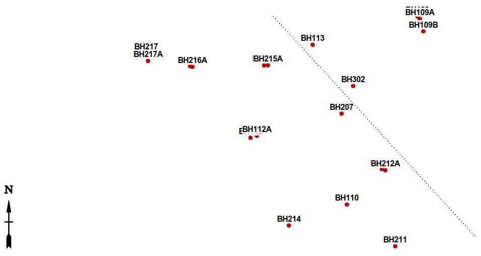
Appendix F - Ground & Groundwater Contour Plots (GIR)
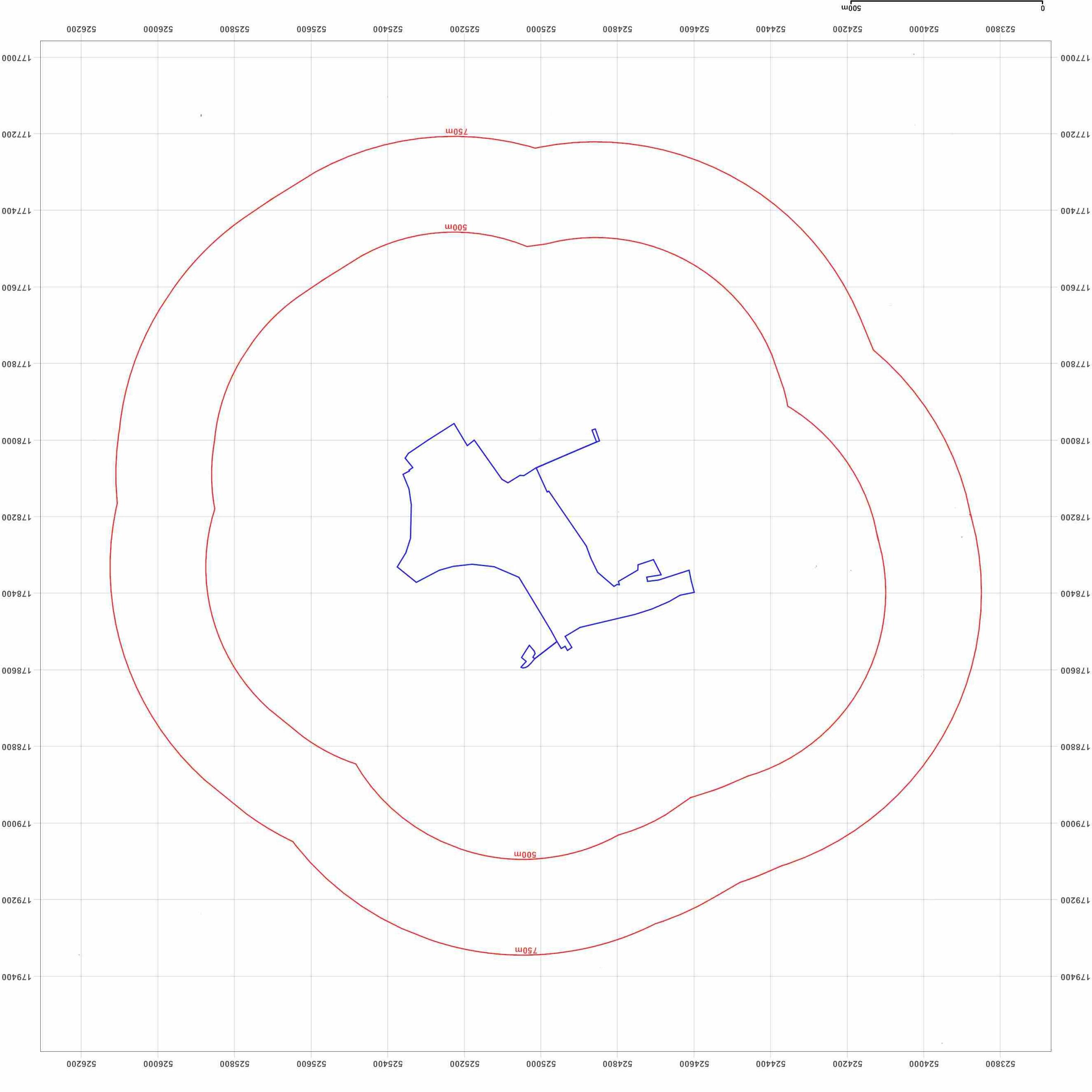
Appendix G - Structural Drawings & Construction Sequence
1.0 Executive Summary 1.1 WSPhaspreparedaConstructionMethodStatement(CMS)onbehalfofEarl’sCourt PartnershipLimited(ECPL)(TheApplicant’)aspartoftheplanningapplicationforplots EC05&EC06oftheEarl’sCourtDevelopmenttobesubmittedtotheRoyalBoroughof Kensington&Chelsea(RBKC).
1.2 ThereporthasbeenpreparedinlinewiththeRBKCValidationChecklistandrequirements stipulatedin“Basements.SupplementaryPlanningDocument”issuedbytheRBKCinApril 2016.
1.3 ThepurposeofthisassessmentistoconsidertheeffectsoftheproposedDetailedComponent PlotsEC05&EC06onthelocalhydrology,geologyandhydrogeologyandpotentialimpactsto neighboursandthewiderenvironment.
1.4 TheSiteislocatedatEarl’sCourtinwestLondonandwasformerlyoccupiedbytheEarls CourtExhibitionCentres.ThecurrentSiteisderelictandallexistingstructuresassociated withtheEarlsCourtExhibitionCentresuperstructurehavebeendemolished,exceptthedeck structurespanningovertheWestLondonRailwayline(WLL)whichpartiallyhasbeen retained.BeneathisanextensivenetworkofrailwayinfrastructureincludingtheDistrictLine andPiccadillyLinetunnels.
1.5 ThepublishedgeologyoftheareashowsthattheSiteisunderlainbytheMadeGroundover super icialdepositscomprisingtheKemptonParkGravelMember.Belowthesuper icial depositstheSiteisunderlainbytheLondonClay,overLambethGroup,ThanetSands,with theUpperChalkatdepth.Asite-speci icSiteinvestigationhasbeencompletedbyConceptin 2022.The indingsofthesite-speci icSIanddatainterpretationarepartofWSP’sGround InvestigationReport(GIR)whoseconclusionsaresummarisedinthisreport.
1.6 WSP’sFloodRiskAssessment(FRA)statesthat“the loodrisktotheProposedDevelopment isinlinewithlocalplanningpolicy,theEA’slatest loodmodellingdataandGov.uk lood mapping.ThisreporthasconcludedthattheSiteisataVeryLowtoLowriskofall looding mechanisms.”
1.7 AbasementimpactscreeningassessmenthasbeenundertakeninthisCMS(refertosection 5.0)andshowsthatthelevelofimpacttotheexistinggeologicalandhydrogeological conditions,adjacentstructures,slopestabilityandsurface lowcanbemitigatedby appropriatedesignandstandardconstructionpractices.
1.8 No3rd partywallbuildingsatgroundlevelfallwithinthede inedpreliminaryground movementzoneofin luence.
2.0 Introduction Authorisation 2.1 ThisConstructionMethodStatementhasbeenpreparedbyWSPandissubmittedaspartof twoHybridPlanningApplications,onesubmittedtotheLondonBoroughofHammersmith andFulham(‘LBHF’)andonesubmittedtotheRoyalBoroughofKensingtonandChelsea (‘RBKC’)inrelationtotheredevelopmentofthelandboundedbyWestCromwellRoad, WarwickRoad,PhilbeachGardens,EardleyCrescent,LillieRoad,OldBromptonRoadandthe WestLondonRailwayLine(‘WLL’);and1ClunyMewsinRBKC(the‘RBKCSite’)andNorth EndRoad,BeaumontAvenue,WestCromwellRoad,theWLL,landcomprisingtheEmpress StateBuilding(‘ESB’),AisgillAvenue,theformerGibbsGreenSchoolpropertiesfronting GibbsGreenClose,andpropertiesfrontingDieppeClose(the‘LBHFSite)whichstraddlethe boundarybetweenthetwoboroughs(togetherforming‘theSite’).TheProposed DevelopmentwillformthenewEarlsCourtDevelopment.TheHybridPlanningApplications havebeensubmittedonbehalfofEarlsCourtPartnershipLimited(‘ECPL’),(“TheApplicant
2.2 TheRBKCHybridApplicationisformedofdetailedDevelopmentproposalsinrespectofplots EC05&EC06forwhichnomattersarereserved("RBKCDetailedComponent"),andoutline DevelopmentproposalsfortheremainderoftheRBKCSite,withallmattersreserved("RBKC OutlineComponent").TheRBKCDetailedComponentandRBKCOutlineComponenttogether arereferredtoasthe“RBKCProposedDevelopment”.
2.3 ThisConstructionMethodStatementhasbeenpreparedinsupportoftheEC05andEC06 detailedcomponentoftheplanningapplication.
2.4 Thepurposeofthisdocumentistoassessthemethodologybywhichthebasements,which areproposedforPlotsEC05andEC06,areconstructedandtodeterminethatthismethodis consideredachievableandispracticalgiventheexistingSiteconstraintsandtheproposed phasingoftherestoftheDevelopmentSite.Itisconceivablethathowtheplotisconstructed maychangeasthedesignofplots(EC05&EC06)developinmoredetailandasthedesign requirementsofotherplotswhicharecurrentlydesignedinoutlinearebroughtforward.
CMS Scope 2.5 TheSiteislocatedatEarlsCourtinWestLondonandwasformerlyoccupiedbytheEarls CourtExhibitionCentre.TheSiteisderelict,andallexistingstructuresassociatedwiththe EarlsCourtExhibitionCentresuperstructurehavebeendemolished,excepttheexisting structurespanningovertheWestLondonRailwaylinewhichpartiallyhasbeenkept–see Figure1.
2.6 TheEarlsCourtDevelopmentconsistsoftheconstructionofvariousnewmixed-usebuildings indifferentplanningstages.ThescopeofthepresentreportreferstotheproposedEC05& EC06plots,thelocationofwhichisshowninblueinFigure1.
2.7 Thepurposeofthisassessmentistoconsidertheeffectsthattheconstructiontheproposed DevelopmentplotsEC05&EC06willhaveonthelocalhydrology,geologyandhydrogeology andpotentialimpactstoneighboursandthewiderenvironment.
2.8 Note:thedesignoftheremainingplotsoftheEarlsCourtDevelopmentaretobeprogressed atalaterstageandwillbesubjecttotheirrespectiveCMSreports/submissions.
Royal Borough of Kensington and Chelsea Requirements Structure spanningoverthe WestLondonLine
2.9 Thepresentreporthasbeenpreparedinlinewiththerequirementsstipulatedin“Basements. SupplementaryPlanningDocument”,issuedbyRBKCinApril2016.
Supporting Documents and References 2.10 Thisreportcontainsinformationfromthefollowingdocumentswhichareavailableon request:
1. Geo-EnvironmentalPreliminaryRiskAssessment(PRA)withreferenceECM-WSP-SW-XX-RPGE-00002datedMarch2024producedbyWSP.
2. ‘DetailedUnexplodedOrdnance(UXO)Threat&RiskAssessment’,withreference9386,dated December2021,producedbyAlphaAssociates.
3. ‘GroundInvestigationReport–Factual.EarlsCourt,London.Phase1.Issue01’,document reference22/3679-GIR-F01,datedJanuary2023,producedbyConcept.
4. ‘GroundInvestigationReport(GIR)withreferenceECM-WSP-SW-XX-RP-GE-00010dated December2023producedbyWSP.
5. EC.PA.39-FloodRiskAssessmentandOutlineDrainageStrategy(FRAandODS)withreference ECD-SW-ZZ-WSP-XX-XX-RP-C-527101producedbyWSP.
6. ‘Earl’sCourtPhase1–EC05&EC06.StructuralStage2Report,withreference,ECD-ECZZ-ZZWSP-XX-XX-RP-S-000001,datedFebruary2024,producedbyWSP.
7. CIRIAReportC760(2017),‘Guidanceonembeddedretainingwalldesign’;
Figure1–ExistingSiteoftheoveralldevelopment
2.11 MuchoftheinformationcontainedwithinthePRA,GIRandFRA&ODSisrelevanttothe currentreportand,whererequired,hasbeenreproduced.
3.0 Site Context and Conditions Site Location 3.1 TheSiteoccupiesanareaofapproximately18hectares(179,956sqm)andislocatedinboththe LondonBoroughofHammersmithandFulham(LBHF)andtheRoyalBoroughofKensingtonand Chelsea(RBKC),inWestLondon.TheSiteareaassociatedwiththeRBKCHybridPlanningApplicationis approximately8hectares(78,561sqm)andtheSiteareaassociatedwiththeLBHFHybridPlanning Applicationisapproximately10hectares(101,395sqm).
3.2 TheLBHFandRBKCadministrativeboundarybisectstheSitealonganorthwest-southeastaxisfrom LillieRoadtoWestCromwellRoad.
3.3 TheRBKCSiteisboundtothenorthby WestCromwellRoad,totheeastby WarwickRoad,PhilbeachGardens (including1ClunyMews)andEardley Crescent,tothesouthbyLillieRoadand OldBromptonRoadandtotheeastby theWestLondonRailwayLine(WLL), and1ClunyMews.
3.4 TheLBHFSiteisboundtothewestby NorthEndRoad,BeaumontAvenue,the formerGibbsGreenSchool,properties frontingGibbsGreenClose,and propertiesfrontingDieppeClose,tothe northbyWestCromwellRoad,tothe eastbytheWestLondonRailwayLine (WLL),tothesouthbyLillieRoadandto thesoutheastbylandcomprisingthe EmpressStateBuildingandAisgill Avenue.
3.5 ThelocationofEC05&EC06fallswithin theadministrationofRBKCtotheeast oftheWLLasindicatedinFigure2.
Figure2-IndicativeSiteLocationPlan
3.6 SitelocationplansareenclosedwithinAppendixA.
3.7 TheSite’sNationalgridreferenceis525096178158.
3.8 TheboundariesandimmediatesurroundingsofTheSitecomprisethefollowing:
North:A4(WestCromwellRoad)andKensingtonTescoSuperstore.Beyondtheseareresidential propertiestothenorth,north-eastandnorth-west.
North-east:A4(WestCromwellRoad),A3220(WarwickRoad),ClunyMewsGardens,Earl’sCourt Hotel,residentialproperties(includingOneClunyMews)andLEYFEarl’sCourtNurseryandPreSchool.
East:Residentialproperties(PhilbeachGardensandEardleyCrescent),ChurchofStCuthbertand StMatthias,andA3220(WarwickRoad).Beyondtheseusesaremoreresidentialpropertiesand theEarl’sCourtundergroundstation.
South:A3218(LillieRoad/OldBromptonRoad).Beyondtheseroadsareresidentialproperties, WestBromptonundergroundstationandBromptonCemetery.
West:TheMetropolitanPoliceEmpressStateBuildingandassociatedcarpark,anetworkof residentialandcommercialpropertiesalongAisgillAvenueandMundStreetwithintheWest.
KensingtonandGibbsGreenEstates,aswellastheformerGibbsGreenSchoolandproperties FrontingDieppeClose.
North-west:BeaumontAvenue,B137(NorthEndRoad),WestKensingtonstationandthe,’Three Kings’publichouse.BeyondBeaumontAvenueandNorthEndRoadareresidentialand commercialproperties.
3.9 Note:theareaofplotsEC05&EC06arelocatedinthemiddleoftheEarlsCourtDevelopmentSiteand aremainlyboundedbythedeckstructureoftheWLLrailwaytothewestandbytheDistrictLine Tunneltoeast.Thesearediscussedinmoredetailinsection0.
Site Description 3.10 AdetaileddescriptionoftheSiteareaispresentedinWSP’sPreliminaryRiskAssessment(reference1). Thefollowingisasummaryofthe indingsofthatdocument.
3.11 TheentireSiteisdiverseintermsofitslandcover,usesandbuildingtypology,whichcanbe summarisedasfollows:
· ClunyMews–ThefarnortheasternpartoftheSitecomprisesanof icebuildingatapproximately4 storeys,anannexbuildingwhichcomprises3storeysofresidential latsandassociatedpavedroadswith parking.Thisiscurrentlyactivatedasatemporarymeanwhileuse.
· LandformerlyhometotheEarlsCourtExhibitionCentres–Theeasternandsoutheasternpartsofthe Site(roughlytriangularshapedandtotheeastoftheWLL)andthesouthwesternpartoftheSite(tothe westoftheWLL)compriseextensiveareasofopenhardstanding.Theseareasofhardstandingwere previouslyoccupiedbytheEarlsCourtExhibitionCentreswhichweredemolishedbetween2015and 2017.TheTablespanstheWLLbetweenthehardstandingareas.Beneathisanextensivenetworkof railwayinfrastructureincludingtheDistrictLineandPiccadillyLine.PartsofthiselementoftheSiteare currentlyactivatedwithtemporarymeanwhileuses.
· EmpressPlace–ThesouthernandsouthwesternpartsoftheSitecomprise3-4storeyterracebuildings frontingEmpressPlaceandLillieRoad.Thesearecurrentlyactivatedwithtemporarymeanwhileuses.
· BusFacility–TothewestofEmpressPlaceisabusturningandwaitingfacilityaccessedfromLillieRoad. Thisareacomprisesabuslayoverareawithcapacityforuptofourbusesandasmallstandalone structurethatincludeswelfarefacilitiesforbusdrivers.
· LillieBridgeDepot(LBD)–Thewestern,northernandnorthwesternpartoftheSitecomprisetheLBD. TheLBDiscurrentlyusedasamaintenancefacilitybyLondonUndergroundLtd(LUL)andasaTfL trainingfacility.TheLBDusesandon-Sitestructurescompriseof icebuildings,railtracks,roadtorail vehicle(RRV)deliveryandaccesspoint,articulatedlorryaccessanddeliveryarea,carpenter/rail workshops,storagebuildings,trainstablingbox,associatedinfrastructureandparking.
· 9BeaumontAvenue–A2storeybuildinglocatedinthefarnorthwesternpartoftheSite.Thisis currentlyactivatedasatemporarymeanwhileuse.
Site Topography 3.12 ThetopographyoftheSiteisvariable,withthelowestpointof1.8maboveOrdnanceDatum(mAOD)in thenorth-easterncornerundertheA4roadandthehighestpointof12.3mAODatthecentreofthe site.AWLLraisedconcretedeck,rangesfrom11.8mAODto12.3mAOD.Theareaimmediately surroundingtheraildeckrangesfrom4.1to6.1mAOD.Overall,theheightofthemainpartdecreases fromeasttowesthorizontallyacrossthesite.TheClunyMewspartoftheSiteislargelylevelat6m AOD,withvarianceof0.3mAOD.
3.13 ASitetopographicsurveyisenclosedwithinAppendixB.
Historical Land Use 3.14 Insummary,theSitehasbeenoccupiedprimarilybyrailinfrastructureinthenorth/centreandbythe variousformsoftheEarlsCourtExhibitionCentreintheeast.
3.15 Inthemid-1800s,theWestLondonExtensionRailwaywasconstructedpassingthroughthecentreof theSiterunninginanorthwesttosoutheastorientation.Thiswaslaterfollowedbytheconstructionof theMetropolitanDistrictRailwaylineby1869runningoffSitefromthesoutheast.TheLillieBridge Depotwasconstructedon-Sitein1871servingasatractionmaintenancedepotfortheMetropolitan Districtline,occupyingmuchofthecentreandsouthoftheSiteandlatergrowingtooccupythewhole northernregionofthesite,asitlargelydoesinthepresentday.
3.16 Throughthe1900stheSitesawtheconstructionoftheEarlsCourtExhibitionCentreandGroundsthat wereredevelopedin1935andfurtherexpandedin1985.Theexhibitioncentresweredemolished between2015and2017.ThemainDevelopmentareaownedbyECPLremainsopenland,partially occupiedbytemporarymeanwhileuses.
3.17 Astudyofavailablehistoricalmapshasbeenundertakentoidentifyanypotentialcontaminative formerlanduses.Table1providesasummaryofthisinformationonSiteandselectedrelevant historicalmapsareprovidedinAppendixC.
Dates & Map Scale
Land Uses
Intheeast,withintheareaofplotsEC05&EC06,theSitepredominantlycomprisesa triangularparcelofopenspacelandbetweentheMetropolitanDistrictRailwaylineswhich mergeattheeasternSiteboundary.
1865-1867(1:1,056)
1867(1:1,056)
1869-1871(1:2,500)
1871-1874(1:2,500)
1873-1874(1:10,560)
TheWestLondonExtensionRailwaylineextendsnorthwesttosoutheastthroughthecentreof theSitewheretheMetropolitanlinejoinsinthenortheastoftheSite.Thesmallparcelofland northeastofthemainEarl’sCourtSiteisundeveloped.
ResidentialhousesareshownalongRichmondGardensinthesouthwest.
LillieBridgeWorksispresentparalleltothewestoftheWestLondonExtensionRailwayline andextendsfromRichmondGardenstothecentreoftheSiteandcomprisessidings,of ices, workshopsandacarriageshed.Thesidingsextendoff-Sitetothesouth,beneathLillieBridge, indicatingthatSitelevelsatthislocationwereapproximately2or3metreslowerthancurrent levels.
LandtothewestandnorthwestoftheWestLondonRailwaylineisshowntobeopen ields. NorthEndHouseandundevelopedlandarepresentinthenorthwestoftheSite.
TheEarl’sCourtExhibitionGroundshavebeenestablishedinthetriangularparceloflandin theeastoftheSitewithagrandstandandalakelabelledonthemap.Aconnectingbridgeis showntopassovertherailwayandLillieBridgeWorkstothesouthwesttojointoafurther largestructureandgroundsextendingalongthesouth-westernSiteboundaryandoff-Siteto thesouth.
1894(1:10,560)
1894-1895(1:10,560)
1894-1898(1:10,560)
1896(1:10,560)
1896(1:2,500)
Historicalplansfrom1895publishedwithintheOf icialCatalogueoftheEmpireofIndia ExhibitionbyImreKiralfy,showthelargestructuretoactualcomprisetheEmpressTheatre (offsite),ImperialCourtGardens,abandstandandfurtherexhibitionspace.
RichmondGardensislabelledasRichmondPlace.
LillieBridgeWorkshavebeenfurtherdevelopedwithadditionalsidingsandbuildings includinganEngineShed.
AfurtherbranchoftheMetropolitanDistrictRailwayhasbeenconstructedpassingthrough thenorthwestoftheSiteandconnectingtotheWestLondonRailwaylineatthenorthern perimeter.AssociatedwiththelineisthenewlyconstructedWestKensingtonStationinthe northwest.ThishasreplacedNorthEndHouseandresidentialproperties.Aspurlineextends fromthenewstation,labelledMidlandRailway,andpassessouthrunningparalleltothemain raillineandbrie lyextendingintoSitebeforeextendingfurthersouthwards.
TheparceloflandnortheastofthemainEarl’sCourtSitehasbeendevelopedwithresidential properties(ClunyMews).
1916(1:2,500)
1919(1:1,056)
TheEarl’sCourtgrandstandhasbeendemolishedandreplacedbyalternativeexhibition buildingsassociatedwiththegrounds.Alakeandwaterchuteislabelledtothesoutheastof theexhibitiongrounds.Theexhibitiongroundsinthewestarenowshownasseveralsmaller buildings.
Dates & Map Scale
Land Uses
TheLillieBridgeWorksisnowshownasonelargebuildingextendingalongtherailway, labelledasadepotforLondonElectricRailway.
1938(1:10,560)
1947-1948(1:10
1949-1950(1:1,250)
1950(1:2,500)
1951(1:1,250)
1951-1953(1:1,250)
1953(1:2,500)
1955-1958(1:10,560)
Intheeast,theexhibitiongrounds,associatedbuildingsandlakeshavebeendemolishedand Earl’sCourtExhibitionBuildingisshown,whichopenedin1937.Thebuildingextendsabove theDistrictrailwaylines,whicharenolongershown.
Thereisnosigni icantchangeintheremainderoftheSite.
Thebridgeextendingovertherailwayanddepotfromtheeasttothewesthasbeenextended intoalargerstructure.TheImperialCourtGardensandexhibitionspacetothewestofthe WestLondonLinearenolongershownandhavebeenreplacedbyonelargebuildingthatalso extendsacrossthesouthernmostsectionofthedepot.
FurtherdetailoftheinfrastructurewithinLillieBridgeDepotareshownonthemapincluding inthenorth:afoundry,enginerepairshed,travellingcranesandacoalbunker,andinthe southernsection,furthertravellingcranes.Atankislabelledonthemapassociatedwiththe tracksinthecentral/northernpartoftheSite.Anelectricalsubstationispresentinthefar northwestextentoftheSiteinproximitytotheWestKensingtonUndergroundStation.
AnelectricalsubstationispresenttothenorthoftheEarl’sCourtbuildingattheeastern perimeteroftheSite.
RichmondPlaceisnowlabelledasEmpressPlace.
1962-1963(1:1,250)
1970-1973(1:1,250)
1972-1975(1:1,250)
1973-1974(1:10,000)
1973(1:1,250)
1976-1977(1,1,250)
1978-1981(1:1,250)
1987-1991(1:1,250)
1987-1991(1:1,250)
1988-1991(1:1,250)
1991(1:1,250)
1991-1993(1:1,250)
1991-1995(1:1,250)
1993(1:1,250)
Thefoundryinthenorthwesthasbeenreplacedbytwobuildingslabelledas‘works’.The westernmostbuildingisthenlabelledasa‘laundry’andhasanadjacentelectricitysubstation.
TheLillieBridgeDepothasexpandedfurther,andadditionalbuildingsareshowntohavebeen constructedalongthewesternboundarycoveringthesamefootprintofthecurrentbuildings.
Thelargestructurethatconnectstothebridgeovertherailwayisnowlabelledasa‘roofcar park’whichextendsoverthesouthernmostsectionoftheLilleBridgeDepotinthesouthwest.
Ash ieldHouseisnowpresentinthenorth.
RailwaysidingsthatextendalongsidethesouthwestandnortheastsectionsoftheWest LondonLinearenolongershown.
Dates & Map Scale Land Uses
1999(Aerial Photograph)
2001(1:10,000)
2010(1:10,000)
2011(Aerial Photograph)
2014(Aerial Photograph)
2019(Aerial Photograph)
2022(Aerial Photograph)
2024(1:10,000)
‘Earl’sCourtTwo’hasbeenconstructedovertherailwayandinthesouthwestoftheSite.The adjacent,farwesternparceloflandisusedascarparking.
TheEarl’sCourtExhibitionBuildingshavebeendemolished(between2015and2017).An accessroadhasbeenconstructedinthenorthleadingoffSitebeneaththeA4fromthe demolitionworks.
Asmallrectangularbuildingwithgreenspaceareasandanabovegroundstoragetankis showninthefarwest,inthelocationoftheCommunityHub.
Asummaryoftheoff-Sitefeatureswithin250mfromSiteboundaryrelevanttocontaminatedlandarepresented inTable2.FurtherdetailisavailableonthehistoricalmapswithinthePRA.
Date & Map Scale Surrounding Land Use
MetropolitanDistrictRailwayextendingofftheSitetowardstheeastandarailwayextending offtheSitetothenorthandsouthoftheSite.
1865-1867(1:1,056)
1867(1:1,056)
1869-1874(1:2,500)
1871(1:2,500)
1873-1874(1:10,560)
Thereareresidentialpropertiesandundevelopedlandlocatedadjacenttothenorth, northeastandnorthwestoftheSite.Thereisapianofortemanufactorylocatedapproximately 150mnorthoftheSite.
ResidentialpropertiesandundevelopedlandboundtheSitetotheeastwiththeMetropolitan DistrictRailwayextendingofftheSitetowardstheeasttowardsEarl’sCourtStation,located approximately250meast.
WestLondonandWestminsterCemeteryislocatedtothesoutheastoftheSite.
WestBromptonStation,apubandresidentialandindustrialpropertiesboundtheSitetothe South.ARi leRangeislocatedapproximately100msouth.
Table 1 –
Table
Date & Map Scale Surrounding Land Use
ResidentialpropertiesandundevelopedlandarepresentadjacenttothewestoftheSite. ThereareBrickFieldslocatedapproximately180mwest.
ExpansionofresidentialandcommercialareasassociatedwithWestKensington,Earl’sCourt, HammersmithandFulhaminalldirectionssurroundingtheSite.
Furnituredepositorieslocatedapproximately30mnorthoftheSite.
ExpansionofEarl’sCourtstationtotheeastoftheSitesothatitislocatedadjacenttotheeast.
1894(1:10,560)
1894-1895(1:10,560)
1896(1:10,560)
1896(1:1,056)
1896(1:2,500)
1916(1:2,500)
1919(1:1,056)
1920(1:10,560)
KensingtonCentralElectricalLightingStationislocatedapproximately150msoutheastofthe Site.
Anelectricallightingworksandstoneyardareshownwithin100mofthesouthernboundary.
Brompton&Fulhamgoodsandcoalstationislocatedapproximately200msouthoftheSite withWesternHospital(InfectiousDiseases)adjacent.
ARi leRangeisnolongerpresentandhasbeendevelopedwithresidentialproperties.Alarge buildingassociatedwithLillieBridgeWorksextendsofftheSitetothesouth.
Anumberofsidingsarepresentimmediatelytothesouthwestwithseveraladjacentindustrial usessuchaslaundries,CannonBreweryandcarandbusdepot/workslocatedbetween100 mand250msouthwestoftheSite.
TheBrickFieldstothewestarenolongerpresentandappearstohavebeendevelopedwith residentialproperties.
Laundriesarepresentlocatedapproximately30mnorthoftheSite.
ThesidingstothesouthwestarelabelledastheMidlandCoalDepot.
A irestationislocatedapproximately150mwest.
Kensington&FulhamGeneralHospitalislocatedapproximately175meast.
1938(1:10,560) Nosigniicantchanges.
1947-1948(1:10,560)
1949-1950(1:1,250)
1949-1951(1:1,250)
1950(1:2,500)
1951(1:1,250)
1951-1953(1:1,250)
1953(1:2,500)
1955-1958(1:10,560)
Acoaldepotispresentapproximately250mnorth.
FiveelectricalsubstationsarelocatedbetweentheeasternboundaryoftheSiteand approximately200moftheSite,includingatEarl’sCourtstation.
Aseconddistillery,engineeringworksandmotorrepairworksarelocatedapproximately100 msouthoftheSite.
Alargebuilding(EmpressHall)islocatedadjacenttothesouthwestoftheSite.TheMidland CoalDepothasbeenrenamedWestKensingtonCoal&GoodsDepot.
Thelaundryandbreweryarenolongershown.Thesehavebeenreplacedbyajoineryworks andtelephoneexchangearelocatedbetween100mand200mtowestoftheSite.Thecarand busdepot/worksisnowlabelledasagarageandtyreservicesdepot.
Date & Map Scale Surrounding Land Use
1962-1963(1:1,250)
1962-1967(1:10,560)
1963-1968(1:1,250)
1971(1:2,500)
1973-1974(1:10,000)
1973-1975(1:1,250)
1977-1981(1:1,250)
1981(1:1,250)
1985-1987(1:10,000)
1991-1993(1:1,250)
1993(1:1,250)
1995(1:1,250)
2001(1:10,000)
2010(1:10,000)
2011(Aerial Photograph)
2019(Aerial Photograph)
2022(Aerial Photograph)
2024(1:10,000)
Thedistilleriestothesoutharenowlabelledasawineandspiritswarehouseandfoodfactory. ThenorthernsectionofBromptonandFulhamgoodsandcoalstationisoccupiedbyfood depots.
Thesidingsandcoalandgoodsdepot,joineryworks,tyreservicesandgaragetothewestof theSitearenolongerpresent.Theareahasbeenredevelopedintotheexistingresidential buildings.Thereareanumberofelectricitysubstationsshownamongsttheresidential properties.
ThefurnituredepositoriestothenortharenowlabelledasAvonTradingEstate.
Residentialpremisestothenorth,eastoftherailwayline,havebeendemolishedandreplaced withtwocarparksandagarage.
TheBrompton&FulhamGoodsandCoalStationtothesouthisnolongershown.
Thefooddepotstothesouthhavebeendemolishedandreplacedbyacarcoachandlorry park.
GoogleEarthimagesshowthedemolitionoftheEarl’sCourtExhibitionCentresbetween2015 and2017.Themainstructureappearstohavebeenremovedby2017,exceptfor‘theTable’ whichextendsovertheWLLrailway.In2017alargecraneisshownintheeastwhichwas usedtoremovestructuralbeamswhichsatabovetheLULtunnels.
Unexploded Ordnance (UXO) 3.18 DetailedUnexplodedOrdnance(UXO)Threat&RiskAssessment,ref:10thDecember2021,Version1.0, reference9386wasproducedbyAlphaAssociates(reference2)forthemainDevelopmentSitearea. TheAssessmentcon irmstheriskisdesignatedas’High’andmitigationmeasureswillneedtobe implementedduringconstructiontoreducetheriskto‘AslowasisReasonablyPracticable(ALARP)’.
3.19 Pleaserefertotheassessmentformoredetailsregardingtheappropriatemitigationtobe implemented.
Key Development Constraints 3.20 ThekeyconstraintstoEC05&EC06ainclude:
LondonUndergroundDistrictLinetunnelandcoveredwayrunningparalleltoEardleyCrescentand PhilbeachGardens.
WestLondonLineRailway.
‘TheTable’structure,apartiallydemolishedstructurewhichpreviouslysupportedtheExhibition HallsbyspanningovertheWestLondonRailway–archivedrawingsenclosedwithin‘AppendixEWLLRailDeckDrawings’.
ExistingfoundationpadsfromdemolitionofExhibitionCentres.
NetworkRailrightofaccesstotheWestLondonLinewhichistoberelocatedalongStCuthbertsLane
3.21 TheSiteconstraintsareindicativelyshowninFigure3a&3b.
a) Railway and Underground Constraints
b) Existing Foundation Constraints
Figure3–SiteConstraintsPlana)andb)
Existing Structures 3.22 FollowingthedemolitionoftheformerEarl’sCourtExhibitionCentresbetween2015and2017there arenoexistingbuildingswithintheEC06&EC06plots.Theonlyremainingexistingstructuresisthe existingraildeckovertheWLLthatiscurrentlyownedbyECPL.
3.23 TheDistrictLineandPiccadillyLinetunnelsruntotheeastoftheproposedEC05&EC06plots.These arebrie lydescribedinthefollowingsections.Archivedrawingsandtopographicsurveysareenclosed in‘AppendixD-LULHistoricalDrawings&Surveys’.
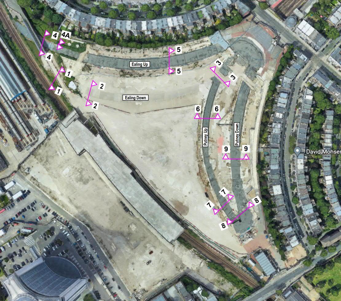
3.24 Thereare4no.DistrictLinethatrunbelowtheEarlsCourtDevelopmentSite–refertoFigure4.The DistrictLinetunnelthatrunsadjacenttotheEC05&EC06Siteis“Tunnel3–DownEaling”asshownin Figure4.Thesetunnelsarebrie lydescribedbelow:
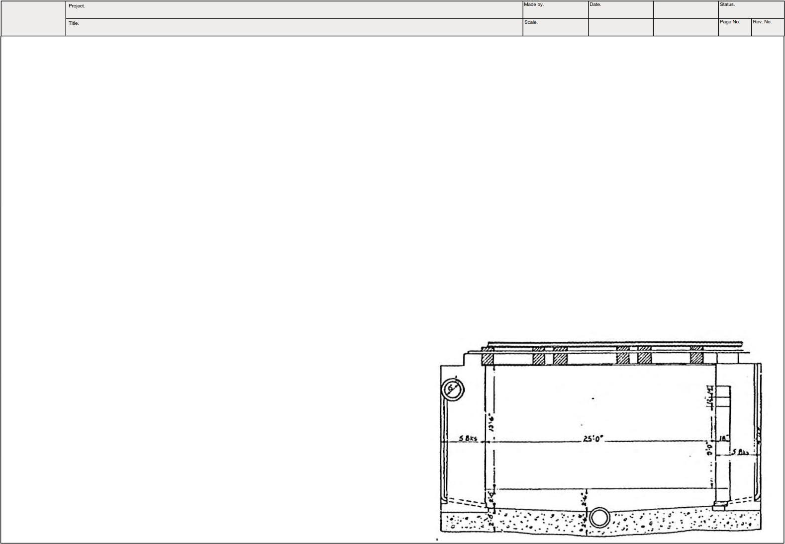
Up Ealing Tunnel –TheLULDistrictLineUpEalingtunnelconsistsofmassconcretesidewalls supportingsteelbeamsinconcretesof it.AvailablerecorddrawingsfromtheLULDistrictLineUp EalingtunnelstructurearepresentedinFigure5.
Down Ealing Tunnel –TheLULDistrictLineDownEalingtunnelconsistsofabrickarchtunnelwith concretebase/trackslabbetweenfollowedbyanothersectionofthetunnelwitharectangular sectionwithmassconcretewallssittingonaconcretebase/trackslabandarectangularcorrugated metal-troughingroof.AvailablerecorddrawingsfromtheLULDistrictLineDownEalingTunnelare presentedinFigure6&7,foreachtypeofconstruction(brickarchtunnelandrectangulartunnel, respectively).
Up Putney Tunnel –TheLULDistrictLineUpPutneytunnelconsistsofaconcretetunnelwithmass concretewallsandasof itofmetalbeamswithdeckin illsfollowedbyanothersectionoftunnelwith acompoSiteconstructionwithmasonryandmassconcretewallswithasof itofconcreteencased steelbeamswithconcretedeckin ill.AvailablerecorddrawingsfromtheLULDistrictLineUpPutney TunnelarepresentedinFigure8.
Down Putney Tunnel –TheLULDistrictLineDownPutneytunnelconsistsofaconcretetunnelwith massconcretewallsandasof itofmetalbeamswithdeckin illsfollowedbyanothersectionoftunnel withacompoSiteconstructiontunnelwithmasonryandmassconcretewallswithasof itofconcrete encasedsteelbeamswithconcretedeckin ill.AvailablerecorddrawingsfromtheLULDistrictLine DownPutneyTunnelarepresentedinFigure9.
Figure4–DistrictLineTunnelsAdjacenttoSite
Figure5–AvailableRecordDrawingfromLULDistrictLineUpEalingTunnel.
Figure6–AvailableRecordDrawingfromLULDistrictLineDownEalingTunnel(brickarchtunnel).
Figure7–AvailableRecordDrawingfromLULDistrictLineDownEalingTunnel(rectangulartunnel).
Figure8–AvailableRecordDrawingfromLULDistrictLineUpPutneyTunnel.
PiccadillyLine
3.25 TheLULPiccadillyLinetunnelscomprisetwindeeptunnelsconstructedduringtheearly1900sbelow thealignmentofthepre-existingLULDistrictLinetunnels.Thetunnelsarebetween3.5mand3.8m diameterandareofsegmentedcast-ironconstruction.Thecrownofthetunnelsislocated approximatelybetween15.9mand20.2mbelowgroundlevel(elevationsbetweenapproximately between-6.90mAODand-11.20mAOD).
Proposed Development 3.26 EC05&EC06comprisestworesidentialtowers(EC05withapodiumlevel)providingamenityspaces andlandscapeareas.St.Cuthbert’sLanealsorunsthroughthedetailedplotboundaryconnectingtothe adjacentEC07plot.ThereisalsoaprovisionforNetworkRailAccessadjacenttotheWLLrailway whichisprovidedwithintheaccesstunnelintoEC07.
3.27 EC05&EC06isa27-storeyand20-storeyconcreteframedbuildingrespectively.Thereisalsoa7storeyresidentialconcreteframedshoulderbuildingattachedtoEC05towerandanindependent ground loor+2storeystownhouselocatedaboveEC05ground loor.Thebasementissinglestorey withdifferentfoundationdepthsandtwogeneralpodiumlevels,oneconnectingtoWarwickCrescent at+9.0mAODand‘ThePark’at+12.5mAOD.
3.28 ArchitecturaldrawingscanbefoundinwithintheEC05andEC06planningdrawingsthathavebeen submitted.
3.29 Structuraldrawingsareavailablein‘AppendixG-StructuralDrawings&ConstructionSequence’.
Figure9–AvailableRecordDrawingfromLULDistrictLineDownPutneyTunnel.
4.0 Environmental Setting Published Geology 4.1 Thepublishedgeologyoftheareaonthegeologicalmap270(Sheetno.256scale1:50000),published byBritishGeologicalSociety(BGS)togetherwiththeavailablehistoricalboreholelogsavailableinthe webplatformofBGSshowthattheSiteisunderlainbytheMadeGroundoversuper icialdeposits comprisingtheKemptonParkGravelMember.Belowthesuper icialdepositstheSiteisunderlainby theLondonClay,overLambethGroup,ThanetSands,withtheUpperChalkatdepth–seeFigure10.
4.2 Worked/MadeGroundisindicatedontheBGSmapwithinthewesternandcentralareastotheeastand westofWLL.
4.3 Alluviumisnotindicatedonthegeologicalmap,however,a‘lost’rivertrendsnorthwesttosoutheast throughthesite,atthelocationoftheexistingrailwaycutting/tunnel(seeFigure11).Itisprobable thatmostoftheAlluviummayhavebeenremovedduringexcavationoftherailwaycutting/tunnel, however,it’spresencecannotbediscounted.AgenericdescriptionaccordingtoBGSofeachstratumis asfollows:
Made Ground -MadeGroundisanticipatedacrosstheSiteareaandislikelytoexhibitacertain degreeofheterogeneity.Thenatureofthematerialcanbeexpectedtovarysubstantiallyinboth compositionandthicknessovershortdistances.
Alluvium -Alluviumisageneraltermforclay,silt,sand,andgravel.Itistheunconsolidateddetrital materialdepositedbyariver,stream,orotherbodyofrunningwaterasasortedorsemi-sorted sedimentinthebedofthestreamoronits loodplainordelta,orasaconeorfanatthebaseofa mountainslope.Normallysoftto irmconsolidated,compressiblesiltyclay,butcancontainlayersof silt,sand,peat,andbasalgravel.Astronger,desiccatedsurfacezonemaybepresent.
Kempton Park Gravel Member (River Terrace Deposits) -Sandandgravel,locallywithlensesof silt,clay,orpeat.
London Clay -TheLondonClayFormationisofrelativelyhomogeneouslithology.Distinctvertical lithologicalchangesarehoweverpresentwithinthematerialthatarepersistentregionallyinthe Londonarea.Thesewereclassi iedasseparate“Divisions”A1,A2,A3,B,C,DandEbyKing(1981), eachrepresentingacoarseningupwardssequence.
Lambeth Group -Verticallyandlaterallyvariablesequencesmainlyofclay,somesiltyorsandy,with somesandsandgravels,minorlimestonesandlignitesandoccasionalsandstoneandconglomerate. TheLambethGroupwasdepositedin luvial,estuarine,lagoonal,orproximalmarineenvironments. LatePalaeocenetoEarlyEocene(lateThanetiantoearlyYpresian).
Thanet Sands -TheThanetSandsgenerallycompriseaverydenseslightlysilty ineor ineand mediumsand.Thesiltandclaycontentofthedepositisexpectedtoincreasewithdepth.
Upper Chalk -TheChalkextendsformanymetersbelowtheLondonBasin.Typically,thematerialis encounteredasawhitechalkwith lints.Initiallythechalktypicallyappearsveryweaktoweak.
TheBGSmapindicatesthatthebaseoftheSuper icialDepositsisatanelevationofcirca0mAOD,andthe baseoftheLondonClayandthetopoftheChalkGroupareatapproximateelevationsof-55mAOD and-75mAOD,respectively.
Figure10–GeologyonSite-ExtractedfromBritishGeologicalSurvey(BGS)MapNo.270
Figure11–LostRiverMap
Historical Site Investigation 4.4 AhistoricalgroundinvestigationhasbeenundertakenbyConceptin2014predominantlyinthe externalspacetothesouthofEarlsCourtExhibitionCentres1and2,includingaccessroads,hard standing,ECparkingareas,TFLownedland(LBD)andresidentialandcommercialareas.
4.5 Table3presentsthesummaryofthestratarecordedfromboreholeswithinandinvicinityofthesite.
Table 3 – Ground Summary (BGS historical and Concept 2022 Investigation): Source WSP Ground Investigation Report Stratum
Description
Ground 0.9 to 5.41
Hardstanding (asphalt and concrete). Very sandy silty Gravel, comprising flint, brick, concrete, clinker, and limestone fragments.
Very soft to soft very gravelly sandy silty Clay, or sandy Silt. Alluvium2
0.95 to 2.15
Langley Silt3 0.2
Soft and soft becoming firm, dark green, brown, and orange, brown mottled, slightly gravelly, sandy, silty Clay locally noted to be slightly organic to organic.
Soft brown grey very sandy Silt. River Terrace Deposits (Kempton Park Gravel Member) 0.37 to 5.20
Sand and Gravel, local lenses of silt, clay and flint. London Clay
Soft to stiff and hard with depth, extremely closely to very closely fissured brownish grey silty slightly micaceous Clay.
Notes:
1 Encountered in BH03 in Concept 2014 investigation.
2 Where encountered.
3 May have been incorrectly logged as Alluvium.
Site Specific Investigations 4.6 Twophasesofsite-speci icgroundinvestigationdesignedbyWSPhavebeencompletedbyConcept Consultants.The ieldworksforEC05&EC06wereundertakenbetween4th and28th April2022whilst Phase2workswerecompletedbetween4th Mayand11th October2022.Figure12presentstheareas coveredbythedifferentphasesoftheSiteinvestigation.
4.7 Followingthesesite-speci icgroundinvestigations,WSPpreparedaGroundInvestigationReport(GIR) (reference4)comprisingacarefulcollection,recordingandinterpretationofthegeotechnical informationinaccordancewithBSEN1997-2:2004obtainedfromConcept’sfactualreports.TheGIR summarizesthegroundandgroundwaterconditionsandthegeneralengineeringparametersforthe retainingwallsandfoundationdesign,andforthegroundmovementassessments.
4.8 ThemeanaveragestratumelevationsandproventhicknessesarepresentedinTable4forthePhase1 investigationareaandinTable5forthePhase2investigationarea.TheGIRincludescontourplotsof
eachgeologicalstratum,de iningthegeologicalvariationbeneathplotEC05&EC06andacrosstherest ofthesite.
Figure12SiteInvestigationPhasesLocation
Table 4 – Proposed Geological Sequence for Design (Earls Court
Notes:
a Mean average elevations / proven thicknesses.
b Only encountered in BH02 (2014 GI) and BH02 (2014 GI).
c Only proven in BH04 (2014 GI).
Table 5 – Proposed Geological Sequence for Design (Earls Court
Notes:
a Mean average elevations / proven thicknesses.
b Only proven in BH303B.
Hydrology 4.9 Thenearestsigni icantsurfacewaterfeatureistheRiverThameslocatedbeyond1kmofthesite.No surfacewaterabstractionlicencesareindicatedwithin1kmoftheSiteonthedatabaseconsulted.The SiteisnotlocatedwithinagroundwaterSourceProtectionZone(SPZ).
Hydrogeology 4.10 ThemainSuper icialDepositsunderlyingtheSite(KemptonParkGravelMember)isclassi iedasa ‘SecondaryA’aquiferaspartofTheGroundwaterRegulations200917.‘SecondaryA’aquifersare de inedaspermeablestratacapableofsupportingwatersuppliesatalocalratherthanstrategicscale. Insomecases,‘SecondaryA’aquiferscanformanimportantsourceofbase lowtoriversandwere previouslytermedMinorAquifers.
4.11 TheAlluviumisclassi iedasa‘SecondaryUndifferentiated’aquifer.SecondaryUndifferentiated aquifersareassignedwhereitisnotpossibletoapplyeitheraSecondaryAorBde initiondueto variablecharacteristicsofthestratum.TheunderlyingLondonClayFormationisclassi iedas UnproductiveStrata.ThedeeperbedrockgeologycomprisingtheLambethGroupandThanetSands Formationareclassi iedasSecondaryAaquifers.TheChalkisdesignatedasaPrincipalaquifer.Made Groundisnotdesignatedwithanaquiferclassi icationbytheEnvironmentAgency(EA).
4.12 ShallowgroundwaterisanticipatedwithintheKemptonParkGravelsoverlyingtheLondonClay Formation.DeepergroundwaterispresentwithinthePalaeogenedeposits(ThanetSandsandUpnor Formation)andChalkunderlyingtheLondonClayFormation.Perchedwatermayhoweverbepresent intheMadeGround.Groundwaterlevelsintheshallowaquifermaybecontrolledinsomeareasofthe Sitebythetrackdrainagefortheadjacentrailwaytracks.
4.13 GroundwatermonitoringduringtheConcept2014investigationrecordedashallowgroundwaterbody withintheKemptonParkGravelatanelevationof+2.1mAOD.Aphreaticlevelofcirca+2.60mAODwas indicatedwithintheKemptonParkGravelduringthe350OldBromptonRoadinvestigation(southeast ofthePhase2investigationarea).NogroundwaterwasrecordedwithintheMadeGround.
4.14 EnvironmentAgencyrecords(ManagementoftheLondonBasinChalkAquifer,StatusReport–2018) identifygroundwaterlevelsintheUpperChalktobecirca-31.0mAOD.
4.15 ThePhase2areaoftheSiteinvestigationrecordedshallowgroundwaterwithintheKemptonPark gravelsatdepthsofbetweencirca+2.66mAODand-1.28mAODwithlocalisedperchedgroundwater withintheMadeGroundrecordedatanaverageofcirca+2.27mAODinthecentreoftheSiteandcirca +5.39mAOD.Ashallowgroundwatercontourisavailableinwithin‘AppendixF-Ground&Groundwater ContourPlots(GIR)’.
4.16 AccordingtotheGIRapiezometricpressureisproposedasahydrostaticlinefrom+2mAOD.
Flooding 4.17 PleaserefertotheFRAformoredetailedinformationonthe loodrisksatthesite.Asummaryofthe luvialandtidal loodingrisksfromthisreportisprovidedbelow:
Fluvial and Tidal Flooding 4.18 Fluvial loodingiscausedbyrivers,watercoursesorditchesover lowing.Tidal loodingiscausedby elevatedsealevelsorovertoppingbywaveaction.WithinLondon, loodingfromtheRiverThamesmay betidallyor luviallydriven,oracombinationofthetwo.
4.19 DifferentpartsoftheSitearelocatedwithinFloodZones1,2and3,where,
FloodZone1isclassi iedaslandhavinglessthan0.1%annualprobabilityofriverorsea looding.
FloodZone2isclassi iedaslandhavingbetweena1%and0.1%chanceof loodingfromrivers ( luvial)andbetweena0.5%and0.1%chanceof loodingfromthesea(tidal).
FloodZone3isclassi iedaslandhaving1%orhigherhanceof loodingfromrivers( luvial)ora0.5 %orhigherchanceof loodingfromthesea(tidal).
4.20 PleaserefertoFRAfortheFloodzonemapswhichshowthespatialextentsofthezonesastheypertain totheSite.
4.21 TheseparateGOV.UKLong-TermFloodMapsindicatethattheSiteisatLowRiskofFloodingfrom RiversandSea,indicatingthattheSiteisbetweena1in100and1in1000annualprobabilityof loodingfromriversorthesea.Thismappingtakesintoaccounttheeffectofany looddefencesinthe area.The looddefencesreducebutdonotcompletelystopthechanceof loodingastheycanbe overtoppedorfail.
4.22 Thestudyareaislocatedwithinanareaprotectedby looddefences(ThamesTidalBarrierandriver walls)whichprovideprotectionforeventsuptoa1in200-yearreturnperiod.TheSitecouldonlybeat riskoftidal loodingduringanextremetidalbreachorovertoppingscenario.
4.23 Analysisofthebreacheventconsidersa loodeventasaresultofafailureintheTidaldefences,for exampleasaresultofadamagetothe looddefences.Anovertoppingeventisa loodeventthat exceedsthe loodmanagementdesignstandards.
4.24 TheFRAconclusionsstates,‘the loodrisktotheProposedDevelopmentisinlinewithlocalplanning policy,theEA’slatest loodmodellingdataandGov.uk loodmapping.Thisreporthasconcludedthat theSiteisataVeryLowtoLowriskofall loodingmechanisms.Theresidualriskposedbyabreachin theThamesTidalDefenceshasbeenassessedandtheextentofpredicted loodingintheextreme2100 breacheventislocalisedandshallow(lessthan0.04m)’.
5.0 Screening General 5.1 Aninitialscreeningexercisehasbeenundertakeninrelationtothesubterranean low,slopestability, surface lowand looding.Thefollowingappraisalisbasedontheproposednewbasementpartofthe EC05&EC06.
5.2 ThescreeningexerciseisbasedonthegroundmodelidentiiedintheGroundInvestigationreport (GIR),FRA,andODSforEC05&EC06.
Subterranean Groundwater Table 6 – Screening of subterranean flow
1a Is the Site located directly above an aquifer. Yes. The Development will be undertaken above the Secondary A Aquifer – Kempton Park Gravels, the Secondary A Aquifers –Lambeth Group and Thanet Sands, and the Principal Aquifer – Chalk.
1b If yes to 1a), will the proposed basement extent beneath the water table surface.
2 Is the Site within 100m of a watercourse, well (used/disused) potential spring line.
3 Will the proposed basement Development result in a change in the proportion of hard surfaced/paved areas.
No
4 As part of the Site drainage, will more surface water (e.g. rainfall and run-off) than
No
Yes
The contour plot for shallow groundwater provided in the GIR report confirms that within the areas of plots EC05 & EC06 the water table varies between circa 0 mAOD and -1 mAOD. The available structural drawings indicate that the excavation down to formation level to form the proposed basements within the footprint of the plots EC05 & EC06 is expected to extend to 0.0mAOD.
No water courses are within 100m.
There will be no increase in impermeable areas as the areas for plots EC05 & EC06 in comparison with the former Earl’s Court Exhibition Centre, which was demolished between 2015 and 2017.
The current situation ‘post-demolition’ has areas of hardcore associated with the crane mat used during demolition.
At the moment surface water falls onto the Site and drains by infiltration into the ground. The proposed Development will catch the surface water and store it in an attenuation tank before discharging it into the sewer system at better than greenfield run-off rates.
No The proposed Development will catch the surface water and store it in an attenuation
Table 6 – Screening of subterranean flow
at present be discharged to the ground (e.g. via soakaways and/or Sustainable Urban Drainage?)
5 Is the lowest point of the proposed excavation (allowing for any drainage and foundation space under the basement floor) close to, or lower than, the mean water level in any local pond or spring line.
Slope Stability Table 7 – Screening of Slope Stability
1 Does the existing Site include slopes, natural or manmade, greater than 7°?
No
2 Will the proposed re-profiling of the landscape at the Site change slopes at the property boundary to more than 7°?
3 Does the Development neighbour land, including railway cuttings and the like, which slopes greater than 7°?
Yes
tank before discharging it into the sewer system at better than greenfield run-off rates.
No such features are present within 100m of the site, as discussed in Question 2 above.
No
No
4 Is the Site in a wider hillside setting with a slope of more than 7°?
5 Is the London Clay the shallowest strata at this site?
6 Will any tree(s) be felled as part of the proposed Development and/or any works proposed within any tree protection zones where trees are to be retained?
7 Is there a history of shrink-swell subsidence in the local area, and/or evidence of such effects at the site?
No
No
No
No
Currently the Site presents an artificial slope greater than 7° immediately to the east of the existing WLL deck. This slope will be excavated and levelled down to the proposed basement level of plots EC06 and EC05.
No slopes greater than 7° exist at the boundary of the main site.
The Site area for plots EC05 & EC06 does not neighbour any railway cuttings or sites with slopes greater than 7°. Note, the WLL is present parallel to the western Site boundary, beyond the historic crane base mat, which will be removed as part of reDevelopment of these plots.
The Site is not in a hillside setting.
The Kempton Park Gravels stratum is the shallower strata where Alluvium is not present.
The existing Site condition is almost entirely hardstanding and there are no trees in the vicinity of plot EC05/EC06.
No history of shrink-swell subsidence in the area is known. The PRA indicates that the potential of shrinking or swelling of clays is ‘moderate’, however, the EC05/EC06 is underlain by the Kempton Park Gravel superficial deposits, which are predominantly granular in nature which do not exhibit shrink-swell subsidence. Any shallow cohesive layers present are local in extent and thickness.
Table 7 – Screening of Slope Stability
8 Is the Site within 100m of a watercourse or potential spring line?
9 Is the Site in an area of previously worked ground?
Answer
Comments
The top of the London Clay is at least 5 m below ground level and no trees are present within and around plots EC05/EC06, therefore, the potential of shrink-swell of clays is unlikely.
10 Is the Site within an aquifer? If so, will the proposed basement extend beneath the water table such that dewatering may be required during construction?
No
Yes
11 Is the Site within 50m of the highway or pedestrian right of way?
12 Will the proposed basement significantly increase the depth of the foundations relative to the neighbouring properties?
13 Is the Site over or within the exclusion zone of any tunnels?
Surface Flow and Flooding Yes
No such features are present within 100m of the site.
Worked/Made Ground is indicated on the BGS map within the western and central areas of to the east and west of WLL. The extent and thickness was confirmed by the Site investigation, as discussed in section 0.
The main Superficial Deposits underlying the Site (Kempton Park Gravel Member) is classified as a ‘Secondary A’ aquifer. The water table surface in this area of the Site is currently between -1.0mAOD and 0.0mAOD as shown in the average groundwater monitoring plan of Phase 2 area in the GIR. Excavation in the footprint of the plots is expected to extend to 0.0mAOD.
No Plots EC05 & EC06 are located within an extensive hardstanding area over the footprint of the former exhibition centre.
No There are no neighbouring properties adjacent to the proposed plots EC05 & EC06.
No
Table 8 –Table 8 Screening of Surface Flow and Flooding Number
1 As part of the proposed Site drainage, will surface water flows (e.g. volume of rainfall and peak run-off) be materially changed from the existing route?
The proposed basement for EC05 & EC06 fall outside the 3 m lateral exclusion zone defined by TfL.
Yes At the moment, surface water that falls onto the Site drains via a combination of infiltration to the ground and pumping to the Thames Water combined sewer network. The proposed Development will capture all surface water that falls within the EC05/06 plot boundary and store it in attenuation features from where it will discharge either to the TW sewer network or a soakaway located outside the EC05/06 plot, but within the Earls Court Development, where ground conditions are more favourable (lower
Table 8 –Table 8 Screening of Surface Flow and Flooding Number Question
Answer
Comments
ground water levels and higher permeability). No infiltration is proposed within the EC05/06 plot. The attenuation systems and soakaway will limit surface water run-off to the TW sewer network to below greenfield rates and volumes.
2 Will the proposed basement Development result in a change in the proportion of hard surface/paved external areas?
Yes
3 Will the proposed basement result in changes to the profile of the inflows (instantaneous and long term) of surface water being received by adjacent properties or downstream water courses?
4 Will the proposed basement result in changes to the quality of surface water being received by adjacent properties or downstream water courses?
5 Is the Site in an area known to be at risk from surface water flooding, or is it at risk from flooding, for example because the proposed basement is below the static water level of a nearby surface water level of a nearby surface water features?
No
No
Existing ground cover is predominantly Made Ground with limited areas of hardstanding. Development proposals would result in structural footprint extending across the entirety of the EC06/06 plot, however, all surface water will be managed through the implementation of SuDS to reduce run-off to below greenfield rates and volumes.
The WLL is present to the west of EC05/EC06. The track drainage for this asset will control groundwater levels in the Made Ground. The nearest adjacent thirdparty property is circa 100m to the northwest and will not be impacted.
Surface water will be initially stored on-Site via Development SuDS strategy and will then be discharged into the sewer network. Therefore, the surface water will no longer interact with the adjacent properties or downstream water courses.
No The FRA&ODS report has concluded that the Site is at a Very Low to Low risk of all flooding mechanisms. The residual risk posed by a breach in the Thames Tidal Defences has been assessed and predicted flooding would not encroach on the EC05/06 plot.
6.0 Scoping 6.1 Thescopingstageconsidersthestepsnecessarytoassesstheimpactoftheissuesidenti iedduringthe screeningphaseintheprevioussection5.0(answeredas‘Yes’).Table9reviewsthoseissuesand addressesthepotentialimpactsandnecessaryactionstomitigatetheseissues.
Table 9 – Scoping of the issues identified in the screening stage
Table and Question Number Question Potential Impact and Actions
Table 6 – 1a Is the Site located directly above an aquifer?
Table 6 – 3 Will the proposed basement Development result in a change in the proportion of hard surfaced/paved areas?
Table 7 – 1 Does the existing Site include slopes, natural or manmade, greater than 7°?
The main Superficial Deposits underlying the Site (Kempton Park Gravel Member) is classified as a ‘Secondary A’ aquifer. The GIR indicates that the shallower phreatic level within the areas of the proposed basement for plots EC05 & EC06 is within 0 and1 mAOD, whereas the formation level for the proposed excavation is at circa 0 mAOD. Therefore, the effects of potential groundwater flooding are not of critical concern during construction. Note, the final basement FFL will be higher at elevation of between circa +2.3mOD and +3.8mOD (see Figure 15 and Figure 16).
The proposed Development will catch the surface water and store it in an attenuation tank before discharging it into the sewer system at better than greenfield run-off rates.
Risk of local slope failure during the excavation of the proposed basement and demolition of the WLL deck. The contractor on-Site must follow a controlled and sensible excavation sequence and adopt safe slope gradients during excavation. Notwithstanding this, the overall stability will be improved as the existing slope will be removed/levelled to form the new basement of plots EC05 & EC06 in line with the existing elevation of the WLL.
Table 7 – 9 Is the Site in an area of previously worked ground?
Table 7 – 10 Is the Site within an aquifer? If so, will the proposed basement extend beneath the water table such that dewatering may be required during construction?
The Worked/Made Ground indicated on the BGS map has been investigated as part of the Site investigation, therefore, its extent, thickness and geotechnical classification properties are known beneath EC05/EC06. The Made Ground is not a suitable founding stratum and plots EC05/EC06 will adopt a piled raft foundation within the underlying natural deposits.
There is a potential impact of flooding during excavation due to perched ground water present within the Kempton Park Gravel stratum, which is close to the proposed foundation formation. Therefore, localised dewatering may be required during construction.
Table 9 – Scoping of the issues identified in the screening stage
Table and Question Number Question Potential Impact and Actions
Table 8 - 1
As part of the proposed Site drainage, will surface water flows (e.g. volume of rainfall and peak run-off) be materially changed from the existing route?
Table 8 - 2 Will the proposed basement Development result in a change in the proportion of hard surface/paved external areas?
The proposed surface water drainage strategy has been planned to capture all surface water that falls within the EC05/06 plot boundary and store it in attenuation features from where it will discharge either to the TW sewer network or a soakaway located outside the EC05/06 plot. The attenuation systems and soakaway will limit surface water run-off to the TW sewer network to below greenfield rates and volumes.
7.0 Structural Engineering Reference 7.1 A‘StructuralStage2’reportwasundertakenbyWSP(reference6).Extractsofthisdocumentare presentedthroughoutthissection,thedocumentisavailableonrequest.
7.2 Therelevantstructuraldrawingsareenclosedin‘AppendixG-StructuralDrawings&Construction Sequence’.
Substructure 7.3 Forthede initionofsubstructureinthisreport,itincludestheLevel01structureaboveSt.Cuthberts LanewhichformstheenclosureoftheaccessroadbelowEC06andEC05,refertoFigure13.
7.4 Thereare2differentlevelsconnectingtheDevelopmenttotheexternalareas,i.e.LevelGFalongthe WarwickCrescentat+9mAODandLevel01alongTheParksideat+12.5mAOD.Thereareanumberof adjoiningDevelopmentplotswhichinterfacewithEC05&EC06basement(seeFigure14).These structuralinterfacesaresummarisedbelow:
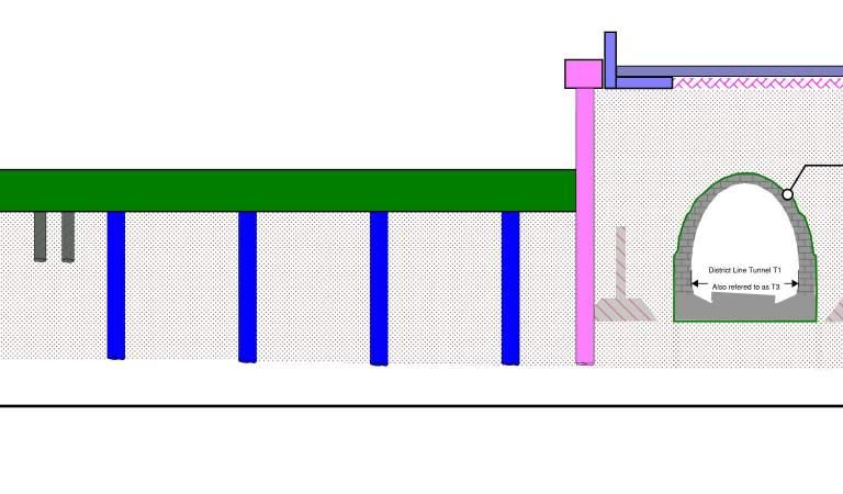
1)ExistingWLLstructuremayrequirelateralrestraintfromEC05&EC06plotinthepermanentstate ofthedevelopment.Therefore,itformspartoftheadjoiningstructuretotheDevelopmentatLevel01 +12.5mAOD,seeFigure15.Thein illedportionoftheslabalongwiththeexisting‘TheTable’ structurewillbeledbythesitewidecoordinationteam.Theconnectiondetailswhichneedtoprovide lateralrestraintandallowfordifferentsettlement(verticalmovementjoint)between2adjoining structureswillbefurtherdevelopedatStage3.Thesitewidecoordinationteamalsodiscussed opportunitiestoprovidethelateralrestraintontheplottothewestof‘TheTable’structure, therefore,removingtheneedtoproviderestraintfromplotEC05&EC06.Thiswillrequirefurther coordinationatStage3.
Figure13–IndicativeCross-sectionofSubstructure
2)TheWLLrailwayand‘TheTable’substructureformsaninterfacewithSt.CuthbertsLane enclosure’ssubstructure,seeFigure16.TheraftfoundationofSt.CuthbertsLaneenclosurewillbe constructedadjacenttotheexistingpilecapsof‘TheTable’columns.Temporaryworkssuchassheet pilesmayberequiredtoenableexcavationofthenewraftfoundation.Impactofthenewbuilding loadingsontheexistingfoundationwillrequireaGroundMovementAssessment(GMA)atStage3.
3)ThepublicrealmdesignofWarwickCrescentformsaninterfacewiththeGroundFloorlevelof plotsEC05&EC06at+9.0mAOD.ThedesignanddetailingofthegroundbearingslabalongWarwick CrescentwhichsitsabovetheDistrictLinetunnelwillbeledbythesitewidecoordinationteam.The connectiondetailsbetweenthecappingbeamandthegroundbearingslabwillneedtoallowfor differentialsettlementandthiswillbefurtherdevelopedandcoordinatedatStage3,seeFigure17.
4)EC07plotbasementformsaninterfacewithEC05basementat+4.8mAODraftlevel,seeFigure18. ThickerEC05raftwillextendfurtherintoEC07toenablebetterspreadoftheEC05towerload.The existinggroundlevelisatcirca+6.0mAOD,dependingontheconstructionsequence,assumingEC07 isbuilt irst,temporarysheetpiles/supportwillneedtobeprovidedtoenableexcavationand constructionofEC05basement.EitherRCconcretewallwithsoftspotsorblockworkwallstoenable futureconnectionbetweenEC05andEC07basement.
5)EC04plotbasementat+5.0mAODraftlevelformsaninterfacewithEC05basementat+4.8mAOD raftlevel.Similarly,topoint4)above,theconstructionmethodologycanbeeitherabatteredback excavationortemporarysheetpilestoenableconstructionofthebasementraft.
Figure14–EC05&EC06basementinterfacewithadjoiningplots
Figure15–SectionA-AshowsinterfacewithWLLandWarwickCrescent
Figure16–InterfacewithWLL‘TheTable’Substructure
Figure17–SectionD-DshowsinterfacewithEC07plot
Figure18–InterfacewithEC07basement(TemporarySheetPilesExcavationConstruction)
Retained and Proposed Basement Walls 7.5 TheexistingSitelevelsforplotEC05&EC06areatcirca+6.0mAOD.Towardsthewest,theSitelevel slopesdowntotheWestLondonRailwaytracklevelto+2.5mAOD.Towardstheeast,theSitelevel slopesuptowardstheDistrictLinetunneltocirca+7.0mOD.
7.6 Theproposedbasementlevelsvaryfrom+2.3mODto+4.8mOD,seeFigure19.Assuming2.25mthick raftunderEC05and2.00munderEC06,theexcavationdepthwillvaryfrom5.95mto3.45m.The proposedDevelopmentwillrequireanembeddedbasementwallalongtheDistrictLinetunnelsideto achievetheseproposedbasementdepths.Theembeddedbasementwallwillbeconstructedwith 900mmdiametersecantpiledwallsat1.3mspacingwithtoelevelextendingminimum5mbelowthe sof itofthetunnel,seeFigure20.Speci icstripsofsecantpiledwallsupportingEC06towercolumns willhavetheircapacityenhancedbyembeddingtodepthof-30mODusingsimilardiameterpiles.The designofthesecantpiledwallswillbeprovidedbythemaincontractoranddesignedtosupportloads fromthesuperstructure,surchargeloadsfromtheadjacentproperties,temporaryworksand constructionloadsfromthemaincontractoraswellashydrostaticandsoilheavepressures.
7.7 Forthe+4.8mODbasement,potentially500mmthickRCretainingwallscanbeadoptedinsteadof piledwallsduetotheshallowerexcavationdepth.Dependingontheconstructionsequence,either batterbackexcavationorinstallingtemporarysheetpilestoenabletheconstructionoftheRCretaining walls.However,thiswillrequireadetailedGroundMovementAssessment(GMA)studyatStage3to informtheimpactstotheLULtunnels.
Figure19–ProposedBasementLevels
7.8 AlongtheDistrictLinetunnelside,boththeLUL3mexclusionzoneandconstructiontolerancesofthe piledwallswillneedtobeconsideredindeterminingtheachievableextentofthebasementarea–see Figure21.
7.9 Thecappingbeamtothesecantpiledwallwillbedesignedtotransferthepointloadsfromthe superstructurecolumnsbyspreadingtheloadoveranumberofhard/reinforcedpilesbelow.Along EC06towerextent,a2mdeepcappingbeamiscurrentlyallowedtoensuretowercolumnloadsare evenlydistributedtothesecantpiles.Forthecappingbeamwithouttheneedtosupport superstructurecolumns,1.2mdeepcappingbeamiscurrentlyallowed.
Figure20–ExistingSiteLevelstowardsDistrictLineTunnel
Figure21–DistrictLineTunnel3mexclusionzoneplusSecantPiledWallsconstructiontolerances
Foundations 7.10 Basementraftof2.25mand2.00mdeepsupportedby900mmdiameterbearingpileswillbedesigned tospreadtheloadsappliedrespectivelyfromtheEC05&EC06corewallsandcolumnsontothepiles. TheperimetersecantpilesalongtheDistrictLinetunnelsideareengagedforsupportthrough dowellingconnectionatraftlevel.Thepiledwallswillalsosupportloadsfromthesuperstructure columns,especiallyanumberofEC06towercolumnswhichsitpartiallyoverthecappingbeam.
7.11 Forthepodiumareasoutsidethetowers,basementraftof1.2mdeepsupportedby750mmdiameter bearingpileswillbedesignedtospreadtheloadsappliedfromthepodiumcolumnsandwallsontothe piles.Thesepileswillalsoassistinresistinganywaterpressureofheaveduetoitsrelativelylighter structuralself-weightincomparisontothetowerareas.
7.12 Thepilinglayoutconsiderstheminimumpilespacingandwilldirectthesuperstructureloadsinthe mostdirectloadpathtothesupportingpiles.Wherenotpossible,thebasementraftisdesignedto transfertheloadstothenearestsupport.
Superstructure 7.13 EC05&EC06isa27-storeyand20-storeyconcreteframedbuildingrespectively.Thereisan7-storey concreteframed‘shoulder’buildingattachedtoEC05tower.Thereisalsoanindependentground loor +2storeyspairoftownhouseslocatedadjacenttotheshoulderbuilding.Thecentralcoreofthetowers providesboththelateralstabilityandgravitysupport,andthecolumnsprovideonlygravitysupport.
Construction Sequence 7.14 PreliminarysketcheswithaproposedconstructionsequenceareenclosedinAppendixG.
7.15 Themainstagesincludedinthepreliminaryconstructionsequencearelistedasfollows:
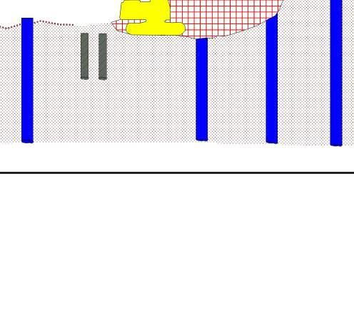
InstalldecktosupportcutsectionofWLLdeck;
SawcuttingexistingWLLdeck;
Removeexistingdeckandsupportingframe;
InitialSiteexcavationandgroundpreparationworks;
Installationofsecantpilewallandbearingpiles;
Excavatedowntoformationlevel(includinglevellingexistingslope);
CastRCraft;
InstallpublicrealmretainingwallsandgroundbearingslababoveDistrictLineTunnel;
InstallcrashdeckoverrelevantsectionsofDistrictLineandWLL;and,
Startconstructionofsuperstructure.
8.0 Preliminary Building Impact Assessment General Considerations 8.1 TheareaofEC05&EC06iscon inedwithintheDevelopmentSiteand,therefore,theproposed structuredoesnothaveneighbouringparty-wallbuildings.ThebuildingpropertiesclosertoEC06& EC06plotscomprisearowofterracedhousesalongPhillbeachGardenstotheeastofthesite. Notwithstandingthis,apreliminarygroundmovementzoneofin luencehasbeenestimatedtocon irm thatnothird-partybuildingpropertiesfallwithinthiszone.
Preliminary Ground Movement Zone of Influence 8.2 The1mmgroundmovementzoneofin luencewasdeterminedbytheestablishedgroundmovement curvespresentedinCIRIAReport760(reference7)generatedintheOasyssoftwareXdispbasedonthe differentestimatedexcavationdepthsalongtheperimeteroftheproposedbasement.
8.3 Xdispallowstheevaluationofgroundmovementsinducedbyembeddedwallinstallations/excavations intermsofthree-dimensionaldisplacements.Theembeddedwallsaredescribedinplanaspolygons. Eachwallofapolygonisassignedhorizontalandverticalgroundmovementcurvesthatareusedto calculatesoildisplacements.
8.4 Thegroundmovementcurvesinputinthemodelwerethe‘Excavationinfrontofhighstiffnesswallin stiffclay(CIRIA760Fig.2.11(a))’andthe‘Excavationinfrontofhighstiffnesswallinstiffclay(CIRIA 760Fig2.11(b))’.ThegroundsurfacemovementscurvesareshowngraphicallyinFigure22.
Figure22–GroundSurfaceMovementsduetoExcavationinFrontofEmbeddedWallinStiffClay(CIRIA760report)
8.5 Theestimated1mmgroundmovementzoneofin luenceisshownFigure23,thuscon irmingthatno 3rd partybuildingpropertiesfallwithinthisarea.
Figure23–1mmGroundMovementZoneofInluence
9.0 Final Remarks 9.1 AConstructionMethodStatementhasbeenpreparedoutfollowingtheguidanceandinformation publishedbytheRBKC.
9.2 InformationfromaSiteInvestigationhasbeenusedtoassesspotentialimpactsidentiiedbythe screeningprocess.
9.3 Itisconcludedthattheproposeddevelopment,withappropriatecontrolstocontroltheexcavation impacts,isunlikelytoresultinanyspeci iclandorslopestabilityissues,groundwaterorsurfacewater issues.
9.4 Theestimated1mmgroundmovementzoneofin luenceindicatesthatno3rdpartywallbuildingsfall withinthede inedpreliminarygroundmovementzoneofin luence.
9.5 LiaisonwiththirdpartyassetownerssuchasLULandTWwillcontinuetobeundertakenandassets ownerspeci icimpactassessmentswiththesebodieswillbeundertaken.
9.6 Theimpactofthegroundmovementswillbemanagedthroughtheproposedmonitoringregimeand implementationofamonitoringactionplan.
AppendixA- Site Location Plans See Appendix A.10 for example of information required
See Appendix A.10 for example of information required
Appendix B -Topography Survey Appendix C - Historical Maps Appendix D - LUL Historical Drawings & Surveys ECM-WSP-SW-DDN-S-0035 - Summary of CW Tunnel Wall depths
Earls Court Redevelopment
Down Ealing (Concrete) Down Ealing (Masonry) Down Ealing (Concrete) ECM-WSP-SW-DDN-S-0035 - Summary of CW Tunnel Wall depths
ECM-WSP-SW-DDN-S-0035 - Summary of CW Tunnel Wall depths
Section 5-5 ECM-WSP-SW-DDN-S-0035 - Summary of CW Tunnel Wall depths
Up Ealing (North Wall) Up Ealing (South Wall) Up Ealing ECM-WSP-SW-DDN-S-0035 - Summary of CW Tunnel Wall depths
From West Kensington Portal for 75m Please refer to, 'District Line Intrusive Tunnel Survey Report V4 (2011.12.05)' for more details on the walls, footings etc.
Section 6-6
Please refer to, 'District Line Intrusive Tunnel Survey Report V4 (2011.12.05)' for more details
Section 7-7 and Section 9-9 ECM-WSP-SW-DDN-S-0035 - Summary of CW Tunnel Wall depths
Section 8-8 Down Putney (East Wall) Down Putney (West Wall)
Up Putney (East Wall) Up Putney (West Wall)
Earls Court Road Development London Underground Ltd, Document Control, Victoria Station House, 191 Victoria Street, London SW1E 5NE
Tel: 020 3054 9588 [89588]
DOCUMENT TRANSMITTAL Transmittal Number: SUP‐ECD‐CAP‐EXT‐00074
Issue Date: 24/01/2012
To: Mark Scotter
Rail Interface Manager Capital & Counties Properties PLC 15 Grosvenor Street London W1K 4QZ
ECD Contact: Paul Godwin
Ref:
Remarks:
Reaction Required: Yes
Recipient(s):
Mark Scotter IFR
Document No. Description/Title
ARP‐TQ‐002
P078
TECHNICAL QUERY: Tunnel Survey Data
Drawing: Piccadilly Line Barons Court – Earls LCS P078/1 & P072/2
Drawing: Extents Plan for ARP‐TQ‐002
Pages from Barons Court to Kings X EB Rev D SP
Pages from Kings X to Barons Court WB Clear Rev C SP
Legend:
Issue Code
Description
IFA Issued for Approval/Acceptance [Reaction required]
IFR Issued for Review/Comment [Reaction expected)
IFI Issued for Information [No reaction expected]
IMP Issued for Implementation [No reaction expected]
SUP Document Control: Nicky Skeete
Please sign, date and return a copy of this transmittal to the user at the address given above.
Received by:
Date:
TECHNICAL QUERY (TQ) SECTION A To be completed by initiator of Technical Query.
REGISTERED TQ No.:
Please register and insert TQ No.
ARP-TQ - 002 TO: LUL Principal Engineer: Paul Godwin
E-mail: paul.godwin@tube.tfl.gov.uk
LUL Document Control:
E-mail: SMBEarlsCourtDevelop@tfl.gov.uk
DATE: 14/12/2011
Tel: 020 7027 8263
Mob: 07980 659 891
FROM:
Insert name and contact details.
Technical Query Details:
CC: CapCo Rail Interface Manager: Mark Scotter
E-mail: mark.scotter@capitalandcounties.com
Name: Jesse Schoor
e-mail: jesse.schoor@arup.com
Tel 020 7755 5022
Earls Court Development – Track Clearance and Tunnel Gauging Survey Data for District and Piccadilly Line Tunnels.
During a recent meeting with LUL (12.12.11), it was agreed that the demolition of Earls Court is likely to induce movement of the District and Piccadilly Line tunnels underlying the Earls Cour Development site. In order to further evaluate the effects of these movements, the following information is requested,
• All survey information relating to existing track clearances; and
• All survey information relating to the gauging of existing tunnels.
In order to assist in this matter, we have provided a plan showing the extents of the tunnels which are of particular interest.
DATE REPLY REQUIRED: 13/01/2012
SECTION B To be completed by LU CIRCULATION/CONSULTATION
FURTHER INFORMATION PROVIDED WITH TQ? Yes No
SECTION C To be completed by LU person responding to Technical Query.
RESPONSE: Please find attached gauging information from 2009 surveys.
DATE OF RESPONSE: 23/01/12
NAME OF RESPONDEE: S.HOLLAND
FURTHER INFORMATION ADDED: Yes No Tick as appropriate
POSITION: TLIP Manager
SECTION D To be completed by the initiator of the Technical Query.
RECORD OF CLOSE OUT:
D175-EB\0012Barons
D175-EB\0048Barons
D175-EB\0054Barons
D175-EB\0060Barons Court Open Platform11-31---------------------201
D175-EB\0068Barons Court Open Platform18-44---------------------197
D175-EB\0074Barons Court Open Platform21-49---------------------173
D175-EB\0082Barons Court Open Platform16-47---------------------194
D175-EB\0088Barons Court Open Platform20-55---------------------151
D175-EB\0094Barons Court Open Platform10-55---------------------60
D175-EB\0100Barons Court Open Platform26-55---------------------53
D175-EB\0106Barons Court Open Platform29-42---------------------169
D175-EB\0112Barons Court Open Platform29-65---------------------71
D175-EB\0122Barons Court Open Platform31-55---------------------65
D175-EB\0129Barons Court Open Platform31-51---572---------------88 P078-EB\0001STRUCTURE43-66---552---------------28 P078-EB\0006STRUCTURE257290398266---------------39 P078-EB\0012STRUCTURE228---495485---------------47
P078-EB\0016STRUCTURE258431421412---------------46 P078-EB\0022STRUCTURE52257238227340------------50 P078-EB\0028STRUCTURE48152137125231------------151
P078-EB\0034STRUCTURE52234223212324------------216 P078-EB\0040STRUCTURE51343339328---------------179 P078-EB\0046STRUCTURE56376---------------------181 P078-EB\0052STRUCTURE54------------------------175 P078-EB\0058STRUCTURE42------------------------212 P078-EB\0064STRUCTURE57------------------------171 P078-EB\0070STRUCTURE55------------------------156 P078-EB\0076STRUCTURE54------------------------157
P078-EB\0082STRUCTURE57------------------------169
P078-EB\0088STRUCTURE54------------------------164
P078-EB\0094STRUCTURE55------------------------163
P078-EB\0101STRUCTURE55------------------------176
P078-EB\0107STRUCTURE53476459------------------189
P078-EB\0115STRUCTURE61------------------------219
P078-EB\0123STRUCTURE53------------------------176
P078-EB\0129STRUCTURE51------------------------185
P078-EB\0137STRUCTURE56------------------------194
P078-EB\0143STRUCTURE54------------------------193
P078-EB\0149STRUCTURE54------------------------230
P078-EB\0157STRUCTURE513228-15---------------183
P078-EB\0163STRUCTURE48-4-47-81---------------194
P078-EB\0169STRUCTURE473-37-69---------------196
P078-EB\0177STRUCTURE53-5-52-88---------------228
P078-EB\0184STRUCTURE40189-8-48---------------231
P078-EB\0190STRUCTURE355316-17---------------232
P078-EB\0198STRUCTURE3999506---------------189
P078-EB\0206STRUCTURE50174682763------------187
P078-EB\0214STRUCTURE551519362127------------278
P078-EB\0220STRUCTURE5019613188201------------277
P078-EB\0228STRUCTURE55205173113171------------262
P078-EB\0234STRUCTURE52210209107188------------256
P078-EB\0242STRUCTURE57218218178226------------290
P078-EB\0250STRUCTURE50190193111202------------274
P078-EB\0256STRUCTURE4919514770250------------292
P078-EB\0263STRUCTURE5421421464275------------238
P078-EB\0271STRUCTURE5721521075307------------223
P078-EB\0277STRUCTURE5420220457323------------253
P078-EB\0285STRUCTURE5219219057501------------269
P078-EB\0291STRUCTURE5015615627336------------295
P078-EB\0301STRUCTURE5718012475583------------223
P078-EB\0307STRUCTURE5116616533337------------266
P078-EB\0315STRUCTURE5716316971356------------246
P078-EB\0321STRUCTURE49-22-2792316------------254
P078-EB\0329STRUCTURE57237240159---------------256
P078-EB\0336STRUCTURE55279285217---------------261 P078-EB\0344STRUCTURE58358358279---------------287
P078-EB\0352STRUCTURE50388384312---------------272
P078-EB\0358STRUCTURE50385385336257
P078-EB\0366TUNNEL513321981675044---------283
P078-EB\0372TUNNEL563122801435852---------236
P078-EB\0378TUNNEL473071901324840---------259
P078-EB\0384TUNNEL482931911175751---------252
P078-EB\0394TUNNEL572871691124952---------266
P078-EB\0398TUNNEL532721371016760---------299
P078-EB\0404TUNNEL452972121269678---------277
P078-EB\0410TUNNEL392762425910591---------261
P078-EB\0417TUNNEL814711033-1256142031784
P078-EB\0425TUNNEL131361249-172257538041
OTHER AREAS
0mm to -34mm =No speed restriction
-35mm to -49mm =35mph speed restriction
-50mm to -74mm =20mph speed restriction
-75mm and over =10mph speed restriction
TUBE SECTIONS
0mm to -34mm =No speed restriction
-35mm to -49mm =20mph speed restriction -50mm and over =10mph speed restriction
/STRUCTURE
PICCADILLY LINE UPGRADE PROJECT
EXISTING TUNNEL/STRUCTURE CLEARANCES
KING'S CROSS TO TURNPIKE LANE EASTBOUND
P078-EB\0431TUNNEL41187120-3-16299260263227
P078-EB\0439TUNNEL3719817054-4226523819753
P078-EB\0447TUNNEL391851629335529727021851
P078-EB\0453TUNNEL4418516189917884220234
P078-EB\0459TUNNEL4622017763163711725020368
P078-EB\0467TUNNEL60223199741-65323118134
P078-EB\0473TUNNEL5924120710036-37224120178
P078-EB\0481TUNNEL662121706-2042225619450
P078-EB\0487TUNNEL442071866621268123317850
P078-EB\0494TUNNEL4821718514854367723816736
P078-EB\0502TUNNEL6120816447-14-88225821467
P078-EB\0510TUNNEL5219819253-29347823721553
P078-EB\0516TUNNEL7622522938-15-31128923974
P078-EB\0524TUNNEL822672021030-46825023165
P078-EB\0532TUNNEL702111767428399126721863
P078-EB\0538TUNNEL56224161184191911727723280
P078-EB\0542TUNNEL89239282125-9-98229826298
P078-EB\0546TUNNEL6923115496242010025823670
P078-EB\0552TUNNEL6021715185252711528024480
P078-EB\0556TUNNEL7422716682-1-380281251104
P078-EB\0562TUNNEL6613514268-26-2077317294138
P078-EB\0566TUNNEL5718412654-23-19114121262102
P078-EB\0572TUNNEL40178150901624823320644 P078-EB\0577TUNNEL5619915985-1304022219841 P078-EB\0581TUNNEL61197169903-12721819838 P078-EB\0587TUNNEL3320614710339535322419428 P078-EB\0591TUNNEL402081399316316223921143 P078-EB\0597TUNNEL3019513910153522605234
P078-EB\0601TUNNEL301981358631415223620847 P078-EB\0605TUNNEL511831357311135415514468 P078-EB\0611TUNNEL43201139742219651039962 P078-EB\0617TUNNEL6015513858-14-105725823479
P078-EB\0621TUNNEL2017910052-1068026723872 P078-EB\0625TUNNEL141138615-2118127925187 P078-EB\0631TUNNEL171841185822314520917722 P078-EB\0635TUNNEL5022016210520-3-3153120-25 P078-EB\0641TUNNEL-5169230-18-182114968241175 P078-EB\0645TUNNEL8214329210423-23-820217026 P078-EB\0651TUNNEL4015512010423-17922218431 P078-EB\0655TUNNEL241351002617-21319717525
P078-EB\0659TUNNEL56138182423-122620718229
P078-EB\0663TUNNEL64324303214687138381358184 P078-EB\0667TUNNEL3828227522812810498320293142 P078-EB\0669TUNNEL3527527821411892107323295150 P078-EB\0672TUNNEL29272274206586884244272150 P078-EB\0674TUNNEL29289292228102109108308277125 P078-EB\0678TUNNEL302762822321247679299271126 P078-EB\0680TUNNEL202722752461059693289263124
P078-EB\0682TUNNEL222843442341268382277252107
P078-EB\0684TUNNEL18240323223935878278254112
P078-EB\0688TUNNEL162433062111368886291262113
P078-EB\0690TUNNEL142182922001315986290260121
P078-EB\0692TUNNEL212152931901058480291264121
P078-EB\0694TUNNEL18195271165678580292265130
P078-EB\0698TUNNEL122102791621116347276251121
P078-EB\0700TUNNEL62162771871053828262232107
P078-EB\0702TUNNEL3248325199105-818251229107
P078-EB\0704TUNNEL024832119496412255234111
P078-EB\0706TUNNEL-5244310176305-14269247118
P078-EB\0708TUNNEL-225631215462318279256132
P078-EB\0712TUNNEL3233287157804240295270134
P078-EB\0714TUNNEL12132901711104236284252119
P078-EB\0716TUNNEL-52062791701003035282229118
P078-EB\0718TUNNEL-3220278169355228278238117
P078-EB\0722TUNNEL3213277150782121277255126
P078-EB\0724TUNNEL2234278157374742289241131
P078-EB\0728TUNNEL3219283152721240292266137
P078-EB\0730TUNNEL5232271146774739290269139
P078-EB\0736TUNNEL6225272125634745304280158 P078-EB\0738TUNNEL6222265127715636303249146 P078-EB\0740TUNNEL8207267145762540305281143
P078-EB\0744TUNNEL12191259164757948294264127
P078-EB\0746TUNNEL8190247153705354293266133 P078-EB\0748TUNNEL6179245133808677314285147 P078-EB\0750TUNNEL61642301308710177324269162
P078-EB\0754TUNNEL6165235128709291332298159
P078-EB\0756TUNNEL101492291257810789289301163 P078-EB\0758TUNNEL11149222123647489309298165 P078-EB\0760TUNNEL121572261115510394344312173 P078-EB\0762TUNNEL31532221125511192345315181 P078-EB\0766TUNNEL-5173237115706983231300171 P078-EB\0768TUNNEL-81622381359010281326293162 P078-EB\0770TUNNEL-180267839874208239156 P078-EB\0774TUNNEL71542151076610396351321180
P078-EB\0776TUNNEL101251928854129113354321190 P078-EB\0778TUNNEL31311857541113137308310186 P078-EB\0780TUNNEL21251859461122105350314175
OTHER AREAS
0mm to -34mm =No speed restriction
-35mm to -49mm =35mph speed restriction
-50mm to -74mm =20mph speed restriction
-75mm and over =10mph speed restriction
TUBE SECTIONS
0mm to -34mm =No speed restriction
-35mm to -49mm =20mph speed restriction -50mm and over =10mph speed restriction
/STRUCTURE
PICCADILLY LINE UPGRADE PROJECT
EXISTING TUNNEL/STRUCTURE CLEARANCES
KING'S CROSS TO TURNPIKE LANE EASTBOUND
P078-EB\0782TUNNEL-31472381348812681278260141
P078-EB\0784TUNNEL-31592371471047778305283140
P078-EB\0786TUNNEL11412211268710490328300156
P078-EB\0788TUNNEL31362091218211995345305166
P078-EB\0790TUNNEL0139226124818798330300162
P078-EB\0793TUNNEL41382131429412995325292162
P078-EB\0797TUNNEL09919011168107121349312171
P078-EB\0799TUNNEL-21171988244147128368332192
P078-EB\0801TUNNEL-41051757545153137385352210
P078-EB\0803TUNNEL21031718245130136376338200
P078-EB\0805TUNNEL-21071898740149147381337194
P078-EB\0807TUNNEL-31091768657149142358323189
P078-EB\0811TUNNEL61151779764146128355313176
P078-EB\0813TUNNEL511018510169138126354316177
P078-EB\0815TUNNEL-611819611176103127343302178
P078-EB\0819TUNNEL71321839946121114347310173
P078-EB\0821TUNNEL5143226914585108346319185
P078-EB\0823TUNNEL51472191066510995319291160
P078-EB\0827TUNNEL81911591591084355161180109
P078-EB\0829TUNNEL92112931971438160260220101
P078-EB\0831TUNNEL142142892061531036726222998
P078-EB\0835TUNNEL16187191180134101122312274127
P078-EB\0837TUNNEL21183192172123153146328293150
P078-EB\0839TUNNEL19183179160120158156339303151
P078-EB\0841TUNNEL12207195171126151165347312141 P078-EB\0845TUNNEL21215205184130163139289311152 P078-EB\0847TUNNEL32215211172124149157357320155
P078-EB\0849TUNNEL36215203161113179173318331172 P078-EB\0851TUNNEL33205200148107171187319343181 P078-EB\0855TUNNEL4519620613792158191393360190
P078-EB\0857TUNNEL4318319613286168194396360196
P078-EB\0859TUNNEL4118518114798174194375341174
P078-EB\0863TUNNEL40239218194145170160344306149 P078-EB\0865TUNNEL34232211181134141157346310156
P078-EB\0867TUNNEL27237215188105166147348318157 P078-EB\0871TUNNEL40260244213159123147324288143 P078-EB\0873TUNNEL48273248212163144149324290132 P078-EB\0875TUNNEL46273243204155165159341301144 P078-EB\0877TUNNEL46285237196149174165346305151
P078-EB\0879TUNNEL39278241199144146165357319156 P078-EB\0883TUNNEL44311252217159187181355318148 P078-EB\0885TUNNEL43296253208157166183368327157 P078-EB\0889TUNNEL51237195191149256237229340157 P078-EB\0895TUNNEL42204150139109251292444396193 P078-EB\0900TUNNEL68242193184140245251404359173
P078-EB\0906TUNNEL67370328289201169163307275119
P078-EB\0910TUNNEL67351311256179147183336299145
P078-EB\0916TUNNEL64286240206146193267417372183
P078-EB\0920TUNNEL60312256183124165204416374207 P078-EB\0926TUNNEL56319262201149167223395356190 P078-EB\0932TUNNEL63334280203150171213390351194
P078-EB\0936TUNNEL56339280213147159216381340178
P078-EB\0942TUNNEL66342301236174191200192326145
P078-EB\0948TUNNEL64369309221156156202365330155
P078-EB\0954TUNNEL59344307252196199188350312131
P078-EB\0958TUNNEL60340314261198195197346302129
P078-EB\0964TUNNEL6637633725317314479131304141
P078-EB\0970TUNNEL6941035928790106132304275125
P078-EB\0974TUNNEL67397381297175142132130105114
P078-EB\0980TUNNEL64421362274147114142309280132
P078-EB\0985TUNNEL6043939630916610011527024496
P078-EB\0991TUNNEL68430379302146114112275245107
P078-EB\0997TUNNEL60386322254142125140120273121
P078-EB\1001TUNNEL67341272192114127186364329177 P078-EB\1007TUNNEL6029423513083125167335363206
P078-EB\1013TUNNEL682481996837126227339378216
P078-EB\1017TUNNEL73233153592779239442409250 P078-EB\1023TUNNEL7025018910461117199376348193
P078-EB\1029TUNNEL68330247902933114346324188
P078-EB\1033TUNNEL653252421246270131325300161 P078-EB\1039TUNNEL663002348134-7132355333202
P078-EB\1045TUNNEL622832351338093143315287143 P078-EB\1051TUNNEL70355300158763275275256124
P078-EB\1057TUNNEL543113162081426510925722464
P078-EB\1063TUNNEL603182461135542136342316172 P078-EB\1068TUNNEL6437529914860-578393498 P078-EB\1074TUNNEL66360303174793379278254118 P078-EB\1080TUNNEL623192731394879106243201141 P078-EB\1084TUNNEL63250184652554178174235191
P078-EB\1090TUNNEL7025619410565136189336328144
P078-EB\1096TUNNEL69279255173115129140309275118
P078-EB\1102TUNNEL7023516563-2101209406372196
P078-EB\1106TUNNEL5718612330-390262457---251 P078-EB\1112TUNNEL81401755943156297434390190 P078-EB\1116TUNNEL261601959865200242403363181
P078-EB\1122TUNNEL612852281075228157370343197 P078-EB\1126TUNNEL5625624712071100168354327175
OTHER AREAS
0mm to -34mm =No speed restriction
-35mm to -49mm =35mph speed restriction
-50mm to -74mm =20mph speed restriction
-75mm and over =10mph speed restriction
TUBE SECTIONS
0mm to -34mm =No speed restriction
-35mm to -49mm =20mph speed restriction -50mm and over =10mph speed restriction
/STRUCTURE
PICCADILLY LINE UPGRADE PROJECT
EXISTING TUNNEL/STRUCTURE CLEARANCES
KING'S CROSS TO TURNPIKE LANE EASTBOUND
P078-EB\1130TUNNEL572262269654103217395361197
P078-EB\1137TUNNEL642622641197276158336311179
P078-EB\1141TUNNEL6230730416410278123314287145
P078-EB\1147TUNNEL603072801276772144336309168
P078-EB\1153TUNNEL6829532319111694149304276116
P078-EB\1157TUNNEL62297320170117101132307276125
P078-EB\1163TUNNEL613043331407211143336310162
P078-EB\1169TUNNEL623283511961379811026924194
P078-EB\1173TUNNEL583623152441346564-5-571
P078-EB\1179TUNNEL65390343240113225422920683
P078-EB\1185TUNNEL5938234723181376923719694
P078-EB\1191TUNNEL633102581516482136318294147
P078-EB\1195TUNNEL602982491378589151332304161
P078-EB\1201TUNNEL573432821716565118305280142
P078-EB\1206TUNNEL5934728216810974118298273131
P078-EB\1212TUNNEL5434329120288-3118280255106
P078-EB\1216TUNNEL6031128922913711411226723982 P078-EB\1220TUNNEL67292241156104123142314289135
P078-EB\1225TUNNEL652762181011592191371341190
P078-EB\1231TUNNEL593022401074132149151207135
P078-EB\1235TUNNEL633132581576094155315288127
P078-EB\1241TUNNEL60313299174119103140221230130 P078-EB\1247TUNNEL5725724210059100169359329177
P078-EB\1251TUNNEL53237214553038201405374231
P078-EB\1257TUNNEL63255243994381199266304190 P078-EB\1263TUNNEL5924828414048147164342314166 P078-EB\1267TUNNEL622272589356154199367333167 P078-EB\1273TUNNEL5822825330-682231436404261 P078-EB\1279TUNNEL612652947124100178373346206
P078-EB\1283TUNNEL612933181434299145307279141 P078-EB\1289TUNNEL6130826017712111611793154110 P078-EB\1294TUNNEL6424716739057186410380251 P078-EB\1300TUNNEL66295228382681132337313183 P078-EB\1306TUNNEL64331269176105102113292264132 P078-EB\1310TUNNEL683282681405159149330304166 P078-EB\1316TUNNEL6634029017397101131304276128 P078-EB\1320TUNNEL613413232051307186271245105 P078-EB\1326TUNNEL6333629819312487144305273112 P078-EB\1330TUNNEL59327328245186159125109541 P078-EB\1334TUNNEL5427430021115320515829026080 P078-EB\1338TUNNEL49344328193307323194376---417 P078-EB\1344TUNNEL5524629779107193200220195137 P078-EB\1350TUNNEL6326929379101190138106189148 P078-EB\1354TUNNEL542803067368186201289319152 P078-EB\1360TUNNEL6026028563103169165155199147
P078-EB\1366TUNNEL64245304102115195190331299129 P078-EB\1370TUNNEL5932035617617416214628625592 P078-EB\1376TUNNEL5130236118016417316229826584 P078-EB\1382TUNNEL5934137318514917315029025684
P078-EB\1386TUNNEL56345378196172189141311276101
P078-EB\1392TUNNEL55336329193153190171343302137
P078-EB\1398TUNNEL61327314153100106202218355196
P078-EB\1402TUNNEL59347327153102129193284290197
P078-EB\1409TUNNEL61334330190142180192350314143
P078-EB\1412TUNNEL56329363223168211200342303126
P078-EB\1419TUNNEL5835639623019918215929826187
P078-EB\1425TUNNEL6031735818118223120031928193
P078-EB\1429TUNNEL65322351204184204196329292110
P078-EB\1435TUNNEL60313353150158222209353317133
P078-EB\1439TUNNEL65352386178151161180329295110
P078-EB\1445TUNNEL6637840821620015315230126799
P078-EB\1451TUNNEL66307347156168227225367326148
P078-EB\1456TUNNEL63305330115120208253202303174
P078-EB\1462TUNNEL55275291122140257260388342151
P078-EB\1468TUNNEL63275271121120228251394350165
P078-EB\1472TUNNEL68256262113110252267407359176
P078-EB\1478TUNNEL6224325398109254288319304172
P078-EB\1484TUNNEL381972235888277308431374173
P078-EB\1490TUNNEL2620322764101266291361354151
P078-EB\1493TUNNEL-21415694128210206209-2818
P077-EB\0004Earls Court Tube Platform-7239-5140----------30-2
P077-EB\0010Earls Court Tube Platform1426-4-11123---------2210
P077-EB\0014Earls Court Tube Platform1626-6-11124---------2111
P077-EB\0020Earls Court Tube Platform2129-5-8126---------2010
P077-EB\0024Earls Court Tube Platform2129-5-9126---------2111
P077-EB\0028Earls Court Tube Platform2028-8-13125---------1910
P077-EB\0034Earls Court Tube Platform1623-15-22121---------168
P077-EB\0038Earls
P077-EB\0058Earls
OTHER AREAS
0mm to -34mm =No speed restriction
-35mm to -49mm =35mph speed restriction
-50mm to -74mm =20mph speed restriction
-75mm and over =10mph speed restriction
TUBE SECTIONS
0mm to -34mm =No speed restriction
-35mm to -49mm =20mph speed restriction -50mm and over =10mph speed restriction
LCS-ROAD\CHAINAGETUNNEL/PLATFORM /STRUCTURE
PICCADILLY LINE UPGRADE PROJECT EXISTING TUNNEL/STRUCTURE CLEARANCES KINGS CROSS TO BARONS COURT WESTBOUND
P076-WB\0546TUNNEL332072378814466167204-1
P076-WB\0554TUNNEL62022349447447423020523
P076-WB\0560TUNNEL162002291025750832272005
P076-WB\0564TUNNEL191962291015251716520929
P076-WB\0572TUNNEL41972291024142851521673
P076-WB\0576TUNNEL132082397819178925122239
P076-WB\0582TUNNEL-41872197129329396847
P076-WB\0588TUNNEL21208235762926841701873
P076-WB\0592TUNNEL131832166913369823221428
P076-WB\0598TUNNEL51812086629569925422538
P076-WB\0602TUNNEL01842117139469625121634
P076-WB\0607TUNNEL92092219236538424722142
P076-WB\0611TUNNEL28209206661387525122546
P076-WB\0617TUNNEL2921923299-3307123921424
P076-WB\0623TUNNEL24196219804755888522527
P076-WB\0627TUNNEL361941956233417524622147
P076-WB\0633TUNNEL302122149036507324021434
P076-WB\0637TUNNEL242132096932356824922530
P076-WB\0643TUNNEL182202216929266610012828
P076-WB\0649TUNNEL332332289537285223621121
P076-WB\0653TUNNEL392292348633286223821532
P076-WB\0659TUNNEL382312461104723452231994
P076-WB\0663TUNNEL4022223411362324022219813
P076-WB\0669TUNNEL512232277825215225022638 P076-WB\0673TUNNEL4421421265-3128625923242
P076-WB\0679TUNNEL221951915713169018021437
P076-WB\0685TUNNEL242222541086040601501621 P076-WB\0691TUNNEL-51932231068381752362063
P076-WB\0695TUNNEL52052349670636323420518 P076-WB\0701TUNNEL3723523823-5-143415178-29
P077-WB\0001Earls Court Tube Platform5640616360---34-74-34-393
P077-WB\0004Earls Court Tube Platform54518-9139----------17-4
P077-WB\0010Earls Court Tube Platform-1012-6-3754----------5-7
P077-WB\0014Earls Court Tube Platform-621-5-2865----------7-8
P077-WB\0020Earls Court Tube Platform52713-18104----------3-6
P077-WB\0026Earls Court Tube Platform-228-9-684----------2-5
P077-WB\0030Earls Court Tube Platform23011-1102----------3-1
P077-WB\0036Earls Court Tube Platform1843199136----------1-2
P077-WB\0040Earls Court Tube Platform13388-1118----------9-10
P077-WB\0046Earls Court Tube Platform144492109----------9-10
P077-WB\0050Earls Court Tube Platform1847119116----------9-11
P077-WB\0056Earls Court Tube Platform63694110----------7-10
P077-WB\0060Earls Court Tube Platform93213-790----------6-8
P077-WB\0066Earls Court Tube Platform-77-25-65119----------8-9
P077-WB\0070Earls Court Tube Platform13337-4124----------9-10
P077-WB\0076Earls Court Tube Platform132911-5125----------12-13
P077-WB\0082Earls Court Tube Platform526125128----------8-10
P077-WB\0086Earls Court Tube Platform54414-8122----------4-6
P077-WB\0090Earls Court Tube Platform18448420145----------2-3
P077-WB\0096Earls Court Tube Platform332280111----------2-1
P077-WB\0100Earls Court Tube Platform-17-5-3-3077----------321
P077-WB\0106Earls Court Tube Platform-23-939-35109239130146-47-3
P078-WB\0004TUNNEL-51863193309114616825
P078-WB\0008TUNNEL11669449-2446920122236
P078-WB\0014TUNNEL-3538318-1916527424270
P078-WB\0020TUNNEL17516918-2038730627993
P078-WB\0024TUNNEL1488028-4139628125275
P078-WB\0030TUNNEL-651814724388110523948
P078-WB\0036TUNNEL857905511396024622245
P078-WB\0040TUNNEL35294691144623921734
P078-WB\0044TUNNEL9589950754624222253
P078-WB\0048TUNNEL236810147-6-93222420852
P078-WB\0056TUNNEL236310263-20-431922720251
P078-WB\0060TUNNEL1048856410815220202-10
P078-WB\0066TUNNEL23799656-3-26-321820241
P078-WB\0072TUNNEL2881914510-71215017033
P078-WB\0078TUNNEL50901127412-5-1010317814 P078-WB\0082TUNNEL28751006321-21019517421
P078-WB\0088TUNNEL15617525-963324722362 P078-WB\0094TUNNEL245979363163223421246 P078-WB\0100TUNNEL408810442202021919840
P078-WB\0104TUNNEL33747933-4-122323521759
P078-WB\0110TUNNEL34849350-17-3313014849 P078-WB\0115TUNNEL619010638-13-50-121919952
P078-WB\0119TUNNEL5210411646-35-35-619918127
P078-WB\0125TUNNEL43891015216-4-119719030
P078-WB\0131TUNNEL47909828-28-141723221151
P078-WB\0135TUNNEL40808341-16-3823020839 P078-WB\0141TUNNEL30738235-431424522367 P078-WB\0147TUNNEL4383110803510-5312822
P078-WB\0151TUNNEL45921147810-10-1113718422 P078-WB\0155TUNNEL50991278731-1-2219617812 P078-WB\0161TUNNEL28174135461174023220843 P078-WB\0165TUNNEL2312812840-4344483611 P078-WB\0169TUNNEL111521315314322915620515 P078-WB\0175TUNNEL60192172867-22-119517527 P078-WB\0181TUNNEL3012910727-47304324621253
Kings X to Barons Court
OTHER AREAS
0mm to -34mm =No speed restriction
-35mm to -49mm =35mph speed restriction
-50mm to -74mm =20mph speed restriction
-75mm and over =10mph speed restriction
TUBE SECTIONS
0mm to -34mm =No speed restriction
-35mm to -49mm =20mph speed restriction
-50mm and over =10mph speed restriction
LCS-ROAD\CHAINAGETUNNEL/PLATFORM /STRUCTURE
EXISTING TUNNEL/STRUCTURE CLEARANCES KINGS CROSS TO BARONS COURT WESTBOUND
P078-WB\0185TUNNEL45152132542-7622219642
P078-WB\0191TUNNEL39160129351-152423220954
P078-WB\0197TUNNEL1481739-22111526424171
P078-WB\0203TUNNEL23156148225174182169384347148
P078-WB\0207TUNNEL621881992792017876313280110
P078-WB\0213TUNNEL631972662631906175321292121
P078-WB\0219TUNNEL54205257236151413216721767
P078-WB\0223TUNNEL6021735828917522-2125823256
P078-WB\0228TUNNEL601583031961247053318293135
P078-WB\0234TUNNEL6015629018312211996358332155
P078-WB\0238TUNNEL571633041991105974336307137
P078-WB\0242TUNNEL54170300218856475329301127
P078-WB\0248TUNNEL52125265162116119122366335173
P078-WB\0252TUNNEL5817129919212810799340312141
P078-WB\0258TUNNEL541892712131468887325299133 P078-WB\0264TUNNEL60181307156988098352329171
P078-WB\0270TUNNEL58165304158828893350321161 P078-WB\0274TUNNEL55173306178115297350325154 P078-WB\0280TUNNEL551563001911267685354330160
P078-WB\0286TUNNEL58197339207195858318294128 P078-WB\0290TUNNEL63213346231555550307283116 P078-WB\0296TUNNEL63166248197977673334300138 P078-WB\0302TUNNEL6314928319110010399347314143 P078-WB\0306TUNNEL611862131841604948315287122
P078-WB\0312TUNNEL5223838528012141715719092
P078-WB\0318TUNNEL622112972521361943297268113 P078-WB\0322TUNNEL571882752381718254301255112
P078-WB\0328TUNNEL591801942631711087430427079 P078-WB\0332TUNNEL60182283249147739130827491 P078-WB\0338TUNNEL58153157224167113109330296113 P078-WB\0342TUNNEL651603011716450101351321147 P078-WB\0348TUNNEL5921334916028974333310156 P078-WB\0352TUNNEL55191338203896368319293132 P078-WB\0358TUNNEL592443872421041924281260111 P078-WB\0363TUNNEL582413202581274133270248103 P078-WB\0367TUNNEL50208293209467782317293130 P078-WB\0371TUNNEL431612471768391122362336165 P078-WB\0375TUNNEL60216291219586692146297136 P078-WB\0379TUNNEL592301551631066564303282124 P078-WB\0383TUNNEL621781841848488111334309154 P078-WB\0389TUNNEL602053001824995126349325165 P078-WB\0393TUNNEL62212308162586075343319167 P078-WB\0399TUNNEL5311911910966115169417384198 P078-WB\0405TUNNEL2046868839147200456421218 P078-WB\0409TUNNEL3812310210071148224430396205 P078-WB\0413TUNNEL4115213712384141190405370179 P078-WB\0419TUNNEL5515413112790138176412380204 P078-WB\0423TUNNEL3317613813091164210399367182 P078-WB\0429TUNNEL578919411277154162424386185 P078-WB\0433TUNNEL49110191160112137114363335152 P078-WB\0439TUNNEL50187259233168985530628393 P078-WB\0443TUNNEL47167240233176636131227888 P078-WB\0447TUNNEL57192271242122475428225289
P078-WB\0453TUNNEL5627135129113219-1022820555
P078-WB\0457TUNNEL572742682621212-323321356 P078-WB\0461TUNNEL532433252598848211012269
P078-WB\0467TUNNEL511992082191478990315281113
P078-WB\0473TUNNEL572132172331717980297270114
P078-WB\0477TUNNEL452402212241539992307261126
P078-WB\0483TUNNEL59220219220146106124328298131 P078-WB\0485TUNNEL55219216225145113129337309145
P078-WB\0491TUNNEL59286256283185939729426589
P078-WB\0498TUNNEL67329294309133114115291263100
P078-WB\0504TUNNEL57313282269130145165264263110
P078-WB\0510TUNNEL61327300319157174176296297119
P078-WB\0516TUNNEL5029028331421915814532429187
P078-WB\0522TUNNEL65246238288214163170381318147
P078-WB\0528TUNNEL59293238295220155179366328137 P078-WB\0534TUNNEL61263240278200184197382346148 P078-WB\0540TUNNEL54239230274137172200389341171
P078-WB\0546TUNNEL59247247271107123176380347161 P078-WB\0552TUNNEL57291272288161155164363334141 P078-WB\0558TUNNEL63287266284109143177358327134 P078-WB\0564TUNNEL58289259284196149185375340127 P078-WB\0570TUNNEL54313282292177152167361329136 P078-WB\0578TUNNEL57286284267138124122370342152 P078-WB\0583TUNNEL63297305271118102136323330147 P078-WB\0587TUNNEL63305303300153101129334308128 P078-WB\0593TUNNEL60257247233156148139375348156 P078-WB\0597TUNNEL65264245223163145145380350170 P078-WB\0603TUNNEL6230227626016578131356328144 P078-WB\0605TUNNEL56299294255146121113346319135 P078-WB\0607TUNNEL56326300279135103100263301119 P078-WB\0609TUNNEL573383322911197989306285109 P078-WB\0611TUNNEL603653363081158276300276100 P078-WB\0613TUNNEL5934032128713597102304285113 P078-WB\0615TUNNEL59340318276138114113280292119 Kings X to Barons Court WB Clear Rev c.xlsPage 22
OTHER AREAS
0mm to -34mm =No speed restriction
-35mm to -49mm =35mph speed restriction
-50mm to -74mm =20mph speed restriction
-75mm and over =10mph speed restriction
TUBE SECTIONS
0mm to -34mm =No speed restriction
-35mm to -49mm =20mph speed restriction
-50mm and over =10mph speed restriction
LCS-ROAD\CHAINAGETUNNEL/PLATFORM /STRUCTURE
PICCADILLY LINE UPGRADE PROJECT
EXISTING TUNNEL/STRUCTURE CLEARANCES KINGS CROSS TO BARONS COURT WESTBOUND
P078-WB\0617TUNNEL573413172614744120162177137
P078-WB\0619TUNNEL55329299249122113123170171139
P078-WB\0623TUNNEL5531930624710788113154320160
P078-WB\0625TUNNEL5235532826711586102229239131
P078-WB\0627TUNNEL493533342741237987314291110
P078-WB\0631TUNNEL49340344247654482217237129
P078-WB\0633TUNNEL42315316240534393327304149
P078-WB\0637TUNNEL452882842058872115351328154
P078-WB\0639TUNNEL423072802079590126364339181
P078-WB\0641TUNNEL45294271204107101141362336148
P078-WB\0645TUNNEL46319269225139127127345319146
P078-WB\0647TUNNEL45317271236148124121344316141
P078-WB\0649TUNNEL4431527923214493137347319134
P078-WB\0651TUNNEL3832425021813982142360331158
P078-WB\0653TUNNEL38265238196125127163371342172
P078-WB\0657TUNNEL46241213185121130164382374175
P078-WB\0659TUNNEL48259237194131131160381352180 P078-WB\0661TUNNEL45300252223144107144345316147
P078-WB\0663TUNNEL44335272260163128132327308132
P078-WB\0667TUNNEL41325269244142100113317292129
P078-WB\0669TUNNEL3429126820910671112325301132
P078-WB\0671TUNNEL3727625019810196113344321161 P078-WB\0673TUNNEL3827423018111167124111117155
P078-WB\0676TUNNEL2825919314399124132173329147
P078-WB\0678TUNNEL2825418412683100156378352183 P078-WB\0680TUNNEL2726418713681109149360308176 P078-WB\0682TUNNEL232631901368288146364341163 P078-WB\0684TUNNEL222642051237495161371349174 P078-WB\0686TUNNEL212631921297371158381355199 P078-WB\0688TUNNEL232651911247289164369344193 P078-WB\0692TUNNEL212391691066490173385358193 P078-WB\0694TUNNEL20242170934881173403375210 P078-WB\0696TUNNEL23259184813867173395368210 P078-WB\0698TUNNEL2127820593-1844165382357195 P078-WB\0700TUNNEL202782061172415151366340187 P078-WB\0704TUNNEL93152631578077128321297162 P078-WB\0706TUNNEL83182521567467126324300161 P078-WB\0708TUNNEL103112381355753126342319180 P078-WB\0710TUNNEL133112361275857119346326185 P078-WB\0714TUNNEL2131523211384398336318195 P078-WB\0716TUNNEL1732525112512383329308195 P078-WB\0718TUNNEL15331254139563683324306185
P078-WB\0720TUNNEL123202581498335106322297174 P078-WB\0722TUNNEL123222641829968120310287143 P078-WB\0724TUNNEL1531725317699-25124308286141 P078-WB\0726TUNNEL2429324616710592133324296155 P078-WB\0730TUNNEL31300250186116106134296268101 P078-WB\0732TUNNEL343162782191598611326423982 P078-WB\0734TUNNEL36337308209159881046321177 P078-WB\0736TUNNEL293373072521717511426423876
P078-WB\0738TUNNEL213322932371688512027624890
P078-WB\0742TUNNEL9287254201146115151310284128 P078-WB\0744TUNNEL14284253174156132137299269102
P078-WB\0746TUNNEL2629327223115910013628325198
P078-WB\0748TUNNEL3331027423918411513327524887
P078-WB\0751TUNNEL29319272218158106140290250115
P078-WB\0753TUNNEL243202641799869152300278114
P078-WB\0755TUNNEL20314268219156110144297272121
P078-WB\0757TUNNEL1632127421993115144165206108
P078-WB\0759TUNNEL15320282229165111140267257109
P078-WB\0761TUNNEL153182741971597611826824493
P078-WB\0765TUNNEL931927723911459124274250100
P078-WB\0767TUNNEL233929722813074106269131100
P078-WB\0771TUNNEL9330281197159749425014488
P078-WB\0773TUNNEL143222801561059011126924686
P078-WB\0775TUNNEL73022542091559611928519094
P078-WB\0777TUNNEL427423220014113214630627596
P078-WB\0778TUNNEL8243207176114158171326297111 P078-WB\0782TUNNEL1522017213799164183365331146 P078-WB\0784TUNNEL1423119114298147170171322141
P078-WB\0786TUNNEL9270215153104115128320297142 P078-WB\0788TUNNEL53182631501036898274281142 P078-WB\0790TUNNEL6305268118673872301283165 P078-WB\0792TUNNEL14315277106663876305285170 P078-WB\0794TUNNEL11299269146996397160204150 P078-WB\0796TUNNEL3-25330318-25-25110397288345 P078-WB\0799TUNNEL231326016011410910910614178 P078-WB\0801TUNNEL1030024619113413011713716769 P078-WB\0805TUNNEL1228625818712813414923122185 P078-WB\0807TUNNEL17279208175105143146310280103 P078-WB\0809TUNNEL19290233164112151149325295101 P078-WB\0811TUNNEL1328420711659107153265279139 P078-WB\0815TUNNEL826622312175163157352318134 P078-WB\0817TUNNEL2027421415096141193349319134 P078-WB\0819TUNNEL2928923319395123152318289125 P078-WB\0821TUNNEL2828426826215277148316287112 P078-WB\0823TUNNEL30305264248140126145292260110 Kings X to Barons Court WB Clear Rev c.xlsPage 23 of 25
OTHER AREAS
0mm to -34mm =No speed restriction
-35mm to -49mm =35mph speed restriction
-50mm to -74mm =20mph speed restriction
-75mm and over =10mph speed restriction
TUBE SECTIONS
0mm to -34mm =No speed restriction
-35mm to -49mm =20mph speed restriction
-50mm and over =10mph speed restriction
LCS-ROAD\CHAINAGETUNNEL/PLATFORM /STRUCTURE
PICCADILLY LINE UPGRADE PROJECT
EXISTING TUNNEL/STRUCTURE CLEARANCES KINGS CROSS TO BARONS COURT WESTBOUND
P078-WB\0825TUNNEL3432727621114814616729126086
P078-WB\0829TUNNEL-2166102461513-171791573
P078-WB\0831TUNNEL31721052505-1419316911
P078-WB\0833TUNNEL418211645107-1418316013
P078-WB\0835TUNNEL151981325213-5-41771555
P078-WB\0837TUNNEL172101326627-3-81671472
P078-WB\0841TUNNEL42031367451314174153-2
P078-WB\0843TUNNEL1918511865-6-720321733
P078-WB\0845TUNNEL1019912422-6-1393318723
P078-WB\0847TUNNEL1218912033-1812121118212
P078-WB\0849TUNNEL15197124531193122119527
P078-WB\0853TUNNEL-71609918-21-256021520822
P078-WB\0855TUNNEL817811331-35-95524221327
P078-WB\0857TUNNEL4420813347-43-19320419641
P078-WB\0861TUNNEL818512871-19-72015521848
P078-WB\0863TUNNEL182151497940-28915414449
P078-WB\0867TUNNEL2221113448-3-155123721133
P078-WB\0869TUNNEL3518614442-19123922520334
P078-WB\0873TUNNEL40178159771101720918825
P078-WB\0875TUNNEL25225167110161892021766
P078-WB\0877TUNNEL38226167115-252061931697
P078-WB\0881TUNNEL40222150925134020418114
P078-WB\0883TUNNEL3021013266-24143022019836 P078-WB\0885TUNNEL1714811450-11153323421049
P078-WB\0889TUNNEL231991706720-13324221033
P078-WB\0890TUNNEL252021547012203124321646 P078-WB\0894TUNNEL3220915658-3-54625322453
P078-WB\0896TUNNEL34203151553114326223764
P078-WB\0898TUNNEL3418915244-2044726523872 P078-WB\0902TUNNEL3921216863-9202524622040 P078-WB\0904TUNNEL3420716977736549922148 P078-WB\0908TUNNEL11851527632646425922728 P078-WB\0910TUNNEL172021578320567625322736
P078-WB\0912TUNNEL191951607126577725923042 P078-WB\0916TUNNEL71821407639577226123048 P078-WB\0922TUNNEL291931596832184123621134 P078-WB\0926TUNNEL26197145602166725422261 P078-WB\0932TUNNEL3221517710041534022520126 P078-WB\0938TUNNEL3121217911356564822119614 P078-WB\0942TUNNEL151911549848464223621130 P078-WB\0948TUNNEL4723319711030212820818511 P078-WB\0954TUNNEL322201789327234023721437 P078-WB\0958TUNNEL3021916884-4143024021739 P078-WB\0964TUNNEL34217184114183222801897 P078-WB\0970TUNNEL1220415784-807724321035 P078-WB\0974TUNNEL3619515136-28-99225122036 P078-WB\0980TUNNEL717912449-1217525523057 P078-WB\0985TUNNEL1620514636-14-4586911718 P078-WB\0991TUNNEL1821316476-3-16371841402 P078-WB\0997TUNNEL1420114468-22-326181159-26 P078-WB\1001TUNNEL919113170-42-1912178147-22 P078-WB\1007TUNNEL417313065-22-37361431815 P078-WB\1011TUNNEL6175132856-28-985144-12 P078-WB\1015TUNNEL3022315711945-28-119298-29 P078-WB\1021TUNNEL31196126424-81216515910 P078-WB\1025TUNNEL18173110150145722520213 P078-WB\1031TUNNEL-71468927-1-9426620121
P078-WB\1035TUNNEL25106100536-8302151909
P078-WB\1041TUNNEL2012010558-21733216184-5
P078-WB\1045TUNNEL22929333-56-43151851655 P078-WB\1051TUNNEL9938926-60-1216198151-2 P078-WB\1057TUNNEL19174963445725207173-17
P078-WB\1061TUNNEL23167104549549208182-14
P078-WB\1067TUNNEL214811632-353552101695 P078-WB\1073TUNNEL-4171136421132402101909
P078-WB\1077TUNNEL-1167145643132157640
P078-WB\1081TUNNEL518315178135-112587-14
P078-WB\1085TUNNEL21882001198222-17131114-66
P078-WB\1091TUNNEL54360277227116113---------279
P078-WB\1095TUNNEL28389287285104105---------284 P078-WB\1099TUNNEL414033153267978---------229
P078-WB\1105TUNNEL364142992927379---------211 P078-WB\1111TUNNEL503663402344762---------221 P078-WB\1119TUNNEL483483473034540---------252 P078-WB\1125TUNNEL503214042853435---------234 P078-WB\1131TUNNEL523903792612724---------229
P078-WB\1139STRUCTURE47221224197-3-7---------289 P078-WB\1145STRUCTURE42199206138---------------255
P078-WB\1153STRUCTURE46213217143---------------246 P078-WB\1161STRUCTURE52287293218---------------230 P078-WB\1167STRUCTURE51314319243---------------228 P078-WB\1175STRUCTURE53340346269---------------196 P078-WB\1183STRUCTURE49329340272---------------192 P078-WB\1189STRUCTURE48377385282---------------201 P078-WB\1198STRUCTURE53374379271---------------245 P078-WB\1204STRUCTURE50400406279---------------245
OTHER AREAS
0mm to -34mm =No speed restriction
-35mm to -49mm =35mph speed restriction
-50mm to -74mm =20mph speed restriction -75mm and over =10mph speed restriction
TUBE SECTIONS
0mm to -34mm =No speed restriction
-35mm to -49mm =20mph speed restriction -50mm and over =10mph speed restriction
P078-WB\1212STRUCTURE54397403269---------------274
P078-WB\1220STRUCTURE50389394255---------------216
P078-WB\1248STRUCTURE50407414215---------------194
P078-WB\1254STRUCTURE51381281204---------------234
P078-WB\1262STRUCTURE49425434448---------------189
P078-WB\1270STRUCTURE48427425407---------------204
P078-WB\1276STRUCTURE51431435380---------------181
P078-WB\1284STRUCTURE47443380361---------------187
P078-WB\1292STRUCTURE49437367351---------------179
P078-WB\1298STRUCTURE55378364355---------------166 P078-WB\1306STRUCTURE48345322302---------------182 P078-WB\1314STRUCTURE46333317300---------------184
P078-WB\1320STRUCTURE55331317308---------------221
P078-WB\1328STRUCTURE50376299270---------------182 P078-WB\1336STRUCTURE3727125123599203---------151
P078-WB\1342STRUCTURE49230204182---------------178
P078-WB\1348STRUCTURE60225207192---------------172
P078-WB\1354STRUCTURE50231212200---------------193 P078-WB\1360STRUCTURE56------------------------264
P078-WB\1368STRUCTURE55------------------------192
P078-WB\1374STRUCTURE54------------------------204
P078-WB\1382STRUCTURE51------------------------189
P078-WB\1389STRUCTURE52------------------------190 P078-WB\1397STRUCTURE52------------------------220
P078-WB\1405STRUCTURE51------------------------197
P078-WB\1409STRUCTURE51------------------------188
P078-WB\1417STRUCTURE55------------------------195 P078-WB\1423STRUCTURE57------------------------214 P078-WB\1429STRUCTURE54------------------------194 P078-WB\1434STRUCTURE56------------------------212 P078-WB\1440STRUCTURE56------------------------215 P078-WB\1446STRUCTURE52------------------------228 P078-WB\1452STRUCTURE52------------------------229 P078-WB\1458STRUCTURE54------------------------239
P078-WB\1466STRUCTURE53------------------------263
P078-WB\1472STRUCTURE52------------------------269
P078-WB\1478STRUCTURE226------------------------41 P078-WB\1482STRUCTURE227------------------------52 P078-WB\1488STRUCTURE233------------------------48
P078-WB\1494STRUCTURE233---135132---------------52 P078-WB\1499STRUCTURE118---556515---------------49 P078-WB\1503STRUCTURE13-48---577---------------37
D175-WB\0006Barons Court Tube Platform28-39
D175-WB\0012Barons Court Tube Platform28-18
D175-WB\0020Barons Court Tube Platform28-9
D175-WB\0026Barons Court Tube Platform30-11
D175-WB\0032Barons Court Tube Platform30-29
D175-WB\0038Barons Court Tube Platform30-14
D175-WB\0044Barons Court Tube Platform30-14
D175-WB\0050Barons Court Tube Platform30-21
D175-WB\0058Barons Court Tube Platform23-8
D175-WB\0062Barons Court Tube Platform17-21
D175-WB\0070Barons Court Tube Platform14-9
D175-WB\0076Barons Court Tube Platform21-11
D175-WB\0082Barons Court Tube Platform13-4
D175-WB\0087Barons Court Tube Platform210
D175-WB\0091Barons Court Tube Platform20-1
D175-WB\0099Barons Court Tube Platform2621------------------------
D175-WB\0107Barons Court Tube Platform303------------------------
D175-WB\0113Barons Court Tube Platform30-34
D175-WB\0119Barons Court Tube Platform4924------------------------
D175-WB\0125Barons Court Tube Platform5331487294368---------------
D175-WB\0129Barons Court Tube Platform5434------------------------
Appendix E - WLLRail Deck Drawings ISSUE SHEET Job Number: 10400
Page Number: 3
Drawing/Sketch/Schedule Title:
Isometric views
Boundary retained deck post demolition
Retained deck foundations/hazard zones
Retained deck columns/brace bay plan
Retained deck steelwork plan
Retained deck concrete plan
Existing sections
Proposed protection screen locations
Proposed deck layout (East)
Proposed deck layout (West)
Proposed column and brace layout
Proposed Baseplates
Proposed new bracing sections
Proposed
Proposed
Proposed Demolition Cut Lines Load Constraints Sheet 1 of 2
Internal Review Number: Issued For: Distribution:
M30HAS20D,270mm EMBEDMENT(MIN)+HVUHILTI RESINORSIMILARAPPROVED. BOLTEDTOPLINTH
C10 M30HAS20D, 270mmEMBEDMENT(MIN)+ HVUHILTIRESINORSIMILAR APPROVED
M30HAS20D, 270mmEMBEDMENT(MIN)+ HVUHILTIRESINORSIMILAR APPROVED
M30HAS20D,270mm EMBEDMENT(MIN)+HVUHILTI RESINORSIMILARAPPROVED. BOLTEDTOPLINTH
M30HAS20D, 270mmEMBEDMENT(MIN)+ HVUHILTIRESINORSIMILAR APPROVED
M30HAS20D, 270mmEMBEDMENT(MIN)+ HVUHILTIRESINORSIMILAR APPROVED
M30HAS20D, 270mmEMBEDMENT(MIN)+ HVUHILTIRESINORSIMILAR APPROVED
M30HAS20D, 270mmEMBEDMENT(MIN)+ HVUHILTIRESINORSIMILAR APPROVED
M30HAS20D,270mm EMBEDMENT(MIN)+HVUHILTI RESINORSIMILARAPPROVED. BOLTEDTOPLINTH.
M30HAS20D, 270mmEMBEDMENT(MIN)+ HVUHILTIRESINORSIMILAR APPROVED
1DONOTSCALETHISDRAWINGONPRINTORELECTRONICALLY.
3ReadthisdrawingwithallArchitects,ServiceEngineersand
5DRAWINGSTATUS:-
Allendplatestobealaminar-freematerial.
1.04 F.S.B.W.denotesfullpenetration,fullstrengthbuttweld.
1.05 CharpyVnotchtestresultsaretobeprovidedforallexternalsteelworkdownto
1.06 Designofallsteeltosteelresponsibilityofthesteelworksubcontractor,thisshallinclude allgussetplates,stiffenerplates,spreaderbeams,corbelsandanyotherminorsteel elementswhicharenotshownorshownbutnotsizedonthedrawings,whichare necessarytoachievetheconnectionincludingallweldsandbolts. PositionsofsplicestobeagreedwithCampbellReithwhowillthenprovideconnection loadsforContractorDesign.
Forfactoreddesignloadsrefertodrawings. Loadsshownare: V=Verticalreaction(shear)inkN; T=TensioninkN; M=BendingMomentinkNm. Atbeamtocolumnconnections,thecentrelineofthecolumnshallcoincidewiththe centrelineofthebeamunlessnotedotherwise.Theloadingstypicallyareappliedvertically unlessnotedotherwise.
1.07 TheSteelworkcontractorshallberesponsibleforsurveyingtheexistingsurrounding structureinordertoestablishthefinalpositionandsettingoutofthesteelworkwhichshall beagreedwiththeengineerpriortofabricationdrawingscommencing.Includingcover metersurveyingofreinforcementtodeveloptemplatesandtodeterminefixingpositions intoreinforcedconcretebases.
1.08 PaintprotectiontobeinaccordancewiththeCampbellReithStructuralSteelwork specificationG10.
M30HAS20D, 270mmEMBEDMENT(MIN)+ HVUHILTIRESINORSIMILAR APPROVED
M30HAS20D, 270mmEMBEDMENT(MIN)+ HVUHILTIRESINORSIMILAR APPROVED
M30HAS20D, 270mmEMBEDMENT(MIN)+ HVUHILTIRESINORSIMILAR APPROVED
M30HAS20D, 270mmEMBEDMENT(MIN)+ HVUHILTIRESINORSIMILAR APPROVED
M30HAS20D, 270mmEMBEDMENT(MIN)+ HVUHILTIRESINORSIMILAR APPROVED
M30HAS20D, 270mmEMBEDMENT(MIN)+ HVUHILTIRESINORSIMILAR APPROVED
1.09 FIREPROTECTION
1.10
Allstructuralsteelworkrequiresaminimumfireresistanceperiodof2hoursexceptwhere notedotherwise.ThisistobeachievedusingintumescentcoatingTBC(referto specificationsectionM61).Whereexistingsprayedfireprotectionisdamageduring installationofthenewbracingthefireprotectionistobe reinstatedandmadegood.
1.11 Fixingstostructuralsteelworkbetoanagreedmethod,sub-contractorsshallsupply detailstoCAforapproval.
1.12 Allconnectionsdesignedtominimumof75kNinanydirection.
M30HAS20D, 270mmEMBEDMENT(MIN)+ HVUHILTIRESINORSIMILAR APPROVED
M30HAS20D,270mm EMBEDMENT(MIN)+HVUHILTI RESINORSIMILARAPPROVED
M30HAS20D, 270mmEMBEDMENT(MIN)+ HVUHILTIRESINORSIMILAR APPROVED
M30HAS20D, 270mmEMBEDMENT(MIN)+ HVUHILTIRESINORSIMILAR APPROVED
M30HAS20D, 270mmEMBEDMENT(MIN)+ HVUHILTIRESINORSIMILAR APPROVED
M30HAS20D, 270mmEMBEDMENT(MIN)+ HVUHILTIRESINORSIMILAR APPROVED
REINFORCINGBARSSHOULDBELOCATEDUSINGACOVERMETERANDCONFIRMEDBYPILOT DRILLINGORCHASINGTHESURFACEOFTHECONCRETE.ANYHOLES CHASESFORMEDTOLOCATE THEREINFORCEMENTMUSTBEFILLEDWITHANAPPROVEDGROUT REPAIRMORTAR.N.B.ONLY MASONRYDRILLBITSARETOBEUSED NODIAMONDOROTHERSPECIALISTBITSCAPABLEOF CUTTINGINTOREINFORCEMENTWILLBEPERMITTED.IFREINFORCEMENTISDAMAGED,REPORTTHIS TOTHEENGINEER. CONNECTIONSTOEXISTINGREINFORCEDCONCRETESTRUCTURENEEDTOALLOWADEQUATE PROVISIONFORTOLERANCE.FIXINGSFORCONNECTIONBRACKETSMAYBELOCATEDTOAVOIDTHE REINFORCEMENT(SLOTTEDHOLESORALTERNATIVEFIXINGPOSITIONSMAYBEPROVIDEDFORTHIS PURPOSE).ALTERNATIVELY,SPECIALBRACKETSMAYBEDESIGNEDWITHPREDETERMINEDFIXING POSITIONSTHATRELIABLYAVOIDTHEREINFORCEMENT.WHEREACCURATESURVEYSARENOT POSSIBLEADDITIONALHOLESMAYBEPROVIDEDINTHEBRACKET(INSTEADOFSLOTTEDHOLES)TO ALLOWSOMEADJUSTMENTINTHEPOSITIONOFTHEFIXINGS.
CROSSING UNDER THE WLL - REFER TO DRG AIP-ME-SK-002 FOR FURTHER DETAILS
CROSSING OVER THE WLL - REFER TO DRG AIP-ME-SK-003 FOR FURTHER DETAILS
SMOKE VENTILATION
CROSSING OVER THE WLL
Appendix F - Ground & Groundwater Contour Plots (GIR) (MG) -Made Ground Monitoring Well Response Zone.
(KPG) -Kempton Park Gravels Monitoring Well Response Zone.
(ALL) -Alluvium Monitoring Well Response Zone.
(LB) -Lillie Bridge Exploratory Hole.
(350OBR) -350 Old Brompton Road Exploratory Hole.
(C2014)-Concept Site Investigation (2014).
(KPG) Average Groundwater Elevation (mOD)
Standpipe Dry on All Monitoring Visits. Base #mOD.
Standpipe Dry on # of # visits. Base #mOD.
Indicative average water elevation contours in the Kempton Park Gravels. Note, other contour interpretations are possible.
Indicative average water elevation contours in the Made Ground / Alluvium. Note, other contour interpretations are possible.
(MG) -Made Ground Monitoring Well Response Zone.
(KPG) -Kempton Park Gravels Monitoring Well Response Zone. (ALL) -Alluvium Monitoring Well Response Zone.
(LB) -Lillie Bridge Exploratory Hole.
(350OBR) -350 Old Brompton Road Exploratory Hole.
(C2014)-Concept Site Investigation (2014).
-# mOD Average Groundwater Elevation (mOD)
Standpipe Dry on All Monitoring Visits.
Base #mOD.
Standpipe Dry on # of # visits.
Base #mOD.
Indicative average water elevation contours in the Kempton Park Gravels. Note, other contour interpretations are possible.
Indicative average water elevation contours in the Made Ground / Alluvium. Note, other contour interpretations are possible.
This is a data outlier and likely to represent perched groundwater within the superficial deposits (groundwater contours excluded) These are likely to represent perched groundwater within the superficial deposits. Which then infiltrates below (note multiple visits recorded as dry) (groundwater contours excluded)
Note, the groundwater contours recorded in 2014 are similar tothe groundwater regime recorded in 2022/2023 as shown in Appendix B.1 and Appendix B.2.
(MG) -Made Ground Monitoring Well Response Zone.
(KPG) -Kempton Park Gravels Monitoring Well Response Zone.
(ALL) -Alluvium Monitoring Well Response Zone.
(LB) -Lillie Bridge Exploratory Hole.
(350OBR) -350 Old Brompton Road Exploratory Hole.
(C2014)-Concept Site Investigation (2014).
-# mOD Average Groundwater Elevation (mOD)
Standpipe Dry on All Monitoring Visits. Base #mOD.
Standpipe Dry on # of # visits. Base #mOD.
Indicative average water elevation contours in the Kempton Park Gravels. Note, other contour interpretations are possible.
Indicative average water elevation contours in the Made Ground / Alluvium. Note, other contour interpretations are possible.
These are likely to represent perched groundwater within the superficial deposits. Which then infiltrates below (note multiple visits recorded as
(Groundwater contours excluded)
Ground Surface Contour Plan GroundSurfaceElevation ContourDrawing Notes:
1.Alldimensionsareinmetersunlessotherwisestated.Dimensionsarenottobescaledfromthedrawing.
2.AllelevationsareinmetersaboveOrdnanceDatum(mOD).
3.Thegroundmodel,groundwaterconditionsandgeotechnicalparametersrecommendedinthisreportarean interpretationbytheDesignerofrepresentativevaluesoftheparametersconsidered,astheyexistinsituand basedonthedataavailableatthecurrenttime.ItistheresponsibilityoftheContractortoreviewtheinformation inthisreport,togetherwithanyotheravailableinformation,inordertoselecttheappropriatedesignparameters fortheparticularpurposeunderconsideration.
4.Therelevantsite-specificgroundinvestigationdatausedinthisdrawingwastakenfromthefactualreportslisted below:
4.1.Concept'GroundInvestigationReport-FactualEarlsCourt,LondonPhase1ReportReference 22/3679-GIR-F01'
4.2.Concept'GroundInvestigationReport-FactualEarlsCourt,LondonPhase2ReportReference 22/3678-GIR-F02'
4.3.GroundEngineering'GroundInvestigationReport350OldBromptonRoadLondonSW5(Factual)Report ReferenceNo.C15411'
4.4.GroundEngineering'GroundInvestigationReportLillieBridgeOldBromptonRoadLondonSW5(Factual) ReportReferenceNo.C15412'
5.Thetablebelowprovidesthefactualdatausedinthiscontourdrawinginatabulatedformat.
Createdby:JA
Checkedby:JR
Approvedby:MS
Date:02/10/2023
Key: Lillie Bridge Exploratory Holes 350 Old Brompton Road Exploratory Holes
Earls Court 2022/23 Investigation
BH1(LB)
Lillie
BH102(350OBR)
Base of Made Ground Base of Coeshive Made Ground Contour Plan Cohesive Made Ground Thickness Plan Lillie Bridge Exploratory Holes 350 Old Brompton Road Exploratory Holes
BH1(LB)
BH102(350OBR)
Base of Made Ground and Top of Alluvium Contour Plan AlluviumSurfaceElevation ContourDrawing Notes:
1.Alldimensionsareinmetersunlessotherwisestated.Dimensionsarenottobescaledfromthedrawing.
2.AllelevationsareinmetersaboveOrdnanceDatum(mOD).
3.Thegroundmodel,groundwaterconditionsandgeotechnicalparametersrecommendedinthisreportareaan interpretationbytheDesignerofrepresentativevaluesoftheparametersconsidered,astheyexistinsituand basedonthedataavailableatthecurrenttime.ItistheresponsibilityoftheContractortoreviewtheinformation inthisreport,togetherwithanyotheravailableinformation,inordertoselecttheappropriatedesignparameters fortheparticularpurposeunderconsideration.
4.Therelevantsite-specificgroundinvestigationdatausedinthisdrawingwastakenfromthefactualreports listedbelow:
4.1Concept'GroundInvestigationReport-FactualEarlsCourt,LondonPhase1ReportReference 22/3679-GIR-F01'
4.2Concept'GroundInvestigationReport-FactualEarlsCourt,LondonPhase2ReportReference 22/3678-GIR-F02'
4.3GroundEngineering'GroundInvestigationReport350OldBromptonRoadLondonSW5(Factual)Report ReferenceNo.C15411'
4.4GroundEngineering'GroundInvestigationReportLillieBridgeOldBromptonRoadLondonSW5(Factual) ReportReferenceNo.C15412'
5.Thetablebelowprovidesthefactualdatausedinthecontourdrawinginatabulatedformat.
Alluvium Thickness Contour Plan Drawing Notes:
1.Alldimensionsareinmetersunlessotherwisestated.Dimensionsarenottobescaledfromthedrawing.
2.AllelevationsareinmetersaboveOrdnanceDatum(mOD).
3.Thegroundmodel,groundwaterconditionsandgeotechnicalparametersrecommendedinthisreportareaan interpretationbytheDesignerofrepresentativevaluesoftheparametersconsidered,astheyexistinsituand basedonthedataavailableatthecurrenttime.ItistheresponsibilityoftheContractortoreviewtheinformation inthisreport,togetherwithanyotheravailableinformation,inordertoselecttheappropriatedesignparameters fortheparticularpurposeunderconsideration.
4.Therelevantsite-specificgroundinvestigationdatausedinthisdrawingwastakenfromthefactualreports listedbelow:
4.1Concept'GroundInvestigationReport-FactualEarlsCourt,LondonPhase1ReportReference 22/3679-GIR-F01'
4.2Concept'GroundInvestigationReport-FactualEarlsCourt,LondonPhase2ReportReference 22/3678-GIR-F02'
4.3GroundEngineering'GroundInvestigationReport350OldBromptonRoadLondonSW5(Factual)Report ReferenceNo.C15411'
4.4GroundEngineering'GroundInvestigationReportLillieBridgeOldBromptonRoadLondonSW5(Factual) ReportReferenceNo.C15412'
5.Thetablebelowprovidesthefactualdatausedinthecontourdrawinginatabulatedformat.
BH1(LB)
BH102(350OBR)
SurfaceElevationContour Drawing Notes:
1.Alldimensionsareinmetersunlessotherwisestated.Dimensionsarenottobescaledfromthedrawing.
2.AllelevationsareinmetersaboveOrdnanceDatum(mOD).
3.Thegroundmodel,groundwaterconditionsandgeotechnicalparametersrecommendedinthisreportareaan interpretationbytheDesignerofrepresentativevaluesoftheparametersconsidered,astheyexistinsituand basedonthedataavailableatthecurrenttime.ItistheresponsibilityoftheContractortoreviewtheinformation inthisreport,togetherwithanyotheravailableinformation,inordertoselecttheappropriatedesignparameters fortheparticularpurposeunderconsideration.
4.Therelevantsite-specificgroundinvestigationdatausedinthisdrawingwastakenfromthefactualreports listedbelow:
4.1Concept'GroundInvestigationReport-FactualEarlsCourt,LondonPhase1ReportReference 22/3679-GIR-F01'
4.2Concept'GroundInvestigationReport-FactualEarlsCourt,LondonPhase2ReportReference 22/3678-GIR-F02'
4.3GroundEngineering'GroundInvestigationReport350OldBromptonRoadLondonSW5(Factual)Report ReferenceNo.C15411'
4.4GroundEngineering'GroundInvestigationReportLillieBridgeOldBromptonRoadLondonSW5(Factual) ReportReferenceNo.C15412'
5.Thetablebelowprovidesthefactualdatausedinthecontourdrawinginatabulatedformat.
Thickness of Kempton Park Gravels Contour Plan KemptonParkGravel ThicknessContourDrawing Notes:
1.Alldimensionsareinmetersunlessotherwisestated.Dimensionsarenottobescaledfromthedrawing.
2.AllelevationsareinmetersaboveOrdnanceDatum(mOD).
3.Thegroundmodel,groundwaterconditionsandgeotechnicalparametersrecommendedinthisreportareaan interpretationbytheDesignerofrepresentativevaluesoftheparametersconsidered,astheyexistinsituand basedonthedataavailableatthecurrenttime.ItistheresponsibilityoftheContractortoreviewtheinformation inthisreport,togetherwithanyotheravailableinformation,inordertoselecttheappropriatedesignparameters fortheparticularpurposeunderconsideration.
4.Therelevantsite-specificgroundinvestigationdatausedinthisdrawingwastakenfromthefactualreports listedbelow:
4.1Concept'GroundInvestigationReportFactualEarlsCourt,LondonPhase1ReportReference 22/3679-GIR-F01'
4.2Concept'GroundInvestigationReportFactualEarlsCourt,LondonPhase2ReportReference 22/3678-GIR-F02'
4.3GroundEngineering'GroundInvestigationReport350OldBromptonRoadLondonSW5(Factual)Report ReferenceNo.C15411'
4.4GroundEngineering'GroundInvestigationReportLillieBridgeOldBromptonRoadLondonSW5(Factual) ReportReferenceNo.C15412'
5.Thetablebelowprovidesthefactualdatausedinthecontourdrawinginatabulatedformat.
0m10m25m
Lillie Bridge Exploratory Holes 350 Old Brompton Road Exploratory Holes
LCF weathered 6m (1.89mOD) to 6.4m (1.49mOD)
LCF B: 6.4m (1.49mOD) to 10m (-2.11mOD)
(350OBR)
LCF weathered 6.2m (1.48mOD) to 7m (0.68mOD) LCF B: 7m (0.68mOD) to 40m (-32.32mOD)
A3ii 40m (-32.32mOD) to base 50m (-42.32mOD)
LCF weathered 5m (2.24mOD) to 5.4m (1.84mOD) LCF B: 5.4m (1.84mOD) to 30m (-22.76mOD)
BH1(LB)
BH102(350OBR)
BH103
Base of the Kempton Park Gravels and Top of the London Clay Contour Plan LondonClaySurface ElevationContourDrawing Notes:
1.Alldimensionsareinmetersunlessotherwisestated.Dimensionsarenottobescaledfromthedrawing.
2.AllelevationsareinmetersaboveOrdnanceDatum(mOD).
3.Thegroundmodel,groundwaterconditionsandgeotechnicalparametersrecommendedinthisreportareaan interpretationbytheDesignerofrepresentativevaluesoftheparametersconsidered,astheyexistinsituand basedonthedataavailableatthecurrenttime.ItistheresponsibilityoftheContractortoreviewtheinformation inthisreport,togetherwithanyotheravailableinformation,inordertoselecttheappropriatedesignparameters fortheparticularpurposeunderconsideration.
4.Therelevantsite-specificgroundinvestigationdatausedinthisdrawingwastakenfromthefactualreports listedbelow:
4.1Concept'GroundInvestigationReport-FactualEarlsCourt,LondonPhase1ReportReference 22/3679-GIR-F01'
4.2Concept'GroundInvestigationReport-FactualEarlsCourt,LondonPhase2ReportReference 22/3678-GIR-F02'
4.3GroundEngineering'GroundInvestigationReport350OldBromptonRoadLondonSW5(Factual)Report ReferenceNo.C15411'
4.4GroundEngineering'GroundInvestigationReportLillieBridgeOldBromptonRoadLondonSW5(Factual) ReportReferenceNo.C15412'
5.Thetablebelowprovidesthefactualdatausedinthecontourdrawinginatabulatedformat.
Northern Site Area Main Site Area Top of London Clay Unit C Notes:
Indicative contours of the base of the London Clay Unit C have not been included as Unit C was only recorded on the 2014 investigation logs.
>1.5 0.84 1.5 WS13
>0.65 -0.01 2.35 WS15
-0.37 2.55 WS16
London Clay UNIT B Main Site Area Top of London Clay Unit C / Unit B 0.19 2.2 BH208B >33.4 0.86 1.6 BH209 >30.35 1.56 5.2 BH210 >26.4 1.92 8.6 BH211 >27 -0.36 8 BH212A >29.6 0.79 5.4 BH213 >29.3 0.37 5.7 BH214
-2.2 9.2 BH215A
-2.03 9.2 BH216A >0.75 -1.86 8.2 BH217
-1.4 8.5
-1.17 9.4
35.7 -0.14 3.3
>2.4 0.8 7.6
>2.45 -1.88 6.55 WS401A 30.5 -4.3 12.75 BH03
Indicative contours of the top of the London Clay Unit C / Unit B.
-0.01mOD
-0.37mOD WS13(2014) 0.84mOD
-2mOD (Unit C)
(2014) -0.95mOD BH09A(2014) -0.21mOD
Surface Ranges Between -2.2mOD and 1.92mOD
-2.25mOD
BH01(2014)
Base of London Clay Unit B and Top of London Clay Unit A3ii London Clay UNIT A3ii Elevation data too variable to contour interface based on log descriptions
Indicative contours of the base of the London Clay Unit A3ii and the top of the London Clay Unit A3i
BH303B (2022 Phase 2 SI)
LC Unit A3ii Base 47.45m bgl(44.29mOD)
London Clay Unit A3ii = 8.45m Thick
Base of London Clay Unit A3ii and Top of London Clay Unit A3i BH301 (2022 Phase 1 SI)
LC Unit A3ii Base 49.00m bgl(44.94mOD)
London Clay Unit A3ii = 9.5m Thick
BH302 (2022 Phase 2 SI)
LC Unit A3ii Base 49.50m bgl(41.27mOD)
London Clay Unit A3ii = 10.5m Thick
BH112A (2022 Phase 2 SI)
LC Unit A3ii Base 45.80m bgl(40.32mOD)
London Clay Unit A3ii = 9.3m Thick
–This anomaly is most likely to be a logging discrepancy, as the contours of the different London Clay units would be expected to follow a similar dip trend.
BH02 (2014)
LC Unit A3ii Base 49m bgl(44.7mOD)
London Clay Unit A3ii =11.40m Thick
BH01 (2014)
LC Unit A2 Base 49.250m bgl(-45.09mOD)
London Clay Unit A3ii = 11.25m Thick
BH03 (2014)
LC Unit A3ii Base 52.25 bgl(43.80mOD)
London Clay Unit A3ii =9.00m Thick
BH04 (2014)
LC Unit A3ii Base 47.95m bgl(44.02mOD)
London Clay Unit A3ii =10.50m Thick
Indicative contours of the base of the London Clay Unit A3i and the top of Unit A2
BH303B (2022 Phase 2 SI)
LC Unit A3i Base 51.00m bgl(47.84mOD)
London Clay Unit A3i = 3.55m Thick
Base of London Clay Unit A3i and Top of London Clay Unit A2
BH301 (2022 Phase 1 SI)
LC Unit A3i Base 53.00m bgl(48.94mOD)
London Clay Unit A3i = 4m Thick
BH302 (2022 Phase 2 SI)
LC Unit A3i Base 52.50m bgl(44.27mOD)
London Clay Unit A3i = 3m Thick
BH01 (2014)
LC Unit A3i Base 51.50m bgl(-47.34mOD)
London Clay Unit A3i = 2.25m Thick
BH02 (2014)
LC Unit A3i Base 50.70m bgl(46.40mOD)
London Clay Unit A3i =1.70m Thick
2022 Exploratory Hole Location Plan
Indicative contours of the base of the London Clay / Top of the Lambeth Group
Base of London Clay Unit A2 and Top of Harwich / Lambeth Group
BH303B (2022 Phase 2 SI) – Lambeth
Group Upper Mottled Beds
LC Base 61.950m bgl(-58.79mOD)
London Clay 59.15m Total Thickness
Unit A2 Thickness = 10.95m
BH301 (2022 Phase 1 SI) – Lambeth
Group Upper Mottled Beds
LC Base 63.70m bgl(-59.64mOD)
London Clay 57.7m Total Thickness
Unit A2 Thickness = 10.7m
BH302 (Base Not Encountered)
LC Base >65.45m bgl(<-57.22mOD)
London Clay >56.35m Total Thickness
Unit A2 Thickness = >12.95m
BH01 (2014) – Harwich Formation
LC Base 63.00m bgl(-58.84mOD)
London Clay 57.5m Total Thickness
Unit A2 Thickness = 11.5m
BH02 (2014) – Harwich Formation
LC Base 61.17m bgl(-56.87mOD)
London Clay 57.42m Total Thickness
Unit A2 Thickness = 10.47m
2022 Exploratory Hole Location Plan
Made Ground Concrete
Gravelly Sand Sandy Gravel
Silty Sandy Clay
Sandy Clay
Sandy Gravelly Clay
Silty Clay
Clay Sand & Gravel
Sand
London Clay
Made Ground
Kempton Park Gravels
Alluvium
London Clay
Made Ground Concrete
Gravelly Sand Sandy Gravel
Silty Sandy Clay
Sandy Clay
Sandy Gravelly Clay
Silty Clay
Clay
Sand & Gravel Sand
London Clay Made Ground
Kempton Park Gravels
Alluvium
Made Ground Concrete
Gravelly Sand Sandy Gravel
Silty Sandy Clay
Sandy Clay
Sandy Gravelly Clay
Silty Clay
Clay
Sand & Gravel Sand
London Clay
Made Ground
Kempton Park Gravels
Alluvium
Alluvium
Alluvium
London Clay
London
Made Ground Concrete
Gravelly Sand Sandy Gravel
Silty Sandy Clay
Sandy Clay
Sandy Gravelly Clay
Silty Clay
Clay Sand & Gravel
Sand
London Clay
Made Ground
Kempton Park Gravels
Alluvium
Alluvium
Alluvium
London Clay
Made Ground Concrete
Gravelly Sand Sandy Gravel
Silty Sandy Clay
Sandy Clay
Sandy Gravelly Clay
Silty Clay
Clay
Sand & Gravel
Sand
London Clay
Made Ground
Kempton Park Gravels
Alluvium
Alluvium
Kempton Park Gravels
Made Ground
London Clay
Made Ground Concrete
Gravelly Sand Sandy Gravel
Silty Sandy Clay
Sandy Clay
Sandy Gravelly Clay
Silty Clay
Clay
Sand & Gravel
Sand
London Clay
Made Ground
Kempton Park Gravels
London Clay
London Clay
Kempton Park Gravels
Made Ground Concrete
Gravelly Sand Sandy Gravel
Silty Sandy Clay
Sandy Clay
Sandy Gravelly Clay
Silty Clay
Clay
Sand & Gravel Sand
London Clay
Made Ground
Kempton Park Gravels
London Clay
London
Made Ground Concrete
Gravelly Sand Sandy Gravel
Silty Sandy Clay
Sandy Clay
Sandy Gravelly Clay
Silty Clay
Clay
Sand & Gravel Sand
London Clay
Made Ground
London Clay
Kempton Park Gravels
Made Ground Concrete
Gravelly Sand Sandy Gravel
Silty Sandy Clay
Sandy Clay
Sandy Gravelly Clay
Silty Clay
Clay
Sand & Gravel Sand
London Clay
Made Ground
Kempton Park Gravels
London Clay
Made Ground Concrete
Gravelly Sand Sandy Gravel
Silty Sandy Clay
Sandy Clay
Sandy Gravelly Clay
Silty Clay
Clay
Sand & Gravel
Sand
London Clay
Made Ground
Kempton Park Gravels
London Clay
London Clay
Alluvium
Indicative
Made
Gravelly
Gravel
Silty Sandy Clay
Sandy Clay
Sandy Gravelly Clay
Silty Clay
Clay
Sand & Gravel Sand
London Clay
Made Ground
Kempton Park Gravels
London Clay
London Clay
Appendix G - Structural Drawings & Construction Sequence Section B-B
Section A-A
400x400mm Columns on 650mm RC Transfer slab
400x400mm Columns on 650mm RC Transfer slab
400mm down-stand for folding slab
400x400mm Columns on 650mm RC Transfer slab
400mm down-stand for folding slab 650mm PT slab
650mm PT slab
400x400mm Columns on 650mm RC Transfer slab
400mm down-stand for folding slab
Assumed slab edge
Roof Slab 300mm PT SLab (support BMU and MEP plants, to be further assessed next stage upon receipt of loads)
Current assumption: Balcony loads are supported directly by the tower columns, no load is supported off the slab edge. Details to be provided by FMDC for WSP to review
(assumed no plant or BMU loads)
Configuration along DL Tunnel side Blade column extends out to pick up the extended slab edge
Blade column pulled back on GF to land on top of pile cap
DL Tunnel 3m Exclusion Zone + Piling Tolerance as per WSP-DDN-ST016 rev1 (subjected to GMA and LUL approval at next design stage)
Column buttress to run down into the basement
B1 (Assume+2.3mOD)


