
A Summary of the City's Procedures, Standards and Services Related to Development


Developer's Handbook

INTRODUCTION....................................................................... 1 WELCOME.................................................................................................................................... 1 CITY CONTACT INFORMATION AND FREQUENTLY ASKED QUESTIONS............................................................. 2 OVERVIEW OF DEVELOPMENT PROCESS............................................................................................... 4 TRACKING YOUR APPLICATIONS......................................................................................................... 6 THE DEVELOPMENT PROCESS..................................................... 9 ZONING...................................................................................................................................... 10 PLATTING.................................................................................................................................... 18 CONSTRUCTION AND PERMITTING...................................................................................................... 26 DESIGN GUIDANCE.................................................................. 33 COMMERCIAL DESIGN.................................................................................................................... 34 NEIGHBORHOOD DESIGN................................................................................................................ 38 SIGNAGE.................................................................................................................................... 44 ENVIRONMENTAL DESIGN............................................................................................................... 54 LIGHTING................................................................................................................................... 60 Contents 332618109112463438445460 toc
This Handbook serves as a guide and source of information related to development in the City of Boerne. It includes resources for property owners, community members, developers, staff, and consultants. It is intended to function as a quick reference, and does not replace the regulations and standards of the City’s Code of Ordinances.
The development process can be challenging due to the number of activities that often occur simultaneously, and the sequencing of steps that are required in the permitting process. Our goal is to make that process clearer and easier to navigate, to provide answers to commonly asked questions, and to explain how these various steps and requirements are related.
INTRODUCTION
Page 1 Welcome! Thank you for your interest in developing in Boerne!
Each section of the Handbook explains a part of the development process. The City staff is able to provide guidance and answer any additional questions should they arise. Contact information for key departments is also included on the pages that follow.
The City maintains digital copies of all forms, permits and applications on its website. You may also obtain a copy of any paperwork you need by visiting the Planning Offices at City Hall.
The schedule of all public hearings can be found on the City’s website.
Ö Engineering plan review Ö Letters of Certification for Infrastructure Documents Ö Construction Release Permit Ö Floodplain Development Permits Ö Grading Permits Ö Traffic Impact Analyses Ö Right of Way Construction Permit Ö Construction documents for development plans and approvals Ö Construction inspections Ö Drainage Studies
City Website: regarding:Contactdevelopment.comprehensiveplanningresponsibledevelopmentDepartmentTheplanning@boerne-tx.govPhone:DEVELOPMENTPLANNINGwww.ci.boerne.tx.us/&COMMUNITY830-248-1501PlanningandCommunityDevelopmentisthekeypointofcontactforquestions.Thedepartmentisforguidingthecity’slongrangeeffortsandimplementingthecity’splanforfuturegrowthandthePlanningDepartment
suppression Ö Operational
Ö Zoning and land use Ö Overlay districts Ö Platting and land subdivision Ö Historic preservation Ö Tree Removal Permits Ö Nonconformities Ö Variances Ö Certificates of Appropriateness Ö Certificates of Approval Ö Parkland dedication Ö Boerne Master Plan / long range planning Ö Boerne Open Neighborhood Discussion (B.O.N.D.) meetings
Thefiremarshal@boerne-tx.govPhone:MARSHAL830-248-1512FireMarshalconductsannual commercial property inspections to ensure adherence to fire codes, as well as residential inspections upon request to assist with home fire safety.
Ö Certificates of Occupancy Ö Sign
HOW DO I KNOW WHAT INFORMATION I NEED TO SUBMIT WITH MY TheAPPLICATION?submittalrequirements for all applications are accessible via the City’s website. For many applications, a checklist will be provided to the applicant at a pre-application conference. Read the section of this handbook related to the application in question to see whether a preapplication conference is required.
Building/Demolition Permits
WHY DO I NEED A DRAINAGE STUDY TO ADD A STRUCTURE OR IMPERVIOUS COVER ON MY LOT?
INTRODUCTION
The City’s sign regulations are also included in the WHATUDC.IS THE UDC?
INTRODUCTION
DEVELOPMENT SERVICES
Contact the Fire Marshal regarding: property inspections Permits for fire alarms and fire permits CODE ENFORCEMENT AND ContactandforregistrationCodetx.usBuildingSigntx.usCodePhone:PERMITTING830-248-1529Enforcement:jaguirre@ci.boerne.Permits:bkwasneski@ci.boerne.tx.usInspections:sskaggs@ci.boerne.Enforcementstaffprocesscontractorandpermitapplications,checkcomplianceofallordinancesandcodes,inspectallconstructionworkinBoerne.CodeEnforcementregarding: Ö
Phone: 830-249-9511
FIRE
Impervious cover is anything from concrete pavement to crushed granite. If it keeps water from absorbing directly into the ground, it is impervious cover. Some impervious cover is less impervious than others, but all are considered with development. The negative effects of impervious cover may seem subtle, especially when you’re using something like crushed granite, but even crushed granite becomes compacted and keeps water from being absorbed. The cumulative effect causes additional run-off and can cause flooding.
It simply means that you are creating something new that was not there before, whether it is a lot or a structure, it’s considered development and requires oversight by the city. Any improvement on a property has the potential to have an impact on surrounding properties.
CITY HALL 447 N. Main Street Boerne, TX 78006
The Unified Development Code (UDC) can be found on the City’s website. It includes development procedures, the City’s zoning and platting regulations, and design standards for residential and nonresidential development.
Page 2 Page 3
WHERE CAN ACCESS THE CITY’S UNIFIED DEVELOPMENT CODE?
The Unified Development Code is a compilation of the city’s zoning and development regulations. This key document in conjunction with the Engineering Design Manual are your “go-tos” for development, process and procedures information.
WHAT IS Development“DEVELOPMENT”?meansanythingfrom building an office building to something as simple as building a driveway. Often people think of development as a large project, but development can be a small project as well; dividing parcels into two or more lots, making any above ground improvements or adding impervious paving (ie. pool, driveway). When you make changes to land, you become a developer. WHY AM I CONSIDERED A DEVELOPER?
WHAT IS IMPERVIOUS COVER AND WHY REGULATE IT?
City Contact Information Frequently Asked Questions
Ö
Phone: DevelopmentsafelyworkDevelopmentpre-constructionordinance.cityensureslimits.commercialpublicServicesADevServices@boerne-tx.gov830-248-1538primaryfunctionofDevelopmentistheengineeringreviewofinfrastructureforresidentialandprojectswithinthecityAplanreviewbytheCityEngineerprojectsmeetcompliancewithconstructionspecificationsandcity Frompre-developmenttotofinalacceptance,theServicesDepartmentwilltoensureprojectsareconstructedandresponsibly.ContactServicesregarding:
Thecustomersvc@boerne-tx.govPhone:UTILITIESPermits830-249-9511CityofBoerneUtilitiesstrives
HOW DO I SCHEDULE A MEETING WITH CITY STAFF? Call the Planning Department. Depending on where you are in the development process, staff will let you know which city personnel you will meet with, and will help you get your meeting WHEREscheduled.CAN I FIND A COPY OF THE FORMS AND PAPERWORK THAT I NEED IN ORDER TO GET AN APPROVAL FROM THE CITY?
Ö Commercial
The City of Boerne has multiple creeks and floodplains that run through it, the most notable is Cibolo Creek. The impact of development over time can take a toll on water quality and impact flooding. It is the city’s responsibility to monitor any development to protect the community and ensure responsible growth. Your small project is one of many in the area and the city is tasked with tracking those projects and making sure that there is no cumulative impact.
to provide outstanding and reliable service while helping customers manage utility services, billing, and payments. Our staff is committed to the community and dedicated to quality service at a competitive cost. Contact the Utilities Department regarding: Ö Utility service connections
Contact the Planning and Community Development Department for any questions: 830-248-1501 or planning@boerne-tx.gov.
HOW CAN I HAVE MY PROPERTY IfANNEXED?theproperty owner initiates the annexation procedure, it is considered voluntary annexation. Annexation into the city limits allows for connection to city utilities. DOES THE CITY MAINTAIN A SCHEDULE OF PUBLIC HEARINGS RELATED TO ZONING AND PLATTING?
City Council meets on the second and fourth Tuesdays of each month. The City Council operates under the City Charter adopted by the citizens of Boerne. The City Council is composed of a Mayor and five Council Members. Meetings are at 6:00 PM in the City Hall Council Chambers at 447 N. Main Street.
WHAT IS ZONING? Every property in the city limits has a zoning category. Zoning determines a property’s allowed uses, dimensions and setbacks. Your property may also fall into an Overlay District. Overlay Districts are also a form of zoning that provide further detail regarding uses, restrictions, lot dimensions, building heights and additional signage requirements. Be sure to check both the zoning and the overlay when you’re looking at the zoning map online.
INTRODUCTION
HOW CAN DETERMINE HOW A PROPERTY IS ZONED? The official zoning map of the City is what is used to determine how each property is zoned. The City maintains an online, unofficial version of the zoning map that can be referenced for the sake of convenience. The map can be read as a pdf, or by accessing the City’s interactive GIS map Once you are able to determine the zoning category assigned to your property, you can look at the zoning chapter of the UDC to find the uses and dimensional standards that are approved for your property, and whether your property is located within an overlay district. To verify your zoning, contact the Planning Department.
WHEN ARE CITY COUNCIL MEETINGS TheHELD?Boerne
Frequently Asked Questions continued
Page 4
The Planning and Zoning Commission holds public hearings on zoning matters and makes recommendations on the development of Boerne. The Commission meets on the first Monday of each month at 6:00 p.m. in the City Hall Council Chambers at 447 N. Main Street.
WHEN ARE PLANNING & ZONING COMMISSION (P&Z) MEETINGS HELD?
1. ZONING & RIGHTS OF USE Before beginning the development process, zoning, variances and other rights of use must be approved for your site.
Ö Engineering Design Manual: Standards and requirements for public infrastructure construction, including engineering design and construction drawings
5. OTHER PERMITS In some cases, construction activity occurs outside of the development process. There are additional city permits required for tree removal, grading, construction in the public rightof-way, floodplain development, and signage.
Ö Boerne Master Plan: Policies for growth and development, including land use, transportation and economic development
INTRODUCTION
3. CONSTRUCTION OF PUBLIC TheIMPROVEMENTSconstruction process begins with a construction release permit, following plat approval. You will work with Development Services to establish a timeline and schedule inspections.
2. ThePLATTINGtypeofplat that is needed for your project will depend on the number of lots to be created and on the public improvements required to service your property.
Ö Unified Development Code: Standards and procedures for zoning, platting, signage, public improvements and project design
INTRODUCTION
MAIN DOCUMENTS FOR REGULATING DEVELOPMENT IN BOERNE:
Ö Boerne Design Guide: Standards and guidelines for the other overlay districts of the City and for creative alternatives
It is important to make sure that you have obtained all of the necessary permissions and approvals from the City. Every project is unique, but there is a general process to follow when developing or constructing on your site. Not all of the project phases identified in this guide are applicable to every project, and some projects require additional permissions or review prior to approval of an application. You are encouraged to contact City Staff whenever a question or need for clarification arises.
Once a building permit is obtained, vertical construction can begin. Final inspections occur once construction is complete, followed by issuance of a Certificate of occupancy, if applicable.
BEFORE BEGINNING A PROJECT
Page 6 Page 7
IN BOERNE…
Overview of the Development Process
4. BUILDING CONSTRUCTION
Ö Historic Design Guidelines: Guidelines for the design of sites, buildings and signs in the Historic Overlay District
Ö Building Codes: The various building codes (mechanical, electrical, etc.) adopted by the City of Boerne
DevelopmentServices DevelopmentServices n/a n/a DevelopmentMaster Plan (for plats) Planning Department DepartmentPlanning P&Z City Council n/a Plat Application Planning Department DepartmentPlanning P&Z Planning(Major);Dept.(Minor) City Council P&Z ROW Permit Development Services DevelopmentServices DevelopmentServices City Manager n/a Sign Permit Code Enforcement Code Enforc./ Planning Dept. (in over lay dist.) Code Enforcement n/a Design CommitteeReview(DRC)
INTRODUCTION
DepartmentPlanning DepartmentPlanning City Council n/a n/a Building Permit Code Enforcement Code Enforcement Code Enforcement City Manager n/a Certificate Appropriatenessof DepartmentPlanning DepartmentPlanning Historic CommissionLandmark(HLC) City Council n/a CertificateApprovalof DepartmentPlanning DepartmentPlanning Design CommitteeReview(DRC) P&Z / City Council n/a Certificate Occupancyof Code Enforcement Code Enforcement Code Enforcement City Manager n/a
Application Type Where to Submit Technical Review Approved By Appeal To Variances Grading Permit Development Services
DevelopmentServices DevelopmentServices City Manager n/a Land Study (for plats) Planning Department DepartmentPlanning DepartmentPlanning P&Z / City Council n/a LoC for Infrastructure (for plats) Development Services
Tree Removal Permit Planning Department DepartmentPlanning PlanningmentDepart City Manager n/a Zoning Planning Department DepartmentPlanning City Council Court Board Adjustmentof
Page 8 Page 9
P&Z = Planning and Zoning Commission LoC = Letter of Certification n/a = not applicable This table is provided to assist developers/applicants with identifying which department to contact for different types of applications. It also serves to identify reviewing agencies.
Application Type Where to Submit Technical Review Approved By Appeal To Variances Annexation
ConstructionRelease DevelopmentServices DevelopmentServices DevelopmentServices City Manager n/a DevelopmentFloodplainPermit DevelopmentServices DevelopmentServices DevelopmentServices P&Z n/a VestedPetitionRight DepartmentPlanning DepartmentPlanning City Manager City Council n/a
Tracking Your Applications
INTRODUCTION
PROCEDURES
Page 11
Permissions and Procedures in Boerne
Property development and construction activity often require multiple permits and approvals from the City. This section identifies key procedures that you are likely to encounter as you develop your project, as well as tips for navigating those processes and notes about important items to consider. Procedural matters related to zoning, platting, construction and permitting are the focus of this chapter.

If you desire to use or develop your property in such a way that is not allowed by your current zoning, you may need to rezone the property. (see the UDC for exceptions, exemptions and rules for variances). First, speak to the Planning staff to see what is right for you.
If you desire to rezone your property, you will need to file a zoning application. The requirements will depend on the type of zoning you are requesting, and whether a Special Use Permit is required. The list of requirements for a property rezoning can be found in the Unified Development Code.
TIP: Ö Be sure to review the UDC for zoning application requirements. Some of the required documents, such as TIAs and CCRs, require more time and detail than others. Check with the Planning Department if you have any questions.
2. SUBMIT A ZONING APPLICATION
Public Hearings and Public Notice for Property Zonings
ZONING
4. COUNCIL DECISION
B.O.N.D. MEETINGS
Staff will provide P&Z with a report, and P&Z will hold a public hearing on the zoning application within 30 days of the filing date of a complete zoning application. After the public hearing, P&Z will make a recommendation to City Council regarding the change.
5. VariancesVARIANCEStothe zoning requirements for a property are granted by the Board of Adjustment. Criteria for approval of a variance can be found in Chapter 2 of the UDC. Variance applications can be found on the City’s website They are submitted to and processed by the Utility Department.
1. PRE-APPLICATION MEETING Before filing a zoning application, you will need to schedule a pre-application meeting with the Planning Department Staff will provide you with an application checklist. If you are applying for a Planned Unit Development (PUD), Planned Development District (PDD), Community Development District (CDD), or Special Use Permit (SUP), submit a concept plan when you schedule your pre-application meeting.
Rezoning Your Property
ZONING
3. P&Z RECOMMENDATION
Page 12 Page 13
Boerne Open Neighborhood Discussion (B.O.N.D.) meetings are a platform that allows open discussion between the developer of a project and the neighbors of the area around the project site. B.O.N.D. meetings are held prior to P&Z’s public hearing, or any time prior to the public hearing. Staff faclitiates the meetings, and presents a report of the meeting to P&Z and to City Council.
Public hearings are required before the zoning of a property can be changed, and public notice is required for every public hearing. Chapter Two of the UDC explains how the City provides public notice, who receives the notice, and when notice is required. Additionally, a sign must be put up on any property where there is a proposed zoning change. *Requests for zoning changes can run concurrently with Special Use Permits (SUP), Planned Unit Development (PUD), Planned Development Districts (PDD), and annexations.
Zoning approvals normally require 2 City Council meetings. At the 1st meeting, City Council will receive P&Z’s recommendation, hold a public hearing about the property zoning request, and vote on a First Reading. At the 2nd meeting, Council will make a final decision on the zoning request. If the zoning is approved, the zoning map will be changed.
HOW TO REZONE YOUR PROPERTY…
The Official Zoning Map of the City is the record of how each property in Boerne is zoned. It is maintained by City Staff. For convenience, an unofficial version of the zoning map is available on the City’s website.
Page 14 Page 15
Boerne's Base Zoning Categories
Boerne is divided into 27 different zoning categories, generally grouped as residential, commercial, industrial and civic. All property in the City is assigned a certain zoning designation, and this determines how a property may be used, how tall buildings can be, and how far buildings have to be set back from property lines.
ZONING RESIDENTIAL ZONING CATEGORIES ZONINGOfficeIndustrialParkOfficeOfficeNeighborhoodResidentialEstateResidentialManorRuralAgricultureCATEGORIESandResidential HoldingInterimCommunityBungalowResidentialAttachedResidentialDuplexCourtLow CommercialRegionalCommercialCommunityCommercialTransitionalCommercialNeighborhoodResidentialModerateResidentialNeighborhoodResidentialMediumResidentialDensityDensityDensity IndustrialGeneralIndustryLightTransportationStorageCommercialCraftand Low HoldingInterimPropertyCityInstitutionalCivicHomeManufacturedResidentialUrbanMultifamilyDensityMultifamilyCommunityandRMRAREO1O2O3 R3-DR3-AR4-BHOL CITYCIVHOLR2-MR1-MR1-LR2-NC1C2C3C4 RMHCR4-UR4-L CRI1I2I3
ZONING MAP
ZONING
ZONING CATEGORIES
ZONING AND THE COMPREHENSIVE PLAN
The zoning categories are in alignment with the future land use component of the city’s comprehensive plan. This ensures that future development will occur in a manner consistent with the community's vision.
DETERMINING IF THE DESIRED USE IS ALLOWED UNDER THE CURRENT ZONING WHAT USES ARE ALLOWED ON THE MASTER TABLE OF USES IN THE UDC? SP the use is allowed "by right" the use may be allowed, but you’ll need to apply for a Special Use Permit. There will likely be additional design requirements to minimize the impact of your development on neighboring properties and the area in general. the use is not allowed
•
An application for any of these flexible zoning tools is a type of zoning application. The process for obtaining a flexible zoning designation is the same as the zoning process described earlier in this section of the handbook, except that the submittal requirements are different. For a flexible zoning application, there is additional documentation required, including a site plan (PUD/PDD/CDD plan) and quantitative data about the uses and allocations of land on the site. See Section 2.5 ZONING PROCEDURE for more information on flexible zoning.
3 The process for obtaining a Special Use Permit is the same as the zoning process, as described earlier in this section of the handbook.
3 Like all other permits and applications, processing fees for SUP can be found at in the City of Boerne Fee Ordinance.
PLANNED DEVELOPMENTUNIT(PUD) CLUSTERDISTRICTDEVELOPMENT(CDD)PLANNEDDISTRICTDEVELOPMENT(PDD)
•
Page 16 Page 17 ZONING Special Use Permits (SUP)
3 SUPs are related to property zoning.
3 Section 3.7 of Boerne’s Unified Development Code contains the Permitted Use Tables for the City. Once you know your property’s zoning, and you know the particular use that you are seeking to exercise, you can look on the table to see if a SUP is required. If the use you are seeking to exercise on your property is designated with an “S” on the Permitted Use Tables, then you will need to obtain a SUP in order to exercise that use.
3
Intended for:
• Infill projects or smaller projects where base zoning conventions are
Criteria for eligibility: Project size: 10 acres or more Single contiguous project under unified control Limits to residential lots and density Intended for: Clustering of compact lots to preserve at least 40% of land for contiguous open space areas
3 Public Hearings are required for Special Use Permits, just as they would be for property rezonings.
3 If you are seeking to rezone your property, and the proposed use requires a SUP, then you would submit the required additional information with your zoning application and it could all be presented at the same meeting.
•
•Criteria:unworkableProjectsize:less than 10 acres All properties contiguous and under unified control Limits to residential density and minimum lot sizes Intended for: Master-planned projects, large commercial centers, mixed-use developments, or larger projects where base zoning is unworkable
WHAT IS A SPECIAL USE PERMIT? I NEED ONE, HOW DO I GET IT?
ZONING
3 SUP typically require design modifications or site improvements to mitigate or minimize the impact that the use would have on neighboring properties and on the area in general. At the pre-application meeting, Planning Staff will indicate the additional documentation that you will need to include in your zoning application.
3 The flexible zoning designation itself, once assigned, is the zoning for your property. The City maintains a record of all PUDs, PDDs and CDDs as a part of the City’s official property zoning record.
3 SUP are processed by the Planning Department. If you think you need a SUP, you can contact the Planning Department to verify the need, and to get information about requirements for obtaining your SUP.
3 There are three flexible zoning tools available in the City of Boerne: Planned Development District (PDD), Planned Unit Development (PUD) and Cluster Development District (CDD). See Section 3.8 Flexible Zoning Tools of the UDC for more information.
Flexible Zoning Tools
•
•
Criteria for eligibility: • Single contiguous project under unified control Gross density same as base zoning Only available for RM, RE, R1-L, R1-M and R2-N properties
•
•
WHAT IS THE PROCESS FOR OBTAINING A SPECIAL USE PERMIT?
3 Not all SUP applications require the same additional documentation. At the pre-application meeting with City Staff, you will receive an SUP application checklist. The potential impacts that your project may have will be identified at that meeting.
•
•
IF
3 Flexible zoning tools are used as an alternative way to zone your property when there are certain factors that create a lack of applicability of any single base zoning category for your project. To be granted a flexible zoning designation, there are additional requirements related to the design of your site, as well as additional submittal requirements for approval of your zoning application.
Overlay
ZONING Districts

HOW TO DETERMINE IF YOUR PROPERTY IS IN AN OVERLAY DISTRICT
If your property lies within one of Boerne’s overlay districts, you’ll need to check 3.9 of the UDC for additional restrictions to uses and dimensions that would apply to properties in that district. There may also be additional design requirements related to parking, signs, landscaping, impervious cover, or other aspects of your project. Any standard or requirement in Section 3.9 replaces the corresponding basic zoning requirement or general standard of the UDC. If there is no additional standard for a design attribute, you will follow the base zoning and general standards of the other chapters of the UDC.
Downtown Community: Protect one of the older, more established neighborhoods of Boerne, preserving the delicate balance of commercial and residential uses in the area. Heritage Corridor: Encourage context-sensitive design, respecting the rural and agricultural heritage of the area through heightened landscape preservation and orientation toward the creekways in the district.
Scenic Interstate Corridor: Accommodate auto-oriented commercial development while preserving the scenic hill country views that characterize the natural beauty of Boerne. Divided into three sub-areas based on topography.
The official zoning map of the City indicates the zoning for all properties inside the City Limits. If your property is in an overlay district, the zoning designation will have a suffix following the symbol for the base zoning. Example: C2RR is the zoning symbol for Transitional Commercial in the River Road overlay district. The information can be found at the Planning and Community Development page, but you can contact the Planning Department if you have any questions or would like to clarify the zoning designation for your property.
Historic District: Preserve and protect the character, history and culture of the City of Boerne through the preservation, restoration and re-use of its historic structures and facilities.
River Road: Protect the enjoyment of views of Cibolo Creek, providing a retail and low-key entertainment destination that maintains historic architectural forms.
ZONING
USES AND DESIGN STANDARDS IN THE OVERLAY DISTRICTS
Entrance Corridors: Preserve the economic function of the primary entrance corridors of the City, managing traffic and connectivity while strengthening wayfinding and orientation through streetscape design.
Page 18 Page 19
SoBo (South Boerne): Spans various entrances into Boerne and contains unique street frontages, ecological features and economic opportunity. Divided into three character zones: Hybrid Commercial, Mixed-Use, Neighborhood Character.
TIPS: Ö P&Z only hears and decides complete plat applications. If your application is not complete, it will be returned to you with a list of the missing or incomplete information. You will have to re-submit the application (with the missing or incomplete information included) before your application will be reviewed.
HOW DO I KNOW IF I HAVE TO PLAT?
AMENDING PLATS If you have an existing plat and you desire to make minor revisions, such as moving lot lines or correcting errors on the plat, without creating any new lots, you will apply for an amending plat.
MAKING CHANGES TO AN EXISTING SUBDIVISION PLAT
Ö By state law, plats must be approved, approved with conditions, or disapproved within 30 days of being deemed complete. Often times, a plat may be submitted several times before being approved.
Are You Subdividing Lots? YES NO Subdivision Plat Development Plat Does your property require public infrastructure? YES NO DevelopmentMajor Plat What type of property is it? NON RESIDENTIAL RESIDENTIAL DevelopmentMinor Plat Does your property require public infrastructure? YES Major SubdivisionPlat NO How Many Lots? 4 OR LESS MORE THAN 4 Minor SubdivisionPlat Page 20 Page 21 PLATTING Platting: Why and What Type?
REPLATS— If you have an existing plat, and you are creating new lots or removing restrictions from your plat, you will apply for a replat.
PLATTING
TYPES OF PLATS
Ö Plats have to be prepared by a registered surveyor or engineer.
NEW PLAT APPLICATION If neither of these conditions applies, you will need to initiate a new plat Follow the corresponding plat process.
Unless an exemption or exception applies, you will be required to obtain a plat before beginning any development activity on your site (if your property isn’t already platted). This may include, but isn’t limited to: Ö Any division of land Ö Building an addition to your house over 50% of the existing square footage Ö New development on an unplatted parcel Ö Any other activity where you are required to include a copy of the plat with the application.
All properties that are within the city limits or the extra-territorial jurisdiction of the City should be platted. Plats document not only the boundaries of a property, but also the easements that are found on the site, right of way dedications, trees and key information about the development of the site included as plat notes. Plats are legal documents recorded with the County, and, once they are recorded, they never expire.
See section 2.6 of the UDC for exceptions.
For the purpose of determining plat type, “public infrastructure” means main extensions of sewer, water, gas and possibly electric, depending on where you tie in.
3 If you have a nonresidential property that you are not subdividing, or a residential project you are not subdividing that requires any public infrastructure, then you would file a Major Development Plat application
3. Submit a Master Development Plan. The Master Development Plan (MDP) covers all phases of a project, and includes preliminary platting and design documentation for the entire site. It must be approved by P&Z before Infrastructure Documents will be reviewed. There are intake dates for MDPs. See City Calendar for dates. MDP is not required for development occuring in one phase or one plat.
WHAT IS THE PROCESS FOR OBTAINING A MAJOR DEVELOPMENT PLAT?
2. Submit a Land Study. The Land Study documents the existing conditions of the property, as well as preliminary site information. Land Studies do not go to P&Z. Staff receives them and checks for completeness. Unless indicated to the contrary at the pre-application meeting with City Staff, a Land Study must be complete before a Letter of Certification for infrastructure documents will be granted.
PLATTING
3. Submit an application for a Letter of Certification of Infrastructure Documents. Before submitting a plat application, infrastructure documents must be certified by Development Services. The applicant will receive a Letter of Certification (LoC) for infrastructure documents once Staff determines that they are compliant with City standards. The Infrastructure documents LoC has to be included in the plat application for the application to be complete.
7. If your application is complete, P&Z will render a decision on your plat application within 30 days of the date that the plat application was received. If the plat application is not complete, staff will notify you of the incomplete status of your application, and you will be required to submit any missing information (on a future intake date), before the plat is considered complete and a decision is rendered by P&Z.
Major Development Plats
WHAT IS THE PROCESS FOR OBTAINING A MAJOR SUBDIVISION PLAT?
3 If you are subdividing property and creating more than 4 lots, or if you are subdividing and public infrastructure is required, you would file an application for a Major Subdivision Plat.
4. Submit an application for a Letter of Certification of Infrastructure Documents. Before submitting a plat application, infrastructure documents must be certified by Development Services. The applicant will receive a Letter of Certification (LoC) for infrastructure documents once Staff determines that they are compliant with City standards. The Infrastructure documents LoC has to be included in the plat application for the application to be complete.
8. Plat Recording. After the plat is approved, it has to be recorded with Kendall County There is a fee for recording plats.
1. Schedule and attend a pre-application meeting with City Staff. At this meeting, staff will confirm what type of plat application you need to file and provide you with a checklist of submittal requirements for a Major Subdivision Plat.
5. If the plat is disapproved or approved with conditions, the plat will need to be resubmitted for P & Z final approval. See the P & Z Plat Submittal Calendar for resubmittal dates. There are no resubmittal deadlines, but keep in mind resubmittals are only accepted on indicated dates.
6. If your application is complete, P&Z will render a decision on your plat application within 30 days of the date that the plat application was received. If the plat application is not complete, staff will notify you of the incomplete status of your application, and you will be required to submit any missing information (on a future intake date), before the plat is considered complete and a decision is rendered by P&Z.
Page 22 Page 23 Major Subdivision Plats
WHEN IS A MAJOR SUBDIVISION PLAT APPLICABLE?
6. If the plat is disapproved or approved with conditions, the plat will need to be resubmitted for P & Z final approval. See the P & Z Plat Submittal Calendar for resubmittal dates. There are no resubmittal deadlines, but keep in mind resubmittals are only accepted on indicated dates.
1. Schedule and attend a pre-application meeting with City Staff. At this meeting, staff will confirm what type of plat application you need to file and provide you with a checklist of submittal requirements for a Major Development Plat.
WHEN IS A MAJOR DEVELOPMENT PLAT APPLICABLE?
2. Submit a Land Study. The Land Study documents the existing conditions of the property, as well as preliminary site information. Land Studies do not go to P&Z. Staff receives them and checks for completeness. Unless indicated to the contrary at the pre-application meeting with City Staff, a Land Study must be complete before the Master Development Plan will be accepted. Amending plats do not require a Land Study.
4. Submit your plat application. After each previous stage has been completed, a plat application may be submitted. There are intake dates for Plat Applications approved by P & Z. See P & Z Plat Submittal Calendar for dates.
7. Plat Recording. After the plat is approved, it has to be recorded with Kendall County There is a fee for recording plats.
5. Submit your plat application. After each previous stage has been completed, a plat application may be submitted. There are intake dates for Plat Applications approved by P & Z. See P & Z Plat Submittal Calendar for dates.
3 A site plan is shown on the plat. If any changes are done to the site plan, then the plat will need to be redone.
PLATTING
Page 24 Page 25 Minor Subdivision Plats
Minor Development Plats
3. Submit an application for a Letter of Certification of Infrastructure Documents. This Letter of Certification (LoC) is required to show existing and/or proposed water and swerer services that serve the lots. It must be obtained before the plat application, and the LoC has to be included in the plat application in order for that application to be deemed complete.
4. Submit your plat application.
3 If you are subdividing property but only creating 4 or fewer lots, and no public infrastructure is required, you would file an application for a Minor Subdivision Plat. 3 Minor Subdivision Plats can be approved by staff. They do not go to P&Z if approved by the Planning Director.
4. Submit your plat application.
WHEN IS A MINOR SUBDIVISION PLAT APPLICABLE?
2. Submit a Land Study . The Land Study documents the existing conditions of the property. Land Study is not required for amending plats.
3 If you have a residential property that you are not subdividing, and your project does not require any public infrastructure, then you would file a Minor Development Plat.
6. If your application is complete, Staff will render a decision on your plat application within 30 days of the date that the plat application was received. If the plat application is not complete, staff will notify you of the incomplete status of your application, and you will be required to submit any missing information on a future application intake date before the plat is deemed complete and staff reviews and provides you with a decision on your plat. If your application is not approved by Staff, they will refer your application to P&Z for a decision.
PLATTING
3 A site plan is shown on the plat.
WHAT IS THE PROCESS FOR OBTAINING A MINOR SUBDIVISION PLAT?
1. Schedule and attend a pre-application meeting with City Staff. At this meeting, staff will provide you with a Minor Development Plat Application Checklist
2. Submit a Land Study The Land Study documents the existing conditions of the property. Land Study is not required for amending plats.
1. Schedule and attend a pre-application meeting with City Staff. At this meeting, staff will provide you with a Minor Subdivision Plat Application Checklist.
7. Plat Recording. After the plat is approved, it has to be recorded. This is how it becomes a permanent record for the property. All plats are recorded with the County, and there is a fee for recording plats.
WHAT IS THE PROCESS FOR OBTAINING A MINOR DEVELOPMENT PLAT?
5. If your application is complete, Staff will render a decision on your plat application within 30 days of the date that the plat application was received. If the plat application is not complete, staff will notify you of the incomplete status of your application, and you will be required to submit any missing information on a future application intake date, before the plat is deemed complete and staff reviews and provides you with a decision on your plat. If your application is not approved by Staff, they will refer your application to P&Z for a decision.
PLATTING
3 Minor Development Plats can be approved by Staff. They do not go to P&Z if approved by the Planning Director.
7. Plat recording. After the plat is approved, it has to be recorded. This is how it becomes a permanent record for the property. All plats are recorded with the County, and there is a fee for recording plats.
WHEN IS A MINOR DEVELOPMENT PLAT APPLICABLE?
6. If the plat is disapproved or approved with conditions, the plat will need to be resubmitted for P & Z final approval. See the P & Z Plat Submittal Calendar for resubmittal dates. There are no resubmittal deadlines, but keep in mind resubmittals are only accepted on indicated dates.
3. Submit an application for a Letter of Certification of Infrastructure Documents This Letter of Certification (LoC) is required to show existing and/or proposed water and swerer services that serve the lots. It must be obtained before the plat application, and the LoC has to be included in the plat application in order for that application to be deemed complete.
5. If the plat is disapproved or approved with conditions, the plat will need to be resubmitted for P & Z final approval. See the P & Z Plat Submittal Calendar for resubmittal dates. There are no resubmittal deadlines, but keep in mind resubmittals are only accepted on indicated dates.
Before P&Z, or the Planning Director, decides a plat application, it is first reviewed by Planning Staff for completeness. If an application contains all required content, it is considered complete. A complete application will be reviewed and decided by P&Z, or the Planning Director. An incomplete application will not be considered. If an application is incomplete, the applicant will be notified, and can resubmit the application on a future intake date set by the City. The 30 days would start from whatever date a COMPLETE application has been Dedicationssubmitted. and financial guarantees have to be executed and accepted by the City before a plat will be approved (before lots can be sold). This includes (if applicable):
Ö Financial guarantees for infrastructure improvements
Page 26 Page 27 PLATTING
Ö Parkland dedication or fee-in-lieu payment for parkland and for park development
Tips OF AN APPLICATION
DEDICATIONS AND FINANCIAL GUARANTEES
Ö The Master Development Plan must include a master plan level drainage plan and a master plan level Traffic Impact Assessment. Plat Applications (for individual phases) will require detailed drainage and traffic planning.
Ö Tree mitigation activity/fees
MULTI-PHASE PROJECTS
Ö For any design component, any change of more than 10% from the Master Development Plan will require an amendment to MDP. This holds true for each phase of the project.
and General Platting Information COMPLETENESS
Ö For all subsequent phases, the applicant will only be required to obtain a Letter of Certification for Infrastructure Documents prior to the plat application.
PLATTING
Ö For multi-phase projects, the plat application process will be different for the initial phase. For the initial phase, the applicant will be required to submit a Master Development Plan for all phases of the project. This will require P&Z approval.
PRE-CONSTRUCTIONMEETING The pre-construction meeting provides the developer with information about the construction process with the City, deadlines and expectations, as well as requirements.scheduling
2.RELEASECONSTRUCTIONPERMIT
standards.SpecificationsSeeinfrastructure.tomaterials,InspectionsCONSTRUCTIONarerequiredforallbackfill,andtestingbecomepartofthepublictheEDMandStandardforconstruction
TIP: Ö There is a provision for partial return and replacement of financial guarantees for public infrastructure, once at 50% completion. Contact Development Services regarding questions about financial guarantees for public infrastructure.
PERMITTING&CONSTRUCTION
Page 28 Page 29 Site Construction Progress and Public Improvements
4. INFRASTRUCTUREACCEPTANCEOFPUBLIC
This permit indicates that all documentation is in order to begin construction. This includes final plat, infrastructure construction plans, contractor approval, Notice of Intent, approval letters, required permits (floodplain, tree removal, ROW, etc.), and payment of any fees. No construction activity past tree removal and grading can take place without a Construction
3.
1.
PERMITTING&CONSTRUCTION
All public improvements must be accepted by the City upon completion. No building permits can be submitted prior to acceptance.
REFERENCE DOCUMENTS ON THE WEB: Development Services maintains a number of documents on their web page with additional information about the construction process and design requirements. These include Boerne’s Engineering Design Manual, Boerne Standard Specifications for Public Works Construction a Construction Inspection FAQ, General Construction Notes, and a Subdivision Infrastructure Substantial Completion Checklist.
Exceptions: Dead or dying trees do not require a permit for removal. Platted, residentially zoned lots of 1/2 acre or less are not required to apply for a Tree Removal Permit. Sometimes the Building Permit serves as the Tree Removal Permit.
Applications can be submitted in person, by email, or online.
There may be other permits, such as a Grading Permit, required for your project. For questions regarding public improvements, construction, drainage, streets, stormwater or engineering, please contact Development Services at (830) 248-1538.
Permits: Development Services
A Construction Release Permit is required AFTER the final plat for a project is approved, but BEFORE site construction can begin (other than grading, which can be authorized through a Grading Permit once Development Services issues a Letter of Certification of Infrastructure
PERMITTING&CONSTRUCTION
Page 30 Page 31 Permits: Planning and Code Enforcement
A drainage study may be required for any increase to impervious cover. See drainage study flowchart here or go to the Development Services website for more details.
The following information can be found on Code Enforcement’s page on the City’s Website: Ö The currently adopted building codes for Boerne Ö Fees for permits and inspections
Note: Building permits are required for any structural modification to your property, which can be more than modifications to actual buildings. Structural modifications include (but are not limited to) installation of pools, gazebos, decks, sheds, patios and fences.
Anyone who intends to install, reconstruct, or alter facilities in, on, or over the public right-of-way is required to obtain a permit prior to construction. A right-of-way permit is required for the construction of concrete flatwork (driveways, sidewalks, etc.), landscaping, irrigation, structures (mailboxes, etc.), signs, or utilities of any kind in a public right-of-way or easement. Permit applications can be obtained online or in person at the Development Services Department located at 447 N. Main St. in Boerne. Complete the application and turn in the required paperwork including but not limited to the application, construction plans, and certificates of insurance. Note: A separate building permit may be required. Contact Code Enforcement for additional information regarding separate building permits.
ADocuments).Floodplain
TREE REMOVAL PERMITS PERMITS ISSUED BY CODE ENFORCEMENT
Ö Scheduling information
Ö Permit applications, instructions and checklists Contact Code Enforcement at (830) 248-1529 with any questions.
OTHER PERMITS ISSUED BY DEVELOPMENT SERVICES
Development Permit Application is required for any proposed development within the FEMA floodplain or the local floodplain.
Mitigation: Mitigation will be required for the removal of certain trees (Legacy Trees and Heritage Trees). There are various alternatives for mitigation, and your Tree Preservation Plan (if applicable) will be required to indicate the means of mitigation.
RIGHT-OF-WAY CONSTRUCTION PERMITS
Note: A Tree Removal Permit, if required, must be obtained PRIOR to any grading work onsite. Contact the Planning Department with questions related to tree preservation and tree removal. Code Enforcement issues permits for residential and commercial projects in Boerne that are related to buildings, signs, lighting, landscaping, and swimming pools. Permitted work must be done by registered contractors.
PERMITTING&CONSTRUCTION
FEMA defines development as "any man-made change to improved or unimproved real estate, including but not limited to buildings or other structures, mining, dredging, filling, grading, paving, excavation or drilling operations, or storage of equipment or materials." For a full list of requirements for developing in the floodplain, please reference the Unified Development Code Chapter 8. Note: A FEMA Elevation Certificate and/or FEMA Floodproofing Certificate must be submitted before, during, and after construction. A Certificate of Occupancy will not be issued until a completed Elevation Certificate and/or Floodproofing Certificate is approved by Development Services.
Tree removal in Boerne requires a permit. This permit must be obtained and the associated fee paid before land clearing or removal of individual trees occurs, unless there is an exception (see below). The Tree Removal Permit Application can be found on the Planning Department’s page on the City’s website.
CONSTRUCTION RELEASE PERMITS FLOODPLAIN DEVELOPMENT PERMITS
Page 32 Page 33 Sign PermitsPERMITTING&CONSTRUCTION
SIGN VARIANCES:
Ö If you are going to seek a sign variance, it has to be approved by the Design Review Committee before a sign permit is granted. Documentation of the variance approval should be included in the sign permit application.
3
WHAT IF THERE’S ALREADY A SIGN ON MY SITE?
OFF-PREMISE SIGNS?
3 For more information about how to obtain a Sign Permit see Section 2.10 in the Boerne UDC, or contact Code Enforcement Department.
3 For properties that are not in an overlay district, you need to submit a permit application to Code Enforcement.
Chapter 9 of the UDC provides the general sign standards for Boerne. If your property is in an overlay district, see 3.9 Overlays for additional requirements for signs in that overlay.
Boerne’s sign standards (Chapter 9 of the UDC ) apply to not only within the city limits of Boerne, but also within the City’s Extraterritorial Jurisdiction CAN(ETJ).
3
Ö If your property is in the Historic District, a recommendation from the Historic Landmark Commission regarding the variance will be required before the DRC will hear and take action on the variance. The HLC Certificate is NOT a sign permit! It is an additional step before you apply for the permit.
DO I HAVE TO FOLLOW THE SIGN STANDARDS IF MY PROPERTY IS OUTSIDE OF THE CITY LIMITS?
3 Contact Code Enforcement to find out if you need a permit.
Chapter 9 of the UDC provides the general sign standards for Boerne. If your property is in an overlay district, see 3.9 Overlays for additional requirements for signs in that overlay.
WHEN IS A SIGN PERMIT REQUIRED?
PUT UP A TEMPORARY SIGN ON MY PROPERTY?
If you are only changing the content on a sign face, you may not have to pull a new sign permit.
FREQUENTLY ASKED QUESTIONS ABOUT SIGNS
If an existing sign has already been permitted and was legally conforming at the time that it was installed, a new sign permit will not be required. If the sign was never a legal sign, a permit will be required for that sign. It is an illegal sign.
If not active, a sign permit expires six months after final inspection.
Off-premise signs are not allowed in Boerne. All signs must be on the site for which the sign is advertising. Master Sign Agreements, however, provide an exception to this limitation. Contact the Planning Department at (830) 248-1501 for more information about Master Sign Agreements.
WHAT'S REQUIRED BEFORE CAN PULL A SIGN PERMIT? No sign permits will be granted without a valid address. Code Enforcement’s web page provides detailed information about other requirements for Sign CANPermits.IPUT UP A TEMPORARY SIGN ON MY PROPERTY?
WILL MY SIGN PERMIT EVER EXPIRE?
PERMITTING&CONSTRUCTION
If your property is in an overlay district, you will first need to obtain a Certificate of Approval from the Design Review Committee or a Cer tificate of Appropriateness from the Historic Landmark Commission. Then you will be able to submit an application to Code Enforcement for a sign permit.
3
WHERE TO FIND INFORMATION ABOUT SIGN STANDARDS
3 A sign permit is required any time that you are going to put up a new sign, relocate or replace a sign, or significantly modify an existing sign on your property.
Chapter 9 of the UDC provides the general sign standards for Boerne. If your property is in an overlay district, see 3.9 Overlays for additional requirements for signs in that overlay.
The UDC establishes rules for temporary signs in the City. For some situations, this includes length of time the sign can be present, and number of times per year that type of sign may be utilized onsite. It also establishes the types of temporary signs that are allowed. Refer to Chapter 9 of the UDC for requirements for Temporary Signs.
HOW DO I OBTAIN A SIGN PERMIT?
3 The Design Review Committee grants Certificates of Approval (prior to the permit/plat application)
Creative alternatives must be approved by the Design Review Committee (DRC) prior to filing your zoning, plat or permit application with the City. The DRC will review your project to determine whether it complies with the design intent for buildings, site design, signs and/or lighting, where applicable, depending on the type of improvement you are planning to make to your property.
3 Priority in the overlays (excluding Historic District): differentiation, landscape preservation and preservation of Hill Country character
Design Guidance
3 Follow the Boerne Historic Design Guidelines. 3 The Boerne Historic Design Guidelines are applicable for all projects in the Historic District 3 The Guidelines address residential and commercial design, as well as signage, lighting and site design
GUIDEDESIGN
Page 35
Within the City’s overlay districts, there are additional design requirements beyond the general standards of the City, and there are different review bodies that oversee design in those districts. The Historic Landmark Commission (HLC) oversees building design, site design and signage in the Historic District, while the Design Review Committee (DRC) oversees design and signage in all of the other overlay districts of the City. The DRC also administers creative alternatives for Boerne (citywide).
The City of Boerne encourages differentiation and creative design and development alternatives, provided they are consistent with the City’s comprehensive plan and the purpose and intent of the regulations in the UDC.
3 Priority in this overlay: preservation of historic structures, historic uses and historic block patterns.
3 The Historic Landmark Commission (HLC) grants Certificates of Appropriateness (prior to the permit/plat application)
3 Follow the Boerne Design Guide. 3 The Design Guide addresses residential and commercial design, as well as signage, lighting and site design
PROJECTS IN ALL OTHER OVERLAYS
PROJECTS IN THE HISTORIC DISTRICT CREATIVE ALTERNATIVES
THE HISTORIC LANDMARK COMMISSION AND THE BOERNE HISTORIC DISTRICT GUIDELINES


SITE CONDITIONS Site conditions include landscaping, entrances and parking or service areas.
DESIGNCOMMERCIAL
Darrylpearson, Wikimedia commons BUILDING DESIGN
FAÇADE DESIGN AND ARCHITECTURAL FEATURES

The guidelines plainly show design requirements for property improvements with drawings and photos that will help you blend new construction and repair with the historic property already in place.
DESIGNCOMMERCIAL
The Boerne Historic District Guidelines apply to all properties within the locally designated Historic District, regardless of age or architectural style. For non-historic buildings (properties which are less than fifty years of age or which have been substantially altered), the Commission may apply the guidelines with more flexibility than for historic buildings. In reviewing work affecting non-historic buildings, the Commission’s approach is to maintain or enhance their relationship and compatibility with adjacent historic buildings and streetscapes.
The color palette and approved materials for buildings in the Historic District.
Page 36 Page 37 Projects in the Historic District
MATERIALS AND COLORS
The design of the building, including number of stories, horizontal zones, setbacks from property lines and orientation to the street.

Design of architectural elements of building frontages, including windows and storefronts, as well as appropriate architectural features.


DESIGN CONSIDERATIONS FOR NONRESIDENTIAL SITES IN THE HISTORIC DISTRICT
The reference document for commercial design in the Historic District is the Boerne Historic District Guidelines, which is administered by the Historic Landmark Commission (HLC) The HLC provides Certificates of Appropriateness for commercial projects within the Historic District as a way to ensure that the design of a project is historically appropriate and consistent with the standards for Boerne. A Certificate of Appropriateness must be obtained from the HLC prior to review of an application for a Building Permit.

There sometimes arise occasions where alternative site or building design may achieve the goals and intent of an overlay district, even though they do not precisely align with the prescribed standards of the UDC. In such cases, the applicant can request a creative alternative.
DESIGNCOMMERCIAL
INTERFACE WITH PUBLIC SPACES
ACCESS, CIRCULATION AND PARKING Requirements for access from side or rear, as well as pedestrian connections; parking and circulation.
Creative alternatives that promote differentiation, traditional hill country design and quality construction practices are encouraged in Boerne. The Boerne Design Guide provides the criteria under which such creative alternatives may be approved.
DESIGN CONSIDERATIONS ADDRESSED IN THE BOERNE DESIGN GUIDE
PROJECT CERTIFICATION BY THE DESIGN REVIEW COMMITTEE
Page 38 Page 39 Other Overlays and Creative Alternatives
FRONTAGE CONDITIONS
The Boerne Design Guide is intended to foster more compact commercial or mixed-use development patterns, with smaller lots that engage public streetscapes and with linkages to adjoining and supporting neighborhoods. It is the intention of the City to foster character and identity through a wide variety of diverse architectural details within a more consistent range of building forms, patterns, and orientation, and to create well-designed frontages along streets and other public or community spaces throughout defined pedestrian-oriented centers.
Includes the percentage of frontage occupied by the facade; setbacks from the property line, and alternative frontage elements.


Compliance with the Design Guide is required for: Ö Projects in any overlay district other than the Historic District Ö Any project for which a creative alternative is requested
Height step backs, enclosure of street space; streetscape enhancements
APPLICABILITY OF THE BOERNE DESIGN GUIDE

DESIGNCOMMERCIAL
The Design Review Committee (DRC) oversees design within Boerne’s overlay districts, as well as creative alternatives within the City. If you have a nonresidential project located in one of the overlay districts of the City, or if you are seeking a creative alternative to any aspect of your site or building design, you will need to obtain a Certificate of Approval from the DRC prior to submittal of your Building Permit Application. If the creative alternative is related to a plat application, the Certificate of Approval must be obtained prior to the plat step that applies for your project (see the section of this guide that describes platting procedure and types of plats). Contact the Planning Department if you have questions related to compliance with the Boerne Design Guide, and if/when a Certificate of Approval will be required for your project.
FAÇADE ArchitecturalDESIGNelements of facades facing public spaces; entrances, windows and openings; first floor requirements

ARCHITECTURAL DIFFERENTIATION
Neighboring houses must be different from one another (building heights, façade design, material selection, bulk and massing, etc.)

variable setbacks to the street
Staggered setbacks, curvilinear streets or allowable encroachments.
Ö If the property has already been platted, the Certificate of Approval must be obtained prior to submitting your building permit application packet.
CERTIFICATES OF APPROVAL AND THE DESIGN REVIEW COMMITTEE
DESIGNNEIGHBORHOOD
TYPES OF DIFFERENTIATION REQUIRED BY THE BOERNE DESIGN GUIDE
Page 40 Page 41
Differentiation in Neighborhood Design DESIGNNEIGHBORHOOD
SETBACKS/ORIENTATION TO THE STREET
GARAGES AND DRIVEWAY ORIENTATION
ROOF FORMS No consecutive repetition of roof forms if setback is less than 80 feet.

The goal of diversity is to lend visual interest and distinctive character and identity to the community. Variation in architectural details, patterns, and orientation are required, to create well-designed frontages along streets and other public or community spaces throughout neighborhoods.
Ö The Design Review Committee (DRC) oversees design and development within Boerne’s Overlay Districts. If you are planning to develop a residential subdivision, or a residential PDD, PUD or CDD in an overlay district, you will need to obtain a Certificate of Approval from the DRC prior to submittal of your Master Development Plan.
Creative alternative design options may be approved by the Design Review Committee if the intent for diversity, visual interest, distinctive character and community identity is suitably achieved on the plat.
Neighborhood Design Standards do not apply within the Historic District, to subdivisions that have already been platted, or to any project where an application related to one of the required steps in the platting process has already been submitted.
Ö For Minor Subdivision Plats, the Certificate of Approval must be obtained prior to submittal of the Minor Subdivision Plat Application Plan (see the section of this guide that describes platting procedure and types of plats in Boerne).


Ö The DRC does not review projects in the Historic District. If your project is in the Historic District, you must follow the HLC’s requirements for residential projects within that overlay district.
The Neighborhood Design Standards in the Boerne Design Guide are intended to create neighborhood character and identity by requiring differentiation with regard to building design and the design of lots within a subdivision. The design guidelines for residential subdivisions are intended to encourage differentiation and diversity within the neighborhoods of the City.
Includes garages that provide articulation of building front; alternate driveway orientation for neighboring houses; separate garage stalls.
CURVILINEAR TRANSPORTATION NETWORK TYPES
GRID NETWORK TYPE Within subdivisions, the Transportation Network Types offer two types of street networks, Grid and Curvilinear. The subdivision design options are tied to the transportation network types that are identified in the Unified Development Code The Grid network and the Curvilinear network are described below. Creative alternative design options may be approved by the Design Review Committee if the intent of each section is met and demonstrated on the plat.

StrategicallyORGANIC connected network that follows the topography and natural features of the land and features meandering low-volume/low-speed streets, supporting a low-density and rural development pattern.
SPECIAL DISTRICT Based on a specific plan for buildings and uses, such as a campus or office park. The network considers vehicle traffic flow within the district. Primary access and through traffic is focused on regional thoroughfares and arterials. Non-automobile pathways may need to deviate from the street network to provide more meaningful and practical connections.
MODIFIED GRID NETWORK (ALTERNATIVE TO A TRADITIONAL GRID)


DESIGNNEIGHBORHOOD
Moderately connected, with an informal and loose block structure to accommodate irregularly spaced local streets within an Arterial grid.
A highly connected network with a more formal and organized block structure, supporting a more compact and walkable development pattern. Modifications of the grid are permitted to provide radial streets that angle across the grid and create and terminate at focal points or important community destinations; to provided off-sets, shifts, or T-intersections with local streets that preserve connectivity but discourage through traffic; and to allow interruptions or irregularities in the grid to preserve valuable topographic or natural features.
Transportation Network in Neighborhoods
CONVENTIONAL CURVILINEAR


Page 42 Page 43
ModeratelyCOVING connected. An informal and loose block structure. Irregularly spaced streets, cul-de-sacs and short streets, with a mix of low-density and high-density development.
DESIGNNEIGHBORHOOD
Page 44 Page 45 SINGLE-FAMILY DETACHED ZERO LOT-LINE (PATIO/GARDEN HOME) SINGLE-FAMILY ATTACHED COTTAGE HOUSE Residential Lot Types DESIGNNEIGHBORHOOD HOW RESIDENTIAL PROPERTIES ARE CLASSIFIED IN BOERNE One unit per lot, detached units One unit per lot, detached units, zero setback allowed on one side One unit per lot, 2 attached units One unit per lot, detached units, shared amenities
single building Multiple units per lot, detached units


multiple units per building Two-four
There are eight residential lot types in Boerne. They are classified by the number of units on an individual lot, whether those units are attached or detached, and whether or not a special condition differentiates them from other similar types. For each lot type, the lot lines (indicated in black in the illustrations) and the separation of buildings are indicated below. Where there is no (white) separation between buildings in a drawing, those buildings are either attached units (like a duplex or townhouse) or multiple units in a single building (like a condominium complex). Your zoning designation will indicate which of these lot types is allowed on your property, as well as dimensional requirements for the building and the lot. unit per lot, >2 units lot, units per lot, attached units units a
or
attached units Multiple
per
in
BUNGALOWDUPLEX/TRIPLEX/QUADPLEXCOURT APARTMENTTOWNHOUSEOR CONDOMINIUM DESIGNNEIGHBORHOODOne


Limits are placed on the size of a sign in order to promote safe and orderly public spaces in the City, to avoid visual clutter, and to ensure that the rights associated with one property do not infringe on those associated with other properties. Generally, the size allowances correspond to the speed and amount of traffic of the roadway that a sign faces. Road that carry more traffic at a higher speed can generally accommodate a larger sign than roads that are narrow and maintain slower traffic. Roads with slower speeds also allow more time for the driver to read a sign and recognize it, making it less important to have a large or tall sign.
FREESTANDING SIGNS Ö Pylon Sign Ö Pole Sign Ö Monument Sign Ö Decorative Post and Panel Sign BUILDING-MOUNTED SIGNS Ö Awning Sign Ö Blade Sign Ö Canopy Sign Ö Hanging Sign Ö Marquee Sign Ö Roof Sign Ö Wall Sign Ö Window Sign TEMPORARY SIGNS Ö Banner Ö Portable Sign Ö Sidewalk Sign Ö Yard Sign Ö Temporary Post and Panel Sign Ö Temporary Window Sign ON ACCESSORY STRUCTURES Ö Entry Feature Sign Ö Perimeter Wall Sign Ö Signs on Detacheda Canopy DESIGNSIGN MEASURING SIGNS ASPECTS OF SIGNS THAT ARE REGULATED IN BOERNE (DEPENDING ON SIGN TYPE)

Sign permits are required for any new sign, as well as any change to an existing sign, other than a compliant message change to the sign face of an existing, compliant sign. The Procedures section of this handbook (as well as Section 2.10 of the UDC) provides information about obtaining a sign permit.
How Signs Are Regulated in Boerne
DESIGNSIGN
Page 46 Page 47
In Boerne, signs are regulated by sign type, and also by location. Chapter Nine of the UDC provides general standards for signs, organized by sign type (monument sign, awning sign, etc.). These are the general sign standards for the City. Within the overlay districts, some sign standards are different, based on the character and intent of the particular overlay. If your property is located in an overlay district, you will be responsible for compliance with any supplemental requirements indicated for that overlay, in addition to the general standards for the sign type you are requesting. The overlay district requirements can be found in 3.9 (Chapter Three) of the UDC.
Width Enclosureof as % of Total Sign Width Width of HeightFaceSignofBase HeightMax.Sign ClearanceVerticalFaceSignSign HeightLetter Sign HeightLetter Sign HeightPanel Sign HeightPanel Sign Width • Number of signs • Total sign area • Height of the sign • Vertical clearance above the ground • Placement in relation to the street • Area of the sign face • Proportion and sign shape • Type of illumination • Sign movement • Electronic components of signs, including digital and video signs Width of Enclosure as % of Total Sign Width

MASTER SIGN AGREEMENTS are a possibility for projects in overlay districts that are under unified control, to minimize sign clutter. Heigh and/ or sign area increases are possible with Master Sign Agreements. See Master Sign Agreements in 2.10 Sign Procedures in the UDC.
MONUMENT SIGN PYLON SIGN POLE SIGNDECORATIVE POST AND PANEL SIGN Pylon Sign Pole Sign Monument Sign DESIGNSIGN


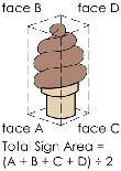
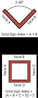
HOW SIGN AREA IS CALCULATED
Page 48 Page 49 Freestanding Signs
DESIGNSIGN
The method used for calculating sign area depends on the number of sign faces and how they are oriented. For three dimensional signs, the illustrations below indicate how sign area is to be determined. The total sign area of the freestanding sign cannot exceed the maximum allowable sign area according to Chapter 9: Signage of the UDC.


MAXIMUM SIGN AREA PER BUILDING

If a window sign covers over 50% of the window, by its outline or total shape, then it counts toward the building’s total sign area.


DESIGNSIGN
HOW BUILDING-MOUNTED SIGNS ARE MEASURED
AWNING WALLMARQUEESIGNSIGNSIGN CANOPY SIGN ROOF SIGN BLADE PROJECTINGSIGN SIGN WINDOW

Page 50 Page 51 Building-Mounted Signs DESIGNSIGN
WINDOW SIGNS
All sign faces summed up for all sides of the building equal the total sign area per building. Capping this helps to avoid sign clutter, while allowing flexibility in placement of signage on a building.

NOTE Ö These standards are only for the sign itself, not for any part of the building to which the sign is affixed or applied. A separate building permit may be required for the object to which the sign is attached, and additional standards may apply. SIGN

Page 52 Page 53 Signs Mounted on Accessory Structures DESIGNSIGN NOTES: Ö Accessory structures include gas station canopies, subdivision entry features, and perimeter walls. Ö Note that these standards are only for the sign itself, not for the accessory structure. A separate building permit may be required for the structure itself, and additional standards may apply. FASCIA SIGN ENTRY SIGN PERIMETER WALL SIGNSPANNER AND SPANDREL SIGNS DESIGNSIGN HOW SIGNS MOUNTED ON DETACHED CANOPIES ARE MEASURED


Page 54 Page 55 DESIGNSIGN BANNER TEMPORARYSIGNPOST AND PANEL SIGN SIDEWALK SIGN YARD SIGN PORTABLE TEMPORARYSIGNWINDOW SIGN
NOTES:
Ö For some temporary signs, there are limits to the amount of time the sign can be in place, and how many times per year that type of sign can be erected on your property.


Ö Some temporary signs require a permit, while others do not.
Ö There is also a requirement to register certain types of temporary signs. Sign registration does not require a fee or an application, but rather just basic information about the sign and how long it will be up. Temporary sign registration can be done on the City’s
Temporarywebsite. Signs DESIGNSIGN

All new residential developments will be responsible for parkland dedication, unless exempted under the UDC (see 2.8.B Parkland Dedication for specific requirements and applicability). Parkland dedication must be designated in your Master Development Plan, and all fees and dedications must be accepted before your plat application will be approved. The parkland dedication requirement includes the cost of the land to be dedicated, as well as the cost of developing the required park facilities.
DRAINAGEWAY PROTECTION ZONES
Watershed protection is a priority in the City of Boerne There are various protection zones and development restrictions that are in place to ensure that water supply and water quality are protected during the development process, and during the future use and enjoyment of your property. During site design, there are three areas of sensitivity with additional development restrictions: Floodplain Management, Drainageway Protection Zones and the Water Supply Protection Zone. You will be required to demonstrate compliance with these standards during the platting process or, if your property is already platted, when you apply for a building permit.
Ö To meet the parkland dedication requirement, you can dedicate the required land, or you can pay a Fee-InLieu-Of parkland development (FILO).
PARKLANDCREDITSDEDICATION
There are two drainageway protection zones (DPZs) that work to provide buffers along the stream corridors of Boerne. There are additional restrictions to land use and development activity in these areas.
Ö DPZ 1 is the approximate width of the riparian zone along the stream corridor.
Ö DPZ 2 is an extended buffer adjacent to DPZ 1.
The land within 200 feet of Boerne Lake, and any other surface water reservoir for the City of Boerne, falls within the Water Supply Protection Zone. There are additional restrictions to land use and development activity in this area.
Ö Contact Planning Department for questions about Parkland Dedication
FLOODPLAIN MANAGEMENT
Page 56 Page 57 Protection of Water Resources
Parkland Dedication
Credits may be available to offset the parkland dedication requirement, depending on what type of subdivision you are developing, for easements in conservation subdivisions, for certain environmentally sensitive land, or for certain types of private parks.
Ö In the UDC see 2.8.B for Parkland Dedication requirements, and 7.11 for Park and Trail Design
DESIGNENVIRONMENTAL
NOTES:
WATER SUPPLY PROTECTION ZONES


DESIGNENVIRONMENTAL
A Floodplain Development Permit is required for any development activity within the FEMA 100-year floodplain or City of Boerne local floodplain.
DEVELOPMENT FORMS THAT CONSERVE OPEN SPACES
Ö LID features must be incorporated into any construction plans submitted to the City for approval.
LOW IMPACT DEVELOPMENT
Cluster(ZONING)Development District (CDD) is a type of flexible zoning designation that allows for more compact lots in a project area than what the base zoning would allow, provided that the GROSS density (total number of lots divided by total acreage of the project area) does not exceed what is allowed by the base zoning. See 3.8.C Cluster Development Districts and 2.5.C Property Zoning and Rezoning in the UDC for more information about Cluster Development District zoning.
CONSERVATION SUBDIVISIONS (PLATTING)
The open space requirements in Boerne are consistent with the community’s desire to preserve the native Hill Country landscape. The UDC provides both a platting and a zoning alternative that allows for more compact development forms while preserving open space. There are conditions that must be met for each option, but they may offset offer some flexibility with regard to lot size for your project, depending on your development objectives and on project constraints. For more information, contact the Planning Department.
This approach to land subdivision requires a minimum percentage of the project area to be dedicated in perpetuity as a conservation easement. There are credits and incentives available for this style of development. See 6.8 Conservation Subdivisions in the UDC for more CLUSTERinformation.DEVELOPMENT

Ö Boerne’s Low Impact Development (LID) requirements can be found in 8.2.B of the UDC
Ö See 8.2.C Impervious Cover in the UDC for information about maximum impervious cover for your project.
DESIGNENVIRONMENTAL
DESIGNENVIRONMENTAL
Page 58 Page 59 Landscape Preservation
Ö Impervious cover is the sum of all surfaces (not just buildings) that prevent the infiltration of water into the ground. This includes amenities and accessory structures like swimming pools and slab patios.

Ö The maximum allowed amount of impervious cover is determined by where your property is located and the zoning or use of your property.
IMPERVIOUS COVER REQUIREMENTS
DISTRICT
Ö The City of Boerne Edition of SARA’s Technical Design Guidance Manual, which is available on the City’s website,
Additional design requirements can be found in 3.9 Overlay Districts of the UDC.
Illustration of landscape buffer requirement for properties fronting IH-35.


There are three sub-areas within the Scenic Interstate Corridor, with height and setbacks determined by subarea: • High Elevation Areas • Middle Elevation Areas • Low Elevation Areas
Page 60 Page 61 Environmental Design in the Overlays
SCENIC INTERSTATE CORRIDOR
HERITAGE CORRIDOR
DESIGNENVIRONMENTAL
Design of properties within this overlay district must preserve the scenic Texas Hill Country views and the natural landscape. A 30-foot natural landscape buffer is required for properties fronting IH-10, excluding utilities, and the buffer has to include trees that will help to screen buildings. Building heights may be increased the farther back a building is set from the Interstate.
The Heritage Corridor Overlay District was set up to protect the rural nature of these roadways by limiting building heights and sign heights and increasing landscaping and screening requirements. There are also additional restrictions on continuous areas of disturbance, prohibiting large plate buildings that will negatively impact drainage patterns. For information about specific design requirements in this overlay, see 3.9 Overlay Districts of the UDC
DESIGNENVIRONMENTAL

Ö
CLASS TWO LIGHTING
Ö If your existing lighting does not conform with the City’s standards, there are cases where it may have to be brought into compliance.
Page 62 Page 63 Outdoor Lighting
Ö
CLASS THREE LIGHTING
Outdoor lighting requirements are based on the use or activity where the lighting is located, not on the location of your property. There are three classes for lighting requirements, based on use. The purpose of the lighting requirements is to preserve dark skies in Boerne. Typical aspects of lighting that are regulated include on and off times, lighting levels, types of luminaires and shielding requirements.
Ö See Appendix D of the UDC for lighting requirements for the City of Boerne.
Ö
Lighting requirements for: Ö Recreational facilities Outdoor sales Lighting requirements for: Ö Parking lots Ö Street lights Ö Security lighting Lighting of canopies and service islands
Lighting requirements for: Ö Ornamental lights Lighting of walkways, bikeways and sidewalks Lighting of outdoor advertising signs Lighting of signs in windows and doors Ö Residential area lighting
DESIGNLIGHTING
NOTES ABOUT LIGHTING:
Ö
Ö
Ö An Illumination Plan is required as a part of your Building Permit Application.
Ö Make sure you are not installing a type of light that is prohibited in Boerne.
CLASS ONE LIGHTING