Large Photo of Big Meadows Reservoir; North Clear Creek Falls by Michael Underwood; Moose by Bob Seago; Up & Over Trail in Creede by B4 Studio
You deserve a break. Come visit Cripple Creek this summer and launch yourself into history. Try your luck in the casinos, observe the stunning natural views, visit our unique geological formations, and more! For more information please go to
FEATURES
20 Animals of the Alpine Tundra
In this wild and wonderful photo essay, life begins at tree line for the plucky creatures that make their homes on the treeless summits of Colorado’s highest peaks.
Story and photographs by Dawn Y. Wilson
28 Going Diagonal, Part 2
Two years after traversing Colorado on a straight line between its southeast and northwest corners, a Boulder woman walks the state along its other diagonal, hiking an ‘X’ across the state map.
By India H. Wood
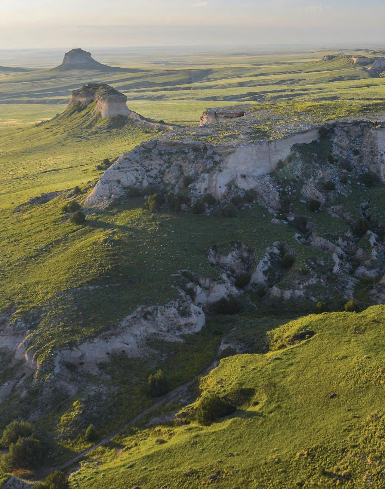
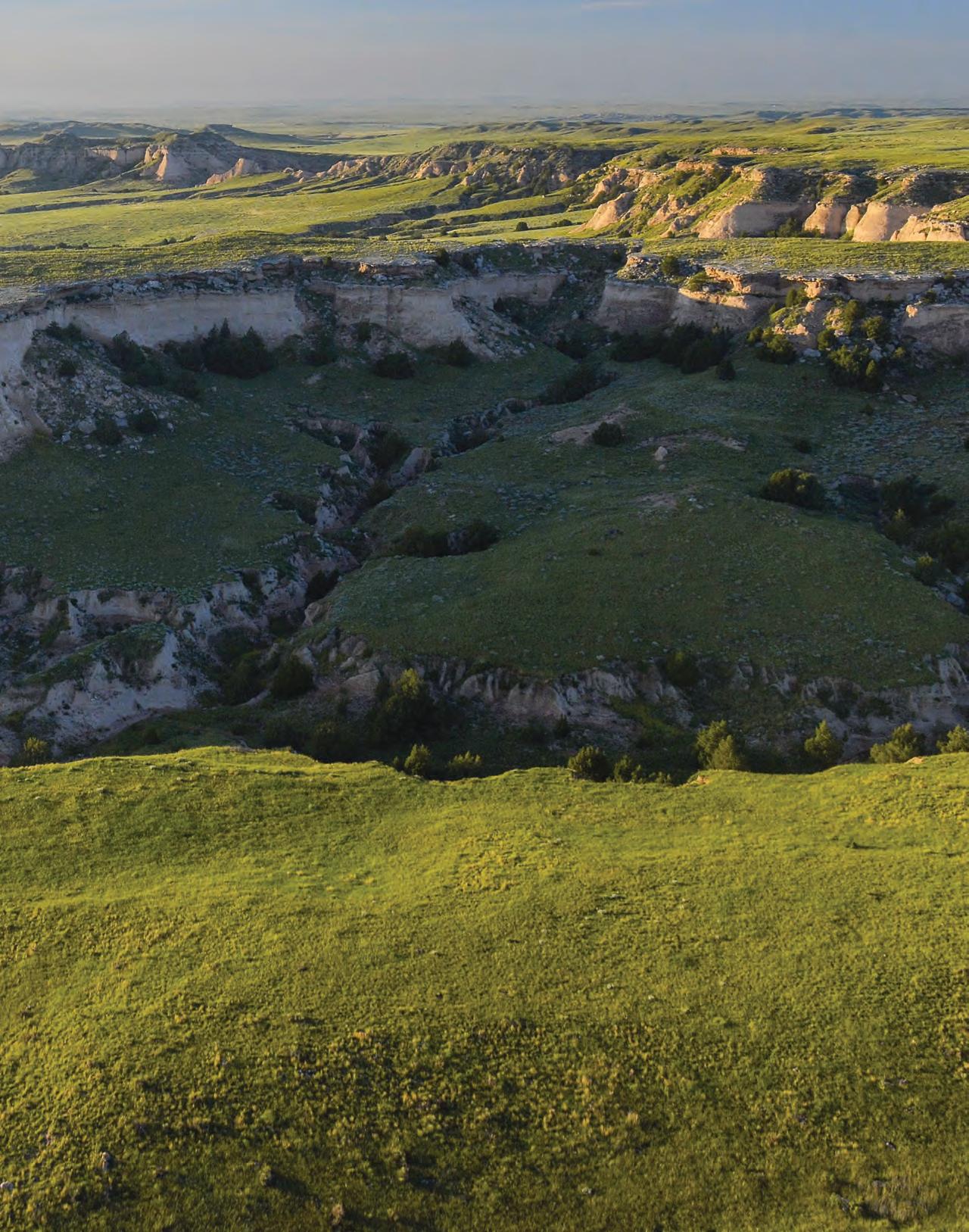
36 Pawnee National Grassland
Towering sandstone buttes, singing birds and a sea of prairie invite explorers to a timeless stretch of the Great Plains in northeast Colorado.
Story by Lisa Truesdale
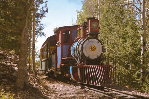
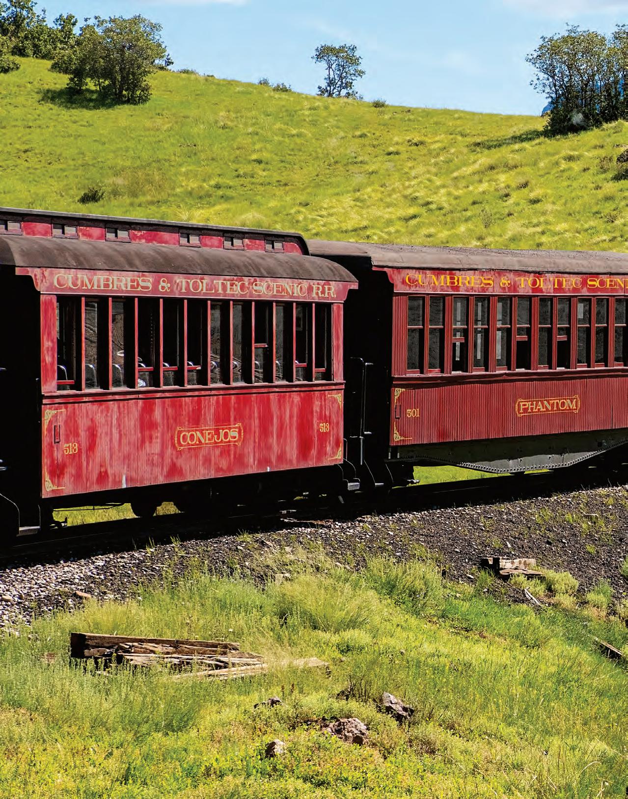
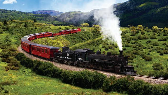
50 Cumbres & Toltec Scenic Railway
An amateur train crew lives out their dream of smoke, soot and steam as they learn to operate a historic locomotive in stunning southern Colorado scenery.
Story by Tom Hess
Photographs by Joshua Hardin
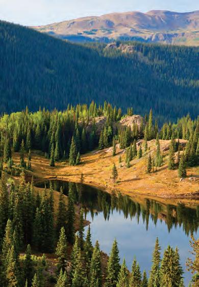
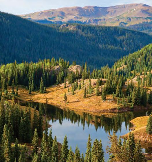
Pawnee National Grassland, p 36
Tundra Critters, p 20
Cumbers & Toltec Scenic Railway, p 50
To Durango
To Pagosa Springs
Navajo Lake
Lake Capote
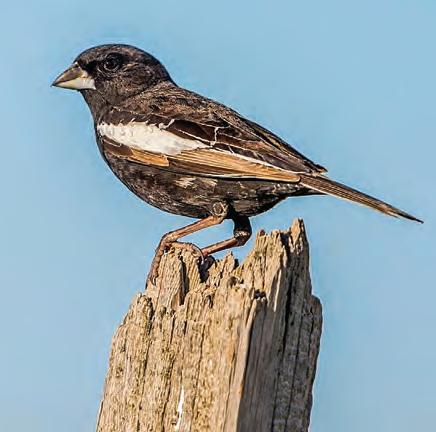
ON THE COVER
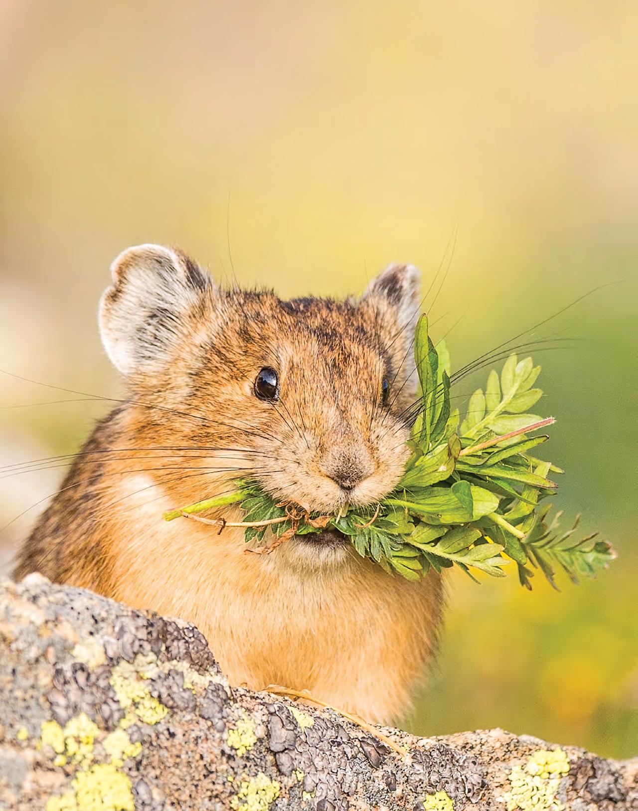
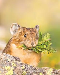
A pika gathers food for its winter reserve on the alpine tundra atop Mount Evans. Story begins on page 20.
PHOTOGRAPH BY DAWN Y. WILSON
IN EVERY ISSUE
Stories in this issue come from
Fort Collins, p 36
Julesburg, p 28
Nunn, p 36
Pierce, p. 36
Greeley, p 36
Sedalia, p 28
Mount Evans, p 20
South Park, p 28
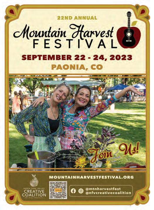
Paonia, p 59
Nucla, p 68
p 68
Cortez, p 28
Durango, p 65
Four Corners Monument, p 28
9 Editor’s Letter Observations on life in Colorado by Editor Matt Masich.
10 Mailbox
Letters, emails and posts from our subscribers.
12 Sluice Box
State park’s ruins tell tale of a burst dam, Poncha Springs winery lets folks stomp its grapes, hiking app gives intel on closed trails and a new novel celebrates Western Slope life.
18 Colorado Trivia
Test your knowledge of Colorado’s rivers and streams.
44 Kitchens
Our latest recipes help make the most of summer’s perfectly ripe, red and juicy tomatoes
Pawnee National Grassland, p 36
p 12
Buena Vista, p 28
Poncha Springs, p 16
Pagosa Springs, p 58
Antonito, p 50
48 Poetry
Poets from across the state celebrate the summertime tradition of traveling in poems that go “on the road.”
58 Go. See. Do.
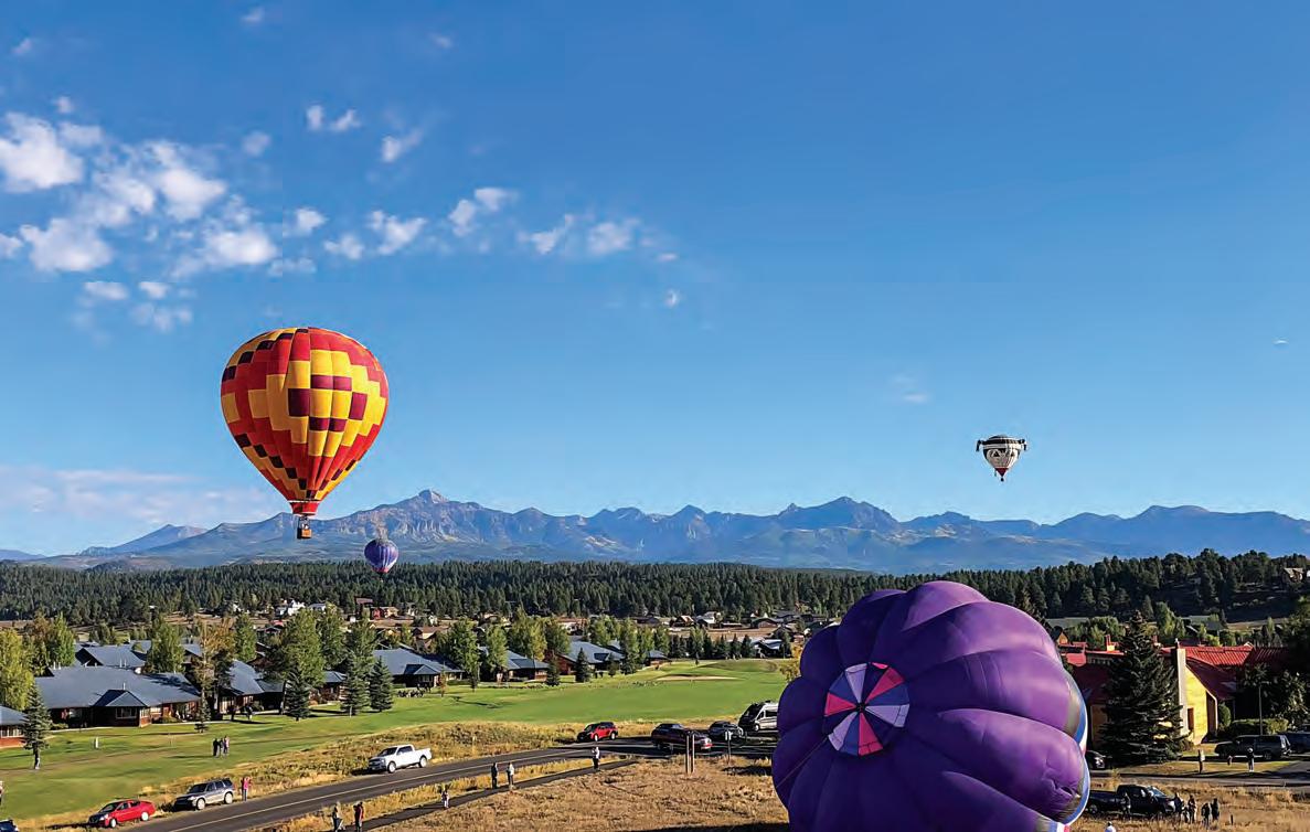
A statewide roundup of local events includes local food and music at Paonia’s Mountain Harvest Festival and hot air balloons at Pagosa Springs’ Colorfest.
64 Colorado Camping
Vallecito Campground offers lofty peaks, towering conifers and tumbling trout stream near Durango.
68 Hometown, Colorado
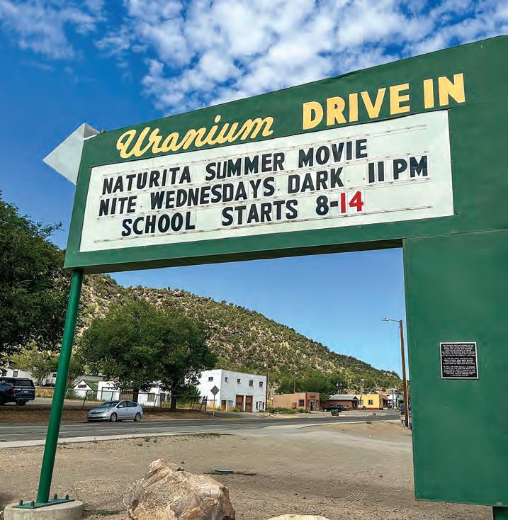
In our recurring feature on small Colorado communities, a local guide tells the story of the Western Slope’s twin towns of Nucla and Naturita, former uranium-mining towns that are now thriving in their post-nuclear era.
Above, from left: Julie Picardi, Dan Leeth, Richard Linnett
Previous page: Joshua Hardin, Dawn Wilson, Joshua Hardin
Naturita,
Franktown,
Blue Mesa Reservoir, p 13
Rocky Mountain National Park, p 20
Morgan County, p 28
Trinidad Lake State Park
RAD Dirt Fest
West Spanish Peaks
SUMMER 2023
Volume 12, Number 4
Publisher & Executive Editor
Chris Amundson
Associate Publisher
Angela Amundson
Editor
Matt Masich
Photo Editor
Amber Kissner
Design
Karlie Pape, Julia Bohan
Rebecca Velazquez
Advertising Sales
Marilyn Koponen
Subscriptions
Lea Kayton, Katie Evans, Janice Sudbeck
Colorado Life Magazine
PO Box 270130
Fort Collins, CO 80527 970-480-0148
ColoradoLifeMag.com
SUBSCRIBE
Subscriptions are 1-yr (6 issues) for $25 or 2-yrs (12 issues) for $44. Please call, visit ColoradoLifeMag.com or return a subscription card from this issue. For fundraising and corporate rates, call or email subscriptions@coloradolifemag.com.
ADVERTISE
Advertising deadlines are three months prior to publication dates. For rates and position availability, please call or email advertising@coloradolifemag.com.
CONTRIBUTE
Send us your letters, stories, photos and story tips by writing to us, visiting ColoradoLifeMag.com or emailing editor@coloradolifemag.com.
COPYRIGHT
All text, photography and artwork are copyright 2023 by Flagship Publishing Inc. For reprint permission, please call or email publisher@coloradolifemag.com.
From the Editorial Team
Colorado the Beautiful
KATHARINE LEE BATES wrote the lyrics to “America the Beautiful” after an inspiring trip to the top of Pikes Peak. The words began forming in her head as she gazed down from its summit onto the Great Plains, and upon returning to her room at the original Antlers Hotel in Colorado Springs, she jotted down the first draft of the lyrics as a poem entitled “Pikes Peak.”
For years, people have debated whether “America the Beautiful” should be the official national anthem instead of “The Star-Spangled Banner.” I take no sides on the matter. On the one hand, “The Star-Spangled Banner” is more action-packed, what with the “rockets’ red glare,” “bombs bursting in air,” etc. However, I’d argue that “America the Beautiful” says more about what makes America such a special place – namely, the stunning geographical diversity of our landscape, from “amber waves of grain” to “purple mountain majesties.”
It is hardly a coincidence that Bates wrote her paean to America’s geographical diversity in Colorado, one of the most geographically diverse states in the union. Want to know just how diverse our geography is?
Just take a look at this issue.
On page 20, writer and photographer Dawn Y. Wilson brings us a remarkable photo essay on Colorado’s alpine tundra. This harsh landscape is entirely above tree line, which in Colorado is usually about 11,500 feet above sea level. Though the tundra might look barren when you look up at the treeless mountain peaks, it is actually home to a surprising variety of plant and animal life.
My first time venturing above tree line into the tundra was on my inaugural drive to the top of Pikes Peak. I remember being amazed when the trees suddenly stopped; I felt like I was entering an entirely different world.
When Bates looked down from the Pikes Peak summit, she saw the Eastern Plains sprawling before her. In this issue, we bring you three stories from those “fruited plains.” On page 36 is Lisa Truesdale’s exploration of Pawnee National Grassland, which covers a 30-by-60-mile swath of the Plains east of Fort Collins. One of my favorite parts of the grassland are Pawnee Buttes, a pair of sedimentary promontories that rise 300 feet above the prairie, giving lie to the notion that the Plains are universally flat.
I’m especially excited about India H. Wood’s page 28 story on her diagonal hike across Colorado from the state’s northeast to southeast corners. This was India’s second diagonal trek across the state – you might recall the story she wrote for our May/June 2022 issue about her previous hike, in which she went from the southeast to northwest corners. In this issue, she talks about the farmers and ranchers – and cows – she met on the Eastern Plains segment of her expedition.
I hope this issue deepens your appreciation for just what a privilege it is that Colorado is ours to explore, from the tundra to the prairie, and everywhere in between.
Matt Masich Editor editor@coloroadolifemag.com
MAILBOX
Welcome Center resource
For the past 30-plus years, I have volunteered at the Colorado Welcome Center in Lamar. Your magazine has been a resource for me to promote events and places that may be of interest to any tourist to Colorado. I’ve been a subscriber since your first issue and sent subscriptions to friends and family with the hope they would use them as a resource for their travels in Colorado. I donate my back issues to the Welcome Center, and they don’t last long. If Colorado Life would donate unsold issues to the 10 Welcome Centers in Colorado, it would boost your subscribers.
Kaye Hainer Lamar
Places to see, things to do
After years of spending summer hiking vacations in Colorado, my wife and I moved here in April 2021. We have subscribed to Colorado Life since the beginning of 2022 and have thoroughly enjoyed every single issue.
After retiring on July 1, 2022, my wife and I have loved exploring Colorado and living our daily lives here in Loveland. While the recipes, photographs and personal stories are enjoyable, the magazine articles about certain areas and places are always intriguing. Whether it be a festival, an old general store, a historical hotel or a colorful restaurant, Colorado Life has been a terrific resource for places to see and things to do throughout all of Colorado. We look forward to exploring more of our wonderful state courtesy of Colorado Life.
Stephen Hatcher Loveland
Our favorite place
My mother grew up in Marble on the Western Slope, and it has always been our favorite place. I love all the beautiful stories your reporters tell. I recently ordered two new subscriptions to Colorado Life for two of my dearest lifetime friends moved away from the mountains and closer to family members due to health issues.
Mary Pat Carberry Bowers
Kudos from Monte Vista
I have been reading and subscribing to your Colorado Life magazine for years. Kudos for producing a high-quality magazine with excellent content and amazing photographs.
I am a native, so I know lots about the state, and your coverage is unparalleled in its overall product, quality and integrity.
Vince Ackerman Monte Vista
SEND US YOUR LETTERS
We can’t wait to receive more correspondence from our readers! Send us your letters and emails by August 25 to be published in the September/October 2023 issue. One lucky reader selected at random will receive a free 1-year subscription renewal. This issue’s winner is Carole Vancil of Lakewood. Email editor@coloradolifemag.com or write by mail to PO Box 270130, Fort Collins, CO 80527. Thanks for reading and subscribing!
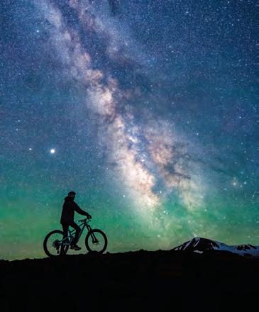
Braving the wind and cold
I loved seeing the incredible photos of the Milky Way that graced the pages of Colorado Life’s May/June 2023 issue.
In late October of last year, my photographer husband and I took a trip down to Mesa Verde, specifically for him to get shots of the Milky Way. It was a moonless, cold and brutally windy night. While I waited in the car, he hung in there until he had the shot he wanted. His talent always delights me, but what I realized on this trip more than anything was the perseverance that he and all the photographers who contribute to your pages possess.
Tracey Hough Denver
Documenting the wonders
Since I have started taking road trips on the Colorado Scenic Byways, I enjoy your pictures and articles on places I want to visit. I did six of the 26 Byways trips last year and am looking forward to making more trips this coming year. I especially like your recommendations for places to stay and restaurants to try. I have lived here almost all my life, and there is still so much to see and experience in Colorado. Thank you also for your suggestions on trips to see the fall colors.
Cyndi Powers Parachute
Adding to her collection
I must say the May/June 2023 issue of Colorado Life blew me away. Not only with the stunning cover shot but also the content and images inside. Colorado Life continues to impress with your selection of stories and photography. Each issue is a keeper. I will add this issue to my collection.
Deb Adams Westcliffe
Memories of life with father
While my sisters and I grew up on a farm in Wiggins, our family traveled to the mountains, to a place where my father could fly fish. Colorado Life brings back memories of so many places from those travels as well as introducing new places and people who make up our great state.
While I will always identify as a Colorado “farm girl,” I hope you will explore the rich history of the high plains, and what inter-
esting Coloradans are doing and creating. Starting in 2021, one of my sisters and I began giving gift subscriptions to three other members of our family, including a sister and brother-in-law who live in California. All the subscription recipients have shared how much they enjoy the magazine.
Mary Lauck Greeley
Wonderful Colorado places
My father’s family homesteaded a ranch near Snyder. My dad was a draftsman at CF&I. Our family camped and fished all over Colorado when we were kids in the 1950s. Telluride and Aspen were still ghost towns. The drive from Pueblo to Snyder was on Highway 85 – only two lanes.
I attended a Girl Scout camp named Lazy Acres near Lake Isabel and worked as a camp counselor at Camp Wilaha near Idaho Springs during the summers when I
was a student at CSU. Your magazine is like a memory book for me – stories about all the wonderful Colorado places I’ve visited and loved and how they’ve changed over my 78 years of exploring and living in this beautiful state. I have sent subscriptions for Colorado Life to family members. Thank you for documenting the many wonders of our state.
Carole Vancil Lakewood
Wow!
You never cease to amaze me. Why so? Your continuing ability to provide such splendid, concise and informative articles and photos on my beloved Colorado. Even after over 10 years of enjoying Colorado Life, I am always surprised how many new places and timely subjects you manage to find, cover and share with your readership.
Joan Fields
Brighton
NUGGETS AND OBSERVATIONS ABOUT LIFE IN COLORADO
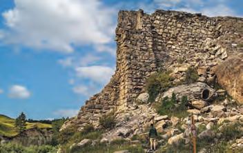
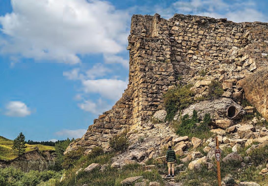
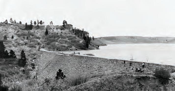
Dam’s ruins visible 90 years after bursting at Castlewood Canyon
By LEAH M. CHARNEY
When an intense thunderstorm unleashed torrents of rain on the Front Range in the wee hours of Aug. 3, 1933, it was more than Castlewood Dam could take. At 2:38 a.m., Denver got word that the dam near Franktown, 32 miles upstream on Cherry Creek, had burst, sending an 11-foot-tall,
1.2-billion-gallon wall of water toward the sleeping city.
Officials dispatched every police car and firetruck in the city at 4 a.m. to rouse and evacuate residents in the flood’s path. The all-out effort paid off: By the time floodwaters hit Denver at 7 a.m., nearly everyone had fled to safety, with only two people drowning.
Ninety years later, the ruins of Castlewood Dam can still be viewed along Douglas County Highway 51, also called Castlewood Canyon Road. The masonry dam, 70 feet tall and 83 feet wide at its base, looks much as it did in the immediate aftermath of the flood, with a huge chunk missing where it gave way that fateful night. In seeing the ruins, “you picture the reservoir
Hikers at Castlewood Canyon State Park near Franktown can walk right up to the 70-foot-tall masonry remains of what was once Castlewood Dam, which burst in the middle of the night in 1933, sending a massive wall of water down Cherry Creek to Denver.
Julie Picardi
Castlewood Dam was built in 1890 to give irrigation water to local farmers. When it burst, the resulting flood caused major damage in Denver, but only two people died.
filled to its brim” said Katie Rudolph, an archivist and librarian at Denver Public Library, “torrents of rain coming down, and the stone dam burst open.”
The dam ruins are now part of Castlewood Canyon State Park. South of Franktown, the canyon cuts into a treeless plateau that is roughly equidistant from Colorado Springs and Denver, with both Pikes Peak and Longs Peak in view. There’s so much scenery visible from Colorado State Highway 83 that motorists might miss the signs for the Castlewood Canyon and see only a portion of it along the west
side of the two-lane road.
The park is a micro-environment of the state – dry conditions up top, lush habitat creekside. And in its midst are the remnants of the failed dam.
The loss of Castlewood Dam made Denver residents worried about controlling future floods on Cherry Creek. The year after the dam burst, the city acquired land more than 20 miles south of Castlewood to build a replacement known as Kenwood Dam, which served as a stopgap until the much larger Cherry Creek Dam was completed at the same site in 1950.
Debut novel set in drowned peach town
By LISA TRUESDALE
In the 1960s, the U.S. Bureau of Reclamation constructed Blue Mesa Dam on the Gunnison River. The resulting Blue Mesa Reservoir submerged three small ranching towns in the valley. One of them was Iola, the place where author Shelley Read, a fifth-generation Coloradan, chose to set her debut novel, Go As a River
“I have long wondered what life and loss were like for the residents,” said Read, who was also a senior lecturer in writing, literature a n d environmental studies at Western Colorado University for almost three decades.
Read weaves into her fictional tale a very real Western Slope crop: peaches.
The book’s main character, a young woman named Victoria Nash, grew up on her family’s peach orchard in Iola. We weep for Victoria when she suffers through heartbreak and tragedy, and we rejoice when she emerges whole on the other side.
Go As a River is an engrossing tale, a celebration of juicy Colorado peaches, an interesting history lesson and a reminder about acceptance of those who are different.
Or, as Victoria herself declares near the end of the story: “We are one and all alike if for no other reason than the excruciating and beautiful way we grow piece by unpredictable piece, falling, pushing from the debris, rising again, and hoping for the best.”
Go As a River, By Shelley Read, Speigel & Grau, 302 pp, hardcover, $28
Colorado History Museum
Denver Public Library
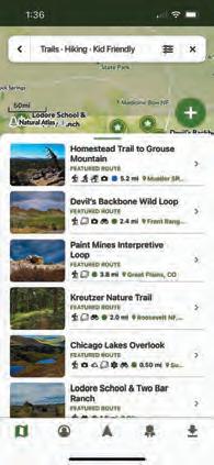
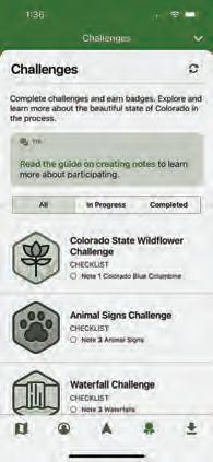
Statewide trail app keeps hikers on right path
By MATT MASICH
Springtime in Colorado is mud season, when snowmelt turns trails into impassible soup. In an average year, mud-season runs from mid-April to the end of May – but this year has been anything but average, meteorologically speaking. The heavy rains that fell throughout June 2023 made it by far the wettest on record for many Front Range communities, prolonging mud season and causing many hiking trails to close due to excessively muddy conditions.
It’s no fun to arrive at a trailhead only to discover the trail you looked forward to hiking is closed due to mud, maintenance work or other reasons, but Colorado Parks & Wildlife has come up with a way to avoid such disappointing surprises with its free Colorado Trail Explorer app. Known as COTREX for short, the app provides information on 2,350 trailheads and 45,000
trail miles statewide, with color-coded maps showing which sections of trail are closed, the reason for the closure and the anticipated time of reopening.
While COTREX doesn’t cover every single trail in Colorado, it does include information on all 43 state parks and a host of county-operated land. All told, some 236 land managers across the state update the app with up-to-the-minute details on trail closures. This gives COTREX a distinct advantage over other apps that rely on crowd-sourcing for their trail information, Colorado Parks & Wildlife’s Kara Van Hoose said.
“A lot of trail apps are user-based, relying on people who use the trails to go on the app to update others on closures and changes,” Van Hoose said. “COTREX is actually run by the people managing the trail, who repair the trails or close them. That’s why it’s the most accurate, best information.”
The app debuted in 2019, but Colorado
Parks & Wildlife has continually updated it with new functionalities. The most recent version introduced a tool allowing users to draw their own routes and calculate the exact distances they cover.
COTREX is designed to allow the least tech-savvy hiker to use it with ease, while offering advanced features for the more technologically adept. Users can look up recommended hiking routes suggested by park managers. Users can also create and save their own favorite hiking routes with notes on the trail, keeping a record of past hikes for future reference or to send to friends.
Just because a trail is open doesn’t guarantee it will be mud-free, Van Hoose said. She reminds hikers that, if and when they encounter muddy stretches not to veer off the designated path, which can damage vegetation and erode the landscape.
“If the trail is open, embrace the mud,” she said. “Stay on the trail, and don’t trample things off-trail.”
The looping trails at Paint Mines Interpretive Park near Calhan represent just 4 miles of the 45,000 trail miles cataloged on the COTREX app.
Joshua Hardin
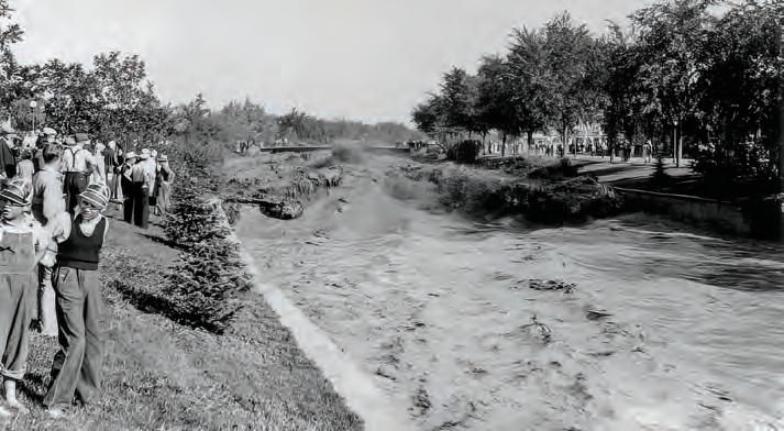
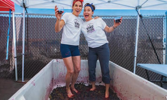
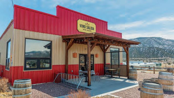
Poncha Springs winery goes old-school with state’s only wine stomp
By JESSICA HUGHES
While many wineries have modernized their production process in extracting juice from grapes, there’s one Colorado winery that still preserves one of the oldest traditional practices of winemaking: stomping grapes with your feet.
Vino Salida Wine Cellars – located 5 miles west of Salida in Poncha Springs –holds its Tenderfoot Grape Stomp each harvest, where anyone can come and squish grapes between their toes. The ancient tradition dates back to early winemaking cultures, when grape stomping was the primary method of extracting juice from grapes. People would remove their shoes, roll up their pant legs and crush the grapes with their bare feet inside large barrels.
Owner and winemaker Steve Flynn,
EXPERIENCE the splendor of the Rockies at Aspen Winds. e secluded setting along Fall River o ers a relaxing atmosphere among the aspen and pines. Aspen Winds is located minutes from Estes Park and Rocky Mountain National Park. We o er one and two bedroom suites and in-room spa suites.
Vino Salida Wine Cellars invites people to roll up their pant legs and squish some grapes at its annual Tenderfoot Grape Stomp at its Poncha Springs tasting room.
Courtesy of Vino Salida
in addition to producing award-winning wines, has also created a welcoming space for celebrating life and wine by keeping this tradition alive. Vino Salida’s founding story ties heavily back to its first ever grape stomp, he said.
“It has not only helped us make wine but build a community as well,” Flynn said. Instead of buying a crusher, Flynn thought, why not include the local community to be involved in the crushing process? “So, we started the annual grape stomp. We celebrate our 20th year in 2023.”
The entire production, from beginning to end, is done on site at their Poncha Springs location, from the grape stomp to bottling. Using only Colorado grapes, the small-batch winery produces about 1,000 cases a year, with many of their wines winning awards. The Vino Rosso di Salida is their most popular wine, but the most unique offering is their Vermouth. Since 2014, they are Colorado’s only producer of Vermouth, a fortified wine heavily flavored with herbs. “What were once prob-
lem batches for me, I distilled and turned into Vermouth,” Flynn said.
Held on Sept. 23, the Tenderfoot Grape Stomp is free and open to the public. Each attendee gets their own stomping bin and a time limit so everyone can join in on the fun. There will be a food truck and live
music. It’s best to try and get there within the first hour, as the open slots for the grape stomp are very competitive.
Flynn attributes much of the winery’s success to the community. “We even bring in volunteers for bottling,” he said. “It’s a community effort.”
Jessica Hughes
TRIVIA RIVERS
BY BEN KITCHEN
1The San Juan River starts in Colorado but courses mostly through New Mexico and Utah. After leaving our state, it briefly cuts back into southwestern Colorado just a few miles from what monument?
2 Weirdly enough, Colorado is home to rivers named after two midwestern states: Illinois and Michigan. Stranger still, they meet just northwest of what Jackson County seat, which shares its name with a famous pond in Massachusetts?
3 What alliteratively named stream, which lends its name to the home county of Mount Evans, Idaho Springs and Loveland Ski Area, meets with the South Platte River in southwestern Adams County, about 2 miles west of Rocky Mountain Arsenal?
4 Rafting company Arkansas River Tours’ “premier trip,” which fittingly starts in Cañon City, takes rafters through what regal geologic feature on the Arkansas River?
5 With a name that’s French for “hide the powder,” what is the only river in Colorado that Congress has designated as a National Wild and Scenic River?
Eve Nagode
Dawn Y Wilson
MULTIPLE CHOICE
6
What river in southwestern Colorado flows through the Black Canyon? As a result, this river is referenced in the name of one of Colorado’s national parks.
a. Gunnison
b. San Miguel
c. Uncompahgre
7
What is the longest river that flows out of Colorado?
a. Arkansas
b. Colorado
c. Rio Grande
8 While it primarily flows through New Mexico, Texas and Oklahoma, southwestern Las Animas County is home to the headwaters of what river with a geographically confusing name?
a. Brazilian River
b. Canadian River
c. Dutch River
9
What is the geographic significance of the point where the Arikaree River flows out of Colorado in eastern Yuma County?
a. It’s where Colorado, Nebraska and Kansas meet
b. It’s the geographic center of North America
c. It’s the state’s lowest point by elevation
10
Which colorful river is not a tributary of the Colorado River that flows in Colorado but rather a tributary of the Rio Grande in New Mexico.
a. Red River
b. Green River
c. Blue River
TRUE OR FALSE
11
Southern Colorado’s Purgatoire River has had several names throughout its history. The current name is French for “purgatory,” but one of the others, Picketwire, came about because of a long fence built on its banks.
12
At a mere 201 feet long, Colorado’s Roe River is the shortest river in the United States, according to the Guinness Book of World Records.
13
In an unusual confluence of rivers and culinary implements, the Fryingpan River is a tributary of the Roaring Fork.
14
Despite the eerie image of the Animas River turning orange after the Gold King Mine spill, the event’s environmental impact has thankfully been minimal, with fish populations experiencing almost no change.
15
Colorado is home to the Big Thompson and Little Thompson rivers, which are curiously named, as the Little Thompson is slightly longer than the Big Thompson.
On Saturday Aug. 5, 2023
No peeking, answers on page 66.
Dawn Y Wilson
begins at Life
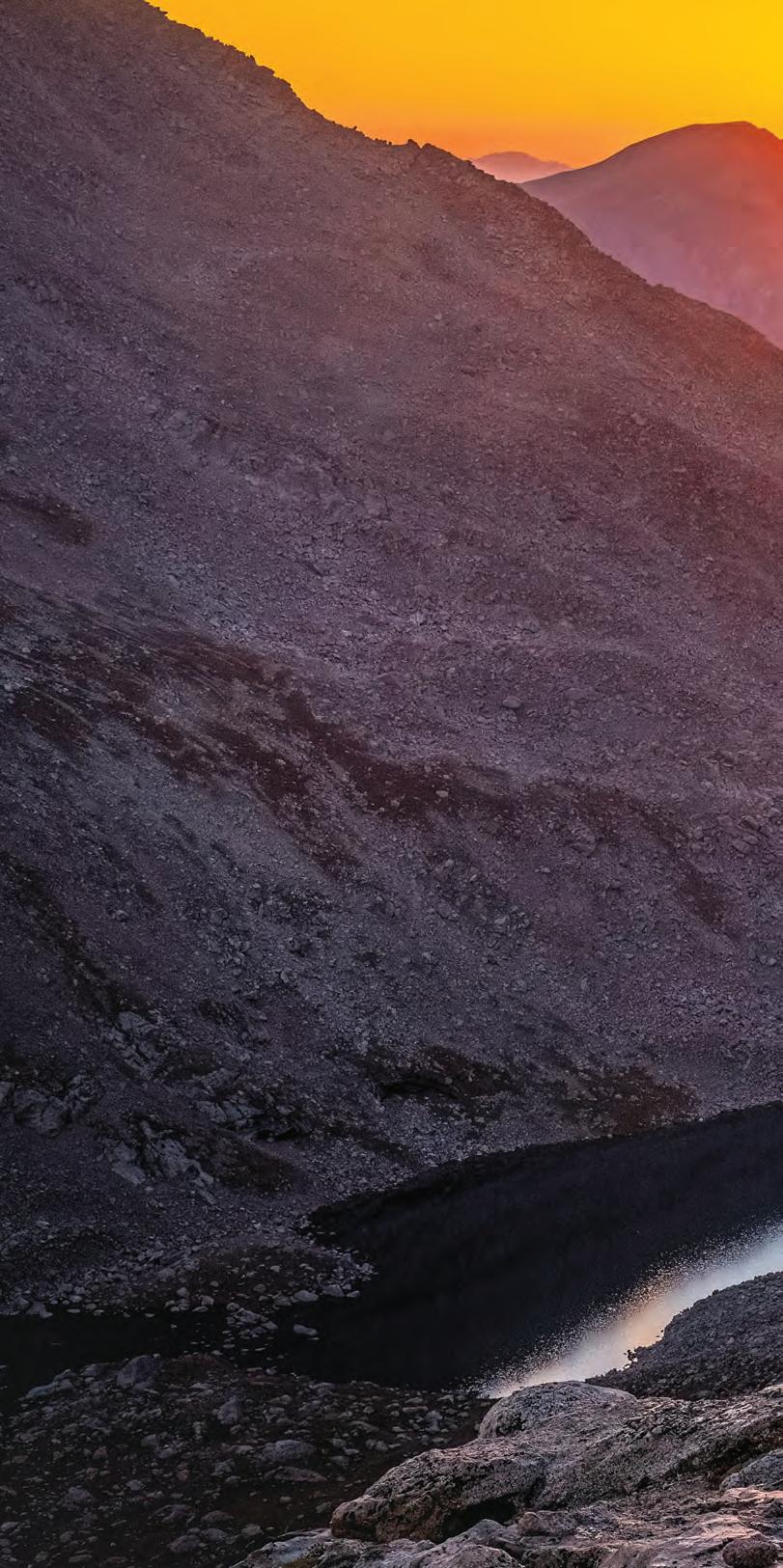
Hardy animals thrive on the unforgiving treeless slopes of Colorado’s alpine tundra
Story and photographs by DAWN Y. WILSON
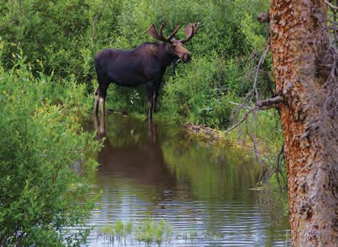
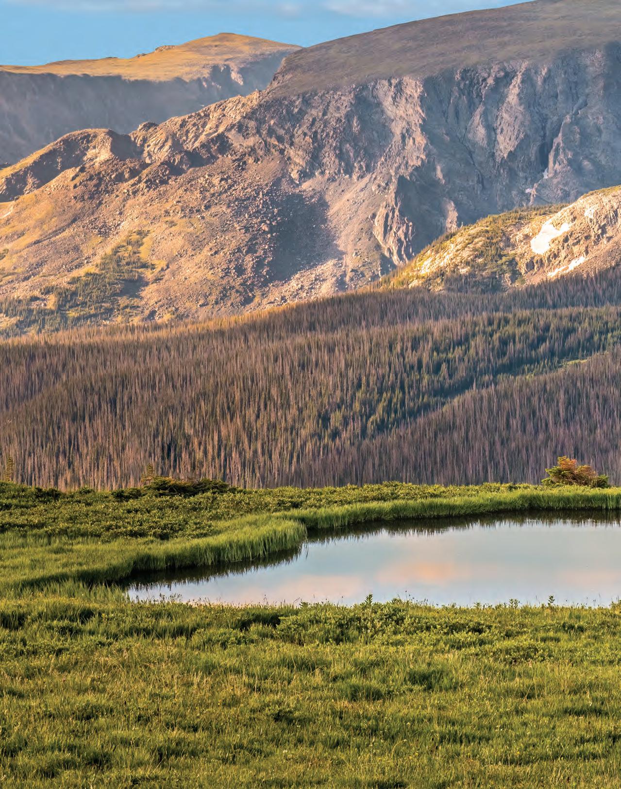
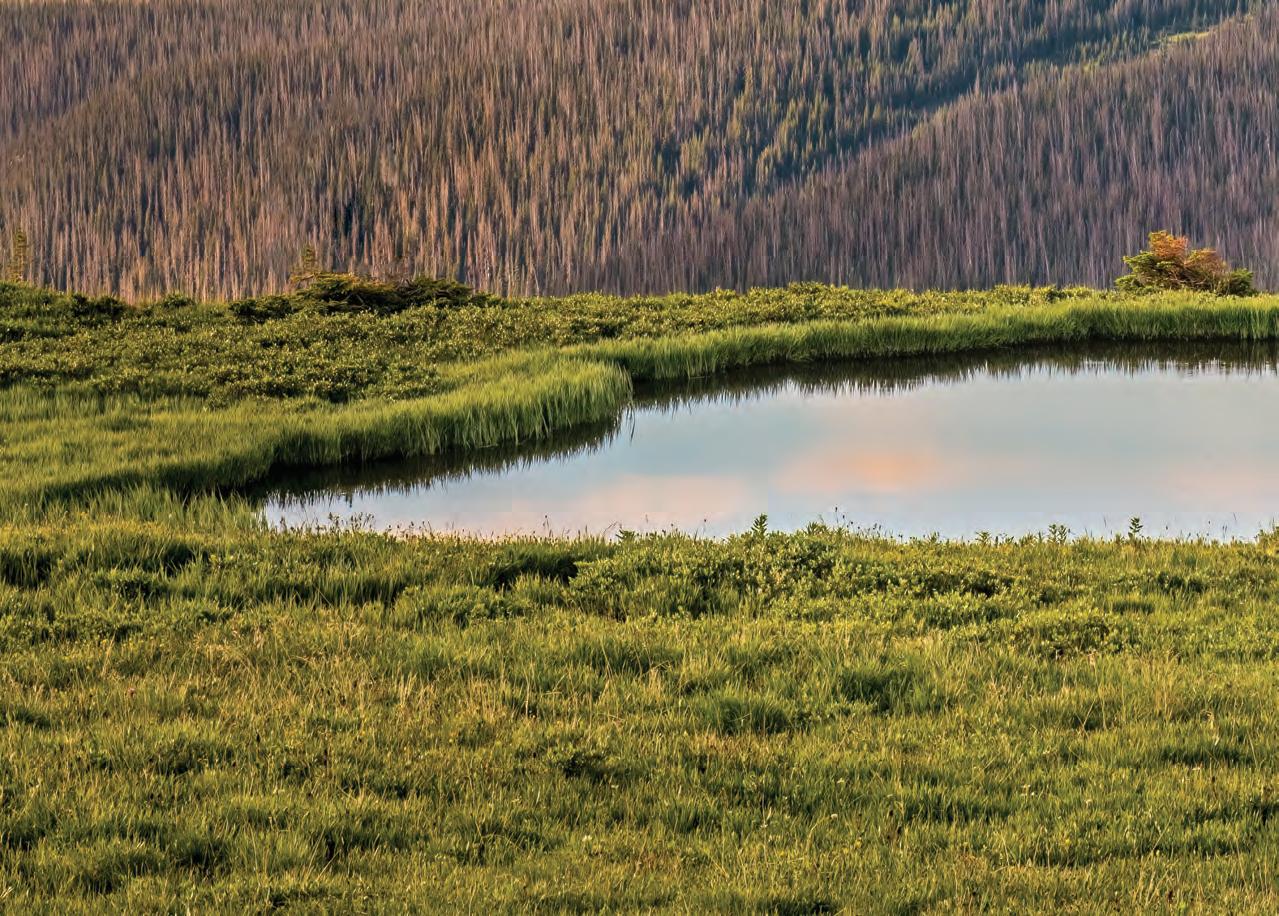
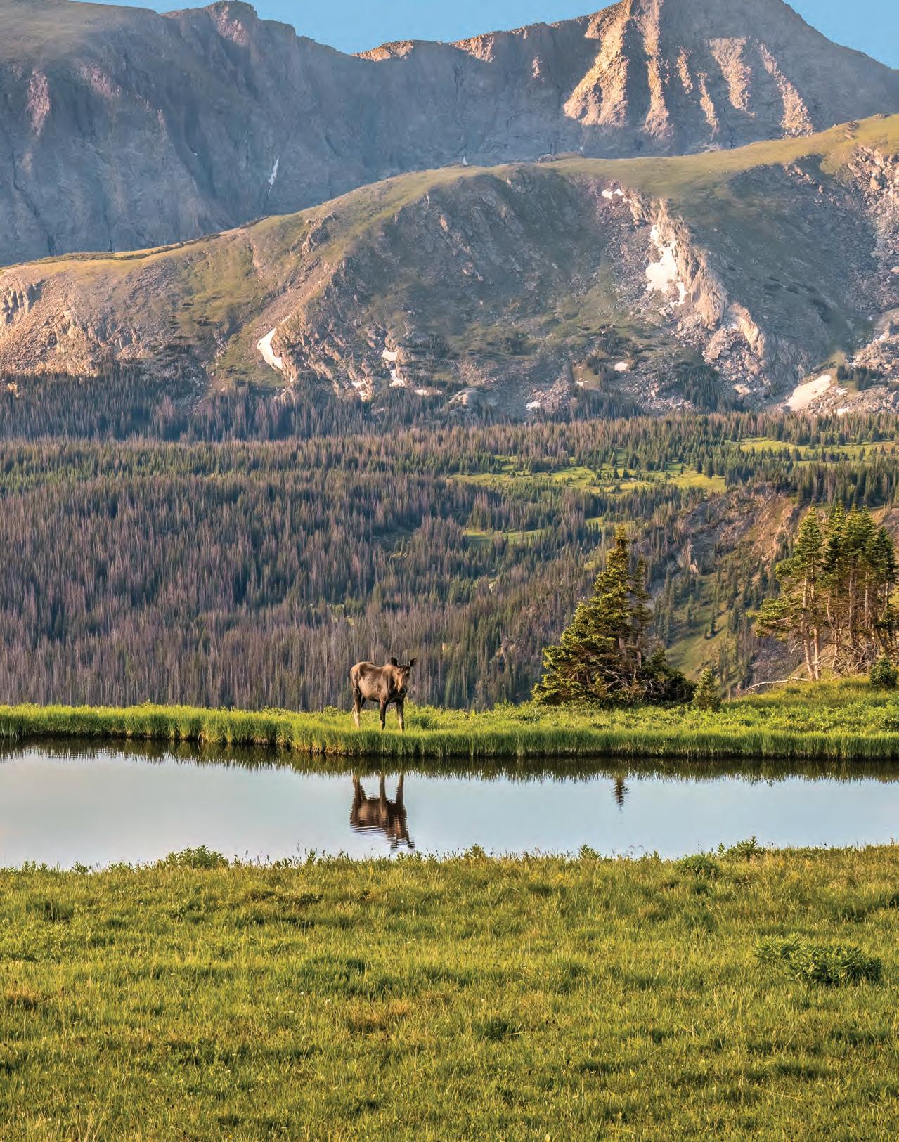
A cow moose stops along the edge of an alpine pond on a calm morning on the alpine tundra of Rocky Mountain National Park.
THE COLORADO LANDSCAP E
hosts a wide range of ecosystems, each with its own unique topography, climate, plants and animals. As you travel east to west, each ecosystem blends into the next as the elevation rises.
That said, I can think of one boundary that clearly marks where one ecosystem ends and another begins, one that can be seen from miles away: tree line.
Below tree line, or about 11,500 feet in Colorado’s mountains, forests of the montane and subalpine ecosystems provide thick cover for their inhabitants. But at tree line, all plant and animal life comes to an abrupt halt, leaving the mountaintops utterly barren – or so it appears from afar.
Appearances can be deceiving. Although cold temperatures, strong winds and heavy snow may prevent tall trees from growing at the highest elevations, my explorations above tree line have taught me that life most definitely continues past the trees. Where the trees stop, the alpine tundra ecosystem begins. Though harsh, it is hardly a wasteland – in fact, it makes an ideal home for the hardy plants and animals that have adapted to thrive in this seemingly inhospitable landscape.
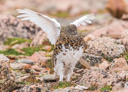
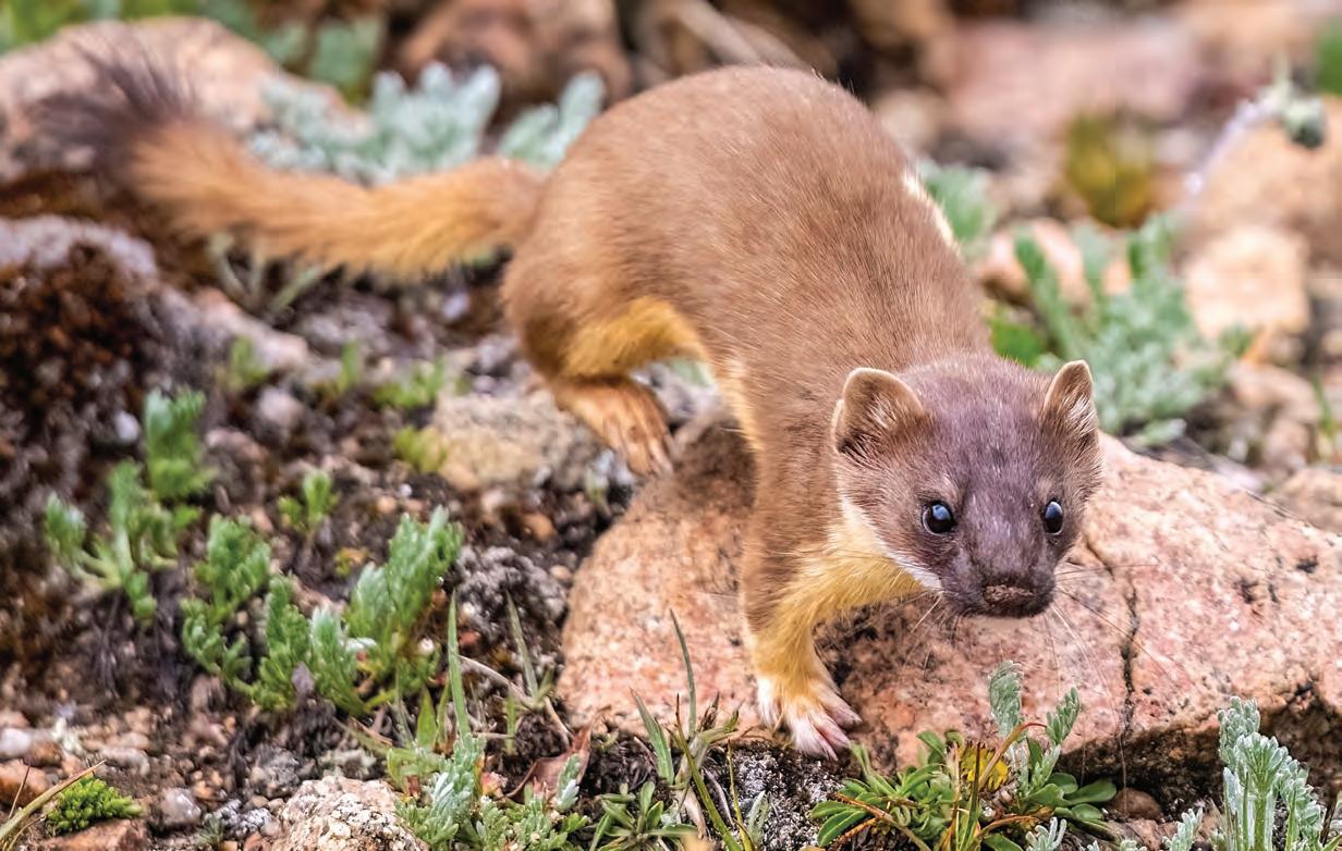
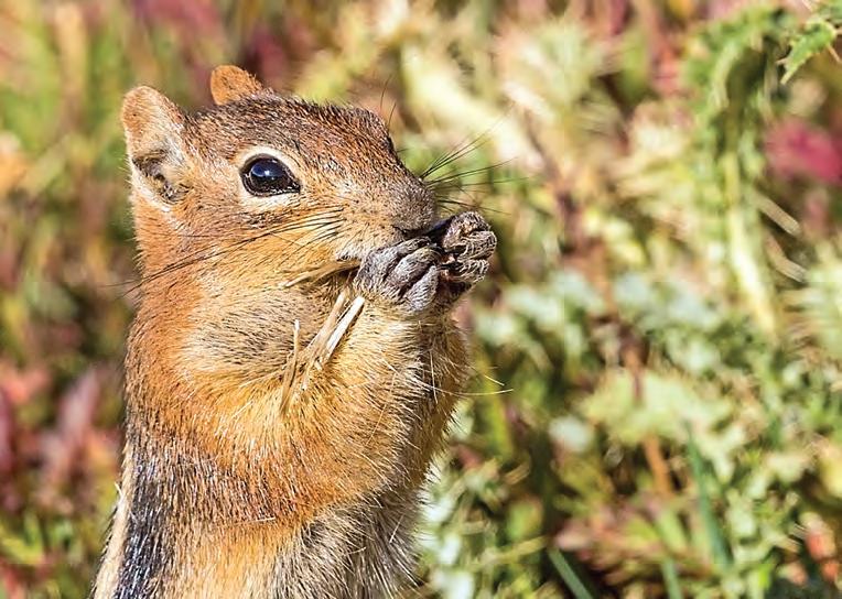
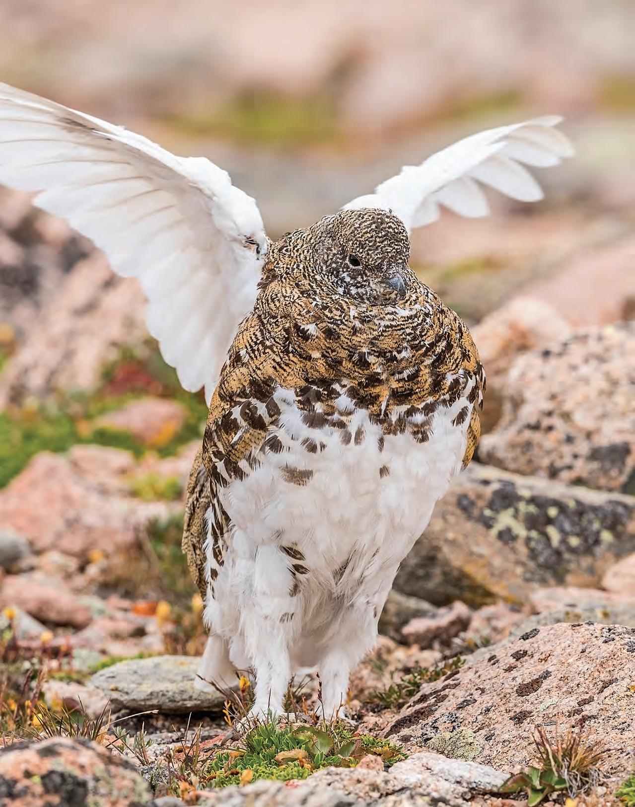
At top, a long-tailed weasel scampers across Mount Evans’ rocky tundra. Below, a golden-mantled ground squirrel stands up on his hind legs to eat thistle seeds on a sunny morning in Rocky Mountain National Park, Colorado. At right, a white-tailed ptarmigan, whose molting feathers are transitioning from winter white to summer brown, flaps its wings on Mount Evans.
THERE IS NO TUNDRA in New Jersey, where I grew up. The contrast between my home state and Colorado, where I fell in love with the alpine tundra, is the contrast between 1,803 feet – New Jersey’s highest point – and 14,439 feet – Colorado’s highest point at Mount Elbert’s summit.
The Garden State’s sea of hardwood trees turns gold, orange and red each fall, amplifying the beauty of the lakes, streams, cedar swamps and rolling hills. In Colorado, I found an entirely new type of beauty in the rugged Rocky Mountains. An initial 1997 horseback ride into Rocky Mountain National Park introduced me to its rocky ledges with views that took my breath away, but I experienced an even greater thrill on my second visit to the park when I first saw the tundra.
The tiny, colorful vegetation fascinated me – lichens, grasses, mosses, sedges, dwarf plants and wildflowers blanketing the ground above tree line. How could they thrive in an environment where wind, thin air and freezing temperatures drastically affect life? Yet life endures. Bighorn sheep, elk, American pikas and yellow-bellied marmots, too – they seemed so well adapted. I found it incredibly inspiring.
The word “tundra” originates from the Finnish word “tunturia,” meaning barren or treeless plain. Alpine tundra, a fragile ecosystem, covers only about 3 percent of Colorado’s landscape, but Colorado contains 25 percent of all alpine tundra habitats in the lower 48 states. Much of the tundra of Colorado is protected by law and undeveloped.
Tundra temperatures range from 64 degrees down to 40 degrees below zero, but strong winds can make even the warmest days feel bitterly cold.
Colorado roads and trails offer an opportunity to explore this landscape yearround in places like Rocky Mountain National Park and Indian Peaks Wilderness, as well as on Pikes Peak, Quandary Peak and Mount Evans.
During the winter, the alpine tundra is
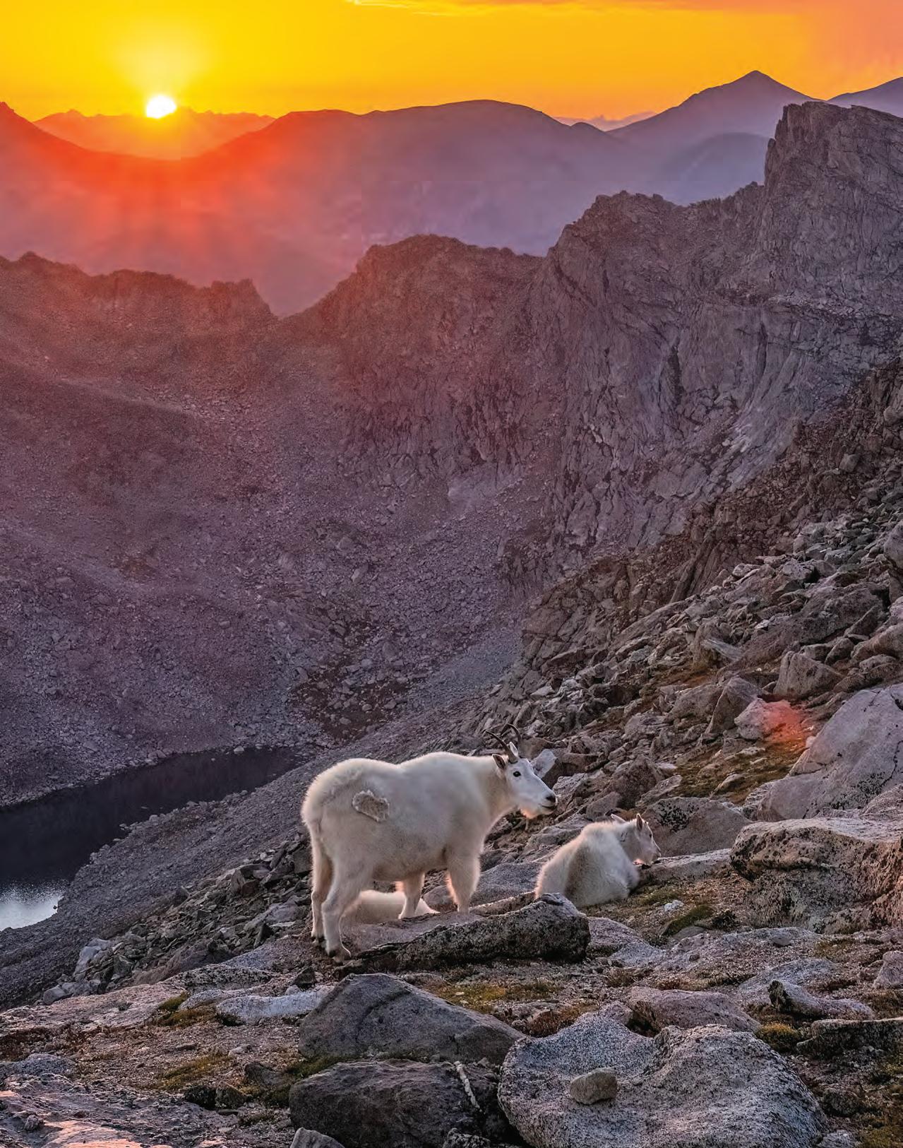
A mother mountain goat and her two kids make their way across the tundra as the sun sets on Mount Evans.
as quiet and peaceful as blustery winds allow. In the short summer, late June through early August, the landscape turns vibrant green. When the temperatures drop in late August and the first frost bites, the plants begin their transition into the kaleidoscope of fall colors.
The array of wildlife on the ground and in the air is more diverse than this former sea-level girl might have expected.
Mountain bluebirds, American pipits and brown-capped rosy finches all nest in the alpine tundra of Colorado. Golden eagles, American crows and various hawks soar on the thermals swirling around the mountain peaks. And white-tailed ptarmigan live the entire year above tree line, molting between white feathers in winter and mottled brown and gray in summer to hide from predators.
Yellow-bellied marmots – the round, sun-loving cousin of the groundhog that
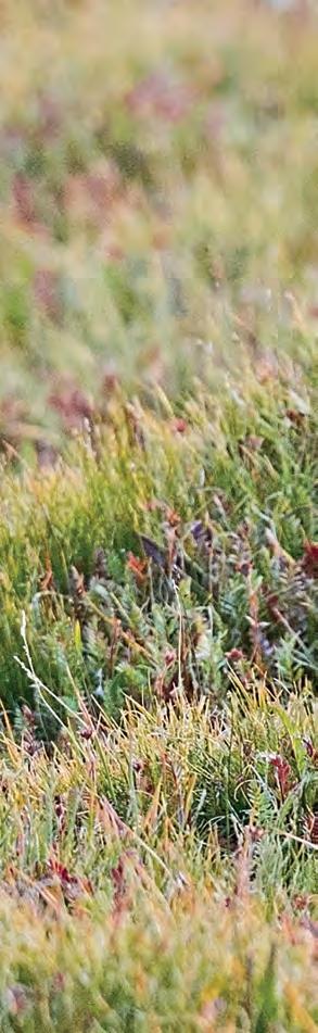
gets its fanciful nickname “whistle pig” thanks to its high-pitched warning chirp – hibernate more than half of the year to survive the challenging elements.
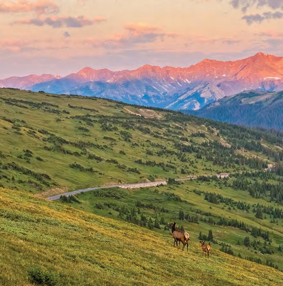
Elk, bighorn sheep and mule deer migrate to lower elevations as the weather cools, following the food down the mountains and canyons before snow covers up what is left of the nutrition in winter, but they spend the summer on the open terrain of the tundra enjoying the abundant plants.
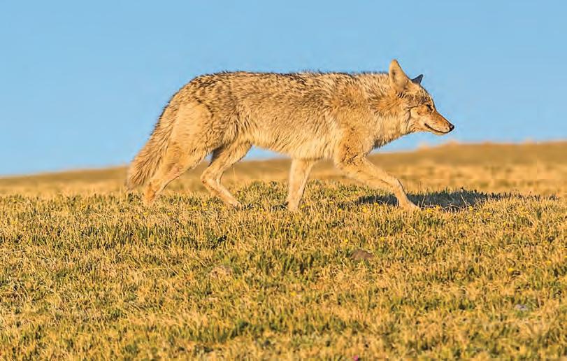
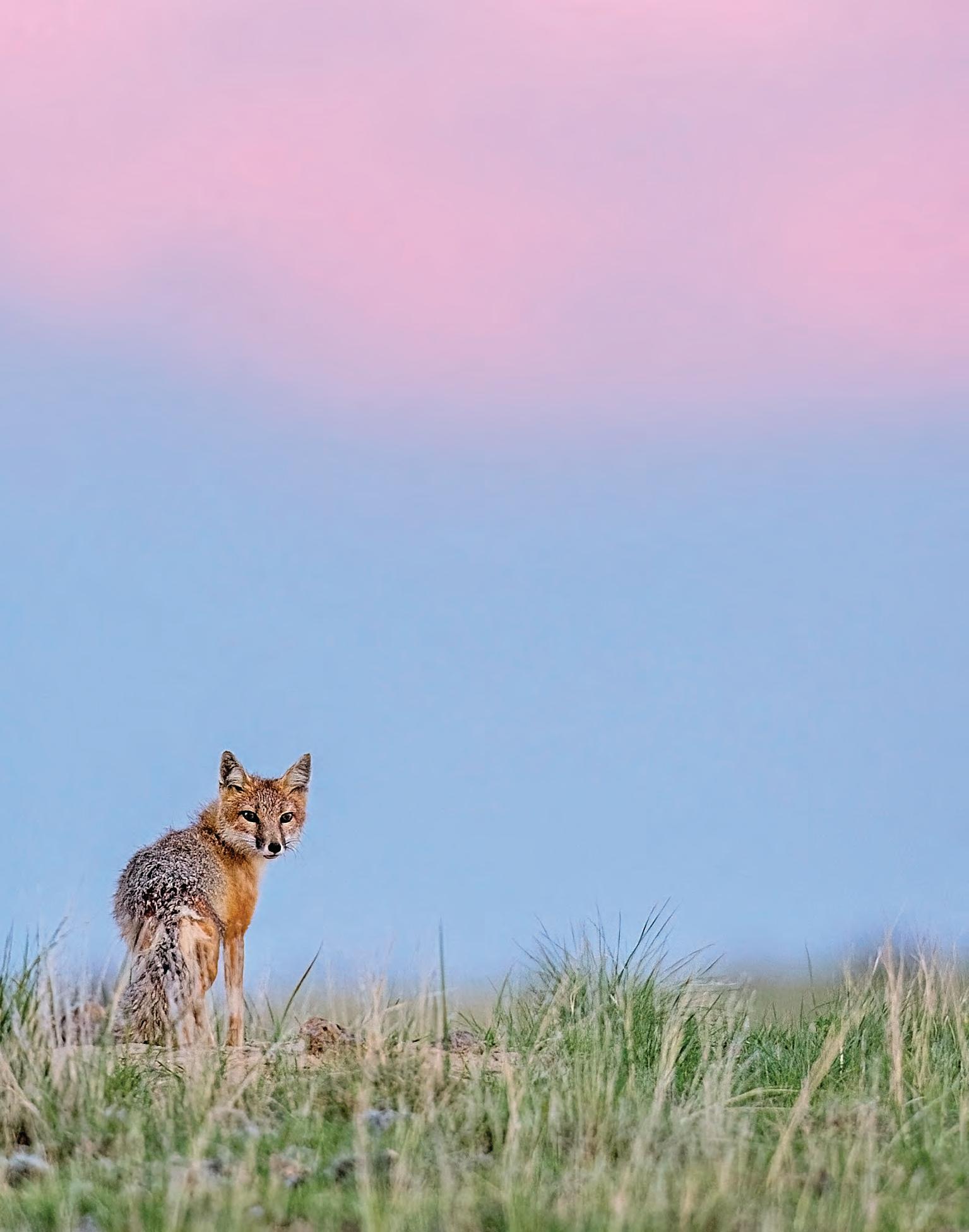
Coyotes and red foxes may stay in high-elevation meadows in winter, pouncing for small mammals under the snow, while in summer, they cruise the tundra seeking unsuspecting marmots and ground squirrels.
American pikas, which do not hibernate, gather flowers, grasses and other plants throughout the summer, hiding them in caches under boulders to feed on when cold weather returns.
Snowshoe hares have large hind feet
lined with stiff hairs that act like snowshoes to help them navigate across the snow in winter. They bound across the tundra disguised by a fuzzy coat of grey hair in summer.
Weasels, like snowshoe hares, change to an all-white winter coat to help them hide from their prey as they tunnel through the snow. In summer, their sleek bodies allow them to quickly move through the talus slopes while hunting their next meal.
And the mountain goat, while not native to Colorado, is the icon of the mountains’ highest elevations, where they navigate steep cliffs with ease using rubbery footpads and cloven hooves.
Summer months bring an abundance of wildlife to the alpine tundra, where they can escape the heat and biting insects of lower elevations. But it takes more effort to flourish here, especially for those animals that live in this ecosystem year-round. Knowing what a tenacious will to live it takes to survive, let alone thrive, above tree line has made my animal encounters here that much more meaningful.
After more than 25 years exploring Colorado’s alpine tundra, I still feel a sense of wonder that such an unforgiving place is home to such a diverse array of wildlife –and a sense of gratitude to be an occasional guest in their high alpine home.
A cow elk and her calf walk the alpine tundra near Trail Ridge Road as a new day begins in Rocky Mountain National Park. Elsewhere in the national park, a coyote stands out against a clear blue sky during the afternoon golden hour. Nearby, a yellow-bellied marmot gathers grasses and plants to use for bedding in its winter den.
Walking an ‘X’ across Colorado Diagonal Going PART II
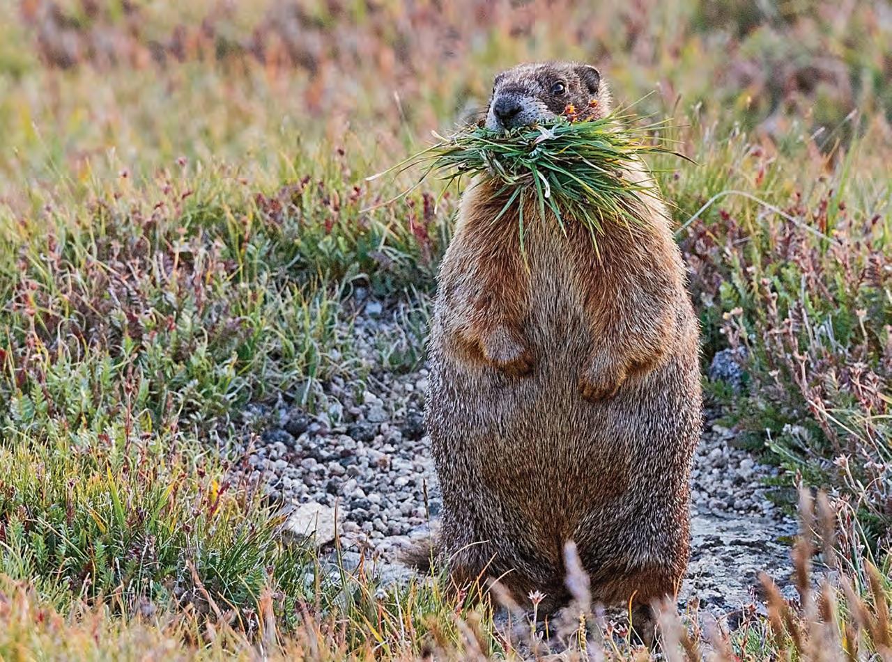
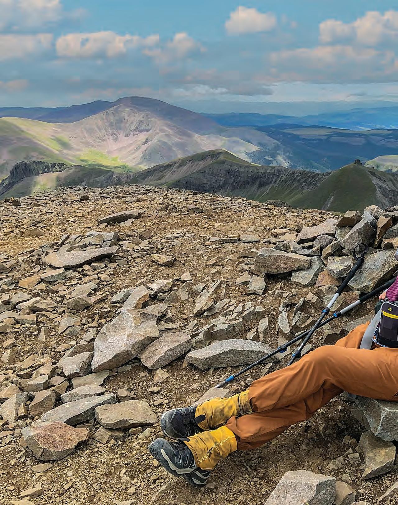
India H. Wood celebrates the high point of her 740-mile hike on top of San Luis Peak, elevation 14,023 feet, in the San Juan Mountains.
Ryan Ernstes
Diagonal
by INDIA H. WOOD
In 2020, India H. Wood of Boulder walked nearly 750 miles across Colorado in a diagonal line from the state’s southeast corner to its northwest corner
– an expedition she recounted in her Colorado Life May/June 2022 story
“Going Diagonal.” She now brings us the story of her journey last year along the state’s other diagonal, where her goal was to meet people and learn about their connections to the land across Colorado.
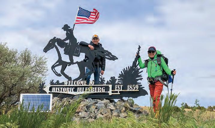
IN THE QUIET of Colorado’s northeastern corner, a meadowlark trilled from its far western Nebraska perch. Then, “BANG!” My friend Jim in his blue “Amen” ballcap fired his starting pistol. I yelped, having forgotten the blast was my idea.
The shot had been the signal for me to begin my second diagonal hike across Colorado. My friend Dennis Lyamkin had started the previous diagonal hike with me on May 11, 2020, at the manhole cover marking the state’s southeast corner. Now, on May 20, 2022, Dennis was with me once again as we ceremonially lifted our feet off a head-size concrete block embedded with a bronze geological survey marker proclaiming, “NORTHEAST CORNER COLORADO.”
My plan for the 2022 diagonal: Stride steadily uphill along the South Platte River basin past Julesburg, Sterling, Fort Morgan and Aurora to South Park, in Park County, where the river begins. Then I would make my rocky way to the Continental Divide west of Buena Vista, slip into the Gunnison River basin and struggle across the formidable San Juan Mountains of Silverton and Rico and dip into the desert beyond Cortez to the Four Corners. Mostly solo.
Dennis bounced me over the northeast monument’s fence into Jim’s hands like catcher’s mitts. The previous night, Jim and Charlene Dolezal had hosted me, Dennis and filmmaker Ryan Ernstes at their tidy farm, where we had all toasted my odd route across the state with an ancient bottle of moonshine.
Charlene strode with Dennis and me south on Sedgwick County Road 63. Two shaggy donkeys eyed us between bites of spring grass, then scurried away suspiciously. I’m sure they’d seen grain trucks, pickups, fertilizer vats, but never humans with backpacks. We elbowed a turn west
on County Road 34, through the Dolezals’ land. Charlene’s presence connected us with the fields here, soil she and her husband had tended for decades. She knew who owned each parcel, their family histories, and the hailstorms and grain price fluctuations that had shaped this place.
A cold west wind carried the scent of earth and fertilizer from checkerboard fields of last year’s pale corn stalks, the green of young wheat and fallow brown. My feet were not allowed to cut across private fields, so I stuck to dirt county roads, zig-zagging south on County Road 61.5, west on 32, south on 61, west on 30. I would walk roads across Colorado’s Great Plains for nearly 300 miles until I reached the trail-tracked Rocky Mountains at Sedalia.
ON MAY 25 I was again joined by filmmaker Ryan Ernstes and her video camera. Ryan would film my journey at several points for her documentary, Diagonal, which would premiere at the 2023 5Point Adventure Film Festival.
No corn fields here, south of I-76 near
Fleming. Our trail shoes sank into sand dunes held down by sand sage, vindictive cacti and last year’s dried wildflowers. Prairie lizards and common lesser earless lizards with orange spots hopped like popcorn from our footsteps. Ryan and I rubbed cylindrical leaves of sand sage, then inhaled the rich scent from our fingers.
The land we were walking is part of the legendary Condon Ranch, leased by Jimmy Mitchell. He manages it with the philosophy that God put all these plants here for a reason, so he shouldn’t try to spray herbicide on everything that wasn’t grass. Jimmy said forbs (non-woody flowering plants other than grasses) were an important source of nutrition for cattle and kept the sand in place. Jimmy knew how the dirt and plants worked here, his wife’s family having farmed and ranched near Crook for generations.
The wind-flapped map Jimmy had bestowed upon me showed his inked line for my hike that led through several pastures to his triangle tent symbol drawn next to a
blue-circle stock tank in a pasture labelled “East Smith.” When I visited earlier on a scouting expedition, Jimmy had showed me how to turn on the water there. We followed his line, meeting a little snake ringed in white, red and black, a jackrabbit fleeing over the horizon, an eagle and a pronghorn buck that snorted like a pneumatic wrench. Jimmy leased this ranch but looked after the land like he owned it. Jimmy knew sandhills.
And Bob Musgrave knew roads. He had driven the Morgan County gravel truck half a million miles in a square county only 36 miles wide and long, centered on the town of Fort Morgan. My zigzag route along my diagonal required five places to pitch my tent solo in Bob’s county. Bob helped me work out three: his and his wife’s house in Fort Morgan, at his childhood school (now abandoned) at Ninemile Corner and at Rosener Reservoir (now empty) above his family’s farm.
Just as important, Bob knew where the few shade trees grew along the Morgan County roads. It was June 12, and I was
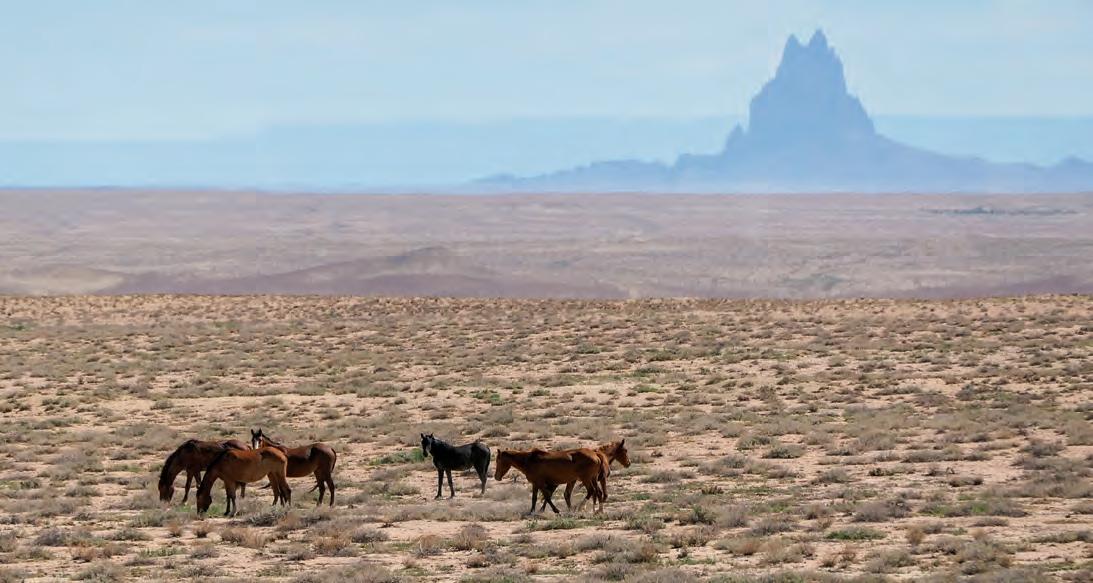
Horses graze on the Ute Mountain Ute Reservation along Highway 160 near the southwest corner of Colorado. Rising 25 miles in the distance in New Mexico is the 1,583-foot-tall rock formation known as Shiprock, or Tsé Bit’a’í (“winged rock”) by the Diné.
wilting on my walk as if I were in a 93-degree oven clicking with grasshoppers. Up ahead beckoned two cottonwoods, one with two trunks like a hippie-hand peace sign along the county road. Bob had promised this “nice lunch spot” if I took a half-mile detour onto County Road 14 on my way from the old school to his farm near Rosener Reservoir.
A herd of black Angus cows and calves stared at me from the trees – their lunchroom for the cool kids, their dark hides lumpy extensions of the tree’s shadows. One calf had a milk mustache.
I imagined them conferring with each other: “Don’t move. She’s gonna try to take our shade.”
“Hi ladies!” I called in a singsong. Hooves shifted; noses sniffed at me.
I sneaked closer to see if they were friendly. “Mind if I share your shade? I’ll go around you to that smaller tree since y’all like the big one.”
“Muuuh! Mooo.” Wet noses stretched toward me as I walked among my bovine sisters to the junior cottonwood. The rancher had put a fence around it to guard the tree from being trampled. The scent of cow manure wafted around me as I shoe-nudged cow pies out of my picnic spot, leaned my pack against the hog panel fence, retrieved my lunch and sat down.
Yellow ear tag #89 sniffed my head; she had a combover and a cleft between her nostrils. Her sidekick, green ear tag #6 in a windblown hairdo, stretched her head toward my corn chips, ears forward.
I looked up at their chins. Each cow I met now had an individual personality. These cows were like thousand-pound black Labrador dogs; most cows would not let me near them. I wondered what kind of human cared for them as I watched an SUV pull away from a ranch house a half mile west. My lungs tensed, worried the rancher would be angry that I was beneath their tree.
“Good morning!” I called as I walked to their open car window. “Is it OK if I eat my lunch here? You have really friendly cows.”
“Where you headed?” The young man at the wheel smiled kindly. His wife was in the back seat with their new baby.
“I’m camping at Rosener Reservoir tonight. Bob Musgrave is helping me out.”
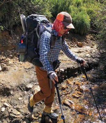
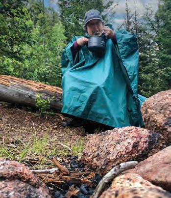
The challenges Wood faced included planning her own route, hiking 100 miles in the San Juans at elevations between 10,000 and 13,000 feet above sea level, dining in bear country near Bailey and bedbugs in an old telegraph building east of Pitkin.
India Wood
Ryan Ernstes
Ryan Ernstes
India Wood
“Musgraves are good people. You’re welcome to have your lunch here.”
I was walking alone now, but I was not lonely. People helped me, then handed me on to other good people. Even the cattle were good company. Heck, I even met a ghost I liked. All made me feel welcome on their landscapes.
BY JUNE 23, my arrival at the Cherokee Ranch, in the foothills near Sedalia, marked the end of the Plains portion of my trip. The ranch has been a nonprofit since founder Mildred Montague Genevieve “Tweet” Kimball died in 1999. I had tried calling and emailing to get permission to hike across the ranch but had not received a definitive answer. The Cherokee Ranch website said its 5 square miles were “closed to hiking without a guide,” but it did offer daily tours of the Scottish castle that housed Tweet’s relics. I booked a tour as an excuse to enter.
“NO TRESPASSING” signs marked the wooden rail fence around the Cherokee Ranch. Sandstone bluffs hovered above dark green clouds of gambel oak and mountain mahogany footed with grassy meadows where ponderosa stood like sentinels. I stepped onto the private road, deciding a walk with a wave on the road would be less incriminating than a furtive ramble through the gambel. Grasshoppers rattled like castanets to accompany the stuttery “tow tow tow heee!” of towhees and buzz of iridescent hummingbirds.
The ghost of Cherokee Minotaur, Tweet Kimball’s favorite Santa Gertrudis bull, gazed at me from two bronze sculptures along the road. There were no monuments to her four ex-husbands. I started to feel a kinship with Tweet; we both loved cattle.
A front door of oak and wrought iron creaked open to release a tour guide herding several women in high-heeled sandals and flowery shirts from Tweet’s Scottish castle, atop a Colorado hill. Local rhyolite stone shaped by Welsh stonemasons and angled slate roofs gleamed silver beneath a sapphire sky.
The guide’s head shot up at the sight of a hiker in a polyester livestock ballcap, stained scarf and hiking poles that looked like they’d done battle with Minotaur. I wanted to tell her my scarf was Hermès
Wood stops for a few photo ops along the trail, posing with Dennis Lyamkin at Julesburg, with Dennis and Jim and Charlene Dolezal at the marker at the state’s northeast corner and with Tina Zimmerman on her property in South Park.
Fern Mandel Ryan Ernstes
India Wood
and I’d graduated from Dartmouth. She assured me the executive director would meet with me after the tour regarding my request to hike through the ranch.
The castle tour revealed Tweet as a female renegade, one I dearly wanted to have tea with but had missed by 23 years. Tweet collected portraits of powerful women of Renaissance England and a suit of armor. She joined the National Western Stock Show board as its first female member. She wanted her guests to sleep in a Renaissance bed of polished black wood that would not fit up the stairs, so she had it hauled through the second-story window. She, like me, was undeterred by practicality. I kneeled ceremonially at the “begging door,” where poor itinerants would show up at a Scottish castle to seek accommodation.
“Good to meet you. Rafael said you might be here.” James Allen Holmes, the executive director of Cherokee Ranch, beamed down from a foot above my head. “When are you hoping to hike across the ranch?
“Right now. I hiked the entrance road today.”
“You didn’t drive here? Today?” His brow furrowed. “I thought next week or something.” He laughed. “Well, then, I can’t tell you ‘no’ and make you turn around since you’re already halfway across. Can I get a picture with you? I think it is remarkable what you are doing, hiking across Colorado solo.”
Thus, approved by Tweet and James, I strolled west on the road through the ranch like I owned it.
NEARLY 90 MILES later, on July 7, I hustled downhill with my daughter, Fern, Ryan and a cameraperson into South Park. My mother wrote a book published in 1969 called Colorado: Big Mountain Country. Of this area she reported, “One rancher has erected a sign on U.S. 24 as it runs through his property at South Park, an almost uninhabited, nearly treeless plain about a hundred square miles in size. The sign reads: ‘No Loitering.’ ”
White cubes of RVs now dotted the tawny prairie below us, the Buffalo Peaks and Mosquito Range a hazy blue lip on the distant edge of South Park. The assortment of
ood
Start date: May 20, 2022
End date: Aug. 30, 2022
Miles hiked in 2022: 739
summer abodes included a green delivery trailer with a door cut in the side, a cat carrier deposited next to an address marker and a pallet palace slapped together next to the carcass of a red Chevy on cinderblocks. Limp barbed-wire fences caught trash bags like fluttering birds. This had been the major calving area for pronghorn antelope; the few that remained bolted awkwardly between all these new structures.
Three retrievers gamboled toward us, barking and wagging, followed by Tina Zimmerman, a woman in a peek-a-boo hat, crocheted blue bikini, turquoise cycling shorts and half-laced army boots. She was wrinkled and effervescent. She said she loved my journey and the idea of minimal living.
“I don’t have to have material things,” Tina said, squinting into the distance. “I am going to find my true happiness, and I am going to get rid of all my stuff.”
“Is that a barber’s chair?” I said.
“I’m a barber, and I collect barber chairs, so yes.”
Fern spun lazily on the white Naugahyde top.
“Can I sit in the queen’s chair?” I pointed to a turreted wooden chair with a red leather seat.
“Yes, you may. It has a little bird poop on it.” Tina picked her way over drifts of scavenged lumber to wipe it off.
I gave a Queen Elizabeth wave from the
2022 Diagonal Route
2020 Diagonal Route
throne of Tina’s kingdom. I could see from here why people deposited themselves along lonely roads across South Park and did what they darn well pleased. Like Tina said, “This makes me happy, my happiness. I’m alone but I’m not lonely. Lovin’ life, girlies!”
My thoughts exactly. Back in Boulder, the city would be on you like lice for code violations with a place like this.
I continued to hike my diagonal past Buena Vista, over the Sawatch Range, across the Gunnison valley, through the San Juan Mountains and down several thousand feet to Cortez. I had been worrying about the final 40 miles for weeks.
Thus far on my 1,500-mile journey I had obtained permission to cross private, state and U.S. government-owned lands. The last 40 miles of my diagonal line, however, coursed across the Ute Mountain Ute Reservation where I hoped I might hike the dirt roads shown on my GPS.
I called the tribal offices and requested permission to hike across their land. They said, “No outsiders.” I understood why, as non-Natives like me had occupied most Indigenous land and tried to destroy their culture. This reservation, the adjacent Southern Ute Reservation and the Uintah and Ouray Reservation in Utah are all that is left of Ute lands that once encompassed most of western Colorado and beyond.
My only option was to walk the shoul-
Julesburg Sandhills
Morgan County
Cherokee Ranch
South Park
Buena Vista
San Juan Mountains
Cortez
Ute Mountain Ute Reservation
ders of the highways through the reservation: Highway 491 (formerly Highway 666, the Devil’s Highway) and Highway 160, both infamous for accidents.
A reconnaissance drive of the last 9 miles to the state corner left me doubtful I would reach my goal. Bulldozers and backhoes belched diesel fumes as they rebuilt and repaved Highway 160. I wondered if the highway workers would stop me, citing safety concerns.
Instead, on hike day we introduced ourselves. Diné and Ute highway workers gave me, Fern and a friend cold bottles of water in the rippling 95-degree heat and radioed ahead, “Yeah, we got the hikers here at mile marker four. Headed your way.” They cheered us on. We were all people doing our thing on a highway through a surreal landscape: Shiprock sailing in the southern haze, Sleeping Ute Mountain resting behind us.
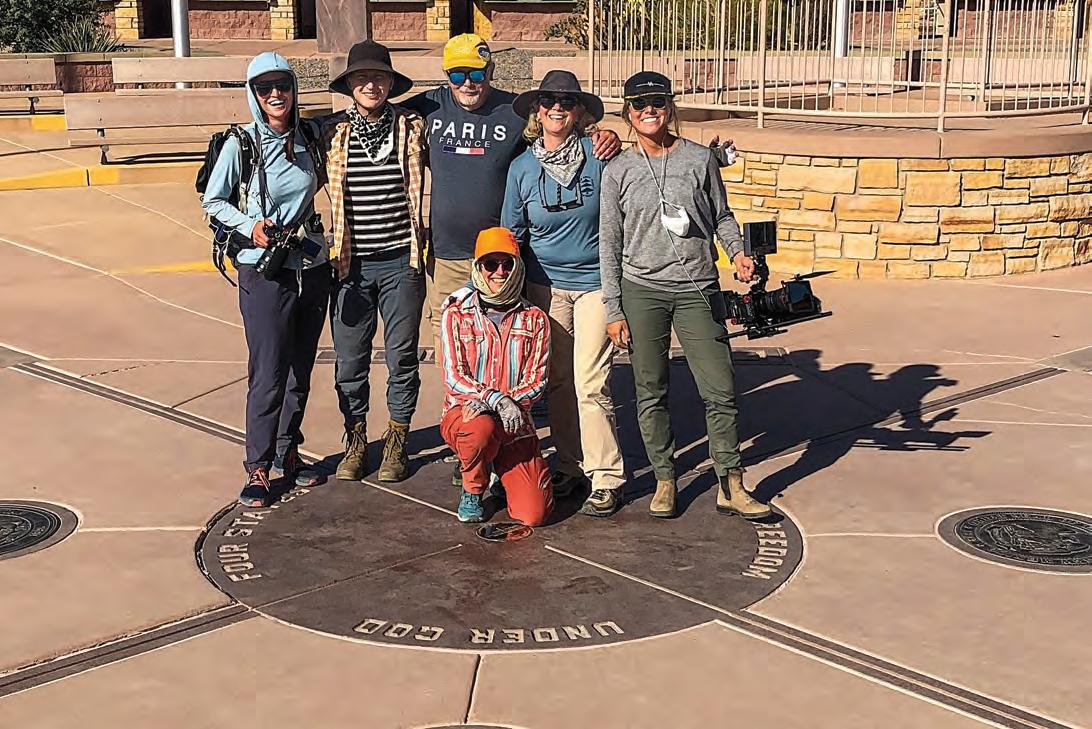
I reached the Four Corners Monument cattle guard the afternoon of Aug. 30. I was cut off from the destination landscape I had worshipped for three months,
my view restricted to a vast concrete and steel installation of ramps, guard rails, benches and souvenir stalls.
I set my pack outside the Four Corners medallion that proclaimed bureaucratically, “FOUR STATES HERE MEET IN FREEDOM UNDER GOD.” A hurried woman asked me to move my pack to get it out of her picture with her grown son. I explained we just needed another minute, and that I had walked here 740 miles from Nebraska. To which she replied curtly, “You have brought your pack 740 miles, and now you can move it.”
I wanted to belong here, but I wasn’t feeling welcome. Then my friend’s dad announced to a dozen tourists what I had just accomplished. Three groovy young men from Germany took pictures with me and asked for advice on places to visit in Colorado. A woman holding a diapered infant congratulated me. “We are going to think about you as we drive back to Georgia,” she said, “but I’d rather drive to Georgia than walk across Colorado.”
“You never know what is inside you
until you try,” I said. “I was never a serious hiker until several years ago – never had hiked further than maybe 5 miles.”
“Wow. That’s so cool.” The mother smiled at me like I was Neil Armstrong.
“As a trail friend said, ‘An inch is a cinch; a yard is hard.’ Do a little bit at a time and work up from that. One day, then another, like becoming a mother and raising a child.” Her baby flapped the Friends of India’s Diagonal Expedition postcard I’d given them.
I had fancied the governor of Colorado and crews from 9News in Denver would greet me. They didn’t. Instead, portraits and landscapes came to my mind – the workers of Highway 160, the South Park of Tina, Bob’s country, Jimmy’s sandhills ranch, Darlene and Jim’s corner. I unclipped the Colorado flag I had displayed on the back of my pack for 1,471 diagonal miles, smoothed it over the four state corners, folded it and kissed the symbol of the state and people I love.
To learn more about India and her journey, visit IndiaHWood.com.
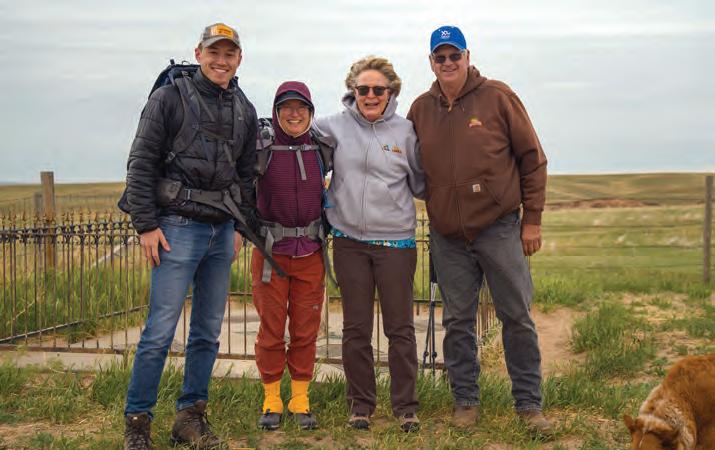
Wood celebrates her completion of the Colorado X on Aug. 30, 2022, at the Four Corners Monument with documentary filmmaker Ryan Ernstes, daughter Fern Mandel, Jim Ague, best friend Marjorie Ague Eiref and cameraperson Jordyn Romero.
India Wood
Soak
Camp
Fish
Hike
Bike
Nordic Ski
Snowshoe
Williams Fork Reservoir
Fly Fish The Colorado River
The topography of
includes buttes and tracts of
in addition to the more expected flat expanses of prairie.
Pawnee National Grassland
broken terrain,
Joshua Hardin
Buttes, birds and a sea of prairie invite explorers to a timeless stretch of northeast Colorado.
story
by
LISA TRUESDALE
With the setting sun casting a colorful glow on Pawnee National Grassland, a male swift fox surveys the prairie from a grassy ridge.
Dawn Wilson
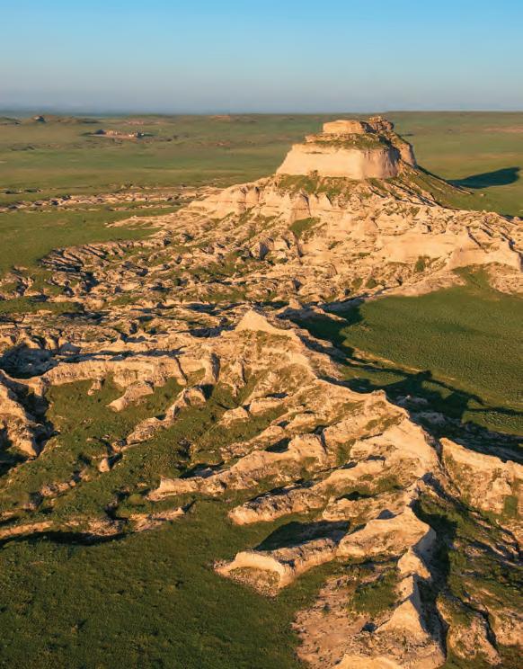
UMPING ALONG THE maze of gravel roads, vehicles kick up plumes of dust and dirt that look like columns of smoke from a distance. At first glance, newcomers to this remote prairie land of northeast Colorado might describe it as flat and featureless. However, they realize their error as they round that last corner, dipping down slightly into a valley, where, as if by magic, the two pinnacles of sandstone known as Pawnee Buttes rise up majestically from the valley floor.
The buttes and surrounding shortgrass prairie are preserved as part of Pawnee National Grassland, which stretches across a 30-by-60-mile swath of land roughly 35 miles east of Fort Collins and 25 miles northeast of Greeley.
The landscape of Pawnee National Grassland has captivated humans for centuries: the Arapahoe, Pawnee, Cheyenne and Kiowa, who hunted bison here; the fur trappers and traders, who arrived in the 1820s; and the hopeful settlers who arrived after that to farm the land.
Pawnee National Grassland also caught the attention of author James Michener,
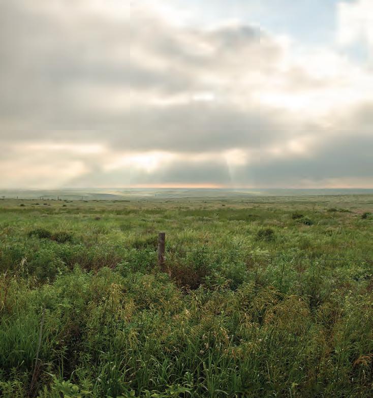
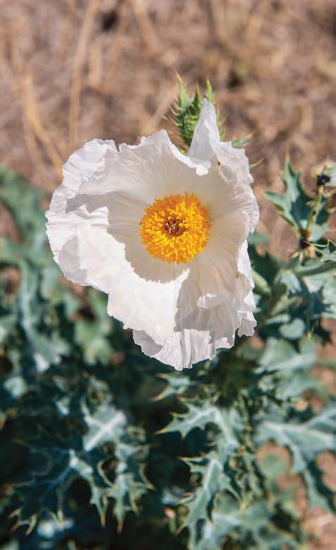
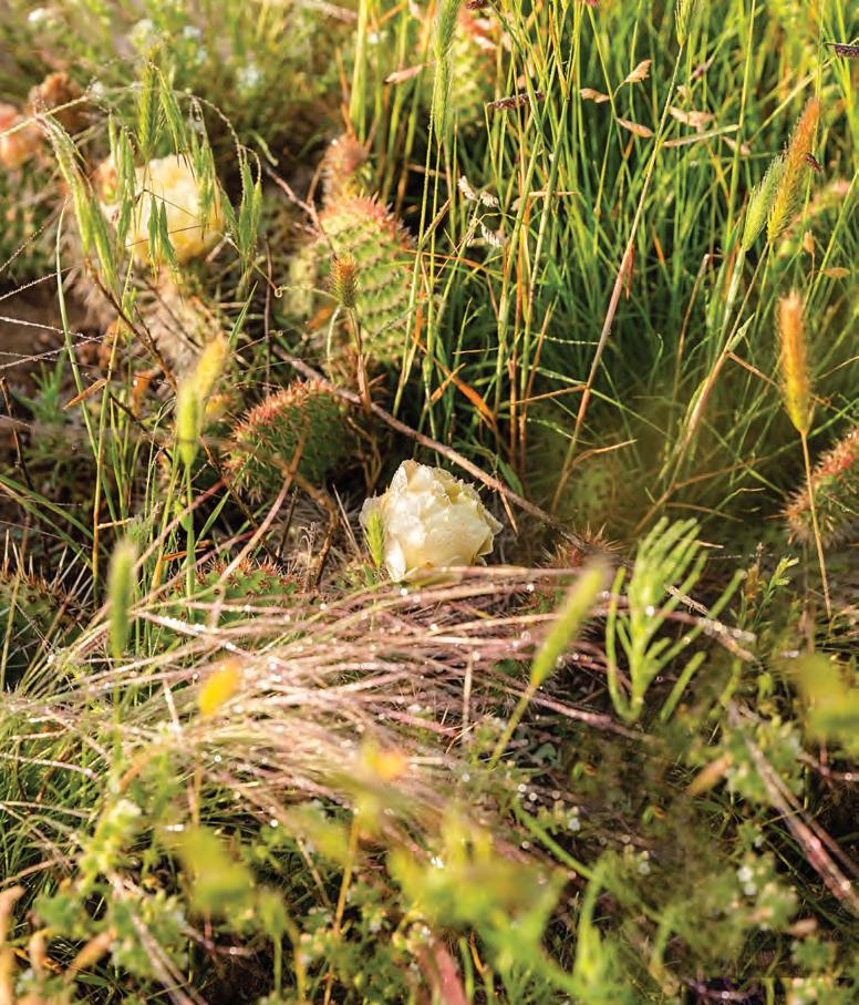
Morning breaks over Pawnee National Grassland, which preserves a 30-by-60-mile stretch of shortgrass prairie starting 35 miles east of Fort Collins. A blossoming white prickly poppy is one of many plant species on the grassland, which also hosts a variety of wildflowers, from Hartweg evening primrose to scarlet globe mallow.
who experienced firsthand the raw beauty of the area in the early 1970s while researching his sweeping historical novel about Colorado, Centennial. The author spent part of that time living in the tiny town of Keota, situated on Pawnee National Grassland about 50 miles east of Greeley. In Centennial, Michener described the thrill of seeing Pawnee Buttes for the first time.
“I was affected by the strange allure of sweeping prairie and lonely vista,” Michener wrote. “I was east of the deserted village when I saw before me a sight of compelling interest: twin pillars rising a sheer five hundred feet from the surrounding land. For miles in every direction there was nothing but empty land, then these twin pillars of red and gray rock shooting skyward.”
That the buttes are actually closer to 300 feet in real life make them no less impressive. They’re the jewels of Pawnee
National Grassland, yet they can’t take all the credit for the area’s allure. There are surprises waiting to be discovered around every corner.
FOR
ALL ITS
AUSTERE BEAUTY,
the grassland is a hard place to make a home. An influx of white settlers in the 1860s forced out the tribes who originally inhabited the area. Farmers soon started homesteading here, and by the 1880s, small towns like Keota and Nunn had sprung up along the Chicago, Burlington & Quincy Railroad.
Yet the harsh winters, the never-ending drought, the relentless, drying winds and the 1930s Dust Bowl eventually chased many of the farmers and ranchers away. Selling their land to the federal government and starting new lives somewhere else was just too tempting. With their newly acquired land, the U.S. Forest Service established Pawnee National Grassland in 1960.
Amber Kissner
Joshua Hardin
One of 20 designated grasslands in the United States, mostly on the Great Plains, Pawnee National Grassland includes 193,060 acres of federal land, broken into two administrative units, the Crow Valley unit to the west and the Pawnee Unit to the east. The rest is a patchwork of private property and state-owned land.
The grassland is open to all, and there’s no fee to enter. Besides being an internationally known birding destination, it also draws wildlife viewers, photographers, campers, bikers, hikers, archers, hunters and target shooters. It also attracts those just looking to get away from it all, to wander and explore with nary a chance of seeing another soul for miles.
Amid the timeless expanse of Pawnee National Grassland are occasional reminders of modern life. Large wind turbines dot the land along the northern edge. There’s fiber-optic cable, even part of a pipeline. Minuteman missile sites administered by the U.S. Air Force create
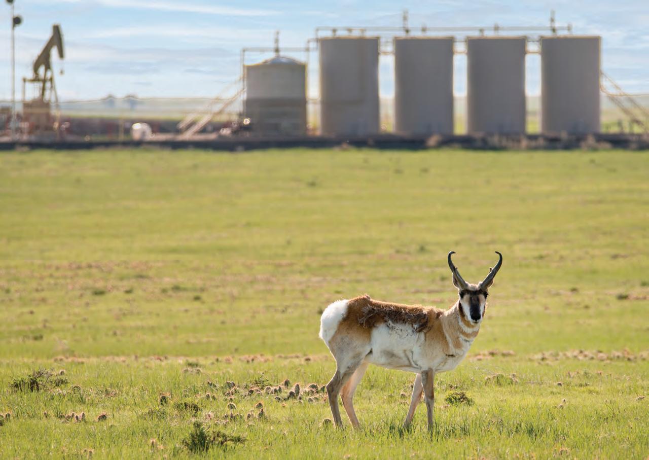
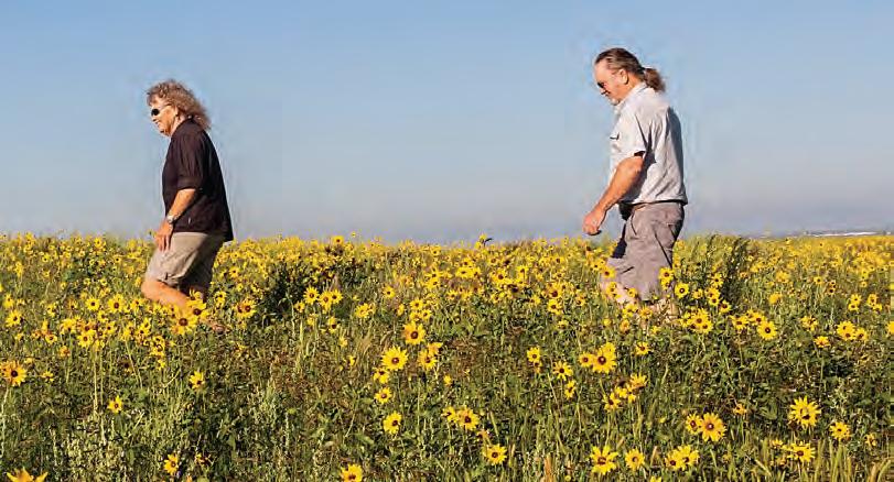
A pronghorn grazes near one of the 40 oil and gas wells on Pawnee National Grassland, which is made up of 193,060 acres of federal land, as well as a patchwork of private property and state-owned land. Nansi and Rick Crom walk through a meadow of wildflowers on the grassland, where they have lived since the 1970s.
Joshua Hardin
Amber Kissner
an air of intrigue straight out of a movie, with their sternly worded warning signs, security cameras and tall chain-link fences topped with barbed wire. Oil and gas sites dot the land, too, somehow looking strangely out of place and right at home at the same time.
Inexplicably, the missile storage and fracking sites coexist peacefully with hiking trails, camping sites and prairie dog towns. Meandering through the grassland, you can be on federal land one second and private the next, then back to federal in the blink of an eye. It’s easy to be a trespasser without realizing it, so Vern Kohler advises picking up a map first.
Not that Kohler needs a map himself. He doesn’t reside on Pawnee National Grassland, but he practically lives there, since it’s been his job for nearly 15 years to, in his words, “keep an eye on things.” As a staff officer in the Ranger District (his official title is biological scientist), one of his main duties is creating and administering
A prickly pear cactus shows there’s more than grass on Pawnee National Grassland. However, “grassland” is no misnomer: The prairie here is dominated by buffalo grass and blue grama grass, which is Colorado’s official state grass.
permits required for conducting research, commercial filming, driving off-road, and oil and gas development.
It’s while making his regular rounds through the grassland that Kohler gets to experience the best parts of his job, like searching for rare plants; observing wildlife; making sure cattle are where they’re supposed to be; estimating forage use during grazing season; and talking to visitors about recreational activities, from camping and shooting to bird watching and hiking.
Even on his busiest days, he takes time to appreciate the sights and sounds, like
the “amazing clouds, rainbows, scary storms, flowers and birds,” as well as the mud and rain that make the roads so slippery that he’s forced to slow down and just look around.
“Getting to work on the Pawnee National Grassland is the best form of therapy,” Kohler said. “The long, long views and the wide-open skies remind me of how small I am, and that’s oddly comforting. That’s where the emotion of working out there has been for me. Peace and calm and wonder and awe.”
NANSI CROM HAS BEEN experiencing the same wonder and awe since moving to Pawnee National Grassland in the early 1970s with her husband, Rick, a grandson of homesteaders who were founding inhabitants of the town of Pierce. Rick had moved to Texas yet was anxious to return home, so when he heard that one of the town’s original 1904 Victorian homes was for sale, he couldn’t resist. While working as a builder and carpenter in the area, Rick has spent five decades lovingly restoring the home to its original condition.
Nansi admits the move was a bit of an adjustment for her at first. “The drier and colder climate, the distance from larger communities where services are located, and the much slower pace of life were challenges for me, not unlike for the early settlers,” she said. Yet it didn’t take long for her to learn to embrace it; she worked for the local school district, served as a town council member and was recently Pierce’s mayor. She was also a Pawnee National Grassland volunteer for many years, so she knows exactly what to tell people who might wonder what the fuss is all about.
“I say just slow down a look at what is right there in front of you,” Nansi said. “So many of the plants and animals blend into the landscape,” like long-eared, short-eared and great horned owls, whose unique coloration perfectly mimics tree bark. Or pronghorn fawns, who typically lie alone, motionless on the ground, while their mothers graze a distance apart to lure predators away from their young. Or the birds that stake their claim to tiny, 3-inch swaths of shade next to fence posts, seeking relief in the midst of summer’s blistering heat.
Amber Kissner
Perched on a fence post is a male lark bunting, Colorado’s state bird.
Training your eye to look for the shapes and silhouettes of the animals, learning their feeding preferences and knowing their behavior habits is essential to spotting the numerous species that inhabit the grasslands, Nansi said. “It takes time to see and experience all the wonders that hide right before your eyes, so just pack a lunch, grab your binoculars and find a good vantage point to just sit, watch and listen.”
Especially listen, for the dominant sound out here is birdsong. With more than 300 identified species of birds, Pawnee National Grassland attracts birders from all over the world who are keen to spy the warblers, tanagers, sparrows, finches, blackbirds, orioles and more. A self-guided Pawnee Birding Tour takes visitors along a 21-mile driving route, with informative signs stationed along the way. At Stop 4, for instance, watch for burrowing owls perched on a fence, scanning the nearby prairie dog town.
“Our plant and animal special diversity is even greater here than it is in the mountains,” said Kohler, explaining that
the grassland is also popular for the many wildflowers, like prairie evening primrose, wooly plantain, white penstemon, tansy, sundrop, milkvetch and prickly pear.
MICHENER’S BOOK Centennial was published in 1974, a couple of years ahead of Colorado’s own centennial of statehood in 1976. It was adapted into a TV miniseries in 1979, primarily filmed in the small town of Orchard, northwest of Fort Morgan. The book and the miniseries offered a seldom-seen look at the history, wildness and beauty of Colorado, and some believe that both may have contributed to the state’s population boom in the late 1970s – even though Michener was brutally honest about conditions in that part of the state.
“Unpredictable winds whip over the prairies, exhausting the land and everything that grows upon it,” he wrote in the book. “Dust storms greater than hurricanes and more persistent can sweep the region for months on end, filling all openings with grit.”
Yet curious visitors continue to flock to the grassland, for all the outdoor experiences it offers, and to catch their own glimpse of the majestic buttes. The west butte is on federal land; about a half mile east, the other sits on private land. The hiking trail to the west butte isn’t a direct route, as it must skirt the boundaries of other private property; it’s about a 1.5mile trek. Climbing the buttes is discouraged, as the sandstone is unsteady and crumbling. Fossils are abundant along the route, but collecting them is not just discouraged, it’s prohibited.
Rancher Butch Deporter, who has lived on the grassland for all his 80-something years on earth, sounds especially proud when he speaks of the buttes.
“There’s not a greater view in this area,” he said. “I know a lot of people who are envious of me living on the grasslands. I just want people to help care for it as they should.”
It’s clear that Kohler, as a true steward of the land, is just as proud. “The amount of sky is overwhelming, and it’s a landscape that has transfixed many,” he said. “Most people don’t think of the Plains when they think of Colorado, but our version of Colorado is no less Coloradoey.”
East Pawnee Butte is one of the twin sedimentary promontories that rise 300 feet above the surrounding prairie, forming the most iconic image of Pawnee National Grassland.
Joshua Hardin
Dawn Wilson
No matter which way you say it, everyone can agree that these tomato-forward dishes are delicious
recipes and photographs by DANELLE McCOLLUM
MODERN SUPERMARKETS MAKE tomatoes available year-round, but there’s nothing quite like the taste and texture of a ripe, juicy tomato plucked from the vine in a summer garden. Here are three recipes to help you make the most of this special window of peak tomatoey goodness. And, just for the record, the correct Colorado pronunciation is “to-may-to.”
Cherry Tomato Bruschetta
Toasted bread is loaded with flavor – tomato, garlic, herbs, lemon, oil.
In a large bowl, toss together tomatoes, garlic, onion, basil, lemon juice, olive oil, and salt and pepper to taste. Cover and refrigerate at least one hour. Serve on slices of toasted baguette or Italian bread. Garnish with additional fresh basil, if desired.
2 pints cherry tomatoes, halved
3-4 cloves garlic, minced
2 Tbsp minced red onion
3/4 cup loosely packed fresh basil leaves, chopped
1 tsp lemon juice
1/4 cup olive oil
Salt and pepper to taste
Toasted baguette or Italian bread slices for serving
Balsamic Roasted Tomato Pasta
Exquisitely seasoned roasted tomatoes transform ordinary pasta into a gourmet dining experience.
Line baking sheet with foil for easy cleanup. Spread halved tomatoes over baking sheet. Drizzle with olive oil and balsamic vinegar. Sprinkle with Italian seasoning, red pepper flakes and sugar. Add garlic and toss everything to coat well. Season with salt and pepper, to taste.
Roast in oven at 450° for 30 minutes, or until tomatoes are soft and pan juices have started to thicken. Meanwhile, cook pasta according to the package directions. Reserve one cup pasta water and drain. Add pasta to large bowl. Pour roasted tomatoes and pan juices over the pasta. Toss well. Add pasta water as needed until sauce reaches desired consistency. Garnish with fresh basil and grated Parmesan cheese before serving.
24 oz cherr y tomatoes, halved
3 Tbsp olive oil
2 Tbsp balsamic vinegar
1 Tbsp sugar
Salt and pepper to taste
16 oz linguine or other long pasta
1/2 cup grated Parmesan cheese
Fresh chopped basil for garnish
BLT Stuffed Tomatoes
Stuff some bacon into tiny cherry tomatoes, add some mayo, pepper, onions and Parmesan cheese, and you’ve got all the goodness of a BLT with none of the carbs.
Cut thin slice off top of each tomato. Scoop out pulp and discard. Invert tomatoes onto paper towel and allow to drain about 30 minutes. Meanwhile, in medium bowl, combine bacon, mayonnaise, Parmesan cheese, red pepper, green onion, parsley, and salt and pepper. Generously stuff each tomato with bacon filling. Cover and refrigerate at least one hour (and up to three hours) before serving.
What’s in Your Recipe Box?
2 10-oz packages cherry tomatoes
6 slices bacon, cooked crisp and crumbled
1/2 cup mayonnaise
1/4 cup Parmesan cheese
1/4 cup finely diced red pepper
2 green onions, chopped
1-2 Tbsp chopped fresh parsley
Salt and pepper to taste
The editors are interested in featuring your favorite family recipes. Send your recipes (and memories inspired by your recipes) to editor@coloradolifemag. com or mail to Colorado Life, PO Box 270130, Fort Collins, CO 80527.
COLORADO POETRY
OUR STATE THROUGH THE WORDS OF OUR POETS
Something in the air inspires wanderlust in Coloradans, and the call of the open road lures travelers out to see where the state’s highways and byways will lead them. Our Colorado poets celebrate the special magic of mountains and plains as seen through car windows while on the road.
Top of the World
Mount Evans, Rocky Mountains, 14,130 feet
Celeste Blundell-Camden, Englewood
“What, a conversation?” said the woman Laughing as she leaned out of her stalled car. Cars were banked up behind that bighorn sheep, Waiting patiently for it to move on, While we chatted to it when it passed by Our window – giving us that bighorn eye. Then we were off and up that great mountain. His steady hands on the wheel – me gasping! The slim road, no barriers and sheer drops, Were death defying in that crawl upwards. Rounding yet another hair-raising bend, We saw it – with joy – the top of the world! We had made it – no altitude effects, No lightning or hypothermia to Deal with, as a nearby sign warned us. Now – free to explore – to soak in those views, Inhale all their beauty – all their wonder!
Off The Road
Shirley Kobar, Loveland
In the gray dawn my car passes a meadow of wild fescue and rye. Cottonwoods follow a creek bed off a three-lane road into the city. I search for sign of hawk or fox in the field, and receive a honk from a disgruntled driver.
No hawks today, just a steel framed chair with a vinyl cover facing east. No one has taken a seat, so, I place myself there, audience of one, applauding the first play of pink streaking through gray, watch the day inch forward to the color of autumn pasture, played to the hum of tires on the road.
Joshua Hardin
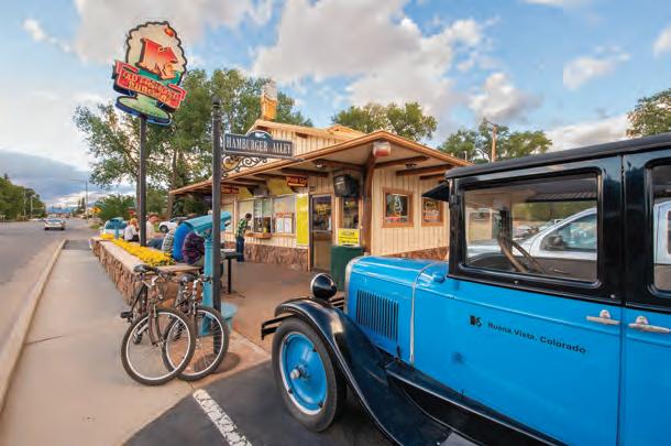
The mountain drive along the Cache la Poudre River passes spectacular scenery. Travelers love to stop at K’s Dairy Delite Stand in Buena Vista.
Dust and Dreams:
The Rocky Road to Riches
Steven Wade Veatch, Grawn, Michigan
They journeyed over rough roads by horse, mule and wagon through meadows of grass freckled with summer blossoms, then through thick pine stands and past toppled trees tilted at odd angles to the gold mines.
Today, along the abandoned roadbeds are fragments of history: rocks fallen from ore wagons, a blacksmith’s mule shoe, a busted whiskey bottle, all evidence of shattered dreams.
Through the foggy mist among the trees, I thought I saw a spectral teamster take his reins and smile as his wagon jolted along a bumpy road and disappeared into Colorado’s past.
Loads of Roads
Marina
Ashworth, Denver
Frosty landscapes are thawing fast Spring sneaks in with her gifts in tow Dig out maps, boots and shake your heart It’s time to get back on the road
The towns, valleys and bears do stir Buds break ground, the cold has slowed Hear road trips beckon as the ices crack fill the tank, must get back on the road
The sun is longer, sharing healing warmth And the lands burst blossoms and glow The air smells fresh and ready to please find adventure and get back on the road
Things have shifted, yet all is the same Waking peaks stir minds and sure goad Ain’t matter where or what paths you take Find your pleasures and go hit the road
On the Road
Janice Walters, Walsenburg
Toward Cuchara Pass on well-paved asphalt I fell in love with Colorado roads.
The autumn leaves were golden and brown with conifers peeking through in green, long needle coats.
Earlier, in summer’s heat, the sky was so blue I lost myself and woke up to a path with grass in the middle.
Mountains, always mountains, lay in my vision as a baby dike poked up through the earth, all bumpy in newborn wrinkles.
Here in Colorado, if we are watching, the roads never take us to a mere destination.
They follow the curves and corners of our minds and reward us spectacularly. with sights and insights to last a lifetime.
DO YOU WRITE POEMS about Colorado? The next poetry theme is “Aspen” for September/ October 2023, Sept. 1; the theme is “Only in Colorado” for November/December 2023, deadline Nov. 1. Send your poems, including your mailing address, to poetry@ coloradolifemag.com or to Colorado Life, PO Box 270130, Fort Collins, CO 80527.
Joshua Hardin
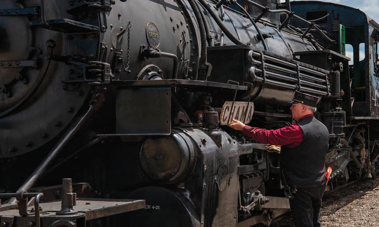
LIVING THE DREAM
A historic steam locomotive pulls passenger cars between Antonito and Chama, New Mexico, on the Cumbres & Toltec Scenic Railway.
STEAM OF SMOKE, SOOT AND
As stunning southern Colorado scenery passes by, a handful of men learns to operate a live steam engine on the Cumbres & Toltec Scenic Railway
story by TOM HESS
photographs by JOSHUA HARDIN
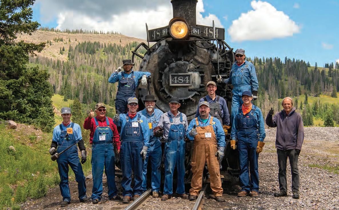
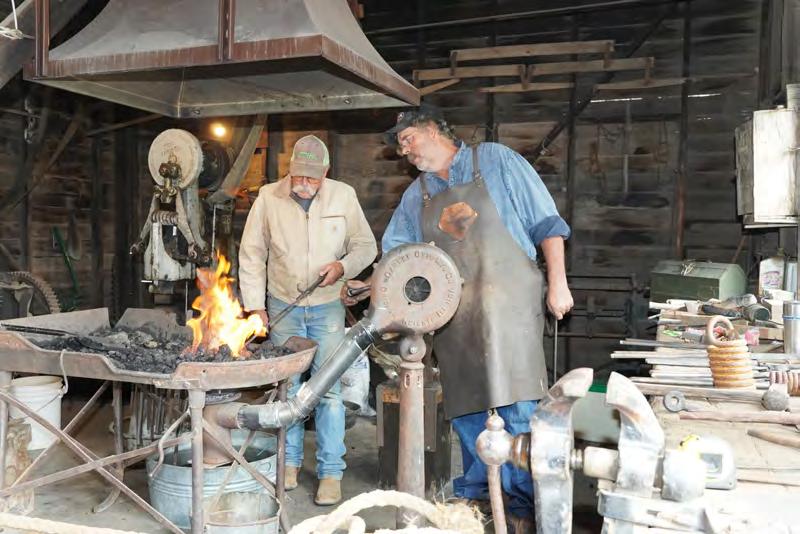
ADOZEN MEN –call them the dirty dozen, because they soon will be – gather quietly at dawn in Antonito, a sleepy town of about 700 founded in 1889 at the southernmost end of Colorado’s San Luis Valley.
The most obvious new thing in old Antonito is a short, spotless concrete section of U.S. Highway 285 that the state laid down as part of Antonito’s Main Street in 2015. That, and the new Family Dollar. Most everything else here is old, including most of the dirty dozen shuffling their feet this morning.
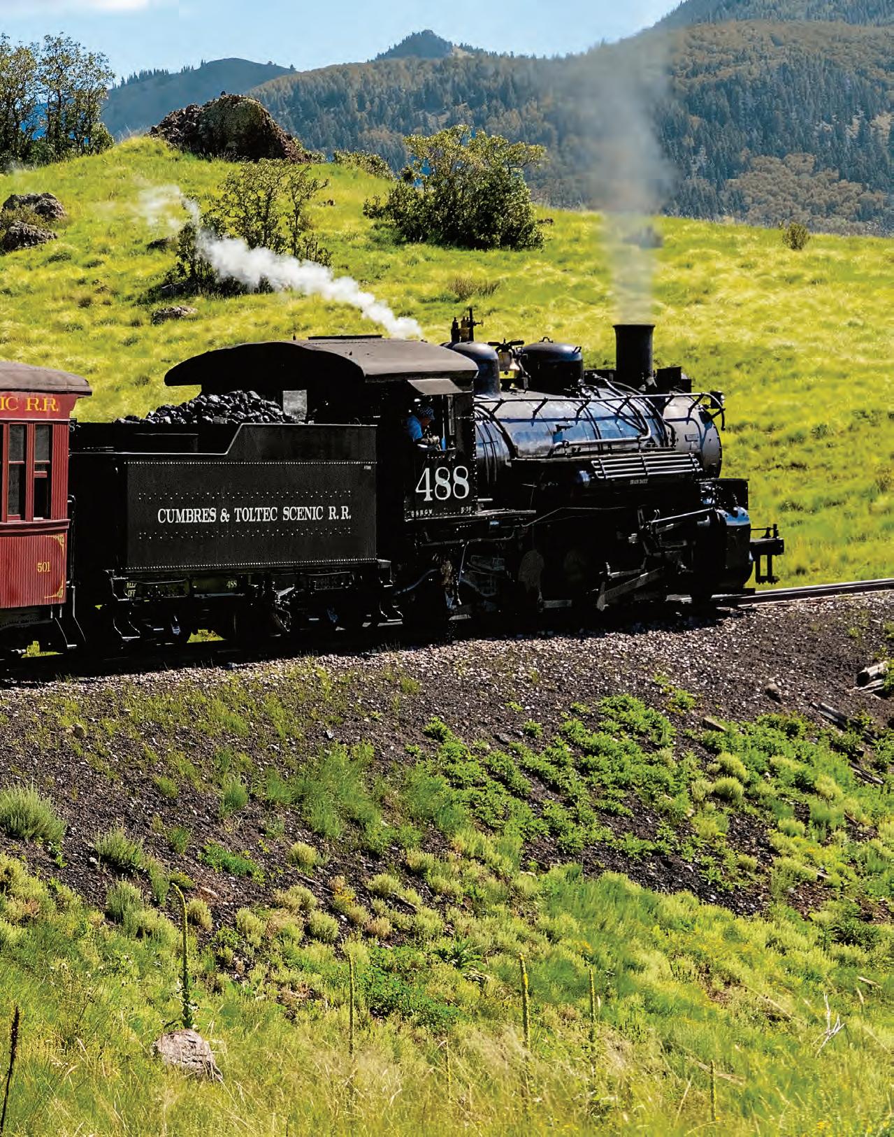
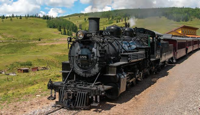
Waiting for the men just south of downtown is a century-old slumbering steam engine, a 187,100-pound black metal beast loudly snoring in its habitat: an 1880s rail yard and depot. Attached to the locomotive is a line of antique passenger cars. The old men will board that train to take their positions – some in the engine and others in the cars – while the morning is still young.
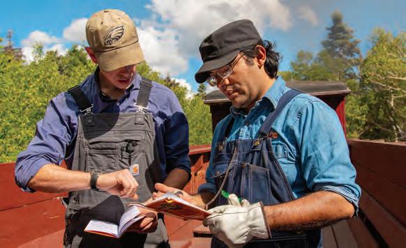
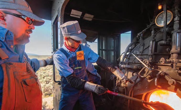
Father and son Steve and Gabe Truesdale, students in the Cumbres & Toltec’s Engineer and Fireman School, refill the locomotive with water at a stop along their route. Locomotive #484, one of five operating steam locomotives the railway uses, appeared in the 1989 Steven Spielberg film Indiana Jones and the Last Crusade.
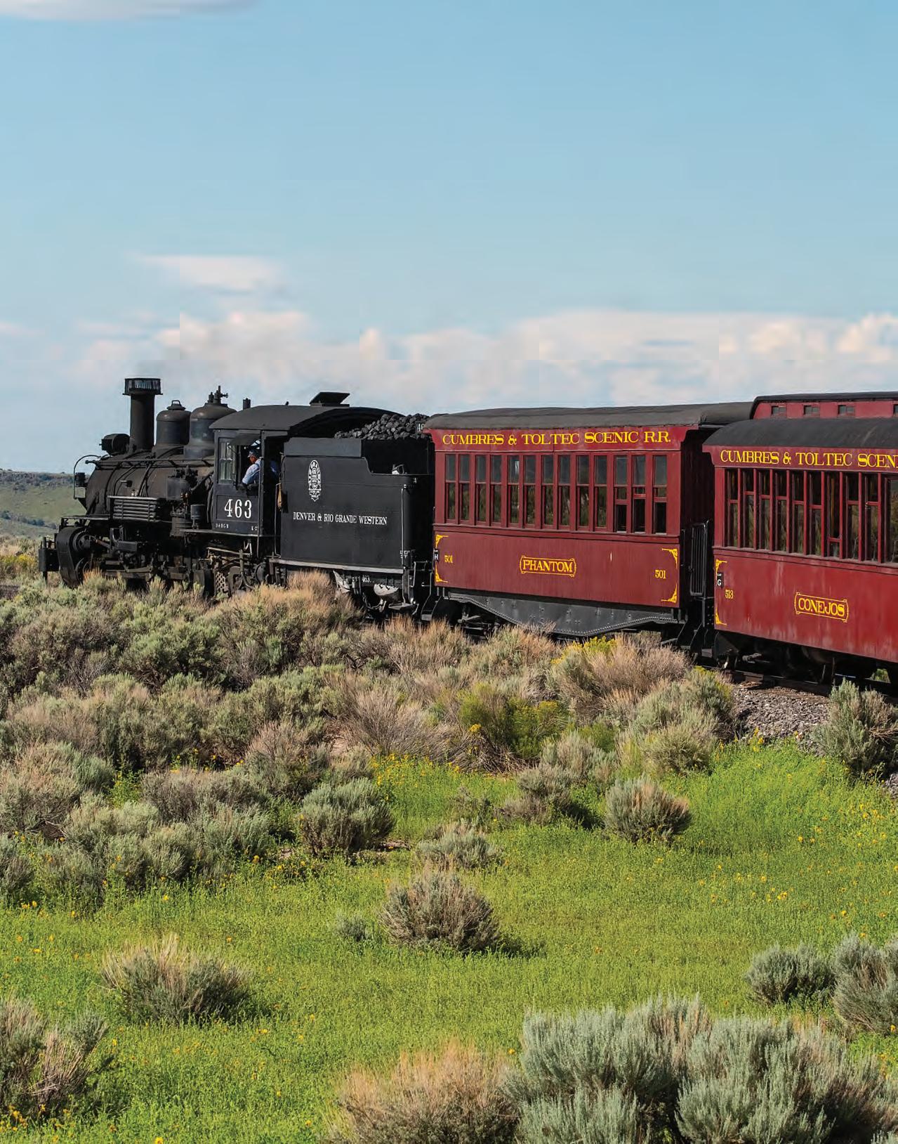
The steam train will travel the Cumbres & Toltec Scenic Railway, a 64-mile narrow gauge track that stitches together two neighboring states: Colorado and New Mexico. Built in 1880 to transport minerals mined from nearby mountains, the railway now delights thousands of passengers from across Colorado and the world who love the sounds and smells of yesteryear.
WHEN IT’S RUNNING, THE BLACK
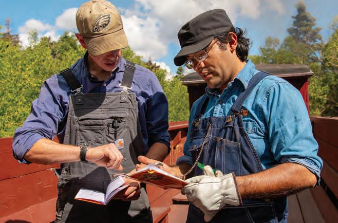
metal beast is always hungry. Today the train is being driven and fed by seven men. The seven paid handsomely for the privilege of enrolling in the Cumbres & Toltec Engineer and Fireman School. Joining them are Cumbres & Toltec staff, a writer and a photographer.
For five of the seven students, their trip will be a series of sprints – 6-mile, 20-minute coal-shoveling shifts – that they describe as exhausting, exhilarating, addicting. The sprints add up to a marathon day. Like all sprinters and marathoners before a race, the men are quiet, reflective, rehearsing in their minds the task ahead.
The two men in the engine’s cramped cab will push the engine’s throttle; when they do, the earth itself will seem to quake. Ten railcars behind them stretch out and shake in succession, a jolt that awakened everyone aboard.
By race’s end, the seven students will smile like 12-year-olds, giddy because they had just cheated death.
If not for sturdy construction, meticulous care and stringent safety measures, the steam locomotive’s massive boiler could unleash the force of a bomb. Today, as on every day since the railroad began running, the boiler remained intact.
Today’s students had successful careers. Many grew up mechanically or mathematically inclined. It was exposure to steam engines at a very young age, typically on a trip with a grandfather, that led them to Antonito.
The school won’t lead its graduates to a job with the railroad. That would require at least four or five seasons, six months each, five days a week. The four-day class is an experience, not a career track. This is
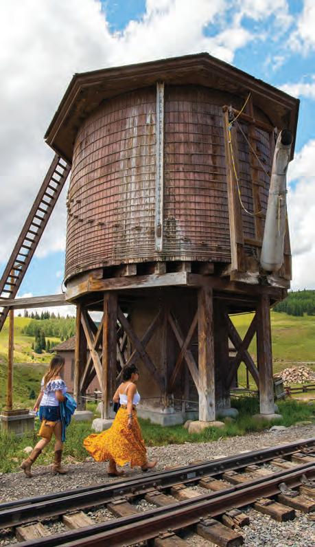
Water tanks are located along the railway to keep the locomotives filled with water to make steam. Students learn from railway employees. The train takes 6 1/2 hours to travel its 64-mile route.
about fun, not work.
Along the way, the men who paid $3,200 apiece for the course will pay precious little attention to the stunning scenery passing them by – such as the deeply sliced and gasp-inducing Toltec Gorge and the gleaming ribbon of water at the gorge’s bottom, 600 feet below.
On the downhill side of 10,015-foot Cumbres Pass is the railway’s most fabled landscape – terrain that inspired Steven Spielberg to haul equipment and transport film crews for scenes in Indiana Jones and the Last Crusade and later provided the backdrop for the four-minute finale of the Christian Bale film Hostiles. It’s all something of an afterthought to the men with the 20-pound shovels and the throttle and the power of life and death in their hands.
ONE OF THESE MEN, Jim Reynolds, practiced internal medicine in Boulder for 32 years. He is retired now, giving him time to operate the railroad’s steam locomotives. This is his 11th four-day engineering school. “It’s an addiction,” Reynolds said with a smile. “I tried rehab, but it didn’t work.”
Reynolds remembers the time as a 3-year-old when his grandfather took him on a ride behind a steam engine back home in Missouri. “I fell in love with steam then,” he said. “We rode from Springfield to St. Louis for a Cardinals ball game.” That’s a 70-year memory that all these years later drives Reynolds’ choice of a vacation.
In his 44 days of engineering school, Reynolds recalls one memorable mishap: the brake rigging fell off a rail car, derailing all 10 cars.
“All of a sudden, bang, the tank car jumped up,” Reynolds said. “Four of us wrestled back 10 cars from an embankment, using a 500-pound tool.”
On another trip, a big herd of sheep started going in front of the train – and stopped. “They were bound and determined to run under the train,” he said. The sheep survived.
Father and son Steve and Gabe Trues-
dale of Lincoln, Nebraska, find a new way to bond on this trip: They take turns shoveling coal.
Steve calls himself “a Renaissance man” who works in computer science, but he considers Gabe his crowning achievement. Gabe, the youngest of four children, plays second-chair cello in a local symphony orchestra. He built a 150-gallon saltwater aquarium. He’s “flown” every
Departing from Antonito, the Cumbres & Toltec’s route winds back and forth over the Colorado-New Mexico state line on its way to Chama, New Mexico. Firemen shovel coal into the engine to keep its fire burning. The train traverses a sagebrush landscape on its way toward Chama Pass.
airplane simulator available. And he’s on the highly functional side of the autism spectrum.
Gabe eagerly jumps atop the engine cab to supply the thirsty engine with water from a tower. The engine holds 5,000 gallons. It will consume 3,500 of it to reach the top of Cumbres Pass.
Whether grandfather and grandson, or father and son, the steam engine is a strong allure for visitors.
The conductor running the engineering school trains is Ed Beaudette, who grew up on a family farm in Vermont, next to the Central Vermont Railway, when it still ran steam engines. In earning an undergraduate degree in theoretical physics, he developed “a healthy respect for gravity.” He managed plastics technology, working for decades with Exxon Mobil before retiring. He’s been with the Cumbres & Toltec for the last 13 years.
Safely in Chama, New Mexico, the dirty dozen – the seven paying customers, staff and the writer and photographer – stand sweaty and sooty, cinders clinging to their clothing, coal smoke blackening their hands and faces and filling their nostrils. The Texas barbeque that several will eat later in the day will taste like it was prepared in a coal fire. And they’ll do it all
again next shift, and maybe next year, too.
The seven students muster their patience for a commemorative photograph. They’re standing in front of a picture-perfect railyard and depot fit for a big Hollywood finale.
The boys’ birth certificates might be yellowing from age but today they’re all 12-year-olds. On this special day, they got the better of the beast.
The graduating class of the Cumbres & Toltec’s Engineer and Fireman School celebrates the completion of a four-day course in which its students learned the basics of operating a steam locomotive. Wellwishers wave goodbye to passengers as the train pulls away from the station.
GO. SEE. DO.
COLORADO’S CALENDAR OF EVENTS
by LEAH M. CHARNEY
CULTURE
PAGOSA SPRINGS COLORFEST
SEP. 15-17 · PAGOSA SPRINGS
Colorfest is a bit like three festivals in one, from multi-day hot air balloon launches to the all-ages Bands & Brews and the 21-and-up Passport to Pagosa Wine and Food.
Though it’s a rain or shine event, “which we’ve had both of,” said Mary Jo Coulehan, event producer and executive director of the Pagosa Springs Chamber of Commerce, it’s a relaxed event with little drama. Except when it comes to the collectible glasses from the wine and beer events.
“One year, a hurricane came through, and the vendor couldn’t ship our glasses because they had to evacuate the warehouse,” Coulehan said. “So we did plastic cups and then donated the money from the
canceled order to hurricane relief efforts.”
That kind of helping spirit is at the heart of Colorfest, which focuses on showcasing local and regional businesses and partners to create a weekend full of festivities. Like Friday night at the wine event, where restaurants and caterers fill a 10,000-square-foot tent with local food paired alongside domestic and international wines.
The mass balloon ascension departs from downtown Saturday morning and from the west side of town on Sunday, giving attendees two different vistas. Imagine the bright balloons against the colorful changing leaves – Colorful Colorado, indeed. (970) 264-2360.
WHERE TO EAT PAGOSA BAKING COMPANY
From the fresh-baked bread and other handcrafted baked goods made in-house, to the burritos smothered in homemade green chile, this is the spot for breakfast and lunch. It also doubles as a town gathering space and makes for a great spot to people watch. 238 Pagosa St. (970) 264-9348.
WHERE TO GO
In between the parties, take time to go for a drive in the surrounding San Juan mountains to see the stunning fall colors that give the event its name. For the best in leaf peeping, Visit Pagosa Springs recommends heading south on Highway 84 to the Blanco Basin turnoff at County Road 326. From the basin, you can see the Continental Divide, Square Top Mountain and Oil Mountain.
Visit Pagosa Springs
COMMUNITY
MOUNTAIN HARVEST FESTIVAL
SEPT. 22-24 • PAONIA
While the festival’s timing coincides with harvest season, when growth gives way to hibernation and the weather turns cold, the Mountain Harvest Festival celebrates more than just the crops plucked from the earth. The festival recognizes the fruits of all kinds of labor, including music, visual arts, poetry, prose, dance and comedy. Of course, the festival also honors the farmers, growers, brewers, vintners and purveyors of fresh foods and innovative cuisine.
The three-day extravaganza transforms Paonia’s Town Park into an open farmers and artisans market that also features live music, community yoga sessions, chili cook offs, pie competitions, a beer and wine garden, and children’s activities.
A true community affair, the festival is not confined to the park’s boundaries. Other event highlights include bike rides, pub crawls, food and wine pairings, concerts, farm and winery tours, and more to bring the festival into the town’s business district and beyond. Music and agricultural workshops are also held to engage attendees who wish to learn a new skill. mountainharvestfestival.org.
WHERE TO GO WEST ELK LOOP SCENIC BYWAY
The 205-mile drive technically begins in Carbondale, but since it’s a loop, the beginning/ending point is arbitrary. Along the way, visitors will traverse Kebler Pass, the stretch of Highway 133 between Paonia and Crested Butte that features stunning vistas of one of the largest aspen groves in the country. The whole loop takes roughly six to eight hours to complete. Highway 133, Paonia. (970) 349-6438.
WHERE TO EAT ROOT & VINE MARKET
A cafe and tasting room for family-owned Qutori Wines, Root & Vine Market offers a daytime menu of breakfast burritos, baked goods, salads, charcuterie plates, quiche, coffee and local wine. The market’s patio boasts dazzling views of the surrounding mountains and vineyard. 40823 Highway 133, Paonia. (970) 527-3236.
Other events you may enjoy
AUGUST
Western Welcome Week
Aug. 11-20 · Littleton
From the kick-off concert and laser show to gold panning, a fishing derby and a grand parade through downtown Littleton on the second weekend, each day of Western Welcome Week packs in family-friendly fun. This year marks the 95th anniversary of this homecoming celebration that welcomes anyone to Littleton. westernwelcomeweek.org.
Sculpture in the Park
Aug. 11-13 · Loveland
More than 2,000 sculptures created by 160 national and international artists fill Loveland’s Benson Sculpture Garden during this two-day celebration of three-dimensional art. Beyond the art for sale, four new sculptures will be installed in the sculpture garden, joining more than 170 other pieces on display year-round. (970) 663-2940.
Public Star Party
Aug. 12 · Westcliffe
Of the 30 or so visible meteor showers each year, the Perseid meteor shower is one of the more impressive, as up to 100 meteors per hour fly by during the peak. With the moon at only 10 percent off its full light at this year’s event, stargazers can expect one of the best viewings in years. (719) 398-1284.
SEPTEMBER
Labor Day Vintage Baseball
Sept. 4 · Colorado Springs
At this 1880s-style baseball game the rules are simple: no spitting, no swearing and no baseball gloves. The game, hosted by the 230-acre historic Rock Ledge Ranch that’s now part of Garden of the Gods, also features vendors in period dress selling old fashioned sodas and peanuts. (719) 578-6777.
Ben Lehman
47th Annual Celtic Cultural Celebration Sept. 8-10 • Estes Park, CO
ARTWORK FROM OVER 16O
& COLORADO ARTISTS PRICED AT $15O OR
SUN, AUG 27, 2O23 | 9AM-3PM TICKETS: $12 ONLINE & AT THE GATE
ARAPAHOE COMMUNITY COLLEGE CAMPUS LITTLETON | FREE PARKING
TICKET PROCEEDS HELP FUND STUDENTS SCHOLARSHIPS AFFORDABLEARTSFESTIVAL.COM
Featuring the Estes Park International Tattoo, Ceilidh Rock Concert, Folk Concert, Dogs of the British Isles, Four Music Stages, Scotch Tasting, Highland Athletics, Clans, Bagpipe & Drum Competitions, Jousting, and Special Animal Demonstrations.
SEPT. 15-17
Morgan
Other events
you may enjoy
Pearl Street Stampedes
Sept. 8, 15, 29 · Boulder
The night before every CU home game, Buffs fans line the Pearl Street Mall to cheer on the home team. The team is led by a vintage firetruck and the University of Colorado Golden Buffalo Marching Band, which stops at each block to perform. (303) 449-3774.
Colorado Mountain Winfest
Sept. 16 · Palisade
Considered one of the top wine festivals in the country, Colorado Mountain Winefest is a celebration of the creme de la creme of Colorado’s grape growers and winemakers. No matter if you bike or take the free shuttle to this 21-and-over event, you’ll taste the best of our state’s viniculture. coloradowinefest.com.
Fiestas Patrias
Sept. 16-17 · Colorado Springs
At Fiestas Patrias (Patriotic Festival), expect Mexican wrestling, live music and dancing, plus food and vendors lining the streets of downtown Colorado Springs. This two-day celebration of culture also kicks off National Hispanic Heritage Month and coincides with Mexican Independence Day, when Mexico broke off from Spanish rule. fiestaspatriascolorado.com.
La Junta Tarantula Festival
Sept. 29-30 · La Junta
Each fall, thousands of male tarantulas trek across Comanche National Grassland on a quest to mate. Humans can witness to their journey while also enjoying guided educational tours, a fun bike ride, plus a parade, a costume contest – any out there available to sew an eight-legged outfit? – and more during this creepy-crawly, family-friendly weekend. visitlajunta.net.
Keep Colorado Wild
As Coloradans, we live life outside — and with that comes the responsibility for all of us to care for Colorado and keep it wild. New this year, Colorado residents will see a $29 Keep Colorado Wild Pass added to their annual vehicle registration through the
our great outdoors and wildlife in a meaningful way.
Colorado is home to more than 960 species of wildlife and 23 million acres of public lands, ranging from wetlands to forests, canyon landscapes to mountain lakes. So it is no surprise that Coloradans cherish an outdoor lifestyle and want to protect the wild spaces and wildlife they treasure.
Keep Colorado Wild PassQuick Facts:
• Save 60% over the traditional annual state parks pass
• Available only with your vehicle registration process
• The $29 pass is included in your price total
• When purchased, the Colorado Parks and Wildlife (CPW) logo prints on your registration card
• The pass is not transferable between vehicles
• Keep your registration card/pass with your vehicle
• The pass can be linked to the MyCPW app
• All regularly priced Colorado state park passes are still available
• You can opt out of the pass
in comparison to the traditional annual state parks pass. Plus, it’s way more than state park entry, the money raised from the pass sales supports your local:
• State parks system
• Search and rescue teams
• Avalanche safety programs
•
• Local accessible outdoor opportunities
All of Colorado wins when you stay opted in! Join us in keeping Colorado, Colorado.
Read more about the Keep Colorado Wild Pass and how it cpw.info/keepcoloradowildpass and cpw.info/keepcoloradowildpassspanish.
IGREW UP in the Arizona desert. Back then, camping meant pitching a puptent in the shade of a saguaro. Until I escaped from college, the closest I got to Rocky Mountain grandeur was listening to John Denver on the radio.
Things changed when a Durango horse packer presented a slide show to my Tucson hiking club. His carousel of colorful Kodachromes depicted a vast landscape of lofty peaks, towering conifers and tumbling trout streams. Those photos became the icons of what I thought the Colorado Rockies should look like.
Inspired, I soon crammed camping gear, girlfriend and dog into my car and sped toward the San Juan Mountains northeast of Durango. Our first night was spent in the Vallecito (va-ya-SEE-tow) Campground near the southern border of the Weminuche Wilderness Area. I awakened in the morning to a landscape of lofty peaks, towering conifers and a tumbling
trout stream. It matched the Colorado I had envisioned.
Hugging Vallecito Creek in the San Juan National Forest, this U.S. Forest Service campground offers 80 individual sites with picnic tables and metal campfire rings. A few even feature electric hookups for RVs, trailers or tent campers wanting to plug in electric blankets. Most of the sites are flat, shaded and spaced widely enough apart to impart a hint of privacy and oneness with nature. Songbirds sing, woodpeckers knock and ground squirrels chirp as they scamper around. Premium sites near the creek’s edge offer a background melody of whooshing water.
Vallecito campers can choose from an extensive menu of nearby pursuits. Outfitters offer horseback riding and mountain bikers will find trails to pedal. The campground lies a short drive from the small community of Vallecito, featuring stores, restaurants, lodging and full-hookup,
Dan Leeth
commercial parks for RV campers preferring to watch their wildlife on cable TV.
Nearby lies Vallecito Reservoir, 2,700acres of flat water for paddleboarding, kayaking, canoeing, motorboating and fishing. Anglers can hook northern pike, smallmouth bass and walleye plus rainbow and brown trout. For campers who came boatless, Vallecito Marina rents pontoon boots, fishing boats and sailboats along with canoes, kayaks paddleboards and peddle boats. Anglers preferring to fling flies at fish can try catching Vallecito Creek’s wild rainbow, cutthroat, cutbow and brook trout.
Campers with a penchant for hiking have options. My favorite is the Vallecito Creek Trail, which provides an easy access route into the Weminuche Wilderness. Backpackers and horse packers use the trail to access backcountry streams, lakes and peaks. For us day hikers, a few miles walk up the trail provides a tempting taste of the wilderness, complete with an occasional side-stream log crossing.
Twenty-one years ago, the area around Vallecito was the site of the Missionary Ridge Forest Fire. The hillsides behind town still show scars from the 73,000-acre inferno, which destroyed more than 45 houses and killed one firefighter. As a tribute to those who battled the blaze, a local
chainsaw artist carved memorial images into 14 tree trunks around the town and reservoir.
Many of the carvings feature images of the wildlife affected by the blaze, including bears. The big bruins occasionally frequent the campground, and the Forest Service warns campers to secure food in vehicles or bear-proof containers. Of course, not everyone listens. A campground host told me about a camper who awakened her early one morning, complaining that his tent had been stolen.
“Were you in the tent?” the puzzled host asked him.
“No,” the man answered. “Because it was raining, I slept in my car.”
“Where was your food?”
“Oh, I put it in the tent,” he replied.
The tale reaffirmed my initial feeling that Vallecito represents the epitome of what a Rocky Mountain campground should be. Not only does it offer lofty peaks, towering conifers and a tumbling trout stream, but it even presents the challenge of thwarting food-thieving bears. I always make sure to securely lock away every morsel of campsite edibles before tucking in for the night. As a result, I’ve never had a tent “stolen” by hungry bear bandits.
Boaters plying the 2,700 acres of water at Vallecito Reservoir often camp at nearby Vallecito Campground, as do many of the anglers who try their luck on local streams.
Vallecito Campground is open until Sept. 24. It has 80 individual campsites, 36 of which are reservable (recreation.gov, 877-444-6777). The campground offers dumpsters, pit toilets and shared water spigots. There is no dump station. Standard sites cost $26-28 per night; electric hookups are $34 per night. Maximum RV size is 45 feet. Food must be secured in vehicles or bear-proof containers. Maps to the Missionary Ridge memorial carvings may be downloaded online (carvingsatvallecito.org).
TRIVIA ANSWERS
Questions on p 18-19
Four Corners
Walden
Clear Creek
Royal Gorge
Cache la Poudre 6 a. Gunnison
7 c. Rio Grande
8 b. Canadian River
9 c. It’s the state’s lowest point by elevation
10 a. Red River
11 False (“Picketwire” was a corruption of “Purgatoire”)
12 False (the river exists, but it’s in Montana, and Guinness no longer recognizes the category)
13 True.
14 True (though mine wastewater is still a problem)
15 False (the Big Thompson is more than 20 miles longer)
Trivia Photographs
Page 18 The Royal Gorge Bridge in Cañon City spans a section of the Arkansas River that rafters love. Water tumbles over the epic North Clear Creek Falls near Lake City.
Page 19 A woman casts her fly rod while fishing along the banks of the Poudre River.
Dan Leeth
Dan Leeth
8 AM-1 PM SATURDAYS JUNE 3OCT. 7
10 AM-5 PM AUG. 19 & 20 SAT & SUN
In Granby, everything’s a little more independent.
At 8,000’, it’s not the easiest place to garden, but that’s why we have Cold Springs Growers.
For more than 50 years, their skillful gardeners have been growing plants from seed and know what it takes to thrive at altitude. Mix that in with a dream to be fully sustainable and provide locally-grown food for Granby, and they have a mountain vision where we all bloom.
It’s not what you’ll find everywhere, but that’s kinda the point.
DESTINATIONGRANBY.COM
HOMETOWN, COLORADO
LOCAL GUIDES GIVE AN INSIDE LOOK AT COLORADO’S SMALL TOWNS
NATURITA
by RICHARD LINNETT NUCLA &
Twin towns of the ‘West End’ thrive after shedding nuclear reputation.
NUCLA AND NATURITA, the twin towns of the West End of Montrose County, lie along Colorado’s Unaweep-Tabeguache Scenic Byway, nearly halfway between the ski mountain resort of Telluride and the red-rock mecca of Moab. They are only 4 miles apart from each other but clearly can be told apart. Founded in 1881 as a trading and transportation hub on the San Miguel river, Naturita is tucked away in the belly of a rocky canyon; it has been the historic home of merchants, outfitters and laborers. Nucla sits on a high plain above Naturita and is known for irrigated hay farms and centennial cattle ranches; it was originally named for a tight-knit agrarian socialist commune – the “nucleus” – that settled there in 1894.
Otherwise, the twins have a lot in common. During the uranium boom of the 1950s and 1960s, both towns became populated with uranium and vanadium workers who mined and milled the ore of the mineral-rich Colorado Plateau. Naturita and Nucla’s main streets bustled with dozens of stores, gas stations and scrappy hellhole bars. Today the mining has ceased and the bars are gone, but the surrounding slick rocks are still pockmarked by mine shafts and their tailings piles.
And a ghost haunts these canyons – the long shadow of the old Union Carbide company town of Uravan, which now lies buried beneath a pile of rocks just down the road from the twin towns. The home of a once busy uranium mill, Uravan was condemned by the EPA as a toxic Superfund site and dismantled by the federal government in the 1980s. All that remains is the town baseball field, which has been transformed by the local Rimrockers Historical Society into a beautiful riverside event and camping site, the home of an annual Uravan reunion and a reminder to its former citizens that they are still a strong community, even without a town.
The West End is starting to bustle again with mountain bikers, adventure motorcyclists, off-road enthusiasts, river rafters and bus tours visiting nearby spectacu-
Tucked into a canyon along the Unaweep-Tabeguache Scenic Byway, Naturita is the twin town to Nucla on the West End of Montrose County. Fred the dog watches Vedder Hainey plunge into the pond at Naturita’s Little Nature Park.
Richard Linnett (both)
NUCLA & NATURITA
lar red-rock Gateway Canyon, stunning Paradox Valley, sublime Disappointment Valley (the home of wild horses) and the highly acclaimed CampV glamping, art and music venue. The West End’s unspoiled backcountry has a growing trail system created by the West End Trail Alliance, a group of dedicated hikers and mountain bikers. While nearby Moab suffers from overuse, Nucla and Naturita are becoming the alternative, untrammeled outdoor recreation destinations.
ON NATURITA’S MAIN STREET, there’s now The Flying Bear pizza bistro, WalkIn Coffee and the Paradox Bicycle shop. There’s a gourmet food shop opening soon, three hotels and two always busy cannabis shops. Among many other bright new enterprises in Nucla, there’s a thriving heirloom orchard preserve run by the nonprofit Apple Core Project, as well as Saucy Mamas, a restaurant run by a mother/daughter team who serve delicious homemade Italian dishes. Nucla also has the gourmet market Wild Gals, the stalwart Fifth Ave Grill, now open for dinner with a new liquor license, and the historic Vestal House, a freshly restored, rather elegant motel. Naturitans and Nucleans boast that the closest stop light is almost two hours away,
but now that traffic is starting to return to these towns, there’s now talk of building speed bumps. Sara Bachman, a born-andbred local whose law office is on Main Street in Naturita, spends part of her day shouting at speeding cars to slow down.
“It’s really getting crazy around here,” she said, after having accosted an offending driver. Sara is one of many volunteers who help water the festive floral arrangements that line Main Street every summer. She has a front-row seat to the area’s rapid growth.
Traffic is not just tourists. A majority of residents work in Telluride, commuting more than an hour’s drive every day to jobs in hospitality and housekeeping services, or in construction, building second homes in the resort town. And they have to drive two hours to Montrose or Grand Junction to stock up on supplies not carried by the two country groceries and the single hardware store in the area. When the Family Dollar opened in Naturita in 2018, locals wandered the aisles dazed by the unfamiliar abundance and the lights. Today, the Dollar is the busiest place in town, its parking lot an informal gathering place where locals like Dan Bishop catch up on news and gossip.
Raised in Naturita, Dan is the grandson
of a prospector and the son of a long-hole driller. He used to be a truck driver, but a decade ago, he launched a local one-man, Uber-style car ride service – the only one for a hundred miles. Dan can talk. All the way to Grand Junction and back, he’ll tell you stories about being a descendant of Buffalo Bill, and he looks it. His long hair falls down his back, and his handlebar mustache droops almost down to his chest.
“I just love to travel, that’s why I do what I do,” Dan said. “Around here, you take the same ride a hundred times, and you’re going to find something different every time. The red rock canyons never cease to amaze. People from all over the world come here just to ride the loops that we have. We’re damn lucky: We get to live here.”
ABOUT THE AUTHOR
Richard Linnett is an experienced author and journalist who has lived in Naturita since 2008 and owns the High Horse Inn on Main Street.
Though the theater closed in the 1980s, Naturita in 2012 restored the sign of the Uranium Drive In, which opened back when uranium drove the local economy.