
DESIGN
Landscape Architecture Cal Poly Pomona 2024
Daniel Lopez
PORTFOLIO

Very passionate Landscape Architect student in pursuit of Bachelor’s Degree. Deep understanding of design principles and aspects. Knowledge of multiple fields and disciplines which range from GIS to Urban Planning and Business Development. As someone who lives in an under-resourced community, I have experienced the hardships and needs of my community. I see the world through a different lens, through this I can approach design from multiple perspectives. This has inspired me to design for equity using tools and resources from multiple disciplines.

Phone 424-299-7735
Site https://www.linkedin.com/in/daniellopez-a92b39214/
E-mail daniellopez3@cpp.edu
2015-2018 - Bishop Montgomery High School
I attended Bishop Montgomery for 3 years and obtained my high school diploma.
2018-2020 - El Camino College
I received an A.A. General Studies: Arts & Humanities degree then proceeded to transfer to Cal Poly Pomona.
2020-2024 - Cal Poly Pomona
I am currently a 3rd year student in the Bachelor of Science Landscape Architecture program with a minor in Urban and Regional Planning.
2021-Current - Design Intern
Tinkercraft: Advocacy Design Group
Conduct site analysis/research, produce renderings/drawings, and participate in community outreach.
2021-2022 - RSL
LA County Dept. of Parks and Rec
Administrative work, organize programs, and coordinate park activities.
2020-2022 - TANQ Athletic
Role of Marketing Director for the company. Aid executive with projects, cost estimates, and advising.


DANIEL

PERSPECTIVE
VISION STATEMENT/GOAL:
To create a public space that encourages therapeutic principles through the use of sustainability, education, and inclusivity. The goal is to enhance the senses, values, and philosophy of the Japanese Friendship Garden. It will expand the garden’s borders to connect as


Objectives:
1. TO IMPLEMENT JFG TYPOLOGY
2. TO CREATE HARMONY FOR SPACES OF


3. TO INCLUDE NATURAL ELEMENTS/ SPACES FOR LEARNING
4. TO INCLUDE MORE ENTRANCES, PATHS, AND RAMPS

5. TO INVITE HABITAT AND LIFE
6. TO USER SMARTER DRAINAGE
LIST OF programs:

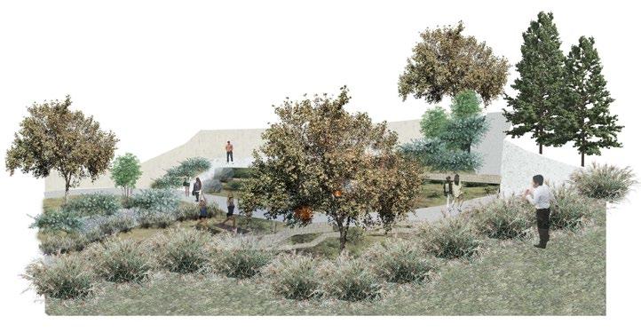
1. SPA STRUCTURE
2. GREEN ROOF


3. PRIVATE SPACES
4. RAIN GARDEN
5.
To create a public space that encourgaes therapeutic principles through the use of sustainability, education, and inclusivity. The goal is to enhance the senses, values, and philosophy of the Japanese Friendship Garden. It will expand the garden’s borders to connect as a whole.


The site visit started with a tour of the garden. I drew sections and took measurements to study the typology. It was followed by two wellness activities offered by the garden. Lastly, it finished with a tour of Balboa Park to understand the scale and context of the site.
1. To implement JFG typology.
2. To create harmony for spaces of rest.
3. To include natural elements and spaces of learning.
4. To improve accessibility and mobility.
5. To invite habitat and life.
6. To use smarter drainage systems.
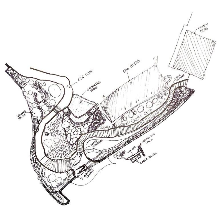
- Spa Structure - Green Roof
- Private Spaces - Rain Garden
- Pollinator Garden - Green Wall
- Terrace Space - Shade Structure

TO CREATE A PUBLIC SPACE THAT ENCOURAGES THERAPEUTIC PRINCIPLES THROUGH THE USE OF SUSTAINABILITY, EDUCATION, AND INCLUSIVITY. THE GOAL IS TO ENHANCE THE SENSES, VALUES, AND PHILOSOPHY OF THE JAPANESE FRIENDSHIP GARDEN. IT WILL EXPAND THE GARDEN’S BORDERS TO CONNECT AS A WHOLE.
1. TO IMPLEMENT JFG TYPOLOGY
2. TO CREATE HARMONY FOR SPACES OF REST

3. TO INCLUDE NATURAL ELEMENTS/SPACES FOR LEARNING

4. TO INCLUDE MORE ENTRANCES, PATHS, AND RAMPS


5. TO INVITE HABITAT AND LIFE
6. TO USE SMARTER DRAINAGE SYSTEMS FOR SUSTAINABILITY.


1. SPA STRUCTURE
CONCEPT PHOTOS:


 T-1 T-2
T-3
T-4 S-1 S-2
S-3 S-4 S-5
S-6 S-7 S-8
S-9 S-10 S-11
T-1 T-2
T-3
T-4 S-1 S-2
S-3 S-4 S-5
S-6 S-7 S-8
S-9 S-10 S-11

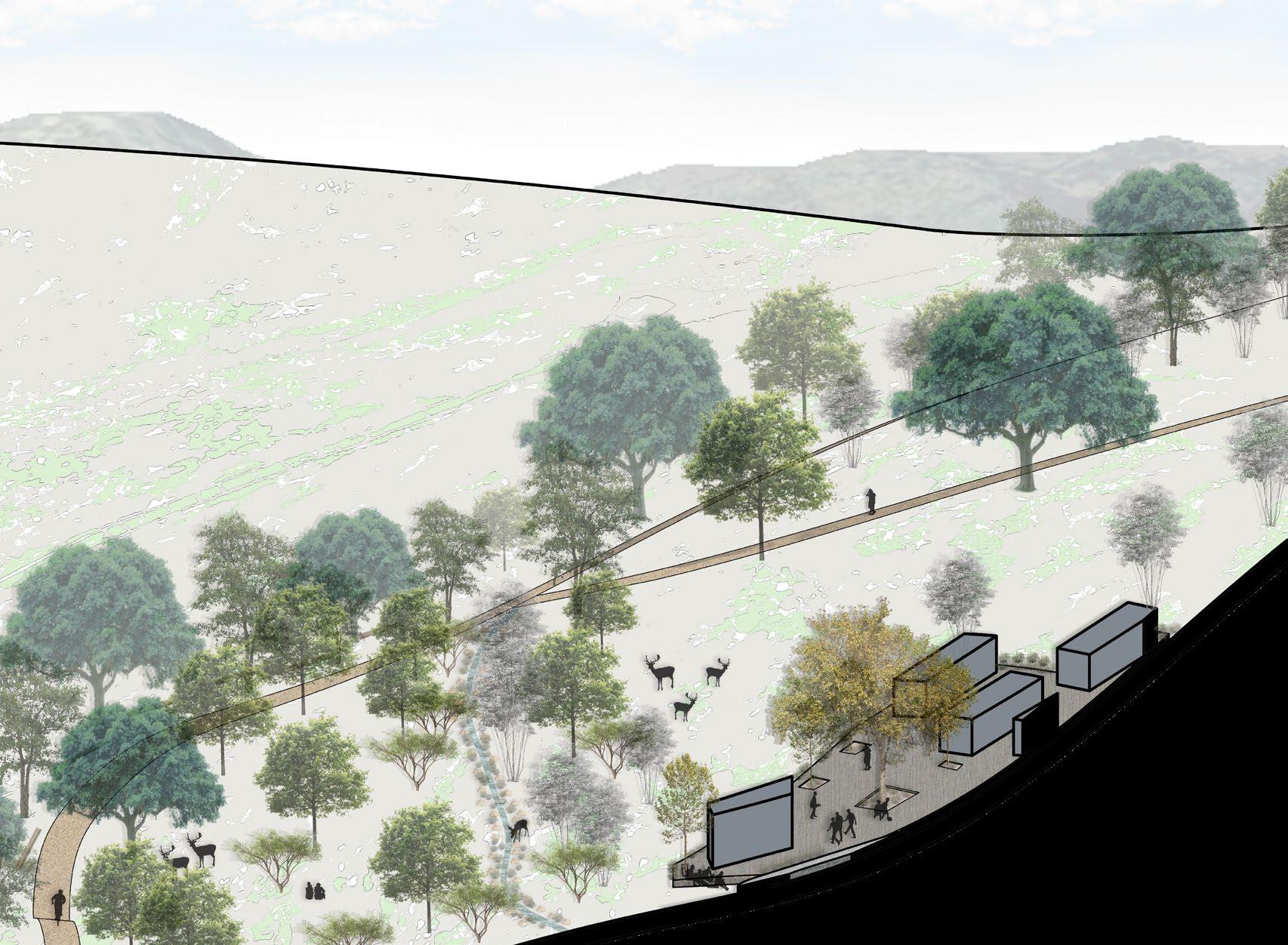
The purpose of our project is to redefine an area of the camp that everyone forgot once existed. We want to give this site of the camp a good purpose by showing that it is different from any other part of the camp. We plan to add a new camp, Terrace, trail, reflection area, and a zip line. Throughout all the main spots of our site, a trail will follow through and guide the visitors to each zone. Within the middle of our site we are adding a wildlife area where there are undefined trails for visitors to explore. We plan to make the campsite livable by reconstructing the cabins, restroom, and kitchen. The zip line that we’re adding will end at the entrance of the entire camp. The reflection area will be a small amphitheater for students to come together and talk about what they’ve done throughout their days at the camp. On the trail there will be trees on each side to guide visitors through the site. The trail will end at the Terrace where there will be small telescopes to look at the other higher points and lower points of the campsite. Although our site feels very far away the zip line is able to connect to the entrance of the camp making it a part of the entire campsite. We hope that the users of this area will be excited to come here and experience something new.
Revive the camp site and offer new spaces for education, growth, and discovery. Gardens, ampitheaters, and classrooms as programs.

Use low-water use planting material and create more canopy for spaces of rest. Maximize California native plants based on climate.
Encourage Woodcraft Rangers to hike, play, and participate in Camp Outpost. Creates a sense of belonging and discovery.
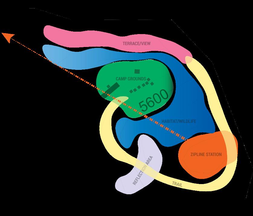
The bubble diagram helped lay out the proposed spaces.
The word diagram was used to demonstrate ideas for the spaces.
The planting diagram helped show scale and types of planting.
The axon drawing informed how steep the site appeared.


The Woodcraft Rangers Outpost project consisted of two phases. Phase I consisted of concept drawings and diagrams. The second phase focused on the planting material and water use.
Phase one implemented feedback from the site analysis and field trip. The thinking behind the concepts can be seen in the diagrams. They show the order, community, and ecology proposed in the master plan.

Phase two focused specifically on the camp grounds where the exisiting cabins were located. The idea was to revive the camp by proposing new cabins and use a low-water planting palette for the design.

1. To revive the rundown camp.
2. To re-use exisitng structures if possible.

SECTION A-A
3. To use California native plants.


4. To improve accessibility.
5. To use low-water planting.
- Cabins
- Kitchen/Dining Hall
- Restrooms
- Outdoor Classroom


- Garden
- Seating Spaces
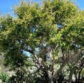
characteristics of the outdoors and wilderness.

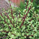
GLOBEMALLOW
The design is incorporated to welcome wildlife as well. Deer friendly plants, open spaces, and minimal disturbance to the habitats that already exist were considered and addressed. Overall, it is a space that includes all while bringing back excitement to a neglected camp.


B
DRAINAGE
BUCKWHEAT PLANTING ALONG EDGE/ SEAL IN PATH
USER SOFTWARE USED
BOULDERS TO SUPPORT SLOPE AND INCREASE SCALE
Adobe illustrator, Photoshop, InDesign were used for diagrams, presentations, and editing. AutoCAD and Rhino were used for drafting and 3D modeling. Lumion was used to render and add textures to perspectives. LandFX was used for the technical planting plan and Plant ID.
GLOBE-MALLOW ALONG SECOND COLUMN
KEY MAP
2022 20


Multiple prototypes were constructed for the design of Camp Outpost. The greatest challenge besides the topography was the architecture for the cabins. After researching cabin types, an A-frame cabin that can house four rangers was created. The next focus of the project was the kitchen and restrooms. Lastly, the planting was added with an emphasis in hydrozones and water-use.

Phase II was an individual project but I did collaborate a lot with my partner from Phase I. We shared resources and cad files to make our projects cohesive. The end result was four poster boards that displayed our Phase I plan as well as our Phase II individual projects. They were displayed in an exhibit style review.
The cabin axonometric diagram shows the layout space of the structure. There are windows placed for sunlight and air flow.


The planting sketch was the final prototype for the orientation of trees, shrubs, and ground cover. It helped visualize the concepts.


The hydrozone diagram helped emphasize the regions for planting. It also showed which types of planting can thrive together.
The planting plan illustrated the steps necessary for technical drawings. Using landfx, the symbols, plant types, and ground covers were represented. Hatches were also used to show the difference between hardscape and softscape.


Prof. Ray Senes
Fall 2021 Daniel Lopez + Cuauhtemoc Hernandez
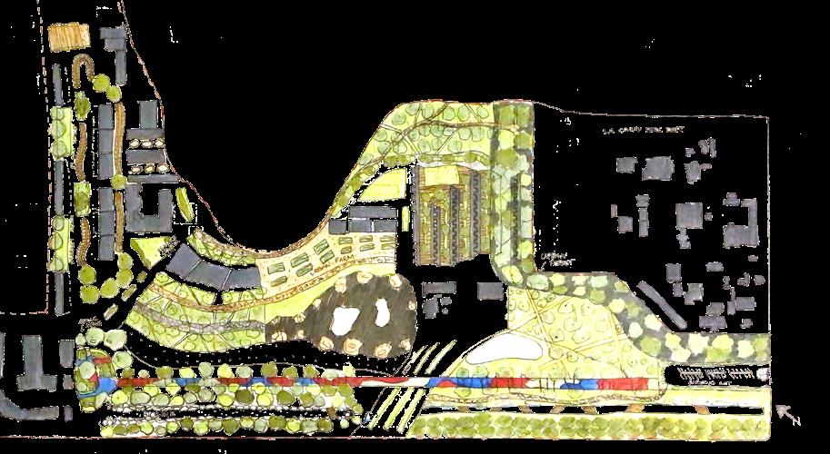
SITE PLAN
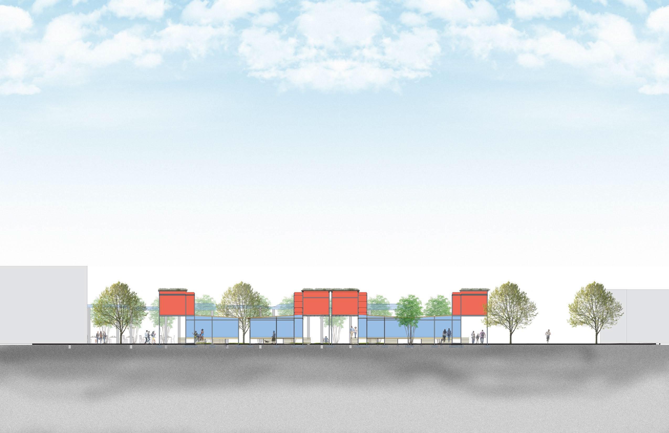
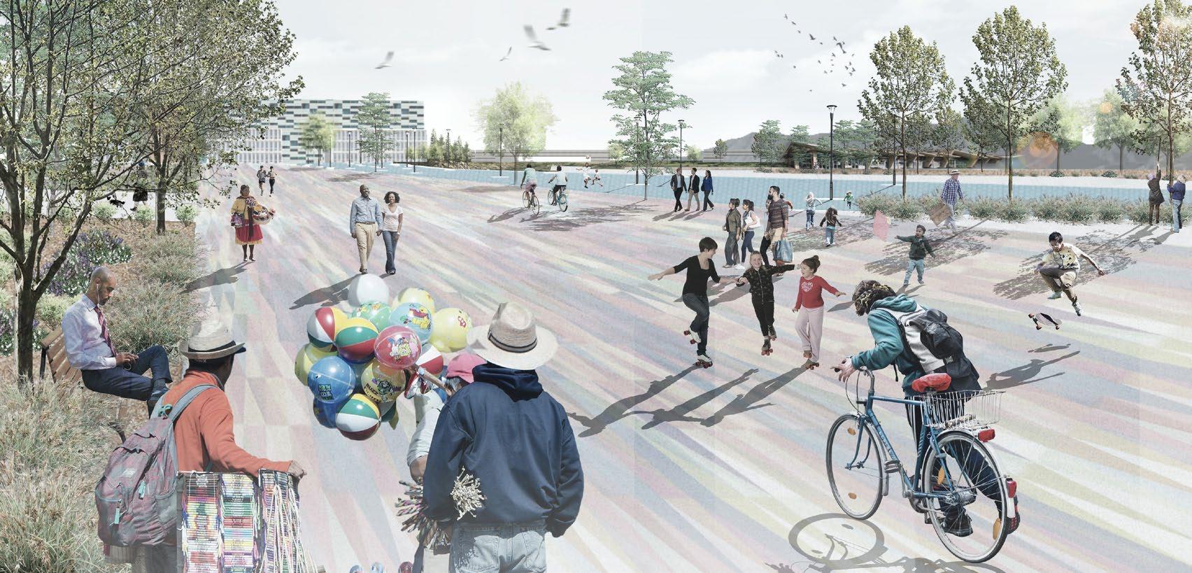
For our design, the journey presented is one of activity, ecology, and gathering. It brings the community together to interact with one another and spread cultures, traditions, and ideas. It is an inviting space which connects the transport hub, Lincoln park, two mixed-use buildings, and City Hall. This connection can be seen through 1st street through the use of planting and ecology. Social value is increased through this space by providing flexible areas which cater to the needs of the community. These spaces can contain programs such as vendor areas, market squares, festivals, and concerts.
SITE PLAN
FOR OUR DESIGN THE JOURNEY PRESENTED IS ONE OF ACTIVITY, ECOLOGY, AND GATHERING. IT BRINGS THE COMMUNITY TOGETHER TO INTERACT WITH ONE ANOTHER AND SPREAD CULTURES, TRADITIONS, AND IDEAS. IT IS AN INVITING SPACE
For the site analysis, my partner and I visited the site multiple times to investigate the social interaction occurring. We noticed a heavy foot traffic due to the train station nearby.
A tour of the site was given by EPT Design. Lincoln park was still under construction when the visit was conducted.
Our goal is to bring more green infrastructure and social interaction to the space through the use of ecology and flexible programming. We identified the weaknesses of the site and tried to address them by enhancing key nodes.
- 1st Street Promenade
- Sycamore Plaza
WHICH CONNECTS THE TRANSPORT HUB, LINCOLN PARK, MIXED-USE BUILDINGS, AND CITY HALL. THIS CONNECTION CAN BE SEEN THROUGH 1ST STREET THROUGH THE USE OF ECOLOGY. SOCIAL VALUE IS INCREASED THROUGH THIS SPACE BY PROVIDING FLEXIBLE AREAS WHICH CATER TO THE NEEDS OF THE COMMUNITY. THESE SPACES CAN CONTAIN PROGRAMS SUCH AS VENDOR AREAS, MARKET SQUARES, FESTIVALS, AND CONCERTS.
- Sycamore Planting
- Seating Spaces
- Natural Trail
Spatial Definition Studies as Strategies + VISIONING


AutoCad was used to draft a site plan, it was then rendered on illustrator and photoshop. The drafted plan was also used in Rhino to create a 3D model of the site. This was used to create diagrams and perspectives. InDesign was used to create a presentation on an 11x17 poster board.


URP 4040 Placemaking, Theories, and Practices
Prof. Nicole Lambrou
Daniel Lopez + Brian Espinoza + Nicholas Conti + Jacqueline Anggriani + Jose A. Cruz
The Wilmington Portscape is an intervention design applying ideas of placemaking. Knowledge of the site was applied through experiences and stories. The site analysis reflected the needs for the site as a very disadvantaged community. The use of recycling shipping containers was a focus of the design to address the ongoing influx of shipping containers throughout the city. The intervention also considered the presence of street vendors and provided a space for them to interact with the public safely. Overall, community was the emphasis for a disadvantaged city.


The Whiteman Airport Master Plan project was a design proposal created by Tinkercraft for the Pacoima Beautiful organization. The project is ongoing but its purpose is to redevelop the Whiteman Airport by including community input and ideas. Input from the community was used to create a narrative and inform the design. The plan proposes re-using hangars and structures for market, education, and social gathering spaces. The idea was to bring sustainability to the site and provide more landscapes. The programs consisted of a hospital, market space, rain garden, educational facilties, and a forest buffer. The idea of the buffer was to extend the LAFD so helicopter pads can be moved further from the residents on Osborne St. while also creating a buffer of trees to prevent noise pollution.


Instructor: Ronnell Hampton
Fall 2022
Daniel Lopez + Juan Leon + Jocelyn Aguirre
LA 4782 was a class that researched creating sustainable landscapes through the use of interventions and prototypes. Different types of research, analysis, and site visits were conducted to achieve an intervention that truly benefited all stakeholders. Wilmington, CA was the focus of my group’s project. I was tasked with mapping our research and creating a graphic narrative of our stakeholder’s values. To create the narrative, I interviewed many residents that lived in proximity to the site. Overall, the biggest takeaways were stories of crime, pollution, and health issues. The canvas paints a picture to detail the burden of the city. This is shown with the trains, shipping containers, and port.
The final concept for the intervention was to address traffic pollution next to the harbor freeway. Green wall planting, safer bike lanes, and areas of rest were proposed. Overall, the idea was to improve the quality of life and create a connection between the site and the rest of landscape.

WILMINGTON, CA


I discovered my love for photography in the landscape architecture discipline. I believe photography to be a important tool in site mapping, analysis, and graphic communication. It helps paint a narrative of time and space. I continue to do photography as my hobby.

The site analysis conducted was for a site in the City of Rialto. GIS was used to portray how accessible the site was to the community and residents. Through the findings one can see that the site felt secluded from the center of the city. It lacked transportation, affordability, and diversity. This helped propose ideas on how to approach a design while identifying stakeholders, community, and impact.


A critical combined map was created to use as an overlay method of the data present to see which issues and areas appeared to impact the site the most. Overall, GIS is a wonderful tool to be able to map out characteristics of a site. It defnitely can help address the needs of people in disadvantaged communities.


BUS ACCESS MAP
HISPANIC POP MAP
