

We track the strategies, teams and technologies driving 5G NTN globally
Es’hailSat delivers satellite services for broadcast, broadband, mobility, corporate and government customers across the Middle East and North Africa, and beyond.
VIDEO SERVICES
•Direct-to-Home
•Broadcast Distribution
•Broadcast Contribution & Occasional Use
• Digital Satellite News Gathering
•Playout & Media Services
TELECOM SERVICES
•VSAT Networks
•Cellular Backhaul
•Maritime Services
•Oil & Gas / Energy Services
•IP Trunking
•Mobility Services
TELEPORT SERVICES
• Tier-4 Certified
• Antenna Hosting
• Private Data Center Suite
• Co-Location Services
• Partial / Full Rack
• Studio Spaces

Visit Us at Hall-1, Stand F68 RAI Amsterdam September 12 - 15, 2025

EDITORIAL
MANAGING DIRECTOR AND EDITOR
VIJAYA CHERIAN
vijaya.cherian@cpipromedia.com
+971 (55) 1053787
EDITORIAL CONTRIBUTORS
KALYANI GOPINATH
NUSRAT ALI
UROOJ FATIMA
SUB EDITOR AELRED DOYLE
ADVERTISING
KEY ACCOUNT MANAGER
VIJAYA CHERIAN
vijaya.cherian@cpipromedia.com
+971 (55) 1053787
GROUP SALES DIRECTOR
SANDIP VIRK
sandip.virk@cpipromedia.com
+971 (0) 50 929 1845 / +44 (0) 7516 993 862
FINANCE
FINANCE EXECUTIVE
YONWIN D’SOUZA finance@cpipromedia.com
DESIGN & PRODUCTION
ART DIRECTOR
DAVID FRASER design@cpipromedia.com
EVENTS EVENTS EXECUTIVE events@cpipromedia.com
DIGITAL SERVICES
WEB DEVELOPER
HAFIZ MUHAMMAD WAQAS IT@cpipromedia.com
FOUNDER
DOMINIC DE SOUSA (1959-2015)
PARTNER
MARIA DE SOUSA

The satellite industry is entering a bold new era with Non-Terrestrial Networks (NTN), pushing connectivity far beyond traditional terrestrial limits. Vendors including Ericsson, All. Space, Kratos and OQ, whom we interviewed for this edition, are testing 5G NTN solutions and laying the groundwork for the next generation of global connectivity. While commercial rollouts remain a few years away, these developments signal a major shift in how enterprises, governments and industrial sectors will access reliable coverage anywhere on the planet.
Real-world satellite innovations are making a huge impact in the market. In MENA, Eutelsat is launching its Majjane platform, which delivers live TV and on-demand video directly to smartphones without relying on internet or mobile data, demonstrating the power of DVBNative IP to bridge digital gaps at scale. Cofactr is transforming aerospace supply chains, using AI to provide real-time visibility across multi-tier Bills of Materials (BOM), ensuring resilience, compliance and operational efficiency in industries where every component counts.
Türksat’s CEO talks about Türkiye’s first fully domestically developed communications satellite, showing how national ambitions are driving technological independence and expanding global coverage.
Earth Observation is also gaining momentum. Initiatives across the GCC demonstrate how satellite capabilities can drive environmental monitoring, strategic planning and infrastructure insights, highlighting the growing commercial and societal impact of space-based intelligence.
Together, these stories illustrate an industry awakening. NTN trials, satellite-powered VOD, AI-driven supply chains, and EO programmes are converging to redefine connectivity, access and intelligence.
For this IBC issue, we conducted extensive interviews with these companies and others, bringing you the latest on emerging market trends, technical breakthroughs and MENA-specific insights. Hope you enjoy reading it. See you at the show.

VIJAYA CHERIAN Editor SatellitePro


UPDATE
Space42 secures $695.5m to fund Al Yah 4 and 5 satellites; Arabsat announces new CEO; FGC and Arabsat to deliver satellite data services across KSA; SATExpo 2026 to move to Dubai Expo venue; Integrasys heads to IBC with Orbisat; and more
TECH UPDATE
Introducing 5G NTN
Sridhar Kuppanna, CTO of ST Engineering iDirect sheds light on how 5G Non-Terrestrial Networks (NTN) are transforming modern connectivity globally
COVER STORY
As the 5G NTN ecosystem takes shape, senior executives from Ericsson, Kratos, All.Space and OQ talk to Vijaya Cherian about the opportunities and challenges it brings
COUNTRY FOCUS - TURKEY
Reaching New Heights
Türksat CEO Ahmet Hamdi Atalay discusses 6A and Türkiye’s space ambitions with SatellitePro ME
MARKET REVIEW
EO Drives Gulf Innovation
Vijaya Cherian reports on how KSA’s Neo Space Group and the UAE’s TII are advancing the GCC’s EO capabilities
CASE STUDY - NEW SERVICE IN MENA
Eutelsat’s New MENA Launch
Eutelsat’s new multiscreen service
Majjane ushers in internet-free content delivery. Kamal Lotfy discusses its hybrid potential with SatellitePro ME
INTERVIEW
Smarter Supply Chains for Space
Cofactr CSO Phillip Gulley on how AI is streamlining aerospace and defence supply chains
GUEST COLUMN
What Lies Ahead for MENA!
Alex Martins explores the Middle East’s expanding satellite market


FUNDING
UAE-based space technology company Space42 has signed a $695.5m Export Credit Agency (ECA)-backed financing facility to fund the development of its nextgeneration geostationary satellites, Al Yah 4 and Al Yah 5, scheduled for launch in 2027 and 2028.
Al Yah 4 and Al Yah 5 will feature software-defined architecture with fully flexible payloads that can be reconfigured in orbit. This enables real-time optimisation of coverage, bandwidth and frequency allocation to meet operational requirements across MEA, Europe and Asia. The two satellites are designed to complement and eventually replace Al Yah 1 and Al Yah 2, launched in 2011 and 2012.
Adnan Al Muhairi, CTO of Space42’s Space Services

division, stated that “Al Yah 4 and Al Yah 5 are fully software-defined, capable of adjusting coverage, bandwidth, and frequency in real time while in orbit”.
“This flexibility not only boosts operational efficiency but ensures responsiveness to evolving demands. Their highthroughput capacity, enabled through Mil-Ka and C-band frequencies, strengthens support for civil, defence, and humanitarian missions alike.”
Al Muhairi noted that Al Yah 4 and 5 will be deployed in Geostationary Earth Orbit (GEO) as part of the company’s multi-layered space infrastructure, which includes the Thuraya-4 satellite, set to enter service this year, a Foresight Earth Observation constellation in Low Earth Orbit (LEO), High-Altitude Platform Stations (HAPS) in the stratosphere, and a growing suite of ground systems.
APPOINTMENT
Arabsat has named Dr Badr Alsuwaidan as its new President and Chief Executive Officer, bringing more than 25 years of experience in the space sector to the role. Dr Alsuwaidan has built a distinguished career in satellite operations, engineering and strategic development, earning recognition for his leadership in advancing

technological innovation. Since 2020, he has served as Senior Vice President and Chief Technical Officer at Arabsat, where he played a key role in boosting operational performance and strengthening the company’s technological capabilities. His contributions have been central to enhancing Arabsat’s standing in the global satellite communications market.
Es’hailSat, Qatar Satellite Company, has announced that Viasat Energy Services, a business unit of Viasat, Inc., has added satellite capacity on the Es’hail-1 satellite located at the 25.5⁰ East hotspot and will use this capacity to provide VSAT services across the MENA region.
Ali Ahmed Al-Kuwari, President and CEO of Es’hailSat, said: “Es’hailSat is excited to enhance and continue to deliver satellite capacity for Viasat Energy Services’ VSAT Network to enable high speed connectivity across the Middle East and North Africa. We believe that the highly robust and reliable data services offered by us at Es’hailSat – Qatar Satellite Company, together with 50,000 sqm of Tier-4 certified Teleport infrastructure provide the strong base that Viasat Energy Services needs to further build their capabilities and serve end customers across the region.”
SATExpo 2026 will take place from 2–4 June 2026 at the Dubai Exhibition Centre (DEC), located in the heart of Expo City Dubai, alongside CABSAT, the Arab world’s most influential broadcast and media technology event. The DEC provides the ideal stage for SATExpo’s ambitions. Spanning 45,000 sqm of flexible event space, it offers nine exhibition halls, five multipurpose halls, 24 meeting rooms, and four suites—perfect for highprofile exhibitions, technical showcases, and strategic networking. Just 300 m from the former Expo 2020 core and directly connected to the Metro’s Route 2020 station,

the venue ensures seamless access for both local and international participants. As part of an AED 10 billion (USD 2.7 billion) expansion, the DEC is evolving into the region’s largest purposebuilt indoor events venue.
Relocating SATExpo
The Kingdom of Bahrain has been chosen to chair the Committee responsible for drafting the Arab Space Strategic Plan, following a decision made at the 11th meeting of the Arab Space Cooperation Group, held in Egypt.
Rasha Al Amad, Chief of Strategic Planning at the Bahrain Space Agency (BSA), has been appointed to lead the Committee, which comprises representatives from eight
Arab space agencies. She will guide the formulation, implementation and assessment of a unified strategy designed to coordinate regional efforts and elevate the Arab world’s position within the global space arena.
The Committee’s objective is to foster deeper cooperation among Arab nations, ensuring a cohesive and competitive regional presence in space sciences and technology.
to this modern, highcapacity space enables improved exhibition layouts, enhanced visibility for exhibitors, and a premium experience for attendees. The June dates also create new opportunities for international engagement,
aligning with SATExpo’s mission to bring together the global satellite industry with the rapidly developing MENA market.
The event will continue to showcase cutting-edge developments in satellite communications, space exploration, and connectivity solutions, alongside expertled conference sessions at the SATExpo Summit. Matchmaking services will facilitate targeted, high-value connections between satellite operators, technology providers, government agencies, and investors.
Exhibitors can reach out to the organiser via satexpome.com to discuss exhibition space.
Eutelsat Communications has appointed Éric Labaye as the new Chairman of both Eutelsat Communications and Eutelsat SA, following approval by the Board of Directors at its latest meeting. Labaye succeeds Dominique D’Hinnin, who had earlier announced he would not seek renewal of his mandate beyond February 2025. Labaye’s appointment is effective from August 4, 2025, and he will serve as Chairman until the next Shareholders’ General Meeting, where his appointment will be proposed for a full term.

First Gulf Company (FGC) and Arabsat will deliver exclusive VSAT and satellite data services across Saudi Arabia. This deal leverages Arabsat’s Geo KU-band infrastructure and FGC’s operational capabilities to provide high-capacity, fully managed data and IP-based services, delivering reliable connectivity across the Kingdom for telcos, MNOs and ISPs.
The service enables organisations to maintain and monitor business operations even in the most remote areas, helping to reduce operational risks, enhance security and increase profitability, particularly for the oil & gas and mining sectors. This partnership reflects our shared commitment to advancing digital connectivity, supporting national infrastructure, and enabling
digital transformation across the government and private sectors in Saudi Arabia.
Joe Chbat, Executive Vice President of Systems Division, First Gulf Company, said: “At First Gulf Company, we’ve always focused on delivering advanced engineering solutions for the broadcast and telecom sectors. This partnership with Arabsat marks a strategic expansion—extending our capabilities to help increase digital connectivity across the Kingdom. Together, we’re not just providing a service; we’re empowering nationwide access to resilient, high-capacity infrastructure that supports Saudi Arabia’s digital future.”
SES has announced the completion of its acquisition of Intelsat, creating a strengthened global satellite operator with an expanded fleet of 120 satellites across two orbits. The newly combined company will leverage its skilled teams with deep vertical expertise to deliver integrated multi-orbit, multi-band satellite and connectivity solutions to businesses and governments around the world, creating a stronger multi-orbit operator with
~60% of revenue in highgrowth segments.
SES will now be able to deliver connectivity solutions utilising complementary spectrum bands including C-, Ku-, Ka-, Military Ka-, X-band and Ultra High Frequency.
The company’s assets and networks, once fully integrated, will put SES in a strong competitive position to better serve the evolving needs of its customers including governments, aviation, maritime and media across the globe.

and KALRO to boost Kenyan agriculture with satellite data
SatSure Analytics India Pvt. Ltd., a leading EO data refinery platforms, has partnered with Kenya Agricultural and Livestock Research Organisation (KALRO) to transform agricultural productivity in Kenya using advanced satellite data and analytics. The partnership will focus on leveraging satellite imagery, remote sensing and advanced analytics to provide actionable insights for crop monitoring, yield forecasting, soil health assessment, and climate resilience strategies.
Dhruva Rajan, Chief Revenue Officer at SatSure, said: “We’re thrilled to collaborate with KALRO in bringing cutting-edge geospatial intelligence to Kenya’s agricultural landscape. This partnership will enable datadriven policymaking, strengthening food security, and empowering small holder farmers with near real-time insights into crop health, weather variability, and sustainable practices.”
IBC2025
Integrasys, a leading provider of space software solutions, has developed Orbisat, an advanced Space Domain Awareness (SDA) system that integrates open data and leverages a broad network of Rx antennas to track satellites in LEO, GEO, MEO, and HEO.
Orbisat was developed in response to the rapid growth of satellites and the increasing demand for effective space traffic management – a critical challenge for the satellite industry, governments and defence organisations. Space is more congested than ever, with 2,695 satellites launched in 2024 alone, according to the Satellite Industry Association (SIA). Today, more than 12,000 satellites and approximately 9,000 metric tons of space debris orbit Earth.
Integrasys’ Enterprise, Management & Control (EM&C) portfolio enables monitoring and protection of both physical assets
and RF signals in space, while allowing satellites to perform manoeuvres to avoid collisions and mitigate potential threats. Now operators can go beyond monitoring and take direct action. Orbisat’s integrated toolset enables satellites to automatically plan and execute manoeuvres to avoid collisions or counter other in-orbit threats. By combining SDA with active control, Integrasys bridges the gap between space surveillance and operational decision-making, using LPXTT&C to maximize
discretion and protection. Orbisat won the SatellitePro Middle East Manufacturer Award at SATExpo this year for Best Sustainable Satellite Operations, and its contribution to space safety and operational resilience. The system combines AIenhanced multisensor data fusion, integrating passive RF, optical, and active data, to transform complex orbital information into clear, actionable intelligence. Its advanced analytics provide early warnings of collision risks, suspicious
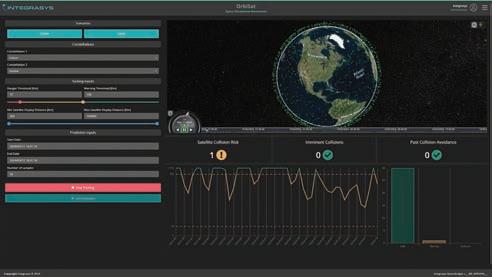
manoeuvres, and potential interference, enabling rapid decision-making in congested or contested orbital environments. This capability is increasingly critical as megaconstellations expand and the space domain becomes central to national security, broadband, and mobility services.
Designed for both defence and commercial command infrastructures, Orbisat’s interoperability allows seamless integration into multinational operations, enabling allies and coalition partners to share a common operational space picture—a vital asset for coalition defence strategies and global governance.
At IBC, Integrasys will also showcase how its EM&C portfolio, anchored by Orbisat, supports sustainable satellite operations, strengthens competitive advantage, and drives operational excellence for customers worldwide.
DATA CENTRE
Abu Dhabi-based startup Madari Space is preparing for its first mission to place a data centre in low-Earth orbit, with the launch planned for Q3 2026.
Dr. Shareef Al Romaithi, founder and CEO of the company, told Bloomberg TV that the mission, developed in collaboration with the Mohammed
bin Rashid Space Centre (MBRSC) and the UN Office for Outer Space Affairs, will serve as a proof of concept to showcase the company’s ability to store and process data in space. He underscored the environmental advantages of moving data storage off-planet, noting that terrestrial data centres are among the most
energy-intensive facilities on Earth, with carbon emissions exceeding those of the aviation industry.
By leveraging low-Earth orbit, Madari Space aims to develop sustainable and secure solutions to manage the surge in data generated both on Earth and in space. The company sees the mission as an opportunity to de-
risk operations and refine its technology before expanding into deeper space and engaging in the emerging cislunar economy between Earth and the Moon.
Initially, Madari Space will focus on serving EO operators and other spacebased enterprises that produce large volumes of data in orbit.

The demand for seamless, highperformance connectivity is redefining the telecommunications landscape. Whether in urban centres or remote regions across land, sea and air, reliable connectivity is no longer optional.
At the heart of this evolution is 5G Non-Terrestrial Networks (NTN). Rooted in 3GPP standards, 5G NTN bridges terrestrial and satellite systems to create a unified global network, unlocking immense potential for operators and users alike.
Satellites transition to an essential role in 5G
Historically, satellites were addons to fill coverage gaps where terrestrial networks fell short. Today, 3GPP Release 17 and 18 provide the
foundation for integrating satellites seamlessly into the 5G ecosystem.
Future advancements planned in Release 19 aim to further enhance this integration. While full interoperability is still on the horizon, satellites are steadily becoming critical components of the global 5G network, promising to deliver unprecedented opportunities for connectivity worldwide.
5G NTN is transforming how we think about connectivity. It extends reliable service to regions traditionally considered unreachable by telcos, such as vessels in expansive maritime zones, high-altitude aviation routes and underserved rural communities.
More than just coverage, it fosters innovation, enhances critical infrastructure and drives global mobility, positioning 5G NTN as a foundational pillar of modern connectivity.
Building 5G NTN with standards and cloud architecture
The success of 5G NTN lies in its adherence to shared standards that promote scalability, simplicity and interoperability. By adopting 3GPP frameworks, terrestrial and multi-orbit Low Earth Orbit (LEO), Medium Earth Orbit (MEO), Geostationary Orbit (GEO) and Highly Elliptical Orbit (HEO) satellite networks can seamlessly converge. This standardisation eliminates operational silos and allows operators to remain agile as market demands evolve. Cloudnative architectures serve as the backbone of this transformation, further enhanced with automation and AI-driven orchestration simplifying integration and bolstering interoperability across networks. Key technologies like
virtualisation, intelligent bandwidth allocation and network slicing enable operators to optimise resources efficiently. These advancements support a wide range of applications, including IoT, enterprise communications and realtime analytics, delivering scalable solutions for diverse business needs.
Expanding connectivity with 5G NTN
While terrestrial infrastructure has its limitations, 5G NTN expands connectivity to regions where traditional solutions are impractical or cost prohibitive. It addresses critical use cases like rural broadband, aviation connectivity and maritime logistics, ensuring reliable service in challenging environments.
The benefits of 5G NTN go beyond coverage. Through features such as dynamic spectrum sharing and network slicing, operators can customise connectivity for various applications, from high-speed consumer broadband to corporate enterprise network extensions and IoT systems. This tailored approach provides consistent quality while enabling operators to meet evolving demands efficiently.
Multi-orbit constellations further enhance flexibility, allowing networks to strategically balance coverage, bandwidth and latency requirements.
A hybrid approach to 5G NTN
I believe that transitioning to 5G NTN requires more than bold ideas. It demands a deliberate, hybrid approach that balances immediate needs with a scalable future. The focus must be on helping operators achieve interoperability without disrupting their existing networks.
The first step to integrating today’s satellite ground systems (non-3GPP networks) into the 5G Core is using an Interworking Gateway Function (IGW). This
allows operators to benefit from 5G Core efficiencies, such as centralised management (including billing, provisioning, authentication) enabling seamless service, without immediate infrastructure overhauls.
And by extension this also enables inter-provider roaming across these satellite networks. By leveraging satellite-specific waveforms like DVB-S2X and Mx-DMA MRC, current networks maintain optimal performance while preparing for 5G New Radio (NR) integration.
Secondly, 3GPP-compliant technologies, including Radio Access Technologies (RAT) including satellite optimised gNodeBs, are introduced to provide direct access to 5G Core and enable the use of 5G NR, unifying satellite and terrestrial systems.
Hybrid user equipment (UE), capable of dynamically roaming across networks, including non3GPP, 5G NTN and terrestrial systems, ensures consistent, reliable connectivity for global users.

Toward a unified, intelligent network fabric
The integration of satellites into a unified 5G ecosystem is more than a technical achievement. It signals a shift in how networks are designed and operated. By emphasising open standards, cloud-native principles and unified orchestration, the telecommunications industry is building networks where every element, from orbiting satellites to terrestrial base stations, is seamlessly connected. For satellite operators, this integration unlocks new potential to participate in globally standardised, multi-vendor ecosystems. With AI-enabled automation and programmable payloads, operators can deliver high-quality services at lower costs while reducing complexity.
Telcos also stand to gain by incorporating satellites into their core strategy, as satellites become indispensable assets, enabling them to deliver competitive, resilient services tailored to modern demands.
A clear vision for the future
The path to 5G NTN adoption is a series of strategic milestones, culminating in a flexible, borderless network. By combining cloudnative systems and future-ready solutions like 5G Core, 5G RAT, 5G NR and hybrid UEs, we’re not just solving today’s connectivity challenges, we’re laying the foundation for 6G and beyond. 5G NTN redefines boundaries in connectivity, creating an ecosystem where terrestrial and satellite networks work in harmony. For operators and telcos alike, it represents a shift from following the market to leading its transformation. With 5G NTN, we’re building a truly global, unified network that’s ready for the future.

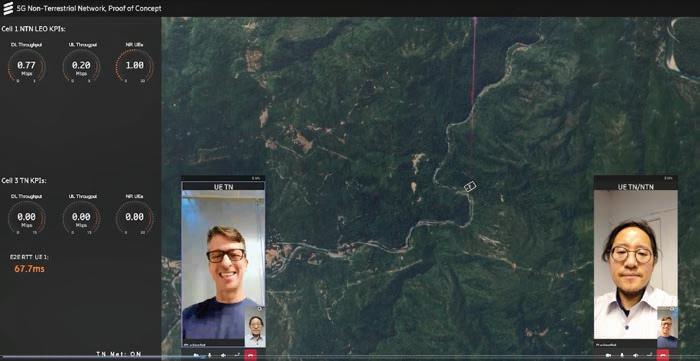
As the race to extend mobile connectivity beyond terrestrial boundaries heats up, non-terrestrial networks (NTN) are emerging as a critical piece of the 5G puzzle. Vendors worldwide are working to develop interoperable, scalable solutions that blend terrestrial 5G with orbital infrastructure. From lab-based trials to LEO constellations, Vijaya Cherian interviews industry players who are paving the way forward, offering both technical solutions and strategic perspectives on where NTN is headed
Vendors are pushing 5G beyond terrestrial towers and into orbit, building interoperable networks, flexible terminals and virtualised ground systems. The emerging NTN ecosystem promises to transform connectivity for enterprise, government and industrial
applications. From controlled environment trials to commercial deployments, Ericsson, All. Space, Kratos and OQ are each tackling critical technical and operational challenges, helping to shape a global ecosystem that extends mobile coverage to regions previously beyond reach, including the Middle East and Africa.
For Ericsson, the recent
collaboration with Thales Alenia Space and Qualcomm marks a significant milestone. In a controlled lab environment, the three companies established an end-to-end 3GPP-compliant connection via a simulated LEO satellite channel, validating the core technical features for integrating terrestrial New Radio (NR) networks with NTN.

“The goal was to demonstrate that 3GPP Rel-17, including NTNTN mobility features, functioned as specified,” says Per Synnergren, Director, Strategic Business Development, GF Technology, Ericsson. “No major technical obstacles emerged, except perhaps for the integration of a third-party radio from Thales Alenia Space.” He remarks that while the lab
setup was simplified compared to future commercial projects, it confirmed that standardisation is essential for building a scalable global ecosystem.
Synnergren also highlights that early MNOs deploying device-todevice (D2D) NTN services are typically operating in vast countries with coverage gaps. “While satellite D2D services can’t match the user
experience of terrestrial networks in busy areas or produce data at the same cost levels, they play a crucial role as lifeline connectivity solutions for messaging, voice calls, and some limited data services,” he explains. Emergency responders, military operations, and industrial IoT also stand to benefit, particularly where global outdoor coverage is essential.
All.Space, by comparison, is tackling a different bottleneck with terminal flexibility. It recently secured funding from the European Space Agency (ESA) to accelerate the development of integrated 5G NTN capabilities within its nextgeneration terminal platform.
“This is a key step for us to be able to offer a standardised software-defined modem as part of our terminal. It will enable any of our users to access a 5G NTN network offered by the satellite operators – these networks are not yet there but are coming in the near future. This flexibility will be a really positive step for the industry and finally remove the need for proprietary, custom, expensive modems to access each satellite network,” explains All. Space CTO, John-Paul Szczepanik. He says today’s terminals are “siloed and network-locked”, like Starlink. “All.Space is all about offering customers access to all the networks in space. We are expanding the list of networks over time, but a challenge is always the custom modems that you need to access these networks. As the operators start to standardise and look to 5G NTN, this development programme and product offering will remove that problem,” he says.
Szczepanik calls the opportunity for the All.Space terminal massive: “We’re really only starting to explore what you can do with compute and intelligence paired with a terminal at the edge. Having a standard waveform

to access many networks is a key foundation for this.”
Like Synnergren, Szczepanik stresses that standardisation is critical, adding that All.Space’s collaboration with ESA aligns the satellite industry with decades of 3GPP work. The company is also moving toward hybrid business models, combining high-performance hardware with subscription-based software services in response to strong customer demand for “Satcom as a Managed Service.” Near-term applications focus on government and commercial sectors requiring dual-use capabilities.
“Our collaboration with NXGSAT and ESA represents the first step in building a more flexible, modular satcom platform. All.Space differentiates itself

through flexibility, capability, and its patented lens-based phased array technology, enabling simultaneous links to multiple networks for resilience and customer flexibility. We are also exploring opportunities in the Middle East, where the market shows strong growth potential.”
On the ground systems front,
We’re really only starting to explore what you can do with compute and intelligence paired with a terminal at the edge”
John-Paul Szczepanik, CTO, All.Space
Kratos is enabling scalable architectures to support commercial-scale 5G NTN deployments. The company recently demonstrated an endto-end 5G NTN network that combined its OpenSpace softwaredefined satellite ground system with Intelsat’s infrastructure, including a cloud-native, virtualised 5G core. Working with Radisys and Viavi, Kratos showed data traffic flowing across a satellite network with multiple test UEs joining from different US locations and also demonstrated the use of DIFI as a digital RF transport mechanism for the 5G NTN waveform in distributed deployment scenarios, transmitting digitised RF data from a central cloud-native gNodeB to an antenna hundreds of miles away.
Jennifer Barber, Director of Product Management for 5G NTN Solutions, Kratos, notes that most ground systems today rely on proprietary, purpose-built hardware that limits flexibility and scalability. “In many cases, for an operator or service provider, the move to 5G NTN requires a complete hardware refresh. The good news is that the development of software-defined satellites has jump-started a move toward virtualised ground networks that can not only match the flexibility of these new satellite payloads, but better support commercial-scale 5G NTN deployments. Adoption of digital RF standards such as DIFI and the push to virtualise satellite modem technology on common compute platforms will continue to be key enablers in the satellite industry as 5G NTN becomes more mainstream.”
She adds that orchestration and virtualisation are vital for integration with terrestrial 5G. “Our focus is on leveraging open interfaces and global standards for orchestration to support a variety of deployment scenarios across common infrastructure components. Alignment with deployment models and infrastructure already adopted by telco and MNOs will facilitate integration between TN and NTN networks and unlock the ability for NTN networks to scale efficiently and cost-effectively.”
Kratos’ OpenSpace platform allows operators to manage multiorbit, multi-vendor, and multiwaveform networks, integrating legacy systems alongside 5G NTN while paving the way toward 6G. Signal integrity, dynamic spectrum management, and virtualised architectures make it possible to adapt to evolving spectrum allocations without costly hardware overhauls. Barber stresses that this
flexibility is particularly relevant in underserved regions of the Middle East and Arab Africa, where cost-effective ground solutions can drive adoption.
Unlike DVB-S2X, Barber says the 5GNR waveform was not designed with satellites in mind. “While there are many benefits of 5GNR in terms of flexibility, scale, open ecosystem etc, expertise in digital signal processing techniques and
satellite-specific channel effects is required in order to effectively utilise the 5GNR waveform over satellite links,” Barber says. “The flexibility of the 5GNR waveform makes it an ideal candidate for deployment in contested or highdensity operating environments. In such scenarios, leveraging spectral monitoring capabilities in conjunction with a dynamic spectrum management system
Given the geographical and coverage similarities, along with industry needs across MENA, the region presents significant opportunities for 5G NTN connectivity ”
Omar Qaise, CEO, OQ


Adoption of digital RF standards such as DIFI and the push to virtualise satellite modem technology on common compute platforms will continue to be key enablers as 5G NTN becomes more mainstream”
Jennifer Barber, Director of Product Management for 5G NTN Solutions, Kratos
allows the user to optimise their deployment in response to rapidly changing network conditions.”
As 3GPP evolves support from S and L bands in Release 17 to Ka in Release 18 and Ku in Release 19, Kratos sees virtualisation and digital RF transport as essential to adapting without full system overhauls. Low-cost, flexible solutions for gateways and terminals will be critical
to adoption in remote regions such as the Middle East and Arab Africa, with distributed deployments, edge processing, and spectral monitoring playing an increasing role. OQ is another company pioneering in the 5G NTN space by leveraging its LEO constellation to deliver IoT and direct-tosmartphone connectivity. CEO Omar Qaise shares that OQ
currently operates 10 satellites with plans to expand to more than 80 by 2028. “The constellation is designed for IoT in remote locations, benefiting industries such as Oil & Gas that operate in areas without cellular coverage, face hazards like wildfires or floods, or run automated plants. With the new satellites, we will offer Direct-To-Smart Phone connectivity,” he says.
OQ’s network is licensed in multiple countries, with a strong focus on Saudi Arabia, providing monitoring and operational efficiency for thousands of assets.
“This is helping companies to increase efficiency, reduce costs, and take decisions based on reliable data provided by our satellites. However, given the geographical and coverage similarities, along with industry needs across MENA, the region presents significant opportunities for 5G NTN connectivity and will be highly relevant for us in the near future,” Qaise says.
The company’s collaboration with Airbus has enabled NTN NB-IoT on drones, making OQ the only company worldwide to offer this capability today. Qaise describes a strategy that combines spectrum ownership, a standard 3GPP satellite fleet, and direct enterprise sales — providing flexibility and scalability unmatched by competitors who lease capacity or rely on proprietary networks. OQ has also integrated MNOs and MVNOs into its network, extending terrestrial services and supporting enterprise use cases in areas lacking coverage. Its commercial deployments, both direct and via wholesale collaborations, represent the first combined LEO and GEO NB-IoT offerings, highlighting a growing dual-use satellite market. Across these vendors, common
themes emerge. Standardisation — whether for terrestrial-to-NTN integration, terminal design, or ground systems — remains foundational. Flexible, open software-defined architectures and the interplay between LEO and GEO systems are enabling broader coverage and more diverse services than ever before. Commercial opportunities extend
While satellite D2D services can’t match the user experience of terrestrial networks in busy areas or produce data at the same cost levels, they play a crucial role as lifeline connectivity solutions for messaging, voice calls, and some limited data services”
Per Synnergren, Director, Strategic Business Development, GF Technology, Ericsson
from enterprise IoT to government and emergency services, while device interoperability and network integration are key to scaling globally.
The market outlook shows convergence: Ericsson anticipates initial real-world deployments in 2027–2028, All.Space is actively exploring new regions including the Middle East, Kratos is
ensuring ground infrastructure keeps pace with satellite and virtualised network innovation, and OQ is already providing direct-to-device connectivity in select regions. As the ecosystem grows, D2D and IoT services will extend mobile coverage far beyond terrestrial limits, with hybrid business models, open platforms, and standard-compliant satellites defining success in the emerging 5G NTN landscape.
With vendors advancing complementary technologies — from Ericsson’s lab-validated network integration to All. Space’s flexible terminals, Kratos’ scalable ground systems, and OQ’s operational LEO constellation — the 5G NTN ecosystem is clearly moving from concept to deployment. The collective push toward standardisation, interoperability, and commercial viability indicates that the era of satelliteaugmented mobile connectivity may soon be within reach.

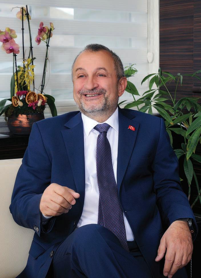
Built largely at home and designed for adaptability, Türksat 6A signals a new chapter for Türkiye’s space ambitions, blending a national engineering achievement with global commercial aspirations. Speaking to Vijaya Cherian, Türksat CEO Ahmet Hamdi Atalay outlines the journey behind 6A and what it means for Türkiye’s future in space
When Türksat 6A was commissioned on April 21, 2025, in a ceremony attended by Türkiye’s President, it marked far more than the activation of another communications satellite. For Türksat and for Türkiye, it was the culmination of nearly two decades of ambition: to shift from being a satellite user to a satellite developer and operator. With a localisation rate exceeding 80%, Türksat 6A is the country’s first fully domestically developed communications satellite, placing Türkiye among a select group of nations with the capability to independently build satellites for geostationary orbit.
“This milestone is both technological and symbolic,” says Türksat CEO Ahmet Hamdi Atalay. “It demonstrates not only our technological capacity but also our engineering and industrial competence, and our vision to develop indigenous satellites. With 6A, Türkiye has elevated its position in space technologies.”
A first of its kind
The Türksat 6A project united some of Türkiye’s most advanced institutions and companies, including TÜBİTAK UZAY, ASELSAN, TUSAŞ, and CTECH, all working alongside Türksat to design and produce critical subsystems. For the first time, national solutions were developed for core technologies like satellite control units, antenna systems, electric propulsion and power distribution systems. “Hundreds of engineers and specialists took part in the process, significantly expanding the domestic production ecosystem.”
But building the country’s first satellite almost entirely at home came with challenges. “One of the biggest challenges was the inherent uncertainty of doing many things for the first time,” Atalay reflects. “Developing all subsystems using national resources, optimising production processes, and executing integration with high precision required great technical discipline and coordination.


Through close cooperation with our project partners, we overcame these challenges. The successful completion of orbital tests stands as evidence of the strong engineering foundation underpinning the project.”
From testing to full operation
After its launch, Türksat 6A was positioned in a test orbit at 50° East on July 20, where it underwent extensive subsystem testing covering everything from power, satellite management, orbit control and several different propulsion subsystem tests including chemical, electric, telemetry, thermal control and payload performance. Having
One of the biggest challenges was the inherent uncertainty of doing many things for the first time”
Ahmet Hamdi Atalay, CEO, Türksat
passed each stage, it was moved to its final position at 42° East. Following a successful broadcast trial on February 17, 2025, Türksat 6A was officially commissioned on April 21 and is now fully operational. Today, Türksat 6A supports a
wide array of services, including television broadcasting, broadband data, emergency communications during disasters, and secure connectivity for public institutions. It also strengthens Türksat’s network security and service continuity by providing backup for existing broadcasting satellites. “In this sense, it should be regarded not only as a communication satellite but also as a critical component of our national security infrastructure,” says Atalay.
Expanding Türkiye’s reach Operating from its orbital slot at 42° East, Türksat 6A significantly expands the operator’s coverage
footprint. Covering densely populated countries such as India, Thailand, Myanmar, Bangladesh and Indonesia along the belt from Europe to South Asia, Türksat now reaches a potential user base of 5bn people in coordination with our other satellites. This expansion opens up brandnew commercial and strategic opportunities for Türksat.
The addition of 6A brings Türksat’s active satellite fleet to six, significantly boosting both coverage and capacity. It also represents a shift in infrastructure, building on the fifth-generation Türksat 5A and 5B platforms but now strengthened by domestically produced technologies.
While Türksat 6A is equipped with next-generation features such as electric propulsion, advanced data transmission infrastructure and remote configuration capabilities, Atalay sees it as a stepping stone toward the next wave of innovation.
“Technologies like softwaredefined payloads and AI-assisted operations are expected in our next generation of satellites. These advanced technologies are strongly represented in Türksat’s upcoming roadmap. But 6A is a major step in that direction.”
The satellite was designed with adaptability in mind, both structurally and in terms of ground control systems. Features such as remote configurability and dynamic frequency and coverage management allow it to easily adjust to varying scenarios, says Atalay.
“This flexibility is especially critical in time-sensitive and location-specific situations like disaster communications. The satellite is fully
Hundreds of engineers and specialists took part in the process, significantly expanding the domestic production ecosystem”
Ahmet Hamdi Atalay, CEO, Türksat
capable of rapidly deploying emergency communication services when needed.”
Looking ahead, Türksat is targeting strategic growth areas including IoT connectivity, maritime and aviation broadband as well as rural coverage. Hybrid architectures that integrate GEO and LEO satellites, along with cloud-supported ground
systems and edge computing, are all central to its roadmap. “We are developing hybrid solutions that combine the speed and low latency of LEO with the reliability and capacity of GEO. Additionally, cloud-supported ground systems, software-defined networks, and edge computing capabilities are enabling us to deliver smarter and more scalable services,” Atalay confirms.
Powered by people
While Türksat 6A is a landmark in local engineering, Atalay emphasises that its foundation lies in human capital. “The success of Türksat 6A is rooted in years of accumulated knowledge, determination and exceptional engineering effort. Our young
engineers not only developed technology but also a vision. What we have achieved is not just technological prowess, but the product of collective national will,” he says.
For Türksat, that collective will is now focused firmly on the future — on exporting services, cultivating new talent, and building the next
What we have achieved is not just technological prowess, but the product of collective national will”
Ahmet Hamdi Atalay, CEO, Türksat
generation of satellites that will carry Türkiye even further into the global space economy.
Türksat at IBC2025
Türksat’s ambitions extend well beyond Türkiye’s borders. At this year’s IBC, the company is showcasing the Türksat 6A platform as part of a broader push to grow its international footprint in broadcasting, OTT, and telecommunications. “Our goal is not just to promote 6A but to establish new partnerships and expand our solution portfolio globally. We hope to deliver integrated solutions for both civil and governmental needs, and increase the export of our services provider,” concludes Atalay.


FGC delivered a major upgrade for Bahrain TV with an advanced IP-based SMPTE ST2110 solution, enabling HD/3G and 4K broadcasting across six playout channels. Utilizing Harmonic Playout, Pebble Beach Automation, and Grass Valley Control Systems, this solution significantly enhanced operational reliability and efficiency.

FGC enhanced SBA’s Studio A with state-of-theart VR, AR, and XR technologies, significantly elevating the quality and versatility of content production. Integrated acoustic and lighting systems, coupled with comprehensive staff training, ensured seamless adoption and optimal utilization.

FGC elevated Al Arabiya’s capabilities by designing and integrating specialized studios in Riyadh's Diplomatic Quarter for news, podcasts, and social media content.
Implementing solutions from Avid, Vizrt, Telestream, and a 1PB Nexis Media Storage system improved workflow efficiency and content quality.
www.fgc.sa


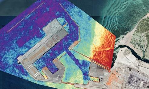
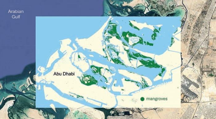
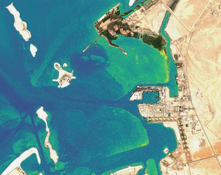
From satellite constellations to AI-driven environmental models, Saudi Arabia and the UAE are turning raw imagery into actionable intelligence. Vijaya Cherian explores how the GCC is advancing the EO frontier with Dr. Felix Vega and Dr. Hakim Hacid of the UAE’s Technology Innovation Institute, and with KSA’s Neo Space Group, which launched the Kingdom’s first EO marketplace last month
Across the Gulf, Earth Observation (EO) has moved from a niche capability to a national priority. Long seen as a tool for scientists and space agencies, EO has now become a backbone for climate monitoring, infrastructure planning, and economic decision-making. Two recent developments illustrate how quickly the region’s ambitions have expanded.
In Saudi Arabia, Neo Space Group (NSG), the Kingdom’s national space company and a Public Investment Fund subsidiary, launched the country’s first dedicated EO data marketplace last month. Powered by UP42, a Berlin-based EO platform
recently acquired by NSG from Airbus, the service centralises access to high-resolution satellite imagery, geospatial data products, and advanced analytics, creating an integrated hub for users across sectors.
In parallel, the UAE’s Technology Innovation Institute (TII), the applied research arm of the Advanced Technology Research Council in Abu Dhabi, has been pushing the technical boundaries of EO through its AI-powered coastal and marine monitoring programme. By combining multispectral, hyperspectral, and Synthetic Aperture Radar (SAR) data with advanced machine learning, the institute has developed models capable of detecting oil spills, tracking
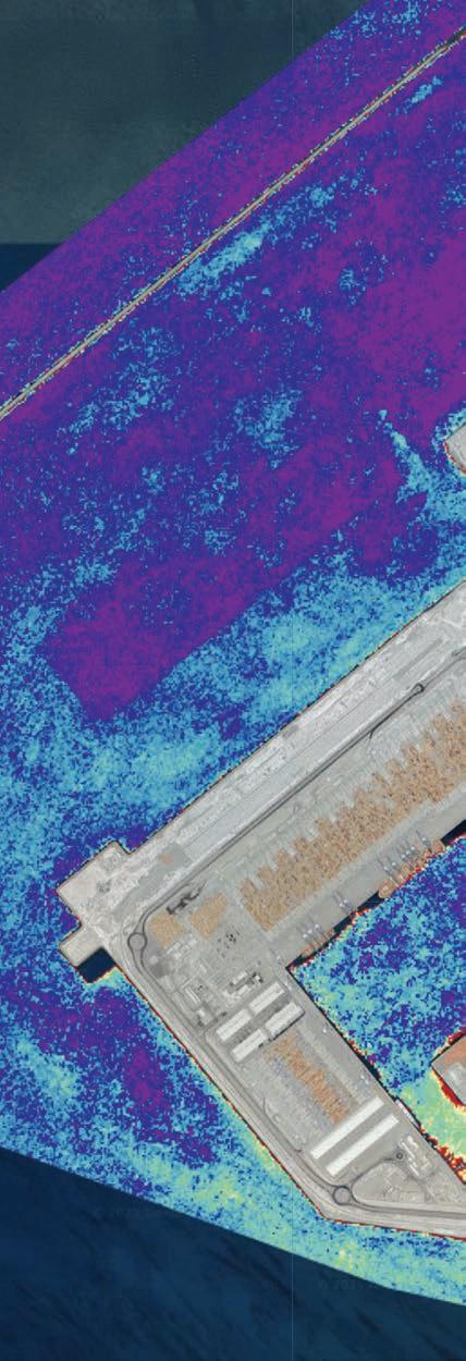
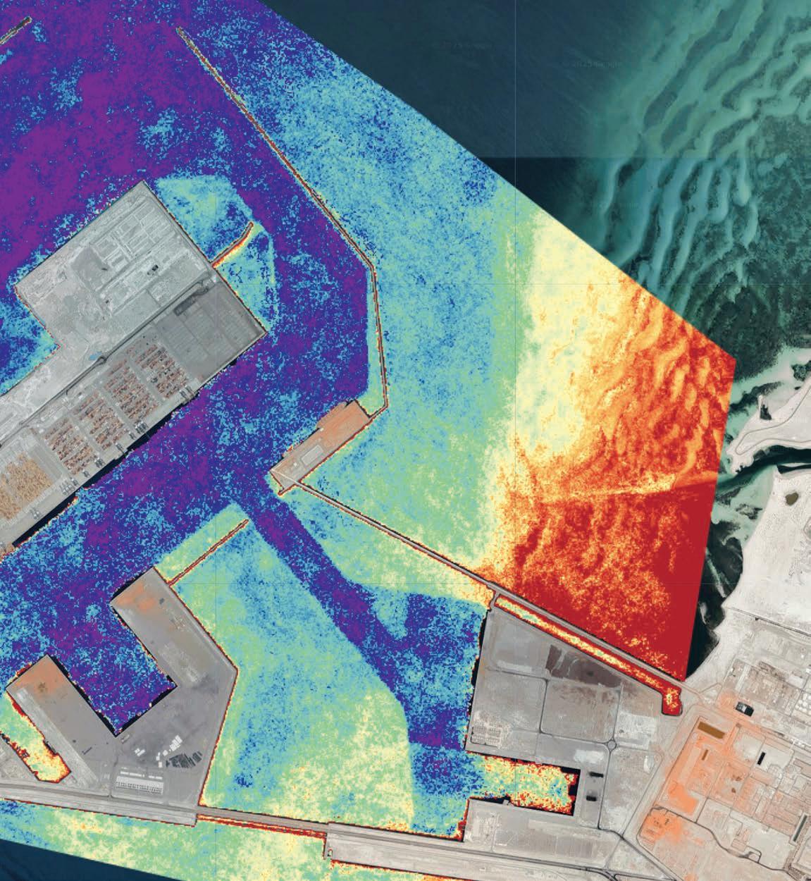
coral reef health, and monitoring erosion in near real time.
Together, these initiatives cover both ends of the EO value chain. Saudi Arabia has focused on creating a marketplace for data access, while the UAE has advanced the science and AI that transforms that data into actionable insight.
Saudi Arabia opens the market
The Saudi EO Marketplace has been designed as a one-stop shop for public sector agencies, Saudi companies, and international users seeking geospatial data and analytical tools. Meeting regulatory requirements and hosted on secure national infrastructure, it caters to applications spanning environment, infrastructure, energy, real estate, mining, transportation, logistics, and agriculture.
“The launch of the EO Marketplace reflects the Kingdom’s remarkable trajectory of growth and the increasing demand for EO data,” says Martijn Blanken, CEO of Neo Space Group. “Given the Kingdom’s vast geography spanning over 2.15 million square kilometres, nearly the size of Western Europe, this platform will serve as both a valuable marketplace and decision-making tool across a wide range of sectors.”
Frank Salzgeber, Acting Deputy Governor for the Space Sector at the Communications, Space, and Technology Commission, has emphasised the timing. “Value creation is shifting downstream in the EO supply chain where AI technologies intersect with space data. The market is now at a perfect inflection point.”
The acquisition of UP42, with its cloud-native platform for EO data access and processing, has provided NSG with an immediate technological foundation. Rebranded for the Saudi market

This platform will serve as both a valuable marketplace and decision-making tool across a wide range of sectors”
Martijn Blanken, CEO, Neo Space Group
and accessible via sa.up42.com, the marketplace allows seamless discovery, acquisition, and analysis of imagery from multiple satellite providers through automated workflows.
UAE advances the science If NSG’s marketplace has focused on access, TII’s work has concentrated on capability. The institute’s Directed Energy Research Center (DERC) and AI and Digital Science Research Center (AIDRC) have
collaborated on EO models that integrate physics-based algorithms with data-driven AI.
“The EO programme sits at the intersection of these domains, leveraging satellite imagery, remote sensing and AI-driven analytics to monitor and understand dynamic environmental processes, particularly in coastal and marine ecosystems critical to the UAE,” says Dr. Felix Vega, Acting Chief Researcher - Directed Energy Research Center, a part of TII.
The EO programme has deliberately been multidisciplinary.
“We have a core team of about a dozen researchers, supported by collaborators across TII’s AI and hardware divisions. Expertise spans satellite remote sensing, photonics, generative AI and machine learning, geospatial analytics, and marine science. This mix allows us to integrate physics-based models with datadriven AI techniques, which has been essential for addressing the UAE’s complex challenges, from water quality monitoring to ship detection and bathymetry,” he adds.
Coastal monitoring and national context
The UAE’s coastline is central to its identity and economy. It supports critical shipping lanes, fisheries, mangroves, coral reefs, and rapidly growing coastal cities, Dr. Vega explains. “At the same time, it has faced unique pressures from rising sea temperatures, industrial activity, and increased maritime traffic. Accurate, timely monitoring has enabled early detection of harmful algal blooms, oil spills, and erosion, which can have significant ecological and economic impacts. Moreover, as the UAE has committed to ambitious sustainability goals, including its Net Zero 2050 strategy, EO has provided the data backbone for evidence-based policymaking and
coastal resilience planning.”
TII has used multiple datasets for its observations, combining multispectral, hyperspectral, and SAR imagery. “Multispectral data, such as from Sentinel-2 or WorldView, is ideal for mapping vegetation like mangroves or detecting sediment plumes. Hyperspectral imagery adds finer spectral resolution, allowing us to distinguish subtle differences in water quality indicators such as chlorophyll-a or dissolved organic matter. SAR, on the other hand, is indispensable for oil spill detection, ship tracking, and monitoring in cloudy or nighttime conditions. We often fuse these datasets combining, for instance, optical water quality indicators with SAR-based vessel detection for a comprehensive situational picture,” says Vega.
To harmonise these inputs, TII has integrated data from MAXAR, Planet Labs, UP42, and the UAE Space Agency, despite differences in resolution, revisit rate, spectral bands, and licensing. “Harmonising these datasets has required careful radiometric and geometric correction, modular data pipelines, and cloudbased co-located storage and processing,” Dr. Vega notes.
AI and modelling innovations
The team has developed two types of AI models: classical machine learning models, including convolutional neural networks for image segmentation and physicsinformed machine learning for parameter retrieval, as well as generative AI-based models.
“In classical models, training begins with curated datasets that
combine satellite imagery with in-situ measurements from buoys and field campaigns. To handle the high variability of marine environments, changing turbidity, seasonal algae blooms, or sunglint effects, we employ data augmentation and synthetic data generation to expose the models to a wide range of conditions. Continuous retraining with new data ensures that models remain robust as environments evolve,” Dr. Vega explains.
Dr. Hacid adds: “For generative AI models, TII has followed an unsupervised learning approach by training an autoencoder to reconstruct the input imagery. Our design preserves spatial and spectral information effectively and can be adapted for multiple downstream tasks such as classification, segmentation, or change detection. The model uses both established benchmark datasets and a custom dataset built at TII, covering herbaceous wetlands,
mangroves, moss and lichen, and ocean environments. This enhances robustness to variability in water turbidity, vegetation density, and seasonal shifts.”
SAR, InSAR and foundation models
SAR has become a cornerstone of monitoring. “Its cloudpenetrating, day-or-night capability has been indispensable,” Dr. Vega says. SAR detects surface roughness changes for oil spills, vessel wakes, or floods, while advanced InSAR tools have mapped millimeter-scale ground deformation, aiding earthquake assessment and infrastructure monitoring.
Hacid notes, “As it is usually difficult to align all the different satellite images in the time domain, the generative AI initiative is working on a foundation model performing intelligent Band-to-Band translation.”
Lessons from field projects
Projects in the Gulf of Oman and coral reef mapping have highlighted the value of sensor fusion and taught the team that no single dataset provides the full
picture. “Combining multispectral, SAR, and bathymetric LiDAR has yielded far more actionable insights than any single source,”
Dr. Vega says. Strategically, early engagement with policymakers and communities has ensured outputs address real decision-making needs.

“We’ve also seen the value of building scalable pipelines that can pivot to new regions or crises, such as quickly adapting our coral reef tools to mangrove health assessments,” he adds. Highresolution datasets have posed storage and compute challenges.
“We have adopted cloud-native architectures with object-based storage and distributed computing frameworks, using tiered storage strategies for cost-effectiveness,” Dr. Vega notes. Continuity has been ensured via cross-calibration and inter-sensor validation, allowing long-term trend analysis even as satellites evolve.
Alignment with national goals and the UAE advantage The EO programme supports multiple national priorities, from the UAE National Space Strategy 2030 to the Net Zero 2050 initiative. “Coastal and marine monitoring feeds directly into climate adaptation strategies, biodiversity protection, and disaster preparedness. By providing near real-time insights into oil spills, algal blooms, coral bleaching, and mangrove degradation, we empower regulators and industry to respond faster, minimising environmental and economic impact,” says Dr. Vega.
The UAE combines strategic geography, modern infrastructure, and a forward-looking vision. Its location at the nexus of major shipping routes offers a natural testbed for maritime monitoring, while its diverse coastal and desert ecosystems provide opportunities to develop and validate EO techniques for a wide range of environments. World-class data centers and cloud infrastructure support large-scale geospatial analytics.
Dr. Hacid notes that two current technological trends could serve as an advantage for the UAE
to become one of the leading players on the field. He sees the emergence of more cost effective and lighter satellites with higher re-visit time and higher resolution rapidly changing the game for space-based EO empowering it with new capabilities but also new problems like synchronisation of data from multiple data sources for real time. Secondly, he sees LLMs and Generative AI transforming EO and offering “a whole new set of capabilities for better analysis, understanding, decision making and automation of downstream tasks.”
“A fully functional space-based Earth observation ecosystem must rely on a coordinated chain of components that work seamlessly from data acquisition to realworld applications. This includes the upstream, midstream, and downstream levels, the policy makers, as well as entrepreneurs and investors. TII plays a role with most of the components of this ecosystem starting with the upstream level with innovations in sensor technologies for example, the midstream level with

innovations in communications and large data management, and at the downstream level with concrete applications for specific domains, e.g., costal monitoring or agriculture. TII also supports
policy makers by bringing valuable advisory expertise from the field.”
While approaches differ — one commercial and market-oriented, the other research and capabilitydriven — NSG and TII share the goal of enabling the Gulf to harness EO for environmental stewardship, infrastructure resilience, and economic competitiveness.
Both efforts highlight AI as a multiplier in the EO value chain, whether powering NSG’s analytics marketplace or TII’s generative models for environmental monitoring. They also reflect the strategic ambitions of their countries, Saudi Arabia through Vision 2030, and the UAE through its sustainability and space strategies.
As the Gulf’s EO ecosystem matures, the marketplace and machine learning converge, with Saudi Arabia providing the data and the UAE transforming it into insights. This positions the region not just as a consumer of EO technologies, but as a global leader shaping their future.


Majjane, Eutelsat’s new multiscreen service, ushers in a new era of satellite content delivery in MENA, bringing live and on-demand programming to second screens without the need for data or internet. Using DVB-Native IP technology and hybrid capabilities, it enables large-scale broadcasts and interactive features. Vijaya Cherian explores the service and its potential with Eutelsat’s Kamal Lotfy
In the Middle East and North Africa, where mobile penetration is high, but connectivity remains inconsistent outside urban centres, Eutelsat is unveiling Majjane, a data-free multiscreen service designed to bring live TV and on-demand video directly to smartphones, tablets and PCs without requiring internet or mobile data. The platform leverages the Eutelsat–Nilesat 7/8° West orbital position and will eventually offer 300 plus channels alongside curated VOD content to any smartphone or device equipped with a compatible application and receiver.
Kamal Lotfy, Senior Sales Director for North Africa, SouthEast Asia, and Asia Pacific at Eutelsat, explains the core distinction: “The platform will include a rich mix of generalinterest and entertainment channels, as well as national and international news and sports. It also offers free download of ondemand video and audio content, including educational files and applications. While traditional satellite TV reaches households with television sets, Majjane brings the broadcast experience directly to the region’s 447m
smartphones, unlocking access to quality content anywhere, anytime without relying on terrestrial networks or data plans.”
In the Gulf and similarly connected high-traffic areas, the strength of Majjane and the native IP standard lies in its ability to deliver large-scale, live event broadcasts and high-quality content simultaneously to massive audiences without straining mobile or fiber networks. This makes it ideal for broadcasting major sports events, cultural festivals, or government announcements efficiently and reliably. By offloading traffic from traditional networks, Majjane ensures smooth, uninterrupted viewing experiences for large, digitally engaged populations complementing existing infrastructure rather than competing with it.
Addressing a multiscreen challenge The initiative is in response to a structural gap in MENA households. Around 70% of MENA homes have one TV screen and an average of 4.5 people per household. This means that when the main television is occupied, others must turn to mobile devices, typically over 3G or 4G networks that incur
costs and suffer from congestion. Majjane reportedly delivers content directly via satellite, allowing multiple users to access programming simultaneously without compromising quality.
“The free offer from Majjane allows all members of the household to benefit from freedom of choice, to watch other TV channels independently of the main TV screen,” Lotfy says. “It offers high-quality reception, avoiding the buffering associated with shared-infrastructure telecoms networks such as 3G/4G, which can be subject to significant congestion when the number of users in a given geographical area becomes too large.”
Where content falls outside the preloaded VOD catalogue, the Majjane app enables a fallback to streaming over 3G/4G or other available internet access. This ensures users can still view desired programmes while prioritising satellite delivery for the bulk of viewing, keeping data costs low.
The multiscreen approach also opens opportunities for institutional use. Educational
Majjane brings the broadcast experience directly to the region’s 447m smartphones, unlocking access to quality content anywhere, anytime”
Kamal Lotfy, Senior Sales Director, Eutelsat
content, public service announcements and health information can be delivered to remote schools, rural clinics and refugee camps without relying on mobile or terrestrial networks. Its low infrastructure requirements make it feasible in areas with limited connectivity and electricity, contributing to digital inclusion and bridging the gap for underserved populations.
DVB-Native IP: Converging broadcast and IP
Majjane operates on the DVBNative IP (DVB-NIP) standard,
which facilitates IP-based content delivery over satellite. DVB-NIP is considered a game-changer because it bridges the gap between traditional broadcast and modern IP-based delivery, allowing satellite to efficiently reach millions of devices while maintaining the reliability and cost-effectiveness of broadcast infrastructure. Majjane takes full advantage of this by delivering both live channels and preloaded VOD at scale, without relying on terrestrial connectivity.
“Today, the main problem with streaming content is that not all users are equal, which presents a big problem for broadcasters and providers,” Lotfy notes. “Patchy broadband services result in a frustrating viewing experience for many, and several regions are still unserved by any terrestrial connectivity. Satellite, which has no geographical boundaries, has been overlooked for too long in the case of IP video distribution. With the growth of IP-based linear and filebased/on-demand video content available to global consumers, coupled with changing consumer viewing preferences, satellite technology can cost-effectively and reliably benefit providers of video streaming services.”
Although Majjane is initially being launched in MENA, leveraging the strong coverage and strategic positioning of the Eutelsat–Nilesat 7/8° West orbital slot, its underlying technology is scalable and globally adaptable. Eutelsat, therefore, intends to extend the service gradually to regions, where it will be most effective, particularly in underserved, rural, or infrastructure-limited areas, such as Sub-Saharan Africa, South Asia and so on.
Majjane’s scalability is deeply rooted in the DVB-NIP standard, which fundamentally transforms satellite content delivery. By
broadcasting IP-native content, the platform can support future extensions such as encrypted channels, paid VOD, or interactive services without requiring infrastructure overhauls. Native IP also enables hybrid satellite/ terrestrial models, allowing return paths for personalisation or updates via 4G/5G or Wi-Fi where available. This flexibility positions Majjane to evolve alongside user expectations and diverse market demands.
One key advantage of DVBNIP is its ability to support modular, regionalised content delivery. This opens the door for local broadcasters, educational institutions and niche content creators to contribute or license content adapted to specific markets. In addition, lessons, training modules and awareness campaigns in multiple languages can be broadcast to schools, clinics and other underserved locations, making critical resources accessible in disconnected regions.
Balancing tech and commercial strategies
Majjane’s VOD library, curated by Noovo, includes popular movies, series, and thematic collections designed to reflect regional trends. Noovo leads the B2C application layer of the service, working with rights holders, broadcasters and content partners to select and update the catalogue while staying within satellite delivery constraints.
When asked how it compares with commercial OTT platforms, Lotfy clarifies: “Majjane isn’t an ‘offline Netflix’ but a satellite-based multiscreen broadcast service delivering live channels and selected VOD without internet or data fees.”
Reception of Majjane requires a satellite dish aligned to 7/8° West and a compatible receiver, such as those supplied by EKT

Satellite, which has no geographical boundaries, has been overlooked for too long in the case of IP video distribution”
Kamal Lotfy, Senior Sales Director, Eutelsat
or Noovo, which integrates WiFi for distribution to multiple devices. Existing dishes can be used; otherwise, the hardware is widely available. For extended VOD functionality, Lotfy recommends connecting to an external hard drive to be able to have access to thousands of movies. Retail pricing is positioned between ¤30 and ¤60, keeping adoption accessible, says Lotfy.
While Majjane is positioned for consumers, it also demonstrates DVB-NIP’s capabilities in B2B
contexts, from hospitality and transportation to public-sector applications. Majjane’s current DVB-NIP-based platform focuses on efficient one-way content delivery, but future iterations could integrate hybrid solutions to enable interactive features, personalised content requests and upstream data transmission, maintaining its core strength of broad, low-cost, high-quality satellite distribution, says Lotfy.
He also points out that with Majjane, direct monetisation isn’t Eutelsat’s primary goal. “Rather, it aligns with our broader objective to expand platform usage and ecosystem uptake across both B2C and B2B contexts,” explains Lotfy.
MENA launch and future outlook Majjane is primarily intended to be a real-world application of the DVB-NIP standard. Eutelsat promotes the B2B use of this standard by providing satellite capacity and the headend platform, while Majjane represents a B2C implementation developed for the MENA market. In this setup, Noovo delivers the consumerfacing experience, including NIPcompatible devices and applications for individual or collective use.
“Eutelsat’s broader vision is ecosystem alignment, where existing OTT applications can be adapted to become NIP-compatible, allowing them to deliver content via satellite without dependency on internet infrastructure. This approach isn’t about competing with IP streaming, but about extending reach and improving reliability, especially in congested or underserved areas. Majjane is an example of how DVB-NIP can bridge that gap between traditional broadcast and OTT, enabling hybrid delivery models that are scalable and inclusive,” concludes Lotfy. Eutelsat will discuss Majjane at IBC this year.

Following its recent acquisition of Factor.io, Cofactr is empowering aerospace and satellite manufacturers with real-time, end-to-end visibility across multi-tier supply chains. Chief Strategy Officer Phillip Gulley tells Vijaya Cherian how the AI-driven platform is transforming BOM management, compliance and resilience in high-stakes industries
Can you walk us through Cofactr’s acquisition of Factor. io? What motivated the move, and how does it enhance your offering for aerospace and satellite clients? One of the biggest challenges in hardware manufacturing, particularly in highly regulated industries like aerospace and defence, is managing the movement and status of thousands of components across the supply

chain. Cofactr’s platform was already built to handle most parts of this process, such as automating inventory management and ensuring compliance. We were already tracking and managing many types of supplier communications, but Factor.io had been working in this field for years. Teams still have to manually comb through emails to reconcile updates with their ERP systems, which can lead to errors that cause delays, mismatched inventory
and missed status updates.
By integrating learnings from Factor.io into the Cofactr platform, our users now get end-to-end visibility into the status of every part in their Bill of Materials (BOM), helping them move faster while meeting strict internal and governmental requirements. Together, we make it easier to catch risks earlier, respond faster to disruptions and ensure every part is documented, sourced by approved suppliers and stored to spec.
What specific logistics challenges in the aerospace and satellite sector do you attempt to solve, particularly when managing complex BOMs?
Aerospace and satellite manufacturers often struggle with limited visibility beyond their tier-one suppliers. Most traditional supply chain platforms stop tracking the movement and origin of parts after the first tier, which leaves manufacturers in the dark about where critical components originate, which suppliers are involved and whether any parts are vulnerable to tariffs, trade restrictions or other disruptions.
Cofactr, on the other hand, gives manufacturers real-time visibility across their entire supplier network. The platform monitors every moving part, down to the serial number, stock lot, and country of origin, and automatically tracks how each component moves across the supply chain. This visibility is especially critical given the long lead times in aerospace and satellite manufacturing, where a delay of a single part can stall an entire build.
How do new tariffs and shifting trade regulations impact manufacturers?
Modern manufacturing is globally integrated, and even US-based assembly often relies on components, raw materials or subassemblies
sourced from overseas. When tariffs are imposed on these parts, manufacturers can face sudden and unexpected cost increases that ripple across their operations.
For example, a US-based aerospace manufacturer may assemble its systems domestically but depend on a specialty semiconductor or composite material from an overseas supplier. Without visibility into where every subcomponent originates, manufacturers risk being blindsided, with costs absorbed, production delayed, or expenses passed on to customers.
Tariffs also add complexity to documentation and compliance processes. Manufacturers need to verify components’ countryof-origin, assign the correct Harmonised Tariff Schedule (HTS) codes and manage duty drawback programmes. Proper systems help avoid delays, compliance violations, and missed savings.
How is the aerospace and satellite supply chain evolving postpandemic and amid ongoing geopolitical tensions?
Events like COVID-19 and ongoing political tensions have exposed the fragility of global supply chains. These disruptions have forced manufacturers to confront the risks built into logistics models they had spent years, or even decades, refining.
Many are now rethinking their entire approach and diversifying their supplier networks to avoid bottlenecks and build long-term resilience.
At the same time, there’s a clear push from companies to streamline and digitise operations. Manufacturers are adopting new technologies to gain deeper visibility into multi-tier supplier networks, track components and orders in real time, and flag risks before they cause delays.
What role does AI now play in BOM risk mitigation and supply chain intelligence for satellite and defence hardware manufacturers?
The application of AI gives companies the ability to map their full BOM and monitor real-time changes across multi-tier supplier networks at a volume and accuracy that people cannot manage.
AI detects early signals of risk, including newly tariffed sourcing, declining supplier performance, or shifting ownership structures, and surfaces insights before they become issues. AI also combs through massive amounts of data, routes and automates simple tasks, and highlights strategic issues that benefit from human attention. This allows companies to make smarter sourcing decisions, reroute procurement strategies and protect critical timelines.
On the operations side, AI automates time-sensitive tasks like assigning HTS codes, preparing documentation for customs inspections and flagging compliance issues as soon as they occur. This accelerates responses to new tariffs or supplier disruptions, helping companies avoid penalties, delays, or rejected claims.
With parts shortages and procurement volatility still a reality, how can manufacturers shift from reactive tactics to strategic forecasting?
To move from reactive scrambling to strategic forecasting, aerospace and satellite manufacturers must modernise how they manage procurement, inventory and supplier relationships. These industries face long lead times, highly sensitive components and strict compliance requirements, meaning that even small delays can derail production schedules or compromise mission-critical builds.
The first step is consolidating inventory and supplier data

The application of AI gives companies the ability to map their full BOM and monitor real-time changes across multitier supplier networks at a volume and accuracy that people cannot manage”
Phillip Gulley, CSO, Cofactr
into a single, centralised system. Fragmented systems make anticipating shortages or confident sourcing nearly impossible.
Once data is centralised, automating the processes that slow down procurement teams becomes the next step. Managing complex BOMs manually is time-
consuming and error-prone. Automation enables faster and more accurate supplier matching, BOM validation, and kitting, freeing up engineering and operations teams to focus on higher-value work.
Strategic forecasting also requires real-time visibility and end-to-end traceability. From procurement through delivery and storage, every component must be monitored to catch issues early and mitigate risk, whether it’s a tariff exposure, an out-of-spec part, or a supplier delay.
What’s the most overlooked risk in space and satellite manufacturing logistics today? One of the most overlooked risks in satellite manufacturing is the delayed or incomplete vetting of suppliers, especially for specialised components that are subject to strict safety and compliance regulations. Vendors must abide by a robust list of legal requirements, such as ITAR, EAR or other export controls, and hold defence-grade quality certifications. These demands make it hard to find suppliers that are both technically capable and legally compliant.
Finding and qualifying compliant vendors can take up to a year; non-compliance or tariff issues can derail schedules, require redesigns, or disqualify products from duty drawback programmes. In an industry where minor delays can push a launch out by months, those risks compound quickly.
Space companies need to integrate supplier evaluation directly into their early design and procurement processes—matching parts not just by fit and function, but also by regulatory readiness.
How should satellite companies and NewSpace players be thinking about supply chain resilience in the context of faster launch cycles? Companies often assume resilience means carrying more
inventory, but it is really about engineering speed, traceability and flexibility into operations.
One way to do this is by gaining real-time visibility into the status of individual parts and suppliers, both direct and indirect. Many hardware parts used in satellite builds (e.g., rad-hard FPGAs or custom power electronics) can only be sourced from a handful of approved suppliers. Finding and qualifying a trusted supplier for these specialised parts can take six months to a year. If one subcomponent is delayed, the entire satellite build can face significant production overruns or come to a standstill.
To avoid this, supply chain teams must align closely with engineering to lock long-lead items earlier in the design process and monitor inventory levels continuously, both within their organisation and across contract manufacturers and distributors. Automated BOM risk systems allow supply chain and engineering teams to act before
launch schedules are jeopardised. Companies should also standardise their kitting practices to ensure every component required for subsystem assembly arrives together, correctly packaged and fully documented.
Where do you see the biggest transformation in aerospace and satellite supply chain management happening over the next five years?
Over the next five years, one of the biggest transformations will be the shift from fragmented, manual processes to integrated, AI-powered platforms offering real-time visibility and control across multi-tier supplier networks. Historically, supply chains have been managed through spreadsheets, siloed systems and vendor emails — tools that cannot keep up with today’s complexity. As geopolitical risks, regulatory scrutiny and component shortages persist, manufacturers are under increasing pressure to digitise and centralise everything from
procurement to compliance tracking. Major advancements will occur in how companies map and monitor their full BOM, not just at the SKU level, but down to subcomponents and stock lots. AI will drive much of this transformation, from automating part classification to flagging emerging risks such as tariff exposure or supplier instability.
Is there a future where advanced supply chain platforms become a default part of mission planning in satellite or space programmes? Absolutely. As satellite and space programmes become more commercially driven, supply chain platforms are becoming necessities for operations and business strategy. This shift is especially evident in NewSpace, where high-mix, lowvolume builds mean each mission may rely on a unique BOM. Every component must be sourced, tracked and documented, often across multiple tiers of suppliers and regulatory environments.


The demand for satellite infrastructure is continuing to grow across the globe, but nowhere quite like the Middle East and North Africa (MENA). The region is at a critical moment in its digital and space transformation, expanding connectivity from bustling smart cities and remote desert communities to offshore energy hubs, maritime trade routes, and aerospace operations.
D2D connectivity
One emerging service is Direct-toDevice (D2D) connectivity, enabling smartphones and other standard consumer devices to connect directly to satellites, bypassing the need for specialised equipment like cellular towers. D2D applications hold great promise, from enabling emergency communications in remote areas to providing reliable connectivity in rural or hard-to-reach locations.
In the Eastern Province of Saudi Arabia for example, D2D could make a difference in key mining applications, or at offshore oil platforms, both of which are high-risk, remote regions crucial to the economic stability of the Kingdom. D2D can help make key connections in areas where traditional means of connectivity cannot reach, helping businesses establish platforms in new, potentially lucrative areas.
The role of flexible licensing Non-terrestrial networks, encompassing communication systems in low, medium, and
geostationary orbits, as well as high-altitude platforms (HAPS), are essential for enabling D2D services and ensuring global access to key services, regardless of location. These networks play a critical role in extending coverage by bridging gaps left by terrestrial telecommunications infrastructure. However, to fully realise their potential, they require regulatory frameworks that support their deployment and scalability; streamlined, adaptive licensing regimes are crucial to fostering growth and maximising impact.
Recognising the rapid pace of innovation, regulators and operators have increasingly adopted more flexible approaches to satellite licensing. One development has been the introduction of sandbox initiatives, which create controlled environments for testing new services and regulatory models. These allow operators to trial innovative satellite applications without immediately being subject to the full extent of traditional licensing requirements.
In the Middle East, where governments are prioritizing digital transformation, regulatory sandboxes are expediting the deployment of next-generation satellite services, including low Earth orbit (LEO) constellations and D2D solutions. By embracing dynamic licensing mechanisms, regulators can foster competition, attract investment, and ensure policies remain aligned with technological advancements, ultimately positioning the region as a leader in satellite innovation
while enhancing connectivity for businesses and communities.
Previously an area that received little attention, cislunar communication is growing in popularity in response to advances in technology and capabilities. Today’s ‘space race’ is being led by commercial entities like Intuitive Machines, while plans to place a data center or an LTE network on the Moon are becoming reality. As this new frontier emerges, ensuring long-term spectrum availability and regulatory certainty is more crucial than ever.
Between 2018 and 2023, the Middle East saw a 175% increase in satellite launches as it transitions from being end users of satellite solutions to leaders within the sector. Saudi Arabia plans to build on this success through its ‘Vision 2030’ plan, which includes extensive investment into developing domestic expertise in satellite solutions and potential future space tourism operations. As regulators around the world work to understand these novel services and their implications, the Middle East has a unique opportunity to assert its position and emerge as a market leader in this field. Investment and openness to embrace new applications will help the region grow at scale and benefit from reliable connectivity no matter the geography or where it’s required. Only then will it have the tools to enable the extraordinary when it comes to the satellite sector.
Alexis Martin is CEO of River Advisers.