


Adopted March 20, 2014
Prepared by

HIGHWAYS 16/36 CROSSROADS ASP BYLAW 1228-13
Highways 16/36 Crossroads Area Structure Plan Bylaw 1228-13
County of Minburn No. 27 |
Highways 16/36 Crossroads Area Structure Plan Bylaw 1228-13 County of Minburn No. 27 | i Table of Contents 1.0 Purpose, Scope & Background ....................................................................................... 1 1.1 Purpose & Scope ................................................................................................................ 1 1.2 Background.................................... .................................. 1 2.0 Terms of Reference & Application.................................................................................. 3 2.1 General Terms of Reference............................................................................................. 3 2.2 Application ................................... .................................... 3 3.0 Statutory Requirements ............................ ..................... 4 3.1 Municipal Government Act .............................................................................................. 4 3.2 Municipal Development Plan ........................................................................................... 4 3.3 Western Biofuels ASP.......................... .............................. 4 3.4 Land Use Bylaw ................................ ................................ 4 4.0 Plan Boundary.................................................................................................................... 5 4.1 Landownership................................. ................................ 5 5.0 Existing Conditions............................................................................................................. 6 5.1 Existing Land Use................................................................................................................. 6 5.2 Soils and Topography.......................... ............................ 6 5.3 Wetlands ...................................... ..................................... 6 5.4 Oil and Gas.......................................................................................................................... 7 5.5 Significant Historical Sites ................................................................................................... 7 6.0 Utility Servicing................................. ................................ 8 6.1 Water......................................... ........................................ 8 6.2 Sanitary................................................................................................................................. 8 6.3 Stormwater .................................... ................................... 8 7.0 Transportation .................................... ............................. 9 7.1 Roads.................................................................................................................................... 9 7.1.1 Existing and Future Traffic Volumes ......... ............... 9 7.2 Canadian National Railway..................... .................... 10 8.0 Future Land Use Concepts............................................................................................. 11
Figure
Figure
Highways 16/36 Crossroads Area Structure Plan Bylaw 1228-13 County of Minburn No. 27 | Purpose, Scope & Background ii 8.1 Future Land Use............................... ............................... 11 8.1.1 Light/Medium Industrial..................... ..................... 11 8.1.2 Commercial................................................................................................................ 12 8.1.3 Agricultural................................ ............................... 12 8.2 Transportation................................ ............................. 13 8.3 Subdivision & Consolidation............................................................................................ 13 8.4 Development Phasing ..................................................................................................... 13 9.0 General Land Use Issues ........................... ................... 15 9.1 Signage & Lighting............................................................................................................ 15 9.2 Screening & Landscaping............................................................................................... 15 9.3 Agricultural Operations....................... .......................... 15 9.4 Sour Gas Facilities ........................... ............................... 15 9.5 Existing Residences ........................................................................................................... 15 10.0 Policy Framework & Implementation ......................................................................... 17 10.1 Interpretation............................... ................................. 17 10.2 Amendments................................................................................................................... 17 10.3 Review & Monitoring ...................................................................................................... 17 11.0 Policies......................................... ................................. 18 List of Tables Table 1. Land Ownership …………………………………………………..…………………………5 Table 2. Highway 16 Peak Volumes 2010 & 2030 ………….……………………………………10 Table 3. Highway 36 Peak Volumes 2010 & 2030 ……………………………………………….10 List of Figures After Page Figure 1. Regional Context …………………………………………………………………………...2 Figure 2. Local Context ………………………………………………………………………………..2 Figure 3. ASP Boundary & Land Ownership ……………………………………………………….5
4. Soils & Topography …………………………………………………………………………6
5. Oil & Gas Activity …………………………………………………………………………...7
6. Roads & Access ……………………………………………………………………………..9
7. Interim Land Use Concept ……………………………………………………………....11
8. Long-Term Land Use Concept …………………………………………...……………..11
Figure
Figure
Figure
Highways 16/36 Crossroads Area Structure Plan Bylaw 1228-13
1.0
Purpose, Scope & Background
1.1 Purpose & Scope
The Highways 16/36 Crossroads Area Structure Plan (ASP) is a statutory planning document intended to give direction to future land use, development, servicing and access for future development around the proposed interchange at Highway 16 and Highway 36.
The ASP serves as a decision-making resource to assist the County in evaluating development and subdivision proposals within the ASP boundary.
It also provides local landowners with direction on future land use to aid decisions regarding their own property.
Last, it is a tool to both attract and assist investors/developers in understanding the requirements and servicing expectations, and potential for future development within the ASP boundary.
1.2 Background
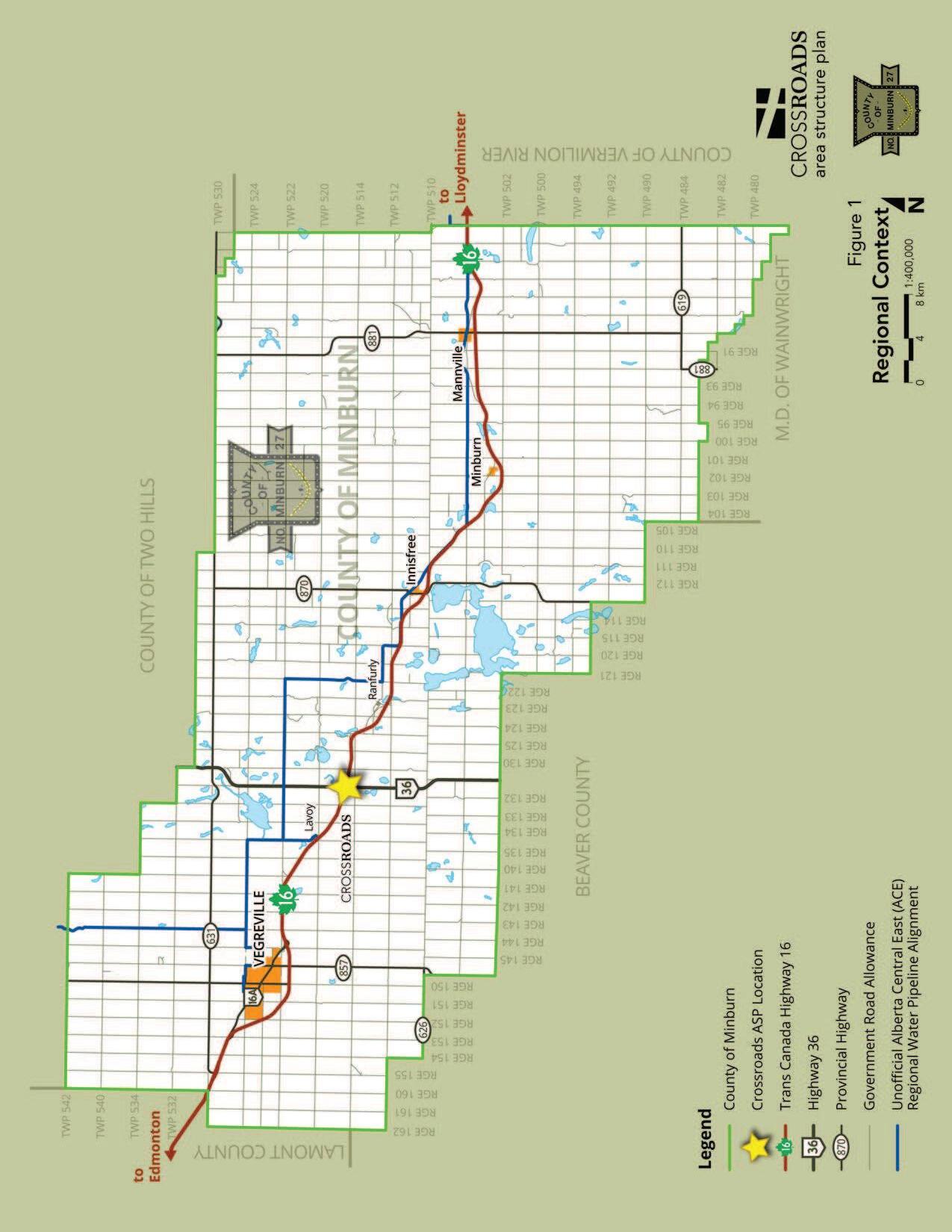
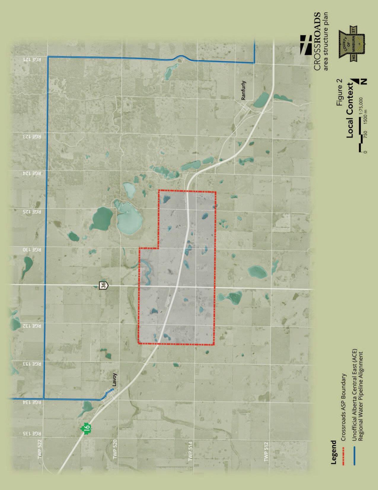
The trade corridors of Highways 16 and 36 form a crossroads of local, regional, national and international importance. Proximity to the Canadian National Railway offers additional value to the area as a major trade and transportation hub. See Figure 1 Regional Context and Figure 2 Local Context
The intersection of Highways 16 and 36 in the County has been identified by the Province of Alberta as a future interchange location1 within an approximate 20-year time horizon2. The interchange footprint, right-of-way requirements, access management issues and detailed functional plans have been addressed by the Highway 16 Freeway Corridor Management Study and by the Highway 16:24/26 & Highway 36:18/20 Interchange Southeast of Lavoy Functional Planning Study (the Functional Planning Study).3
Highway 16 (Yellowhead) is part of the National Highway System, and will eventually be classified as a freeway, which means that access to the highway from adjacent roads will be restricted to interchanges.4 As a major east-west corridor, Highway 16 also links
1 Highway 16 Freeway Corridor Management Study
2 Highway 16:24/26 and Highway 36:18/20 Interchange Southeast of Lavoy Functional Planning Study, Al-Terra Engineering, 2013.
3 Highway 16:24/26 and Highway 36:18/20 Interchange Southeast of Lavoy Functional Planning Study Open House Display, Exhibit 1.1, Al-Terra Engineering, August 2010.
4 Highway 16:24/26 and Highway 36:18/20 Interchange Southeast of Lavoy Functional Planning Study, Al-Terra Engineering, 2013.
County of Minburn No. 27 | Purpose, Scope & Background 1
Highways 16/36 Crossroads Area Structure Plan Bylaw 1228-13
the County of Minburn No. 27 (the County) and Western Canada to the Port of Prince Rupert and destinations beyond.
Highway 36 (Veterans Memorial Highway) is part of the north-south CANAMEX trade corridor whose value will continue to increase as its potential for linking the province of Alberta with the United States and Mexico is fully realised.5
Highway 36 is designated to serve intra-provincial travel needs, forming part of the provincial High and Oversize Loads Corridor between Highway 1 in the south and Highway 28 in the north.6
5 Trade Corridors of the BRAED Region – Position Paper, Western Sky Management Associates Inc, 2009.
6 Highway 16:24/26 and Highway 36:18/20 Interchange Southeast of Lavoy Functional Planning Study, Al-Terra Engineering, 2013.
County of Minburn No. 27 | Purpose, Scope & Background 2
Highways 16/36 Crossroads Area Structure Plan Bylaw 1228-13
2.0 Terms of Reference & Application
2.1
General Terms of Reference
The ASP was prepared in consideration of the following general requirements:
a) Acknowledge the present and future importance of the two highways as major transportation and trade corridors;
b) Capture the benefit of proximity to the Canadian National Railway located at the present intersection of the two highways;
c) Consider the potential of having fully serviced development sites in the long term with discussion of interim servicing possibilities of the developable lands;
d) Discuss the range of suitable land uses within the context of:
i. Highways 16/36 access and visibility,
ii. proximity to the Canadian National Rail line,
iii. internal roadway access,
iv. interim and long term servicing,
v. topography and soil characteristics,
vi. oil and gas activity, and,
vii. mitigating land use conflict with existing agricultural activity;
e) Discuss generally:
i. development phasing, ii. signage and lighting, iii. screening and landscaping, iv. other requirements per the MGA, and v. other matters the County deems necessary.
2.2
Application
A goal of this ASP is to receive endorsement from Alberta Transportation pursuant to Section 14 of the Municipal Government Act Subdivision and Development Regulation. Since applications for subdivision and development within 800 meters of a Provincial Highway must be referred to Alberta Transportation for review and approval, endorsement of this ASP by the Province could result in reduced processing requirements and timelines for subdivision and development applications.
Additionally, it is intended this ASP will be used by the County to evaluate the merits of individual applications for subdivision and/or development that fall within or are immediately adjacent to the ASP boundary.
County
27 | Terms of Reference
3
of Minburn No.
& Application
Highways 16/36 Crossroads Area Structure Plan Bylaw 1228-13
3.0 Statutory Requirements
3.1 Municipal Government Act
Part 17, Section 633 of the Municipal Government Act (MGA) outlines the minimum requirements for the preparation of an Area Structure Plan,
“An ASP
(a) must describe
(i) the sequence of development proposed for the area,
(ii) the land uses proposed for the area, either generally or with respect to specific parts of the area,
(iii) the density of population proposed for the area either generally or with respect to specific parts of the area, and
(iv) the general location of major transportation routes and public utilities, and
(b) may contain any other matters the council considers necessary.”
3.2 Municipal Development Plan
Section 4.1 of the County of Minburn Municipal Development Plan (MDP) Bylaw 119909, as amended, speaks to the development potential and policy needs of the Highway 16 and Highway 36 intersection. Further, Appendix Two of the MDP provides general terms of reference for preparation of an Area Structure Plan in the County of Minburn No. 27.
3.3 Western Biofuels ASP
An existing Area Structure Plan, the Western Biofuels ASP 1191-08, was located within this ASP’s boundary. The Western Biofuels ASP was prepared and adopted in 2008 in anticipation of a biofuel processing development being located on the subject lands. The proposed development did not proceed and development approval was never granted. This ASP supersedes Bylaw 1191-08, and therefore the Western Biofuels ASP was rescinded at the time this Highways 16/36 Crossroads ASP was adopted.
3.4 Land Use Bylaw
County of Minburn Land Use Bylaw 1218-12 identifies the ASP area as Agricultural District, and details development permit and subdivision application rules and procedures in Part III.
County of Minburn No. 27 | Statutory Requirements 4
4.0 Plan Boundary
4.1
Landownership
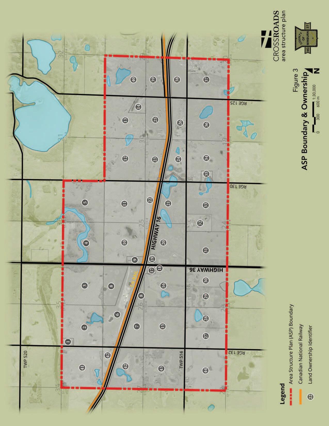
The total ASP area is approximately 1,918 ha (4,740 ac), including all roadways and roughly to 29 quarter sections. See Figure 3 ASP Boundary & Landownership.
Landownership is summarized in Table 1 below. The “Map #” in Table 1 below corresponds to the numbers on Figure 3. For privacy reasons, landowner names are not provided; rather, ownership is identified as either private or public. All but one of the parcels within the ASP boundary is privately owned.
Table 1. Land Ownership
Highways
Crossroads Area Structure Plan Bylaw 1228-13 County of Minburn No. 27 | Plan Boundary 5
16/36
Map # Type Map # Type Map # Type Map # Type 1 Private 12 Private 23 Private 34 Private 2 Private 13 Private 24 Private 35 Private 3 Private 14 Private 25 Private 36 Private 4 Private 15 Private 26 Private 37 Private 5 Private 16 Private 27 Private 38 Private 6 Private 17 Private 28 Private 39 Private 7 Private 18 Public 29 Private 40 Private 8 Private 19 Private 30 Private 41 Private 9 Private 20 Private 31 Private 42 Private 10 Private 21 Private 32 Private 43 Private 11 Private 22 Private 33 Private 44 Private
Highways 16/36 Crossroads Area Structure Plan Bylaw 1228-13
5.0 Existing Conditions
5.1
Existing Land Use
The entire ASP area is currently districted Agricultural in the County’s Land Use Bylaw and Agricultural/Rural Development in the Municipal Development Plan. Uses within the ASP boundary are predominately agricultural and rural residential in nature with some oil and gas activity and other non-residential uses.
There are 11 single family residences and three cabins (all on one parcel) located within the ASP boundary. One of the residences is located on publically owned land.
There is one rural industrial development located at the northwest corner of the Highway 16/36 intersection on Part of N-26-51-13-W4M, Block 1, Plan 972 3485.
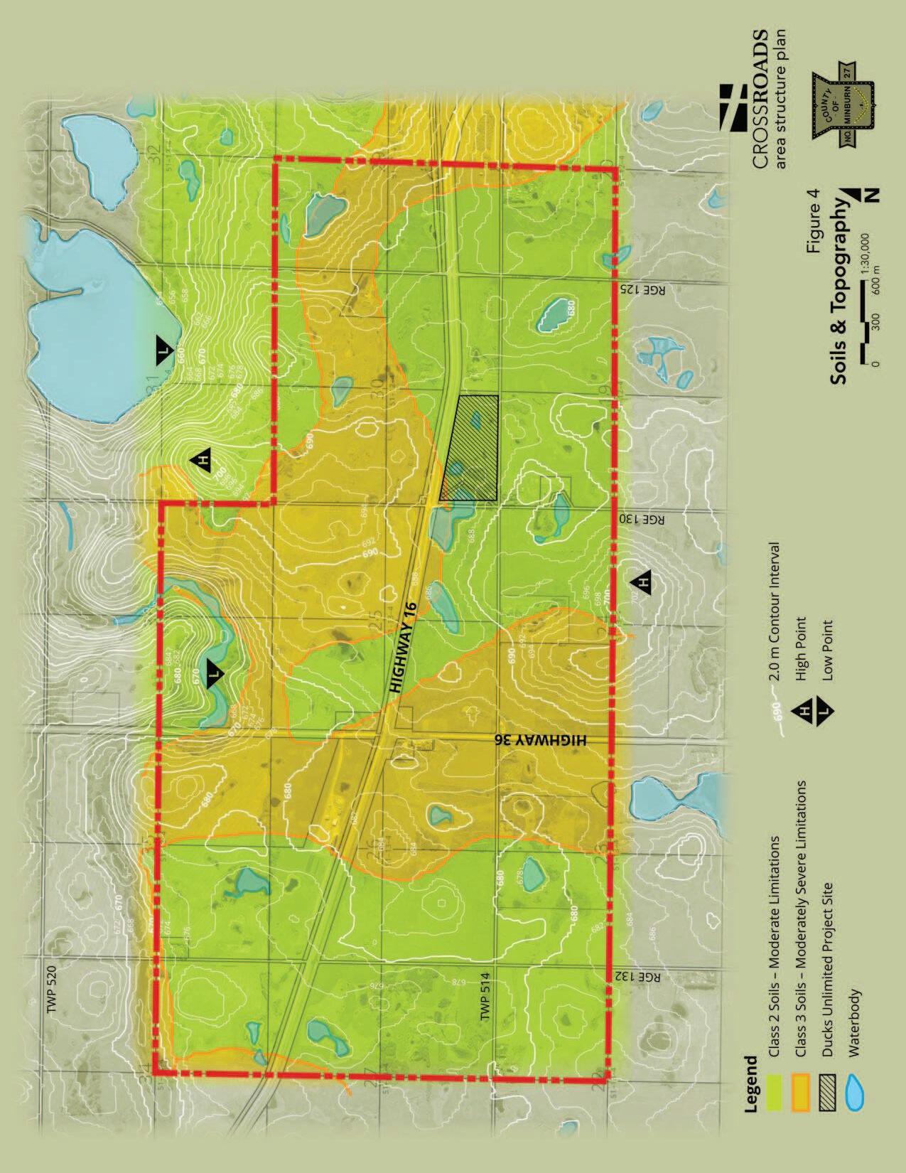
5.2 Soils and Topography
The soil characteristics vary along the edges of the ASP boundary. However, the majority of the central plan area can be characterized as Eluviated Black Chernozen on medium textured soil that is poorly drained and that contains some Solonetzic soils.7
The farmland within the ASP boundary is Canada Land Inventory classification Class 2 and 3. Class 2 soils have moderate limitation that restrict the range of crops or require moderate conservation practices.8 Class 3 soils have moderately severe limitations that restrict the range of crops or require special conservation practices.9 See Figure 4 Soils & Topography
Farmland assessment values are calculated by the County’s consultant Municipal Assessor and are used to determine whether a quarter section is considered arable or dryland for the purpose of applying regulations in Land Use Bylaw 1218-12. There is a mix of arable and dryland quarter sections within the ASP boundary. Confirmation of quarter section designation can be obtained directly from the County.
The terrain of the ASP area is hummocky with low relief and limiting slopes of 6%.10 The maximum elevation in the ASP boundary is 700 m and the lowest elevation is 666 m. Drainage patterns are variable, with overland drainage generally directed to localized wetlands or low-lying areas.
5.3 Wetlands
Numerous wetlands exist within the ASP boundary (see Figure 4). Development constraints may exist related to the Province claiming ownership of permanent and
7 Alberta Soil Information Viewer, found at www4.agric.gov.ab.ca/agrasidviewer
8 Canada Land Inventory Soils Classification for Agriculture, Environment Canada, Land Inventory, 1972.
9 Ibid
10 Alberta Soil Information Viewer, found at www4.agric.gov.ab.ca/agrasidviewer
County of Minburn No. 27 | Existing Conditions 6
Highways 16/36 Crossroads Area Structure Plan Bylaw 1228-13
naturally occurring wetlands in the ASP area.11 Further, Ducks Unlimited has identified one project within the ASP boundary12 (see Figure 4) and should be advised of any potential developments that may impact the existing, or any proposed, project.
A permitting process pursuant to the Alberta Water Act would be triggered by a proposed development in or removal of a Crown-owned wetland. Developers are advised to consult a qualified environment professional in the early stages of development to confirm if a Provincial permitting process may be triggered. In instances where approval for development in or removal of Crown-owned wetlands is granted, creation of compensatory wetlands may be required.13
Moreover, a development proposed near a Crown-owned wetland or waterbody may have minimum setback distances applied to it by the Province, in addition to setbacks the County may require pursuant to its Land Use Bylaw. Therefore, development in the vicinity of any wetland or water body requires careful consideration.
It should be noted that wetland areas, regardless of the Province’s claim to them, may be suitable for designation as Environmental Reserve through the subdivision process.
5.4 Oil and Gas
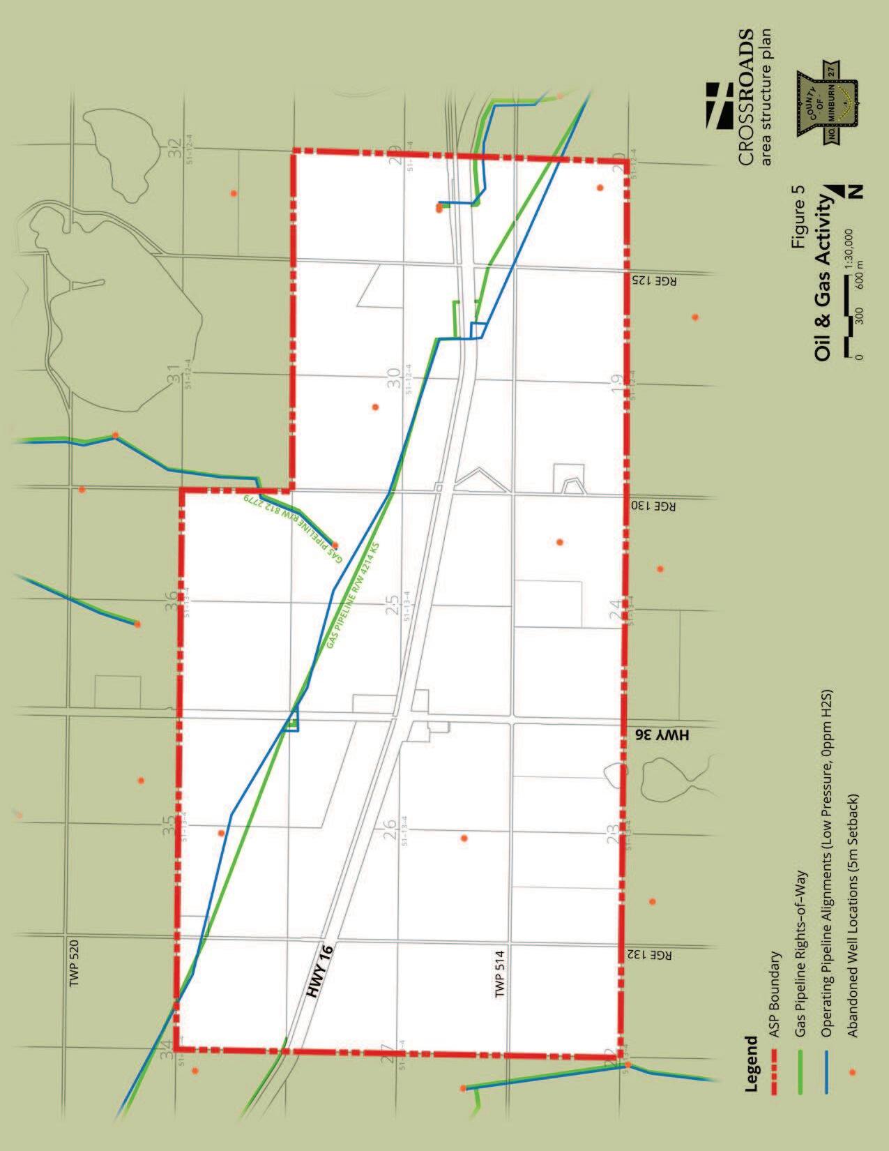
Oil and gas wells and pipelines are shown in Figure 5 Oil & Gas Activity. All well sites within the boundary are abandoned, requiring a minimum development setback radius of 5 m. All of the pipelines within the ASP boundary are low pressure natural gas and have minimum development setback requirements equal to the pipeline right-of-way.
Developers are advised to contact the Alberta Energy Regulator (or its successor) to confirm development setback requirements to all oil and gas facilities prior to submitting an application for development or subdivision to the County.
5.5 Significant Historical Sites
There are no known significant historical sites within the ASP boundary.14
11 Excerpt from Environment Overview prepared by Spencer Environmental Management Services Ltd. for Al-Terra Engineering. Source: Appendix B of Highway 16:24/26 and Highway 36:18/20 Interchange Southeast of Lavoy Functional Planning Study, Al-Terra Engineering, 2013.
12 Email correspondence from Ian Taylor, Conservation Programs Specialist for North East Alberta, dated September 28, 2013.
13 Ibid.
14 Alberta Register of Historic Places interactive database searched September 2013 via HeRMIS Heritage Resources Management Information System website found at: https://hermis.alberta.ca/ARHP/map/#
County of Minburn No. 27 | Existing Conditions 7
6.0 Utility Servicing
6.1
Water
The Alberta Central East (ACE) Water Commission water line is located about 4.0 km (2.5 miles) north of the ASP boundary along Township Road 522, as shown in Figure 2. Extension of the water line south to the ASP area at this time may not be economically feasible. However, as development potential within the ASP boundary is realised, extending the regional water south may become desirable.
At this time independent water servicing (water well or cistern) or a centralized water distribution system for a group of developments may be the most cost-effective means of servicing developments with potable water. Rainwater catchment and treatment may be a suitable alternative source of water for low volume users provided the systems comply with Provincial regulations. Dry land uses, such as lay down yards, may not require water servicing.
Providing sufficient volumes and pressure for fire flow water may prove challenging in the absence of a piped water supply system. Water storage tanks, use of stormwater ponds, dry chemical suppression and other alternatives could be explored. Proponents will be required provide suitable solutions to this issue at the time of permit application.
6.2 Sanitary
Independent sewage disposal or a scalable centralized sewage management system would be required to provide sewage disposal for developments requiring such servicing. Innovative sewage disposal systems proven to be effective in a northern prairie climate and meeting Provincial regulations are encouraged. The use of holding tanks may be supported on a case by case basis if all other alternatives prove unsuitable for the soil and site conditions or are demonstrated to be cost-prohibitive. Dry uses may not require sanitary servicing.
6.3 Stormwater
Stormwater management, as necessary, will be accommodated on site for each development and/or accomplished by way of a centralized stormwater management system (i.e.: a stormwater management facility/pond) within a development area. The use of permeable surfaces and rainwater storage systems could help reduce peak flow volumes.
An overall site grading and stormwater management plan would be subject to the applicable County and Provincial review, as necessary, and be required to balance pre- and post-development runoff volumes while detailing the specifications for any required stormwater management facilities.
8
Highways 16/36 Crossroads Area Structure Plan Bylaw 1228-13 County of Minburn No. 27 | Utility Servicing
7.0 Transportation
7.1 Roads
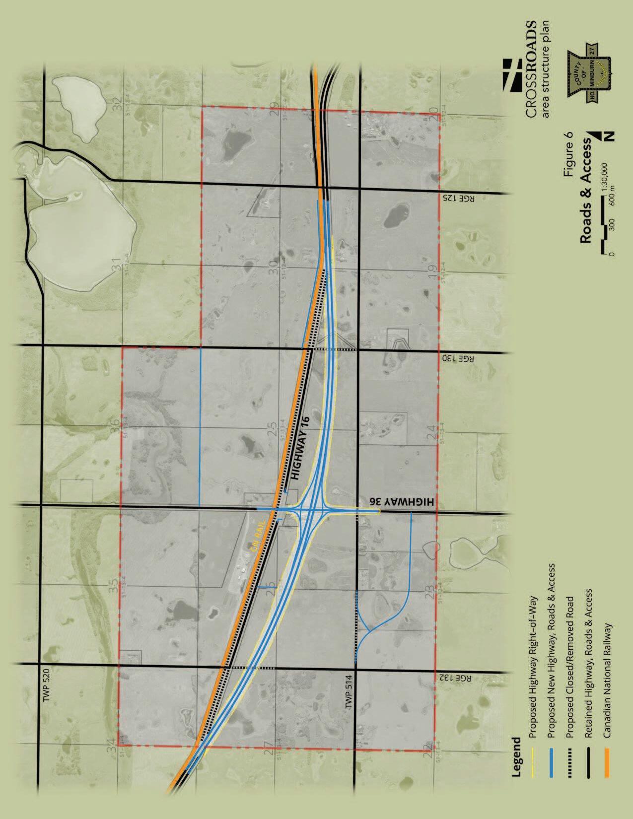
In the area of the proposed interchange, Highway 16 is a four-lane, divided highway with a posted speed limit of 110 km/hr.15 Highway 36 at this location is a two-lane, undivided highway with a posted speed limit of 100 km/hr and intersects Highway 16 just south of the CNR line.16 There is approximately 25 m between Highway 16 and the CNR crossing.17
Range Roads 132, 130 and 125 are all gravel surfaced with a width of between 19 and 24 ft, averaging 22 ft. All of the Range Roads currently cross Highway 16 at grade. Township Road 514 also has a gravelled surface with a width of 24 ft west of Highway 36 and 22 ft east of Highway 36. Township Road 514 intersects Highway 36 at grade. (See Figure 6 Roads & Access).
7.1.1 Existing and Future Traffic Volumes
The following data is obtained from the Highway 16:24/26 and Highway 36:18/20 Interchange Southeast of Lavoy Functional Planning Study (the Functional Planning Study) prepared by Al-Terra Engineering, 2013, and is provided for information purposes only. Readers looking for greater detail and analysis of this information are directed to the source document.
AADT
According to the Functional Planning Study, the 2010 Average Annual Daily Traffic (AADT) on Highway 16 is 6,740 vehicles per day (vpd) to the west of Highway 36 and 6,240 vpd to the east of Highway 36. Further, truck traffic comprises 22% of these daily traffic volumes.
The Functional Planning Study also indicates the 2010 AADT on Highway 36 north of Highway 16 is 950 vpd, while the AADT south of Highway 16 is 1,130 vpd. Truck traffic travelling north accounts for 27% of the traffic volume on this section of Highway 36, while truck traffic accounts for over 18% of the volume travelling south on Highway 36.
AM/PM Peak
Table 2 and Table 3 summarize the morning and afternoon ‘peak’ traffic volumes for Highways 16 and 36, both existing (2010 base year) and in the year 203018:
15 Highway 16:24/26 and Highway 36:18/20 Interchange Southeast of Lavoy Functional Planning Study, Al-Terra Engineering, 2013.
16 Ibid
17 Ibid
18 Ibid
Highways 16/36 Crossroads Area Structure Plan Bylaw 1228-13 County of Minburn No. 27 | Transportation 9
Highways 16/36 Crossroads Area Structure Plan Bylaw 1228-13
Table 2. Highway 16 Peak Volumes 2010 & 2030
(2010)
16 AM
Table 3. Highway 36 Peak Volumes 2010 & 2030 Existing (2010)
36
7.2 Canadian National Railway
The Canadian National Railway (CNR) line runs parallel to the existing Highway 16 rightof-way alignment, offering potential advantage to prospective developers in both the interim and the long term (see Figure 6).
A rail spur was constructed to service a rural industrial development on part of the N 2651-13-W4M, located near the northwest quadrant of the Highways 16/36 intersection. Additional rail spur development opportunities may be possible and details would need to be negotiated directly with CNR in the early stages of a proposal.
Adequate advanced notification of CNR by prospective developers is required to confirm setback and other safety requirements that may influence projects. Developers may also wish to refer to the Proximity Guidelines and Best Practices Final Report 2007 prepared by EarthTech for the Railway Association of Canada and the Federation of Canadian Municipalities, readily available online and directly from CNR.
County
10
of Minburn No. 27 | Transportation
Future (2030) % Increase HIGHWAY
Peak PM Peak AM Peak PM Peak AM Peak PM Peak Eastbound 328 344 605 595 45% 42% Westbound 365 369 525 551 30% 33%
Existing
Future (2030) % Increase HIGHWAY
AM Peak PM Peak AM Peak PM Peak AM Peak PM Peak Northbound 58 38 138 82 58% 53% Southbound 56 59 108 112 48% 47%
8.0 Future Land Use Concepts
8.1 Future Land Use
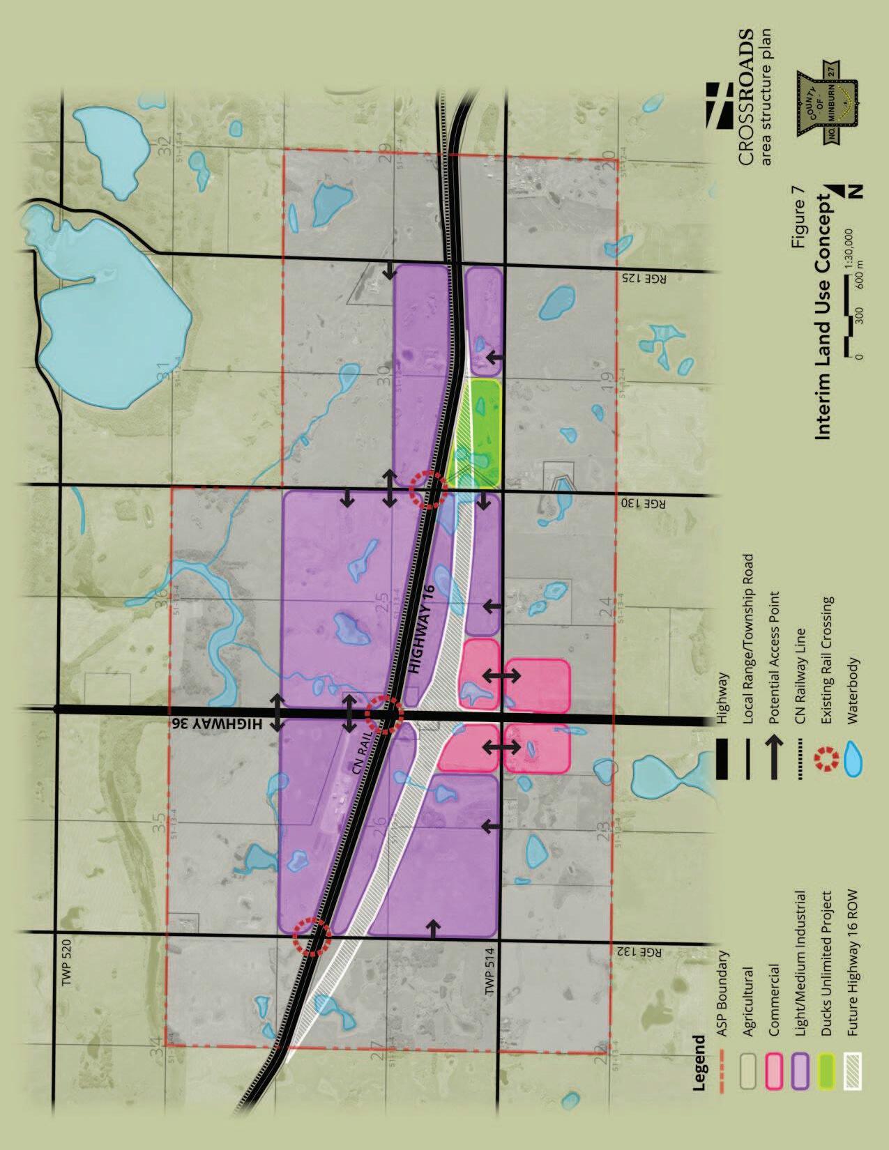
Figure 7 Interim Land Use Concept illustrates land use designations and potential access points in relation to the existing Highway 16 right-of-way alignment. This concept has an estimated time horizon of 20 years, which coincides with the approximate timing of the realignment of Highway 16.
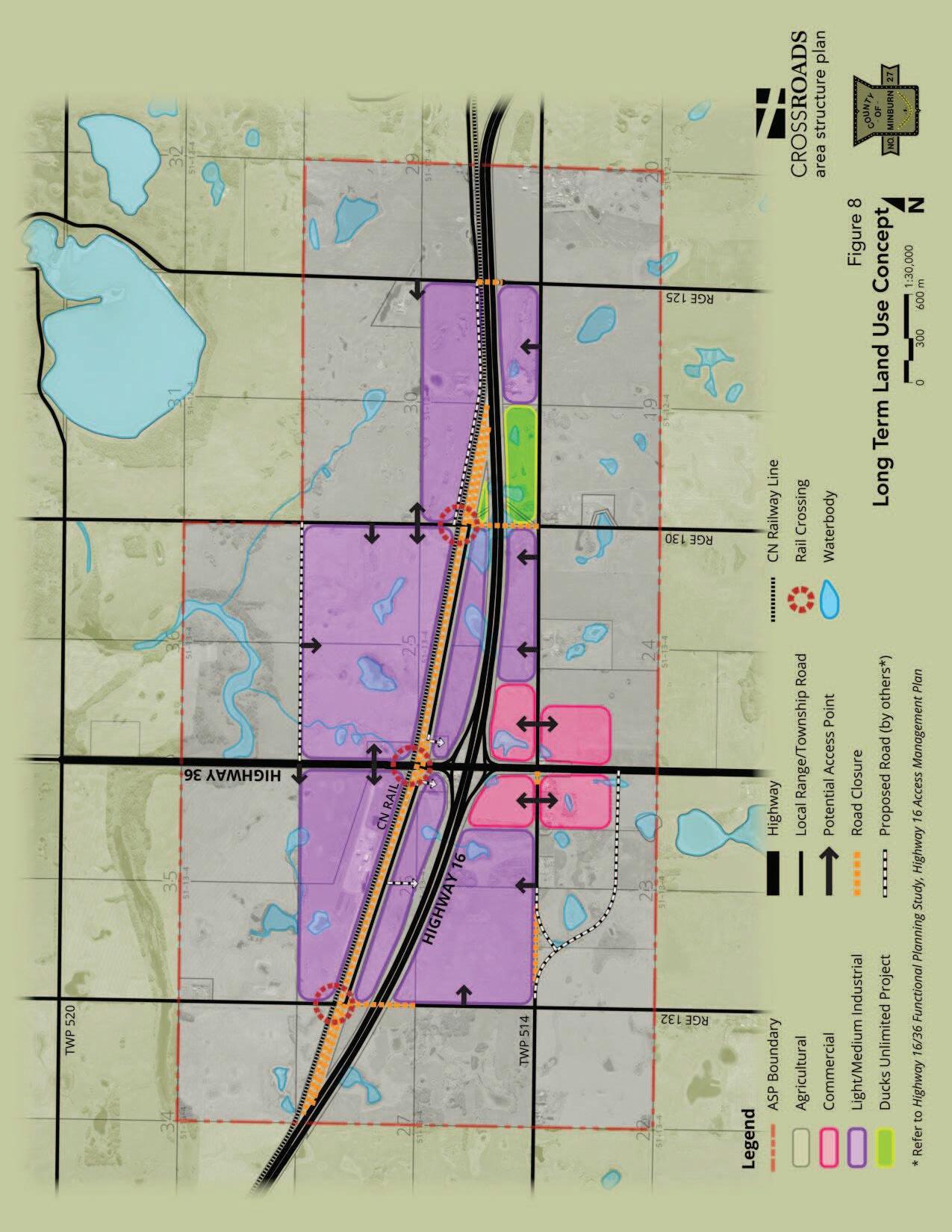
Figure 8 Long-Term Land Use Concept varies from Figure 7 in that it shows the future realignment of Highway 16, the proposed resultant road closures, alternative potential access points to designated lands, and new roads as proposed by the Functional Planning Study and the Highway 16 Freeway Corridor Management Study. Areas designated for Agriculture, Light/Medium Industrial and Commercial remain unchanged.
8.1.1 Light/Medium Industrial
8.1.1.1 Land Use
Approximately eight and a half quarter sections of land are designated Light/Medium Industrial. Light/Medium Industrial lands takes advantage of highway frontage (interim and long-term), good visibility and, for parcels immediately north of the Highway 16 right-of-way, possible direct access to the CNR line.
Suitable uses in this designation are consistent with the uses listed in the County’s Land Use Bylaw for the Rural Industrial land use district including, but not limited to, the following: agricultural service facility, agricultural processing industry, bulk fuel depot, equipment fabrication, heavy equipment sales and service, natural resource processing industry, outdoor storage, rural industry or vehicle service establishment.
8.1.1.2 Access
Access to industrial land is proposed off the existing Range Roads, Township Roads and from Highway 36. No direct access will be allowed to Highway 16 in the long term. New direct accesses to Highway 36 may be allowed with a preferred spacing of 800 m between accesses.19
Two areas of Light/Medium Industrial land are located on either side of Highway 36 between the existing and future realigned Highway 16 rights-of-way. In the interim, access may be obtained from Range Roads 130 and 132; however, any access to these areas from these Range Roads will be temporary in nature. In the long term, these lands may be challenging to access because the sections of Range Roads 130 and 132 that offer access in the interim will be closed in the long term once Highway 16 is realigned.
19 Alberta Transportation via email correspondence September 17, 2013
County
11
Highways 16/36 Crossroads Area Structure Plan Bylaw 1228-13
of Minburn No. 27 | Future Land Use Concepts
Highways 16/36 Crossroads Area Structure Plan Bylaw 1228-13
Direct, permanent access to these two areas after Highway 16 is realigned is proposed to be from the eastbound lane of the former Highway 16, as shown in Figure 8. Yet, these accesses cannot be created until after Highway 16 is realigned, an event not anticipated for at least another 20 years. Additionally, the lack of east-west connections via local roads north of Highway 16, especially west of Highway 36, results in circuitous access to these two areas.
Development of internal subdivision roads may help to mitigate this long term access situation; therefore, internal subdivision road layout should be designed to provide more direct access from Highway 36 to these two areas wherever practical.
8.1.2 Commercial
8.1.2.1 Land Use
Approximately 120 acres of land is designated Commercial in the Land Use Concepts. It is expected that the area of Commercial land designated in this ASP may be adjusted over time to reflect actual market needs.
Land uses appropriate for this location at the intersection of Highway 36 and Township Road 514 include those uses listed in the County’s Land Use Bylaw under the Rural Commercial land use district including, but not limited to, the following: commercial greenhouse/plant nursery, commercial storage, contractor service (minor), food and beverage establishment, heavy equipment sales and service, recreation vehicle storage, retail gasoline and petroleum product sales, transportation facility, and warehouse.
8.1.2.2 Access
Direct access to the commercial areas will be from Township Road 514 (see Figures 7 & 8). Access to Highway 36 from Township Road 514 will be shifted south due to the future Highway 16 interchange footprint and roadway alignment requirements. Township Road 514 will look, and perhaps may function, as a service road fronting commercial land for a distance south of the existing Highway 36/Township Road 514 intersection (see Figure 6 for road alignment details).
8.1.3 Agricultural
8.1.3.1 Land Use
The lands within the ASP boundary not designated for Light/Medium Industrial or Commercial are designated Agricultural. This designation is consistent with existing land use districting under the County’s Land Use Bylaw, and uses listed therein are generally supported by this ASP.
Market demand may increase desire/need to re-designate some Agricultural land for either Light/Medium Industrial or Commercial. However, consideration of expansion of
County of Minburn No. 27 | Future Land Use Concepts 12
Highways 16/36 Crossroads Area Structure Plan Bylaw 1228-13
the designations as shown in Figures 7 & 8 shall be supported with clear and defensible planning rationale. Further, any approved expansion of the Light/Medium Industrial or Commercial lands should be contiguous to avoid “leap frog” development and undue negative impact on intervening lands. Any expansion or contraction of the land use designations shown in Figures 7 & 8 would constitute an amendment to this ASP and would warrant a full public engagement process.
8.1.3.2 Access
Access to existing Agricultural parcels (including rural residential) will remain unchanged until such time as the realignment of Highway 16 is implemented. At that time access will be per the Highway 16 Freeway Corridor Management Study and the Functional Planning Study, and as generally shown in Figure 6. Any discrepancies between this ASP and the aforementioned transportation planning documents commissioned by Alberta Transportation regarding existing and future roads, road closures and accesses are unintentional, and the Alberta Transportation documents take precedence.
8.2 Transportation
Internal subdivision roads are expected to be detailed in the future to meet development needs at that time. Therefore internal subdivision roads have not been shown. Rather, potential access points from existing roadways have been illustrated for conceptual purposes only.
Figure 6 Roads and Access shows the future Highway 16 right-of-way alignment and the resultant road and access closures. The solid black lines depict roads or parts of roads that will remain open after the Highway 16 realignment. Dashed black lines show roads or parts of roads that will be closed. The blue lines indicate the locations of future roadways or accesses proposed to be constructed.
It is important to note that all existing parcels retained after the Highway 16 realignment will be provided with legal and physical access, as shown in Figure 6.
8.3
Subdivision & Consolidation
Upon realignment of Highway 16, it may be prudent to work with landowners to reconfigure lot lines into more rational and marketable parcels. Wherever feasible, the County should encourage landowners with awkwardly fragmented parcels to consider working collaboratively with adjacent landowners to reconfigure lot lines for mutual benefit. Subdivision or consolidation will not constitute an amendment to this ASP.
8.4 Development Phasing
Development phasing is likely to occur in response to market demand and investment in upgrading road infrastructure.
County
| Future Land Use Concepts 13
of Minburn No. 27
Highways 16/36 Crossroads Area Structure Plan Bylaw 1228-13
Access to servicing is less likely to influence development phasing in the interim given the cost constraints of creating served lots at this location.
of Minburn No. 27 | Future Land Use Concepts
14
County
9.0 General Land Use Issues
9.1
Signage & Lighting
As the ASP area develops, centralized signage at entrances to development nodes may be desirable and should be supported. Individual signage will need to conform to the requirements of the County’s Land Use Bylaw.
The predominately agricultural nature of this area requires that exterior lighting of developments/sites be sensitive to this dominant character and maximize the benefits of maintaining dark night skies. Light trespass into the night sky and onto adjacent properties should be avoided. Excessively bright overhead lighting/yard lights should be avoided and full cut off fixtures employed to avoid glare and distraction to the travelling public using the adjacent roadways.
Additionally, Alberta Transportation may have signage and lighting guidelines pertaining to developments adjacent to highways that would need to be considered.
9.2
Screening & Landscaping
The proximity to and visibility from Highways 16 and 36 suggest that appropriate and year-round effective landscaping and/or fencing/screening be applied to developments that include outdoor storage that could be considered unattractive.
In addition to the provisions of the County’s Land Use Bylaw, the Development Officer and/or Subdivision Authority, as applicable, is enabled by this ASP to apply more rigorous screening and landscaping requirements. Variances to the minimum required screening and landscaping requirements of the Land Use Bylaw should not be considered, especially in proximity to a public road or Provincial Highway.
9.3 Agricultural Operations
Existing agricultural operations will be allowed to continue in perpetuity at the will of the landowner. Lands designated Agricultural should not be unduly impacted by future adjacent non-agricultural development within the ASP boundary.
9.4
Sour Gas Facilities
There are no existing sour gas facilities in the ASP boundary. The County may support the development of a sour gas facility depending on its proximity to developed areas and the limitations such a facility could place on future development.
9.5
Existing Residences
Existing habitable and inhabited residences within the ASP boundary may be impacted by future non-agricultural developments.
County of Minburn No. 27 | General Land Use Issues 15
Highways 16/36 Crossroads Area Structure Plan Bylaw 1228-13
Highways 16/36 Crossroads Area Structure Plan Bylaw 1228-13
Early, appropriate and meaningful consultation between the development proponent and any directly affected households should be conducted as part of the development or subdivision application requirements
The outcomes of the consultation should be recorded and provided to the Development Officer and/or Subdivision Authority, as appropriate, to be considered during the decision-making process.
Issues 16
County
of Minburn No. 27 | General Land Use
Highways 16/36 Crossroads Area Structure Plan Bylaw 1228-13
10.0 Policy Framework & Implementation
10.1 Interpretation
Policies are written using “shall”, “should” or “may” statements. The interpretations of “shall”, “should” and “may” that follow may provide the reader with a greater understanding of the intent of each policy statement:
‘shall’ – denotes compliance or adherence to a preferred course of action.
‘should’ – denotes compliance is desired or advised but may be impractical or premature because of valid planning principles or unique/extenuating circumstances.
‘may’ – denotes discretionary compliance or a choice in applying policy.
10.2 Amendments
Applications for amendment will require supporting documentation as described in the Municipal Development Plan and Land Use Bylaw, and must be based on sound planning reasons and generally accepted planning practices.
Changes in the location of land use designations as illustrated on Figures 7 and 8 will trigger an amendment to this ASP. Small, reasonable adjustments to the boundaries of the land use designations illustrated in Figures 7 and 8 may not constitute an amendment, at the sole discretion of the County of Minburn.
Access points indicated on Figures 7 and 8 are conceptual only, and changes to their locations shall not constitute an amendment to this ASP.
10.3
Review & Monitoring
This ASP shall be reviewed and monitored to ensure its policies and intent are consistent with current planning principles and the needs of the County of Minburn.
It is recommended this document be reviewed at least every five (5) years. It is also recommended that a thorough update, as needed and in consultation with Alberta Transportation, be conducted upon completion of the Highways 16/36 interchange.
County of Minburn No. 27 | 10.0 Policy Framework & Implementation 17
11.0 Policies
The following policies will be used by the County of Minburn No. 27, including Administration and Council, to provide guidance and direction when making decisions on land use, subdivision and development on lands within the ASP boundary.
General
Policy 1 The County of Minburn shall ensure that all future land use, subdivision and development, and amendment decisions made with respect to lands within the boundary of the Highway 16/36 Crossroads ASP comply with the provisions contained within this ASP, including the Figures. Decisions related to document ‘housekeeping’ or those that would be considered minor deviations, relaxations or variations from the provisions of this ASP would not require an amendment to this document where it can be demonstrated that the deviation, relaxation or variance does not substantively alter the intent, force or effect of the provisions of this ASP.
Policy 2 Any discrepancies between this ASP and the Provincial transportation planning documents referenced herein are unintentional, and the Provincial transportation planning documents take precedence.
Variance
Policy 3 The exercise of discretion and variance related to any matter or decision rendered with respect to this ASP as well as the amendment of this ASP shall be guided by the following principles:
a) The exercise of variance or discretion in deciding an application or amendment to this ASP must be both reasonable and defensible within the letter and spirit of this ASP as well as widely accepted planning principles;
b) If a requirement or provision of this ASP is to be deviated from or if an amendment is to be made, it is essential that those exercising the discretion or deciding upon variance or making the amendment clearly understand the rationale behind the requirement or provision they are being asked to vary or amend;
c) Discretion, variance and amendment shall only be considered if it can be demonstrated that the discretion, variance or amendment being considered will, at a minimum, not jeopardise the policies of this ASP and, at best, better serve them;
Policies 18
Highways 16/36 Crossroads Area Structure Plan Bylaw 1228-13 County of Minburn No. 27 | 11.0
d) Any variance or discretion exercised or any amendment made shall be fully documented so that the reasons and rationale for the variance or discretion exercised or amendment made are accurately recorded and clearly understood.
Amendment Applications
Policy 4 The County of Minburn may undertake or require that the owner/developer undertake an overall review of this ASP should an owner/developer make repeated applications to amend this ASP once it is in effect. The intent of an overall review, instead of continuing to entertain individual, isolated amendment applications, is to consider and evaluate the implications of the revisions to this ASP, at a minimum, in the context of the entire ASP area and, if warranted, beyond this ASP area.
Policy 5 The County of Minburn shall ensure that amendment applications to alter the boundaries of the Light/Medium and Commercial land use designations shown on Figures 7 and 8 are supported by sound planning rationale and generally accepting planning practices, result in contiguous development (i.e.: avoid ‘leap frog’ development) and mitigate negative impacts on adjacent Agricultural lands.
Subdivision & Development
Policy 6 The County of Minburn should support subdivision and consolidation of awkwardly fragmented parcels resulting from the realignment of Highway 16 to improve access, parcel shape and marketability, as practical.
Signage & Lighting
Policy 7 The County of Minburn should support centralized signage at the entrance to development nodes.
Policy 8 The County of Minburn shall encourage dark night skies.
Policy 9 The County of Minburn should require developers mitigate light trespass from new developments through use lighting with full cut-off fixtures and avoiding unnecessary up-lighting into the night sky.
Screening & Landscaping
Policy 10 The County of Minburn shall encourage an elevated standard both with respect to landscaping standards and architectural appearance, with
Policies 19
Highways 16/36 Crossroads Area Structure Plan Bylaw 1228-13 County of Minburn No. 27 | 11.0
respect to all new development or any redevelopment within 300 m (985 ft.) of Highway 16 or Highway 36 within this ASP, considering this area is highly visible from two major highways. The County will work to achieve this through the various mechanisms at its disposal including, as examples, the use of an overlay land use district and/or restrictive covenant. This will be addressed at the time of subdivision and/or development as appropriate.
Policy 11 The County of Minburn should not vary minimum standards of the Land Use Bylaw for screening and landscaping on new developments, especially in proximity to a public road or Provincial Highway.
Agricultural Operations
Policy 12 The County of Minburn shall allow existing agricultural operations to continue in perpetuity at the will of the landowner. Existing agricultural operations in the designation Agricultural should not be unduly impeded and/or impacted by future non-agricultural development within the ASP boundary and adjacent to existing agricultural operations.
Public Consultation
Policy 13 The County of Minburn may require proponents to engage adjacent residents if it is deemed the proposed development may directly impact an existing residence. The consultation must be done in the early stages of the application process, be appropriate and meaningful, and the outcomes of the consultations will be recorded and submitted for consideration by the Development and/or Subdivision Authority.
Engineering Requirements
Policy 14 Developers shall ensure that all site preparation, public roads, and any other public facilities/improvements is professionally engineered and constructed to the satisfaction of the County of Minburn in accordance with the County’s standards.
Policy 15 Owners/developers shall ensure that subdivision and development permit applications comply with the Stormwater Management Guidelines for the Province of Alberta 1999, prepared by Alberta Environment, as applicable. There shall be no change between pre- and post‐development off‐site flows except where the application conforms to an approved stormwater management plan approved in conjunction with the County of Minburn.
Policy 16 Applicants of subdivision and development permit applications shall be responsible for making all necessary arrangements regarding the disposal/management of stormwater off‐site and providing to/for the
County of Minburn No. 27 | 11.0 Policies 20
Highways 16/36 Crossroads Area Structure Plan Bylaw 1228-13
County of Minburn all required documentation, permission, approvals and/or other forms of authorization from all relevant agencies having jurisdiction in relation thereto.
Transportation
Policy 17 The provisions of the Crossroads ASP uphold and protect the integrity and function of both Highway 16 and Highway 36. This is important to secure and maintain Alberta Transportation’s endorsement of this ASP.
Policy 18 The applicant/owner/developer may be required to prepare a Traffic Impact Assessment (TIA), at their sole expense, as a condition of subdivision or development approval pursuant to this ASP. The timing and scope of the TIA will be determined by Alberta Transportation and the County of Minburn. If a TIA should be required, it will be prepared to the satisfaction of the County as well as Alberta Transportation.
Policy 19 The developer shall undertake, at the sole cost of the developer, any engineering, requirements or improvements identified in or resulting from the TIA approved by the County and/or Alberta Transportation, or any other engineering, requirement or improvement specified by Alberta Transportation in relation to Highway 16 or Highway 36 as a result of or that is attributable to the development of this ASP area must be undertaken to the satisfaction of Alberta Transportation, in consultation with the County.
Policy 20 Developers should design internal subdivision road layout(s) to help mitigate circuitous access to adjacent parcels wherever practical.
Land for Road Widening
Policy 21 The County of Minburn shall ensure that when the opportunity arises as part of a subdivision or development permit application within the ASP area, and when considered warranted and appropriate by the Development Officer in his review of the application, road rights of way required up to and including 30 metres (100 ft) in total width should be protected without compensation using whatever legal means/form of agreement necessary and appropriate (ranging from survey and transfer to dedication by caveat, etc.) at the time of subdivision or development permit approval, as the case may be.
Hazardous Materials Development
Policy 22 The Development or Subdivision Authority, as the case may be, in consideration of an application that involves explosives or radioactive material, shall:
Policies 21
Highways 16/36 Crossroads Area Structure Plan Bylaw 1228-13 County of Minburn No. 27 | 11.0
Highways 16/36 Crossroads Area Structure Plan Bylaw 1228-13
a) consider the effects of the storage and/or transport of explosives or radioactive material proposed in an application (e.g. the implications of the development setbacks specified in the applicable Regulations or the provisions of the Transportation of Dangerous Goods Act) on the other existing and proposed use(s) located or proposed to be located on the subject parcel as well as adjacent parcels;
b) at their discretion, prior to deciding upon the application before them, provide public notice, through means and to whom they consider necessary, that a decision regarding an application involving the storage and/or transport of explosives or radioactive material is to be made, that an opportunity will be afforded to any person notified to make representation on the application and that the representations made shall be taken into account when final consideration is given to the said application; and,
c) based on the circumstances of the application before them, and at their sole discretion, either grant their approval, provided the application otherwise complies with this ASP or any Conceptual Scheme in effect, the applicable MDP and LUB, subject to the applicant complying with all applicable provincial and federal as well as any other municipal regulations related to explosives or radioactive material (and submitting proof of same – e.g. a license or certificate, as specified by the Development or Subdivision Authority, that they have complied), or withhold their approval until such time as the applicant demonstrates, to their satisfaction, compliance with all applicable provincial and federal as well as any other municipal regulations related to explosives or radioactive material.
Oil & Gas Activity
Policy 23 The County of Minburn will not support development of sour gas facilities within the ASP boundary.
Policy 24 The County of Minburn will work with oil and gas interests and landowners to identify well‐site development and production schedules that coordinate with land use designations within this ASP. In working with oil and gas interests and landowners, the County will strongly recommend that the following siting/development principles be followed:
a) wells should be clustered whenever possible;
County of Minburn No. 27 | 11.0 Policies 22
Highways 16/36 Crossroads Area Structure Plan Bylaw 1228-13
b) flow lining to a common location for multiple wells should be utilized whenever possible;
c) clustered well sites should be located whenever possible next to public utility lots, storm water lakes and future municipal reserves (parks);
d) road accesses to clustered wells should be combined wherever possible and access routes utilized should be made to fit existing and identified future roadways whenever possible;
e) operating conditions of well/battery sites should be adjusted as follows:
i. fluids should be hauled, tanks should be vacuumed/cleaned and servicing/maintenance should take place during regular daytime hours,
ii. storage tank temperature should be kept at a level such that associated impacts, particularly odour, are minimized to the fullest extent possible,
iii. portable generators should not be used to provide power, and
iv. every effort needs to be made using whatever measures required to minimize odours, noise, dust, vibration and any other negative impacts.
Subdivision Application Requirements
Policy 25 The County of Minburn may require that applicants for subdivision within the Crossroads ASP provide information or address any or all of the following prior to accepting the subdivision application as complete:
a) general terrain;
b) soil characteristics;
c) soils capability to provide drainage and absorb sewage effluent;
d) potential for flooding, erosion or slumping of the land;
e) stormwater/wetland management;
f) adequacy of the proposed building sites;
County of Minburn No. 27 | 11.0
Policies 23
Highways 16/36 Crossroads Area Structure Plan Bylaw 1228-13
g) proposed public road access;
h) availability of a water supply that is adequate for drinking and for the intended use of the parcel(s);
i) proximity to existing utilities;
j) proposed means of buffering in relation to adjacent lands;
k) all existing and historic oil/gas facilities and measures to mitigate any associated impacts;
l) provision/availability of emergency services;
m) identification and form of reserve dedication as applicable per the Municipal Government Act;
n) how the configuration, dimensions, spacing and location of the proposed parcel(s) complies with the concepts of this ASP; and
o) any other matters the Subdivision Officer considers necessary.
Compliance with ASP
Policy 26 The County of Minburn shall pursue whatever actions are deemed appropriate or necessary to secure compliance with the provisions of this ASP.
Policy 27 The County of Minburn may require owner(s)/developer(s) to enter into an agreement with the County as a condition of an approved subdivision or development permit application pursuant to the Municipal Government Act.
Policy 28 The County of Minburn may require caveats, performance bonds, letters of credit, restrictive covenants or any other available mechanisms to secure performance of any requirement stipulated in the provisions of this ASP.
Consistency
between Plans
Policy 29 The County of Minburn will ensure that when amendments are made to this ASP in the future, any complementary amendments to the Municipal Development Plan or Land Use Bylaw are also made to ensure conformance with Section 638 of the Municipal Government Act.
Policies 24
County of Minburn No. 27 | 11.0
Highways 16/36 Crossroads Area Structure Plan Bylaw 1228-13
Monitoring
& Review
Policy 30 The County of Minburn will monitor the Crossroads ASP on an on‐going basis. Notwithstanding, this ASP will be reviewed within five years of being adopted (i.e.: by 2019).
County of Minburn No. 27 | 11.0 Policies 25
