C onsultation Draft

2
3 Equality, Accessibility, and Inclusion in the Public Realm
3.1

C onsultation Draft
3.1
Public realm is generally defined as the publicly accessible spaces between buildings which provide an infrastructure for the movement and interaction of people 1. The London Plan 2 definition includes all such spaces, “whether public or privately owned, from alleyways and streets to squares and open spaces”.
Westminster’s City Plan defines it as “all the physically and visually public, accessible space which form the setting for human interaction, such as streets, pavements, forecourts, squares, parks, open spaces and building façades”.
Supplementary planning documents (SPDs) build upon and provide more detailed advice or guidance on policies in the local development plan. Westminster’s Local Development Plan consists of the City Plan (2019-2040), the Mayor’s London Plan and Neighbourhood Plans produced by designated Neighbourhood Forums with support from the council. As SPDs do not form part of the development plan, they cannot introduce new planning policies. They are however a material consideration in decisionmaking. They should not add unnecessarily to the financial burdens on development.
This Public Realm Supplementary Planning Document presents the City Council’s current approach to the design, maintenance, and use of the public realm. It is intended to be used by the City Council, developers, neighbourhood planning groups and others, when maintaining, upgrading, developing, and considering proposals affecting the public realm.
This SPD builds upon policies within Westminster’s City Plan, by explaining and amplifying policy application where it affects aspects of the design and management of the spaces between buildings, irrespective of ownership or management.
It sets out the context for, and provides guidance in yellow boxes on, the implementation of City Plan policies and other policies relevant to the public realm, whilst signposting to specific technical guidance and best practice Whilst this SPD is mainly focused on planning guidance, the scope for this SPD is broad It also provides guidance that goes beyond planning controls such as other regulatory regimes like highways licensing Once adopted, it will become a material consideration in decision making
The approach adopted in this document recognises the continuing demands placed on the city’s streets, squares and spaces The document aims to provide coordinated design guidance for all those who influence the appearance of the public realm and strives to reconcile the often-conflicting demands on the streets and open spaces of the city, whilst seeking to preserve local distinctiveness. It recognises the operational requirements to keep the city clean, safe and well maintained.
In addition to subject specific guidance, it seeks to provide a basic level of understanding of key processes that public realm schemes go through It should be noted that this document goes beyond what Planning can control and provides references and links to related regimes involved in the management and maintenance of the public realm.
Establishing a mutually supportive relationship between buildings and the public realm is key to creating successful places, and the design and quality of the public realm plays an important part in achieving this.
1 Public-London-(combined).pdf (nla-production.s3.amazonaws.com)
2 https://www.london.gov.uk/programmes-strategies/planning/london-plan/new-london-plan/london-plan-2021
New development is likely to create additional pressure on the existing highway and public realm network and its ability to carry out its functions, therefore generating a requirement for investment in the public realm. The City Plan is clear that development should positively contribute to the public realm.
The public realm is at the crucial interface of all the various activities and functions of Westminster and should encourage social interaction and enjoyment whilst still performing successfully as a conduit for movement.
Improving the quality of the public realm can make a real difference in encouraging the uptake in sustainable mobility patterns, where physical improvements and additional provision can support more walking, cycling and other sustainable mobility initiatives. A high-quality public realm also complements and brings together the surrounding built elements and can positively contribute to the commercial, leisure, social and resident functions of a locality.
In line with City Plan and London Plan policy, development is expected to improve accessibility and inclusivity in the public realm by delivering enhancements which ensure everyone, including those with disabilities and the elderly, can navigate comfortably, safely and with dignity.
The City Plan sets an expectation on development to contribute to reducing the dominance of private motor vehicles to promote the uptake of more sustainable transport modes, create safer streets for all, reduce traffic and improve air quality.
Both the City Plan and the London Plan set out in detail the policy approach to public realm and sustainable transport, and a strong preference for this to be considered in early scheme design stages.
Where does this guidance apply?
This Public Realm SPD provides an approach for all publicly accessible parts of the city and a palette of components for the whole city except for the Royal Parks.
This guidance applies to all spaces that will normally be usable by the public either explicitly or permissively, including:
• Highways, including those maintained by Westminster and Transport for London
• Public Rights of Way
• Parks and other spaces owned or leased and maintained by the City Council
• Private forecourts adjacent to adopted highway
• Privately owned/managed streets and areas with permissive access (walkway agreements etc.)
• Privately managed spaces as part of ‘public’ facilities (e.g. shopping courtyards, access frontages to railway stations)
• Other privately owned areas that are very publicly visible/legible and have high degrees of public access.
• Other public (non-council) but owned/managed by a public body (e.g. TfL and Crown Estate Paving Commission)
• Adopted council owned/managed streets
• Privately owned/managed with highly regulated access restricted (some garden squares with keyholder access only)
Who are the intended users of this guidance?
This guidance is intended for use by all those with an interest in, and responsibility for the condition of the city’s public realm. This includes:
• Developers and applicants intending to put forward applications or proposals affecting the public realm.
• Consultants, designers, and contractors engaged in projects for the City Council, estates, owners, developers, and other parties.
• Local community groups intending to put forward proposals for the public realm, for example as part of a Neighbourhood Community Infrastructure Levy bid.
• Neighbourhood Forums proposing new policy which will impact the public realm in their neighbourhood planning areas
• All council officers engaged in activities that affect the design, operation and management of the public realm
• Council officers assessing public realm proposals as part of planning applications and independent schemes.
• Those that need a briefing document when working in the city for the first time
• Those that need a reference document whether they be members, amenity societies or interest groups.
This Public Realm Supplementary Planning Document (SPD) should be used when preparing and evaluating planning applications and new projects that impact on the public realm, whether initiated by the public or private sector.
When using the document, please note the color-coded guidance provided throughout: Yellow boxes contain important guidance on planning policy, highways, and licensing. Green boxes outline specific design expectations to help clarify design standards and best practices. Blue boxes offer case studies that illustrate practical examples.
This guidance aims to build on established best practice advocating a generally minimalist, but coordinated and holistic approach that considers whole life costing and sustainability in design, implementation, and management of the public realm, together with priority for the pedestrians and a truly inclusive public realm. It advocates that all parties employ ‘joinedup-thinking’ whilst considering all policy parameters set out in the City Plan and implementing the Fairer Westminster strategy (see section 2.3 for further details) in the consideration of the public realm and decision-making processes.
This document sets out commonly required guidance and supplements and details existing standards
Public realm in Westminster must be accessible and inclusive, to ensure that all members of society can participate, use, and enjoy our public spaces. It is not about making special provision for disabled people but is about removing barriers and designing the environment in a way that encompasses everyone’s needs.
Improving routes to and from public transport nodes, including bus stops and railway stations, is essential for encouraging more people to choose buses and trains for their journeys. Providing more accessible public spaces and routes, including to sustainable travel choices, can facilitate people’s continued participation in their community, employment and social activities. Whilst it may not be possible to attain perfect standards of accessibility and inclusivity across the public realm in the whole of Westminster, mainly due to space constraints and heritage and conservation needs, there are improvements which can be made to facilitate better access, even in locations such as Soho where there are challenges such as narrow pavement widths
Thinking ‘beyond the redline’ should be a routine consideration of development. Improvements to public realm and infrastructure beyond the boundary of a development scheme should always be sought Examples include, improving connectivity of social or children’s infrastructure in a neighbourhood, linking walking routes, and ensuring cohesion
Improvements such as these ensure the quality achieved in one stretch of paving does not end at scheme end but is instead integrated with further improvements provided to create a comprehensive scheme for each place.
The pedestrian network should be continuous and joined-up without impediment. Where this continuity has been damaged, it must be remedied. The expectation is that inconsistencies will be removed, where possible. Large scale development should contribute to increased permeability within development blocks.
Proposals for the public realm will be considered against a range of criteria and site conditions, with priority given to the following:
A. Positive impact of proposal on the environment and all public realm users
B. Positive change towards the safe movement of people
C. Improvements to air quality and local microclimate
D. The retention and reuse of materials
E. Use of standardised and sustainable materials appropriate to their proposed function and location
F. Enhancing wellbeing , biodiversity, and sustainable drainage
G. Increasing attractiveness and accessibility of cycling, walking routes and other sustainable modes of transport, and minimising the use of and impact of private cars.
The Westminster Code is a set of five key guiding principles established to guide the nature of ALL interventions in the city’s public realm. The Westminster Code flows from a range of policies in the City Plan, principally policy 43 (Public Realm), but also Connections, Environment, Design and Heritage policies.
Proposals for the public realm will be considered against a range of criteria and site conditions, with priority given to how they respond to the following rules.
Their application will ensure continuity of design standards and maintenance and should be used in the delivery (inception through to completion and into maintenance) of all streets, open space, environmental and public realm works whether a new project, maintenance issue or a simple replacement.
Public Realm in Westminster is expected to:
1. Be functional, clutter-free, intuitive, safe, inclusive, and accessible to all users
Westminster’s public realm should be simple, easily legible/understandable, and unambiguous. It should be designed in a manner that puts pedestrians first. It should be attractive, welcoming, discourage anti-social behaviour and allow the safe dwelling and movement of people. This helps ensure inclusiveness of access for all users, regardless of their characteristics. Public access to routes and spaces should be maintained.
Elements within the public realm should be fit for purpose, designed for their specific function and location. Physical and visual clutter should be reduced as much as possible to ensure the best use of space. This means for example rationalising street furniture, by only installing new items where absolutely necessary, considering multifunctional elements, and removing redundant items.
2. Be of high quality, consistent, durable, and easy to service and maintain
Proposals should be of a high-quality design which ensures the public realm is attractive, durable, and timeless. This includes designing and selecting items and materials that minimise and facilitate long-term cleaning, servicing, and maintenance requirements and which can withstand their intended use and environmental conditions.
Interventions should contribute to making the public realm a coherent and unified network of spaces that the Council can maintain. Proposed interventions should align with Westminster’s standard approach to street furniture and other public realm items, as well as the material and the colour palette set out within Appendix 2 of this guidance. The City Council may allow variations in limited locations where a more bespoke approach is considered appropriate (e.g. where an item of historic interest or character is one that should be preserved or where there is an agreed area difference or exceptional scheme).
Items which are replaced should be exchanged with a like for like item especially where the existing quality is high. Inconsistencies such as gradual repairs/reinstatements, signage or road layout must be removed particularly where lowquality materials mar the standards required by this guidance. Regeneration/improvement projects where existing quality is poor might introduce unusual elements by special agreement in exceptional circumstances
3. Incorporate solutions to respond to the climate emergency
The public realm should support the City Council’s ambition to improve the city’s environmental sustainability. Proposals should demonstrate how they have been sustainably designed when looking at the scheme’s full-life cycle The use of resources and energy, both from sourcing and in a durability and maintenance sense, should be minimised. This includes selecting more sustainable, low-carbon materials, and materials with high recycled content, promoting material re-use, avoiding waste of material or equipment, and employing sustainable operational practices. To support this, an efficient and coordinated approach to public realm interventions is required wherever possible.
Proposals should also demonstrate how they positively contribute to mitigating the impacts from climate change (including the urban heat island), reducing carbon emissions (including facilitating electric grid integration) , mitigating surface water flood risk and improving natural drainage, enhancing greening and biodiversity, and helping with carbon capture.
4. Support improved health and wellbeing and uptake of more sustainable travel modes
The public realm should support community interaction, general wellbeing, and active lifestyles. It should encourage active mobility and pedestrian priority and minimise exposure to noise and air pollution.
Proposals should seek to improve walking routes and the pedestrian environment, increase the attractiveness of cycling, supporting the uptake of walking and other sustainable modes of transport, while minimising the use and impact of private cars.
The public realm should provide for a network of spaces that can cater to different needs, including quiet spaces, cool and shaded spaces, spaces with good sun exposure, sheltered spaces, natural spaces for exposure to nature and spaces for play and recreation.
5. Maintain and celebrate Westminster’s historic character whilst welcoming innovation and sustainable growth
Well managed infrastructure is essential for supporting social well-being and productivity across the city. Our public realm must be resilient and adaptable to changing patterns of behaviour, environmental influences, and new technologies that allows for sustainable growth which is socially and economically inclusive whilst environmentally sustainable
New spaces and interventions in the public realm should respect and seek to enhance Westminster's exceptional townscape, historic character and local distinctiveness. It is essential to preserve the balance between the protection of the public realm’s existing character and local distinctiveness whilst still evolving and developing as a living, vibrant, and inclusive city. It is vitally important to strike the right balance between preservation of the character of Westminster’s historic streets and squares and the demands of a modern city.
The context and character of the public realm should be considered at the outset of the design process and elements which contribute positively to local distinctiveness should be maintained or enhanced. Context-specific, public realm should respond to and engage in dialogue with locally specific features ensuring integration with the existing context and character and the design response should consider potential for change to enhance the settings of heritage assets and important viewpoints, including opening up new views and creating space to appreciate landmarks, where appropriate Without careful control and co-ordination of street furniture and surface treatment the appearance and functions of the street can be fundamentally compromised.
The city’s distinctive black street furniture livery should be adopted for all furniture items, unless specifically identified as an established exception to this rule in this document. Choice of furniture items, planting and materials should be informed by the character and traditions of its context. The established pattern of geographically distinct furniture items should be respected and continued.
The National Planning Policy Framework (NPPF) 3 sets out the Government’s planning policies for England and how these should be applied. The NPPF does not have specific policies on public realm; however, it sets out general design and planning principles which are relevant to the development of public realm initiatives.
Chapter 8 Promoting healthy and safe communities, states that planning policies and decisions should aim to achieve healthy, inclusive and safe places which “promote social interaction”, “are safe and accessible” and “enable and support healthy lifestyles” (paragraph 92), and that proposals should “plan positively for the provision and use of shared spaces, community facilities […] and other local services to enhance the sustainability of communities and residential environments” (paragraph 93).
Chapter 9 Promoting sustainable transport, states that applications for development should “give priority first to pedestrian and cycle movements […] address the needs of people with disabilities and reduced mobility […] create places that are safe, secure and attractive […] allow for the efficient delivery of goods, and access by service and emergency vehicles; and be designed to enable charging of plug-in and other ultra-low emission vehicles” (paragraph 112).
Chapter 12 Achieving well-designed places, emphasises that “good design is a key aspect of sustainable development, creates better places in which to live and work and helps make development acceptable to communities” (paragraph 126). It is encouraged that significant weight should be given to “development which reflects local design policies and government guidance on design” (paragraph 134).
Chapter 15 Conserving and enhancing the natural environment, states that “planning policies and decisions should contribute to and enhance the natural and local environment” (paragraph 174). Similarly, Chapter 16 Conserving and enhancing the historic environment, emphasises that “plans should set out a positive strategy for the conservation and enjoyment of the historic environment”.
The National Design Guide 4 and the National Model Design Code and Guidance Notes for Design Codes 5 form part of the Government’s collection of planning practice guidance and are referenced in the NPPF. These documents should be read alongside this SPD when developing a scheme for the public realm.
3 National Planning Policy Framework
4 National Design Guide
5 National Model Design Code and Guidance Notes for Design Codes
The London Plan (2021) 6 is the Spatial Development Strategy for Greater London and sets out a framework for how London will develop over the next 20-25 years. All London Local Plans must be in ‘general conformity’ with the London Plan, ensuring that the planning system for London operates in a joined-up way and reflects the overall strategy for how London can develop sustainably.
Policy D8 Public realm is a design policy encouraging development plans and proposals to explore opportunities to create new public realm, where appropriate. It recognises the significant influence that public realm has on quality of life, affecting people’s sense of place, security and belonging, as well as having an influence on a range of health and social factors. It is a space for all users and to facilitate the movement of people, modes of transport and social activities at any time, whether temporary or regularly.
Policy D5 Inclusive design encourages development plans and proposals to achieve the highest standard of accessible and inclusive design by taking into account factors to enable welcoming, accessible, safe and inclusive design when developing schemes at an early stage. This policy focuses on creating inclusive neighbourhoods within the built environment that includes the internal and external parts of buildings as well as the spaces between them, such as the public realm. This policy is underpinned by one of the six Good Growth policies, GG1 Building strong and inclusive communities, to ensure that London’s growth is Good Growth. This policy aims to erode inequalities and make new connections through early engagement with local people to help shape London’s growth and creating a thriving city that works better for all Londoners. Proposals to create and enhance the public realm are encouraged to factor these objectives to create and maintain spaces that are strong and inclusive communities.
Whilst Policy D8, D5 and GG1 specifically apply to development proposals for the creation and enhancement of the public realm, other London Plan policies should also be read alongside and considered as part of developing schemes which may impact the public realm.
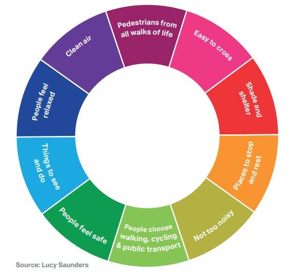
Transport for London (TfL) adopted a Healthy Streets Approach 7 which was the framework used to inform the Mayor’s Transport Strategy 8 and then used to inform London Plan Policy T2 Healthy Streets. The Healthy Streets Approach aims to put people and their health at the heart of decision making. It focuses on creating streets that are pleasant, safe, and attractive, where noise, air pollution, accessibility and lack of seating and shelter are not barriers that prevent people – particularly those most vulnerable – from getting out and about.
The Healthy Streets Approach uses the following ten evidence-based indicators of what makes streets attractive places:
6 London Plan (2021)
7 TfL Healthy Streets for London
8 Mayor’s Transport Strategy
Fairer Westminster 9 is a corporate strategy in which residents are at the heart of decision-making, helping to determine the city’s future. It aims to build a more inclusive city that celebrates its diverse communities, and where residents, workers and visitors from all backgrounds will feel welcome and safe. The strategy sets out five main ambitions which will be used to support the City Council’s decision-making: Fairer Communities, Fairer Housing, Fairer Economy, Fairer Environment, Fairer Council. In line with these key ambitions, the following key deliverables should be considered as part of any schemes to create or enhance the public realm:
• Greening, biodiversity, shading
• Contributing or enabling carbon targets
• Improving air quality
• Flood resilience / drainage / Sustainable Drainage Systems
• Cycling – routes, improvements, stands
• Walking – routes, improving safety, crossings
• Accessibility
• Resident first approach/support
• Supporting local businesses and shopping streets
• Support schemes that allow the City Council to be fair, transparent, and responsive to residents
The City Council’s strategic planning policies are set out in Westminster’s City Plan (2021) 10. This sets out the council’s vision for up to 2040 and includes policies that have an impact on the public realm, which this SPD seeks to expand on.
Policy 43 of the City Plan is the key policy in the plan related to the public realm . It sets out that development will contribute to delivering an inclusive and accessible public realm that is safe and attractive, and to improving connectivity, legibility, and permeability of the network of spaces that make up the city’s public realm. Policy 43 also covers commerce in the public realm, including tables and chairs on the highway, public art, statues and monuments and signs and advertisements.
Being the space for movement and human interaction, the public realm is a key aspect that contributes to delivering on multiple core policy strands such as sustainable mobility, health and wellbeing, design, and town centre vitality. The City Plan therefore stresses on its importance to delivering successful places and sets out how it should be considered at the heart of development schemes, rather than being an accessory consideration once the design of built elements has already been decided.
While there is a dedicated public realm policy in the City Plan, there are several other policies listed below, which should be considered when developing schemes which may impact the public realm.
Key Westminster’s City Plan (2021) policies:
1. Westminster’s spatial strategy
15. Visitor economy
24. Sustainable transport
25. Walking and cycling
26. Public transport and infrastructure
27. Parking
28. Highway access and management
29. Freight and servicing
30. Technological innovation in transport
31. Waterways and waterbodies
32. Air quality
9 Fairer Westminster 2022-2026
10 Westminster City Plan (2021)
33. Local environmental impacts
34. Green infrastructure
35. Flood risk
36. Energy
37. Waste management
38. Design principles
39. Westminster’s heritage
40. Townscape and architecture
43. Public realm
44. Security measures in the public realm
The City Council is working on an emerging City Plan Partial Review which will concentrate on three issues: affordable housing, retrofitting and the inclusion of Site Allocations. When adopted, the new policies will become part of Westminster’s Development Plan, and some existing ones may become superseded. Whilst the new policies do not directly relate to schemes within the public realm, they must still be considered as part of the overall development plan for Westminster once adopted.
Neighbourhood Planning enables communities to play a strong role in shaping the areas in which they live and work, providing them with statutory powers to affect how their local area develops. Almost all of Westminster is covered by designated ‘Neighbourhood Areas’, with the majority of these having designated local ‘Neighbourhood Forums’, and many developing locally distinct ‘Neighbourhood Plans’.
Neighbourhood Plans are written by the local community and are an important tool for managing development, regeneration, and conservation within their respective Neighbourhood Area. They typically include the forum’s aspirations for the public realm within their designated area The City Plan, London Plan and any made neighbourhood plans make up Westminster’s Development Plan. See Westminster's Development Plan and Neighbourhood Planning Guidance for further information.
The Queen’s Park Community Council is the statutory body representing the interests of residents in the Queen’s Park area. Similar to a Neighbourhood Forum, their Neighbourhood Plan outlines policies that will guide decision-making about new developments in their area. See Queen’s Park Community Council.
In September 2019, the council declared a climate emergency and committed to achieve net zero emissions by 2040. A Climate Emergency Action Plan 11 has been developed to set out comprehensive actions for reducing carbon emissions across the city, working in partnership with businesses, communities, and residents.
The council’s Climate Emergency Action Plan identifies the following key outcome priorities and goals to deliver the greatest levels of emissions savings:
• Efficient buildings
• Clean and affordable energy
• Reduced consumption and waste
• Sustainable travel and transport
• Green and resilient city
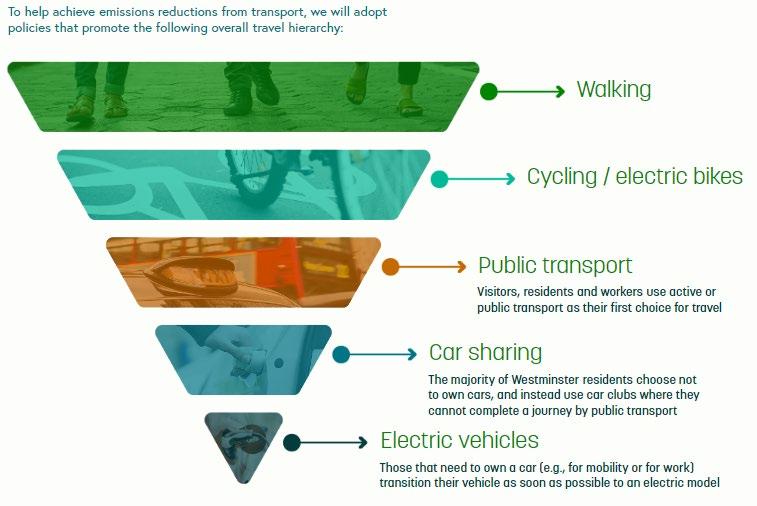
A key outcome priority listed that is particularly relevant to this SPD is sustainable travel and transport. To help achieve emissions reductions from transport, the Climate Emergency Action Plan sets out a travel hierarchy which underpins the approach in this public realm SPD:
11 Westminster Climate Emergency Action Plan
There are a range of opportunities available to reduce carbon footprint through public realm scheme design, delivery, and operation; through careful materials selection including, but not limited to, type, source and delivery methods; changes in working practices (switching from diesel to electric vehicles); use of local storage facilities to reduce the number of trips required; use of cargo bikes for deliveries; and use of sustainable modes of travel.
The action plan sets out actions to respond to each of the goals to enable a zero-carbon city by 2040. To respond to the goal to fully embed resources and efficiency and reuse materials as part of an established low carbon circular economy, there is an action that states that “by 2030, we will require the use of low-carbon methods and material across all WCC highway maintenance and public realm projects” (page 47). While this is a long-term aim, this should be considered for schemes impacting the public realm.
On 20th September 2023, the City Council declared an ecological emergency, recognising the importance of a healthy and biodiverse environment that ensures the wellbeing of all in Westminster. The council notes that the ecological and climate emergencies are intertwined, as burning fossilised carbon places stress on the ecosystems which regulate the climate. If habitats are compromised or destroyed, this has impacts not only on the decline of local species but also on resilience for more extreme weather events such as heatwaves and floods.
As part of this declaration, the council has made a pledge to act within the council’s power to reverse the decline in biodiversity and deliver measurable biodiversity net gain within Westminster. In recognition of this ecological emergency, the council will:
• Make council housing estates, parks, and open spaces more hospitable to a wide range of plants and animals.
• Encourage community engagement with habitat creation through community gardens and improving biodiversity in our streets
• Identify how the city’s open spaces function as part of a Westminster ecological network and prioritise areas for protection and enhancement.
• Work in partnership with institutions, schools, businesses and community groups, to raise awareness and encourage wider biodiversity action across the city through public engagement and advice to residents and businesses on how to protect and enhance habitats within their neighbourhoods.
• Ensure the delivery of biodiversity enhancements through our planning policy and development control functions.
• Review and increase ambition on the council’s target to increase tree canopy cover by 10% by 2050, including working with Westminster Tree Trust to make it easier for residents to propose tree planting. Work with communities to increase tree planting, and where street trees are not appropriate, install green walls, hedges, and planters for smaller trees.
• Design new council housing for net gain of biodiversity and opportunities in the form of integral swift boxes and biodiverse green roofs.
In addition, the council will be publishing a Greening and Biodiversity Strategy in September 2024 which will outline the key visions for Westminster’s green spaces. The strategy, and any subsequent action plans, will be centred around 6 key principles:
• Protect and enhance nature in the city
• Corridors for nature and people
• Make our streets cleaner and more liveable
• Improve resilience to climate change and pollution
• Ensure access to nature for all
• Empower local stewardship.
The list below identifies those key strategy documents that the City Council has developed and those which are emerging , and which should be read in conjunction when developing proposals for public realm. Whilst this list is not exhaustive, it provides helpful guidance to other strategies and documents that can be used when developing public realm schemes.
Planning Policy Documents
Other Key Strategic Documents:
12 Environment SPD
• Environment SPD 12
• Planning Obligations and Affordable Housing SPD 13
• Strategic Flood Risk Assessment 14
• Active Westminster 15
• Walking Strategy 16
• Health and Wellbeing Strategy 17
• Safer Westminster Partnership Strategy 18
• A partnership approach to open spaces and biodiversity in Westminster 19
• Greener City Action Plan 20
• Air Quality Action Plan 21 2019 – 2024
• Cultural Strategy 22
• Lighting Masterplan 23
• Market Strategy 24
13 https://www.westminster.gov.uk/media/document/planning -obligations-and-affordable-housing-spd-wcc-adopted-2024-
14 https://www.westminster.gov.uk/sites/default/files/media/documents/SFRA%20Report%20%283%29.pdf
15Active Westminster Strategy
16 Walking Strategy
17 Health and Wellbeing Strategy
18 Safer Westminster Partnership Strategy
19 A partnership approach to open spaces and biodiversity in Westminster
20 Greener City Action Plan
21 Air Quality Action Plan
22 Cultural Strategy
23 Lighting Masterplan
24 Market Strategy
Emerging Planning Policy Documents:
Emerging Key Strategic Documents:
• Cycling Strategy 25
• Developer Guidance for highway and public realm works 26
• Local Flood Risk Management Strategy 27
• Play Facilities Strategy 28
• Green Infrastructure Audit 29
• Greening and Biodiversity Strategy 30
• Lighting Design Guide 31
• Street Lighting Column Guidance 32
• Responsible Procurement and Commissioning Strategy 33
• Environment SPD update
• New Active Westminster Strategy
• Air Quality Action Plan 2025 - 2029
• Sustainable Transport Strategy
• Carbon Reduction Strategy
• Highways Carbon Management Plan
• New Local Flood Risk Management Strategy
• Westminster After Dark
25 Cycling Strategy
26 Developer Guide for Highway and Public Realm Works
27 https://www.westminster.gov.uk/media/document/en-env-011 local-flood-risk-management-strategy-2017-2022
28 https://www.westminster.gov.uk/media/document/wcc-play-facilities-strategy-2021
29 https://www.westminster.gov.uk/media/document/westminster-green-infrastructure-audit-
30 https://www.westminster.gov.uk/media/document/a-greening-and-biodiversity-strategy-for-westminster
31 https://committees.westminster.gov.uk/documents/s38069/4. WCC lighting design guide.pdf
32 https://www.westminster.gov.uk/media/document/street-lighting-3rd-party-attachments
33 Responsible Procurement and Commissioning Strategy .pdf
Consistency across Westminster is a key principle of Westminster’s approach to the public realm (see section 1.2 The Westminster Code). A common, limited palette of materials and street furniture is applied in most circumstances across the city, though is applied flexibly to reflect differing historical development and local character.
A consistent palette of paving, lamp columns, bollards and other elements of street furniture help to distinguish Westminster from its neighbouring boroughs. There must also be consistency in the design and use of materials and equipment on street, so that signage, posts and lamp columns are of the same arrangement, height and size in any street.
However, within the city are areas of local distinctiveness, which it is important to maintain. Some 80% of the city is within one of Westminster’s fifty-six designated Conservation Areas. The city is also home to the Palace of Westminster and Westminster Abbey World Heritage Site, and five Royal Parks, each of which has distinct characteristics which it is important for public realm schemes to respect.
As well as designated heritage assets there are less formal pockets of particular character — defined by street lighting fittings and sometimes by other unique equipment such as bollards cast by former local government units or parishes. Land use characteristics, ownership or other factors make them different from the rest of the city and these help define some areas
Sometimes patterns of use will justify a locally specific approach. Areas like the West End and town centres need to be sufficiently robust to withstand a greater degree of activity. Areas of growth may need to plan for intensive use.
Westminster ’s conservation areas cover 78% of the city. These cover a diverse range of townscapes from all periods of the city’s development. Many contain a high proportion of listed buildings, and some contain townscape of national or international significance.
Westminster has conservation area audits for most conservation areas which set out to define what is distinct and special about them . Each conservation area audit contains a detailed section on aspects of the public realm including street furniture, public art, hard landscaping, and trees.
In some conservation areas, locally distinct street furniture, such as lamp standards or bollards, or distinctive paving materials create pockets of a particular character. Conservation areas will be particularly vulnerable to harm caused by poorly designed or sited advertisements For more information see conservation area audits, maps and guidance on the council’s website.
The Palace of Westminster and Westminster Abbey, including St Margaret’s Church, were inscribed as a World Heritage Site (WHS) in 1987 It is considered to have ‘Outstanding Universal Value’ as part of the world’s cultural and natural heritage, to be protected, managed, and enhanced.
The WHS Management Plan 34 sets out the vision for the future of the WHS It should be consulted as part of any proposed scheme within the site or its setting. It sets out that the public realm which forms the setting of the WHS should be of exceptional quality reflecting the outstanding , universal value and significance of the site.
Westminster’s Royal Parks — Hyde Park, The Green Park, St James’s Park, Regent ’s Park and Kensington Gardens — are managed by the Royal Parks Agency. The Royal Parks have their own suite of street furniture, including benches, bollards, kiosks and railings, which is distinct from the standard approaches set out in the detailed guidance section of this document. Further information on the management of the Royal Parks estate can be found in the individual management plans for Westminster’s five Royal Parks
34 https://www.westminster.gov.uk/planning-building-and-environmental-regulations/design-and-heritage/world-heritage-site
Registered Historic Parks and Gardens and London Squares in Westminster
Westminster has 23 historic parks and gardens, identified by Historic England. Whilst there are no additional planning controls for parks and gardens listed on the register, they are identified as designated heritage assets in the NPPF and applications must consider and address any impacts on their special character. Historic England are consulted where an application affects a Grade I or II* registered site, and the Gardens Trust on all applications affecting registered sites. There are also 85 London Squares which are protected under the London Squares Preservation Act. These can be viewed on the council’s website, London Squares and Registered Parks and Gardens 35
The riverside provides a unique space offering picturesque views and a calming water body cutting through the dense built environment. The north bank of the Thames runs through Westminster and is a popular tourist route and destination. The Environment Agency has published the Thames Estuary 2100 Plan 36 that sets out a vision for the Thames Estuary future and outlines how to manage the risk of flooding as sea levels rise and defences get older. The Plan states that flood defences west of the Thames Barrier, partially covering Westminster, will need to be raised by 2050. The City Council are working with key stakeholders to develop an emerging Riverside Strategy by 2030, coordinated by the Thames Estuary Partnership.
The design of the public realm on the north bank should accommodate large numbers of footfall and improve the area as a river front destination.
Public and private green open spaces and waterways are shown on the map overleaf
35 Historic parks and gardens | Westminster City Council
36 Thames Estuary 2100 (TE2100) - GOV.UK (www.gov.uk)
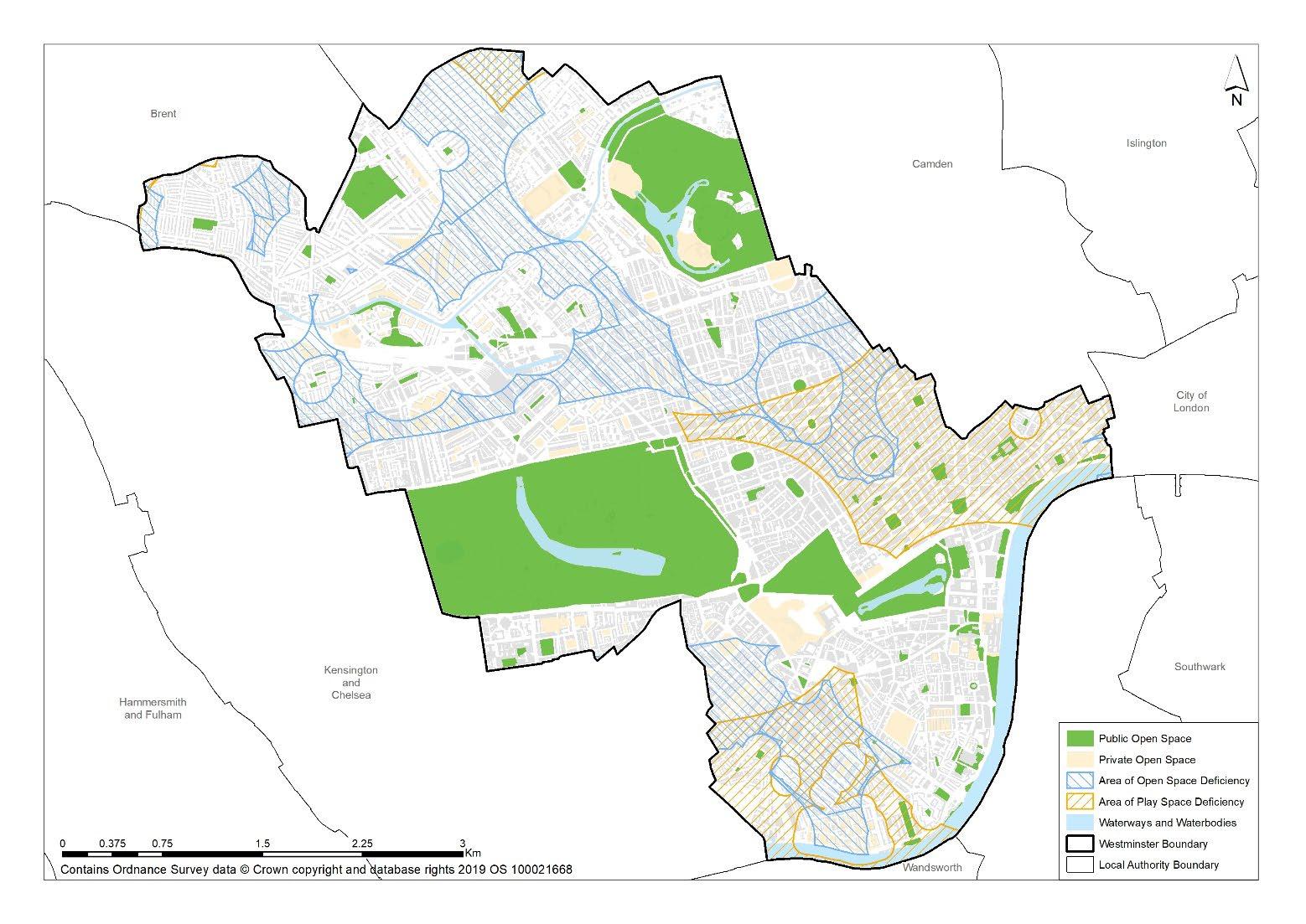
Figure 3: Westminster public and private open spaces.
Westminster’s three designated ‘Opportunity Areas’ at Paddington, Victoria and Tottenham Court Road offer potential for, and have experienced, major development in recent history creating their own modern identities The recent opening of Elizabeth line in Tottenham Court Road and Paddington opportunity areas has brought more people into these central locations, and the latter is now experiencing additional extensive development around the canal basin and goods yards.
The City Plan sets out in Policy 3 that development in the Paddington Opportunity Area must deliver inclusive and high-quality public realm as a priority addressing the north-south severance resulting from the Westway, rail line and canal. It also identifies enhanced travel modes to improve movement for pedestrians and cyclists as a priority.
The Grand Union Canal and the Paddington Basin are already strong assets to the area providing a sense of place. There are opportunities to further improve these waterside places in ways that encourage walking and cycling for pleasure and as an alternative last-mile connection to the Paddington public transport hub.
An improved canal side environment will also strengthen links with other areas to the north west of Paddington along the course of the canal. An improved public realm will help ease congestion linked with the volume of pedestrians using the station and provide accessible, welcoming spaces for people to rest and enjoy the area.
The City Council’s 2023 Paddington Public Realm Strategy sets out a series of design guidelines and strategy for public realm across Paddington, and includes a programme which seeks to transform the fragmented neighbourhoods in north Paddington into a vibrant, healthy and inclusive area.
Victoria and Tottenham Court Road are areas identified as having potential for extensive growth. Victoria is a gateway with rail terminus and a coach station while Tottenham Court Road is served by a new Crossrail station and straddles the boundary between Westminster and Camden
City Plan Policy 4 sets out that development in the Victoria Opportunity Area will deliver inclusive and high-quality public realm that enhances sense of place and encourages dwelling. It also states that development in the area should achieve enhanced sustainable travel modes through improvements to the public realm and local environmental quality to strengthen the area’s capacity, legibility, and permeability, particularly for pedestrians and cyclists.
City Plan Policy 2 relates to the Tottenham Court Road Opportunity Area and aims to deliver an improved retail and leisure experience, which will be achieved in part through public realm improvement. The policy also specifically identifies enhanced pedestrian environment, public realm, and network of transport infrastructure as objectives in the opportunity area.
The West End is a truly unique area of London rich in heritage and culture. It is home to several famous institutions and attractions, making it very popular with tourists and visitors. The intensification of the West End will require an enhanced pedestrian environment, public realm, and transport infrastructure. The unique townscape is one of the reasons why the area is so popular with tourists, so it is crucial we protect this heritage whilst managing the high footfall effectively. Within the West End there are many smaller areas, each with their own distinct character.
The West End is home to international shopping streets, where paving and street infrastructure is subject to exceptional wear. The demands on the public realm here require a particularly robust palette of materials, and a special emphasis on keeping space clutter free because of high pedestrian flows.
There are examples around the city where an element of experimentation with design has taken place. For instance, in the Covent Garden area, street furniture items such as bollards have been painted to suit the colours of the rainbow to promote the celebration of Pride. Festoon lighting and bunting can be seen in this area too, with public art. Whilst this is an exception to the norm, appropriately located, features such as these have contributed to the character of the area. Additional area specific guidance can be found in the public realm framework which has been produced for the Covent Garden Area.
Chinatown has a distinctive aesthetic which sets it apart from other areas in Westminster. The modified metal street furniture such as the red and gold painted canon bollards and red lamp columns, and Chinese lanterns attached from building façades provides a unique cultural experience set apart from the wider area
Westminster has a diverse network of town centres which serve the city’s residents, workers and visitors. It includes the International Shopping Centres of the West End and Knightsbridge; the West End Special Retail Policy Area (WESRPA); CAZ Frontages; Other Shopping Centres Within the CAZ; and Major, District, and Local Centres.
The major retail centres are designed to incorporate freight and servicing requirements.
The public realm environment in Town Centres is subject to much higher levels of wear due to higher levels of footfall from shoppers, visitors, and workers as well as the servicing vehicles which support the commercial premises.
The public realm in our Town Centres should aim to reduce obstructions and let pedestrian movement flow as best as possible. It should also consider the needs of servicing and goods movement.
Westminster is home to vibrant and diverse residential communities. Each one has its own unique built environment with different architectural styles from the Victorian townhouses to the brutalist residential blocks of the 1960s. Our mews roads offer a quieter entrance to residential properties and are used by both cars and pedestrians The public realm should be accessible and inclusive but also respect the heritage and history of these neighbourhoods.
Neighbourhood plans can be used to define and enhance local identities and identify opportunities for local environmental improvements Westminster’s Neighbourhood Plans set out a further approach to describing local distinctiveness following the establishment of Neighbourhood Planning Areas. These areas may share historic or architectural distinctiveness, or less tangible similarities such as patterns of use or community connections Neighbourhood plans will by definition be in conformity with the City Plan and often propose specific public realm initiatives.
Westminster has a defined road hierarchy setting out the different types of roads and their distinctive roles. The street types and hierarchy are currently being looked at as part of the emerging Transport Strategy including, prioritising liveable streets with a key focus on Westminster residents. Westminster’s defined road hierarchy is set out below:
• Transport for London Road Network (TLRN) are main roads managed by Transport for London (TfL). These are considered most suitable for through traffic.
• The Westminster Strategic Road Network (WSRN) distributes traffic within Westminster and to neighbouring boroughs. These main roads are managed by Westminster City Council and prioritise through traffic, with improved parking, loading and waiting conditions The strategic road network is primarily for through traffic and is for the safe and expeditious movement of essential HGV, LGV, bus, coach, taxi and private hire vehicles in particular.
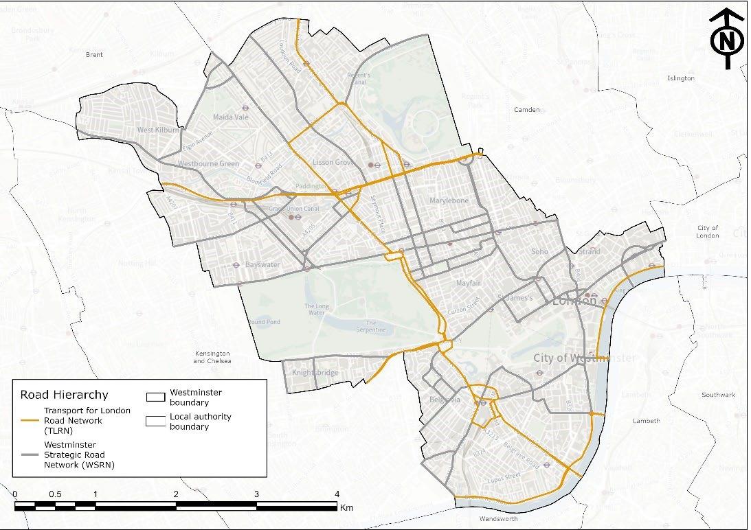
• Local Roads, High Streets and Local Centres give priority to pedestrians and cyclists over motor traffic, providing access to residential areas and local centres. They are more likely to have respite seating areas, electric vehicle (EV) charge points, cycle hire and cargo cycle infrastructure.
• Residential Streets are more likely to have more dropped kerbs, residential cycle hangars, school streets, EV infrastructure, cycle quietways, trees and greening infrastructure.
Related SPD sections • All sections of this SPD
Key City Plan policies 15 (i). Visitor Economy
24. Sustainable Transport
25. Walking and Cycling
26. Public Transport and Infrastructure
38. Design principles
43. Public realm
44. Security Measures in the Public Realm
Context
Westminster ’s just under a quarter of a million resident population comprises highly diverse local communities. We have some of the most affluent residential areas in the country, but a diverse demographic also means some of the most deprived 37 , 38 Its population swells with the influx of workers, students, shoppers and tourists throughout the day and night.
The Public Sector Equality Duty requires the City Council in the exercise of its functions to have due regard to the need to:
• Eliminate discrimination, harassment, victimisation and any other conduct prohibited by the Equality Act 2010.
• Advance equality of opportunity between persons who share a relevant protected characteristic and persons who do not share it.
• Foster good relations between persons who share a relevant protected characteristic and persons who do not share it. This involves:
• Removing or minimising disadvantages suffered by people due to their protected characteristics.
• Taking steps to meet the needs of people from protected groups where these are different from the needs of other people
• Encouraging people from protected groups to participate in public life or in other activities where their participation is disproportionately low.
Under the provisions of the Equalities Act 2010 the City Council has a duty to ensure that when providing its services, it does not discriminate, directly or indirectly, against people or groups within the following protected characteristics:
• age;
• disability;
• gender reassignment;
• marriage and civil partnership;
• pregnancy and maternity;
• race;
• religion or belief;
• sex;
• sexual orientation.
The council’s City Plan seeks to create an inclusive public realm that is safe and accessible to all, and to achieve this development should improve the permeability and legibility of the public realm to users living with disabilities and to people with protected characteristics
37 https://www.westminster.gov.uk/facts-and-figures-about-westminster
38 Ward profiles | Westminster City Council
‘Accessibility ’ is defined in the City Plan as: ‘ The ability of all people, including elderly and disabled people, those with young children and those carrying luggage and shopping, to reach, move around and use places and facilities’.
‘An inclusive environment is one which can be used safely, easily and with dignity by all. It is convenient and welcoming with no disabling barriers, and provides independent access without additional undue effort, separation, or special treatment for any group of people.’ 39
In considering impacts of proposals, Westminster’s ‘Equalities Impact Assessment’ framework also includes care leavers and people on low incomes as an additional relevant category.
11% of Londoners say that they are disabled (https://content.tfl.gov.uk/disabled-people.pdf ), however disability is not homogenous, and interventions which may be beneficial to one public realm user may have a detrimental impact on another.
Accessibility of information is important to improving journey experiences and increasing the confidence to travel, and some may be put off journeys that are too difficult to complete, either perceived through a lack of information about routes, or physically through actual barriers (such as steps, lack of seating or uneven surfaces).
In 2021, the City Council signed up to Transport for All’s ‘Equal Pavement Pledge’.
The pledge is focused around ensuring that the city is accessible for all, and that barriers such as the lack of dropped kerbs, inconsistent tactile paving, uneven or steep pavements, potholes and tree roots, street clutter and bollards, which make the streets difficult to traverse if you are disabled, are addressed.
Guidance for specific features in the public realm are provided in the relevant sections of this guidance SPD. General guidance to improve accessibility and inclusivity is provided below, and is applicable across the city:
Equality considerations when designing for the public realm
• Public realm design and quality can have an important impact on people’s mental and physical health and wellbeing, offering opportunities for social interaction to help fight loneliness and isolation, and providing access to green space and active travel, to encourage a healthier life.
• Public realm design also includes measures to enhance climate-resilience such as, providing shaded areas and floodresistant infrastructure. These features can reduce barriers to access by making public spaces safer and more comfortable for all groups, regardless of age or ability.
• Public realm design can support more sustainable movement across the city, with well-designed spaces that are intuitive and easy to navigate, promoting inclusion and encouraging active travel.
• Whilst Westminster has the highest level of public transport accessibility overall, we must ensure that public realm is designed in a way that ensures public transport as well as our public spaces, are truly accessible to all.
Sites are different, they are used differently by different groups of people, at different times of the day, and in varying weather, environmental conditions, and at different times of the year.
It is not a person’s ability that determines whether they can access the public realm, more so the design and layout of that space. Poorly designed public realm can restrict the ability of those with physical and non-visible disabilities to enjoy public spaces. This can make them feel excluded from spaces that are not welcoming and feel unsafe in spaces that do not provide for their needs.
Standard design methods often inadvertently overlook the needs of different individuals and groups, and whilst a public realm scheme may have been successfully delivered in one location, an identical scheme may not be appropriate for delivery elsewhere.
Designing successful and inclusive public realm requires a clear understanding of the expected users of a space, and their sitespecific needs.
In October 2023, the City Council commissioned an ‘Inclusive Design’ study, to provide independent guidance and an evidence base against which decision can be taken on public realm scheme design, and any changes to our public spaces. This considered user experience of the public realm for each of the protected groups and will be used to inform consideration of all public realm proposals across the city, and as evidence to ‘Equality Impact Assessments’
39 Design Council
The equality and inclusion guidance in this document has been produced by reviewing best practice, previous public realm scheme appraisals, and third sector equalities reports, in relation to common accessibility issues in the public realm.
The appended Inclusive Design Guidance should be used as a baseline for appraisals for schemes, and when exploring design solutions to improve accessibility and inclusivity The guidance has informed development of this SPD. However, it is not intended to be exhaustive and does not replace the need to carry out an Equalities Impact Assessment 40 The required complexity of the EQIA will depend on the complexity of the public realm scheme.
• Consideration must be given to the needs of all public realm users, including those with physical, sensory, and learning impairments.
• The public realm must be easy for users to understand and navigate, with legible, permeable, and inclusive design consistently applied across the city.
• Clear and legible routes must be provided and maintained, with street furniture placed to avoid obstruction, minimising barriers to accessibility and inclusion.
Inclusion
• Changes to the public realm should seek to remove any barriers (both actual and perceived) and ensure inclusion.
• Developers must communicate with the community and seek co-produced solutions.
• The conversion of a footway to a shared space should not be favoured. This type of design challenges the safety, comfort and accessibility of both pedestrians and cyclists, particularly when flows are high.
• All proposed schemes must demonstrate how accessibility and inclusivity have been considered through completion of Equalities Impact Assessments (EqIAs)
Westminster’s ‘Inclusive Design Guidance’, attached as Appendix 1 to this document, provides guidance and links to British Standards and other related guidance and evidence documents, against common WCC public realm scheme types, and the needs of the identified protected characteristics. This should be read in the development of schemes and their respective EqIAs.
The below table provides an indication of some of the issues which must be considered in the design, development and delivery of all public realm scheme, alongside suggested solutions. Each of which is integrated and explained further in the relevant topic-based guidance sections below.
Users Example Requirements
Wheelchair/ three-wheel bicycle user
Blind or partially sighted
Adequate widths on pedestrian and cycle spaces; stepfree access; Smooth surface for wheels; parking; adequately placed street furniture
Simple colour contrast; consistent texture cues; clear segregation/delinea tion between
Potential Barriers
Tactile paving; uneven surfaces; long-step free bypasses; narrow widths pavement; narrow cycle widths; narrow cycle storage; inadequate white badge parking; traffic calming measures; increased journey times; clutter; street furniture / obstructions.
Clutter; street furniture causing obstruction; inconsistent pavement treatments; unclear separation between footway and
Example Design Solutions
• Clear and consistent use of tactile paving.
• Access ramps, and steps only used where necessary.
• Adequate widths to be maintained in pedestrian and cycle spaces.
• Accessible/wide cycle storage provided wherever possible.
• Adjusted-height street furniture such as lower-level signage, and cycle stands
• Rationalise use of tactile paving at crossings / conflict points.
• Provide and maintain clear unobstructed routes.
40 Further Guidance on EQIAs for Public Realm Schemes is being developed by the City Council. Any further update will be included in the final SPD for adoption.
highway users; priority at crossings
Neurodiverse Clear consistent road markings; highway user segregation; simple colour schemes; obstacle free; adequate crossing times; rest/quiet points.
Chronic illness/pain; Pregnancy; Maternity
Availability of spaces of respite; public seating provision; access to public toilets; access to drinking fountains.
Age Obstacle free; smooth not slippery surfaces; appropriate crossing times; seating opportunities. School crossings Well shaded streets and accessible cool zones
carriageway; inconsistent use of tactile paving.
Tactile paving and textures surfaces; commercial activity; background noise levels; inconsistent pavement layout and design
• Consistent and perceptible street furniture design with clear colour contrast, recognisable texture, and design features to support cane users.
• Rationalise tactile paving and limit expansive use in one location unless necessary.
• Use simple and consistent surfacing materials and colour schemes.
• Avoid confusing material patterns.
• Provide clear unobstructed routes.
• Avoid shared use spaces without clear delineation between those uses
Lack of resting points; uneven surfaces; pollution; crossing times; lack of drinking water and public toilets provision including changing places; delayed travel times (if using no through traffic/school streets)
Tactile paving on slopes and crossing points; slopes and ramps; steps; uneven surfaces; obstacles and street furniture; long crossings; short crossing signal periods; limited visibility past street furniture for children.
• Incorporate rest spaces (including seating opportunities and quiet spaces).
• Ensure provision of public toilets and changing places.
• Provide drinking fountains.
• Provide toilets and rest spaces (including seating opportunities and quiet spaces)
• Rationalise tactile paving and limit expansive use in one location unless necessary
• Provide longer crossing signal times, pedestrian islands, and limit length of crossings.
• Provide a variety of seat heights, some back and arm rests; choice of sun or shade.
• Provide safe school crossings
• Provision of well shaded streets to reduce potential ill health.
• Use of appropriate paving materials that can help reduce the urban heat island effect
Sex and gender identity
Race, Religion or belief
Well-lit public spaces; activity; clear visibility; less prescriptive play spaces.
Safe congregating points; beliefneutral design, but safe and welcoming to people of different beliefs
Poor lighting in public spaces; furniture/features creating blind spots; traffic free routes reducing activity; public toilet access
Privatised space/security
• Clear sight lines and lighting schemes;
• Overlooked areas (e.g. through design solutions or co-location of activities)
• Gender-neutral toilets and baby changing rooms
• Non-invasive interventions that assist those with beliefs to negotiate the public realm.
A. Public realm designs should address the impacts they might have on all users and should ensure their use, permanence, and movement for all people (regardless of age, gender, or origin) in an autonomous and easy way, including people with physical or mental disabilities, especially those with reduced mobility.
B. A location’ s public realm should reflect the range of needs and expectation of those who live and work in or visit that location.
C. The needs of these different groups should be measured to ensure accessibility, and inclusivity is at the heart of scheme design.
D. Schemes should be designed with consideration of the range and requirements of likely users, and how these requirements may differ at different times of the day, and in varying weather, environmental conditions, and at different times of the year.
E. Barriers to accessibility and inclusion within the public realm should be removed or mitigated.
F. The starting point for the design of all public spaces should be that no user groups are excluded, or feel excluded, from accessing public space.
G. The City Council expects equal access to be at the core of any public realm design scheme and operation.
H. When designing schemes, inclusivity should be a core consideration from the early concept stages, to ensure that access is fully integrated, and avoid the use of add-on interventions after a scheme has already been designed.
I. For major public realm interventions, and those proposing a change to the layout or function of a space, scheme designers should demonstrate how they have taken account of local requirements and circumstances, considering the demographics of the likely users of the public realm, and location specific needs.
J. Design and operating responses should be location specific.
K. Equality Impact Assessments should be used to identify possible negative impacts of decisions on individuals and groups with protected characteristics and plan mitigating action accordingly.
L. Level access into sites and buildings should be provided within the site/building itself and not through change or intervention to the highway (including footway).
Equality, accessibility, and inclusion should run through all stages of a proposal’s development, including public consultation. Applicants must be mindful of the potential issues that may arise for those with protected characteristics during engagement and provide effective solutions to ensure engagement is truly accessible and inclusive.
Engagement guidance:
• Information should be presented in ways that can be understood by those with differing communication needs (for example, the elderly, people with learning disabilities, people with low literacy levels or people with visual or hearing impairments). Adopting an Easy read approach is encouraged to ensure information is accessible to all.
• Applicants should consider consulting with those with protected characteristics earlier in the process. This is to allow time for modifications to the engagement approach and diversification of consultation materials to be made to accommodate people’s needs.
• Engagement activities should include a mix of both online and in-person events where possible.
• Digital resources should use simple language, enhance usability and be compatible with supportive software tools which aid digital accessibility, such as read aloud extensions
• Engagement activities should aim to do as much as feasibly possible to involve hard-to-reach groups. This includes holding sessions in a variety of different locations and offering different times of day, preferably those that are most convenient for the target group
• Concerning hard-to-reach groups, teams carrying out the engagement should aim to be as diverse as possible to create an inclusive atmosphere and encourage contributions from those who may prefer to speak to someone of a particular gender or ethnic background.
• Collation of equality data is crucial for evaluating the consultation process and suggesting improvements moving forward.
Further guidance is set out in Westminster’s Inclusive Design Guidance which has informed development of this SPD The Inclusive Design Guidance references British Standards. The SPD sets out how these standards will be applied in Westminster.
Subject specific guidance relating to accessibility and inclusion is spread throughout this SPD and is a fundamental consideration when designing, delivering and managing any public realm scheme.
See Appendix 1 for Westminster’s detailed ‘Inclusive Design Guidance’ and guidance for completing Equalities Impact Assessments for public realm schemes.
Related SPD sections • 4.2 Cycling / Active Travel
Key City Plan policies
25. Walking and Cycling
26. Public Transport and Infrastructure
27. Parking
28. Highway access management
Context
The Highways Act 1980 is a key piece of UK legislation which governs the creation, maintenance and management of public highways. It outlines the responsibilities of highway authorities (such as the City Council) in maintaining public realm and regulating activities on highways.
When preparing proposals that may impact the public realm, the Act must be considered to ensure projects align with statutory obligations. For example, under the act, certain works may require approval from the highway authority and any alterations to highways must ensure safety and accessibility of public spaces.
The highway is a key strategic asset. In Westminster, this comprises Transport for London’s Road Network – strategic through routes, plus Westminster’s highway network – connecting and local routes operated, and maintained by the City Council
The highway is where there is a public right of passage over land at all times ‘without let or hindrance’, there are many areas of private land that are highway, despite not being publicly maintained – for example basement pavement lights On the other hand, not all areas of the public realm are designated as highway. For example, parks can form part of the public realm but are not public highway.
Section 31 of the Highways Act 1980 covers public rights of way. It states that if a path or way has been used by the public continuously for 20 years, legally it can be deemed as a public right of way without landowner objection. This means proposals must be conscious of areas that have become public rights of way and may therefore require planning permission for proposed works/activities.
The role of the highway within the public realm is to facilitate the movement of people. The highway may have secondary functions, including supporting the movement of people such as cycle parking. Tertiary functions are those that do not directly support a highway function, such as commercial use for tables and chairs. The way in which highway space is allocated has a key impact on the deliverability of wider strategic objectives.
The economy of Westminster relies heavily upon a functional and well-designed highway, allowing for the movement of people and goods through the city, as well as providing space for economic activity to occur. Ensuring the correct balance between competing demands on the highway is therefore crucial.
Whilst the RTRA 1984 makes it our duty "to secure the expeditious, convenient and safe movement of vehicular and other traffic (including pedestrians) and the provision of suitable and adequate parking facilities on and off the highway" The City Council’s ambitions to achieve Net-Zero means that a modal shift to more active and sustainable forms of transport is required for commercial, leisure and commuting travel, placing new demands on the highway network.
The Road Traffic Act 1988 placed a statutory duty on Local Highway Authorities to undertake studies into road traffic collisions and to prepare a programme of measures designed to promote road safety. Westminster’s programme of ‘Local Safety Schemes’ sets out to prevent these collisions, prioritising measures to locations based on frequency and severity of collisions, and vulnerable road user groups.
The Government’s Manual for Streets sets out general guidance for highway widths and allocation, with a view to accommodate a variety of different modes of transport and functions for the highway.
The Mayor’s Transport Strategy and the London Plan aim to ensure that the whole community feels comfortable and safe using the highway at all times, and the design of the street should reflect this aim.
The council’s ‘Climate Emergency Action Plan’ sets out a hierarchy of transportation that will influence the council’s policies. The council’s Sustainable Transport Strategy will build upon this and set out priorities for road users and kerbside space.
The City Plan affirms this approach, seeking to ensure an accessible public realm, and promotes sustainable transport, prioritising walking and cycling in the city. It states that the council will generally resist the loss of highway land, particularly footways.
The City Council is currently developing a Sustainable Transport Strategy for Westminster. The strategy, once adopted in Winter 2024, will outline the council’s vision for enhancing and improving the transport network in Westminster. The strategy will aim to ensure that everyone in the borough can travel safely and sustainably, lead healthier lifestyles in a cleaner environment, and benefit from increased local economic and social growth.
Where appropriate the council will aim to work towards the Healthy Streets approach, which seeks to encourage active transport by ensuring highways are not dominated by motorised transport.
The streets of Westminster are composed of a range of different layouts, reflecting its history as a conglomeration of several smaller towns, villages, and suburbs, each with their own priorities for street design, which have grown together over time. Within the constraints of the historic street layout, development within the public realm should help shape and manipulate streets to reflect the modern needs of both the city and locality. The demands of a street will vary according to its function: a transport node, shopping area, recreational space, community meeting space, or residential street – and often a street must accommodate several of these functions at the same time. The City Council’s approach to allocation of highway space will vary according to this context, with a view to ensuring the best use of highway space. In all locations, movement of people will be prioritised over other highway uses, with strong support for those interventions which support active travel.
The City Plan Policy 27 states that the council will prioritise alternative kerbside uses (such as car club spaces, cycle parking and electric vehicle charge points) ahead of parking for private vehicles. Acceptable uses of kerbside space will be prioritised according to kerbside activity and local circumstances. Factors influencing the use of kerbside space will include:
• The type of street, be it primarily commercial, residential or mixed and the associated:
• Level of pedestrian activity
• Traffic levels
• Accessibility requirements
• Parking demand
• Servicing requirements
• Flood risk
• Air quality
The hierarchy of kerbside activity will be covered in depth in the council’s forthcoming Sustainable Transport Strategy.
A. Safety for all road users will be the guiding principle for highway design.
B. The function and role of the highway as the means to facilitating movement and transportation should not be compromised.
C. The highway should be designed to facilitate accessible transportation and movement, and prioritise active transportation, especially walking and wheeling, while maintaining movement for vital servicing.
D. Pedestrian movement will not be compromised for other transportation or highway uses, and where conflicts arise between maintaining pedestrian safety and vehicular movement, pedestrian safety and ease of movement will be given priority.
E. Cycling safety, movement and permeability will be prioritised ahead of private motorised traffic.
F. All parking, loading, and waiting conditions should be reviewed and minimised or removed to reveal a clear carriageway for the safe and expedient flow of through traffic
G. Where there are proven public benefits and adequate widths, alternative uses can be considered on the highway, subject to other considerations, however these should not compromise the core function of the highway, or cause harm to the amenity of the area.
:
A. Ensuring the design of the footway considers the needs of the pedestrian, particularly those with accessibility needs, is paramount.
B. The maintenance of adequate clear zones for pedestrians will be prioritised over competing demands for pavement or highway space.
C. The minimum width of footway depends upon the road typology, scale, and the function of the area.
D. In quieter parts of the city, a minimum of a 2 metre clearway should be maintained where possible, ideally with an overall width of 3 metres (including building frontage zone and street furniture zone).
E. In areas of high pedestrian movement, and especially where pedestrians are likely to dwell, the widths required will increase.
F. Pavement widths should be maintained up to at least 2.6 metres above ground level vertical clearance Within 1 metres of the kerb edge and over carriageway, a minimum vertical clearance of 5.3 metres should be provided over highway for any structure or other item. For single and/or shared surface highway, 5.3 metres vertical clearance should be provided
G. Where pavements have been widened due to high pedestrian demand, the space should not subsequently be used for activities or equipment other than pedestrian movement.
H. Exceptions to the 2 metres guidance already occur on some narrower historic streets in Westminster, where it would not be possible to safely extend the footway without compromising the functions of the carriageway. In these situations, every effort should be made to increase clear footway width for pedestrians by reducing street clutter and considering the wider role and function of the street Commercial activity, such as tables and chairs, would be resisted in these locations. Where pedestrian safety is a concern on these historic streets, traffic calming measures may be considered.
I. Where the pavement width is less than 1.8 metres, passing places 2 metres long × 1.8 metres wide should be provided and located within direct sight of another passing place, or at a maximum distance of 25 metres from another, whichever is the closer.
For the purposes of this guidance, footways are broken down into four zones, with each zone having a purpose for the safe and efficient functioning of the highway as shown in Figure 5 below.
1. The frontage is the area adjacent to the property line and highway boundary
2. The footway “clear zone” relates to the minimum 2 metres clear zone referenced in this document to enable the passing space required for two buggies or wheelchairs.
3. The furniture and planting zone where present, is a strip of pavement adjacent to the carriageway in which street furniture and planting can sometimes be accommodated.
4. The kerb zone provides a buffer between the above zones and the carriageway.
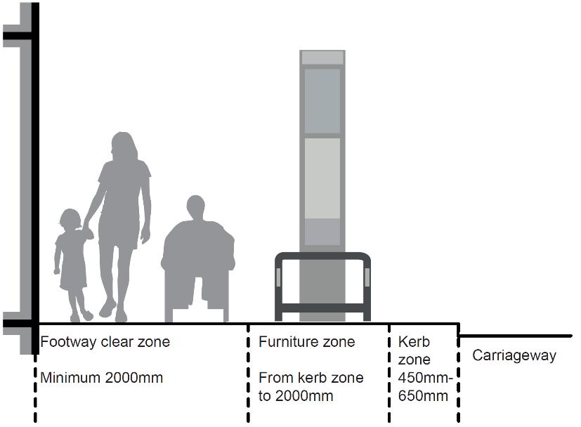
Coordinating street furniture in a consistent arrangement ensures an unobstructed section of footway for pedestrian use and further demarcates a separation between vehicles and pedestrians.
Depending on their use and level of activity streets may require significantly more than a 2-metre clear zone. It will not always be possible to include pavement space for all types of street furniture or planting zones.
Chapter 4.7 Street Trading / Commercial Activity (Including Tables and Chairs) of this document contains detailed guidance concerning commercial tables and chairs on the highway.
Guidance
Frontage zone:
Not every street will have a frontage zone. Where a frontage zone is present:
A. Wherever possible this zone should be kept free of street furniture to enable visually impaired people who use canes to navigate the street using the building line; and facilitate dwelling around retail frontages.
B. In some locations commercial tables and chairs may be appropriate to locate in this zone
Footway clear zone:
A. The clear zone should be entirely free of obstructions to allow for unhindered pedestrian movement along the footway.
B. The width of the clear zone provided should relate directly to the character and use of the street, and in particular the volume of pedestrians.
C. The footway clear zone should be designed to comfortably accommodate peak pedestrian demand alongside necessary service activity.
D. The footway clear zone should be at least 2 metres wide (excluding street furniture and other items)
Furniture and planting zone:
A. A furniture zone should only be provided where suitable clear footway widths and kerb zone widths are deliverable and should only exist where there is a requirement for furniture.
B. The zone should normally be adjacent to the kerb zone starting 450mm from the face of kerb.
C. Where there is no need for street furniture a zone may not be provided.
D. Where footway widths are narrow, essential street furniture may be located tight against the property boundary to prevent obstructions and hazards to road users.
E. Where there is generous space available, additional furniture may be positioned where this contributes towards secondary functions of the highway in place shaping or promoting commercial activity.
F. 2 metres clear width is in addition to the furniture and planting zone
Kerb zone:
A. Should be kept completely free of street furniture to prevent damage from vehicles overhanging the carriageway edge and be a minimum depth of 450mm
The Pedestrian widths for comfort (Pedestrian Comfort Guide)
The below images (figures 6 – 8) show how pedestrian flow will affect minimum width requirements
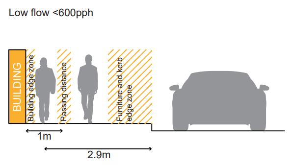
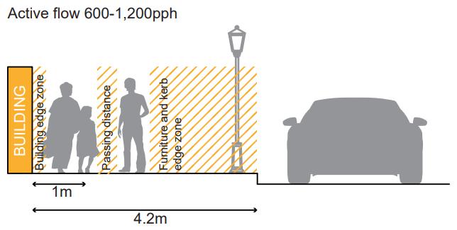
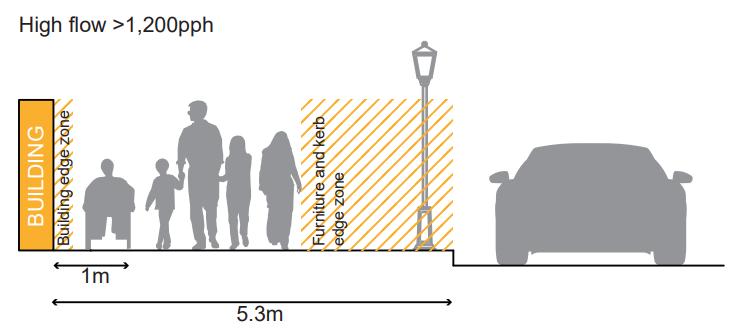
Some of Westminster’s key tourism sites would fall within the high flow category, such as the approaches to Leicester Square and Trafalgar Square. Other destinations, such as Oxford Street and other streets with active frontages, can also be high flow areas during peak periods. The widths at these sites will be protected, and consideration given to widening pinch points
Kerbs
Road kerbs serve a number of purposes:
• Retaining the carriageway edge to prevent 'spreading' and loss of structural integrity
• Acting as a barrier or demarcation between road traffic and pedestrians or verges
• Providing physical 'check' to prevent vehicles leaving the carriageway
• Forming a channel along which surface water can be drained
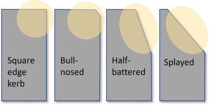
Kerbs Guidance:
A. The use of half-battered or splayed kerbs may be beneficial where cycle needs are identified. These must need to be balanced with the need to discourage vehicles from mounting the kerb.
Uneven steps can be confusing and cause trip hazards Particular care is required at ramps and steps to avoid disguising the gradient or the distinction between steps and risers Whilst ramps can improve accessibility for some, others have difficultly using ramps, making a ramped route undesirable as the only route option.
A. Level access should be provided wherever possible.
B. Level access into sites and building should be provided within the site/building itself and not through change or intervention to the highway (including footway). Any steps or ramps within the public realm should comply with the standards set out in BS:8300-1
C. Steps and ramped surfaces should be clearly defined to help people avoid unnecessary hazards.
D. Where any change of level of 1:20 occurs in an access route, ramped access should be provided, within a range of 1:20-1:12
E. Gradient of ramps should be no steeper than 1:12.
F. Unless the change in level is less than 300 mm a stair should be provided in addition to a ramp
G. Steps should have consistent height (‘rise’) and tread depth (‘going ’) and should be safe in all weather conditions
H. Handrails between 900-1000 mm in height should be provided on both sides of staircases (rather than on both sides of individual steps)
I. Handrails should be made of material that is resistant to heat and cold, and visually contrast against their surroundings
J. Rest space should be provided between flights of stairs.
K. Lifts are required where there is a substantial change in level, and these should be located as close as possible to other access routes
L. The use of tapered or fading steps, as shown below, are not generally supported
M. Eye-level signage should indicate with a map/plan alternative step-free routes and access options for those unable to use steps.
N. Ramps and steps should be lit to at least minimum standards.
O. BS8300 recommends a minimum of 100 Lux at tread level.
For further guidance, please refer to the Lighting Master Plan.
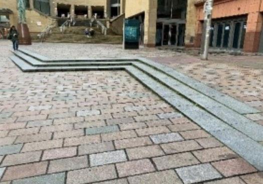
A. The following crossfalls should be taken into consideration as part of any scheme, to ensure pedestrian comfort and safety (trip hazards), and also vehicular safety. This includes gradients between the public highway boundary and proposed kerb alignment as well as carriageway long fall gradients.
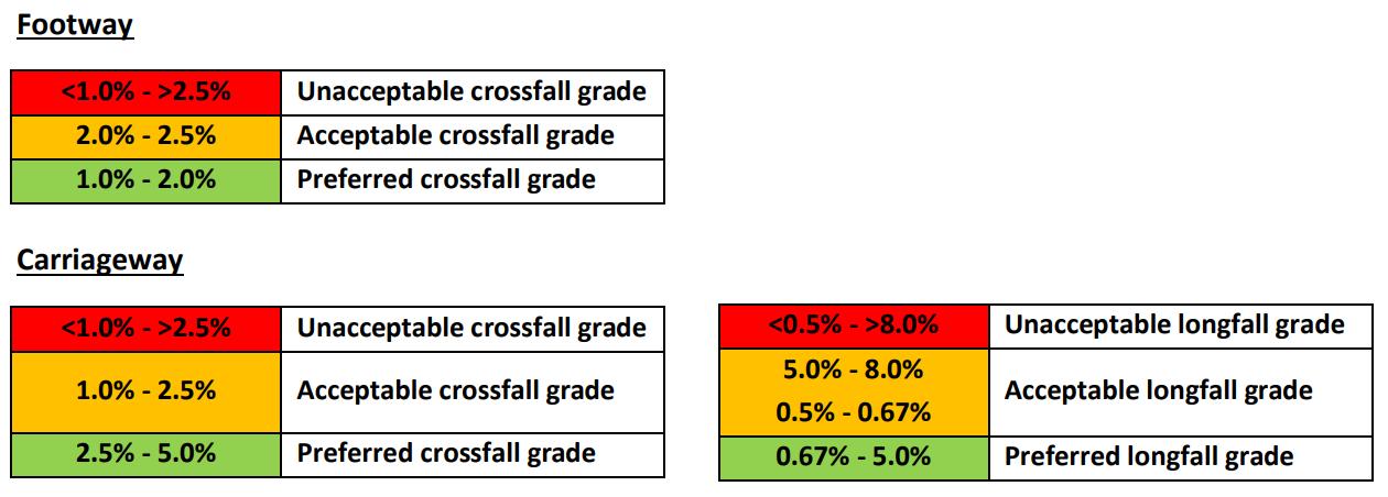
Vehicles crossing pavements can be disproportionately problematic for vulnerable pedestrians, and the City Council aims to reduce conflict between pedestrians and motor vehicles.
Exceptions may be made to facilitate service vehicles, although these should only occur during clearly specified timed periods, when pedestrian flow is expected to be low. Spaces with varying access throughout the day should be clearly signed as such.
Special Pedestrian and Cycle Zones (PCZs) (School Streets) can be used to create safer spaces outside schools’ main entrances, during school drop-off and collection times, as a key part of our ‘School Travel Plan Programme’ to encourage pupils to walk, cycle and scooter on school journeys. In this way, ‘School Streets’ have been trialled in Westminster since January 2020, using Experimental Traffic Orders (ETO), for up to 18 months. Vehicle movements are reduced during the operating times, with signage on the roads informing drivers of the times of operation at the entrance(s) to the zone.
Shared Spaces Guidance:
A. Where shared spaces are acceptable, they should be clearly demarcated, with a change in materials, textures, signage, or other methods to make clear to all users of the space that there is a share function there.
B. Shared spaces between cyclists and pedestrians may be accepted, where these are considered desirable for improving cycle and walking permeability.
C. Where shared spaces between cyclists and pedestrians are considered acceptable, careful consideration should be given to the design of the scheme to ensure that pedestrian priority is re-enforced, and cyclists are encouraged to move in consideration of all road users and the speed limit indicated
Guidance for vehicle crossovers is provided online here: https://www.westminster.gov.uk/roads-and-travel/roads-andhighways/vehicular-crossovers-application-forms-and-advice
Carriageway widths will vary according to the function of the highway, roads that serve as public transport routes or trunk roads will require greater widths than roads serving less strategic functions.
The Building Regulation requirement B5 (2000) concerns ‘Access and Facilities for the Fire Service’. Section 17, ‘Vehicle Access’, includes the following advice on access from the highway:
• There should be a minimum carriageway width of 3.7 metres between kerbs;
• There should be a minimum gateway width of 3.1 metres;
• Fire service vehicles should not have to reverse more than 20 metres.
Carriageway Widths Guidance:
A. Smaller residential streets should provide a minimum of 4.1 metres for general traffic, excluding any space for parking, or dedicated cycle lines.
B. Where carriageway space permits, a minimum of 2 metres (on either side) may be dedicated to parking, subject to other highway and planning considerations and requirements being met – with an absolute maximum of 2.4 metres where space permits.
C. Where parking occurs on both sides of the road or where the available carriageway width is not enough to allow vehicles to pass in both directions, double yellow lined passing places should be considered
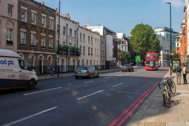
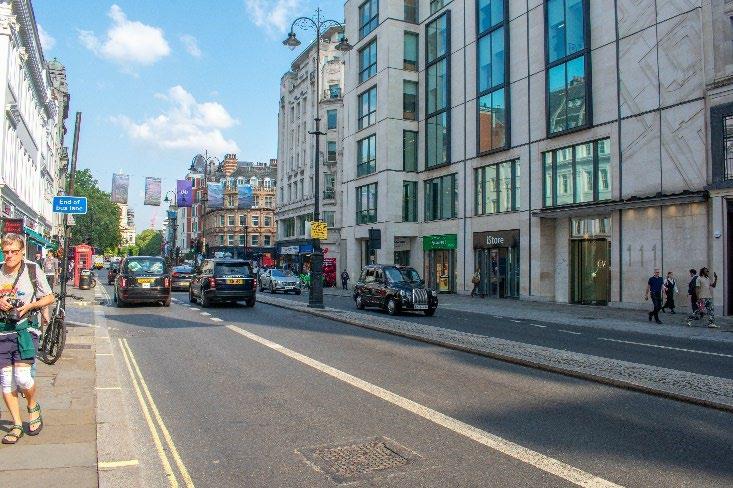
Bus routes and shelters
Highways that serve as bus routes are likely to be important for pedestrian movement. Bus shelters provide respite for pedestrians but in many places of high footfall run the risk of obstructing pedestrian flow. During development of Westminster’s Inclusive Design Guidance (see appendix 1), stakeholders state that bus lane bypasses are a key barrier for people with visual impairments, older people and people with mobility impairments accessing public transport stops.
Bus Routes and Shelters Guidance:
A. The safety of passengers is most important, both while waiting at bus shelters and whilst walking to and from them
B. Bus shelters should be within a walking distance to key community facilities, shopping and business areas.
C. They should help connect transport modes
D. They should not obstruct pedestrian flow
E. They should be provided at intervals of 300-400m along a route.
F. Vertical and horizontal stepping distance from kerb to and from buses should be minimised for users.
G. Carriageways that serve bus routes should not generally be less than 6m wide, excluding any space dedicated for parking.
H. Short sections that are narrower may be acceptable where visibility is clear, but an absolute minimum of 4.8m should be maintained.
I. Areas where buses can pull into the left should only be accommodated where the pedestrian widths above can be maintained, and only on carriageways where high traffic flows justify the need.
J. Pedestrians should be able to access bus stops without crossing cycle routes
K. Where this is not possible due to strategic cycle route provision, consideration should be given as to how to make the cycle route clear to pedestrians
L. Bus shelter access should not be compromised by street furniture
M. Shelters should contrast visually with the background against which they are seen
N. They should provide suitable weather protection
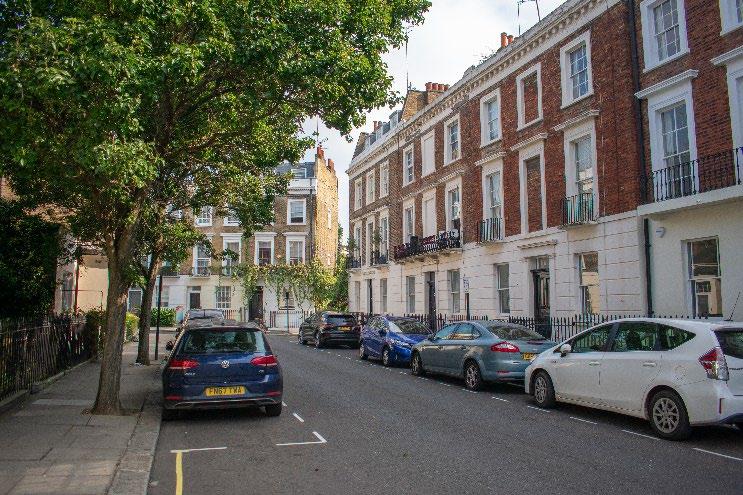
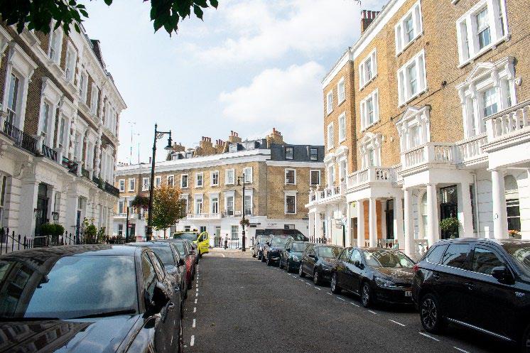
Junctions and crossings are often the site of collisions and conflict for users of the highway. The most recently adopted Highway Code sets out a system of priority for road users when using un-signalled junctions 41 The availability of formal crossings is particularly important for visually impaired people Consistency is critical to aid accessibility. Raised tables where the carriageway is raised to footway level (also known as raised carriageways), can provide a more comfortable and accessible walking environment, are easier for disabled people to negotiate, and reduce the risk of ponding at the bottom of dropped kerbs Raised tables can also act as traffic calming, slowing traffic.
Within Westminster, most traffic light-controlled crossings are timed, and this is managed by TfL. However, the timings for the pedestrian crossing period are often short, and in some areas, a significant subset of pedestrians cannot cross the road in the allocated time. The City Council works with TfL to introduce new timed crossings under our Pedestrian countdown at traffic signals (PCATs) programme.
The aim is to visually and physically reinforce pedestrian priority, reduce crossing lengths, and improve crossing accessibility and safety
The installation of tactile paving provides clarity of routes for people with visual disabilities.
Crossings Design Guidance:
A. Road design should reflect the Highway Code hierarchy, and support vulnerable road users.
B. Crossing designs should be consistent and easy to recognise by pedestrians and drivers.
C. Crossing routes and points should be suitably designed to ensure ease of use by all potential users, with materials of colour contrast, tactile paving (see materials guidance below) and other appropriate audio and visual signals.
D. A colour lighter than the general road surface should be used for built crossings to aid the visually impaired
E. Step-free crossings should be provided either by way of a dropped kerb or raised crossing
F. Shared surfaces which provide no tonal/surface contrast between pedestrian/cycle/vehicle areas create confusion and will not be supported.
G. Where in exceptional circumstances shared surfaces are allowed, they should include formal crossing points
H. Zebra crossing paint can be used to indicate pedestrian priority in turnings to minor roads
41 This relates to Rules 170 and H2 of the Highway Code: ‘Give way to pedestrians crossing or waiting to cross a road into which or from which you are turning. If they have started to cross they have priority, so give way (see Rule H2).’
I. Innovative design features to emphasise pedestrian priority can be explored. However, these should not distract from delivery of a cohesive legible public realm
J. When designing such crossings, consideration should be given to different types of pedestrians, in particular those with visual impairments and wheelchair users.
K. Zebra crossings should be retrofitted into junctions around areas of high pedestrian flow where appropriate.
L. Colourful crossings, such as those incorporating artwork on a pedestrian crossing facility, are not generally supported in Westminster.
M. Junction re-designs which enlarge pedestrian or cycle routes and prioritise their safe movement will generally be supported.
N. Dropped kerbs at crossing points (including junctions) should have a corresponding dropped kerb at the other side of the crossing, including at borough boundaries. Any public realm improvement works should rectify this, where this is not already in place.
O. Uncontrolled crossings should only be installed in low traffic streets.
P. Crossing distances should be minimised.
Q. Crossings may need to be repositioned to avoid steep dropped-kerb gradients and reduce crossing distances.
R. If repositioning a crossing is not possible to avoid a steep gradient, a raised table (road crossing raised to the same level as the pavement) should be considered.
S. Raised tables can additionally benefit traffic management by helping to reduce vehicle speeds and should be considered where traffic calming is a priority.
T. Raised tables are only appropriate in streets where traffic volumes are low.
U. Raised tables are preferred for uncontrolled junction crossings.
V. Two stage crossings should be avoided, except on main roads or roads with bus lanes on either side.
W. Pedestrian islands on single stage crossings may be acceptable, where crossing distances are particularly wide.
X. Junction angles should be kept as close to 90 degrees as possible to slow down traffic turning. Exceptions to this will be considered for roads commonly used by larger vehicles and follow a swept path analysis to ensure that larger vehicles do not overhang the kerbside.
Y. Wherever possible, crossings which reinforce pedestrian priority should be used.
Z. Installation of bollards at crossing points should take account of access requirements of all users, including wheelchair users and their safe turning needs
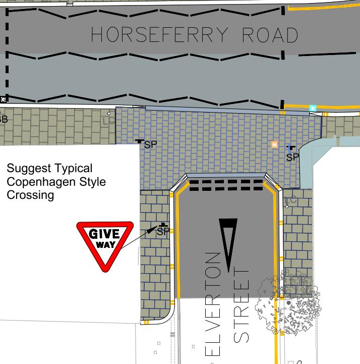
Figure 14: Example design of a crossing which reinforces pedestrian priority.
Taxis
Drop-off points exclusive to taxis use do not exist. A drop-off point could be a single or double yellow line but available to any vehicle.
Taxi Ranks:
A. Taxi ranks should be provided in places identified as having the greatest value to residents, visitors, and workers in Westminster, particularly as some people with disabilities are unable to use public transport.
B. Locations should be identified through liaison with relevant stakeholders.
C. Kerb heights at taxi rank pick-up points need to align with taxi floor heights to enable easy access into vehicles.
Car Clubs Guidance:
A. Generally, flexible car club schemes without dedicated parking spaces are preferred, because they remove the need for Traffic Orders that are costly and time consuming to introduce.
B. The City Council will look to accommodate dedicated Roundtrip Car Club bays, noting that this is the preferred operating model for some suppliers.
C. Appropriate demand levels will need to be maintained to justify the existence of the bay.
Westminster's City Plan policy (policy 27) is that new development should be car free, including residential development (except for disabled parking) . Any proposals for new parking in association with new floorspace should comply with the parking standards in adopted policy.
The standard kerbside parking bay is around 1.8 - 2 metres wide and 5-6 metres in length and should remain so where kerbside parking is considered appropriate. Modern vehicles have been increasing in widths considerably, with some SUV models being over 2 metres wide. Notwithstanding this, wider parking widths cannot be accommodated on Westminster’s busy and historic streets – especially without compromising carriageway widths. The council will not seek to accommodate wider vehicles, which are generally not appropriate on Westminster’s narrow streets.
On-Street Car Parking Guidance:
A. Where car parking is required, this should be in line with standard parking bay lengths.
B. Disabled parking spaces must be provided in accordance with The Traffic Signs Regulations and General Directions 2016 and should ensure adequate length to enable users to load and unload wheelchairs, and other mobility aids.
C. Signage notifying of pay-by-phone payment systems should be positioned close to accessible parking spaces.
D. Where existing parking space is not required or undesirable, the City Council will explore the re-allocation of this space.
In some parts of Westminster, it may be suitable to restrict the use of the highway to certain users only, whose use of the highway generally requires less space – enabling the highway to accommodate a diverse range of uses. Re-allocation also can occur where carriageway widths or parking spaces are affecting pedestrian comfort. In appropriate locations pavements may be widened to accommodate trees with appropriate drainage, SuDS, or cycle hangars. Reallocating carriageway space for pedestrians and cyclists can improve the public realm, pedestrian and cyclist comfort and slow the speed of traffic.
Highways Space Allocations Guidance:
A. Where these re-allocations occur, there will be a presumption in favour of pedestrian comfort and mobility, while accommodating where possible improved permeability for cyclists.
B. Provided that any enhanced pedestrian widths are not compromised, alternative highway allocations can be considered – and would need to have clear public benefit to offset any detraction from the primary use of the highway for movement.
C. Third party use of highway space cannot detract from the primary use of the highway for movement.
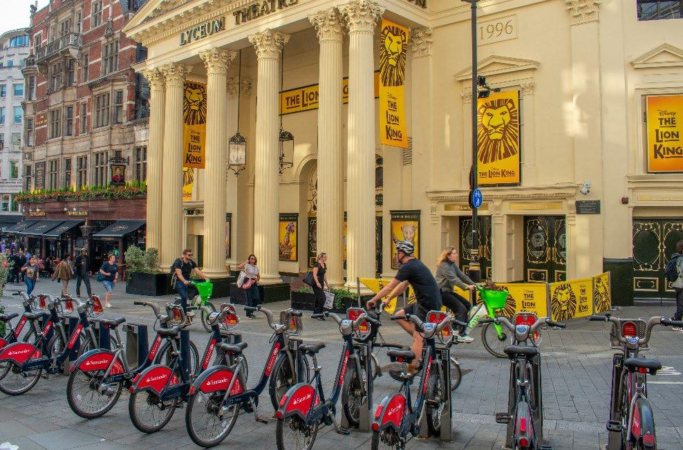
Figure 15: Wellington Street, where reallocation of highway facilitates a range of uses, including commercial activity, bike hire stands, and servicing spaces, while continuing to provide comfortable permeability for cyclist and pedestrians.
Parklets are temporary structures, often located in former parking spaces, and often providing seating, and planting, and sometimes cycle parking. Parklets can respond to the growing demand for greater pedestrian space, greener kerbsides and a more liveable urban realm.
The appropriateness for installing parklets compared to other kerbside activities will be covered by the City Council’s emerging Sustainable Transport Strategy. They can be difficult to maintain and take away space from other kerbside activity. In general, Parklets are seen as an intervention within the highway of last resort.
The City Council will consider parking occupancy, single yellow line availability, local land use, road safety and sightlines, accessibility and data regarding on-street issues to inform if a location is suitable for the installation of a parklet.
Where parklets are installed, it is important that they are used as public spaces and not be used to serve commercial uses nearby.
Parklets provided and maintained by third parties, require planning permission and S115E licence S115E licenses give third parties permission to put something on our highway. The licence can stipulate conditions for maintenance. The community group, resident association, or business, that has made the application to install the parklet, becomes the parklet owner and is responsible for the parklet’s management and maintenance, through a Management and Maintenance agreement with the City Council. These should include:
• general maintenance and repairs to the structure of the parklet (i.e. to fixed items and furniture)
• plant maintenance, including water supply
• cleaning and upkeep
• removal of the parklet
The parklet owner is responsible for making sure the parklet is kept in good condition and is safe and comfortable for all users, e.g., fixing a broken seat or replacing dead plants. The parklet owner will need to ensure repairs are completed promptly, and to a good standard.
For any parklets maintained by the council, these will require a commuted sum to be agreed and paid to the council prior to installation to cover future maintenance costs
Parklets Guidance:
A. Parklets should only be considered a temporary intervention.
B. Permanent/long term landscaping solutions (including street trees) would be preferable.
C. As part of the design proposals for parklets, drainage requirements and obstruction or potential trip hazards must be considered.
D. Guidance in relation to planters also applies to proposals for parklets.
E. A Road Safety Audit is required for the installation of any parklet in Westminster. This is to mitigate any issues or problems associated with a parklet that might affect users of the public highway.
F. A Traffic Management Order will be required to change any kerbside control (parking bay, lines and signs) to enable the parklet to be on the carriageway.
G. Third parties installing assets will require planning permission and an S115E licence
H. Costs will also need to be held to return the carriageway to its previous operation if the parklet is then removed.
I. Public liability insurance up to £5 million of third-party claims is required.
J. The success of parklets will be kept under live review.
K. The City Council supports proposals for pocket parks and parklets only where they do not compromise desire lines; pedestrian safety; and/or parking need, and where they do not detract from the character or appearance of the area.
L. Parklets should not cause trip hazards or any safety issues.
M. The parklet owner will be responsible for making sure the parklet is kept in good condition and is safe and comfortable for all users, e.g., fixing a broken seat or replacing dead plants.
N. The parklet owner will need to ensure repairs are completed promptly, and to a good standard
Related SPD sections
Key City Plan policies
• 4 1 Highway space
• 4.5 Street Furniture
• 4 13 Signs and Adverts
24. Sustainable Transport
25. Walking and Cycling
28. Highway Access and Management
43. Public realm
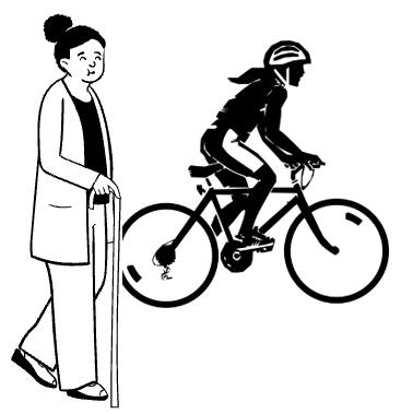
City Plan policy 25 requires that developments deliver a first-class public realm which supports cycling through ensuring a safe and accessible environment, providing for connected, high quality cycle routes in line with or exceeding London Cycle Design Standards, and achieving improvements to signage. It requires schemes to enable and contribute towards improvements to cycle access, including the delivery of current and planned cycle routes and to meet the cycle parking and cycle facilities standards in the London Plan.
Policy 25 seeks to ensure that developments promote cycling and provide a safe and accessible environment for cyclists, while not compromising the needs of pedestrians The policy further requires that schemes provide links to public transport nodes, contribute towards improved wayfinding, and promote and contribute towards the introduction and expansion of cycle hire facilities.
The sense of safety is a significant determinant of cycling in the city While segregated lanes are not always possible on Westminster’s streets given the constraints of a dense and historic built environment, it is important that cycle lanes are of generous widths that can accommodate a range of different kinds of bicycles. This is to ensure they can cater for a range of cyclists of different abilities, making cycling an accessible and safe mode of transport
The City Council is committed to improving conditions for cyclists and encouraging other sustainable travel options. This will be achieved through a variety of interventions including developing the cycle network, upgrading the public realm, managing parking demand, reducing severance, proactively place shaping, and implementing junction improvements and traffic calming measures.
Space in Westminster is in high demand as competing uses have their individual impact on the street scape and highway space. The space demands for cyclists are often relatively small and easier to safely integrate within street spaces, when compared to other transport options. The minimum policy requirement for cycle parking associated with a development must be met within the development itself and not on highway.
Cycling as a modal share of transport in Westminster is relatively low, however it is increasing. This is an important part of tackling the climate emergency and transitioning as a city to Net Zero. Understanding and addressing the barriers to cycling, and other sustainable transport choices such as e-scooters, is vital in order to increase the modal share Furthermore,
active travel, such as cycling increases daily physical activity and the amount of time spent outside. These are factors that play a crucial role in promoting positive physical and mental health.
Those using bicycles, e-scooters, or similar vehicles will often have strong preferences towards desire lines to minimise distances travelled, or to avoid other hazards such as busy roads and air pollution. Failure to create direct permeability for these highway users could lead to unintended misuse of footways Legibility of cycle routes, for both cyclists, car users, and pedestrians, is also important. Clear boundaries are likely to reduce potential conflicts between road users, while segregated lanes may not always be possible Cycle parking facilities in the public realm are also an important piece of street furniture to encourage greater use of bicycles.
Through co-ordinated efforts to improve the environment for cyclists, cycling can become a more attractive transport option resulting in an increased modal shift away from private car use.
A number of TfL designated cycle routes already permeate through the city (see figure 16) Facilitating safe connection to these routes, is of key importance when planning for the public realm, especially where there are existing desire lines for cyclists. The City Council will work with the Mayor’s office, Tf L and neighbouring authorities towards the implementation of a central London cycling grid.
TfL cycle hire docking stations, dockless bicycles and other similar modes of transport are not considered to be substitutes from developments providing their minimum policy requirement long and short stay cycle parking within their development sites (and not on highway).
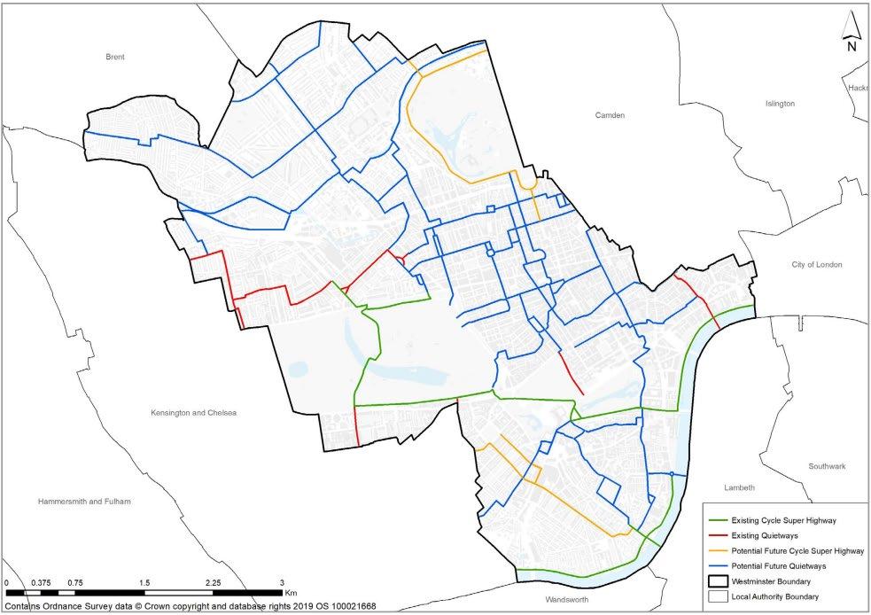
New safe and legible cycle routes:
When planning new routes, regard will be had to existing and proposed wider strategic London-wide cycle routes, and providing connectivity, with efforts made to integrate new infrastructure with the existing network.
A. Development in the public realm should improve connectivity to existing and proposed Cycleway and Quietway routes.
B. Schemes located between two existing routes should facilitate cycling connections.
C. Schemes should incorporate cycle permeability. This includes ensuring they do not block established cycling and walking pathways.
D. Walking and cycling routes should be designed with clear road and footway markings and unambiguous signage at eye level to indicate where cyclists or pedestrians may be present and to improve visibility of cycle routes
E. Cycle lane surfaces should be smooth, sealed, solid and visually contrasted with other surface uses. For example, they should be visually distinct from bus lanes and other road surfaces.
F. Segregated cycle paths should be considered where space permits (see example in figure 17)
G. Creating small sections of shared space to promote cycle and pedestrian permeability will generally be supported, provided that adequate design mechanisms are used to help more vulnerable pedestrians negotiate the route safely and equally
H. Cycling routes should be designed with appropriate illumination
Dimensions and placement of cycling routes:
I. Where practical, one lane cycleways that run alongside the carriageway, whether segregated or not, should be a minimum of 2 meters in width.
J. Where practical, two-way cycleways should be a minimum of 4 metres 29 in width
K. The available width of the carriageway will dictate the location of the cycle lane, although lanes that place cyclists within the ‘door zone’ of parked cars should be avoided. If car parking is retained, floating parking arrangements where vehicles are parked to the right of the cycle lane could be considered.
L. New routes should comply with LTN1/20
New cycle parking:
M. Development likely to generate increased visitors or is nearby or adjacent to public transport (in particular, National Rail stations) should include increased provision of on-street cycle parking (Policy 25).
N. Adjacent to National Rail stations, development should provide larger scale parking facilities that meet the cycle standards in the London Plan.
O. Schemes located close to cycleways or quiet routes should also include enhanced provision of cycle parking.
P. In residential areas, cycle hangars that allow secure overnight storage of bicycles should prioritised. All new facilities should be installed in line with guidance set out in Chapter 5.6 Street Furniture of this SPD
Q. Cycle parking should be designed to be clearly defined, contrasting visually with the surrounding background. The use of tactile paving to ensure the area is identifiable is encouraged
R. The design of cycle parking should provide space for adapted cycles and step free access.
Cycle and e-scooter hire facilities:
S. Opportunities for increased provision of public cycle (or e-scooter) hire schemes should be explored when planning development in the public realm.
T. Private hire cycles and e-scooters will be expected to use designated bays with clear signage and road markings.
Sustainable last mile:
U. Schemes should explore opportunities for facilitating and improving access by cargo delivery bicycles - including dedicated on-street loading bays and anchors. Where roadside parking bays are not appropriate, dedicated wide bicycle cycle storage on the footway can be considered. These should be located adjacent to commercial uses, and
consideration should be given to future proofing bays for the installation of e-bike/scooter facilities. The City Council also supports the introduction of new e-bike delivery centres to contribute to reaching net-zero.
For more information about legible cycle routes and wayfinding guidance please refer to Cycle infrastructure design (LTN1/20) The City Council also has published a Cycling Strategy which outlines how the council will support and encourage cycling in Westminster.
Where a route or facility forms part of the London Cycleway network, the City Council works with TfL to assign a cycleway number ("Cxx") and incorporate any additional wayfinding needed to integrate the route with the wider Cycleway network.
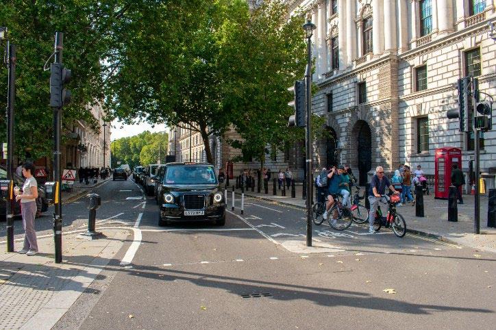
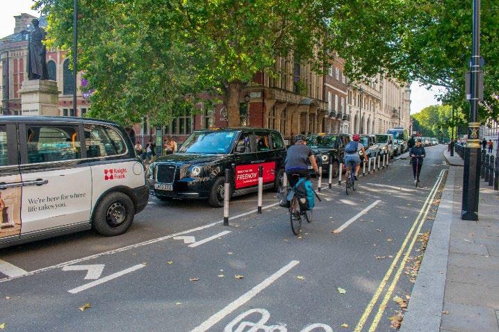
Related SPD sections
Key City Plan policies
• Microclimate
• Street Furniture
• Play and Recreation
31 Waterways and waterbodies
34. Green Infrastructure
35. Flood Risk
43. Public Realm
Context
In 2022, the city council published an Environmental Supplementary Planning Document (ESPD) which sought to provide guidance for developers on how they can meet the environmental policies within Westminster’s City Plan 2019-2040. One environmental topic the ESPD covers is green infrastructure and focuses on the functions and benefits that our green and blue assets can bring. This Public Realm SPD seeks to provide guidance to applicants on how to deliver high quality green and blue infrastructure within the public realm and should be read in conjunction with the ESPD which provides guidance specifically related to development for green and blue infrastructure
In the ESPD, it is acknowledged that an integrated approach is required to get the most out of our green and blue infrastructure network to maximise its benefits. Green infrastructure can be defined as a multifunctional, connected network of green spaces, and other environmental features, capable of delivering a broad range of ecosystem services and linked social and economic benefits 42 . Blue infrastructure is the network of waterways and waterbodies which forms part of the open space network. The areas are protected and enhanced to deliver ecosystem services while also benefiting biodiversity and society more widely. Green infrastructure can boost the capacity of a local environment to accommodate sustainable development and provide a wide range of environmental, social, and economic benefits, including:
• Climate change mitigation
• Carbon sequestration
• Biodiversity conservation and improvement
• Improvement of air quality
• Water quality and quantity management
• Local food provision
• Enhancing and supporting the natural character
• Socio-cultural benefits (e.g. social interactions, recreation, health)
42 Green Infrastructure Guidance, Natural England, 2009
Some of the specific ways in which green infrastructure can play a vital role in improving the quality of the environment and be a nature-based solution for climate change adaptation and mitigation include:
• Mitigate surface water flood risk
• Enhance biodiversity by developing a variety of habitat types
• Improve air quality
• Counter the heat island effect by incorporating green infrastructure into development
Green infrastructure can provide ecosystems and can provide access of species to habitats and resources when designed well. There are different types of green infrastructure - core areas are larger and more natural, such as parks and natural urban greenspaces, and smaller stepping stone green infrastructure areas can include green corridors, cemeteries, city farms, street trees and green roofs.
Policy 34 in the City Plan 2019-2040 emphasises the importance of well-designed green infrastructure that enhances to maximise its environmental, social and economic value rather than focuses on aesthetics. The effect of the Covid-19 pandemic has underlined the importance of local green space to support people’s mental health and wellbeing, and to address inequalities 44. There is a need for a drive to grow, improve and interconnect our green spaces, especially near to where people live, work and transportation links. By being accessible, these locations are more likely to be well looked after so people will perceive them to be safer. The combination of safe and easily accessible green space are important factors when planning green infrastructure, but these must also be considered alongside the desires of the local communities so that new or improved green infrastructure is suitable.
The importance that the natural environment plays in improving biodiversity and reducing the harmful effects of climate change is recognised in the City Council’s declaration of a climate and ecological emergency. There is an urgent need to develop actions to reverse biodiversity loss, enhance habitat enhancements and species richness, and regulate the climate in our city. Green and blue infrastructure plays a big role in supporting Westminster’s biodiversity and improve ecological value through parks and open spaces, community gardens, pocket parks, tree planting and other initiatives to provide for biodiversity net gain in the urban environment.
The Royal Parks are a huge asset, and they cover nineteen percent of the borough. However, there are still areas of open space deficiency in Westminster that means that not every resident has easy and convenient access to public open space. The City Council has published an Environmental Justice Measure (EJM) 45 which is a new data tool that aims to raise awareness of climate and environmental impacts and empower Westminster communities with data to help them make informed decisions, and to act to reduce negative environmental impacts in their local areas. Westminster is a densely populated and highly developed city and new green infrastructure will mainly be provided through the creation of spines and networks. Care must be taken to understand the potential impacts of actions and to ensure that provision of green and blue infrastructure is equitable, fair and does not increase inequalities in health between different social groups.
Green and blue infrastructure is an extremely valuable asset contributing to several aspects of life in a city (recreation, health, amenity, quality of life, biodiversity, wayfinding, enhancing heritage, etc.). In 2024, Urban Design London published a collection of guidance documents on collaboration with the London boroughs of Camden and Islington, funded by National Lottery Heritage Fund, National Trust and the Ministry of Housing, Communities and Local Government, and supported by the Greater London Authority 46 These series of documents provide guidance on exploring and developing creative and innovative ways of using highways land to provide the access to nature and the green infrastructure benefits that are needed to address inequality, improve quality of life and support vital ecosystems.
43 Nature-based solutions in Europe: Policy, knowledge and practice for climate change adaptation and disaster risk reduction — European Environment Agency (europa.eu)
44 Enhancing England’s urban green spaces - Natural England (blog.gov.uk)
45 Environmental Justice Measure | Westminster City Council
46 Urban Design London guidance documents – Gren Infrastructure for Streets
A. Enhanced and additional green infrastructure is strongly supported where such initiatives are strategically implemented in appropriate locations to maximise wider benefits within the local area Key considerations are how the enhanced and additional green infrastructure relates and enhances the character of the location, how it seeks to address known environmental issues in the area, and how these impacts users of the public space and public safety.
B. All public realm schemes should contribute to the city’s green and blue infrastructure wherever feasible and possible and have minimal impact on existing infrastructure/assets
C. Green and blue infrastructure is an integral design component and should be considered and engaged on at early stages of a design proposal.
D. Early design proposals for green and blue infrastructure schemes should demonstrate how the proposals integrate with the existing green infrastructure network, seek to enhance the character of the location, specify choice of species to maximise biodiversity, including benefit to pollinators, to ensure climate resilience, identify green and blue infrastructure for different functions (where possible and multifunctional) in response to the location/ needs of area, ensure pedestrian flow and public safety is maintained and ensure ongoing management. An integrated approach to green and blue infrastructure which considers it a spatial as well as natural system, as opposed to an ad-hoc approach, should be taken.
E. All public realm schemes should have regard to the City Council’s declaration of climate and ecological emergencies. Public realm proposals should seek to minimise damage or removal of existing biodiversity and should deliver biodiversity net gain as mandated under Schedule 7A of the Town and Country Planning Act 1990 (as inserted by Schedule 14 of the Environment Act) which regulate the climate and should, wherever possible, maximise biodiversity opportunities.
F. Careful consideration should be had of the effect of landscaping (i.e. location and types of selected species) upon crime prevention. Designers should aim to minimise opportunities for concealment and should use landscaping positively to deter graffiti and prevent scaling on boundary walls.
G. Effective and timely evaluation of the total cost of including greenery in the project, against the long-term economic benefits which greenery can generate and balancing this with long-term sustainability and management should be undertaken, thus enabling optimisation of space and other resources for landscaping.
H. Watercourses and Sustainable Drainage Systems (SuDS) should be integrated into the design of public realm schemes.
I. Green and blue infrastructure should enhance walking and cycling routes, to support active travel and recreation. Where possible, these should be designed to provide for public access for all types of users.
J. Public realm proposals should seek, where possible, a partnership approach to enhancing and maintaining Westminster’s green and blue infrastructure to ensure integration, connection, diversity, and usability of the whole network.
K. Hanging baskets make a limited contribution to biodiversity and are unlikely to contribute to the biodiversity offer of a public realm development or scheme.
Westminster’s ESPD incorporates general requirements for all green space typologies that are set out in the Wild West End (WWE) Value Matrix, which includes requirements for the public realm.
Major developments are required to consider incorporating elements of publicly accessible green spaces. These can also be at different levels within the development, including rooftops. Connectivity between existing and new publicly accessible green spaces, great squares, piazza spaces etc. should be made when preparing early design proposals within the public realm.
See section 4.1 Highway Space, Road Safety and Parking above for guidance on Parklets
The City Council supports the incorporation of green and blue infrastructure into existing public open spaces, great squares, piazza spaces, play areas and the public highway where this does not negatively affect pedestrian movement,
servicing, and essential transportation functions. Opportunities to provide for greening in the public realm should be taken where the benefits can be demonstrated
The City Council commissioned a Green Infrastructure Audit 47 which aims to produce a robust evidence base of Westminster’s green assets to support the implementation of the City Plan. The findings have been used to inform the recently published Greening and Biodiversity Strategy 48 and remains relevant to proposals affecting or creating public realm schemes in providing new or enhancing existing green infrastructure. The Green Infrastructure Audit identifies a number of priority recommendations, including:
• Address areas of green space deficiency in the north west and south east of the borough
• Address gaps in the active travel network
• Reduce the impact of high visitor pressures on existing green spaces
• Integrate new green infrastructure into key streets experiencing declining footfall
• Maximise green infrastructure opportunities provided by Westminster’s historic environment
• Mitigate impacts of the urban heat island effect, particularly where these are disproportionately higher in areas to the north west of the borough
• Restore lost rivers
• Deliver a bigger, better, more joined up SINC network
• Deliver nature recovery and climate change resilience
• Address the risk of surface water flooding in the borough
• Protect existing trees and woodland
• Encourage new tree planting within the borough
• Adopt and encourage tree pit designs that optimise SuDS benefits
The Greening and Biodiversity Strategy builds on this activity, providing a vision and framework for collaborative action to protect and enhance the local natural environment. It promotes a city ‘ecosystem’ approach where nature and people can thrive, through six outcome priorities:
• Protect and enhance nature in the city
• Establish corridors for nature and people
• Make our streets cleaner and more liveable
• Improve resilience to climate change and pollution
• Ensure access to nature for all
• Empower local stewardship
Trees are one of the principal components of green infrastructure in Westminster. They are integral to Westminster’s townscape and have an enormous amenity value, as well as being a major contributor to the environmental, social, and economic benefits delivered by green infrastructure. To maximise the benefits of trees, it is essential that they are protected and well managed. The following additional guidance applies only for trees in the public realm and should be read in conjunction with the ESPD.
47 https://www.westminster.gov.uk/media/document/westminster-green-infrastructure-audit-
48 https://www.westminster.gov.uk/media/document/a-greening-and-biodiversity-strategy-for-westminster
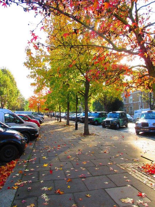
Trees Guidance:
Existing trees
A. New development should be designed to retain and protect existing publicly owned trees of amenity, ecological and historic value and those which contribute to the character and appearance of the townscape, in line with Policy 34H of the City Plan.
B. Trees in the public realm should be included in the arboricultural details submitted to support new developments, in accordance with British Standard 5837:2012 “ Trees in relation to design, demolition and construction –Recommendations” (or successor document) 49
C. The proposed method of construction of development in relation to existing trees and their roots should be considered at an early stage to avoid conflict with construction requirements such as scaffolding, gantries, site accommodation and construction access.
D. Any elements of development which overhangs or otherwise encroaches on the public realm, such as façade maintenance equipment or projecting canopies should be carefully designed to avoid conflict with existing trees.
E. New trees should be planted in order to optimise canopy cover, and according to the principle of the ‘right tree in the right place’ (see ESPD and Trees and the Public Realm 2011).
Site specific constraints on new tree planting in the public realm include:
F. Footway safety - new tree planting should ensure sufficient pavement width is provided to allow unimpeded passage of pedestrians, particularly those with accessibility needs, subject to the guidance in the Highway Space and Street Furniture sections of this SPD.
G. Road safety - The anticipated ultimate height and spread of new trees should be considered to ensure the safe passage of vehicles. For example, small-growing broad-headed trees on busy routes where lateral branches could come into contact with vehicles should be avoided.
H. Proximity to adjacent buildings - Planting locations should be planned to take into account existing building features such as windows, doors, and projecting balconies.
49 BS 5837:2012 | 30 Apr 2012 | BSI Knowledge (bsigroup.com)
I. Existing street furniture and other highway infrastructure, including street lighting and below ground infrastructurePlanting locations should be chosen in order to minimise conflict with existing street furniture, or where appropriate, street furniture and below ground infrastructure should be rationalised to allow for new tree planting. In order to limit conflict with street lighting, a minimum distance of 5 metres minimum, and optimal 7 metres from existing street lights is recommended. See also guidance in the Power and Lighting section.
J. Important views - Tree planting which would impede strategically important views (identified in the council’s adopted City Plan) should be avoided
K. Respect for the local townscape – new tree planting should ensure that the trees contribute to the character and appearance of the area.
Trees in planters
L. Trees in raised planters are not a sustainable approach to greening. They are usually short lived and rely on artificial irrigation for the duration of their lives. Where provision of trees in planters is proposed, they will need careful justification on the grounds of the aesthetic or other benefits that they have the potential to provide. (see Street Furniture for more details).
Lighting of trees
M. Lighting of trees should only ever be used on exceptional specimens or in exceptional locations, see Power and Lighting section for more details.
Tree pruning
N. Street trees will not normally be pruned for the following reasons, but if it is possible to address issues through general maintenance, this work will be carried out at the appropriate time as part of our cyclical maintenance programme:
• Obstruction of light, and/or a view
• Leaf-fall
• Issues associated with flowers, fruit, seeds, pollen or honeydew
• To accommodate renewable energy systems such as solar panels or wind turbines
• To improve television reception
• Birds in trees and/or their droppings
• Insect activity
• Where a tree is perceived to be too large
• Offers of payment for tree removal and/or replacement
• To create space for new trees
• Disturbance to pavements, kerbs, walls or paths, except where an engineering solution to these problems is inappropriate
• Perceived risk of future subsidence damage by property owners
Tree Removal
O. Street trees should only be removed for good arboriculture reasons, including trees which are:
• Dead or dying
• Dangerous, or with significant disease and/or defects
• Demonstrated to be causing significant structural damage
• Considered by the City Council to be inappropriate in their location
P. Trees should also be removed or pruned:
• As part of an agreed management plan or as part of an approved public realm improvement project
• When planning permission has been granted for tree removal and all pre-commencement conditions and legal obligations have been satisfied
• In the interest of national security
When trees are removed, they should usually be replaced, according to the principle of the ‘right tree in the right place’ (see ESPD).
Privately owned trees and vegetation
Q. Owners of trees which encroach on the public highway should manage their trees, hedges, and shrubs so they do not impede the safe passage of pedestrians or vehicles. The highway authority may undertake work to overhanging vegetation and, if necessary, recoup the cost. Overhead clearance from trees, hedges and shrubs should be a minimum of 2.1 metres to the underside of signs, 2.5 metres over footways and up to 5.5 metres over carriageways and regularly managed to maintain theses clearances, remembering that wet foliage hangs lower. Hedges, trees, shrubs or bushes should be cut back to the boundary line to ensure the highway is free of obstruction
The City Council’s Trees and the Public Realm (2011) provides guidance on townscape character, as do the council’s adopted conservation area audit SPDs 50
Tree pits
See Paving Materials section for guidance on tree pit materials.
Tree inspection and management
Council owned trees are managed in order to meet legal responsibilities and to limit risks to safety. The overall risk from trees and branches falling is extremely low, but trees are living organisms so risks from trees cannot be removed entirely. The City Council shall manage trees to ensure that risks to safety are as low as reasonably practicable.
Tree inspection regime
The City Council undertakes regular inspections of trees in the public realm in order to meet legal responsibilities and in the interest of tree safety. Trees on highways are inspected every 2 years. Trees in parks, on housing estates and in out of borough cemeteries are inspected every 2 to 3 years. Guidance provided by the London Tree Officer Association’s (LTOA) Risk Limitation Strategy and the National Tree Safety Group’s ‘Common Sense Risk Management of Trees’ (or successor documents) are taken into account with regard to respect to tree inspection.
Tree management
The City Council carries out routine tree maintenance based on the results of regular tree inspection regime. In addition to this, there are planned tree management interventions which include:
• Removal of growth at the base of trees annually
• Work to address Massaria disease of London plane trees on an annual basis
• Cyclical reduction of tree canopies in order to limit the risk of tree related subsidence, taking into account guidance provided by the London Tree Officer Association’s (LTOA) Risk Limitation Strategy (or successor documents).
Other types of planting
Vertical Rain Gardens / Green Walls Guidance:
A. Public realm schemes should clearly demonstrate their contribution to the city’s green infrastructure network, particularly in terms of climate adaptation, water management and biodiversity.
B. Public realm schemes that are purely aesthetic with species to look attractive but not necessarily the right type for vertical rain gardens/green walls and will require disproportionate maintenance with the sole intensive use of clean potable water will generally not be accepted. See ESPD for further guidance to potable water.
C. Public realm schemes should incorporate and maximise rainwater runoff collection and reuse. See ESPD for further details.
D. Public realm proposals should demonstrate that they have selected appropriate species that can thrive in the microclimate of the space they are to be located within. London Plan guidance advises using natural vertical habitats and mimic plan groupings and structure into wall designs 51
E. There are structural and fire safety implications for green walls and green roofs that will need to be carefully considered and mitigated for. Advice should be sought from the appropriate specialists as part of development proposals.
F. Non-living green walls will generally not be accepted.
G. ‘Living pillars’ (attached to lamp columns) are generally not supported due to the difficulty in maintaining them and their negligible contribution to biodiversity.
50 Conservation area audits, maps and guidance, from A to K | Westminster City Council
Conservation area audits, maps and guidance, from L to Z | Westminster City Council
51 urban_greening_and_bng_design_guide_march_2021.pdf (london.gov.uk)
When rainwater does not drain away either by soaking into the ground or through the drainage system on roads and around buildings, surface water flooding occurs. Increasing rainfall and intensity of rainstorms due to climate change is likely to increase surface water flooding in the future. Sustainable Drainage Systems (SuDS) incorporate a range of measures which can help to better manage surface water run-off from buildings and hard standings now and in the future, by employing a combination of infiltration (allowing surface water to soak into the ground) and attenuation (storing surface water and releasing it slowly) before it enters the drainage system. Along with water quantity, SuDS are also designed to deliver benefits in water quality, amenity and biodiversity.
Carefully integrated and well-designed SuDS can make a major contribution to the public realm; not only reducing flood risk but also numerous environmental benefits in addition to improving character and appearance. SuDS can create or improve habitats for biodiversity, improve air quality, contribute to amenity value, help mitigate the urban heat island effect, improve the quality of run-off entering rivers and create a sense of place 52 Even small SuDS features can make a contribution to reducing flood risk and providing additional benefits, and as such all public realm developments should consider opportunities for SuDS. Examples of SuDS in the public realm include permeable paving, green/blue roofs or walls, rain gardens, tree pits, downpipe planters, swales, and detention ponds.
Although not currently set in place, legislation is set to come in 2025 (Schedule 3 of the Flood and Water Management Act 2010) which will see Westminster City Council designated as a SuDS Approval Body (SAB). This will mean that all projects larger than 100sqm or more than one property that have a drainage implication will need to incorporate a SuDS based drainage scheme that complies with new standards and be approved by the SAB before construction can commence. Once legislation comes into effect, this will need to be applied to the relevant public realm schemes.
A. All new developments and interventions in the public realm should aim to achieve greenfield runoff rates and ensure that surface water runoff is managed as close to its source as possible. SuDS should be implemented unless there are clear practical reasons for not doing so.
B. SuDS components should be considered from early on in the design process, taking account of the topography and use of the site/area. Consideration should be given to SuDS which aim to deliver multiple benefits in biodiversity, water quality, water quantity and amenity.
C. Public realm proposals should refer to the Construction Industry Research and Information Association (CIRIA) SuDS Manual, London Sustainable Drainage Action Plan, TfL ‘SuDS in London’ Guide, the City Council’s published Strategic Flood Risk Assessment (SFRA) and Environment Supplementary Planning Document (ESPD) as part of the early design stage for new development proposals.
D. Developers are encouraged to contact Thames Water as early as possible to discuss their development proposals and intended delivery programme to assist with identifying any potential water and wastewater network reinforcement requirements
E. Public realm proposals should encourage natural drainage in the public realm wherever possible whilst maintaining a healthy balance between the other functions within the public realm. For new developments located in Surface Water Management Zones (previously known as Surface Water Flood Risk Hotspots), as identified within the SFRA, proposals will be required to actively explore opportunities to incorporate SuDS or other methods of mitigating surface water runoff. Due to the constrained nature of Westminster’s built environment, public realm proposals should consider innovative solutions to incorporate SuDS, including consideration of opportunities within residual spaces such as building setbacks or areas outside of pedestrian desire lines.
F. Porous materials can provide rainwater with an alternative route into the drainage system, lessening the likelihood of surface water flooding. Porous materials should be designed into schemes whenever possible. Permeable asphalt,
52 Guidance from the Mayor of London (http://content.tfl.gov.uk/sustainable-urban-drainage-november-2016.pdf ) to be read alongside CIRIA C753 The SuDS Manual 2015, which provides industry standards in this area.
for example, allows water to infiltrate into the ground, and therefore reduce demand on waste-water drainage. See Materials Guidance in this SPD.
G. All new public realm developments should prevent harm to existing trees and allow sufficient soil volume for new trees to grow to maturity.
H. Public realm proposals should explore innovative, non-traditional drainage solutions in the public realm including a range of types of SuDS. Examples include raingardens, permeable surfaces, green/blue roofs, rainwater harvesting, underground water storage, water squares, tree pits, swales, detention ponds, and other ways of storing and slowing down the flow of surface water.
I. Different types of SuDS may be more or less appropriate depending on specific local circumstances or constraints. Proponents should carefully consider and justify their proposed drainage solutions to the City Council.
J. We strongly encourage ‘opportunistic interventions’ to integrate or retrofit SuDS where other public realm works are being planned.
K. The design of SuDS should ensure they do not restrict the use of the public realm to any groups or individuals, particularly vulnerable people.
L. Design of new public spaces should be carried out in line with the concept of the ‘sponge city’, where urban areas utilise good design and nature-based solutions to absorb rain and prevent flooding.
M. Robust funding, management and maintenance plans should be agreed in advance of scheme delivery.
N. Applicants should ensure appropriate management and maintenance arrangements for relevant green spaces and features are in place for the lifetime of the development.
O. The decision to take on management/maintenance responsibilities and/or ownership will be at the City Council’s discretion.
The following should be considered as part of the funding and management/maintenance for all green infrastructure proposals:
• Depending on individual circumstances, the City Council will use planning conditions or obligations as appropriate to secure funding and delivery of green infrastructure, including for monitoring and management where required.
• For major developments, arrangements for funding the long-term sustainable management and maintenance of green infrastructure should be identified as early as possible and factored in alongside consideration of costs and benefits.
• Where the council is requested to take ownership and/or management and maintenance of green infrastructure proposals, funding will be provided for by the developer to cover management/maintenance for the lifetime of the development via contributions secured by planning obligations or a commuted sum. If this route for funding, management/maintenance is chosen, developers will need to engage with the council at the earliest opportunity.
Related SPD sections • 4 3 Green and Blue Infrastructure
Key City Plan policies
32. Air Quality
33 Local Environmental Impacts
41. Building Height

Microclimate refers to the local climate of a small area or of a particular habitat, which is different from the macroclimate of the larger surrounding geographical area.
The public realm should be designed to achieve optimum comfort levels for users to encourage longer dwelling periods. This can be done by considering microclimatic factors such as:
• Temperature / Thermal Comfort
• Sunlight / Solar exposure (sky view and shadowing)
• Wind / Air direction, movement, and speed
• Air Quality/ Dust and pollution
• Acoustic Comfort / Environment
Context
This guidance is focused on the impact of microclimates in the public realm. Both natural and human-induced conditions such as wind, sun, temperature, air quality and noise create specific micro-climates within urban environments.
Micro-climates influence how people use the public realm and should therefore be carefully considered when designing proposals for public spaces. Any scheme development should take a proactive approach to mitigating adverse local microclimatic conditions.
Building design can have a significant impact on the public realm. Proposed developments should not negatively impact the usability, comfort or safety conditions of a public space.
Thermal comfort in the public realm is described as the ‘feels like’ quality of the microclimates, i.e. a person’s perception of feeling neither too hot nor too cold. Many factors influence people's experiences of thermal comfort, including age, and physical attributes. Thermal comfort modelling encapsulates all of the effects on the microclimates such as wind, sunlight, temperature and humidity, a good understanding of thermal comfort conditions enables new schemes and public spaces to be developed to the highest thermal comfort quality.
Thermal comfort will vary season to season, sunny areas that are subject to windy conditions may be appealing in the summer months but uncomfortably cold in winter. Equally, shaded areas may not be comfortable to dwell in in the winter but are appealing in hot summer weather. Therefore, it is key to forward plan and create a robust and adaptive public realm.
London is experiencing hotter and drier summers that are further impacted by the Urban Heat Island effect (UHI). The UHI can cause London to be up to 10°C warmer than neighbouring rural areas as the sun rays are absorbed and radiated by hard
surfaces, rather than by vegetation such as trees, plants, and grass. The UHI reduces the ability for cities to cool and impacts on our own capacity to regulate temperature.
The use of carefully selected materials can curtail or add to thermal comfort, such as glazing, green walls and soft/ hard landscaping. Glass can reflect sunlight and radiate heat, making conditions sweltering hot in the summer and comfortably warm in the winter. Green roofs, living walls and green façades can be valuable for building energy performance and for urban microclimate mitigation increased greening can also reduce the impact of carbon emissions.
Expert judgement remains a requirement at the commencement of a scheme, as this guidance cannot cover all eventualities and schemes should be assessed individually.
Sunlight has an important positive effect on public spaces; sunlit spaces are more attractive, are more pleasant to spend time in, and are beneficial to biodiversity, and public health
It is important to consider the solar glare or dazzle that can occur when sunlight is reflected from different materials such as a glazed façade or areas of metal cladding. This can affect public realm users and is a serious safety issue when drivers are blinded. For larger public realm schemes, the solar glare impacts should be assessed at an early phase of design to avoid the need to retrospectively address unforeseen impacts.
When considering sunlight conditions, it is important to also consider the shadows which they can create.
There are a number of ways in which shading can be created in the public realm:
• By the change in time and setting of the sun, subsequently creating shadows from surrounding buildings, commonly seen in Westminster in areas with increased high-rise buildings.
• Deciduous trees are a good way to provide shade in the summer months and increase thermal temperatures in winter, as they will not be in leaf in winter, when sunlight is at a premium. The dappled shade of a tree is more pleasant than the deep shadow of a building, however, locations for tree planting should be chosen with care. The aim should be to have some areas of partial shade under trees, while leaving other areas in full sun. For more information regarding green infrastructure, please see Chapter 4.3 Green and Blue infrastructure within this SPD.
• For large-scale projects, a shadow plotting plan is an appropriate action to take, this would involve producing plans showing the location of shadows at different times of the day and year and its expected user pattern.
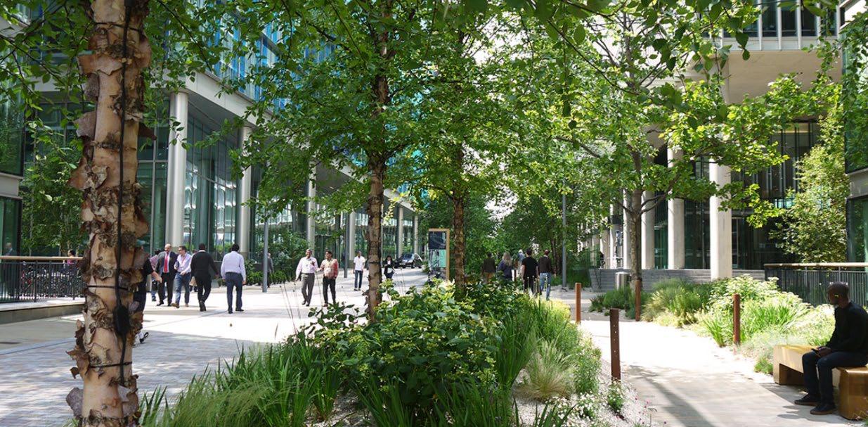
The below diagram highlights the change in shadows created by the sun at alternate times of the year. When an area is well lit by sunlight and offers places of respite in the shade, it can promote longer dwelling periods and increased use of the public realm
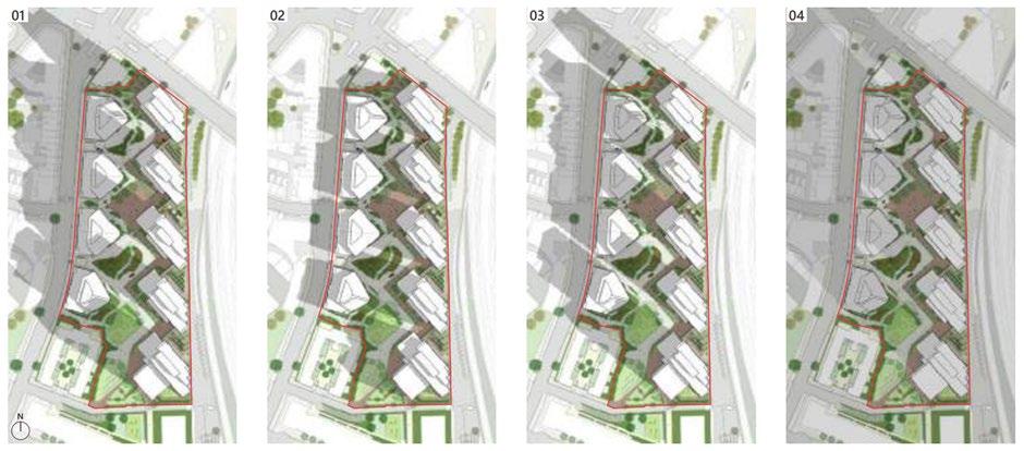
Bridge in spring, summer, autumn and winter, showing how green space is sited to maximise sunlight through the year.
Wind conditions within the public realm can affect comfort levels for users and like other microclimatic effects, can be affected by seasonal change.
Wind is a natural phenomenon that can be manipulated and impacted by its surroundings. Wind in the summer may be a welcome relief from intense heat, whereas in winter months high wind speeds may discourage individuals from dwelling in certain areas. In Westminster tall buildings can cause wind tunnels which directly affect the user experience creating uncomfortable and, in some instances, unsafe conditions. When considering the placement of a scheme and/ or street furniture it is important to consider the impact of wind tunnels and if possible, avoid close proximity to them. Effective landscaping can mitigate the impact of high wind speeds. Planters, ‘windrows of trees’ and ‘wind-break shrub hedges’ help to break up wind flows at ground level, and create a gentle breeze, an ambience of calmness generated by the sound of the leaves in the wind.
Note, building heights effect wind microclimates in the public realm, the taller the building the larger the impact. We follow guidelines produced by the City of London on Wind Microclimate which set out the general expectations for the types of wind microclimates studies required for various building heights.
Some existing tall building proposals may have involved wind modelling. These will be a useful resource in preparing public realm schemes.
Wind effects can have a major impact on cycling comfort and safety. In extreme cases, particularly the crosswinds can destabilize or push the cyclist into the path of vehicles. With increasing numbers of cyclists in London this is an important consideration.
Assessments should also take into account approved development within the vicinity. Even if development is yet to be built or in the early stages of construction, any new development is likely to cumulatively affect any wind modelling exercise so should be considered in wind assessments
The long-term impacts of air pollution are widely known and recognised. In the short-term, air quality in the public realm can impact a user's decision to dwell in an area for prolonged periods or even cause them to avoid an area altogether. It is therefore important to shape the public realm to ensure exposure to air pollution is minimised to improve user comfort and contribute to improving user health long-term.
Benefits of improving air quality include:
• Contributing to urban cooling and helping to reduce the urban heat island effect, the public realm is a highly influential space which can be used to address the negative impacts of the urban heat island effect through creative and thoughtful design.
• Improving health and wellbeing.
• Encouraging users to dwell longer, benefitting local businesses and supporting social activity.
Westminster City Council have published their ‘Air Quality Action Plan’ which identifies several priorities to help keep our air clean: reducing or cleaning dirty journeys and creating better infrastructure for electric and low emission vehicles; placing emissions and pollution at the forefront of decision making on public spaces and buildings; making environmentally friendly options easier for everyone; moving the air quality agenda forward through thought leadership and innovation.
It is important to future proof designs for public realm schemes, with adaptative measures in mind. The placement of public spaces should take account of air quality microclimates For instance, it would not be appropriate to place a children’s play park in a location subject to high levels of emissions from petrol and diesel vehicles.
Pedestrians should be kept spatially away as best as possible where busy and polluting roads remain, strategically placed greening infrastructure and/or green corridors could be considered to create a barrier reducing the level pollutants which reach pedestrians; however, their careful placement is integral to the efficacy of this method.
The Mayor of London has produced guidance demonstrating the different ways in which green infrastructure can be utilised to alleviate the effects of air pollution, outlined in the table below:
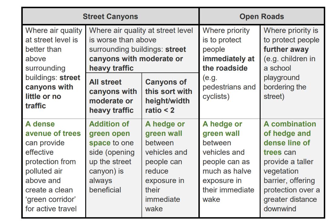
21: Mayor of London's right green infrastructure, right place.
The below diagrams show the strong correlation between heavily congested traffic routes, and concentration of poor air quality throughout Westminster. It is important to monitor areas of known high pollution levels to be aware of the health risks to residents as well as regular visitors, to change behaviours and to encourage developments which will mitigate the effects of poor air quality.
Related Links:
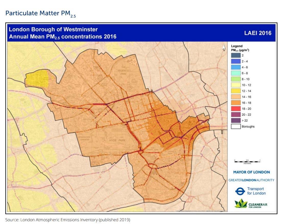
Figure 22: Westminster annual mean particulate matter PM2.5 concentrations 2016.
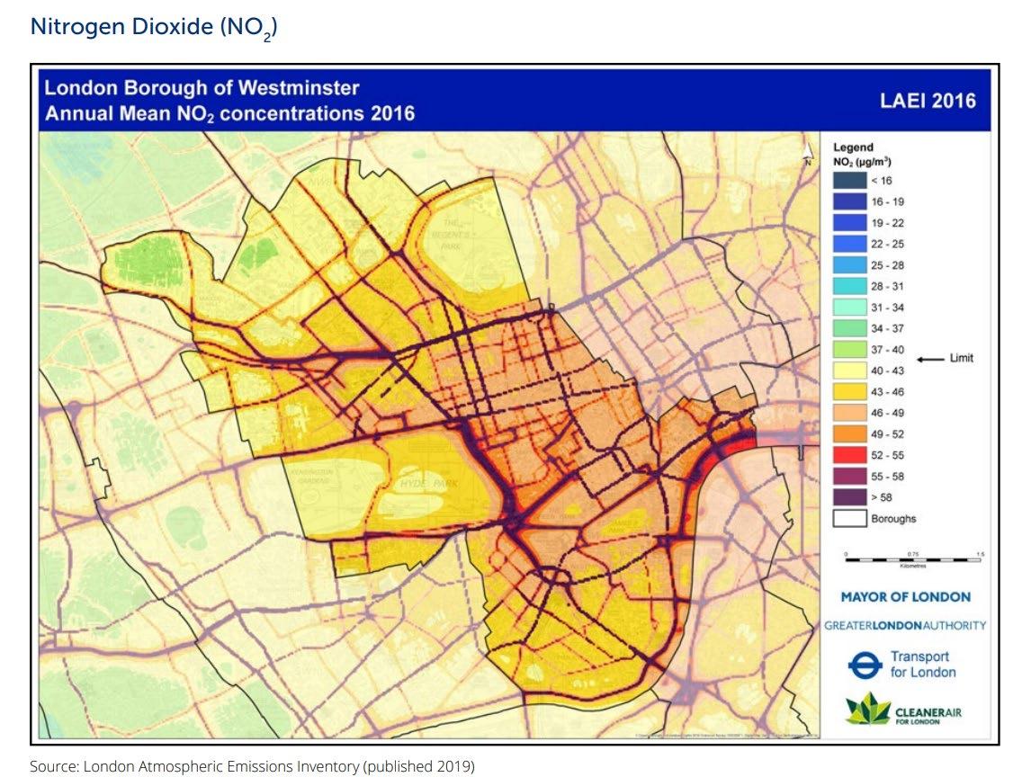
Figure 23: Westminster annual mean nitrogen dioxide concentrations 2016.
• Air Quality data is available on the London Air Quality Network (London Air Quality Network)
• Breathe London (Breathe London)
• Diffusion tube data in our yearly reports regarding air quality data – for example WCC Annual Status Report 2020 Final.pdf
Micro-climate Guidance:
A. Public realm proposals and any development which will impact the public realm, should clearly demonstrate they have sensibly responded to and improved the specific micro-climates of the area.
B. It should be noted that microclimates differ at locations and will likely have separate considerations to be assessed and reviewed, therefore assessments should be undertaken individually.
C. Where new development or public realm schemes create a new microclimate, any negative impacts of said microclimate should be mitigated with immediate effect.
D. Seasonal change should be considered when designing an open space or brining forward development that will impact the public realm. This is to ensure alterations are robust throughout the year, certain elements within the space may be incorporated to address seasonal needs.
E. Materiality is also key to microclimates in relation to seasonal change. Opting for materials that are quick drying, antiskid/slip, or materials which do not create unpleasant glares such as metals or glass are important considerations when choosing the m aterial palette of a public realm scheme. Similarly, materials which do not overheat in the sunlight which can exacerbate the urban heat island impact, such as concrete and darker paving materials including asphalt.
F. Increased greening within the public realm can assist with heat absorption
‘Soundscape’ describes the quality of the acoustic environment as people perceive it. In the city, the soundscape is broad ranging, but there are ways to mitigate the impact of harsher sounds when developing a public realm scheme by shaping the streetscape. The approach to effective sound scaping is influenced by the balance of unwanted sound (noise), natural sounds and the visual environment.
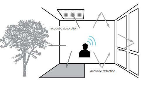
In Westminster the dominant noise sources are traffic, sirens, and construction all of which detract from a balanced soundscape. Positive aspects to the soundscape in Westminster include birdsong, running water, human noise, trees rustling and unique sounds to Westminster (such as the chiming of Big Ben).
Mitigating the impact of unwanted noise is key to a successful acoustic microclimate. Effective sound scaping will increase the use of the space, encourage longer dwelling periods, and also offers crossover benefits to other aspects of the microclimate like air quality and visual amenity.
Where there is scope, controlling traffic noise is an important step in urban design and in achieving a more balanced soundscape. Legislation to reduce tyre noise is addressing this balance and low noise road surfaces can offer even greater benefits. Government plans to phase out the sale of new petrol and diesel cars by 2035 will also reduce traffic noise at lower speeds.
Traffic calming measures, timed pedestrianisation and traffic free neighbourhoods all provide enormous benefits to the local soundscape. Car free areas are becoming more common in European cities with particularly successful examples in Amsterdam, Barcelona, and Brussels.
The sound insulation effect of vegetation in urban environments is small, with the reductions ranging from 5 to 10 decibels (dB) Increased greening and planting have a greater impact on people’s perception of sound and as a result the soundscape is more likely to be considered positively. In addition, if road traffic is well screened visually this can have a large impact on perception.
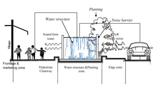
Noise Guidance:
Where noise cannot be controlled and barriers, screening and absorption are used to mitigate the impact, the following should be considered:
A. Using water or artificial masking noise as an acoustic camouflage.
B. Increasing the distance between traffic and seating or paths.
C. Facing seating away from busy areas and roads.
D. Noise barriers, green walls, or green barriers at the roadside to mitigate noise levels.
E. Using absorbent materials for paving such as resin bound or rubberised materials.
F. Absorbent features on nearby buildings or structures such as green wall panels, complete green walls, green roofs, planting, and other absorbent materials such as acoustic panels.
G. Using buildings to screen traffic noise with the best examples being enclosed courtyards.
H. The City Council has introduced designated ‘ Tranquil Open Spaces’ in the city that are protected from intrusive noises largely from development.
Related links:
• Noise and Vibration in Environment SPD 2022
Related SPD sections
• 4 2 Cycling / Active Travel
• 4.7 Street Trading
• 4.10 Waste, Cleansing and Maintenance
• 4.12 Power and Lighting
• 4.13 Signs and Adverts
• 4.14 Public Art, Statues and Monuments
• 4 15 Security
Key City Plan policies
28. Highway Access and Management
34. Green Infrastructure
38. Design Principles
39. Westminster’s Heritage
40. Townscape and architecture
43. Public realm
44. Security measures in the public realm
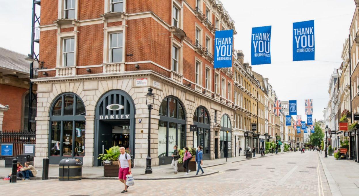
Street furniture is defined as structures and objects in and adjacent to the highway which contribute to the look, feel and use of the public realm. This includes but is not limited to structures such as seating, traffic signals, lamp columns, wayfinding and cycle stands.
It is important to carefully select and coordinate street furniture to ensure it positively contributes to the function and heritage of a location and does not cause an obstruction.
Increased demand for street furniture, including cycle stands, planters, trees, and other forms of greening, mean that very careful consideration should be given to any proposed new installation. Consideration must be given to unintended consequences and potential misuse or mismanagement of street furniture.
The space required for people should come first with other obstructions, where permissible, placed to minimise the intrusion into that space.
Items may be installed for a central purpose whilst providing other functions in the interest of reducing clutter and improving user experience. Examples are noted throughout this guidance document
Planning permission is usually required where third parties wish to install street furniture on the highway, on privately owned land which has been adopted as highway, or on privately owned open spaces.
This section does not include guidance for temporary structures such as scaffolding and hoarding. Guidance for these is set out on the council’s website: Guide to temporary structures and section 50 licences
General principles
Items should be carefully selected, and should not create clutter, ensuring street furniture has a reason to be there and earns its place and is co-located where appropriate.
Function What is it for? Is it needed?
Design and form Is the design functional, inclusive, and suitable to the location?
Location Is the suggested location the most appropriate one?
Street furniture should be designed to ensure efficient servicing and maintenance.
Street furniture should always be clean, smart and in good order, and comprised of materials that require minimal repainting and maintenance.
A. The function, design/form and location of street furniture should respond to demonstrable need and benefit the public realm and its users in that specific location.
B. Street furniture should not obstruct pedestrian use of the street, or cause any other access issues, or negatively affect the quality of an area.
C. The positioning and orientation of street furniture should ensure that sufficient space is left for maintenance access, and access for all;
D. Proposals for street furniture should respond to Westminster’s key public realm principles (‘The Westminster Code’) set out in section 1.
E. New street furniture should enhance the appearance of the area, improve a sense of safety, and not create negative impacts to the local residential amenity.
F. Security implications should be considered in the initial design.
G. Selection and placement of street furniture should take account of security considerations, including location and operation of street lighting.
H. Where possible street furniture items should be combined and be multifunctional.
I. All metal street furniture items, including third party attachments, should be coloured black (RAL-9005) and provide contrast with the surrounding environment. Exceptions may only apply where there is previously established local variant.
J. Street furniture should not have a highly reflective finish.
K. Any ambiguity should be avoided, for example the possibility of water features or utilities infrastructure being mistaken for seating.
Historic Street Furniture Guidance:
A. Historic street furniture and those that make a positive contribution to local character, should be retained in-situ (whether they are listed or not).
B. If there is a case to be made to relocate or remove such an item, an appropriate methodology should be agreed which may include Listed Building Consent
C. Where street furniture is temporarily removed, its safe storage and reinstatement plans should be agreed in advance.
D. Listed building consent will be required where alterations are proposed to listed street furniture.
E. Locally distinctive designs, for example historic railings or streetlamps, should be respected and their use continued.
F. Where street furniture is locally distinctive, it should not be used indiscriminately in other areas.
G. The replication of historic street furniture should be accurate both in terms of its detailed design and faithful to its historic distribution (but dated to show its provenance).
Locational Guidance
A. Street furniture on the footway should remain in the street furniture zones, allowing pedestrians full access and usage of the pedestrian clear zone.
B. The width of the pedestrian clear zone should be proportionate to the pedestrian numbers at peak times.
C. The recommended minimum clear width for the pedestrian clear zone is 2 metres. Street furniture should not be placed in this zone. Wider clear widths will generally be required in areas of high footfall. (Also refer to Figure 5 of this SPD for a detailed illustration)
D. In narrow streets only mandatory items should be installed such as lighting, utility cabinets and bins if necessary.
E. On wide footways the street furniture zone at the building frontages may be an acceptable alternative provided it does not cause the clear zone to ‘weave.’
F. Street furniture should only be provided where it serves a specific function and is appropriate for the location.
G. Street furniture should not obstruct sightlines to crossing facilities.
H. Pedestrian desire lines should always be considered when deciding where street furniture should be placed.
I. Street furniture should be grouped to reduce street clutter whilst maintaining accessibility.
J. In constrained areas such as historic areas with limited footway space, an absolute minimum of 1.8 meters passage should be maintained.
K. Proposals for new street furniture should consider the cumulative impact with existing street furniture.
L. The location of street furniture should be carefully selected to avoid harm to the significance of heritage assets.
M. New street furniture proposals will be assessed as to whether their presence will enhance the locality, improve a sense of safety, and whether it would create disproportionate negative impacts to the local amenity.
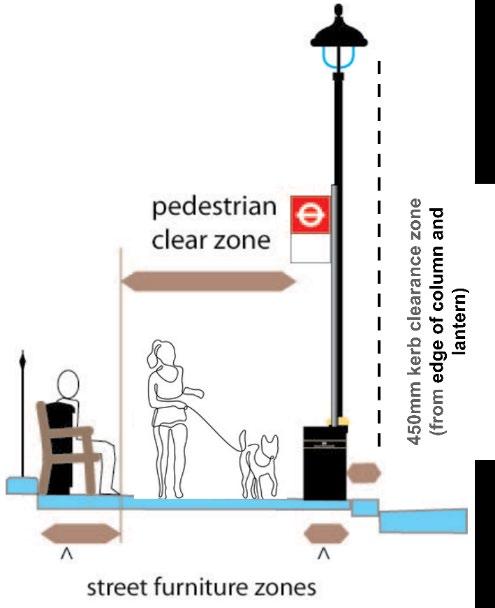
Context
Clear and consistent wayfinding can encourage people to make journeys through walking, cycling, and using public transport.
It is a vital component of orientation and can help people feel more comfortable by offering better understanding of the proximity of key locations. This is particularly useful in key tourist areas of Westminster but would be desirable in appropriate settings across the whole borough.
TfL’s ‘Legible London’ signage provides a recognisable, consistent, and connected pedestrian signpost network to aid pedestrian wayfinding across London and is therefore the preferred wayfinding system.
Legible London signs come in a variety of sizes to suit site specific need and are the preferred system for assisting pedestrian navigation in Westminster.
TfL have strict guidance on what they allow on the Legible London signs, and provides guidance on the design and placement of Legible London wayfinding maps and signs: https://content.tfl.gov.uk/streetscape-guidance-.pdf
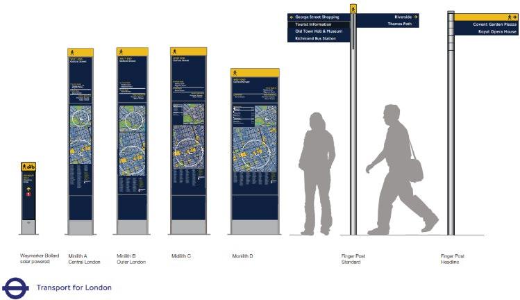
Essentially:
Key maps and orientation systems are best placed in stations and on bus and taxi structures, however some reinforcement at key locations in the public realm is often necessary.
Signage selection and placement
• Wider signs are used where groups of people can stand without blocking the path of others;
• Taller, narrower signs are useful where pavement space is at a premium, and they can be seen above a crowd;
• Tall signs combined with illuminated beacons are used at transport interchanges;
• Miniliths and monoliths should be located within the street furniture zone (Figure 29 refers), and in areas of key decision points and landmark destinations. Some examples of this may be near famous landmarks, tubes and/or train stations and bus shelters.
• Finger posts are used where a map-based sign may not be suitable, and to confirm the route for a pedestrian or a cyclist. They must not be placed to cause clutter.
The City Council will:
• Encourage signage which is necessary and enhances the amenity of the public realm.
• Promote a consistent approach to signage design and placement.
• Promote appropriate dual-use of signposts and other street furniture to help minimise clutter.
• Ensure that signs and advertisements do not distract from the safe enjoyment of the public realm.
• Whilst the City Council will work with designers to determine the detail and orientation of Legible London signage, each will ultimately require TfL approval.
A. Pedestrian Wayfinding across Westminster should follow Legible London standards37
B. Different signage styles should not be used to “brand” an area or location
C. All pedestrian signs should be consistent in design and quality.
D. Wayfinding should be provided at areas with high footfall through pedestrian decision-making points and should reaffirm directions on routes over long distances.
E. Routes to, and the location of, key accessible facilities such as parking, transport hubs, information centres and public toilets should be clearly identified
F. Legible London should be integrated with new developments and area initiatives.
G. Clarity of wayfinding will be assisted by the careful placement of all other equipment, including other street furniture, signs and trees
H. Redundant signs should be removed where they are not of heritage value
I. Dedicated stand-alone signs will only be considered where there is demonstrable need and ample space for them.
J. Tactile and audible maps providing both visual and audible information, which aid wayfinding for visually or hearingimpaired people, should be considered in areas with high footfall.
K. Directional signs should specifically identify routes that are accessible and step-free and should give as much information as possible to assist people in planning and navigating their route
L. Entrances to public spaces should be clearly signed.
M. Wayfinding should be improved to highlight new and existing routes, including temporary wayfinding around construction sites
N. A risk management plan should be in place to guarantee public safety during installation and the lifespan of the work
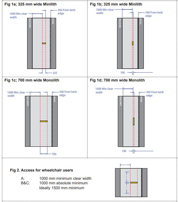
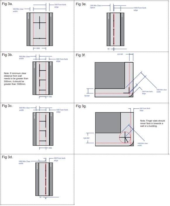
• Refer to the advertisement’s guidance in section 4.13 Signs and Adverts, in this SPD for further information.
The City Council is committed to providing and improving cycling infrastructure, including the provision of cycle parking and storage facilities in order to encourage an uptake of cycling.
Where street furniture zones are generous, hire stations and stands for general cycle parking (accessible to all) have been permitted on footways and build-outs The City Council will follow usual Traffic Management Order processes to ensure the kerbside is assigned correctly should cycle parking be required in carriageway. Cycle hire stations adopt the pan-London design agreed by the City Council.
Hangars are often located in residential areas and estates. They are for long-stay purposes, and for private key holders’ use 53. There is increased demand to provide cycle hangars within the city
The installation of cycle hangars is classed as permitted development, where installed by the City Council, and provides the benefit of enabling 6 bikes to park in the space of 1 car.
53 The City Council operates a waiting list for provision of hangar space in appropriate locations.
A. New cycle hangars should have fixed side panels for increased security for users, while maintaining visibility into the hangar
B. Hangars should be located away from residential front doors and windows.
C. The preferred design of cycle hangars is the cycle hoop hangar and is pictured below.
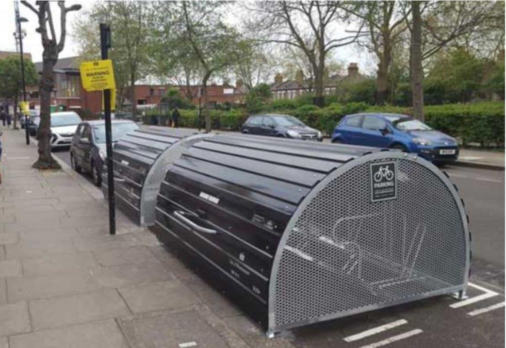
Figure 30: Cycle hangar in repurposed half a car parking space, with space for 6 bikes, with covered weather protection. They are approximately 2.6m wide, 1.3m high (Open: 2.3m), 2.0m deep and painted black to match existing street furniture in Westminster.
On-street cycle stands are intended for short-stay purposes Their visual impact can be reduced if placed between other street furniture or landscaping, such as a tree planting, bus stops and seating, as part of a coordinated furniture zone.
A. Cycle stands should be placed close to retailers and play parks, offices, public buildings and outside of the pedestrian clear zone.
B. Cycle parking should be considered at stations and bus stops and incorporated into their design.
C. Cycle stands should generally be ‘Sheffield’ type stands.
D. The colour of the cycle stand should generally match the street furniture standards.
E. As with all street furniture, the colour should be in contrast with the surroundings to enhance visibility.
F. On the end of each rack, a horizontal bar ‘tapper plate’ positioned lower to the ground should be used to aid detection by a cane.
G. A second higher bar may be appropriate to aid accessibility.
H. Westminster’s Standard Details set out the precise spacing required between stands, depending on the type of stand used, its orientation, and spacing between stands and the kerb line.
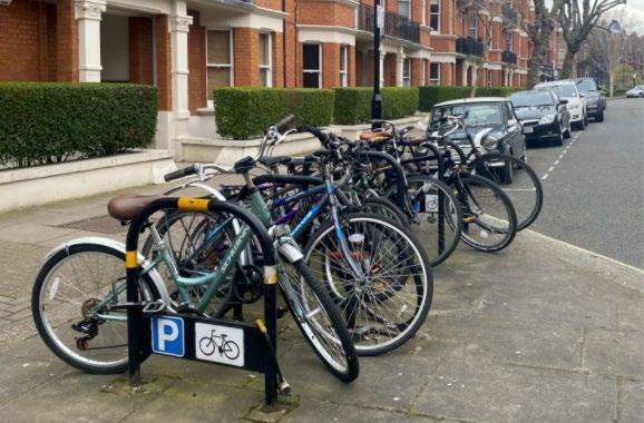
Further information
• For more information on cycle parking for non-standard cycles please visit the LTN 1/20 guidance
• For more information, please turn to Chapter 4.2 Cycling / Active Travel within this SPD.
While planters can help to green and soften the street environment, they require careful consideration as they can attract litter and pose an obstruction to pedestrian movement if not appropriately sited. Planters will rarely be a successful solution in mitigating problems arising from inappropriate use of the public realm. Planters are permitted development when installed by the City Council within the highway, otherwise they require planning permission, S115E licence and appropriate management and maintenance agreements Greening via planters is not considered sustainable and should only be used as a temporary measure and an intervention of last resort.
A. In-ground planting is preferable to the provision of free-standing planters.
B. Proposals for new street planters should demonstrate that any proposed planters would represent the best use of the public realm.
C. Their specific siting and design should have regard to local environmental constraints, for example considering the level of sunlight and shading.
D. Materials choices should similarly reflect local circumstances and facilitate cleansing rather than act as a barrier to the existing highways cleansing regime.
E. Planters should be designed to colour contrast against their setting.
F. Traditionally planters would be black, however alternative colours may be considered where they are consistently used across an expanse of public realm, for a specific reason.
G. Planters must be robust to withstand environmental conditions, and high enough not to pose trip hazards in the public realm. Good practice suggests that the same minimum height of 1,000 mm as for bollards should be applied to planters.
H. They must not have sharp edges.
I. They should be sited so as not to create places to hide anti-social materials, for example waste or drugs, behind them or between them and a wall. They should also be sited so as to not be used as steps, for example providing a step access point into private gardens or over walls, or to collect waste.
J. As with all street furniture, the placement of planters should consider pedestrian site and desire lines and not create a hazard to any users of the public realm.
K. Where planters are permitted these should be multi-functional to reduce clutter.
L. Planters should not be used to permanently enclose public space for private use, this includes as part of tables and chairs layouts Planters used for this function should be moveable and removed as per the terms of each licence
M. Sufficient drainage must be built into the design of all planters
N. Fixed planters should incorporate appropriate drainage into the sub-soil and/or drainage system.
O. Appropriate maintenance arrangements must be agreed for the lifespan of the proposed planter installation. This is likely to include a commuted sum.
• See Chapter 4.3 Green Infrastructure section in relation to species selection and planting requirements.
• See Chapter 4.3 Green Infrastructure section for guidance on parklets
Seating can perform many functions within the streetscape besides providing a place for people to rest. Well-designed and appropriately positioned seating encourages people to dwell and enjoy the public realm. It can invite users to previously underused areas through creative designs and thoughtful placement, though seating in attractive and in sunlit areas is more likely to be used. Public seating can also be used to define spaces and create zones of different activities.
Functionality, comfort, and accessibility are key requirements of seating. A variety in rest stop options could particularly benefit ambulant disabled people who may find it difficult to sit or rise from the standard seated position. The maximum distance someone with a mobility impairment is expected to walk without a rest is 20 to 50 metres.
Standard seating materials are often: timber, stainless steel, and natural stone. Rest stops may not be limited to standard seating, but could include novel designs such as perching points, either standalone or incorporated into public realm installations such as pocket parks or built planters.
A. Seating should be provided at intervals of no more than 50 metres in areas of high demand.
B. More frequent placement of seating should be considered in areas of highest demand.
C. Seats should be positioned and oriented in a manner that appears inviting and enables users to enjoy the surroundings.
D. Materials should be chosen for their durability and be fast drying
E. All new public seating must be easy to maintain and clean.
F. Median standard height of seating should be 480 mm with perch-type seating at 700 mm.
G. Where possible, seating with ‘sheltered backing’ should be used to achieve optimum user comfort.
H. Seating with chair arms should be used to assist the rising and sitting motion of users.
I. Placement of seating within the public realm should allow for space for those using the seating, for example for legspace, prams, and bags, and to not impede passing pedestrian flow and be outside the pedestrian clear-zone.
J. Consideration should be given to space alongside public seating to allow for wheelchair users and children’s pushchairs to sit alongside rather than in front.
K. Studs, notches or similar should be used to protect seating from skateboarding.
L. New designs and bespoke items should be reviewed with the City Council in the early design stages.
M. Impacts of noise and antisocial behaviour should be considered when public realm is in close proximity to public areas
N. Temporary trials to street furniture arrangements could be considered to test their impact ahead of permanent installation.
O. Public seating should not:
a. be placed against a wall where this would allow anti-social activity or where it could be used as a step to gain access over a wall or fence;
b. be placed near known wind tunnels, for example between tall buildings, which could make use uncomfortable;
c. be placed in isolated locations which may not make users feel safe and invite anti-social behaviour.
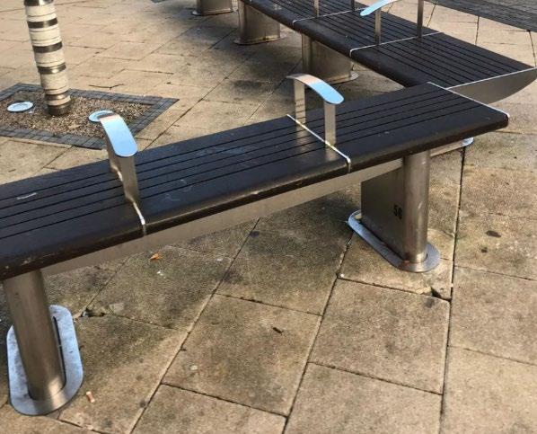

Context
There are different examples across Westminster of both temporary and permanent tables and chairs installations. This section relates to tables and chairs that are not linked to commercial premises licences. Tables and chairs linked to licensed/commercial premises are covered in Chapter 4.7 Street Trading / Commercial Activity below. Fixed public seating is covered above.
Tables and chairs in the public realm for non-commercial reasons are an alternative option to benches. They provide the opportunity for socialising outdoors where they are provided for everybody’s use.
Tables and chairs that are not installed in connection with an establishment would require planning permission, and fixed tables and chairs would also require planning permission because they are not movable
A. A pavement licence is required before installation of tables and chairs on the public highway, with an associated management plan agreed by the City Council
B. The expectation is that tables and chairs would be privately funded and maintained.
C. Any moveable tables and chairs need to be carefully managed and securely stored when not in use.
D. When installing tables and chairs, consideration must be given to nearby residential areas, to noise and disturbance which could be associated with the use of the tables and chairs, and the times in which they are available for use. The potential littering arising from the use of tables and chairs must be addressed in the management plan
E. Tables and chairs that the City Council consider will have a negative impact on residential amenity and/or pedestrian movement will not be allowed.
F. Moveable street furniture will require an agreed perimeter and/or location where it will be placed. This detail can be agreed as part of the project design with the City Council
Design expectations for tables and chairs are set out in Chapter 4.7 Street Trading / Commercial Activity (including Tables and Chairs)
54 For information on tables and chairs for commercial use (where associated with a business), please see Chapter 4.7 Street Trading / Commercial Activity (Including Tables and Chairs)
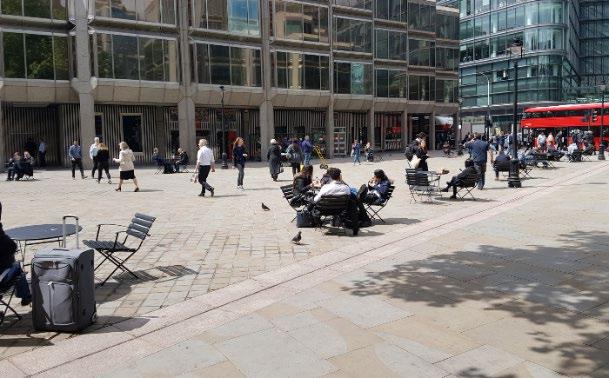
Drinking water fountains provide the opportunity for visitors to quench their thirst, encouraging people to spend time in the public realm, including through active travel. They also help reduce single waste plastic usage by encouraging people to refill their water bottles, without the need to purchase bottled water.
The City Council has installed drinking fountains in Westminster’s libraries and leisure centres to increase public access to free drinking water. See Water Fountains (arcgis.com) Our partners, such as Network Rail, have also installed drinking fountains in high footfall areas such as Paddington and Victoria Station. In addition, the ‘Refill London’ scheme launched in 2018 to provide water refills in shops and cafes who agree to the scheme. See Refill London - Refill - Staying hydrated in the capital
A. Drinking fountains should be placed where there is high pedestrian and visitor footfall, and where no other facility is available
B. The design of new drinking fountains should be kept simple but should also include high-quality detailing and the use of durable materials
C. Proposals for drinking water fountains should consider the location, the context, and how many other drinking fountains there are within the vicinity.
D. Applications for drinking water fountains will need to include details of third-party maintenance and management arrangements, to ensure that fountains are kept clean and in good working order.
E. Drinking water fountains need to be easily maintainable and accessible, kept clean and clear from litter and tree debris and as such fountains should not be placed under trees.
F. Ground level fountain trays can be used for dogs.
G. Historic drinking fountains are maintained by the City Council, they should be free of litter and any aesthetic damage should be repaired.
H. Three monthly tests are required for water quality and should be included in maintenance costs.
I. Contactless water drinking fountains are preferred for hygiene reasons.
J. Electrical tests are required every 3 years for any electrically powered fountains.
K. Foul water drainage systems are essential when installing a drinking fountain.
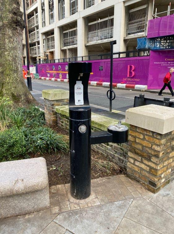
City Plan Policy 37.B. (Waste Management) specifies that all new developments (including extensions and change of use) must provide appropriate facilities for the storage of separate waste streams which are safe and convenient to access for deposit and collection, with sufficient capacity for current and projected future use.
Appropriate waste management will be required for new developments in accordance with this plan and in line with Westminster’s Waste Management Strategy which has a focus on maximising waste reduction, reuse, and recycling. The City Council’s ‘Recycling and Waste Storage Requirements’ Planning Advice provides more detailed guidance for waste storage and public recycling sites.
Listed below is guidance on in-street waste management, litter bins, ‘bring sites’ and bin-housing.
Accessibility should be central to the design, height, and location of bins, including step-free level access, clear and consistent colour coding/contrasting, and safe access for servicing. Ground fixing can help with detection by cane users.
• Waste in the public realm presents significant hazards for people with visual or cognitive impairments, and poses obstructions to people who use mobility aids, who have children in prams or pushchairs, or who have luggage.
In much of Westminster, particularly areas such as Soho or Fitzrovia, streets and pavements are often narrow, and it is often not possible to widen them. This means that any further narrowing of pavements caused by the leaving of waste can severely inhibit use of the public realm, particularly when the streets are busy. A combination of improvements to infrastructure, logistics, and the management of the public realm could be expected to yield benefits in addressing the problem.
The City Council’s adopted ‘Waste Management Strategy ’ sets out that waste services should be designed to encourage high participation, with expanded provision of ‘on the go’ recycling services for street litter – these are fixed public bins that are designed to enable passing pedestrians to place rubbish and recycling generated while out and about. They are not intended for intensive residential or commercial use and are designed for smaller items.
The ready availability of well-designed and well-maintained ‘on the go’ bins and ‘bring sites’ is a key component in managing waste, helping to encourage the use of bins, reducing the waste collected through labour-intensive street cleansing, reducing inappropriate waste disposal; and securing a high-quality environment for everyone to enjoy.
Public ‘bring sites’ are easily accessible recycling points with a wider range of recycling facilities in larger containers. They may include clothes recycling, plastics that are not collected from residents’ collections, or harder to recycle items such as electronics and batteries. These sites are of importance in encouraging wider participation in recycling, especially around higher density urban areas.
• Clear and consistent colour contrasting, and coding is integral to ensuring ease of use and accessibility.
The predominant design for litter bins in Westminster is the Olympic standard bin and/or Duobin (present in 1,600 locations), although the Olympic design will be phased out gradually by 2027 and replaced by the Metal Duobin. These bins allow recycling as well as waste litter in two separate apertures and have an integrated cigarette butt disposal.
The standard bin is half the size of the duo-bin and only allows for waste litter. This bin type is usually installed at areas which have limited footway space. All other bin designs currently on street have also been phased out.
Compactors can help reduce the size and bulk of bins required in high demand areas, while providing a high-capacity solution. Solar compactor bins currently require large refuse vehicles for emptying but may become feasible with the use of electric vehicles during the lifespan of this document.
Provision:
L. In line with City Plan policy 37, appropriate waste facilities must be provided to reduce the likelihood of litter and rubbish bags being left in the public realm.
M. New waste facilities should seek to expand provision of ‘on the go’ recycling services for street litter.
N. The number of bins needed varies depending on footfall and maintenance regime of a specific area. It is recommended to liaise with the Westminster cleansing team when making a strategy for cleansing and to identify the number of required bins and models.
O. Waste facilities should be well designed and located to ensure that pedestrian access is maintained or improved.
Location:
P. Services should be designed and located to encourage high participation.
Q. Design and placement of waste facilities should consider collections. Waste collection operatives should not be required to:
a) carry dustbins or move wheeled bins more than 20 metres total;
b) carry waste sacks more than 20 metres total;
c) transport ‘Eurobins’ or similar wheeled waste more than 10 metres total
R. Transport any waste along a gradient whether rising or falling.
S. Bins should be sited with consideration to the smells and insects which they may attract. It may not always be appropriate to site bins immediately adjacent to public seating, for this reason.
Design Specifications:
T. Litter bins should be simple, durable, recognisable and convenient.
U. Litter bins should have a minimum height of 1,000 mm from ground level, with a bin opening 1,000 mm from ground level.
V. Bins should be detectable at ground level.
W. Design of bins should be consistent across any given area.
X. The colour palette used for bins should contrast with their surroundings.
Y. All street litter bins should have the provision to clear waste and recyclables at one place. Mixed / duo bins with capacity for general litter, mixed recycling, and cigarette stubs are preferred to standalone waste or recycling bins.
Z. The use of green for recycling materials, and black for general waste should be used wherever waste facilities are provided within the public realm.
AA. Good practice suggests that bins should be approximately 1300 mm high, with the opening 100 mm above ground level.
BB. Bins should have a slam shut door with a robust low maintenance lock.
CC. Bins should have galvanised steel pull out liners and a hood to prevent litter from being blowing out of the bin.
DD. Liners should be able to withstand high pressure water cleaning for a period of up to 5 years without degradation.
EE. Bins must not pose a fire or safety hazard.
FF. Smart bins which notify servicing operators that a bin is at capacity are encouraged, enabling more efficient collection and servicing, as well as ensuring capacity is maintained. Care should be taken to ensure the chosen sensor software is compatible with current waste collection sensor platforms.
GG. Alternative and innovative designs may be considered for bins that are serviced and maintained on private land within the public realm, however these should maintain the principles of ease of access, and maintain the colour coding of bins found elsewhere in the city.
Placement:
HH. New public realm schemes should consider the existing local bin network, and possibilities for its rationalisation, including removal or relocation of underused bins.
II. Litter bins should be placed at locations where there is higher footfall, such as commercial areas / busy streets, along pedestrian walking routes as well as near bus stops, rail station and tube entrances/exits, sitting benches, local attractions, and parks to aid park users and dog walkers.
JJ. They must be located at the front of the footway, outside of the pedestrian clear zone and consideration should be given to ground fixing with approved details.
KK. Eurobins or similar wheel waste containers should have clear paths to the nearest vehicular access which:
a. are free of steps or kerbs;
b. have a solid foundation;
c. are rendered with a smooth and continuous finish (a cobbled surface would be unsuitable);
d. are level, unless the gradient falls away from the housing then it must not exceed 1:14;
e. have a minimum width of 2 meters.
LL. Bins should not normally be provided in the following locations:
a. High security areas – it is important to make an assessment and/or seek specialist guidance on the possible security threats;
b. Private roads/borders shared by neighbouring councils;
c. Areas with a history of dumping or fly tipping or commercial abuse;
d. Areas which have issues with vandalism or cause demonstrable concerns to local businesses or residents;
e. Areas which are operationally hard to serve such as adjacent to traffic lights, double red route;
f. Narrow footpaths.
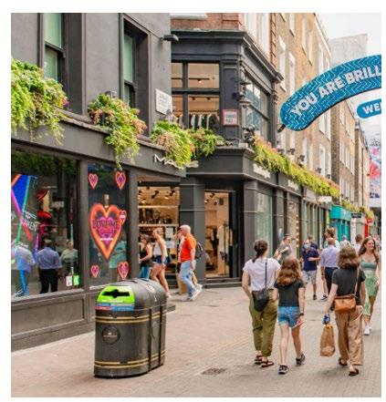

The use of large unit shared street bins can help with waste management and encourage higher uptake of recycling. The City Council has public waste ‘bring sites’ across the city to support doorstep collections and meet the needs of residents, businesses and visitors.
A. In areas of known demand, and where the highway space and design allow, public bring site recycling and waste facilities should be encouraged.
B. Small recycling ‘wheelie’ bins should be located at the front of footway, outside of the clear pedestrian zone.
C. Eurobins, or similar sized facilities, that are placed on the street must be anchored at the back of footway in a discrete manner. Their location should allow for ease of servicing by refuse collection vehicles.
D. Well-designed and overlooked enclosures can discourage waste being dumped and make bring sites appear more attractive while protecting the contents from disturbance, degradation and causing localised environmental impacts
E. Visual screening can reduce their visual impact on the amenity of the area.
F. Careful consideration should be given to ensuring enclosures are accessible, clearly marked, and the materials and design facilitate ease of maintenance and cleansing.
G. The provision of recycling for more unusual items, such as batteries and clothes, will be provided where space and demand allow.
H. Clear zones will always take priority over the placing of waste facilities, which must only be located where there is adequate space to do so.
I. Any recycling-exclusive facilities serving commercial or residential buildings should be located, where possible, within the building line.
J. Waste facilities serving commercial or private residential premises should not be located on the street, where it impedes the pedestrian access and is a significant contributor to street clutter. Where this is not possible, they should be placed within suitable enclosures in off-street areas such as forecourts, and car parks.
See https://www.westminster.gov.uk/recycling-and-rubbish/waste-storage-planning-advice for further guidance relating to Public Recycling Sites.
See the Materials Palette in Appendix 2 of this SPD for guidance about appropriate paving to be used under and around bins.
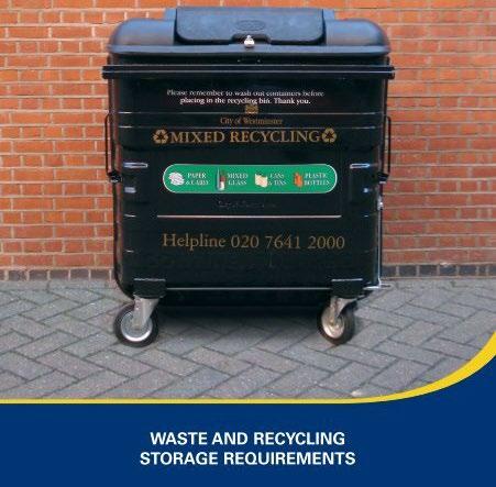
Bollards are used to restrict vehicular access to certain areas, for road safety reasons, access management, security and to prevent parking/ encroachment onto the footway.
Bollards are one form of Hostile Vehicle Mitigation but are generally considered problematic for people with visual impairments regardless of design or placement. Their use should be limited to locations of genuine demonstrable need –where there is a recognised security concern. Where obstructions are essential for public safety, they must be carefully positioned and have a high level of contrast with their surroundings.
It may be appropriate in some instances to remove bollards as part of new public realm schemes.
The standard metal bollard design in Westminster is the Cannon Bollard or the City Bollard. These are generally acceptable in Conservation Areas. In some exceptional circumstances the design may differ, however variation from standard black painted bollards does cause maintenance issues.
In Chinatown, the bollards have been painted red to suit the character of the area.
Where there is demonstratable need, other hostile vehicle mitigation measures remain a preferable option 55. For more information on security measures, please visit Protect UK and the section 4.13 of this document.
A. Bollards should only be used where there is evidenced need, for the public benefit. Bollards should not be used to protect individual business interests, where there is no demonstrable need nor public benefit
B. Bollards should be black and contrast with their surroundings.
C. Bollards should be carefully selected so that they match the character and appearance of the area.
D. Consistency within areas is expected.
E. In Victorian and earlier conservation areas the Cannon Bollard and the City Bollard are equally acceptable.
F. Twentieth century development from the accession of King Edward VII in 1901, is more suited to the City Bollard and this should be used in all areas affected by redevelopment from that date onwards and has been re-engineered to withstand considerable impacts.
G. Where there is demonstrable need, highlighting in the form of a 150 mm deep contrasting reflective yellow or white strip on black bollards may be considered where this will aid accessibility.
H. Bollards should be at least 1000 mm high.
I. Bollards should be a consistent width, and not flare at the base.
J. Permanent bollards are preferable to manually operated or hydraulic bollards. Westminster City Council can advise on a case-by-case basis.
K. Manually dropped bollards can be useful for the time-managed streets where there are on-site personnel to raise and lower them. The life-time operation of these must be agreed with the City Council prior to their installation. 56
L. It is important to consider the maintenance requirements and durability of hydraulic bollards as technical faults may impact required access into streets (see below).
M. The usual clearance between the faces of bollards in a cordon should not be less than 1.2 metres. Staggered bollard lines may be considered to maintain the 1.2 metres minimum spacing, whilst allowing pedestrian and wheelchair access to pass on or near desire lines.
N. Careful consideration should be made when making this decision on the need for the bollards, and the impact that removing them may have.
55 Centre for Protection of National Infrastructure (CPNI) Public Realm Design Guide for Hostile Vehicle Mitigation (third Edition) https://www.cpni.gov.uk/public-realm -design-guide-hostile-vehicle-mitigation-0
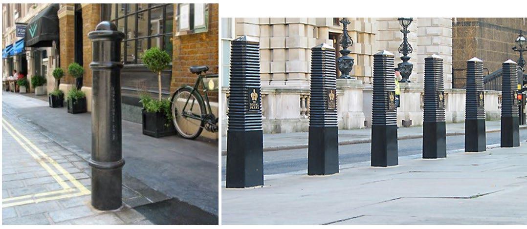
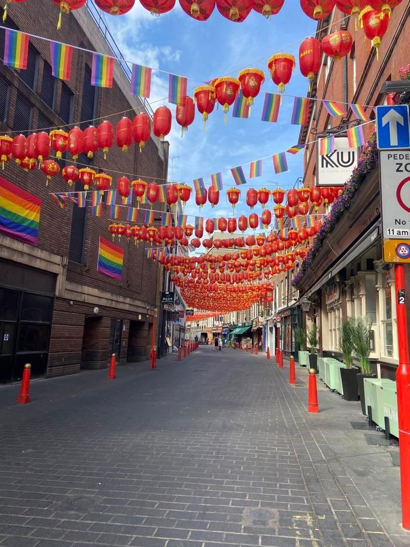
Context
Guardrails have been used to protect pedestrians and vulnerable footway users, against vehicles, motorcycles, and bicycles. Whilst their use in some locations can still be deemed necessary, they can clutter the streetscape in other instances and limit pedestrian movement across desire lines.
The City Council’s policy to declutter the streetscape has seen some guardrails removed, with other protective measures put in place such as footway extensions, which increases the distance between road users and pedestrians. Additionally, other street furniture items can also be used to create a barrier between pedestrians and the carriageway, such as cycle parking provision.
The removal of guardrails should be reviewed on a case-by-case basis and pedestrian comfort should take priority.
Guardrails Guidance
A. In the interest of reducing street clutter and making the public realm more accessible to all, new guardrails are not generally supported unless it can be demonstrated that there is no alternative solution to mitigate an identified risk.
B. Guardrails can be placed at entry and exit points to parks, schools, alleys, public buildings, and tourist attractions –to deter pedestrians, most notably children, from exiting onto the highway.
C. It is important to liaise with the Transport Officers within Highways for further advice on guardrails and where to place them.
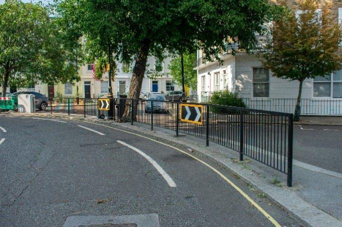
Adequate lighting is essential. Lighting plays a key role in matters of both safety and security in any city centre at night and can be beneficial to the night-time economy. Inadequate lighting prevents and discourages our use and exploration of the city, increasing our sense of unease. Too much lighting can cause disruption to surrounding residents and biodiversity through light pollution. The Council aims to have the right light, in the right place, at the right time, managed with the right control system. Guidance about lighting standards is provided in the Power and Lighting section below.
This section provides guidance about lamp columns and lanterns. Further details are set out in the City Council’s Lighting Masterplan 2020-2040.
Character can be defined by street lighting, and street lighting fittings. Across the city the street column style generally in use is the iconic Westminster design known as the ‘Grey Wornum’. They are the city ’s marque and are used across most conservation areas.
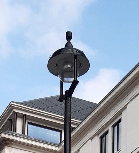
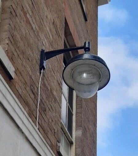
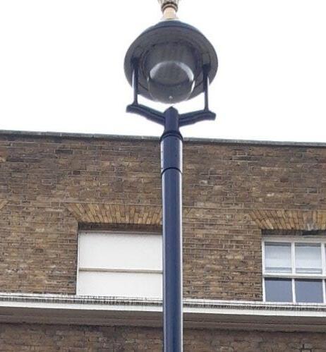
Within the city there are also several other column styles. These include, but are not limited to the MacKenzie Moncur, St Martin-in-the-Fields, and the George V Eddystone
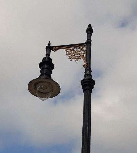
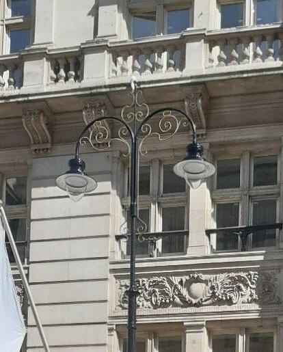
In historic parts of the city, original light installations remain. In some cases, the lamp or lantern has been modified, with modern fittings such as LEDs without changing the appearance.
Westminster also has cherished columns, those that are unlisted but still have significant historical importance and/or made of material such as cast iron
For further information on Lighting columns and locations please see the Lighting Master Plan.
A. Lamp columns and lanterns should be carefully considered, well-designed, and appropriately located, in order to minimise intrusive lighting infrastructure and reduce light pollution.
B. Lamp columns should be located at the front of the footway, outside of the clear pedestrian zone and generally a minimum of 450 mm from the kerb face (see below), to avoid them being hit by vehicles. The camber of the carriageway may need this width to be greater where carriageway is flush with footway, such as shared areas, there is no kerb upstand to protect columns from vehicles so their position needs to take this into consideration to avoid this conflict See Figure xx [cross section figure with 450 mm shown]
C. Street furniture should be placed no closer than 800 mm from lamp column access panels / doors, to allow access.
D. It should be noted that powered columns are a sought after and required asset for the installation of sensors, Wi-Fi, EV, and cameras so the removal or absence of lamp columns should be carefully considered for each scheme.
E. Lanterns shall be of a style to suit their purpose, provide the required optical performance and comply with the EU circular economy requirements in that they shall be serviceable, upgradable, and maintainable throughout their operational life.
F. Lantern types should adhere to the City Council’s specifications as set out in the WCC Lighting Masterplan suite of documents and WCC Standard Details drawings.
G. Lanterns for highway lighting will in most cases be consistent with types already on the highway to manage future maintenance and replacement in a cost-effective manner.
H. Standard and heritage types should be in keeping with the locations that they are in across the city, cohesion and consistency are paramount.
I. Any columns and lanterns varying from Westminster’s agreed Lighting Master Plan standards will require additional commuted sums agreed prior to design sign-off, to cover extra-over costs for maintaining and replacing nonstandard equipment for a period of 15 years that our service provider do not contain within the contract, plus to full replacement costs at end of life which may differ depending on the asset type
J. Where possible heritage lamp columns and lanterns should be maintained in their original location.
K. Changes to heritage stock must be carefully considered at every stage and the appropriate consents obtained.
For more information, please consult the Lighting Master Plan and Lighting Design Guide
Westminster’s Lighting Masterplan 2020-2040 provides an overview of existing lamp column styles throughout Westminster: Figure 43: Existing column and luminaire styles in Westminster.
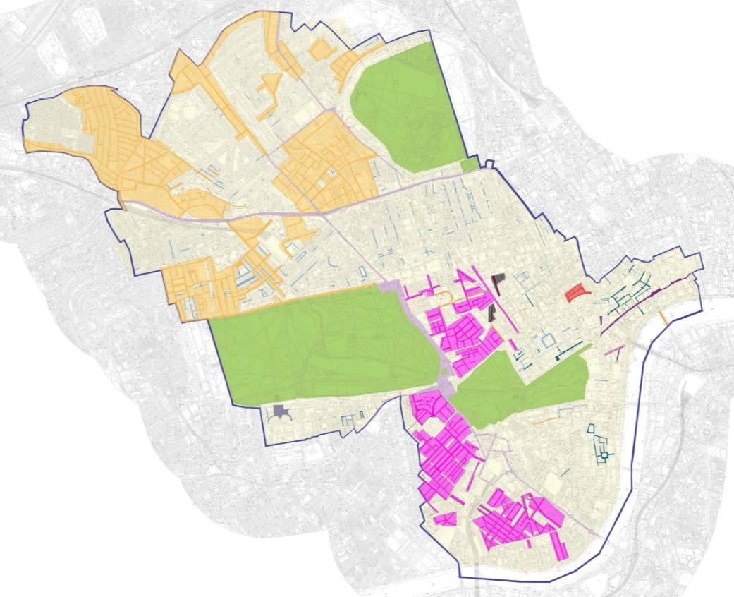
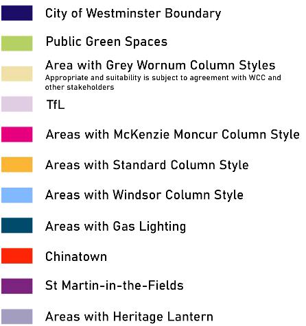
The primary function of lamp columns is to light the highway They provide consistent power, which means that in appropriate circumstances they can be used to attach electric vehicle charging, festive decorations, hanging baskets, smart sensors, smart cells and Wi-Fi 57 devices amongst others. However, these demands often overlap, putting pressure on our lighting infrastructure and power supplies
Within the city there are many different types and designs of street lighting columns, therefore, it cannot be assumed that all columns can accommodate the integration of attachments.
The City Council is able to future proof some columns by installing double door columns as standard on some types of columns across the city when the columns are due for replacement, so that there is enough room in the column for other equipment.
A rental fee will be charged for the columns in use, which has been independently assessed for rental cost in Westminster.
The Council's Third Party Attachment guide shall be used to request attachments to columns for the City Council to review and advise next steps, and may include fees to undertake structural assessments, electrical works to accommodate attachment, and ongoing energy usage payments. The attachment may also need to be taken down if the column is required to be replaced or requires painting as part of planned works.
Greening of lamp columns in the form of ‘living pillars’, for example, can cause problems with rust to the lamp column, requires manual watering and also carries risk of failure of the planting. The plants themselves need appropriate growing
57 See government definition of Wi-Fi and the difference between Wi-Fi and 5G; Code of practice for wireless network development in England - GOV.UK (www.gov.uk)
conditions – sunlight/shade depending on their species and are therefore location dependent and biodiversity sensitive, bees for example, do not survive with their removal.
Westminster’s Temporary public lighting works 58 advises on the procedures and requirements where public lighting is requested to be removed, which includes the provision of temporary lighting, for example, whilst scaffolding, hoarding, and development work is undertaken. Essentially where any scaffolding or hoarding is being considered the design, construction, and maintenance of it must take account of the public lighting service and look to ensure it is not adversely affected by the works.
A. Anyone considering attachments to Westminster’s lamp columns, from signs to sensors, cameras and small cells need to engage and seek approval from the City Council.
B. Proposals must follow the third-party attachment guide on the City Council’s website and complete the column attachment form. The Street Lighting team will assess the safe use of the column and advise of any and all costs
C. Lamp column attachments may be subject to structural condition surveys (which assesses both metal deterioration and how additional loading may affect the life of the column).
D. Anything powered needs to have its energy paid for and anything powered on the highway should have an approved unmetered supply user group code
E. Listed columns will not be allowed anything attached to them without obtaining listed building consent, which in the majority of cases will not be approved as they are detrimental to the special interest of the listed asset.
F. Attachments will not be allowed on cherished assets in most cases
G. Any works to attach attachments to lamp columns must take account of their primary function and need for the highway to be adequately lit.
For further information please visit: https://www.westminster.gov.uk/roads-and-travel/street-lighting/street-lightingcolumn-guidance
Light columns are preferred for highway lighting; however, use of wall mounted lighting can increase the space available for unobstructed movement, or if physical constraints make columns unsuitable.
Approvals from building owners will be needed to attach lights, bracketry, cabling, and conduit as part of a wayleave agreement. Even with the London Local Authorities Act 2007 (LLA), an enforceable piece of legislation, delays to lighting the highway may result if not approved with building owner at an early stage of a design.
A. Consideration should be given to wall mounted lanterns in congested areas if wayleaves can be negotiated first
B. Appropriate approvals must have been agreed with building owner via wayleave agreements or the London Local Act 2018 (LLA)
C. Where wall mounting is the preferred option, the fixings and anchorage must be secure and suitable for the building, which may include internal wall ducting.
D. Adequate space should be provided for feeder pillars for non-column wall mounted and catenary style lighting.
E. Wall mounted or catenary lighting should be at least 5.7 meters above ground level and more than 2.5 meters away from any other powered equipment to allow for maintenance, reduce light blocking from these fittings and safe earthing distances for persons maintaining, reducing potential for electrocution.
F. When considering any fixing to a building, those undertaking the design and installation of such works shall refer to the Construction Fixings Association (CFA) guidance note regarding anchorage systems (www.thecfa.co.uk). Contractor vehicle access to maintain wall lights will be needed at all times for maintenance purposes and must be considered at the earliest design stages.
58 WCC Temporary public lighting works May 2020: https://committees.westminster.gov.uk/documents/s38070/5.%20WCC%20temporary%20public%20lighting%20works.pdf
For lighting standards see chapter 4.12 Power and Lighting
City Plan policy 19 Digital infrastructure, information and communications technology sets out how the planning system will support investment in digital and telecommunications infrastructure.
Wi-Fi connectivity is becoming an increasingly used service in a public realm setting, as many individuals work in a more agile way and social networking and internet browsing on the move is common Wi-Fi has the ability to increase the accessibility of public spaces, allow public spaces to be used flexibly (e.g. for leisure or for work) and can encourage people to spend longer dwelling periods in the public realm. This helps provide natural surveillance and reduce risk of crime. Having increased Wi-Fi can assist people with wayfinding and allow people to raise an alarm via phone if in danger.
The City Council has also been rolling out small cell units (4G) in the public realm, with over 300 units in the public realm at the time of writing Small cell installations require the correct infrastructure for the best connectivity and for health and safety purposes. To date, the most appropriate infrastructure has been lamp columns, preferably between 5 and 8 metres high as these are a powered item of street furniture regularly positioned along the public highway In some circumstances buildings and other street furniture have also been used to host small cells
As future Wi-Fi and small cell equipment may change in size and shape, it is important to ensure that the public realm is future proofed for these considerations as connections and power supply requirements may evolve
Small cell installations may be considered within public realm scheme design. These help to improve mobile connectivity by infilling capacity not-spots which improve user experience of the networks.
A. User comfort and usability must be considered when installing Wi-Fi as part of a public realm scheme
B. Wi-Fi provision should be incorporated into existing street furniture elements or through delivery as part of a multifunctional element, as much as practicable.
C. Lamp columns are the preferred location for Wi-Fi and smart technology.
D. Where lamp column attachment is not appropriate, alternative small feeder pillars can be considered to store some equipment in an appropriate location nearby.
E. Aesthetics must be considered for the appearance of attachments, with colour to work with the Council’s streetscape of black, and minimal size and shape
F. Energy usage costs to be covered by attachment owner
G. Opportunities to increase the overall capacity of the publicly accessible Wi-Fi network will be considered
H. Loss of Wi-Fi capacity should be resisted without replacement.
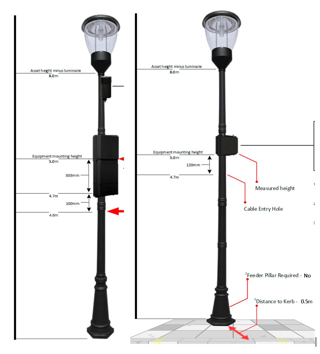
‘Smart Sensors’ are devices which capture physical information from a site and convert it into electrical data to enable measurable outputs such as remote monitoring and management of on-site environmental conditions and activity.
These have been used in Westminster to monitor air quality, capacity of drainage gullies, traffic volumes, traffic types and speed on road network. They can enable proactive decisions to be taken on the management and maintenance of our public spaces and infrastructure, provide adaptability and resilience to help reduce the risk of failure of our assets, for example to avoid instances of flooding by ensuring gullies remain clear of obstruction.
Making use of remote monitoring and data modelling enables the City Council to develop its maintenance programmes in a proactive and targeted approach.
3rd party smart sensors can we welcomed if they add benefits to public users. There will be adequate charges to evaluate attachments and ongoing costs to sensor owners for maintenance and energy usage and regular structural testing and any maintenance required.
A. The City Council supports the use of smart sensors, in appropriate locations, attached to useable council assets, where there is an agreed demonstrable need for the information which they will collect, and where there is a clear plan for how the data collected is to be used to improve conditions in the public realm. All data must meet requirements of General Data Protection Regulation (GDPR) suitable for its usage
Requirements for third party smart sensors / monitoring equipment are set out in the City Council’s ‘Third Party Attachments / Smart Lighting Column Guidance’ May 2020
Bus shelters are provided by companies in contractual arrangements with Transport for London (TfL). Manufacturers will be encouraged to combine functions in new concept designs provided the width of the obstruction together with the space needed to use the additional facilities does not impede the pedestrians using the street.
TfL is responsible for the selection, procurement, payment, design, maintenance, cleaning and removal of all bus shelters at TfL Bus Stops on all TfL Red Route and Borough Highways. To this end they specify and maintain a standard and limited range of designs - and that greatly restricts any scope for the City Council to influence on its design through the new SPD.
As Westminster City Council does not have jurisdiction to wholly influence the standard TfL design some brief guidance and expectations in relation to bus shelters are outlined below. It is important to consider placing bus shelters on wider footways so that passing pedestrians can be accommodated for within the pedestrian clear zone. Bus shelters protect passengers from the elements, and should be placed as close to main bus, tube, and train stations as possible. Redundant bus shelters should be removed by TfL.
Whilst bus shelters do not always require planning permission, the City Council does sometimes have to deal with and arrange for the moving of TfL shelters. Illuminated and digital advertisements on bus stops require consent.
A. TfL bus shelters should use a standard TfL design.
B. Proposals for bus shelters should consider accessibility needs and incorporate a minimum 100 mm kerb height and maximum kerb height 140mm for a bus to deploy a ramp safely
C. Units which are predominantly made from glass in structure should have clearly contrasting plastic panelling to ensure they are inclusive and suitable for those with visual impairments
D. Provide passenger shelters and resting opportunities and any key information on routes, timetables, and mapping at all stops where feasible, to ensure the best possible passenger waiting environment.
E. Maintain a minimum pedestrian clear zone of 3 metres, increased to 4.5 metres by shops.
F. Designs must consider the placement of the bus stop in relation to queuing passengers.
G. Designs must follow TfL’s consistent design standards, allowing passengers to locate the correct stop easily and board and alight safely and conveniently.
H. TfL bus shelters should be sited sensitively where they may affect the setting of a nearby listed building or structure.
I. Any new bus shelter site should be fully evaluated through an Equalities Impact Assessment (EqIA) evaluation including an independent consultation with a mobility group
J. Floating/Island bus stops on cycle routes require careful consideration due to the high numbers of people that use Westminster’s Highways network, and the increased risk of collision between people getting on and off buses and those passing on bikes that these layouts bring with them. The use of floating/island bus stops should be carefully considered in terms of their impact on people with protected characteristics, in particular those with visual impairments. Adequate circulation and orientation space must be maintained. Suitable alternative options and means of mitigating pedestrian-cyclist conflict should be considered prior to proposing their use.
K. Bus stop shelters should be removed if no bus service stops there
For more information please see: Accessible bus stop design guidance (tfl.gov.uk)
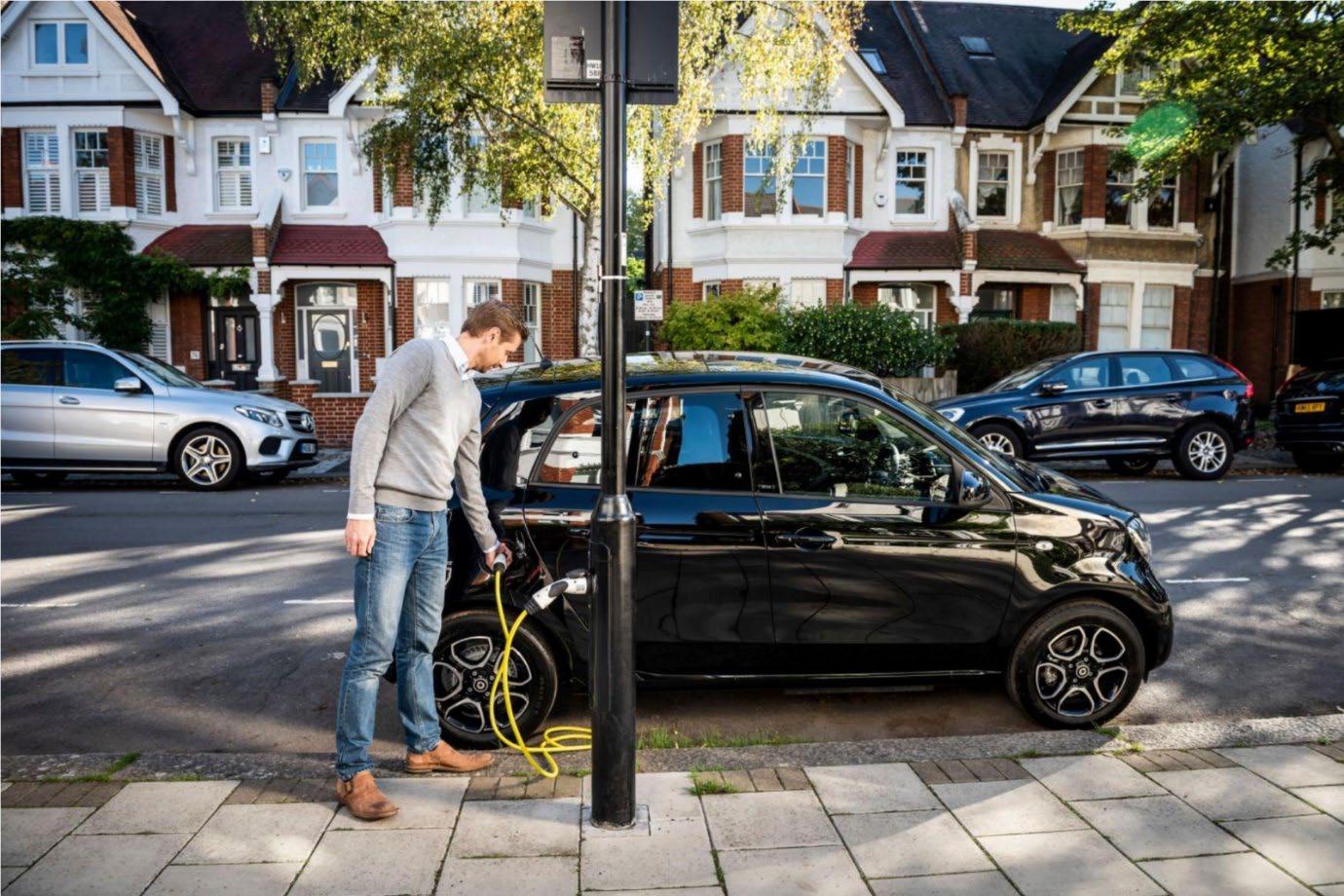
The City Council is taking a proactive approach to introduce new initiatives to achieve a net zero council by 2030 and a net zero city by 2040. Initiatives that facilitate sustainable modes of transportation – walking, cycling, public transport and electric vehicles (EVs) – are among some of ways through which the council is hoping to enable a greener and fairer city.
City Plan Policy 26 Public Transport and infrastructure (C,2) supports car clubs, cycle hire facilities and other sustainable transport initiatives such as EV charging infrastructure where they do not detrimentally impact upon public realm improvements and pocket parks.
A lack of charge points is often cited in consumer research as a key reason why some people will not consider buying an EV. The City Council is keen to address this concern by installing further EV chargers across Westminster.
The installation of EV chargers has been driven by demand from residents and local businesses. Requests for local charge points in December 2018 – October 2021 exceeded 1500, and with thorough planning of the latest installations 98.5% of those requesting live within a 3-minute walk of a charge point. EV charger locations have been selected to ensure an appropriate ratio of charge points to EVs exist in all wards in the city. The ratio is approximately 3 EVs to each charger as of 31st March 2024.
Our goal is to make it as easy as possible for residents, and those driving commercial and works vehicles into the city, to switch to a less polluting electric vehicle. The City Council will therefore prioritise alternative kerbside uses (such as car club spaces, cycle parking and electric vehicle charge points) ahead of parking for private vehicles However, space in Westminster is limited, and our overall ambition is to reduce clutter in the public realm.
• Whilst EVs are more carbon efficient than diesel- and petrol-powered cars, they still emit harmful air pollutants from the brake pads and tyres and contribute to traffic congestion. The council therefore encourages the use of sustainable travel such as walking, cycling, and using public transport, in the first instance
• Legislation: Local Authorities and Transport for London Act 2019
Challenges
• Ability to secure suitable charge point locations given competing demands and London’s limited land availability.
• Cost of energy grid upgrades.
• Charge point infrastructure is particularly difficult to install in heritage locations in the city because of the presence of underground services, basements and narrow footways.
Key benefits of using electric vehicles
• There are clear benefits of using EV over legacy Internal Combustion Engine (ICE) vehicles, the council is committed to rolling out a charging network.
• Opportunities also exist from the battery storage offered by EVs. Vehicle to Grid (V2G) capability exists within the charge points on the Westminster highway allowing the transfer of energy back to the grid from connected vehicles.
Cleaner and Greener
• The City Council will proactively support the shift to electric vehicles from petrol and diesel, most notably for servicing; public transport; essential operational vehicles (e.g., police, ambulance, refuse, public utility, etc)
• Installing on-street charging facilities will subsequently help to achieve the aim of a cleaner and greener city for all and to be carbon neutral by 2040.
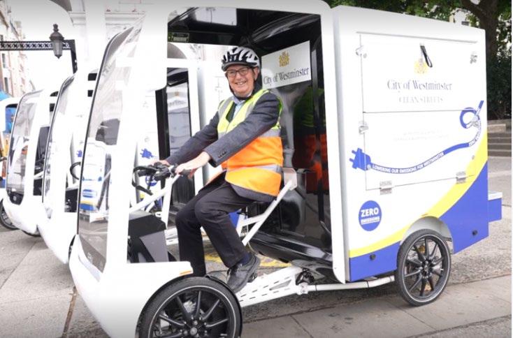
The City Council will:
• Continue to roll-out electric vehicle charge points in consideration of the demand for them.
• Co-locate points with other street furniture, including attaching to street light power sources to avoid street clutter and obstructions to pedestrians and cyclists.
• For more information about EV charging and EV use in Westminster please visit: Electric vehicles | Westminster City Council
• Ways to integrate and/or implement EV charge points for public usage without cluttering the public realm are needed
• In residential areas EV chargers will be primarily located in lamp columns enabling people without driveways to charge overnight. In central areas the focus is on rapid charge points for freight vehicles and taxis.
• Reducing street clutter is a key priority at the City Council, some of the ways in which this can be achieved is by the following: bigger items of street furniture should be redesigned to be multifunctional, and some (particularly electrical equipment) housed in lighting columns.
• There are a range of highway users with competing demands whose needs must be catered for. The public realm must reflect these needs and requirements for both road and footway users.
• Freight and servicing requirements should be considered when allocating space for EV chargers, both for their shortterm use of charge points and not to hamper any servicing needs.
• A more common solution is to install charge points in lamp columns in residential areas, a new power connection or upgrade, does not require planning permission or street works. They are cheaper and faster to install than freestanding column chargers and physically and visually less obtrusive, have a low energy output and are typically used by residents over longer periods such as for overnight charging.
• Statutory signage/road markings would be used and all kit black throughout the city. Where there is possibility, charge points should be installed in under-used parking bays or streets.
• City Plan: Parking policy 27 states that all new parking spaces should provide provision for electric charging vehicles.
A. Clear signage and painted bays help EV drivers find charge-points.
B. To avoid creating a tripping hazard, charge- points should not be placed at the back of a pavement or wall-mounted, where this requires cables to stretch across a pavement.
C. Vehicles charging on the public highway must do so from infrastructure that is appropriately managed and regularly maintained, in compliance with applicable regulatory standards, to ensure public safety. Consequently, the City Council does not sanction EVs charging on the highway from a private supply off street.
D. A clear distance of 2.5 metres should be maintained between the charge point, feeder pillar and vehicles connected with other electrical infrastructure, on a different earthing system, on the highway.
E. Avoid installing charge- points in locations where the available pavement space has already been restricted by other street furniture, such as road signs, feeder pillars, and bike racks.
F. Standalone EV chargers should not block the footway, appropriate space should be left for pedestrians, push chair and wheelchair users to utilise the footway unimpeded (2 metres) and should be placed in the carriageway unless in exceptional circumstances such as on very wide footways (over 2 metres wide) and or high parking stress areas. Furthermore, EV chargers should not block crossing points, both in terms of vision and entry points, nor accessibility parking bays.
G. The colour of EV chargers and associated feeder pillars is black in Westminster as per the City Council’s design principles. Those currently used are approved and are acceptable under the Westminster palette
• To find your nearest Electric Vehicle Charge Point please visit: ZAP MAP, other maps are available online including the council’s map:
• Map of electric charging points for electric cars UK: Zapmap (zap-map.com)
• Electric Vehicle Charge Points (arcgis.com)
• The Council expects consistency in charger location (in a line) and design, within a locality.
• Technical Specification: EV chargers installed across the city range from 3kW to 50kW.
• Technical specifications for EV chargers are set out in the procurement documents when we go out to tender. Any sites installed by third parties are further validated by our service provider to ensure they meet the council’s specifications.
• EV charge point should be well maintained and function well, with responsibility for their maintenance, as well as the customer relationship, covered by contractual terms.
• The Council’s EV contracts cover the installation and maintenance arrangements for EV chargers on the highway to ensure they are well-functioning, and availability is optimised.
• Vehicles charging on the public highway must do so from infrastructure that is appropriately managed and regularly maintained, in compliance with applicable regulatory standards, to ensure public safety. Consequently, the City Council does not sanction EVs charging on the highway from a private supply off street.
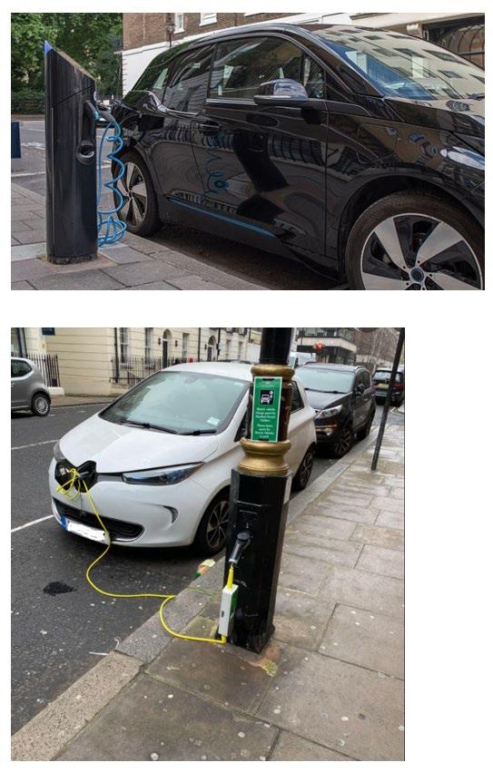
Sub-topics
Freight and servicing:
• It is important to ensure that there are suitable fast-charge points in appropriate locations, for delivery and servicing bays for goods vehicles, given the high volumes of freight, servicing and delivery traffic in Westminster.
• Utilising electric vehicles for the last mile or consolidating loads are just a couple of examples of how freight and servicing can be done in a more sustainable way.
The Future of EV Charging
Proposals for new infrastructure
• Future proofing the public realm will be essential in the coming years, consideration should be given to implementing future infrastructure.
• Future innovation may include but is not limited to, Hydrogen, EV wireless charging and fuel cell powered vehicles. This would be subject to trials ahead of any roll out.
• The Council will review requirements for new electric vehicles, as technology advances.
• Provision of EV charge points and hubs will be prioritised on a basis of demand.
• Look for opportunities to install Ultra-Rapid chargers and other higher output chargers if demand requires it and locations can accommodate it However, off street locations are better suited to accommodate this type of infrastructure.
• The City Council is investigating the possibility of installing one or more rapid charging hubs in the city (TfL’s definition of a hub: 6 or more rapid chargers in close proximity) which if progressed would notably benefit commercial EVs.
• The City Council will look to facilitate the opportunity to develop EV charging facilities within its car parks.
• The expectation is that the private sector will take the lead on introducing charging hubs as EV usage increases. This is already evident in Westminster with charging hubs appearing in Q-Park car parks and also at Aldi on Edgware Road. We can expect to see the transition of petrol station sites too with growth in EV ownership, noting that all of the major oil and gas companies have a stake now in the EV charging market, as evidenced by the Shell Recharge station on Fulham Road.
Further Guidance
Links and Related Documents and Strategies
Sources:
• Westminster goes electric with 1,000 electric vehicle charge points | Westminster City Council
• https://www.westminster.gov.uk/parking/electric-vehicles
• Local-Authority-Guidance-Positioning-chargepoints.pdf (energysavingtrust.org.uk)
• London electric vehicle infrastructure delivery plan (tfl.gov.uk)
• Electric vehicle charging in residential and non-residential buildings (publishing.service.gov.uk)
• Westminster Electric Vehicle Infrastructure Charging Strategy 2019 - 2025
• (https://committees.westminster.gov.uk/ieDecisionDetails.aspx?ID=1167)
Utility cabinets are permitted development 59 They are distributed by the service provider in locations which best serve their network and in accordance with the operator ’s code.
While operators are allowed to install utility cabinets on the public highway without the need to ask for planning permission, the City Council encourages them to give notice to officers so that the council is sighted and can raise any issue with the proposed location if needed.
Cabinets can be costly to remove and/or relocate. Utilities providers can advise on whether cabinets can be removed or relocated.
Further guidance on services and utilities can be found in the Services and Utilities Section below.
A. Utility cabinets should be at least 1000 mm high and should have a consistent width to ensure accurate ground level detection.
B. Where a cabinet cannot be located against the back of the footway, doors should open so that utility operatives face towards the carriageway or oncoming traffic.
C. Consideration should be made to street cleaning and preventing build-up of rubbish behind cabinets where they are not placed against a wall.
D. Utility cabinets should be painted black to blend with the broader Westminster streetscape. In some locations cabinets may be painted beige and or green to blend with surroundings for example in a park. Low-profile clear matt anti-graffiti finishes facilitate the removal of graffiti and fly-posters
E. Utilities equipment should be housed safely and locked in cabinets with the aim to prevent inadvertent contact by unauthorised people.
F. Ownership / contact details should be discretely visible on each unit.
Telephone Kiosks
Telephone boxes are the responsibility of the telecommunication operators. The council will work with telecoms operators to ensure they minimise harm to the visual amenity of the area, and do not cause or contribute to antisocial behaviour.
The Giles Gilbert Scott designed red telephone boxes (K2s and K6) are common and a widely recognised feature on London’s streets, many of which are designated listed structures and make a positive contribution to Westminster’s streetscape. The council will take a proactive approach to ensuring that listed red telephone boxes are kept in a good state of repair where appropriate.
Where boxes have fallen into disuse or suffer from regular antisocial behaviour, the council will consider proposals for alternative uses. Any alternative uses would have to demonstrate they would conserve or enhance special interest of the phone box
The council prefers the removal of telephone kiosks unless they are listed or of particular townscape value. Where modern telephone kiosks are no longer commonly used or have been disconnected, and are primarily used for advertisements, the Council will seek removal.
Telephone Kiosks Guidance:
A. Listed red telephone boxes should remain located in their original position. The relocation of listed boxes will only be considered where it forms part of a wider public realm improvement, although listed building consent would be required for the removal, storage, and relocation of the box.
59 See Glossary for definition of terms
B. The required planning permissions must be secured with the City Council’s Planning Team and BT before the adoption of a telephone box takes place and/or relocation is considered.
C. Illuminated advertisements, including digital screens, will generally be resisted on telephone boxes and other on-street communication installations. See chapter 4.13 Signs and Advertisements for further detail on advertisements in telephone kiosks
D. Novel kiosk-style structures which incorporate other functions, including advertising screens, will generally be resisted
E. If a kiosk is no longer required, it should be removed.
F. Use of kiosks for non-statutory provision of telecommunications services will generally not be supported
Letter boxes are permitted development and are the responsibility of Royal Mail.
Standard letter boxes are red, except in very exceptional circumstances. Letter boxes survive from every period since their first introduction in the mid-nineteenth century. They are a characterful and well-loved element of Westminster’s Street scene. Some of the most exceptional examples are listed, though unlisted letter boxes are also considered to make a positive contribution to the character and appearance of areas, and as such are considered to be cherished items of street furniture.
A. Some letter boxes are listed structures; these should not be removed.
B. Letter boxes should not be installed where the footway clear zone will be less than 2 metres wide.
C. When appropriately designed and located, the council support the placing of boxes within external walls of buildings.
D. Any proposals impacting letter boxes must be coordinated with Royal Mail and the City Council.
Scaffolding and hoardings should have a colour contrast at the skirting to any hoarding, to provide smooth surfaces to a height of approximately 1.2 metres, and to mark projecting corners and change of direction of hoardings with black and yellow markings on both faces at the corners. Contractors must adhere to Police guidance 60 and avoid ‘tunnels’ through gantries and scaffolding by leaving them as open as possible above that height. They should also refer to Westminster’s Temporary Public Lighting Guidance 61
60 National Business Crime Centre (2019) Construction Site Security Guidance. Available from : nbcc.police.uk/images/Construction_Site_Security_Guidance_Edition_1_01.pdf
61 Westminster City Council (2020) Temporary public lighting works. Available from: https://committees.westminster.gov.uk/documents/s38070/5.%20WCC%20temporary%20public%20lighting%20works.pdf
Related SPD sections
• Context
• 4.3 Green and Blue Infrastructure (including SuDS)
• 3.1 Equality, Accessibility and Inclusive Design
• 4 4 Microclimate and user comfort
Key City Plan policies

43. A Public Realm
43. B An Inclusive and Accessible Public Realm
One of the overarching objectives of the NPPF is to protect and enhance our natural, built, and historic environment: using natural resources prudently, minimising waste and pollution, and mitigating and adapting to climate change, including moving to a low carbon economy.
The City Plan requires development to make use of high quality and durable materials capable of easy maintenance and cleaning, and the integration of high-quality soft landscaping as part of the streetscape design, using high quality new, or reinstated paving materials whose colour and texture underline a sense of place and consistency of materials and have an appropriately engineered surface that is fit for purpose.
Westminster is at the forefront of developing low-carbon highway schemes for widespread implementation. The City Council is committed to significantly reducing its carbon footprint with the use of carbon efficient materials, which are sustainably sourced, delivered, installed, maintained, and where possible reused at the end of a project’s life, to support the City Council’s ambition to be carbon neutral by 2030. This will be supported by the City Council’s Highways Carbon Management Plan 2024/5 62
Material choices for new public realm projects and maintenance schemes should consider the whole-life span of those projects, from material selection and sourcing, through to delivery, construction, operation, use, maintenance, end of life/removal and re-use.
The sustainable impact of materials is a crucial consideration for Westminster. With the climate emergency declared in 2021, it is imperative that materials, from their supply chain through to decommissioning, contribute positively to the environment.
The carbon impact of different modes of transport and fuel types should also be assessed, especially where heavy vehicles/machinery are not likely to be required. There is an option to reduce trips through consolidation and efficient planning of logistics, and to take any essential trips by sustainable travel modes.
Supply of materials should encourage use of sustainable fuels.
The weight of transported material should be reduced as far as practicable with reuse being promoted through careful specification as well as buying with takeback agreements.
All materials should adhere to:
NRSWA - New Roads and Street Works Act 1991 (legislation.gov.uk)
SRoH - Specification for the Reinstatement of Openings in Highways - Fourth edition (publishing.service.gov.uk)
62 Currently in development
The below guidance sets out the City Council's approach to material and paving choices, sourcing, implementation, operation, and, where appropriate, reuse in the public realm, and is to be used in assessing future proposals.
The principles of material choices are set out below. The appended Materials Palette (Appendix 2 – linked to below) identifies the recommended and accepted materials for use across the city and sets out their specific technical properties and suitable areas for their usage.
A. Paving materials should enable safe and efficient movement for pedestrians, cyclists, and vehicles.
B. The selection of materials and how they are laid should be appropriate to the context, both in terms of their appearance and functionality, thereby being fit for purpose in the longer term.
C. To ensure longevity and minimise carbon emissions throughout the project’s lifecycle, all chosen materials should comply with the standard technical requirements
D. Materials with limited functionality and / or high maintenance requirements should be avoided, especially when these are primarily proposed for aesthetic purposes.
E. Materials with a longer lead time of 4-5 months should be avoided.
F. All public realm design should seek to complement and seamlessly combine with the surrounding heritage infrastructure where applicable and complement and enhance the area where it is situated
G. Public realm design should be consistent across ownership, particularly where the public realm intersects and extends (in use) to privately owned land. Partnership working to achieve consistency is encouraged.
H. All designs should demonstrate value for money with respect to initial and operational environmental and economic costs.
I. The final design and materials selection of colour combinations should be consulted and agreed upon with the City Council on a case-by-case basis.
See appended Materials Palette Appendix 2 for detailed standards.
The intensity of use and associated wear of materials varies across the city. Footways in primarily residential areas generally sustain lower levels of wear in comparison to heavily trafficked commercial areas which require different treatments, maintenance, and cleansing regimes.
These requirements should be carefully considered in selecting the most suitable materials and construction technology in any public realm scheme.
Engineering judgement should respect minimum standards set out in the Materials Palette Matrix, aligned with the relevant design standards, and be applied for suitable locations. For example, when possible, the use of thinner slabs to minimise carbon is the general recommendation where light use is expected, but thicker slabs are required in areas likely to experience vehicle overrun is expected.
A. Material choices should reflect the function and planned use of the space.
B. The materials and construction depths should be suitable for the planned purpose, based on thresholds, expected loading, and existing ground conditions.
C. The potential of structural material strengths should be optimised, avoiding under or over-designing the public realm.
D. All selected materials should be technically assessed to ensure their long-term durability with regard to maintenance, structure and function.
E. Over specification of materials is not supported where this would have negative environmental impacts.
F. Expected life of the material must be considered to ensure that the longevity of the scheme is maximised.
Providing a Healthy Environment
Material Selection for a Healthy Environment Guidance
G. Material selection and implementation should contribute to society as stated in the Healthy Streets for London guidance to make London's diverse communities greener, healthier, and more attractive places to live active lifestyles, work, play and do business within a safe and sustainable public realm.
H. Projects should aim to positively address local health and wellbeing by incorporating measures to lower emissions, reduce the harm caused by air pollution, and minimise acoustic impact, reducing noise levels.
I. Vegetation should also be considered as it reduces air pollution, provides a noise barrier to vehicle traffic, and reduces noise reflection while enhancing biodiversity and promoting wildlife.
J. Green and blue infrastructure, for example storm drainage, should be included where possible as these positively affect air and noise quality.
Materials Design:
Public realm design in the city should be simple at its core to avoid creating visual clutter and detracting from an already ‘information-rich’ streetscape. A simple palette of materials and colours coherent with the area’s character and use will ensure uncluttered-looking streets and public spaces.
When designing public spaces, the appropriate material choice, design and construction depend on: the townscape conditions and surrounding buildings, in addition to the intended use, any risks to maintenance and longevity, and the existing ground/environmental conditions.
Paving materials add to the attraction of character areas such as Covent Garden and Soho, which have a mix of building styles, where the relatively homogenous uniform paving helps create a sense of place, making it feel like a distinct area in its own right.
Piecemeal designs tend to segregate rather than unify the public realm and detract from the harmony within the city's built environment.
It is essential that all public spaces have a consistent design and that this is maintained throughout the area. The use of a limited palette will support the conservation of the city’s identity and guarantee consistent, high-quality maintenance and development of new schemes aligned with the city’s overall vision and commitments.
Materials Design Guidance:
A. Material design should be simple, coherent, and consistent.
B. Material choices should contribute positively to the surrounding built environment.
C. Any materials and design proposed should respond to the local context, for example, conservation areas, market places or character areas with high footfall, especially as different requirements may arise due to the specific function of a place.
D. New developments should consider materials and designs that provide continuity with all adjacent sites and buildings.
E. Use of colours and patterned surface treatment should be subject to the appropriate level of Equalities Impact Assessment.
F. Materials with limited functionality should be avoided.
G. If a material is proposed for primarily aesthetic purposes, it is unlikely to meet the other guiding principles of this document.
Accessibility:
Consistency of approach and materials is best practice to aid accessibility. This enables individuals – disabled or not – to travel independently across a wider radius without having to learn and adapt to different designs and meanings of surface materials.
Plain and consistent paving, with porous surfaces to reduce potential for slipping in wet conditions and aid drainage wherever possible, and with a distinct tonal contrast from road surfaces, is the recommended option for people with dementia, and is also the most suitable option for people with other disabilities and is therefore considered to be the best choice for updating Westminster’s public realm.
A. The public realm should provide a consistent, stable pavement, without loose elements, with a homogeneous surface, which is non-slip in wet and dry conditions.
B. Even surfaces should be provided wherever possible.
C. A wet slip resistance value (SRV) of greater than 36 is recommended, increased to greater than 40 where wheelchair user or pedestrian with a pushchair or pram is likely to be turning.
D. A roughness of >20 microns reduces the risk of those with mobility impairments or visual impairments slipping in dry conditions
E. Confusing patterned paving designs in the public realm are not congruent with our commitment to making our environments more dementia-friendly and will not be supported.
F. The introduction of cobbles or small-set block paving should generally be avoided.
G. Smooth, sealed solid surfaces, such as asphalt, offer the best conditions for everyday cycling.
H. Textured surfaces such as block paving and setts can help reinforce cyclist speed reduction where they provide a visual and audible reminder of low-speed environments.
Tactile paving refers to repeating textured pavement surfaces, which can be universally recognised by the visually impaired, increasing accessibility and safety of our public realm.
‘Blister paving’, indicating the borderline between the pavement and the road, is the most recognised form of tactile paving. It comprises rows of flat-topped domes around 5mm high.
Linear ‘corduroy’ paving is used to warn of specific hazards, such as steps, and comprises rounded bars running across the direction of pedestrian travel.

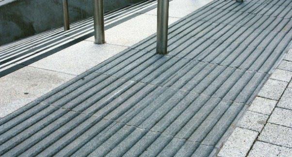
The distinction between ‘standard’ 63 and tactile paving materials helps visually impaired people to understand where they are in the public realm, where crossings are, whether these are controlled or not, and whether there is a change in surface, activity, or a specific hazard that they need to be aware of.
A distinct tonal contrast between the footway and carriageway surfaces, and access points between them, can also increase the accessibility of the public realm for neurodiverse people and those with dementia, as well as the visually impaired.
Whilst tactile paving typically delineates the edge of a particular space or level change, ‘tails’, also known as ‘stems’, or ‘Lshaped’ configurations, are used to indicate to people moving along the pavement the location of crossing points to their side.
The provision of the right type of tactile paving to aid accessibility is a fundamental requirement of any public realm scheme, with consistency key to ensuring accessibility in maintained across London. Worn and inconsistent use of tactile paving is confusing to users and poses safety concerns.
Metal studs have in the past been used in place of tactile paving slabs, however, these can become slippery when wet, are generally more painful for people with sensitive feet and wheelchair users, and heat up on hot days becoming painful for dogs’ feet.
Stick-down style tactile paving used as a temporary measure is prone to damage and wear.
Whilst the Department for Transport (DfT) guidance on tactile paving recommends use of red blister paving, with exceptions made in heritage areas, red blister paving is not proposed to be used in Westminster; 78% of the city is covered by Conservation Area, and the use of different materials in the remaining 12% of the city would result in an incoherent pattern of use.
A. The provision of the right type of tactile paving to aid accessibility is a fundamental requirement of any public realm scheme.
B. Tactile paving should be applied consistently.
C. Tactile paving should meet DfT standards.
D. Blister paving should be used to indicate the location of controlled and uncontrolled crossing points. This includes both where the footway has been dropped flush with the carriageway, and where the carriageway has been raised to the footway level.
E. ‘Tails’ should be used to indicate the location of controlled-crossing points to people moving along the pavement. These must use the same, recognisable form of tactile paving, as the feature they are leading people to.
F. Tactile paving at uncontrolled crossing points should be buff, or another colour that provides a clear colour contrast with the surrounding footway and the road.
G. Grey tactile paving should not be used where it does not contrast with the surrounding area.
H. Dark colours are unlikely to comply with our public commitment to make Westminster dementia-friendly.
I. Some relaxation of the colour requirements may be acceptable in conservation areas or in the vicinity of a listed building, in discussion with local groups of vision impaired people, mobility specialists, and the council’s conservation specialists. In these limited circumstances only, the tactile surface may be provided in a colour that is in keeping with the surrounding material.
J. Bespoke tactile paving designs, including the use of metal studs, will generally not be supported.
K. Tactile paving should be retrofitted into existing schemes whenever opportunities arise.
L. The preference is for permanent, rather than temporary “stick-down” paving.
M. Corduroy paving should be used to warn of hazards such as the top and bottom of steps, where it should extend across the full width of the steps.
63 In this case “standard” refers to the majority paving type
N. Corduroy warning of steps should be placed sufficiently in advance of the steps to give time for people to adjust their steps and not miss the warning.
O. Dedicated shared spaces for pedestrians and cyclists should be clearly demarcated with material changes at their start and end, as well as along the length of the track.
Material selection should follow BS EN 15209 Tactile paving surface indicators produced from concrete, clay and stone. This should be applied alongside the Inclusive Mobility Guidance on the use of tactile surfaces by the Department for Transport.
See The Department for Transport (DfT) published detailed ‘Guidance on the Use of Tactile Paving Surfaces’ for further information.
See TfL’s 2019 Streetscape Guidance for evidence-based examples of the use of tactile paving.
Carbon Reduction
Considerations to maximise carbon reduction:
• Challenge the need for intervention
• Consider alternative approaches to achieving the desired outcomes
• Maximise the use of existing assets
• Design in low carbon materials and operating models
• Minimise resource consumption
• Embrace new technologies
• Eliminate waste
Through specification based on suitable technical properties, modern production, for example, splitting rather than machine cutting of materials, and construction methods to ensure only the correct amount is extracted, produced, and installed to reduce the need for amendments on-site, which minimises disruption, carbon, and pollution and waste of materials.
Material Selection for Carbon Reduction Guidance:

A. A reduction in carbon must be prioritised in line with the carbon management hierarchy set out within the City Council’s Climate Emergency Action Plan.
B. Careful consideration must be given to the choice, sourcing, delivery, installation impact, operation, cleansing, maintenance, and lifespan, including reuse of paving materials.
C. Carbon considerations must include the product’s procurement, installation, replacement, and maintenance throughout the life of a given scheme.
D. Exceeding minimum carbon performance targets will be highly commended, especially through using low-carbon materials and suppliers who provide products with improved environmental performance.
E. A simple and durable selection of footway materials in standard sizes should be utilised.
F. Designers must demonstrate efforts to minimise carbon emissions.
G. Reduction or elimination of material usage should be considered as the first step of the waste and carbon reduction hierarchies.
H. Building less, building clever and building efficiently (maximising re-use) should be implemented once building nothing has been considered.
I. Material choices should respond to climate change.
J. Materials used should be low carbon concrete, granite, Yorkstone or asphalt or equivalent low carbon materials approved by the City Council.
K. Carbon-intensive materials should be avoided, reduced, or substituted.
L. Use of paving materials which are low carbon, sustainable, reliable, and easily sourced from ethical and sustainable sources are preferred.
M. Materials, and their installation, and associated practices, must meet environmental performance requirements set by the City Council, adopted from Publicly Accessible Specification (PAS) 2080.
N. Carriageway materials should contain at least 50% recycled materials.
O. Design and construction processes should incorporate strategies for disassembly and other circular economy principles such as reuse, reduce, and recycle.
P. The long-term health of the asset must be ensured to minimise repairs and the carbon impact from repair and maintenance activity.
Q. In line with the City Council’s current practices, the carbon impact, and monetary terms for the whole expected life of public realm designs should be assessed using industry standard assessment tools to ensure that sustainability has been genuinely addressed in the design
Material Types
The following are the main materials proposed to be implemented in new public realm schemes. Practitioners should refer to the Materials Palette Matrix to find further details such as their technical specifications, preferred locations, and other fundamental points to consider when selecting materials for each scheme.
The prevalent historic paving stone in Westminster is carboniferous sedimentary rock from the English Pennines. The most common are tight-grained blue/grey and buff sandstone from Lancashire, Yorkshire, and other UK counties, collectively often called Yorkstone (see Figure 55). Until the nineteenth century paving in Westminster used large format slabs, typically two feet in width by three feet or random length, many examples of which remain.
Granite cobbled streets, typical of Victorian London, also remain in various streets throughout Westminster, most notably in mews, and on other roads that have not required to be resurfaced in asphalt (see Figure 56).
Where historic paving survives, it is likely to make a significant contribution to the character of the public realm, however the use of cobble stones and other historic materials in new schemes requires careful consideration as they may detrimentally impact on accessibility – being uncomfortable for wheelchair users and a hazard for cane users, and improvements can be made to original surfaces to aid accessibility and maintenance.
Avoiding small unit paving in new schemes enables safer and easier access for many groups who may find it challenging to use uneven surfaces due to temporary or permanent physical/mental conditions and those or using pushchairs, strollers, high-heels, or luggage.
From the early twentieth century the concrete paving flag, or ‘Artificial Stone Paving’ (ASP), was increasingly used (see Figure 57). Whilst these have become the most ubiquitous paving material, their use can be carbon intensive and therefore detrimental to the environment. Use of standard / carbon-intensive ASP is not encouraged where there are more environmentally sound materials available, which may include low carbon specification ASP, to meet the need.
Cast iron coal hole covers are a distinctive feature of pavements throughout Westminster in areas of remnant stone paving (see Figure 58). The covers are typically 12 to 14 inches in diameter and are often decorated with intricate patterns. They are of historic interest and contribute to the character of the city. Most iron works in the public realm are owned and therefore maintained by the utility companies. Where the highway authority replaces the utility company standard cover with a bespoke inset cover, the highway authority assumes the maintenance responsibility for that cover. For more information on drain and inspection covers see Services and Utilities Guidance below.
A. Historic paving materials, including setts, natural stone slabs and coal hole covers, should be retained and where necessary repaired with matching materials.
B. Conservation requirements will demand that cobbles, granite setts or small-set blocks be kept in some historic locations.
C. The use of new cobble setts or small-set cropped paving is to be avoided unless there is a historic context.
D. Where it is to be used in a historic context any new small unit paving should be specified to maximise accessibility.
E. Restoration of cobbled stone pointing can help improve accessibility in historic areas.
F. Regular restoration of the cobble points can help to ensure that the surface remains as even as possible.
G. Accessible routes should be provided through cobbled areas.
H. Causeways of more regular granite setts may be inserted to ensure a continuous network of routes for people with differing access requirements.
I. Such areas must not present high slippage risks in wet conditions or due to wear.
J. In heritage settings new paving should be matched to historical paving and should be laid in a traditional pattern.
K. Historical materials and high-quality new paving should be matched with care and, as far as it is practical, should replicate traditional laying methods.
L. Items of character, such as mounting blocks from the Era of the Horse and coal hole covers (see Figure 58) from the Age of Coal Fires, should be retained as historic features.
A. Where cast iron coal hole covers survive, they should be preserved in situ and should dictate the coursing of the surrounding paving.
B. Generally, these are characterful features in conservation areas that should be retained and replaced in replica when failed and if part of the vault of a listed building must not be removed unless authorised by a prior listed building consent
C. Non-historic coal hole covers can provide an opportunity to install public art, although this will be reviewed on a caseby-case basis.
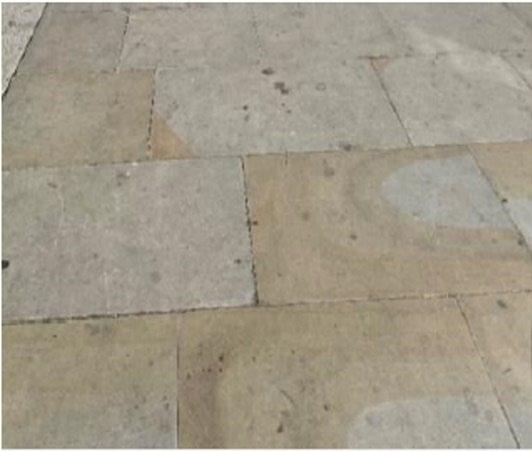

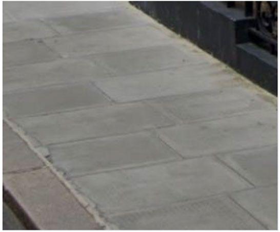
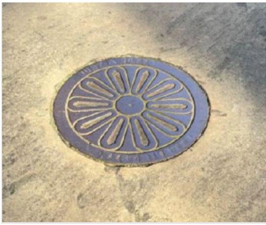
Yorkstone / Sandstone
Yorkstone is a carboniferous sandstone sedimentary rock found in the English Pennines. Sandstones vary in strength, water absorption and other desirable properties, so it is essential to assess each sandstone in its own right.
Guidance:
A. The preferred location for using sandstones, is in heritage areas with high pedestrian footfall.
B. The use of sandstone should be limited in areas with food establishments and markets to minimise the risk of staining the sandstone when exposed to grease.
C. Use of sandstone slabs should be avoided in loading bays as they may break under considerable load.
Granite and Basalt
Granites and basalts are igneous rocks formed through the cooling of molten rock. The city has had prolonged success with both the use of mixtures of colour and the utilisation of darker greys and black in areas where paving is significantly prone to staining.
Basalt and granite cobbles have been used in streets with markets and other areas such as the West End / Leicester Square, where the public uses the space for food consumption and socialising. Granite slabs and setts provide the most durable surface material and can withstand intense wear and hot or pressure washing. Both setts and cobbles have performed exceptionally well under traffic loading when designed correctly
Granite Guidance
A. Granite setts should be considered on carriageways and footways with high footfall and where the public uses the space for food and drink consumption
B. Darker setts and cobbles maybe used in areas where the risk of staining through grease and oil is elevated, such as parking bays and loading bays
C. Granite setts can also be used in trafficked areas such as on speed tables or vehicular crossovers, due to their strength but in high trafficked areas they are not favoured due to the turning movements of vehicles causing breaks in joints and the disruption to the network for replacement.
Other Natural Stones
Porphyry, similar to Granites & Basalts, are igneous rocks formed by cooling solid hot rock. Whilst the benefits of this material are still being assessed, there are currently no identified benefits in using porphyry over other materials and therefore its use will not generally be supported in Westminster.
Black/Dark Grey Sandstones and Mudstones such as Caithness are sedimentary rocks from the Devonian period. Caithness has been applied in Hanover Square. Although relatively new materials deployed in Westminster, these natural stones have desirable properties, such as being strong and hardwearing, which should be maximised through good procurement, design, engineering and construction.
Concrete Materials
Concrete Flags, also known as Artificial Stone Paving (ASP), are a staple of the streetscape in London. They have been successfully introduced in a range of areas. However, they should be avoided or designed to the required standard in locations with expected vehicle overruns to avoid extensive cracking.
Coloured Concrete Flags replicating natural stone products and small elements are undesirable based on appearance and functionality. These types of elemental paving are not deemed fit for Westminster’s streetscape, being hard to source and maintain.
Coloured Flag Guidance:
A. Use of coloured concrete flags is not generally supported in Westminster.
Permeable Paving / Sustainability Standards
Certain materials, such as pervious/porous or permeable paving, and/or paving laid with porous spacing (i.e. space around paving slabs to allow for drainage) support principles associated with sustainable urban drainage as they allow infiltration, water retention and/or attenuation. Special consideration should be given to such materials and their requirements followed to ensure the good functioning of the proposed sub-surface drainage system and avoid clogging.
Appropriate maintenance schedules are expected to be provided by developers, stipulating the tasks and frequencies over the expected lifespan of these materials.
Materials Sustainability Guidance:
A. All schemes must demonstrate the highest sustainability standards during the whole-life span of projects and must consider and, where possible, include the introduction of trees and green infrastructure in combination with Sustainable Urban Drainage Systems (SuDS) for better management of water resources and rainwater run-off.
B. Suitable surface water drainage methods must be designed into all public realm schemes.
C. Where SuDS are proposed, surrounding areas should also be adequately designed and constructed, for example, with inclines to channel water into proposed features. This will maximise the success of these features from a functionality and flood risk reduction standpoint to ensure that the quantified benefits are reaped.
Reflective materials can reduce the ‘heat island effect’, by reflecting rather than absorbing the sun’s heat. The replacement of hard surfaced areas with new grassed or planted areas can also contribute to heat reduction and has other environment benefits 64
D. Designs must consider use of materials to address urban heat retention and deliver a safer and more pleasant environment.
E. Potential for greening of underutilised footway space should be explored.
64 The Healthy Streets for London Guidance
This approach should complement shade elements to improve the experience in resting areas. [see Chapter 4.4 Microclimate].
Tree Pit materials
The surface materials covering tree pits are generally contiguous with the footway, and special consideration is therefore required to ensure that these surfaces perform successfully within the public realm.
Selecting the most appropriate surface materials for trees located in hard surfaces, such as those on footways, highway build outs and in public realm schemes, requires consideration of the needs of the trees, (such as permeability to air and water), highways requirements (for example, providing safe level surfaces), maintenance and installation considerations (including lifespan, sustainability, cost, and ease of installation), and townscape considerations, (including the design intent of particular projects or public realm schemes).
The most appropriate surfacing varies according to the trees and site requirements. The optimum surfacing for a given location may also change over time, as the trees grow and mature. Consideration should be given to the changing future requirements for tree pit surfaces when preparing landscape management plans.
1. Criteria for the selection of surface materials
The criteria for selecting suitable materials can be broadly divided into:
• Tree criteria, such as permeability to air and water, flexibility of material, risk of tree damage during installation and suitability for installation for new trees or established trees.
• Site criteria, such as tolerance to pedestrian or vehicular traffic, maintenance, weeding and street cleaning considerations, townscape and aesthetic issues and community engagement.
• Installation and maintenance criteria, such as level of experience/competence required to correctly install and maintain the surfacing, sustainability and expected lifespan of material.
Trees Appendix (Figure 59) below sets out a list of considerations and a matrix of selection criteria for surfacing around trees as suggested by the London Tree Officers Association (LTOA), in their publication Surface materials around trees in hard landscapes. It illustrates the wide variety of criteria which determine the best surface material for any given situation.
2. Available materials
The most common materials used around trees in hard landscapes in Westminster are:
• Soil
• Self-binding gravel
Other materials include:
• Resin-bound gravel
• Asphalt
• Rubber crumb
Rarely used materials include:
• Inorganic mulch/ materials
• Organic mulch
• Grilles – these can be particularly problematic for people using mobility aids such as sticks, canes, wheelchairs or wheeled walking frames, or for people with assistance dogs
A brief description of the benefits and limitations of these materials and their use in Westminster is set out at the Materials Palette in Appendix 2 of this SPD
The standard specification for new trees planted in pavements is soil. This provides the trees with good conditions for establishment and is low cost, although the pits can become weedy and risk compaction in busier areas.
In commercial areas, areas of high footfall, or on narrow footways, where a more robust surface is required, self-binding gravel or permeable resin bound gravel should be used, according to the site requirements. This can be used to provide adequate pavement width and prevent compaction to tree roots. Inclusion of self-binding gravel in these locations allows the sufficient level footway width and Disability Discrimination Act compliance, without which tree planting would be precluded.
Highway build-outs provide the opportunity to plant larger trees in specially designed tree pits. For highway build-outs select self-binding gravel or permeable resin bound gravel, in line with safety audits and site criteria.
Bare soil is not usually an appropriate tree pit surface for large scale public realm and highways improvement schemes, as these interventions are usually designed to make public spaces more accessible and to cater for particular activities. The surface in these schemes needs to be level, firm, easy to maintain and provide suitable conditions for tree growth. Resin bound aggregate in suspended trays or modular tree grilles can meet these requirements, and provide aesthetically appropriate permeable surfacing. These schemes are subject to an internal Key Stage Review process in which the proposed surface materials around trees are considered by relevant officers, taking into account safety audits and the purpose and design criteria of the scheme.
Impermeable materials are not appropriate for newly planted trees.
After a new tree has been planted in soil it is common for levels in the tree pit to settle naturally. Soil around new and existing trees can also become displaced or compacted by pedestrian movement or vehicle overrun.
Materials are installed around existing trees to maintain the highway in a good and safe condition, either as reactive works or as part of planned highways maintenance. Different materials are selected according to the criteria outlined above.
Soil, mulch, or loose gravel are not selected to install around existing trees due to the tendency of these materials to become displaced over the highway, and the enhanced maintenance and replacement regimes they require over other materials. Soil also has the propensity to become weedy. Grilles are not suitable for retrofitting around existing trees.
Self-binding material such as Breedon gravel or hoggin are usually selected where footway widths permit and/or where footfall is relatively low. These materials are permeable, help to suppress weed growth and provide a neat appearance, and are relatively easy to remove and can be replaced with topsoil by community gardeners.
Where footways are too narrow for self-binding materials, or in busy commercial and retail areas, select permeable resin bound gravel as a preference over non- permeable surfacing materials. Hard surfacing such as resin bound gravel is selected in busy commercial and retail areas, and in locations where footways are narrow, in order that the tree pit can serve as part of the footway.
Where paving is disrupted or root plates have caused distortion of the surface, select resin bound gravel or rubber crumb with a percentage of gravel as a preference over non-permeable surfacing.
Flexible surfacing such as rubber crumb with some gravel content is used in particular instances, for example where roots have caused displacement of the footway.
Asphalt is sometimes used in tree pits but is more commonly used to repair displaced surfacing surrounding the tree pits. Where trees are well established and where required for consistency of surfacing, install asphalt as a low-cost solution or temporary solution, only after permeable solutions have been ruled out.
The practical, environmental, aesthetic, and financial considerations which are taken into account when surface materials are installed around trees include:
Age, species and condition of tree; Pedestrian/vehicular traffic levels; Width of footway; Cost of installation;
Cost and frequency of maintenance;
Skill level required for installation and maintenance; Predicted lifespan of material; Sustainability of source; Permeability of proposed material;
Site topography;
Design, townscape and aesthetic issues;
Street cleaning; Availability of materials.
Selection criteria matrix
The matrix below sets out the selection criteria for these surfaces as suggested by the London Tree Officers Association (LTOA). The designations of high medium and low are all relative, and the colour coding suggests green is a good option, and red is not so good.
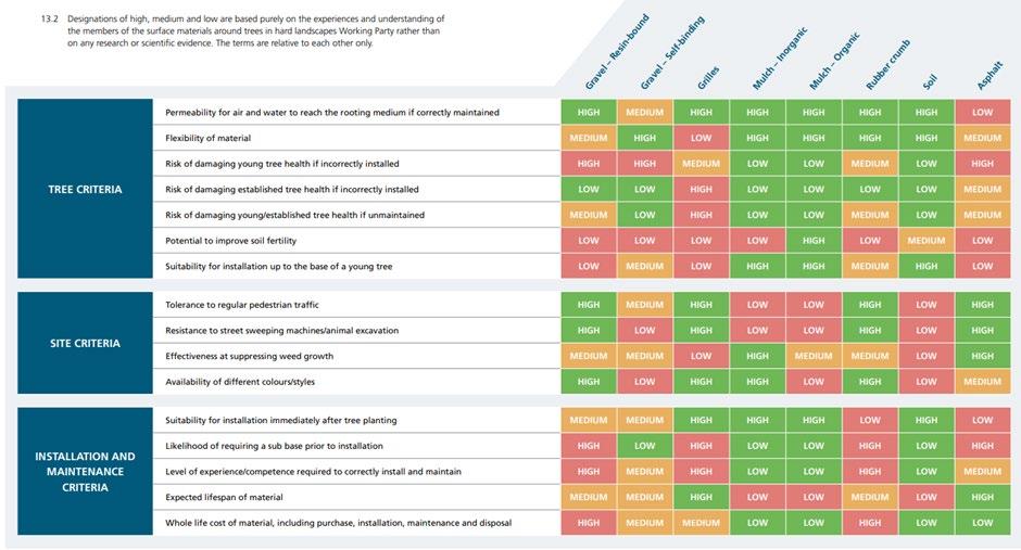
There is a need to maintain a manageable palette of materials to enable stocks to be held for urgent repair and maintenance response purposes, and for the City Council to satisfy itself that any materials used will still be available for maintenance and repair in the longer term.
Damage to materials with a long production time or logistics chain will result in temporary patching until proper replacements can be sourced and put in place. Paving materials with reliable supply and that are easily sourced from local suppliers is preferred.
Ethical sourcing places a responsibility on designers and contractors to ensure that materials used are supplied in line with minimum standards of labour practices, respecting human rights, whilst the purchase of local materials can help reduce transport and related environmental impacts.
Careful consideration should be given to any material coming in from distant and remote places where the stability of the source and the commitment to the environment may not align with the city’s overarching principles.
A. The carbon impact of different modes of transport and fuel types required to transport materials and operators should be assessed, especially where heavy vehicles/machinery are not likely to be required.
B. Opportunities should be taken to reduce trips through consolidation and efficient planning of logistics.
C. Opportunities should be taken to reuse and source materials locally.
D. Supply of materials and scheme transportation should encourage the use of sustainable operational models, sustainable fuels, sustainable transport to and from site for site operators, and limit the usage to what is strictly required.
E. The weight of transported material should be reduced as far as practicable - with reuse being promoted, through careful specification as well as buying with takeback agreements.
F. All materials specified must come from ethical sources in line with Westminster’s ‘Responsible Procurement and Commissioning Strategy’2022-2026 and avoid unacceptable practices such as child labour.
G. Materials should be locally sourced, from reliable suppliers.
H. Consideration must be given to the sourcing and timescales for delivery of replacement materials should they be needed in the future.
Paving materials should be obtained from reliable suppliers and sourced in preference order from:
I. UK manufacturers
J. Mainland Europe where commitments to Climate Change and reductions in carbon dioxide and greenhouse gas emissions are a shared policy within the UK and the City of Westminster
A. Using the most up-to-date guidance, materials must be kept to the minimum required volumes, making effective use of resources, and reducing waste.
B. New paving materials outside of the existing pallet are likely to be refused.
C. Surplus surfacing materials should be stored by third parties to ensure that future paving repairs can be consistently matched.
D. Developers will be expected to pay commuted sums to cover the cost of additional replacement materials.
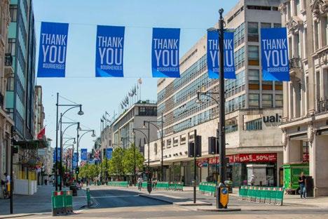
King Street, St. James’s Westminster, underwent a 6-week repair and replacement of the footpath and kerbs. The full life cycle impacts of design and delivery were taken into account, to reduce embodied carbon. To minimise carbon footprint, the scheme used recycled materials, reduced consumption of natural resources, and made use of electric rather than diesel vehicles.
Materials used included recycled asphalt, and low carbon concrete for the kerbing and footway, with reduced slab thickness laid, reducing the amount of concrete used. https://www.fmconway.co.uk/case-studies/king-street
Ease of maintenance of paving schemes not only ensures longevity but also reduces carbon and enables functionality to be retained. This is particularly relevant in areas of intense use where spillage is likely to occur, for instance, outside food and drink premises, street markets, and areas of waste disposal and collection.
Consideration of ease and efficiency of cleansing of materials must be factored into public realm designs from the start, and is an important factor when choosing materials, for example to facilitate removal of chewing gum using high-pressure water jets.
Very intense cleansing regimes and pressure washing may not be suitable for all materials.
A. Consideration of ease and efficiency of cleansing must be factored into designs from the start as it is an essential factor when choosing materials, for example, to avoid permanent staining, or to facilitate chewing gum removal.
B. If a site necessitates intense cleansing, then the use of loose materials such as sand will generally not be supported there.
C. Deterioration of materials can be minimised by a surface treatment immediately after laying (or after deep cleansing) to restore the appearance and resist dirt and gum.
D. Any material departures must be justified and agreed upon with the City Council. It is expected that the maintenance needs of these materials be considered to ensure the longevity and sustainability of the scheme.
Reinstatement of Materials:
Reinstatement of Materials Guidance:
A. Good quality existing paving should be reused.
B. If surface damage is to be patched, contractors should use material of a similar tone to the existing surface.
C. Where darker materials are used for this purpose, as in the example shown below, this can appear as a hole in the pavement to people with visual or cognitive impairments.
D. Any repairs or reinstatement of materials should be undertaken by competent professionals and finished to the highest quality possible when considering all due technical properties requirements as set out in the attached Materials Palette Matrix.
E. All works should effectively restore original surfacing as soon as possible to cause minimal impact.
F. Any repair or reinstatement work that uses differing materials from existing will not be acceptable unless previously approved by the City Council.
G. Where a utility repair is carried out and the reinstatement work is not in accordance with the Specification for the Reinstatement of Openings in Highways (SROH), the utility company will be required to make good reinstatement at their cost.
H. Where this cannot be achieved then it will be re-instated by the City Council and the utility provider will be recharged for the work.

Lifespan / Temporary Schemes
Guidance:
A. In implementing pilot projects and temporary schemes, materials should be chosen according to the corresponding scheme duration.
B. For short to medium-term nature of this type of projects, it is recommended to use quality materials that are removable and reusable, to allow materials to be reused in other similar exercises or in permanent schemes at the end of the project or the testing period, reducing the costs of procurement and disruptions related to installation and removal works.
C. Temporary schemes are likely to be refused unless a longer-term scheme is being actively considered.
BIBLIOGRAPHY & REFERENCES [materials palette only]
• Transport for London (2017) Health Streets for London
• BSI (2016) PAS 2080: Carbon management in infrastructure.
• City of Westminster (2019) Climate Emergency Action Plan.
• City of Westminster (2021) City Plan 2019-2040.
• Department for Transport (2021) Guidance on the Use of Tactile Paving Surfaces.
• Reference https://www.legislation.gov.uk/ukpga/1991/22/schedule/6 SCHEDULE 6 Roads with special engineering difficulties New Roads and Street Works Act 1991
Related SPD sections • 4 5 Street furniture
Key City Plan policies
• 4.15 Security
15. Visitor Economy
16. Food, Drink and Entertainment
28. Highway Access and Management
33. Local Environmental Impacts
38. Design Principles
43. Public Realm
Other relevant regulations and policy Statement of licensing policy
Context
Commercial activity, street trading and patrons sitting outside premises can add to the liveliness of the public realm and create opportunities for social interaction. However, this requires careful management and integration to ensure that it does not detrimentally impact on residential amenity and the safe enjoyment of public spaces. The overspilling into the street by commercial activity will not be appropriate in all locations and circumstances.
This guidance sets out the City Council’s approach to street trading and commercial activity in the public realm. It outlines the rules and guidance relating to street markets and isolated trading pitches, as well as guidance on al fresco dining and associated furniture It specifies how we will implement our City Plan policy where a planning application is required, and also provides advice on licensing applications and other regulatory regimes involved in the management of commercial activities in the public realm.
Policy and regulations context
The City of Westminster Act 1999 gives the City Council the powers to regulate street trading, which includes the sale of goods and services on the street. The Act sets out rules for who can trade on the streets, what kind of goods or services can be sold, and the conditions under which street trading can take place through the granting of licences to street traders. The aim of the Act is to ensure that street trading is safe, does not cause disruption, and does not negatively impact the local community.
Policy 43 of the City Plan outlines the policy framework for ensuring that commerce in the public realm is well designed and carefully managed. It also sets out criteria for the provision of new or replacement units Clause C and D sets out:
C. Additional kiosks or other structures for the display and sale of goods outside of a market will be resisted. The replacement and relocation of existing structures will be designed and sited to:
1. Respect local context and not detract from any heritage asset;
2. Minimise obstruction to pedestrian movement and street cleansing arrangements;
3. Minimise energy consumption;
4. Ensure they are capable of quick removal.
D. Proposals for trading from premises extending into the street (including provision of tables and chairs on the highway) will be supported where they would not:
1. Harm local amenity;
2. Compromise pedestrian movement or traffic conditions;
3. Impede refuse storage and street cleansing arrangements.
A. The function and character of the highway and public realm should not be compromised by commercial activity and should remain primarily accessible and free for all users.
B. Proposals for trading from premises extending into the street (including provision of tables and chairs on the highway) should:
i. Protect any heritage asset;
ii. Comply with inclusive design guidance for pedestrian infrastructure;
iii. Be moveable and not involve the storing of items on the public highway outside of permitted licensing hours
Street trading, be it historical street markets, individual trading pitches, or organised events, can add to the variety and vibrancy of the public realm, provide valuable employment opportunities, help regenerate areas, and bring activity to underused spaces.
Attractive, well managed markets and isolated pitches can activate spaces and displace undesirable activity, with visitors providing natural surveillance on the street
There are six outdoor street markets in Westminster (see Figure 62 for details), plus weekend farmers markets, as well as isolated street trading pitches and kiosks in busy retail areas. These offer a range of goods and services.
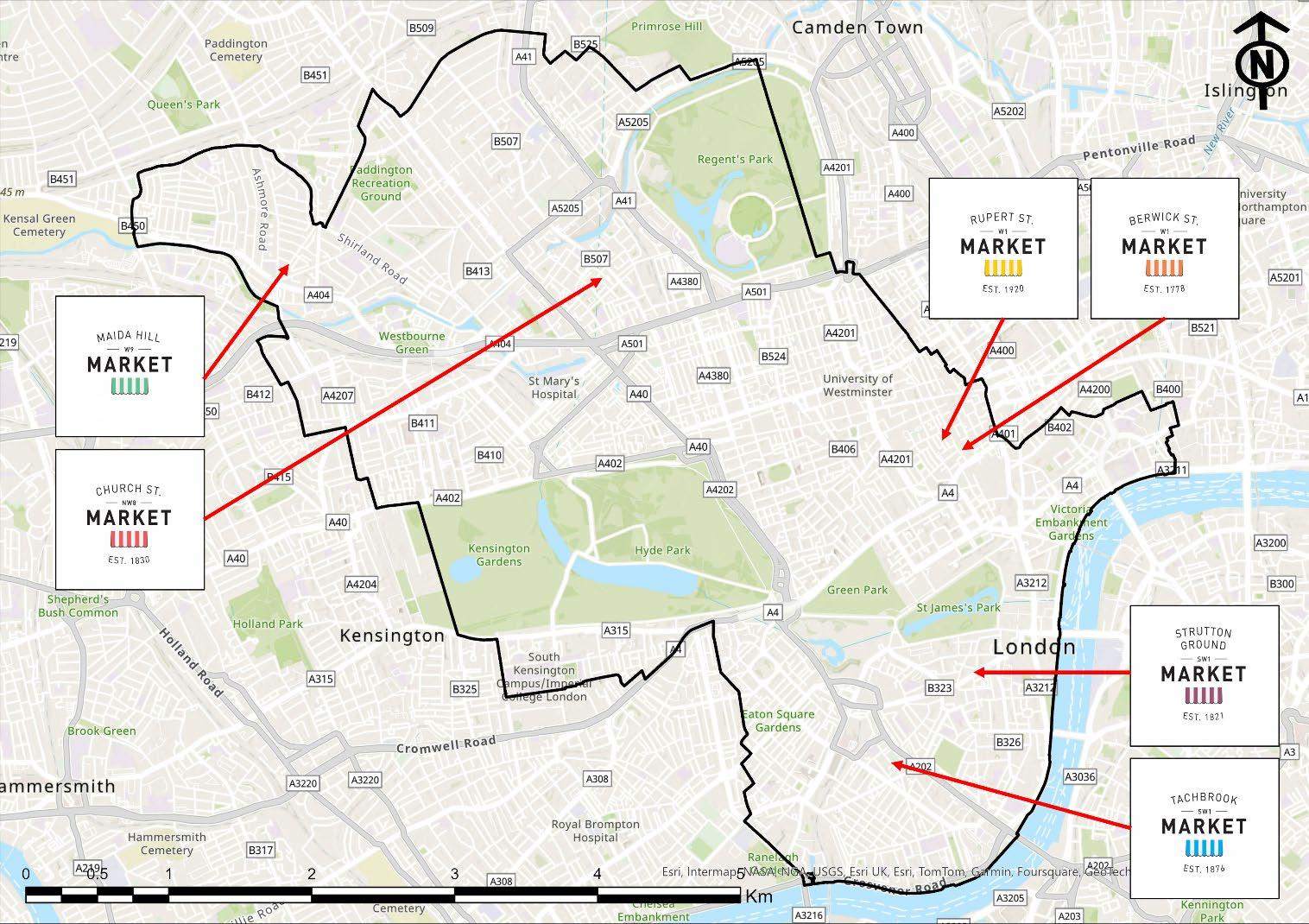
Markets are usually well serviced, temporary (i.e. not operating 24/7), involve street closures, and are controlled by the Westminster’s Markets Team within the council. Kiosks are more often permanently placed on the highway.
Permitted development rights exist under the Town and Country Planning (General Permitted Development) (England) Order 2015 (GPDO) for the holding of a market by or on behalf of a local authority. The purpose of this is to allow local authorities to operate markets as a means of promoting economic activity and supporting local communities without the need for planning permission, while also ensuring that the market is properly managed and does not cause undue harm to the surrounding area. The GPDO sets out the conditions under which a local authority may hold a market and the types of activities that are permitted as part of the market, including specifying the types of goods that may be sold, the hours of operation, and any restrictions on the frequency of the market.
Westminster City Council’s ‘Statement of Street Trading Policy’ sets out our approach to street licensing and its standards for those engaged in street trading either from an isolated pitch or within one of Westminster’s street markets. It outlines the common set of rules and how those rules will be applied. This policy also contains detailed criteria and guidance on the design of stalls, with details of stalls likely to be considered suitable and unsuitable for street trading.
A. Street markets should not have a detrimental impact on their setting in terms of visual amenity, noise and smells, physical obstruction, waste generation, and the economic success of their locality.
B. Paving materials used in street markets should be hard wearing and non-porous where there is a risk of staining from food and waste associated with the operation of the market/pitches. See Chapter 4.6 Paving Materials within this SPD.
C. Street trading should enhance, rather than detract from, the street in which it is located, in both design and goods on offer.
In most cases non-temporary furniture and items on the public highway or forecourts, such as trading kiosks, require planning permission. Unlike markets, isolated kiosks can cause issues as they are usually not on closed roads, and some are permanently placed on the highway, so their design needs careful consideration. When poorly managed, they can have a negative effect on an area including causing obstructions for pedestrians, displaying excessive advertising, causing harm to the visual amenity of the area, and creating an untidy street scene.
It is considered that a single, well designed and located structure could have fewer negative impacts than clusters of smaller stalls, and as such may be preferable where it can be used to house several separate functions. Quick removal of structures may be necessary to facilitate highways works, street cleansing, or other works for special events in the public realm.
Policy 43 Public Realm in the City Plan sets out criteria for provision of new or replacement units and kiosks. (see Commerce in the Public Realm, Clause D above).
Kiosks will only be permitted where they meet the criteria set out in the City Plan, as well as the guidance provided in ‘A Strategy for Westminster Council’s Markets 2019-2022’.
To minimise potential harm:
A. Semi-permanent kiosks will generally be resisted.
B. Where replacement facilities are proposed (including those in alternative locations to the existing), they should deliver net benefits by being designed and constructed in a manner that makes a positive contribution to their proposed setting and wider energy efficiency goals.
C. Stock should not spread onto the pavement.
D. Clusters of smaller stalls will generally be resisted.
E. Kiosks should be designed to include minimal advertising , no more than 10% of the stall can be used for advertising Ideally only a nonilluminated single fascia sign and menu panel. Planning conditions will be used to limit the number of advertisements that may be displayed on the structure
F. They should have regard available street space, pedestrian comfort levels, and potential for negative impacts on the highway caused by queues.
G. Due to flood risk, the use of in-ground power supply units should be avoided
‘Al
‘Al fresco dining’ is used to define tables and chairs placed outside premises, and linked to the commercial operation of those premises, for example to facilitate outdoor dining or drinking associated with licensed premises. Extending trading onto the highway, including through provision of outdoor seating, can help sustain businesses such as bars, cafes, and restaurants by increasing their trading space – at the expense of public access to this space. In the context of this guidance, the term is used to denote the footway and/or highway space allocated, as well as furniture and space requirement around outdoor tables and chairs. The demand for tables and chairs in the public realm is increasing and requires careful management.
Well-managed, commercial al fresco tables and chairs can enhance the utilisation of the public realm as a space for social interaction. However, this needs to be carefully balanced against the need to facilitate movement of pedestrians and other highways users, and the impact of associated noise to residents, occupiers, and other visitors.
Commercial activity can make an important contribution to the public realm; however it is a tertiary function to the primary function of the highway, which is the free and unobstructed movement of pedestrians, and secondary uses (e.g.
parking of vehicles, provision of cycle parking (including dockless), bus stop facilities, statutory undertaker equipment, SuDS etc).
Guidance for tables and chairs provided independently of commercial activities, for example in public squares and open spaces, is provided in Chapter 4.5 Street Furniture in this document
Chapter 5.2 Highways Space, Road safety and Parking in this document sets out pedestrian comfort levels and the corresponding minimum pavement widths generally required.
A. Al fresco dining and outdoor tables and chairs should be temporary, moveable structures and outside of permitted hours, the highway should return to its original use
B. Tables and chairs should not have a harmful impact on pedestrian comfort levels or desire lines
C. Priority will be given to pedestrian movements, and applications for tables and chairs will be considered in this context, having regard to potential impact on them.
D. Tables and chairs associated with commercial use will only be permitted in appropriate locations and at suitable times.
E. The function of the highway for passing and re-passing cannot be compromised to facilitate commercial activity.
F. The use of fixed structures, e.g. decking and permanent barriers to delineate space for al fresco dining will not generally be supported.
G. Consideration must be given to the impact of associated noise and disturbance to residents, occupiers, and other visitors
H. Internal storage for all items should be provided within the business unit.
I. Items should not be stored on the highway outside of permitted hours.
J. Some locations may require items to be removed from the highway while the business is trading to facilitate highway functions
K. When instructed by an appropriate council officer, items licenced for alfresco dining must be removed immediately
L. The use of the public highway for tables and chairs will be subject to review at all times given the changing demands upon the city.
M. Power provisions must be installed and assessed by a competent Highways electrician.
N. The instalment of power provisions should not allow trailing and overhanging cables and must not impact the safety of users or passersby
O. Licensees are responsible for all cost accrued from instalment and use of power supplies.
P. Generators and heating equipment will generally be resisted unless there is an identifiable need, this will be assessed by the council on a case-by-case basis.
Planning permission
The Business and Planning Act 2020 enabled applicants to apply for a pavement licence for tables and chairs and if granted, they would have deemed planning permission
The Levelling-up and Regeneration Act 2023 65 made provision to make the above arrangements permanent. Planning permission is generally not required for moveable tables and chairs, on the highway, however a pavement licence is still required
Businesses looking to place moveable tables and chairs on the highway are required to apply for a pavement licence and the licensing regime could condition such placement for limited periods of time. Where a licence is granted by the City Council, planning permission is deemed to have been granted. This is subject to a number of conditions. In some cases, for example, for furniture that is not removable and used in connection with the outdoor selling or the consumption of food and drink, planning permission may be required.
65 https://www.legislation.gov.uk/ukpga/2023/55
A pavement licence only permits the placing of tables and chairs within a defined area on the public highway. The licence does not permit businesses to fence off areas in front of their premises for dedicated smoking areas or for vertical drinking, to help minimise impacts on amenity and on the highway. For further information on licensing conditions please read Pavement Licence Conditions on the council’s website.
Planning permission is still generally required if businesses want to use the highway for any purpose other than placing tables and chairs. This includes al fresco dining areas which use the highway for vertical drinking, food preparation, or as a dedicated smoking area, with the exception of those activities allowed by the permitted development rights explained below which relate to moveable structures.
Where planning permission is required, this will be considered in line with City Plan policy 43 (see Commerce in the Public Realm above).
More information on pavement licences can be found on the council’s website 66 and the government’s website on Paving licences: guidance
Businesses looking to place tables and chairs outside their property need to apply for a pavement licence if the items are to be placed on any land either dedicated or adopted as public highway. Section 31 of the Highways Act 1980 states that if a path or way has been used by the public continuously for 20 years, legally it can be deemed as a public right of way without landowner objection. Privately owned land outside of premises which has been used for passing and re-passing uninterrupted for the past 20 years is considered to be public highway, and a pavement licence is required to place tables and chairs, and other authorised furniture. Even if Land Registry Title documents can demonstrate land ownership, a pavement licence may still be required if the land is considered to be public highway.
The City Council will base its decision on whether to grant licences for tables and chairs associated with commercial activity with consideration for the following:
• The location and proximity of the tables and chairs in relation to the licensed premises, and the space proposed to be dedicated to trading. This includes the associated circulation space, access by serving staff and customers to and from that space and the serviced premises. Off-set or floating tables and chairs away from the immediate retail frontage will not be supported.
• The number of tables and chairs proposed relative to the space available.
• The space left for pedestrians and other highway users not using these facilities.
• The proposed maintenance arrangements of the tables and chairs, and the proposed hours of operation and storage arrangements for the tables and chairs when not in use.
• The proposed design of associated street furniture such as umbrellas, and the proposed space between items.
• The space between the above and any existing items in the footway, including trees, lamp posts and other street furniture, drainage gullies, and other features of the public realm.
• The location and proximity of any furniture to fire escapes, tactile paving, or utilities infrastructure.
• Photographs showing the site, and its surroundings can be helpful when we deal with applications for tables and chairs in the public realm.
Further guidance on tables and chairs and how applicants must minimise impact on the highway
Location
Location Guidance:
66 Apply for a pavement license: https://www.westminster.gov.uk/licensing/apply-pavement-licence
A. Tables and chairs may be permitted:
• In fully pedestrianised streets and public squares;
• In partially pedestrianised streets where vehicles are banned at certain times of the day;
• In streets with footways of adequate width and carriageway.
B. Tables and chairs will generally not be permitted outside stations, near pedestrian crossings, outside the frontage of the applicants' premises or other locations where they are likely to impede unobstructed movement.
C. The amounts of space that might be available for tables and chairs at the above locations are shown as an indicative guide in figures below
D. Larger canopies will only be allowed in suitable open areas where they will not clutter important local views48 (This includes Protected Vistas and Other Strategic Views identified in the City Plan, local views of metropolitan importance and other important views identified in neighbourhood plans or conservation area audits)
E. Canopies, umbrellas or other structures should not extend beyond the permitted area for tables and chairs
F. Canopies, umbrellas or other structures need to be removeable and should not be stored on the highway at night.
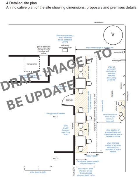
An indicative plan of a site with tables and chairs showing dimensions, proposals and premises details.
Placement, layout, and dimensions
Sufficient pavement space must be provided and maintained to allow all pedestrians, including wheelchair users, the elderly and those with prams and buggies to pass along safely and easily. Space must be provided to enable safe escape from premises, and access by the emergency services.
Placement, Layout and Dimensions Guidance:
A. Tables and chairs should generally be placed against the building and not kerb edge Tables and chairs off-set from the property frontage will generally not be allowed. Tables and chairs will normally only be allowed directly outside the premises at the back of the footway.
B. The layout should allow for the tables to be served or for customers to carry food and drink themselves without leaving the proposed area to be licensed. Where this is not possible, any seating area should be table service only.
C. In all locations an absolute minimum clear zone of at least 2 metres of footway width must be kept free of tables and chairs and other obstructions, in line with recommended footway widths. Neither is this area to be used to service tables. In most locations more than the 2 metres minimum clear width will be required to ensure highway primary functions can continue and the highway can support Active Travel modes. The minimum width of the clear zone of unobstructed pavement increases to 4 metres in streets with heavy pedestrian traffic or poorly scoring pedestrian comfort levels.
D. Where footways are very crowded the width of the clear zone may be determined on a case-by-case basis. This area is not to be used to service the tables. Some streets are so busy or so narrow that they are unsuitable for tables and chairs altogether.
E. Placement of tables and chairs should not obstruct the safe flow of pedestrians or impact desire lines, crossing points of access to other highway infrastructure (for example cycle stands and tactile paving).
F. Placement of tables and chairs should not obstruct cleansing and maintenance vehicles.
G. Furniture should be arranged to reduce opportunities for crime.
H. Associated umbrellas/temporary covers should not overhang footways or interfere with vehicle sight lines and traffic signs.
I. A 3.45 metre wide pavement is unlikely to be sufficient to enable the placing of tables and chairs and a sufficiently clear pavement for pedestrians to safely pass.
J. For practical and safety reasons it is considered inappropriate in principle, to install and operate tables and chairs where the available pavement depth is less than 1.45 metres measured from the building line (i.e. where the total available pavement depth is less than 3.45 metres). This is because it is unlikely this would allow enough space for people to be served unless the tables and chairs can be served directly from the doorway.
K. In streets which are pedestrianised or shared/single surface a minimum of 4 metres clear width should be maintained to ensure emergency vehicle access
L. In streets which are pedestrianised or shared/single surface generally only a maximum of 25% of the width of the street will be allocated to temporary tables and chairs use – provided other clear widths are also possible. (This allows the opposite side of the street to also have 25% and the remaining 50% is for highway movement and uses) No more than 50% of the footway and carriageway width should be taken over by commercial activities
M. No arrangement or layout should allow or support vertical drinking
N. The needs of those with disabilities should be considered. The layout should allow enough space for wheelchair users to manoeuvre – at least one chair available for replacement by a wheelchair. A minimum depth of 1 metre is generally required.
O. Space must be provided and allocated (as well as marked on drawings) within the retail/business unit for the storage of all items to be placed on the highway, to be stored outside of permitted hours. It should be clear this should not conflict with business operation (i.e. tables and chairs may need to be stored off the highway while the business itself is still open).
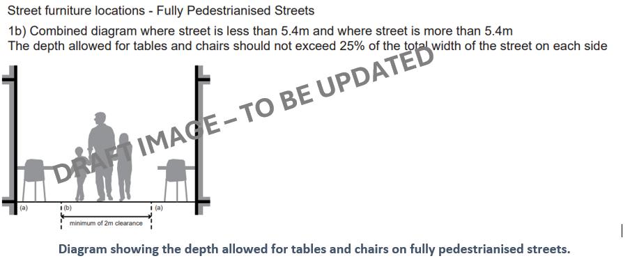
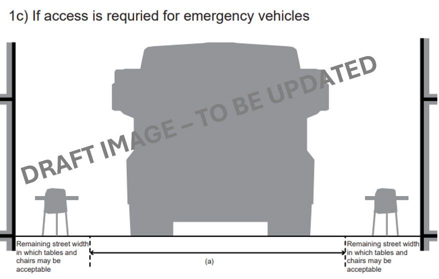
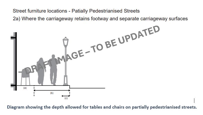
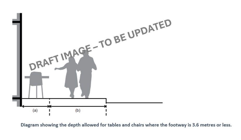
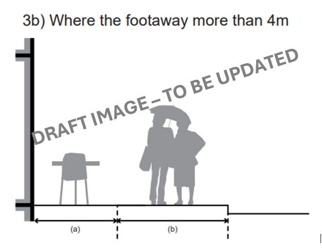
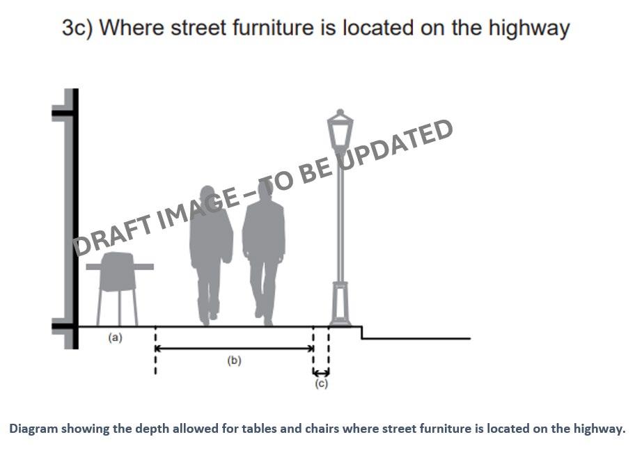
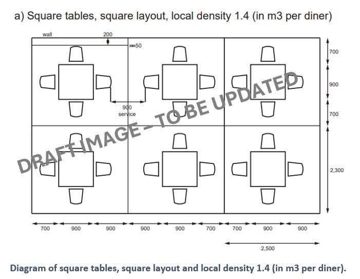
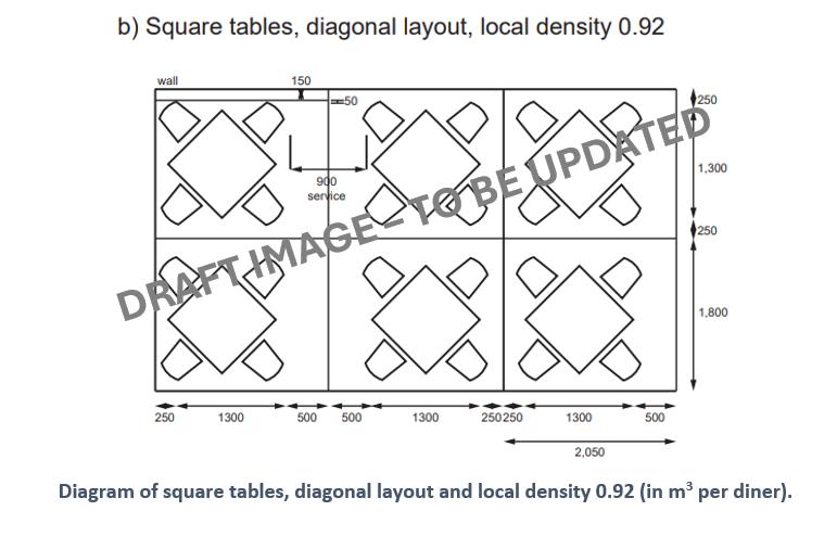
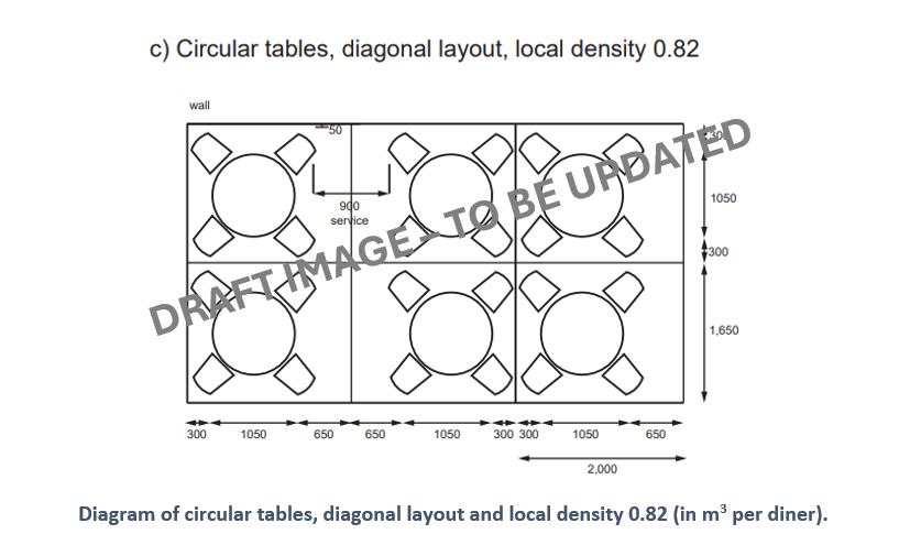
Street furniture associated with tables and chairs such as space heaters, umbrellas and umbrella stands and barriers which require planning permission, are generally not acceptable. Such furniture provided when street trading rules were relaxed as an emergency response during lockdown measures in the early 2020s will be expected to be removed in line with permitted development and licensing agreements.
A. Where provision of tables and chairs associated with commercial premises are supported on the highway, the tables and chairs will be required to be stored off-street outside of trading hours, so as not impede refuse storage and street cleaning. All tables and chairs and associated furniture and equipment must be removed and securely stored at night.
B. The cumulative impact of tables and chairs should not obstruct pedestrian desire lines, and cause zig-zag pathways along the highway.
C. Permanent barriers are not permitted, as the licensed area must be capable of reverting to use as public highway outside of the permitted licensed hours
D. Consideration should be given to the impact of “feet” of barriers on pedestrian movement. They should not obstruct or create a trip hazard.
E. Patio style gas space heaters will not be allowed in the public realm.
F. Electric radiant space heaters designed specifically for outdoor use may be allowed in the public realm with subject to risk assessment. The strong preference is for these to be sustainably powered.
G. Cable cover mats with rubber backing may be permissible subject to risk assessment.
H. Cables (including overhead) or mats should not be placed outside of the permitted tables and chairs area and should not cross pedestrian paths No trailing cables will be allowed.
The following guidance about the design and management of furniture is offered to potential applicants. To avoid difficulties arising from tables and chairs it is strongly recommended that they consider the following:
Design expectations:
• Tables and chairs should be well designed and respect the character of buildings and settings. Furniture should be strong, stable, and durable enough for heavy use and is easily wiped down and dried after rain or cleaning.
• Muted tones and durable easy to maintain materials such as timber and steel are most likely to be most appropriate.
• Furniture with rubber feet should be used to help reduce noise associated with them being moved and damage to the pavement.
• Tables and chairs and related furniture / umbrellas should be stable enough to withstand strong winds.
• Tables and chairs and related furniture / umbrellas should generally be
• Umbrellas should be in a plain canvas material, capable of being folded down and removed.
• Plastic garden furniture is unlikely to be strong enough for constant use and could blow away and cause an accident. Its use is not recommended.
• Enclosures for tables and chairs should be easily distinguishable to passers-by.
• Security implications should be considered in the initial design and selection of furniture.
The City of Westminster is home to some of the most iconic event locations in the world. Westminster’s streets and open spaces are the first choice for thousands of outdoor events, parades, and brand activations every year. Public spaces designed to host events should have suitable provision for power and water supplies as required, with ducting laid in anticipation of demand. Consideration should be given to the impact of barriers, temporary structures and plant equipment required for the event, with particular attention paid to the impact on highway users and residential amenity.
Material choices should reflect the proposed nature of events, and not include porous materials where food spills are expected.
Access requirements, including emergency and utility access should be designed into schemes. If necessary contingency plans should be arranged to ensure structures and barriers that may impede emergency access are easily movable
For temporary or permanent power supplies event organisers should discuss requirements with the Event team. Event organisers should submit a management plan to be reviewed by the council
For further information on power supplies for events, please see Chapter 4.12 Power and Lighting, within this SPD.
The City Council will work with you to plan a safe and successful event by securing your event date and location and offering advice on the permits and licences you will need. We will review your event management plan, risk assessment and other documentation.
Sources:
• Pavement licences guidance
• Guidance: pavement licences (outdoor seating) - GOV.UK (www.gov.uk)
Replacing existing Guidance contained in:
• Westminster Way SPD
• Tables and chairs SPG
Related SPD sections
• 4 3 Green infrastructure
• 4.6 Paving m aterials
• 4.13 Signs and adverts
• 4.5 Street Furniture
• 4.14 Public art, statues and m onuments
Key City Plan policies 34. Green infrastructure 43. Public realm
Context
Westminster has areas of high resident population density, while the quadrupling in its daytime population due to people commuting into the city to work creates significant additional demand for physical activity, leisure and/or sport provision.
In Westminster’s dense and busy urban environment, there are limited opportunities for children to roam, play and navigate the built environment freely. Urban environments can feel unsafe, inhospitable, and unwelcoming to children and young people. In addition, issues of childhood obesity, mental health problems, and physical health impacts from air pollution, have become increasingly common among young city dwellers. How places are built and designed is critical to creating more active and playful public streets and spaces.
Children and young people are essential public space users and play is a key aspect of their development, culture, and quality of life. The first years of a child’s life are particularly crucial to their development and the built environment can help support positive experiences through providing opportunities for play.
Whilst demand for play space is addressed through more discrete provision (playing pitches, built facilities and informal recreational facilities), there remains an identified overall lack of play facility provision in Westminster, with a shortage of facilities geared towards older children and young people. Some areas of the city, such as Church Street, Pimlico, Little Venice, East Marylebone, and Soho, have a deficiency in play and informal recreational facilities and a higher concentration of children compared to other parts of the city. See Figure 80 below
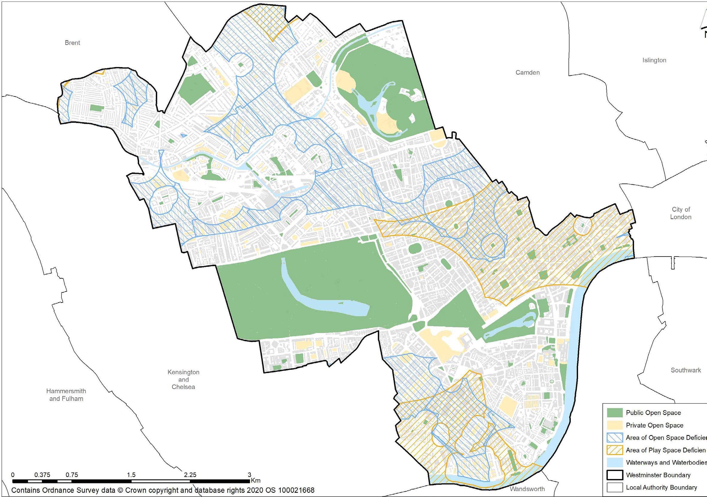
Figure 63: Open and Play Space Deficiency Areas across Westminster.
The Council is keen to take opportunities to add play and informal recreational facilities in such areas, whenever and however they arise, including opportunities such as ‘Play Street’ initiatives, as part of the council’s overall ‘Active Streets’ programme.
Child-friendly design goes beyond designing playground provision, and towards shaping the physical features around and in between buildings in neighbourhoods to become multifunctional, inclusive, and welcoming for everyone.
There is a wider role that the public realm can play to contribute to the expanding opportunities for more informal play and recreation. Local access to opportunities for play and recreation can contribute to the health and wellbeing of residents and visitors as it can encourage independent and active play, mobility, curiosity, discovery, entertainment, access to nature, human interaction, and social integration. Appropriate provision of opportunities for play and recreation can also make a positive contribution to reducing anti-social behaviour.
High quality streets, parks and spaces can encourage, facilitate, and enable physical activity by default. They can also help focus attention towards less traditional spaces often used by those not participating in physical activity, leisure, and sport.
London Plan Policy S4 sets out that large-scale public realm developments should incorporate incidental play space to make the space more playable.
City Plan policy 34 Green Infrastructure, Open Space D sets out that major developments will be required to provide new or improved public open space and space for children’s active play, particularly in areas of open space or play space deficiency.
WCC’s Planning Obligations and Affordable Housing SPD sets out that: When a requirement is triggered, s106 legal agreements will be used to secure on-site provision. Where it is not practical to deliver on-site, financial contributions may be accepted.
The Council's Play Facilities Strategy sets out best practice recommendations including:
• The quality of spaces and routes for children and young people should be assessed, alongside the quantum of space.
• Widened pavements and shared surfaces should be key considerations in street design to allow for the non-linear, meandering movement patterns of children.
• Safe routes should connect children and young people’s amenities through well-marked and playfully designed streets and public transport provision, including suitable lighting.
• Streets should be designed to reduce the speed of drivers in residential areas where possible.
‘Play street’ orders 67 are tools that can be used to achieve temporary street closures to allow children and young people to play on the street. See further guidance in relation to School Streets in Section 4.1 Highway Space, Road Safety and Parking.
A. Public realm interventions should contribute to providing further opportunities for people to enjoy play and leisure activities.
B. Where appropriate and in response to an identified need, dedicated play space and facilities should be provided.
C. Opportunities for playful design should be incorporated.
D. Public realm schemes should seek to improve access to existing local play and recreation opportunities through the provision of links and wayfinding
E. ‘Meanwhile’ proposals which expand opportunities for play and recreation will generally be supported, where these can be provided safely, and where there is demonstrated need.
F. Loss of publicly accessible play facilities by private developments will not be acceptable.
G. Proposals for play and recreation space should seek to ensure easy access to public conveniences or where relevant, improve access to existing facilities.
H. Seating and resting points should be provided through play and recreation spaces.
67 https://playingout.net/wp-content/uploads/2017/03/Legal-basis-for-Temporary-Play-Street-Orders-.pdf
Related SPD sections
Key City Plan policies
• 4 1 Highway space, Road Safety and Parking
• 4 10 Waste, Cleansing and Maintenance
28. Highway Access and Management
43. Public Realm
Freight, servicing, and delivery (FSD) activities are essential to ensuring the functioning of the city Westminster has a high level of demand for freight, servicing, delivery, and collection services. This means that goods vehicles have a significant impact on traffic congestion, road safety and emissions, as well as potential conflict with other road uses.
Goods vehicles form a considerable part (17%) of total traffic in Westminster. This activity takes place more significantly in the West End and is concentrated in the morning hours. Delivery and collection vehicles make up 85% of goods vehicle movements and are stationary on-street for short periods of time. Servicing vehicles, while making up only 15% of the total goods vehicles, dwell for significantly longer with greater impact on the highway and highway users. The high concentration of commercial activity interspersed with residential development is a particular characteristic of Westminster’s dense, historic urban fabric. This is especially the case in the CAZ including the West End, which creates challenges for the movement, re-moding and re-timing of freight, servicing and deliveries.
There is a risk of freight vehicle collision with pedestrians, cyclists and other vulnerable road uses. In some areas, the peak hours of freight movement overlap with the peak periods for many pedestrian and cyclist movements, especially in the weekday AM peak, where many cyclists are riding to work and many delivery drivers are delivering goods and services to local businesses before they open. Transfer of goods from a FSD vehicle to the delivery point can create obstruction to pedestrians and other highway users
Figure 64 - On street and off-street occupancy by FSD vehicles (taken from Westminster's Freight, Servicing and Deliveries Strategy and Action Plan)
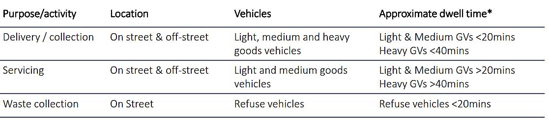
Many parts of Westminster have streets which are congested, narrow, multi-use and kerbside access is demanded 24 hours a day, 7 days a week by a range of users, especially in the West End and other parts of the Central Activities Zone (CAZ). The most effective way of managing freight’s impacts on congestion, while allowing efficient operations, is by planning for the needs of freight at an early stage of the statutory planning process. New development can contribute to the management of freight traffic through the provision of dedicated off-street space for servicing, deliveries and collections particularly where multiple developments can share the same facility so as to ensure efficient use of scarce space. This can also enable retiming. Rethinking the public realm to better accommodate lighter/more sustainable logistics will help reduce user conflict, noise disturbance and environmental impacts
The use of consolidation centres can reduce delivery and servicing vehicle numbers, where deliveries are consolidated into one consignment, and delivered at a pre-arranged time. The City Council strongly supports consolidated freight servicing, especially last mile solutions, to maximise the efficiency of freight movements, reduce pollution and eradicate FSD related Killed or Seriously Injured (KSI) collisions 68 Planning conditions and traffic orders can be used to limit and consolidate the times that space can be used for FSD.
Westminster’s Freight Servicing and Deliveries Strategy and Action Plan 69 sets out how to improve FSD operations through:
• Reducing – reducing the number of trips generated by freight, servicing and delivery activity, the time spent in the city and the impact on the local road network and environment; minimise freight movements through macro and micro consolidation initiatives;
• Re-moding – making use of alternative modes (including rail and water), increasing the uptake of zero emission vehicles, and enhancing the infrastructure required to support their use; seek ways to transform the vehicle fleet to less polluting and less dangerous modes that will include the use of hand porterage and cycle delivery, as well as more environmentally friendly vehicles; and
• Retiming – making best use of an extended delivery, collection, and servicing operating window in a managed, monitored and enforced way, utilising non-peak hours. Manage delivery times to avoid conflict with other street users, particularly pedestrians and cyclists.
City Plan policy 29, sets an expectation for dedicated on-site, off-street space to carry out freight, servicing and delivery functions associated with a development. Space and facilities for FSD, including waste collection operations, must be provided on-site and vehicles must be able to pull clear of the public highway without causing obstruction.
For new commercial developments, require provision of EV charging and floorspace to provide urban depot(s)/microdistribution hub(s) and cargo bike storage/facilities. New commercial developments using consolidation should ideally require all trips to be undertaken using zero emission vehicle fleets, cargo bikes, etc.
Where the council considers that provision of off-street space for FSD is not possible and servicing is to be undertaken on street, it must be demonstrated that it would not lead to adverse safety implications for pedestrians and/or vehicles, the obstruction of traffic and adverse effects on other residential or commercial activity.
A. Proposals should aim to reduce potential FSD vehicular conflict with pedestrians and other vulnerable users of the highway as much as practicable. This includes transfer of goods from vehicle to delivery point.
B. Wherever possible, freight, servicing and deliveries should be integrated within developments and occur in dedicated off-street space, in order to prioritise public realm space for walking, cycling/the safe movement of people.
68 Supporting the Mayor’s Vision Zero ambition to eliminate all Killed and Serious Injury casualty related collisions by 2041
69 https://www.westminster.gov.uk/roads-and-travel/roads-and-highways/freight-servicing-and-deliveries
C. Any potential negative impact from FSD activities on the public realm and its users should be carefully considered at the outset of any proposal and designed out wherever possible.
Where, as part of a development scheme, some or all of the servicing and delivery needs are met through use of the public highway, the development will need to meet the initial and on-going costs associated with that use of the public highway. In addition, schemes should seek to:
A. Achieve more effective use of on-street loading/unloading bays throughout the 24-hour period.
• Co-location of logistics space and shared use of loading/unloading bays by different businesses
• Explore innovative digitally enabled solutions, data sharing and collaborative platforms to optimise logistics efficiency.
• Ensure proposals for new bays are justified in terms of most appropriate location and amount required.
• Proactively identify suitable locations that can support retiming activity while ensuring residential amenity (particularly sleep hours) is not affected.
• Explore shared use of strengthened footway areas (‘loading pads’) for delivery during limited times of the day.
• Maximise usage of underutilised parking infrastructure for medium and long stay servicing
• Seek to consolidate FSD activities at the outset of goods/services journeys particularly by areas or multitenanted buildings, which would allow consolidation at source and reduced number of trips.
• Not result in an adverse environment for pedestrians and other highway users or loss of highway from other uses/functions
B. Ensure public realm design encourages the use of cleaner, quieter and lighter vehicles or more sustainable options for last-mile logistics
• Dedicated on-street bays to accommodate lighter/sustainable logistics so that they are not forced to occupy pedestrian space and cause disruption to pedestrians and other vulnerable users.
• Increase accessibility to the existing cycle infrastructure to cycle-based logistics.
• Increased provision of a range of EV charge points, particularly with over 50 KWh capacity, to support last mile and consolidation through the use of electric vehicles.
• Explore potential for dedicated ground floor off-street holding areas to hold goods/waste to facilitate FSD operations.
• Explore potential of supporting the Mayor and TfL in the development of appropriate zero-emission zones and positively adopt the use of zero emission vehicles.
• Explore potential future use of hydrogen-fuelled vehicles for FSD activities.
C. Develop and/or use consolidation and micro-distribution facilities, particularly in areas that have greater potential for large-scale regeneration and development.
• Development of consolidation and micro-distribution facilities to help reduce the number of vehicle movements and enable the use of lighter vehicles or more sustainable options for FSD activities.
• Promote the use of loading bays, underused on-street space, off-street car parking, and underused space, for micro-consolidation hubs/sustainable last-mile logistics operations.
• Increased use of close proximity urban delivery points for last mile/first mile delivery/collection by zero emission alternative vehicles.
• Make space within the carriageway to support micro-distribution vehicles delivery process away from the hubs
A. Servicing Management Plans are required when the council considers that significant FSD activity will be generated on the highway in association to the proposed scheme.
B. Delivery and Servicing Plans (DSPs) may be required for major developments or for schemes referrable to the Mayor of London, and are usually secured by means of a section 106 obligation or other planning condition. Applicants should ensure the principles set out in this guidance, including with regards to the ‘last mile’ of good movement, are incorporated within DSPs.
Servicing Management Plans See: Planning Obligations and Affordable Housing SPD 2024 for costs and calculations.
Other useful links:
• Developing the Future of Freight Logistics in London, Westminster City Council and The Cross River Partnership: TITLE (crossriverpartnership.org)
• Evaluation of freight consolidation demonstration projects (tfl.gov.uk)
• WCC Freight Servicing and Delivery Strategy and Action Plan 2020-2040
Related SPD sections •
Key City Plan policies
28. Highway access management
29. Freight and Servicing
37. Waste Management
43. Public Realm
The NPPF sets out the strategic principles of securing the re-use, recovery or disposal of waste without endangering human health and without harming the environment; and ensuring the design and layout of developments and other infrastructure complements sustainable waste management, including the provision of appropriate storage and segregation facilities to facilitate high quality collections of waste.
Westminster’s Waste Strategy focuses on maximising waste reduction, reuse and recycling 70 The same applies to household waste as it does to waste arising in the public realm. Appropriate provision for waste management needs to be designed into schemes with appropriate waste receptors located where there is recognised need.
Guidance on the design and placement of waste facilities is included in Chapter 4.5 Street Furniture above.
Public realm scheme design should also consider ease of cleansing and maintenance of each item placed within the public realm, including all types of street furniture, paving materials, and greening. Loose materials for example will not withstand the type of jet washing required of heaving traffic areas of the West End. Light coloured and porous materials if not treated, will quickly stain if bins or vehicles are placed upon them.
When designing a public realm scheme, it is also necessary to plan for sufficient future maintenance through the payment of a commuted sum. The maintenance activities and time period of the commuted sum payment is to agreed with the council, it should refl ect the likely maintenance required during the design life of the project This will ensure that the newly designed area will be maintained to a high standard. Communication with the Waste and Cleansing team should be initiated in the early design stages of a project to align any strategy 71
A. Proposals must include information detailing proposed future management and maintenance arrangements of a scheme and its features
B. Maintenance and management should be designed in at the start of the process and may require securing through legal agreement.
C. Delivering partners will be expected to contribute towards maintenance for the lifetime of the scheme.
70 https://www.westminster.gov.uk/media/document/municipal-waste-management-strategy-2016-2031
71 https://www.westminster.gov.uk/media/document/planning -obligations-and-affordable-housing-spd-wcc-adopted-2024
Related SPD sections • 4 6 Paving Materials
Key City Plan policies
17. Community Infrastructure and Facilities
19. Digital Infrastructure
35. Flood Risk
37. Waste Management
The City Plan requires new infrastructure and facilities to be of a nature and scale to meet identified need and be sufficiently flexible to meet the requirements of providers as they may change over time.
Coordinated facilities, services and utilities play a vital role for the successful operation of the city. When street-based infrastructure provision is not coordinated, this can create major nuisances to all public realm users. The City Council will work with applicants and infrastructure providers to coordinate and enhance infrastructure provision
The City Council’s Draft Infrastructure Delivery Plan sets out our approach to the delivery of infrastructure to support future growth in the city
Different organisations have responsibility for different utilities’ infrastructure in the public realm.
Undertakers – Water, Gas, Power, and Digital Infrastructure providers
Statutory undertakers supply water, gas, electricity, and digital/telecommunications infrastructure. These organisations, including 72 Thames Water and UKPN, have a legal right under the New Roads and Street Works Act 1991, to dig up the road to maintain their existing infrastructure, pipes, and cables, and to install new ones.
The City Council has a duty to coordinate the work of the statutory undertakers, and its permit schemes require anyone wishing to carry out work on the highway to coordinate and approve the methodology and timing of their work in advance. For minor works, the statutory undertaker must send the council a daily list of where works will take place. For other works it must give notice, the bigger the work the longer the notice.
Undertakers have a general duty to co-operate. Under the New Roads and Street Works Act:
(1) An undertaker shall as regards the execution of street works use his best endeavours to co-operate with the street authority and with other undertakers:
(a) in the interests of safety,
(b) to minimise the inconvenience to persons using the street (having regard, in particular, to the needs of people with a disability), and
(c) to protect the structure of the street and the integrity of apparatus in it.
The City Council will continue to coordinate the work of the statutory undertakers and has been successful in persuading some companies to work together and lay several cables in one trench.
Some works cannot safely take place together and sometimes due to the location of each company’s equipment in the street, the space they need to occupy to let them work together would be more disruptive.
City Plan Policy 45 states that work to basement vaults can restrict the space available for services in the highway and may make it difficult to access cables, pipes, sewers, etc. for maintenance and to provide essential items of street furniture.
In order to ensure that services and essential street furniture can be provided, adequate space must be available between the highway and any excavation proposed under the highway.
Applications adjacent to or affecting the Transport for London Road Network (TLRN) or public transport infrastructure should seek advice from Transport for London.
In order to help minimise disruption to newly delivered schemes, the City Council serves a special legal notice on all the statutory undertakers who work in Westminster, to prevent them from digging up newly resurfaced road/paving for the next 3 years after the works have been completed. Exceptions apply for emergencies and for new services to customers. Under the terms of the Act 73, it is the duty of the undertaker by whom street works are executed to reinstate the street, as soon after the completion of any part of the street works as is reasonably practicable.
Under the New Roads and Street Works Act undertakers also have a duty to maintain apparatus to the reasonable satisfaction of:
(a) the street authority, as regards the safety and convenience of persons using the street (having regard, in particular, to the needs of people with a disability), the structure of the street and the integrity of apparatus of the authority in the street, and
(b) any other relevant authority, as regards any land, structure or apparatus of theirs; and he shall afford reasonable facilities to each such authority for ascertaining whether it is so maintained
The consent of the street authority (WCC or TfL) is required for the placing of apparatus by an undertaker in a protected street 74 as defined in the NRSWA legislation: New Roads and Street Works Act 1991 (legislation.gov.uk)
Services and Utilities Guidance
A. Wherever possible works should be coordinated between statutory undertakers to minimise disruption
B. Utilities companies should plan ahead and inform the council of planned works to allow for combined works
C. Where unplanned urgent works are carried out, consideration should be given to including other, planned, statutory works.
D. The City Council expects the highway to be returned to its former condition or improved, rather than be left piecemeal.
E. Following statutory works, any electrical item must remain easily accessible to maintain and repair, including cabling.
F. Power feeds need to be in appropriately sized enclosure to meet the DNO's requirements and British Standards for clear zones for safety.
G. Items outside contract rates, i.e. any non-standard items which are not already included in the City Council’s listed contract rates, will need to have commuted sums applied over a specified duration period for that asset
H. In line with TfL Streetscape Guidance, coloured surfacing should not be applied at locations with a high density of utilities or where one or several utility companies have a high rate of attendance and trenching
I. Access chambers and manhole covers should be positioned in a location that minimises physical and visual disruption.
TfL’s Streetscape Guidance provides advice on inset covers, where high quality materials are used and in areas with tactile paving: https://content.tfl.gov.uk/streetscape-guidance-.pdf (section 7.5)
See https://www.westminster.gov.uk/roads-and-travel/roads-and-highways/street-works-faqs for further information.
As set out in the Mayor’s London Plan, public toilets are especially important for certain groups including disabled people, older people, people with babies and young children and pregnant women, as well as tourists and visitors who may be less familiar with their surroundings. They can increase footfall and dwell time, giving visitors the confidence to spend more time in the city. Conversely, a lack of public conveniences can impact visitors' choice to travel into the city 24-hour accessible public toilets can encourage visitors through the evening, supporting Westminster’s night-time economy.
The City Council’s Strategy for public conveniences provided by the City Council, was agreed in July 2023. The principles apply to both City Council as well as externally provided public conveniences. These should be well-designed, safeguarding the vulnerable, and accessible, to enhance the experiences of people coming to the City.
A. Public conveniences should seek to be inclusive and accessible to all visitors and their requirements.
B. Provision should seek to cater for women, men, non-gender specific and accessibility friendly toilets and baby changing and family rooms.
C. Changing Places toilets should be considered in addition to standard and accessible toilets, where possible
D. Anti-social behaviour (ASB) and safety considerations should be of paramount importance when considering the placement, including orientation and visibility of entrances, of public conveniences.
E. They should be placed in locations where there is expected pedestrian footfall.
F. Public conveniences should seek to incorporate devices enabling usage of facilities and surrounding footfall counts.
G. Public conveniences should be of durable and seek to have an appropriate management plan to limit the impact of ASB.
H. Where new public conveniences are provided, designers should seek to integrate them into multifunctional installations
I. Where there is increased demand or where permanent facilities become temporarily unavailable, the provision of accessible toilets should be sought in temporary roll-outs
J. Provision must be made for the ongoing maintenance and cleaning of public conveniences for the duration of their placement
K. The onus will be on the developer to undertake the necessary compliance and health and safety checks. The liability for these assets will lay with the developer.
L. Developers will need to work with the City Council’s Public Conveniences Service to ensure proposals and management, maintenance and cleansing plans align with our contracts for cleansing, compliance and maintenance.
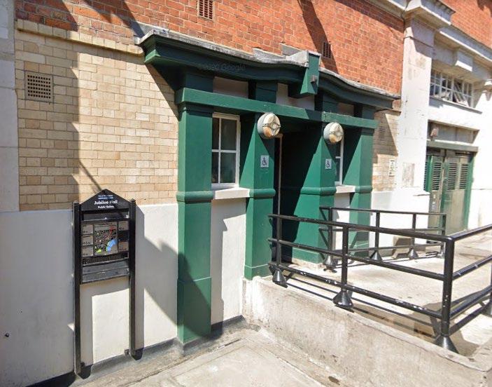
Figure 65: Example of inclusive and accessible public conveniences.
To find where public conveniences are located in Westminster, please visit: Public toilets | Westminster City Council
Wastewater Drainage and flood risk management: Context
The City Council is the Lead Local Flood Authority responsible for managing the risk of flooding from surface water, groundwater, and ordinary watercourses. Thames Water as the wastewater company is responsible for sewer flooding, and The Environment Agency is responsible for managing the risk of flooding from the River Thames.
The council’s “Strategic Flood Risk Assessment” (SFRA) provides an assessment of all sources of flooding, taking account of the impacts of climate change. Areas of the City Council sit within recognised flood risk zones. These, alongside blocked drainage assets and increased rainfall arising from climate change, can contribute to the increased risk of localised flooding.
Effective rainwater management is essential for the operation of the public realm. The risk of surface water flooding is growing. The way we plan, implement, and manage our drainage and flood risk infrastructure must be adaptable to changing climate conditions.
The City Council maintains a schedule of drain cleaning to prevent localised flooding. Gully cleansing is carried out through the City Council’s Planned Preventative Maintenance (PPM) Programme, supplemented by reactive maintenance, however increased rainfall and extreme weather events require a proactive approach to flood management, with a range of options implemented to reduce occurrences of flooding in Westminster.
The City Council’s maintains a proactive ‘Drainage Improvement Programme’ where gulley outlet conditions are surveyed and where needed, repaired, to prevent defects, ensuring the risk of drainage issues and flooding is minimised.
For specific guidance on Sustainable Drainage Systems (SuDS ) see Chapter 4.3 Green and Blue Infrastructure above Wastewater Drainage and Flood Risk Management Guidance
H. Surfaces should we well-drained to minimise the risk of surface water flooding.
I. Natural drainage in the public realm is encouraged.
J. All existing flood management infrastructure will be protected including access for maintenance.
K. Developers must comply with drainage hierarchy as set out in the Mayor’s London Plan
L. Cycle friendly gully covers should not be installed in low-risk areas as defined as:
o Inside parking bays
o Adjacent to parking bays
o Adjacent to build outs
M. Wherever possible, an undeveloped buffer zone of 16 metres should be maintained around flood defence structures, including buried elements of the flood defence.
TfL’s Streetscape Guidance sets out the types of drainage systems in use in London, and their design and layout requirements It includes guidance on the design requirements of kerbs and gullies, drainage pipes and attenuation tanks, amongst others, to “mitigate the impact of current and future climatic conditions by assessing, managing and minimising risk through good design”.
Utilities companies own most of the drain and inspection covers in the public realm.
Utility companies own the majority of ironwork that appears on the public highway and are responsible for the maintenance of their inspection covers. A small proportion are owned by the highway authority, and these relate to traffic signalling, drainage and CCTV surveillance equipment. Where the highway authority replaces the utility company standard cover with a bespoke inset cover, the highway authority assumes the maintenance responsibility for that cover.
Westminster’s 2023 ‘Drainage Design and Construction Guide for Highways Drainage’ document provides guidance on the design standards that are to be adopted for the planning, design, maintenance, and improvement and highway drainage infrastructure within the City of Westminster (WCC), based on existing national standards, published strategy, industry best practice guidance and Westminster guidance, to ensure that drainage systems within Westminster are adequately designed, specified and constructed within the constraints of the city ’s infrastructure, historical design standards used for existing infrastructure and good practice.
The use of smart devices on our infrastructure assets will be used where appropriate, to provide real time data to assist and improve our services, and enable proactive maintenance, for example cleaning gullies in advance of anticipated rainfall, in response to and to prevent patterns in localised flooding.
The Electronic Communications Code 75 is a set of rights that are designed to facilitate the installation and maintenance of electronic communications networks. It provides a statutory basis whereby communications providers can place their Apparatus on land or buildings owned by another person or organisation, to ensure that their services are provided where they are needed. Electronic communications services, including internet and mobile phone services, are considered essential services.
The Code confers “code rights” on a person with Code powers to:
• Install, keep, inspect, maintain and operate electronic communications apparatus on, under or over the land;
• carry out any works on the land to enable apparatus to be installed and gain access to land to maintain or operate the apparatus;
• construct and maintain electronic communications networks and infrastructure (such as ducts, cabinets and poles) on public highways without the need to obtain a street works licence to undertake such works;
• construct communications infrastructure which is classified as ‘permitted developments’ under Town and Country Planning legislation (such as certain types of masts, poles and cabinets) without the need to apply for planning permission;
• connect to a power supply;
• interfere with or obstruct a means of access to or from the land (whether or not any electronic communications apparatus is on, under or over the land); and
• lop or cut back any tree or other vegetation that could interfere with apparatus.
75 The Electronic Communications Code is set out in Schedule 3A of the Communications Act 2003: https://www.legislation.gov.uk/ukpga/2003/21/schedule/3A
The government’s UK Digital Strategy 76 sets out the importance of providing world class digital infrastructure to improve connectivity. The continued growth and success of Westminster’s economy is dependent on securing access to digital infrastructure. Investment in digital and telecommunications infrastructure will be supported here. The council has put in place a concession framework for the installation of 5G infrastructure on highway street lighting assets where safe to attach to.
Westminster City Plan Policy 19 requires applications for new apparatus such as boxes that enable the roll out of 5G 77 to seek to minimise unnecessary and visually obtrusive clutter of the public realm.
Ofcom’s ‘Electronic Communications Code of Practice’ has been established under the Digital Economy Act to support the Electronic Communications Code, designed to facilitate the installation and maintenance of electronic communications equipment. It sets out expectations to reduce clutter and improve the experience of pedestrians and other highway uses and the quality of the public realm, and the stages for reaching agreement on the installation of new apparatus.
All traffic signal works within London are managed by Transport for London
With the closure of telephone exchanges over the next 10-15 years, the number of cabinets on the street is likely to increase.
A. Investment in digital and telecommunications infrastructure for public benefit within the public realm will be supported where it does not impact on movement within the public realm, and only where the benefits of the new infrastructure are considered by the City Council to outweigh any negative impacts on local character, heritage assets, or the quality of the public realm.
B. All electrical supplies to street furniture must be provided by the current appointed Electricity Network Management organisation (currently UKPN). No other body is currently permitted to work on or connect to the electricity network without both UKPN and WCC’s approval.
C. Opportunities for co-location, shared facilities, and innovations such as smart street furniture, referred to as multifunctional minor structures by British Standards Institute, should be explored where new digital and telecommunications infrastructure is proposed.
D. New standalone apparatus will only be supported where all reasonable options for sharing existing facilities, or the use of less obtrusive locations, have been ruled out as impracticable.
E. Equipment that is no longer required must be removed. Powered equipment must be removed at the cost of the asset owner.
F. Any electrical item needs to be easily accessible to maintain and repair, including cabling. Power feeds need to be in appropriately sized enclosure to meet the DNO's requirements and British Standards for clear zones for safety. Items outside contract rates need to be formally agreed with the council will require commuted sums to cover 25 year period. There are also earthing requirements when near other powered furniture
• London Sustainable Drainage Action Plan 2016.
Cross-Reference:
• Chapter 4.5 Street Furniture Guidance in this SPD
• Chapter 4.1 Highways space / Carriageway space / Parking Guidance in this SPD
• Chapter 4.3 Green Infrastructure Guidance in this SPD
• Section 3 Equality, Accessibility, and Inclusion in the Public Realm in this SPD
Sources:
76 UK Digital Strategy Policy paper: https://www.gov.uk/government/publications/uk-digital-strategy
77 And other related technological advances. 5G is the fifth generation of mobile phone technology, bringing greater speed, capacity, and functionality to mobile services.
• WCC Draft Infrastructure Delivery Plan 2019-2040: https://www.westminster.gov.uk/media/document/ev-gen-007 draft-infrastructure-delivery-plan
• HM Government 5G mobile technology: a guide: https://www.ofcom.org.uk/__data/assets/pdf_file/0015/202065/5g -guide.pdf
• Ofcom ’s ‘Electronic Communications Code Code of Practice’: https://www.ofcom.org.uk/__data/assets/pdf_file/0025/108790/ECC-Code-of-Practice.pdf
• For drainage see Streetscape Guidance 2022
• https://www.local.gov.uk/topics/severe-weather/flooding/sustainable-drainage-systems
• https://www.susdrain.org/delivering-SuDS/
Regulations/Legislation:
• New Roads and Street Works Act 1991
• The Electronic Communications Code is set out in Schedule 3A of the Communications Act 2003: https://www.legislation.gov.uk/ukpga/2003/21/schedule/3A
• https://www.gov.uk/government/publications/uk-digital-strategy
• https://content.tfl.gov.uk/sustainable-urban-drainage-november-2016.pdf
Related SPD sections
• 4.3 Green Infrastructure (re: lighting of and near trees)
• 4.5 Street Furniture (re: lamp columns – location and design and re: Placement of Wi-Fi and Smart technology)
• 4.13 Signs and Adverts
• 4.11 Services and utilities
• 4.7 Street Trading / Commercial Activity (including Tables and Chairs)
Key City Plan policies 43. Public Realm
The City Plan specifies that development should contribute to improving connectivity, legibility and permeability of the public realm and the network of public spaces in the city through: creating clear sight lines, improve lighting and following the principles of designing out crime.
This section focuses on required light levels and the function of lighting in the public realm. Guidance on the placement of lamp columns, and on lamp column and lantern types, is provided in the Street Furniture section above.
Westminster’s Westminster's Master Lighting Plan 2020-2040 and Lighting Design Guide defines a standard of lighting “The Westminster Standard” appropriate to the needs of the council and its highway and public realm users, whilst the Third Party Attachments/Smart Lighting Column Guide requires the light column structure to be assessed to what it can safely support: https://www.westminster.gov.uk/roads-and-travel/street-lighting
These documents lay down a strategic approach to managing the use of artificial light across the city. TfL are responsible for street lighting on the Transport for London Road Network (TLRN 78). Westminster City Council has responsibility for street lighting on Westminster’s remaining streets.
When considering lighting levels, the scale of the space and its component factors must be taken into consideration. Different spaces require different lighting illumination, for instance conservation areas, high security areas, and residential areas.
Street lighting plays an important function enhancing safety and legibility in the public realm and shaping the city’s streetscape after dusk.
Light has the power to reveal or conceal buildings, landscape, and topographical features, highlight and define routes and boundaries, and emphasise views.
It can:
• Aid wayfinding, security, and help create a sense of place.
• Keep our public realm accessible, legible, and safer after dark.
• Reduce the risk of accidents, and increase visibility for emergency services.
• Protect assets, discouraging crime and vandalism.
78 See TLRN Network diagram in Highways Guidance in this SPD.
• Serve as its own form of public art
However, excessive or poor lighting can:
• Create visual overload.
• Detrimentally impact road users, pedestrians, residents, and biodiversity.
Getting the approach to lighting of the public realm right through a coordinated use of artificial lighting supports our nighttime economy and enables the safe movement of people through the city, encouraging dwell time in appropriate locations, and deterring anti-social behaviour.
Where they arise, opportunities to improve the energy efficiency of street lighting and centrally manage lighting levels in response to user needs must be taken.
Additional incidental lighting comes from shop windows, offices, homes, and vehicles. The orientation of entrances and windows to buildings can encourage surveillance and self-policing of public spaces. Good lighting is an important tool in this respect and schemes should consider all artificial light sources both public and private, that may contribute to the highway environment
Third party lighting interventions usually require planning permission Westminster’s Lighting Design guide advises on the required standards to meet.
Pedestrian routes through open spaces should be carefully designed to ensure safety and convenience and have appropriate levels of lighting as well as clear sign-posting and additional safety measures such as camera enforcement and barriers where there is an agreed evidenced need.
Whilst there is no statutory requirement for the City Council to provide street lighting, if a system of street lighting exists it should be lit to required British lighting Standards. We are responsible for the safety of our highway/public realm users and require anyone developing schemes on the public realm to abide by the below Strategic Principles.
Public lighting cannot be viewed in isolation and should never be seen simply as providing a certain fitting with a certain type of lamp.
Lighting proposals must be examined holistically, and provide a balance between safety and security, and sustainability / energy efficiency.
We need to create a coherently lit nightscape, using the latest technology to manage and reduce energy consumption and light pollution, and to increase a sense of safety and security on the streets. Use of light emitting diodes (LEDs) offer opportunities to enliven the city at night with a lower environmental footprint and at reduced cost.
• Wayfinding — Through lighting equipment style and application, enable all users to locate themselves and navigate through the city by providing local identities by day and night and the appropriate lighting of key wayfinding landmarks, nodes and routes at both a citywide and local area level.
• Sustainable — Taking a European Commission Green Public Procurement 79 approach to the consideration, planning, design, and operation as well as the application of the right technologies, standards and guidance through a whole life costing approach reduces the energy and carbon footprint and provides a reliable sustainable and maintainable
79 Green Public Procurement (GPP) means that public authorities seek to purchase goods, services and works with a reduced environmental impact throughout their life-cycle compared to goods, services and works with the same primary function which would otherwise be procured. Green Public Procurement is a voluntary tool for Europe's public authorities that favours products, services and works that respect the environment." https://ec.europa.eu/environment/gpp/index_en.htm
lighting installation. This includes working towards a Circular Economy for any component to reduce carbon and prolong a component's life by re-use, recycling etc.
• Environment — Manage the environmental consequences that arise from using artificial light at night with respect to humans as well as our treasured flora and fauna. These objectives are not mutually exclusive but have large overlaps; improving lighting in an area demonstrates investment with that area, promotes safety but also links to developing the local economy and celebrating local distinctiveness, perhaps changing a perception of an area The Council’s Artificial Lighting Environmental and Ecological Impact Strategy details relevant legislations and areas requiring specific attention within the City.
• The City Council will maintain modern street lighting columns and lanterns to a high standard in terms of its physical condition/state of repair as well as in terms of its lighting level and efficiency, with a target of 50 year column life and 20 year equipment life
• It is also important to maintain our historic and cherished lighting assets, maintaining their appearance and fit within the built environment but using modern innovations to light the highway and minimising impact on their aesthetic quality.
• Future Ready — Develop an approach by which the lighting infrastructure is considered to support future technologies associated with good light & lighting practice and Smart City applications. Advising on how these can be assessed, trialled and if suitable brought into standard application.
• Quality in design — Promote quality in the design and application of lighting, undertaken by competent lightings designers, ensuring that Westminster is attractive, welcoming and neighbourhoods continue to thrive.
• Support the night-time economy — good light and lighting practices can significantly enhance the city for residents, tourists, workers, and businesses, drawing people into areas at night.
Energy reduction is an important objective and remote central monitoring systems and new technologies using light emitting diodes (LEDs) have offered new opportunities to enliven the city at night with a lower environmental footprint and at reduced consumption
Technological advancements may provide future opportunities for use of renewable energy, however this would require battery storage issues to be resolved, as the power would be generated mostly in the daytime when it would be needed to power lighting at night. Aesthetic considerations must also be considered with respect to the built environment they are placed in and the council historic column assets.
• Every lighting scheme will consume energy, emit light and require maintenance. The following actions may be taken to control and reduce energy waste and light pollution:
o the use of lower energy light sources
o use of improved optics and lighting design by competent lighting professionals
o the change to the most energy efficient control gear
o the use of remote control and central monitoring systems
o eradication of shabby, non-standard units and damaged equipment.
• The Council is open to testing more sustainable energy sources including solar, wind and kinetic where a positive business case and whole life carbon emissions is proven.
• Materials and equipment, including their delivery and installation, should be procured in a carbon neutral way. See materials guidance in this SPD.
A. Lighting in the public realm must be designed and located to maximise energy and lighting level efficiency, and not detrimentally impact on public realm or highways users, or local residential amenity or biodiversity.
B. They must be of appropriate size and provide sufficient lighting for their setting.
C. Designers are responsible for considering the location, maintenance, repair, clean and eventually demolition and recycling and/or reusability of the structures.
D. Columns should not be placed in front of windows and doors.
E. Lighting can be applied staggered, or one-sided, double-sided, or a mixture depending on the underground conditions and other issues such as windows and trees. Trial holes will need to be dug prior to construction beginning, to ensure no obstructions are in the ground. These may include, but are not limited to, basements and utilities.
F. The use of in-ground uplighters in the public realm will generally not be supported. These are difficult to maintain and their use will be resisted. There are more preferred methods to provide feature lighting above ground that the Council can advise on that will also reduce obtrusive light.
G. Street lamps that are not historic will still have characteristic Westminster bases if in prominent locations, but there will be places calling for a simpler approach with undecorated stepped tubular columns with standard functional lanterns.
H. All street lamps will use the council’s current central monitoring system (CMS)
I. Safely lighting streets is the priority of our lamp columns. Lamp-column powered attachments, Wi-Fi/cameras etc. will be switched off if needed to make safe to work on repairing the lights. Contact phone numbers need to be visible on the attachment to contact in these cases.
Lighting levels should be chosen to suit the needs of the user and the environment. Westminster’s streets are often mixed use, so the light from the lanterns needs to provide good lighting for traffic and a safe, secure feeling and a good ambience for pedestrians, cyclists, and other public realm users.
Inadequate lighting prevents and discourages use and exploration of the city, increasing our sense of unease. Conversely, too much uncontrolled lighting creates visual overload, and can negatively impact on amenity and the environment.
It is possible to make accurate predictions of the potential lighting effects and levels of illumination of a scheme (colour, beam angle, light wash, shadow etc.) through the use of illuminated models, sketches and computer modelling.
When designing schemes, thought should be given to the relationship between lighting and paving materials, including the colour and reflectivity of materials. Guidance about pavement materials is provided in the Materials section of this SPD.
A. Streetlights must be designed to avoid direct sky illumination.
B. In-ground uplighters are prone to water damage and difficult to keep clean and maintain and will, in most cases, not be supported. Above ground highway infrastructure are preferred for feature lighting to give a similar effect if required
C. Any lighting should adhere to the Institute of Lighting Professionals Guidance Note 01: The Reduction of Obtrusive Light for the city’s E2-E4 environment zones, curfew time taken as 11pm unless otherwise agreed with Planning.
D. Lighting levels must reflect their purpose and setting, and the level of lighting required to match the activities being undertaken.
E. The Westminster Lighting Design Guide 2020, section 4.2.2 Adaptive Lighting Strategy provides the recommended lighting level and environment zone for every road in the City to advise the right light at the right time with the right controls in place.
A. Light sources which give colour rendering similar to daylight (such as LED lighting) are likely to be of most benefit to people with a visual impairment.
B. Particular care is required at ramps and steps to avoid disguising the gradient or the distinction between steps and risers.
C. BS8300 advises specific minimum lighting levels
D. Trees planted within close proximity to streetlights can create areas of shadow and also cause damage to the lighting
E. The lighting design guide on the Westminster City Council webpage provides a defined hierarchy of streets and spaces, each to be reinforced by specific lighting treatments and a hierarchy of lighting levels. For more information, please see the City of Westminster Lighting Design Guide
At the present time, existing gas lighting assets cannot be adapted. Preserving the listed gas assets is important and no changes to their location or appearance shall be permitted without undertaking a Listed Building Consent process with statutory bodies
A review is currently ongoing with Historic England and Planning regarding unlisted gas lighting assets. Where warranted, due to poor lighting levels with high crime and safety concerns, additional complementary gas effect LED lighting on gas lit roads is available that mimic the appearance of the gas lights, as an addition to the existing listed gas lights.
LED lights are more energy efficient than traditional bulbs, offering 50-80% energy savings. They also have a much longer life cycle than traditional lamps 80, and offer a wider range of colours and brightness – both of which can be controlled remotely, in response to user needs. They are also significantly cheaper to operate. The ability to focus LED lights also results in less upward light pollution.
As new lighting technologies are identified, highway street lighting will look into them to improve the night-time environment and reduce energy and carbon emissions.
Remote monitoring is used to adapt light levels to changing vehicle and pedestrian volumes and other requirements.
This may include the use of smart devices on our assets to provide real time data to assist and improve our services, for example, informing proactive maintenance.
Remote control of lighting assets enables the City Council to control lighting levels in response to how busy a street is at different times throughout the night, and to increase lighting where appropriate for events, or to assist the emergency services.
The central management systems can also be also used to automatically advise of potential power faults or lantern failures, creating jobs on the council’s asset inventory system to enable repairs.
Specific guidance on the below is set out in the City Council’s Lighting Masterplan 2020-2040:
• Feature and orientation lighting
• Lighting for retail
• Architectural / Urban realm enhancement lighting
• Lighting of open spaces
• Lighting art/festivals/events
Power supplies can enhance the functionality of public spaces, provide vital infrastructure for street markets and individual trading pitches, and provide energy for temporary, one-off, and seasonal events.
80 https://www.centreforlondon.org/reader/lighting-london/chapter-2-designing-and-managing-lighting/#public-lighting
Different supply wattages are available which must be designed specifically for each site according to site constraints. The City Council have standard options for both virtual metering up to 16 A installations, and standard metered supplies up to 100 A. 16 A is the preferred supply.
16A is universally preferred for isolated pitches, street markets and events, as this allows virtual metering, which is more accurate to the user for paying energy, safer on the highway not having that much power accessible to the public and can be installed at much quicker and cheaper cost. This will also produce much less carbon emissions as per our climate emergency.
Costs and timeframes are specific to the location and different metering types, but 100 A metered supplies can take a minimum of 6 months to install due to the type of work required from the power companies.
Proposals to provide power supplies should take account of the location of underground vaults, cellars, trees, depth of underground tube lines and existing services. Utility companies should be approached for details of their services at the outset of the design.
Approval from respective Events or Market Trader teams will be required prior to starting design for power supply installations.
Ownership of meters needs to be clearly defined and ongoing maintenance, both reactive repairs and routine electrical and structural testing, needs to be undertaken by competently trained persons approved by the council to work on the highway, with their costs covered
Specific guidance on the types of supplies and requirements to follow can be found in in the Market Traders Electrical Supply Guidance. Any overloaded power supplies resulting in work will be at the expense of those who caused the damage. Early and regular communication with traders is needed to keep everyone aware of power limitations
A. Power connections must be safe, fit for purpose, energy efficient, and not cause any danger or obstruction to other users of the public realm (or anyone else).
B. Cables should not be placed on or across surfaces used by pedestrians and other highway users
C. Third party lighting on or within the highway will be resisted
D. Market trader power supplies will be limited to 16AMP per trader from one power source to provide consistent, managed and safe power supply.
For more information, please refer to the following:
• Chapter 4.5 Street Furniture Guidance in this SPD re: Placement of Wi-Fi and Smart technology and the lighting of street furniture
• Chapter 4.11 Services and Utilities Guidance in this SPD
• Chapter 4.7 Street Trading / Commercial Activity (including Tables and Chairs) in this SPD
Trees planted close to streetlights can create areas of shadow and cause damage to the lamp column due to branch movement and residue deposits and may impact on the health of the tree
A. Lighting should be positioned away from trees to avoid interference with street lighting performance and permit unobstructed illumination of the carriageway and footway.
B. Positioning advised in the Lighting Design guide, preferably opposite each other or mid-distance between columns, with a minimum distance of 5m between lights and trees such that canopies do not adversely affect lighting performance or lights do not affect tree growth and root system. If the tree type or column type is proven to not affect the other, a reduced minimum distance may be possible once approved by the council.
C. Where trees and street lighting are to be co-located, early consultation with the Westminster Public Lighting and Arboriculture officers must be so that the requirements of both can be considered.
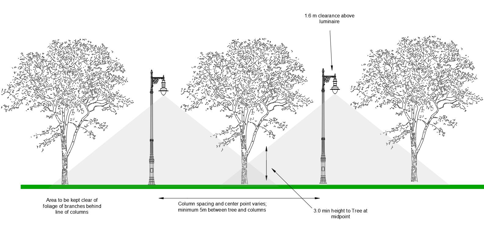
Figure 66: Relationship of trees and street lights, including spacing.
The Westminster Lighting Design Guide provides information on the relationship of trees and street lights, including spacing.
Feature Lighting of Trees Guidance
A. Lighting specifically of trees should only ever be used on exceptional specimens or in exceptional locations - as an integral part of a purposeful place-making scheme. It can cause problems for the tree’s health, light pollution, and increased maintenance requirements, and also raises issues of sustainability in the consumption of electricity and carbon emissions, for a non-essential purpose
B. Commuted sums would be required to allow these, however they are usually not be supported
C. In the limited cases where lighting is deemed to be appropriate, the appearance of lights should not detract from the appearance of the trees or townscape, including the appearance of the lights when they are switched off, nor should they negatively affect local flora and fauna. The amount of hardware required should be minimised, and invasive fixings should be avoided. Installations should always be time limited.
D. The following details will be required before approval by is given:
• Lighting design and specification
• Detailed method statement for installation and removal of lights
• Duration of proposed installation
• Fully costed and funded maintenance schedule, and energy consumption costs
• Risk assessment to include risks to the tree, the public, the installation contractors, and the Council’s tree contractors should they need to carry out urgent work to the tree.
In addition, separate approvals are likely to be required for a highway licence and for electrical source. Advertisement consent may also be required in some cases.
Links and Related Documents and Strategies
• Westminster’s Lighting Master Plan 2020-2040
• Westminster’s Lighting Design Guide
References
• WCC Infrastructure Delivery Plan (IDP)
• Guide to Highway Electrical Street Furniture The Institution of Engineering and Technology 2018
Related SPD sections • 4 7 Street Trading / Commercial Activity
• 4 12 Power and Lighting
Key City Plan policies 43. Public Realm
Signs and advertisements can have significant impacts on the quality, appearance, and safety of the public realm.
They are important to the success of many businesses and, where carefully designed, can contribute to attractiveness and variety in townscapes of commercial parts of the city.
The proliferation of advertising can, however, have a harmful impact the character of areas and the appearance of individual buildings. It is therefore important to ensure that the size, design, and siting of adverts has been carefully considered, is related to the use of the building and does not harm visual or residential amenity, heritage assets or impact harmfully on highway safety.
Signs and advertisements should make a positive contribution to amenity or public safety by being sensitively designed in terms of their size, location, method and degree of illumination, their impact on the building on which they are displayed, local context, street-scene, and wider townscape.
The display of advertisements and signs is controlled by the Town and Country Planning (Control of Advertisements) Regulations 1992. These Regulations control all types of advertisements, whether illuminated or not. The law relating to advertisements is highly complicated; signs and advertisements can variously require no consent at all, have ‘deemed’ (or automatic) advertisement consent, and some require ‘express’ consent from the City Council Many functional signs, installed by the City Council will not require express consent, while many commercial advertisements will require express consent. The Advertisement Regulations 81 set out in detail which advertisements require permission. A user -friendly guide 82 covers the most common forms of advertisement in plainer English than the regulations.
Advertisements, signs, and innovative wayfinding should avoid creating barriers to accessibility, through readability, language barriers, or lack of access for users of smart phones or internet.
All new pedestrian wayfinding signs should be consistent in design and quality and be consistent with the Legible London style Redundant wayfinding, advertisements, signs and poles should be removed throughout the city, except in rare instances where the advertisements are of intrinsic heritage value
Advertisements can cause obstruction to pedestrians and other highway users (e.g. A-boards, banner barriers). They can add to street clutter and pose a trip hazard and obstruction to all pavement users. A-boards on the highway and in the public realm present significant hazards for people with visual or cognitive impairments, and to all in crowded streets. They pose obstructions to people who use mobility aids, or who have children in prams or pushchairs, or who have luggage. In much of Westminster pavements are narrow and it is often not possible to widen pavements. This means that any further narrowing of pavements caused by businesses’ or contractors’ use of free standing advertisements can severely inhibit use
81 https://www.legislation.gov.uk/uksi/2007/783/contents
82 https://assets.publishing.service.gov.uk/media/5a755a88e5274a3cb2869c26/326679.pdf
of the public realm, making it difficult to navigate narrowed areas of pavement, particularly when busy. The protected groups of disabled people and parents of young children are particularly affected by this.
Virtual wayfinding, for example online signposting, can be an alternative and addition to traditional physical wayfinding signs in the public realm
Where signs and advertisements are illuminated, or otherwise powered, they should be as energy efficient as possible
A. All new signs and advertisements will protect visual amenity and public safety. In Westminster this means that signs and advertisements will:
1. Have no harmful impact on highway safety, operation or obstruct movement;
2. Be sensitively located within the street-scene and respect the predominant character and appearance of the area;
B. Advertisements, including digital or projected images, should not pose a risk to the safety of drivers or pedestrians through distraction. Very striking or engaging signs should not encourage the public to congregate in congested areas and should be positioned to avoid bright patches of reflected light and glare
C. Where they are fixed to a building, relate in terms of size, detailed design and materials to its use, character, scale, proportions and architectural features of the building;
1. Protect heritage assets and/or designated local, metropolitan or neighbourhood plan views i 83;
2. Not obscure existing architectural detail
A. Advertisements should relate sensitively to the character and appearance of area in which they are located and the appearance of the building to which they are fixed.
B. The following forms of advertising cause harm to visual amenity and will generally be resisted:
1. LED and video screens, moving digital displays and message boards and intermittent, flashing, or lightprojecting signs.
2. Significant advertising in residential areas.
3. Internally illuminated box fascias or projecting signs.
4. Illuminated advertisements adjacent to or visible from the Royal Parks or London Squares.
5. High level signs and banners.
6. Signs and advertisements on street furniture [such as bus stops or telephone kiosks] especially in conservation areas, London squares, or adjacent to Royal Parks, listed buildings, or other sensitive locations.
7. Portable advertisements, including A-boards on the public highway; and
8. Significant advertising on scaffold shrouds
C. Shop signs should be at fascia level and be externally illuminated. Internally illuminated box fascias and projecting signs are not normally appropriate in conservation areas, unless they can be related successfully to the design and detailing of the building and do not detract from the character of a group of buildings or a street. Shop blinds should generally be traditional, retractable canvas awnings and should not bridge between shop windows.
D. Advertisements should not impinge on significant views, including views from parks and open spaces, Metropolitan Views as identified in the draft Metropolitan Views SPD, and Mayor of London’s ‘London View Management Framework’ (LVMF) or locally significant views as identified in our conservation area audits, neighbourhood plans or other place shaping strategies.
E. Advertisements should usually be confined to the ground floor of buildings. Projecting signs should be fixed to the pilasters or columns between buildings, or the fascia above the ground floor window, in one exists. Advertisements should not normally be attached to railings.
F. Advertisements fixed above the ground floor will not normally be allowed, unless they cannot reasonably be fixed at a lower level, or if it can be demonstrated that they make a positive contribution to the character of an area or a building.
83 Relevant views are identified in the Mayor of London’s View Management Framework, Westminster’s Metropolitan Views SPD, Conservation Area Audits and other area based guidance. Neighbourhood Plans can also include identify locally important views.
G. The number of advertisements should be kept to the minimum necessary to convey essential information, even in commercial areas. Only one advertisement, or one projecting and one fascia sign on each principal frontage will normally be permitted. The appearance of a large number of advertisements on a building or in a street is often counter-productive because it becomes difficult to pick out one individual advertisement and can be very disruptive to the appearance and architectural character of an area. When preparing designs for new advertisements, the opportunity should be taken to reduce the number of signs on the building or structure and remove those which are redundant.
H. Where the City Council considers that harm is being caused by advertisements that do not normally require express consent, as in the case of Estate Agents’ boards, they may apply to the Secretary of State for additional controls in the interest of amenity
A. On theatres the council will allow some high-level signage and three-dimensional signage in agreed locations, where this does not harm important views and is appropriately fixed so as not to harm heritage assets.
B. Internally illuminated signs on theatres may be acceptable where they:
1. Are of a size sympathetic to the scale and architecture of the theatre;
2. Are sensitively located;
3 Are well detailed in terms of materials and design;
4. Have no adverse impact to highway safety.
5. Consideration will be given to the intensity of light levels in internally illuminated signs.
6 The impact of signs on the appearance of the building during both daylight and night time hours will be considered. Some theatres by virtue of their historic importance may always be inappropriate for internally illuminated signs. Others may lend themselves more readily to this approach.
7 All proposals which involve sound should be refused in line with the Environmental Protection Act 1990
A. Temporary hoardings or shrouds around building sites or empty sites should not normally be used for displaying poster advertisements. However, in commercial streets, posters on building site hoardings at ground floor level may be acceptable.
B. Large displays above ground floor level are not normally appropriate. In some circumstances well designed shrouds, which respond sensitively and appropriately to their context, with minimal advertising content, may be acceptable.
C. Where consent is granted for advertising on shrouds and hoardings, this will only be permitted for the duration of those works. A schedule and timetable of works may be required as supporting information for an application to display advertisements on shrouds.
D. Such shrouds should aim to mitigate the harm caused to the appearance of the area by use of a full scale representation of the building or a work of public art. Large-scale third party advertising is not acceptable on such shrouds.
and other advertisements suspended above the street
Temporary banners and other suspended advertisements are those which, suspended from purpose designed street lighting columns or buildings, are erected to publicise a specific cultural event in the immediate locality.
A. Suspended advertisements should be at least 5.7 metres above ground level and at least than 2.5 metres away from any light/wall light, to allow for maintenance, reduce light blocking from these fittings and safe earthing distances for persons maintaining and potential for electrocution. Where temporary display is considered acceptable, no two events should be the subject of such a display concurrently.
B. In the case of Christmas Lights and other illuminated displays the proposal will be expected to minimise energy use through the use of low energy technology and controlled lighting up times. The duration of the display of Christmas and other seasonal displays will be controlled by condition. The installation and illumination of Christmas displays will not ordinarily be acceptable before the start of October and November, respectively.
C. In circumstances where temporary banners are acceptable, they should be suspended from unlisted buildings or multi-functional street furniture. They should not harm the setting of heritage assets, having regards to the provisions of the heritage assets policies. Listed street furniture should not be used to display advertising.
Flags
A. Flags and banners can have an adverse impact on the appearance of buildings and the streetscape, by obscuring the façade of buildings and contributing to visual clutter. In streets throughout the city such displays will generally be unacceptable in principle
B. In certain commercial streets such as Regent Street, Old and New Bond Streets, Albemarle Street and Savile Row there is a long standing tradition of flag display. Flags on commercial premises contribute to the character of these streets. Nonetheless flags on these streets, and on the building types listed in the policy, remain subject to design considerations in terms of the size, siting and angle of flagpole. If these elements cannot be satisfactorily designed, applications for flag advertisements may be unacceptable
C. Design Standards for Flags, where they are acceptable, are:
• Only one flag per building
• Flags should be free flying, not tethered
• The maximum acceptable flagpole length is generally 3 metres
• Maximum acceptable flag size is generally 2 metres x 1 metres
• Poles should be angled at 45° on Old and New Bond Streets, and 30° on Regent Street
• A minimum of 5.3 metres vertical clearance should be provided from the base of the flag and banners where the flag hangs over the carriageway or within 1 metre of the carriageway.
• Where the flag is over footway and is setback 1 metre from any kerb edge, a minimum vertical clearance of 2.6 metres is required from the base of the flag to the highway surface.
Digital advertisements and media screens
A. Through their illumination and moving content, digital screens can have an impact on the visual amenity of the public realm disproportionate to their size. They are often proposed at high level, in prominent locations. They will not normally be acceptable. Any that are permitted must adhere to Institute of Lighting Professionals (ILP) Public Lighting Guide 05 Brightness of Illuminated Advertisements
B. The existence of a concentration of such advertisements will not justify its expansion into previously unaffected areas. The cumulative impact of additional screens will be taken into consideration in determining applications.
Advertisement totems
A. New, free-standing structures to display advertisements such as advertising totems or novel hybrid telecommunications/advertising installations are unlikely to be permitted in sensitive locations such as conservation areas in the vast majority of cases. Outside conservation areas, consent to display advertisements on existing or new street furniture will rarely be granted
A. Temporary signs, announcing that a property is for sale or letting, within certain specified limits as set out in the Advertisements Regulations, can generally be erected without consent on private property. However, there is currently a Regulation 7 direction in place obtained from the Secretary of State that grants the City Council the power to request applications for express consent for the display of any such boards in certain areas. A separate leaflet entitled ‘Boardwatch’ has been published by the City Council, showing the restricted areas (known as Regulation 7 Direction Areas). The regulation is due for renewal and this is currently under review.
B. Following the approval of special controls, the City Council agreed that all applications for estate agents’ boards for residential property in the restricted areas will normally be refused and special criteria will apply to commercial buildings. Outside the restricted areas, the maximum size permitted without consent is defined by the Town and Country Planning (Control of Advertisements) Regulations 1992. Separate listed building consent will be required for
display of boards on listed buildings in such areas. Careful attention will be paid to the positioning and method of fixing, to minimise the impact of boards on the character and appearance of listed buildings or conservation areas.
A. Signs, adverts, and wayfinding infrastructure should not be placed in a location likely to cause obstruction to pedestrians or vehicles, including pedestrian desire lines or occasional vehicular access such as street cleaning.
B. Augmented or virtual reality can enhance users’ experience of the public realm, improve accessibility to information, and promote activity. Augmented reality information / advertisement points should not be located where they could cause obstruction to the safe flow of pedestrians or traffic or put any highway user in danger.
C. Signs and advertisements should not distract from the safe enjoyment of the public realm.
D. The use of delineating or signing material, such as road marking, signs, paving or bollards, should be carefully considered not only in terms of signage but also about cost, effectiveness, sustainability, durability and safety (e.g. slip resistance) and in accordance with guidance provided in the Materials Palette document.
E. Projecting and oversailing signs, banners, displays and canopies should provide a minimum safe clearance for pedestrians and road users. Projecting signs should have a minimum clearance of 2.6m. Awnings should have a minimum clearance of 2.14m (and 2.3m at the building façade). Projecting signs should be set back to a minimum of 1m from the kerb edge.
F. Where they require consent, A-boards on the highway will be resisted unless there are exceptional circumstances. Aboards on private forecourts should not cause obstruction to pedestrians, nor detract from the character or appearance of buildings or areas
G. Proposals to introduce new plaques or other markers within the pavement should be treated with caution. Introducing inset plaques, for example route-finding markers, within footpaths or footways can create slip and trip hazards and can cause a maintenance challenge
Advertising on street surfaces, such as adhesive vinyls, constitutes a slip and trip hazard, and is not supported
Technical Guidance on Public Information Signage
Public information signage across Westminster should be accessibly located, consistent in design, and legible. The City Council will:
1. Encourage public information and wayfinding signage which is necessary and enhances the amenity of the public realm (see also ‘Wayfinding’ in section 4.5 Street furniture).
2. Promote a consistent approach to signage design and placement.
3. Promote appropriate dual-use of sign posts and other street furniture to help minimise clutter.
Street Signs
Street signage must be consistent, in terms of design, size and height, in any area.
Wayfinding
See Wayfinding in Chapter 4.5 Street Furniture within this SPD
Traffic Signs
The ‘Traffic Signs Regulations and General Directions 2016’ (TSRGD) guides the location, design, and appearance of traffic signs/bollards, including road markings, traffic signals and pedestrian crossings.
Traffic
A. Traffic signage should be sufficient to enforce regulations but not excessive in terms of numbers and signs
B. Scheme designers are expected to reduce to the practical minimal, road markings and signage to a level necessary to satisfy the regulations and give information, without cluttering the public realm.
C. In all cases the need for signage must be demonstrated to the satisfaction of the highway authority.
D. Unless required by the TSRGD, signs should be unlit. Any signs which require lighting should preferably be externally lit, and should always be lit using a renewable energy source.
E. Decisions to remove signage lighting should be underpinned by robust risk analysis. The expectation is that highway signage is to be de-illuminated as part of the 20-mph speed limit. Retro-reflective signs should be standard unless specific safety issues show the need for illuminated signage, if so, such signage would be externally illuminated.
F. Signs should be at least 450 mm from kerb face to sign edge to reduce being hit.
G. Redundant traffic signs should be removed as they can spoil the visual attractiveness of a place.
H. Where signs are required, they should be concise, no bigger than necessary and carefully sited.
I. In the interest of reducing clutter and making best use of limited space, proposals should actively explore opportunities to use existing street furniture for the placement of signage, as opposed to stand alone signs.
J. Traffic sign backs should be black, signs should be visible and not obscured from view. Poles should be capped at the top.
K. Traffic bollards, usually on centre islands, should be black and be reflectorised or as noted above. The guide post is used within the World Heritage Sites; outside that area, the council’s standard traffic bollard with white reflective strip should be used
L. Upright signs (traffic bollards – as shown in the example images below) should be reflectorised. Where illumination specifications are not specified, this default applies.
M. Co-location of a waiting or delivery times plate on an unlisted lamp column to save having a separate pole is good rationalisation. Two neat plates back-to-back is also good co-location, and one plate with two sets of information up to 300 mm high and 150 mm wide has been found to be good practice and tolerably neat. Two additions to a post is the maximum desirable.
N. Plates giving delivery and parking times could be fixed to walls or railings. A short post at the back of the footway is an alternative, but less neat, solution.
O. In areas of high demand and high townscape quality innovative ways of presenting information will have to be devised in conjunction with other information and wayfinding initiatives
P. For the almost 80% of the city that is conservation area, the 50 mm primrose markings should be used for parking and waiting restrictions.
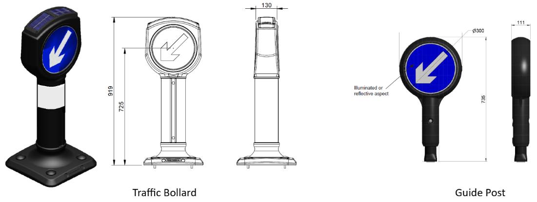
Figure 67: Example of traffic bollard requirements. For further information see: Traffic Signs Manual – Chapter 3 - Regulatory Signs (publishing.service.gov.uk)
A. Where acceptable, signs on posts should be consistent within the local area. To avoid street clutter and a proliferation of signs, criteria for the acceptability of new finger posts will be judged against the published criteria for Legible London signs.
B. Third party signage, including way finding signage, will not be acceptable within the highway, either on existing or new posts.
Street Name Plates
In accordance with regulations made under the London Building Acts (Amendment) Act 1939, the Council is required to erect and maintain street nameplates throughout the City of Westminster and to affix these to buildings, boundary walls or fences adjoining the highway / at each street corner. These nameplates provide valuable information to pedestrians, motorists, businesses, emergency services and others, and should be readily visible to all. In accordance with the regulations, and to ensure consistency of street nameplates across the city, they must be supplied and fitted by the council.
The world famous ‘Westminster’ street name plates are a council copyright design from the 1960s and must be correctly implemented using the specified typography
A. Street name plates should be fixed within 10 feet of every street corner (excluding the width of the public footway) on both sides of each street and may be placed on part of a building or structure.
B. Installed at a height of between 2.5 and 3.5 metres above ground level for best visibility, where installed on a building.
C. In some cases, historic circumstances require them to be fixed higher or to railings or boundary walls.
D. In rare circumstances they can be pole mounted.
E. Name plates should be repeated at intervals of approximately 200 yards on alternate sides of the street on straight lengths of street without intersections.
F. Placed directly opposite the side street at ‘T’ junctions.
G. Displayed at the point of change if the name of a street changes other than at a junction. Both names should be displayed indicating to which parts of the street the names refer.
H. A complete set of street nameplates is a key requirement, and any omissions and broken links need to be corrected.
I. Historic nameplates or incised or moulded street names that survive should be retained where possible.
See Westminster’s published street naming and numbering guidelines for further details
Related documents
• Specification for Highway Works for Westminster City Council – Standard Details
Related SPD sections • 4 5 Street furniture
Key City Plan policies 15. Visitor Economy 43. Public Realm
The City Plan specifies that applicants will be encouraged to provide high quality public art as an integral part of the design of new major developments, particularly around gateway locations and where they benefit legibility. It states that new statues, monuments, or memorials in the public realm will be directed outside of the Monument Saturation Zone.
The City Council has also developed a Cultural Strategy 84 which commits the council to ensuring Westminster remains a vibrant, welcoming, and inclusive cultural hub. The strategy emphasises that ‘art and culture in public spaces is about enhancing the public space and making it more appealing, but also about encouraging the social cohesion and identity of a neighbourhood’. Creative placemaking is identified as one of the key priorities, with various actions listed to improve and ensure culture is at the heart of public realm schemes.
This policy draws a distinction between public art, which is ordinarily developer or community led, and ordinarily located on private land, and commemorative art (such as statues, monuments or memorials) which often take the form of freestanding sculpture, and are usually proposed on public land.
Art
Context
Public art is defined as a creation by professional artists or craftspeople to be enjoyed in public spaces and related to that particular space, site, or community. It can be freestanding or integrated within the fabric of a development. It is ordinarily on private land but must be readily visible and publicly accessible. Public art can take many forms, it is ordinarily permanent in the form of fixed art, statues and monuments, but may occasionally be more temporary in nature including artist residencies, interactive events, performances, augmented reality, sound, and light which adds to public enjoyment of the public realm.
Art plays an important role adding interest to the public realm and attracting tourists and visitors, and can assist in highlighting important buildings and spaces, creating a sense of space in new sites, and aiding wayfinding and legibility, and can define an area which people can identify and use to navigate. Art can be educational and thought provoking to help reveal aspects of our history and contribute to sense of place.
Only the best quality examples of new public art will be acceptable for Westminster’s buildings, streets, and spaces. The City Council encourages property owners, developers, designers, and architects to invest in the conservation of existing and creation of high-quality new public art in appropriate locations.
84 https://www.westminster.gov.uk/cultural-strategy
Where public art is proposed or required applicants are encouraged to engage with the planning service at an early stage of their application process. Documentation accompanying the application should set out how this guidance has been addressed and provide details of public art proposed, including:
• Theme, content, and relationship to place
• Explanation of artist selection process and artist involvement in design
• Community engagement
• Arrangements for future care and maintenance.
Planning permission will usually be required for the removal of public artwork, and this will be resisted without an equivalent or greater public art contribution.
Public art can often be successfully integrated into the fabric of the building, for example as relief sculpture, artist designed metalwork or glazing, artist designed landscaping. Free standing sculpture should not be the default approach to public art provision.
Developers and/or architects are encouraged to work collaboratively with professional artists during the design phase of the project. In selecting the public art approach in a new development, the artist will often be as well placed to identify opportunities for art as the design team.
Considerations to be demonstrated in new Public Art applications:
Public Art Guidance
A. Art works included in a development should be of high quality, be easily and regularly maintained by the owner or occupier, not impact on movement, fulfil all relevant public safety requirements, and should relate well to the form and quality of the surrounding environment.
B. Permanent public art delivered under a developer obligation will not normally be acceptable on the highway and should be provided within the development site itself
C. Proposals for public art should be located where it is accessible to and can be enjoyed by the public such as within piazza spaces between buildings. Art within buildings or behind gates will rarely be acceptable.
D. The artist’s name and title of the work should always be incorporated into permanent public art.
E. Innovation in the creation of public art is encouraged to create diverse and vibrant experiences in public spaces to meet the aspirations of modern-day communities and visitors.
Maintenance
Considerations to be demonstrated in maintenance of new Public Art applications:
Public Art Maintenance Guidance
A. The materials used should be considered for their robustness and suitability for the intended lifespan, their ongoing maintenance and in the context of the setting.
B. New installations should be accompanied by management plans to keep them in good order and these need to be maintained with the construction manuals for buildings and other property to allow future commissioners and contractors to retrieve the correct procedures, products and techniques for their proper conservation and good appearance.
C. The maintenance of public artwork within the private boundary of a site provided through a s106 agreement will usually be the responsibility of the developer or landowner.
D. Public Art should meet the Equality Act 2010 and should not pose a health and safety risk or restrict sightlines or pose a trip hazard.
E. All art installations on the highway (temporary or permanent) should be detectable at ground level by a symbol or long cane and consider all users experience of them in the context of the city environment
Temporary public art is an artwork which has a specific duration time as part of the project held in the public realm. Temporary public art can vary from performances and installations, which are a highly engaging experience for the public, animating under-utilised spaces and add to the diversity and interest of life in the city The installation of temporary art work may require other temporary uses (including tables and chairs) of the highway to be paused while the art work is in place.
Considerations to be demonstrated in temporary art applications:
Temporary Art Installations Guidance
A. Applications for temporary displays of art and performances should be considered in relation to issues of duration, safety, and management. Proposals should have regard to street trading/commercial activity guidance section in this SPD.
B. Any proposed temporary installation should not add burden to the existing highways maintenance regime.
C. The temporary installations should be appropriate and safe for both the intended location and anticipated footfall from visitors.
D. Public benefits for the community should be clearly defined and the consideration of the impact on all users taken into account
E. Where there are physical object(s), a decommissioning plan should be in place with a circular economy/recycling approach to minimise environmental impacts
Public art, both developer-led and commemorative, can take the form of artist designed lighting schemes and moving water installations. The maintenance of these elements is often costly and complex. If water or light schemes fail to be adequately maintained the public art contribution for that site becomes limited, or even nil. For this reason, proposals for new water features or relying entirely on lighting should be treated with great caution. Proposals in relation to light features should take into account the City Council’s published Lighting Masterplan 2019-2040 85 and Lighting Design Guide 2020 86
Context
Westminster has an outstanding heritage of more than 300 statues and memorials. Many of these were designed by the leading artists of their day and are major works of art in their own right. Almost half of all memorials, 47%, are situated in the royal and governmental heart of Westminster – a relatively small area centred on Whitehall and in the Royal Parks. It is not possible to continue to accommodate new statues and monuments in Westminster in the same scale as in the past, and the most central areas are already saturated. However, where new statues and monuments are acceptable their location within other areas of Westminster, where public art is under-represented, is encouraged.
The City Council has established a monument saturation zone as referenced in Policy 43 in the City Plan, where applications for new statues and monuments will not normally be permitted. The area of concern consists of the five Royal Parks, and seven conservation areas:
• Westminster Abbey and Parliament Square
• St James’s
• Adelphi
• Strand
85 Lighting Masterplan 2019-2040
86 Lighting Design Guide 2020
• Whitehall
• Trafalgar Square
• Savoy
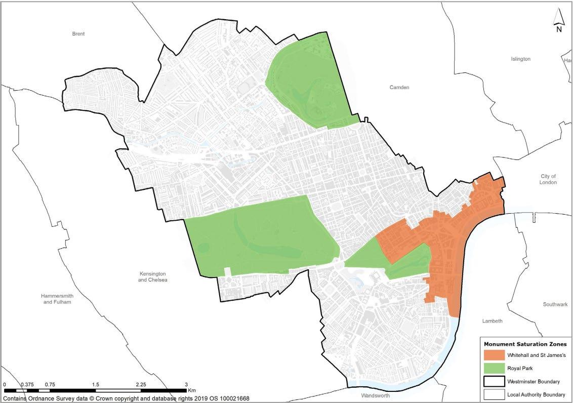
Where a new statue or monument is, exceptionally, located on the highway or in Westminster’s parks or gardens, the City Council will need to be satisfied of the arrangements for future maintenance, including maintenance in perpetuity and associated landscaping works. Ordinarily this means that a one-off commuted sum payment will be required to cover future maintenance costs.
The City Council is also responsible, as a local planning authority, for dealing with planning or listed building consent applications to remove any statues, whether in our care or the care of others. Many existing status and sculptures within Westminster are listed and therefore, any works to a listed public artwork will require listed building consent and planning permission will also be required for the removal of public artwork.
The Mayor of London is committed to ensuring that the capital’s population and history are celebrated and commemorated. As part of this, the Mayor set about establishing the Commission for Diversity in the Public Realm. The role of the Commission is to enrich and add to the current public realm and advise on better ways to raise public understanding behind existing statues, street names, building names and memorials. It is committed to building an accessible programme which is sensitive to the beliefs, views, and opinions of all Londoners, helping people have a better understanding of London’s diverse histories.
Local community engagement in the selection and commissioning process is encouraged. Explanation of the work to be provided, where appropriate is encouraged.
For proposals to relocate or remove public artworks, consideration should be had to seeking views of the artist or commissioner of the artwork, as well as local communities.
We will normally seek the retention of existing statues, monuments and memorials but will follow the approach set out in the NPPF to ‘retain and explain’ (paragraph 204, NPPF 2023) . This may include re-interpretation, added layers and installations, new artworks, displays and counter-memorials, as well as non-physical interventions, such as education programmes, where appropriate.
Considerations to be demonstrated in new Statues, Monuments and Memorial applications: Statues, Monuments and Memorials Guidance
A. Existing statues should generally be retained and where appropriate, explain their historic and social context
B. New statues or memorials should generally be resisted within the monument saturation zone.
C. Where new statues and monuments are acceptable in principle, they should generally be located in areas of Westminster outside the identified saturation zone, where public art, statues and monuments are under-represented
D. Proposals for new statues and monuments should demonstrate how they relate to the context of their proposed setting. Proposals for new statues and monuments where there is no relationship between subject and location should be resisted
E. No statues or memorials should be erected before ten years have elapsed from the death of the individual the statue or monument relates to or the event commemorated.
F. Free-standing public sculptures or monuments are encouraged where they are designed to the very highest standards, where they are appropriate and where they sit happily in the street scene.
G. Multiple memorials to the same individual or event will be resisted unless exceptional circumstances can be demonstrated for the proposal.
H. Local community engagement in the selection and commissioning process is encouraged.
I. In circumstances where it is considered necessary to relocate or remove a statue, clear and convincing justification should be provided, for example where the existing site has been compromised by changes to context and where the relocation will help to better reveal their significance proposed for removal
Related SPD sections
Key City Plan policies
• 4 5 Street Furniture
• 4 7 Street Trading / Commercial Activity
43. Public Realm
44. Security Measures in the Public Realm
Westminster is a busy international tourist destination, the centre of the UK government, and home of several major institutions and businesses. This means security risks (including terrorist attacks) in the public realm are higher in Westminster than elsewhere. Ensuring and maintaining a safe and secure environment is paramount and proposals in the public realm should seek to proactively consider crime, disorder and protective security in the development and design of all schemes
By security we mean all efforts aimed at protecting the public from deliberate harm (crime). They normally include:
o Saferdesign - designing out opportunities for crime and anti-social behaviour
o Physicalbarriers - creating barriers to prevent hostile vehicle attacks
o Surveillance - creating opportunities for natural surveillance over publicly accessible spaces, and where absolutely necessary use of CCTV monitoring
Ensuring the public realm is secure involves identifying potential risks and addressing them appropriately.
Safety relates to freedom from risks of harm or danger. The feelings of safety and fear are often linked with individual perception of the level of risk in a certain environment. It is important to understand public perception of safety, including from security risks, in public spaces.
Fear of crime, as well as crime itself, can deter people from using even good-quality public spaces. Children and young people, for example, are often prevented from using our parks, squares, and streets because of their parents’ fears about crime, whilst women often also face particular concerns. Fear of violence and crime in outdoor areas can also deter adult people from engaging in physical activity in public spaces. Physical changes to, and the better management of, public space can help to allay these fears 87
Prominent security measures could however have the detrimental impact of creating a sense of uneasiness (e.g. too many bollards/visible security measures can create a perception of danger). Schemes should therefore seek to achieve public security without increasing fear of crime.
Landscaping can be a useful crime prevention tool. Careful placing of suitable plant and tree species can reduce opportunities for concealment or vandalism and help define public and private spaces. Good deterrent plants such as Berberis, Robinia and Rose varieties can be employed where suitable. Conversely, poorly designed, ill maintained landscaping schemes may obscure views and create shadows and places for people to hide and hide antisocial materials; thereby encouraging opportunist criminals and increasing fear of crime.
87 The Value of Public Space, CABE
When arranging street furniture, its placement should be carefully considered to help reduce opportunities for crime. For example, the positioning of benches or litter bins in relation to fences and railings, The presence of active frontages and activities spilling over onto the public realm can also act as a deterrent for crime and anti-social behaviour.
Protective security encompasses a range of measures and risk reduction can be achieved in a variety of ways but should be proportionate to the risk and threat posed. One of these ways is through Hostile Vehicle Mitigation (HVM). HVM are a series of measures to protect users from vehicle-borne threats. Bollards are only one form of vehicle security barrier a form of HVM. More detailed guidance on bollards can be found in the Street Furniture section (see chapter 4.5).
It is not always possible to entirely predict how a space will be used in the future, and this poses a challenge to designing appropriate security solutions. Applicants should consider implementing a variety of mitigation measures in anticipation of possible future risks.
The government’s draft Terrorism (Protection of Premises) Bill, known as ‘Martyn’s Law’ (previously known as the ‘Protect Duty ’ Bill) in recognition of the campaign led by the mother of one of the victims of the Manchester Arena Bombings was published on 2nd May 2023. The primary aim of the Bill is to improve protective security and preparedness measures in publicly accessible locations. The emerging Bill, if enacted by Parliament, will place a requirement on publicly accessible venues and locations to consider the threat of terrorism and put into place appropriate mitigation measures.
In delivering security measures within the public realm, it is important that security systems are designed and properly maintained for longevity and reliability. They should be designed in such a way that is both functional but adaptable to future change and balance the potential risk and threat posed with amenity, functionality, aesthetic, pedestrian comfort, accessibility etc. By working in partnership with key stakeholders we can ensure the right security measures are in place for all public realm schemes, future-proof our city and keep the public safe.
A. Security should be considered in the design and operation of public realm, to improve the wellbeing of users of those spaces.
B. Potential security issues and constraints should be identified at the early stages of developing a scheme impacting on the public realm. Assessments should include consideration of how a place functions at different times of the year (e.g. to account for seasonality/events) and throughout the day, including particularly during night hours.
C. Proposals are expected to incorporate the principles of ‘Secure By Design’ at the outset of the design process and to have undergone an appropriate risk assessment considering schemes in the context they would be operating 88. The assessment should identify potential solutions to reduce the likelihood or mitigate risk. Solutions must be reasonable, viable, specific, and proportionate 89 to the identified risk. When devising solutions to address the identified risk(s), applicants are advised to explore a range of approaches that are not limited to just physical measures, as several elements can affect the level, type, and extent of security risk. These include layout, land use, lighting, thresholds, etc.
D. Applicants should demonstrate that they have given due consideration to risks and have acted on that due consideration when putting forward a proposal with impacts on the public realm. The City Council needs to be satisfied that the risk is sufficient to require special measures and that there is no alternative way to address confirmed safety risks.
E. Measures should be integrated into the design of schemes, while retrofitting is to be avoided where possible.
F. Emergency service needs, management and servicing access should be considered when designing security measures and – particularly for ’active’ measures 90 – how they will be operated.
G. Public realm schemes should ensure resilience against emergencies including terrorism and related hazards. Applicants should work alongside Metropolitan Police ‘Designing Out Crime’ to incorporate Counter Terrorism Security Advisors’ advice.
88 Please refer to the Police’s Protect Guidance for specialist advice: https://www.protectuk.police.uk/
89 Solutions to respond to JASPAR (Justifiable, Achievable, Sustainable, Practical, Affordable and Reasonable) principles.
90 E.g., removable, socketed, coffin and manual/hydraulic/electric bollards
H. Proposals should also consider how they can mitigate the risk of suicides in public spaces 91. In particular, where taller buildings provide new public realm (e.g. through publicly accessible roof gardens), a holistic design concept should be established from the outset to create safe places and ensure the safety of members of the public. Where practicable schemes should incorporate a range of measures in order to mitigate possible future risks.
I. The public realm should be designed for maximum natural surveillance to encourage its use and discourage misuse.
J. Designs should ensure a balance between security and accessibility.
K. Pedestrian routes may need to be more serpentine to thwart vehicle-borne devices but should ensure pedestrian access is maintained
L. Bollards may need to be staggered to allow wheelchair users to pass between them, whilst still maintaining a physical barrier to hostile vehicles, with specific bollards made removable to facilitate access when required.
M. Schemes should deliver places that feel safe to use (‘perceived security’).
N. A balance should be achieved between the need to make users aware that security measures are in place and making measures too visible
N. Demonstrate a holistic and multifunctional approach to public realm design, including with regards to security measures.
O. Public realm elements should seek to be multifunctional (‘multi-functional objects’) wherever this is possible and would not create increased security risks.
P. Unnecessary bollards, where there is no other public benefit, are unwelcome, unless they protect fragile vaults or that there is no alternative way to address the identified risk and that the level and type of risk demands special measures.
Q. Street furniture should be positioned to help reduce opportunities for crime
R. Temporary approaches may be acceptable in instances where this is considered appropriate and will be determined on a case-by-case basis. For example, temporary security barriers can be used for special uses of the public highway (e.g. events).
S. Proposals for Hostile Vehicle Mitigation (HVM) measures should respond to the key guiding principles set out above and align with specialist guidance in the National Protective Security Authority’s (NPSA) Public Realm Design Guide for Hostile Vehicle Mitigation 92
T. Metropolitan Police Counter Terrorism Security Advisor, NPSA, TfL, and Westminster City Council’s Town Planning and Highways teams are key stakeholders that should be consulted when considering security measures for a scheme.
U. Public realm schemes including security measures should be subject to coordinated planning and highways consent by Westminster City Council.
V. Security measures should ideally be agreed through legal agreements and then deemed consent, where appropriate and in light of a significant vulnerability to terrorism.
91 Public Health England – Preventing suicides in public spaces https://www.gov.uk/government/publications/suicideprevention-suicides-in-public-places
92 Public Realm Design for Hostile Vehicle Mitigation | NPSA https://www.npsa.gov.uk/public-realm-design-guide-hostilevehicle-mitigation-0
Active provision for electric vehicles: A socket or equivalent connected to the electrical supply system that vehicle owners can use to recharge their vehicle (see also ‘Passive provision for electric vehicles’).
Carriageway: A way constituting or comprised in a highway, being a way (other than a cycle track) over which the public have a right of way for the passage of vehicles
Concession framework: Westminster City Council may offer a concession contract for the use of its street furniture, like streetlights, to install small cell equipment. The Council will engage with suppliers to create a Small Cell Infrastructure within the City of Westminster that helps deliver against the wider commercial, economic and social objectives of the Council. Concessionaires will be expected to meet a set of technical, health and safety and operational requirements.
Crossfalls: The transverse sloping of a roadway toward the shoulder or gutter on either side
Equalities Impact Assessment (EqIA): A way of systematically considering equal opportunities during the decision-making process.
Footpath: A highway over which the public have a right of way on foot only, not being a footway. Footways on roads that comprise a carriageway are not defined as footpaths according to the Highways Act 1980.
Footway: A way comprised in a highway which also comprises a carriageway, being a way over which the public have a right of way on foot only
Footway clear zone: An area along the footway that should kept free of obstructions to allow for safe, unhindered pedestrian movement, including those with mobility aids.
Frontage zone: An area immediately adjacent to the property line. This space is located between the property line and the highway boundary and should be kept free of street furniture.
Highway: A way over which members of the public have the right to pass and repass, comprising carriageway, footway, footpath and any verge adjoining them
Highway authority: In Westminster, the City Council is the highway authority for all highways, whether or not maintainable at the public expense, except those belonging to the Transport for London Road Network (TLRN) which falls under TfL’s responsibility.
Important local views: Views that have been identified as protected vistas and other strategic views in the City Plan, Metropolitan Views as identified in the draft Metropolitan Views SPD, and Mayor of London’s ‘London View Management Framework’ (LVMF) or identified in Westminster conservation area audits, neighbourhood plans or other place shaping strategies.
Kerb zone: The area of pavement that is directly adjacent to the road or carriageway. It provides a buffer between the road or carriage way and the frontage zone / footway clear zone.
The Local London Authority Act 2018 (LLA 2018): This is legislation that grants specific powers to London boroughs and other local authorities in the capital. It is designed to improve local governance, address transport and infrastructure needs, and regulate issues such as street trading, housing, and public safety within London. The act allows local authorities to manage their responsibilities more effectively in line with the city's unique challenges.
Monument Saturation Zone: An area where available sites for new memorial applications grow ever scarcer. The City Council has established a monument saturation zone where applications for new statues and monuments will not be permitted unless there is an exceptionally good reason.
Passive provision for electric vehicles: The network of cables and power supply necessary so that at a future date a socket or equivalent can be added easily to allow vehicle owners to recharge their vehicle
Pedestrian Clear Zone: The area available for the pedestrian (including wheelchair user, pram, buggy) to walk without obstruction. Also known as the ‘clear footway width’. The useable zone to accommodate the flow of pedestrians between the street furniture zones (and space to use the street furniture) at the back of footway (if any) and that placed adjacent to the kerb (if any). The minimum width for any new design should be 2 metres but, in many locations, a greater clear width will be
required. In intensely used locations it may have to be the full width available, even if this is less than the desirable width for the peak time foot traffic if it were being designed today.
Permitted Development Rights: A general planning permission granted not by the local authority but by Parliament. Legislation (currently the Town and Country Planning (General Permitted Development (England) Order 2015) sets out classes of development for which a grant of planning permission is automatically given, provided that no restrictive condition is attached or that the development is exempt from the permitted development rights. (London Plan 2021)
Planning (Development): Development is defined under the 1990 Town and Country Planning Act as ‘the carrying out of building, engineering, mining or other operation in, on, over or under land, or the making of any material change in the use of any building or other land.’ Most forms of development require planning permission (see also ‘Permitted Development rights’).
Planning Permission: The formal approval granted by a planning authority (LPA) for the development or change of use of land or buildings.
Public Realm: Publicly accessible space between and around buildings, including streets, squares, forecourts, parks and open spaces.
Protected streets: Any highway or proposed highway which is a special road in accordance with section 16 of the Highways Act 1980 or a street designated by the street authority as protected. On these highways or proposed highways, the consent of the street authority is required for placing apparatus, such as utilities, by an undertaker. Consent is not needed for renewing existing apparatus or if operating under a street works licence granted before the highway became protected.
S115E Licence: Refers to permissions granted under Section 115 of the Highways Act 1980, specifically aimed at allowing the use of public highways (roads, pavements, etc.) for purposes other than passage, such as placing objects or structures on the highway.
Section 106 (S106) agreements: Agreements established under Section 106 of the Town and Country Planning Act 1990 between developers and local planning authorities (LPAs) concerning land use, which govern development or mandate payments to the LPA to offset development impacts. These agreements are tied to the land and are enforceable against future owners.
Section 278 (S278) legal agreement: A provision of the Highways Act 1980 which permits developers to form a legal agreement with the council to pay for or make alterations or improvements to a public highway as part of a planning application.
Street Furniture: Structures and equipment in and adjacent to the highway which contribute to and are essential for the amenity and management of the street scene, such as bus shelters, litter bins, seating, lighting, railings, and signs.
Street Trading: The selling or exposing or the offering for sale of any article, and the purchasing of or offering to purchase any ticket, and the supplying or offering to supply any service, in a street for gain or reward.
Traffic Management Order: Traffic management orders (TMOs) (also known as Traffic Regulation Orders) are legal mechanisms usually made by the council, under the Road Traffic Regulation Act 1984. They enable the council, as the highway authority, to manage the use of highways for movement and parking.
Ultra Low Emission Zone (ULEZ): The ULEZ is a zone in London which operates all day, every day of the year, except Christmas Day (25th December). The zone covers all areas within the North and South Circular Roads. Vehicles that do not meet the ULEZ emission standards and are not exempt pay a daily charge to drive within the zone.
Wayleaves: Contractual agreements used to gain formal approval of the building owner to attached wall lighting and other required items to exterior walls to assist in lighting the public highway due to reasons noted below.
Appendices
1 Westminster City Council Inclusive Design Guidance 2024
2 Materials Palette
(for the purpose of the public consultation, the appendices are available on the Commonplace consultation page)
Overarching, relevant to all sections of the SPD
Legislation/Government
• NPPF
• Paved with Gold, CABE 2007
• World Class Places, CABE 2009
• New Roads and Street Works Act 1991
TfL/Mayor of London
• London Plan 2021
• Expanding London’s Public Realm, GLA 2020
• Mayor’s Transport Strategy 2018
• Healthy Streets for London 2017
• Guide to Healthy Streets Indicators
• Vision Zero action plan
• Walking Action Plan
• The Planning for Walking Toolkit
• Small Change, Big Impact – A guide to changing London’s public spaces
• Streetscape Guidance
• London Streetscape Guidance (2022)
• Public London Charter - LPG
• Better Streets Delivered (2013)
• Better Streets Delivered 2 (2017)
• Cycling Action Plan 2 (2023)
• London Cycling Design Standards (2016)
• Pedestrian Comfort Guidance for London
• London View Management Framework
• Specification for the reinstatement of openings in highways (fourth edition)
Westminster City Council
• Fairer Westminster Delivery Plan
• Westminster’s City Plan 2019-2040
• Climate Emergency Action Plan
• Environment SPD
• Planning Obligations and Affordable Housing SPD
• Strategic Flood Risk Assessment
• Active Westminster Strategy
• Walking Strategy
• Health and Wellbeing Strategy
• Safer Westminster Partnership Strategy
Other
• A partnership approach to open spaces and biodiversity in Westminster
• Greener City Action Plan
• Air Quality Action Plan
• Cultural Strategy
• Lighting Master Plan 2020-2024
• Market Strategy
• Cycling Strategy
• Developer Guide for Highway and Public Realm Works
• Local Flood Risk Management Strategy
• Play Facilities Strategy
• Green Infrastructure Audit
• Greening and Biodiversity Strategy
• City of Westminster Lighting Design Guide
• Street lighting column guidance 2020
• Responsible Procurement and Commissioning Strategy 2022-2026
• Noise Technical Guidance note
• School travel plans | Westminster City Council
• Vehicular crossovers: application forms and advice
• Temporary public lighting works 2020
• Public London, NLA 2015
• Future Streets, NLA 2019
Temporary Public Realm changes
• Temporary public realm changes | High Streets Task Force
Accessibility
• Accessible public realm: updating guidance and further research - overview and recommendations (publishing.service.gov.uk)
• Inclusive journeys - RNIB - See differently
• Accessible bus stop design guidance (tfl.gov.uk)
• CRP_Highways-and-Footways-Acccessibility-Guidance_Final-Report.pdf (crossriverpartnership.org)
Additional Guidance:
There are numerous sources of guidance available to inform development of a safe and accessible public realm. External sources include but are not limited to:
• BS8300-1:2018 Design of an accessible and inclusive built environment. External environment. Code of practice. January 2018.
• London Plan 2021
• The Mayor’s Accessible London: achieving an Inclusive Environment SPG, includes inclusive design principles and guidance.
• Accessible public realm: updating guidance and further research
• Using tactile paving surfaces
• Accessible London: Achieving an Inclusive Environment (October 2014)
• Public London Charter | GLA Engagement Portal (draft consulted on, comments being reviewed, final doc to be published Spring/Summer 2021 (delayed?))
• Making the built environment inclusive - guidance on ensuring regeneration schemes are accessible for people with sight loss 2021
Wider reading
• Healthy-Urban-Planning-Checklist-March-2014.pdf (healthyurbandevelopment.nhs.uk)
• Vision (inclusivedesigntoolkit.com)
Security
• The Value of Public Space, CABE
• Terrorism (Protection of Premises) Bill 2024 - GOV.UK (www.gov.uk), known as ‘Martyn’s Law’ (previously known as the ‘Protect Duty’ Bill)
• https://www.protectuk.police.uk/
• Public Health England – Preventing suicides in public spaces
• Public Realm Design for Hostile Vehicle Mitigation | NPSA
• Hostile Vehicle Mitigation (HVM) | NPSA
• Security Considerations Assessment | NPSA
• CCTV | NPSA
• Security-Minded approach to Digital Engineering | NPSA
• National Protective Security Authority | NPSA
• Register of Security Engineers and Specialists (RSES) | NPSA
• Publicly accessible locations (PALs) guidance | ProtectUK
• Construction Site Security Guidance - Designing Out Crime Group 2019 Highways
• New Roads and Street Works Act 1991 (legislation.gov.uk) (NRSWA)
• Specification for the Reinstatement of Openings in Highways - Fourth edition (publishing.service.gov.uk) (SRoH)
• Guidance on the use of tactile paving surface | DfT
• Artificial Lighting Environmental and Ecological Impact Strategy
• Street Lighting – Westminster City Council
• Guidance on the Use of Tactile Paving Surfaces
• Schedule 6 Roads with special engineering difficulties New Roads and Street Works Act 1991 Cycling
• Cycle Parking map
• TFL Cycling Action Plan
• Cycle Parking Implementation Plan
• London Cycling Design Standards (2016)
Street furniture:
• Streetscape Guidance (tfl.gov.uk)
• TfL Station Public Realm Design Guidance
• Temporary public lighting works
• Waste Management Strategy
• ‘Recycling and Waste Storage Requirements’
• A strategy for Westminster City Council’s markets 2019-2022
• Guidelines on Street & Building Naming and Numbering
EV charger:
• Westminster goes electric with 1,000 electric vehicle charge points | Westminster City Council
• https://www.westminster.gov.uk/parking/electric-vehicles
• Local-Authority-Guidance-Positioning-chargepoints.pdf (energysavingtrust.org.uk)
• London electric vehicle infrastructure delivery plan (tfl.gov.uk)
• Electric vehicle charging in residential and non-residential buildings (publishing.service.gov.uk)
Freight:
• TFL Freight and Servicing Plan
• Kerbside Loading Guidance
• Freight, Servicing and Deliveries, Strategy and Action Plan 2020-2040 ( City of Westminster)
• Westminster’s Local Implementation Programme (LIP)
• Air Quality Action Plan (2019-2024), City of Westminster
• The Central Westminster Freight and Servicing Study, July 2020
• London Plan
• TfL/Mayor’s Delivery and Servicing Plan Guidance (2020)
• The Mayor’s Transport Strategy (2018)
• TfL/Mayor’s Vision Zero Action Plan (2018)
• TfL/Mayor’s Freight & Servicing Action Plan (2019)
• TfL/Mayor’s Healthy Streets for London (2017)
• Better Delivery – The Challenge for Freight, National Infrastructure Commission (NIC), April 2019
• Worth the Weight: Making London’s deliveries greener and smarter, Centre for London, 2021
Microclimate:
• Step 2 (breeam.com)
• EBR-05-DAS_Part_2.pdf (eburybridge.org)
• Rights of Light Calculations and Reports | Rights to Light Surveyors (right-of-light.co.uk)
• (Breathe London
• London Air Quality Network
• WCC Annual Status Report 2020 Final.pdf
• main.pdf (sciencedirectassets.com)
• Urban Soundscapes: Creating Quiet Spaces in a Roaring City | DeepRoot Blog
• Acoustic Comfort - an overview | ScienceDirect TopicsAcoustic Comfort - an overview | ScienceDirect Topics
• Acoustic Comfort - an overview | ScienceDirect Topics
• Urban Soundscapes: Creating Quiet Spaces in a Roaring City | DeepRoot Blog
Materials Palette and Paving Options:
Background and Reference documents
Working draft list -
• Mayor’s London Plan 2021
• TfL Streetscape Guidance 2019
• Expanding London’s Public Realm, GLA 2020
• Mayor’s Transport Strategy 2018
• Healthy Streets for London 2017
• Guide to Healthy Streets Indicators
• Walking Action Plan
• The Planning for Walking Toolkit
• Small Change, Big Impact – A guide to changing London’s public spaces
• Streetscape Guidance
• WCC Walking strategy
• WCC Westminster Conservation Area Audits
• WCC Standard Details and Specification (currently held on WSP server)
• BSI (2016) PAS 2080: Carbon management in infrastructure.
Example Guidance Notes:
• Public London, NLA 2015
• Future Streets, NLA 2019
Play and recreation
Links and Related Documents and Strategies
• Play Facilities Strategy (PFS), Westminster City Council 2021
• A Partnership Approach to Open Spaces and Biodiversity in Westminster
• Westminster Joint Health and Wellbeing Strategy 2023 - 2033
• WCC Open Spaces Strategy March 2007
• Westminster Open Spaces and Biodiversity Strategy Draft for Consultation July 2018
Sources:
City authored guidance:
• Making London Child-friendly, GLA 2020
• Play and Informal recreation | London City Hall
• Expanding London’s Public Realm, GLA 2020
Independently led research/toolkits:
• Building Better Cities with Young Children and Families, 880 Cities
• Urban95 Starter Kit Ideas For Action, Urban95 2019
• Charter for Children’s Plan, Play England 2009
• Good Parks for London, Parks for London 2020
• Active Design guidance, Sports England
Legislation/National Policy:
• UN Convention of the Rights of the Child, ratified by the UK Government in 1991
• NPPF Paragraphs 96-97
• https://publica.co.uk/projects-making-london-child-friendly/
Green infrastructure
• Environment Supplementary Planning Document (2021)
• Green Infrastructure Guidance, Natural England, 2009
• Nature-based solutions in Europe: Policy, knowledge and practice for climate change adaptation and disaster risk reduction — European Environment Agency (europa.eu)
• Enhancing England’s urban green spaces - Natural England (blog.gov.uk)
• Environmental Justice Measure | Westminster City Council
• Urban Design London guidance documents – Gren Infrastructure for Streets
• Schedule 7A of the Town and Country Planning Act 1990 (as inserted by Schedule 14 of the Environment Act)
• Green Infrastructure Audit (2024)
• Greening and Biodiversity Strategy (2024)
• BS 5837:2012 | 30 Apr 2012 | BSI Knowledge (bsigroup.com)
• Trees and the Public Realm (2011)
• Conservation area audits, maps and guidance, from A to K | Westminster City Council
• Conservation area audits, maps and guidance, from L to Z | Westminster City Council
• London Tree Officer Association’s (LTOA) Risk Limitation Strategy
• London Tree Officer Association’s (LTOA) National Tree Safety Group’s ‘Common Sense Risk Management of Trees’
• urban_greening_and_bng_design_guide_march_2021.pdf (london.gov.uk)
• Construction Industry Research and Information Association (CIRIA) SuDS Manual
• London Sustainable Drainage Action Plan
• TfL ‘SuDS in London’ Guide
• Strategic Flood Risk Assessment (SFRA) (2023)
• Open Space Strategy (adopted February 2007)
• A Partnership Approach to Open Spaces and Biodiversity in Westminster (2019)
• Local Flood Risk Management Strategy 2017-2022 (2017)
• Draft Surface Water Management Plan (2011)
• Air Quality Action Plan 2019-2024
• Climate Emergency Action Plan 2021
• London Environment Strategy
• Green capital (2016) Cross River Partnership
• Green infrastructure audit (2010) Victoria BID
• The Green Infrastructure Audit Best Practice Guide (2013) Victoria BID
• Natural England’s Green Infrastructure Guidance, 2011
• Project PERFECT, TPCA
• Green Infrastructure Resource Library (GIRL)
Street Trading
• Statement of Street Trading Policy
Waste
• Waste Strategy
• Recycling and Waste Storage Requirements Guide
Public Art
• Cultural Strategy 2021-2025
• Lighting Masterplan 2020-2040
• Lighting Design Guide 2020
• Mayor’s Commission for Diversity in the Public Realm
Westminster City Council
64 Victoria Street
London, SW1E 6QP
020 7641 6000
October 2024