Strategic Objectives to support Vibrant Communities:
4 Strengthen the health and well-being, identity and sustainability of rural communities and the pride of local people in their area.
5. Promote energy efficient housing to meet local needs including affordable housing to maintain the vibrant communities of the National Park.
7. Encourage land management that both promotes and sustains traditional commoning practices to protect and enhance the special qualities of the National Park.
To support Partnership Plan Themes: Climate, People, Place, Partnership
Reflecting the following special qualities:
• Strong and distinctive local communities:
• A healthy environment:
• Wonderful opportunities for quiet recitation, learning and discovery;
• Tranquillity
• The New Forest’s outstanding natural beauty;
• An extraordinary diversity of plants and animals;
• A unique historic cultural and archaeological heritage;
8.1. National planning policy recognises the need for small-scale, sustainably located development within national parks to support the socio-economic well-being of their communities. This includes the provision of local affordable housing and recognising the bespoke housing requirements of local communities in relation to commoning and agricultural land holdings. This chapter therefore takes forward the strategic objectives to promote affordable housing to meet local needs and to strengthen the well-being and sustainability of rural communities.
Housing
8.2. The provision of housing to meet the local needs of people living within the National Park is a key part of supporting the communities of the New Forest. The Local Plan establishes the level of new housing to be delivered in the National Park between 2024 and 2043 in a way that is consistent with the two statutory Park purposes and related duty.
National policy context
8.3. The Government’s National Parks Vision and Circular (2010) – cross-referenced within the NPPF and NPPG - recognises that national parks are not suitable locations for unrestricted housing. The expectation is that new housing in national
New
Regulation 18 Part 2 Consultation
parks will be focused on meeting local affordable housing needs, rather than catering for external demands. National park authorities are expected to work with local housing authorities and other agencies to ensure that the needs of local communities in the national parks are met and that affordable housing remains so in the longer term. Previous strategic and local plans for the New Forest have acknowledged the sensitivity of the New Forest and its landscape and the area has been protected from large scale new development.
8.4. The NPPF confirms that local plans should meet ‘objectively assessed needs’ identified for an area unless the adverse impacts of doing so would outweigh the benefits. The objectively assessed housing need figure for an area is the starting point for the plan-making process and does not set the final housing requirement. Specific policies in the NPPF indicate development in National Parks should be restricted. These include policies relating to National Parks, sites protected under the European Birds and Habitats Directive, Sites of Special Scientific Interest, and designated heritage assets. The New Forest National Park is covered by a wide range of national and international landscape and ecological designations and therefore national planning guidance on meeting housing needs must be considered alongside the protection afforded to the New Forest’s landscape and habitats in primary legislation. Within this context, and when considered against the NPPF, meeting the area’s full housing need is not achievable within the National Park without having a detrimental impact on the reasons for its designation and the statutory National Park purposes.
8.5. The NPPF also states that planning authorities should plan for a mix of housing based on current and future demographic trends, market trends and the needs of different groups. One of the roles of a Local Plan is to identify the size, type, tenure and range of housing required.
New Forest Housing Needs Assessment
8.6. In line with Government policy, the process for determining the amount of housing to be delivered in the National Park starts with the identification of the ‘objectively assessed need’. This should be informed by a Housing Needs Assessment, which in the case of the New Forest was jointly commissioned by the National Park Authority and New Forest District Council in 2024. This Assessment concluded that the National Park falls within three separate housing market areas centred on the Southampton, Bournemouth and Salisbury urban areas, but that there is no specific ‘New Forest Housing Market Area’.
8.7. This assessment concluded that over the period 2024-2043, the objectively assessed housing need in the New Forest National Park is circa 260 dwellings per annum, or 4,940 new dwellings over the Plan period. This figure is based on anticipated changes in households in the National Park area. The Authority considers this evidence to be robust and the best available information on the ‘policy off’ 43 housing needs arising within the National Park. It should be noted that
43 Assessments of housing need are required by national policy to be ‘policy off’, meaning that consideration is not given to the constraints and designations that cover an area in assessing needs. These considerations are, however, important in preparing a Local Plan.
New
Regulation 18 Part 2 Consultation
the New Forest National Park boundary does not align with local authority boundaries (it includes land within New Forest District, Wiltshire and Test Valley Borough) and therefore the National Park Authority does not receive a specific housing need figure generated by the Government’s standardised methodology.
8.8. The NPPF and NPPG are clear that the assessment of need should not take account of development constraints, such as those related to the environment or land availability. These factors will however clearly affect the potential supply of land for housing and are relevant in translating the assessments of need into policy. The objectively assessed housing need figure for the National Park therefore represents an objective, ‘policy off’ analysis and takes no account of land supply or development constraints within the New Forest, including its National Park status and the significant areas subject to national and international nature conservation designations.
8.9. Policy SP28 sets out the planned level of new housing (affordable housing and market housing) to be provided within the New Forest National Park over the Plan period. This figure of circa 950 additional dwellings in the National Park between 2024 and 2043 is considered deliverable within the context of a nationally protected landscape. This level of development will stabilise the population of the National Park and help to support local service provision.
8.10. In arriving at this the Authority has been mindful of the evidence from the most recent New Forest Housing Needs Assessment and evidence on constraints in terms of the wealth of habitat designations that cover the New Forest and its coastline. This has also included an assessment of previous levels of development and an assessment of potential development sites through the ‘Call for Sites’ and ‘Call for Brownfield Sites’ processes. In addition, an assessment of the role and function of the larger villages has been undertaken, with regard to the existing settlement hierarchy, in line with the need to explore reasonable options and alternatives for meeting the identified need as required by planning legislation. This has considered the presence of key services within villages, their population, accessibility to public transport and employment opportunities to conclude that there are other villages that could accommodation some proportionate new development as per the revised spatial strategy
8.11. Importantly the dwelling provision set out below reflects national planning policy in the NPPF and NPPG which seeks to protect the landscape and natural beauty of national parks. Of particularly relevance is that given the wide range of environmental designations covering over half of the New Forest National Park, to meet the full identified need for housing would clearly conflict with the statutory National Park purposes and such a scale of development which would impact on the integrity of such sites does not constitute sustainable development. The scale of planned new residential development is projected to stabilise the population of the National Park.
Regulation 18 Part 2 Consultation
Policy SP28: New residential development in the National Park
An additional 9 50 dwellings will be delivered within the New Forest National Park between 2024 and 2043 To meet this, new residential development will be permitted within the National Park to maintain the vitality of local communities and support local services where the proposal involves:
a) the development of sites allocated for housing in this Local Plan (315 dwellings);
b) the implementation of extant planning permissions (which stood at 222 net new dwellings at 31 March 2025);
c) the development of land previously unallocated or unidentified (windfall development) within the Defined Villages of the National Park (Policy SP3) – estimated at 20 dwellings per annum;
d) development that comes forward on appropriate rural exception sites (Policy SP42); and
e) housing for New Forest Commoners (Policy DP43); Estate and tied agricultural and forestry workers’ dwellings (Policy DP44).
Proposals for residential development (including small sites) must take account of the housing needs of the local area to ensure a range of house types and tenures are provided.
Subject to design considerations, new dwellings should be built to accessible and adaptable standards to meet the requirements of the Building Regulations M4(2), unless evidence indicates this is not feasible. In addition, and where evidenced by local need, a proportion of affordable dwellings to be built as wheelchair user dwellings to meet the requirements of Building Regulations M4(3).
8.12. Policy SP28 indicates that about 950 dwellings will be delivered up to 2043. This will be made up of the following components:
Source
No of dwellings
Housing completions in the Plan period to date (April 2024 – March 2025) 59
Extant permissions as at 31 March 2025 222
Proposed site allocations in the Local Plan Review 44 315 Windfalls (including rural exception sites, commoners; dwellings, other tied dwellings, redevelopment within the defined villages, dwellings delivered through PD rights)
20 dwellings per annum = 380 over the Plan period
Addressing the needs of an ageing population
8.13. The New Forest Housing Needs Assessment (2025) confirms that New Forest has an older age structure than seen regionally or nationally, but lower levels of
44
Noting some units will be C2 or extra care, so would not be equivalent to one additional C3 dwelling
New
Regulation 18 Part 2 Consultation
disability compared with the national average. Over the Plan period to 2043 it is projected that there will be a 23% increase in the population over 65 in the National Park area (the comparable figure for New Forest District outside the National Park is 30% over the same period) and a decline in the population under 65 in the National Park area.
8.14. Within the context of National Park designation and other housing policies in this plan, it is important that opportunities should be taken to address the local need for specialist housing for older people rather than simply catering for external demand and continuing in-migration into the National Park. The provision of new specialist accommodation for older people will therefore be supported within the Defined Villages as shown on the Policies Map where residents will have better access to the ancillary services they require. Outside the Defined Villages, new developments would generate additional activities and traffic and therefore development will be limited to extensions to existing specialist accommodation where they can be achieved in a satisfactory manner within the existing site.
8.15. Given the limited availability of sites; clear national guidance that development in national parks should not be catering for external demand; and the Authority’s duty to foster the socio-economic well-being of communities within the National Park, a planning obligation will be placed on new housing for older people to ensure it meets the needs of the local communities within the National Park. This will apply to the development of Use Class C2 of the Town & Country Planning (Use Classes) Order 1987 (as amended) where affordable housing would not usually be sought. Furthermore, age-restricted housing falling within Use Class C3 (Specialist Accommodation) will be expected to provide on-site affordable housing (with a local connection tie) to ensure a proportion of the development is directed towards meeting local housing needs. The local occupancy tie will ensure C2 development addresses the locally arising needs of the National Park’s older residents and other vulnerable members of the community, rather than contributing to a potential increase in older households moving to the area.
Proposals which address an identified local need or requirement for specialist housing for older people will be permitted in accordance with the settlement hierarchy.
On sites outside of the Defined Villages extensions to existing specialist housing for older people will be permitted providing this can be achieved in a satisfactory manner within the existing site and without having a harmful impact on the locality.
A planning obligation will be secured to ensure that the occupancy of new specialist housing for older people is confined in perpetuity to a local person (and their dependents) who has a minimum period of 5 years permanent residence within parishes in the National Park.
Policy SP29: Specialist housing for older people (Use Class C2)
New
Size of new dwellings
8.16. The NPPF states that local planning authorities should plan for a mix of housing based on current and future demographic trends; and identify the size of housing that is required, reflecting local need The housing stock in the New Forest National Park as a whole should provide a range of accommodation types, sizes and tenures to meet the needs of local communities. The Local Plan necessarily focuses on new development, which will make up a small proportion of the National Park’s housing stock by 2043. Policy SP30 aims to ensure that, in terms of size, type and tenure, new housing permitted within the National Park will result in a better mix of dwellings across the National Park and a focus on meeting the identified local needs. This broad policy approach has been in place in the New Forest National Park since 2019 and has helped to ensure net new dwellings are tailored towards identified local housing needs.
8.17. The existing dwelling stock in the New Forest National Park stands at around 15,000 dwellings and is heavily skewed towards larger properties, with 75% of homes having 3 or more bedrooms. The New Forest Housing Needs Assessment informing this local plan review identifies a continuing need for smaller homes within the National Park, with the vast majority of local housing need being in the 1 – 3 bedroom dwelling categories.
8.18. In response to the clear evidence on local needs relating to smaller dwelling sizes, Policy SP30 sets out a maximum floor area on the size of new dwellings from all sources to ensure that the new housing delivered addresses the i dentified local housing needs as much as possible. This approach was first introduced in 2019 and also reflects that of several other English national parks in response to the finite land resource for new development and the need to target new development towards meeting the identified local housing needs.
8.19. This approach is also supported by the data set out in the Government’s Technical housing standards – nationally described space standard (2015), which confirms that 100 square metres enables provision of a family-sized 3 bed dwelling or a modest 4 bed (5 person) dwelling.
Policy SP30: The size of new dwellings
To ensure the dwelling stock of the New Forest as a whole is balanced and that development meets the identified local housing need for smaller dwellings, net new dwellings permitted in the National Park will have a maximum total internal habitable floor area of 100 square metres. Where permission is granted for new dwellings of up to 100 square metres, a condition will be attached removing permitted development rights in respect of extensions to ensure the aims of the policy are achieved.
This policy applies to applications resulting in net new dwellings including, commoners’ dwellings, Estate Workers’ dwellings, agricultural/forestry workers’ dwellings and conversions of existing buildings
New
Housing site allocations
8.20. In response to the requirements of national policy, in updating the local planning policies for the National Park the Authority has undertaken a review of the settlement hierarchy and identified potential housing site allocations.
8.21. To inform this, the Authority undertook a ‘Call for Sites’ exercise and maintains a ‘Brownfield Sites Register’ which assess a wide range of potential development sites for housing, employment and gypsy and traveller use. All the sites submitted, as well as those identified through other sources, were assessed against a range of relevant criteria, including an assessment of the services and facilities within settlements across the National Park. This was undertaken within the context of considering development within a landscape that has the highest status of protection in relation to landscape and scenic beauty due to its National Park status. In addition, the New Forest includes a wealth of internationally protected habitats and the potential impacts of the housing allocations have been considered through a Habitats Regulations Assessment.
8.22. The following section sets out the proposed housing land allocations within the National Park. The distribution of these sites is in accordance with the spatial strategy for the National Park which seeks to direct new development towards the most sustainable locations (the ‘Defined Villages’) in accordance with the Government’s emphasis on sustainable development.
Ashurst
8.23. The parish of Ashurst & Colbury is home to around 2,100 residents. The village has a range of services within the defined shopping frontage, local schools and transport links (including a mainline rail station). The settlement grew in the 20th century and the revised Ashurst & Colbury Village Design Statement (2025) provides further information on the history of the parish and settlement. The assessment of the Defined Village boundary of Ashurst concluded that development to the south of the A35 raises significant landscape concerns and land to the north of the main railway line is located within an area at risk from flooding. The south west part of the village is adjacent to the internationally protected habitats of the New Forest.
8.24. The north east of the village is less constrained by flood risk and the range of national and international habitat designations that cover the Open Forest to the west of Ashurst. The Parish Council produced a Village Design Statement that was first adopted as a Supplementary Planning Document in 2013 and then updated in 2025. The work on the Village Design Statement has highlighted the value that residents of Ashurst place on the greenfield land around the edge of the village. The Village Design Statement expresses the desire to prevent the coalescence of the village and West Totton.
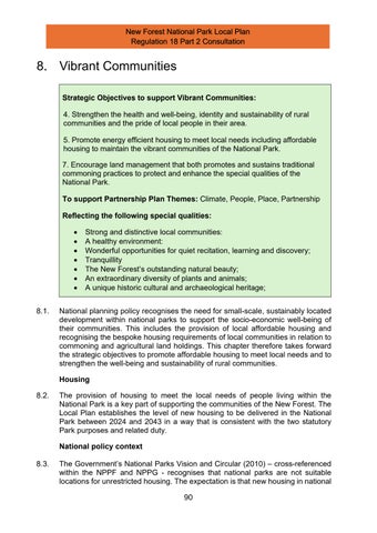
8.25. Land off W hartons Lane is well screened by mature trees which are protected through Tree Preservation Orders and therefore the development of this site would not have a wider landscape impact on the National Park The 2.5 hectare
Regulation 18 Part 2 Consultation
site is well located for the facilities of Ashurst and would not reduce the gap between the village and the National Park boundary to the east. There is an existing pedestrian pavement along the Whartons Lane frontage of the site that should be retained and the site is also well related to the cycle route running along Lyndhurst Road, linking the site with the services in Ashurst and Lyndhurst. The site is allocated for a residentially-led development of around 60 dwellings in the adopted New Forest National Park Local Plan 2016 – 2036 and full planning permission was subsequently granted in January 2024. The policy is retained in this draft of the New Forest National Park Local Plan Review on the basis that development is not yet completed.
Policy SP31: Land at Whartons Lane, Ashurst
Land at Whartons Lane, Ashurst is allocated for the development of around 60 residential dwellings. Detailed proposals for the site that meet the following sitespecific requirements will be permitted:
a) the provision of on-site affordable housing for local people in housing need in accordance with the target of 50% affordable housing;
b) all of the dwellings on the site will be limited to a maximum total internal habitable floor area of 100 square metres;
c) the site must be developed in a comprehensive manner;
d) measures must be put in place to protect the trees subject to Tree Preservation Orders that border the site;
e) contributions will be required to enhance the adjacent Whartons Lane Recreation Ground located opposite the site; and
f) development proposals must provide a connection to the nearest point of adequate capacity in the sewerage network, as advised by the service provider; and
g) a site-specific flood risk assessment will be required and measures put in place to address any groundwater or surface water flooding issues identified.
Ashurst Hospital
8.26. The Ashurst Hospital site comprises previously developed land with access to a range of local services, including the train station and local shops. The site immediately adjoins the existing Defined Village boundary of Ashurst and is located within Flood Zone 1 for fluvial flooding.
8.27. Large parts of the site have been declared surplus to the operational healthcare requirements of the NHS and are vacant. The more modern Snowden Building at the west of the site currently contains the Birthing Centre and is to be retained.
8.28. The adopted New Forest National Park Local Plan 2016 – 2036 allocates the site for a mix of residential (C2 care home use or extra care) and retained healthcare provision. It is considered that the surplus part of this previously developed site can deliver around 30 units - although the exact number will depend on the final form of residential development, which will in turn be guided by the need to avoid impacts on the adjacent protected habitats. Viability modelling for the Local Plan indicates that the redevelopment of the Ashurst Hospital site (including site clearance costs) is unlikely to achieve the 50% affordable housing policy target.
8.29. The site allocation policy highlights the natural and built environment constraints and opportunities on the Ashurst Hospital site. The site lies adjacent to the New Forest SSSI, SAC, SPA and Ramsar sites and the Habitats Regulations Assessment for the Local Plan identifies the potential for a range of possible effects from development on these protected sites, including recreation pressure, urban edge effects including cat predation and the loss or damage to off-site supporting habitats.
8.30. Policy SP32 therefore requires development to be confined to the previously developed land to the north of the site and the strengthening of the planted boundary to the adjacent international nature conservation designations. Mitigation measures for potential urban edge effects could include the use of legal covenants (e.g. preventing cat or dog ownership) and arrangements for grounds maintenance. The requirement to ensure no adverse impact on the adjacent national and internationally protected habitats will also influence the form of the C2 care home or extra care residential development on site. The residential element of the allocation responds to the evidence on demography in the National Park area and positive allocates the site for Use Class C2 care home or extra care use. The site allocation is retained in this draft of the New Forest National Park Local Plan Review on the basis that full planning permission has not yet been issued for the redevelopment of the site.
8.31. Elements of the existing built development on the site date back to the 1830s. The former historic workhouse building is considered to be a non-designated heritage asset due to its 19th Century origins. The Victorian chapel on the site was constructed sometime between 1869 and 1896 and the exterior remains in good condition. The former workhouse building and Victorian chapel have heritage significance and Policy SP32 confirms the chapel will be retained as part of the redevelopment of the site.
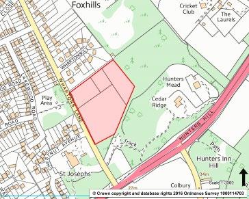
Policy SP32: Land at Ashurst Hospital
Land at Ashurst Hospital is allocated for a mixed-use development comprising: • retained (and potentially extended) healthcare provision in the western part of the site (focused on the Snowden Building) – illustrated in blue on the map below; and
• around 30 residential units (Use Class C2 care home or extra care use) on the remaining previously developed part of the site (i.e. on the footprint of the existing buildings and car park).
Detailed proposals for the site that meet the following site-specific requirements will be permitted:
a) the site must be redeveloped in a comprehensive manner and detailed proposals for residential development will need to ensure the retained healthcare uses on the site can operate efficiently;
b) built development will be confined to the previously developed land to ensure the existing green buffer remains to the south of the site and the New Forest’s protected habitats.
c) the Victorian chapel will be retained as part of the redevelopment. A detailed heritage assessment and structural survey will be required to justify the loss of the former workhouse buildings;
d) redevelopment proposals must retain the protected trees on the site;
e) proposals for extra care use (that is not C2 Use) must provide on-site extra care affordable housing for local people in housing need as close to the Authority’s target of 50% affordable housing as is viable. Viability will be demonstrated through an open book approach;
f) proposals for C2 care home use must be accompanied by a legal agreement requiring the occupancy to be limited to those with a local connection;
g) all of the dwellings on site will be limited to a maximum total internal floor area of 100 square metres;
h) development proposals must incorporate measures to mitigate potential significant urban edge impacts on adjacent protected habitats. The existing southern boundary between the site and the adjacent protected habitats should be retained and strengthened with the planting of native species. Proposals should seek to enhance both its role in buffering the designated sites and supporting species of principal importance for biodiversity. A detailed application for the site will be subject to a full appropriate assessment; and
i) development proposals must provide a connection to the nearest point of adequate capacity in the sewerage network, as advised by the service provider.
Land at Knellers Lane, Ashurst
8.32. Further assessment of the Defined Village boundary, natural and built environment designations indicate that land to the north east of the village is less constrained and could accommodate proportionate new development to meet local needs arising within the National Park. In accordance with Ashurst being one of the larger villages within the National Park, together with its level of services and facilities, lack of environmental constraints to the north east, this local plan review recognises the opportunity to identify further land for allocation around Knellers Lane. This would include improvements to the local road network and associated pedestrian/cycle links to ensure safe access to local facilities including the schools and sports facilities in this locality.
8.33. The site is in a single ownership and has the potential to deliver wider community benefits (e.g. open space provision) alongside new residential development. Development would be focused on the south west of Knellers Lane given the
Regulation 18 Part 2 Consultation
importance attached by the local community to ensuring Ashurst maintains a distinct identity as a New Forest village, separate for the larger urban areas to the east. Further work will be undertaken on the potential of this land to meet some of the identified local needs arising within the National Park, including consideration of the underground pipe route in this area.
Policy SP33: Land at Knellers Lane, Ashurst
Land to the south west of Knellers Lane, Ashurst is allocated for circa 50 – 70 dwellings, including a target of 50% affordable housing.
Detailed proposals for the site that meet the following site-specific requirements will be supported:
a) Provision of a landscaped buffer adjacent to Knellers Lane, to create a new village edge and to define the extent of the built up area to avoid coalescence with land outside the National Park;
b) Traffic assessment to include enhancements to Knellers Lane to ensure safe access to the site, for both vehicles and pedestrians and cyclists;
c) Layout of the site to reflect the character and appearance of the village in accordance with the Ashurst and Colbury Village Design Statement (January 2025);
d) Retention and enhancement of existing protected hedgerows and trees belts to be integral to the layout of the site;
e) The development will be required to demonstrate nutrient neutrality in relation to the Solent’s internationally designated sites; and
f) The retention of the existing sporting facilities in the area centred on Langley Manor Cricket Ground.
Brockenhurst
8.34. Despite its size, Brockenhurst is also situated within an area of internationally important nature conservation designations, as illustrated on the extract from the adopted New Forest National Park Local Plan Policies Map (2019) illustrated below. Parts of the settlement are also affected by fluvial flood risk. Consequently there are no site allocations in Brockenhurst within the adopted development plan for the National Park area, although windfall development continues to be delivered within the Defined Village boundary.
8.35. Through the Local Plan Review the focus will therefore be on supporting appropriate redevelopment opportunities within the Defined Village boundary as they arise, alongside rural exception sites that may come forward adjacent to the settlement boundary.
Lyndhurst
8.36. The village of Lyndhurst (population 3,200 people) has the widest range of services and facilities of the settlements within the New Forest National Park. The village has a strong built heritage focused on the High Street, but is also affected by traffic congestion. It is also one of the largest villages and is often referred to as the ‘Capital of the New Forest’
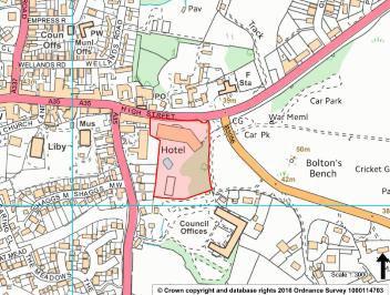
8.37. The Defined Village boundary of Lyndhurst was established in the 1980s and in response to the requirements of the NPPF a review of the Defined Village boundary was undertaken to inform the New Forest National Park Local Plan 2016 – 2036. This review identified brownfield land at the former Lyndhurst Park Hotel as the main area with development potential. Although the site represents one of
Regulation 18 Part 2 Consultation
the largest brownfield sites within the National Park, its redevelopment also presents a number of challenges, and future redevelopment of the site would be required to respect site specific factors. Full planning permission has subsequently been granted for the redevelopment of the site for 79 residential units and a number of retails units on the main frontage of the site. Construction is progression, with the first completions on the site in the 2025/26 monitoring period. The site allocation has been retained in this draft of the New Forest National Park Local Plan Review on the basis that although full planning permission has been granted for the redevelopment of the site, development is not yet completed:
• the site occupies a highly-prominent gateway location into the village and lies within the Lyndhurst Conservation Area, linking the High Street with the popular Bolton’s Bench area
• the core of the hotel building has a historic association with Sir Arthur Conan Doyle. Historic England have confirmed that the building does not meet the criteria for listing and subsequently planning permission has been granted for the demolition of the non-designated heritage element of the site following the submission of an assessment justifying its loss.
• large parts of the site are covered in mature trees which are subject to a Tree Preservation Order and provide a natural transition from the built environment to the Open Forest at this important edge of village location
• the site is located immediately adjacent to the internationally protected New Forest Special Protection Area (SPA), Special Area of Conservation (SAC), Ramsar site and a Site of Special Scientific Interest (SSSI). The proximity of these protected habitats means the redevelopment of the site must adequately mitigate the potential urban edge impacts (including cat predation and the introduction of invasive species from fly-tipping of garden waste). Mitigation measures could include the use of legal covenants and arrangements for grounds maintenance.
Policy SP34: Land at the former Lyndhurst Park Hotel, Lyndhurst
Land at the former Lyndhurst Park Hotel is allocated for a mixed-use development. The site has potential for around 50 dwellings alongside the retention of the historic elements of the existing building and development could include tourism uses. Residential development on the site should secure the future conservation of the heritage assets on the site. Detailed proposals for the site that meet the following site-specific requirements will be permitted:
a) the site must be redeveloped in a comprehensive manner;
b) the historic elements of the existing hotel building must be retained and could be used for a range of uses, including tourism and residential use. A detailed heritage assessment will be required to justify any proposals which harmed their retention;
c) the design and scale of the redevelopment of the site must conserve or enhance the character of this part of the Lyndhurst Conservation Area;
d) redevelopment proposals must retain the important trees on the site that contribute to the open verdant setting and the site’s edge-of-village location;
e) redevelopment proposals for the site should be accompanied by a Transport Assessment, given the proximity of the site to the designated Lyndhurst Air Quality Management Area. Adequate parking provision must be made on-site;
f) proposals for C3 residential use must provide on-site affordable housing for local people in housing need as close to the Authority’s target of 50% affordable housing as is viable. Viability will be demonstrated through an open book approach;
g) all of the dwellings on site will be limited to a maximum total internal habitable floor area of 100 square metres;
h) any proposals for C2 use (i.e. where no affordable housing for local people would be provided) must be accompanied by a legal agreement requiring the occupancy to be limited to those with a local connection.
i) development proposals must ensure future access to existing water supply infrastructure for maintenance and upsizing purposes.
j) development proposals must incorporate measures to mitigate potential significant urban edge impacts on adjacent protected habitats.
8.38. Opportunities for further development through the review of the Local Plan are limited in Lyndhurst due to the various designations and constraints that exist. Over the course of the Plan-period to 2043 a potential future development opportunity could be at Appletree Court, currently owned and occupied by New Forest District Council. The site is well located to facilities in the village and has access to the main highway network. The main office building at Appletree Court is locally listed (and so would be considered a non-designated heritage asset) and the site also includes several significant specimen trees. The site is located immediate adjacent to the New Forest’s internationally designated sites (SAC, SPA and Ramsar) and nationally designated sites (SSSI). Should the site become available during the Plan-period these factors would be important material planning considerations in the assessment of the future of the site.
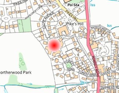
Land at Calpe Avenue, Lyndhurst
8.39. Land at Calpe Avenue - most recently in use as a Hampshire County Councilowned residential care facility - has been put forward through the call for sites for redevelopment/intensification. This is a previously developed site within the Defined Village boundary for Lyndhurst. The site lies within the 400 metre buffer of the New Forest’s internationally designated sites and abuts the Lyndhurst Conservation Area, there are also a number of trees on the site. Given the demography of the National Park and the identified need for additional older persons accommodation, the draft local plan therefore proposes the allocation of the site accordingly. The proximity of the New Forest’s designated sites means that the form of development will be restricted to C2 of extra care use to address potential urban edge impacts. Development will also be required to demonstrate nutrient neutrality in relation to the Solent’s internationally designated sites.
18 Part 2 Consultation
Policy SP35: Land at Calpe Avenue, Lyndhurst
Redevelopment and intensification of land forming the site at Calpe Avenue, Lyndhurst for circa 60 C2 or extra care housing will be supported, in accordance with the following site-specific requirements:
a) proposals must retain the important trees on the site that contribute to the site’s setting and edge-of-village location;
b) the design and scale of the proposals must positively respond to the proximity of the Lyndhurst Conservation Area;
c) proposals for C2 use must be accompanied by a legal agreement limiting occupancy to those with a local connection;
d) development proposals must incorporate measures to mitigate and potential urban edge impacts that remain on adjacent protected habitats;
e) The development will be required to demonstrate nutrient neutrality in relation to the Solent’s internationally designated sites;
f) Adequate parking provision must be made on-site; and
g) Identify and contribute to infrastructure needed to make the development acceptable in planning terms
Sway
8.40. The village of Sway (population 2,700) includes a station on the main railway line and a modest range of services, local shops, businesses and accommodation. The village adjoins the internationally designated sites of the New Forest to the north and east.
8.41. The Defined Village boundary of Sway was identified in the 1980s and was reviewed as part of the preparation for the adopted New Forest National Park
Regulation 18 Part 2 Consultation
Local Plan 2016 – 2036. With international nature conservation designations adjoining the village boundaries to the north and the east the only area of potential is to the south and west of the village, which is also located closer to the school, services and transport links in the village centre.
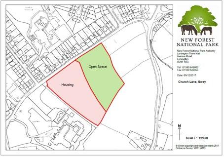
8.42. Land to the south of Church Lane in Sway has been identified as suitable to make a significant contribution towards meeting the identified local housing needs arising within the parish. The site is located within a short, level walk of the existing services within the village, including the station, shops and school. The provision of a safe, off-road pedestrian link from the Jubilee Fields Sports Ground to Church Lane though the site will be supported. The site will also provide additional community benefits through the provision of 1 hectare of informal greenspace to complement the more formal recreational facilities available at the adjacent Jubilee Field. The site is allocated in the adopted New Forest National Park Local Plan 2016 – 2036 and full planning permission was granted in December 2023 for the development of 46 dwellings and public open space. As the development is not yet completed this draft Plan retains the site allocation policy.
Policy SP36: Land south of Church Lane, Sway
Land to the south of Church Lane, Sway is allocated for the development of around 40 residential dwellings. The site will also provide 1 hectare of informal greenspace provision for the local community. Detailed proposals for the site must meet the following site-specific requirements:
a) the provision of on-site affordable housing for local people in housing need in accordance with the target of 50% affordable housing;
b) all of the dwellings on the site will be limited to a maximum total internal habitable floor area of 100 square metres;
c) the site must be developed in a comprehensive manner;
d) residential development on the site will be limited to the part of the site that lies outside the New Forest Special Area of Conservation (SAC) and Special Protection Area (SPA) 400 metre zone (illustrated in the red shading on the map below);
e) measures should be put in place to protect the trees that fringe the site that are protected by Tree Preservation Orders;
f) the access to the site off Church Lane must ensure adequate visibility splays and provide safe access to the school and on foot to the village centre;
g) the use of the remainder of the site (green shading) that lies within the New Forest SAC and SPA 400 metre zone for informal greenspace will be supported. Proposals should be accompanied by details of the proposed layout and long-term management arrangements for the greenspace provision; and
h) development proposals must provide a connection to the nearest point of adequate capacity in the sewerage network, as advised by the service provider.
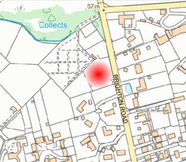
8.43. Given the existing designations and constraints, opportunities for further smallscale site allocations to meet local needs are limited in Sway. A small site has been submitted through the call for sites. This lies adjacent to the cemetery, fronting Brighton Road, with existing built development to the south and east. The international nature conservations of the New Forest lie to the north of the site and it falls within the 400m buffer of the New Forest’s internationally designated nature conservation sites This is an important factor in what the site could be developed for. Given the fact that the site is located immediately adjacent to the existing Defined Village boundary, the potential for this site should be explored further in the context of the above.
Policy SP37: Land
to west of Brighton Road, Sway
Land to the west of Brighton Road, Sway is allocated for C2 or extra care units. Subject to further detailed design work, it is considered that the site could accommodate circa 50 C2 or extra care units.
Detailed proposals for the site that meet the following site-specific requirements will be supported:
a) Provision of a landscaped buffer to the north and west to create a new village edge and to define the extent of the built up area;
b) Layout of the site to reflect the character and appearance of the village in accordance with the adopted Sway Village Design Statement;
New Forest National Park Local Plan
Regulation 18 Part 2 Consultation
c) Retention and enhancement of existing protected hedgerows and trees belts to be integral to the layout of the site;
d) development proposals must be supported by information on how any remaining urban edge impacts on the adjacent internationally protected habitats will be addressed;
e) development will be required to demonstrate nutrient neutrality in relation to the Solent’s internationally designated sites;
f) development must ensure the peace and tranquillity of the adjacent cemetery is respected and safeguarded; and
g) Identify and contribute to infrastructure needed to make the development acceptable in planning terms.
Land to the south of Fawley Power Station
8.44. The Fawley Power Station closed in 2013. The 49-hectare brownfield site is entirely within the New Forest District Council Local Plan area, but uniquely it is enclosed by the New Forest National Park. The former Power Station buildings –including the chimney – have been demolished. Redevelopment of the site involves a number of challenges.
• The foreshore, estuarine and coastal areas adjoining the site are internationally and nationally designated for their ecological value (Hythe to Calshot Marshes SSSI, Solent Maritime SAC, Solent & Southampton Water SPA and Ramsar).
• Parts of the site are in Zone 3 for flood risk.
Regulation 18 Part 2 Consultation
• The northern part of the brownfield site area (14.5 hectares) lies within the Health and Safety Executive’s middle hazard consultation zone for the Fawley refinery complex and also includes National Grid infrastructure which is expected to remain operational for the next 20 years.
• Land adjoining the site within the National Park is designated a Site of Importance for Nature Conservation (Chambers Copse, Tom Tiddler’s Ground).
8.45. Land to the south of the former Power Station is allocated in the adopted New Forest National Park Local Plan 2016 – 2036 for residential development to support the comprehensive redevelopment of the wider 49 hectare brownfield site. Since this Local Plan allocation was made the site has also been designated as one of the Solent Freeport tax sites (Southampton Water – Fawley Waterside tax site). In 2024 the planning application for the redevelopment of the site allocation in the National Park – and the wider scheme within New Forest District Council’s planning jurisdiction - was formally withdrawn by the applicant on the basis that the proposed scheme was not considered to be viable. National planning policy requires site allocations to be deliverable and on the basis of engagement with the site promoters of the Fawley Waterside site, it is not considered that the existing site allocation is deliverable. Through the review of the New Forest National Park Local Plan it is therefore proposed to remove the existing site allocation.
8.46. The National Park Authority remains committed to supporting the positive regeneration of the previously developed land at the former Fawley Power Station and acknowledges the benefits the site’s Freeport Tax Site status brings in attracting employment-led development to the site. The Authority will continue to work in partnership with New Forest District Council and other stakeholders to deliver these benefits, recognising that development on the previously developed land outside the National Park will need to consider impacts on the National Park in accordance with the requirements of national planning policy and Section 245 of the Levelling Up & Regeneration Act 2023.
Other Villages
8.47. The review of the local plan has provided an opportunity to reassess the existing settlement hierarchy and spatial strategy. This reflects the requirements of national planning policy, as well as the need to consider ‘reasonable alternatives’ within the Sustainability Appraisal/Strategic Environmental Assessment (SEA) process. This review has resulted in a revised draft settlement hierarchy establishing two levels of settlement and identifying in addition to the existing four Defined Villages above, the three smaller villages of Cadnam – Bartley, Landford - Nomansland and Redlynch, where opportunities for proportionate, small-scale development to meet local needs should be explored.
8.48. These settlements have a level of basic services and facilities, together with some public transport links and employment provision that could support some limited growth to helps sustain the socio-economic well-being of local communities within
Regulation 18 Part 2 Consultation
the National Park. Such growth would have the benefit of introducing affordable housing to a wider range of settlements within the National Park to encourage families to the area to support local schools and other services. There may also be opportunities for small scale community projects to be supported and funded from any associated development such as improvements to open space and community facilities.
Cadnam – Bartley
8.49. Cadnam and Bartley fall within Copythorne parish located to the north east of the National Park adjacent to Totton, with good access to M27, via A336 which serves both villages.
8.50. The combined population of both Cadnam and Bartley is over 2000 people, making it comparable to the existing Defined Villages of the National Park It also has a basic level of services and facilities to support this population, including local schools, sports facilities and community facilities.
8.51. Large parts of Copythorne parish fall within the 400 metre buffer of the New Forest SPA and SAC, with the exception of Cadnam, parts of Bartley and Ower. Importantly there are also areas identified as being at risk of surface water and fluvial flooding. Parts of the parish are also covered by Conservation Area designations in recognition of the built character of the area. The factors limit areas of potential search for new development.
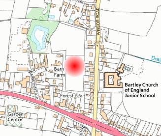
8.52. However, in response to the call for sites a site has been put forward for consideration for development within Bartley, with access from Winsor Road. This part of the settlement is relatively unconstrained lying beyond the 400 metre SPA buffer, the conservation areas and the area is also not identified as being at risk from surface water or fluvial flooding risk
Policy SP38: Land to West of Winsor Road, Bartley
Land to the west of Winsor Road, Bartley, is allocated for around 55 dwellings, including 50% affordable housing.
Detailed proposals for the site that meet the following site-specific requirements will be supported:
a) All of the dwellings on the site will be limited to a maximum total internal habitable floor area of 100 square metres;
b) Provision of suitable vehicular access onto Winsor Road and creation of pedestrian and cycle links and safe crossing points to the nearby primary school;
c) Retention and enhancement of existing hedgerows and trees belts to be integral to the layout of the site;
d) Layout of the site to reflect the character and appearance of the village in accordance with the adopted Copythorne Village Design Statement (2025);
e) Development must ensure impacts on the existing residential properties in the area are addressed through the layout and design of the scheme;
f) Development proposals will be required to consider impacts on the New Forest’s internationally designated sites (including urban edge effects) and the Forest North East Conservation Area,
g) Development will be required to demonstrate nutrient neutrality in relation to the Solent’s internationally designated sites; and
h) Identify and contribute to infrastructure needed to make the development acceptable in planning terms.
8.53. Landford and Nomansland lie within the Wiltshire area of the National Park. The combined settlement of Landford and Nomansland form one of the largest settlements in the north of the New Forest and for many years there was a defined settlement boundary under the planning policies prepared by the predecessor planning authorities in Wiltshire. Whilst being smaller in terms of households and population than the other settlements, the settlement is in close proximity to A36, linking with South Hampshire to the south and Salisbury to the north. It also has a level of local facilities, including basic local transport links, public open space, a local school and village hall.
8.54. While part of Landford and Nomansland is covered by the 400 metre buffer for the New Forest’s internationally designated sites, land to the north is unconstrained and offers a potential area of search for some proportionate development to meet local needs arising within the National Park. The village does not include any
Landford – Nomansland
2 Consultation
Conservation Areas and the level of flood risk is low. The draft Habitats Regulations Assessment of the Local Plan Review highlights that the site is just under 9 kilometres from the Mottisfont Bats Special Area of Conservation. Although some distance, the site could be within the range used by foraging bats from Mottisfont. The draft site allocation policy therefore highlights the requirement for further information on the use of the area by Barbastelle Bats to allow an appropriate assessment to be undertaken.
Policy SP39: Land to the south of Hamptworth Road, Landford
Land to the south of Hamptworth Road, Landford, is allocated for around 30 dwellings, including 50% affordable housing.
Detailed proposals for the site that meet the following site-specific requirements will be supported:
a) All of the dwellings on the site will be limited to a maximum total internal habitable floor area of 100 square metres;
b) Provision of suitable vehicular access on Hamptworth Road and Lyndhurst Road and the creation of pedestrian and cycle links and safe crossing points to the nearby primary school;
c) A landscape-led design and layout that reflects the landscape character of this part of Landford;
d) Further information is necessary on the use of site and the surrounding area by Barbastelle Bats to allow an appropriate assessment to be undertaken The development will also be required to demonstrate nutrient neutrality in relation to the Solent’s internationally designated sites;
e) The layout of the site to reflect the character and appearance of the village in accordance with the adopted Landford Village Design Statement: and
f) Identify and contribute to infrastructure needed to make the development acceptable in planning terms.
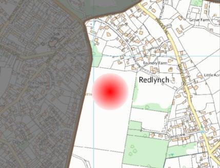
Redlynch
8.55. The village of Redlynch lies at the northern tip of the National Park, within Wiltshire. The adjacent settlements of Woodfalls and Morgan’s Vale provide a number of local facilities including the primary school and there is a bus service running along Quarry Road through Redlynch. The settlement of Redlynch had a defined settlement boundary in the development plan prepared by the predecessor planning authorities prior to the designation of the National Park.
8.56. Like other settlements within this area of the National Park, there are fewer environmental constraints and the village of Redlynch is one of the larger settlements in the north of the National Park with some basic local services. Consequently this offers a potential area of search for some limited proportionate development to meet the socio-economic needs of local communities living with the National Park and help to support local services.
Policy SP40: Land to the east of The Ridge, Redlynch
Land to the east of The Ridge, Redlynch, is allocated for around 50 dwellings, including 50% affordable housing.
Detailed proposals for the site that meet the following site-specific requirements will be supported:
a) Provision of suitable vehicular access onto The Ridge, and contribute to any off-site junction improvements necessary;
Regulation 18 Part 2 Consultation
b) Create a pedestrian and cycle link to Kiln Lane;
c) Retain existing trees belts and hedgerows;
d) A landscape-led design and layout that reflects the landscape character of this part of Redlynch and helps to create a high-quality scheme in the National Park;
e) Development will be required to demonstrate nutrient neutrality in relation to the Solent’s internationally designated sites; and
Identify and contribute to infrastructure needed to make the development acceptable in planning terms.
Windfall Development
8.57. Windfall developments are those that are not specifically allocated for housing within the development plan. These sites come forward through the lifetime of the local plan on rural exception sites and through other sources of supply such as redevelopment within the defined villages and the delivery of specialist housing (e.g. commoners’ dwellings, tied agricultural dwellings and permitted development such as office-to-residential conversions). The NPPF states that planning authorities can make an allowance for windfall development if they have compelling evidence that such sites have consistently become available and will continue to provide a reliable source of supply. Any windfall allowance should have regard to historic windfall rates and expected future trends.
New
Regulation 18 Part 2 Consultation
8.58. Evidence from the monitoring of dwelling completions in the National Park over the last decade highlights the consistent delivery of housing on windfall sites. Over 250 additional dwellings have been completed within the New Forest between 2016 and 2025 on unallocated windfall sites. This equates to an annual average of just under 30 dwellings per annum and justifies the inclusion of a windfall allowance within the Local Plan.
8.59. The Local Plan Review therefore includes a future estimate of 20 dwellings per annum from windfall developments. This is considered to be realistic given the historic level of windfall development within the National Park and the range of routes through which windfall development can be delivered. Windfall development will continue to be an important source of small-scale development within the New Forest National Park.
Affordable housing
8.60. The provision of affordable housing in the New Forest is consistently raised as one of the biggest challenges facing local communities in the National Park. The affordability of housing is a major barrier to sustainable communities in the National Park, with the New Forest the least affordable national park in the UK. As already outlined, the Government’s National Parks Vision & Circular (2010) states that national park authorities have an important role to play in the delivery of affordable housing, and the Local Plan should include policies that pro-actively respond to local needs. Therefore, a strong justification exists for policies that maximise the delivery of affordable housing, while at the same time upholding the purposes of national park designation. The evidence base for the Local Plan review concludes that the level of affordable need justifies the Authority seeking to maximise the delivery of affordable housing at every opportunity.
8.61. The NPPF requires local planning authorities to identify the range of types and sizes of accommodation likely to be needed by the population in future. Based on the evidence base and the current advice of New Forest District Council as the housing authority for the majority of the National Park, a strategic policy target of 20% intermediate and 80% affordable rented tenure is considered appropriate. Local connection criteria will be applied to the affordable housing provided to ensure that local needs arising within the National Park are met and more detail on this is set out in Annex 4 of the Local Plan.
8.62. National planning policy also requires planning authorities to balance meeting local affordable housing needs with the economic viability of development. To ensure viability, the costs of any affordable housing requirements applied to development should provide competitive returns to a willing landowner and developer to enable the development to be deliverable. To inform the affordable housing approach taken in the review of the Local Plan, the Authority has commissioned an updated Local Plan Viability Assessment 45. This assessment considers the proportion of affordable housing that could be sought on windfall and allocated development sites, as well as the approach towards rural exceptions
45 Three Dragons, September 2024
New
Regulation 18 Part 2 Consultation
sites within the National Park. The emerging viability evidence demonstrates the proposed Local Plan review requirement of 50% affordable housing on allocated sites and windfall development sites within the Defined Villages can be achieved.
8.63. In addition, the updated viability evidence assesses the site size threshold above which it is viable to seek affordable housing to meet local needs. A large proportion of housing in the New Forest National Park is delivered on small windfall sites of fewer than 10 dwellings. National Planning Policy Guidance establishes size thresholds for the delivery of affordable housing (either through a financial contribution or on-site provision) and confirms that in ‘designated rural areas’ (including National Parks) local planning authorities can set lower site size thresholds. The viability evidence commissioned as part of the Local Plan preparation process highlights that development remains economically viable with affordable housing provision on smaller development sites than that outlined in national policy. The Local Plan seeks to maximise the delivery of affordable housing within the main villages and on-site allocations. This applies to all development falling within Use Class C3, including any retirement or assisted living accommodation within this use class.
8.64. Developers and landowners are expected to consider the overall cost of development prior to negotiating the sale or purchase of land. The Authority will not accept a case that a site is unviable to develop in line with the requirements of the development plan because the landowner has paid too much for the site. Land purchase should take account of the likely costs of development, including adopted development plan policies. Affordable housing provision will therefore result in reduced residential land values.
Policy SP41: Affordable housing provision within the Defined Villages and on allocated sites
50% of net dwellings developed within the Defined Villages and on sites allocated for residential development in the Local Plan will be provided as affordable homes to meet local needs. In practice:
a) on developments of 1 – 2 net new dwellings, no affordable housing will be sought;
b) on developments of between 3 – 10 net new dwellings, a target of 50% affordable housing will be sought on site. At the discretion of the National Park Authority, financial contributions in lieu of on-site provision will be accepted on smaller sites;
c) on development sites of 11 dwellings or more, a target of 50% affordable housing will be sought on site
The layout and design of affordable housing will be appropriately integrated into each development. Local connection criteria will be applied to affordable housing to ensure local needs arising within the National Park are met.
The tenure (social and affordable rented, intermediate, shared ownership and other) of affordable homes will be based on up-to-date evidence of local needs.
A suitable mix will be determined through liaison with the local housing authority and the starting point is to seek 80% social / affordable rented tenure and 20% shared ownership / intermediate housing. The proportion and tenure mix of affordable housing sought will take into account evidence on viability.
Rural Exception Sites
8.65. The NPPF confirms that in rural areas, authorities should plan housing development to reflect local needs, particularly for affordable housing, including through rural exception sites. Outside the Defined Villages of the National Park and the housing site allocations, rural exception sites can provide an important source of affordable housing to meet local needs on land that would not normally be used for housing. Rural exception sites seek to address the needs of the local community by accommodating households who are either current residents or have a connection to the area.
8.66. The NPPF allows, at the Authority’s discretion, for small numbers of full market homes where it is essential to enable the delivery of significant additional affordable housing. This has been tested through the viability assessment that forms part of the evidence base for the Local Plan Review. The viability assessment concludes that an element of open market housing on rural exception sites is not necessary to make them deliverable in the New Forest National Park. The evidence does highlight that a degree of flexibility may be required on the tenure of affordable housing on rural exception sites to ensure they are viable, and the Local Plan therefore supports an element of shared ownership / intermediate ownership affordable housing (20%) alongside affordable rented housing (80%) on rural exception sites.
8.67. The National Park Authority is part of the Hampshire Alliance for Rural Affordable Housing (HARAH) which seeks to address the need for affordable housing in rural villages across Hampshire. The Authority will continue to work with HARAH and local communities across the National Park to identify suitable affordable housing exception sites.
Policy SP42: Rural exception sites
Small-scale developments of affordable housing on land in or adjoining villages will be supported provided that:
a. Proposals meet a particular local housing need that cannot be accommodated in any other way;
b. be subject to a planning obligation under Section 106 of the Town and Country Planning Act (1990) to ensure that the dwellings provide for lowcost housing for local needs in perpetuity;
c. be capable of management by an appropriate body, for example a Registered Provider, the Authority, a community land trust or similar accredited local organisation;
Proposals for villages where there is no defined settlement boundary will be considered, in accordance with criteria a – c above and:
d. the village has a basic level of services and facilities including a school, pub and local shop and access to public transport;
e. there is an identified local need;
f. the proposal is small scale and makes a positive contribution to the sustainability of the community
In all circumstances 100% of the housing on rural exception sites will be affordable.
Commoners’ dwellings
8.68. Providing affordable housing for commoners has long been recognised as essential for the future viability of the commoning system in the New Forest. The New Forest Commoners have played a key role in shaping the New Forest over centuries and are fundamental to maintaining the landscape character and landbased economy of the National Park. The Authority is committed to supporting the long term viability of commoning through the local plan and the Commoners’ Dwelling Scheme (CDS), which was originally established in 1992 to provide a mechanism by which commoners could enter into an appropriate legal agreement to meet the requirement for obtaining planning permission to build a dwelling outside of a village, from which they could common.
8.69. Since its inception in 1992, the CDS has delivered over 20 new homes for commoners across the New Forest, and in most cases this has also included associated farm buildings to help establish viable new commoners’ holdings. In order to guarantee the long-term availability of dwellings built for commoners under the CDS (which is administered by the Authority), applicants are required to enter into legal agreements and to demonstrate a long-term personal and family commitment to the exercising (or use) of common grazing rights on the New Forest.
8.70. The CDS comprises a three stage process:
i. Stage one is the consideration of an applicant’s commoning history and need for housing. This is undertaken by a Commoners’ Dwelling Scheme Panel which includes representatives from the local commoning community appointed for their knowledge and understanding of commoning, as well as the National Park Authority. The Panel assesses an applicant’s eligibility and makes a recommendation as to whether the application is within or without the remit of the Scheme.
Regulation 18 Part 2 Consultation
ii. Stage two is the consideration of the planning application by the Authority. Applicants are encouraged to seek pre-application advice about the design, location and siting of the proposed development. Acceptance at Stage One does not necessarily mean that planning permission will be granted. All applications are reported to and determined by the Planning Committee. If the Authority is minded to grant consent, the application proceeds to stage three.
iii. Stage three is the completion of various legal agreements, obligations, transfer and leasing arrangements to ensure that the property remains available for commoning in perpetuity.
8.71. The Authority will also encourage proposals for commoners’ dwellings to consider the re-use of existing buildings where appropriate and support the provision of suitable rented accommodation to better assist commoners on lower incomes.
Policy DP43: New Forest Commoners’ dwellings
Exceptionally, dwellings to meet the specific needs for New Forest Commoners may be permitted outside of an existing settlement.
The total internal habitable floorspace of the dwelling should not exceed 100 square metres.
Proposals for Commoners’ dwellings must fulfil the requirements of the Commoners Dwelling Scheme (CDS) and applicants must be able to demonstrate:
a) an established recent history of active commoning;
b) why they cannot common from their existing property; and
c) that they do not have access to a property from which they can carry out their commoning.
Applicants will be required to sign a legal agreement to ensure the dwelling remains in use for commoning in perpetuity.
Consideration will also be given to proposals that provide rented accommodation to assist Commoners on lower incomes where such accommodation is capable of management by an appropriate body such as the New Forest Trust. Proposals for rented accommodation must have common rights of pasture and include the minimum amount of grazing land as required under the CDS. The appropriate management body will also be required to sign a legal agreement to ensure the dwellings remain in commoning use in perpetuity.
Estate workers’ dwellings
8.71 Outside the Crown Lands at the core of the New Forest, the National Park is
New
Regulation 18 Part 2 Consultation
characterised by a number of large land -owning estates including Beaulieu, Cadland, Exbury and Meyrick. These estates manage large land holdings in the New Forest and include commercial, social and environmental activities. Between them the larger Estates manage a significant area of the National Park and play an important role in the conservation of the landscape and cultural heritage of the New Forest, as well as the development of a sustainable rural economy. However, given the increasingly broad range of work undertaken by estate workers, many are ineligible for agricultural or forestry worker dwellings.
8.72. The Local Plan recognises the role large landowners play in the delivery of the two statutory National Park purposes and related socio -economic duty Policy SP30 therefore encourages the production of Estate Plans to inform the consideration of development proposals within the larger estates. This allows a comprehensive picture of the whole estate to be shared and helps place individual development proposals withi n their wider context. Whole Estate Plans will generally be most suitable for estates with land holdings in excess of 1,000 acres within the National Park with multiple activities taking place and employing or having residents in excess of 30 people.
8.73. Whole Estate Plans may demonstrate a range of material considerations related to the National Park purposes and special qualities that justify development outside the Defined Village boundaries. Where the need for additional development is identified through an Authority-endorsed Estate Plan, the Authority would encourage the re-use of existing buildings as a first preference. Where small-scale new housing is proposed (either through new build or a change of use) occupancy will be controlled through the use of appropriate planning conditions and/or planning obligations. In considering proposals for new build dwellings for Estate workers, the Authority will need to be satisfied that there is no existing accommodation available and affordable, or that the conversion / change of use of existing buildings is not a viable alternative. In accordance with Policy SP30, the floorspace of new dwellings will be a maximum of 100 square metres.
Agricultural and forestry workers’ dwellings
8.74. National policy has long acknowledged that certain agri cultural and forestry activities may require a worker to live close to the site. W here this is justified, it is crucial that any housing provided is subject to strict criteria and conditions to ensure they are only used for the accommodation of essential workers.
8.75. Agricultural and forestry workers’ dwellings will not be permitted on holdings where other dwellings on or closely connected with that holding have recently been disposed of, for example, by sale or by removal of restrictive conditions so that the dwelling could be let out on the open rental market.
8.76. The size restriction of 100 square metres is consistent with Policy SP30 and seeks to ensure that the size of a worker’s dwelling is commensurate with the needs of the holding. Permitted development rights to provide further accommodation will normally be removed by use of planning conditions.
Policy DP44: New dwellings for estate, agricultural and forestry workers
Proposals for estate, agricultural and forestry workers dwellings, will be supported where:
a. There is a demonstrate need for the new dwelling and the nature of the work makes it essential for the worker to live at, or very close to their place of work;
b. The functional need could not be fulfilled by another existing dwelling on the unit;
c. no other suitable dwellings on the estate/holding/enterprise have been recently sold or let on the open market;
d. Priority will be given in the first instance to the conversion of a building on the estate/holding/enterprise that could be converted for residential purposes
e. the dwelling will be subject to an occupancy condition to ensure that it remains available for estate or agricultural/forestry workers, or last employed as estate or agricultural/forestry workers, in perpetuity;
f. the size of the proposed dwelling would not result in the maximum total internal habitable floor area exceeding 100 square metres; and
g. in all instances a planning condition will be applied to the new residential unit limiting occupation to the nature of the worker applied for.
Removal of agricultural occupancy conditions
8.77. There are some 100 dwellings in the New Forest National Park that are subject to agricultural occupancy conditions. These dwellings have usually only been supported due to a particular agricultural need and are located in areas where planning permission would not usually be granted for unrestricted housing.
8.78. A more detailed development management policy on the removal of agricultural occupancy conditions is justified to ensure that dwellings which have been permitted specifically to meet the needs of the rural economy remain available for that purpose. It relates not only to the needs of the particular holding but includes the general need for workers’ dwellings in the surrounding area. The Authority will not readily accept the case for the removal of an occupancy condition where there is evidence that the associated landholding has been fragmented and reduced to such an extent that the agricultural holding is no longer viable.
Policy DP45: Removal of agricultural occupancy conditions
An occupancy condition restricting the occupancy of a dwelling to a person solely, mainly or last working in agriculture or forestry will not be removed unless the Authority is satisfied that the long-term need for the dwelling has ceased and there is no evidence of a continuing need for housing for persons employed or last employed in the National Park area in those categories, or practising commoning.
Regulation 18 Part 2 Consultation
8.79. In order to demonstrate that the long-term agricultural need for the dwelling has ceased, the applicant will normally be expected to show that appropriate steps have been taken to try to realistically market and sell the property with the occupancy condition intact and that marketing has been correctly targeted, financially realistic and sustained. This would be expected to include:
• contacting other local land and estate owners in the vicinity of the dwelling to establish whether they require further accommodation either presently or in the near future;
• the property placed with local and specialist estate agents and advertised locally for at least a 12-month period at a substantially discounted price that reflects the fact that it is subject to an agricultural occupancy condition;
• the property being advertised widely in local newspapers and appropriate publications including specialist trade organisation journals; and
• contacting the Commoners Defence Association to establish whether the property would meet the housing needs of a New Forest commoner.
Self / custom build
8.80. A significant proportion of the housing development that takes place in the National Park is characterised by very small developments within the Defined Villages, which by its nature is likely to fall within the Government’s definition of custom and self-build dwellings. The Government wants to enable more people to build and own their own home. All relevant authorities are required by the Selfbuild and Custom Housebuilding Act 2015 to maintain a register of individuals and associations of individuals who wish to acquire a serviced plot for self-building.
8.81. The Government defines custom build housing as either a builder being contracted by a home to create a ‘custom built’ home or where a private individual builds their own home as a ‘self-build’. The National Park Authority has established a self-build register of people interested in self-build or custom build. The register will be used to help identify and address the local need for housing. Custom / selfbuild will be considered positively within the Defined Villages of the New Forest National Park
Policy SP46: Self and Custom House Building
Proposals for self-build and custom housebuilding will be supported where these comply with other development plan policies as relevant to the site and location within the National Park.
In all instances a planning condition or legal agreement will be applied to restrict occupation to those with a local connection to the National Park.
New
Regulation 18 Part 2 Consultation
Gypsies, Travellers and Travelling Showpeople
8.82. The New Forest has a long history of travelling communities and their needs are recognised in national planning policy. The Government’s Planning Policy for Traveller Sites (December 2024) outlines the overarching aim to ensure the fair and equal treatment of gypsies and travellers in a way that facilitates their traditional way of life while respecting the interests of the settled community. This revised policy also updates the definition of a traveller and now includes individuals who have a cultural tradition of nomadism or living in caravans, even if they have ceased travelling permanently or temporarily.
8.83. National policy requires local planning authorities to assess the need for gypsy and traveller provision using robust evidence. National policy also makes it clear that, as with any other forms of development, planning permission should only be granted in national parks where it is demonstrated that the objectives of the designation will not be compromised by the development. It also confirms that planning authorities should strictly limit new traveller site development in open countryside away from existing settlements. The New Forest Gypsy, Traveller and Travelling Showpeople Accommodation Assessment (ORS, 2025) covers the whole of the New Forest National Park (including the Wiltshire part of the National Park) and is in the process of being finalised. It is the National Park Authority’s intention to identify and allocate suitable sites where possible through the Local Plan Review, supported by a criteria-based policy to assess windfall applications. Policy DP47 carries forward the gypsy site allocation from the adopted New Forest National Park Local Plan.
8.84. Any planning permission granted will include a planning condition or obligation to ensure that the occupancy of the site is limited to persons able to demonstrate an essential need for the accommodation. Policy SP48 also allows for the intensification of an existing traveller site.
18 Part 2 Consultation
Policy SP47: Land at Forest View Landford for gypsies and travellers
Land within the curtilage of the existing gypsy site at ‘Forest View’ in Landford is allocated for an additional permanent gypsy and traveller pitch (a net gain of one pitch). The site benefits from existing access and site infrastructure. Detailed development proposals for the site must meet the following site specific requirements:
i. a detailed landscaping plan must be submitted setting out how the site boundaries can be enhanced. To positively enhance the site and its surroundings within the New Forest National Park, high walls and fencing will not be supported;
ii. occupancy of the site will be restricted to gypsies and travellers with a local connection to the New Forest National Park; and
iii. due to the proximity of the New Forest SAC, measures must be put in place to adequately mitigate the potential for the introduction of invasive species from fly tipping of garden waste.
Any planning permission will include a planning condition or obligation to ensure that occupancy of the site is limited to persons as defined in Planning Policy for Traveller Sites (2024) or any subsequent policy.
18 Part 2 Consultation
Policy SP48: Gypsies, travellers and travelling showpeople
Proposals for the provision of permanent and / or transit accommodation to meet an established need of gypsies, travellers and travelling showpeople will be supported within the National Park where it can be demonstrated that there is a need for the site to be located within the National Park; and:
a) the impact of the site on the landscape character of the National Park is acceptable;
b) occupancy of the site will be restricted to gypsies and travellers, and travelling showpeople with a local connection to the New Forest National Park;
c) the site is well located on the highway network a nd will not result in a level of traffic generation inappropriate for the roads in the National Park;
d) there are adequate on-site facilities for parking and storage;
e) in the case of any permanent site, be located where there are appropriate local facilities (e.g. shops, schools and public transport); and
f) the site does not detrimentally affect the amenities of surrounding occupiers.
Replacement dwellings, extensions to dwellings and outbuildings
8.85 The following policies on replacement dwellings, extensions to dwellings and outbuildings reflect the local importance of these issues and the cumulative impact such development can have on the National Park. The policies in the Local Plan aim to protect the special qualities of the New Forest, while also recognising the need for development to meet the needs of local communities.
Replacement dwellings
8.86 The Authority continues to receive a significant number of applications for replacement dwellings in the National Park. To address concerns regarding longterm urbanisation, impacts on landscape character, the erosion of local distinctiveness, impacts on the balance of the housing stock and the loss of heritage assets, successive local plans have sought to limit the impact of replacement dwellings through appropriate planning policies. A tighter approach to replacement dwellings is taken outside the Defined Villages as the landscape impact of replacement dwellings in these more rural locations can be greater.
8.87 The Local Plan therefore includes a detailed planning policy stating that, outside the Defined Villages, replacement dwellings should be of a similar footprint, scale and size as the existing dwelling. The fundamental aim of the policy is to ensure that there remains a balanced housing stock within the National Park and to ensure replacement dwellings do not have an increased impact on the protected landscape of the New Forest. The policy also requires consideration to be given to impacts on heritage assets. The Authority will continue to impose planning conditions to
Regulation 18 Part 2 Consultation
remove permitted development rights to extend and/or alter approved replacement dwellings other than in accordance with Policy DP50 to ensure the range of dwelling sizes in the National Park is maintained.
Policy DP49: Replacement dwellings
The replacement of existing dwellings will be permitted except where the existing dwelling:
a) is the result of a temporary or series of temporary permissions or the result of an unauthorised use; or
b) makes a positive contribution to the historic character and appearance of the locality. This includes both designated and non-designated heritage assets.
A replacement dwelling may be sited differently than the dwelling to be replaced, providing that there are clear environmental benefits (such as increasing the distance of the dwelling from protected habitats and reducing the landscape impacts). Opportunities should be taken to integrate appropriate, small-scale renewable energy measures within the replacement dwelling scheme.
Caravans and mobile homes may not be replaced by permanent dwellings.
In the case of small dwellings and those permitted by Policies SP28 – DP44 of this Local Plan, replacement dwellings must not result in the total internal habitable floor area exceeding 100 square metres
In exceptional circumstances, a larger dwelling may be permitted if it is essential to meet the genuine family needs of an occupier who works in the immediate locality. In respect of this exceptional circumstance, the maximum habitable floorspace of the replacement dwelling must not exceed 120 square metres.
In the case of other dwellings outside the Defined Villages, the replacement dwelling should be of no greater floorspace than the existing dwelling.
8.88 This policy does not apply to former dwellings that have either been demolished or abandoned. Abandonment is likely to have occurred where there has been a deliberate intention to cease the residential use of the property by: (i) leaving the dwelling vacant for a considerable period; (ii) allowing the dwelling to deteriorate to the extent that residential re-use would involve what would be tantamount to rebuilding; or (iii) introducing a different use that supplants the earlier residential use. In terms of the requirement for the existing dwelling to be authorised, dwellings with Lawful Development Certificates are exempt from planning enforcement action (typically through the passage of time), but are not technically ‘authorised’.
Extensions to dwellings
8.89 Even with extended permitted development rights, the Authority continues to receive a significant volume of applications each year for residential extensions.
New
Regulation 18 Part 2 Consultation
Proposals to incrementally extend dwellings in a nationally designated landscape can affect the locally distinctive character of the natural and built environment of the New Forest (including designated and non-designated heritage assets). In addition, extensions can over time cause an imbalance in the range and mix of housing stock available. For these reasons it is considered important that the Local Plan continues to include a clear policy to guide decisions for extensions to dwellings. The extension lim its are intended to limit the impact of such extensions on the protected landscape and special qualities of the National Park. The extension limits apply outside the Defined Villages as extensions in these locations are likely to have a greater impact on the protected landscape of the National Park.
8.90 The 30% limit set out in Policy DP50 is not an allowance, target or entitlement and it is important to emphasise that although an extension may comply with the criterion on size, there could be other harmful impacts which would make the proposal unacceptable. In all cases, the Authority will have regard to the scale and character of the core element of the original dwelling (rather than subsequent additions) in determining whether or not an extension is sympathetic to the dwelling.
Policy DP50: Extensions to dwellings
Extensions to existing dwellings will be permitted provided that they are appropriate to the dwelling and its curtilage and do not have a detrimental impact on the locality.
Small dwellings and new dwellings permitted by Policies SP28 to DP44 of this Local Plan, the extension must not result in a total internal habitable floorspace exceeding 100 square metres. In the case of other dwellings (not small dwellings) outside the Defined Villages the extension must not increase the floorspace of the existing dwelling by more than 30%.
In exceptional circumstances a larger extension may be permitted to meet the genuine family needs of an occupier who works in the immediate locality. In respect of these exceptional circumstances, the total internal habitable floorspace of an extended dwelling must not exceed 120 square metres.
In all cases, extensions will not be permitted where the existing dwelling is the result of a temporary or series of temporary permissions or the result of an unauthorised use.
8.91 Where necessary the Authority will use appropriate planning conditions to ensure that permitted extensions are not used in conjunction with national Permitted Development Rights to undermine the aims of policy DP50.
8.92 For the purposes of applying Policies DP49 and DP50:
• original dwelling means the dwelling as first built;
Regulation 18 Part 2 Consultation
• existing dwelling means the dwelling as it existed on 1 July 1982, or as the dwelling was originally built or legally established, if the residential use postdates 1 July 1982;
• small dwelling means a dwelling with a floor area of 80 sq. metres or less as it existed on 1 July 1982, or as the dwelling was originally built or legally established, if the residential use post-dates 1 July 1982;
• floorspace of original, existing and small dwellings will be measured as the total internal habitable floorspace of the dwelling but will not include floorspace within conservatories, attached outbuildings and detached outbuildings (irrespective of whether the outbuilding’s current use is as habitable floorspace);
• floorspace of proposed extensions will include conservatories and attached outbuildings and any habitable floorspace provided within a detached outbuilding;
• a conservatory is defined as having not less than three-quarters of the area of its roof and not less than one-half of the area of its external walls made of clear or translucent material;
• a modest basement will not normally be regarded as habitable floorspace. However, some judgement will need to be applied in terms of whether it is genuinely a secondary space in association with the main dwelling. Key criteria to consider include availability of light; size (in relation to the main dwellings); access; use; layout and headroom. Basements to houses set into a hillside with any form of exposed elevation will usually be treated as habitable accommodation.
• genuine family need is defined as an exceptional and unique family need that could not have been reasonably anticipated at the time of purchase of the property. For example, additional floorspace may be required to cater for specialist equipment and facilities required in connection with an unforeseen event, such as a severe disability arising from an accident whilst in occupation of the property; but, it normally would not cater for the needs of growing families or the need to care for elderly relatives, as these needs are not considered to be so ‘exceptional’ as to warrant a departure from the floorspace restrictions set out in this policy.
Residential Outbuildings
8.93 There remains considerable development pressure to provide for larger outbuildings in the context of domestic properties. Concerns have been raised that proposals for outbuildings ancillary to residential uses are:
a) impacting on the character of the New Forest;
b) increasingly being used to circumvent restrictions on residential extensions and replacement dwellings;
c) taking up important amenity space, including parking provision, within the curtilage of dwellings and this is resulting in parking being pushed beyond sites onto protected verges; and
d) resulting in the overdevelopment of sites.
8.94 The Authority therefore continues to carefully control proposals for domestic outbuildings through its Local Plan, while at the same time recognising the role of such buildings in supporting home-working for example. It is important that the number, scale and design of any buildings within the curtilage of a dwelling should not detract from the character or appearance of the dwelling, the site and the surrounding area. The Authority will normally impose a planning condition limiting the use of the outbuilding to purposes incidental to the dwelling on the site and excluding any use as habitable floorspace.
Policy DP51: Outbuildings
Domestic outbuildings relating to residential dwellings will be permitted where they:
a) are proportionate and clearly subservient to the dwelling they are to serve in terms of their design, scale, size, height and massing;
b) are located within the residential curtilage of an existing dwelling;
c) are demonstrably required for purposes incidental to the use of the main dwelling;
d) are not providing additional habitable accommodation; and
e) will not reduce private amenity space – including parking provision –around the dwelling to an unacceptable level.
Domestic outbuildings should not include dormer windows and only minimal areas of glazing will be permitted to safeguard impacts on residential amenity and light pollution.
Non-domestic outbuildings relating to non-residential uses will be permitted where are proportionate and clearly subservient to the building they are to serve in terms of their design, scale, size, height and massing. Such outbuildings should be located within the curtilage of the neighbouring / associated building; and be demonstrably required are required for purposes incidental to the use of the neighbouring / associated building.
8.95 The use of outbuildings to support home working and home-based businesses will be considered acceptable where this does not involve a change of use of the main dwelling or have an adverse impact on the residential amenities of adjoining occupiers or the special qualities of the National Park.
Community facilities and services
8.96 In pursuing the two statutory National Park purposes, the Authority is committed to fostering, ‘…the economic and social wellbeing of local communities within the National Park .’ The special qualities of the New Forest National Park include its strong and distinctive local communities and one of the strategic objectives identified in this Local Plan is to further strengthen the wellbeing and sustainability of local communities.
New
8.97 The NPPF states that to support a strong rural economy, local plans should promote the retention and development of local services and community facilities in villages, such as local shops, meeting places, sports venues, cultural buildings, public houses and places of worship.
8.98 Local communities in the New Forest face similar challenges to those in many rural areas however, changes to the General Permitted Development Order (2015) and the Use Classes Order (1987) as updated, has allowed for various retail and community uses to convert to other uses without the need for planning permission.
8.99 Community facilities and key services are essential in sustaining local villages are often under threat and therefore it is important that local planning policies for the area support their retention and improvement where possible. In recent years the planning policy framework for the National Park has supported the development of new and enhanced community facilities, such as Woodgreen village shop, and this approach will be retained.
8.100 The Local Plan supports the retention of existing community facilities and the provision of essential facilities (including village shops and local educational services) in villages across the whole of the National Park where there are clear community benefits. Where planning permission is required, any proposals for the change of use of local commercial services and community facilities will only be considered where robust evidence is provided to demonstrate that:
• there is no longer a need for a specific service or facility in the longer term,
• the property has been subject to a rigorous marketing exercise
• a suitable replacement service or facility is provided, or
• there is an existing similar facility accessible to the local community.
8.101 Essential local community facilities are facilities that are of direct benefit to the immediate local community that provide an essential service, including village shops, pubs and village halls as well as small-scale health, educational services and social facilities. Public open space, sport and recreational facilities are covered by Policy DP16.
Policy SP52: Local community facilities
The Authority will support the retention of existing community facilities throughout the National Park and prevent their loss or redevelopment where they contribute to the sustainability of local communities.
The Authority will support the development of essential local community facilities where the proposal is of clear and direct benefit to the local village or rural community; the scale of the proposed facility is proportionate to the local areas; and they are accessible to the local communities they will serve.