New
Regulation 18 Part 2 Consultation
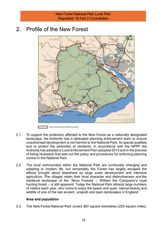
In 2022 the National Park had a population of 34,931 people 2 and with around 62 people per square kilometre it is the second most densely populated national park after the South Downs. The housing stock amounts to 15,503 dwellings (New Forest Housing Needs Assessment, Iceni, 2025) The main settlements of Ashurst, Brockenhurst, Burley, Cadnam, Landford, Lyndhurst and Sway have between 1,000 and 3,500 residents. Average house prices in the New Forest are significantly higher than surrounding areas, with an average property price more than 12 times the average annual earnings. This means the New Forest has the highest average house price of any UK National Park.
Landscape character
2.4. The New Forest Landscape Charact er Assessment (2015) describes 19 character areas. A Landscape Action Plan for the National Park extends the landscape assessment work and provides guidance for individuals and organisations wanting to help enhance and conserve the special landscape character of the area . At the heart of the New Forest is an extensive area of unenclosed woodland, grassland and heath which is of international nature conservation importance and is maintained largely by the grazing of commoners’ stock. Recent figures show that 10,509 animals are depastured on the Open Forest by over 700 practising commoners 3 This historic form of land management faces threats from the high land and property costs.
Nature conservation
2.5. In total 56% of the New Forest National Park is designated of international value for nature conservation – the highest proportion of land in any planning authority area in the country. The New Forest Special Area of Conservation (SAC), Special Protection Area (SPA) and Ramsar sites cover more than 300 square kilometres in the core of the New Forest, including the most extensive area of heathland and valley mire in lowland Europe. Much of the coastline is similarly designated, principally for the populat ions of wintering wildfowl and waders and a framework is in place along the Solent (including the National Park) to ensure the impacts of new residential development on the coast are mitigated.
Cultural heritage
2.6. The National Park conta ins a wealth of designated and non-designated heritage assets. There are more than 340 Bronze Age barrows, a number of fine Iron Age hill forts, and numerous remnants of medieval and later buildings, enclosures and other earthworks associated with the royal forest. The main rivers supported a boat and shipbuilding industry and the coastal salt workings were among the most important in the country during the 18 th Century. The National Park has 214 scheduled ancient monuments, 624 listed buildings and 17 designated conservation areas, plus three which straddle the National Park boundary with surrounding authorities. In addition to the nationally listed buildings,
2 New Forest Housing Needs Assessment, Iceni, 2025
3 Verderers of the New Forest data 2024
Regulation 18 Part 2 Consultation
there are well over 2,000 non-designated heritage assets. There are also seven registered historic parks and gardens, four of which are grade II*. The cultural heritage of the National Park extends beyond its rich built environment and includes the long history of commoning in the New Forest. Commoners’ stock comprising ponies, donkeys, pigs and cattle roam free across the Open Forest and are part of the ‘special qualities’ of the National Park. Commoning has helped shape the mosaic of landscapes, biodiversity and character of the National Park and is essential to the land-based economy and management of the Open Forest
Access and recreation
2.7. The New Forest has 42 kilometres of coastline, 325 kilometres of Public Rights of W ay (PROW ), and over 30,000 hectares of accessible land (more than 50% of the area of the Nationa l Park) This provides numerous opportunities for quiet recreation. Tranquillity and a sense of remoteness can be found in many parts of the Natonal Park. In addition, the major attractions, including Buckler’s Hard, Lepe Country Park, Calshot Activities Centre, the National Motor Museum in Beaulieu, Paulton’s Park, and the villages of Lyndhurst, Brockenhurst, Beaulieu and Burley, attract people throughout the year.
2.8. Research by RJS Associates (2019) indicated that there were over 15 million visitor days spent per annum in the New Forest National Park – an increase of over 12% since the previous assessment was undertaken in 2004. Research commissioned by the Authority, New Forest District Council, Natural England and Forestry England and other local planning authorities 4 estimated that housing development in the period up to 2036 within 25 kilometres of the New Forest will result in an increase of around 11.4% in the number of visits to the New Forest’s designated sites.
Communities and Settlement Pattern
2.9. The local communities of the New Forest have a strong cultural identity; with a wealth of local traditions, and there remains an active commoning community. There are 37 parish and town councils wholly or partly within the National Park.
2.10. The review of the Local Plan provides an opportunity to re-assess the settlement hierarchy in the National Park. The larger villages of Ashurst, Brockenhurst, Lyndhurst and Sway are currently identified as ‘Defined Villages’ due to their character, population and the range of facilities and services they provide.
2.11. Other smaller settlements with a basic range of local services within the National Park include Beaulieu, Burley, Cadnam - Bartley, East Boldre, LandfordNomansland, Netley Marsh, Redlynch and Woodgreen. The revised draft Local Plan identifies a number of further ‘defined villages’ that provide some services for local people. The surrounding urban areas of Southampton, Bournemouth and Salisbury are easily reached by rail or road from the National Park and provide a
4 Recreation use of the New Forest SAC/SPA/Ramsar: Overview of visitor results and implications of housing change on visitor numbers’ Footprint Ecology, 2020
wide range of housing, shops, leisure facilities and employment opportunities. The towns of Lymington, New Milton, Ringwood, Totton and the Waterside are important local employment centres and provide services to meet most of the needs of National Park residents.
Economy
2.12. W hile the National Park is predominantly rural in nature, the economy is diverse and is highly integrated with its surrounding areas. There are around 2,500 businesses in the National Park, reflecting a very broad range and types of businesses, with the largest sector, in terms of the numbers of individual businesses, being professional, scientific and technical services. Residents of the National Park are employed in a wide range of businesses and services, with the health sector; tourism; wholesale and retail; professional and technical services; and education all being particularly important employers. Only a small proportion of employment is now found in traditional rural land-based activities such as farming, forestry and commoning, but these activities remain vital in maintaining t he land use management practices that help conserve the landscape character of the National Park. Unemployment within the National Park has remained at lower levels than in the South East and th e UK as a whole over the last decade and currently stands at circa 1.3%. Looking forward, a decline in the working age population is forecast.
2.13. In delivering the two statutory National Park purposes, the Authority has an important duty to foster the socio-economic wellbeing of the communities within the National Park. The English National Parks and the Broads UK Government Vision and Circular (2010) confirms that national park authorities should continue to focus their expenditure on the delivery of their statutory purposes, while seeking to maximise the socio-economic benefits available from such activity. Experience to date has shown that by harnessing the economy to environmental ends, tangible economic benefits can be delivered through the statutory purposes whilst at the same time achieving those purposes 5
Transport
2.14. The National Park is crossed by several major routes which carry high volumes of traffic. The A31, linking South W est England with Southampton and the wider South East, is the most heavily used road in the National Park , carrying over 70,000 vehicles daily and effectively cuts the area in two. The National Park is well-served for long-distance rail travel, with connections at Ashurst, Beaulieu Road, Brockenhurst and Sway Lymington – located just outside the National Pa rk - also has two train stations which link with the Isle of W ight ferry. There are a number of regular scheduled public bus services, including a regular service between Southampton and Lymington, via Lyndhurst and Brockenhurst. However, many of the rural settlements are less well -served and here public transport is not a practical option for the majority of residents.
5 Paragraph 66, English National Parks and the Broads UK Government Vision and Circular, 2010
2.15. During the summer months the New Forest Tour bus operates three interlinked routes across the National Park and is aimed at both visitors and residents.
2.16. Southampton and Bournemouth Airports are located within close proximity to the National Park. Plans for the expansion of both airports are set out in the respective Airport Masterplans, with combined annual aircraft movements predicted to increase over the plan-period in line with the consented developments at the airports. The scale of the impact of this increase of passenger aircraft flights will depend on future flight paths and the extent of improvements in aircraft engine technology.
2.17. Southampton is a major international gateway port with significant global and economic importance. Land at Dibden Bay, adjoining the National Park and also referred to as the ‘Strategic Land Reserve’, has been identified as the only area of land physically capable of accommodating significant expansion of the port in the draft Port of Southampton Masterplan 2016-2035. The Waterside area of the New Forest also includes several of the designated Solent Freeport tax and customs sites. Any future development proposals for the Strategic Land Reserve and Fawley Waterside in particular must have regard to the Government’s National Policy Statement on Ports; potential impacts on the adjacent New Forest National Park (as required by the strengthened Section 62(2) of the Environment Act 1995); national planning policy on major development in national parks; and the legal requirements of the Habitats Regulations .