AECOM Limited (“AECOM”) has prepared this report for the sole use of the South Downs National Park Authority (“Client”) in accordance with the terms and conditions of appointment.
AECOM shall have no duty, responsibility and/or liability to any party in connection with this report howsoever arising other than that arising to the Client under the Appointment. Save as provided in theAppointment, no warranty, expressed or implied, is made as to the professional advice included in this report or any other services provided by AECOM.
Where any conclusions and recommendations contained in this report are based upon information provided by the Client and/or third parties, it has been assumed that all relevant information has been provided by the Client and/or third parties and that such information is accurate. Any such information obtained by AECOM has not been independently verified by AECOM, unless otherwise stated in this report. AECOM accepts no liability for any inaccurate conclusions, assumptions or actions taken resulting from any inaccurate information supplied to AECOM from the Client and/or third parties.
Table
Table
Table
Table
Table 8-3
Table 8-4 Test of Likely Significant Effects of the SDLP (2019) Site Allocations
Proposed to be carried forward 163
Table 8-5 Test of Likely Significant Effects of the Plan Potential Site Allocations ... 169
1. Introduction
1.1 South Downs National Park Authority (SDNPA) is undertaking a review of the South Downs Local Plan (SDLP) adopted in 2019.AECOM undertook an HRA of the adopted SDLP in 2018. The South Downs Local Plan Review will produce a revised Local Plan (LP) that will set out the spatial vision, objectives, levels and types of growth, and strategic and development management policies. It will also identify infrastructure requirements and allocate sites for development in the period up to 2042. AECOM has been appointed to undertake the Habitats Regulations Assessment (HRA) report for the Regulation 18 consultation
1.2 The SDLP is a strategy document that will provide a positive vision for the future of the South Downs National Park. It will include a framework for addressing identified development needs and environmental and social priorities, to make sure future development provides the right kind of jobs, homes and infrastructure in the best and most sustainable locations.
1.3 SDNPA is a Competent Authority as defined in Regulation 7 of the Conservation of Habitats and Species Regulations 2017 (as amended). Regulation 105 states that ‘A competent authority, before deciding to undertake, or give any consent, permission or other authorisation for, a plan or project which… is likely to have a significant effect on a European site [a Special Area of Conservation, Special Protection Area or, as a matter of Government policy, a Ramsar site] or a European offshore marine site (either alone or in combination with other plans or projects) …must make an appropriate assessment of the implications of the plan or project for that site in view of that site’s conservation objectives’.
1.4 There is no ‘one size fits all’ guidance regarding Zones of Influence (ZoIs) around Habitats Sites. The ZoIs of some impact pathways (e.g. loss of functionally linked habitat, water quality and water quantity, level and flow) can extend beyond 10km. For example, potential water quality impacts via the discharge of treated sewage effluent and / or surface runoff depend on the presence of hydrological linkages to environmental receptors and are typically assessed on a catchment scale AECOM has therefore been led by identified impact pathways and their zone of influence rather than an arbitrary distance.
2. HRA Law and Methodology
Legal Context
2.1 The UK left the European Union (EU) on 31 January 2020 under the terms set out in the EU (Withdrawal Agreement) Act 2020 (“the Withdrawal Act”). However, the WithdrawalAct retains the bodyof existing EU-derived law within our domestic law. Therefore, the requirement for HRA continues as set out in the Conservation of Habitats and Species (Amendment) (EU Exit) Regulations 20191, unless this is changed by future legislation. It is to be noted that there are current government plans to change the Habitats Regulations although how they may change is currently unclear. Similarly, although EU case law is currently still considered of relevance in UK courts, that position may change during preparation and implementation of the SDLP.
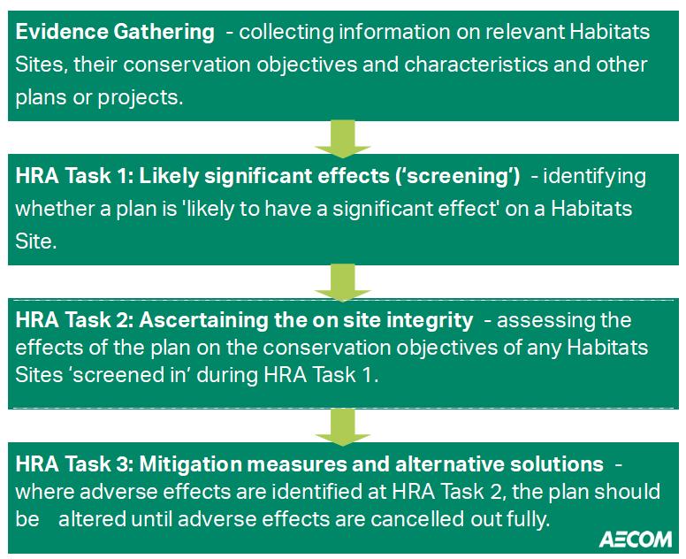
2.2 The need for Appropriate Assessment (AA, Figure 1) is set out in the Conservation of Habitats and Species Regulations 2017 (as amended). The HRA process applies the ‘Precautionary Principle’2 to Habitats Sites (also known as European sites and covering SpecialAreas of Conservation, Special Protection Areas and Ramsar sites). Plans and projects can only be permitted having ascertained that there will be no adverse effect on the integrity of the Habitats Site(s) in question. Plans and projects that are associated with potential adverse impacts on the integrity of Habitats Sites may still be permitted if there are no reasonable alternatives and there are Imperative Reasons of Overriding Public Interest (IROPI) as to why they should go ahead. In such cases, compensation would be necessary to ensure the overall integrity of the site network.
Figure 1: The legislative basis for Appropriate Assessment (AA).
Conservation of Habitats and Species Regulations 2017 (as amended)
The Regulations state that:
“A competent authority, before deciding to … give any consent, permission or other authorisation for a plan or project which… is likely to have a significant effect on a European site or a European offshore marine site (either alone or in combination with other plans or projects) … must make an appropriate assessment of the implications for that site in view of that site’s conservation objectives … The authority shall agree to the plan or project only after having ascertained that it will not adversely affect the integrity of the European site ”.
2.3 Over time the phrase ‘Habitats RegulationsAssessment’ (HRA) has come into wide currency to describe the overall process set out in the Regulations from
1 These do not act as a replacement for the 2017 Regulations but are another set of amendments
2 The Precautionary Principle, which is referenced in Article 191 of the Treaty on the Functioning of the European Union, has been defined by the United Nations Educational, Scientific and Cultural Organisation (UNESCO, 2005) as: “When human activities may lead to morally unacceptable harm [to the environment] that is scientifically plausible but uncertain, actions shall be taken to avoid or diminish that harm. The judgement of plausibility should be grounded in scientific analysis”.
screening through to IROPI. This has arisen in order to distinguish the process from the individual stage described in the law as an ‘AppropriateAssessment’.
2.4 In spring 2018, the ‘Sweetman’ European Court of Justice ruling3 clarified that ‘mitigation’ (i.e. measures that are specifically introduced to avoid or reduce a harmful effect on a Habitats Site that would otherwise arise) should not be taken into account when forming a view on Likely Significant Effects (LSEs). Mitigation should instead only be considered at the AA stage.
HRA Methodology
2.5 This HRA has been carried out with reference to the general EC guidance on HRA4; the UK government also produced its own guidance in 20215 .
2.6 Figure 2 below outlines the stages of HRAaccording to government guidance. The stages are essentially iterative, being revisited as necessary in response to more detailed information, recommendations and any relevant changes to the plan until no significant adverse effects remain.
Description of HRA Tasks
HRA Task 1 – Likely Significant Effects (LSEs) Screening
2.7 Following evidence gathering and scoping (this stage), the first formal stage of any HRA is a Likely Significant Effects (LSEs) Screening. This is a brief, high-level assessment to decide whether the full subsequent stage known as AA is required. The essential question is: “Is the project, either alone or in combination with other relevant projects and plans, likely to result in a significant effect upon Habitats sites?”
3 People Over Wind and Sweetman v Coillte Teoranta (C-323/17)
4 European Commission (2001): Assessment of plans and projects significantly affecting Natura 2000 Sites: Methodological Guidance on the Provisions of Article 6(3) and 6(4) of the Habitats Directive.
Figure 2. Four Stage Approach to Habitats Regulations Assessment..
2.8 The objective is to ‘screen out’ those plans and projects that can, without any detailed appraisal, be concluded to be unlikely to result in significant adverse effects upon Habitats Sites. This is usually because there is no mechanism for an adverse interaction.
2.9 The LSEs Screening is based on identification of the Source of impact, the Pathway of that impact to Receptors and then confirmation of the specific European Site receptors. These are normally designated features but also include habitats and species fundamental to those designated features achieving favourable conservation status (notably functionally linked land outside the European site boundary).
2.10 In the Waddenzee case6, the CJEU ruled on the interpretation of Article 6(3) of the Habitats Directive, including that:
• An effect should be considered ‘likely’, “if it cannot be excluded, on the basis of objective information, that it will have a significant effect on the site” (para 44);
• An effect should be considered ‘significant’, “if it undermines the conservation objectives” (para 48); and
• Where a plan or project has an effect on a site “but is not likely to undermine its conservation objectives, it cannot be considered likely to have a significant effect on the site concerned” (para 47).
2.11 The LSEs Screening consists of two parts: It determines whether there are any policies in the plan that could result in negative impact pathways and any Habitats sites that are sensitive to these impact pathways lie within the ZoI of the authority boundary.
2.12 Note that in line with the aforementioned 2018 case law, the conclusion of ‘no LSEs’ must not take account of any measures specifically introduced to avoid or reduce harm to Habitats Sites. Embedded measures (i.e. those that are integral to the plan itself or are otherwise required by law irrespective of the presence of Habitats sites) can be considered at this stage, but other types of mitigation must be deferred to the AA.
2.13 LSEs Screening must generally follow the Precautionary Principle as its main purpose is to determine whether the subsequent stage of AA (i.e. a more detailed assessment of impact pathways) is required.
HRA Task 2 –
Appropriate Assessment (AA)
2.14 Where it is determined that a conclusion of ‘no Likely Significant Effect’ cannot be drawn, the analysis must proceed to the next stage of HRA known as Appropriate Assessment (AA). Case law has clarified that ‘Appropriate Assessment’ is not a technical term. In other words, there are no particular technical analyses, or level of technical analysis, that are classified by law as belonging to AA rather than the LSE screening AA refers to whatever level of assessment is appropriate to form a conclusion regarding effects on the integrity (coherence of structure and function) of Habitats sites in light of their conservation objectives.
2.15 There is a clear implication that the analysis in an AA should be more detailed than undertaken at the previous stage. One of the key considerations during AA is whether there is available mitigation that would entirely address the potential effect. In practice, the AA would take any policies or allocations that could not be dismissed following the high-level Likely Significant Effects Test analysis and assess the potential for an effect in more detail. The purpose would be to conclude whether there would actually be an adverse effect on site integrity (in other words, disruption of the coherent structure and function of the European site(s)).
2.16 In 2018 the Holohan ruling7 was handed down by the European Court of Justice. This included paragraph 39 which stated that ‘As regards other habitat types or species, which are present on the site, but for which that site has not been listed, and with respect to habitat types and species located outside that site, … typical habitats or species must be included in the AA, if they are necessary to the conservation of the habitat types and species listed for the protected area’ [emphasis added].
2.17 Where necessary, measures will be recommended for incorporation into the emerging Local Plan in order to avoid or mitigate adverse effects on Habitats sites. There is considerable precedent, both nationally and locally, concerning the level of detail that a Plan document needs to contain regarding mitigation for recreational impacts on Habitats sites, for example. The implication of this precedent is that it is not necessary for all measures that will be deployed to be fully developed prior to adoption of the Local Plan, but the Local Plan must provide an adequate policy framework within which these measures can be delivered.
2.18 In evaluating significance, AECOM have relied on professional judgement as well as the results of bespoke studies, supported by appropriate evidence/data, and previous stakeholder consultation regarding development impacts on the Habitats sites considered within this assessment.
Mitigation
2.19 Once the AA was completed there was some requirement identified for mitigation. For a Local Plan this generally consists of amendments to policy wording of the Local Plan, or the identification of strategic mitigation solutions for smaller sites unlikely to be able to deliver their own mitigation. The purpose is to ensure an adequate framework exists to protect Habitats sites from any identified adverse effects.
2.20 For example, for Habitats sites at which recreational pressure is a concern mitigation is often achieved through creating a Strategic Access Management & Monitoring (SAMM) Strategy. This may be accompanied by the provision of SuitableAlternative Natural Greenspace (SANG), provided either by individual large developments to ‘consume their own smoke’ or strategically by the local authority to cater to those developments too small to deliver their own SANG.
2.21 The Department for Levelling Up, Housing & Communities (DLUHC) and Ministry of Housing, Communities and Local Government (MHCLG) guidance8
7 Case C-461/17
8 Department for Levelling up, housing and communities 2019. Guidance on Appropriate assessment https://www.gov.uk/government/organisations/department-for-levelling-up-housing-and-communities https://www.gov.uk/guidance/appropriate-assessment
makes it clear that when implementing HRA of land-use plans, the AA should be undertaken at a level of detail that is appropriate and proportional to the level of detail provided within the plan itself:
• “The comprehensiveness of the [Appropriate] assessment work undertaken should be proportionate to the geographical scope of the option and the nature and extent of any effects identified. An AA need not be done in any more detail, or using more resources, than is useful for its purpose. It would be inappropriate and impracticable to assess the effects [of a strategic land use plan] in the degree of detail that would normally be required for the Environmental Impact Assessment (EIA) of a project.”
• The Court of Appeal9 ruled that providing the Council (competent authority) was duly satisfied that proposed mitigation could be ‘achieved in practice’ to satisfy that the proposed development would have no adverse effect, then this would suffice. This ruling has since been applied to a planning permission (rather than a Local Plan)10. In that case the High Court ruled that for ‘a multistage process, so long as there is sufficient information at any particular stage to enable the authority to be satisfied that the proposed mitigation can be achieved in practice it is not necessary for all matters concerning mitigation to be fully resolved before a decision maker is able to conclude that a development will satisfy the requirements of Regulation 102 of the Habitats Regulations’.
2.22 In other words, there is an acceptance that AA can be tiered and that all impacts are not necessarily appropriate for consideration to the same degree of detail at all tiers. The fullest level of detail is required at the reserved matters or full planning application stage.
2.23 Similarly, in any Local Plan, there are numerous policies for which there is a limit to the degree of assessment that is possible at the plan level. This is because either:
• The policy in question does not contain any specifics as to what will be delivered so literally cannot be assessed in detail at the plan level. In these cases, the AA would focus on precautionary mitigation that can be included in the plan to ensure that whatever proposals come forward will not result in adverse effects on integrity; or
• The nature of the potential impacts (notably lighting, noise and visual disturbance during construction, or loss of functionally-linked land) are very closely related to exactly how the development will be designed and constructed or require detailed development site-specific bird survey data. They therefore cannot be assessed in detail at the plan level. In these instances, the AA focusses on the available mitigation measures, the extent to which such measures would be achievable and effective and whether an adequate protective framework exists to ensure that the policy would not
lead to an adverse effect on the integrity of any internationally designated sites.
2.24 On these occasions the advice of Advocate-General Kokott11 is worth considering. She commented that: ‘It would …hardly be proper to require a greater level of detail in preceding plans [rather than planning applications] or the abolition of multi-stage planning and approval procedures so that the assessment of implications can be concentrated on one point in the procedure. Rather, adverse effects on areas of conservation must be assessed at every relevant stage of the procedure to the extent possible on the basis of the precision of the plan This assessment is to be updated with increasing specificity in subsequent stages of the procedure’ [emphasis added]. This is the approach taken in the HRA and is in line with the Department for Levelling Up Housing and Communities guidance referenced in paragraph 4.27, and Court rulings that regarding level of detail of the assessment which is appropriate at each stage of the planning process.
Assessment ‘in combination’
2.25 It is a requirement of the Regulations that the impacts and effects of any land use plan being assessed are not considered in isolation but in combination with other plans and projects that may also be affecting the European site(s) in question. In practice, ‘in combination assessment’ is of greatest importance when the policy would otherwise be screened out because the individual contribution is not significant. When undertaking in combination assessment for specific development sites, it is important to avoid double-counting since many housing and employment projects that deliver growth will usually already be allocated in the Local Plan. In these instances, the development of a planning application essentially provides further detail on those aspects of Local Plan growth rather than presenting a new project.
2.26 Similarly, where growth that is being delivered within surrounding authorities, this is captured in the ‘in combination’ assessment through consideration of the relevant Local Plan that sets out the total amount of growth that will be delivered across that authority during its plan period, based on currently adopted Local Plans.
11 Opinion of Advocate General Kokott, 9th June 2005, Case C-6/04. Commission of the European Communities v United Kingdom of Great Britain and Northern Ireland, paragraph 49 http://curia.europa.eu/juris/document/document.jsf?docid=58359&doclang=EN
3. Habitats Sites
3.1 In the case of the South Downs National Park, the Habitats sites being considered are based upon a combination of tracing impact pathways and using distances derived from various studies, as was decided in the HRA of the adopted Local Plan but updated where more recent evidence exists. The Habitats sites of relevance to HRA are shown in Table 3-1. These sites lie wholly or partly within the South Downs National Park or within the surrounding sphere of influence. Habitats Sites are listed alphabetically
Table 3-1: Relevant Habitats Sites and their location in relation to the South Downs National Park (SDNP) boundary.
Internationally Designated Site
Arun Valley SAC/SPA/Ramsar
Ashdown Forest SAC and SPA12
Butser Hill SAC
Castle Hill SAC
Chichester and Langstone Harbours SPA / Ramsar
Duncton to Bignor Escarpment SAC
East Hampshire Hangers SAC
Ebernoe Common SAC
Emer Bog SAC
Kingley Vale SAC
Lewes Downs SAC
The Mens SAC
Pagham Harbour SPA and Ramsar
Pevensey Levels SAC and Ramsar
Portsmouth Harbour SPA / Ramsar
River Itchen SAC
Rook Clift SAC
Shortheath Common SAC
Singleton and Cocking Tunnels SAC
Solent and Dorset Coast SPA
Solent & Southampton Water SPA / Ramsar
Solent Maritime SAC
Thames Basin Heaths SPA
Thursley, Hankley & Frensham Commons SPA
Thursley, Ash, Pirbright & Chobham SAC
Location
Within SDNP
Approx. 13km north of SDNP
Within SDNP
Within SDNP
Approx. 1.7km south of SDNP
Within SDNP
Within SDNP
Within SDNP
Approx. 6.6km to the west of SDNP
Within SDNP
Within SDNP
Within SDNP
Approx. 8.5km south of SDNP
Approx. 3.2km north-east of SDNP
Approx. 5km south of SDNP
Within the SDNP
Within SDNP
Within SDNP
Within SDNP
Approx. 4.3km south of SDNP
Approx. 13km to the south-west of SDNP
Approx. 1.7km south of SDNP
Approx. 4.9km to the north of SDNP
Approx. 2.2km to the north of SDNP
Approx. 2.2km to the north of SDNP
12 This Habitats site lies beyond the normally used impact pathway distances but has been included in the scope of the HRA as it was covered in the HRA of the adopted Local Plan
Thursley & Ockley Bogs Ramsar
Wealden Heaths Phase II SPA
Woolmer Forest SAC
Approx. 7.9km to the north of SDNP
Within SDNP
Within SDNP
3.2 The locations of the Habitats Sites identified in Table 3-1 are illustrated in Appendix A, Figure A1 and further information on their interest features is provided in Appendix B.
3.3 Emer Bog SAC is located 6.7km from the South Downs National Park Authority boundary. By nature of the bog habitats present, it is sensitive to changes in hydrology. However, the River Itchen separates the South Downs National Park Authority area from the catchment area of Emer Bog SAC, and as such there is no hydrological connection between the SAC and the SDNP boundary. As such, Emer Bog SAC is not discussed further.
3.4 At its closest, the Solent and Isle of Wight Lagoons SAC is located 7.8km in a straight line from the South Downs National Park Authority boundary. The site is vulnerable to changes in salinity. However, the South Downs National Park Authority Local Plan is unlikely to contain any impact pathways that could result in changes. As such the Solent and Isle of Wight Lagoons SAC is not discussed further.
4. Relevant Impact Pathways
Recreational Pressure
4.1 There is concern over the cumulative impacts of recreation on key nature conservation sites in the UK, as most sites must fulfil conservation objectives while also providing recreational opportunity. Various research reports have provided compelling links between changes in housing and access levels13 , and impacts on Habitats Sites14 15 This applies to any habitat, but recreational pressure from housing growth is of particular significance for Habitats Sites. Different Habitats Sites are subject to different types of recreational pressures and have different vulnerabilities. Studies across a range of species have shown that the effects from recreation can be complex. HRAs of planning documents tend to focus on recreational sources of disturbance due to new residents16. Housing developments within the Local Plan will need to strongly consider their impact on Emerald Network sites.
Trampling Damage, Nutrient Enrichment and Wildfires
4.2 Most terrestrial habitats (especially heathland, woodland and dune systems) can be affected by trampling and other mechanical damage. This dislodges individual plants, leads to soil compaction and erosion. The following studies have assessed the impact of trampling associated with different recreational activities in different habitats:
• Wilson & Seney)17 examined the degree of track erosion caused by hikers, motorcyclists, horse riders and cyclists in 108 plots along tracks in the Gallatin National Forest, Montana. Although the results proved difficult to interpret, it was concluded that horses and hikers disturbed more sediment on wet tracks, and therefore caused more erosion, than motorcycles and bicycles.
• Cole et al18 conducted experimental off-track trampling in 18 closed forest, dwarf scrub and meadow & grassland communities (each trampled between 0 – 500 times) over five mountain regions in the US. Vegetation cover was assessed two weeks and one year after trampling, and an inverse relationship with trampling intensity was discovered, although this relationship was weaker after one year than two weeks indicating some recovery of the vegetation. Differences in plant morphology (structure) was found to explain more variation in response than soil and topographic
13 Weitowitz D.C., Panter C., Hoskin R. & Liley D. (2019). The effect of urban development on visitor numbers to nearby protected nature conservation sites. Journal of Urban Ecology 5 https://doi.org/10.1093/jue/juz019
14 Liley D, Clarke R.T., Mallord J.W., Bullock J.M. (2006a). The effect of urban development and human disturbance on the distribution and abundance of nightjars on the Thames Basin and Dorset Heaths. Natural England / Footprint Ecology.
15 Liley D., Clarke R.T., Underhill-Day J., Tyldesley D.T. (2006b). Evidence to support the appropriate Assessment of development plans and projects in south-east Dorset. Footprint Ecology / Dorset County Council.
16 The RTPI report ‘Planning for an Ageing Population‘ (2004) which states that ‘From being a marginalised group in society, the elderly are now a force to be reckoned with and increasingly seen as a market to be wooed by the leisure and tourist industries. There are more of them and generally they have more time and more money.’ It also states that ‘Participation in most physical activities shows a significant decline after the age of 50. The exceptions to this are walking, golf, bowls and sailing, where participation rates hold up well into the 70s’.
17 Wilson, J.P. & J.P. Seney. (1994). Erosional impact of hikers, horses, motorcycles and off-road bicycles on mountain trails in Montana. Mountain Research and Development 14:77-88
18 Cole, D.N. (1995a). Experimental trampling of vegetation. I. Relationship between trampling intensity and vegetation response. Journal of Applied Ecology 32: 203-214 Cole, D.N. (1995b). Experimental trampling of vegetation. II. Predictors of resistance and resilience. Journal of Applied Ecology 32: 215-224
factors. Low-growing, mat-forming grasses regained their cover best after two weeks and were considered most resistant to trampling, while tall forbs (non-woody vascular plants other than grasses, sedges, rushes and ferns) were considered least resistant. The cover of hemicryptophytes (plants with buds at or near the soil surface) and geophytes (plants with buds below the soil surface) was heavily reduced after two weeks but had recovered well after one year. These were therefore considered most resilient to trampling. Chamaephytes (plants with buds above the soil surface) were least resilient to trampling. It was concluded that these would be the least tolerant of a regular cycle of disturbance.
• Cole19 conducted a follow-up study (across four vegetation types) in which shoe type (trainers or walking boots) and trampling weight were varied. Although immediate damage was greater with walking boots, there was no significant difference after one year. Heavier tramplers caused a greater reduction in vegetation height than lighter tramplers, but there was no differential impact on vegetation cover.
• Cole & Spildie20 experimentally compared the effects of off-track trampling by hikers and horse riders (at two intensities – 25 and 150 passes) in two woodland vegetation types (one with an erect forb understorey and one with a low shrub understorey). Horse trampling was found to cause the largest reduction in vegetation cover. The forb-dominated vegetation suffered greatest disturbance but recovered rapidly. Generally, it was shown that higher trampling intensities caused more disturbance.
4.3 A major concern for nutrient-poor terrestrial habitats (e.g. heathlands, sand dunes, bogs and fens) is nutrient enrichment associated with dog fouling (addressed in various reviews21). It is estimated that dogs will defecate within 10 minutes of starting a walk and therefore most nutrient enrichment arising from dog faeces will occur within 400m of a site entrance. In contrast, dogs will urinate at frequent intervals during a walk, resulting in a more spread out distribution of urine. For example, in Burnham Beeches National Nature Reserve it is estimated that 30,000 litres of urine and 60 tonnes of dog faeces are deposited annually22. While there is limited information on the chemical constituents of dog faeces, nitrogen is one of the main components23. Nutrient availability is the major determinant of plant community composition and the effect of dog defecation in sensitive habitats is comparable to a high-level application of fertiliser, potentially resulting in a shift towards plant communities that are more typical of improved grasslands.
Bird Disturbance
4.4 Human activity can affect birds either directly (e.g. by eliciting flight responses) or indirectly (e.g. by damaging habitat or reducing bird fitness in less obvious ways such as through inducing stress responses). The most obvious direct
19 Cole, D.N. (1995c). Recreational trampling experiments: effects of trampler weight and shoe type. Research Note INT-RN425. U.S. Forest Service, Intermountain Research Station, Utah.
20 Cole, D.N., Spildie, D.R. (1998). Hiker, horse and llama trampling effects on native vegetation in Montana, USA. Journal of Environmental Management 53: 61-71
21 Taylor K., Anderson P., Taylor R.P., Longden K. & Fisher P. (2005). Dogs, access and nature conservation. English Nature Research Report, Peterborough.
22 Barnard A. (2003). Getting the facts – Dog walking and visitor number surveys at Burnham Beeches and their implications for the management process. Countryside Recreation 11:16-19.
23 Taylor K., Anderson P., Liley D. & Underhill-Day J.C. (2006). Promoting positive access management to sites of nature conservation value: A guide to good practice. English Nature / Countryside Agency, Peterborough and Cheltenham.
effect is that of immediate mortality such as death by shooting. Human activity can also lead to much subtler behavioural (e.g. alterations in feeding behaviour, avoidance of certain areas and use of sub optimal areas etc.) and physiological changes (e.g. an increase in heart rate). While such changes are less noticeable, they might result in major population-level changes by altering the balance between immigration / birth and emigration / death24 .
4.5 Concern regarding the effects of disturbance on birds stems from the fact that they are expending energy unnecessarily and time spent responding to disturbance is time that is not spent feeding25. Disturbance therefore increases energetic expenditure while reducing energetic intake, which can adversely affect the ‘condition’and ultimately survival of birds.Additionally, displacement of birds from one feeding site to another can increase the pressure on the resources available within alternative foraging sites, which must sustain a greater number of birds26. Moreover, the higher proportion of time a breeding bird spends away from its nest, the more likely it is that eggs will cool and the more vulnerable they, or any nestlings, are to predators. Recreational effects on ground-nesting birds are particularly severe, with many studies concluding that urban sites support lower densities of key species, such as stone curlew and nightjar27 28 .
4.6 Several factors (e.g. seasonality, type of recreational activity) may have pronounced impacts on the nature of bird disturbance. Disturbance in winter may be more impactful because food shortages make birds more vulnerable at this time of the year. In contrast, this may be counterbalanced by fewer recreational users in the winter months and lower overall sensitivity of birds outside the breeding season. Evidence in the literature suggests that the magnitude of disturbance clearly differs between different types of recreational activities. For example, dog walking leads to a significantly higher reduction in bird diversity and abundance compared to hiking29. Scientific evidence also suggests that key disturbance parameters, such as areas of influence and flush distance, are significantly greater for dog walkers than hikers30 . Furthermore, differences in on-site route lengths and usage patterns likely imply that key spatial and temporal parameters (such as the area of a site potentially impacted and the frequency of disturbance) will also differ between recreational activities. This suggests that activity type is a factor that ought to be taken into account in HRAs.
Summary
4.7 Several Habitats sites relevant to the South Downs National Park are designated for habitats and species that are sensitive to recreational pressure. A growth in the local population will lead to an increased demand for access to outdoor areas and recreational greenspaces, especially Habitats sites. Of
24 Riley, J. (2003). Review of Recreational Disturbance Research on Selected Wildlife in Scotland. Scottish Natural Heritage.
25 Riddington, R. et al. (1996). The impact of disturbance on the behaviour and energy budgets of Brent geese. Bird Study 43:269-279.
26 Gill, J.A., Sutherland, W.J. & Norris, K. (1998). The consequences of human disturbance for estuarine birds. RSPB Conservation Review 12: 67-72.
27 Clarke R.T., Liley D., Sharp J.M., Green R.E. (2013). Building development and roads: Implications for the distribution of stone curlews across the Brecks. PLOS ONE https://doi:10.1371/journal.pone.0072984.
28 Liley D. & Clarke R.T. (2003). The impact of urban development and human disturbance on the numbers of nightjar Caprimulgus europaeus on heathlands in Dorset, England. Biological Conservation 114: 219-230.
29 Banks P.B., Bryant J.Y. (2007). Four-legged friend or foe? Dog walking displaces native birds from natural areas. Biology Letters 3: 14pp.
30 Miller S.G., Knight R.L., Miller C.K. (2001). Wildlife responses to pedestrians and dogs. Wildlife Society Bulletin 29: 124-132.
particular relevance to the HRA, a series of Habitats sites (those where recreational pressure has been identified as the greatest concern due to a combination of sensitivity and development pressure) have been subject to specific visitor surveys which have led to the identification of a series of recreational catchments. These are:
• The Solent Habitats sites as a group – core recreational catchment 5.6km based on studies undertaken by Footprint Ecology;
• Pagham Harbour SPA/Ramsar - core recreational catchment 3.5km based on studies undertaken by Chichester District Council;
• Ashdown Forest SAC/SPA – core recreational catchment 7km based on studies undertaken by Footprint Ecology. This is the largest visitor catchment identified for sites within or around the SDNP and is a reflection of the role of Ashdown Forest asa regional draw, although it should be noted excluding tourists, 78% of visitors to the SAC/SPA live in Wealden or MidSussex and the majority of frequent (at least weekly) visitors live in Crowborough, East Grinstead and Uckfield;
• Wealden Heaths Phase 2 SPA/Woolmer Forest SAC/Shortheath Common SAC – core recreational catchment 5km based on studies undertaken by Footprint Ecology and AECOM;
• Thursley, Hankley & Frensham Commons SPA/ Thursley, Ash, Pirbright & Chobham SAC – core recreational catchment 5km based on studies by UE Associates;
• Thames Basin Heaths SPA – core recreational catchment 5km based on numerous studies over many years by Footprint Ecology, EPR and others.
4.8 A number of sites may be sensitive to excessive recreational pressure but have no specific recreational catchment defined based upon bespoke visitor survey of that site. This usually reflects lesser concern over recreational pressure due (for example) to expected low levels of net new housing around the sites. Based on the studies above an indicative recreational catchment of 5km has been used for these sites.
4.9 Overall, the following Habitats sites are sensitive to increased recreational footfall and, therefore, could be negatively impacted by residential development, although the sites identified above will be the primary focus for the assessment depending on the focus of new residential development in the National Park:
• Arun Valley SAC/SPA/Ramsar
• Ashdown Forest SAC and SPA
• Butser Hill SAC
• Castle Hill SAC
• Chichester and Langstone Harbours SPA and Ramsar
• Duncton to Bignor Escarpment SAC
• East Hampshire Hangers SAC
• Ebernoe Common SAC
• Kingley Vale SAC
• Lewes Downs SAC
• The Mens SAC
• Pagham Harbour SPA and Ramsar
• Rook Clift SAC
• Shortheath Common SAC
• Singleton and Cocking Tunnels SAC
• Thames Basin Heaths SPA
• Thursley, Hankley & Frensham Commons SPA
• Thursley, Ash, Pirbright & Chobham SAC
• Wealden Heaths Phase II SPA
• Woolmer Forest SAC
Urbanisation
4.10 This impact is closely related to recreational pressure, in that they both result from increased populations within close proximity to sensitive sites. Urbanisation is an issue in area where a designated site is located within close proximity to a large urban area. Urbanisation is considered separately as the detail of the impacts is distinct from the trampling, disturbance and dog-fouling that results specifically from recreational activity and is more related to close proximity of large scale urban development. The list of urbanisation impacts can be extensive, but core impacts can be singled out:
• Increased fly-tipping: Rubbish tipping is unsightly but the principle adverse ecological effect of tipping is the introduction of invasive alien species with garden waste. Garden waste results in the introduction of invasive aliens precisely because it is the ‘troublesome and over-exuberant’ garden plants that are typically thrown out31. Alien species may also be introduced deliberately or may be bird-sown from local gardens.
• Arson – Heathlands are particularly susceptible to arson or accidental fires. Consultations reported in the Whitehill & Bordon HRA have revealed a snapshot of the extent of fire on Habitats sites over recent years. Monitoring has not always been carried out uniformly, but site managers logged two incidences of fire on Shortheath Common in 2010, with none in the preceding two years. The total area of Shortheath Common lost to wildfire in 2010 was 0.92 hectares, representing about 1.6% of the site, much of which is not heathland (pers. comm., 2011). On Broxhead Common, four fires were logged between 2008 and 2010, totalling 5.60 hectares.
• Cat predation - A survey performed in 1997 indicated that nine million British cats brought home 92 million prey items over a five-month period. A large proportion of domestic cats are found in urban situations, and increasing urbanisation is likely to lead to increased cat predation.
4.11 The impact of general urbanisation also of course involves recreational pressure. However, the recreational pressure impact pathway arises from a potentially much wider catchment than 400m and thus has been discussed separately above.
31 Gilbert, O. & Bevan, D. 1997. The effect of urbanisation on ancient woodlands. British Wildlife 8: 213-218.
4.12 The most detailed consideration of the link between relative proximity of development to Habitat Sites and damage to interest features has been carried out with regard to the Thames Basin Heaths SPA and the Dorset Heathlands SAC/ SPA/ Ramsar site For example, in relation to the Dorset Heathland sites Natural England and its partners produced a Supplementary Planning Document (SPD)32 which sets out a framework for accommodating development while also protecting the interest features of the heathland sites This included the implementation of a series of zones within which varying constraints would be placed upon development.
4.13 While the zones relating to recreational pressure expanded to 5km (as this was determined from visitor surveys to be the principal recreational catchment for this Habitats Site), that concerning other aspects of urbanisation (predation of the chicks of ground-nesting birds by domestic cats, recreational pressure that cannot be readily diverted, fly tipping, increased incidence of fires and general urbanisation) was identified at 400m from the site boundaries. The SPD concluded that the adverse effects of residential development located within 400m of the SPA boundary could not be adequately mitigated, in part because this was the range within cats could be expected to roam routinely and there was no realistic way of restricting their movements. Setting a 400m housing exclusion zone surrounding heathland sites is, therefore, the principal means through which urbanisation effects are addressed.
4.14 In relation to the Thames Basin Heath SPA, after extensive research, in 2009 Natural England and its partners produced the ‘Thames Basin Heaths Special Protection Delivery Framework’33 which made recommendations for accommodating development while also protecting the interest features of the Habitats Site. This included the recommendation of implementing a series of zones within which varying constraints would be placed upon development. While the zones relating to recreational pressure expanded to 5km (as this was determined from visitor surveys to be the principal recreational catchment for this European site), that concerning other aspects of urbanisation (particularly predation of the chicks of ground-nesting birds by domestic cats but also including other disturbance) was determined at 400m from the SPA boundary. The delivery plan concluded that the adverse effects of development located within 400m of the SPAboundary could not be mitigated and as such, no new housing should be located within this zone.
4.15 No exact correlation can be made between the incidence of fly-tipping and deliberate arson and the specific proximity of large-scale human settlement, since it does depend on circumstances. However, it is reasonable to conclude that the risk will be particularly high when large amounts of human settlement is very near (for the purposes of this assessment we have as a precaution defined ‘very near’ as being within 400-500m rather than immediately adjacent). While this is not an empirically derived distance, it does enable urbanisation effects to be defined and the likelihood assessed at this scale.
4.16 Overall, the available baseline information suggests the following European Site within the South Downs National Park are sensitive to urbanisation if residential development is located within 400m:
33 Available at Thames Basin Heaths SPA Delivery Framework (bracknell-forest.gov.uk) [Accessed 02/10/2024]
• Wealden Heaths Phase II SPA/Woolmer Forest SAC.
Loss of Functionally Linked Habitat
4.17 While most Habitats Sites have been geographically defined to encompass the key features that are necessary for coherence of their structure and function, and the support of their qualifying features, this is not necessarily the case. A diverse array of qualifying species including birds, fish, mammals and invertebrates are not always confined to the boundary of designated sites.
4.18 For example, the highly mobile nature of both wader and waterfowl species implies that areas of habitat of crucial importance to the integrity of qualifying populations lie outside the physical limits of Habitats Sites. Despite not being part of the formal designation, these habitats are integral to the maintenance of the structure and function of the designated site, for example by encompassing important foraging grounds. Therefore, land use plansthat may affect such functionally linked habitat require further assessment.
4.19 There is now an abundance of authoritative examples of HRA cases on plans affecting bird populations, where Natural England recognised the potential importance of functionally linked land34. For example, bird surveys in relation to a previous HRA established that approximately 25% of the golden plover population in the Somerset Levels and Moors SPA were affected while on functionally linked land, and this required the inclusion of mitigation measures in the relevant plan policy wording. Another important case study originates from the Mersey Estuary SPA / Ramsar, where adjacently located functionally linked land had a peak survey count of 108% of the 5 year mean peak population of golden plover. This finding led to considerable amendments in the planning proposal to ensure that the site integrity was not adversely affected.
4.20 Generally, the identification of an area as functionally linked habitat is not always a straightforward process. The importance of non-designated land parcels may not be apparent and thus might require the analysis of existing data sources (e.g. Bird Atlases or data from record centres) to be firmly established. In some instances, data may not be available at all, requiring further survey work.
Arun Valley SPA and Ramsar
4.21 The Arun Valley SPA and Ramsar site is located within the SDNP boundary. Over winter the Arun Valley supports 115 Bewick’s swans, representing approximately 1.6% of Britain’s migratory population35. The Bewick’s swan is a highly migratory bird species that spends summer in Russia. However, during the autumn months these swans migrate to northern Europe where they feed upon a diet of grasses, sedges and aquatic plants. The Arun Valley consists of mixed wet grasslands that provides optimal over wintering habitat for these species. In addition, much of the wider surrounding area of Arun consists of floodplain grazing marsh due to the periodic flooding of the River Arun; also supporting suitable over wintering grounds. The Bewick’s swan has
34 Chapman C & Tyldesley D. 2016. Functional linkage: How areas that are functionally linked to European sites have been considered when they may be affected by plans and projects – A review of authoritative decisions. Natural England Commissioned Reports 207. 73p
35 JNCC (2001) SPA Description: Arun Valley (www.jncc.defra.gov.uk)
seen recent declines of 27% from 1995 to 200536 with national trends indicating continual declines. Preservation of significant habitat for Bewick’s swan, whether it occurs within or outside the SPA and Ramsar site boundary is therefore essential.
4.22 TheArun Valley SPAand Ramsar site is designated for its wintering population of Bewick’s swan. Bewick’s swans will fly up to 10km from their roost sites to feed. However, it is widely accepted37 that Bewick’s swans frequently feed on suitable farmland up to 5km from the designated site and this matches unpublished Natural England guidance on Impact Risk Zones which identifies that the type of development allocation in Local Plans (notably residential) will generally only significantly affect the species within 5km of the sites for which it is designated.As such, suitable fields within 5km of the SPAcould constitute important supporting habitat if they support a large enough percentage of the SPA population on a regular basis. The Horsham Local Plan HRA goes a little further and notes that review of the underlying SSSI Impact Risk Zones online indicates that Impact Risk Zone 2 extends to about 6.5km from the SPA / Ramsar.
4.23 Bewick’s swan feed during the day on pastures within the SPA or at a range of sites to the south of the SPA, between Arundel and Amberley. Natural England have identified that much of the functionally linked land is located within a designated Important BirdArea (which includes Ramsar sites and SPA sites). The species of waterfowl that contribute to the designated bird assemblage of the SPA are not identified by the SPA citation. The SupplementaryAdvice on the Conservation Objectives for the SPA states that in addition to Bewick swan key assemblage species comprise: wigeon, teal, shoveler, pintail, lapwing, ruff, black-tailed godwit and green sandpiper38 Most of these remaining avian features of the Arun Valley SPA and Ramsar site (pintail, ruff, shoveler, teal and widgeon), primarily frequent waterbodies such as lakes, and will be found foraging and roosting around these waterbodies rather than within arable parcels of land. Lapwing, black-tailed godwit and green sandpiper may use farmland. In broad terms if fields are suitable for foraging non-breeding Bewick’s swan they are also likely to be suitable for these other species.
The Sussex Bat SAC Sites
4.24 Ebernoe Common SAC, The Mens SAC and Singleton and Cocking Tunnels SAC are designated for their populations of rare bats; Bechstein’s and barbastelle. Bats are not expected to be confined to the boundaries of Habitats Sites and are anticipated to forage within the wider vicinity of their Core Sustenance Zone (CSZ). For example, in a 2001 study, female adult Bechstein’s bats regularly undertook commuting distances of up to 1km39 A second radio-tracking study in 2002 of Ebernoe Common SAC, showed that the maximum distance travelled by tagged individuals was 1,407m, with an
36 Rees, E.C. & Beekman, J. Submitted. Bewick’s Swan: a population in decline. British Birds.
37 Whilst there is no formal publication confirming this, from discussions with the Royal Society for the Protection of Birds (RSPB), Wildfowl and Wetland Trust (WWT) and Natural England (NE) on other projects, and from unpublished Natural England internal guidance it has been established that Bewick’s Swan often use habitat up to 5km from the designated site for foraging in the winter months. As such 5km has been defined as a zone within which likely significant effects could result from loss of supporting habitat.
38 European Site Conservation Objectives for Arun Valley SPA - UK9020281 (naturalengland.org.uk) [Accessed 04/10/2024]
39 Kerth G., Wagner M. & Koenig B. 2001. Roosting together, foraging apart: Information transfer about food is unlikely to explain sociality in female Bechstein’s bats (Myotis bechsteinii). Behavioural Ecology and Sociobiology 50: 283-291.
average of 735.7m40 . For Bechstein’s it is reasonable to assume that the core foraging areas around the Ebernoe Common SAC and The Men’s SAC, for which they are designated, is likely to be within c.1km of each site boundary.
4.25 Barbastelle bats are known to travel substantial distances from their roots to feeding sites. A study on barbastelle bats determined that home range distances show considerable inter-individual differences, with bats traveling between 1 and 20km to reach their foraging areas41. In 2016, the Bat Conservation Trust published guidelines on how to determine CSZs for bats and highlighted that barbastelles have a mean maximum CSZ of 6.47km42.
4.26 As a precaution, Natural England and South Downs National Park Authority have since agreed a Sussex Bat Protocol43, which identifies a maximum 12km zone around the Sussex Bat SAC sites (Ebernoe Common SAC, The Mens SAC and Singleton & Cocking Tunnels SAC) in which HRAs investigating habitat fragmentation are required. This is based on the furthest distance from the first two SACs at which foraging bats were radio-tracked. The protocol identifies two key impact zones surrounding the three bat SACs as follows:
• 6.5km: Key conservation area – all impacts assessed;
• 12km: Wider conservation area – significant impacts or severance to flightlines to be considered
4.27 The 6.5 km includes the key conservation area in which all impacts must be considered as habitats within this zone are considered critical for sustaining the populations of bats within the SACs. All three of the Sussex Bat SAC sites are located within the SDNP boundary.
4.28 Therefore, the following Habitats Sites are taken forward into the following chapters regarding impacts on functionally-linked land:
• Arun Valley SPA/Ramsar
• The Sussex Bat SAC sites: Ebernoe Common SAC, The Mens SAC, and Singleton and Cocking Tunnels SAC
Atmospheric Pollution
4.29 The main pollutants of concern for Habitats Sites are oxides of nitrogen (NOx), ammonia (NH3) and sulphur dioxide (SO2), and these are summarised in Table 4-1. Ammonia can have a directly toxic effect upon vegetation, particularly at close distances to the source such as near road verges44. NOx can also be toxic at very high concentrations (far above the annual average Critical Level). NOx and NH3 both contribute to the total nitrogen deposition to soils, potentially leading to deleterious knock-on effects in resident ecosystems. Increases in nitrogen deposition from the atmosphere can, if sufficiently great, enhance soil fertility and lead to eutrophication. This often has adverse effects
40 Fitzsimmons P., Hill D., Greenaway F. (2002). Patterns of habitat use by female Bechstein’s bats (Myotis bechsteinii) from a maternity colony in a British woodland.
41 Zeale M.R.K., Davidson-Watts I. & Jones G. (2012). Home range use and habitat selection by barbastelle bats (Barbastella barbastellus): Implications for conservation. Journal of Mammalogy 93: 1110-1118.
42 Bat Conservation Trust. (2016). Coe Sustenance Zones: Determining zone size. Available at Core_Sustenance_Zones_Explained_04.02.16.pdf (bats.org.uk) [Accessed on the 04/10/2024].
43 South Downs National Park Authority/ Natural England (2017). Sussex Bat Special Area of Conservation Planning and Landscape Scale Enhancement Protocol. Final Draft
on community composition and quality of semi-natural, nitrogen-limited terrestrial and aquatic habitats45 46
Table 4-1: Main sources and effects of air pollutants on habitats and species47
Pollutant Source Effects on habitats and species
Sulphur Dioxide (SO2)
The main sources of SO2 are electricity generation, and industrial and domestic fuel combustion. However, total SO2 emissions in the UK have decreased substantially since the 1980’s. Another origin of sulphur dioxide is the shipping industry and high atmospheric concentrations of SO2 have been documented in busy ports. In future years shipping is likely to become one of the most important contributors to SO2 emissions in the UK.
Acid deposition Leads to acidification of soils and freshwater via atmospheric deposition of SO2, NOx, ammonia and hydrochloric acid. Acid deposition from rain has declined by 85% in the last 20 years, which most of this contributed by lower sulphate levels.
Wet and dry deposition of SO2 acidifies soils and freshwater and may alter the composition of plant and animal communities. The magnitude of effects depends on levels of deposition, the buffering capacity of soils and the sensitivity of impacted species.
However, SO2 background levels have fallen considerably since the 1970’s and are now not regarded a threat to plant communities. For example, decreases in Sulphur dioxide concentrations have been linked to returning lichen species and improved tree health in London.
Gaseous precursors (e.g. SO2) can cause direct damage to sensitive vegetation, such as lichen, upon deposition. Can affect habitats and species through both wet (acid rain) and dry deposition. The effects of acidification include lowering of soil pH, leaf chlorosis, reduced decomposition rates, and compromised reproduction in birds / plants. Not all sites are equally susceptible to acidification. This varies depending on soil type, bed rock geology, weathering rate and buffering capacity. For example, sites with an underlying geology of granite, gneiss and quartz rich rocks tend to be more susceptible.
Ammonia (NH3)
Ammonia is a reactive, soluble alkaline gas that is released following decomposition and
The negative effect of NH4+ may occur via direct toxicity, when
45 Wolseley, P. A.; James, P. W.; Theobald, M. R.; Sutton, M. A. (2006). Detecting changes in epiphytic lichen communities at sites affected by atmospheric ammonia from agricultural sources Lichenologist 38: 161-176.
46 Dijk, N. (2011). Dry deposition of ammonia gas drives species change faster than wet deposition of ammonium ions: evidence from a long-term field manipulation Global Change Biology 17: 3589-3607.
47 Information summarised from the Air Pollution Information System (http://www.apis.ac.uk/).
Pollutant Source Effects on habitats and species volatilisation of animal wastes. It is a naturally occurring trace gas, but ammonia concentrations are directly related to the distribution of livestock. It is also emitted from some vehicles.
Ammonia reacts with acid pollutants such as the products of SO2 and NOX emissions to produce fine ammonium (NH4+) - containing aerosol. Due to its significantly longer lifetime, NH4+ may be transferred much longer distances (and can therefore be a significant trans-boundary issue). While ammonia deposition may be estimated from its atmospheric concentration, the deposition rates are strongly influenced by meteorology and ecosystem type.
uptake exceeds detoxification capacity and via N accumulation. Its main adverse effect is eutrophication, leading to species assemblages that are dominated by fast-growing and tall species. For example, a shift in dominance from heath species (lichens, mosses) to grasses is often seen. As emissions mostly occur at ground level in the rural environment and NH3 is rapidly deposited, some of the most acute problems of NH3 deposition are for small relict nature reserves located in intensive agricultural landscapes.
Nitrogen oxides (NOx)
Nitrogen oxides are mostly produced in combustion processes. Half of NOX emissions in the UK derive from motor vehicles, one quarter from power stations and the rest from other industrial and domestic combustion processes. In contrast to the steep decline in Sulphur dioxide emissions, nitrogen oxides are falling slowly due to control strategies being offset by increasing numbers of vehicles.
Direct toxicity effects of gaseous nitrates are likely to be important in areas close to the source (e.g. roadside verges). A critical level of NOx for all vegetation types has been set to 30 ug/m3. Deposition of nitrogen compounds (nitrates (NO3), nitrogen dioxide (NO2) and nitric acid (HNO3)) contributes to the total nitrogen deposition and may lead to both soil and freshwater acidification. In addition, NOx contributes to the eutrophication of soils and water, altering the species composition of plant communities at the expense of sensitive species.
Nitrogen deposition
The pollutants that contribute to the total nitrogen deposition derive mainly from oxidized (e.g. NOX) or reduced (e.g. NH3) nitrogen emissions (described separately above). While oxidized nitrogen mainly originates from major conurbations or highways, reduced nitrogen mostly derives from farming practices.
All plants require nitrogen compounds to grow, but too much overall N is regarded as the major driver of biodiversity change globally. Species-rich plant communities with high proportions of slowgrowing perennial species and bryophytes are most at risk from N eutrophication. This is because many semi-natural plants cannot assimilate the surplus N as well
Pollutant Source Effects on habitats and species
The N pollutants together are a large contributor to acidification (see above). as many graminoid (grass) species. N deposition can also increase the risk of damage from abiotic factors, e.g. drought and frost.
Ozone (O3) A secondary pollutant generated by photochemical reactions involving NOx, volatile organic compounds (VOCs) and sunlight. These precursors are mainly released by the combustion of fossil fuels (as discussed above).
Increasing anthropogenic emissions of ozone precursors in the UK have led to an increased number of days when ozone levels rise above 40ppb (‘episodes’ or ‘smog’). Reducing ozone pollution is believed to require action at international level to reduce levels of the precursors that form ozone.
Concentrations of O3 above 40 ppb can be toxic to both humans and wildlife and can affect buildings.
High O3 concentrations are widely documented to cause damage to vegetation, including visible leaf damage, reduction in floral biomass, reduction in crop yield (e.g. cereal grains, tomato, potato), reduction in the number of flowers, decrease in forest production and altered species composition in semi-natural plant communities.
4.30 Sulphur dioxide emissions overwhelmingly derive from power stations and industrial processes that require the combustion of coal and oil, as well as (particularly on a local scale) shipping48. As such, it can be excluded that material increases in SO2 emissions will not be associated with the Local Plan. In contrast, NOx emissions are dominated by the output of vehicle exhausts (more than half of all emissions). A ‘typical’ housing development will contribute by far the largest portion of its overall NOx footprint (92%) through associated road traffic. Other sources, although relevant, are of minor importance (8%) in comparison49. Emissions of ammonia can also be linked to traffic although vehicles are not the major source. Therefore, emissions of NOx and ammonia can reasonably be expected to increase primarily due to an increase in the volume of commuter traffic associated with housing growth.
4.31 The World Health Organisation has the following critical thresholds for plant communities: The critical NOx concentration (also known as the Critical Level) for the protection of vegetation is 30 µgm-3, that for vascular plans for ammonia is 3 µgm-3 and the threshold for sulphur dioxide is 20 µgm-3. Additionally, ecological studies have determined ‘Critical Loads’50 of atmospheric nitrogen deposition (that is, NOx combined with ammonia NH3). Natural England has published guidance regarding the early stages of air quality impact assessment51
49 Proportions calculated based upon data presented in Dore CJ et al. 2005. UK Emissions of Air Pollutants 1970 – 2003. UK National Atmospheric Emissions Inventory. http://www.airquality.co.uk/archive/index.php
50 The critical load is the rate of deposition beyond which research indicates that adverse effects can reasonably be expected to occur.
51 Natural England’s approach to advising competent authorities on the assessment of road traffic emissions under the Habitats Regulations - NEA001
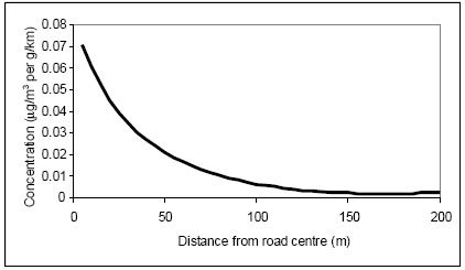
4.32 According to Design Manual for Roads and Bridges Volume LA105 (Air Quality)52, beyond 200m, the contribution of vehicle emissions from the roads to local pollution levels is insignificant. Therefore, this distance has been used throughout this HRAto determine whether Likely Significant Effects (LSEs) on sensitive Habitats sites may arise due to implementation of the Plan.
Figure 3: Schematic representation of the reduction in traffic contribution to concentrations of pollutants at different distances from a road
4.33 Overall, the following Habitats Sites are sensitive to an increase in atmospheric pollution. The average UK car journey is approximately 10.6km53 At a 10km distance between a development site and any road within 200m of a vulnerable Habitat site, the traffic generated from that development is likely to have dispersed across the network such that it is unlikely to contribute to a statistically significant difference in annual average daily traffic. A 10km buffer is therefore utilised within this report to identify sites which may have a potential likely significant impact.
4.34 Being within this 10km buffer does not necessarily mean there will be a likely significant effect, just that they will be assessed within the report to ascertain if they will contribute to a likely significant effect in combination:
• Butser Hill SAC
• Castle Hill SAC
• Chichester and Langstone Harbours SPA and Ramsar site
53 GOV.UK (2019). Average number of trips made and distance travelled. https://www.gov.uk/government/statistical-datasets/nts01-average-number-of-trips-made-and-distance-travelled
• Solent Maritime SAC
• Thames Basin Heaths SPA
• Thursley, Hankley & Frensham Commons SPA
• Thursley, Ash, Pirbright & Chobham SAC
• Wealden Heaths Phase II SPA
• Woolmer Forest SAC
4.35 Singleton and Cocking Tunnels SAC lies within the SDNP but consists of two railway tunnels. It is therefore not considered to be sensitive to atmospheric pollution.
4.36 Traffic and air quality modelling will ultimately be required to inform the Habitats Regulations Assessment work for the Local Plan, which will include consideration of whether the Habitats sites identified above lie within 200m of roads likely to be material journey to work routes for residents of the SDNP. Note that this will be undertaken to inform the Regulation 19 Local Plan and is not included in this Regulation 18 HRA.
Water Quality
4.37 The quality of the water that feeds Habitats Sites is an important determinant of the nature of their habitats and the species they support. Poor water quality can have a range of environmental impacts:
• At high levels, toxic chemicals and metals can result in immediate death of aquatic life, and can have detrimental effects even at lower levels, including increased vulnerability to disease and changes in wildlife behaviour.
• Eutrophication, the enrichment of plant nutrients in water, increases plant growth and consequently results in oxygen depletion. Algal blooms, which commonly result from eutrophication, increase turbidity and decrease light penetration. The decomposition of organic wastes that often accompanies eutrophication deoxygenates water further, augmenting the oxygen depleting effects of eutrophication. In the marine environment, nitrogen is the limiting plant nutrient and so eutrophication is associated with discharges containing available nitrogen.
• Some pesticides, industrial chemicals, and components of sewage effluent are suspected to interfere with the functioning of the endocrine system, possibly having negative effects on the reproduction and development of aquatic life.
4.38 The main risk associated with the SDLP is the discharge of treated sewage effluent from Wastewater Treatment Works (WwTWs) serving the Authority area. This could increase the nutrient concentrations in the water feeding Habitats Sites that are hydrologically linked to waterbodies that receive treated wastewater, such as the Arun Valley SAC/SPA/Ramsar site, the River Itchen SAC or the Solent Habitats Sites. The Rother, the Stor and the Arun are all thought to contribute to the nutrient and sediment loading in the Arun Valley.
4.39 Whilst the main risk associated with the SDLP is the discharge of treated sewage effluent from WwTW serving theAuthority area, a risk relating to direct run off from a proposed site into a watercourse that is linked to a Habitats Site also exists. However, it is an offence to pollute watercourses anyway under
the Environmental Permitting (England and Wales) Regulations 2016, irrespective of whether they are linked to Habitats sites. For the purposes of the Local Plan HRA it is therefore assumed that any development will not be granted planning permission without these standard provisions in place, and as such it is not considered further within this HRA.
Nutrient Neutrality
4.40 Nutrient neutrality has become a requirement in many areas of the country, such as the Solent, Somerset Levels, the Wye catchment in Herefordshire, the Camel catchment in Cornwall, and the Stour catchment in Kent. It ultimately results from the ruling of the European Court of Justice (ECJ) in combined cases C-293/17 and C-294/17 (the Dutch Nitrogen case). That judgment was about nitrogen from atmosphere but in the process of making their ruling the judgment refined the definition of plans and projects to include operations such as agriculture, confirming that agricultural inputs of nutrients (either from atmosphere or runoff) need to be covered in the ‘in combination’ requirements of the HRA process. This is significant because the traditional assessment process as applied for example in the Environment Agency Review of Consents programme distinctly separates treated wastewater from agricultural discharge, largely because the latter is effectively unconsented [diffuse] and outside the remit of the Environment Agency.
4.41 There are published methodologies and calculation tools for nutrient neutrality related to the Solent Habitats sites and River Itchen SAC54 It is these sites will be the focus of the water quality assessment regarding nutrients and treated wastewater. It is noted that the impact pathway in relation to Nutrient Neutrality is time limited. The Levelling Up and Regeneration Act 2023 makes significant amendments to the legal regime applicable to Habitats Sites subject to the nutrient neutrality requirement. LURA received Royal Assent in October 2023 and entered into force on Boxing Day 2023.
4.42 Under LURA’s Part 755 the Water Industry Act 1991 (“WIA”) was amended to require sewerage undertakers to secure specific nitrogen and phosphorus pollution standards by the “upgrade date” of 2030 (for designations made in the initial period). The insertion of new Section 96B into the WIA56 requires both “nitrogen significant plant” and “phosphorus significant plant” to meet a specified nitrogen or phosphorus nutrient pollution standard (as the case may be) by the upgrade date. The duty to achieve this result is enforceable principally by the Secretary of State, but also by the Environment Agency57 , and thusno longer the responsibility of the LocalAuthority such as the SDNPA. However, for sake of completeness it is discussed in this HRA.
Water Flow, Velocity and Volume
4.43 The unique nature of wetlands combines shallow water, high levels of nutrients and high primary productivity. These conditions are ideal for the growth of organisms at the basal level of food webs, which feed many species of birds, mammals, fish and amphibians. Overwintering and migrating wetland bird
54 Nutrient Neutrality - South Downs National Park Authority
55 Levelling Up and Regeneration Act 2023 Levelling-up and Regeneration Act 2023 (legislation.gov.uk) [Accessed 11/10/204]
56 Water Industry Act 1991 Water Industry Act 1991 (legislation.gov.uk) [Accessed 11/10/2024]
57 Habitats Regulations advice for LPAs | Local Government Association
species are particularly reliant on these food sources, as they need to build up enough nutritional reserves to sustain their long migration routes.
4.44 Maintaining a steady water supply is of critical importance for many hydrologically dependent SPAs, SACs and Ramsars. For example, in many wetlands winter flooding is essential for sustaining a variety of foraging habitats for SPA / Ramsar wader and waterbird species. However, different species vary in their requirements for specific water levels. Splash and / or shallow flooding is required to provide suitable feeding areas and roosting sites for ducks and waders. In contrast, deeper flooding is essential to provide foraging habitats for Bewick’s swans and other ducks.
4.45 Wetland habitats (and thus the fauna they support) rely on hydrological connections with other surface waters, such as rivers, streams and lakes. A constant supply of water is fundamental to maintaining the ecological integrity of sites. However, while the natural fluctuation of water levels within narrow limits is desirable, excess or too little water supply might cause the water level to be outside of the required range of qualifying birds, invertebrate or plant species. This might lead to the loss of the structure and functioning of wetland habitats. There are two mechanisms through which urban development might negatively affect the water level in Habitats Sites:
• The supply of new housing with potable water will require increased abstraction of water from surface water and groundwater bodies. Depending on the level of water stress in the geographic region, this may reduce the water levels in Habitats Sites sharing the same catchment.
• The proliferation of impermeable surfaces in urban areas increases the volume and speed of surface water runoff. As traditional drainage systems often cannot cope with the volume of stormwater, sewer overflows are designed to discharge excess water directly into watercourses. Often this pluvial flooding results in downstream inundation of watercourses and the potential flooding of wetland habitats.
4.46 Specifically, the Site Improvement Plan58 for Arun Valley SAC/SPA/Ramsar identify inappropriate water levels as threats to the respective sites. Increases to the quantity and rate of water delivery can result in summer flooding and prolonged / deeper winter flooding. This in turn results in the reduction of feeding and roosting sites for birds and be harmful to the little whirlpool ram’shorn snail, which has very specific water level requirements.
4.47 The emerging Local Plan could result in changes to the water quantity, level and flow in the catchment of the River Arun Habitats sites if it required additional abstraction from such sites or the continuance of existing damaging abstraction. This could alter the water level within the designated sites themselves with potential cascading effects on qualifying species.
4.48 Following consultation with Natural England at the Horsham Draft Local Plan Regulation 18 stage, Natural England expressed concerns regarding the Hardham groundwater abstraction and its effect on Arun Valley SAC/Ramsar following a review of evidence. It should be noted that ultimately it is for Southern Water working with the Environment Agency to ensure that this abstraction does not result in an adverse effect on the integrity of the Arun
Valley. However, until such time that this issue has been resolved at the higher tier level, Natural England has requested that local authorities within the Sussex North Water Resource Zone do their utmost to provide for water neutrality within the Local Plan in order to minimise the burden new development places on local water resources and thus minimise the need for Southern Water to use the Hardham Borehole to its full permitted extent.
Summary
4.49 Table 3 below summarises the potential linking impact pathways. Where existing evidence exists in relation to a specific impact pathway or an internationally designated site, further discussion is undertaken in the subsequent section.
Table 3 Potential Impact Pathways that Could Link the Local Plan to an Internationally Designated Site
Internationally Designated Site
Arun Valley SAC/SPA/Ramsar
Potential Linking Impact Pathways
• Recreational Pressure
• Water Quality
• Water Quantity (Water Neutrality)
• Loss of functionally-linked habitat for waterfowl and waders
Ashdown Forest SAC and SPA
Butser Hill SAC
Castle Hill SAC
Chichester and Langstone Harbours SPA and Ramsar
Duncton to Bignor Escarpment SAC
East Hampshire Hangers SAC
Ebernoe Common SAC
• Recreational Pressure
• Atmospheric Pollution– This site is located circa 13km from the SDNP boundary and is therefore beyond the normal assessment distance for this impact pathway. However, since it was included in the HRA of the adopted South Downs National Park Local Plan it is also considered in this report.
• Recreational Pressure
• Atmospheric Pollution (Nitrogen and Ammonia Deposition)
• Recreational Pressure
• Atmospheric Pollution (Nitrogen and Ammonia Deposition) 59
• Recreational Pressure
• Water Quality (Nutrient Neutrality)
• Water Quantity
• Atmospheric Pollution (Nitrogen and Ammonia Deposition)
• Recreational Pressure
• Atmospheric Pollution (Nitrogen and Ammonia Deposition)
• Recreational Pressure
• Atmospheric Pollution (Nitrogen and Ammonia Deposition) 60
• Recreational Pressure
• Atmospheric Pollution (Nitrogen and Ammonia Deposition)
59 There are no signfiicant roads within 200m of Castle Hill SAC, so although the interest features are vulnerable to atmospheric pollution they are beyond the zone of influence for South Downs Local Plan growth
60 There are no signfiicant roads within 200m of East Hampshire Hangers SAC, so although the interest features are vulnerable to atmospheric pollution they are beyond the zone of influence for South Downs Local Plan growth
Internationally Designated Site
Emer Bog SAC
Kingley Vale SAC
Lewes Downs SAC
The Mens SAC
Pagham Harbour SPA and Ramsar
Portsmouth Harbour SPA and Ramsar site
Potential Linking Impact Pathways
• Loss of functionally linked habitat for bats
• Atmospheric Pollution (Nitrogen and Ammonia Deposition)
• Recreational Pressure
• Atmospheric Pollution (Nitrogen and Ammonia Deposition)
• Recreational Pressure
• Atmospheric Pollution (Nitrogen and Ammonia Deposition)
• Recreational Pressure
• Atmospheric Pollution (Nitrogen and Ammonia Deposition)
• Loss of functionally linked habitat for bats
• Recreational Pressure
• Water Quality
• Water Quantity
• Recreational Pressure
• Water Quality (Nutrient Neutrality)
• Water Quantity
• Atmospheric Pollution (Nitrogen and Ammonia Deposition)
Thames Basin Heaths SPA
Thursley, Hankley & Frensham Commons SPA
Thursley, Ash, Pirbright & Chobham SAC
River Itchen SAC
Rook Clift SAC
Shortheath Common SAC
Singleton and Cocking Tunnels SAC
Solent and Dorset Coast SPA
Solent Maritime SAC
Solent and Southampton Water SPA Ramsar site
• Recreational pressure
• Atmospheric Pollution (Nitrogen and Ammonia Deposition)
• Recreational pressure
• Atmospheric Pollution (Nitrogen and Ammonia Deposition)
• Recreational pressure
• Atmospheric Pollution (Nitrogen and Ammonia Deposition)
• Atmospheric Pollution (Nitrogen and Ammonia Deposition)
• Water Quality (Nutrient Neutrality)
• Water Quantity
• Recreational Pressure61
• Recreational Pressure
• Atmospheric Pollution (Nitrogen and Ammonia Deposition) 62
• Recreational Pressure
• Loss of functionally linked habitat for bats
• Atmospheric Pollution (Nitrogen and Ammonia Deposition)
• Water Quality (Nutrient Neutrality)
• Water Quantity
• Water Quality (Nutrient Neutrality)
• Water Quantity
• Atmospheric Pollution (Nitrogen and Ammonia Deposition)
• Atmospheric Pollution (Nitrogen and Ammonia Deposition)
– However this site is located circa 13km from the SDNP boundary and as such it is not a realistic linking impact pathway and not discussed further
61 There are no significant roads within 200m of Rook Clift SAC, so although the interest features are vulnerable to atmospheric pollution they are beyond the zone of influence for South Downs Local Plan growth
62 There are no significant roads within 200m of Shortheath Common SAC, so although the interest features are vulnerable to atmospheric pollution they are beyond the zone of influence for South Downs Local Plan growth
Internationally Designated Site
Wealden Heaths Phase II SPA
Potential Linking Impact Pathways
• Recreational Pressure
• Atmospheric Pollution (Nitrogen and Ammonia Deposition)
• Urbanisation
Woolmer Forest SAC
• Recreational Pressure
• Atmospheric Pollution (Nitrogen and Ammonia Deposition)
4.50 While the Habitats sites identified above are vulnerable to other impacts, those identified in the table are most likely to be associated with potential changes in South Downs National Park.
5. Test of Likely Significant Effects
The Local Plan
5.1 The Likely Significant Effects test of Local Plan policies and potential site allocations is undertaken in full in Appendix A. Table 8-3 undertakes the Test of Likely Significant Effects for the Local Plan polices. The site allocations in this Local Plan review will consist of (a) allocations from the adopted Local Plan that have yet to be built out and are proposed to be carried forward and (b) new site allocations. Table 8-4 undertakes the Test of Likely Significant Effects for those existing Local Plan allocations which are to be carried forward to the new Local Plan, whilst Table 8-5 undertakes the Test of Likely Significant Effects for the entirely new potential Local Plan allocations.
Local Plan Policies
5.2 Table 8-3 identifies the following Local Plan policies that could potentially link to a Habitats Sites:
• SD23 Tourism – potentially allows for an increase in tourism provision
• SD25 Development Strategy – when completed this policy will indicate where in the Local Plan area development is appropriate
• SD31 Extensions/Householder Development – this could enable an increase in the occupancy of particular dwellings
• SD32 Rural Worker Dwellings – this would result in a small increase in the number of dwellings
• SD34 Sustaining the Local Economy – this policy could result in an increase in tourism and economic development
• SD26: Supply of Homes - provides a quantum of residential development during the plan period
• SD33: Gypsies and Travellers – provides a quantum of Gypsie, Traveller and Travelling Showpeople pitches during the plan period.
• SD35: Employment Land – provides for a quantum of office and industrial development during the plan period.
5.3 Potential linking impact pathways related to these policies are as follows:
• Recreational pressure
• Urbanisation
• Loss of Functionally Linked Land
• Air quality
• Water flow, velocity and volume
• Water quality
Local Plan Allocations
5.4 The following potential new SDLP site allocations provide for potential linking impact pathways to Habitats sites.
Recreational Pressure
• Land south of Lovell Gardens at Binsted for 12 dwellings (Shortheath Common SAC/ Wealden Heaths Phase 2 SPA/Woolmer Forest SAC)
• Land west of Liphook / Land at Westlands Park for 300 dwellings and 14 traveller pitches (Wealden Heaths Phase 2 SPA/Woolmer Forest SAC)
• Land at Westlands, Liphook for 8 dwellings (Wealden Heaths Phase 2 SPA/Woolmer Forest SAC)
• Land at Farnham & Station Roads for 30 dwellings and/or a 60 bed care home (Wealden Heaths Phase 2 SPA/Woolmer Forest SAC)
Urbanisation
• Land west of Liphook / Land at Westlands Park (slight overlap with 400m zone around Wealden Heaths Phase II SPA)
Loss of Functionally Linked Land
• Land East of Coombe Crescent (within 5km of Arun Valley SPA and Ramsar site)
• Land Adjacent (north of) Hollow Croft and Quince Cottage (east) (within 5km of Arun Valley SPA and Ramsar site)
• East Street Farm (within 5km of Arun Valley SPA and Ramsar site)
• Land north of Northend Close – Petworth (The Mens SAC and Ebernoe Common SAC)
• Land west of Station Road – Petworth (The Mens SAC and Ebernoe Common SAC)
• Playing Fields Associated with Former Primary School – Easebourne (Singleton and Cocking Tunnels SAC,The Mens SAC, and Ebernoe Common SAC)
• Land West of The Street – Lodsworth (The Mens SAC and Ebernoe Common SAC)
• Land west of Valentines Lea – Northchapel (The Mens SAC and Ebernoe Common SAC)
• Land Adjacent (north of) Hollow Croft and Quince Cottage (east) – Bury (The Mens SAC)
• Land East of Coombe Crescent – Bury (The Mens SAC)
• East Street Farm – Amberley (The Mens SAC)
• Land at Hawksfold – Fernhurst (Ebernoe Common SAC, and Singleton and Cocking Tunnels SAC)
• Land east of Pitsham Lane – Midhurst (Ebernoe Common SAC, and Singleton and Cocking Tunnels SAC)
• Former Bus Depot, Pitsham Lane – Midhurst (Ebernoe Common SAC, and Singleton and Cocking Tunnels SAC)
• Land at Forest and Hawthorn Close – Midhurst (Ebernoe Common SAC, and Singleton and Cocking Tunnels SAC)
• Land adj The Grange Car Park – Midhurst (Ebernoe Common SAC, and Singleton and Cocking Tunnels SAC)
• Land west of Budgenor Lodge – Easebourne (Ebernoe Common SAC, and Singleton and Cocking Tunnels SAC)
• South of Hollist Lane – Easebourne (Ebernoe Common SAC, and Singleton and Cocking Tunnels SAC)
• Midhurst Community Hospital and 1-2 Rotherfield Mews – Easebourne (Ebernoe Common SAC, and Singleton and Cocking Tunnels SAC)
• Land east of A286 and north of Mill Lane – Cocking (Singleton and Cocking Tunnels SAC)
• Manor Farm – Singleton (Singleton and Cocking Tunnels SAC)
• Land west of Village Hall – Sheet (Singleton and Cocking Tunnels SAC)
• Land north of Northend Close – Petworth (Singleton and Cocking Tunnels SAC)
• Land west of Station Road – Petworth (Singleton and Cocking Tunnels SAC)
• Land West of The Street – Lodsworth (Singleton and Cocking Tunnels SAC)
Water Quality
• Land at Old Green Farm (River Itchen SAC and Solent Habitat Sites –Solent and Southampton Water SPA and Ramsar)
• Land north of Hewlett Close (River Itchen SAC Solent Habitat Sites – Solent and Southampton Water SPA and Ramsar)
• Land at Whites Hill Farm (River Itchen SAC Solent Habitat Sites – Solent and Southampton Water SPA and Ramsar)
• Land north of Dodds Lane (Solent Habitat Sites – Solent and Southampton Water SPA and Ramsar)
• Manor Farm (Solent Habitat Sites – Solent Marime SAC and Chichester and Langstone Harbours SPA and Ramsar sites)
Water Flow, Velocity and Volume
• Land West of Village Hall, Sheet (Arun Valley SAC/SPA/Ramsar)
• Land at Hawksfold, Fernhurst (Arun Valley SAC/SPA/Ramsar)
• Land West of Budgenor Lodge, Easbourne (Arun Valley SAC/SPA/Ramsar)
• Playing Fields Associated with Former Primary School, Easebourne (Arun Valley SAC/SPA/Ramsar)
• Midhurst Community Hospital and 1-2 Rotherfield Mews, Easebourne (Arun Valley SAC/SPA/Ramsar)
• South of Hollist Lane, Easebourne (Arun Valley SAC/SPA/Ramsar)
• Land West of Village Hall Rogate (Arun Valley SAC/SPA/Ramsar)
• Land adjacent The Grange Car Park, Midhurst (Arun Valley SAC/SPA/Ramsar)
• Land at Forest and Hawthorn Close, Midhurst (Arun Valley SAC/SPA/Ramsar)
• Former Bus Depot, Pitsham Lane, Midhurst (Arun Valley SAC/SPA/Ramsar)
• Land east of Pitsham Lane, Midhurst (Arun Valley SAC/SPA/Ramsar)
• Land east of A286 and north of Mill Lane, Cocking (Arun Valley SAC/SPA/Ramsar)
• Manor Farm, Singleton (Arun Valley SAC/SPA/Ramsar)
• Land West of The Street, Lodsworth (Arun Valley SAC/SPA/Ramsar)
• Land north of Northend Close, Petworth (Arun Valley SAC/SPA/Ramsar)
• Land to the rear of Rothermead, Petworth (Arun Valley SAC/SPA/Ramsar)
• Land west of Station Road, Petworth (Arun Valley SAC/SPA/Ramsar)
• Land west of Valentines Lea, Northchapel (Arun Valley SAC/SPA/Ramsar)
• Land Adjacent (north of) Hollow Croft and Quince Cottage (east), Bury (Arun Valley SAC/SPA/Ramsar)
• Land East of Coombe Crescent, Bury (Arun Valley SAC/SPA/Ramsar)
• East Street Farm, Amberley (Arun Valley SAC/SPA/Ramsar)
Habitats Sites and Threats and Vulnerabilities Discussed
5.5 Table 5-1 outlines which Habitats Sites are sensitive to which potentially linking impact pathways that could link to the Local Plan, and as such are discussed within this chapter.
Table 5-1 Habitat Site Potential Threats and Vulnerabilities that Could Link to the Local Plan.
Habitat Site Potential Linking Impact Pathways
Arun Valley SAC/SPA/Ramsar
• Recreational Pressure
• Water Quality
• Water Quantity (Water Neutrality)
• Loss of functionally-linked habitat for waterfowl and waders
Ashdown Forest SAC and SPA
Butser Hill SAC
Castle Hill SAC
Chichester and Langstone Harbours SPA and Ramsar
Duncton to Bignor Escarpment SAC
East Hampshire Hangers SAC
Ebernoe Common SAC
Kingley Vale SAC
Lewes Downs SAC
• Recreational Pressure
• Atmospheric Pollution (Nitrogen and Ammonia Deposition)
• Recreational Pressure
• Atmospheric Pollution (Nitrogen and Ammonia Deposition)
• Recreational Pressure63
• Recreational Pressure
• Water Quality (Nutrient Neutrality)
• Water Quantity
• Recreational Pressure
• Atmospheric Pollution (Nitrogen and Ammonia Deposition)
• Recreational Pressure64
• Recreational Pressure
• Atmospheric Pollution (Nitrogen and Ammonia Deposition)
• Loss of functionally linked habitat for bats
• Recreational Pressure
• Atmospheric Pollution (Nitrogen and Ammonia Deposition)
• Recreational Pressure
63 There are no signfiicant roads within 200m of Castle Hill SAC, so although the interest features are vulnerable to atmospheric pollution they are beyond the zone of influence for South Downs Local Plan growth
64 There are no significant roads within 200m of East Hampshire Hangers SAC, so although the interest features are vulnerable to atmospheric pollution they are beyond the zone of influence for South Downs Local Plan growth
Habitat Site
The Mens SAC
Pagham Harbour SPA and Ramsar
Thames Basin Heaths SPA
Thursley, Hankley & Frensham Commons SPA
Thursley, Ash, Pirbright & Chobham SAC
River Itchen SAC
Potential Linking Impact Pathways
• Atmospheric Pollution (Nitrogen and Ammonia Deposition)
• Recreational Pressure
• Atmospheric Pollution (Nitrogen and Ammonia Deposition)
• Loss of functionally linked habitat for bats
• Recreational Pressure
• Water Quality
• Water Quantity
• Recreational pressure
• Atmospheric Pollution (Nitrogen and Ammonia Deposition)
• Recreational pressure
• Atmospheric Pollution (Nitrogen and Ammonia Deposition)
• Recreational pressure
• Atmospheric Pollution (Nitrogen and Ammonia Deposition)
• Atmospheric Pollution (Nitrogen and Ammonia Deposition)
• Water Quality (Nutrient Neutrality)
• Water Quantity
Rook Clift SAC
Shortheath Common SAC
Singleton and Cocking Tunnels SAC
Solent and Dorset Coast SPA
Solent Maritime SAC
Wealden Heaths Phase II SPA
Woolmer Forest SAC
Recreational Pressure
• Recreational Pressure65
• Recreational Pressure66
• Recreational Pressure
• Loss of functionally linked habitat for bats
• Water Quality (Nutrient Neutrality)
• Water Quantity
• Water Quality (Nutrient Neutrality)
• Water Quantity
• Atmospheric Pollution (Nitrogen and Ammonia Deposition)
• Recreational Pressure
• Atmospheric Pollution (Nitrogen and Ammonia Deposition)
• Urbanisation
• Recreational Pressure
• Atmospheric Pollution (Nitrogen and Ammonia Deposition)
5.6 Habitat Sites that could be potentially impacted upon by recreational pressure as a result of the Local Plan are:
• Arun Valley SAC/ SPA/ Ramsar site
• Ashdown Forest SAC and SPA
• Butser Hill SAC
65 There are no significant roads within 200m of Rook Clift SAC, so although the interest features are vulnerable to atmospheric pollution they are beyond the zone of influence for South Downs Local Plan growth
66 There are no significant roads within 200m of Shortheath Common SAC, so although the interest features are vulnerable to atmospheric pollution they are beyond the zone of influence for South Downs Local Plan growth
• Castle Hill SAC
• Chichester and Langstone Harbours SPA and Ramsar site
• Duncton to Bignor Escarpment SAC
• East Hampshire Hangers SAC
• Ebernoe Common SAC
• Kingley Vale SAC
• Lewes Downs SAC
• The Mens SAC
• Pagham Harbour SPA and Ramsar site
• Rook Clift SAC
• Shortheath Common SAC
• Thames Basin Heaths SPA
• Thursley, Hankley & Frensham Commons SPA
• Thursley, Ash, Pirbright and Chobham SAC
• Wealden Heaths Phase II SPA
• Woolmer Forest SAC
5.7 The following paragraphs discuss recreational pressure in relation to each identified Habitats Site. It discusses if the Local Plan provides a valid linking impact pathway to recreational pressure at that Habitats Site. It discusses there is realistically potential for likely significant effect (and AA is required) or not (i.e. there would be no likely significant effect), and the impact recreational pressure in relation to the specific Habitats Site can be screened out from further consideration.
Arun Valley SAC/ SPA/ Ramsar site
5.8 There is the potential for a likely significant adverse effects on the integrity of this SPA/Ramsar site via disturbance of wintering waterfowl. The potential for disturbance may be less in winter than in summer, in that there are often a smaller number of recreational users, whereas the winter is the peak period for wildfowl use of the site. In addition, the consequences of disturbance at a population level may be reduced because birds are not breeding. However, winter activity can still cause important disturbance, especially as birds are particularly vulnerable at this time of year due to food shortages, such that disturbance which results in abandonment of suitable feeding areas can have severe consequences.
5.9 The Local Plan allocates three sites within 5km of the SPA/SAC/Ramsar site: East Street Farm atAmberley for 45 dwellings, Land East of Coombe Crescent at Bury for 15 dwellings, and LandAdjacent (north of) Hollow Croft and Quince Cottage (east) at Bury for 5 dwellings. This is a total of 65 dwellings within 5km. The nearest site is East Street Farm which is 110m from Amberley Wild Brooks. However, it is separated from the SPA/SAC/Ramsar site by existing residential and other development.
5.10 The component parts of the SPA/Ramsar site are Pulborough Brooks SSSI, Waltham Brooks SSSI and Amberley Wild Brooks SSSI. Although disturbance is therefore a theoretical potential pathway for this SPA/Ramsar site, it is not
noted as a concern or priority for action in Natural England’s Site Improvement Plan67. This is presumably because two of the most potentially sensitive parts of the SPA (Amberley Wild Brooks SSSI and Pulborough Brooks SSSI) are managed by the RSPB. Unlike many other RSPB reserves, recreational visitors are not encouraged to Amberley Wild Brooks SSSI because of the sensitivity of the site, and the site is not designed or promoted to attract visitors. Access within the site is severely restricted specifically in order to ensure that disturbance is not possible. Access is therefore restricted to the Wey South Path.
5.11 Pulborough Brooks SSSI is open to the public under normal circumstances but access is well-managed with a network of hides and prohibitions on dogs in the most sensitive areas. Whilst a single Public Right of Way passes through the site from the village of Pulborough (in the north) to Wiggonholt and the RSPB visitor centre (in the south), the site is located approximately 0.6km from the village itself. Additionally, parking provision and access to the site is not advertised from the village of Pulborough. It is likely that the majority of visitors will access the site from the RSPB car park visitor centre as access is publicly advertised and managed from this location.
5.12 With the exception of RSPB members, a per visit charge is in place (albeit there is no charge for accessing along the public right of way) and the limited parking provision will also limit the number of casual walkers. Moreover, there are ample areas of alternative attractive natural greenspace already available to residents of Storrington and West Chiltington: Rackham Hill (located within the South Downs National Park) is the closest landmark, Parham Park SSSI lies between Storrington and Amberley Wild Brooks SSSI, while Hurston Warren SSSI lies between West Chiltington and the same SSSI.
5.13 Consultation comments from both the Coldwaltham Meadows Conservation Trust and the Sussex Wildlife Trust to the previous South Downs Local Plan HRA did identify concerns regarding recreational pressure on the Waltham Brooks SSSI component of the SAC, SPA and Ramsar site. The primary risk here would be an increase in visitor pressure (particularly involving dog walkers) disturbing grazing livestock which are used to manage the Waltham Brooks SSSI, the condition of which is ‘Recovering’. However, this part of the SPA is a minimum of 2.2km from the closest potential allocation in the Local Plan and the nearest allocation in Horsham is over 2km away. The HRA for the Horsham Local Plan scoped out recreational pressure as an impact pathway.
5.14 The principal other plans and projects of relevance to development around the Arun Valley SAC/SPA/Ramsar site are the Local Plans for HorshamLocal Plan and to a lesser extent Arun and Adur districts. The HRA of the Horsham Local Plan considered recreational pressure from these local authorities collectively (including SDNP). Both Adur and Arun have begun preparation of their new Local Plans which provide for an increase in dwelling provided during their Plan periods (Adur are currently providing for 3,609 new dwellings during its Plan period, whilstArun are providing for approximately 16,700 new dwellings during its emerging Plan period). However, the HRAs for the Arun, Horsham and Adur Local Plans all considered that there would be no likely significant
effects on Arun Valley SAC, SPA and Ramsar site ‘in combination’ with each other and growth in Horsham.
5.15 It is therefore considered that a conclusion of no likely significant effect can be drawn regarding this impact pathway.
Ashdown Forest SAC and SPA
5.16 Ashdown Forest is well known to be sensitive to recreational pressure and due to the close proximity of relatively substantial settlements existing recreational pressure is considered a concern. As such a mitigation strategy has been developed by the surrounding local planning authorities including South Downs National Park Authority. However, as already identified the core recreational catchment for the SAC/SPAis 7km and the SDNPlies well beyond 7km from the SAC/SPA. Therefore, no likely significant effects will arise.
Butser Hill SAC
5.17 Part of Butser Hill SAC lies within the Queen Elizabeth Country Park and is managed by Hampshire County Council. Butser Hill does have footpaths and public rights of way crossing it and has been subject to organised recreational events numerous times in the past (such as ‘Butserfest’ and various country fairs). This implies that while calcareous grassland can be damaged by repeated excessive recreational trampling over long periods of time, the grasslands of Butser Hill SAC are not considered to be particularly vulnerable to well-managed recreational pressure and activity, even when relatively large events are held. This was the conclusion of the HRA of the Chichester Local Plan HRA, with which Natural England concurred.
5.18 Likely Significant Effects can therefore be dismissed alone and in combination with other plans or projects.
Castle Hill SAC
5.19 Castle Hill SAC is not noted to be vulnerable to increase in recreational pressure. The Brighton & Hove City Plan HRA confirmed that recreational pressure on this site was not a particular concern and that ‘Castle Hill is managed as a National Nature Reserve and therefore increased recreation, if it did become an issue, could be managed accordingly’. This is reflected in the Natural England Site Improvement Plan68 which does not identify recreational pressure as being a concern or an issue targeted for further action. The main concerns noted on this site are not development related but are management issues: under-grazing and use of fertilisers. According to the Supplementary Advice on the Conservation Objectives69 for this SAC an issue with this site is excessive vegetation growth (or coarse grasses) suggesting trampling is not a concern.
5.20 Likely Significant Effects can therefore be dismissed alone and in combination with other plans or projects.
Singleton and Cocking Tunnels SAC
5.21 Singleton and Cocking Tunnels are not generally open to the public, being gated. However, policy SD20: Walking, Cycling and Equestrian Routes includes the development of the Chichester –Midhurst disused railway line as a proposal. This proposal has theoretical potential to impact adversely upon
the barbastelle and Bechstein bat features of Singleton & Cocking Tunnels SAC. The inclusion of the tunnels in the route could affect its use by the bats that hibernate there and therefore could lead to an adverse effect. Likely Significant Effects are therefore not dismissed and this policy is taken forward to AA.
Chichester and Langstone Harbours SPA and Ramsar site/Solent Maritime SAC
5.22 Chichester and Langstone Harbours SPA/Ramsar is known, like all the Solent Habitats sites to be sensitive to recreational pressure, particularly regarding disturbance of SPA birds. A core recreational catchment of 5.6km has been identified. The SDLP makes no potential allocations within that zone but there are several settlements within the National Park that could receive windfall development within that zone. While policies that promote tourism have the potential to have a likely significant effect upon the SPA/Ramsar site Policy SD23 specifically promotes sustainable tourism which by definition would not support tourism development that harmed Habitats sites. This specific policy is therefore screened out of AA.
5.23 Recreational pressure is screened into AA given the potential for windfall within 5.6km of the SPA/Ramsar site
Duncton to Bignor Escarpment SAC
5.24 The Views About Management document for Duncton to Bignor Escarpment SSSI70 identifies that ‘Access to this site, and any recreational activities within, may also need to be managed.’ The Site Improvement Plan71 for Duncton to Bignor Escarpment SAC does not identify any specific current requirement for access management improvements. The SAC is located in a rural area in isolation from any large settlement. The Supplementary Advice on the Conservation Objectives72 identifies that ‘activities such as construction, forestry management and trampling by grazing livestock and human feet during recreational activity may all contribute to excessive soil compaction around ancient trees’. However, this is clearly a general observation rather than any indication the site is subject to unsustainable recreational pressure.
5.25 The Local Plan allocates three sites within 5km of the SAC: East Street Farm at Amberley for 45 dwellings, Land East of Coombe Crescent at Bury for 15 dwellings, and Land Adjacent (north of) Hollow Croft and Quince Cottage (east) at Bury for 5 dwellings. This is a total of 65 dwellings within 5km. The nearest site is LandAdjacent (north of) Hollow Croft and Quince Cottage (east) for 5 dwellings, which is 1.8km away. There are no potential allocations within 5km of the SAC in any other Local Plans.
5.26 Given the low population density around the SAC and the large amounts of alternative locations available for recreationalactivity, it can be considered that the new housing identified within the SDLPwill not result in likely significant effects upon the integrity of the SAC alone or in combination with other plans and projects. This is consistent with the conclusions of the Horsham and Chichester Local Plan HRAs.
70 Views About Management
71 Site Improvement Plan: Duncton to Bignor Escarpment - SIP067
72 UK0030138_Duncton to Bignor Escarpment_SAC_Published 10 Jul 2024
East Hampshire Hangers SAC
5.27 The East Hampshire Hangers SAC is a composite site comprising woodlands that are distributed along a north-south axis throughout the district. All qualifying features of the SAC (semi-natural dry grasslands on calcareous substrates, beech forests, mixed woodland and yew woodland) are potentially sensitive to recreational impacts such as trampling damage, which is particularly concerning where orchid assemblages or ancient / veteran trees are present. While Natural England’s SIP does not specify public access as a threat or pressure to the site, the Supplementary Advice on Conservation Objectives (SACO)73 refer to a target of maintaining the soil structure around mature and ancient trees in an un-compacted condition. In compacted soils, which may result to varying extents from different recreational activities, there is little space for air and water, both of which are essential substances for root and tree growth.
5.28 A core catchment zone of the SAC of approx. 5km (based on data from other terrestrial and woodland Habitats sites) is considered reasonable; however, given that there are few formal car parks that serve as official access points to the SAC, it is very likely that residents walking to the site from nearby housing represent the typical profile of a recreationist within the SAC. Therefore, any residential allocation within a typical walking distance of between 1-2km is likely to increase the recreational footfall within the site. The nearest potential Local Plan allocation is Windward, Reservoir Lane for 5 dwellings, 1.9km from the SAC. However, this is separated from the SAC by the A3 such that it is very unlikely residents would walk to the SAC.
5.29 Natural England’s SSSI condition assessment identify most SSSI components of the SAC are ‘favourable’ and, where this is not the case, recreational pressure is not identified as an underlying cause. Moreover, it is noted that the SAC is permeated by an extensive network of Public Right of Ways (PRoWs). Generally, some recreational impacts are ‘naturally’ managed through existing access networks in nature conservation sites. For example, unless paths show significant erosion and expose underlying roots, impacts of any recreational activity that is kept on-track will be somewhat buffered. An additional buffer against off-track activities is imposed by the steep slopes and challenging overall topography of the site, which is likely to encourage visitors to stick to the formal path network.
5.30 As such it is considered that there would be no likely significant effect alone or in combination with other plans and projects.
Ebernoe Common SAC
5.31 Ebernoe Common is designated for its woodland and for its population of barbastelle and Bechstein bats. The SAC is relatively remote from significant sized settlements with the nearest being Petworth 3.5km to the south.As such the SupplementaryAdvice on the Conservation Objectives74 for the SAC does not identify recreational pressure as a concern. There are four potential Local Plan allocations within 5km of the SAC, the nearest being 2km away: Land west of Valentines Lea at Northchapel for 25 dwellings, Land north of Northend Close at Petworth for 18 dwellings, Land West of The Street at Lodsworth for
10 dwellings and Land west of Station Road at Petworth for 8 dwellings. This is a total of 61 dwellings within 5km, the nearest of which is 2km away.
5.32 Lighting from human sources is a potential issue that at least requires further investigation. A study was undertaken during 2015-16 to clarify existing light levels and whether these are likely to be affecting the bat populations. There are no specific proposals in the Local Plan that would result in increased lighting of these sites and any proposals that did come forward would be captured by the HRA requirement of Policy SD10: The Sussex Bat Special Areas of Conservation (SAC): The Mens SAC, Ebernoe Common SAC and Singleton & Cocking Tunnels SAC
5.33 As such it is considered that there would be no likely significant effect alone or in combination with other plans and projects. This matches the conclusions of the HRA for Chichester Local Plan and Horsham Local Plan.
Kingley Vale SAC
5.34 The Kingley Vale SAC is designated for Taxus baccata woods and seminatural dry grasslands / scrubland facies with potential sensitivity to recreational impacts, such as trampling damage and nutrient enrichment. It is situated in a rural area. The SAC is permeated by an extensive network of PRoWs, criss-crossing woodland and more open parcels within the site boundary. There is one formal car park providing access to the SAC at Lambdown Hill, but most visitors are likely to originate from the few smaller settlements and villages surrounding the site. The fact that the site lies in an undeveloped part of Chichester District and does not support the infrastructure to draw visitors from further afield, may indicate that overall visitor numbers are relatively low. Recreational pressure is not specified as a concern in the SIP75 or SACO76 for the SAC.
5.35 The nearest potential allocation in the South Downs Local Plan is over 4km from the SAC and is for 8 dwellings It is therefore concluded that the potential emerging Reg.18 Local Plan residential site allocations will not result in LSEs on the Kingley Vale SAC regarding recreational pressure. This site is screened out from AA in relation to this impact pathway.
Lewes Downs SAC
5.36 As with Castle Hill SAC, the Lewes District Core Strategy HRA report concluded that impacts upon Lewes Downs SAC as a result of increased recreational pressure resulting from new residential development could be screened out as the SAC is not vulnerable to recreational pressures. This issue was not queried at Examination. As such, this impact pathway can be screened out. The Site Improvement Plan77 and Supplementary Advice on Conservation Objectives78 for the SAC does not identify development-related increases in general recreational activity as a concern, but rather targets some instances of antisocial behaviour and identifies a commitment to ‘Introduce measures to discourage public gatherings on sensitive grassland areas’. The steep topography of much of the SAC is likely to naturally limit the scale and extent of recreational activity over much of the site.
75 Available at: http://publications.naturalengland.org.uk/publication/6393220716036096 [Accessed on the 20/10/2022]
76 Available at: http://publications.naturalengland.org.uk/publication/5727834794360832 [Accessed on the 20/10/2022]
5.37 Likely Significant Effects can therefore be dismissed alone and in combination with other plans or projects.
The Mens SAC
5.38 The Mens is designated for its woodland and for its population of barbastelle and Bechstein bats. The SAC is relatively remote from significant sized settlements with the nearest being Petworth Petworth 3km away, with Pulborough and Billingshurst being approximately 4km from the SAC.As such the SupplementaryAdvice on the Conservation Objectives79 for the SAC does not identify recreational pressure as a concern. There are two potential Local Plan allocations within 5km of the SAC, the nearest being 3.2km away: Land north of Northend Close at Petworth for 18 dwellings, and Land west of Station Road at Petworth for 8 dwellings. This is a total of 26 dwellings within 5km, the nearest of which is over 3km away.
5.39 Lighting from human sources is a potential issue that at least requires further investigation. A study was undertaken during 2015-16 to clarify existing light levels and whether these are likely to be affecting the bat populations. There are no specific proposals in the Local Plan that would result in increased lighting of these sites and any proposals that did come forward would be captured by the HRA requirement of Policy SD10: The Sussex Bat Special Areas of Conservation (SAC): The Mens SAC, Ebernoe Common SAC and Singleton & Cocking Tunnels SAC
5.40 As such it is considered that there would be no likely significant effect alone or in combination with other plans and projects. This matches the conclusions of the HRA for Chichester Local Plan and Horsham Local Plan.
Pagham Harbour SPA and Ramsar site
5.41 Pagham Harbour SPA/Ramsar is known to be sensitive to recreational pressure, particularly regarding disturbance of SPA birds. A core recreational catchment of 3.5km has been identified in work by Chichester District Council The SDLP does not allocate any dwellings within the 3.5km zone with the nearest being much more distant. The entire National Park lies more than 3.5km from this SPA/Ramsar site. Therefore, it is considered that there would be no likely significant effect alone or in combination with other plans and projects.
Rook Clift SAC
5.42 Rook Clift SAC is isolated from any large settlements. The nearest potential Local Plan allocation is over 5km from the SAC. The Local Plan will therefore not result in a material change in recreational activity at the site. The Site Natural England Improvement Plan and Supplementary Advice on Conservation Objectives80 for Rook Clift SAC does not identify recreational pressure as a site vulnerability.
5.43 No likely significant effects would result from increased recreational pressure as a result of the SDLP alone or in combination with other plans or projects.
Shortheath Common SAC
5.44 Visitor survey work undertaken for the East Hampshire Local Plan has identified that this SAC is susceptible to recreational pressure and has identified a core catchment of 5km. The SDLP allocates 1 site within 5km of the SAC: Land south of Lovell Gardens at Binsted for 12 dwellings. In itself this would not pose a likely significant effect, but it must be considered in combination with a currently unconfirmed number of dwellings to be allocated in the East Hampshire Local Plan.
5.45 Shortheath Common SAC is therefore screened in for AA.
Thames Basin Heaths SPA
5.46 Visitor survey work undertaken over many years has identified that this SPA is susceptible to recreational pressure and has identified a core catchment of 5km. The SDLP does not allocate any sites within this zone and there are no settlements within this zone within the South Downs National Park Likely Significant Effects can therefore be screened out, alone and in combination with other plans and projects.
5.47 Visitor survey work undertaken for the East Hampshire Local Plan has identified that this SPA is susceptible to recreational pressure and has identified a core catchment of 5km. The SDLP does not allocate any sites within this zone and there are no settlements within this zone within the South Downs National Park. Likely Significant Effects can therefore be screened out, alone and in combination with other plans and projects.
Wealden Heaths Phase II SPA/Woolmer Forest SAC
5.48 Visitor survey work undertaken for the East Hampshire Local Plan has identified that this SPA is susceptible to recreational pressure and has identified a core catchment of 5km. The SDLP allocates 4 sites within 5km of the SPA: Land west of Liphook / Land at Westlands Park for 300 dwellings and 14 traveller pitches, Land at Westlands, Liphook for 8 dwellings, Land south of Lovell Gardens, Binstedfor 12 dwellings, and Land at Farnham & Station Roads for 30 dwellings and/or a 60 bed care home. Moreover, this must be considered in combination with a currently unconfirmed number of dwellings to be allocated in the East Hampshire Local Plan.
5.49 Wealden Heaths Phase II SPA/Woolmer Forest SAC is therefore screened in for AA.
Summary
5.50 In summary the following Habitats sites will be taken forward to AA:
• Chichester & Langstone Harbours SPA/Ramsar and Solent Maritime SAC
• Wealden Heaths Phase 2 SPA/Woolmer Forest SAC/Shortheath Common SAC
Urbanisation
5.51 Habitat Sites that could be potentially impacted upon by urbanisation as a result of the Local Plan are:
• Wealden Heaths Phase II SPA
5.52 This SPA is located within the Local Plan area. There now is extensive evidence that heathland sites are sensitive to a wide range of urbanisation impacts, including cat predation, fly-tipping and arson. The SSSI parcels of the Wealden Heaths Phase II SPA, distributed in the north-west of the South Downs National Park Authority Area amidst high housing densities in Bordon, Whitehill, Headley and Lindford. Therefore, it is evident that these Habitats Sites are already subject to urbanisation impacts that cannot be fully mitigated.
5.53 If no constraints were placed on housing developments (i.e. no policy mechanism is in place) and assuming that future growth would follow historic development patterns, it is reasonable to anticipate that a significant portion of new housing would be delivered in close proximity to the heathland complex. This would exacerbate any existing urbanisation impacts with the potential to significantly impact designated heathland and ground-nesting birds. Therefore, LSEs of Reg.18 SDLP on the Wealden Heaths Phase II SPA, regarding urbanisation effects cannot be excluded.
5.54 The nearest potential site allocation to the SPAis Land west of Liphook / Land at Westlands Park, allocated for mixed use, including 300 dwellings, four permanent Gypsy and Traveller pitches and SANG. At its closest it is located 366m from the SPA. It is noted that the majority of this potential allocation is located more than 400m from the SPA. No other potential site allocations are located within 400m of the SPA. This impact pathway is screened in for AA.
Summary
5.55 The only potential allocation within this zone in the SDLP is located 366m from the SPA, and as such this impact pathway is screened in for AA.
Loss of Functionally Linked Land
5.56 Habitat Sites that could be potentially impacted upon by Loss of Functionally Linked Land (FLL) as a result of the Local Plan are:
• Arun Valley SPA and Ramsar site for waterfowl and waders
• Ebernoe Common SAC, The Mens SAC, and Singleton and Cocking Tunnels SAC, collectively known as the “Sussex Bat SAC sites”.
5.57 The following paragraphs discuss loss of functionally-linked land in relation to each identified Habitats Site. It discusses if the Local Plan provides a valid linking impact pathway to Loss of FLLat that Habitats Site. It discusses if there is realistically potential for likely significant effect (and AA is required) or not (i.e. there would be no likely significant effect), and the impact Loss of FLL in relation to the specific Habitats Site can be screened out from further consideration.
Arun Valley SPA and Ramsar site
5.58 The component parts of the SPA/Ramsar site are Pulborough Brooks SSSI, Waltham Brooks SSSI andAmberley Wild Brooks SSSI. All of these are within the South Downs National Park.
5.59 As detailed in paragraph 4.22, it is widely accepted that Bewick’s swans frequently feed on suitable farmland up to 5km from the designated site, and as such, suitable fields within 5km of the SPA could constitute important
supporting habitat if they support a large enough percentage of the SPA population on a regular basis. In addition, Natural England have identified that much of the functionally linked land associated with the Arun Valey is located within a designated Important BirdArea (which includes Ramsar sites and SPA sites). For the Horsham Local Plan a zone of 6.5km was used rather than 5km.
5.60 LP Core Policy SD26: Supply of Homes, provides for dwellings to be delivered via windfall development, which by definition could result in an application for development being submitted anywhere within the SDNP boundary.
5.61 The following potential LP sites allocations are located within 5km of the Arun Valley SPA and Ramsar site:
• Land East of Coombe Crescent
• Land Adjacent (north of) Hollow Croft and Quince Cottage (east)
• East Street Farm
5.62 If one increases the zone of influence to 6.5km it doesn’tadd any new potential allocations in the South Downs National Park.
5.63 From review of freely available aerial mapping, all three of the above identified potential site allocations are located within greenfield sites. They are, however, located outside of the identified Important Bird Area and located within or adjacent to the urban area associated with the settlements of Amberley and Bury, and as such these land parcels are less likely to support a significant population of designated Arun Valley bird features.
5.64 Nonetheless, in absence of site-specific habitat data and if required wintering bird survey data from each site, it is not possible to definitively conclude no likely significant effect at the plan level, and as such AA Is required. Further, as detailed within LP Core Policy SD26: Supply of Homes, some of the housing provision will be provided by windfall development. By its nature, no locations of windfall development are identified within the LP, and an application for development could potentially be submitted for anywhere within the SDNP boundary, the potential for likely significant effects remains and AA is required.
Sussex Bat Sites (Ebernoe Common SAC, The Mens SAC and Singleton and Cocking Tunnels SAC)
5.65 All three of the Sussex Bat SAC sites are located within the SDNP boundary.
5.66 The Mens SAC is owned and managed by Sussex Wildlife Trust. The Mens SAC is important for its barbastelle populations and radio-tracking studies have been undertaken to identify core foraging areas. These reports have identified that the barbastelles of The Mens SAC forage to the east of the SAC, principally on the floodplain of the River Arun from close to Horsham in the north to Parham in the south. They also cross to the Adur floodplain. In some cases, the bats travelled up to 12.2km to visit foraging areas81. The currently available radio-tracking evidence indicates that 75% of the bat population forage within 9km of the SAC although it is conceivable for barbastelle bats of the SAC to use a wider area for activities such as migrating between hibernation roosts and summer roosts.
81 Greenaway, F. (2008) Barbastelle bats in the Sussex West Weald 1997 - 2008
5.67 Settlements that contain potential LP site allocations within 12km of the Sussex Bat SAC sites include Midhurst Petworth, Amberley, Bury, Cocking, Singleton, Fernhurst, Cross Gate, Bury, Lodsworth, Northchapel, and Easebourne. Development within the built-up areas of any of the settlements or villages within this 12km zone is unlikely to materially interfere with commuting or foraging opportunities for barbastelle bats associated with either SAC. However, greenfield development in this part of the SDNP boundary could have an adverse effect if it led to the net loss of linear features in pastoral landscapes including deciduous woodland, wet meadows and waterbodies82 . Even if it did not lead to their loss but failed to provide an adequate physical buffer zone against construction and operational lighting (for example), it could still result in an adverse effect.
5.68 LP Core Policy SD26: Supply of Homes, provides for dwellings to be delivered via windfall development, which by definition could result in an application for development being submitted anywhere within the SDNP boundary. As such there is potential for a likely significant effect to result.
5.69 Potential Site Allocations located within 6.5km of The Mens SAC:
• Land north of Northend Close – Petworth
• Land west of Station Road – Petworth
5.70 Potential SiteAllocations located between 6.5km and 12km of The Mens SAC:
• Playing Fields Associated with Former Primary School – Easebourne
• Land West of The Street – Lodsworth
• Land west of Valentines Lea – Northchapel
• Land Adjacent (north of) Hollow Croft and Quince Cottage (east) – Bury
• Land East of Coombe Crescent – Bury
• East Street Farm - Amberley
5.71 Potential Site Allocations located within 6.5km of Ebernoe Common SAC:
• Land north of Northend Close – Petworth
• Land west of Station Road – Petworth
• Land West of The Street – Lodsworth
• Land west of Valentines Lea – Northchapel
5.72 Potential Site Allocations located between 6.5km and 12km of Ebernoe Common SAC:
• Playing Fields Associated with Former Primary School - Easebourne
• Land west of Budgenor Lodge - Easebourne
• South of Hollist Lane - Easebourne
• Midhurst Community Hospital and 1-2 Rotherfield Mews - Easebourne
5.73 Potential Site Allocations located within 6.5km of Singleton and Cocking Tunnels SAC:
• Land east of Pitsham Lane – Midhurst
• Former Bus Depot, Pitsham Lane - Midhurst
• Land at Forest and Hawthorn Close – Midhurst
• Land at Forest and Hawthorn Close – Midhurst
• Land adj The Grange Car Park – Midhurst
• Playing Fields Associated with Former Primary School - Easebourne
• Land west of Budgenor Lodge - Easebourne
• South of Hollist Lane - Easebourne
• Midhurst Community Hospital and 1-2 Rotherfield Mews – Easebourne
• Land east of A286 and north of Mill Lane – Cocking
• Manor Farm - Singleton
5.74 Potential Site Allocations located between 6.5km and 12km of Singleton and Cocking Tunnels SAC:
• Land west of Village Hall – Sheet
• Land at Hawksfold – Fernhurst
• Land north of Northend Close – Petworth
• Land west of Station Road – Petworth
• Land West of The Street – Lodsworth
5.75 As likely significant effects could potentially result from LP development (as detailed above), AA is required.
Summary
Arun Valley SPA and Ramsar site
5.76 The SDLP contains policy and potential site allocations that could result in a likely significant effect on the Arun Valley SPA and Ramsar site, and as such AA is undertaken.
The Sussex Bat SAC Sites
5.77 The SDLP contains policy and potential site allocations that could result in a likely significant effect on the Sussex Bat SAC sites, and as such AA is undertaken.
Air Quality
5.78 Habitat Sites that could be potentially impacted upon by air quality as a result of the Local Plan are:
• Ashdown Forest SAC/SPA – located 13km from the SDNP boundary
• Butser Hill SAC - located within the SDNP boundary
• Castle Hill SAC - located within the SDNP boundary
• Chichester and Langstone Harbours SPA and Ramsar site - located circa 1.7km south of the SDNP boundary
• East Hampshire Hangers SAC - located within the SDNP boundary
• Ebernoe Common SAC - located within the SDNP boundary
• Emer Bog SAC - located circa 6.6km west from the SDNP boundary
• Kingley Vale SAC - located within the SDNP boundary
• Lewes Downs SAC - located within the SDNP boundary
• The Mens SAC - located within the SDNP boundary
• Portsmouth Harbour SPA and Ramsar site - located circa 5km south of the SDNP boundary
• River Itchen SAC – located within the SDNP boundary
• Shortheath Common SAC - located within the SDNP boundary
• Singleton and Cocking Tunnels SAC - located within the SDNP boundary
• Solent Maritime SAC - located circa 1.7km south of the SDNP boundary
• Thames Basin Heaths SPA - located circa 4.9km south of the SDNP boundary
• Thursley, Hankley & Frensham Commons SPA - located circa 2.2km south of the SDNP boundary
• Thursley, Ash, Pirbright & Chobham SAC - located circa 2.2km south of the SDNP boundary
• Wealden Heaths Phase II SPA - located within the SDNP boundary
• Woolmer Forest SAC - located within the SDNP boundary
5.79 The following paragraphs discuss air quality in relation to each identified Habitats Site. It discusses if the Local Plan provides a valid linking impact pathway to air quality impacts at that Habitats Site. It discusses if there is realistically potential for likely significant effects (andAAis required) or not (i.e. there would be no likely significant effect), and the impact air quality in relation to the specific Habitats Site can be screened out from further consideration.
Ashdown Forest SAC/SPA
5.80 Three A roads lie within 200m of the Ashdown Forest SAC/SPA, the A26, the A22 and the A275. The SAC is designated for its heathland habitats, which are known to be susceptible to atmospheric nitrogen deposition and ammonia.
The minimum Critical Load for heathland is 5 kgN/ha/yr. The average background nitrogen deposition to heathland at this site is above this Critical Load (Site Minimum N Deposition 13.86 kg/N/ha/yr and Site Maximum N Deposition 14.58 kg/N/ha/yr) according to APIS83
5.81 Before undertaking air quality modelling, it is necessary to determine the Affected Road Network i.e. the roads likely to be affected by traffic growth associated with SDLP. It is very likely that the Ashdown Forest SAC/SPA will lie well beyond the Affected Road Network of the South Downs National Park. However, it is considered at this point that a Likely Significant Effect due to increased traffic attributable to the Local Plan cannot be dismissed. An AA is therefore required, which as a minimum will involve scrutiny of traffic modelling data to determine whether the change in flows due to growth in the SDLP is likely to be result in a likely significant effect, alone, or in combination with other plans and projects.
Butser Hill SAC
5.82 Butser Hill SAC is adjacent to an A road (the A283). Habitats for which the SAC is designated are sensitive to nitrogen deposition. These are calcareous grassland and its epiphytic communities, and (coniferous) yew woodlands. The minimum Critical Load for calcareous grassland and associated epiphytic communities, and yew woodland is 10 kg/N/ha/yr and as such the average background nitrogen deposition at this site is above this Critical Load (Site Minimum N Deposition 25.117 kg/N/ha/yr and Site Maximum N Deposition 25.718 kg/N/ha/yr) according to APIS84 .
5.83 Relatively high nitrogen deposition rates (Site Average N Deposition 25.476 kg/N/ha/yr) compared to relatively low NOx concentrations (Site Average NOx Deposition 9.864 μg/m3) suggests that much of the nitrogen deposition at the SAC derives from surrounding agriculture rather than road traffic.
5.84 Before undertaking air quality modelling, it is necessary to determine the Affected Road Network i.e. the roads likely to be affected by traffic growth associated with SDLP. The majority of the traffic passing Butser Hill SAC along the A3 will likely have come from outside of the SDNP boundary (i.e. Portsmouth or elsewhere on the south coast, or from locations in Surrey and beyond. will have come from theA272 and Petworth with in the SDNP and will be travelling to Godalming at the A3 and beyond, although it is acknowledged that a portion will have come from within the SDNP boundary.
5.85 It is considered at this point that a Likely Significant Effect due to increased traffic attributable to the Local Plan cannot be dismissed. An AA is therefore required, which as a minimum will involve scrutiny of traffic modelling data to determine whether the change in flows due to growth in the SDLP is likely to be result in a likely significant effect, alone, or in combination with other plans and projects.
Castle Hill SAC
5.86 Castle Hill SAC is a remote site that does not lie within 200m of any roads that would constitute journey to work routes for residents of the SDNP (it is located adjacent to a small rural dead end road (Jugg’s Road) that leads to fields. As
83 APIS app | Air Pollution Information System [Accessed 04/10/2024] 84 APIS app | Air Pollution Information System [Accessed 04/10/2024]
such, air quality is not a realistic linking impact between the SAC and the SDLP. It can be concluded that no likely significant effects will result alone or in combination with other projects or plans.
Chichester and Langstone Harbours SPA and Ramsar site
5.87 Chichester & Langstone Harbours SPA and Ramsar site, and The Solent Maritime SAC overlap much of each other in extent. They are relatively remote from the main population centres of the National Park and the vast majority of both sites are more than 200m from significant roads. Where the sites do lie within 200m of a significant road (i.e. briefly adjacent to the A259 south-west of Chichester) the only SAC habitats present are intertidal mudflat and small amounts of saltmarsh. There is no nitrogen critical load for intertidal mudflat and the critical load for saltmarsh is derived from studies that were not particularly realistic85; ultimately, APIS itself states that ‘Overall, N deposition [from the atmosphere] is likely to be of low importance for these systems as the inputs are probably significantly below the large nutrient loadings from river and tidal inputs’86. In other words, the key to protecting saltmarshes, particularly in an area like the Solent, is to focus on controlling the vastly larger nitrogen inputs from wastewater treatment works and agricultural runoff. Inputs from rivers (sewage treatment works etc.). It is considered for all the reasons set out above that there will be no likely significant effect on the Chichester & Langstone Harbours SPA (or Solent Maritime SAC) from atmospheric nitrogen deposition.
East Hampshire Hangers SAC
5.88 The East Hampshire Hangers SAC is a composite site that bisects East Hampshire District on a north-south axis (but is also located within the SDNP boundary). The SAC is designated for a range of habitats and species which are sensitive to atmospheric pollution. Its features that are most sensitive to atmospheric nitrogen deposition are the Taxus baccata (yew) wood of the British Isles and beech forests (nitrogen CL of 10-15 kg N/ha/yr). Exceedance impacts listed on APIS encompass changes in soil processes, nutrient imbalances, and altered composition of mycorrhiza and ground vegetation. The Minimum background nitrogen deposition rate is 24.281kg N/ha/yr and the Maximum nitrogen deposition is 28.29kg N/ha/yr. These exceed the maximum nitrogen CL for all designated woodland habitats (e.g. Taxus baccata woods, Asperulo-Fagetum beech forest, Tilio-Acerion forests of slopes, screes and ravines). Furthermore, the qualifying ‘semi-natural dry grasslands and scrubland facies’ and ‘Asperulo-Fagetum beech forests’ also harbour lichens and bryophytes, which are sensitive to direct toxicity effects from high ammonia (NH3) concentrations with an identified Critical Level of 1 μg/m3.
5.89 A review of the road infrastructure along the SAC indicates that there are no major commuter routes within 200m of the site. However, there are several smaller B roads (B3004, B3006) alongside the SAC that connect the conurbations of Whitehill & Bordon and Alton. While B roads are less likely to experience significant increases in traffic flows, this cannot be excluded
85 This is acknowledged on the APIS website, where it states that ‘… the N addition experiments that have been undertaken have neither used very realistic N doses nor input methods i.e. they have relied on a single large application more representative of agricultural discharge’. http://www.apis.ac.uk/node/968 [Accessed 04/10/2024]
particularly where large developments (dwellings and / or employment floorspace) are situated in close proximity.
5.90 Overall, Likely Significant Effects of Reg.18 SDLP on the East Hampshire Hangers SAC regarding atmospheric pollution cannot be excluded. An AA is required.
Ebernoe Common SAC
5.91 This Habitats Site is adjacent to an A road (the A283). The woodland of Ebernoe Common SAC is sensitive to nitrogen deposition which could affect the ground flora and epiphytic communities of the beech forest, although it is unlikely to affect tree survival. According to the UK Air Pollution Information System nitrogen deposition is not believed to have a direct, major effect on tree growth in the UK 87
5.92 Before undertaking air quality modelling, it is necessary to determine the Affected Road Network i.e. the roads likely to be affected by traffic growth associated with SDLP. The majority of the traffic passing Ebernoe Common along the A283 will have come from the A272 and Petworth with in the SDNP and will be travelling to Godalming at the A3 and beyond.
5.93 The designated habitat for this SAC is beech woodland. This habitat has a minimum Critical Load of 10 kg/N/ha/yr, and as such the average background nitrogen deposition at this site is above this Critical Load (Site Minimum N Deposition 22.349 kg/N/ha/yr and Site Maximum N Deposition 23.305 kg/N/ha/yr) according to APIS88. Relatively high nitrogen deposition rates (Site Average N Deposition 22.734 kg/N/ha/yr) compared to relatively low NOx concentrations (Site Average NOx Deposition 8.06 μg/m3) suggests that much of the nitrogen deposition at the SAC derives from surrounding agriculture rather than road traffic.
5.94 Nonetheless, it is considered at this point that a Likely Significant Effect due to increased traffic attributable to the Local Plan cannot be dismissed. An AA is therefore required, which as a minimum will involve scrutiny of traffic modelling data to determine whether the change in flows due to growth in the SDLP is likely to be result in a likely significant effect, alone, or in combination with other plans and projects.
Emer Bog SAC
5.95 Emer Bog SAC is a remote site that does not lie within 200m of any roads that would constitute journey to work routes for residents of the.As such, air quality is not a realistic linking impact between the SAC and the SDLP. It can be concluded that no likely significant effects will result alone or in combination
Kingley Vale SAC
5.96 The dry calcareous grasslands (including epiphytic communities and yew dominated woodland of the SAC are sensitive to nitrogen deposition, which could affect these communities.
5.97 A review of the road infrastructure along the SAC indicates that there are no major commuter routes within 200m of the site. However, it is located within
87 Nitrogen deposition :: Broadleaved, Mixed and Yew Woodland | Air Pollution Information System (apis.ac.uk) [Accessed 04/10/2024]
88 APIS app | Air Pollution Information System [Accessed 04/10/2024]
200m of the B2141. This road connects Chichester (and East Lavant) with Petersfield (and other smaller settlements located along the B2141 located within the SDNP boundary. While B roads are less likely to experience significant increases in traffic flows, this cannot be excluded.
5.98 APIS identifies that the most sensitive SAC habitat to nitrogen deposition is the yew dominated woodland habitat has a Minimum Critical Load of 10 kg/N/ha/yr and a Maximum Critical Load of 15 kg/N/ha/yr. The dry calcareous grasslands (including epiphytic communities) with a Minimum Critical Load of 10 kg/N/ha/yr and a Maximum Critical Load of 20 kg/N/ha/yr. The average background nitrogen deposition at this site is above this Critical Load (Site Minimum N Deposition 24.256 kg/N/ha/yr and Site Maximum N Deposition 25.315 kg/N/ha/yr) according to APIS89 .
5.99 Relatively high nitrogen deposition rates (Site Average N Deposition 24.901kg/N/ha/yr) compared to relatively low NOx concentrations (Site Average NOx Deposition 9.15μg/m3) suggests that much of the nitrogen deposition at the SAC derives from surrounding agriculture rather than road traffic.
5.100 Nonetheless, it is considered at this point that a Likely Significant Effect due to increased traffic attributable to the Local Plan cannot be dismissed. An AA is therefore required, which as a minimum will involve scrutiny of traffic modelling data to determine whether the change in flows due to growth in the SDLP is likely to be result in a likely significant effect, alone, or in combination with other plans and projects.
Lewes Downs SAC
5.101 The calcareous grassland for which Lewes Downs SAC is designated is sensitive to nitrogen deposition, which could affect this community. The calcareous grassland is also an epiphytic community. The minimum Critical Load for calcareous grassland and associated epiphytic communities is 10 kg/N/ha/yr and as such the average background nitrogen deposition at this site is above this Critical Load (Site Minimum N Deposition 22.647 kg/N/ha/yr and Site Maximum N Deposition 23.179 kg/N/ha/yr) according to APIS90
5.102 Relatively high nitrogen deposition rates (Site Average N Deposition 22.889 kg/N/ha/yr) compared to relatively low NOx concentrations (Site Average NOx Deposition 11.406 μg/m3) suggests that much of the nitrogen deposition at the SAC derives from surrounding agriculture rather than road traffic.
5.103 Lewes Downs SAC is located within 200m of the A26 and the B2192, both considered to be key routes within Lewes and the surrounding area. The A26 carries traffic from Lewes to areas to the east of Lewes (within the SDNP boundary), and to neighbouring settlements outside of the SDNP such as Uckfield and the A22 to the north-east and towards Eastbourne and the A27 to the south-east. The B2192 carries traffic from Lewes to areas to the east of Lewes (within the SDNP boundary), and to smaller neighbouring settlements outside of the SDNP such as Norlington, Broyle Side, Shortgate and Halland on the A22.
89 APIS app | Air Pollution Information System [Accessed 04/10/2024]
90 APIS app | Air Pollution Information System [Accessed 04/10/2024]
5.104 It is considered at this point that a Likely Significant Effect due to increased traffic attributable to the Local Plan cannot be dismissed. An AA is therefore required, which as a minimum will involve scrutiny of traffic modelling data to determine whether the change in flows due to growth in the SDLP is likely to be result in a likely significant effect, alone, or in combination with other plans and projects.
The Mens SAC
5.105 The woodland of The Mens SAC is sensitive to nitrogen deposition which could affect the ground flora and epiphytic communities of the beech forest, although it is unlikely to affect tree survival. According to the UK Air Pollution Information System nitrogen deposition is not believed to have a direct, major effect on tree growth in the UK.91
5.106 The Mens SAC is adjacent to an A road (the A272). Work undertaken for the South Downs Local Plan adopted in 2019 indicated that the road at this location has relatively low traffic flows such that modelled baseline NOx concentrations did not exceed the critical level for that pollutant even at the roadside and are forecast to fall further over the plan period due to the improvements in vehicle emissions technology (i.e. people replacing older vehicles with those compliant with the current emissions standard, Euro6, and working towards implementation of Euro7 standards from 2030), outstripping the forecast increase in vehicle flows.
5.107 The designated habitat for this SAC is beech woodland. This habitat has a minimum Critical Load of 10 kg/N/ha/yr, and as such the average background nitrogen deposition at this site is above this Critical Load (Site Minimum N Deposition 22.716 kg/N/ha/yr and Site Maximum N Deposition 23.471 kg/N/ha/yr) according to APIS92. Relatively high nitrogen deposition rates (Site Average N Deposition 23.071 kg/N/ha/yr) compared to relatively low NOx concentrations (SiteAverage NOx Deposition 8.427 μg/m3) suggests that much of the nitrogen deposition at the SAC derives from surrounding agriculture rather than road traffic.
5.108 Similar to Ebernoe Common SAC, nonetheless, it is considered at this point that a Likely Significant Effect due to increased traffic attributable to the Local Plan cannot be dismissed, particularly since the A272 is one of the main routes within this part of the SDNP that connects interconnects locations within the SDNP such as Petersfield, Midhurst and Petworth and the A3 in the west to locations to the east of the SDNP such as Haywards Heath, Uckfield the Horsham, the A24 (a key north south route that connects the M25 to the south coast near Worthing, and the A23 (a key, north south route between the M25 and Brighton and Hove, also connecting to Gatwick airport). An AA is therefore required, which as a minimum will involve scrutiny of traffic modelling data to determine whether the change in flows due to growth in the SDLP is likely to be result in a likely significant effect, alone, or in combination with other plans and projects.
Portsmouth Harbour SPA and Ramsar site
5.109 Portsmouth Harbour SPA and Ramsar site is relatively remote from the main population centres if the National Prak, with the vast majority of the site being
91Nitrogen deposition :: Broadleaved, Mixed and Yew Woodland | Air Pollution Information System (apis.ac.uk) [Accessed 04/10/2024]
92 APIS app | Air Pollution Information System [Accessed 04/10/2024]
more than 200m from significant roads. All four qualifying species (redbreasted merganser, black-tailed godwit, dark-bellied brent goose and dunlin) of the SPA / Ramsar rely on saltmarsh. APIS previously identified the nitrogen critical load for upper saltmarsh of 20-30 kg N/ha/yr, however, in 2023, this was lowered to lowered to 10-20 kgN/ha/yr for upper saltmarsh. Upper saltmarsh is of less importance to the SPA/Ramsar birds than lower and pioneer saltmarsh, and SPA birds are less sensitive to subtle botanical changes than major structural changes. Therefore it is considered that for the SPA/Ramsar the higher critical load of 20 kgN/ha/yr is appropriate. For blacktailed godwits, which feed on aquatic invertebrates in mud, the effect of nitrogen addition to the system may balance out because an increase in nutrients may increase the number of prey items available to them. In contrast, dark-bellied brent geese feed on coastal saltmarsh, which could be replaced by other plant communities under elevated nutrient concentrations. Therefore, an increase in road traffic could lead to negative impacts on the geese due to the loss of suitable foraging habitat.
5.110 To establish the sensitivity of a Habitats site to atmospheric pollution arising from traffic, a detailed assessment of sensitive habitats within the site needs to be undertaken. Habitat mapping on MAGIC identifies that there are relatively few sectionsof coastal saltmarsh within the SPA/ Ramsar in general. Only one of these habitat parcels lies within 200m of a major road, the A32 Gosport Road to the south-east of CamsAlders Sports Centre. Even here, the closest area of saltmarsh is 171m from the roadside and consists of a small patch, well beyond the zone where most of the nitrogen from the road will be deposited. This road is unlikely to constitute a major journey-to-work route for SDNP residents.
5.111 The critical load for saltmarsh is derived from studies that were not particularly realistic93; ultimately, APIS itself states that ‘Overall, N deposition [from the atmosphere] is likely to be of low importance for these systems as the inputs are probably significantly below the large nutrient loadings from river and tidal inputs’94 In other words, the key to protecting saltmarshes, particularly in an area like the Portsmouth Harbours of the Solent, is to focus on controlling the vastly larger nitrogen inputs from wastewater treatment works and agricultural runoff. Inputs from rivers (sewage treatment works etc.). It is considered for all the reasons set out above that there will be no likely significant effect on the Portsmouth Harbours SPAfrom atmospheric nitrogen deposition.
River Itchen SAC
5.112 The River Itchen SAC is located within the north west extent of the SDNP. The River Itchen SAC crosses main roads the A31 and M3 within the SDNP boundary. The A31 joins the settlements of Winchester and Alresford, which are both located immediately outside of the SDNP boundary. The SAC is partially designated for its Southern damselfly. APIS identifies two habitats for southern damselfly onAPIS: wet heath (the habitat in which they are normally found) and ‘rivers and streams’ which is the habitat in which they are found around the River Itchen, living in emergent aquatic and riverside vegetation. For the latter habitat there is no critical load onAPIS. Rather it states: ‘Decision
93 This is acknowledged on the APIS website, where it states that ‘… the N addition experiments that have been undertaken have neither used very realistic N doses nor input methods i.e. they have relied on a single large application more representative of agricultural discharge’. http://www.apis.ac.uk/node/968 [Accessed 04/10/2024]
to be taken at a site specific level since habitat sensitivity depends on N or P limitation’ This is because most lowland flowing waterbodies are phosphatelimited; in other words, phosphorus is the growth limiting nutrient rather than nitrogen and is therefore the key to controlling eutrophication and the growth of undesirable competitive riverine vegetation. The River Itchen is well known to be phosphate-limited hence the considerable effort put by the Environment Agency into reducing phosphate levels rather than nitrogen levels. As such, it could be argued that due to its phosphate-limited nature there would be no effect on the SAC from increased nitrogen deposition from atmosphere.
5.113 However, reedbeds and emergent vegetation are not wholly aquatic and it could therefore be argued that the emergent vegetation at the SAC is nitrogen limited (or at least nitrogen and phosphorus co-limited).
5.114 As a precaution, therefore, an appropriate nitrogen critical load for reedbeds can been used in this analysis. There is no specific critical load for reedbeds but the critical load for ‘rich fen’ is considered an appropriate proxy as this is generally the proxy for reedbeds used for SPAs where reedbeds are important habitats such as for bittern (reedbeds are not an SAC feature so does not feature in the critical loads for SPAs), and the reedbed and other emergent aquatic vegetation along the River Itchen, a classic chalk river, will be calcium rich. The minimum part of the Critical Load range for rich fen is 15 kgN/ha/yr, and as such the maximum background nitrogen deposition at this site is just above this Critical Load (Site Maximum N Deposition for short vegetation 15.773 kg/N/ha/yr) according to APIS95 .
5.115 Based on the precautionary approach, it is considered at this point that a Likely Significant Effect due to increased traffic attributable to the Local Plan cannot be dismissed. An AA is therefore required, which as a minimum will involve scrutiny of traffic modelling data to determine whether the change in flows due to growth in the SDLP is likely to be result in a likely significant effect, alone, or in combination with other plans and projects.
Shortheath Common SAC
5.116 The Shortheath Common SAC lies to the north-west of Bordon and is considered to be a functional part of the Wealden Heaths Phase II SPA complex, partly because it also supports ground-nesting birds. It is designated for a range of habitats that are potentially sensitive to atmospheric nitrogen deposition, including transition mires and quaking bogs, European dry heaths and bog woodland. However, a review of existing road infrastructure surrounding the SAC indicates that there are no major commuter routes (A roads) within 200m of the site boundary. Potential traffic-related nitrogen deposition impacts of the SDLP on the Shortheath Common SAC are therefore screened out from further consideration.
Singleton and Cocking Tunnels SAC
5.117 At its closest, Singleton and Cocking Tunnels SAC is located circa 80m from the A286 a route that connects Chichester with Midhurst and the A272. The site is designated for its roosting Barbastelle and Bechstein’s bat’s which hibernate within the tunnels. The tunnel features that support the SAC are not
considered to be sensitive to atmospheric nitrogen deposition and as such there is no potential for likely significant effects alone or in combination.
Solent Maritime SAC
5.118 The Solent Maritime SAC and Chichester & Langstone Harbours SPA and Ramsar site overlap much of each other in extent. They are relatively remote from the main population centres of the National Park and the vast majority of both sites are more than 200m from significant roads. Where the sites do lie within 200m of a significant road (i.e. briefly adjacent to the A259 south-west of Chichester) the only SAC habitats present are intertidal mudflat and small amounts of saltmarsh. There is no nitrogen critical load for intertidal mudflat and the critical load for saltmarsh is derived from studies that were not particularly realistic96; ultimately, APIS itself states that ‘Overall, N deposition [from the atmosphere] is likely to be of low importance for these systems as the inputs are probably significantly below the large nutrient loadings from river and tidal inputs’97 In other words, the key to protecting saltmarshes, particularly in an area like the Solent, is to focus on controlling the vastly larger nitrogen inputs from wastewater treatment works and agricultural runoff. Inputs from rivers (sewage treatment works etc.). It is considered for all the reasons set out above that there will be no likely significant effect on the or Solent Maritime SAC (or Chichester & Langstone Harbours SPA) from atmospheric nitrogen deposition.
Thames Basin Heaths SPA
5.119 The SPA is designated for ground-nesting Dartford warbler, nightjar and woodlark. The dry heaths, and pine forests upon which these bird species depend, are noted to be sensitive to atmospheric nitrogen deposition. These habitats all have a minimum Critical Load of 5 kg/N/ha/yr, and as such the average background nitrogen deposition at this site is above this Critical Load (Site Minimum N Deposition for short vegetation 11.074 kg/N/ha/yr and Site Maximum N Deposition for short vegetation13.421 kg/N/ha/yr) according to APIS98. There is a clear potential for traffic-related atmospheric nitrogen deposition to reduce the suitability of supporting habitats for these qualifying species.
5.120 At its closest, the Thames Basin Heaths SPAis located around 4.8km north of the SDNP boundary at Heath Brow SSSI near Ewshot. The SPA comprises of scattered land parcels within the districts of Hart, Rushmore, Waverly, Surrey Heath and Woking and Bracknell Forest. All components are located to the west of the A3/ A31 (with the exception of the Ockham and Wisley Common SSSI component which straddles the A3 to the south of the junction of the A3 with the M25 near Wisely Common and Bolder Mere more than 30km from the SDNP boundary). The SPA is located in proximity to the larger settlements located outside of the SDNP boundary such as Guildford,Aldershot, Farnham, and Camberley etc. Consequently, the SPA is located within 200m of major roads The SPA component that is located closest to the SDNP boundary that is located within 200m of a main road is Heath Brow SSSI. Heath Bow SSSI is located adjacent to theA287 approximately 4.8km from the SDNPboundary. However when looking at potential commuter routes from settlements within
96 This is acknowledged on the APIS website, where it states that ‘… the N addition experiments that have been undertaken have neither used very realistic N doses nor input methods i.e. they have relied on a single large application more representative of agricultural discharge’. http://www.apis.ac.uk/node/968 [Accessed 04/10/2024]
98 APIS app | Air Pollution Information System [Accessed 04/10/2024]
the SDNP, none of main roads out of the SDNP pass within 200m of the SPA. To pass within 200m of the SPA, convoluted routes would need to be travelled.
5.121 As such, it is considered that no likely significant effects would result alone or in combination with other projects and plans.
Thursley, Hankley & Frensham Commons SPA
5.122 Similar to the Thames Basin Heaths SPA, the Thursley, Hankley and Frensham Commons SPA is designated for its ground-nesting Dartford warbler, nightjar and woodlark. The dry heaths, and pine forests upon which these bird species depend, are noted to be sensitive to atmospheric nitrogen deposition. These habitats all have a minimum Critical Load of 5 kg/N/ha/yr, and as such the average background nitrogen deposition at this site is above this Critical Load (Site Minimum N Deposition for short vegetation 12.053 kg/N/ha/yr and Site Maximum N Deposition for short vegetation13.563 kg/N/ha/yr) according to APIS99. There is a clear potential for traffic-related atmospheric nitrogen deposition to reduce the suitability of supporting habitats for these qualifying species.
5.123 The SPA is located within 200m of two main roads that could provide key commuter routes from the SDNP. These are the A287 at Frensham Common where the road is located immediately adjacent to the SPAandA3 that bisects Thursley Common, Ockley Common and Witley Common.
5.124 As such, there is potential for this impact pathway to link to the SPA. An AA is therefore required, which as a minimum will involve scrutiny of traffic modelling data to determine whether the change in flows due to growth in the SDLP is likely to be result in a likely significant effect, alone, or in combination with other plans and projects.
Thursley, Ash,
Pirbright & Chobham SAC
5.125 Thursley, Ash, Pirbright and Chobham SAC spatially overlaps with the Thursley, Hankley and Frensham Commons SPA. It is designated for its wet heath, European dry heaths and depressions on peats substrates. All three habitats have a minimum Critical Load of 5 kg/N/ha/yr (maximum Critical Load of 15 kg/N/ha/yr), and as such the average background nitrogen deposition at this site is above this Critical Load (Site Minimum N Deposition for short vegetation 11.483 kg/N/ha/yr and Site Maximum N Deposition for short vegetation13.563 kg/N/ha/yr) according to APIS100. There is a clear potential for traffic-related atmospheric nitrogen deposition to reduce the suitability of supporting habitats for these qualifying species.
5.126 The SAC is located within 200m of two main roads that could provide key commuter routes from the SDNP. These are the A287 at Frensham Common where the road is located immediately adjacent to the SPAandA3 that bisects Thursley Common, Ockley Common and Witley Common.
5.127 As such, there is potential for this impact pathway to link to the SAC. An AA is therefore required, which as a minimum will involve scrutiny of traffic modelling data to determine whether the change in flows due to growth in the
SDLP is likely to be result in a likely significant effect, alone, or in combination with other plans and projects.
Wealden Heaths Phase II SPA
5.128 Similar to Thames Basin Heaths SPA and Thursley, Hankley and Frensham Commons SPA, The Wealden Heaths Phase II SPA is designated for its ground-nesting Dartford warbler, nightjar and woodlark. The dry heaths, upon which these bird species depend, are noted to be sensitive to atmospheric nitrogen deposition. These habitats all have a minimum Critical Load of 5 kg/N/ha/yr, and as such the average background nitrogen deposition at this site is above this Critical Load (Site Minimum N Deposition for short vegetation 13.438 kg/N/ha/yr and Site Maximum N Deposition for short vegetation14.775 kg/N/ha/yr) according to APIS101. There is a clear potential for traffic-related atmospheric nitrogen deposition to reduce the suitability of supporting habitats for these qualifying species.
5.129 The SPA is located within 200m of two main roads that could provide key commuter routes from the SDNP. These are theA325 andA3 which could both provide for key commuting routes from residents of the SDNP.
5.130 As such, there is potential for this impact pathway to link to the SPA. An AA is therefore required, which as a minimum will involve scrutiny of traffic modelling data to determine whether the change in flows due to growth in the SDLP is likely to be result in a likely significant effect, alone, or in combination with other plans and projects.
Woolmer Forest SAC
5.131 Woolmer Forest is in its entirety located within Wealden Heaths Phase II SPA. Woolmer Forest SAC is designated for its natural dystrophic waterbodies, Northern Atlantic wet heaths, European dry heaths, transition mires and quacking bogs and depressions on peats substrates. The habitat that is most sensitive to atmospheric nitrogen deposition is the dystrophic water bodies. This has a minimum Critical Load of Critical Load of 5 kg/N/ha/yr (maximum Critical Load of 10kg/N/ha/yr). All other designated habitats have a minimum Critical Load of 5 kg/N/ha/yr and a maximum Critical Load of 15 kg/N/ha/yr. this identifies that the average background nitrogen deposition at this site is above this Critical Load (Site Minimum N Deposition for short vegetation 13.959 kg/N/ha/yr and Site Maximum N Deposition for short vegetation14.775 kg/N/ha/yr) according to APIS102. There is a clear potential for traffic-related atmospheric nitrogen deposition to reduce the suitability of supporting habitats for these qualifying species.
5.132 The SAC is located within 200m of two main roads that could provide key commuter routes from the SDNP. These are theA325 andA3 which could both provide for key commuting routes from residents of the SDNP.
5.133 As such, there is potential for this impact pathway to link to the SAC. An AA is therefore required, which as a minimum will involve scrutiny of traffic modelling data to determine whether the change in flows due to growth in the SDLP is likely to be result in a likely significant effect, alone, or in combination with other plans and projects.
101 APIS app | Air Pollution Information System [Accessed 04/10/2024] 102 APIS app | Air Pollution Information System [Accessed 04/10/2024]
Summary
5.134 It was concluded that the following Habitats Sites could potentially be subjected to deleterious changes in air quality as a result of the SDLP alone or in combination with other projects and plans.As such AAwill be undertaken of the following Habitats Sites:
• Butser Hill SAC
• East Hampshire Hangers SAC
• Ebernoe Common SAC
• Kingley Vale SAC
• Lewes Downs SAC
• River Itchen SAC
• The Mens SAC
• Thursley, Hankley & Frensham Commons SPA
• Thursley, Ash, Pirbright & Chobham SAC
• Wealden Heaths Phase II SPA
• Woolmer Forest SAC
5.135 All other Habitats Sites not listed above (Castle Hill SAC, Chichester and Langstone Harbours SPA and Ramsar site, Emer Bog SAC, Portsmouth Harbour SPA and Ramsar site, Shortheath Common SAC, Solent Maritime SAC, Singleton and Cocking Tunnels SAC and Thames Basin Heaths SPA) could be screened out from air quality changes stemming from the SDLP resulting in a likely significant effect, alone or in combination and are not discussed further in relation to this impact pathway.
5.136 AA is undertaken in the subsequent chapter.
Water Quality
5.137 Habitat Sites that could be potentially impacted upon by water quality as a result of the Local Plan are:
• Arun Valley SAC, SPA and Ramsar site
• Ashdown Forest SAC and SPA
• Chichester and Langstone Harbours SPA and Ramsar site
• Ebernoe Common SAC
• Emer Bog SAC
• Pagham Harbour SPA and Ramsar site
• Pevensey Levels SAC and Ramsar site
• Portsmouth Harbour SPA and Ramsar site
• River Itchen SAC
• Solent and Dorset SPA
• Solent & Southampton Water SPA and Ramsar site
• Solent Maritime SAC
5.138 The following paragraphs discuss water quality in relation to each identified Habitats Site. It discusses if the Local Plan provides a valid linking impact pathway to water quality at that Habitats Site. It discusses there is realistically potential for likely significant effect (and AAis required) or not (i.e. there would be no likely significant effect), and the impact water quality in relation to the specific Habitats Site can be screened out from further consideration.
Arun Valley SAC, SPA and Ramsar site
5.139 The Arun Valley designated site is vulnerable to changes in water quality from siltation and low nutrient inputs. According to Natural England’s Site Improvement Plan103 for the Arun Valley SAC and SPA, the rivers Arun and Stor are failing on phosphate levels. The failure on phosphate levels is directly linked to point source pollution from a sewage treatment works (STW) upstream of the site. Siltation on the other hand is primarily due to agricultural runoff rather than point sources. There may also be a risk of increased levels of nutrients and silt entering the site through flooding, especially if the river banks are not maintained. The ramshorn snail for which the SAC is designated is sensitive to eutrophication, and bird species for which the SPA and Ramsar site is designated are also vulnerable to increased levels of nutrient enrichment as there is an increased likelihood of certain disease. Increase in growth of vegetation from sustained nutrient enrichment can make the habitat unsuitable for many bird species. Diffuse pollution and siltation from agricultural runoff is likely to be contributing to the phosphate levels (this latter issue is managed via Catchment Sensitive Farming).
5.140 In November 2021 Natural England identified that new targets for the interest features of the Arun Valley have been agreed as part of the condition assessment review based on national guidance changes. These include a reduced total phosphorus target and the introduction of a total nitrogen target. These will be included in updates to the favourable condition tables and supplementary advice as outcomes of the condition evidence review. Natural England’s November 2021 Consultation states ‘Early indications from the site specific water quality monitoring started in June 2021 and due for completion in June 2022 suggest the designated sites are likely to fail both total nitrogen
103 Natural England Site Improvement Plan Arun Valley (2014) https://publications.naturalengland.org.uk/file/5185212862431232 [Accessed 10/10/2024]
and total phosphorus targets. Most of the wastewater treatment work in the Arun Rother and Stor do not have nitrogen stripping. Though agriculture will form a source of nitrogen sediment and phosphorus, the precise relationship cannot be known until the source apportionment is completed. Nitrogen is particularly impactful on aquatic and riparian plants which include those that form part of the Ramsar features. The SAC snail is thought to require high water quality and both phosphorus and nitrogen targets are important for the SAC. All the supporting habitats for the birds and invertebrate SPA and Ramsar features also require low nitrogen and phosphorus.
5.141 Data from habitat work on Pulborough, early results of the ongoing condition assessment and other surveys of the SAC species suggest that sediment is also an issue in the drying ditches on Pulborough and possibly on Amberley.’
5.142 This outcome is confirmed in the ConditionAssessments (which were updated between February and May 2024) for both Pulborough Brooks SSSI and Amberley Wild Brooks SSSI (which are located within the Arun Habitats Site). The Site ConditionAssessment for Pulborough Brooks SSSI identifies that the SSSI is in 80% Unfavourable- Declining104 condition. The Unfavourable –Declining condition includes for the majority of wintering birds (except for Teal which is in Favourable condition), the little ramshorn whirlpool snail and ditches (within which the snail lives). A similar story is told at Amberley Wild Brooks SSSI which is also in part noted to be in Unfavourable- Declining 105 condition. The condition assessment for ditches within both SSSIs states that “the recorded concentrations for mean annual total phosphorous and total nitrogen exceeded the current CSMG, or where applicable newly instated/revised target, an unfavourable declining condition for the water chemistry attribute was concluded for the feature.”
5.143 Within both SSSIs, the condition assessments identified that the snail was not present in much of the previous locations and as such is not meeting targets for population density, extent or its ability to successfully regenerate.
5.144 To support Nutrient Neutrality assessments, Natural England have published a Nutrient Neutrality Catchments (England) map106. This map was updated in July 2024 and the Arun Valley Habitats Sites are not identified on this map, suggesting that at present nutrient neutrality consideration are not of concern to Natural England.
5.145 Although diffuse pollution from agricultural runoff is a significant issue that must be addressed, the principal pathway for a Local Plan to affect water quality in Habitats Sites is through increased discharge of treated sewage effluent stemming from new residential development that falls within the water catchment of a sensitive Habitats Site As identified in the above discussion, there is a mixed message about if the Arun Valley Habitats Sites are sensitive to changes in water quality stemming from the SDLP. However, based on the precautionary principle, it is considered that there is potential for likely significant effects in combination. AA is required. This is discussed in Chapter 6.
104 Natural England Designated Sites View (naturalengland.org.uk) [Accessed 11/10/2024]
105 Natural England Site feature condition (naturalengland.org.uk) [Accessed 11/10/2024]
106 Natural England Nutrient Neutrality Catchments (England) | Natural England Open Data Geoportal (arcgis.com) [Accessed 11/10/2024]
Ashdown Forest SAC and SPA
5.146 Ashdown Forest SPA and SAC is located within a river basin catchment that overlaps with the SDNP, the Adur and Ouse catchment107. However, the Habitats Site is located upstream of the SDNP and as such there is no hydrological connection stemming from the SDLP that could affect Ashdown Forest SAC and SPA. There are no realistic linking impact pathways present and this impact pathway upon this Habitats Site can be screened out.
Solent Habitat Sites: Chichester and Langstone Harbours SPA and Ramsar site, Solent Maritime SAC, and the Solent and Dorset SPA.
5.147 The Chichester and Langstone Harbours SPA / Ramsar, Solent and Southampton Water SPA and Ramsar site, Solent Maritime SAC and Portsmouth Harbour SPA / Ramsar (which collectively form part of the Solent complex) are all sensitive to changes in water quality. Suboptimal water quality has the potential to affect qualifying birds in SPA and Ramsar sites indirectly via impacts on foraging resources. For example, excessive algal growth and concomitant changes in water quality parameters may lead to changes in ecosystem composition, reducing the availability for foraging resources (e.g. eelgrass, invertebrates and fish) to qualifying waterfowl and waders. Eutrophication can also lead to increased turbidity, which reduces the ability of visual hunters (e.g. terns) to locate their prey. Furthermore, where elevated nutrients reach SAC habitats, these have the potential to directly affect their structure and function. Given the Solent sites all encompass marine habitats, nitrogen is the main nutrient of concern as it is growth-limiting in these ecosystems.
5.148 Water pollution is identified as a threat to the Solent in Natural England’s SIP108, which states that ‘water pollution affects a range of habitats and bird species at the site through eutrophication and toxicity. Sources include both point source discharges (including flood alleviation / storm discharges) and diffuse water pollution from agriculture / road runoff, as well as historic contamination of marine sediments, primarily from copper and Tributyltin (TBT).’ While treated sewage effluent is not specifically referred to in the SIP, data from the Environment Agency Catchment Data Explorer indicate that dissolved inorganic nitrogen from sewage discharge is contributing to Chichester Harbour not attaining good overall ecological status109 .
5.149 Natural England’s 2022 advice on Habitats sites that are in unfavourable condition due to negative water quality impacts includes the wider Solent area. This means that LSEs of future development resulting in a net increase in nitrogen and phosphorus input to the Solent catchment cannot be excluded. It is advised that all development resulting in a net increase in population (i.e., overnight accommodation such as new homes, student and tourist accommodation) must demonstrate nutrient neutrality in order to be granted planning consent. According to available mapping110, the Solent has a large
107 Environment Agency Adur and Ouse Management Catchment | Catchment Data Explorer [Accessed 10/10/2024]
108 Available at: http://publications.naturalengland.org.uk/publication/4692013588938752 [Accessed on the 10/10/2024]]
109 Information on the ecological status of Chichester Harbour can be obtained on the Environment Agency Catchment Data Explorer. Available at: https://environment.data.gov.uk/catchment-planning/WaterBody/GB580705210000?cycle=3 [Accessed on the 10/10/2024]
110 The nutrient neutrality map for the Solent is available at: Nutrient Neutrality Catchments (England) | Natural England Open Data Geoportal (arcgis.com) [Accessed on the 10/10/2024]
hydrological catchment that includes the southern and north-western parts of East Hampshire District.
5.150 A bespoke nutrient budget calculator111 and accompanying guidance document112 have been published for the Solent Catchment, which is to be used to quantify potential nutrient inputs arising from development plans.
5.151 Potential site allocations have been reviewed against the Nutrient Neutrality map for the Solent Catchment113 . These are: Land at Old Green Farm, Land north of Hewlett Close, Land at Whites Hill Farm, Land north of Dodds Lane, and Manor Farm.
5.152 As such, there is potential for likely significant effects in combination. AA is required. This is undertaken in Chapter 6.
Ebernoe Common SAC
5.153 The SIP114 identifies that the Bechstein’s bats of the SAC are potentially vulnerable to change sin hydrology. It identifies that water availability (ponds and streams) within a Bechstein’s breeding site is likely to be important. Housing development around the site and hydrological changes in the local area could impact on the availability of these habitats. However, the SAC is located within a rural location and there are no potential site allocations located within close proximity to the SAC (the closets being Land west of Valentines Lea, Northchapel located 2.2km north west from the SAC). It is considered that no likely significant effects will result.
Emer Bog SAC
5.154 Emer Bog SAC is located approximately 6.6km west from the SDNP boundary within the Test Valey Borough. It is located to the west of the River Itchen , and thus hydrologically distinct to the SDNP. Hydrological changes within the SAC are not a realistic linking impact pathway between the SDLP and the SAC. As such, there is no likely significant effect.
Pagham Harbour SPA and Ramsar site
5.155 Pagham Harbour is located approximately 8.5 km south of the SDNP within Chichester District. It is fed by two catchments, the Bremere Rife and the Pagham Rife115. There are no potential site allocations located within the catchemt of either of these Rife’s, and as such there is no potential for likely significant effects as a result of the SDLP potential site allocations. However, the SDLP provides for its quantum of housing provision, in part via windfall development, which by its nature, the location of the windfall development is not known. The only settlement located within both SDNP and the Pagham Harbour catchment (i.e. Bremere Rife and Pagham Rife) is Waterbeach. This is a small settlement which is less likely to support windfall development than a larger settlement within the SDNP such as Petworth for example.
111 Solent Nutrient Budget Calculator (2024) Available on the South Downs National Park Authority website at: https://www.southdowns.gov.uk/wp-content/uploads/2024/02/Nutrient_Calculator_Solent_V_02_3.xlsx [Accessed 10/10/2024]
112 Ricardo Energy and Environment. (2022). Nutrient Budget Calculator Guidance Document for the River Itchen SAC. 14pp. Available at: Nutrient-Budget-Calculator-Guidance-Document_Solent_Issue1.pdf (southdowns.gov.uk) [Accessed 10/10/2024]
113 DEFRA (2021). European protected sites requiring nutrient neutrality strategic solutions Component SSSIs of Solent. Available at: https://www.easthants.gov.uk/media/6920/download?inline [Accessed on the 10/10/2024]
114 Natural England https://publications.naturalengland.org.uk/file/5365367427825664 [Accessed 11/10/2024]
115 Environment Agency Catchment Data Explorer Western Streams Operational Catchment | Catchment Data Explorer [Accessed 11/10/2024]
5.156 To support the preparation of its Local Plan, Chichester District Council commissioned a Water Quality Assessment116, which identifies that due to the distance from the discharge points at Pagham and Sidlesham WwTW to the Habitats sites, and the processes of mixing and dilution, the contribution of nitrate loading in the Pagham Harbour is ‘potentially low’. The Assessment concludes that no mitigation measures are required and as such development within those settlements that are served by both Pagham and Sidlesham WwTW would not adversely affect the water quality of Pagham Harbour European site. Nonetheless, the Assessment identifies potential measures that could be put in place to limit nitrate emissions such as demand management and reduce water usage. It is noted that Waterbeach is located further from Pagham Harbour than Pagham or Sidlesham, and as such, (whilst it is not known where waste water from Waterbeach is discharged to), it is highly likely to have more opportunity to have been subject to mixing and dilution prior to it entering Pagham Harbour. As such, it is considered that no likely significant effects will result.
Pevensey Levels SAC and Ramsar site
5.157 The Pevensey Levels SAC/Ramsar is designated for its notably large population of ramshorn snails, an invertebrate species that preferentially occurs in unpolluted water. Eutrophication and resulting low oxygen concentrations and excessive algal growth have been identified as a major threat to this species. The Pevensey Levels Ramsar encompasses a range of important wetland flora and fauna communities, all of which are sensitive to water pollution. The site supports outstanding invertebrate populations, including Mollusca, aquatic Coleoptera, over 15 species of dragonfly and the fen raft spider Dolomides plantarius. Point-source domestic sewage pollution is identified as one of two factors currently adversely affecting the Ramsar’s ecological status.
5.158 Pevensey Levels is located 3.2km north east of the SDNP within Wealden District. Only a small portion of the SDNP shares the same water catchment area as the Pevensey Levels. This is the area of the SDNP just to the west of Polgate at Folkington that is connected to the Pevensey Levels via the Langney Sewer at Eastbourne catchment117. Similar to Pagham Harbour, Folkington is a small settlement. The SDLP does not provide any potential site allocations within Folkington, however, there is potential for windfall development to fall in this location within the same water catchment as the Pevensey Levels. Whilst when considered in isolation there is unlikely to be a likely significant effect, in combination considerations are required.
5.159 Within Wealden District, the SAC / Ramsar lies immediately south-east to the conurbation of Hailsham, which is served by two WastewaterTreatment Works (WwTWs) – Hailsham North and Hailsham South. Both WwTWs discharge into waterbodies that are connected to the SAC / Ramsar and sit directly adjacent to the boundary of the site. This implies that there is little scope for natural dilution and attenuation processes to reduce the influx of nutrients to the SAC / Ramsar. Natural England’s Site Improvement Plan118 specifies that
116 AMEC Foster Wheeler (August 2018). Chichester District Council Water Quality Assessment. Final Report.
117 Environment Agency Catchment Data Explorer Pevensey Operational Catchment | Catchment Data Explorer [Accessed 11/10/2024]
118 Site Improvement Plan: Pevensey Levels - SIP171
the storm water tank of one of the WwTWs adjoins the SAC / Ramsar and discharges untreated sewerage into the site under peak flow conditions.
5.160 It is noted that treatment upgrades at Hailsham North and Hailsham South WwTWs have been made and that The WTWs operate in accordance with Environmental Permits set by the Environment Agency so that water quality objectives are protected. Water is now being treated to the best standard (the technically achievable limit – TAL)119, substantially reducing the phosphorus concentration in the treated sewerage that is released into the Pevensey Levels.
5.161 In the context of in combination development, AA is required. This is undertaken in Chapter 6.
River Itchen SAC
5.162 The River Itchen SAC is designated for its water course of plain to montane levels with Ranunculion fluitantis and Callitricho-Batrachion vegetation. Furthermore, the site is also notified for a range of Annex II species, including Atlantic salmon, brook lamprey, bullhead, southern damselfly, white-clawed crayfish and otter. The qualifying vegetation and animal species all fully or partially depend on aquatic habitats with good water quality. Treated sewage effluent from existing and new development is a major cause of nutrient enrichment and associated decline in water quality. Typically, excessive levels of nutrients can cause the rapid growth of algae through eutrophication, causing knock-on impacts such as low dissolved oxygen concentrations, increased turbidity and overall biodiversity loss. While the water quality in Habitats sites is typically safeguarded through the implementation of discharge limits at Wastewater Treatment Works (WwTWs), this is no longer deemed sufficient for sites in ‘Unfavourable’ condition.
5.163 Natural England’s SIP for the River Itchen SAC120 identifies species for which water pollution is the primary threat to qualifying features of the site. It states that ‘the Diffuse Water Pollution Plan identifies numerous issues with water quality, in addition to point sources from Waste Water Treatment Works… Pollution causes excessive algal growth, smothering macrophytes, and increased BOD, decreasing oxygen availability for spawning gravels used by salmon and trout.’ Due to these existing impacts, Natural England have established a requirement for nutrient neutrality for developments with hydrological connectivity to the SAC121 . While the River Itchen SAC encompasses a freshwater environment (in which phosphorus is the primary growth-limiting nutrient), nutrient neutrality requirements have been extended to also include nitrogen (presumably because the SAC is part of the wider Solent marine catchment). A bespoke nutrient budget calculator122 and accompanying guidance document123 have been published for the River
119 TAL is the lowest level to which nutrients/pollutants can be removed to using current technology, and as technology changes and lower levels become achievable, the TAL will reduce further.
120 Available at: http://publications.naturalengland.org.uk/publication/5404054607888384 [Accessed on the 10/10/2024]
121 Advice in a letter to relevant Local Planning Authorities. Natural England. (March 2022). Advice for development proposals with the potential to affect water quality resulting in adverse nutrient impacts on habitats sites. 25pp.
122 River Itchen Nutrient Budget Calculator (2024) Available on the South Downs National Park Authority website at: https://www.southdowns.gov.uk/wp-content/uploads/2024/02/Nutrient_Calculator_Itchen_SAC_V_02_3.xlsx [Accessed 10/10/2024]
123 Ricardo Energy and Environment. (2022). Nutrient Budget Calculator Guidance Document for the River Itchen SAC. 14pp. Available at: Nutrient-Budget-Calculator-Guidance-Document_Solent_Issue1.pdf (southdowns.gov.uk) [Accessed 10/10/2024]
Itchen SAC, which is to be used to quantify potential nutrient inputs arising from development plans.
5.164 Potential site allocations have been reviewed against the Nutrient Neutrality map for the River Itchen124. SDNP potential site allocations that are located within the River Itchen SAC catchment are Land at Old Green Farm, Land north of Hewlett Close, and Land at Whites Hill Farm. As such, there is potential for likely significant effects in combination. AA is required. This is undertaken in Chapter 6.
Summary
5.165 Following the Test of Likely Significant Effects, the following Habitats Sites could not be screened out from resulting in a Likely Significant Effects, and as such will be subject to AA in Chapter 6. These are:
• Arun Valley SAC and SPA
• Solent Habitats Sites (Chichester and Langstone Harbours SPA and Ramsar site, Solent Maritime SAC, and the Solent and Dorset SPA)
• Pevensey Levels SAC and Ramsar site
• River Itchen SAC
5.166 Impacts on Ashdown Forest SAC and SPA, Ebernoe Common SAC, Emer Bog SAC, and Pagham Harbour SPAand Ramsar site, and could be screened out from resulting in Likely Significant Effects and as such are not discussed further in relation to this impact pathways.
Water Flow, Velocity and Volume
5.167 Habitat Sites that could be potentially impacted upon by water flow, velocity and volume as a result of the Local Plan are:
• Arun Valley SAC, SPA and Ramsar site
5.168 The following paragraphs discuss water resources in relation to each identified Habitats Site. It discusses if the Local Plan provides a valid linking impact pathway to water flow, velocity and volume at that Habitats Site. It discusses there is realistically potential for likely significant effect (and AA is required) or not (i.e. there would be no likely significant effect), and the impact water flow, volume and velocity in relation to the specific Habitats Site can be screened out from further consideration.
Arun Valley SAC, SPA and Ramsar site
5.169 The evidence summarised in the preceding chapter identified that development could have a negative effect on the SAC/SPA/Ramsar if it lies within the Sussex North Water Resource Zone. A total of nineteen sites allocated in the Local Plan lie within that area and are therefore screened in for AA
• Land West of Village Hall, Sheet (Arun Valley SAC/SPA/Ramsar)
• Land at Hawksfold, Fernhurst (Arun Valley SAC/SPA/Ramsar)
• Land West of Budgenor Lodge, Easbourne (Arun Valley SAC/SPA/Ramsar)
• Playing Fields Associated with Former Primary School, Easebourne (Arun Valley SAC/SPA/Ramsar)
• Midhurst Community Hospital and 1-2 Rotherfield Mews, Easebourne (Arun Valley SAC/SPA/Ramsar)
• South of Hollist Lane, Easebourne (Arun Valley SAC/SPA/Ramsar)
• Land West of Village Hall Rogate (Arun Valley SAC/SPA/Ramsar)
• Land adjacent The Grange Car Park, Midhurst (Arun Valley SAC/SPA/Ramsar)
• Land at Forest and Hawthorn Close, Midhurst (Arun Valley SAC/SPA/Ramsar)
• Former Bus Depot, Pitsham Lane, Midhurst (Arun Valley SAC/SPA/Ramsar)
• Land east of Pitsham Lane, Midhurst (Arun Valley SAC/SPA/Ramsar)
• Land east of A286 and north of Mill Lane, Cocking (Arun Valley SAC/SPA/Ramsar)
• Manor Farm, Singleton (Arun Valley SAC/SPA/Ramsar)
• Land West of The Street, Lodsworth (Arun Valley SAC/SPA/Ramsar)
• Land north of Northend Close, Petworth (Arun Valley SAC/SPA/Ramsar)
• Land to the rear of Rothermead, Petworth (Arun Valley SAC/SPA/Ramsar)
• Land west of Station Road, Petworth (Arun Valley SAC/SPA/Ramsar)
• Land west of Valentines Lea, Northchapel (Arun Valley SAC/SPA/Ramsar)
• Land Adjacent (north of) Hollow Croft and Quince Cottage (east), Bury (Arun Valley SAC/SPA/Ramsar)
• Land East of Coombe Crescent, Bury (Arun Valley SAC/SPA/Ramsar)
• East Street Farm, Amberley (Arun Valley SAC/SPA/Ramsar)
Conclusions of Test of Likely Significant Effects
5.170 Following the Test of Likely Significant Effects some impact pathways linking to Habitats Sites could not be screened out from potentially result in a likely significant effect and as such require AA AA is undertaken in Chapter 6
Recreational Pressure
5.171 There are four new allocated sites which will deliver housing within 5km of Wealden Heaths Phase 2 SPA/Woolmer Forest SAC and/or Shortheath Common SAC. These Habitats sites are therefore taken forward to AA.
Urbanisation
5.172 The nearest potential new site allocation within the SDLP is located 366m from the Wealden Heaths Phase II SPA, and as such this impact pathway is screened in for AA. AA is undertaken in Chapter 6.
Loss of Functionally Linked Land
5.173 The SDLP contains policy and potential new site allocations that could result in a likely significant effect on the Arun Valley SAP and Ramsar site and the Sussex Bat SAC sites as a result of loss of functionally linked land, and as such AA is to be undertaken AA is undertaken in Chapter 6
Air Quality
5.174 It was concluded that the following Habitats Sites could potentially be subjected to deleterious changes in air quality as a result of the SDLP alone or in combination with other projects and plans. As such AA will be undertaken of the following Habitats Sites: Butser Hill SAC, East Hampshire Hangers SAC, Ebernoe Common SAC, Kingley Vale SAC, Lewes Downs SAC, River Itchen SAC, The Mens SAC, Thursley, Hankley & Frensham Commons SPA, Thursley,Ash, Pirbright & Chobham SAC, Wealden Heaths Phase II SPA, and Woolmer Forest SAC. AA is undertaken in Chapter 6.
Water Flow, Velocity and Volume
5.175 A total of nineteen new sites allocated in the Local Plan lie within the Sussex North Water Resource Zone. These are therefore taken forward to AA in Chapter 6 regarding the Arun Valley SAC/SPA/Ramsar site.
Water Quality
5.176 A total of five potential new allocations lie within the surface water catchments of the River Itchen SAC and/or the Solent Habitats sites. These would therefore pose the potential for an in combination effect on these Habitats sites along with other development in these catchments. Other Habitats sites are also vulnerable to water quality impacts from treated sewage effluent and are therefore taken forward to AA.
6. Appropriate Assessment (AA)
Recreational Pressure
Introduction
6.1 Recreational use of a European site has the potential to:
• Prevent appropriate management or exacerbate existing management difficulties;
• Cause damage through erosion and fragmentation;
• Cause nutrient enrichment as a result of dog fouling;
• Hinder grazing management;
• Cause disturbance to sensitive species, particularly ground-nesting birds and wintering wildfowl; and,
• Increase the risk of colonization by invasive non-native species, for example via seed transfer.
6.2 Different types of Habitats sites are subject to different types of recreational pressures and have different vulnerabilities. Studies across a range of species have shown that the effects from recreation can be complex. Generally, policies that lead to increases in housing or tourism have potential to result in increases in recreational pressure upon a site.
6.3 Sites that have previously been identified as being particularly vulnerable to impacts from increases in recreational pressure are as follows:
• Singleton & Cocking Tunnels SAC;
• Chichester and Langstone Harbours SPA/ Ramsar; and
• Wealden Heaths Phase II SPA/Woolmer Forest SAC/Shortheath Common SAC.
6.4 Policies promoting new residential development and tourism could lead to adverse effects on the integrity of designated sites, if they were not delivered sensitively.
Singleton and Cocking Tunnels SAC
6.5 Singleton and Cocking Tunnels are not generally open to the public, being gated. However, policy SD20: Walking, Cycling and Equestrian Routes includes the development of the Chichester – Midhurst disused railway line as a proposal. This proposal has theoretical potential to impact adversely upon the barbastelle and Bechstein bat features of Singleton & Cocking Tunnels SAC. The inclusion of the tunnels in the route could affect its use by the bats that hibernate there and therefore could lead to an adverse effect. The constraint imposed by the SAC will have to be a major factor in any feasibility study. If a proposal is developed that does affect these tunnels it will be captured by the project-level HRA requirement of Policy NEW2 (Designated Sites Hierarchy). It is therefore possible to conclude that the Local Plan itself will not result in an adverse effect on the integrity of this SAC.
Solent Habitats sites: Chichester and Langstone Harbours
SPA/ Ramsar and Solent Maritime SAC and Solent & Dorset
Coast SPA
6.6 The settlements of Lavant, Funtington and West Ashling are all located within 5.6km of this SPA/Ramsar site. Windfall due to associated policies could therefore result in adverse effects on integrity in combination with other growth in the core catchment in other Local Plans. These policies are:
• SD23 Tourism
• SD25 Development Strategy
• SD26: Supply of Homes
• SD30: Replacement Dwellings
• SD31 Extensions/Householder Development
• SD32 Rural Worker Dwellings
• SD33: Gypsies and Travellers and Travelling Showpeople
• SD34 Sustaining the Local Economy
6.7 Chichester & Langstone Harbours have interest features (principally the wintering bird interest) that are likely to be vulnerable to recreational disturbance. Although recreational activity arising from the Local Plan alone would be unlikely to prove significant, it is likely to be significant when considered ‘in combination’ with that arising from the rest of the South Hampshire sub-region.
6.8 The Solent Recreation Mitigation Strategy (SRMS) established that disturbance levels within Chichester & Langstone Harbours SPAare generally high (particularly in Chichester Harbour). Water-based recreation causes disturbance in parts of the Harbour and encourages birds to move to the heads of the channels and smaller creeks where water depths are too shallow to allow boat movement. These are often areas favoured by the birds for other reasons: they are the areas where the intertidal mudflats are exposed for the longest periods, they provide shelter in times of storm, and they provide freshwater areas of importance for the birds. In these areas, disturbance is related more to walkers and their dogs passing along the shoreline. In some places, the footpaths along the channels are on the tops of flood defences, enhancing the potential for disturbance as the walker is silhouetted against the sky; elsewhere, the paths are partially concealed behind tall hedges. This has potential to cause disturbance to bird species for which the site is designated.
6.9 The Solent Forum project undertook a project to investigate recreational pressure issues and their mitigation125 as a result of development within all the Solent authorities. Phase 1 of this project:
125 Stillman, R. A., Cox, J., Liley, D., Ravenscroft, N., Sharp, J. & Wells, M. (2009) Solent disturbance and mitigation project: Phase I report. Report to the Solent Forum
• Collated existing data on the distribution of housing and human activities around the Solent;
• Assessed stakeholder opinion of the importance of recreational disturbance on birds through a series of workshops and interviews;
• Collated data on bird distribution and abundance around the Solent; and
• Outlined the range of mitigation measures that could potentially minimise the impacts of increased recreational disturbance caused by increased housing in the Solent area.
6.10 Phase 2 of the project assessed the impact of current visitor numbers and activities on the survival rates of shorebirds throughout the Solent126 Visitor surveys were undertaken during 2009/10 at a number of locations around the harbours. In contrast to the previous study56 most visitors were local in origin, with median distances travelled to points around the harbours ranging from 2.3-9.1km. A core catchment area for the Solent Habitats sites has been identified at 5.6km.
6.11 At a strategic level it has been agreed that any development within 5.6km of the Solent Habitats sites can address the effects of increased recreational pressure upon the European designated sites via financial contributions per dwelling towards the Solent Recreation Mitigation Scheme and/ or by providing measures associated with development designated to avoid or mitigate any adverse effects on integrity 127
6.12 Medmerry Managed Realignment scheme is located in close proximity to the Solent Habitats sites. Once habitats have become fully established, it is expected that the site will support features for which the site can be designated. As such the Medmerry extension will be subject to the same strategic level mitigation as afforded to the other Solent Habitats sites.
6.13 The most recent mitigation strategy is under Item 11 in this location: https://www.push.gov.uk/wp-content/uploads/2024/09/Item-11-Bird-AwarePartnership-Revised-Strategy.pdf.This strategy sets out a framework for funding the activities carried out by the Bird Aware Partnership via developer contributions for developments undertaken within a 5.6km buffer for SPAbirds. The main change from previous strategies is an amendment to the tariffs to reflect the fact that the strategy is now updated to also cover breeding birds for which the Solent SPAs are designated.
6.14 The Local Plan includes a new policy, Strategic Policy NEW6: Solent Coast SPAs – Recreational Pressure states that: “Development proposals resulting in a net increase in residential units, within the Solent Coast SPAs (Chichester & Langstone Harbours SPA, Portsmouth Harbour SPA and Solent & Southampton Water SPA) zone of influence shown on the Policies Map, defined as 5.6km from the boundary of these sites, may be permitted where ‘in combination’ effects of recreation on the Solent Coastal SPAs are satisfactorily mitigated through the provision of an appropriate financial contribution to the delivery of strategic mitigation through the Bird Aware Solent Strategy. In the absence of a financial contribution toward mitigation,
127 If site specific mitigation is provided (i.e. not a contribution towards the SDMP), evidence of the effectiveness of the mitigation will need to be provided as will a separate provision for monitoring.
an appropriate assessment may be is required to demonstrate that any ‘in combination’ impacts which are likely to have a significant adverse effect can be avoided or can be satisfactorily mitigated through a developer-provided package of measures and agreed with the Local Planning Authority and Natural England.”
6.15 In addition, Policy NEW2: Designated Sites Hierarchy states:
• ‘1… a) International Sites, as shown on the Policies Map (Special Protection Areas (SPAs), Special Areas of Conservation (SACs) and Ramsar Sites, or candidate and formally proposed versions of these designations):
• i. Where development proposals are considered likely to have a significant effect on one or more international site(s), a Habitats Regulations Assessment (HRA) will be required.
• ii. Development proposals that will result in any adverse effect on the integrity of any international site will be refused unless it can be demonstrated that: there are no alternatives to the proposal; there are imperative reasons of overriding public interest why the proposal should nonetheless proceed; and adequate compensatory provision is secured.’
6.16 NEW2 and NEW6 act as ‘hook’ policies within the Plan that provide protection both broadly and specifically for the Solent designated sites. As such a conclusion of no adverse effect on integrity can be reached regarding this impact pathway.
6.17 Bird Aware Solent (the initiative that is managing the strategic approach to managing increased recreational pressure upon the Solent designated sites) has now established the final Solent Recreation Mitigation Strategy to replace the existing Interim Solent Recreation Mitigation Strategy. Similar to the Interim strategy, it is anticipated that this Final Strategy will be updated according to the results of site monitoring. The South Downs National Park Authority is a participant in Final Strategy, thus ensuring that a conclusion of no adverse effect on integrity alone or in combination can be reached regarding this impact pathway.
Heathland bird sites: Wealden Heaths Phase II
SPA, Shortheath Common SAC and Woolmer Forest SAC
6.18 The Wealden Heaths Phase II SPA is designated for two ground-nesting (or low nesting in the case of Dartford warbler) bird species: Dartford warbler, nightjar and woodlark. There is a known potential for likely significant effects of housing development in particular on these sites, depending on the scale of development proposed. There has been multiple years of visitor survey to inform the Whitehill-Bordon project in East Hampshire district and these have identified that the SAC/SPA has a ‘core catchment’ of 5km (in that this is the zone within which the majority of visitors, particularly dog-walkers, to the SPA derive128).
6.19 These sites are discussed together as Woolmer Forest SAC is entirely overlapped by the SPA and Shortheath Common is close to the SPA and has
128 For no part of the SPA do more than 30% of surveyed dog walkers live more than 5km away, and for some parts of the SPA such as Broxhead Common, over 90% of dog walkers lived within 4km. Non-dog walkers come from a more widespread area but the majority of visitors still live within 5km of the SPA.
similar issues and can be addressed by a similar mitigation approach. Although their interest features are not identical the heathlands of the SAC support the SPA bird interest. Measures to protect the SPA will therefore also protect the SACs
6.20 Natural England’s Supplementary Advice on Conservation Objectives (SACO)129 highlights disturbance caused by human activity as a potential threat to the long-term viability of the populations of SPA breeding birds. This includes changes to foraging and roosting behaviour, increases in energy expenditure, abandonment of nest sites and desertion of supporting habitats. Cumulatively, this can lead to contraction of distribution ranges and impede reproductive success. The SACO also states that ‘human disturbance plays a key role in increasing the vulnerability of eggs and chicks to predation.’ Public access / disturbance is also listed as a threat in the Site Improvement Plan (SIP)130 for the heathland complex, which specifies that ‘Visitor access provision is not currently coordinated between sites or managed so as to reduce impacts on ground-nesting birds.’
2018 Footprint Ecology Visitor Survey
6.21 To update the baseline evidence on recreational patterns within the heathland complex obtained in a previous survey undertaken in 2012,AECOM (on behalf of EHDC) commissioned Footprint Ecology to carry out a repeat visitor survey across these sensitive Habitats sites. The survey points represented a subset of locations used in the 2012 survey to enable a direct comparison in visitor trends, including Shortheath Common, Kingsley Common, Broxhead Common, Woolmer Forest and Ludshott & Bramshott Commons. Each survey location was surveyed over 16 hours, with even 8-hour splits between a weekday and weekend day. Tally counts of discrete user groups, number of people and dogs seen were undertaken to provide an estimate of site busyness. Visitor interviews were carried out to characterise the nature of recreational usage in the heathland complex, including type of activity, frequency and length of visit, reasons for visiting and home postcode. Obtaining the home postcode of interviewees is a key parameter to calculate the distance travelled from home and establish a core recreational catchment for the heathland complex.
6.22 Overall, across all 23 survey locations, 2,012 people and 1,345 dogs were recorded over 16 hours, equating to 87.5 people and 58.5 dogs per survey point. In turn this represents 5.5 people and 3.7 dogs per hour at each survey location, which indicates an expected moderate busyness given the urban location of these heathland sites. However, there was a marked difference in visitor counts between different sub-parts of the heathlands. For example, Ludshott and Bramshott Commons were by far the busiest areas (with visitor numbers equating to 11 people and 8.3 dogs per hour per survey point), followed by Woolmer Forest (4.2 people per hour per survey point, noting that dog numbers at Woolmer Forest were lowest). The Shortheath Common SAC was the quietest site with an average of only 2.3 people and 1.5 dogs per hour per location. The available data indicate that the recreational burden is not distributed evenly across the heathland complex, with Bramshott & Ludshott Common and Woolmer Forest clearly being focal points of interest. In part, this is likely to reflect the higher density of housing development adjoining
129 Available at: https://publications.naturalengland.org.uk/publication/5729030657540096 [Accessed on the 21/11/2023]
130 Available at: https://publications.naturalengland.org.uk/publication/5431913779036160 [Accessed on the 21/11/2023]
these two sites compared to Broxhead Common, Kingsley Common and Shortheath Common. It is also an important observation because the EHLP allocates a significant quantum of dwellings on Preferred Sites in parishes close to the heathland components that experience the highest existing levels of recreational pressure.
6.23 Interview data indicate that the vast majority of interviewees (96% of interviewees) are local residents, undertaking a short visit directly from home. This implies that a large portion of the recreational burden in the heathland complex is likely to originate from East Hampshire and adjoining authorities. As is commonly observed across most Habitats sites, dog walking was by far the most common activity undertaken (71%), followed by walking (12%), cycling (5%) and angling (specifically at Shortheath Common). However, there were statistically significant differences in activities undertaken between sites, particularly for dog walkers. For example, while Woolmer Forest experiences high footfall (see previous paragraph), the proportion of dog walkers here was much lower (52%) than at other sites (e.g. Kingsley Common; 81%). Accounting for differences in the volume of footfall and recreational activities is important, because each parameter is associated with its own implications for ecological receptors. For example, excessive trampling is associated with higher impact potential to SAC vegetation, whereas a high proportion of dog walkers implies a higher disturbance potential to ground-nesting birds. Therefore, it would appear that the component part of the heathland complex experiencing the highest existing pressure is Ludshott & Bramshott Common, with the highest visitor counts and second-highest proportion of dog walkers (80%) recorded. Moreover, the highest proportion of dogs off-lead (87%) was also recorded at Ludshott and Bramshott Common.
6.24 A common trend across all sites was that interviewees undertake short, but frequent visits. The most frequently given visit duration was between 30 minutes and 1 hour (55%), with only 2% of interviewees visiting for more than 3 hours. The two most common visit frequencies given were daily (26%) and ‘1 to 3 times a week’(26%). Furthermore, a majority of interviewees have been highly loyal to this heathland complex, visiting for more than 10 years (49%) or between 5 to 10 years (10%). These data lend further support to the notion that the heathland complex is primarily a recreational resource for local residents. If the site were visited from further afield (i.e. more akin a tourism destination), it is expected that the average visit would be less frequent and of longer duration.
6.25 A total of 437 interviewees provided valid, georeferenced postcodes. Most interviewed visitors originated from East Hampshire District (85%), followed by Waverley District (10%). All other local authorities contribute a negligible portion of the recreational burden in the heathlands complex. Within East Hampshire District, the majority of interviewees were living in Headley (23%), Whitehill (16%) and Bramshott and Liphook (12%). When considering the 75th percentile of interviewees visiting from home (i.e. the three-quarters of postcodes that lie closest to the heathland sites), an approach that is typically used to identify the core recreational catchment of Habitats sites, this yields a core catchment of 3.6km. There were also considerable differences in catchment size between different heathland parcels. Three-quarters of interviewees to Woolmer Forest came from within 3.2km, while Kingsley Common had the largest core catchment of 6.9km.
6.26 A fourth formal monitoring programme for EHDC and Whitehill Town Council (WTC) was undertaken in 2023, following five years of monitoring under contract with Natural England. This survey targeted the designated breeding species (nightjar, woodlark and Dartford warbler) that utilise habitats within the Wealden Heaths Phase II SPA, Woolmer Forest SAC and Shortheath Common SAC. Importantly, compared to the populations cited at the time of designation in 1998, all three species were considerably more abundant in 2023 (nightjar by +120%, woodlark by +173% and Dartford warbler by +619%). As a general trend this appears to indicate that the qualifying bird populations are thriving, despite an increase in housing development within the 5km core recreational catchment of the heathland complex.
6.27 It should also be noted that the breeding populations of all three species experience strong inter-annual fluctuations. For example, the 2023 territory data for both woodlark and Dartford warbler were considerably lower than previously recorded peak figures and differences to population numbers at the time of citation. Weather patterns are a key driver of the fluctuation in Dartford warbler abundances. Mild winters in the 1990s and early 2000s likely fuelled the initial population increase, with the increased frequency of colder winter weather since 2008 being responsible for inter-annual dips in numbers. Conversely, habitat improvements are likely to be a key factor for the increase in nightjar and woodlark. Crucially, the long-term population trends of all three species most likely are driven by factors other than human disturbance (e.g. availability of suitable habitat, weather). This indicates that meeting the Conservation Objectives of the Wealden Heaths Phase II SPAis unlikely to be impeded by recreation, although it does not imply that recreational pressure is not an important additional stressor on qualifying breeding birds.
6.28 Generally, there are two main pillars for mitigating housing growth in core catchments and reducing recreational pressure in Habitats sites, including Suitable Alternative Natural Greenspace (SANG) provision and Suitable Access Management and Monitoring (SAMM). The general rationale behind SANG provision is to increase access to attractive greenspaces locally to new housing, with the aim to reduce the number of recreational visits to more sensitive Habitats sites. Natural England have established comprehensive criteria that a site must fulfil to be acceptable as SANG, which are tailored to maximise attractiveness to particular user groups, particularly dog walkers.
6.29 Natural England have advised that the appropriate solution would be a Sustainable Access Management and Monitoring (SAMM) strategy, coupled with bespoke or strategic SuitableAlternative Natural Greenspace (SANG) for larger developments. This would be delivered jointly by East Hampshire District Council, South Downs National Park Authority and (if appropriate) Wealden District Council:
• 1-49 dwellings would pay SAMM tariff only
• 50+ dwellings would pay SAMM tariff, plus bespoke or strategic SANG mitigation.
6.30 The SANG requirement would only apply to one of the potential South Downs Local Plan allocations: Land west of Liphook / Land at Westlands Park for 300 dwellings.
6.31 SANG are not required for all net new dwellings because of the much lower pressure experienced by the Wealden Heaths Phase 2 SPA compared to Thames Basin Heaths SPAor Dorset Heathlands SPA. Table 6-1 below shows that when each SPA is looked at as a whole the scale of existing development is an order of magnitude lower than that around Thames Basin Heaths SPAor Dorset Heathlands SPA.
Table 6-1: Comparison of the demographic setting for Dorset Heathlands SPA/SAC/Ramsar site and Thames Basin Heaths SPA with Wealden Heaths
6.32 While some parcels of the Wealden Heaths Phase 2 SPA have more existing housing within 5km than others, when each SPA is looked at as a whole there is a very clear difference in pressure between Wealden Heaths and Thames Basin Heaths. Moreover, for Wealden Heaths Phase 1 in particular the main settlements are a long way from the SPA, whereas at the Thames Basin Heaths very large settlements such as Woking, Guildford, Bracknell,Aldershot and Farnborough all lie within 2km of the SPA and are often adjacent to it. Finally, for a number of Thames Basin Heaths SPAauthorities (such as Surrey Heath and Rushmoor) there are few other areas of natural greenspace available for recreation, which is not the case around either part of the Wealden Heaths.
6.33 East Hampshire District Council are in the process of developing a wider SAMM programme which will expand the existing SAMM programme to cover all net new housing within 5km of the SPA and Woolmer Forest SAC (and potentially Shortheath Common SAC if deemed appropriate). It is advised that South Downs National Park Authority also participate in this strategy. While the emerging SAMM strategy is still under development, it may comprise some of the following access management measures:
• Dedicated project officer to oversee the collation of funds, governance and administration of the SAMM strategy;
• Three new information boards at access points to SPA parcels introducing the designated site, identifying preferred walking routes and discussing the
ecological sensitivities of SPA birds (as well as allowing for the maintenance of new / existing information boards);
• Maintenance of and improvements to all major access points;
• Delivery of temporary signage and seasonal campaigns, such as groundnesting bird signage, dog waste signage and signage delineating on-lead zones for dogs;
• Improved way-marking throughout SPA parcels to promote visitor routes away from sensitive bird territories;
• Path and habitat management to prevent desire lines, erosion and trampling damage, as well as planting of vegetation to discourage off-lead dog walking;
• Provision of new dog waste bins in every SPA parcel, ideally moving them further away from car parks towards the centre of SPA parcels;
• Employment of an engagement officer to run off-site engagement events in schools and other institutions, as well as providing additional funding for such events; and
• Fuller analysis of existing data, such as by using mobile phone technology to evaluate where visitors venture on sites.
6.34 The strategy would need to be developed before the South Downs Local Plan was submitted to the Secretary of State for Examination and it is therefore recommended South Downs National Park Authority take an active role in developing the SAMM strategy.
6.35 A key aspect of delivering the SAMM will be setting an appropriate tariff, and this itself will be influenced by the number and cost of measures to be delivered, coupled with the number of dwellings likely to be delivered within 5km of the SPA/SACs. Given the different stage of development of the different Local Plans, the total number of dwellings expected within 5km is not currently known. Therefore, the SAMM strategy may need to be broken down into phases, with each phase having a cap on the number of dwellings it covers. Each phase would consist of a package of measures and would be ‘drawn down’upon as allocations come forward. Once a given phase has been exhausted the second phase of measures would be made available for further new housing.
6.36 It will be necessary to prioritise and deliver certain measure(s) likely to be most effective in reducing recreational impacts, particularly since a relatively small amount of housing will come forward within the SDNP part of the 5km zone For example, discussions with site managers indicate that the engagement officer role and associated awareness events are likely to be most influential in promoting a respectful treatment of the SPA and reducing the number of bird disturbance events. The final suite of mitigation measures to be delivered will be identified following a comprehensive costings exercise and gaining clarity over any additional authorities that would participate in SAMM provisioning. This HRA and policy recommendations for the Local Plan will be updated accordingly towards the Reg.19 stage of the plan.
6.37 The requirement for this mitigation strategy is already provided in the Local Plan policy Strategic Policy NEW5: Wealden Heaths Phase II SPA –Urbanisation and Recreational Pressure. This states that:
6.38 ‘Development proposals resulting in a net increase in residential units within 5km of the boundary of the Wealden Heaths Phase II SPA must be supported by a Habitats Regulation Assessment setting out the likely significant effects of the development on the interest features of the SPA and SACs (or effect on site integrity where the appropriate assessment stage of HRA is triggered). If an adverse effect on the integrity of the SPA or SACs will arise the HRA must also set out the avoidance and/or mitigation measures proposed. The types of mitigation measures considered and/or required will depend on the type and size of the proposed development. Any such mitigation measures are to be delivered prior to occupation and in perpetuity.
6.39 To help protect the Wealden Heaths Phase II SPA, the National Park Authority will work with relevant authorities and Natural England as part of a working group with regard to monitoring, assessment and measures which may be required. Planning permission will only be granted for development that responds to the emerging evidence from the working group, the published recommendations, and future related research’.
6.40 AECOM advises that additional policy wording should be included in Policy NEW5 to clarify the mitigation requirements for net new residential development within 400m to 5km core catchment area surrounding the Wealden Heaths Phase II SPA, Woolmer Forest SAC and Shortheath Common SAC.
Urbanisation
Wealden Heaths Phase II SPA
6.41 As detailed in the Test of Likely Significant Effects – Urbanisation section, due to the proximity of the potential site allocation Land west of Liphook / Land at Westlands Park and due to the potential for windfall development to fall in close proximity to the Wealden Heaths Phase II SPA, AAis required in relation to urbanisation effects on the SPA.
6.42 Local Plan Strategic Policy NEW5: Wealden Heaths Phase II SPA –Urbanisation and Recreational Pressure provides a strategic framework to protect the SPA from the effects of urbanisation (and recreational pressure) occurring within the SPA. With regards to urbanisation (i.e. development within 400m of the SPA) The policy states:
“1.Development proposals resulting in a net increase in residential units131 within 400m of the boundary of the Wealden Heaths Phase II SPA, Woolmer Forest SAC and Shortheath Common SAC boundaries as shown on the Policies Map, will not be permitted unless an Appropriate Assessment demonstrates that development would not result in harm to the SPA or SACs and has been agreed by the Local Planning Authority in consultation with Natural England”
6.43 As such, the potential site allocation Land west of Liphook / Land at Westlands Park, and any residential development that falls within 400m of the SPA will need to be subject to a project level HRA(including consultation with the Local
131 “Including Gypsy, Traveller and Travelling Showpeople pitches or plots, and development which leads to a permanent residency e.g. hotels which have permanent staff accommodation. ”
Planning Authority and Natural England) prior to permission being granted. It is noted that only a small portion of the potential site allocation Land west of Liphook / Land at Westlands Park is located within 400m of the SPA, and as such it is unlikely to provide deliverability issues.
6.44 With the provision of this strategic policy text within the Local Plan, it can be concluded that no adverse effects on the integrity of the SPA will result.
Loss of Functionally Linked Land
6.45 The following paragraphs undertake the AAin relation to loss of FLL in relation to the Arun Valley SPA and Ramsar site, and also the Sussex Bat SAC sites (The Mens SAC, Ebernoe Common SAC and Singleton & Cocking Tunnels SAC). Specific potential new allocations are discussed but other policies which could result in development in affected zones are:
• SD23 Tourism
• SD25 Development Strategy
• SD26: Supply of Homes
• SD30: Replacement Dwellings
• SD31 Extensions/Householder Development
• SD32 Rural Worker Dwellings
• SD33: Gypsies and Travellers and Travelling Showpeople
• SD34 Sustaining the Local Economy
Arun Valley SPA and Ramsar site
6.46 As detailed in the Test of Likely Significant Effects regarding Loss of Functionally Linked Land, Arun Valley SPA and Ramsar site, due to the proximity of three potential site allocations (Land East of Coombe Crescent, Land Adjacent (north of) Hollow Croft and Quince Cottage (east), and East Street Farm) to the Arun Valley SPA and Ramsar site (i.e. they are located within 5km of the SPAand Ramsar site). If one increases the zone of influence to 6.5km it doesn’t add any potential new allocations. Due to this and the fact that LP Core Policy SD26: Supply of Homes identifies that housing provision will in part be provided for by windfall development (for which an application for development could potentially be submitted for anywhere within the SDNP boundary), AA is required in relation to loss of FLL that supports designated bird features of the Arun Valley SPA and Ramsar site.
6.47 Local Plan Strategic Policy NEW3:Arun Valley Special ProtectionArea (SPA): Functionally Linked Habitat provides a strategic framework to protect the Arun Valley site from the effects of loss of FLL. The policy states:
“1. Development proposals on greenfield sites within 5km of the Arun Valley SPA, as shown on the Policies Map, must undertake an appraisal as to whether the land is suitable for wintering Bewick Swan. If it is suitable then appropriate surveys must be undertaken to determine whether the fields are of importance to the swan population. If so, development proposals must provide compensation in the form of appropriate alternative habitat, to be
agreed with the Local Planning Authority and Natural England and delivered before development could proceed.”
6.48 As such, the potential site allocations Land East of Coombe Crescent, Land Adjacent (north of) Hollow Croft and Quince Cottage (east), East Street Farm, and any residential development that falls within 5km of the SPA and Ramsar site will need to be subject to the avoidance measures outlined in LP Strategic Policy NEW3: Arun Valley Special Protection Area (SPA): Functionally Linked Habitat
6.49 Recommendation: To ensure full robustness of this policy it is recommended that Strategic Policy NEW3: Arun Valley Special Protection Area (SPA): Functionally Linked Habitat is amended to include the provision for a site specific HRA to ensure that no adverse effects on the integrity of the Arun Valley SPA and Ramsar site result. It is also recommended that the text is amended to ‘Bewick’s swan’ for accuracy.
6.50 In addition, the Horsham Local Plan HRA goes a little further and notes that review of the underlying SSSI Impact Risk Zones online indicates that Impact Risk Zone 2 extends to about 6.5km from the SPA / Ramsar. It is therefore recommended that it is checked with Natural England as to whether the zone referenced in policy should remain 5km or should increase to 6.5km.As already discussed, it would not capture any further potential Local Plan allocations if it was increased.
6.51 With the provision of this strategic policy text within the Local Plan and the inclusion of the above recommendation, it can be concluded that no adverse effects on the integrity of the Arun Valley SAP and Ramsar site will occur as a result of loss of FLL.
Sussex Bat SAC Sites (Ebernoe Common SAC, The Mens SAC and Singleton and Cocking Tunnels SAC)
6.52 As detailed in the Test of Likely Significant Effects – Loss of Functionally Linked Land – The Sussex Bat SAC sites, due to the proximity of potential site allocations located within 12km of the SACs, and due to the fact that LP Core Policy SD26: Supply of Homes identifies that housing provision will in part be provided for by windfall development (for which an application fordevelopment could potentially be submitted for anywhere within the SDNP boundary), AA is required in relation to loss of FLL of the three Sussex Bat SAC sites.
6.53 Local Plan Strategic Policy SD10: The Sussex Bat Special Areas of Conservation (SAC): The Mens SAC, Ebernoe Common SAC and Singleton & Cocking Tunnels SAC provides a strategic framework to protect the three Sussex Bat SAC sites from the effects of loss of FLL. The policy states:
“1. Development proposals on greenfield sites and sites that support or are in close proximity to suitable commuting and foraging habitat (including mature vegetative linear features such as woodlands, hedgerows riverine and wetland habitats) within the following ranges of The Mens SAC, Ebernoe Common SAC and/or Singleton & Cocking Tunnels SAC as shown on the Policies Map, should have due regard to the possibility that Barbastelle and Bechstein’s Bats will be utilising the site. Such proposals will be required to incorporate
necessary surveys and ensure that key features (foraging habitat and commuting routes) are retained, in addition to a suitable buffer to safeguard against disturbance .
a) 6.5km: Key conservation area – all impacts to bats must be considered given that habitats within this zone are considered critical for sustaining the populations of bats within the SACs; and
b) 12km: Wider conservation area – significant impacts or severance to flightlines to be considered.
2. Proposed use or development of the tunnels comprising the Singleton & Cocking Tunnels SAC will be required to demonstrate that there is no adverse effect on the interest features, including hibernation habitat for Barbastelle and Bechstein’s Bats, or on the integrity of the site.”
6.54 As such, the potential site allocations identified in the Test of Likely Significant Effects, and any development that falls within 12km of the three Sussex Bat SAC sites will need to be subject to the avoidance measures outlined in LP Strategic Policy SD10: The Sussex Bat Special Areas of Conservation (SAC): The Mens SAC, Ebernoe Common SAC and Singleton & Cocking Tunnels SAC.
6.55 With the provision of this strategic policy text within the Local Plan, it can be concluded that no adverse effects on the integrity of The Mens SAC, Ebernoe Common SAC and Singleton & Cocking Tunnels SAC will occur as a result of loss of FLL.
Air Quality
6.56 As detailed in paragraph 5.133, AA is required, to determine if the SDLP is likely to result in an adverse effect on the integrity alone or in combination with other plans and projects. To inform this, traffic and potentially air quality modelling is required. It is understood that this will be undertaken to support the Regulation 19 LP HRA. As such, at present it is not possible to draw any conclusion.
6.57 To inform AA, traffic and potentially air quality modelling is required. It is understood that this will be undertaken to support the Regulation 19 LP HRA. As such, at present it is not possible to draw any conclusion.
Water Quality
6.58 Specific potential new allocations are discussed but other policies which could result in development in affected zones are:
• SD23 Tourism
• SD25 Development Strategy
• SD26: Supply of Homes
• SD30: Replacement Dwellings
• SD31 Extensions/Householder Development
• SD32 Rural Worker Dwellings
• SD33: Gypsies and Travellers and Travelling Showpeople
• SD34 Sustaining the Local Economy
Arun Valley SAC and SPA
6.59 As discussed in the Test of Likely Significant Effects section, there is potential for the SDLP to result in likely significant effects on the designated bird features and little whirlpool rams-horn snail of the SAC and SPA, and their supporting habitats. The discussion provided in the Test of Likely Significant Effects section provides a mixed message (i.e. that phosphorous and nitrogen levels exceeded the current CSMG and the SSSI Condition Assessments identify that SPA bird populations and the SAC rams-horn snail are in Unfavourable – Declining condition, in part at least due to the nutrient condition of the ditches within the site). These condition assessments were updated between February and May 2024.
6.60 However, the Natural England Nutrient Neutrality Catchment mapping was updated subsequent to the condition assessments of the Pulborough SSSI and Amberly Wild Brooks SSSIs (July 2024) and does not identify nutrient neutrality as being an issue at the Arun Valley. The HRA of the recently submitted Regulation 19 Horsham Local Plan132 stated that “the wastewater treatment standards of the relevant Sewage Treatment Works are already being tightened to protect the Arun Valley international sites from excessive phosphate loading the Horsham District Local Plan is screened out at this time (October 2023) ” and thus no adverse effects on the integrity to the site as a result of new residential development within the Arun Valley catchment would result. However, at this point in time (October 2024), this is under review and will be considered further for Regulation 19
Solent Habitats Sites
6.61 As discussed in the Test of Likely Significant Effects section, there is potential for the SDLP to result in likely significant effects on the designated bird features Solent Habitats Sites, and their supporting habitats through windfall but particularly through two potential allocations: Land north of Dodds Lane Swanmore for 15 dwellings and Manor Farm Singleton for 8 dwellings. For both of these three potential allocations indicative nutrient neutrality calculations should be undertaken for the Regulation 19 Local Plan. However, it is clear that given the small size they are likely to need to input to strategic mitigation rather than delivering anything on site.
6.62 SDLP Strategic Policy NEW7: Solent Coast SPAs and SACs and the River Itchen SAC – Nutrient Neutrality provides for strategic protection to the Solent Habitats Sites in relation to Nutrient Neutrality. This policy states:
132 Horsham District Council https://www.horsham.gov.uk/__data/assets/pdf_file/0004/132295/Habitats-RegulationAssessment.pdf [Accessed 11/10/2024]
6.63 “Development involving an overnight stay (including dwellings, Gypsy, Traveller and Travelling Showpeople plots and pitches, and all forms of holiday accommodation), and tourism attractions of a nature that could bring visitors from outside the catchment, that discharges into the SPAs, SACs and Ramsar sites of the Solent and River Itchen (either surface water, non mains drainage development or through wastewater treatment works) will be required to demonstrate that it will be nutrient neutral for the lifetime of the development in accordance with guidance provided by Natural England, either by its own means or by means of agreed mitigation measures.
6.64 A nutrient budget using the most up-to-date Natural England calculator is required to demonstrate that development proposals are nutrient neutral.
6.65 Development proposals for mitigation must be agreed with the Local Planning Authority and Natural England and will be supported where they are located in appropriate areas in relation to the development they are to serve, conserve and enhance landscape character, and make a positive contribution to the ecological network.”
6.66 With the provision of this protective policy in place it can be concluded that no adverse effects on the integrity of the Solent Habitats Sites in relation to Nutrient Neutrality will result.
Pevensey Levels SAC and Ramsar site
6.67 As detailed in the Test of Likely Significant Effects, it is only in combination impact that require AA. The site is designated for various species that rely on sufficient water levels because they live in aquatic habitats. For example, the little whirlpool ram’s-horn snail floats on the surface of freshwater ditches and land drainage has been identified as a key threat to this species. Young snails require annual winter floods to colonise new ditches and maintain healthy, genetically diverse populations. Furthermore, the Pevensey Levels Ramsar is designated for its assemblage of wetland plants and invertebrates (especially Coleoptera and Odonata), which all require appropriate water levels.
6.68 The Pevensey Levels SAC/Ramsar is designated for its notably large population of ramshorn snails, an invertebrate species that preferentially occurs in unpolluted water. Eutrophication and resulting low oxygen concentrations and excessive algal growth have been identified as a major threat to this species. The Pevensey Levels Ramsar encompasses a range of important wetland flora and fauna communities, all of which are sensitive to water pollution. The site supports outstanding invertebrate populations, including Mollusca, aquatic Coleoptera, over 15 species of dragonfly and the fen raft spider Dolomides plantarius. Point-source domestic sewage pollution is identified as one of two factors currently adversely affecting the Ramsar’s ecological status.
6.69 Notably, the SAC / Ramsar lies immediately south-east to the conurbation of Hailsham, which is served by two Wastewater Treatment Works (WwTWs) –Hailsham North and Hailsham South. Both WwTWs discharge into waterbodies that are connected to the SAC / Ramsar and sit directly adjacent to the boundary of the site. This implies that there is little scope for natural dilution and attenuation processes to reduce the influx of nutrients to the SAC
/ Ramsar. Natural England’s Site Improvement Plan133 specifies that the storm water tank of one of the WwTWs adjoins the SAC / Ramsar and discharges untreated sewerage into the site under peak flow conditions.
6.70 None of the settlements in the South Downs National Park are served by WwTWs that discharge to catchments which are not hydrologically connected to the Pevensey Levels SAC / Ramsar.
6.71 There will therefore be no adverse effect on integrity in combination with other plans or projects.
River Itchen SAC
6.72 As discussed in the Test of Likely Significant Effects section, there is potential for the SDLP to result in likely significant effects on the River Itchen SAC through windfall but particularly through three potential allocations: Land at Old Green Farm Owslebury for 10 dwellings, Land north of Hewlett Close Twyford for 15 dwellings and Land at Whites Hill Farm Owslebury for 5 dwellings For each of these three potential allocations indicative nutrient neutrality calculations should be undertaken for the Regulation 19 Local Plan. However, it is clear that given the small size they are likely to need to input to strategic mitigation rather than delivering anything on site.
6.73 SDLP Strategic Policy NEW7: Solent Coast SPAs and SACs and the River Itchen SAC – Nutrient Neutrality provides for strategic protection to the River Itchen SAC in relation to Nutrient Neutrality. Strategic Policy NEW7: Solent Coast SPAs and SACs and the River Itchen SAC – Nutrient Neutrality states:
6.74 “Development involving an overnight stay (including dwellings, Gypsy, Traveller and Travelling Showpeople plots and pitches, and all forms of holiday accommodation), and tourism attractions of a nature that could bring visitors from outside the catchment, that discharges into the SPAs, SACs and Ramsar sites of the Solent and River Itchen (either surface water, non mains drainage development or through wastewater treatment works) will be required to demonstrate that it will be nutrient neutral for the lifetime of the development in accordance with guidance provided by Natural England, either by its own means or by means of agreed mitigation measures.
6.75 A nutrient budget using the most up-to-date Natural England calculator is required to demonstrate that development proposals are nutrient neutral.
6.76 Development proposals for mitigation must be agreed with the Local Planning Authority and Natural England and will be supported where they are located in appropriate areas in relation to the development they are to serve, conserve and enhance landscape character, and make a positive contribution to the ecological network.”
6.77 With the provision of this protective policy in place it can be concluded that no adverse effects on the integrity of the River Itchen SAC in relation to Nutrient Neutrality will result.
Water Flow, Velocity and Volume
6.78 Policies which could result in development in affected zones are:
• SD23 Tourism
• SD25 Development Strategy
• SD26: Supply of Homes
• SD30: Replacement Dwellings
• SD31 Extensions/Householder Development
• SD32 Rural Worker Dwellings
• SD33: Gypsies and Travellers and Travelling Showpeople
• SD34 Sustaining the Local Economy
6.79 In order to ensure that water supplies can be maintained and the environment protected, the affected local authorities within Southern Water’s Sussex North Water Resource Zone (Horsham District, Crawley Borough, Chichester District, Mid Sussex District, South Downs National Park, and West Sussex County) have worked with consultants, Natural England, Southern Water, the Environment Agency and others to produce a Water Neutrality Strategy134 Part C of the study develops a Strategy to achieve water neutrality. The purpose of the Strategy is to demonstrate that the Local Plan growth of the commissioning LPAs (Horsham District, Crawley Borough, Chichester District, Mid Sussex District, South Downs National Park, and West Sussex County) can be delivered in compliance with the Habitat Regulations (i.e., that the Local Plans will be water neutral).
6.80 Two approaches are proposed to be included in the Local Plan to ensure that its identified growth is water neutral:
• Firstly, all new development will need to be highly water efficient. This can be achieved by designing in water efficiency measures such as low flush toilets, rainwater harvesting and greywater recycling in new development.
• However, all new development will still require some additional water. This additional water demand will need to be offset by reducing the demand for water in existing development within the Sussex North Water Resource Zone. This might include fixing leaks or retrofitting existing buildings with more water efficient technology. The affected authorities are looking to introduce an offsetting scheme which planned development could utilise to achieve water neutrality based on the principles outlined in the ‘Part C’ Study.
6.81 The strategy includes a summary and further update of the growth accounted for in the study from each LPA in the water resource zone; a recommendation for a new build water efficiency standard, including how this may be achieved and an indicative cost; and options for offsetting remaining water demand, including Southern Water’s existing contribution, and indicative costs for each offsetting option(s). A strategy to achieve water neutrality is presented, including recommendations for appropriate measures, how these may be funded, delivered, and monitored. Part C states that ‘Further work will be required to implement the Strategy that is not included within this scope of work. This will include setting up the appropriate governance structure, conducting a procurement exercise to obtain accurate costings for implementing mitigation measures or offsetting, and development of the
detailed processes and procedures for running and reporting a neutrality scheme. Until such a time as a strategy is agreed and implemented, development management applications will remain subject to the Natural England position statement.’
6.82 The Strategy that has been identified to offset water demand can be utilised anywhere in the WRZ, ‘except the area around Upper Beeding as in normal conditions these measures will not reduce water demand in the wider WRZ.’
6.83 The Strategy reiterates that water neutrality measures are required for any development that has not already been granted outline or full planning permission, although the C G Fry & Son Limited vs Secretary of State for Levelling Up, Housing and Communities and Somerset Council High Court decision handed down in June 2023 also requires that development granted before the Natural England position statement was issued, where there are outstanding consents to be issued, also need to demonstrate water neutrality. The Strategy also reiterates that it must be demonstrated that water neutrality can be achieved and be in place prior to the demand occurring.
6.84 The Strategy notes that Southern Water will provide alternative water sources to replace the groundwater abstraction at Pulborough, however, this will not be in place until c. 2030 or later. As such, development provided before an alternative and sufficient long term water supply is identified and functional, any net new development in the water resource zone (including that provided within the Horsham, Crawley, Chichester, Mid Sussex, South Downs and West Sussex Development Plans) will be required to ensure they are water neutral, to ensure no adverse effect on the integrity of the Arun Valley designated site results. It may be that once these new long-term water sources are functioning, water neutrality will no longer need consideration with regard to the Arun Valley. As such the Strategy only covers until 2030, and an extension may be required to cover the entire Local Plan period i.e. until 2038/2039.
6.85 The Strategy makes the following key recommendations:
• ‘The Water Neutrality Strategy should cover the period up to the end of a combined Local Plan periods of the commissioning LPAs (up to 2038/39).
• A water efficiency target of 85l/p/d should be adopted for new build housing.
• Non-household development should achieve a score of three credits within the water (Wat 01 Water Consumption) issue category for BREEAM New Construction Standard, achieving 40% reduction compared to baseline standards.
• The Strategy will include an Offsetting Scheme which will run up to the end of 2029/30. This should be reviewed in 2030 based on whether a long-term solution has been implemented by Southern Water.
• The Offsetting Scheme should be LPA-led, and operated collectively across LPAs, with the costs and benefits shared.
• Developer contributions should be collected via Section 106 agreements.
• Flow regulators are most appropriate for providing offsetting in the early part of the Strategy.
• Pilot studies for a water efficiency programme in schools, non-household rainwater harvesting, and reduction in golf course irrigation should be set
up, and if successful implemented alongside the flow regulator in the Offsetting Scheme.
• A procurement process for delivering offsetting measures should be started as soon as possible to obtain accurate costing for offsetting measures.’
6.86 This is reflected in Strategic Policy NEW4: Arun Valley SPA/SAC/Ramsar –Water Neutrality:
6.87 “1. All development within the Sussex North Water Resource Zone (WRZ) will need to demonstrate water neutrality through water efficient design and offsetting of any net additional water use of the development. This is to be achieved by ensuring that:
6.88 Water Efficient Design
6.89 a. New residential development is designed to utilise no more than 85 litres of mains supplied water per person per day;
6.90 b. New non-domestic buildings to achieve a score of 3 credits within the water (WAT01 Water Consumption) issue category for the BREEAM Standard or an equivalent standard set out in any future update; and
6.91 Offsetting Water Use
6.92 c. Development proposals must demonstrate that having achieved water efficient design, any mains-supplied water use from the development is offset such that there is no net increase in mains-supplied water use within the WRZ compared with pre-development levels.
6.93 Water Neutrality Statement
6.94 2.A water neutrality statement will be required to demonstrate how policy requirements have been met in relation to water efficient design and offsetting. The statement shall provide, as a minimum, the following:
6.95 a. baseline information relating to existing water use within a development site;
6.96 b. full calculations relating to expected water use within a proposed development; and
6.97 c.full details of how any remaining water use will be offset.
6.98 Offsetting Schemes
6.99 3.A local authority and SDNP led water offsetting scheme will be introduced to bring forward development and infrastructure supported by Local and Neighbourhood Plans. The authorities will manage access to the offsetting scheme to ensure that sufficient water capacity exists to accommodate planned growth within the plan period.
6.100 4.Development proposals are not required to utilise the local authority and SDNP led offsetting scheme and may bring forward their own offsetting schemes. Any such development proposals will need to have regard to the local authority-led offsetting scheme and associated documents.
6.101 5.Offsetting schemes can be located within any part of the Sussex North Water Resource Zone, with the exception that offsetting will not be accepted within
the Bramber/Upper Beeding area identified in the Policies Map, unless the application site is located within the Bramber/Upper Beeding area.
6.102 Alternative Water Supply
6.103 6.Where an alternative water supply is to be provided, the water neutrality statement will need to demonstrate that no water is utilised from sources that supply the Sussex North WRZ. The wider acceptability and certainty of delivery for alternative water supplies will be considered on a case-by-case basis.
6.104 Area of Water Stress
6.105 7.Should the need to demonstrate water neutrality no longer be required, development must be designed in accordance with the water efficiency standards set out in Policy SD48: Sustainable Construction. Should tighter national standards be introduced during the Local Plan period applicable for areas of serious water stress, they will be applied.”
6.106 With this policy included it can be concluded that no adverse effect on the integrity of the Arun Valley SAC/SPA/Ramsar site will arise.
7. Other Plans and Projects
7.1 It is a requirement that HRAs assess the implications of development plans not only in isolation, but also in-combination with other plans and projects. This is particularly important where potential effects of a plan alone are insignificant (and the plan would otherwise be screened out from AA), but there is a potential for negative interactions with other development resulting in significant impacts cumulatively. The most important in-combination plans are Local Plans in adjoining authorities that are likely to affect the same Habitats Sites. Therefore, the following Local Plans have been considered while undertaking this HRA of the SDLP:
• Local Plan documents for authorities surrounding the National Park:
Lewes (Local Plan Part 1 adopted 2016, new Local Plan in early stages)
Horsham (Local Plan currently awaiting Examination)
Wealden (new Local Plan Regulation 18 consultation occurred 2024)
Eastbourne (new Local Plan being prepared)
Brighton & Hove (new Local Plan in early stages)
Mid Sussex (Local Plan currently undergoing Examination)
Worthing (Local Plan adopted 2023)
Adur (Local Plan adopted 2017, new Local Plan in early stages)
Arun (Local Plan adopted 2018, new Local Plan undertook Issues and Options consultation 2024)
Chichester (Local Plan currently undergoing Examination)
East Hampshire (Joint Core Strategy adopted 2014, new Local Plan in early stages)
Waverley (Local Plan Part 1 adopted 2018, Local Plan Part 2 adopted 2023)
Winchester (new Local Plan due for Regulation 19 consultation)
Eastleigh (Local Plan adopted 2022)
Havant (Core Strategy adopted 2011, new Local Plan in preparation)
Portsmouth (new Local Plan awaiting submission for Examination)
Fareham (Local Plan adopted 2023)
Gosport (Local Plan adopted 2015, new Local Plan in preparation)
Southampton (Core Strategy adopted 2010 and amended 2015, new Local Plan in preparation)
7.2 The assessment in the preceding sections of the report (particularly Chapters 5 and 6) have been undertaken with consideration of in combination effects in mind.
7.3 The zones for functionally-linked land around SPAs and SACs have been set specifically to capture the effect of an accumulation of growth none of which may
be of particular significance in itself but when taken collectively may negatively affect the designated sites.
• Arun Valley SPA/Ramsar: Two other local authority areas lie within 5km to 6.5km of this SPA/Ramsar. These are Horsham District and Arun District. Both local authorities considered impacts on functionally linked land as part of their Local Plan HRAs and both concluded that there would be no adverse effect on the integrity of the SPA/Ramsar either alone or in combination. This was because either relevant site allocations were not on habitat suitable for Brent geese, or because there was a policy in the Local Plan ensuring that further assessment, and if necessary mitigation, was required for planning applications. This was the approach for example applied to the two relevant allocations in the Horsham Local Plan.
• Sussex Bat sites: The following local authority areas lie within 12.6km of the Sussex Bat sites – Chichester District, Arun District, Horsham District and Waverley District. As with the Arun Valley SPA/Ramsar, all these local authorities considered impacts on functionally linked land as part of their Local Plan HRAs and concluded that there would be no adverse effect on the integrity of the SACs either alone or in combination. This was because either relevant site allocations were not on habitat suitable for commuting or foraging Bechstein or barbastelle, or because there was a policy in the Local Plan ensuring that further assessment, and if necessary mitigation or preservation of key features (including avoidance of lighting), was required for planning applications. This was the approach for example applied to the eighteen relevant allocations in the Horsham Local Plan.
7.4 In addition to Local Plans there are a series of Neighbourhood Areas within the relevant zones around each Habitats site. Each Neighbourhood Area is producing its own Neighbourhood Plan. However, each Neighbourhood Plan will be, or has been, accompanied by its own HRA and where it makes allocations this includes an assessment of whether the relevant allocation site is likely to contain features of value to SAC bats, or Arun Valley Brent geese. A review of these Neighbourhood Plan HRAs identifies that where such features are present the HRA recommends a policy for inclusion in the Neighbourhood Plan which mimics those of the relevant Local Plans, requiring detailed survey, preservation of key features, and if necessary mitigation delivery, for each relevant allocation.
7.5 The recreational pressure zones around sensitive Habitats sites (Wealden Heaths Phase 2 SPA/Woolmer Forest SAC/Shortheath Common SAC, Solent Habitats sites, Ashdown Forest SAC/SPA, Thursley, Hankley & Frensham Commons SPA/ Thursley, Ash, Pirbright & Chobham SAC, and Thames Basin Heaths SPA) are all also set to capture the core recreational catchments and the collective impact on recreational pressure from a range of allocations across numerous plans.
7.6 The South Downs National Park doesn’t allocate any sites within the core recreational catchments of the Solent Habitats sites, Ashdown Forest, Thursley, Hankley & Frensham Commons/Thursley, Ash, Pirbright & Chobham, or Thames Basin Heaths SPA and therefore will not result in an ‘in combination’ effect with other Local Plans, although the potential for windfall housing to come forward within those National Park settlements within 5.6km of the Solent Habitats sites has been identified.
7.7 That leaves Wealden Heaths Phase 2 SPA/Woolmer Forest SAC/Shortheath Common SAC. Two other local authorities are delivering housing within 5km of these designated sites: East Hampshire District Council and Waverley Borough Council. Both local authorities are currently working on their next Local Plans, so the amount of housing they envisage delivering within 5km of the Wealden Heaths Phase 2 SPA over the South Downs Local Plan period is uncertain. However, the fact that growth across the three authorities could act ‘in combination’on the SPAand associated SACs has been taken into account in discussions between the three local authorities and has informed Natural England’s advice regarding mitigation.
7.8 Water neutrality regarding Arun Valley SAC/SPA/Ramsar site and nutrient neutrality regarding the River Itchen SAC and Solent Habitats sites have been assessed ‘in combination’ in Chapter 6 of this report, but are reviewed here for completeness:
• Water neutrality: In order to ensure that water supplies can be maintained and the environment protected, the affected local authorities within Southern Water’s Sussex North Water Resource Zone (Horsham District, Crawley Borough, Chichester District, Mid Sussex District, South Downs National Park, and West Sussex County) have worked with consultants, Natural England, Southern Water, the Environment Agency and others to produce a Water Neutrality Strategy. Each local authority has incorporated, or is incorporating, a policy into their Local Plan similar to that included in the South Downs Local Plan.
• Nutrient neurality: Many local authorities lie within the catchment of the River Itchen or the Solent Habitats sites. These are Basingstoke & Dean, Winchester, East Hampshire, Eastleigh, New Forest, Test Valley, Southampton, Portsmouth, Gosport, Chichester and Fareham. The Natural England nutrient neutrality approach to both Habitats sites takes account of the potential for growth across relevant parts of all these authorities to act in combination with each other. Each local authority has incorporated, or is incorporating, a policy into their Local Plan similar to that included in the South Downs Local Plan.
7.9 With the measures already identified in Local Plan policy, or recommended for addition to policy, the Local Plan will have addressed its contribution to these combination effects and no adverse effect on integrity will arise.
8. Conclusion
8.1 There are 20 Habitats sites that could be impacted by development within the South Downs National Park. These are:
• Arun Valley SAC/SPA/Ramsar
• Ashdown Forest SAC and SPA
• Butser Hill SAC
• Castle Hill SAC
• Chichester and Langstone Harbours SPA and Ramsar
• Duncton to Bignor Escarpment SAC
• East Hampshire Hangers SAC
• Ebernoe Common SAC
• Kingley Vale SAC
• Lewes Downs SAC
• The Mens SAC
• Pagham Harbour SPA and Ramsar
• River Itchen SAC
• Rook Clift SAC
• Shortheath Common SAC
• Singleton and Cocking Tunnels SAC
• Solent and Dorset SPA
• Solent Maritime SAC
• Wealden Heaths Phase II SPA
• Woolmer Forest SAC
8.2 There are 7 potential impact pathways which could link to development within the South Downs National Park.These are recreational pressure, atmospheric pollution, water quality, nutrient neutrality, water quantity, loss of functionally linked habitat and urbanisation.
Recreational Pressure
8.3 With the inclusion of Policy NEW2: Designated Sites Hierarchy, Strategic Policy NEW5: Wealden Heaths Phase II SPA – Urbanisation and Recreational Pressure and Strategic Policy NEW6: Solent Coast SPAs – Recreational Pressure, it is considered that the SDLP does contain a strategic policy framework to ensure no adverse effects on the integrity of Wealden Heaths Phase 2 SPA/Woolmer Forest SAC/Shortheath Common SAC. Policy SD20 includes the development of the Chichester – Midhurst disused railway line, which has theoretical potential to impact adversely upon the barbastelle and Bechstein bat features of Singleton & Cocking Tunnels SAC. However, this will be captured by the project-level HRA requirement of Policy NEW2 Designated Sites Hierarchy).
8.4 However, East Hampshire District Council are in the process of developing a wider SAMM programme which will expand the existing SAMM programme to cover all net new housing within 5km of the SPA and Woolmer Forest SAC (and potentially Shortheath Common SAC if deemed appropriate). It is advised that South Downs National Park Authority also participate in this strategy. The strategy would need to be developed before the South Downs Local Plan was submitted to the Secretary of State for Examination and it is therefore recommended South Downs National Park Authority take an active role in developing the SAMM strategy.
8.5 AECOM also advises that additional policy wording should be included in Policy NEW5 (Wealden Heaths European SPA and SAC Sites) to clarify the mitigation requirements for net new residential development within 400m to 5km core catchment area surrounding the Wealden Heaths Phase II SPA, Woolmer Forest SAC and Shortheath Common SAC.
Urbanisation
8.6 With the inclusion of Strategic Policy NEW5: Wealden Heaths Phase II SPA –Urbanisation and Recreational Pressure, it was concluded that the Regulation 18 SDLP contains sufficient strategic policy framework to ensure that no adverse effects on the integrity of the Wealden Heaths Phase II SPA occur as a result of urbanisation effects due to the Local Plan, either alone or in combination.
Loss of Functionally Linked Land
8.7 With the inclusion of Strategic Policy NEW3: Arun Valley Special Protection Area (SPA): Functionally Linked Habitat and the recommended modification to the policy (see recommendation section below), and with the inclusion of Strategic Policy SD10: The Sussex Bat Special Areas of Conservation (SAC): The Mens SAC, Ebernoe Common SAC and Singleton & Cocking Tunnels SAC, it was concluded that the Regulation 18 SDLP contains sufficient strategic policy framework to ensure that no adverse effects on the integrity of the Arun Valley SPA and Ramsar site or the Sussex Bat SAC sites (The Mens SAC, Ebernoe Common SAC and Singleton & Cocking Tunnels SAC) occur as a result of urbanisation effects due to the Local Plan, either alone or in combination.
8.8 However, regarding the reference to a 5km zone around Arun Valley SPA/Ramsar in Policy NEW3: Arun Valley Special Protection Area (SPA): Functionally Linked Habitat, the Horsham Local Plan HRA goes a little further and notes that review of the underlying SSSI Impact Risk Zones online indicates that Impact Risk Zone 2 extends to about 6.5km from the SPA / Ramsar. It is therefore recommended that it is checked with Natural England as to whether the zone referenced in policy should remain 5km or should increase to 6.5km. As already discussed, it would not capture any further potential Local Plan allocations if it was increased.
Air Quality
8.9 As detailed above, AA is required, to determine if the SDLP is likely to result in an adverse effect on the integrity alone or in combination with other plans and projects on the following Habitats Sites.
• Ashdown Forest SAC/SPA
• Butser Hill SAC
• East Hampshire Hangers SAC
• Ebernoe Common SAC
• Kingley Vale SAC
• Lewes Downs SAC
• The Mens SAC
• Thursley, Hankley & Frensham Commons SPA
• Thursley, Ash, Pirbright & Chobham SAC
• Wealden Heaths Phase II SPA
• Woolmer Forest SAC
8.10 To inform Approriate Assessment, traffic and potentially air quality modelling is required. It is understood that this will be undertaken to support the Regulation 19 LP HRA. As such, at present it is not possible to draw any conclusion.
Water Flow, Velocity and Volume
8.11 With the inclusion of Strategic Policy NEW4: Arun Valley SPA/SAC/Ramsar –Water Neutrality it is considered that the SDLP sets an appropriate policy framework to protect this Habitats site from water level and flow issues due to new development.
Water Quality
8.12 With Strategic Policy NEW7: Solent Coast SPAs and SACs and the River Itchen SAC – Nutrient Neutrality in place it is considered that the SDLP sets an appropriate policy framework to protect these Habitats sites from water quality issues due to new development.
Work Required to Inform Regulation 19 LP HRA
8.13 To inform AA, traffic and potentially air quality modelling is required. It is understood that this will be undertaken to support the Regulation 19 LP HRA. As such, at present it is not possible to draw any conclusion. Nutrient neutrality calculations will also be required for sites allocated within the surface water catchments of the River Itchen SAC and/or Solent Habitats sites.
Recommendations
8.14 Recommendation: To ensure full robustness of this policy it is recommended that Strategic Policy NEW3: Arun Valley Special Protection Area (SPA): Functionally Linked Habitat is amended to include the provision for a site specific HRA to ensure that no adverse effects on the integrity of the Arun Valley SPA and Ramsar site result. It is also recommended that the text is amended to ‘Bewick’s swan’ for accuracy.
8.15 Recommendation: East Hampshire District Council are in the process of developing a wider SAMM programme which will expand the existing SAMM
programme to cover all net new housing within 5km of the SPA and Woolmer Forest SAC (and potentially Shortheath Common SAC if deemed appropriate). It is advised that South Downs National Park Authority also participate in this strategy. The strategy would need to be developed before the South Downs Local Plan was submitted to the Secretary of State for Examination and it is therefore recommended South Downs National Park Authority take an active role in developing the SAMM strategy.
8.16 Recommendation: AECOM also advises that additional policy wording should be included in Policy NEW10 (Wealden Heaths European SPA and SAC Sites) to clarify the mitigation requirements for net new residential development within 400m to 5km core catchment area surrounding the Wealden Heaths Phase II SPA, Woolmer Forest SAC and Shortheath Common SAC.
8.17 Recommendation: Regarding the reference to a 5km zone around Arun Valley SPA/Ramsar in Policy NEW3: Arun Valley Special Protection Area (SPA): Functionally Linked Habitat, the Horsham Local Plan HRA goes a little further and notes that review of the underlying SSSI Impact Risk Zones online indicates that Impact Risk Zone 2 extends to about 6.5km from the SPA / Ramsar. It is therefore recommended that it is checked with Natural England as to whether the zone referenced in policy should remain 5km or should increase to 6.5km. As already discussed, it would not capture any further potential Local Plan allocations if it was increased.
Appendix A Figure A1 – Location
of the South Downs National
Park
Authority and Habitats Sites
Th am es B asin
Heat h s (S PA )
Th u rs lay and Ockl ey B o g s (R amsar)
Wo o m er Fo r est (S AC )
Po r tsmo u t h Har bo u r (S PA )
SO U TH DO WN S NE W F OR E S T
So l en t Mar ti me (S AC )
Th u rs ley A sh , Pi rb ri g h t & C h o b h am (S AC )
Weal d en H eath s Ph ase I ( SPA)
Pag h am H arb o u r (R amsar)
So l en t an d Do rset
Co ast (p S PA )
Th e N ew Fo r est (S AC , S PA and R amsar)
Ch i ch ester an d Lan g st o ne (R amsar )
So en t and S o ut h amt on Water (R amsar )
So u th Wi g h t Mari ti me (S A C)
Aru n Va ey (R amsar, S A C and S PA )
Ash d o wn Fo r est (S AC and S PA )
Du n g en ess, Ro m n ey Marsh an d Rye B ay Ext en sio n ( p SPA)
Peven sey Level s (S PA an d R amsar )
Appendix B Habitat Sites Detail
Arun Valley SAC / SPA / Ramsar
Reasons for Designation
SAC features135
8.18 Annex II Species that are a primary reason for selection of this site:
• Little whirlpool rams-horn snail Anisus vorticulus
SPA features136
8.19 This site qualifies under Article 4.1 of the Directive (79/409/EEC) by supporting populations of European importance of the following species listed on Annex I of the Directive:
8.20 Over winter;
• Bewick's swan, 115 individuals representing at least 1.6% of the wintering population in Great Britain (5 year peak mean for 1992/93 to 1996/7, at the time of notification).
8.21 Assemblage qualification of non-breeding waterbirds.
• The area qualifies under Article 4.2 of the Directive (79/409/EEC) by regularly supporting at least 20,000 waterfowl. Over winter, the area regularly supports 27,241 individual waterfowl (5 year peak mean for 1992/93 to 1996/97) including: shoveler, teal, wigeon, Bewick's swan.
Ramsar criteria137
8.22 The is site is designated as a Ramsar site for the criteria summarised in Table 8-1: Ramsar criteria and qualification.Table 8-1
Table 8-1: Ramsar criteria and qualification.
Ramsar criterion Description of Criterion River Arun and marshes
2 A wetland should be considered internationally important if it supports vulnerable, endangered, or critically endangered species or threatened ecological communities.
The site supports seven wetland invertebrate species listed in the British Red Book and the endangered Pseudamnicola confuse (swollen spire snail). As well as four nationally rare and four nationally scarce plant species.
135 Available at: https://sac.jncc.gov.uk/site/UK0030366 [Accessed on 02/04/2024]
136 Available at: https://designatedsites.naturalengland.org.uk/Terrestrial/TerrestrialSiteDetail.aspx?SiteCode=UK9020281 [Accessed on 02/04/2024]
137 Available at: https://jncc.gov.uk/jncc-assets/RIS/UK11004.pdf [Accessed on 02/04/2024]
3 A wetland should be considered internationally important if it supports populations of plant and/or animal species important for maintaining the biological diversity of a particular biogeographic region
5 A wetland should be considered internationally important if it regularly supports 20,000 or more waterbirds.
Within the ditches intersecting the site there are all five British duckweed Lemna species, all five water-cress Rorippa species, and all three British water milfoils Myriophyllum species, all but one of the seven British water dropworts Oenanthe species, and two-thirds of the British pondweeds Potamogeton species.
Species with peak counts in winter:
• 13774 waterfowl (5 year peak mean 1998/992002/2003)
Species identified subsequent to designation for possible future consideration:
• Northern pintail , Anas acuta, NW Europe 641 individuals, representing an average of 1% of the population (5 year peak mean 1998/9- 2002/3)
Species currently occurring at levels of national importance:
• Eurasian wigeon , Anas penelope, NW Europe 4742 individuals, representing an average of 1.1% of the GB population (5 year peak mean 1998/9-2002/3)
• Eurasian teal , Anas crecca, NW Europe 2931 individuals, representing an average of 1.5% of the GB population (5 year peak mean 1998/92002/3)
• Northern shoveler , Anas clypeata, NW & C Europe 222 individuals, representing an average of 1.5% of the GB population (5 year peak mean 1998/9- 2002/3)
• Ruff , Philomachus pugnax, Europe/W Africa 27 individuals, representing an average of 3.8% of the GB population (5 year peak mean 1998/9-2002/3).
SPA / SAC Conservation Objectives
SPA138
8.23 “With regard to the SPA and the individual species and/or assemblage of species for which the site has been classified (the ‘Qualifying Features’ listed below), and subject to natural change;
8.24 Ensure that the integrity of the site is maintained or restored as appropriate, and ensure that the site contributes to achieving the Favourable Conservation Status of its Qualifying Features, by maintaining or restoring;
• The extent and distribution of the habitats of the qualifying features,
• The structure and function of the habitats of the qualifying features,
• The supporting processes on which the habitats of the qualifying features rely,
• The population of each of the qualifying features, and,
• The distribution of the qualifying features within the site.”
SAC139
8.25 “With regard to the SAC and the natural habitats and/or species for which the site has been designated (the ‘Qualifying Features’ listed below), and subject to natural change;
8.26 Ensure that the integrity of the site is maintained or restored as appropriate, and ensure that the site contributes to achieving the Favourable Conservation Status of its Qualifying Features, by maintaining or restoring;
• The extent and distribution of the habitats of qualifying species,
• The structure and function of the habitats of qualifying species,
• The supporting processes on which the habitats of qualifying species rely,
• The populations of qualifying species, and,
• The distribution of qualifying species within the site.”
Threats / Pressures to Site Integrity
140
• Inappropriate water levels
• Water pollution
138 Available at: https://publications.naturalengland.org.uk/publication/4567444756627456 [Accessed on 02/04/2024]
139 Available at: https://publications.naturalengland.org.uk/publication/4924283725807616 [Accessed on 02/04/2024]
140 Available at: https://publications.naturalengland.org.uk/publication/5353882309885952[Accessed on 02/04/2024]
• Inappropriate ditch management
Ashdown Forest SAC / SPA
Reasons for Designation
SAC features141
8.27 Annex I habitats that are a primary reason for selection of this site:
• Northern Atlantic wet heaths with Erica tetralix
• European dry heaths
8.28 Annex II species present as a qualifying feature, but not a primary reason for site selection:
• Great-crested newt Triturus cristatus
SPA features142
8.29 Qualifying individual species listed in Annex I of the Wild Birds Directive (Article 4.1):
Breeding
• Nightjar Caprimulgus europaeus;
• Dartford warbler Sylvia undata.
Conservation Objectives
SPA143
8.30 “With regard to the SPA and the individual species and/or assemblage of species for which the site has been classified (the ‘Qualifying Features’ listed below), and subject to natural change;
8.31 Ensure that the integrity of the site is maintained or restored as appropriate, and ensure that the site contributes to achieving the aims of the Wild Birds Directive, by maintaining or restoring;
• The extent and distribution of the habitats of the qualifying features,
• The structure and function of the habitats of the qualifying features,
• The supporting processes on which the habitats of the qualifying features rely,
• The population of each of the qualifying features, and,
• The distribution of the qualifying features within the site.”
141 Available at: https://sac.jncc.gov.uk/site/UK0030080 [Accessed on 02/04/2024]
142 Available at: https://designatedsites.naturalengland.org.uk/TerrestrialAdvicePDFs/UK9012181.pdf [Accessed on 02/04/2024]
143 Available at: https://designatedsites.naturalengland.org.uk/Terrestrial/TerrestrialSiteDetail.aspx?SiteCode=UK9012181 [Accessed on 02/04/2024]
SAC144
8.32 “With regard to the SAC and the individual species and/or assemblage of species for which the site has been classified (the ‘Qualifying Features’ listed below), and subject to natural change;
8.33 Ensure that the integrity of the site is maintained or restored as appropriate, and ensure that the site contributes to achieving the aims of the Wild Birds Directive, by maintaining or restoring;
• The extent and distribution of qualifying natural habitats and habitats of qualifying species,
• The structure and function (including typical species) of qualifying natural habitats,
• The structure and function of the habitats of qualifying species,
• The supporting processes on which qualifying natural habitats and the habitats of qualifying species rely,
• The populations of qualifying species, and,
• The distribution of qualifying species within the site.”
Threats / Pressures to Site Integrity145
• Change in land management
• Air Pollution: Impact of atmospheric nitrogen deposition
• Public Access / disturbance
• Hydrological changes
Butser Hill SAC
Reasons for Designation146
8.34 Annex I habitats that are a primary reason for selection of this site:
• Semi-natural dry grasslands and scrubland facies on calcareous substrates (Festuco Brometalia) (* important orchid sites).
• Taxus baccata woods of the British Isles (* priority feature)
Conservation Objectives147
8.35 “With regard to the SAC and the natural habitats and/or species for which the site has been designated (the ‘Qualifying Features’ listed below), and subject to natural change;
144 Available at: https://designatedsites.naturalengland.org.uk/Terrestrial/TerrestrialSiteDetail.aspx?SiteCode=UK0030080 [Accessed on 02/04/2024]
145 Available at: https://publications.naturalengland.org.uk/publication/5793096570765312 [Accessed on 02/04/2024]
146 Available at: https://sac.jncc.gov.uk/site/UK0030103 [Accessed on 02/04/2024]
147 Available at: https://publications.naturalengland.org.uk/publication/5067404384141312 [Accessed on 02/04/2024]
8.36 Ensure that the integrity of the site is maintained or restored as appropriate, and ensure that the site contributes to achieving the Favourable Conservation Status of its Qualifying Features, by maintaining or restoring;
• The extent and distribution of qualifying natural habitats
• The structure and function (including typical species) of qualifying natural habitats, and
• The supporting processes on which qualifying natural habitats rely.”
Threats / Pressures to Site Integrity148
• Inappropriate scrub control
• Undergrazing
• Air Pollution: Risk of atmospheric nitrogen deposition
Castle Hill SAC
Reasons for Designation149
8.37 Annex I habitats that are a primary reason for selection of this site:
• Semi-natural dry grasslands and scrubland facies on calcareous substrates Festuco-Brometalia (* important orchid sites)
8.38 Annex I species present as a qualifying feature, but not a primary reason for site selection:
• Early gentian Gentianella anglica
Conservation Objectives150
8.39 “With regard to the SAC and the natural habitats and/or species for which the site has been designated (the ‘Qualifying Features’ listed below), and subject to natural change;
8.40 Ensure that the integrity of the site is maintained or restored as appropriate, and ensure that the site contributes to achieving the Favourable Conservation Status of its Qualifying Features, by maintaining or restoring;
• The extent and distribution of qualifying natural habitats and habitats of qualifying species,
• The structure and function (including typical species) of qualifying natural habitats,
• The structure and function of the habitats of qualifying species
• The supporting processes on which qualifying natural habitats and the habitats of qualifying species rely
• The populations of qualifying species, and,
148 Available at: https://publications.naturalengland.org.uk/publication/4842655599034368 [Accessed on 02/04/2024]
149 Available at: https://sac.jncc.gov.uk/site/UK0012836 [Accessed on 02/04/2024]
150 Available at: https://publications.naturalengland.org.uk/publication/6088288314064896[Accessed on 02/04/2024]
• The distribution of qualifying species within the site.
Threats / Pressures to Site Integrity
151
• Undergrazing
• Fertiliser use
• Air Pollution: Impact of atmospheric nitrogen deposition
Chichester and Langstone Harbours SPA / Ramsar
Reasons for Designation
SPA features152
8.41 This site qualifies under Article 4.1 of the Directive (79/409/EEC) by supporting populations of European importance of the following species listed on Annex I of the Directive:
152 Available at: https://designatedsites.naturalengland.org.uk/Marine/MarineSiteDetail.aspx?SiteCode=UK9011011&HasCA=1&NumMarineSea sonality=18&SiteNameDisplay=Chichester%20and%20Langstone%20Harbours%20SPA#SiteInfo [Accessed on 02/04/2024]
Waterbird assemblage:
8.42 Over winter the area regularly supports 72,666 waterbirds (5 year peak mean 2009/10-2013/14).
Ramsar features153
Ramsar criterion 1:
• Two large estuarine basins linked by the channel which divides Hayling Island from the main Hampshire coastline. The site includes intertidal mudflats, saltmarsh, sand and shingle spits and sand dunes.
Ramsar criterion 5:
• Assemblages of international importance – Species with peak counts in winter: 76,480 waterfowl (5 year peak mean 1998/99-2002/2003)
Ramsar criterion 6:
8.43 Species / populations occurring at levels of international importance. Qualifying Species/populations (as identified at designation):
8.46 Species/populations identified subsequent to designation for possible future consideration under criterion 6.
8.47 Species regularly supported during the breeding season:
• Little tern Sterna albifrons albifrons
SPA Conservation Objectives
154
8.48 “With regard to the SPA and the individual species and/or assemblage of species for which the site has been classified (the ‘Qualifying Features’ listed below), and subject to natural change;
8.49 Ensure that the integrity of the site is maintained or restored as appropriate, and ensure that the site contributes to achieving the aims of the Wild Birds Directive, by maintaining or restoring;
• The extent and distribution of the habitats of the qualifying features,
153 Available at: https://jncc.gov.uk/jncc-assets/RIS/UK11013.pdf [Accessed on 02/04/2024]
154 Available at: https://publications.naturalengland.org.uk/publication/5789102905491456 [Accessed on 02/04/2024]
• The structure and function of the habitats of the qualifying features,
• The supporting processes on which the habitats of the qualifying features rely,
• The population of each of the qualifying features, and,
• The distribution of the qualifying features within the site.”
Threats / Pressures to Integrity of SPA155
• Public access / disturbance
• Coastal squeeze
• Fisheries: Commercial marine and estuarine
• Water pollution
• Changes in species distributions
• Climate change
• Change to site conditions
• Invasive species
• Direct land take from development
• Biological Resource Use
• Change in land management
• Inappropriate pest control
• Air Pollution: Impact of atmospheric nitrogen disposition
• Hydrological changes
• Direct impact from 3rd party
Duncton to Bignor Escarpment SAC
Reasons for Designation
156
8.50 Annex I habitats that are a primary reason for selection of this site:
• Asperulo-Fagetum beech forests
Conservation Objectives
157
8.51 “With regard to the SAC and the natural habitats and/or species for which the site has been designated (the ‘Qualifying Features’ listed below), and subject to natural change;
8.52 Ensure that the integrity of the site is maintained or restored as appropriate, and ensure that the site contributes to achieving the Favourable Conservation Status of its Qualifying Features, by maintaining or restoring;
• The extent and distribution of qualifying natural habitats,
155 Available at: https://publications.naturalengland.org.uk/publication/4692013588938752 [Accessed on 02/04/2024]
156 Available at: https://sac.jncc.gov.uk/site/UK0030138 [Accessed on 02/04/2024]
157 Available at: https://publications.naturalengland.org.uk/publication/6492790347268096 [Accessed on 02/04/2024]
• The structure and function (including typical species) of qualifying natural habitats, and,
• The supporting processes on which the qualifying natural habitats rely.”
Threats / Pressures to Site Integrity158
8.53 No current or historic issues affecting the designated feature of this SAC have been identified in Natural England’s Site Improvement Plan (SIP).
East Hampshire Hangers SAC
Reasons for Designation159
8.54 Annex I habitats that are a primary reason for selection of this site:
• Asperulo-Fagetum beech forests
• Tilio-Acerion forests of slopes, screes and ravines (* priority feature)
8.55 Annex I habitats present as a qualifying feature, but not a primary reason for selection of this site:
• Semi-natural dry grasslands and scrubland facies on calcareous substrates (Festuco-Brometalia) (* important orchid sites)
• Taxus baccata woods of the British Isles (* priority feature)
8.56 Annex II species present as a qualifying feature, but not a primary reason for site selection:
• Early gentian Gentianella anglica
Conservation Objectives160
8.57 “With regard to the SAC and the natural habitats and/or species for which the site has been designated (the ‘Qualifying Features’ listed below), and subject to natural change;
8.58 Ensure that the integrity of the site is maintained or restored as appropriate, and ensure that the site contributes to achieving the Favourable Conservation Status of its Qualifying Features, by maintaining or restoring;
• The extent and distribution of qualifying natural habitats and habitats of qualifying species,
• The structure and function (including typical species) of qualifying natural habitats,
• The structure and function of the habitats of qualifying species
• The supporting processes on which qualifying natural habitats and the habitats of qualifying species rely,
• The populations of qualifying species, and,
158 Available at: https://publications.naturalengland.org.uk/publication/5623422855938048[Accessed on 02/04/2024]
159 Available at: https://sac.jncc.gov.uk/site/UK0012723 [Accessed on 02/04/2024]
160 Available at: https://publications.naturalengland.org.uk/publication/6500658190483456 [Accessed on 02/04/2024]
• The distribution of qualifying species within the site.”
Threats / Pressures to Site Integrity161
• Air Pollution: Risk of atmospheric nitrogen deposition
• Invasive species
• Forestry and woodland management
Ebernoe Common SAC
Reasons for Designation162
8.59 Annex I habitats that are a primary reason for selection of this site:
• Atlantic acidophilous beech forests with Ilex and sometimes also Taxus in the shrublayer (Quercion robori-petraeae or Ilici-Fagenion)
8.60 Annex II species that are a primary reason for selection of this site:
• Barbastelle Barbastella barbastellus
• Bechstein’s bat Myotis bechsteinii
Conservation Objectives163
8.61 “With regard to the SAC and the natural habitats and/or species for which the site has been designated (the ‘Qualifying Features’ listed below), and subject to natural change;
8.62 Ensure that the integrity of the site is maintained or restored as appropriate, and ensure that the site contributes to achieving the Favourable Conservation Status of its Qualifying Features, by maintaining or restoring;
• The extent and distribution of qualifying natural habitats and habitats of qualifying species,
• The structure and function (including typical species) of qualifying natural habitats,
• The structure and function of the habitats of qualifying species,
• The supporting processes on which qualifying natural habitats and the habitats of qualifying species rely,
• The populations of qualifying species, and,
• The distribution of qualifying species within the site.”
161 Available at: https://publications.naturalengland.org.uk/publication/5890345141272576 [Accessed on 02/04/2024]
162 Available at: https://sac.jncc.gov.uk/site/UK0012715 [Accessed on 02/04/02024]
163 Available at: https://publications.naturalengland.org.uk/publication/6255629165395968 [Accessed on 02/04/2024]
164 Available at: https://publications.naturalengland.org.uk/publication/6364242571689984 [Accessed on 02/04/2024]
• Habitat fragmentation
• Change in land management
• Hydrological changes
• Air Pollution: Risk of atmospheric nitrogen deposition
• Public access / disturbance
Emer Bog SAC
Reasons for Designation165
8.63 Annex I habitats that are a primary reason for selection of this site:
• Transition mires and quaking bogs
Conservation Objectives166
8.64 “With regard to the SAC and the natural habitats and/or species for which the site has been designated (the ‘Qualifying Features’ listed below), and subject to natural change;
8.65 Ensure that the integrity of the site is maintained or restored as appropriate, and ensure that the site contributes to achieving the Favourable Conservation Status of its Qualifying Features, by maintaining or restoring;
• The extent and distribution of the qualifying natural habitat
• The structure and function (including typical species) of the qualifying natural habitat, and,
• The supporting processes on which the qualifying natural habitat rely.”
Threats / Pressures to Site Integrity167
• Public access / disturbance
• Hydrological changes
• Air pollution: Impact of atmospheric nitrogen deposition
Kingley Vale SAC
Reasons for Designation168
8.66 Annex I habitats that are a primary reason for selection of this site:
• Taxus baccata woods of the British Isles (* priority feature)
8.67 Annex I habitats that are a primary reason for selection of this site:
165 Available at: https://sac.jncc.gov.uk/site/UK0030147 [Accessed on 02/04/2024]
166 Available at: https://publications.naturalengland.org.uk/publication/4900551749795840 [Accessed on 02/04/2024]
167 Available at: https://publications.naturalengland.org.uk/publication/6367668705689600 [Accessed on 02/04/2024]
168 Available at: https://sac.jncc.gov.uk/site/UK0012767 [Accessed on 02/04/2024]
• Semi-natural dry grasslands and scrubland facies on calcareous substrates (Festuco-Brometalia) (* important orchid sites)
Conservation Objectives169
8.68 “With regard to the SAC and the natural habitats and/or species for which the site has been designated (the ‘Qualifying Features’ listed below), and subject to natural change;
8.69 Ensure that the integrity of the site is maintained or restored as appropriate, and ensure that the site contributes to achieving the Favourable Conservation Status of its Qualifying Features, by maintaining or restoring;
• The extent and distribution of qualifying natural habitats and habitats,
• The structure and function (including typical species) of qualifying natural habitats, and,
• The supporting processes on which qualifying natural habitats rely.”
Threats / Pressures to Site Integrity170
• Deer
• Undergrazing
• Agriculture: Other
• Air Pollution: Impact of atmospheric nitrogen deposition
Lewes Downs SAC
Reasons for Designation171
8.70 Annex I habitats that are a primary reason for selection of this site:
• Semi-natural dry grasslands and scrubland facies on calcareous substrates (Festuco-Brometalia) (* important orchid sites)
Conservation Objectives172
8.71 “With regard to the SAC and the natural habitats and/or species for which the site has been designated (the ‘Qualifying Features’ listed below), and subject to natural change;
8.72 Ensure that the integrity of the site is maintained or restored as appropriate, and ensure that the site contributes to achieving the Favourable Conservation Status of its Qualifying Features, by maintaining or restoring;
169 Available at: https://publications.naturalengland.org.uk/publication/5727834794360832 [Accessed on 02/04/2024]
170 Available at: 6393220716036096 [Accessed on 02/04/2024]
171 Available at: https://sac.jncc.gov.uk/site/UK0012832 [Accessed on 02/04/2024]
172 Available at: https://publications.naturalengland.org.uk/publication/4618459505754112 [Accessed on 02/04/2024]
• The extent and distribution of qualifying natural habitats,
• The structure and function (including typical species) of qualifying natural habitats, and,
• The supporting processes on which qualifying natural habitats rely.”
Threats / Pressures to Site Integrity173
• Game management: Pheasant rearing
• Undergrazing
• Public access / disturbance
• Air Pollution: Impact of atmospheric nitrogen deposition
The Mens SAC
Reasons for Designation
8.73 Annex I habitats that are a primary reason for selection of this site:
• Atlantic acidophilous beech forests with Ilex and sometimes also Taxus in the shrublayer (Quercion robori-petraeae or IliciFagenion)
8.74 Annex II species present as a qualifying feature, but not a primary reason for site selection:
• Barbastelle Barbastella barbastellus
Conservation Objectives174
8.75 “With regard to the SAC and the natural habitats and/or species for which the site has been designated (the ‘Qualifying Features’ listed below), and subject to natural change;
8.76 Ensure that the integrity of the site is maintained or restored as appropriate, and ensure that the site contributes to achieving the Favourable Conservation Status of its Qualifying Features, by maintaining or restoring;
• The extent and distribution of qualifying natural habitats and habitats of qualifying species,
• The structure and function (including typical species) of qualifying natural habitats,
• The structure and function of the habitats of qualifying species,
• The supporting processes on which qualifying natural habitats and the habitats of qualifying species rely,
• The populations of qualifying species, and,
173 Available at: https://publications.naturalengland.org.uk/publication/5857326774878208 [Accessed on 02/04/2024]
174 Available at: https://publications.naturalengland.org.uk/publication/5642356338458624 [Accessed on 02/04/2024]
• The distribution of qualifying species within the site.”
Threats / Pressures to Site Integrity
175
• Forestry and woodland management
• Habitat connectivity
• Invasive species
• Change in land management
• Air pollution: Risk of atmospheric nitrogen deposition
• Public access / disturbance
Pagham Harbour SPA / Ramsar
Reasons for Designation
SPA features176
8.77 Pagham Harbour SPA qualifies under Article 4.1 of the Birds Directive (79/409/EEC) by supporting populations of European importance of the following species listed on Annex I of the Directive.
Breeding:
• Little Tern Sterna albifrons
• Common Tern Sterna hirundo
Over winter:
• Ruff Philomachus pugnax
• Little Egret Egretta garzetta
8.78 This site also qualifies under Article 4.2 of the Directive (79/409/EEC) by supporting populations of European importance of the following migratory species.
Over winter:
• Dark-bellied brent Goose Branta bernicla bernicla; 0.6% of the population (5year peak mean 1991/2 - 1995/6)
Ramsar criteria177
8.79 The site qualifies asa Ramsar site forthecriterionshownin Error!References ource not found..
175 Available at: https://publications.naturalengland.org.uk/publication/5548316158853120 [Accessed on 02/04/2024]
176 Available at: https://designatedsites.naturalengland.org.uk/Marine/MarineSiteDetail.aspx?SiteCode=UK9012041&HasCA=1&NumMarineSea sonality=4&SiteNameDisplay=Pagham%20Harbour%20SPA [Accessed on 02/04/2024]
177 Available at: https://jncc.gov.uk/jncc-assets/RIS/UK11052.pdf [Accessed on 02/04/2024]
Table 8-2: Pagham Harbour Ramsar site criteria.
Description
6 A wetland should be considered internationally important if it regularly supports 1% of the individuals in a population of one species or subspecies of waterbird.
8.80 “With regard to the SPA and the individual species and/or assemblage of species for which the site has been classified (the ‘Qualifying Features’ listed below), and subject to natural change;
8.81 Ensure that the integrity of the site is maintained or restored as appropriate, and ensure that the site contributes to achieving the aims of the Wild Birds Directive, by maintaining or restoring;
• The extent and distribution of the habitats of the qualifying features,
• The structure and function of the habitats of the qualifying features,
• The supporting processes on which the habitats of the qualifying features rely,
• The population of each of the qualifying features, and,
• The distribution of the qualifying features within the site.”
Threats / Pressures to Site Integrity
179
• Physical modification
• Public access / disturbance
• Water pollution
• Fisheries: Commercial marine and estuarine
• Fisheries: Recreational marine and estuarine
• Change in land management
Pevensey Levels SAC / Ramsar
Reasons for Designation
SAC features180
8.82 Annex I species that are a primary reason for selection of this site:
178 Available at: https://publications.naturalengland.org.uk/publication/6147434560356352 [Accessed on 02/04/2024]
179 Available at: https://publications.naturalengland.org.uk/publication/5799069091889152 [Accessed on 02/04/2024]
180 Available at: https://sac.jncc.gov.uk/site/UK0030367 [Accessed on 02/04/2024]
• Ramshorn snail Anisus vorticulus
Ramsar criteria181
8.83 The site qualifies as a Ramsar site for the following two criteria.
Ramsar Criterion 2:
• The site supports an outstanding assemblage of wetland plants and invertebrates including many British Red Data Book species.
Ramsar Criterion 3:
• The site supports 68% of vascular plant species in Great Britain that can be described as aquatic. It is probably the best site in Britain for freshwater molluscs, one of the five best sites for aquatic beetles Coleoptera and supports an outstanding assemblage of dragonflies Odonata.
SAC Conservation Objectives182
8.84 “With regard to the SAC and the natural habitats and/or species for which the site has been designated (the ‘Qualifying Features’ listed below), and subject to natural change;
8.85 Ensure that the integrity of the site is maintained or restored as appropriate, and ensure that the site contributes to achieving the Favourable Conservation Status of its Qualifying Features, by maintaining or restoring;
• The extent and distribution of the habitats of qualifying species,
• The structure and function of the habitats of qualifying species,
• The supporting processes on which the habitats of qualifying species rely,
• The populations of qualifying species, and,
• The distribution of qualifying species within the site.”
Threats / Pressures to Site Integrity
183
• Inappropriate water levels
• Invasive species
• Water pollution
181 Available at: https://jncc.gov.uk/jncc-assets/RIS/UK11053.pdf [Accessed on 02/04/2024]
182 Available at: https://publications.naturalengland.org.uk/publication/6293054151458816 [Accessed on 02/04/2024]
183 Available at: https://publications.naturalengland.org.uk/publication/6057793526169600 [Accessed on 02/04/2024]
Portsmouth Harbour SPA / Ramsar
Reasons for Designation
SPA features184
8.86 Portsmouth Harbour SPA qualifies under Article 4.1 of the Birds Directive (79/409/EEC) by supporting populations of European importance of the following species listed on Annex I of the Directive.
8.88 The site qualifies as a Ramsar for the following criteria.
Ramsar criterion 3:
• The intertidal mudflat areas possess extensive beds of eelgrass Zostera angustifolia and Zostera noltei which support the grazing dark-bellied brent geese populations. The mud-snail Hydrobia ulvae is found at extremely high densities, which helps to support the wading bird interest of the site. Common cord-grass Spartina anglica dominates large areas of the saltmarsh and there are also extensive areas of green algae Enteromorpha spp. and sea lettuce Ulva lactuca. More locally the saltmarsh is dominated by sea purslane Halimione portulacoides which gradates to more varied communities at the higher shore levels. The site also includes a number of saline lagoons hosting nationally important species.
Ramsar criterion 6:
8.89 Species / populations occurring at levels of international importance. Qualifying Species/populations (as identified at designation):
184 Available at: https://designatedsites.naturalengland.org.uk/Marine/MarineSiteDetail.aspx?SiteCode=UK9011051&HasCA=1&NumMarineSea sonality=4&SiteNameDisplay=Portsmouth%20Harbour%20SPA [Accessed on 02/04/2024]
185 Available at: https://jncc.gov.uk/jncc-assets/RIS/UK11055.pdf [Accessed on 02/04/2024]
SPA Conservation Objectives186
8.91 “With regard to the SPA and the individual species and/or assemblage of species for which the site has been classified (the ‘Qualifying Features’ listed below), and subject to natural change;
8.92 Ensure that the integrity of the site is maintained or restored as appropriate, and ensure that the site contributes to achieving the aims of the Wild Birds Directive, by maintaining or restoring;
• The extent and distribution of the habitats of the qualifying features
• The structure and function of the habitats of the qualifying features
• The supporting processes on which the habitats of the qualifying features rely
• The population of each of the qualifying features, and,
• The distribution of the qualifying features within the site.”
Threats / Pressures to Site Integrity187
• Public access / disturbance
• Coastal squeeze
• Fisheries: Commercial marine and estuarine
• Water pollution
• Changes in species distributions
• Climate change
• Change to site conditions
• Invasive species
• Direct land take from development
• Biological Resource Use
• Change in land management
• Inappropriate pest control
• Air Pollution: Impact of atmospheric nitrogen disposition
• Hydrological changes
• Direct impact from 3rd party
186 Available at: https://publications.naturalengland.org.uk/publication/4857883850178560 [Accessed on 02/04/2024]
187 Available at: https://publications.naturalengland.org.uk/publication/4692013588938752 [Accessed on 02/04/2024]
River Itchen SAC
Reasons for Designation188
Annex I habitats that are a primary reason for selection of this site:
• Water courses of plain to montane levels with the Ranunculion fluitantis and Callitricho-Batrachion vegetation.
Annex II species that are a primary reason for selection of this site:
• Southern damselfly Coenagrion mercuriale
• Bullhead Cottus gobio
Annex II species present as a qualifying feature, but not a primary reason for site selection:
• White-clawed crayfish Austropotamobius pallipes
• Otter Lutra lutra
• Atlantic salmon Salmo salar
• Brook lamprey Lampetra planeri
Conservation Objectives189
8.93 “With regard to the SAC and the natural habitats and/or species for which the site has been designated (the ‘Qualifying Features’ listed below), and subject to natural change;
8.94 Ensure that the integrity of the site is maintained or restored as appropriate, and ensure that the site contributes to achieving the Favourable Conservation Status of its Qualifying Features, by maintaining or restoring;
• The extent and distribution of qualifying natural habitats and habitats of qualifying species,
• The structure and function (including typical species) of qualifying natural habitats,
• The structure and function of the habitats of qualifying species,
• The supporting processes on which qualifying natural habitats and the habitats of qualifying species rely,
• The populations of qualifying species, and,
• The distribution of qualifying species within the site.”
Threats / Pressures to Site Integrity190
• Water pollution
• Physical modification
188 Available at: https://sac.jncc.gov.uk/site/UK0012599 [Accessed on 02/04/2024]
189 Available at: https://publications.naturalengland.org.uk/publication/5130124110331904 [Accessed on 02/04/2024]
190 Available at: https://publications.naturalengland.org.uk/publication/5404054607888384 [Accessed on 02/04/2024]
• Siltation
• Overgrazing
• Water abstraction
• Inappropriate weed control
• Hydrological changes
• Inappropriate water levels
• Change in land management
• Inappropriate cutting / mowing
• Invasive species
• Undergrazing
• Inappropriate ditch management
• Inappropriate scrub control
• Forestry and woodland management
Rook Clift SAC
Reasons for Designation191
8.95 Annex I habitats that are a primary reason for selection of this site:
• Tilio-Acerion forests of slopes, screes and ravines (* priority feature)
Conservation Objectives192
8.96 “With regard to the SAC and the natural habitats and/or species for which the site has been designated (the ‘Qualifying Features’ listed below), and subject to natural change;
8.97 Ensure that the integrity of the site is maintained or restored as appropriate, and ensure that the site contributes to achieving the Favourable Conservation Status of its Qualifying Features, by maintaining or restoring;
• The extent and distribution of qualifying natural habitats,
• The structure and function (including typical species) of qualifying natural habitats, and,
• The supporting processes on which qualifying natural habitats rely.”
Threats / Pressures to Site Integrity193
• Deer
• Forestry and woodland management
• Feature location / extent / condition unknown
191 Available at: https://sac.jncc.gov.uk/site/UK0030058 [Accessed on 02/04/2024]
192 Available at: https://publications.naturalengland.org.uk/publication/6335772969926656 [Accessed on 02/04/2024]
193 Available at: https://publications.naturalengland.org.uk/publication/6352739575529472 [Accessed on 02/04/2024]
Shortheath Common SAC
Reasons for Designation194
8.98 Annex I habitats that are a primary reason for selection of this site:
• Transition mires and quaking bogs
8.99 Annex II habitats present as a qualifying feature, but not a primary reason for selection of this site:
• European dry heaths
• Bog woodland (* priority feature)
Conservation Objectives195
8.100 “With regard to the SAC and the natural habitats and/or species for which the site has been designated (the ‘Qualifying Features’ listed below), and subject to natural change;
8.101 Ensure that the integrity of the site is maintained or restored as appropriate, and ensure that the site contributes to achieving the Favourable Conservation Status of its Qualifying Features, by maintaining or restoring;
• The extent and distribution of the qualifying natural habitats,
• The structure and function (including typical species) of the qualifying natural habitats, and,
• The supporting processes on which the qualifying natural habitats rely.”
Threats / Pressures to Site Integrity196
• Inappropriate scrub control
• Public access / disturbance
• Direct impact from 3rd party
• Air Pollution: Impact of atmospheric nitrogen deposition
Singleton and Cocking Tunnels SAC
Reasons for Designation197
8.102 Annex II species present as a qualifying feature, but not a primary reason for site selection:
• Barbastelle Barbastella barbastellus
• Bechstein`s bat Myotis bechsteinii
194 Available at: https://sac.jncc.gov.uk/site/UK0030275 [Accessed on 02/04/2024]
195 Available at: https://publications.naturalengland.org.uk/publication/4851353352404992[Accessed on 02/04/2024]
196 Available at: https://publications.naturalengland.org.uk/publication/6257070747680768 [Accessed on 02/04/2024]
197 Available at: https://sac.jncc.gov.uk/site/UK0030337 [Accessed on 02/04/2024]
Conservation Objectives198
8.103 “With regard to the SAC and the natural habitats and/or species for which the site has been designated (the ‘Qualifying Features’ listed below), and subject to natural change;
8.104 Ensure that the integrity of the site is maintained or restored as appropriate, and ensure that the site contributes to achieving the Favourable Conservation Status of its Qualifying Features, by maintaining or restoring;
• The extent and distribution of the habitats of qualifying species,
• The structure and function of the habitats of qualifying species,
• The supporting processes on which the habitats of qualifying species rely,
• The populations of qualifying species, and,
• The distribution of qualifying species within the site.”
Threats / Pressures to Site Integrity199
• Habitat connectivity
• Habitat fragmentation
• Public access / disturbance
• Air Pollution: Risk of atmospheric nitrogen deposition
Solent and Dorset SPA
Reasons for Designation
8.105 The site qualifies under Article 4 of the Birds Directive (2009/147/EC) for the following species listed in Annex I of the Birds Directive: Breeding
• Sandwich tern Sterna sandvicensis
• Common tern Sterna hirundo
• Little tern Sterna albifrons
Conservation Objectives200
8.106 “With regard to the SPA and the individual species and/or assemblage of species for which the site has been classified (the ‘Qualifying Features’ listed below), and subject to nature change;
8.107 Ensure that the integrity of the site is maintained or restored as appropriate, and ensure that the site contributes to achieving the aims of the Wild Birds Directive, by maintaining or restoring;
• The extent and distribution of the habitats of the qualifying features,
198 Available at: https://publications.naturalengland.org.uk/publication/6518329883754496 [Accessed on 02/04/2024]
199 Available at: https://publications.naturalengland.org.uk/publication/5755291169718272 [Accessed on 02/04/2024]
200 Available at: https://publications.naturalengland.org.uk/publication/5294923917033472 [Accessed on 02/04/2024]
• The structure and function of the habitats of the qualifying features,
• The supporting processes on which the habitats of the qualifying features rely,
• The population of each of the qualifying features, and,
• The distribution of the qualifying features within the site.”
Threats / Pressures to Site Integrity
• Water pollution
• Disturbance from activity
Solent & Southampton Water SPA / Ramsar
Reasons for Designation
SPA features201
8.108 This site qualifies underArticle 4.1 of the Directive (79/409/EEC) by supporting populations of European importance of the following species listed on Annex I of the Directive:
8.109 Over winter the area regularly supports 43,987 waterbirds (5 year peak mean 2009/10-2013/14).
Ramsar criteria202
Ramsar criterion 1:
• The site is one of the few major sheltered channels between a substantial island and mainland in European waters, exhibiting an unusual strong double
201 Available at: https://designatedsites.naturalengland.org.uk/Marine/MarineSiteDetail.aspx?SiteCode=UK9011061&HasCA=1&NumMarineSea sonality=9&SiteNameDisplay=Solent%20and%20Southampton%20Water%20SPA [Accessed on 02/04/2024]
202 Available at: https://jncc.gov.uk/jncc-assets/RIS/UK11063.pdf [Accessed on 02/04/2024]
tidal flow and has long periods of slack water at high and low tide. It includes many wetland habitats characteristic of the biogeographic region: saline lagoons, saltmarshes, estuaries, intertidal flats, shallow coastal waters, grazing marshes, reedbeds, coastal woodland and rocky boulder reefs.
Ramsar criterion 2:
• The site supports an important assemblage of rare plants and invertebrates. At least 33 British Red Data Book invertebrates and at least eight British Red Data Book plants are represented on site.
Ramsar criterion 5:
• Assemblages of international importance – Species with peak counts in winter: 51,343 waterfowl (5 year peak mean 1998/99-2002/2003)
Ramsar criterion 6:
8.110 Species / populations occurring at levels of international importance. Qualifying Species/populations (as identified at designation):
8.111 Species with peak counts in spring / autumn:
8.113 “With regard to the SPA and the individual species and/or assemblage of species for which the site has been classified (the ‘Qualifying Features’ listed below), and subject to natural change;
8.114 Ensure that the integrity of the site is maintained or restored as appropriate, and ensure that the site contributes to achieving the aims of the Wild Birds Directive, by maintaining or restoring;
• The extent and distribution of the habitats of the qualifying features
• The structure and function of the habitats of the qualifying features
• The supporting processes on which the habitats of the qualifying features rely
• The population of each of the qualifying features, and,
• The distribution of the qualifying features within the site.”
Threats / Pressures to Site Integrity204
• Public access / disturbance
• Coastal squeeze
203 Available at: https://publications.naturalengland.org.uk/publication/6567218288525312 [Accessed on 02/04/2024]
204 Available at: https://publications.naturalengland.org.uk/publication/4692013588938752 [Accessed on 02/04/2024]
• Fisheries: Commercial marine and estuarine
• Water pollution
• Changes in species distributions
• Climate change
• Change to site conditions
• Invasive species
• Direct land take from development
• Biological Resource Use
• Change in land management
• Inappropriate pest control
• Air Pollution: Impact of atmospheric nitrogen disposition
• Hydrological changes
• Direct impact from 3rd party
Solent Maritime SAC
Reasons for Designation205
8.115 Annex I habitats that are a primary reason for selection of this site:
• Estuaries
• Spartina swards (Spartinion maritimae)
• Atlantic salt meadows (Glauco-Puccinellietalia maritimae)
8.116 Annex I habitats present as a qualifying feature, but not a primary reason for selection of this site:
• Sandbanks which are slightly covered by sea water all the time
• Mudflats and sandflats not covered by seawater at low tide
• Coastal lagoons (* priority feature)
• Annual vegetation of drift lines
• Perennial vegetation of stony banks
• Salicornia and other annuals colonizing mud and sand
• "Shifting dunes along the shoreline with Ammophila arenaria (""white dunes"")"
8.117 Annex II species present as a qualifying feature, but not a primary reason for site selection:
• Desmoulin’s whorl snail Vertigo moulinsiana
205 Available at: https://sac.jncc.gov.uk/site/UK0030059 [Accessed on 02/04/2024]
Conservation Objectives206
8.118 “With regard to the SAC and the natural habitats and/or species for which the site has been designated (the ‘Qualifying Features’ listed below), and subject to natural change;
8.119 Ensure that the integrity of the site is maintained or restored as appropriate, and ensure that the site contributes to achieving the Favourable Conservation Status of its Qualifying Features, by maintaining or restoring;
• The extent and distribution of qualifying natural habitats and habitats of qualifying species,
• The structure and function (including typical species) of qualifying natural habitats,
• The structure and function of the habitats of qualifying species,
• The supporting processes on which qualifying natural habitats and the habitats of qualifying species rely,
• The populations of qualifying species, and,
• The distribution of qualifying species within the site.”
Threats / Pressures to Site Integrity207
• Public access / disturbance
• Coastal squeeze
• Fisheries: Commercial marine and estuarine
• Water pollution
• Changes in species distributions
• Climate change
• Change to site conditions
• Invasive species
• Direct land take from development
• Biological Resource Use
• Change in land management
• Inappropriate pest control
• Air Pollution: Impact of atmospheric nitrogen disposition
• Hydrological changes
• Direct impact from 3rd party
206 Available at: https://publications.naturalengland.org.uk/publication/5762436174970880 [Accessed on 02/04/2024]
207 Available at: https://publications.naturalengland.org.uk/publication/4692013588938752 [Accessed on 02/04/2024]
Thames Basin Heaths SPA
Reasons for Designation208
8.120 This site qualifies under Article 4 of Directive 2009/147/EC by supporting populations of European importance of the following species listed on Annex II of the Directive:
Breeding
• European nightjar Caprimulgus europaeus
• Dartford warbler Sylvia undata
Conservation Objectives
209
8.121 “With regard to the SPA and the individual species and/or assemblage of species for which the site has been classified (the ‘Qualifying Features’ listed below), and subject to natural change;
8.122 Ensure that the integrity of the site is maintained or restored as appropriate, and ensure that the site contributes to achieving the aims of the Wild Birds Directive, by maintaining or restoring;
• The extent and distribution of the habitats of the qualifying features
• The structure and function of the habitats of the qualifying features
• The supporting processes on which the habitats of the qualifying features rely
• The population of each of the qualifying features, and,
• The distribution of the qualifying features within the site.”
Threats / Pressures to Site Integrity
210
• Public access / disturbance
• Undergrazing
• Forestry and woodland management
• Hydrological changes
• Inappropriate scrub control
• Invasive species
• Wildfire / arson
• Air pollution: Impact of atmospheric nitrogen deposition
• Feature location / extent / condition unknown
• Military
• Habitat fragmentation
208 Available at: https://publications.naturalengland.org.uk/publication/4952859267301376 [Accessed on 02/04/2024]
209 Available at: https://publications.naturalengland.org.uk/publication/4952859267301376 [Accessed on 02/04/2024]
210 Available at: https://publications.naturalengland.org.uk/publication/6249258780983296 [Accessed on 02/04/2024]
Thursley, Hankley & Frensham Commons SPA
Reasons for Designation211
8.123 This site qualifies under Article 4 of Directive 2009/147/EC by supporting populations of European importance of the following species listed on Annex II of the Directive:
Breeding
• European nightjar Caprimulgus europaeus
• Woodlark Lullula arborea
• Dartford warbler Sylvia undata
Conservation Objectives
212
8.124 “With regard to the SPA and the individual species and/or assemblage of species for which the site has been classified (the ‘Qualifying Features’ listed below), and subject to natural change;
8.125 Ensure that the integrity of the site is maintained or restored as appropriate, and ensure that the site contributes to achieving the aims of the Wild Birds Directive, by maintaining or restoring;
• The extent and distribution of the habitats of the qualifying features
• The structure and function of the habitats of the qualifying features
• The supporting processes on which the habitats of the qualifying features rely
• The population of each of the qualifying features, and,
• The distribution of the qualifying features within the site.”
Threats / Pressures to Site Integrity
213
• Public access / disturbance
• Undergrazing
• Forestry and woodland management
• Hydrological changes
• Inappropriate scrub control
• Invasive species
• Wildfire / arson
• Air pollution: Impact of atmospheric nitrogen deposition
• Feature location / extent / condition unknown
• Military
• Habitat fragmentation
211 Available at: https://publications.naturalengland.org.uk/publication/5735025425252352 [Accessed on 02/04/2024]
212 Available at: https://publications.naturalengland.org.uk/publication/5735025425252352 [Accessed on 02/04/2024]
213 Available at: https://publications.naturalengland.org.uk/publication/6249258780983296 [Accessed on 02/04/2024]
Thursley, Ash, Pirbright & Chobham SAC
Reasons for Designation214
8.126 Annex I habitats that are a primary reason for selection of this site:
• Northern Atlantic wet heaths with Erica tetralix
• European dry heaths
• Depressions on peat substrates of the Rhynchosporion
Conservation Objectives215
8.127 “With regard to the SAC and the natural habitats and/or species for which the site has been designated (the ‘Qualifying Features’ listed below), and subject to natural change;
8.128 Ensure that the integrity of the site is maintained or restored as appropriate, and ensure that the site contributes to achieving the Favourable Conservation Status of its Qualifying Features, by maintaining or restoring;
• The extent and distribution of qualifying natural habitats
• The structure and function (including typical species) of qualifying natural habitats, and
• The supporting processes on which qualifying natural habitats rely”
Threats / Pressures to Site Integrity
216
• Public access / disturbance
• Undergrazing
• Forestry and woodland management
• Hydrological changes
• Inappropriate scrub control
• Invasive species
• Wildfire / arson
• Air pollution: Impact of atmospheric nitrogen deposition
• Feature location / extent / condition unknown
• Military
• Habitat fragmentation
214 Available at: https://sac.jncc.gov.uk/site/UK0012793 [Accessed on 02/04/2024]
215 Available at: https://publications.naturalengland.org.uk/publication/5141075941392384 [Accessed on 02/04/2024]
216 Available at: https://publications.naturalengland.org.uk/publication/6249258780983296 [Accessed on 02/04/2024]
Thursley and Ockley Bogs Ramsar
Reasons for Designation217
8.129 The site qualifies as a Ramsar for the following criteria.
Ramsar criterion 2:
• Supports a community of rare wetland invertebrate species including notable numbers of breeding dragonflies.
Ramsar criterion 3:
• It is one of few sites in Britain to support all six native reptile species. The site also supports nationally important breeding populations of European nightjar Caprimulgus europaeus and woodlark Lullula arborea
Threats and Pressures218
8.130 No threats or pressures identified on the Ramsar Information Sheet. However, as a bog habitat it will innately be vulnerable to changes in hydrological conditions.
Wealden Heaths Phase II SPA
Reasons for Designation219
8.131 This site qualifies under Article 4 of Directive 2009/147/EC by supporting populations of European importance of the following species listed on Annex II of the Directive:
Breeding
• European nightjar Caprimulgus europaeus
• Woodlark Lullula arborea
• Dartford warbler Sylvia undata
Conservation Objectives220
8.132 “With regard to the SPA and the individual species and/or assemblage of species for which the site has been classified (the ‘Qualifying Features’ listed below), and subject to natural change;
8.133 Ensure that the integrity of the site is maintained or restored as appropriate, and ensure that the site contributes to achieving the aims of the Wild Birds Directive, by maintaining or restoring;
• The extent and distribution of the habitat of the qualifying features,
• The structure and function of the habitats of the qualifying features,
217 Available at: https://jncc.gov.uk/jncc-assets/RIS/UK11074.pdf [Accessed on 02/04/2024]
218 Available at https://rsis.ramsar.org/RISapp/files/RISrep/GB647RIS.pdf {Accessed on 01/10/2024]
219 Available at: https://publications.naturalengland.org.uk/publication/5729030657540096 [Accessed on 02/04/2024]
220 Available at: https://publications.naturalengland.org.uk/publication/5729030657540096 [Accessed on 02/04/2024]
• The supporting processes on which the habitats of the qualifying features rely,
• The population of each of the qualifying features, and,
• The distribution of the qualifying features within the site.”
Threats / Pressures to Site Integrity
221
• Change in land management
• Invasive species
• Hydrological changes
• Feature location / extent / condition unknown
• Public access / disturbance
• Military
• Air Pollution: Impact of atmospheric nitrogen deposition
• Wildfire / arson
Woolmer Forest SAC
Reasons for Designation
222
8.134 Annex I habitats that are a primary reason for selection of this site:
• Natural dystrophic lakes and ponds
• European dry heaths
8.135 Annex I habitats present as a qualifying feature, but not a primary reason for selection of this site:
• Northern Atlantic wet heaths with Erica tetralix
• Transition mires and quaking bogs
Conservation
Objectives
223
8.136 “With regard to the SAC and the natural habitats and/or species for which the site has been designated (the ‘Qualifying Features’ listed below), and subject to natural change;
8.137 Ensure that the integrity of the site is maintained or restored as appropriate, and ensure that the site contributes to achieving the Favourable Conservation Status of its Qualifying Features, by maintaining or restoring;
• The extent and distribution of the qualifying natural habitats
• The structure and function (including typical species) of the qualifying natural habitats, and,
• The supporting processes on which the qualifying natural habitats rely”
221 Available at: https://publications.naturalengland.org.uk/publication/5431913779036160 [Accessed on 02/04/2024]
222 Available at: https://sac.jncc.gov.uk/site/UK0030304 [Accessed on 02/04/2024]
223 Available at: https://publications.naturalengland.org.uk/publication/4583742731452416 [Accessed on 02/04/2024]
Threats / Pressures to Site Integrity224
• Change in land management
• Invasive species
• Hydrological changes
• Feature location / extent / condition unknown
• Public access / disturbance
• Military
• Air Pollution: Impact of atmospheric nitrogen deposition
• Wildfire / arson
224 Available at: https://publications.naturalengland.org.uk/publication/5431913779036160 [Accessed on 02/04/2024]
Appendix C Test of Likely Significant Effects
8.138 Where the Likely Significant Effects column is coloured green, this means that the policy or allocation does not have any potentially linking impact pathways to any Habitats Site and will not result in a Likely Significant Effect. These policies or allocations will not be discussed further. Where the Likely Significant Effects column is coloured orange, this means that the policy or allocation does have the potential to provide a linking impact pathways to a Habitats Site, and will could potentially result in a Likely Significant Effect. These policies or allocations will be subject to Appropriate Assessment in Chapter 6.
Test Of Likely Significant Effects of the Plan Policies
Table 8-3 Test of Likely Significant Effects of the Plan Policies
SD1: Sustainable Development This is a core policy relating to sustainable development.
It details the Authorities approach of sustainable development and how the Authority will work with applicants to approve applications without delay.
Outlines the National Parks purposes: i) to conserve and enhance the natural beauty, wildlife and cultural heritage of the area; and ii) to promote opportunities for the understanding and enjoyment of the special qualities of the National Park by the public. In pursuit of the purposes, the National Park Authority will pay due regard to its duty to seek to
No HRA implications.
This outlines policy for sustainable development and is a development management policy. There are no impact pathways present.
Policy Policy Description
foster the economic and social well-being of the local communities within the National Park.
When determining any planning application, the Authority will consider the cumulative impacts of development.
Planning permission will be refused where development proposals fail to conserve the landscape, natural beauty, wildlife and cultural heritage of the National Park unless two exceptional criteria are met.
Likely Significant Effects Test
SD2: Regenerative Design, Ecosystem Services, and Environmental Net Gain
This is a core policy.
It identifies that development proposals will be permitted where they use regenerative design to restore ecosystem services and have an overall positive impact on biodiversity and the environment. This will be achieved through applying the principles of nature-led place-based design, enhancing how natural and human systems work together, and creating healthy and equitable communities, and by delivering opportunities.
No HRA implications.
This is a positive development management policy that outlines the need to have an overall positive impact on biodiversity and the environment. There are no linking impact pathways present.
SD3: Major Development
A core policy relating to major development.
It outlines what constitutes a major development and how the Authority will determine this.
It outlines that major development will be refused within the National Park except under certain specific criteria identified.
No HRA implications.
This is a development management policy relating to major development. There are no linking impact pathways present.
SD25 Development Strategy
This is a core policy that provides criteria regarding when development will be supported. Criteria includes scale and nature of the proposed development, making best use of the suitable and previously developed land, and makes efficient use of the land. It provides criteria where development outside of settlement boundaries will be considered.
Landscape & Heritage
SD4: Landscape Character A strategic policy that details criteria under which development will be permitted in relation to landscape character.
SD5: Design
A policy that details design principles that development will be required to adhere to. It also provides minimum standards for the quality of living environments of residential development.
NEW1: Accessible Homes A strategic policy that outlines criteria relating to accessibility of homes that development proposals must adhere
Likely Significant Effects Test
Potential HRA implications
This is a policy relating to development strategy. It provides development management criteria and guidelines. There are currently no linking impact pathways present but it is understood that a list of settlements will be added at the Regulation 19 Local Plan stage. This policy would then identify where in the plan area development should occur. As such, it is screened in for AA.
SD6: Safeguarding Views A development management policy that provides criteria for the protection and safeguarding of views.
No HRA implications.
This is a strategic policy relating to landscape character.
There are no linking impact pathways present.
No HRA implications.
This is a development management policy relating to landscape character.
There are no linking impact pathways present.
No HRA implications.
This is a strategic policy relating to accessible homes.
There are no linking impact pathways present.
No HRA implications.
This is a development management policy relating to safeguarding of views.
There are no linking impact pathways present.
SD7: Relative Tranquillity
SD8: Dark Night Skies
A development management policy that identifies that development proposals will only be permitted where they conserve and enhance relative tranquillity and identifies impacts which will be considered.
A strategic development management policy that identifies that development proposals will be permitted where they conserve and enhance the intrinsic quality of dark night skies and the integrity of the Dark Sky Core. Development proposals must demonstrate that all opportunities to reduce light pollution have been taken, and must ensure that the measured and observed sky quality in the surrounding area is not negatively affected, having due regard to the identified hierarchy.
No HRA implications.
This is a development management policy relating to relative tranquillity.
There are no linking impact pathways present.
No HRA implications.
This is a strategic development management policy relating to dark night skies. This is a positive policy that will by its nature benefit designated bat species.
There are no linking impact pathways present.
SD12 Historic Environment and Cultural Heritage
SD13: Listed Buildings
A development management policy requiring the safeguarding of heritage assets and their setting. This is to be done via a requirement for heritage impact statements, supporting proposals for the enhancement or re-use of Heritage Assets and providing permission for proposals that ensure the conservation of heritage assets that would not otherwise meet the standards of other planning polices where this meets certain criteria.
No HRA implications.
This is a development management policy relating to historic environment.
There are no linking impact pathways present.
A development management policy that restricts the development of proposals that affect listed buildings unless they preserve and enhance the significance of the listed building and its setting, or No HRA implications.
This is a development management policy relating to listed buildings.
There are no linking impact pathways present
Likely Significant Effects Test
SD15: Conservation Areas
any harm is considered to be outweighed by public benefit and appropriate mitigation is provided.
Development proposals will be refused planning permission and/or listed building consent where they cause substantial harm to a listed building or its setting.
A development management policy that requires proposals within conservation areas to preserve or enhance the special architectural or historic interest, character or appearance of the conservation area. Sufficient information to make an informed assessment of this should be provided with the proposal.
Proposals within conservation areas resulting in complete or substantial demolition of buildings will not be supported unless the current building does not make a positive contribution to the interest character and appearance of the conservation area and the replacement would make an equal or greater contribution.
No HRA implications.
This is a development management policy relating to conservation areas.
There are no linking impact pathways present.
SD16: Archaeology
A development management policy that controls development that may impact archaeological heritage assets.
Development proposals will be permitted where they do not cause harm to archaeological heritage assets and/or their setting. Sufficient information is required to allow an informed assessment.
No HRA implications.
This is a development management policy relating to Archaeological Heritage Assets.
There are no linking impact pathways present
Policy Policy Description
This policy makes a presumption in favour of in-situ preservation of scheduled monuments and equivalently significant archaeological heritage assets.
Development proposals that will cause unavoidable harm to these assets will only be permitted with clear justification that public benefits outweigh the harm, and if there is no less harmful option and harm has been minimised. Where this happens preservation by record will be required.
Likely Significant Effects Test
Nature Recovery
NEW2 Designated Sites Hierarchy
A strategic policy that set a hierarchy of designated sites for use in the determination of development proposals with the highest level of protection given to internationally designated sites. For internationally designated sites, proposals with the potential to impact one or more of the internationally designated sites must be subject to an HRA. Proposals with an adverse effect will be refused unless there are no alternatives, there are imperative reasons of overriding public interest and adequate compensatory provision is secured.
No HRA implications.
This is a strategic policy setting out a hierarchy for protected sites and setting out protections for each level of this hierarchy. This is a positive policy that provides for the explicitly requirement for HRA where a development proposal is considered to have the potential to have a likely significant effect on an internationally designated site, thus providing sufficient protection for European designated sites. This is a key policy in providing explicit protection to European designated sites.
There are no linking impact pathways present
SD9: Nature Recovery
A strategic policy that requires development to conserve and enhance biodiversity and geodiversity, giving regard to ecological networks and areas with high potential for priority habitat restoration and creation. This should be
No HRA implications.
This is a positive strategic policy that provides for the requirement that development proposals must have regard for biodiversity and geodiversity.
Strategic Policy SD10:
The Sussex Bat Special Areas of Conservation (SAC): The Mens SAC, Ebernoe Common SAC and Singleton & Cocking Tunnels SAC
demonstrated through an assessment with UpToDate ecological information.
Development proposals with a primary goal of conserving, enhancing or restoring biodiversity will be supported where consistent by the landscape character.
Development proposals must also demonstrate Biodiversity Net Gain in addition to any required mitigation, with contribution to the provision of blue and green infrastructure. Proposals for this net gain must meet certain criteria including feasibility and a demonstration of appropriate management being secured a minimum of 30 years.
“1. Development proposals on greenfield sites and sites that support or are in close proximity to suitable commuting and foraging habitat (including mature vegetative linear features such as woodlands, hedgerows riverine and wetland habitats) within the following ranges of The Mens SAC, Ebernoe Common SAC and/or Singleton & Cocking Tunnels SAC as shown on the Policies Map, should have due regard to the possibility that Barbastelle and Bechstein’s Bats will be utilising the site. Such proposals will be required to incorporate necessary surveys and ensure that key features (foraging habitat and commuting routes) are retained, in addition to a suitable buffer to safeguard against disturbance 1 .
Likely Significant Effects Test
There are no linking impact pathways present.
No HRA implications.
This is a development management policy that provides explicit protection for the Sussex Bat SAC sites. It outlines required avoidance and mitigation strategies that are to be adhered to. This is a key positive hook policy.
There are no linking impact pathways present.
Likely Significant Effects Test
Strategic Policy NEW3: Arun Valley Special Protection Area (SPA): Functionally Linked Habitat
a) 6.5km: Key conservation area – all impacts to bats must be considered given that habitats within this zone are considered critical for sustaining the populations of bats within the SACs; and
b) 12km: Wider conservation area – significant impacts or severance to flightlines to be considered.
2. Proposed use or development of the tunnels comprising the Singleton & Cocking Tunnels SAC will be required to demonstrate that there is no adverse effect on the interest features, including hibernation habitat for Barbastelle and Bechstein’s Bats, or on the integrity of the site”
“1-The scale of the buffer will need to be determined on a case-by-case basis, informed by bat activity survey work and would take account of the species involved and their sensitivity to disturbance/artificial lighting and the natural screening provided by existing surrounding vegetation. It would need to be devised in consultation with the SDNP (in addition to Natural England, as required)”
“1. Development proposals on greenfield sites within 5km of the Arun Valley SPA, as shown on the Policies Map, must undertake an appraisal as to whether the land is suitable for wintering Bewick Swan. If it is suitable then appropriate surveys must be undertaken to determine whether the fields
No HRA implications.
This is a development management policy that provides explicit protection for the Arun Valley SPA in relation to its functionally linked land located outside of the footprint of the designated site. It outlines in what circumstances surveys are
Policy Policy Description
are of importance to the swan population. If so, development proposals must provide compensation in the form of appropriate alternative habitat, to be agreed with the Local Planning Authority and Natural England and delivered would be required before development could proceed.”
Likely Significant Effects Test
required and what to do if a land parcel is confirmed to support a significant population of Bewick’s Swan. This is a key positive hook policy. There are no linking impact pathways present.
Strategic Policy NEW4: Arun
Valley SPA/SAC/Ramsar – Water Neutrality
“1. All development within the Sussex North Water Resource Zone (WRZ) will need to demonstrate water neutrality through water efficient design and offsetting of any net additional water use of the development. This is to be achieved by ensuring that:
Water Efficient Design
a. New residential development is designed to utilise no more than 85 litres of mains supplied water per person per day;
b. New non-domestic buildings to achieve a score of 3 credits within the water (WAT01 Water Consumption) issue category for the BREEAM Standard or an equivalent standard set out in any future update; and Offsetting Water Use
c. Development proposals must demonstrate that having achieved water efficient design, any mainssupplied water use from the development is offset such that there is no net increase in mains-supplied water use within the WRZ compared with predevelopment levels.
No HRA implications.
This is a development management policy that provides explicit protection for the Arun Valley SPA in relation to water neutrality. It outlines in what avoidance measures are required to be provide by new development. This is a key positive hook policy.
There are no linking impact pathways present.
Water Neutrality Statement
2.A water neutrality statement will be required to demonstrate how policy requirements have been met in relation to water efficient design and offsetting. The statement shall provide, as a minimum, the following:
a. baseline information relating to existing water use within a development site;
b. full calculations relating to expected water use within a proposed development; and
c.full details of how any remaining water use will be offset.
Offsetting Schemes
3.A local authority and SDNP led water offsetting scheme will be introduced to bring forward development and infrastructure supported by Local and Neighbourhood Plans. The authorities will manage access to the offsetting scheme to ensure that sufficient water capacity exists to accommodate planned growth within the plan period.
4.Development proposals are not required to utilise the local authority and SDNP led offsetting scheme and may bring forward their own offsetting schemes. Any such development proposals will need to have regard to the local authority-led offsetting scheme and associated documents.
5.Offsetting schemes can be located within any part of the Sussex North Water Resource Zone,
Policy Policy Description
with the exception that offsetting will not be accepted within the Bramber/Upper Beeding area identified in the Policies Map, unless the application site is located within the Bramber/Upper Beeding area.
Alternative Water Supply
6.Where an alternative water supply is to be provided, the water neutrality statement will need to demonstrate that no water is utilised from sources that supply the Sussex North WRZ. The wider acceptability and certainty of delivery for alternative water supplies will be considered on a case-bycase basis.
Area of Water Stress
7.Should the need to demonstrate water neutrality no longer be required, development must be designed in accordance with the water efficiency standards set out in Policy SD48: Sustainable Construction. Should tighter national standards be introduced during the Local Plan period applicable for areas of serious water stress, they will be applied.”
Likely Significant Effects Test
Strategic Policy NEW5: Wealden Heaths Phase II SPA –Urbanisation and Recreational Pressure
“1.Development proposals resulting in a net increase in residential units2 within 400m of the boundary of the Wealden Heaths Phase II SPA, Woolmer Forest SAC and Shortheath Common SAC boundaries as shown on the Policies Map, will not be permitted unless an Appropriate Assessment demonstrates that development would
No HRA implications.
This is a development management policy that provides explicit protection for the Wealden Heaths Phase II SPA in relation to urbanisation and recreational pressure. It outlines in what avoidance and mitigation strategy is required to ensure no
Policy Description
not result in harm to the SPA or SACs and has been agreed by the Local Planning Authority in consultation with Natural England.
2. Development proposals resulting in a net increase in residential units within 5km of the boundary of the Wealden Heaths Phase II SPA must be supported by a Habitats Regulation Assessment setting out the likely significant effects of the development on the interest features of the SPA and SACs (or effect on site integrity where the appropriate assessment stage of HRA is triggered). If an adverse effect on the integrity of the SPA or SACs will arise the HRA must also set out the avoidance and/or mitigation measures proposed. The types of mitigation measures considered and/or required will depend on the type and size of the proposed development. Any such mitigation measures are to be delivered prior to occupation and in perpetuity.
3. To help protect the Wealden Heaths Phase II SPA, the National Park Authority will work with relevant authorities and Natural England as part of a working group with regard to monitoring, assessment and measures which may be required. Planning permission will only be granted for development that responds to the emerging evidence from the working group, the published recommendations, and future related research”.
Likely Significant Effects Test
likely significant effects result. This is a key positive kook policy. There are no linking impact pathways present.
“2- Including Gypsy, Traveller and Travelling Showpeople pitches or plots, and development which leads to a permanent residency e.g. hotels which have permanent staff accommodation.”
“1. Development proposals resulting in a net increase in residential units, within the Solent Coast SPAs (Chichester & Langstone Harbours SPA, Portsmouth Harbour SPA and Solent & Southampton Water SPA) zone of influence shown on the Policies Map, defined as 5.6km from the boundary of these sites, may be permitted where ‘in combination’ effects of recreation on the Solent Coastal SPAs are satisfactorily mitigated through the provision of an appropriate financial contribution to the delivery of strategic mitigation through the Bird Aware Solent Strategy. In the absence of a financial contribution toward mitigation, an appropriate assessment may be is required to demonstrate that any ‘in combination’ impacts which are likely to have a significant adverse effect can be avoided or can be satisfactorily mitigated through a developerprovided package of measures and agreed with the Local Planning Authority and Natural England.”
No HRA implications.
This is a development management policy that provides explicit protection for the Solent Coast SPAs in relation to recreational pressure. It outlines in what avoidance and mitigation strategy is required to ensure no likely significant effects result. This is a key positive kook policy. There are no linking impact pathways present.
Strategic Policy NEW7: Solent Coast SPAs and SACs and the River Itchen SAC – Nutrient Neutrality
“1. Development involving an overnight stay (including dwellings, Gypsy, Traveller and Travelling Showpeople plots and pitches, and all forms of holiday accommodation), and tourism attractions of a nature that could bring visitors from
No HRA implications.
This is a development management policy that provides explicit protection for the Solent Coast SPAs and SACs in relation to nutrient neutrality. It outlines in what avoidance and mitigation strategy
SD11: Trees, Woodlands, Hedgerows and Scrub
outside the catchment, that discharges into the SPAs, SACs and Ramsar sites of the Solent and River Itchen (either surface water, non mains drainage development or through wastewater treatment works) will be required to demonstrate that it will be nutrient neutral for the lifetime of the development in accordance with guidance provided by Natural England, either by its own means or by means of agreed mitigation measures.
2. A nutrient budget using the most up-to-date Natural England calculator is required to demonstrate that development proposals are nutrient neutral.
3. Development proposals for mitigation must be agreed with the Local Planning Authority and Natural England and will be supported where they are located in appropriate areas in relation to the development they are to serve, conserve and enhance landscape character, and make a positive contribution to the ecological network. “
A development management policy concerning trees, woodland, hedgerows and scrub. This policy supports proposals that conserve hedgerows, woodland, trees and scrub and requires full survey where these would be affected. This policy requires buffer zones around woodland, trees, hedgerows and scrub, requiring appropriate replacement or compensation where loss is
Likely Significant Effects Test
is required to ensure no likely significant effects result. This is a key positive kook policy. There are no linking impact pathways present.
No HRA implications.
This is a development management policy concerning trees, woodland, hedgerows and scrub. This is a positive policy which seeks to protect the natural environment. There are no linking impact pathways present
Policy Policy Description
unavoidable and exceptional circumstances for the loss of protected trees.
Proposals must demonstrate protection measures prior to works, incorporating opportunities for natural regeneration, restoration or new planting where appropriate, using native species. New roads should be tree-lined where appropriate.
Likely Significant Effects Test
Climate Action
SD48: Climate Change and Sustainable Use of Resources
A strategic policy that requires development to achieve net zero operational carbon unless this is not feasible. Development will be expected to achieve specific standards for design, efficiency, generation and other factors depending on their intended use.
Development proposals must consider reducing high embodied carbon materials, and maximising the use of low embodied carbon materials, and the re-use of reclaimed materials.
All development proposals must use ≤ 90 litres of water per person/day if residential or visitor accommodation or achieve at least 70% of available BREEAM Water credits if a major nonresidential development.
All development proposals should use sustainable materials
Development proposals involving the change of use or redevelopment of a building, or an extension
No HRA implications.
This is a positive strategic policy in that it promotes sustainable development, which has potential to reduce greenhouse gas emissions and water consumption, and thus theoretically improve air quality and water availability. There are no linking impact pathways present.
Policy Policy Description
to an existing building, should consider opportunities to improve the energy efficiency, carbon emissions, water consumption and embodied carbon.
Likely Significant Effects Test
SD51: Renewable Energy
This is a development management policy concerning renewable energy.
This policy supports renewable energy schemes as long as they are appropriate, retain other land uses where possible, make provision for removal if the site ceases to be operational, does not restrict public access or result in the permanent loss of Grade 1, 2 or 3a agricultural land (unless exceptionally justified).
Small-scale renewable energy for individual properties will be permitted if suitably sited, appropriately sized and not causing adverse impacts. Community led renewable and low carbon schemes will be supported. Solar panels on existing roofs, carparks and brownfield land are supported.
This policy supports renewable energy projects on the following sites as identified on the Policies where they are community-led subject to further technical work on grid connections and impact on the National Park and neighbouring uses:
a) Land east of Langrish Primary School –ground mounted solar arrays; b) Tolmare Farm, Findon – rooftop solar; and
No HRA implications
This is a positive development management policy in that it seeks to contribute to reducing greenhouse gas emissions, thus improving air quality.
This policy does not identify type, location or extent of any development. Dependant on the development, there is potential for likely significant effects, however, this policy ensures for the protection of wildlife.
Any wind-turbine renewable energy proposals would need to have due regard to the proximity of Habitats sites designated for bats and birds.
The solar array locations identified in the policy would not lead to likely significant effects on any SAC, SPA or Ramsar sites.
There are no linking impact pathways present
SD14: Climate Change Mitigation and Adaptation of Historic Buildings
c) Land at Longridge Avenue, Saltdean – ground mounted solar arrays.
A development management policy that permits the development of heritage assets to adapt to or mitigate for the effects of climate change provided relevant listed building consent is granted and the development is consistent with the preservation and enhancement of the heritage asset, including significance, character, appearance, architectural or historical interest, historic built fabric and setting.
No HRA implications.
This is a development management policy permitting the developments of heritage assets to adapt or mitigate to climate change. There are no allocations or development as part of this policy. There are no linking impact pathways present
Water & Pollution
SD17: Protection of the Water Environment
A development policy that protects the water environment. This will be done by proposals demonstrating a catchment and landscape-led approach, prioritising the delivery of nature-based solutions.
Development proposals are required conserve, enhance and/or restore the character, significance, access and biodiversity value of surface water features and the water quality and quantity and the natural functioning of groundwater, surface water and water courses. They must provide appropriate buffer zones for watercourses and support relevant Catchment Management Plans and Local Nature Recovery Strategies where appropriate.
No HRA implications.
This is a development management policy relating to the protection of the water environment. It provides for the conservation and enhancement of water quality and quantity and biodiversity. It also identifies the need for development to eliminate the risk of pollution to groundwater and surface waters which could harm their ecological and chemical status.
This is a positive policy as it will, by definition, aid in the protection of the Arun Valley SPA/SAC/Ramsar site and River Itchen SAC. There are no linking impact pathways present.
SD49: Flood Risk Management
Policy Description Likely Significant Effects Test
Developments must avoid risk of pollution and if in a Groundwater Source Protection Zone avoid adverse impacts of water quality or supply. Development proposals for the provision of reservoirs or natural flood management measures that aid demand management, water efficiency and water storage, including contributing to the recharge of the aquifer, will be permitted where they are compatible with the National Park purposes.
A strategic proposal requiring development proposals to avoid flood risk and use a management measure to reduce the impact and extent of flooding.
Development proposals should, where required by national policy and guidance, be accompanied by a site specific Flood Risk Assessment (FRA).
Proposed flood protection, mitigation and adaptation measures should be supported with a delivery programme including any phasing, a management schedule, the identification of the body responsible for maintenance, and evidence of funding and maintenance in perpetuity.
No HRA Implications.
This is a positive strategic policy in that it ensures that development will not impact upon flooding at that location or elsewhere and where possible is reduced. A site specific Flood Risk Assessment is required.
There are no linking impact pathways present.
SD50: Sustainable Drainage
A development management policy that permits development where there is no increase in surface water run-off, with brownfield sites reducing it. Proposals must maximise opportunities for above ground multifunctional surface water management
No HRA implications
This is a positive development management policy in that encourages the use of SuDS, and prevents increased surface water runoff that could have a
Policy Policy Description
and drainage, including Sustainable Drainage Systems (SuDS), with major developments providing a SuDS management train.
Surface water management and drainage should maintain and improve water quality, manage water quantity, contribute to blue and green infrastructure, Use above ground solutions and natural flood management methods and be effective minimising the need for pumping and other supporting infrastructure;
Where SuDS are provided, arrangements must be put in place for their whole life management and maintenance.
SD18: The Open Coast A strategic policy that prevents development in the Sussex Heritage Coast are and undeveloped coast area unless they:
Are appropriate, conserving and enhancing the character of the Heritage Coast/undeveloped National Park coastline; or Are necessary for the operational needs of activities in support of the Heritage Coast. And; Are consistent with the Beachy Head to Selsey Bill Shoreline Management Plan, or its replacement; Conserve and enhance coastal access to/from the coast and along the coastline;
Likely Significant Effects Test
detrimental effect upon internationally designated sites.
There are no linking impact pathways present
No HRA implications.
This is a strategic policy that prevents development in the Sussex Heritage Coast or the undeveloped coast area.
There are no linking impact pathways present.
Cause no adverse impact on the Beachy Head West and Beachy Head East Marine Conservation Zones and should ensure their conservation and, where possible, enhancement.
SD54: Pollution and Air Quality Development management policy that requires development to not cause pollution that would result in negative effects on people or the environment including cumulative effects.
If a proposal would impact an air quality management area or would lead to expanded or new AQMAs it must have regard for any air quality management plan and provide mitigation measures as required.
Development must follow best practice to reduce levels of dust and pollutants during the development process.
SD55: Contaminated Land A development management plan, requiring development proposals for sites with known or suspected contamination or the potential to contaminate nearby land to submit evidence regarding investigations and remedial measures sufficient to ensure that any unacceptable risk to human health or the health of the environment is removed prior to development.
No HRA implications.
This is a positive development management policy that aims to manage atmospheric pollution by ensuring that development proposal will not have a significant adverse effect on the natural environment, now or in the foreseeable future. There are no linking impact pathways present
No HRA implications.
A development management policy relating to contaminated land.
There are no linking impact pathways present.
National Park for All: Homes, Resilient and Vibrant Communities & Economy, Infrastructure Homes
Core Policy SD26: Supply of Homes
Policy Description
This policy outlines the quantum of net new dwellings to be provided during the Plan period. It is noted that no quantum is provided at Regulation 18. This detail will be provided at Regulation 19. This policy identifies how this housing will be delivered (i.e. through the development of strategic sites and allocation of land in the Local Plan and NDPs, the implementation of planning permissions and windfall development). It provides development management policy text relating to Neighbourhood Plans and the loss of C3 dwellings.
Likely Significant Effects Test
Potential HRA implications.
This policy provides for a quantum of residential development to be provided by the Local Plan. It is noted that in the Regulation 18 Plan, this quantum is not provided as this detail is in preparation. This level of detail will be provided within the Regulation 19 Local Plan.
The policy identifies how residential sites will be delivered, including through Local Plan allocations. Potential linking impact pathways:
- Recreational pressure
- Air quality
- Water quality
- Water flow, velocity and volume
- Loss of Functionally Linked Land
- Urbanisation
SD27: Mix of Homes
A strategic policy that requires a balanced mix of dwellings in residential development programs. Planning permission for developments deviating from the anticipated mix should demonstrate that there is evidence of different local need or that sitespecific considerations necessitate a different mix to ensure National Park Purpose 1 is met.
Development for older people’s and specialist housing are supported where there is local need for the housing mix to include this.
No HRA implications.
This is a strategic policy that sets a requirement for a balanced mix of dwellings in residential developments. This policy does not set any quantum or location for growth. There are no linking impact pathways present.
SD28: Affordable Homes A strategic policy to support the delivery of affordable housing. This policy states that developments of 10 or more dwellings must provide at least 50% affordable homes with lower requirements for smaller developments. Affordable housing should be indistinguishable from market housing and spread throughout the development. Occupancy conditions will be applied to ensure that local affordable housing needs are met. Development that intensifies affordable housing will be permitted provided that the new homes are affordable, embodied carbon is considered, the new homes have improved climate change and water resilience and there is early engagement with existing tenants.
SD29: Rural Exception Sites A strategic policy that permits rural exception sites provided they meet certain criteria. These include being 100% affordable housing in perpetuity (or 80% if community led), considering all reasonable options for the site including factoring in landscape and ecosystem services.
There will be requirements on occupancy of affordable housing to ensure local needs are met.
No HRA implications.
This is a development management policy relating to the provision of affordable housing. There are no linking impact pathways present.
No HRA implications.
This is a strategic policy that sets criteria for the development of rural exception sites. This policy does not set any quantum or location for growth. There are no linking impact pathways present.
SD30: Replacement & Subdivision of Dwellings
A development management policy concerning replacement dwellings and sub-divisions.
Development proposals for the replacement of one dwelling with one new dwelling will be permitted where the floorspace does not increase by over
Potential HRA implications.
This policy allows 1 dwelling to be replaced by multiple dwellings and thus affects the quantum of residential development to be provided by the Local Plan. It is noted that in the Regulation 18
Policy Policy Description
30% and the new development is not detrimental or overbearing. Replacement with multiple dwellings or sub-division must also have sufficient space and amenity, while being suitably small in scale.
Likely Significant Effects Test
Plan, this quantum is not provided as this detail is in preparation. This level of detail will be provided within the Regulation 19 Local Plan.
The policy identifies how residential sites will be delivered, including through Local Plan allocations.
Potential linking impact pathways:
- Recreational pressure
- Air quality
- Water quality
- Water flow, velocity and volume
- Loss of Functionally Linked Land
- Urbanisation
SD31: Householder Development
SD32: New Rural Workers Dwellings
A development management policy that sets criteria for householder developments. These include respecting the character of the local area, not increasing the floorspace of the existing dwelling by more than approximately 30% for extensions. Annexes should be ancillary to the main dwelling and outbuildings be required for uses incidental to the host dwelling.
A development management policy that sets criteria for the development of rural workers’ dwellings. These criteria include being essential for the nature of the work, full consideration being given to conversion of existing buildings, and being well related to existing buildings in the enterprise.
Potential HRA implications
This is a development management policy that sets criteria for householder development of annexes extensions and outbuildings. This policy does not set any quantum or location for growth but it does potentially allow for an increase in population size of an individual dwelling.
Potential HRA implications
This is a development management policy that sets criteria for the development of rural enterprise dwellings. This policy does not set any quantum or location for growth; however, this policy does allow
Policy Description
SD33: Gypsies and Travellers A strategic policy that safeguards permanent sites for Gypsies, travellers and travelling showpeoples. This policy also allocates a total of 9 pitches. This policy also sets criteria for the development of unallocated sites to meet the needs of Gypsys Travellers and Travelling Showpeoples. These include meeting local needs, not being over concentrated in one location, providing sufficient amenity.
Likely Significant Effects Test
for an increase in residential dwellings, albeit in low numbers (e.g. a single dwelling)..
Potential HRA implications.
This policy provides for a quantum of Gypsie, Traveller, and Travelling Showpeople residential development. This policy allocates 9 pitches.
The policy identifies how residential sites will be delivered, including through Local Plan allocations. Potential linking impact pathways:
- Recreational pressure
- Air quality
- Water quality
- Water flow, velocity and volume
- Loss of Functionally Linked Land
- Urbanisation
Economy
SD34: Sustaining the Local Economy A strategic policy that supports proposals which foster economic and social well being provided they fulfil one or more of the listed functions. These include promoting and protecting farming, forestry, tourism, or green businesses, supporting rural supply chains, providing small start-up units, and promoting economic growth and advantages in information and communications technologies.
Potential HRA implications
This is a strategic policy that sets functions for which development proposals in the National Park will be accepted. This policy does not set any quantum or location for growth but it does promote and encourage tourism and the visitor economy, although it doesn’t specify locations. As a precaution it is screened in for AA.
SD35: Employment Land This strategic policy makes provision for employment land during the Plan period.
Office (approximately 5.9 hectares)
Industrial – B2 small scale warehousing (B8) (approximately 13 hectares)
This policy also provides development management policy in relation to change of use of redundant B2 properties, safeguarding of existing employment site and allocations, and the location and the protection of principal and local employment sites.
Potential HRA implications.
This policy provides for a quantum of economic development, including office and industrial development.
Potential linking impact pathways include:
- Air quality
- Water quality
- Water flow, velocity and volume
- Loss of Functionally Linked
- Land Urbanisation
SD39: Agriculture and Forestry
A development management policy that sets criteria for the development of new forestry and agriculture development. These are that the development must be appropriate to meet a specific need, the site be chosen to best conserve the national park and its wildlife, the building is in keeping with the local character and design reflects the usage, The building being integrated into the local landscape, no building that could have served this function being lost in the last 3 years, and removal of redundant buildings with negative landscape impact where possible. Forestry access tracks are permitted where they are essential for management and cannot be accommodated on existing accesses. They must also conserve the local landscape character and where feasible be open for permissive public use.
No HRA implications.
This is a development management policy that sets criteria for the development of agricultural and forestry buildings as well as forestry access routes. This policy does not set any quantum or location for growth.
There are no linking impact pathways present.
SD40: Farm and Forestry Diversification
SD41: Conversion of redundant agricultural or forestry buildings
A development management policy that permits development proposals relating to farm and forestry diversification.
A diversification plan should be submitted including how the proposal provides long-term benefit to the national park, that it does not cause severance or disruption to agricultural holdings and the diversification remain subsidiary to agricultural and forestry operations.
The development must reuse or replace existing buildings where feasible, being of appropriate scale and character, with any outdoor storage being a minor ancillary element of other uses.
A development management policy that sets criteria for any conversion of agriculture and forestry buildings.
These include but are not limited to; the existing building being suitable for conversion without significant rebuilding, conversion not leading to a requirement for another agricultural or forestry building, and there are no adverse impacts on the character of the building or its setting.
Heritage assets that are to be converted must also preserve the significance and historic fabric of the building.
No HRA implications.
Farm diversification could result in adverse effects on habitat sites depending on what is proposed. However, this policy does not promote, or seek to achieve, diversification but is a development management policy intended to manage diversification of farms and forestry and ensure it is compatible with the objectives of the National Park (and, explicitly, its first objective to conserve and enhance the natural beauty, wildlife and cultural heritage of the area).
There are no impact pathways present.
No HRA implications.
This is a development management policy relating to the conversion of agricultural buildings. It does not outline any quantum or location of development.
There are no linking impact pathways present.
NEW8: Viticulture, Winemaking and Wine Tourism
A development management policy which permits the development of viticulture and winemaking facilities including wine tourism and associated
No HRA implications.
This is a development management policy relating to the development of viticulture and winemaking
Policy Policy Description
infrastructure provided that, the development has selected the most suitable location, the density and scale of development is suitable, make optimal use of the existing footprint and access tracks, demonstrate a site-wide approach to energy and water efficiency and conservation-based land management, avoid removing historic field boundaries and provide access routes to nonmotorised transport.
Tourism facilities should not harm residential amenity or local retail.
SD36: Town and Village Centres A strategic policy that sets a hierarchy of centres for the development of town centre uses. This is as follows:
a) Market Town Centres: Petersfield, Midhurst, Petworth and Lewes
b) Larger Village Centre: Liss
c) Smaller Village Centres: Alfriston, Ditchling, Fernhurst and Findon
Likely Significant Effects Test
facilities. It does not outline any quantum or location of development.
There are no linking impact pathways present.
No HRA implications
This is a policy that seeks to manage development in town and village centres rather than allocating development. It does not provide any quantum or locations for development. There are no linking impact pathways present.
SD37: Development in Town and Village Centres
A development management policy that controls development in centres and within protected shopping frontages.
Main town centre uses are permitted within town centres and larger village centres. Within shopping frontages, permission will be granted for class E usage and loss of class E usage will not be supported except for temporary town centre uses
No HRA implications.
This is a policy that manages development within town centres. This policy does not set any quantum or locations for development.
There are no linking impact pathways present
Policy Policy Description
Development for evening economies will be permitted in town and larger village centres if they don’t result in adverse impacts on residential a business amenity.
In smaller village centres retail developments will be supported if appropriate to the community and the loss of Class E use will not be supported without evidence that continued use as Class E is not feasible.
SD38: Shops Outside Centres A development management policy concerning developments outside of centres.
Development proposals for small convenience stores are supported if suitably small and fulfils a local need
Loss of Class E uses will not be permitted unless demonstrated as non-viable.
New and extensions to existing farm shops and garden centre are supported if they meet certain criteria.
Retail impact assessments are required for Class E developments over a certain floorspace depending on if this is within a market town or larger village centre or not.
All retail development outside centres should consider and take opportunities to increase people’s awareness, understanding and enjoyment of the special qualities of the National Park.
Likely Significant Effects Test
No HRA implications.
This is a development management policy concerning the development of shops outside of centres and does not specify any location or quantum of development.
There are no impact pathways present.
SD23 Regenerative Tourism A strategic policy concerning the tourism facilities. Potential HRA implications
Policy Policy Description
Development proposals for visitor accommodation, visitor attractions and recreation facilities are permitted under certain criteria, including positively contributing to the national park, being accessible to non-motorised routes, making good use of existing buildings and structures and supporting the vitality of town and village centres. Development resulting in a loss of visitor accommodation must demonstrate a lack of viability and lack of market demand for equivalent tourism use.
Development proposals must not detract from tourism uses or the landscape character of the national park.
SD24: Equestrian Uses
A development management policy requiring equestrian development proposals to: be of an appropriate location, scale and sitting, avoid removing historic field boundaries and where possible avoid field subdivisions and fencing, avoid creating water pollution, reuse existing buildings where possible, locate new buildings adjacent to existing ones, be well located with respect to transport and infrastructure, provide hard and soft landscaping consistent with the local landscape character and demonstrate a conservation based land management approach.
Likely Significant Effects Test
This is a strategic policy concerning both the development of tourism and visitor facilities as well as their loss and the impact of other development on tourism uses. This policy does not specify any location or quantum of development. Moreover, it specifically supports sustainable tourism. Nonetheless, increased tourism facilities and the local economy present the following potential impact pathways that are discussed in the main report:
• Recreational pressure
• Atmospheric pollution
• Water quality
• Water quantity
No HRA implications.
It is acknowledged that equestrian activity within a designated site has the potential to result in likely significant effect through increased nutrient inputs, habitat abrasion and disturbance to features. However, this is a development management policy that does not provide for any location of development and specifies that the scale and intensity of use needs to be compatible with the landscape and its special qualities. There are no linking impact pathways present.
SD52: Shop Fronts
SD53: Adverts
A development management policy setting criteria for new or changes to existing shop frontages. This policy includes a presumption against internally lit logos and shutters or other features that obscure window displays as well as external lighting where the business is not operating during the evening.
A development management policy concerning adverts. Adverts should support the character and appearance of the host building, without a cumulative harmful impact on the host building or amenity of the area and no harmful impact on public safety.
There is a presumption against internally lit adverts with externally lit adverts only being suitable for businesses operating in the evening.
No HRA implications.
This is a development management policy relating to shop fronts.
There are no impact pathways present.
No HRA implications.
This is a development management policy relating to adverts.
There are no impact pathways present.
Communities and Health
SD43: New and existing community facilities
A development management policy concerning community facilities
Proposals for new community facilities or enhancements to existing facilities will be permitted where there is a local need, the development is of appropriate scale, there is community engagement, they are accessible and inclusive and adequate consideration has been given to shared use, re-use or redevelopment of existing buildings.
No HRA implications.
This is a development management policy relating to the development or loss of community facilities. There is no quantum or location for the development of community facilities provided in this policy.
There are no impact pathways present.
Proposals resulting in a loss of community facilities must demonstrate a lack of market demand for a commercially run facility or a lack of local need for a community or publicly owned facility or there must be provision of equivalent or improved community facilities without causing unreasonable shortfall
SD45: Green Infrastructure (GI) A strategic policy that supports development which conserves, connects and enhances green infrastructure, with assets and linkages integrated into the design.
Green infrastructure proposal must contribute to accessibility, character, connection, multifunctionality and variety.
Developments harming the GI network must incorporate sufficient mitigation.
No HRA implications.
This is a strategic policy supporting the provision of green infrastructure in developments. This is a possitive policy that does not set any quantum or location for development.
There are no impact pathways present.
SD46: Provision and Protection of Public Open Space, Sport and Recreational Facilities and Burial Grounds / Cemeteries
A development management policy requiring the provision of public open space for residential developments over 10 dwellings.
Proposals should be appropriate to local needs, with high quality design and be safe and accessible. Sports facilities should be located within settlement boundaries where possible, with those outside limited to those necessary for existing lawful use or those with evidence of a sequential search for the most suitable site.
New and extended burial grounds and cemeteries must be appropriately located, make opportunities
No HRA implications.
This is a development management policy concerning the provision and protection of public space and sports facilities and the provision of burial sites and cemeteries. This policy does not set any quantum or location for development. There are no impact pathways present.
Policy Policy Description
to improve or create biodiversity, habitats, green infrastructure and non-motorised routes and not negatively impacting water quantity or quality.
Proposals resulting in a loss of public space or sports and recreational facilities are not supported without local equivalent provision of replacement space and facilities.
SD47: Local Green Spaces A development management policy that designates over 50 existing areas of green space as Local Green Spaces. Development will not be permitted within these areas except under very special circumstances.
Likely Significant Effects Test
SD20: Walking/Wheeling, Cycling and Equestrian Routes
A strategic policy concerned with the provision of non-motorised routes.
Developments proposals should conserve and enhance the non-motorised network and connect to it.
Several disused railway lines and existing corridors are safeguarded for use as non-motorised routes. Developments facilitating this will be supported while developments adversely affecting this are prohibited.
Development proposals that protect or provide additional crossings for non-motorised users will be permitted
No HRA implications.
This is a development management policy protecting existing green areas from future development by designating the Local Green Spaces. This is a positive policy that does not set any quantum or location for development. There are no impact pathways present.
Potential HRA implications
This is a strategic policy requiring the protection and encouraging enhancement of non-motorised routes through the National Park. This is a positive policy that encourages non-motorised travel, potentially reducing the impacts of air pollution. This policy does not set any quantum or location for development. However, it also includes the development of the Chichester –Midhurst disused railway line as a proposal. This proposal has theoretical potential to impact adversely upon the barbastelle and Bechstein bat features of Singleton & Cocking Tunnels SAC. This policy is therefore screened in for AA.
SD19: Transport & Accessibility
SD21: Public Realm, Highway Design and Public Art
Development proposals will be permitted if they minimise travel and support sustainable transport, including active travel.
Development proposals that will lead to significant additional journeys must be located near existing centres and routes and provide a transport assessment.
Development proposals must demonstrate the continued safe and efficient operation of the strategic and local road networks.
A range of improvements to public transport infrastructure are supported, including waiting facilities and bicycle parking.
In town and village centres, development will be permitted which appropriately provides for improved footways and cycle routes, cycle parking, and measures to restrict the impact of heavy goods vehicles and other traffic on historic streets.
A development management policy concerning the public realm.
Development must protect and enhance highway safety and must not reduce the biodiversity, landscape and amenity value of historic roads. Site design must protect the safety and amenity of all road users, with priority given to active travel.
No HRA implications
This is a strategic policy that seeks to manage development in a way that promoted sustainable transport and limits journey requirements. This is a positive policy that has potential to limit the Plan’s contribution to atmospheric pollution. This policy does not set any quantum or location for development.
As such there are no impact pathways present.
No HRA implications.
This is a development management policy for public realm, highway design and public art. Whilst the design of a highway could have potential to alter atmospheric contributions, this policy does not set any quantum or location for development. There are no linking impact pathways present.
SD22: Parking Provision
SD42: Infrastructure
Description
Street design must be context-sensitive and consider building location and access points.
Public art is supported where appropriately designed and located.
A development management policy which sets requirements for the provision of parking.
Proposals for public parking should achieve traffic or recreation management benefits, be part of a traffic management scheme that gives preference to sustainable travel and be close to main roads and public rights of way.
Developments must provide adequate cycle and vehicle parking to meet the needs of that development.
All parking should be suitably located and incorporate sustainable drainage.
Electric vehicle and bike charging should be provided in parking where feasible
A strategic policy setting requirements for the development of infrastructure.
Development of new, improved or supporting infrastructure must represent the least environmentally harmful option and avoid, minimise and mitigate impacts of the environment, landscape and people.
Development will only be permitted where appropriate infrastructure provision is secured, and
Likely Significant Effects Test
No HRA implications.
This is a development management policy relating to parking provision. It is a positive policy as it provides for connections to allow vehicle charging, thus encouraging the use of electric vehicles which has the potential to reduce atmospheric pollution contributions.
There are no linking impact pathways present.
No HRA implications
This is a development management policy relating to the provision of infrastructure. The policy does not specifically promote infrastructure but sets out the requirements that any infrastructure proposal must meet in order to be deemed acceptable. This policy does not set any quantum or location for development.
There are no linking impact pathways present.
SD44: Telecommunications Infrastructure
Description
infrastructure provision should be phased to ensure timely provision.
A development management policy setting criteria for the provision of telecommunications infrastructure and a requirement for broadband provision for all residential properties.
Telecommunication infrastructure must meet needs that cannot be met via existing infrastructure, be the least harmful site of the realistic options and provide suitable mitigation and enhancement measures for the landscape and ecology of the site
Likely Significant Effects Test
No HRA implications.
This is a development management policy concerned with telecommunications provision. This policy does not set any quantum or location for development.
There are no impact pathways present.
Test Of Likely Significant Effects of the Plan Allocations
Table 8-4 Test of Likely Significant Effects of the SDLP (2019) Site Allocations Proposed to be carried forward
SD56: Shoreham Cement Works
Mixed Use 200 46,000m2 (23,000m2 general industrial, 23,000m2 storage and distribution)
7,500sqm hotel (116-bed), 500sqm retail, 280sqm local shop. No HRA implications
Whilst the use of this site for sustainable tourism/ leisure development and business use to support the local economy has potential to impact upon internationally designated sites (increases in recreational pressure, water quality and water quantity issues), at its closest it is located 16.3km from Castle Hill SAC and 16.8km from the Arun Valley SAC/ Ramsar site. Due to the distances involved this policy can be screened out. As such there are no impact pathways present.
SD57: North Street Quarter and adjacent Eastgate area, Lewes
Mixed Use 685 3500m2
SD58: Former Allotments, Alfriston
SD59: Kings Ride, Alfriston
SD60: Land at Clements Close, Binsted
Residential 8 0
Residential 8 0
Residential 10 0
SD61: New Barn Stables, The Street, Binsted Gypsy & traveller 0 0 1 additional permanent Gypsy and Traveller pitch
Likely Significant Effects
This policy outlines residential development for 685 new dwellings, 3500 m2 of employment floorspace. At its closest it is approximately 500m from Lewes Downs SAC.
Impact pathways present:
Disturbance – recreational pressure Air quality
No HRA implications
Due to the distances involved (8.5km to the nearest European site, the Pevensey Levels SAC), there are no linking impact pathways present.
No HRA implications
Due to the distances involved (8.5km to the nearest European site, the Pevensey Levels SAC), there are no linking impact pathways present.
Likely Significant Effects
This site is located 3km from the Wealden Heaths Phase II SPA. Impact pathways include: Recreational pressure
Likely Significant Effects
This site is located 3km from the Wealden Heaths Phase II SPA. Impact pathways include: • Recreational pressure
SD63: Land South of the A272 at Hinton Marsh, Cheriton
Residential 14 0
SD64: Land South of London Road, Coldwaltham
Residential 28 0
SD65: Land at Park Lane, Droxford
SD66: Cowdray Works Yard, Easebourne
Residential 26
SD69: Land east of Elm Rise, Findon
SD70: Soldiers Field House, Findon
Residential 20
Residential 14
Residential 12
Likely Significant Effects
The River Itchen SAC is located 180m west of the site. Potential impact pathways present include hydrological changes due to construction-related effects on water supply, depending on how the site is delivered. Nutrient neutrality also requires consideration since the site was first allocated for the adopted Local Plan. There are no other linking impact pathways present.
Likely Significant Effects
This site is located 95m from Arun Valley Ramsar and SPA, and abuts the SAC.
In addition it is 3.5km from Duncton to Bignor Escarpment SAC, and 5.5km from The Mens SAC.
Potential impact pathways discussed in the main report:
Loss of functionally linked land
Water quality
Water resources (water neutrality)
No HRA implications.
This site is 9.4km from the River Itchen SAC. Due to the distances involved there are no linking impact pathways present
No HRA implications. Likely Significant Effects
Although this site is located within 5km of Singleton and Cocking Tunnels SAC, the site does not contain any mature and/ or connected linear features that could support commuting bats from the SAC.
However, water neutrality at Arun Valley also requires consideration since the site was first allocated for the adopted Local Plan.
No HRA implications.
Located more 9.3km from the Arun Valley SPA, SAC and Ramsar site.
Due to the distances involved, there are no linking impact pathways present.
No HRA implications.
Located more 9.6km from the Arun Valley SPA, SAC and Ramsar site.
Due to the distances involved, there are no linking impact pathways present.
SD71: Land at Petersfield Road, Greatham
Residential 37
SD72: Land at Fern Farm, Greatham
Gypsy & Traveller 0 0 4 permanent pitches
Likely Significant Effects
This site is located 600m from Wealden Heaths Phase II SPA, 1.4km from Woolmer Forest SAC, 1.5km from East Hampshire Hangers SAC and 5.2km from Shortheath Common SAC.
Potential impact pathways are investigated in the main report:
Recreational pressure
Water quality
Water quantity
Likely Significant Effects
This site is located 190m from Wealden Heaths Phase II SPA.
Potential impact pathways present include:
Urbanisation
Recreational pressure
SD73: Land at Itchen Abbas House, Itchen Abbas
Residential 9 0
SD74: Castelmer Fruit Farm, Kingston near Lewes
Residential 10 0
SD76: Land at Old Malling Farm, Lewes
Residential 226 0
Likely Significant Effects
This site is located within 50m of the River Itchen SAC, separated from the SAC by the B3047 and a 30m deep block of woodland:
Impact pathways present:
Water quantity
Water quality
Likely Significant Effects
Located 2.1km from Castle Hill SAC, and 3.4km from Lewes Downs SAC. It is not anticipated that Castle Hill SAC is vulnerable to increased recreational pressure. However, due to the site’s proximity to Lewes Downs SAC, the following in combination impact pathways are present and are thus discussed in the main report:
Air quality
Recreational pressure
Likely Significant Effects
This site is 1km from Lewes Down SAC.
There is potential for LSE in-combination with other projects and/ or plans. Impact pathways present are discussed in the main report:
Air quality
Recreational pressure
SD77 Malling Brooks, Lewes
SD79: Holmbush Caravan Park, Midhurst
Employment 0 4,340m2
SD80: Land at the Fairway, Midhurst
Residential 60
Residential 9 0
SD83: Offham Barns, Offham Gypsy & Traveller 0 0 Four permanent Gypsy and Traveller pitches
Likely Significant Effects
This site is located approximately 100m from Lewes Downs SAC. As an employment allocation potential impact pathways present include: Air quality.
In the SDLP (2019) this allocation was made for 70404m2 of employment floorspace. This area has been reduced to account for the partial completion of development at this site since that plan was adopted.
Likely Significant Effects
Located 3.5km from Singleton and Cocking Tunnels SAC, 6.4km from Rook Clift SAC, and 8.3km from Duncton to Bignor Escarpment SAC.
Due to its proximity to Singleton and Cocking Tunnels SAC potential impact pathways are present. In addition, water neutrality needs consideration for Arun Valley SAC/Ramsar site
Likely Significant Effects
Located 3.6km from Singleton and Cocking Tunnels SAC, 6.5km from Rook Clift SAC, and 8.2km from Duncton to Bignor Escarpment SAC.
Due to its proximity to Singleton and Cocking Tunnels SAC potential impact pathways are present. In addition, water neutrality needs consideration for Arun Valley SAC/Ramsar site
Likely Significant Effect
Located 2.9km from Lewes Downs SAC.
Potential linking impact pathways present, and thus discussed in the main report, include: Disturbance – recreational pressure Air quality
SD84: Land to the rear of Ketchers Field, Selborne
Residential 6 0
Likely Significant Effects
The site is located 290m from East Hampshire Hangers SAC, and 3.9km from Wealden Heaths Phase II SPA/ SAC and 4.0km from Shortheath Common SAC.
This site is located 3.2km from East Hampshire Hangers, 4.8km from Butser Hill SAC and 5.5km from Wealden Heaths Phase II SPA. Due to the topography and isolated location of these sites they are not vulnerable to impact pathways resulting from the SDLP. There are no impact pathways present.
Likely Significant Effects
Rook Clift SAC is the located 3km from the site, Wealden Heaths Phase II SPA is located 10.2km from the site and Singleton and Cocking Tunnels is located 8.7km from the site.
Due to the small number of houses identified, and the distances involved, there are no realistic impact pathways present for most European sites. However, water neutrality needs consideration for Arun Valley SAC/Ramsar site
Likely Significant Effects
Rook Clift SAC is the located 2.9km from the site, Wealden Heaths Phase II SPA is located 10km from the site and Singleton and Cocking Tunnels is located 8.7km from the site.
Due to the small number of houses identified, and the distances involved, there are no realistic impact pathways present for most European sites. However, water neutrality needs consideration for Arun Valley SAC/Ramsar site
Likely Significant Effects
Located 5.2km from Singleton and Cocking Tunnels SAC and Rook Clift SAC, and 9.1km from Wealden Heaths Phase II SPA.
Due to the distances involved, there are no realistic impact pathways present for most European sites However, water neutrality needs consideration for Arun Valley SAC/Ramsar site
No HRA implications
Located 745m from East Hampshire Hangers SAC and 4.6km from Butser Hill SAC. Due to the topography of the site, no realistic impact pathways are present. Whilst at its closest the settlement of Steep is located within 5km of the Wealden Heaths Phase II SPA, this site allocation is located 5.6km from Wealden Heaths Phase II SPA. Due to the distances involved, there are no linking impact pathways present.
Site Name Settlement Type of development Dwellings Other HRA Implications
Likely significant effects
The Solent Habitat sites are located 6.6km from the site.
Land north of Dodds Lane Swanmore Housing 15
Land at Old Green Farm Owslebury Housing 10
Land at Whites Hill Farm Owslebury Mixed Use 5
Land north of Hewlett Close Twyford Housing 15
Employment floorspace: 750m2 light industry and 750m2 storage and distribution
The only identified impact pathway is nutrient neutrality
Likely significant effects
River Itchen SAC is located 3.2km from the site.
Due to the proximity of the site to the SAC
Atmospheric pollution is a potential impact pathway as is nutrient neutrality regarding the River Itchen
Likely significant effects
River Itchen SAC is located 3.4km from the site.
Due to the proximity of the site to the SAC
Atmospheric pollution is a potential impact pathway as is nutrient neutrality regarding the River Itchen
Likely significant effects
River Itchen SAC is located 0.4km from the site.
Land rear of Four Winds (Shear Hill) Sheet Housing 8
Land south of Paddock Way Petersfield C2/C3 care home/flats 150
Land at Drum Court, The Spain Petersfield Housing 21
Land at Festival Hall Petersfield Mixed Use 20
875m2 local shops and 875m2 food and drink (hot food takeaway)
Impact pathways present:
Water quantity
Water quality
Atmospheric pollution
No likely significant effects
2.8km from East Hampshire hangers SAC
5.8km from Wealden Heaths Phase II SPA
Due to the topography and isolated location of these sites they are not vulnerable to impact pathways resulting from the SDLP
There are no impact pathways present.
No likely significant effects
1.9km from Butster Hill SAC
3km from East Hampshire hangers SAC
8km from Wealden Heaths Phase II SPA
Due to the topography and isolated location of these sites they are not vulnerable to impact pathways resulting from the SDLP.
There are no impact pathways present.
No likely significant effects
3km from Butster Hill SAC
2.7km from East Hampshire hangers SAC
7km from Wealden Heaths Phase II SPA
Due to the topography and isolated location of these sites they are not vulnerable to impact pathways resulting from the SDLP.
There are no impact pathways present.
No likely significant effects
3km from Butster Hill SAC
2.9km from East Hampshire hangers SAC
The Courtyard, Heath Road Petersfield Mixed Use 8
Windward, Reservoir Lane Petersfield Housing 5
Land at Penns Place Petersfield Mixed Use 35
Land at Farnham & Station Roads West Liss Housing 30
Sports hub including provision of 2 additional sports pitches
6.7km from Wealden Heaths Phase II SPA
Due to the topography and isolated location of these sites they are not vulnerable to impact pathways resulting from the SDLP There are no impact pathways present.
No likely significant effects
3km from Butster Hill SAC
2.9km from East Hampshire hangers SAC
6.7km from Wealden Heaths Phase II SPA
Due to the topography and isolated location of these sites they are not vulnerable to impact pathways resulting from the SDLP.
There are no impact pathways present.
No likely significant effects
4.4km from Butster Hill SAC
1.9km from East Hampshire hangers SAC
5.7km from Wealden Heaths Phase II SPA
Due to the topography and isolated location of these sites they are not vulnerable to impact pathways resulting from the SDLP.
There are no impact pathways present.
No likely significant effects
3.6km from East Hampshire hangers SAC
5.6km from Wealden Heaths Phase II SPA
Due to the topography and isolated location of these sites they are not vulnerable to impact pathways resulting from the SDLP. There are no impact pathways present.
60 bed Care Home
Likely significant effects
1.0km from Wealden Heaths Phase II SAC
Land north of Winchester Road Stroud Housing 20
Land at Westlands Liphook Housing 8
Land west of Liphook / Land at Westlands Park Liphook Mixed Use 300
4 permanent Gypsy and Traveller pitches, SANG (with car park), open space, GP surgery (with car park), railway station car park, performance/theatre buildings for Bohunt School, playing pitches (incl. football) for Bohunt School, and a 66-bed care home.
2km from East Hampshire Hangers SAC
Due to the proximity of the site to the SAC
Atmospheric pollution is a potential impact pathway as is Recreational Pressure
No likely significant effects
2.6km from Butster Hill SAC
1.7km from East Hampshire hangers SAC
Due to the topography of these sites they are not vulnerable to impact pathways resulting from the SDLP.
There are no impact pathways present.
Likely significant effects
0.5km from Wealden Heaths Phase II SAC
Due to the proximity of the site to the SAC
Atmospheric pollution is a potential impact pathway as is Recreational Pressure
Likely significant effects
0.3km from Wealden Heaths Phase II SAC
Due to the proximity of the site to the SAC
Atmospheric pollution, Recreational Pressure and Urbanisation are potential impact pathways
Land south of Lovell Gardens Binsted Housing 12
Likely significant effects
1.1km East Hampshire Hangers SAC
3.0km from Wealden Heaths Phase II SAC
3.7km from Shortheath Common SAC
Land at Greenways Lane and Kiln Lane Buriton Housing 11
Land West of The Street Lodsworth Housing 10
Manor Farm Singleton Housing 8
Land at Hawksfold Fernhurst Housing 8
HRA Implications
Due to the proximity of the site to the SAC
Atmospheric pollution and Recreational Pressure are potential impact pathways
No likely significant effects
1.2km from Butster Hill SAC
Due to the topography of the SAC they are not vulnerable to impact pathways resulting from the SDLP
There are no impact pathways present.
Likely Significant effects
4.7km from Ebernoe Common SAC
Impact pathways present:
• Recreational Pressure
• Loss of functionally linked land
• Water resources (nutrient neutrality)
No HRA Implications
1.0km from Singleton and Cocking Tunnels SAC
4.3km from Kingley Vale SAC
The site does not contain any mature and/ or connected linear features that could support commuting bats from Singleton and Cocking Tunnels SAC. Due to distance there is not anticipated to be any impact from recreational pressure on Kingsley Vale SAC. As such this site can be screened out.
There are no impact pathways present.
Likely Significant Effects
7.3km from Ebernoe Common SAC
The site is bordered by woodland and trees providing linear features which may be used by commuting bats, however development will not
Land to the rear of Rothermead Petworth Housing 6
Land north of Northend Close Petworth Housing 18
Land west of Station Road Petworth Housing 8
result in major flightline severance and therefore this site can be excluded due to distance.
However, the site is screened in due to the need to consider water resources (water neutrality)
Likely Significant effects
4.0km from The Mens SAC
4.5km from Ebernoe Common SAC
The site does not contain any mature and/ or connected linear features that could support commuting bats from the SACs.
Impact pathways present:
• Recreational Pressure
• Water resources (water neutrality)
Likely Significant effects
4.0km from The Mens SAC
4.5km from Ebernoe Common SAC
The site contains several lines of trees that may be used by commuting bats from the SACs.
Impact pathways present:
• Recreational Pressure
• Loss of functionally linked land
• Water resources (water neutrality)
Likely Significant effects
4.0km from The Mens SAC
4.5km from Ebernoe Common SAC
The site does not contain any mature and/ or connected linear features that could support commuting bats from the SACs.
Impact pathways present:
Site Name
Land west of Valentines Lea, Northchapel Housing 25
Land west of Village Hall Rogate Housing 9
Playing Fields Associated with Former Primary School Easebourne Housing 10
Land west of Budgenor Lodge Easebourne Housing 20
HRA Implications
• Recreational Pressure
• Water resources (water neutrality)
Likely Significant effects
2.2km from Ebernoe Common SAC
The site does not contain any mature and/ or connected linear features that could support commuting bats from the SACs.
Impact pathways present:
• Recreational Pressure
• Water resources (water neutrality)
Likely Significant Effects
5.6km from Rook Clift SAC
9.6km from Singleton and Cocking Tunnels SAC
The site does not contain any mature and/ or connected linear features that could support commuting bats from the SACs.
Due to the distance from habitat sites it is assumed that recreational pressure is not a factor
However, the site is screened in for consideration of water resources (water neutrality)
Likely significant effects present
6.4km from Singleton and Cocking Tunnels SAC
The site is bordered by lines of trees that could be used by commuting bats.
Impact pathways present:
• Loss of functionally linked land
• Water resources (water neutrality)
Likely significant effects present
6.2km from Singleton and Cocking Tunnels SAC
South of Hollist Lane Easebourne Housing 15
Midhurst Community Hospital and 1-2 Rotherfield Mews Easebourne
Housing and C2/C3 care home/flats
60 C3 retirement flats or 35 C5 Houses
60 C2 Care home beds
HRA Implications
The site is bordered by hedgerow that could be used by commuting bats.
Impact pathways present:
• Loss of functionally linked land
• Water resources (water neutrality)
Likely significant effects present
5.6km from Singleton and Cocking Tunnels SAC
The site is bordered by hedgerow that could be used by commuting bats.
Impact pathways present:
• Loss of functionally linked land
• Water resources (water neutrality)
Likely Significant Effect
5.6km from Singleton and Cocking Tunnels SAC
The site does not contain any mature and/ or connected linear features that could support commuting bats from the SACs.
However, the site is screened in for water resource (water neutrality) considerations
Likely significant effects present
3.0km from Singleton and Cocking Tunnels SAC
The site contains linear lines of trees and woodland that can be used by foraging and commuting bats.
Impact pathways present:
• Loss of functionally linked land
Land east of Pitsham Lane, Midhurst Housing 75
Land adj The Grange Car Park, Midhurst Housing 10
• Water resources (water neutrality)
Likely Significant Effects
4.4km from Singleton and Cocking Tunnels SAC
Former Bus Depot, Pitsham Lane, Midhurst Housing 6
Land at Forest and Hawthorn Close Midhurst Housing 5
Land east of A286 and north of Mill Lane, Cocking Housing 25
Land Adjacent (north of)
Hollow Croft and Quince
Cottage (east) Bury Housing 5
HRA Implications
The site does not contain any mature and/ or connected linear features that could support commuting bats from the SACs.
However water resources (water neutrality) needs consideration
Likely significant effects present
4.4km from Singleton and Cocking Tunnels SAC
The site is bordered by hedgerow that could be used by commuting bats.
Impact pathways present:
• Loss of functionally linked land
• Water resources (water neutrality)
Likely Significant Effects
4.6km from Singleton and Cocking Tunnels SAC
The site does not contain any mature and/ or connected linear features that could support commuting bats from the SACs.
However water resources (water neutrality) needs consideration
Likely significant effects present
0.8km from Singleton and Cocking Tunnels SAC
The site is bordered by woodland and lines of trees that could be used by commuting bats.
Impact pathways present:
• Loss of functionally linked land
• Water resources (water neutrality)
Likely significant effects present
1.2km from Arun Valley SAC/SPA/Ramsar
1.8km from Duncton to Bignor Escarpment
Impact pathways:
Site Name Settlement Type of development
Dwellings Other
Land East of Coombe Crescent Bury Housing 15
Former Allotments Findon Housing 20
Land off Steepdown Road, Sompting Housing C2/C3 40