The Two Stories of Brainard Lake By John Wallack
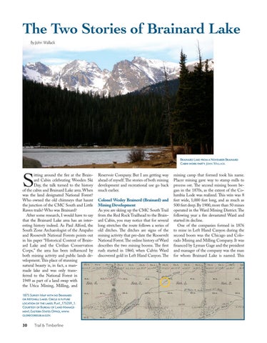
Brainard Lake from a November Brainard Cabin work party. John Wallack.
S
itting around the fire at the Brainard Cabin celebrating Wooden Ski Day, the talk turned to the history of the cabin and Brainard Lake area. When was the land designated National Forest? Who owned the old chimneys that haunt the junction of the CMC South and Little Raven trails? Who was Brainard? After some research, I would have to say that the Brainard Lake area has an interesting history indeed. As Paul Alford, the South Zone Archaeologist of the Arapaho and Roosevelt National Forests points out in his paper “Historical Context of Brainard Lake and the Civilian Conservation Corps,” the area has been influenced by both mining activity and public lands development. This place of stunning natural beauty is, in fact, a manmade lake and was only transferred to the National Forest in 1949 as part of a land swap with the Utica Mining, Milling, and 1875 Survey Map with no Brainard or Mitchell Lakes. Circle is future location of the lakes. Plat_175259_1. Courtesy of Bureau of Land Management, Eastern States Office, www. glorecords.blm.gov.
30
Trail & Timberline
Reservoir Company. But I am getting way ahead of myself. The stories of both mining development and recreational use go back much earlier. Colonel Wesley Brainerd (Brainard) and Mining Development As you are skiing up the CMC South Trail from the Red Rock Trailhead to the Brainard Cabin, you may notice that for several long stretches the route follows a series of old ditches. The ditches are signs of the mining activity that pre-date the Roosevelt National Forest. The online history of Ward describes the two mining booms. The first rush started in 1860, when Calvin Ward discovered gold in Left Hand Canyon. The
mining camp that formed took his name. Placer mining gave way to stamp mills to process ore. The second mining boom began in the 1870s, as the extent of the Columbia Lode was realized. This vein was 8 feet wide, 1,000 feet long, and as much as 500 feet deep. By 1900, more than 50 mines operated in the Ward Mining District. The following year a fire devastated Ward and started its decline. One of the companies formed in 1876 to mine in Left Hand Canyon during the second boom was the Chicago and Colorado Mining and Milling Company. It was financed by Lyman Gage and the president and manager of the company was the man for whom Brainard Lake is named. This


