Lion Gulch Trail: The Best Estes Park Hikes is the most recent addition to the Colorado Mountain Club Press’ “pack guide” series. Lion Gulch Trail, one of the 20 hikes included in the book, is a moderately difficult trail that offers an exciting view of two worlds—the natural and the historical. After traversing 3.1 miles, mostly uphill, from the trailhead, you’ll arrive at the Homestead Meadows. This is the world of hardy pioneers who worked the land in order to perfect their claim to a piece of the beautiful high country. Lion Gulch Trail is extremely popular and attracts a blend of CMCers and other hikers, equestrians, and mountain bikers. While pedestrians have the right of way over bikes, it’s often easier to step aside as they go whooshing by you. Dogs are also welcome on the trail; though there are many sound reasons to keep them leashed. As often as not, the soft dirt of the meadows area reveals that mountain lions also favor this trail, which, after all, is named in their honor. (Refer to “keeping your dog leashed” above.) My personal experience with Lion Gulch Trail began just about five years ago and with another outdoor organization I belong to. Circumstances had placed me at the trailhead—lacing my boots and preening just a bit in my spiffy uniform. There were four of us that day, members of the Poudre Wilderness Volunteers, all anxious to begin the day’s micro adventure. As we began hiking, the conversation seemed a bit loopy: “Just to be clear, you’re the mentor, and we’re the mentees, correct? And you’ve been in the program only since last year?” This was already a case study in rhetorical questions, but I jumped in anyway. “Yep,” I said trying to sound confident, “yep, to both.” I knew what was coming next: “And you’ve never hiked this trail before? And you know I’ve been on it lots of times?” These double questions were a bit disconcerting, but I went along: “Yep”, and
A Window to the Past
]
By John Gascoyne
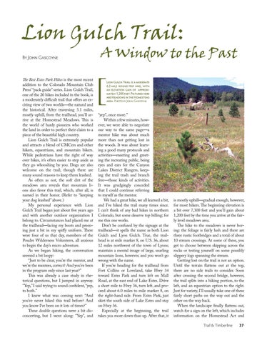
Lion Gulch Trail is a moderate 6.2-mile round-trip hike, with an elevation gain of approximately 1,200 feet. Pictured here are Meadows in the Homestead area. Photo by John Gascoyne
“yep”, once more.” Within a few minutes, however, we were able to negotiate our way to the same page—a mentor hike was about much more than not getting lost in the woods. It was about learning a good many protocols and activities—meeting and greeting the recreating public, being eyes and ears for the Canyon Lakes District Rangers, keeping the trail trash and branch free—those kinds of activities. It was grudgingly conceded that I could continue referring to myself as the mentor. We had a great hike, we all learned a bit, and I’ve hiked the trail many times since. I can’t think of any bad hikes in northern Colorado, but some deserve top billing; for me this one works. Don’t be confused by the signage at the trailhead—it spells the name as both Lion Gulch and Lyon Gulch. True, the trailhead is at mile marker 8, on U.S. 36, about 12 miles northwest of the town of Lyons; maintain a mental image of large, snarling mountain lions, however, and you won’t go wrong with the name. If you’re heading for the trailhead from Fort Collins or Loveland, take Hwy 34 toward Estes Park and turn left on Mall Road, at the east end of Lake Estes. Drive a short mile to Hwy 36, turn left, and proceed about 6.0 miles to mile marker 8, on the right-hand side. From Estes Park, just skirt the south side of Lake Estes and stay on Hwy 36. Especially at the beginning, the trail takes you more down than up. After that, it
is mostly uphill—gradual enough, however, for most hikers. The beginning elevation is a bit over 7,300 feet and you’ll gain about 1,200 feet by the time you arrive at the fairly level meadows area. The hike to the meadows is never boring: the foliage is fairly lush and there are three rustic footbridges and a total of about 10 stream crossings. At some of these, you get to choose between skipping across the rocks or testing yourself on some possibly slippery logs spanning the stream. Getting lost on the trail is not an option. Until the terrain flattens out at the top, there are no side trails to consider. Soon after crossing the second bridge, however, the trail splits into a hiking portion, to the left, and an equestrian option to the right. Just for variety, I’ll usually take one of these fairly short paths on the way out and the other on the way back. When the landscape finally flattens out, watch for a sign on the left, which includes information on the Homestead Act and Trail & Timberline
37


