Pikes Peaklife 18-Life-Color
18 The Courier View August 21, 2013
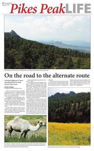
Gravel road tops out on the eastern side, revealing beautiful vistas and drops down into Sedalia. Photos by Rob Carrigan
On the road to the alternate route Colorado Highway 67 from Woodland Park to south Denver Metro area By Rob Carrigan
rcarrigan@ourcoloradonews.com Editor’s note: Recent closures and safety considerations with U.S. Highway 24 have prompted travelers to consider alternate routes. As an ongoing effort, we explore some of those possible routes. No stranger to its own problems, Colorado Highway 67 winds through parts of the Hayman burn area and has suffered from previous disastrous flooding. Time, forest growth and restoration, and flood mitigation efforts for more than 10 years, makes it relatively safe passage today. In July 2006, a flood on West Creek washed out the highway north of Westcreek, closing the highway between Westcreek and Deckers to two-way traffic until reconstruction was completed.
The closed segment reopened on October 27, 2006. The state portion of the highway overlap U.S. Highway 24 for seven miles from Divide east into Woodland Park, splitting off the concurrent road to turn north once again. Continuing to the northnorthwest, the road enters the Pike National Forest, passing Colorado Campground and Painted Rocks Campground before turning west and entering Douglas County, where it promptly heads into Westcreek and turns north until it reaches a junction with North Rainbow Falls Road and turns to the northwest. In Deckers, the state portion of the road again ends to overlap County Road 126 and heads to the north-northeast signed as South Platte Canyon Road. The route takes an abrupt turn east signed as Sugar Hill Road, rejoining the larger road it split after turning north and the larger road has taken on the name Pine Creek Road. The route turns east and changes name again to Jarre Canyon Road, resumes state highway status at its intersection with Rampart Range Road southwest
If you head south, on Highway 105 to Palmer Lake, just before going into the town of Sedalia, beautiful pastoral scenes of ranches, mountains and glenns and hollows, greet you all along the way through Perry Park and into El Paso County. Some of the ranches sport exotic animals in the mix.
of Sedalia. The route leaves Pike National Forest a few miles east of resuming state highway status, and continues northeast with increasing intersections as it approaches
Sedalia. After crossing State Highway 105 (Perry Park Road), the route turns north and is named Manhart Street for a few blocks before reaching its northern terminus at U.S. Highway 85.
Field full of sunflowers near the South Platte river, between Woodland Park and Sedalia.