

CLARE AYISI
LANDSCAPE ARCHITECTURE PORTFOLIO
2022
CLARE AYISI

Clare holds a Bachelor of Science ( Hons) in Architecture obtained from Taylors University, Malaysia and a Bachelor in Landscape Architecture (Hons) from the University of Cape Town. She just completed a Master of Landscape Architecture from the University of Cape Town Clare’s interest is in creating spaces that uplift memorable and unique user experiences. In her spare time, she likes exploring new places and learning the different cultures of the places and capturing all those moments through photography and social media.
EDUCATION
Master of Landscape Architecture 2021
Bachelor of Landscape Architecture (Hons) 2020
Bachelor of Science (Hons) in Architecture 2015 - 2019
EXPERIENCE
State Department of Public Works, Intern
Innovation 360 Architects and Project Managers, Intern
SKILLS LANGUAGES
Adobe Creative Suite
Microsoft Office
AutoCAD
html www.linkedin.com/in/clare-ayisi-751a15143/
trager.ca@gmail.com
E-PORTFOLIO
https://tragerca.wixsite.com/clareayisi
Revit 3Ds Max Qgis
Swahili - Fluent
English - Fluent
Korean - Beginner
2
CONTENT
Selected Works from my Masters programme in the University of Cape Town, South Africa


1.
Nairobi, Kenya
Masters Thesis Dissertation 2. Urban Design rural studio project Montagu, Western Cape 3. TRUP Studio design project Cape Town, South Africa3


4
Masters Thesis Dissertation
Instagrammable Landscapes: Linking and Revealing Heritage
Through
Social Media Influence
Nairobi, Kenya
Thesis Abstract:
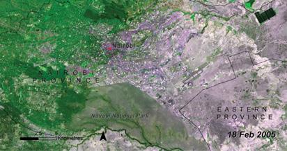
The natural heritage of Nairobi is deeply rooted within the city’s natural landscape. Nairobi once boasted a rich landscape characterized by natural forests, wetlands and marshy wetlands, abundant wildlife, the Kitengela corridor and riverine ecosystems. It was known as the “Green City in the Sun.” However, urbanization and the rapid population rise have led to a reduction in the natural landscape (Tibaijuki, 2007). With the city having lost most of its landscape character and natural vegetation, only a few green spaces were spared to serve as recreation spaces, offer tourists the chance to see the Kenyan wildlife and to aid in improving environmental and air quality.
This thesis is an investigation of how social media influence, specifically Instagram, can help to restore the lost heritage in Nairobi, by studying the physiological and historical landscape of the city and the site, Uhuru Park. By regenerating the forgotten indigenous heritage through systems restoration and green infrastructure – the dissertation studies the role of Nairobi’s landscape character in defining the identity of the city. It highlights a juxtaposition between natural landscapes identity and aesthetics value. The correlation between the two emphasizes the heritage value of restoring natural landscapes in urban cities where indigeneity is slowly getting lost with vegetation cover being quickly replaced with urban surface.
The site being used to reveal the heritage of Nairobi is Uhuru Park, a recreation park located adjacent to the central business district of Nairobi. Uhuru Park was originally a large green swath but has since been encroached to make room for a hotel, a museum and a ‘members only’ Golf Club (Communications, 2019). Further plans by the Kenyan government are to come up with an elevated highway that links downtown Nairobi to the Jomo Kenyatta International Airport curving its way through Uhuru Park. Ultimately this means disrupting the natural landscape even more. Addressing the issue of heritage value of the natural landscape would mean restoring the park to what Nairobi once was pre-colonial – a wetland, the savannah grasslands and the wildlife that once occasionally roamed along the Kenyatta Avenue during the colonial era.
The thesis aims to eventually show that through the lens of instagram, landscape architects can create a unique identity and user experience that is reminiscent of the indigenous landscape character of a space, the heritage of the space becomes well preserved and with that people are drawn to that landscape.
5 01

NAIROBI CITY CENTER
The dissertation is based in Nairobi, Kenya within the Central Business District. The macro analysis study looks at Nairobi and the city center, whereas the micro analysis zooms into the site which is Uhuru Park and Central Park. The analysis unpacks the city’s identity by looking at its physiological analysis and spatial analysis. The analysis will help in the design interventions of using indigeneity in invoking an instagrammable landscape.


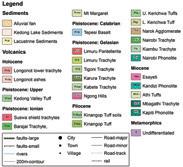


6 SPATIAL DEVELOPMENT PHYSIOLOGICAL STUDY GREENERY ANALYSIS
GEOLOGY HYDROLOGY Legend Rivers Nairobi Boundary Study Area and Site Uhuru Park


SAFE SPACES FOR PHOTOGRAPHY


Mapping of open spaces in the city was essential because Nairobi is urbanized, and the city center sits separated from the green spaces on the adjacent side.
The map on the left identifies most open spaces as government car park spaces with rather fewer trees, therefore, an opportunity to merge the park into the city by adding green infrastructure in the spaces. The figure ground on the right shows how there is beginning to be a seamless connection of open spaces which link into the site.


Green spaces are considered safe spaces for photography within the city and also museums. Government buildings are non-safe spaces. Monuments located within the park are accessible as compared to those located within the streets.
NON-SAFE SPACES FOR PHOTOGRAPHY


Artefact exploration was explored as an abstract study and the identity word was correlation in terms of instagrammable landscapes and spaces. The artefact shows how instagrammable landscapes can create physical and visual linages between people and spaces.
The linkage study further helps in the study of the precinct. Nairobi city center has a lot of heritage spaces and monument spaces that hold a lot of historical significance. With the spaces linked, they create a heritage walk and the locals and tourists will get to see the identity of Nairobi

Legend Uhuru Park CBD Boundary Open spaces Roads 7 OPEN SPACE STUDY
PHOTOGRAPHY ANALYSIS Legend Open Spaces Built Fabric
LINKAGE STUDY
Nyayo Monument
Tom Mboya statue and National Archives
National Museum of Kenya
Dedan Kimathi Statue Peace, Love & Unity Fountain
The KICC Building
Jeevanjee Gardens
Kimathi statue
The Triangle War Memorial Statue
The Railways Museum
Macmillan Meorial Lbrary
The Maumau monument
War Mmeorial monument
KICC Helipad
Memorial Library
In order to bridge the disconnect within the city center, the design used green infrastructure as a connecting element and incorporating local activities as linkages between spaces.

8
Pulling the Park into the City
FRAMEWORK INTERVENTION
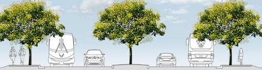
Linkage 3: Revitalizing the Street
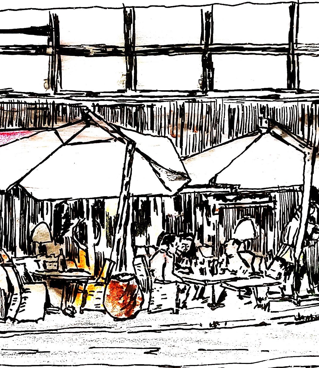
The Kenyatta Avenue, originally called sixth street and later Delamare avenue was historically seen as the entertainment hub of the budding city but is now less active than it used to be. As mentioned before, lots of parking space in the city is wasted and is opportunity to green the city and other functions. One of the famous markets in Nairobi is the Maasai market which is nomad maasai women selling traditional maasai artefacts and outfits and they appeal to the tourism industry. This creates an opportunity for them to use the parking spaces over the weekends and holidays.
The Re-imagined Uhuru Park will carry on from the frame work and will extend the themes applied on the framework onto the design development of the instagrammable landscape.
Linkage 2: Capitalizing on local cultures
Muindi Mbingu Street linkage runs from one of the most historical avenues, Kenyatta Avenue, to one of the oldest gardens, Jeevanjee Gardens. The street is currently being used as side parking space next to the sidewalks and there is an opportunity to incorporate varying local activities in the side walk spaces so as to reveal the cultural heritage of the Maasai
Linkage 1: Continuity of Indigenous green infrastructure
Wabera Street linkage runs from the proposed indigenous garden to the historical Macmillan Memorial Library. It’s a commercial street with few trees. Opportunity to add more green infrastructure on the sidewalks and the median which will promote legibility on the streets and continuity of the greenery from the garden leading up to the library. The trees and plants planted will be native trees and can continue and link up to the Jeevanjee gardens
 Linkage 4 - Site: Re-imagined Uhuru Park
9

10
LINKAGE 1
LINKAGE 2
LINKAGE 3
CONCEPTUAL DEVELOPMENT

concept
DESIGN DEVELOPMENT

Merge
of ecosystems - a programmatic landscape -
Different ecologies ensure the possibility of varying human experiences within the landscape. Coming up with a diverse landscape. By restoring the wetlands/ swamp ecosystem, we also make room for the bird islands, promoting indigenous bird species within the park. By restoring he savannah grasslands, we also promote the savannah herbivores such as the zebras to exist within the park.


The Monuments - activated hotspots -
Activity hot spots are organized at the existing monuments / heritage spots. The whole essence is to link the heritage and to make the existing monument spaces more frequented by activating them. The monuments are also evenly distributed, and each monument strategically placed near an entry

The Artefact - linked form -
The whole idea of linking the heritage monuments within the park, helps with formation of a new form with the help of the lines drawn from the artefact. The bold lines show both physical connections and visual linkages from one activity hotspot “monument” to the next.


The Instagrammable Landscape - optimizing the landscape -
The developing landscape, with the merged ecosystems, the restored landscapes, there is now a habitat formed where the humans and the animals can co-exist. A landscape reminiscent of what used to be.
11
Linkages
Establishing the swamp landscape vs savannah landscape
Water as a connector
MASTER PLAN HAND RENDER


Uhuru Park
Marsh with boardwalks and maasai styled manyatta gazebos
Podium/ Skateboarder’s paradise (transforms to performace area)
Natural Playscape
Instagramming spots
Outdoor Gym
MauMau Lane
Peace, Love and Unity Route
Water Mirror
Bird Island
Picnic Spots
Vegetation -refer to planting strategy page
Savannah Landscape
Tress
Shrubs
Grasses
Marshy Landscape
Submerged
Floating
Emergent
12 A B Sm
CBD CBD ExistingAmphitheater seating Kenyatta Avenue UhuruHighway C 1 2 3 4 1 2 3 4 10 5 6 7 8 9 10 10 Sm F&E T,S,G T,S,G T,S,G T,S,G T,S,G A A’ B B’
Serena Hotel
Legend Program
Monuments Nyayo Monument Mau Mau Monument
Love and Unity Fountain Program Central Park Zebra Meadow Ha-ha Open Picnic Savannah plants nursery A 1 1 5 B 2 2 6 C 3 3 7 4 4 8 9 T Sm S G F E 10
Existing
Peace
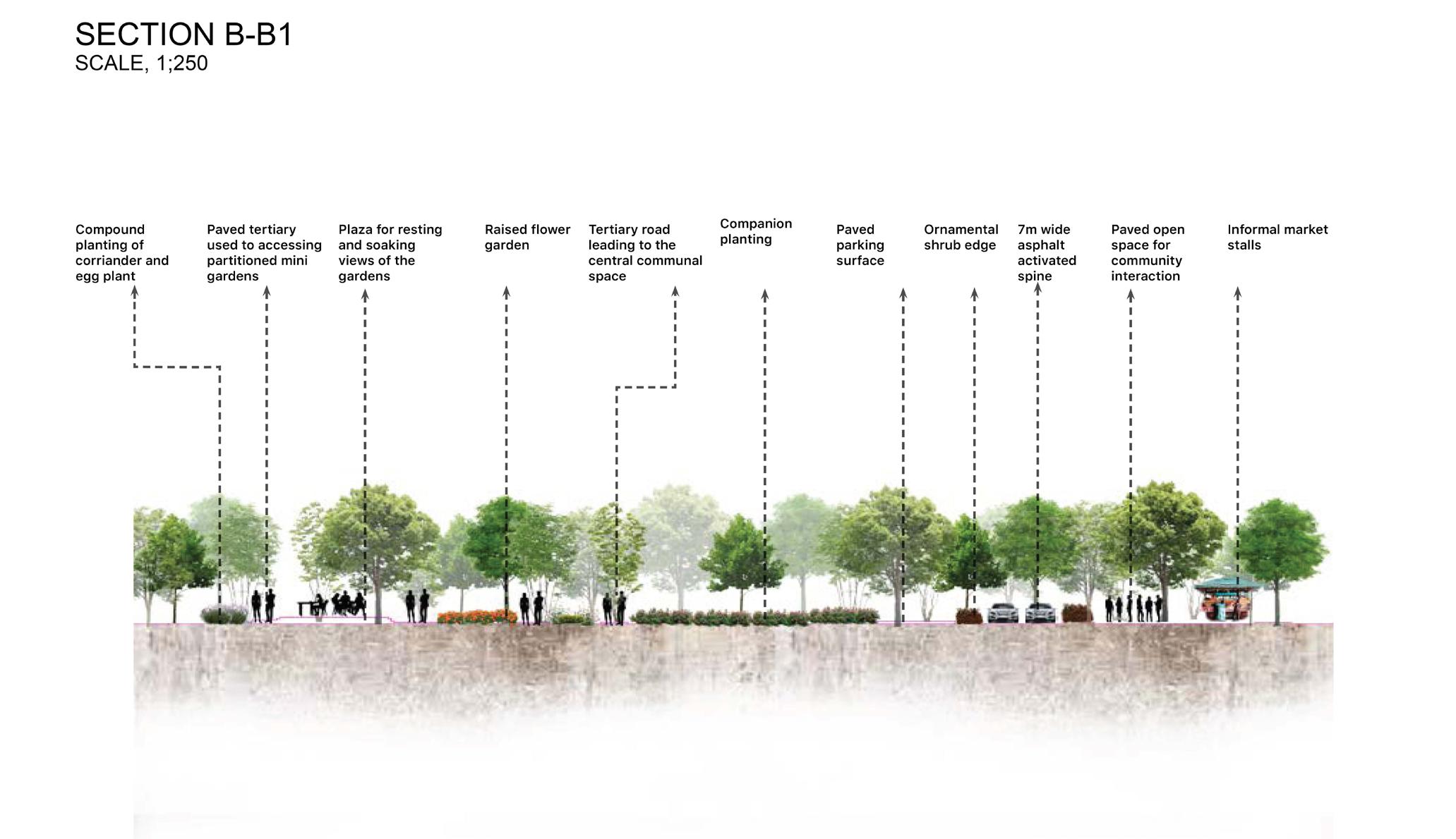
SECTION B-B1
SCALE, 1;500 A1
Fully grown Acacia polyacantha hosting several birds and insects also acting as fodder for giraffes

Giraffes and Zebra in the savanna ecosystem helping in energy recycling.
Stream separating the wildlife area from the viewing area.
600mm high protective natural stone wall
Gently flowing stream to the Marshy Ecosystem Medium-Tall elephant Grasses
Pavament area for circulation & vantage point for viewing
NYAYO Monument
Open paved area for circulation & vantage point for viewing
Stream flowing to the Marshy Ecosystem


13
14
Urban Design Rural Studio Project
Reconnecting Montagu by Introducing Communal Local Activities that will bridge the gap between Bergsig Montagu and Ashbury
Montagu, Western Cape, South Africa
Overview:
This project was conducted as a joint studio between Urban design students and Landscape Architecture Students. The area of study was a rural town - Montagu, located in Western Cape. In pairs of one urban design student and one landscape architecture student, each group identified issues they would like to tackle and sustainable development goals that would like to achieve during the design proposal. My group chose to deal with the disconnect by reconnecting the town using water and land.
Project Intention:
Montagu is a disconnected town. The disconnect can clearly be traced from the spatial layout of the town, the spatial typology as one moves from the core to the outskirts and even via the distribution of public amenities and spaces. The Montagu core boasts areas of heritage significance, communal spaces and public amenities, and has a refined grid layout. Ashbury is located on the outskirts of Montagu. It’s a rural area that makes up half of Montagu population but feels very disconnected from the Montagu core.
The project intention is to come up with a space that reconnects Bergsig Montagu to Ashbury through a shared community activity that is also beneficial to small business farmers. The space would also maintain the identity of Montagu through the activities such as agriculture.
15 02

MONTAGU 16


22
TRUP Studio Design Project
Liesbeek River Project
Cape Town, South Africa
Overview:
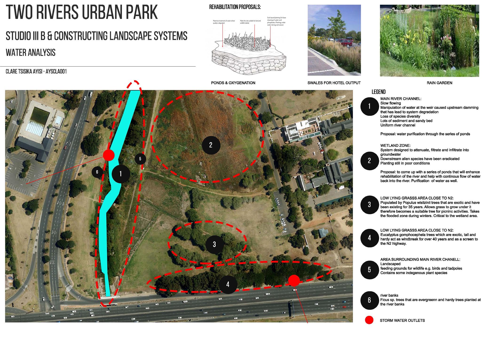
This studio design project was run side by side with the Constructing Landscape Systems Course. It was focused on Reimagining spatial and formal expression of ecological infrastructure. The studio study area was the Two Rivers Urban Park, located in the Southern Suburbs in Cape Town. The park is located towards the confluence of Liesbeek River and the Black River. This studio asked us to redefine ecological infrastructure, its purpose, its performance and importantly its spatial and formal expression to re imagine the river system as an armature, serving both ecological and social functions.
Project Intention
The design proposal focused on the study and design of a fresh water system with a focus on river rehabilitation and flood control. The design made use of existing parking and transport routes and incorporating walkways and boardwalks for to encourage an interactive landscape and water experience. Design considerations were put in place to allow for maximum human interaction for varying age groups.
23 03
CAPE TOWN

24
25

26


27


28

29

30

31
ONLINE
html www.linkedin.com/in/clareayisi-751a15143/
EMAIL trager.ca@gmail.com