MIDTOWN CENTENNIAL
URBAN DESIGN FRAMEWORK &
SUBAREAS REDEVELOPMENT STUDY


The City is committed to ongoing planning and collaboration to realize the vision for Midtown Centennial. The City has played an important role in the planning process, and special acknowledgment is extended in recognition of their passion, hard work and enthusiasm reflected in this document. In addition, the following people are recognized for their support and input into the document.
CHRIS PAREZO
NEIL MARCINIAK, ECONOMIC DEVELOPMENT DIRECTOR
DAVID KING, SENIOR PLANNER
JENNA CAMPBELL, PRINCIPAL PLANNER
MATT STURGEON, CITY MANAGER
JENNY HOULNE, COMMUNITY DEVELOPMENT DIRECTOR
MICHAEL GRADIS, PLANNING MANAGER
ANNA BIGNAULT
ELISHA THOMAS, DEPUTY CITY MANAGER
ANNA BUNCE, CITY TRAFFIC ENGINEER
MERINA IRFANO
SOON CHOI
RHEA PAI
WENLIN YANG
CHAPTER 1 VISION STATEMENT, GOAL AND OBJECTIVES [SUBAREA 1, 2 +3]
1.1 VISION STATEMENT
1.2 GOALS AND OBJECTIVES
CHAPTER 2 ANALYSIS & UNDERSTANDING (SUB AREA 1, 2, +3)
2.1 EXISTING CONDITIONS
2.2 COMPARISON AND PRECEDENCE (RESEARCH PRECEDENT CHARACTER IMAGERY TO CONVEY THE SCALE)
2.3 FINDINGS
CHAPTER 3 IDEATION & URBAN DESIGN FRAMEWORK (SUB AREA 1, 2, +3)
3.1 GUIDING PRINCIPLES
3.2 URBAN DESIGN FRAMEWORKS
• Open Space Network
• Pedestrian/Bicycle Networks
• Street Networks
• Nodes/Activity Center
• Land Use Distribution
• Connections to Light Trail and Surrounding Neighborhoods
3.3 CHARACTER AREAS
• Sub Areas Characteristics (diagrams+images)
• Public Realm and Place Making Strategies
• Street Cross Sections
CHAPTER 4 PUBLIC REALM INTENT AND GUIDELINE (SUB AREA 1)
4.1 PUBLIC REALM DESIGN
4.1.1 CIRCULATION
• Vehicles
• Pedestrians
• Bike and Trails Connectivity
4.1.2 STREETS
• Hierarchy/Classifications
• Primary Streets
• Secondary Streets
• Main Streets
• Parkways
• Woonerf
• Street Cross Sections
• Pedestrian Oriented Street Scape Design
4.1.3 OPEN SPACE
• Parks, Open Spaces, and Plazas
4.1.4 LANDSCAPE
4.2 PLACE MAKING DESIGN APPROACH
4.3 BRANDING AND IDENTITY OPPORTUNITIES
• Gateways
• Signage & Wayfinding
• Public Art
CHAPTER 5 PHASING AND IMPLEMENTATION STRATEGY (SUB AREA 1, 2, +3)
5.1 PHASING AND IMPLEMENTATION STRATEGY
CHAPTER 6 RECOMMENDATIONS (SUB AREA 1, 2, +3)
6.1 SUMMARY AND RECOMMENDATIONS
6.2 OUTLINE OF POTENTIAL URBAN DESIGN/PUBLIC REALM DESIGN & GUIDELINES
APPENDIX

A Vision Plan for Midtown – Creating a New Urban Neighborhood as the Heart of Centennial
Midtown’s redevelopment is driven by significant shifts in market trends, particularly in office space demand. Midtown Centennial will evolve as new, urban neighborhood that is the heart of Centennial.
Midtown’s central location, freeway visibility, and light rail train station will elevate Centennial’s stature along I-25 corridor (and front range) as the place to live, work, play, and gather.
The transformation of a suburban office park into a vibrant, walkable neighborhood stitched together by a network of distinct parks, public spaces, and multi-modal infrastructure network will create a distinct identity that will attract residents, corporate offices and destination retail that will want to co-locate in a vibrant, urban environment.
Midtown Centennial was identified as a dynamic, mixed-use environment in The Centennial NEXT comprehensive plan. Guided by Centennial NEXT and the City’s Strategic Plan, Midtown Centennial’s vision will be rooted in creating a vibrant district with more diverse housing, business and recreational opportunities.

Strategically located along the I-25 corridor, Midtown Centennial is uniquely positioned to become a central hub of activity within the City of Centennial. Midtown will emerge as a downtown node within the greater area integrating vibrant residential, commercial and transitoriented spaces.
The focus of the effort will be on: public realm, connectivity & transit, pedestrian access, infrastructure and city branding/identity. The urban design concept centered around place making idea, fostering meaningful activity and revitalization.
Additional work may include assistance in identifying urban design regulations that can complement and enhance the public realm. This transformation will be guided by thoughtful planning, community input, and strategic investment to create a connected, sustainable and resilient destination within Centennial.


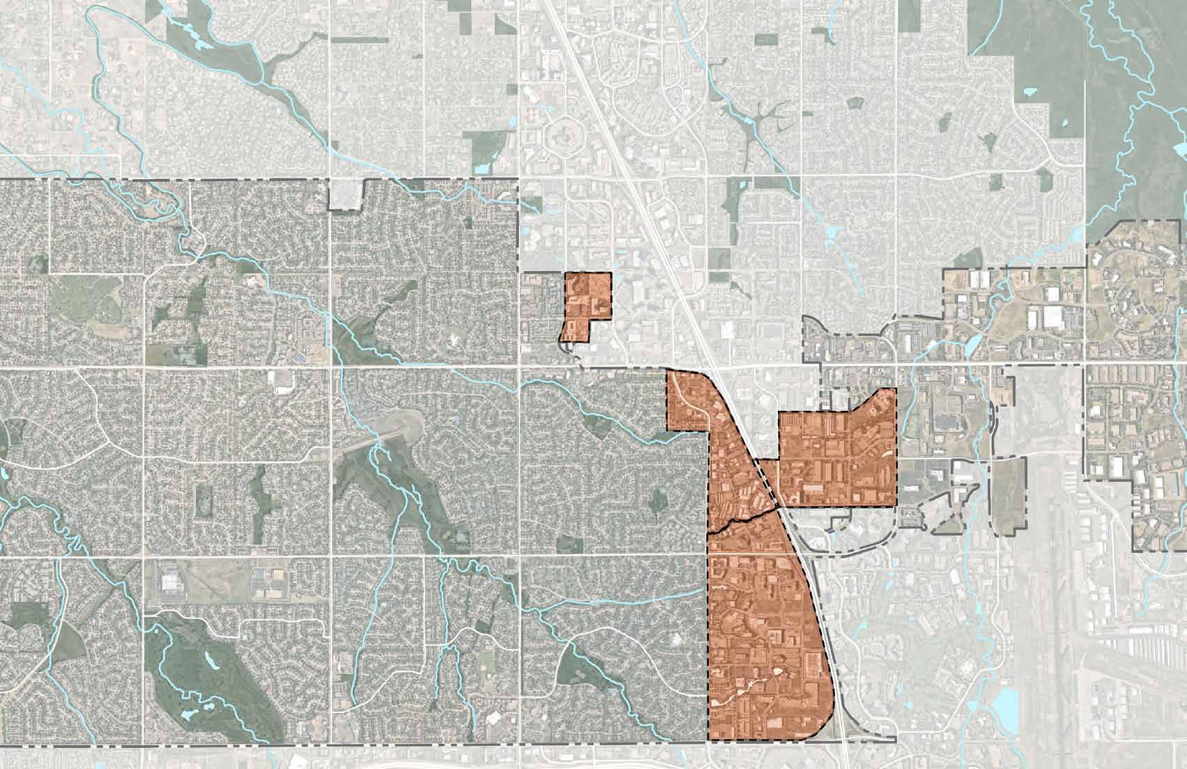
Midtown Centennial encompasses the area between S. Yosemite St. and S. Havana St. (west to east) and E. Arapahoe Rd. and E. County Line Rd. (north to south). This area is centered around major regional assets, including the Dry Creek Light Rail Station, I-25, Centennial Airport and an emerging entertainment district.
This corridor has historically been dominated by mid-20th-century office parks and commercial spaces. However, evolving market trends and shifting work environments have opened the door to creating a walkable, mixed-use district that serves as a gathering place for residents, workers and visitors alike.

Existing + Planned Trails and Open Space Framework
There are multiple local trail connections from the surrounding park and open space system directly to the site, with Little Dry Creek being a major regional trail that connects into midtown . A planned bike facility runs within the site on Chester St.
The Parks + Open space network on either side of Midtown allows for multiple green connections within the site; allowing for integration within the regional context .


• The “Midtown Centennial” are divided to 4 Sub Areas. Sub Areas 1-4. are approximately 416 acres, 136 acres, 220 acres and 45 acres respectively. The vision aims to utilize on existing transit nodes generated by the I-25 and the light rail corridor.
• The site has an easy access and good visibility from the I-25 corridor and within approximately less than a mile distance from Arapahoe and Dry Creek light rail stations.
• The site is envisioned to emerge as a downtown node with various public and private redevelopments to facilitate this cohesive development.
• The focus of the effort will be on the public realm, including parks & open space, pedestrian infrastructure, transit connectivity and city/area branding and identity.
• The site offer a tremendous mountain view of the Rockie Mountain Range.


Regional districts with a similar vision to Midtown were compared, to help establish a sense of scale and help located the site within a larger context.


• The map on the far left identifies larger area parcels with single ownership; the smallest parcel being less than 4 acres.
• The larger parcel areas under single ownership in this study is considered having a higher opportunity to be developed/redeveloped and integrated as part of Midtown Vision Plan.
• This study also review buildings or structures ages on parcels within the study areas. The older the age of those buildings or the structures, the stronger they become candidates for potential redevelopment.
• Overlaying the data from both maps helps evaluate aging building or structures and the subsequent parcels that might be easier to redevelop from a single ownership standpoint as well.


• The far left map identifies sidewalks connectivity within the study areas. Predominantly the streets within Midtown study areas are suburban in nature, with attached sidewalks and few streets with no sidewalks.
• There is an opportunity to improve urban street network and pedestrian connectivity with increased detached sidewalk to increase pedestrian safety.
• It was identified as part of this study that there are significant amount of mature trees growth within the site.
• Mapping the age of trees and the extent of canopy cover, allows for conscious steps during redevelopment of parcels and creating of complete street grids.
• Existing mature trees should be preserved as much of possible and considered as a valuable asset instead of encumbrance to new developments.

An AUTHENTIC MIDTOWN District creates a district identity and regional address signaling that Centennial is evolving into a contemporary, urban, mixed-use urban center in the Front Range.
• Creates an urban center that will become a central gathering place for City of Centennial citizens.
• Creates a hybrid origin/destination station that supports freeway office headquarters and a walkable, urban neighborhood in proximity to the light rail station.
• Capitalizes on freeway visibility, access and light rail service to position Midtown for growth in all potential sectors with flexibility to adapt to market cycles and demand.

A CONNECTED MIDTOWN links adjacent neighborhoods to the district, stitches together various character areas, and connects to the LRT Station.
• Creates an urban fabric that knits Midtown together through a network of walkable, pedestrian scaled streets.
• Improves accessibility and permeability for all modes of transportation.
• Creates a network of parks and open spaces that serves as a place-making identity and organizing feature that ties a variety of land uses together.
• Connects midtown district and adjacent neighborhoods to the LRT Station.
• Creates a gateway/front to the city (arriving by vehicle and light rail).
• Capitalizes on mountain views from the LRT platform creating a distinct experience and identity when arriving to the district from the light rail.
• Takes advantage of topography to capitalize on vistas and terminus views.

A RESILIENT MIDTOWN exemplifies best practices for urban infill, economic development, and green infrastructure.
• Promotes economic resiliency by allowing encouraging a mix of uses to develop both horizontally and vertically, in the near and long term to respond to market demand.
• Encourages environmental sustainability by encouraging multimodal transportation systems, encouraging higher density development (limiting sprawl) and using drought tolerant, water wise planting pallet in parks and public realm.
• Enhances social sustainability by incorporating a variety of housing types, densities, and price points.
• Attracts private investment and sustains a destination and local economy.
• Encourages urban lifestyle by facilitating more walking and biking, transit use, and social interactions that are associated with improved human health.


A VIBRANT MIDTOWN is an active, mixed-use district with a series of distinct places and spaces that is the heart and gathering place for future residents, employees, adjacent neighborhoods and a future regional destination.
• Creates an urban center neighborhood with density and intensity of development necessary to support neighborhood serving retail and place-making strategies.
• Establishes holistic urban design vision through an integrated public realm plan, urban form, and quality architecture.
• Creates a new and distinct district along the I-25 corridor where people will want to live, work, play, and visit

The Midtown Vision Plan is structured around key urban design strategies that physically define characters areas, mobility functions, and create the backbone for successful re-development. It sets the stage for a series of integrated frameworks for future park and open space, streets, pedestrians, bicycles, circulation, transit, and development.


A series of new open spaces will be introduced within Midtown that ranged from but not limited to greenway, linear park, urban plaza, nodes, naturalized open space that connects to the existing open space network.
• Greenway - A north-south greenway corridor with multi use path for pedestrian and bike along Chester St. connecting Midtown Subareas neighborhoods and employment districts.
• Linear Park - linking park and open spaces through a well connected loop system to ensure residents have an easy access to various type of open spaces.
• Urban Plazas - strategically located next to or within higher density areas with place making concept that will improve quality of life.
• Nodes / Activation - Create “string of pearls” or activity centers along Midtown linear park or “Midtown Loop”, provides opportunities for recreation and play.
• Naturalized Open Space - Incorporate green stormwater infrastructure in naturalized open space or incorporating it into parks and productive areas when possible.
• Neighborhood & Pocket Parks - are publicly used outdoor space for recreation, programmed activities such as playgrounds, picnic areas, small courts, biking, walking, etc.


• Establish pedestrian and bicycle networks throughout Midtown sub areas.
• Connecting Midtown pedestrian and bicycle network to the existing and proposed pedestrian and bicycle system
• Improve pedestrian and bicycle priority intersections for safety reason


• Midtown has historically dominated by large office parks with some parcels were developed as campus settings in large block with lack of pedestrian, bike and vehicular connectivities.
• With the shift in the market trends and work environments, there’s a huge opportunity create a walkable, mixed-use district that serves as an urban ‘core’ and a ‘destination’ for residents, workers and visitors alike.
• Large block can be splitted to smaller block to accommodate new land use and building types.
• New street layout is introduced with improved public realm including connected detached sidewalk through a pedestrian friendly streets.
• Improve street network to maximize proximity to the Light Rail Station.
• Improve pedestrian crossings especially at major intersections to promote safety and connectivity.


• Midtown Centennial presents opportunities for future gateway development with a unified and cohesive wayfinding system that is recognizable and unique.
• Gateway and Wayfinding system should be considered to enhance arrival experience getting in and around Midtown.
• Simplify vehicular and pedestrian traffic patterns by directing the traveling public along the most desirable routes
• Enhance Midtown image as an accessible, attractive and active destination through distinctive, themed/branded signage, gateway elements, wayfinding mediums.
• Locate gateways at key locations along Highway I’25 corridor and main access points entering Midtown district from surrounding areas.


• The linear park is an urban green spine, create prominent green loop at the core of Midtown.
• This establishes E Panorama and S. Akron St. as the north-south linear park connecting to the linear parks that run east-west at the Panorama District on the north end and Highland Park on the south end.
• The linear Park as pedestrian priority spine is the first step of connecting several planned and existing developments and park spaces together.
• The park will also create a network of open spaces that serves as a place-making identity and organizing feature that ties a variety of land uses together


• Centennial Station: The Gateway to Midtown Centennial Station is characterized by higher density and intensity of office and residential uses creating an iconic identity and address along the light rail corridor.
• A signature public space includes a mix of hardscape and landscape elements arranged in a more formal environment suitable that is suitable for high volumes of use in an 18-hour environment that is used by daily office employees and residents, as well as evening and weekend visitors. Handsome and durable materials convey a sense of quality and longevity suitable for the urban center of Midtown.


• Expand the existing detention pond to accommodate district-wide capacity, freeing up more valuable land for development and place making.
• Design the detention area as an accessible water quality and detention pond that can be enjoyed by people.


1. Frame Mountain Views :
• Create a bold public space and view corridor that frames western views from centennial station
• Provides a view into midtown centennial from Yosemite
2. Re-imagine Highland Park :
• Create a unique destination and identity along the existing open space that encourages development and community gathering


3. Create A Continuous Loop Road
• Connect Chester st to the station and freeway oriented office sites
• Provides a signature address for office
4. Preserve High Visibility Land
• Highest visibility corridor and views
• Preserve land for signature offices or destination places along the I-25 freeway


• Centennial Midtown is envisioned to be a walkable district/neighborhood where residents, neighbors, visitors have easy access to parks, open spaces and plazas by foot or using any mode of transportations.
• A series of parks, open spaces and plazas are planned within 0.25 mile radius to ensure park and open spaces provision and continuous open space network
• Provide connections to the existing and planned pedestrian and trails around Midtown, especially connection to the existing neighborhood to the west.
• Creating a walkable pedestrian network within the site, allows for better access from the RTD / urban core to the residential units on the west.
• The network would also integrate the green spine to smaller pockets of open space within the site.


Centennial Station: The Gateway To Midtown
• Centennial Station is characterized by higher density and intensity of office and residential uses creating an iconic identity and address along the light rail corridor.
• A signature public space includes a mix of hardscape and landscape elements arranged in a more formal environment suitable that is suitable for high volumes of use in an 18-hour environment that is used by daily office employees and residents, as well as evening and weekend visitors. Handsome and durable materials convey a sense of quality and longevity suitable for the urban center of Midtown.
• Highland park is re-imagined as an urban oasis surrounded by mixed use residential, restaurants, boutique shops and neighborhood serving retail and services.
• Building upon the assets of mature trees and the water feature, both rare amenities in the front range, this area is transformed into a unique mixed use residential and shopping area that supports a growing midtown and draws visitors for unique shopping experience. Surgical interventions create additional ways to engage the water.


• The Town Green is a central gathering space along Panorama Parkway. It is characterized an informal neighborhood gathering space with primarily soft-scape environment. Bosques of trees and garden rooms create more intimate settings for small gatherings or personal quite time, while a large flexible lawn is suitable for farmer and makers markets, movie nights, and informal play.
• The edges of the Town Green are activated by neighborhood serving ground floor retail providing a variety of local food and beverage options that may include a coffee shop, brewery, taqueria, burger joint, ice cream parlor, salon/barber, breakfast joint, etc.
• Unique destinations or experiences are located intermittently along Panorama Parkway. A funky patio, interactive art feature, unique retail elements create interesting spaces along Parkway inviting people to explore the larger district.


• Residential uses line the street with generous front porches and front doors; providing ‘eyeson-the-street’ and informal social interaction. Upper level balconies are integrated into the building design.
• Centennial Station is characterized by higher density and intensity of office and residential uses creating an iconic identity and address along the light rail corridor.
• An urban green spine i.e. the linear park runs along midtown to create prominent green loops within the site. This establishes E Panorama as a linear park/ pedestrian priority spine is the first is the first phase of connecting several planned and existing developments and park spaces together.
• The park will also create a network of open spaces that serves as a placemaking identity and organizing feature that ties a variety of land uses together


• Chester St. is a major collector street that runs north south approximately at the center of Midtown Sub Area 1.
• Chester St. in this study is envision as a greenway street that connect Midtown Sub Area 1 and Sub Area
2.


• Chester Greenway will have Multi-Use Path for pedestrian and bike on both sides of the street to improve pedestrian and bike connectivity throughout Midtown


• In some instances, existing trees may need to be saved and sidewalk can be placed on the other side of the existing trees

• Midtown Loop is an urban green spine. The prominent green loop runs around midtown core area as a pedestrian priority spine connecting several planned and existing developments and park spaces.
• Midtown loop creates a network of open spaces that serves as a placemaking identity and organizing feature that ties a variety of land uses together


• A series of place making nodes are planned along Midtown loop to provide various outdoor active and passive space accessible to the public. These series of “outdoor rooms” offer small to medium gathering spaces with each space offer their own unique character
• Place making nodes can be varied in size to provide a range of activities from outdoor lunch break setting, play ground area, water quality garden, ice skating ring, dog park, etc.


• Midtown Station Plaza is characterized by higher density and intensity of office and residential uses creating an iconic identity and address along the light rail corridor. A signature public space includes a mix of hardscape and landscape elements arranged in a more formal environment suitable that is suitable for high volumes of use in an 18-hour environment that is used by daily office employees and residents, as well as evening and weekend visitors. Handsome and durable materials convey a sense of quality and longevity suitable for the urban center of Midtown.


• Midtown Green is a central gathering space along Midtown Panorama Loop. It is characterized as an informal neighborhood gathering space with primarily soft-scape environment.
• Bosques of trees and garden rooms create more intimate settings for small gatherings or personal quite time, while a large flexible lawn is suitable for farmers, makers markets, movie nights, and informal play.
Green is a central gathering space along Midtown Panorama Loop. It is characterized mal neighborhood gathering space with primarily soft-scape environment . Bosques of d garden rooms create more intimate settings for small gatherings or personal quite ile a large flexible lawn is suitable for farmer and makers markets, movie nights, and play. The edges of Midtown Green are activated by neighborhood serving ground ail providing a variety of local food and beverage options that may include coffee ewery, taqueria, burger, ice cream parlor, salon/barber, and breakfast spots.
• The edges of Midtown Green are activated by neighborhood serving ground floor retail providing a variety of local food and beverage options that may include coffee shop, brewery, taqueria, burger, ice cream parlor, salon/ barber, and breakfast spots.


• Highland park is re-imagined as an urban oasis surrounded by mixed use residential, restaurants, boutique shops and neighborhood serving retail and services.
• Building upon the assets of mature trees and the water feature, both rare amenities in the front range, this area is transformed into a unique

mixed use residential and shopping area that supports a growing mid-town and draws visitors for unique shopping experience.
• Surgical interventions create additional ways to engage the water.


• Prairie Park is envision as neighborhood scale park and serves as west gateway to Midtown.
• A public art located at the terminus of Yosemite St. and Mineral Ave. function as gateway signifying element, enhance community identity.
• The park characterized with large lawn and prairie meadow, quieter atmosphere compare to smaller pocket parks located closer to the higher density residential areas. A nice open space as transition from single family residential neighborhood scale on the west side to a higher density neighborhood/district on the east


• Signature buildings can create a unique highway identity for Midtown by strategically located tallest building along the highway.
• An integrated light rail station and pedestrian bridge can add unique identity to signify Midtown.
• Highway identity can be created by a placing a striking landscape form that bordered Midtown along I-25 corridor.

• Public arts can be used as another alternative way to identify arrival at Midtown.


Town green with woonerf

•
Open space with multi use trail/amenity zone
PROPOSED STREET SECTIONS A WALKABLE STREET NETWORK

1. Creating a walkable pedestrian network within the site, allows for better access from the RTD / urban core to the residential units on the west.
2. The network would also integrate the green spine to smaller pockets of open space within the site


• High density area with high visibility from the highway is a good location for high profile office , commercial and or a
CENTENNIAL STATION TOD
- High Density,
- Highly walkable, - Highest quality Architecture
TRANSITION ZONE
- Lower density office
- Commercial
- Residential.
This may include more horizontally mixed-uses transitioning on a parcel by parcel basis
VILLAGE CORE
- Medium density,
- Highly walkable,
- Urban building form
SIGNATURE ADDRESS SITE
- High Density
- Primarily residential with some some vertical mixed use a key locations
HIGHLAND PARK
- Special Place making focused on open space
- Medium density,
- Car-Free Core
- Urban building form

• Centennial Station is characterized by higher density and intensity of office and residential uses creating an iconic identity and address along the light rail corridor.
• A signature public space includes a mix of hardscape and landscape elements arranged in a more formal environment suitable that is suitable for high volumes of use in an 18-hour environment that is used by daily office employees and residents, as well as evening and weekend visitors. Handsome and durable materials convey a sense of quality and longevity suitable for the urban center of Midtown.


• PROPOSED CHARACTER AREAS

• PROPOSED CHARACTER AREAS
• HIGHLAND PARK
• Special place-making zone
• Primarily focused on open space
• Medium density zone and potential car-free zone
• Walkable network integrated with urban building form


• • Medium density area
• Highly walkable streets and urban building form
• Primarily residential area with vertical mixed use in key locations


Defining the role and character of the various types of streetscape is the key to ability achieving the goal of creating or enhancing a network of walkable and bike-able pedestrian-scaled streets throughout Midtown in Centennial.
The streetscape design will establish the overall character of the Midtown district by improving pedestrian pathways and bike networks. Since the district will be envisioned as a mixed-use development, multiple tenants of office users and residents will be around the LRT station. The streetscape and open spaces are intended to provide a common thread that ties all the various activities and communities together. Common materiality, furnishings, and wayfinding help visitors understand they are in the Midtown district.
Streetscape design varies based on specific street functions. Primary streets with cycle tracks are expected to connect the Midtown district and adjacent neighborhoods by improving accessibility and permeability for all modes of transportation. Streets with linear parks are expected to serve pedestrian movements primarily. This will enhance the pedestrian experience by creating a more unique and dynamic space. Secondary Streets and Tertiary Ways that are expected to serve parking areas will be treated with a simplified streetscape design.
Site furnishings should be coordinated and located adjacent to building entries and within the amenity zone. Utility access should be coordinated so that it is not placed in front of primary building entries. The final layout of the streetscapes will be designed to be compliant with the City of Centennial’s standards.
Chester Street is the primary north and south automobile and bicycle connection through Midtown between Dry Creek Rd. and Countyline Rd. The street is intended as a multi-modal street balancing the needs of pedestrians, bicycles, and automobiles. This streetscape is characterized by well-designed, durable pedestrian zones with sidewalks and amenity zones, shade trees, and off-street cycle tracks.
Quality detailing, finishes, and materials create a unique identity. Special care should be taken to design intersections that minimize potential conflicts between pedestrians, automobiles, and bicycles.
• Bicycle facility: Both directional off-street cycle track on one side of street.
• Sidewalk: Cast in place concrete, broom finish minimum 6’ wide.
• Building frontage: Primary facade.
• Build-to zone: 0’-10’.
• Parking Structures: Liner building or active ground floor use required.
• Parking Lots: Not allowed between a building’s primary facade and street
• Curb cuts are limited.
• Street Lighting:
• Amenity Zone:
• Bench: 1 per building entry, minimum.
• Bike Racks: Embedded, centered in scoring pattern. 4 per building entry, minimum.
• Trash Receptacle: Surface mounted at edge of paving, 1 per building entry, minimum.

• Landscape: Deciduous tree in minimum 5’x10’ planting bed with rock mulch, crusher fines, or some other ‘innovative’ planting bed material.
• Trees: Deciduous trees at 25’-35’ on center.
• Explore opportunities for water quality treatment integrates with landscape zone.

• Existing Land use :
• - The land use within the core of subarea 1 is primarily Employment center [EC] - Suburban office spaces. With subarea 2 being Employment center [EC] - warehouse & retail.
• - The area deemed vacant around the RTD light rail acts as a major core for Midtown; shaped along with Panaroma Center and the Jones district developments
• Existing Land use


• The land use within the core of subarea 1 is primarily Employment Centre [EC] - Suburban office spaces. With subarea 2 being Employment Centre [EC]warehouse & retail.
• The area deemed vacant around the RTD light rail acts as a major core for Midtown; shaped along with Panaroma Center and the Jones district developments
• Zoning around the Panorma center / Jones district sites + RTD area is primarily Urban center, with no specific height limit. Areas on either side of this are zoned as BP100, with a height limit of a 100ft.
• Areas in closer proximity to the residential units on the far left have a height limit between 75 to 35ft, allowing for increased pedestrian accessibility/ visibility to the main core.


• In general the existing topography is fairly flat. However, some areas have steeper contours with slopes greater than 5%.
• The site is slopping down from east to west, opening a good view to the mountain range on the west.
• In general the site occupied by office/commercial and retail uses with larger building footprints compare to most residential buildings on the west side.
• Some small industrial buildings are found in the northern portion of the site.
• The area west of the site bordered by Yosemite St. is predominantly use as single family residential neighborhoods.
• The IKEA building anchored the site located towards south east of Midtown that has the biggest building foot print in the study area.

• Existing street classification map shows street’s pattern and hierarchy.
• Highway I-25 corridor bisect the site with limited eastwest connections.
• Most streets characterized with attached sidewalk with wide drive lane which is typical for suburban streets.


• Understanding property ownership map help identify the size needs for potential future developments.
• A single parcel ownership will be easier to develop compare to develop parcels with several ownerships.
• The map on the left identified several single parcels and groups of parcels under one ownership.

• The maximum building height provides insights into potential redevelopment patterns / opportunity zones on the site.
• Areas that are zoned to allow for greater vertical expansion with taller structures i.e. the urban village core and centennial station TOD can unlock higher land value by maximizing allowable density.


LANDSCAPE ZONE BIKE / PEDESTRIAN ZONE MIN BUILDING SETBACK


LANDSCAPE ZONE
PEDESTRIAN ZONE
AMMENITY ZONE


• Subareas 2 and 3 were studied to test potential development growth to anticipate future market when development timing is ready for implementations


STREET CROSS SECTIONS