Aotea Station Main Works
Transport Access and Parking Delivery Work Plan
CRL-AOT-RME-LKA-PLN-800032
Revision: 001
Date: 08 May 2020

Transport Access and Parking Delivery Work Plan
CRL-AOT-RME-LKA-PLN-800032
Revision: 001
Date: 08 May 2020
CRL-AOT-RME-LKA-PLN-800032
This document is uncontrolled when printed. This document should be printed in colour.
Revision Status
Approval Status


6.4.1.
Appendix F: Record of CLG and independent peer review comments ...........85
Appendix G: High Level Staging Plans .............................................................95
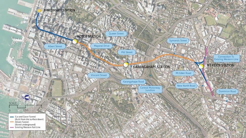
The City Rail Link (CRL) project comprises the construction, operation and maintenance of a 3.4 km underground passenger railway, running between Britomart Station and the North Auckland Rail Line in the vicinity of Mt Eden Station. The CRL also involves the construction of two new underground stations at Aotea and Karangahape and the redevelopment of the station at Mt Eden (refer to Figure 1-1). The design and construction of the CRL infrastructure between the Aotea and Mt Eden Stations is being delivered by the Link Alliance.
This Transport Access and Parking Delivery Work Plan (TAP DWP) has been prepared in relation to the main construction works for the new Aotea Station.
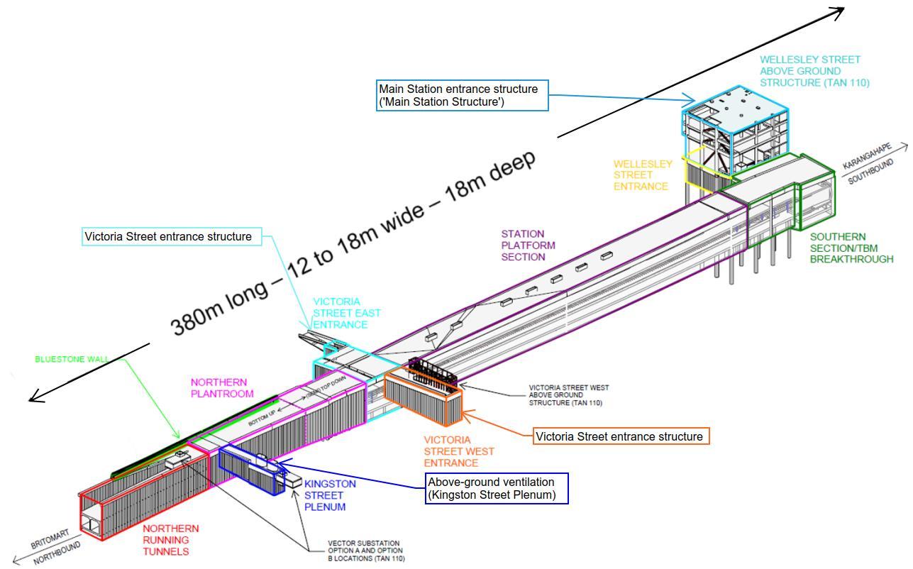
Once completed, the Aotea Station will include platforms, lifts, escalators, rooms for housing stations and tunnel services equipment, an entrance building at Wellesley Street, two additional entrance buildings at Victoria Street, a Plenum at Kingston Street, services, internal and architectural finishings, structural fittings, utilities services diversions and connections.
The location of the Aotea Station is primarily beneath Albert Street, connecting the Contract 2 (C2) cut and cover tunnels to the north and the tunnel-boring-machine (TBM) tunnels to the south. The works are approximately 380m long by 18m wide and will be excavated around 18-20m below ground level. Additional boxes branch off from the tunnel alignment at Kingston Street (to form the Plenum), Victoria Street (for two entrance buildings to the Aotea Station) and Wellesley Street (to form the main entrance building to the Aotea Station) (refer to Figure 1-2 below)1 .
Given the nature and scale of the Aotea Station construction, works will be undertaken in a staged manner, involving:
• Five stages of early works (canopy removal, network utility relocation and site establishment work), being undertaken from October 2019 to March 2020 (Stages 1 to 3) and December 2019 through to August 2020 (Stages 4 and 5); these works have been authorised by separate Outline Plans (Council ref. OPW60345651 and OPW60348747);
• Main construction works (the ‘Aotea Station main works’) involving construction of the station box, associated above ground structures, mined tunnels for the rail tracks, internal finishings, structural fitout, all Mechanical, Electrical, Fire and Hydraulic (MEFH) installation, and architectural finishings2. The Aotea Station main works will be undertaken from early2020 through to late-2023; and
• Ground reinstatements (from late-2022) and urban realm improvements. These works will be described in a future Outline Plan2 .
This TAPDWP relates to the main construction works for Aotea Station and will be implemented throughout. The on going construction requires mitigation measures to be implemented to manage traffic, access and parking.
Refer to Section 2 of the Construction Environmental Management Plan (CEMP) for a detailed description of the Aotea Station main works.
To reflect the staged construction approach for Aotea Station, TAP DWPs are being developed in stages. This TAP DWP addresses the Aotea Station main works, which are described in detailed in the CEMP and an overview is provided in Section 2
This TAP DWP has been prepared to identify measures that will be implemented to mitigate and manage the potential adverse effects on transport, parking and property access during the Aotea Station main construction works. In accordance with CRL designation condition 25.2, the objective of the TAP DWP is to:
So far as is reasonably practicable, avoid, remedy, or mitigate the adverse effects of construction on transport, parking and property access. This will be achieved by:
• Managing the road transport network for the duration of construction by adopting the best practicable option to manage congestion.
• Maintaining pedestrian access to private property at all times; and
• Providing on-going vehicle access to private property to the greatest extent possible.
2 It is noted the architectural finishing component of works (the exterior look and feel of the Aotea Station) will occur during Phase 5 of the Aotea Station main works (approx. 2022 – December 2023). These finishings are still being designed and determined. Once designs are completed a separate Outline Plan and suite of DWPs will be prepared, describing the finishings and other permanent above ground public realm reinstatements. That Outline Plan package will address the relevant Urban Design related Designation conditions (condition 47 – 54, including landscaping (condition 55.3(c))).
This TAP DWP addresses the requirements of CRL designation conditions 25.3 (general TAP DWP matters), 27.1 and 27.2 (matters specific to the Aotea Station area) and will be implemented throughout the construction period.
This TAP DWP has been developed in consultation with the Aotea Community and Business Liaison Group (CLG) and has undergone Independent Peer Review (IPR) prior to submission to Auckland Council (as per designation conditions 7 and 11). A record of CLG consultation outcomes and IPR review comments is provided in Appendix A
This TAP DWP forms part of the CEMP for the Aotea main works.
Table 1-1: identifies the CRL designation conditions relevant to this TAP DWP and where they are addressed in the document.
Table 1-1: CRL designation conditions and location in Plan
18.1 The Requiring Authority and its contractor shall work collaboratively with the New Zealand Transport Agency (NZTA) during the preparation of the Traffic, Access and Parking DWP (Conditions 25, 27, 28, 29, and 30) in relation to confirming the management of adverse transport effects on the road network. A record of this consultation and outcomes shall be included in the Traffic, Access and Parking DWP. The Requiring Authority shall consult with the NZTA throughout the duration of construction on any changes or updates to the Traffic, Access and Parking DWP which relate to the management of the road network.
20.1 In order to give effect to the objective in Condition 19.1, the CEMP must provide for the following:
(d) A Travel Management Plan for each construction site outlining onsite car parking management and methods for encouraging travel to the site using forms of transport other than private vehicle to assist in mitigating localized traffic effects.
21.1 In order to give effect to the objective in Condition 19.1, the CEMP shall include the following details and requirements in relation to all areas within the surface designation footprint where construction works are to occur, and / or where materials and construction machinery are to be used or stored:
(a) Where access points are to be located and procedures for managing construction vehicle ingress and egress to construction support and storage areas;
25.1 A Transport, Access and Parking DWP shall be prepared to manage the adverse effects of construction of the City Rail Link, or any part of it, on the transport network. This document
25.2 The objective of the Transport, Access and Parking DWP is to so far as is reasonably practicable, avoid, remedy or mitigate the adverse effects of construction on transport, parking and property access. This is to be achieved by:
(a) Managing the road transport network for the duration of construction by adopting the best practicable option to manage congestion;
All Sections
(b) Maintaining pedestrian access to private property at all times; and Sections, 6.1.1, 6.2.1, 6.3.1, 6.4.1 and 6.5.1
(c) Providing on-going vehicle access to private property to the greatest extent possible.
25.3 To achieve the above objective, the following shall be included in the Transport, Access and Parking DWP:
(a) The road routes which are to be used by construction related vehicles, particularly trucks to transport construction related materials, equipment, spoil, including how the use of these routes by these vehicles will be managed to mitigate congestion, and to the greatest extent possible, avoid adverse effects on residential zoned land and education facilities;
(b) Transport route options for the movement of construction vehicles carrying spoil, bulk construction materials or machinery shall be identified, and details provided as to why these routes are considered appropriate routes. In determining appropriate routes, construction vehicles carrying spoil, bulk construction materials or machinery shall as far as practicably possible only use roads that:
(i) Form part of the regional arterial network;
(ii) Are overweight / over dimensioned routes;
(iii) Or other routes (specified below) where no other practical option is available.
(c) For the purposes of this condition the following routes (that at the time this designation was confirmed were not part of the regional arterial network and / or overweight / over dimensioned) shall be used where practicable for the movement of construction vehicles carrying spoil, bulk construction materials or machinery:
Sections 6.1.2, 6.2.2, 6.3.2, 6.4.2 and 6.5.2
Sections 4.3, 6.1.4, 6.2.4, 6.3.4, 6.4.4 and 6.5.4
(i) Ngahura Road, for trucks heading to/from Eden Terrace construction site; Not applicable
(ii) Dundonald Street and Basque Road, for trucks heading to/from the Newton Station construction sites; Not applicable
(iii) Pitt Street (between Hobson Street and Hopetoun Street), Beresford Square, Mercury Lane, Canada Street and Upper Queen Street (between Canada Street and Karangahape Road), for trucks heading to/from Karangahape Station construction sites;
Not applicable
(iv) Wellesley Street (between Nelson Street and east of Albert Street), Cook Street (between Mayoral Drive and Hobson Street) and Mayoral Drive (between Wellesley Street and Cook Street) for trucks heading to/from Aotea Station construction sites;
(v) Nelson Street (north of Wellesley Street), Hobson Street (north of Cook Street) and Lower Albert Street, for trucks heading to/from the Albert Street and Downtown construction sites.
(d) Where other routes are necessary (other than those routes identified above), the Transport, Access and Parking DWP shall identify any residential zoned land and education facilities and shall provide details on how adverse effects from these vehicle movements are to be mitigated through such measures as:
Section 4.3
Section 4.3
(i) Communication and consultation (in accordance with Condition 15 of this) Not applicable
(ii) Restricting vehicle movements on Monday to Friday to between 9.30am and 4pm, and on Saturday to between 9am and 2pm. Not applicable
(e) Proposed temporary road lane reductions and / or closures, alternative routes and temporary detours, including how these have been selected and will be managed to mitigate congestion as far as practicably possible and how advance notice will be provided;
(f) How disruption to the use of private property will be mitigated through:
(i) Ensuring pedestrian and cycle access to private property is retained at all times;
(ii) Providing vehicle access to private property as far as practicably possible at all times, except for temporary closures where landowners and occupiers have been communicated and consulted with in reasonable advance of the closure; and
(iii) How the loss of any private car parking will be mitigated through alternative car parking arrangements.
(g) Where an affected party unexpectedly finds their vehicle blocked in as a result of a temporary closure, the Requiring Authority shall (within reasonable limits) offer alternative transport such as a taxi, rental car, or other alternative.
Note: For the purposes of designation Conditions 25, 27, 28, 29 and 30 “temporary closure” is defined as the following:
(i) In place for less than six hours, the Requiring Authority shall communicate and consult on the closure at least 24 hours in advance, but is not required to offer or provide alternative parking arrangements, though it may choose to offer this on a case by case basis in consultation with the affected party; and
(ii) In place for between six and 72 hours, the Requiring Authority shall communicate and consult on the closure at least 72 hours in advance and will offer and provide where agreed with the affected party alternative parking arrangements. The alternative parking arrangement should be as close to the site affected as is reasonably practicable.
Section 4.2
Sections 6.1.1, 6.2.1, 6.3.1, 6.4.1 and 6.5.1
Sections 6.1.2, 6.2.2, 6.3.2, 6.4.2 and 6.5.2
Sections 6.1.2, 6.2.2, 6.3.2, 6.4.2 and 6.5.2
Noted.
Noted.
(h) How disruption to use of the road network will be mitigated for emergency services, public transport, bus users, taxi operators, freight and other related vehicles, pedestrians and cyclists through:
(i) Prioritising, as far as practicably possible, pedestrian and public transport at intersections where construction works are occurring;
(ii) Relocating bus stops and taxi stands to locations which, as far as practicably possible, minimise disruption; and
Section 4.1
Sections 6.1.3, 6.2.3, 6.3.3, 6.4.3 and 6.5.3
(iii) Identifying alternate heavy haul routes where these are affected by construction works. Not applicable
(i) Cross references to the specific sections in the Communication and Consultation Plan that detail how emergency services, landowners, occupiers, public transport users, bus and taxi operators, and the general public are to be consulted with in relation to the management of the adverse effects on the transport network.
26.1 To achieve the objective of Condition 25.2(a), the Requiring Authority will undertake monitoring of the transport network and implement additional mitigation measures as required to manage congestion to achieve the best practicable option.
26.2 The purpose of the monitoring is to monitor congestion on the transport network by measuring average delays for traffic travelling along specified routes. The evaluation times will be:
(a) The average travel times over the weekday two-hour morning peak period; and
(b) The average travel times over the weekday two-hour evening peak period; and
(c) The average weekday inter-peak travel times between 9am to noon, noon to 2pm and 2 to 4pm.
26.3 The Requiring Authority shall carry out continuous monitoring for the duration that construction of the City Rail Link is occurring. The intention is that this monitoring is to be continuous, although it is acknowledged that there may be occasional malfunctions.
26.4 If a congestion incident occurs (such as an accident), the monitoring during the affected period will be considered unrepresentative.
26.5 Monitoring shall commence six months prior to construction of the City Rail Link to establish a baseline of existing transport congestion.
26.6 The monitoring will establish whether the City Rail Link construction works have increased traffic delays as follows:
(a) Either by more than 10 minutes (from the monitoring previously undertaken in accordance with this condition)
Section 8
Section 7
Section 7
Section 7
Section 7
Section 7
Section 7
Section 7
Section 5 and 7
(b) Or if the travel times are more than three minutes or 30% greater than the forecast modelled increases along that route (according to the most recent traffic model test of that scenario, undertaken prior to the start of construction. The modelled time is to be based on the Auckland City Centre SATURN traffic model or a different traffic model approved by the Requiring Authority).
(c) The 30% above shall only apply for an increase predicted to be over four minutes.
26.7 If the travel times exceed the above criteria on any one of the specified routes, then additional mitigation shall be implemented by the Requiring Authority in its role as the Road Controlling Authority (under its statutory obligation). The additional mitigation could include but is not limited to advertising alternative routes, removing on street car parking or implementing operational measures, such as lane reconfigurations or signal phasing, to increase capacity on the surrounding network where reasonably possible at that time.
26.8 The purpose of additional mitigation measures is to mitigate the increases in traffic delays, reducing these to below the levels identified in Condition 26.6 as far as is reasonably achievable.
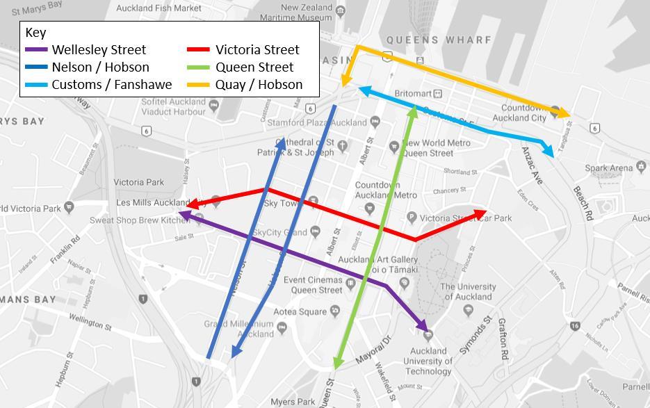
26.9 For the purposes of this condition, the following are the specified routes:
(a) Wellesley Street (between Victoria Street and Princes Street)
(b) Victoria Street (between Wellesley Street and Princes Street)
(c) Customs Street/Fanshawe Street (between Nelson Street and Tangihua Street)
(d) Quay Street/Lower Hobson Street (between Fanshawe Street/Hobson Street and Tangihua Street)
(e) Nelson Street/Hobson Street (between Pitt Street and Fanshawe Street)
(f) Queen Street (between Mayoral Drive and Customs Street)
(g) New North Road/Symonds Street (between Dominion Road and Newton Road)
Section 5 and 7
Section 5 and 7
Section 5 and 7
Section 5 and 7
Section 5 and 7
Section 5 and 7
Section 5 and 7
Section 5 and 7
Section 5 and 7
Section 5 and 7
Section 5 and 7
(h) Mount Eden Road (between Normanby Road and Symonds Street) Section 5 and 7
(i) Khyber Pass Road between the southern motorway ramps and Symonds Street if this route is to be used by construction related trucks
(j) Newton Road between the north western motorway ramps and Symonds Street
26.10 The specified routes shall exclude whichever east-west route has its intersection with Albert Street closed at the time of the surveys.
Section 5 and 7
Section 5 and 7
Noted.
27 Transport, Access and Parking: Specific Requirements (Britomart to Mayoral Drive)
27.1 To achieve the objective in Condition 25, the following measures shall be implemented:
(a) A vehicle access lane at least 3m wide shall be provided along the eastern side of Albert Street between Customs Street and Victoria Street to provide access to properties (except that while the Albert Street/Victoria Street intersection is closed, this access lane is only to be provided between Customs Street and Durham Street); Section
(b) A vehicle access lane at least 3m wide shall be provided along the western side of Albert Street between Customs Street and Victoria Street to provide access to properties, except that: Section 4.2
(i) While the Albert Street/Customs Street intersection is closed, this access lane is only to be provided between Victoria Street and Wolfe Street; and
(ii) While the Albert Street/Victoria Street intersection is closed, this access lane is only to be provided between Kingston Street and Customs Street. If Kingston Street is also to be closed to Albert Street during this construction stage, this access lane shall be provided between Wyndham Street and Customs Street;
(iii) For a single period of up to 3 months while the cut and cover trench structure establishment works are carried out along Albert Street between Swanson Street and Customs Street, this access land is only required to be provided between Victoria Street and Swanson Street if northbound traffic is otherwise diverted via Swanson Street West and Federal Street; and
Noted.
Noted.
Not applicable.
(iv) For a single period of up to 10 months while the public realm reinstatement works are carried out along Albert Street between Wyndham Street and Wolfe Street, this access lane is only required to be provided between Victoria Street and Swanson Street if northbound traffic is otherwise diverted via Swanson Street West and Federal Street. Not applicable.
(c) The east-west / west-east connection (two fully operational traffic lanes in each direction) is to be maintained in each direction at two of the Customs Street, Victoria Street and Wellesley Street intersections with Albert Street during the period when the third of those intersections is otherwise fully closed;
(d) The left turn movement from Customs Street (from the east) into Albert Street, and the left turn from Customs Street (from the west) into Albert Street, shall be retained while the Albert Street / Customs Street intersection is fully closed;
(e) The left turn from Durham Street into Queen Street shall be reopened while the Albert Street/Victoria Street intersection is fully closed;
(f) Two way access shall be provided on the single service lane along the western side of Albert Street between 87 Albert Street and Kingston Street while the Albert Street/Victoria Street intersection is fully closed; If Kingston Street is also to be closed to Albert Street during this construction stage, this access shall be provided to Wyndham Street;
(g) Vehicular access into and egress from:
Section 4.2
Not Applicable
Not Applicable
Section 4.2.3
(i) Mills Lane to and from either Albert Street or Swanson Street; and Not applicable
(ii) The Stamford Plaza Auckland main entrance and forecourt area is to be provided at all times and for the avoidance of doubt cannot be temporarily closed during construction.
(h) Providing pedestrian and cycle access to private property at all times; Sections 6.1.1, 6.1.2, 6.2.1 6.2.2, 6.3.1, 6.3.2, 6.4.1, 6.4.2, 6.5.1 and 6.5.2
(i) Providing footpaths of at least 1.5m in width along either side of Albert Street; Section 4.2
(j) At a minimum two safe crossing passageways (which are “fully accessible” with a minimum width of 1.5m wide and well lit, need to be provided in the vicinity of Swanson Street and Wyndham Street, in addition to pedestrian crossings at the intersections of Victoria Street and Customs Street; and
(k) Ensuring that construction traffic does not use Swanson Street, Wolfe Street or Federal Street north of Swanson Street;
(l) During the Kingston Street closure, pedestrian access to and from the Auckland District Court’s fire escape on the north side of Kingston Street shall be maintained at all times; and
(m) 18 metres of on street parking within Kingston Street shall be reserved for police at the nearest practicable location.
27.2 The Traffic, Access and Parking DWP shall demonstrate how these measures will be implemented and shall also include the following:
(a) How construction works will be undertaken to mitigate congestion on Albert Street, Wellesley Street, Victoria Street, Customs Street, and Quay Street including retaining east-west traffic movements across Albert Street on Customs Street, Victoria Street and Wellesley Street;
(b) The timing and sequencing of temporary road lane reductions and / or closures, and the alternative routes and temporary detours to be used, including:
(i) How these have been selected and will be managed to, where practicable, mitigate congestion on the surrounding road network;
Section 4.2
Section 0 and 0
Section 6.3.2
Section 3.1.2 and 6.3.5
Section 4.2
Section 4.2
Section 4.2
(ii) How the Albert Street/Wyndham Street intersection will be reopened as soon as practically possible; Not applicable.
(c) How disruption to the use of private property located immediately adjacent the designation with access onto Galway Street, Tyler Street, Queen Elizabeth Square, Customs Street, Albert Street, Kingston Street, will be mitigated through:
(i) Providing vehicle access to private property as practicably possible at all times;
(ii) Retaining local vehicle access to properties located along Albert Street (which may include only left in, left out access);
Section 4.2 and Sections 6.1.2, 6.2.2, 6.3.2, 6.4.2 and 6.5.2
Section 4.2
(iii) Retaining access for loading and unloading of goods located along the service lane on the eastern side of Albert Street, between Victoria Street and Wellesley Street; and; Section 4.2
(iv) Providing an on street loading bay on Customs Street, Lower Albert Street or Lower Queen Street to provide servicing to 21 Queen Street if access during construction cannot be provided to the existing loading bay area for 21 Queen Street, accessed from Lower Albert Street; and;
Not applicable.
(v) Providing access for loading and unloading of goods between Wyndham Street and Victoria Street West. Sections 6.1.5, 6.2.5, 6.3.5, 6.4.5 and 6.5.5
(d) How disruption to the use of the local road network will be mitigated for private bus users, pedestrians and cyclists through:
(i) Providing, where practicable, for the continued operation of private bus operators from hotels and other pick up / drop off locations in the city centre area (cross references to the Communication and Consultation Plan for consulting with private bus operators shall be included in the CEMP and Traffic, Access and Parking DWP); and
(ii) Retaining pedestrian and cycle access through Lower Queen Street and / or Queen Elizabeth Square to provide access to and from the Ferry terminal and Customs Street; and
(e) How disruption to pedestrians and cyclists requiring the ability to cross from east to west (and vice versa) across Albert Street between Victoria Street and Customs Street can be mitigated through providing, where practicable, safe pedestrian and cyclist passageways across the construction works on Albert Street.
Section 4.2
Not applicable.
The Link Alliance is seeking an Infrastructure Sustainability Council of Australia (ISCA) Infrastructure Sustainability (IS) Rating. Further details can be found in the CEMP and Sustainability Rating Management Plan. In some cases, the IS requirements and sustainability goals enhance the designation and consent requirements.
This TAP DWP is a live document that will be reviewed at least annually, or as a result of a material change to the project, or to address unforeseen adverse transport effects arising from construction, or unresolved complaints. Any material changes to this DWP must be approved by Auckland Council prior to any on-site activity reliant upon the change commencing. Refer to Section 6.7 of the CEMP for further detail on the review and updating process.
The Aotea Station main works will involve three main phases of work. Each phase of work involves multiple construction activities undertaken throughout the Aotea project site. The phases associated with the Aotea Station main works involve:
• Foundation works to form the perimeter walls of the station box and underground running tunnels. This involves diaphragm wall construction, roof construction, piling and jet grouting;
• Construction of the Aotea Station platforms, main station structure, concourse, entrance structures and Plenum, and;
• Structural fitout of the Aotea Station including MEFH installation, and internal and architectural finishings.
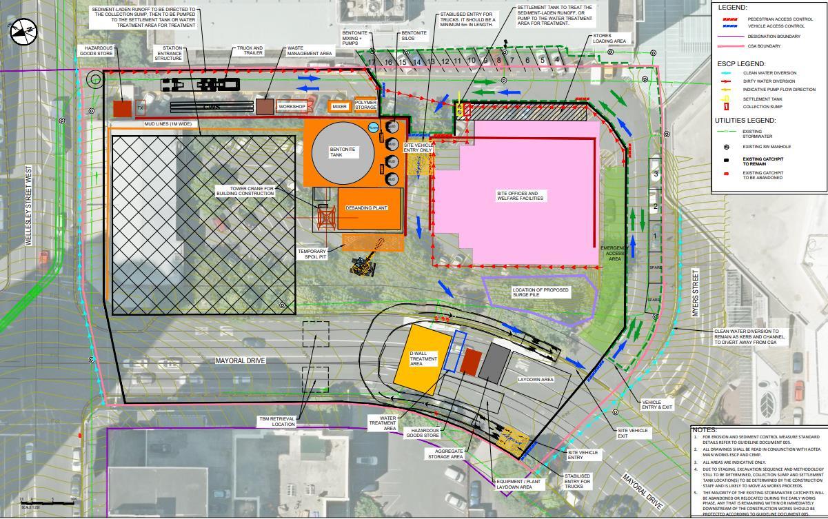
The works require the operation of a Construction Support Area (CSA) within the Bledisloe House car park site and a portion of Mayoral Drive. Equipment used to undertake these works will be predominantly situated in the CSA. Upon completion of the Aotea Station main works, the area will be repurposed in preparation for public realm reinstatement works2
The methodology for the construction of the Aotea Station is predominantly based on a ‘top down’ and ‘bottom up’ approach. The ‘top down’ approach relates to the southern end of Albert Street (south of Durham Street) and involves the installation of the ‘roof structure’ early on, which enables a limited number of traffic lanes to operate concurrently with the construction of the station, which occurs beneath. This approach reduces the construction effects on traffic flow within the city centre. The tunnel alignment on the northern end of Albert Street (north of Durham Street) will be constructed using a ‘bottom up’ methodology.
A detailed description of the Aotea Station main works is included in the CEMP and includes;
• an overview of the works including indicative timeframes in Table 2-1.
• the construction sequencing including equipment and earthworks volumes for the works in Table 2-2.
• further detail of the CSA in Section 2.6.2 of the CEMP. Drawings indicating the staging of the construction activities and proposed layout of the CSA is provided as Appendix B.
It is noted that public realm reinstatement works and details of architectural finishings for the Aotea Station (Condition 47 – 54 of Designation 2500-1), will form part of separate Outline Plan packages to be prepared in the future prior to the commencement of the respective works2 .
The Aotea Station main works are anticipated to take approximately 45 months to complete, occurring from April 2020 to December 2023 (approximately) as detailed in Table 2-1 in Section 2.2 of the CEMP. Some construction activities outlined in each phase of the Aotea Station main works will occur in parallel.
The construction workforce required for the Aotea Station main works will vary over the duration of the works, however it is expected to peak at approximately 300 staff.
12 carparks for the workforce will be provided within the site office at 44-54 Wellesley Street West, and no parking will be provided within the construction support area at Bledisloe House carpark. The majority of workers will need to either park within nearby public parking buildings or travel via other transport modes. Vehicle access to construction zones will be restricted to plant and material delivery, spoil removal and service vehicles.
Workforce vehicle trips will be minimised by use of public transport, carpooling and off-peak shift starts and ends (construction hours of 0700hrs – 1900hrs). The project workforce will be provided with public transport travel information and encouraged to carpool where practical. Further details will be specified in the Workforce Travel Management Plan that will be developed and the workforce briefed prior to works start. The limited amount of parking provided in the Project area, along with the implementation of the Workforce Travel Management Plan will serve to help ease congestion generated by the workforce in the main works area.
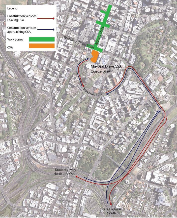
The construction support area (CSA) will primarily be located in the Bledisloe House carpark at 2 – 10 Wellesley Street West, at the intersection with Albert Street. The CSA will be accessed from Mayoral Drive and is shown in Error! Reference source not found. The CSA will allow for a number of site v ehicle movements as well as vehicle movements of visitors to the Auckland Council car park. Error! Reference source not found. shows that visitors to the Auckland Council car park will have entry and exit out of the Bledisloe carpark via the green arrows. Small site vehicles will have a one-way movement through the site, entering from the Bledisloe Carpark and will proceed one-way through the CSA exiting onto Mayoral Drive. Spoil removal vehicles will follow a smaller loop entering and exiting on to Mayoral Drive.
The CSA will contain the following:
• Offices
• Storage
• Changing rooms, toilets, showers and bike storage
• Lunchroom/kitchen
• Evacuation and briefing area
• Bentonite Plant and associated equipment
• Surge Pile
All vehicle movements related to the Surge Pile will be managed on-site using a gateman and/or TC to ensure all vehicle access into Bledisloe Carpark is unimpeded. Figure 2-1 shows the extent of the surge pile in purple, and allowances for vehicle movements within the site compound fence around the surge pile have been made.
For the purposes of this TAP DWP, the existing condition of the street layout assumed at commencement of the Aotea Station main works are those that exist at the last stage of the Aotea early works and utility relocations (Stage 5).
Table 3-1 outlines the road classification according to the Auckland Unitary Plan (AUP) and the Annual Average Daily Traffic (AADT) of the roads surrounding the Aotea Station construction area.
Table 3-1: Road Classifications and AADT
2019 Wellesley Street West
Durham Street West Local Road No data
There are several signalised intersections in the vicinity of the works that provide for traffic and pedestrian movements:
• Victoria Street West and Albert Street
• Victoria Street West and Federal Street
• Victoria Street West and Elliott Street
• Wyndham Street and Albert Street
• Wellesley Street West and Albert Street
• Wellesley Street West and Elliott Street
• Wellesley Street West and Federal Street
Albert Street contains a slip lane which runs between Wyndham Street and Victoria Street West, and a service lane which runs between Victoria Street West and Wellesley Street West (below Crowne Plaza). Both run one-way from north to south.
The Albert Street and Wellesley Street West intersection however, will be closed to vehicle traffic due to the Aotea early works for around six months. Traffic will still be permitted along the Albert Street service lane (below Crowne Plaza), and vehicles will be able to exit via a left turn onto Wellesley Street West.
Kingston Street provides one-way traffic movements from west to east. Durham Street West (between Durham Lane and Queen Street) is also one-way running from east to west.
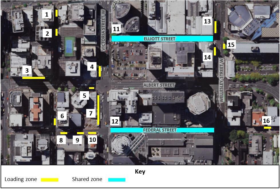
On Albert Street, parking is prohibited within the area subject to works, with the exception of a loading zone on the northern section of the Albert Street slip lane. This slip lane runs on a lower grade on the eastern side of Albert Street (adjacent to the Bluestone Wall) for a distance of approximately 120m, providing access to and from Durham Street West
On Victoria Street West (west of Albert Street), parking is prohibited except for a loading zone on the northern side and a bus stop on the southern side. Victoria Street West (east of Albert Street) has a loading zone (approx. 18m), car share parking and on-street paid parking on the northern side, while the southern side contains a bus stop.
On Wellesley Street West (between Federal Street and Elliott Street), all parking will be prohibited due to the closure of the Wellesley Street West/Albert Street intersection during the Aotea early works.
On Mayoral Drive, parking is prohibited in the area subject to the works.
The southern side of Kingston Street (between Federal Street and Albert Street) contains a loading zone. On both sides, the remainder of Kingston Street has on-street paid parking available.
Approx. 18m of police parking has been relocated to the northern side of Kingston Street, west of Federal Street in accordance with CRL designation condition 27.1 (m). This relocated parking will not be affected by the Aotea Station main works or any future CRL works.
The loading zone provisions are illustrated in Figure 3-1, and there are eleven loading zones and two shared spaces in the vicinity of the Aotea Station works area. The details of these are summarised below:
• 1, 2 – Durham Street, two 15m loading zones.
• 3 – Albert Street slip lane, 40m
• 4 – Victoria Street West, 18m loading zone
• 5 – Albert Street, 8m loading zone
• 6 – Kingston Street, 14m
• 7 – Victoria Street West (west of Albert Street), 40m loading zone
• 8, 9, 10 – Federal Street, three 12m loading zones
• 11 – Elliott Street, shared space
• 12 – Federal Street (between Victoria Street West and Wellesley Street West), shared space
• 13 – Wellesley Street West, 16m loading zone
• 14 – Wellesley Street West, 12m loading zone
• 15 – Wellesley Street West, 8m loading zone
• 16 – Federal Street, 10m loading zone
(Note: these measures are approximate )
The loading zones have a maximum five-minute stay duration (LZ5), and the shared zones can be used as a loading zone from 0600 – 1100 hrs. Loading zone #14 is not currently in place but will be implemented as part of the Aotea early works to supplement the loading zone availability in the area.
Due to the closure of the Wellesley Street West/Albert Street intersection during the Aotea early works, buses will be rerouted off Wellesley Street West and onto other east-west corridors. It will remain this way prior to the commencement of Aotea Station main works. Auckland Transport (AT) is planning and managing these diversions in conjunction with their bus operators
A full campaign of communication with the community and public transport users is already underway by AT and CRLL. This will provide detailed information about changes to bus routes, bus stops and timetables well in advance of the changes occurring.
3.2.1.
Albert Street, Wellesley Street, Victoria Street West, Mayoral Drive and Kingston Street all have footpaths along both sides of the road. The footpaths affected by the proposed Aotea Station main works serve three main functions:
• Access function: Providing access to properties located along these roads
• Through function: Providing a through route for pedestrians to walk to destinations in other areas
• Public transport function: Provide access to/from public transport facilities, including providing waiting space for public buses
The footpaths on these roads and adjacent to the work zones are not observed to provide much of a place function, as there are no facilities provided for pedestrians to linger and interact. In addition, current CRL construction works have already reduced the width of some footpaths in the area and hence limited space is available for this function
A signalised Barnes Dance pedestrian crossing is located at the Wyndham Street/Albert Street intersection and the Victoria Street West/Albert Street intersection.
The Wellesley Street West/Albert Street intersection will be closed to vehicle traffic prior to the commencement of the Aotea Station main works, however full pedestrian access across the intersection will be maintained.
There are few dedicated cycling facilities in the immediate area of works. There are cycle advance stop boxes on the Victoria Street approaches to the Victoria Street West/Albert Street intersection, as well as cycle advance stop boxes on both sides of the pedestrian crossing located 85m east of the same intersection.
Federal Street (south of Victoria Street West) and Elliott Street are shared use environments and a protected cycle lane is provided on Federal Street (between Victoria Street West and Wyndham Street).
Other streets in the area do not have any dedicated cycling facilities.
This TAP DWP has been developed in general accordance with the traffic management approach outlined in the CRL designation conditions, as well as with AT’s Code of Practice (ATCoP) and the New Zealand Transport Agency (NZTA) Code of Practice for Temporary Traffic Management (CoPTTM)
In practical terms, this means providing for the connectivity and access described in the designation conditions wherever and whenever possible, and in particular for main road movements. Additional turn bans or changes to connectivity or access have been restricted to those imposed by safe operational practice, and geometric or spatial constraints for traffic management.
The modal priorities adopted by this TAP DWP are:
1. Active transport
2. Public transport
3. Freight, service vehicles, couriers and taxis
4. Private vehicles (including construction traffic)
Within CoPTTM, Albert Street, Wellesley Street West and Victoria Street West are classified as Level 2LS (low speed) roads. The traffic management measures proposed in this DWP have been developed accordingly.
In addition, the traffic management methods outlined below have been developed to be commensurate with the nature and scale of the main works construction activities and the expected effects on the transport network.
The main works for the construction of Aotea Station will be undertaken in a number of construction phases over a period of approximately 3.5 years from Q2 2020 to Q4 2023 (Refer to the CEMP for more detail).
Long term Temporary Traffic Management Plans (TMP’s) will be implemented for each traffic stage of the works. Across all the traffic stages , the work zones will occupy most of Albert Street (between Wellesley Street West and Wyndham Street), Wellesley Street West (between Elliott Street and Federal Street) and Victoria Street West (between Elliott Street and Federal Street).
Pedestrian routes (with a minimum width of 1.5m) will be maintained along the frontage of buildings where possible, or by providing a protected pedestrian passageway through the work zone. Where practical, TMP’s will ensure that all pedestrian routes meet accessibility requirements, with appropriate ramps and gradients for all users. Full pedestrian access across the Wellesley Street West/Albert Street intersection and Victoria Street West/Albert Street intersection will be maintained. Traffic management areas interfacing with pedestrian crossing points will widen to cater for the crossing demand as required during the works.
Wayfinding signage will be provided at junctions along the key pedestrian routes through the work area. Where appropriate, additional information will be provided on the location and operation of
specific buildings or businesses (refer to the main works Social Impact and Business Disruption Delivery Work Plan (SIBD DWP) for further detail in this regard).
The traffic management features are separated into 5 general stages, which have similar effects for traffic and for stakeholders in the area. However, within each of the 5 stages, there will be substages to facilitate the construction. The five stages are detailed in the sections below and shown in Appendix G.
This traffic stage will occur from April 2020 – July 2020. Traffic management features are as follows:
• Albert Street (between Wyndham Street and Victoria Street West) will be open to traffic, maintaining one lane northbound and one lane southbound (using the Durham Street slip lane), maintaining an access lane along the eastern side of Albert Street. This is in adherence with CRL designation condition 27.1 (a)
• Vehicle access to the two driveways at 87-89 Albert Street will be maintained with a left-in movement and a left-out towards Wyndham Street.
• The Wellesley Street West/Albert Street intersection will remain closed to traffic, however the Victoria Street/ Albert Street intersection will be open to traffic with two lanes in each direction The Customs Street/ Albert Street intersection (not part of C3 project area) will also be open to traffic with two lanes in each direction. This is in adherence with CRL designation condition 27.1 (c).
• Access to the Albert Street service lane (below Crowne Plaza) will generally be maintained with exit via a left-out onto Wellesley Street West. For a period of four weeks access to the service lane will be in and out via Wellesley Street under temporary traffic signal control.
• Entry to the Crowne Plaza forecourt and Atrium Carpark will be from Victoria Street West, and exit will be a right-out on Albert Street towards Victoria Street West. The entry/exit will be realigned.
• Access to the Sky City Premium Carpark is to be maintained, however discussions are ongoing regarding other mitigation methods.
• Access to the Manhattan Apartments Carpark is to be maintained, however discussions are ongoing regarding the temporary relocation of the carparks.
• Vehicle access to the carpark located at 44-54 Wellesley Street West will be maintained throughout the closure of the Wellesley Street West/Albert Street intersection.
• Kingston Street (between Federal Street and Albert Street) will be closed to vehicle traffic for a period of time during this phase, but access to properties will be maintained.
This traffic stage will occur from August 2020 – February 2021 Traffic management features are as follows:
• Albert Street (between Wyndham Street and Victoria Street West) through traffic movement function will be closed to traffic, except for local access The Albert Street slip lane will be reversed again during this closure, with all traffic for Durham Lane West entering via Queen Street and exiting via the slip lane to the Albert Street and Wyndham Street intersection.
• Vehicle access to the two driveways at 87-89 Albert Street will be maintained with a right-in and a left-out towards Wyndham Street.
• The Wellesley Street West/Albert Street intersection will remain closed to traffic, as is the case during traffic stage 1. The Victoria Street/ Albert Street intersection will be open to traffic with two lanes in each direction. The Customs Street/ Albert Street intersection (not part of C3 project area) will also be open to traffic with two lanes in each direction. This is in adherence with CRL designation condition 27.1 (c).
• Access to the Albert Street service lane (below Crowne Plaza) will be maintained with exit via a left-out onto Wellesley Street West.
• Entry to the Crowne Plaza forecourt and Atrium Carpark will be from Victoria Street West, and exit will be a right-out on Albert Street towards Victoria Street West. The entry/exit will be realigned.
• Access to the Sky City Premium Carpark is to be maintained, however discussions are ongoing regarding other mitigation methods.
• Access to the Manhattan Apartments Carpark is to be maintained, however discussions are ongoing regarding the temporary relocation of the carparks.
• Vehicle access to carpark located at 44-54 Wellesley Street West will be maintained throughout the closure of the Wellesley Street West/Albert Street intersection.
At the end of traffic stage 2, there will be a short transition period to allow for the changeover between the Wellesley Street/Albert Street intersection closure and the Victoria Street/Albert Street intersection closure. This will occur around January 2021 – February 2021. The purpose of this is to allow AT to move the bus routes from Victoria Street West to Wellesley Street
4.2.3.
This traffic stage will occur from February 2021 – August 2021. Traffic management features are as follows:
• Kingston Street (between Federal Street and Albert Street) will be closed to vehicle traffic for a period of time during this traffic stage, but access to properties will be maintained.
• Albert Street (between Victoria Street West and Wyndham Street) will facilitate one lane in each direction, with southbound movement via the Durham Street slip lane. A turning head will be located at the Victoria Street West end due to the closure of the Victoria Street/ Albert Street intersection.
• Vehicle access to the two driveways at 87-89 Albert Street will be maintained with entrance from the Albert Street slip lane and utilising the turning head at Victoria Street West.
• The Victoria Street West/Albert Street intersection will be closed to through traffic, however access to the Albert Street service lane below the Crowne Plaza will be maintained.
• Access to the Manhattan Apartments Carpark is to be maintained from Victoria Street West, however discussions are ongoing regarding the temporary relocation of the carparks.
• The Wellesley Street West/Albert Street intersection will be open to eastbound and westbound movements with two lanes in each direction along Wellesley Street West. The Customs Street/ Albert Street intersection (not part of C3 project area) will also be open to traffic with two lanes in each direction. This is in adherence with CRL designation condition 27.1 (c).
• Entry to the Crowne Plaza forecourt will be from Victoria Street West, and exit will be a leftout on Albert Street towards Wellesley Street West.
• Access to the Sky City Premium Carpark is to be maintained with access from Wellesley Street West, however discussions are ongoing regarding other mitigation methods.
Traffic stage 4 will take place as a continuation from traffic stage 3 from August 2021 – April 2022. It will include the following:
• Kingston Street (between Federal Street and Albert Street) will be reopened.
• Albert Street (between Victoria Street West and Wyndham Street) will facilitate one lane in each direction, with southbound movement on the slip lane. A turning head will be located at the Victoria Street West end.
• Vehicle access to the two driveways at 87-89 Albert Street will be maintained with entrance from the Albert Street slip lane and utilising the turning head at the intersection with Victoria Street West.
• The Victoria Street West/Albert Street intersection will be closed to through traffic, however access to the Albert Street service lane will be maintained late in this traffic stage. A single eastbound lane on Victoria Street West will be opened once works are complete, to allow this to occur
• Access to the Manhattan Apartments Carpark is to be maintained, however discussions are ongoing regarding the temporary relocation of the carparks.
• The Wellesley Street West/Albert Street intersection will continue to be open to eastbound and westbound movements with two lanes in each direction along Wellesley Street West. The Customs Street/ Albert Street intersection (not part of C3 project area) will also be open to traffic with two lanes in each direction. This is in adherence with CRL designation condition 27.1 (c).
• Entry and exit to the Crowne Plaza forecourt will be from Wellesley Street West – no access from Victoria Street West.
• Access to Sky City Premium carpark will be from Wellesley Street West – there will be no access from Victoria Street West.
4.2.5. Traffic Stage 5 (long term set up)
Traffic stage 5 is the final traffic stage of the Aotea Station main works This traffic stage will have the longest effect on street layout for traffic management lasting around 18 months (April 2022 –December 2023). The traffic management features are outlined below:
• Albert Street (between Victoria Street West and Wyndham Street) will facilitate one lane in each direction, with southbound movement on the slip lane. One lane in each direction will be maintained on the section between Victoria Street West and Wellesley Street West.
• Vehicle access to the two driveways at 87-89 Albert Street will be maintained with entrance from Victoria Street West and exit towards Wyndham Street.
• Victoria Street West (between Federal Street and Elliott Street) will have vehicle movements reinstated with one lane in each direction.
• The Wellesley Street West/Albert Street intersection will continue to be open to eastbound and westbound movements with two lanes in each direction along Wellesley Street West. The Customs Street/ Albert Street intersection (not part of C3 project area) will also be open to traffic with two lanes in each direction. This is in adherence with CRL designation condition 27.1 (c).
• The Albert Street service lane (below Crowne Plaza) will be open with access from Victoria Street West.
• Access to the Manhattan Apartments Carpark is to be maintained, however discussions are ongoing regarding the temporary relocation of the carparks
• Entry to the Crowne Plaza forecourt will be from Victoria Street West end only and exit will be towards Wellesley Street West.
• Access to Sky City Premium carpark is to be maintained with entrance from Wellesley Street West and exit towards Victoria Street West, however discussions are ongoing regarding other mitigation methods
The Aotea Station main works will generate different types of construction traffic. The types of vehicles that will be expected to access the work site include:
• Concrete Truck – sizing varies between 5m3 and 8m3
• 6-wheeler trucks – 6m3
• Truck and Trailer for spoil removal – 12m3
• Material delivery vehicles – various sizes
• Other contractor vehicles – various sizes
Refer to Section 2.5 for the access point for trucks into and out of the CSA Conflicts between pedestrians, private vehicles and construction activity at each access point will be managed by a Traffic Controller (during active site hours) and detailed within the TMPs. Traffic movements are designated under the hours of operation for 0700 hrs - 1900 hrs, Monday to Saturday. Additional operation may be performed outside these hours subject to compliance with construction restrictions, conditions and requirements.
Construction Traffic has been calculated on an ‘on average’ basis. Due to this, daily or hourly expected vehicles are an approximate number. Sections 4.3.1, 4.3.2 and 4.3.3 below outline the construction traffic predictions for concrete delivery trucks, spoil removal trucks and other site delivery vehicles respectively.
Concrete will be delivered directly to the pour site. Deliveries will occur over the working day, Monday to Saturday, however some deliveries may occur before the start of the working day as required.
Traffic stages 1 – 3 will have more concrete deliveries compared to traffic stages 4 – 5 due to the construction of the diaphragm and piled walls and roof slab. The roof slab will be the largest pour of concrete (250m3) and will require 42 – 44 concrete trucks. The roof slab will be poured in 10m sections to prevent cracking of the concrete and the trucks will take 12 – 15 minutes to unload. The worst-case scenario for truck numbers due to concrete delivery will be 5 – 6 concrete truck deliveries (10 – 12 movements) per hour.
Throughout the duration of the Aotea station construction approximately 361,000 tonnes of spoil will be removed from the site area.
Spoil removal will require two types of movement:
1. Movement of spoil from excavation site to the CSA surge pile (by 6-Wheeler trucks).
2. Removal of spoil to an offsite location (by Truck and Trailer).
Excavation will occur under 4 activities:
1. Road surface
2. Diaphragm wall
3. Roof slab (2m deep)
4. Bulk excavation
Traffic stages 3 – 5 from early 2021 to late 2023 will support the bulk excavation which will generate the greatest amount of spoil removal (this is the worst case for truck movements). It should be noted that when the excavation is happening at Victoria Street West, spoil may be transported straight onto the State highway, rather than via the CSA surge pile to prevent double handling.
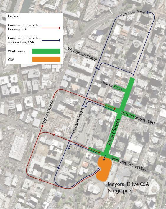
Three 6-wheeler trucks will be used to transfer spoil from the point of excavation to the CSA surge pile. Hobson Street will primarily be used to transport the spoil to the Mayoral Drive CSA. Total trips will be between 9 – 12 per hour (18 – 24 movements). This is based on one truck taking 20 minutes to complete a round trip during peak period and 15 minutes to complete a round trip in the interpeak period. These timings have taken into consideration loading and unloading time of the construction vehicles and the time taken to pass through a number of signalised intersections (dependent on which route is being taken). The routes that trucks can take to transfer spoil to and from the CSA are shown in Figure 4-1
It should be noted that:
• Routes being used by construction vehicles will be subject to the active work zone at the time
• The use of Albert Street between Wyndham Street and Fanshawe Street will be limited as much as practicable until the completion of the CRL Contract 2 in late 2020.
• Although not an arterial or specifically mentioned as a permitted route, Wyndham Street will be used as a route by construction vehicles to reduce longer trips on Albert Street. There are no adverse effects associated with this.
4.3.2.2. Removal of spoil off site (from CSA)
Truck and trailers will be used to transfer spoil from the Mayoral Drive CSA to the tip sites. It is predicted that approximately 300 – 400m3 of spoil will be transferred to the surge pile per day and hence the same volume will be available to be transferred from the surge pile to the tip sites. The tip sites are estimated to be up to a two-hour round-trip including loading and unloading of the spoil and will be located at various points across the Auckland region. Refer to Section 4.3.4 for the proposed haulage routes for spoil to access the State Highway network. Subsequently, the worstcase scenario will be approximately 33 truck and trailers arriving at the site per day which is 3 vehicles an hour over a 10-hour period (6 vehicle movements), noting that this will be dependent on the availability of truck and trailers.
There will be large deliveries such as precast material and reinforcement. These types of deliveries are expected to be low frequency. It is also expected that the site will have 2 – 3 delivery trucks / vans within the work zones per day. These vehicles will also accommodate picking up of equipment and/or visits from site engineers.
Access is required to the works area from the State Highway network. The routes which construction vehicles will take when arriving or leaving the Aotea work area and CSA are shown in Figure 4-2. This route has been set to minimise the distance travelled on the local network.
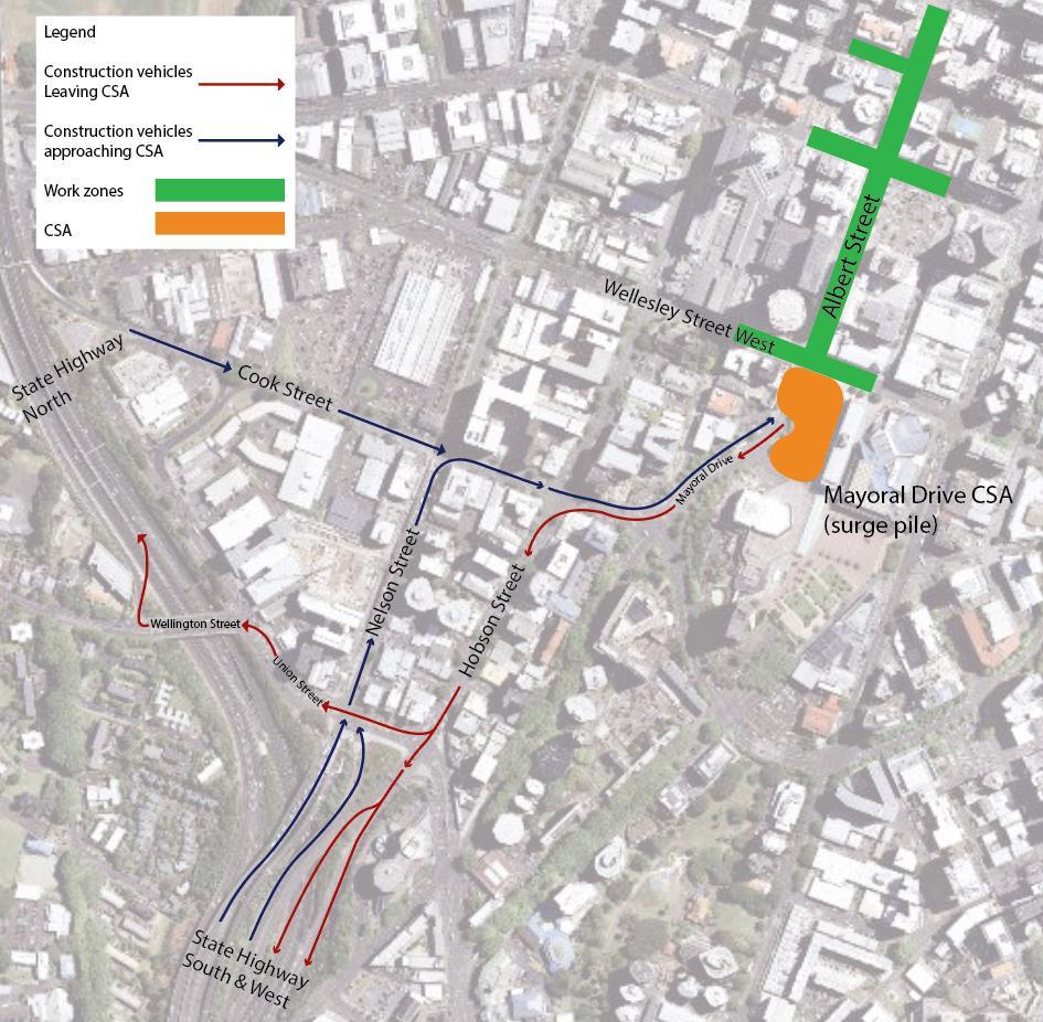
A secondary option has been identified to allow for an alternative path in the event of a traffic incident or other event blocking access to and from the primary route. This will be using Mayoral Drive and Wellesley Street East to access the State Highway network as shown in Figure 4-3.
Overall, the predicted volume of construction traffic generated by the Aotea Station main works is expected to have a small impact on the overall network. The greatest volume of construction traffic during the works is expected to occur in traffic stage 4, in which an upper bound of 320 vehicles are
predicted to be generated by the works. This will average approximately 32 vehicles per hour. It should be noted that this is only during the busiest traffic stage of the project and construction traffic throughout the Project will fluctuate on a day to day and week by week basis The predictions of the worst case for construction traffic volumes as a result of Aotea Station main works is outlined in Table 4-1:, for each traffic stage of works.
Table 4-1: Construction traffic predictions for each Traffic management stage
Stage 5
On-site parking will be provided for the loading/unloading of equipment, materials, spoil and for other essential vehicles. These areas will be provided within the work site and within the CSA Workforce parking is not included within this, and workforce parking will otherwise be provided by way of twelve spaces within the site office compound at 44-54 Wellesley Street.
5.1.1.
The purpose of this modelling section is to present the steps undertaken to assess the potential transport impacts, and particularly the proposed temporary traffic management as a result of the Aotea Station main works Victoria Street Closure.
The Main Works construction associated with the Aotea Station has four modelling scenarios and includes various committed projects across the City in each traffic stage of work as and when they occur. This includes detailing the impacts associated with the closure of the Wellesley Street/Albert Street intersection and the Victoria Street/Albert Street intersection, as well as the wider changes to network caused by the works on the surrounding areas to these two intersections.
The modelling scenarios are divided into 4 phases of work occurring subsequently. The four scenarios are aligned with the traffic management stages as outlined below:
• Scenario 1: This aligns to Traffic Stage 1 of the traffic management layout.
• Scenario 1a: This aligns to Traffic Stage 2 of the traffic management layout.
• Scenario 2: This aligns to Traffic Stage 3 of the traffic management layout.
• Scenario 3: This aligns to Traffic Stage 4 of the traffic management layout.
• Scenario 4: This aligns to Traffic Stage 5 of the traffic management layout.
5.1.2.1. Scenarios
The Reference Case includes existing infrastructure provision (including committed schemes) and the latest bus routing, but additionally includes the network changes expected to take place at least in part during the same time as the closure of the Wellesley Street Intersection and Albert Street Utility and Aotea Station main works.
The Auckland City Centre SATURN 20183 model was used as a base for this assessment. All other committed projects are included in this model. The Reference Model reflects the modifications listed below:
(i) Karangahape Road construction works between Ponsonby Road and Symonds Street were included to reflect streetscape construction work on Karangahape Road4
(ii) Symonds Street/Karangahape Road intersection to reflect Karangahape Road Cycleway construction complete5 were included.
3 Received the Auckland City Centre SATURN 2019 from Flow Transportation Specialists on 13/08/2019
4 Received the AFC_K_Road_Modelling_Update_TMP_PhasesAandF_v2 model from AFC on 20/08/2019.
5 Received an updated layout for K’Rd/Symonds St junction from AFC on 23/08/2019
(iii) Corrected inconsistent distances6 from ‘2018 Base model’ and “AT K’Rd Streetscape TMP A & F” model on Karangahape Road.
(iv) Quay Street Enhancements which renders Quay Street 1 lane in each direction.
(v) Reduction of traffic lanes on Pitt Street and closure of Beresford Square towards Pitt Street to reflect construction work associated with the Karangahape Station7 .
(vi) ICON construction at the Wyndham Street/Albert Street intersection8
(vii) Reversing Lower Albert Street to one lane southbound, with bus realignment to reflect planned work consented under the C2 works9 .
(viii) Closing the Wellesley Street/Albert Street intersection for general traffic as undertaken for the Aotea Station Stages 4 and 5 early works.
(ix) Bus diversions10 in response to buses not able to travel through the Wellesley Street/Albert intersection as provided by Auckland Transport.
(x) NZICC streetscape work on Hobson Street which reduces Hobson Street to one lane between Victoria Street and Wellesley Street
(xi) Freemans Bay TMP for Picton Street, Hepburn Street and Angelsea Street
The following projects were not included in the Reference Model, either due to the projects being deferred to a later date or due to network coding assumptions not being available at the time of this assessment:
(i) Auckland Transport bus prioritisation measures
(ii) Victoria Street cycleway between Hasley Street and Nelson Street
(iii) The signalisation of the Sale Street /Wellesley Street intersection
CRL Model Aotea Station Main Works Scenario 1 (with CRL temporary traffic management)
For the CRL Model Scenario 1 (with CRL temporary traffic management), the Reference Model above was used as a base for this assessment. The only network change introduced was the worst-case scenario listed below:
(i) Closing a southbound lane on Albert Street between Wyndham Street and Victoria Street.
(ii) Closing the car park exit on the east of Albert Street turning into Victoria intersection.
CRL Model Aotea Station Main Works Scenario 1a (with CRL temporary traffic management)
For the CRL Model Scenario 1a (with CRL temporary traffic management), the CRL Model Scenario 1 above was used as a base for this assessment. The only network change introduced was the worstcase scenario listed below:
(i) Partial Closure of Albert Street and Victoria Street intersection, with only a left turn from the Albert Street Slip lane allowed.
(ii) The closure of the northbound lane on Albert Street beyond the Victoria Street intersection.
6 Agreed corrections with Flow Transportation Specialists and AFC on 27/08/2019
7 Planned work submitted as part of TAP DWP for Karangahape Station Early Works
8 Assumed that ICON construction would operate as existing layout.
9 Extracted from Appendix 22.14 - TAP DWP Addendum Lower Albert (Dec 2019 to Aug 2020 Assumptions)
10 AT Bus route changes as per ‘2019-08-19 Bus Response Routes - Updated.xlsx’ received on 28/08/2019
The Reference Case includes existing infrastructure provision (including committed schemes) and the latest bus routing, but additionally includes the network changes, expected to take place at least in part during the same time as the closure of the Victoria Street Intersection and Albert Street Utility Works
The Auckland City Centre SATURN 201811 model was used as a base for this assessment. All other committed projects are included in this model. The Reference Model reflects the modifications listed below:
(i) Karangahape Road construction works between Ponsonby Road and Symonds Street were assumed complete and the final layout which reflects the streetscape on Karangahape Road12 was incorporated.
(ii) Symonds Street/Karangahape Road intersection to reflect Karangahape Road Cycleway construction complete13 were included.
(iii) Corrected inconsistent distances14 from ‘2018 Base model’ and “AT K’Rd Streetscape
TMP A & F” model on Karangahape Road.
(iv) Quay Street Enhancements which renders Quay Street one lane in each direction.
(v) Reduction of traffic lanes on Pitt Street and closure of Beresford Square towards Pitt Street to reflect construction work associated with the Karangahape Station15
(vi) ICON construction at the Wyndham Street/Albert Street intersection16
(vii) Reversing Lower Albert Street to one lane southbound, with bus realignment to reflect planned work consented under the C2 works17
(viii) Partial opening of the Wellesley Street/Albert Street intersection for general traffic in Scenario 2.
(ix) Bus diversions18 in response to buses not able to travel through the Victoria Street/Albert Street intersection as provided by Auckland Transport.
(x) Freemans Bay TMP for Picton Street, Hepburn Street and Angelsea Street.
(xi) Victoria Street cycleway between Hasley Street and Nelson Street, signalising the left turns onto Wellesley Street and Hasley Street.
(xii) Signalisation of the Sale Street/Wellesley Street intersection
(xiii) Albert Street Streetscape, C2 works from Wyndham Street to Swanson Street to Wolfe Street.
The Auckland Transport bus prioritisation project was not included in the Reference Model, either due to the projects being deferred to a later date or due to network coding assumptions not being available at the time of this assessment
11 Received the Auckland City Centre SATURN 2019 from Flow Transportation Specialists on 13/08/2019
12 Received the AFC_K_Road_Modelling_Update_TMP_PhasesAandF_v2 model from AFC on 20/08/2019.
13 Received an updated layout for K’Rd/Symonds St junction from AFC on 23/08/2019
14 Agreed corrections with Flow Transportation Specialists and AFC on 27/08/2019
15 Planned work submitted as part of TAP DWP for Karangahape Station Early Works
16 Assumed that ICON construction would operate as shown in Figure 2 below.
17 Extracted from Appendix 22.14 - TAP DWP Addendum Lower Albert (Dec 2019 to Aug 2020 Assumptions)
18 AT Bus route changes as per ‘2019-08-19 Bus Response Routes - Updated.xlsx’ received on 28/08/2019
CRL Model Aotea Station Main Works Scenario 2 (with CRL temporary traffic management)
For the CRL Model Scenario 2 (with CRL temporary traffic management), the Reference Model above was used as a base for this assessment. The only network change introduced in the Scenario are listed below:
(i) Complete Closure of Victoria Street/Albert Street Intersection except for a left turn movement from the eastern approach.
(ii) Providing a U-turn movement for the vehicles on the Albert Street slip lane.
(iii) Close Kingston Street between Federal Street and Albert Street
CRL Model Aotea Station Main Works Scenario 3 (with CRL temporary traffic management)
For the CRL Model Scenario 3 (with CRL temporary traffic management), the CRL Model Scenario 2 above was used as a base for assessment. The following network changes were made to Scenario 3 before comparison:
(i) Open left turn movement from Albert Street and Victoria Street
(ii) Open through movements from the western approach of Victoria Street
(iii) Open northbound lane on Albert Street (Partially)
(iv) Close Kingston Street between Federal Street and Albert Street
CRL Model Aotea Station Main Works Scenario 4 (with CRL temporary traffic management)
For the CRL Model Scenario 4, the CRL Model Scenario 3 above was used as a base for this assessment. The only network change introduced was the worst-case scenario listed below:
(i) Open left and through movements permitted in all the approaches at the Albert Street/Victoria Street intersection
(ii) Open the northbound lane between Wellesley Street and Victoria Street
(iii) Open the right-turn movement from Albert Street/ Albert Street Slip lane
(iv) Open Kingston Street between Federal Street and Albert Street
(v) One exit lane is provided each on the east and west approach
To isolate the potential impacts of the proposed works, the proposed traffic management measures included in the CRL Model Scenarios have been compared to the Base model Reference Cases for each scenario. The changes were quantified in the form of flow difference plots and journey time changes.
In the SATURN plots for scenarios 1 through 4 shown in Appendix A to E, the green bands indicate the increase in traffic flows between the Reference Case scenario and the Aotea Station main works CRL Scenario, while the blue lines indicate decreases in traffic flows (width proportional to the volume of change).
The flows displayed are what SATURN terms “demand” flows, which are the flow given by the assignment stage and corresponds to the total demand independent of when the flow arrives. In congested networks, these “demand” flows are higher than the “actual” flows
5.2.1.
The proposed temporary traffic management is predicted to result in traffic flow changes primarily on Albert Street, and minor re-routing in the immediate surrounding area such as Wyndham Street and Victoria Street as shown in the plots in Appendix A.
The modelling results for the morning peak shows:
• a decrease in traffic flows along the Albert Street southbound lane, due to the closure
• a corresponding increase in Albert Street slip lane traffic flows which accommodates the shift in traffic travelling south
• minor traffic rerouting to immediate surrounding routes
The modelling results for the evening peak shows:
• a reduction in traffic flows coming out of the Albert Street car park as a result of the closure
• more traffic along the slip lane to exit the car park
• a moderate increase in traffic flows along Wyndham Street which accounts for the traffic evading the closure.
As shown in Appendix B, the proposed temporary traffic management is predicted to result in minor traffic flow changes primarily on Victoria Street. Most of the rerouting occurs around Albert Street/ Victoria Street intersection to exit out of the carpark using the exclusive left turn movements.
The modelling results for morning peak shows:
• a minor decrease in traffic flows along Albert Street slip lane, since only left turn movement is permitted.
• a corresponding increase on the Victoria Street section between Albert Street and Queen Street.
• the traffic being reduced on the Victoria Street section between Hobson Street and Albert Street as a result of the prohibition of right turns. The through movements are banned in the earlier phase and doesn’t reflect much variation.
The modelling results for the evening peak shows:
• an increase in traffic flows on the Victoria Street eastbound section, majorly exiting the carpark on Albert Street.
• reduction in traffic on the westbound section between Albert Street and Hobson Street.
5.2.3.
The proposed temporary traffic management is predicted to result in a major decrease in traffic flow on Victoria Street, and a considerable increase in traffic on Albert Street and in the immediate surrounding areas such as Wyndham Street and Wellesley Street, as shown in Appendix C.
The modelling results for the morning peak shows:
• a significant decrease in traffic flows along Victoria Street, due to the intersection closure.
• an increase in vehicular movements taking U-turn from the Albert Street slip lane.
• increase in flows on Albert Street southbound and on east-west movements on Wellesley Street.
• minor rerouting on routes surrounding the areas of influence.
The modelling results for the evening peak shows:
• a reduction in traffic flows on Victoria Street like the morning peak due to the closure.
• increase in traffic flows on Albert Street and Wellesley Street.
• a large increase in vehicular movements taking U-turn from Albert Street slip lane.
• rerouting on surrounding roads such as Hobson Street, Queen Street, Wyndham Street and surrounding areas.
5.2.4.
The temporary traffic management in Scenario 3, as shown in Appendix D, is predicted to increase the traffic flows along Victoria Street as its being partially open as compared to Scenario 2 wherein it is completely closed. The neighbouring Albert Street, Wyndham Street and Wellesley Street also show a difference in flow pattern.
The modelling results for the morning peak shows:
• An increase in traffic flows along Victoria Street due to the partial opening of Victoria Street/Albert Street intersection.
• a corresponding increase in traffic flows on Durham Street West and Albert Street northbound from Wellesley Street.
• Reduced traffic flows on Elliott Street and Albert Street beyond Wyndham Street as a part of re-routed traffic.
The modelling results for evening peak shows:
• Increase in traffic flows on Victoria Street as a result of the partial opening of the Victoria Street/Albert Street intersection.
• Reduction in traffic flows on Albert Street northbound due to the removal of the U-turn from the Albert Street slip lane.
• The traffic being rerouted along Wyndham Street and Victoria Street East as a result of the proposed changes to the intersection.
5.2.5.
The temporary traffic management in Scenario 4, as shown in Appendix E, is predicted to increase the traffic flows surrounding Victoria Street and Albert Street as more movements at the intersection are being opened.
The modelling results for the morning peak shows:
• an increase in traffic flows along Victoria Street due to the addition of a westbound exit lane from Victoria Street/Albert Street intersection.
• a decrease in traffic on the Albert Street approach to Wellesley Street due to the northbound lane between Victoria Street and Wellesley Street.
• traffic rerouting from between Albert Street and Elliott Street.
The modelling results for evening peak shows:
• an increase in traffic flow westbound on Victoria Street and the opposite on the eastbound.
• a reduction in traffic rerouting via Wellesley Street-Federal Street as a result of the westbound through movement from the Victoria Street/Albert Street intersection.
• increase in traffic on the Wyndham Street/Albert Street intersection as a result of Kingston Street between Federal Street and Albert Street being opened.
• minor rerouting on routes surrounding the areas of influence.
5.3.1.
The proposed temporary traffic management is predicted to result in journey time changes due to network changes in Albert/Victoria/Wellesley Street. The closure of the intersections followed by reopening will change the traffic pattern and cause variation in journey times for general traffic. The results suggest that traffic flows on the immediate surrounding areas, such as Queen Street and Customs Street, are influenced by Aotea early works
Specified routes have been assessed and are listed below:
• Wellesley Street (between Victoria Street and Princes Street)
• Victoria Street (between Wellesley Street and Princes Street)
• Nelson Street / Hobson Street (between Pitt Street and Fanshawe Street)
• Queen Street (between Mayoral Drive and Customs Street)
• Customs Street / Fanshawe Street (between Nelson Street and Tangihua Street)
• Quay Street / Lower Hobson Street (between Fanshawe Street / Hobson Street and Tangihua Street)
These routes are illustrated below in Figure 5-1. The journey time routes are consistent with those specified routes that are used to monitor the CRL construction effects.
5.3.2. Scenario 1
Table 5-1 and Table 5-2 present the modelled journey times for the routes assessed for both the Reference Case and temporary construction works in Scenario 1. The comparative analysis suggests that the temporary construction work will have relatively low impacts (less than 2-minute change) to all the journey times assessed. Both the rerouting and delay caused by the temporary construction works do not seem to extend far enough to have any noteworthy change on the journey times routes specified in the CRL designation conditions.
Table 5-3 and Table 5-4 present the modelled journey times for the routes assessed for both the Reference Case and temporary construction works in Scenario 1a. The comparative analysis suggests that the temporary construction work will have less than 3-minute change to all the journey times assessed. The delay caused by the temporary construction works are localised around the immediate surrounding roads and do not have extreme effects on the journey times of the general traffic.
Table 5-4: Scenario 1a: Journey Times (Evening Peak)
Table 5-5 and Table 5-6 present the modelled journey times for the routes assessed for both the Reference Case and temporary construction works. The comparative analysis suggests that the temporary construction work will have a 0 to 5 minute delay to all the journey times assessed.
5-5: Scenario 2: Journey Times (Morning Peak)
Table 5-7 and Table 5-8 present the modelled journey times for the routes assessed for both the temporary construction works Scenario 2 and Scenario 3. The comparative analysis suggests that the temporary construction works will mostly reduce the journey times (by less than 0 to 5 minute) to almost all the journey times due to parts of Albert Street and Victoria Street being reopened. Both the rerouting and delay caused by the temporary construction works are localised around the immediate surrounding roads and do not have extreme effects on the journey times of the general traffic.
Table 5-8: Scenario 3: Journey Times (Evening Peak)
Table 5-9 and Table 5-10 present the modelled journey times for the routes assessed for both the temporary construction works Scenario 3 and 4. The comparative analysis suggests that the temporary construction works will have relatively low impacts (less than 2- minute change) to all the journey times assessed. Both the rerouting and delay caused by the temporary construction works on the CRL assessed routes are concentrated around the Albert Street/Victoria Street intersection.
Table 5-9: Scenario 4: Journey Times (Morning Peak)
Table 5-10: Scenario 4: Journey Times (Evening Peak)
To understand the impact of the proposed works on the bus routes, travel times for crucial bus routes that pass through or immediately surrounding the area has been extracted for the Scenarios; and their respective Reference Cases for journey time comparisons.
5.4.1. Scenario 1
Table 5-11 and
Table 5-12 summarise the comparative analysis between the proposed closure and the Reference Case, as shown below for various routes. The comparative analysis suggests that the proposed closure will likely decrease bus journey times (ranging between 0 to 4 minutes) and cause minor increase on certain routes
This can be due to the partial closure of the Victoria Street and Albert Street which decreases the general traffic on the roads and reduces delay caused by mixed traffic movements.
Table 5-13 and Table 5-14 summarise the comparative analysis between the proposed closure in Scenario 1a and the Reference Case, as shown below for various routes. The comparative analysis suggests that the proposed closure is relatively low and will likely decrease bus journey times (ranging between 0 to 3 minutes). The SKY Airport to Downtown route has a notable increase of 6 minutes in the PM Peak. This is likely due to the left turn movement on Victoria Street which increases the demand for general traffic also.
Table 5-15 and Table 5-16 summarise the comparative analysis between the proposed closure and the Reference Case, as shown below for various routes. The comparative analysis suggests that the proposed closure will likely increase bus journey times (ranging between 0 to 4 minutes) for the 27 assessed bus routes. This is likely due to the closure of the Victoria Street and Albert Street intersection, which will cause the re-routing of buses onto the adjacent streets.
Table 5-17 and Table 5-18 summarise the comparative analysis between the proposed closures in Scenario 2 and Scenario 3, as shown below for various routes. The comparative analysis suggests that the proposed closure will likely increase and decrease bus journey times (ranging between 0 to 5 minutes) as more sections of Albert Street and Victoria Street intersection open This change in journey time is likely due to the closure of the Victoria Street and Albert Street intersection, which will cause the re-routing of buses onto the adjacent streets.
Table 5-19 and Table 5-20 summarise the comparative analysis between the proposed closure, Scenario 4 and Scenario 3, as shown below for various routes. The comparative analysis suggests
that the proposed closure will largely decrease bus journey times (ranging between 0 to 2 minutes) as more sections of the Victoria Street/Albert Street intersection are opened, returning capacity to the network.
Due to the different traffic stages of traffic management and their individual effects, the assessment of effects will be discussed with regards to each traffic management stage: 1, 2, 3, 4, and 5. In circumstances where the effects are the same or similar as the preceding traffic stage, this will be stated along with the differences listed.
6.1.1.
Access to properties and all pedestrian routes will be maintained. Pedestrian and cyclist effects will be limited to minor inconvenience due to reduced footpath widths and minor diversions being in place. The diversions that are implemented will still allow access to all properties.
The works may result in reduced/realigned foot traffic which could have an impact on businesses. These effects are addressed in the SIBD DWP
The ability for pedestrians to cross Albert Street from east to west (and vice versa) will be managed by signalised pedestrian crossings at the Wyndham Street/Albert Street intersection, Victoria Street West/Albert Street intersection, midblock of Albert Street (50m north of Wellesley Street West)
Due to the closure of the Wellesley Street West/Albert Street intersection to traffic, pedestrian crossing routes across the intersection will be changed, however pedestrian access to all legs of the intersection will be maintained. The width of the pedestrian routes will be such that they will accommodate the crossing demand.
A small section of footpath between Crowne Plaza and Econolodge on Albert Street will need to be closed. The location and construction of the D-wall for the station box structure has to occur directly below this section of footpath. The resulting footpath closure in this location cannot be avoided. However, pedestrians will be directed to cross over to the western side of Albert Street and are then able to use the crossing at the intersection of Albert Street and Wellesley Street West to continue their journey down Wellesley Street West towards Queen Street. This equates to roughly a 60-80m diversion for pedestrians. This effect of this is considered minor and acceptable.
When Kingston Street is closed to vehicle traffic for a period of time in this stage, a pedestrian route will be maintained adjacent to the work zone, providing connectivity from Federal Street to Albert Street and also to access properties in the area.
The cycle boxes on Victoria Street West will be maintained during the works, and there will be no impact to the shared use environment on Elliott Street and Federal Street (south of Victoria Street West) or the cycle lanes on Federal Street (north of Victoria Street West).
During the works, pedestrian and cyclist access to properties affected by the work zone will be maintained at all times. Safe access will generally be maintained by providing a pedestrian route along the frontage of buildings where possible, or by providing a protected pedestrian passageway through the work zone. Wayfinding signage will be provided to guide pedestrians requiring access to properties.
Existing vehicle access to the Albert Street service lane below Crowne Plaza (accessed off the southern leg of the Victoria Street West/Albert Street intersection) will be maintained, vehicles using the service lane will be able to exit via a left turn onto Wellesley Street West.
For a period of four weeks in traffic stage 1 (in April or May), the northern end of the service lane (below Crowne Plaza) will be closed. Access to the service lane for deliveries will be facilitated from Wellesley Street with the use of temporary signals as shown in Figure 6-1. Parking for Elliott Hotel, Attic Backpackers and Econolodge that is accessed from the service lane will be relocated during these works. Wilson Carpark is able to be accessed from Elliott Street, therefore the service lane entrance to the carpark will be closed during this time.
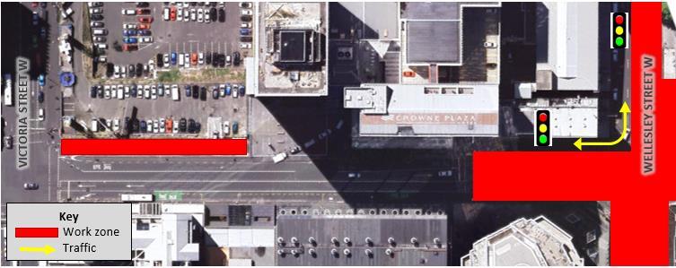
During the closure of Kingston Street in this traffic stage, pedestrian and cyclist access to properties (including emergency access) will be maintained and as well as vehicle access to properties. Specific wayfinding signage will be provided as required.
Access to the two driveways at 87-89 Albert Street at will be maintained with a left-in left-out movement, via a vehicle access lane on the eastern side of Albert Street. This is in accordance with CRL designation condition 27.1 (a).
Existing vehicle access to properties on Albert Street (between Victoria Street West and Wellesley Street) will be maintained as detailed below:
• Manhattan Apartments: Vehicle access to the carpark will be maintained with a right-in leftout movement
• Crowne Plaza: Vehicle access will be maintained with a left-in right-out movement. Adequate space will be provided for the access/egress of coaches.
• Atrium carpark: Vehicle access to the carpark will be maintained, however the access will be realigned to avoid conflict with the work zone. The access will be a left-in right-out movement.
• Sky City Premium carpark: Vehicle access will be maintained with a right-in left-out movement.
Due to the number of vehicle accesses on Albert Street between Victoria Street West and Wellesley Street, the vehicle movements bulleted above are illustrated in Figure 6-2 Where needed, a traffic controller will be present at these accesses to manage conflict with pedestrians and construction activity during working hours.
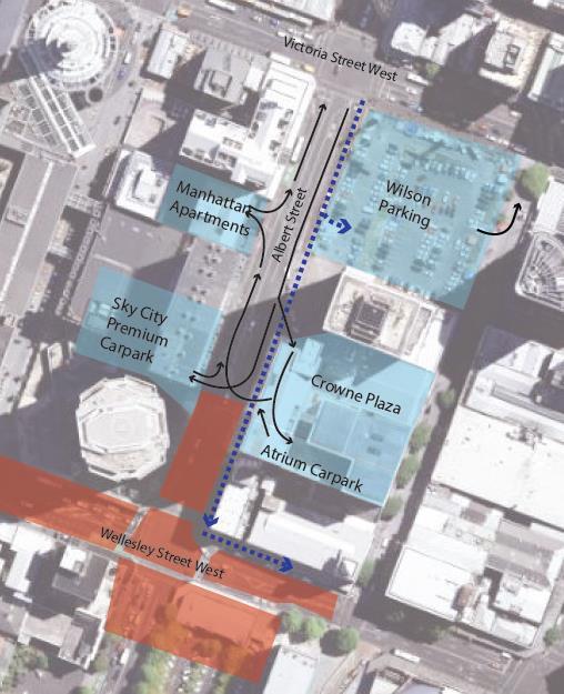
Vehicle access to the Bledisloe House carpark (a part not being used for the CSA) will be maintained with entry and exit off Mayoral Drive, with a right-in and left-out movement.
Vehicle access to the carpark located at 44-54 Wellesley Street West will be maintained throughout the closure of the Wellesley Street West/Albert Street intersection by providing local vehicle access through or around the work zone.
It is anticipated that that any access to private property (for pedestrians, cyclists and vehicles) will not be closed during the works. However, if short term vehicle access closures are necessary during the works, property owners and occupiers will be consulted with in advance of the closure in accordance with CRL designation condition 25.3 (g)(i). This will be minimised as much as practicable
In the event an affected party unexpectedly finds their vehicle blocked in as a result of a temporary closure, the Link Alliance will (within reasonable limits) offer alternative transport such as a taxi, rental car, or other alternative, in accordance with CRL designation condition 25.3 (g).
In traffic stage 1 of the main works, the Wellesley Street West/Albert Street intersection will remain closed to through traffic as is the case during Stage 4B and 5 of the Aotea early works. Correspondingly, the bus routes that will be rerouted off Wellesley Street West for the early works, will remain as such for traffic stage 1 of the main works. This will affect bus routes that currently use Wellesley Street West between Queen Street and Hobson Street. AT is planning and managing the bus diversions required for the intersection closure.
Traffic stage 1 will consist activities from both phase 3 and 4. The construction vehicle numbers are expected to be mainly influenced by concrete delivery. The following approximate vehicle numbers are expected:
• Concrete trucks: 5 – 6 concrete deliveries per hour (10 – 12 movements)
• Contractor vehicles: 2 per hour (4 movements)
• Delivery of materials: 2 - 3 vehicles per day
• Spoil Removal vehicles:
• 2 – 3 (4 – 6 movements) per hour to the CSA
• 1 – 2 per day for offsite movements
Taking the above into consideration it can be expected that during traffic stage 1, approximately 12 – 16 (24 – 32 movements) construction vehicles per hour will be generated by the Aotea Station main works. This is on average 120 – 160 vehicles (240 – 320 movements) per (10 hour) working day which is expected to have minimal to no effect on the overall traffic network.
No on-street parking will be impacted as part of traffic stage 1. However, this traffic stage of works will impact on two loading zones on Wellesley Street. The indicative loading zone availability is shown in Figure 6-3.
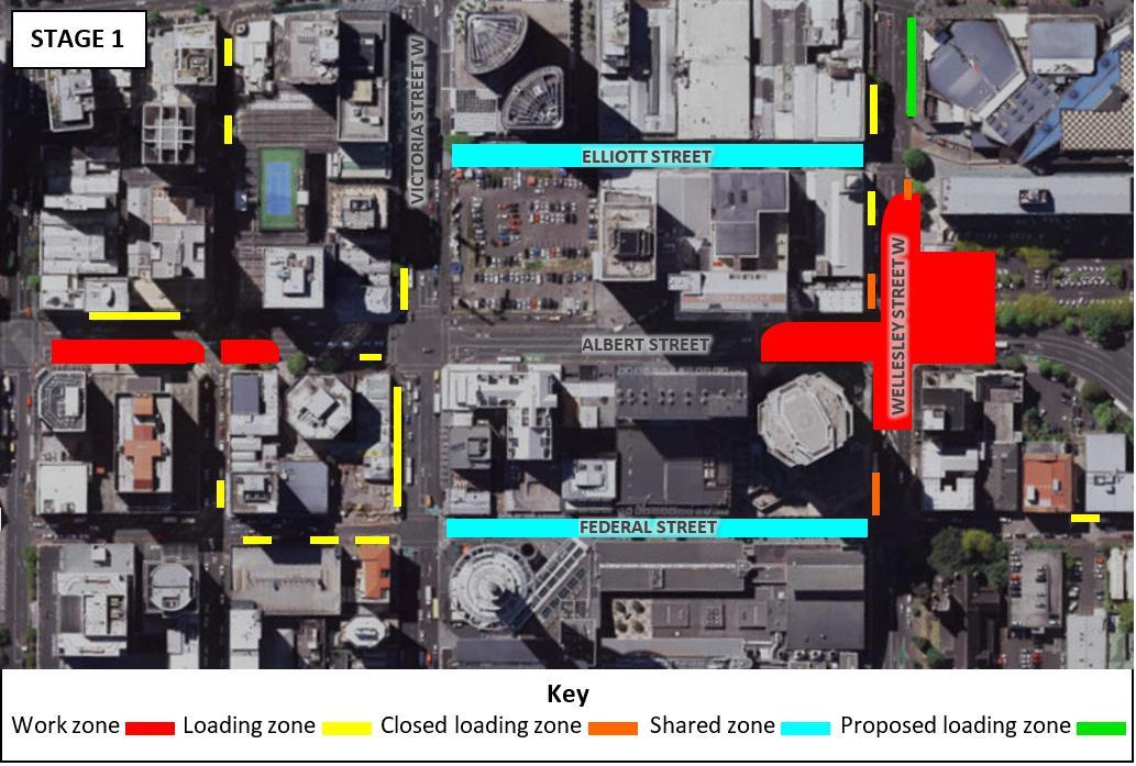
6.2 Traffic Stage 2
The pedestrian and cyclist effects will be the same as traffic stage 1, detailed in Section 6.1.1.
6.2.2.
The property access restrictions in this traffic stage will be managed in a similar way to traffic stage 1, as is detailed in Section 6.1.2.
However, in traffic stage 2, traffic on the slip lane will not be able to exit towards Victoria Street West, therefore the proposed mitigation for access to businesses and residential properties on Durham Street West, is to retain vehicle entry from Queen Street and reverse the entry from Albert Street to be exit only. This will provide the same level of access to all properties within Durham Street West as is currently the case.
To facilitate the safe exit of vehicles onto Albert Street and/ or Wyndham Street from the reversal of the Albert Street slip lane, traffic signals at the intersection of Albert Street and Wyndham Street will be modified to provide a green phase for these vehicles. Entry to Durham Street West from Queen Street will be via both left turn and right turn manoeuvres and, due to the expected increase in vehicles using this entry (especially in the AM peak), there will be manual traffic control present on site between 7am-10am to manage the conflict with pedestrians along Queen Street. The proposed mitigation is depicted in Figure 6-4 below.
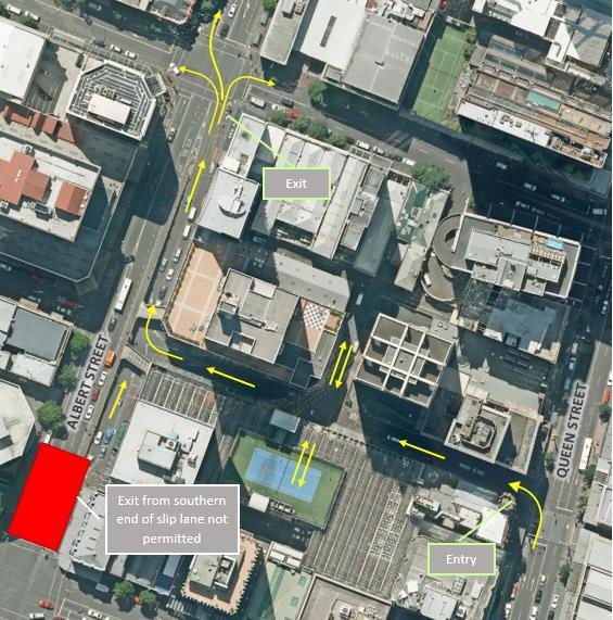
6-4: Proposed mitigation for Albert Street slip lane and Durham Street West access
6.2.3. Public Transport effects
The bus routes will continue to follow the same diversions as in traffic stage 1, as is detailed in Section 6.1.3.
6.2.4. Construction Traffic
The construction traffic effects for traffic stage 2 are expected to be the same as traffic stage 1, which is outlined in Section 6.1.4.
6.2.5. Parking and Loading
The parking and loading effects for traffic stage 2 are similar to traffic stage 1, except the loading zone on Albert Street will be closed as shown in Figure 6-5. Note: loading zone availability as shown in Figure 6-5 is only indicative.
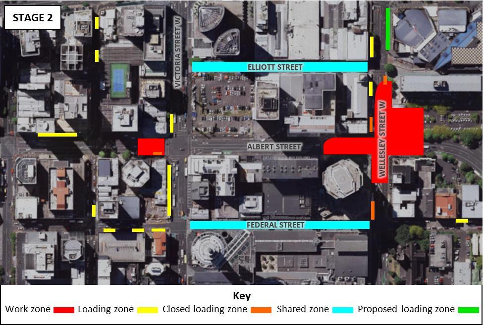
6.3 Traffic Stage 3
In traffic stage 3, the Wellesley Street West/Albert Street intersection will be reopened, thus pedestrians will be able to cross the intersection using the signalised pedestrian crossing.
The Victoria Street West/Albert Street intersection will be closed to through traffic however pedestrian access through the intersection will be maintained by providing a pedestrian route through the work zone. The width of the pedestrian routes will be such that they will accommodate the crossing demand.
In this traffic stage, most of Albert Street between Wyndham Street and Wellesley Street West will be closed and Victoria Street West will be closed to through traffic between Elliott Street and Federal Street. Therefore, the property access routes will differ from previous traffic stages and is detailed below:
• During the closure of Kingston Street in this traffic stage, pedestrian and cyclist access to properties (including emergency access) will be maintained and vehicle access will continue to be provided. All through traffic will be diverted along Federal Street and will be able to access Albert Street via Wyndham Street.
• A vehicle access lane on the eastern side of Albert Street between Wyndham Street and Victoria Street will be provided for local vehicle access only. This is in accordance with CRL designation condition 27.1 (a) As the Victoria Street West/Albert Street intersection is fully
closed, there will be a turning head for vehicles at the north approach of the intersection, so that vehicles can exit at Wyndham Street.
• Property access for 44-54 Wellesley Street will no longer be restricted due to Wellesley Street West being open in this traffic stage
Property access for properties on Albert Street (between Victoria Street West and Wellesley Street West) are outlined below:
• Albert Street from Victoria Street West to Wellesley Street West will also be closed to through traffic with local access only.
• Access to Manhattan Apartments carpark will be maintained with entrance and exit from Victoria Street West.
• Access to the Albert Street service lane (below Crowne Plaza) will be maintained, entrance will be a left in from Victoria Street West and exit will be as per usual.
• Access to Crowne Plaza and Atrium Carpark will be maintained with entrance from Victoria Street West and exit out towards Wellesley Street West.
• Access to Sky City Premium Carpark will be from Wellesley Street West. Entrance will be a left turn into the property from Albert Street and exit will be a right turn out of the property onto Albert Street.
Due to the number of vehicle accesses on Albert Street between Victoria Street West and Wellesley Street, the vehicle access routes bulleted above are illustrated in Figure 6-6. Conflict management will be in place to coordinate vehicle movements from Crowne Plaza, Atrium Carpark and Sky City Premium Carpark.
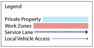

6.3.3.
In this traffic stage the Wellesley Street West/Albert Street intersection will be reopened to through traffic on Wellesley Street West. Victoria Street West (between Elliott Street and Federal Street) will be closed to traffic
The bus routes will be shifted off Victoria Street West and onto Wellesley Street West or other eastwest routes. This will affect buses that currently (as at October 2019) use Victoria Street West (between Queen Street and Hobson Street) as well as buses that will be put on Victoria Street West as a result of the Wellesley Street West/Albert Street intersection closure in Stage 4B and 5 of the Aotea early works and (traffic) stage 1 and 2 of the Aotea Station main works. This is being planned and managed by AT. Further detail regarding this will be available closer to the time and will be included in the annual review of the TAP DWP.
The works occurring in traffic stage 3 will consist of activities from all three phases (3-5). The nature of the works means that spoil removal trucks will be the main type of construction vehicles in this traffic stage. Construction vehicles being added to the network in the traffic stage are predicted to be:
• Concrete trucks: 5 – 6 concrete deliveries per hour (10 – 12 movements)
• 6-Wheeler trucks for internal spoil movements: 9 – 12 trips per hour (18 – 24 movements)
• Truck and trailer off site removal of spoil: 3 trips per hour (6 movements)
• Contractor vehicles: 2 vehicles per hour (4 movements)
• Delivery of materials: 2 – 3 vehicles per hour
From these assumptions it is expected that traffic stage 3 will add 21 – 26 construction vehicles to the traffic network per hour. This is on average 210 – 260 construction vehicles being added to the network per (10 hour) working day. From the results of the traffic modelling, the impact of these vehicles on the road network, and from the work itself, is indicated to have minimal to no impact relative to the background traffic. Additional travel time on the consent monitored routes is indicated to be in the range of 0 to +3 minutes, with an increase of 5 minutes for Customs Street.
Due to the closure of Kingston Street (between Federal Street and Albert Street) in this traffic stage there will be no access to parking and loading on Kingston Street. This is will affect approximately 12 on-street paid parking spaces and the loading zone on Kingston Street. Police parking has been relocated to further west on Kingston Street as part of the Aotea early works and so the police parking will not be affected by this closure.
Additionally, two loading zones on Victoria Street West and the loading zone on Albert Street will also be closed.
It is not proposed to replace the on-street paid parking spaces during this traffic stage. For the loading zone closures, an additional loading zone is proposed at the Victoria Street West turning head area. Loading zones on Federal Street and the Elliott Street shared space are suggested to be used as alternatives.
The loading zone at the corner of Federal Street and Wellesley Street West, and the loading zone outside Bledisloe House will be open in this traffic stage due the reopening of Wellesley Street West.
In this traffic stage, the works on the Albert Street service lane will close the parking at the northern end. This is approximately 5 parks.
The indicative loading zone availability in traffic stage 3 is depicted in Figure 6-7
6.3.6.
Traffic stage 3 of the main works is scheduled from February 2021 – August 2021. This timeframe is predicted to overlap with two major events that Auckland is hosting:
1. The Asia- Pacific Economic Cooperation (APEC)19: This involves a year of hosting a series of different events from December 2020 to November 2021. The most critical week will be Leader’s Week, taking place in Auckland from the 8th – 14th of November 2021 with 10,000 attendees expected in the city.
2. America’s Cup: The build-up for event is expected to begin from December 2020 with the main event occurring between the 6th – 21st of March. Event activities will be mainly based around the Wynyard Quarter and the Waterfront and will have minor to no vehicular traffic impact to the CRL project works at Aotea Station.
It can be expected that the combined attraction of both events will see more people moving around the Auckland City Centre across various modes. The planning process around the management of these events are underway. It is expected that AT will issue instructions, restrictions or moratoriums regarding the operation of the transport network and traffic management during the critical event time periods. Liaison with AT will continue and as details evolve, the annual review of the TAP DWP will be updated with any new or change in information provided on these events.
19 https://www.aucklandnz.com/akl2021/apec-2021
The pedestrian and cyclist effects will largely be similar to traffic stage 3, with the exception of:
• Kingston Street being reopened to traffic; thus the pedestrian route will be reinstated to its usual state.
6.4.2.
The property access routes in this traffic stage are largely similar to traffic stage 3 with the following changes:
• Access to Sky City Premium Carpark, Crowne Plaza and Atrium Carpark will be from Wellesley Street West with a turning head located halfway down Albert Street (between Wellesley Street West and Victoria Street) so that vehicles can exit onto Wellesley Street West.
This is illustrated in Figure 6-8.
Note: eastbound lane on Victoria Street West will be open late in stage 4 only

No change to traffic stage 3, buses that have been rerouted off Victoria Street West will run along Wellesley Street West and other east-west corridors. AT is planning and managing these diversions.
6.4.4.
Traffic stage 4 will comprise of similar construction activities as traffic stage 3 (outlined in Section 6.3.4) and therefore similar construction traffic effects are expected However, due to the internal station fit out also occurring in this traffic stage it is expected that there will be additional deliveries. This is estimated to be at 4-6 trips per hour. Therefore, an average of 250 – 320 construction vehicles are expected to be added to the network per (10 hour) working day, which is 25 – 32 per hour From the results of the traffic modelling, the impact of these vehicles on the road network, and from the work itself, is indicated to have minimal to no impact relative to the background traffic. Additional travel time on the consent monitored routes is indicated to be in the range of 0 to +3 minutes, with an increase of 5 minutes for Customs Street.
6.4.5.
Traffic stage 4 will have the same parking and loading effects as traffic stage 3, with the exception of Kingston Street. Kingston Street will be reopened in this traffic stage, and therefore the 12 on-street parking spaces on Kingston Street will be available, as will the loading zone. The indicative loading zone availability in this traffic stage is shown in Figure 6-9
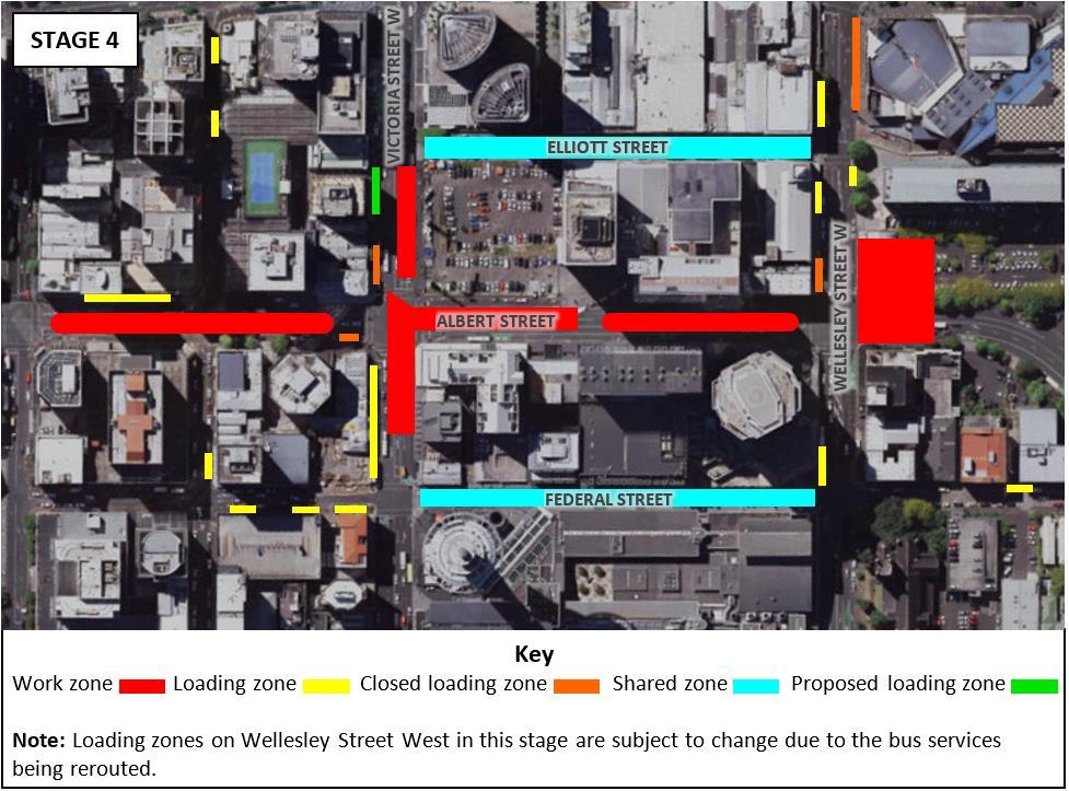
6.4.6.
During this traffic stage of works there will be a cross over with the APEC ‘Leaders Week’ as outlined in Section 6.3.6. On the annual review of the TAP DWP, the TAP DWP should be updated with any additional information provided on the APEC event that may impact the scheduled works.
6.5.1.
The pedestrian and cyclist effects will be the same as traffic stage 1 as detailed in Section 6.4.1.
6.5.2.
The property access routes in this traffic stage are largely similar to traffic stage 3 with the following changes:
• Access to Crowne Plaza and Atrium carpark will be entrance from Victoria Street West and exit towards Wellesley Street West.
• Exit for Sky City Premium Carpark will be towards Victoria Street West
The access routes for properties on Albert Street between Victoria Street West and Wellesley Street West are depicted in Figure 6-10.
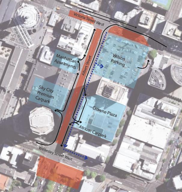
6.5.3.
The public transport effects will be the same as traffic stage 3 (outlined in Section 6.3.3), buses that have been rerouted off Victoria Street West will run along Wellesley Street West and other eastwest corridors.
6.5.4.
Traffic stage 5 will comprise of similar construction activities as traffic stage 4 (outlined in Section 6.4.4), however concrete deliveries are expected to be fewer in this traffic stage Therefore, an average of 220 – 300 construction vehicles are expected to be added to the network per day, which is 22 – 30 per hour. This is expected to have a minor effect on the overall traffic network.
Victoria Street West will have two lanes available in this traffic stage, therefore the loading zone on Victoria Street West between Federal Street and Albert Street will be open. The indicative loading zone availability is shown in Figure 6-11.
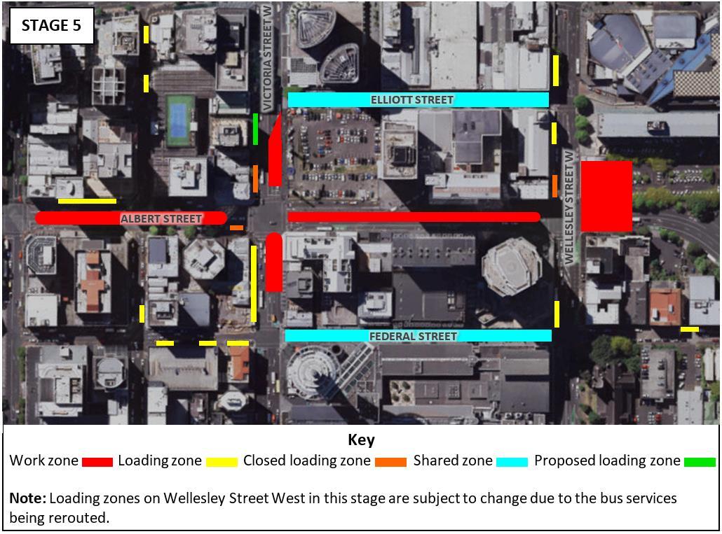
CRL designation condition 26 requires that monitoring of travel times and transport network congestion be carried out on specified routes during the CRL construction works.
The specified routes subject to monitoring (according to CRL designation condition 26.9) that are closest to the Aotea Station main works are Wellesley Street (between Victoria Street and Princes Street), Victoria Street (between Wellesley Street and Princes Street) and Queen Street (between Mayoral Drive and Customs Street).
In accordance with CRL designation condition 26.6, the monitoring will establish whether the CRL construction works have increased average traffic delays as follows:
(a) “Either by more than 10 minutes (from the monitoring previously undertaken in accordance with this condition)
(b) Or if the travel times are more than three minutes or 30% greater than the forecast modelled increases along that route (according to the most recent traffic model test of that scenario, undertaken prior to the start of construction. The modelled time is to be based on the Auckland City Centre SATURN traffic model or a different traffic model approved by the Requiring Authority).
(c) “The 30% above shall only apply for an increase predicted to be over four minutes.”
AT is monitoring the routes specified in CRL designation condition 26.9 throughout the CRL works and will identify if the works are resulting in travel time increase in excess of the conditions. Should travel times on the specified routes be exceeded, additional mitigation will be implemented in accordance with CRL designation condition 26.7 to minimise impacts to below the travel time levels specified in CRL designation condition 26.6 as far as is reasonably achievable
The Aotea Station main works Communication and Consultation Plan (CCP) sets out the procedures that will be implemented to advise affected parties, key stakeholders (including emergency services) and the general public of the main works, potential impacts on transport, access and parking and proposed temporary traffic management works.
Table 8-1 identifies the key stakeholders with respect to this TAP DWP with whom engagement will be undertaken in relation to the Aotea Station main works.
Table 8-1
Stakeholder Potential Issue
Media Design School
Auckland District Court –Ministry of Justice (65 Albert Street)
6-12 Kingston Street
Temporary access restrictions
Temporary access restrictions to Kingston Street
Temporary vehicle access restrictions
Resolution
Consultation ongoing to understand access requirements.
Consultation ongoing to understand access requirements.
All efforts have been made to contact property owner/occupier, but no response has been given. Building likely to be vacant.
87-89 Albert Street
Sky City
Manhattan Apartments
Crowne Plaza
Temporary vehicle access restrictions
Vehicle access restrictions to Carpark accessed from Albert Street
Vehicle access restrictions to carpark accessed from Albert Street
Vehicle access restrictions
Econolodge
Atrium Carpark
Elliott Hotel
Skybus
Auckland Council
Vehicle access restrictions.
Vehicle access restrictions
Vehicle access restrictions
Relocation of bus route through Wellesley Street West
Loss of parking for customers and staff at the Bledisloe House carpark due to the CSA.
Consultation ongoing to establish suitable mitigation.
Discussions between CRLL and Sky City have taken place and will continue to be progressed.
Consultation ongoing to establish suitable mitigation.
Discussions between CRLL and Crowne Plaza have taken place and will continue to be progressed.
Consultation ongoing to establish suitable mitigation.
Consultation ongoing to establish suitable mitigation.
Consultation ongoing to establish suitable mitigation.
AT is managing the diversion of this service and the ongoing consultation and liaison with Skybus.
Consultation has taken place with Auckland Council. CRLL and Auckland Council have agreed on the occupation of the Bledisloe House carpark during CRL construction.
Datacom carpark on Mayoral Drive
11 Mayoral Drive carpark
The general public and wider city centre community
Vehicle access restrictions
Vehicle access restrictions
Temporary changes to loading bays, pedestrian routes and increased truck movements.
Consultation ongoing to establish suitable mitigation.
Vehicle access for carpark will be moved further south on Mayoral Drive to limit interaction between tenant’s vehicles and construction traffic.
Consultation to take place via the Aotea Community Liaison Group (CLG). Ongoing consultation to the wider community to be carried out via the CRL Project website and drop-in sessions
AT Temporary changes to bus routes and bus stop locations, temporary closure of loading zones.
Public transport users and operators
Taxi operators
Consultation is ongoing and will remain ongoing throughout the project.
Changes to bus stop locations, and bus routes AT is planning and managing these changes and will be consulting with operators and issuing notifications to the public.
Taxi Stands will not be impacted, and taxis will be affected to the same extent as general traffic
NZTA “One Network” consultation in accordance with CRL designation condition 18
Emergency Services
The works will close or restrict sections of road in the City Centre and consultation with emergency services is required regarding this.
Notification of works will be issued to Taxi operators as part of the general public notification.
Consultation is being progressed.
Consultation has been undertaken with St John Ambulance, Fire and Emergency NZ and NZ Police. No major issues were raised but all three would like to be kept up to date with the construction work happening and the timeframes.
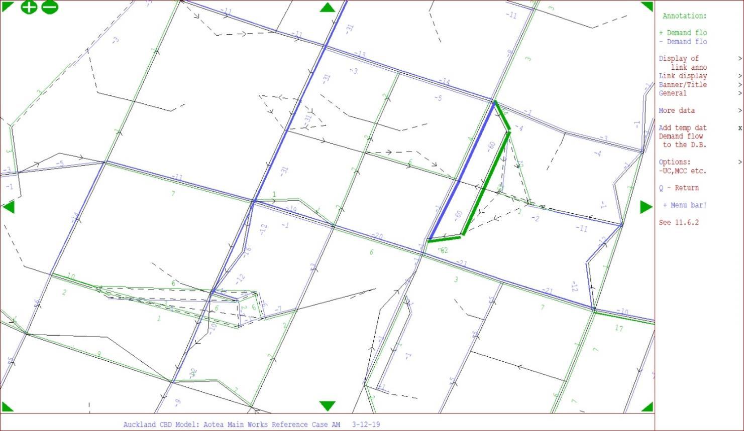
A-1: Demand Flow Difference - Area of Influence (Reference Case vs Aotea Main Work Closure Scenario 1); Morning Peak
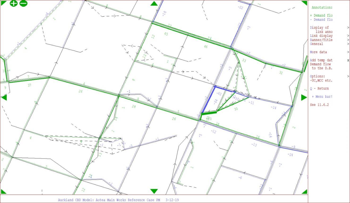
Figure A-2: Demand Flow Difference - Area of Influence (Reference Case vs Aotea Main Work Closure Scenario 1); Evening Peak
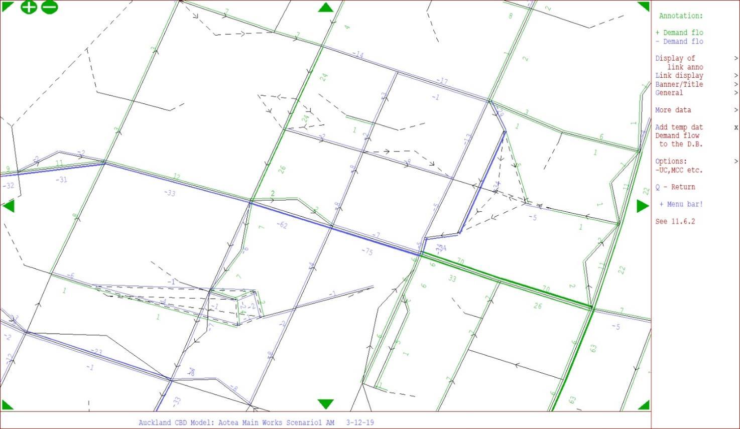
B-3: Demand Flow Difference - Area of Influence (Reference Case vs 4b&5 Utility Work Closure); Morning Peak
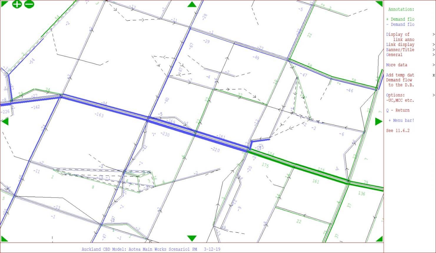
B-4: Demand Flow Difference - Area of Influence (Reference Case vs 4b&5 Utility Work Closure); Evening Peak
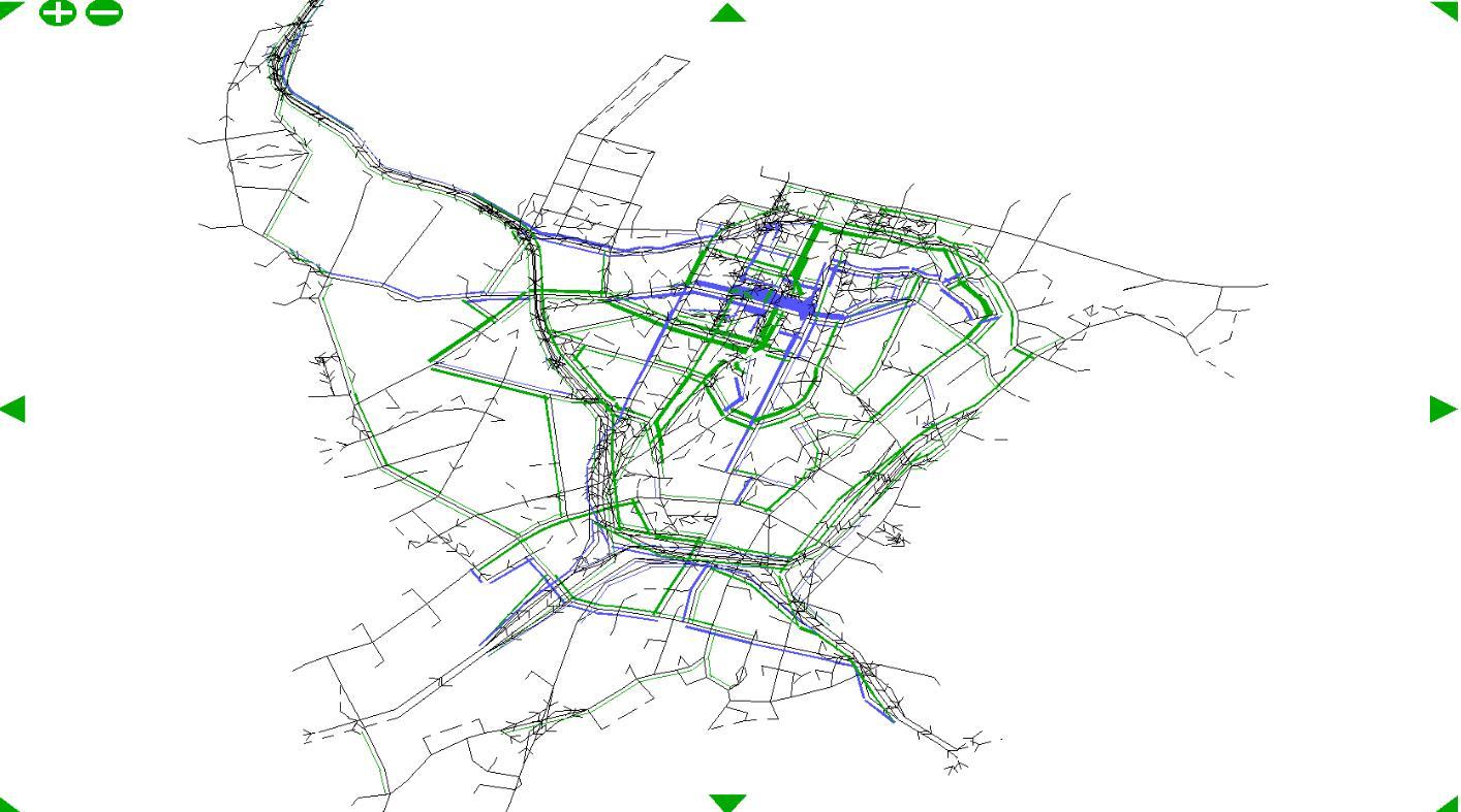
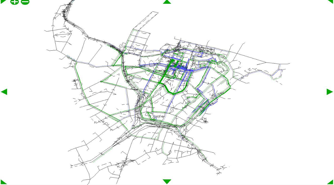
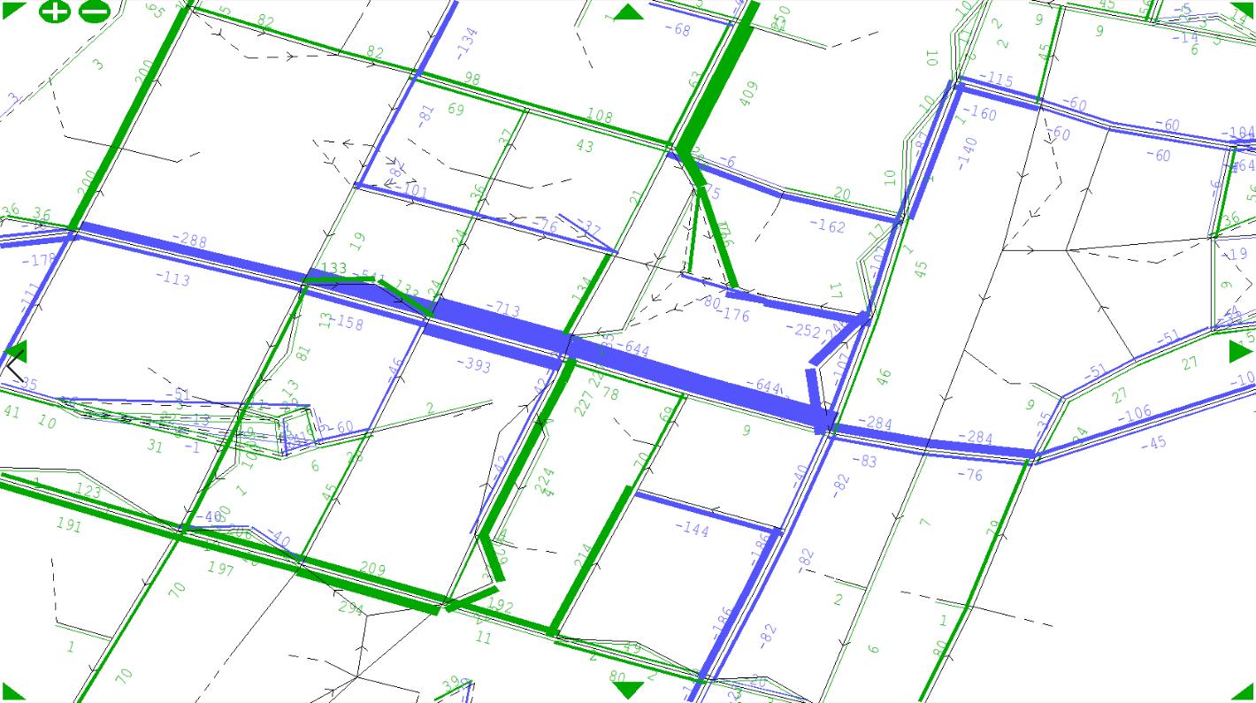
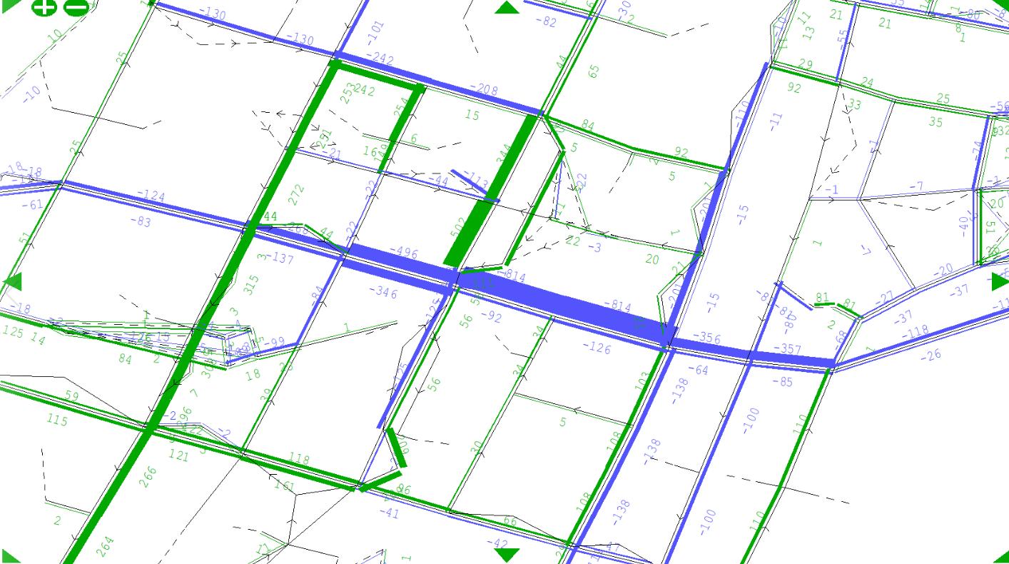
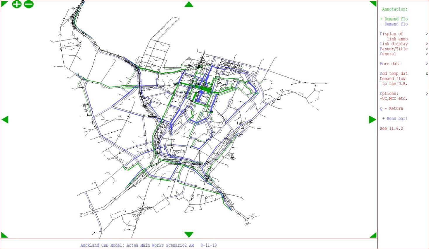
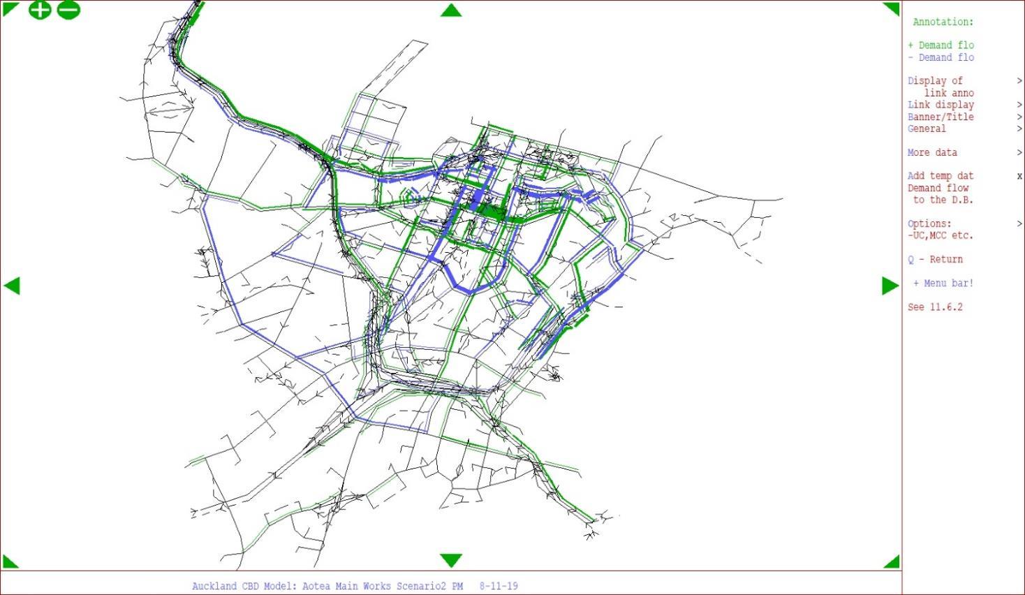
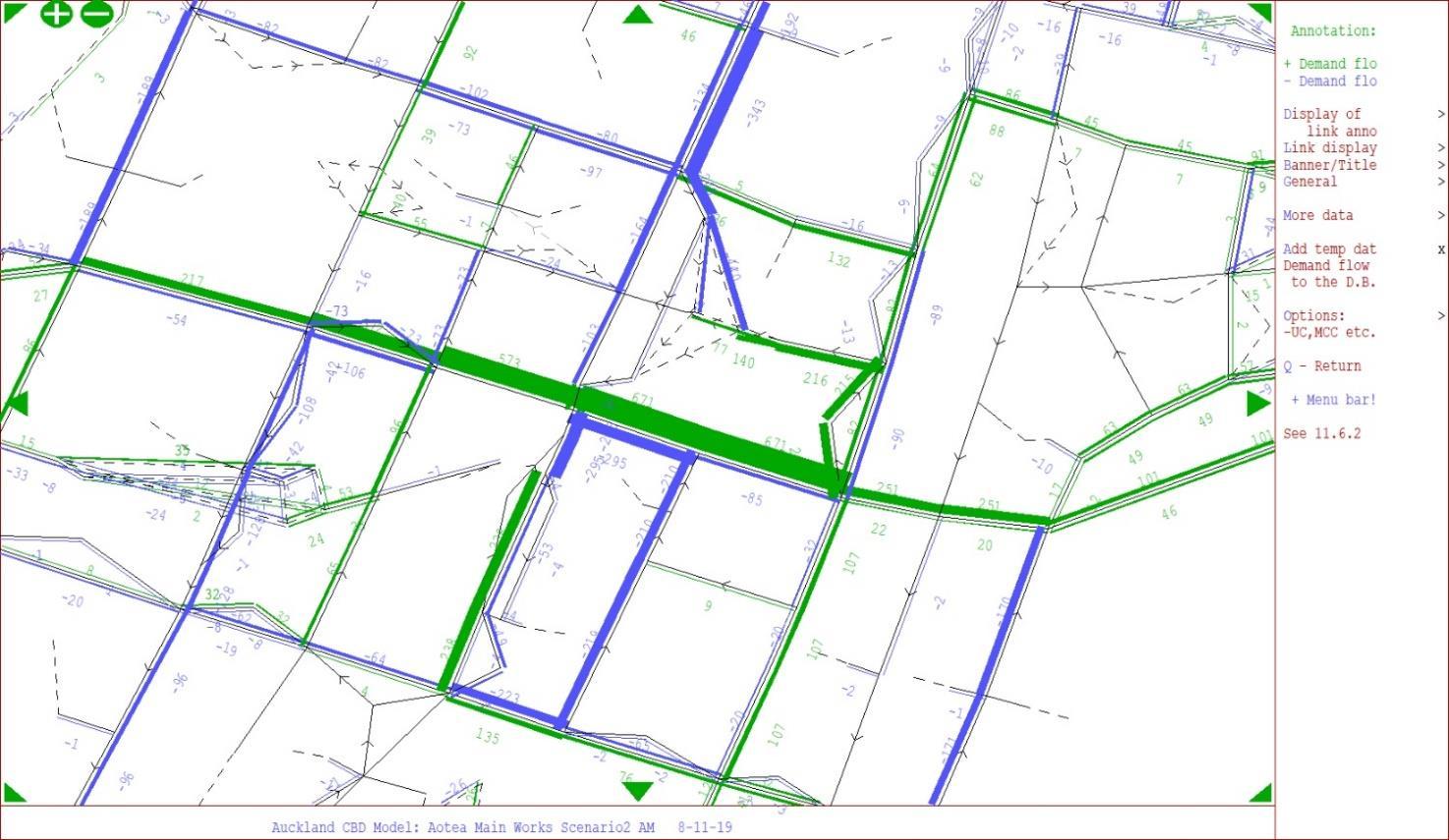
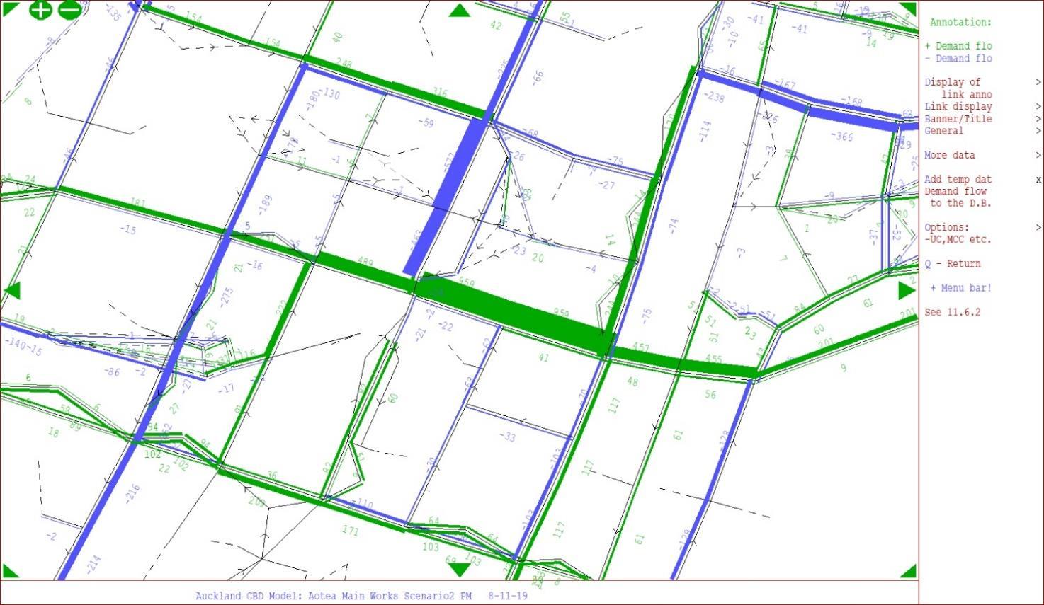
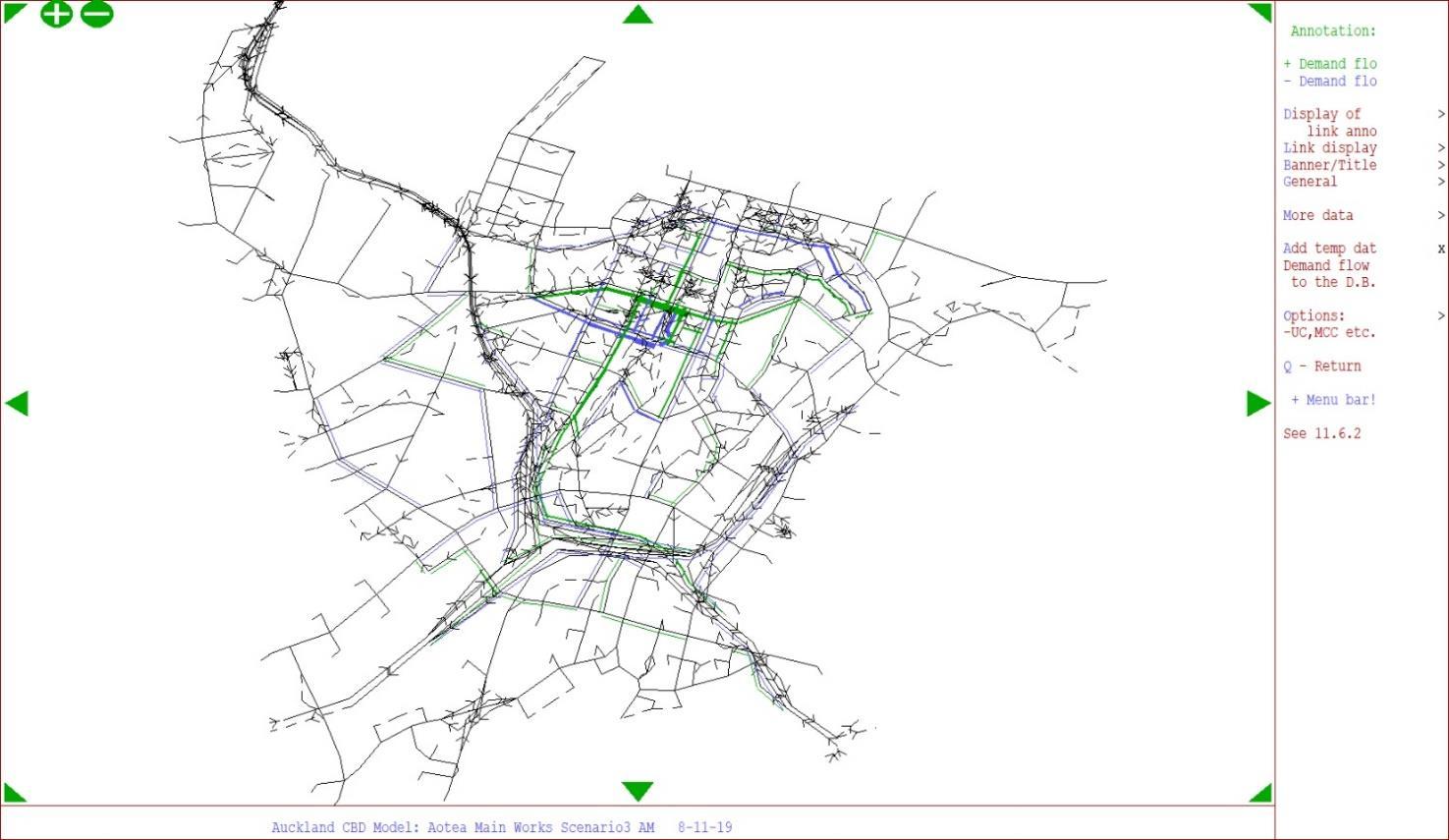
E-13: Demand Flow Difference (Scenario 3 Utility Work Closure vs Scenario 4 Utility Work Closure); Morning Peak
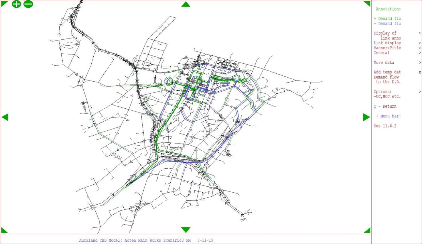
E-14: Demand Flow Difference (Scenario 3 Utility Work Closure vs Scenario 4 Utility Work Closure); Evening Peak
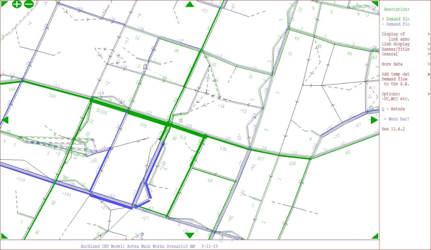
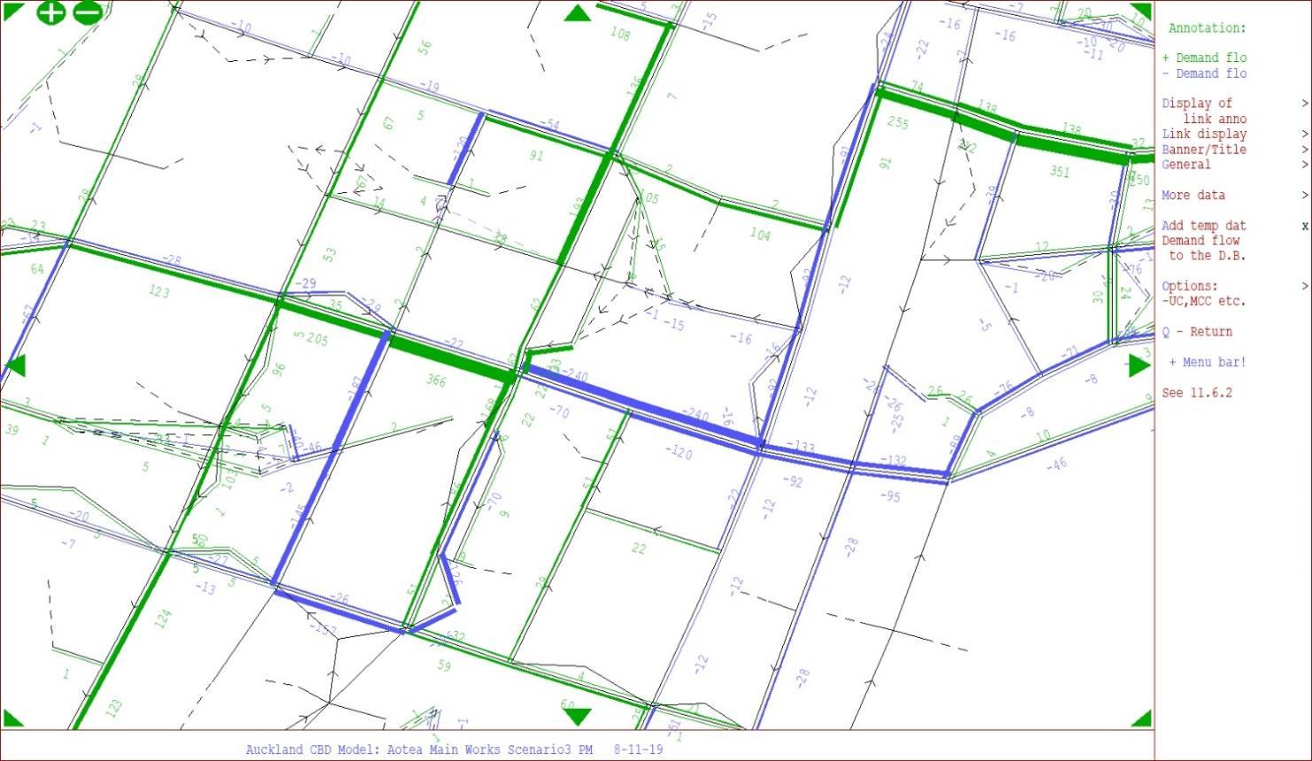
1.0 19/11/19 4pm CLG Heart of the City
Tania Loveridge, Advocacy and Engagement Management
2.0 19/11/19 4pm CLG Heart of the City
Tania Loveridge, Advocacy and Engagement Management
3.0 19/11/19 4pm CLG Heart of the City
Tania Loveridge, Advocacy and Engagement Management
We’d like confirmation that there will be no additional site containers in the road corridor for the purpose of staff support, given the development of the site area at the Bledisloe House carpark. This is needed to reduce the overall impact to the environment and visibility of businesses and tenancies in the area.
Heart of the City would like the opportunity to be briefed on and review the project TMPs when available, this would include understanding the more detailed locations and approach to support loading provision, and taxi drops offs in the area of construction works.
This comment has been advised to the contractors.
No update to TAP DWP.
TMPs will be produced separately to the TAP DWP and reviewed and approved by Auckland Transport. This request will be passed to the Link Alliance Traffic Manager.
No update to TAP DWP.
As per our conversation with Dan Marsh at the Aotea Station CLG on 19 November 2019, it is our understanding that the intention is to:
o Utilise unused and available construction space for loading and possible taxi drop offs, where possible. Noting that this will be confirmed when the TMP is finalised for each traffic stage of works.
Use kerbside space in Victoria Street, adjacent to the construction site area for P5 loading space
o Use kerbside space in Wellesley Street for loading – previously used for bus stops when the buses are rerouted to other streets.
Yes, additional loading zones will be implemented where possible.
Refer to loading zone maps that have been added.
TAP DWP updated.
4.0 19/11/19 4pm CLG Heart of the City
Tania Loveridge, Advocacy and Engagement Management
5.0 19/11/19 4pm CLG Heart of the City
Tania Loveridge, Advocacy and Engagement Management
6.0 19/11/19 4pm CLG Heart of the City
Tania
Loveridge, Advocacy and Engagement Management
7.0 19/11/19 4pm CLG Heart of the City
Tania Loveridge, Advocacy and Engagement Management
Heart of the City requests that any loading spaces created as part of the project can be monitored and enforcement undertaken, as appropriate, to ensure that these spaces are used for loading activity only.
Recommendation to develop a “loading” map that can be used by businesses and service delivery businesses alike. This could be published on the CRL website and made available digitally. Integration of any loading spaces, even if temporary, into the AT parking app which currently shows loading spaces or other alerts/technology to help couriers and other deliveries companies easily finding loading spaces in the area would be essential. On street signage should also be considered, and this should be considered as part of the ‘signage strategy’ that is being developed in collaboration with Auckland Transport.
We understand that Link Alliance will be working with Auckland Transport on the Signage Strategy which will identify detours and support access around the city centre. Signage and communications must positively support people getting around, and not end up being a deterrent to visitation.
Section 6.1.1: It is not clear from the draft DWP as to whether north/south pedestrian access will be maintained during the Wellesley Street/Albert Street intersection closures, as it only makes reference to ‘east/west pedestrian access. Heart of the City would be concerned if N/S access would be restricted.
Loading zones that are created as part of the project will either be implemented as a resolution (which AT monitors) or as part of the TMP which will be monitored during site hours.
No update to TAP DWP.
Indicative loading zone maps have been developed for each traffic stage.
TAP DWP updated.
Noted. This comment has been passed on to the Development Response team.
No update to TAP DWP.
Both east-west and north-south access will be maintained.
TAP DWP updated.
8.0 19/11/19 4pm CLG Heart of the City
Section 8. Consultation and Communication. The list of stakeholders in the plan does not seem comprehensive:
o The loss and relocation of loading zones is a potential issue on the business and wider community in the area of the construction and we would expect that they should be listed here.
o Businesses & property owners located in direct proximity of the intersection closures should also be identified as a specific group with a potential issue of restricted access for their building for activity such as building maintenance/refurbishment etc., particularly if kerbside space and/or access is restricted. Special resolutions or processes may have to be put in place to ensure this activity can still occur.
o Courier and delivery companies identified as specific stakeholder group to engage and communicate with, with potential issues of changes to loading zones and access to specific businesses/residential properties.
We believe that there should be greater commitment to a Travel Demand Programme put in place to get construction workers to site, and this could include incentives from CRLL or in collaboration with Auckland Transport to ensure this happens. We note that there is provision for a Workforce Travel Management Plan (Appendix D) and would like to understand the scope of this plan once it is completed.
Additional stakeholders have been engaged with respect to the effects from the service lane works. Wider communication and engagement will be ongoing prior to the commence of each traffic stage of works detailing changes and provisions. Other suggestions have been passed to the Communications and SIBD teams. AT and CRLL are jointly working on a wider Travel Demand Management program related to the CRL and other project works within the City.
TAP DWP updated.
9.0 17/02/19 Email Heart of the City
Tania Loveridge, Advocacy and Engagement Management
Has there been any assessment of the likely impact on Wyndham Street as part of the Main Works changes, particularly any likely increase in general traffic? If so, are there any mitigations planned to ensure it remains a safe place for pedestrians and cyclists
While Wyndham Street is not one of the 10 key and monitored routes, the increase in traffic volumes along the corridor during the various stages of works is not considered to be a concern. Throughout the various stages of main works construction changes to the peak time traffic volumes on the corridor fluctuate between -200 (less than baseline) and +240 (more than baseline) vehicles. AT have reviewed the modelling and network changes and have not raised any concern with the changes predicted for Wyndham Street from an operational and safety perspective.
No update to TAP DWP
10.0 17/02/19 Email Heart of the City
Our assessment from the document is that the upcoming works, including the Wellesley Street/Victoria Street intersection closures, will have limited impacts on journey times for both private vehicles and buses –ranging from a -5 minutes to +5 minutes difference in journey times. We would like the opportunity to discuss these scenarios in more detail.
Yes, this is correct. Changes in travel times vary between -5 minutes and +5 minutes depending on the stage of works occurring. It should be noted that this assessment considers only known projects that will be occurring on the transport network, as advised by AT. For future years beyond 2021, the programme of works occurring on the transport network was not 100% confirmed at the time the assessment was made (Sept/ Oct 2019). Therefore, future reviews and updates to the TAPDWP may require a reassessment of the traffic modelling, which may alter the currently advised travel times. Any changes to this current assessment that are considered material will follow a due process of stakeholder consultation and engagement where necessary.
No update to TAP DWP
Page no.
Section 5.1.2 and Appendix C
Comment
The review has identified an issue with the modelling undertaken and the incorrect treatment of Kingston Street in Stage 3 (the Stage 3 plans showing this being closed however Section 5.1.2.2 describes it being closed in Stage 4). This is currently being updated. The Link Alliance team consider the impact of this change in the modelling to be minor given the local nature of the route. The reviewer considers this appropriate and the likely result of the updated analysis, however this should be confirmed once the modelling is updated.
Resolution
Modelling amendments have been completed.
Updates have been made to figures in Appendix C (Scenario 2)
Table 5-5, Table 5-6, Table 5-15, Table 5-16, Table 5-17 and Table 5-18 have been updated accordingly including the appropriate updates to the text.
No material changes to the original modelling results however, with a less than 30 second increase in delay for Federal Street, which is not one of the CRL monitored routes
Amendments made to this TAP DWP
Page 75 Section 8 NZTA“One Network” consultation in accordance with CRL designation condition 18.
“Consultation is being progressed”
The Transport Agency have not provided confirmation they are comfortable with the impacts. It is critical that this is resolved prior to the approval of this DWP.
Ongoing discussions with NZTA have concluded that there is no direct impact to NZTAs network and operational and maintenance activities. These discussions will continue throughout the course of the project to keep NZTA abreast of the project.
Wider concerns were raised by NZTA with respect to the collective management of the CBD network, taking into account all current project impacts and mitigations in place. It was agreed that this sits outside of the scope of the CRL project.
AT and NZTA are subsequently working together to produce a Concept of Operations for the CBD network, into which, the Link Alliance will contribute in regard to the CRL impacts and mitigation.
Page no. TAP DWP section
Pages 58, 62, 64, 69, 71
Paragraph/ sentence
Sections 6.1.2, 6.2.2, 6.3.2, 6.4.2, 6.5.2 & 8
Comment
There are a number of stages and changes to access for neighbours which will require careful and proactive communication.
Page 32 Section 4.3.4 “A secondary option has been identified to allow for an alternative path in the event of a traffic incident or other event blocking access to and from the primary route. This will be using Mayoral Drive and Wellesley Street East to access the State Highways as shown in Figure 4-3”
The alternative spoil disposal route should only be used as an alternative, which is what is proposed.
Resolution
Noted.
This will be addressed as the construction progresses and the TAP DWP will be updated accordingly. Detailed TMP development will occur 3-6 months prior to the start of each stage of work and as part of this access arrangements will be maintained or addressed via a suitable mitigation plan where access cannot be provided for. This will involve regular ongoing engagement with affected stakeholders and AT.
No Amendments made to this TAP DWP
Noted.
No Amendments made to this TAP DWP
It should be confirmed that there are no residential dwellings along the section of Wyndham Street
Confirming, Wyndham Street has no residential dwellings. It is a commercial and retail area made up of businesses. It supports the Ibis hotel. It is intended that Wyndham will be used while the C2 CRL construction along Albert Street (Wyndham to Customs) is ongoing. It is not practical to run construction traffic from the C3 works along Albert St until after the C2 works are complete.
No Amendments made to this TAP DWP
Pages 10, 29, 32
Sections 0 and 4.3.2 / 4.3.4
Consent Condition 27.1 (k)
Ensuring that construction traffic does not use Swanson Street, Wolfe Street or Federal Street north of Swanson Street;
Page 75 And 23, 26, 61, 63, 66, 70, 72 (Bus related effects)
Sections 8 And 3.1.4, 4.2.2, 6.1.3, 6.2.3, 6.3.3, 6.4.3, 6.5.3 (Bus related effects)
AT Consultation:
Temporary changes to bus routes and bus stop locations, temporary closure of loading zones.
“Consultation is ongoing and will remain ongoing throughout the project”
This is not specifically confirmed, however routes for vehicles do not use these roads so compliance is assumed, this needs to be confirmed.
Resolution
Confirming construction traffic will not be using Swanson Street, Wolfe Street or Federal Street north of Swanson Street
Refer to images in sections 4.3.2 (page 29) and 4.3.4 (page 32)
No Amendments made to this TAP DWP
Bus planning is critical to the successful operation of the transport system and this needs sustained and proactive planning and management (which is being undertaken) to ensure this is appropriately and dynamically managed to provide customers clear information and attractive travel options
The future TMP’s is an important step in confirming vehicle tracking and should seek to maximise the vehicle size for vehicles accessing hotels.
Noted.
AT is leading on the bus rerouting and diversions. The Link Alliance continue to support AT in various matters in regard to this and are working closely together to ensure consistent and early messaging.
No Amendments made to this TAP DWP.
Noted. This will be worked through as the construction staging progresses and related TMP’s are required. The process of TMP production will generally proceed the start of construction by 3-6 months to allow time for all issues to be worked through and addressed.
No Amendments made to this TAP DWP.
Page 75 Section 8
A number of the communications with property owners over access are yet to be concluded and it is important that these are continued and concluded as part of this DWP development and the need to actively monitor these areas during construction.
Noted. These are ongoing conversations around access relate to latter stages of construction (i.e 2021 and beyond) Therefore, conversations will be concluded prior to 2021 and any updates required to the TAPDWP as a result of these will be made at the appropriate time or as part of the annual review and update, whichever is sooner.
No Amendments made to this TAP DWP.
Section 1.5
We also support the update of the DWP as things change given the long duration of the works.
Agree with the IPR. The TAPDWP will remain a live and evolving document throughout the construction period to capture changes that have a corresponding impact on the transport network.
No Amendments made to this TAP DWP
Page 19
Section 2.5
Bledisloe House carpark, located at 2-10 Wellesley Street West and the intersection of Albert Street will house the Construction Support Area (CSA) and is proposed to be accessed from Mayoral Drive. Figure 2-1 in the DWP shows the proposed CSA layout. Issues here are the transformer; located in the middle of the entry and egress point – please comment on the location of the transformer, if it is to remain or endeavour to shift this
It’s also unclear where the proposed flow of vehicles go through the site – further information is needed
Also, vehicle tracking of entry and exit points of the site CSA should be provided. CoPTTM requirements will need to be met for the shutdown of part of Mayoral Drive and Myers Street –this is just a reminder note.
The transformer has been moved to behind the public toilets by Mojo and therefore not impeding any vehicle movements through/ around the site or impacting on customer access to Auckland Council car parking.
Site vehicles will only enter from the Bledisloe Carpark and will proceed one-way through the CSA exiting onto Mayoral Drive. The CSA layout plan has been updated to reflect this. Only small utility vehicles (Utes, vans) will use the Bledisloe Carpark entrance to the CSA due to limitation with vehicle tracking. All large vehicle will enter and exit via the Mayoral Drive access points. Amendments made to this TAP DWP.
Noted. Design of CSA layout has considered the requirements of vehicle tracking.
Page 19
Section 2.5
Page 67
Section 6.3.4 “From these assumptions it is expected that traffic stage 3 will add 21 – 26 construction vehicles to the traffic network per hour. This is on average 210 – 260 construction vehicles being added to the network per (10 hour) working day. This is expected to have not more than minor effect on the overall traffic network.”
Pedestrian routes through the site are required to be confirmed in the TAP DWP – please provide these.
Noted. Pedestrian routes have been included on the high-level staging plans now included in Appendix G. These will be further refined as the TMPs are developed in line with the consent requirements and the requirements of AT, CoPTTM and adjacent stakeholder needs.
TAP DWP Updated.
Figure 2-1; Surge pile located west of the proposed site offices –proximity to the emergency access area and the laydown area should be noted. 300-400m3 of spoil is expected on site – boundaries should be added to the surge pile diagram to show the maximum extent of the surge pile will not impede the movement and manoeuvring of any vehicles.
Noted. All vehicle movements related to the Surge Pile will be managed on-site using a gateman and/or TC to ensure all vehicle access into Bledisloe Carpark is unimpeded. Figure 2-1 shows the extent of the surge pile in purple (contained around the perimeter), we have made allowances for vehicle movements around this (not shown for clarity reasons in this figure) to ensure the layout is workable Amendments made to this TAP DWP.
Comprehensive traffic modelling using SATURN software has been undertaken as per CRL designation conditions, with results presented in the form of flow difference plots and changes to journey times. The overall analysis of the network surrounding the Aotea work site shows that a ‘minor effect’ will be placed on the network with the addition of worst-case construction traffic. Congestion will be monitored by Auckland Transport, with any exceedance of the 10minute maximum congestion to trigger the implementation of mitigation measures in accordance with designation Condition 26.7 Please confirm the definition of minor effect. Is this 10 minutes of additional travel time? – This monitoring method is consistent with CRL designations and previous TAP DWP’s.
As per the modelling results in Section 5 , travel time delays are not indicated to exceed more than 5 mins in the worst case and this is on Customs Street only. Along the majority of the monitored routes travel time delay is indicated to be in the range of 0 to +3 minutes over the duration of the project works. The use of the word ‘Minor’ has been removed from the text and replaced with a less subjective description of the impacts.
Delay will be monitored as stated in this TAP DWP with one of the thresholds being 10 minutes of additional delay on the key defined routes.
Amendments made to this TAP DWP.