An enclosed shed for the purpose of blocking noise and light pollution from the residential dwellings within close proximity of the site
Active Transport Walking and cycling (as trips in their own right or as part of a public transport journey)
AECOM AECOM NZ Limited
AT Auckland Transport
ATCoP
ATEED
Auckland Transport Code of Practice (document prescribing AT’s adopted design standards and practices, such as for infrastructure devices, corridor access management and temporary traffic management)
Auckland Tourism, Events and Economic Development (an Auckland Council organisation)
ATOC Auckland Transport Operations Centre
CAR Corridor Access Request (also used to refer to the Corridor Access team at AT)
CBD Central Business District
CCI City Centre Initiatives (an AC organisation)
CEMP Construction Environmental Management Plan
CEPs
CMJ
CNVMP
CoPTTM
Construction Execution Plans
Central Motorway Junction (i.e. Spaghetti junction linking the Southern, Northwestern, Northern and Port motorway links)
Construction Noise and Vibration Management Plan
NZTA Code of Practice for temporary Traffic Management (national standard for TMP documentation, signage and practice)
CPTED Crime Prevention Through Environmental Design
CRL City Rail Link
Design Vehicle The largest vehicle expected or permitted to use a section of road
DWP
Delivery Work Plan – management plan addressing management of a particular aspect of construction such as traffic, noise or archaeology
EBD Eastbound
ECI Early Contractor Involvement (i.e. Connectus)
EED
Engineering Exception Decision (approval for specific relaxation of standards or alternate engineering treatment, made by the AT CAR team)
GRP Glass-reinforced plastic
ITA Integrated Transport Assessment
LT Left turn (lane movement descriptor)
MTC Manual Traffic Controller
NBD Northbound
NZTA New Zealand Transport Agency
OMS Orakei Main Sewer
OMS shaft Smaller piled tunnelling shaft, located between Albert Street and Federal Street. Also known as the Victoria #2 shaft.
Connectus Transport, Access and Parking Delivery Work Plan
Trenchless pipe installation method where pipes are driven horizontally between two vertical shafts using a tunnel boring machine. This technique will be used for both the stormwater realignment and on a smaller scale by the OMS temporary by-pass works.
PT Public Transport (i.e. buses, ferries and rail services)
RCA Road Controlling Authority (i.e. AT for CBD surface roads and NZTA for the motorway and state highway network)
RT Right turn (lane movement descriptor)
SBD Southbound
SOV Single Occupant Vehicles
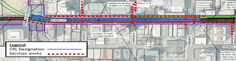
SP1 Separable Portion 1 - CRL Enabling Works Contract 2: Customs Street West/Albert Street Intersection to Wyndham Street section
STMS Site Traffic Management Supervisor
TAP DWP Transport, Access and Parking Delivery Work Plan (i.e. this document)
TBC To Be Confirmed
TBM Tunnel Boring Machine
TCC Traffic Control Committee (responsible for legal approval of changes to traffic control devices such as loading zones and bus stops)
TDM Travel Demand Management ( also referred to as ‘TD’)
The Project
The Albert Street cut and cover works between the Downtown Centre site and south of Wyndham Street
TH Through (lane movement descriptor)
TSL Temporary Speed Limit
TMCG Traffic Management Coordination Group
TMP Traffic Management Plan
TTMP
Victoria Main shaft
Temporary Traffic Management Plan for the CRL Albert Street stormwater main realignment works, equivalent and with similar content to this TAP DWP
The main work site and largest piled tunnelling shaft located on the steep slope, located between Albert Street and Elliot Street. Also known as the Victoria #1 shaft.
VMS Variable Message Sign
WAP Work Access Permit
WBD Westbound
Connectus Transport, Access and Parking Delivery Work Plan
Project #: 2665
Client: Auckland Transport
1 INTRODUCTION
1.1 GENERAL
Doc. No. CRL-PAT-ENV-CON-PLN-000904
Revision: 5, Date: 2 June 2016
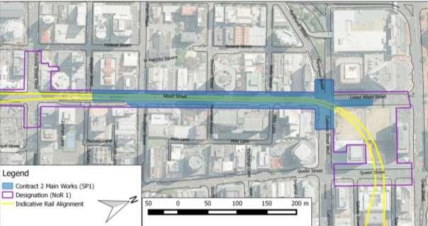
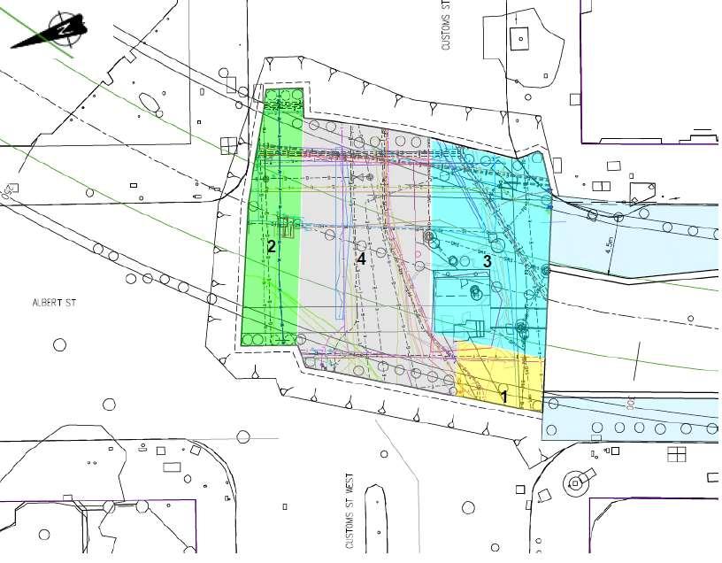
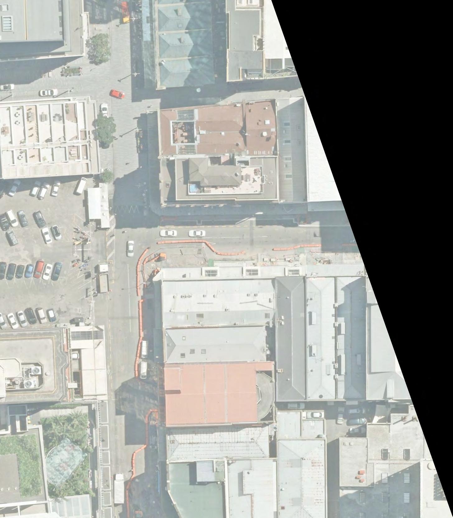
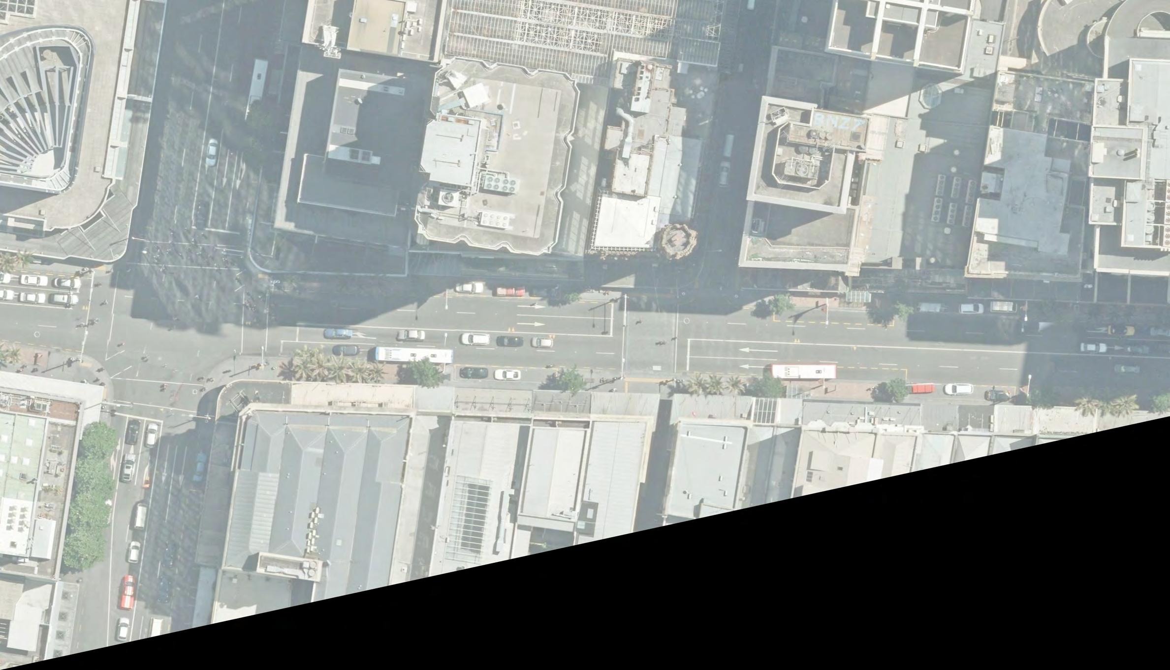
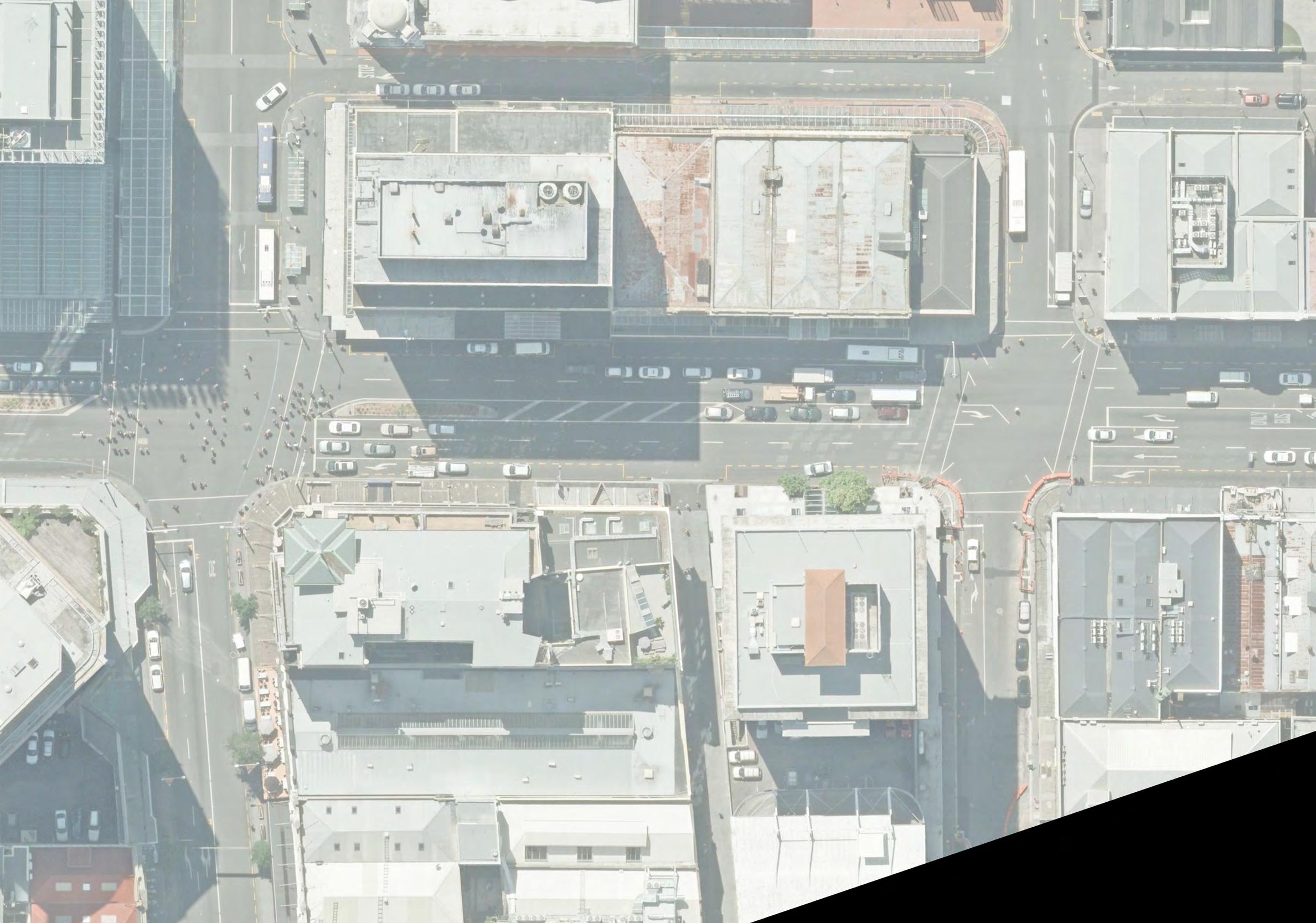
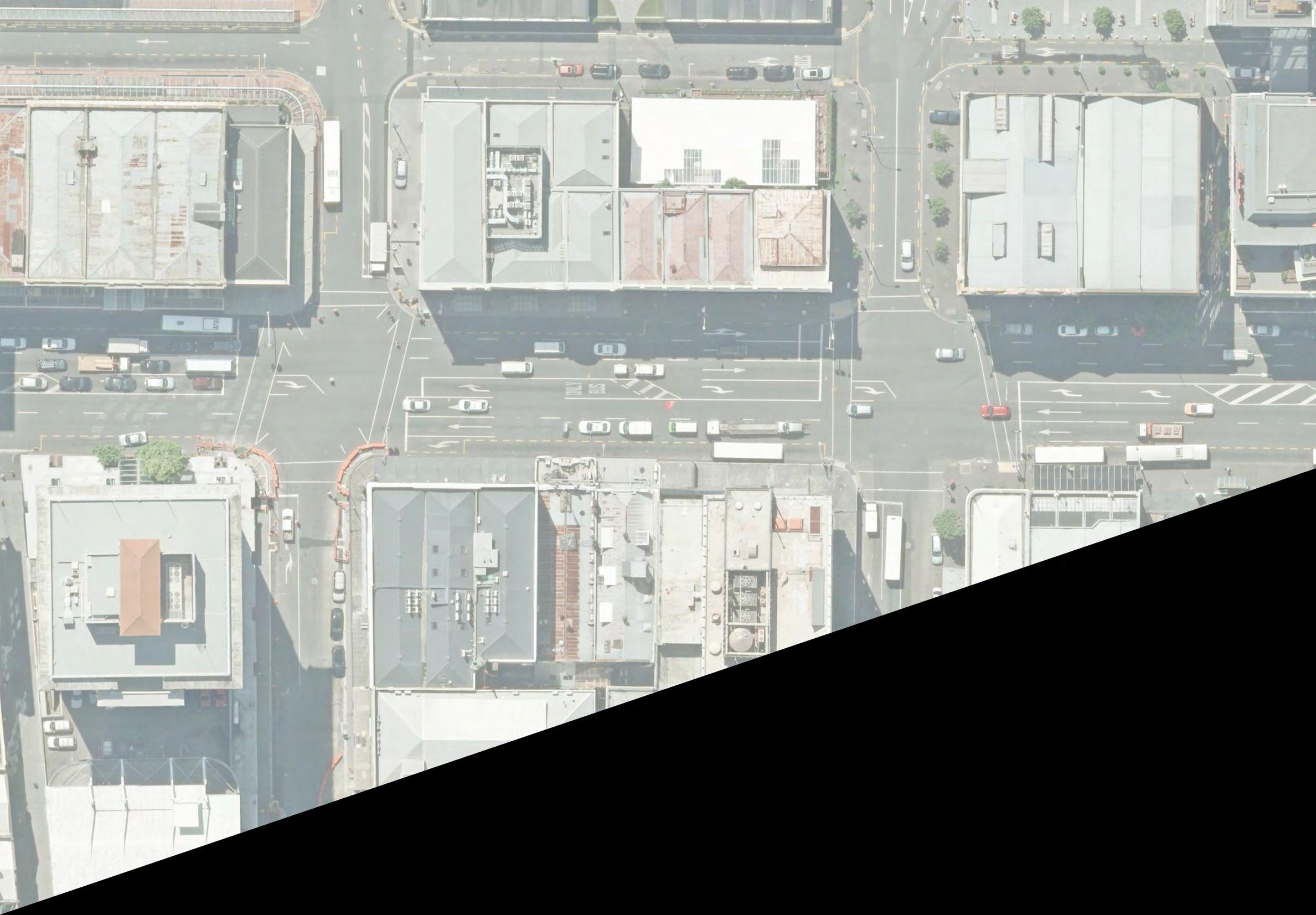
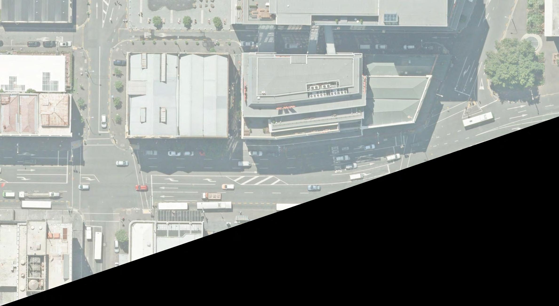
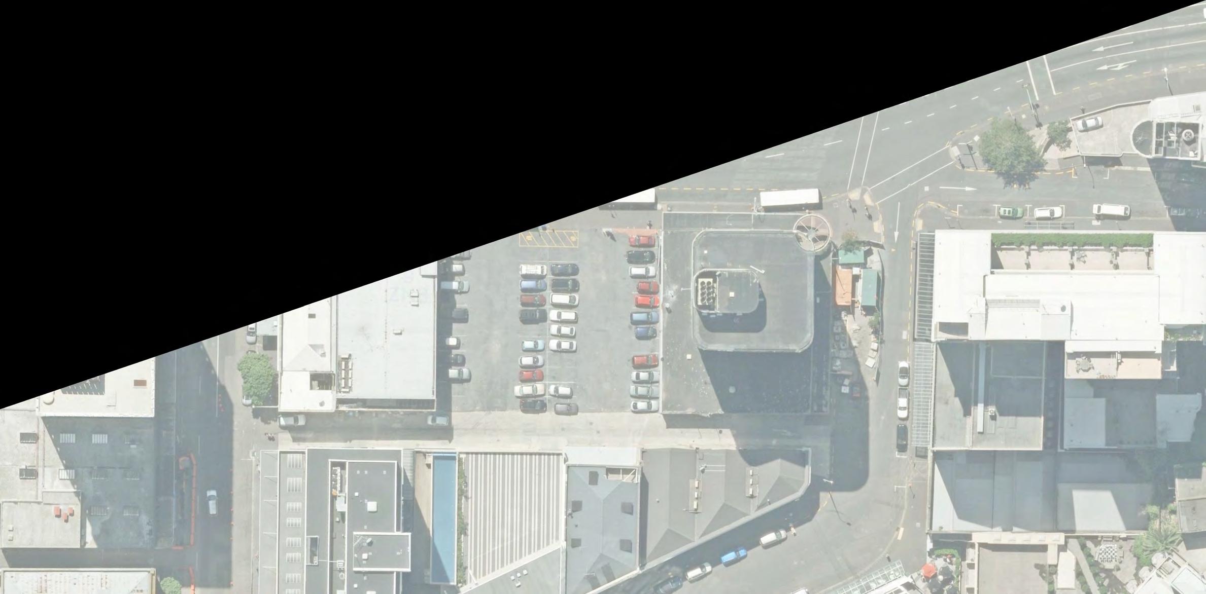
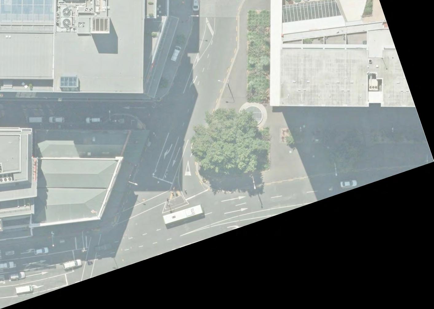
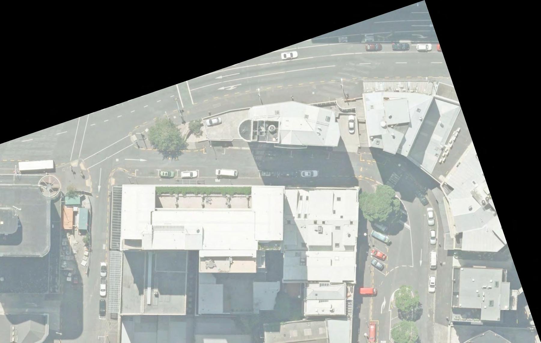
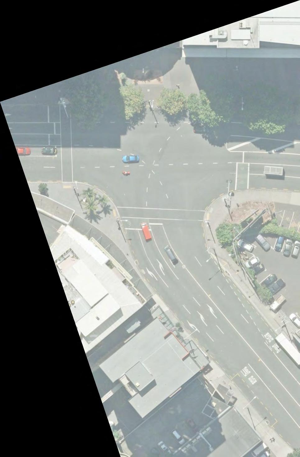
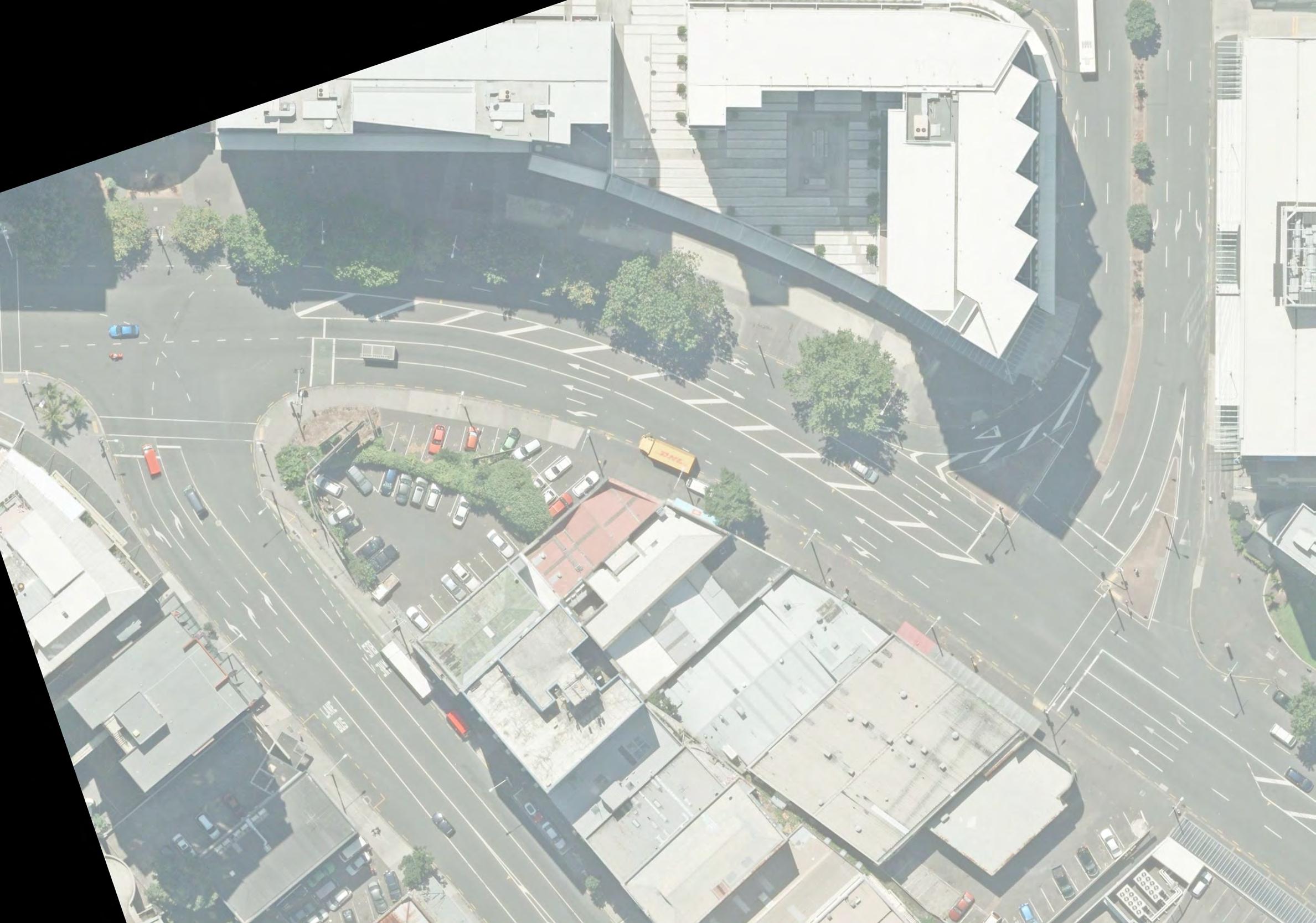
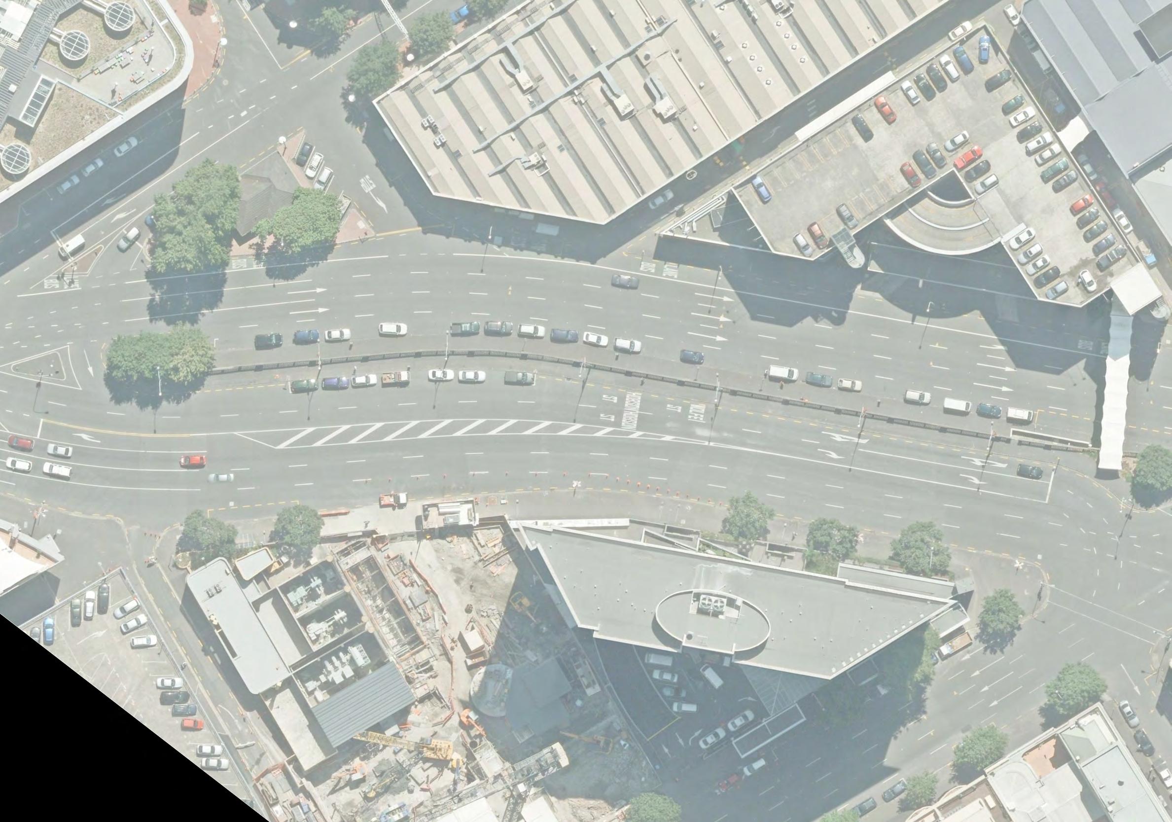
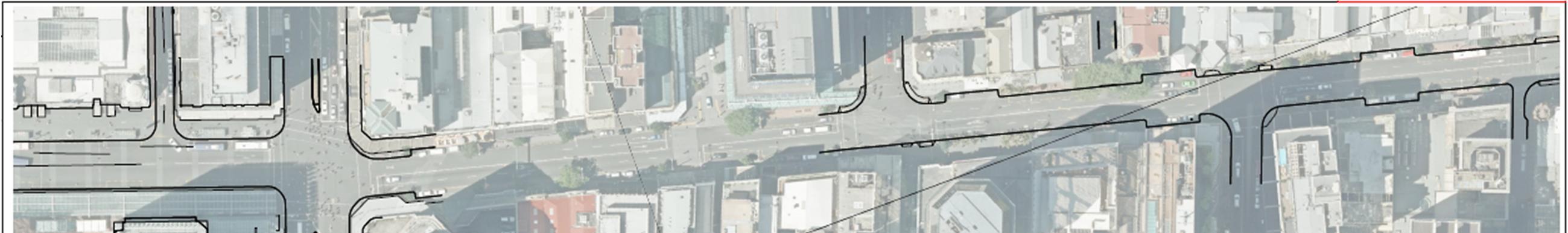
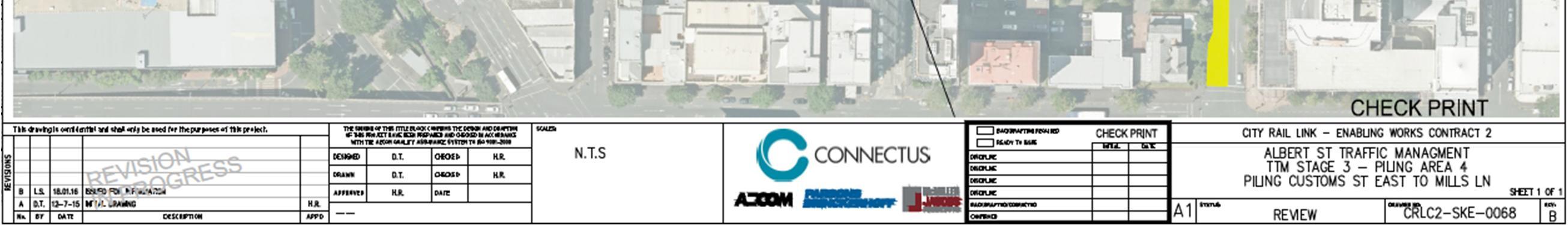
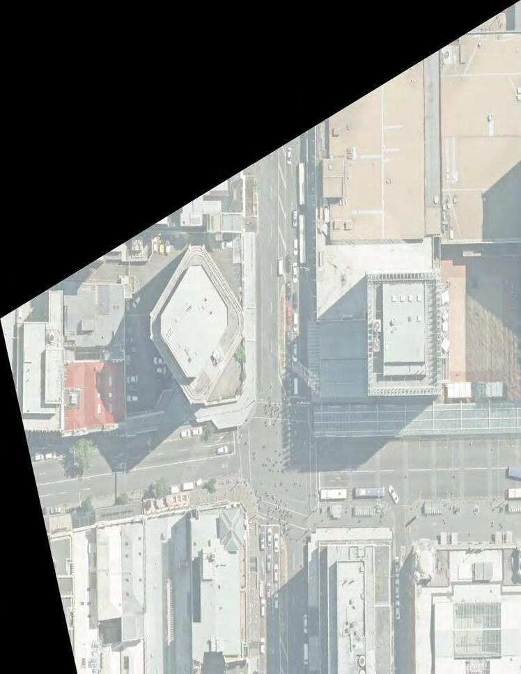
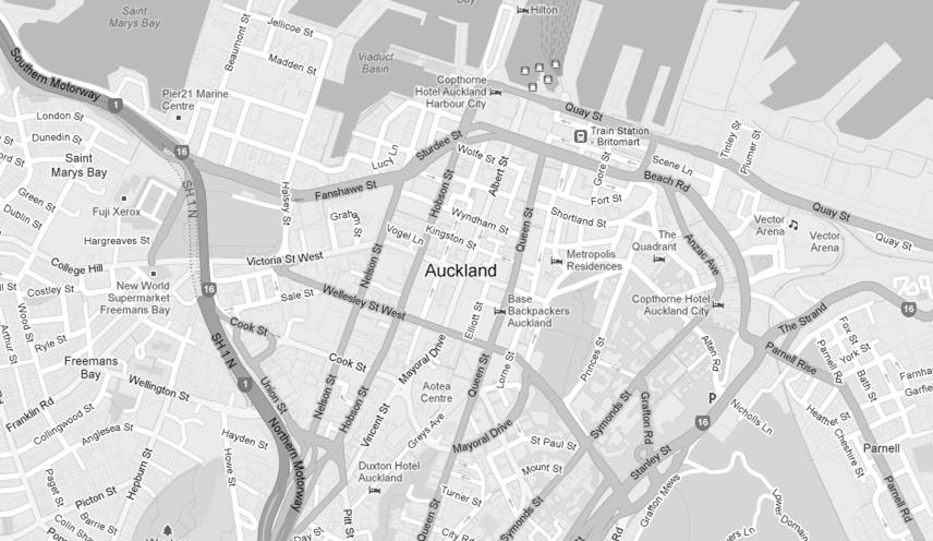
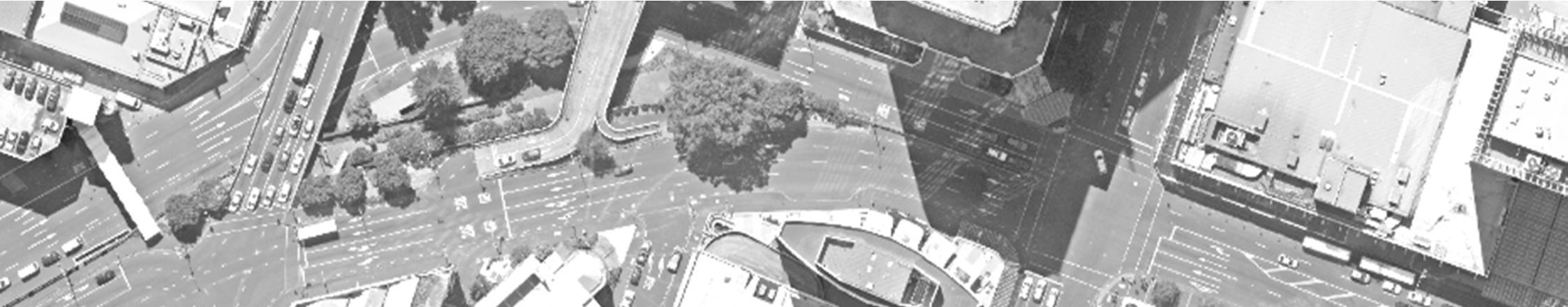
The City Rail Link (CRL) project comprises the construction, operation and maintenance of a 3.4 km underground passenger railway, running between Britomart Station and the North Auckland Rail Line in the vicinity of Mt Eden station. The works (the Project) relating to this Transport, Access and Parking Delivery Work Plan (TAP DWP) constitute part of the enabling works for the CRL. The Project involves the construction of twin rail tunnels within the Albert Street road corridor from Customs Street West to Wyndham Street. The tunnels will be constructed using a staged cut and cover method and are expected to take 33 months to complete. Figure 1 outlines the extent of works for the Project.
This TAP DWP has been prepared by AECOM New Zealand Limited (AECOM) and forms part of the Construction Environmental Management Plan (CEMP) for the Project.
Figure 1 Project site location plan
1.2 PURPOSE OF TRANSPORT, ACCESS AND PARKING DELIVERY WORK PLAN
The purpose of this TAP DWP is to so far as is reasonably practicable, avoid, remedy or mitigate the adverse effects of construction on transport, pedestrian safety and amenity, parking and property access. As well as assessing the impacts of the proposed construction methodology and mitigations, it sets the framework for the subsequent development of Traffic Management Plans (TMP) for individual activities and stages of work during the Project life cycle (including associated resolution reports for traffic control device changes and Corridor Access Requests)
The TAP DWP has been prepared in accordance with the CRL designation conditions, particularly Conditions 18, 25, 26 and 27 (see Table 1), and Condition 36 of the CRL Britomart to Wyndham Street enabling works resource consents (see Table 2).
The TAP DWP will be implemented throughout the entire construction period and will be the primary tool for the management of traffic impacts resulting from the Project. It is a ‘living document’ that will
Connectus
Project #: 2665
Client: Auckland Transport
Transport, Access and Parking Delivery Work Plan
Doc. No. CRL-PAT-ENV-CON-PLN-000904
Revision: 5, Date: 2 June 2016
be reviewed and updated as the Project progresses and traffic and working conditions change. Any material change to the TAP DWP shall be submitted to Auckland Council (AC) for approval.
1.3 SPATIAL REFERENCES
For ease of reference it is noted that in this document Albert Street is referred to as running northsouth while the crossroads are referred to as running east-west. Traffic is thus referred to as moving northbound (NBD), southbound (SBD), westbound (WBD) or eastbound (EBD).
1.4 DESIGNATION CONDITIONS
Table 1 identifies the CRL designation conditions that specify what is to be addressed by the TAP DWP, and in turn which sections of the TAP DWP address these conditions.
Table 1 TAP DWP CRL designation conditions and the relevant sections of this document
18.1 The Requiring Authority and its contractor shall work collaboratively with the New Zealand Transport Agency (NZTA) during the preparation of the Traffic, Access and Parking DWP (Conditions 25, 27, 28, 29, and 30) in relation to confirming the management of adverse transport effects on the road network. A record of this consultation and outcomes shall be included in the Traffic, Access and Parking DWP. The Requiring Authority shall consult with the NZTA throughout the duration of construction on any changes or updates to the Traffic, Access and Parking DWP which relate to the management of the road network.
Construction Environmental Management Plan (CEMP) and Delivery Work Plans (DWPs)
20.1 In order to give effect to the objective in Condition 19.1, the CEMP must provide for the following:
(d) A Travel Management Plan for each construction site outlining onsite car parking management and methods for encouraging travel to the site using forms of transport other than private vehicle to assist in mitigating localised traffic effects
21.1 In order to give effect to the objective in Condition 19.1, the CEMP shall include the following details and requirements in relation to all areas within the surface designation footprint where construction works are to occur, and / or where materials and construction machinery are to be used or stored:
(a) Where access points are to be located and procedures for managing construction vehicle ingress and egress to construction support and storage areas;
General Transport, Access and Parking
25.1 A Transport, Access and Parking DWP shall be prepared to manage the adverse effects of construction of the City Rail Link, or any part of it, on the transport network. 4 and 6
25.2 The objective of the Transport, Access and Parking DWP is to so far as is reasonably practicable, avoid, remedy or mitigate the adverse effects of construction on transport, parking and property access. This is to be achieved by:
4 and 6
(a) Managing the road transport network for the duration of construction 4 and 6
Project #: 2665
Client: Auckland Transport Revision: 5, Date: 2 June 2016
by adopting the best practicable option to manage congestion;
(b) Maintaining pedestrian access to private property at all times; and 4 and 6
(c) Providing on-going vehicle access to private property to the greatest extent possible. 4 and 6
25.3 To achieve the above objective, the following shall be included in the Transport, Access and Parking DWP:
(a) The road routes which are to be used by construction related vehicles, particularly trucks to transport construction related materials, equipment, spoil, including how the use of these routes by these vehicles will be managed to mitigate congestion, and to the greatest extent possible, avoid adverse effects on residential zoned land and education facilities;
(b) Transport route options for the movement of construction vehicles carrying spoil, bulk construction materials or machinery shall be identified and details provided as to why these routes are considered appropriate routes. In determining appropriate routes, construction vehicles carrying spoil, bulk construction materials or machinery shall as far as practicably possible only use roads that:
(i) Form part of the regional arterial network;
(ii) Are overweight / over dimensioned routes;
(iii) Or other routes (specified below) where no other practical option is available.
(c) For the purposes of this condition the following routes (that at the time this designation was confirmed were not part of the regional arterial network and / or overweight / over dimensioned) shall be used where practicable for the movement of construction vehicles carrying spoil, bulk construction materials or machinery:
(i) Ngahura Road, for trucks heading to/from Eden Terrace construction site; n/a
(ii) Dundonald Street and Basque Road, for trucks heading to/from the Newton Station construction sites; n/a
(iii) Pitt Street (between Hobson Street and Hopetoun Street), Beresford Square, Mercury Lane, Canada Street and Upper Queen Street (between Canada Street and Karangahape Road), for trucks heading to/from Karangahape Station construction sites; n/a
(iv) Wellesley Street (between Nelson Street and east of Albert Street), Cook Street (between Mayoral Drive and Hobson Street) and Mayoral Drive (between Wellesley Street and Cook Street) for trucks heading to/from Aotea Station construction sites;
(v) Nelson Street (north of Wellesley Street), Hobson Street (north of Cook Street) and Lower Albert Street, for trucks heading to/from the Albert Street and Downtown construction sites.
(d) Where other routes are necessary (other than those routes identified above), the Transport, Access and Parking DWP shall identify any residential zoned land and education facilities and shall provide details on how adverse effects from these vehicle movements are to be mitigated through such measures as:
(i) Communication and consultation (in accordance with Condition 15 of this designation) with these properties in advance of the vehicle movements occurring;
and 8
CRL-PAT-ENV-CON-PLN-000904 Client: Auckland Transport Revision: 5, Date: 2 June 2016
(ii) Restricting vehicle movements on Monday to Friday to between 9.30am and 4pm, and on Saturday to between 9am and 2pm. 4
(e) Proposed temporary road lane reductions and / or closures, alternative routes and temporary detours, including how these have been selected and will be managed to mitigate congestion as far as practicably possible and how advance notice will be provided;
(f) How disruption to the use of private property will be mitigated through:
4,6 and 8
(i) Ensuring pedestrian and cycle access to private property is retained at all times; 4 and 6
(ii) Providing vehicle access to private property as far as practicably possible at all times, except for temporary closures where landowners and occupiers have been communicated and consulted with in reasonable advance of the closure; and
4 and 6
(iii) How the loss of any private car parking will be mitigated through alternative car parking arrangements. 4 and 6
(g) Where an affected party unexpectedly finds their vehicle blocked in as a result of a temporary closure, the Requiring Authority shall (within reasonable limits) offer alternative transport such as a taxi, rental car, or other alternative.
Note: For the purposes of designation Conditions 25, 27, 28, 29 and 30 “temporary closure” is defined as the following:
(i) In place for less than six hours, the Requiring Authority shall communicate and consult on the closure at least 24 hours in advance, but is not required to offer or provide alternative parking arrangements, though it may choose to offer this on a case by case basis in consultation with the affected party; and
(ii) In place for between six and 72 hours, the Requiring Authority shall communicate and consult on the closure at least 72 hours in advance, and will offer and provide where agreed with the affected party alternative parking arrangements. The alternative parking arrangement should be as close to the site affected as is reasonably practicable. 8
(h) How disruption to use of the road network will be mitigated for emergency services, public transport, bus users, taxi operators, freight and other related vehicles, pedestrians and cyclists through:
6
(i) Prioritising, as far as practicably possible, pedestrian and public transport at intersections where construction works are occurring; 6
(ii) Relocating bus stops and taxi stands to locations which, as far as practicably possible, minimise disruption; and 6
(iii) Identifying alternate heavy haul routes where these are affected by construction works. 6
(i) Cross references to the specific sections in the Communication and Consultation Plan that detail how emergency services, landowners, occupiers, public transport users, bus and taxi operators, and the general public are to be consulted with in relation to the management of the adverse effects on the transport network.
8
(j) The alternative (to road) transport options that are available (including the option of rail use at the main construction site adjacent the North Auckland Rail Line) and that have been considered and assessed for the transportation of spoil. This will include as applicable: 4.20
(i) Benefits that could be provided by alternative options; 4.20
(ii) Potential adverse effects associated with alternative options; 4.20
(iii) Where an alternative option is proposed, methods for managing potential adverse effects; and 4.20
(iv) Reasons for either adopting or not adopting alternative transport options. 4.20
Monitoring of Transport Network Congestion
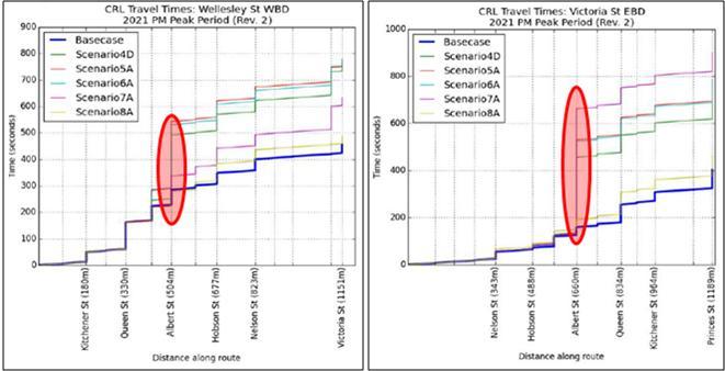
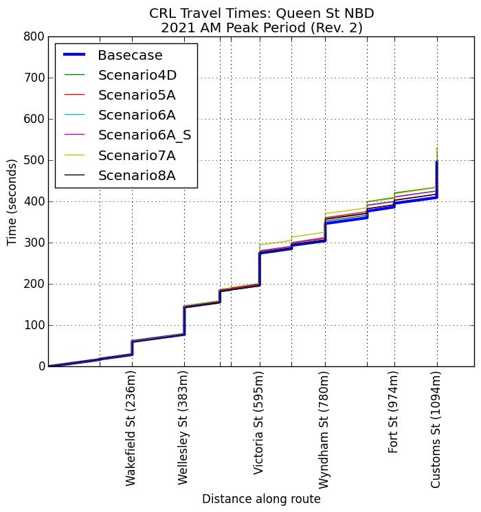
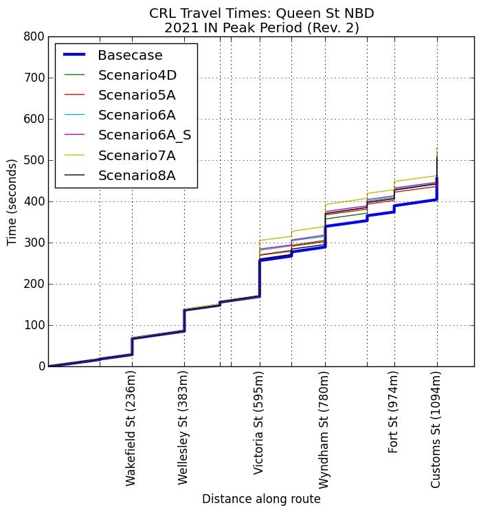
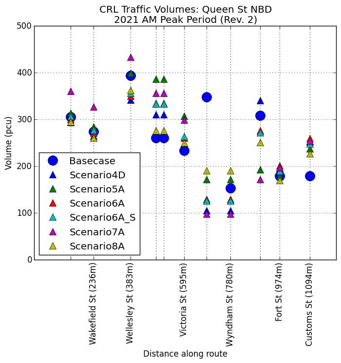
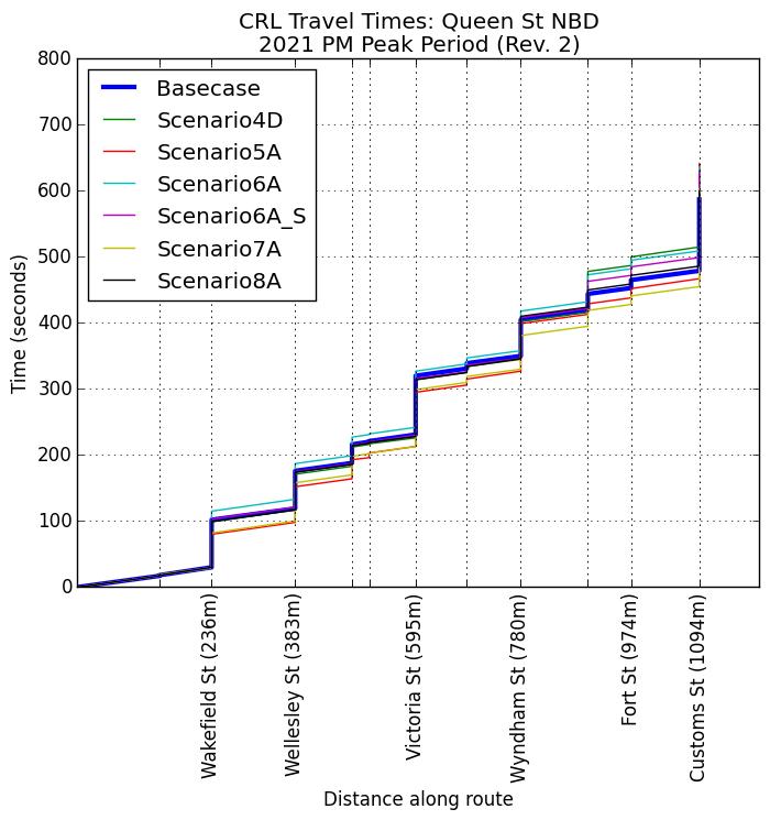
26.1 To achieve the objective of Condition 25.2(a), the Requiring Authority will undertake monitoring of the transport network and implement additional mitigation measures as required to manage congestion to achieve the best practicable option.
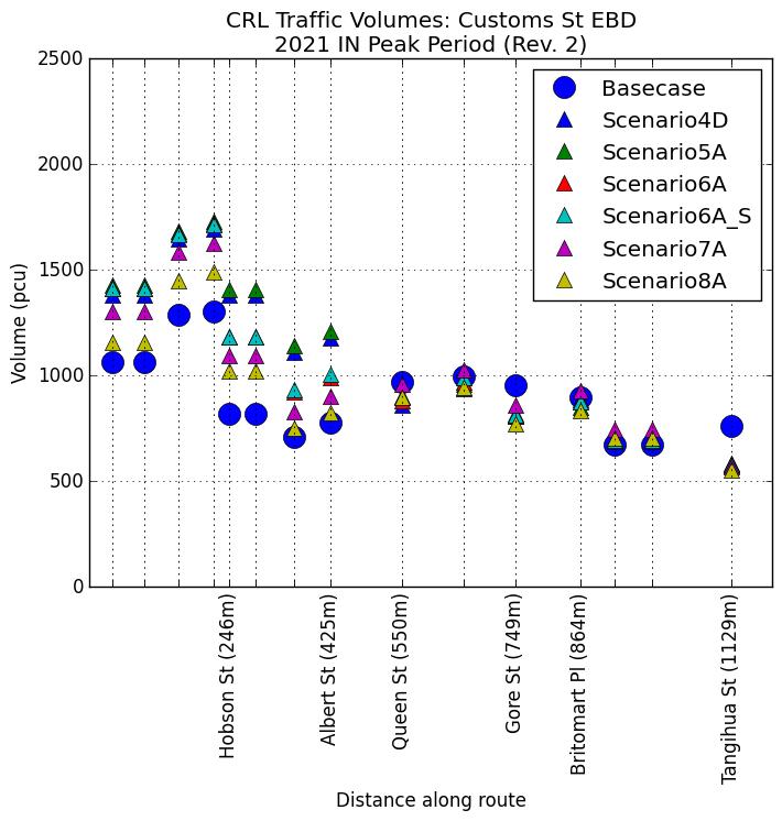
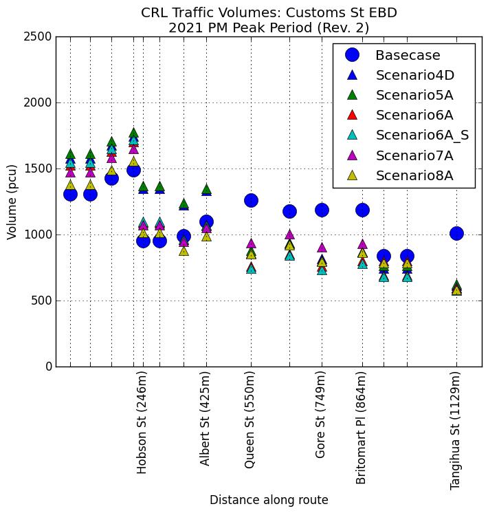
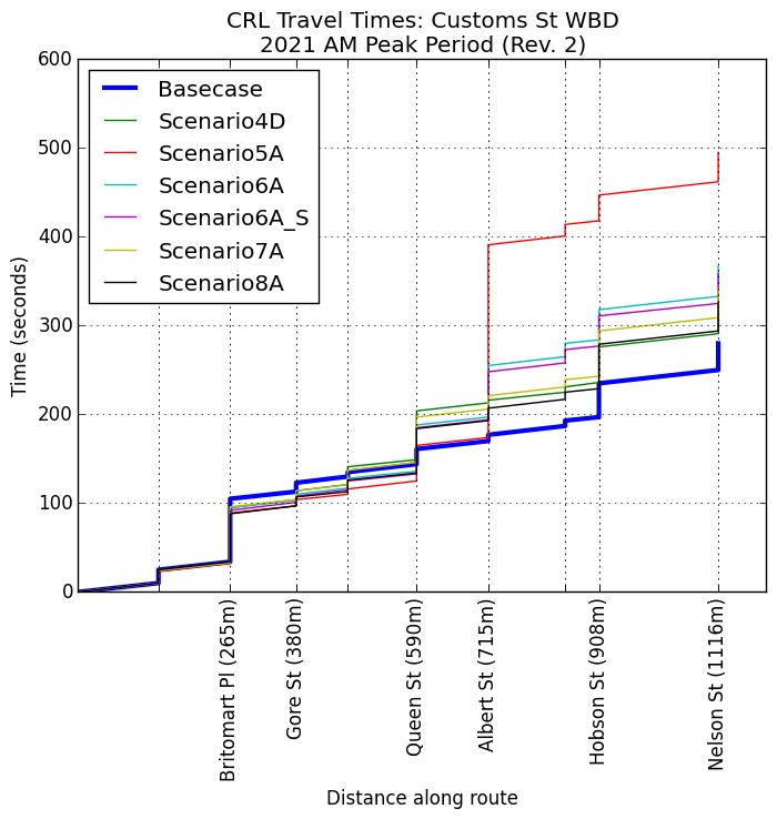
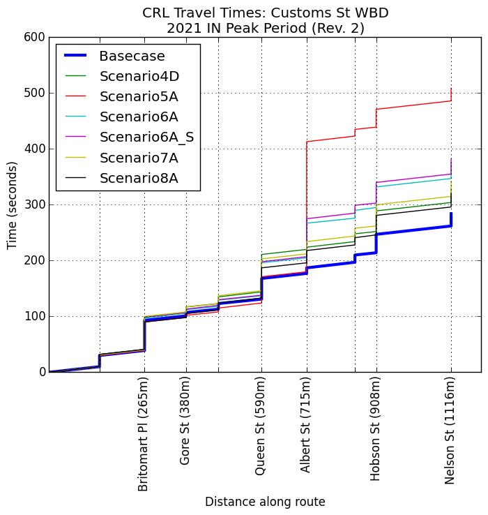
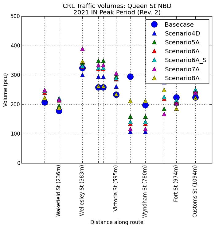
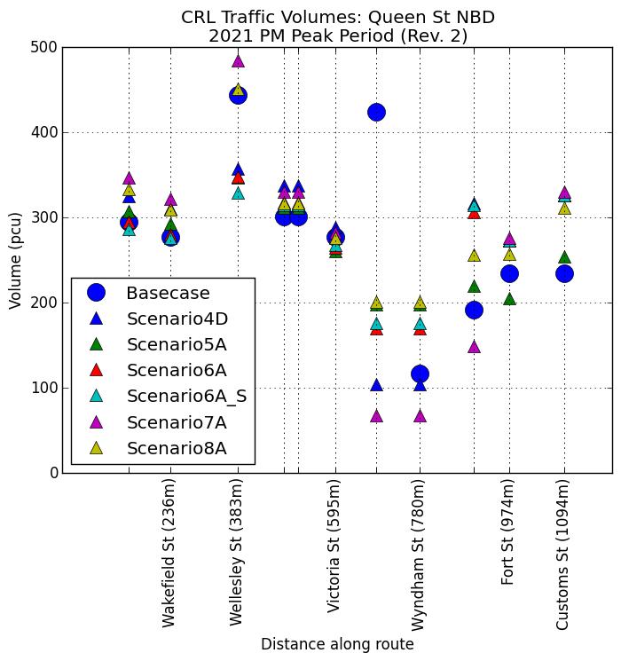
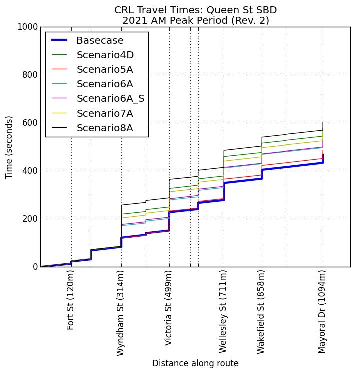
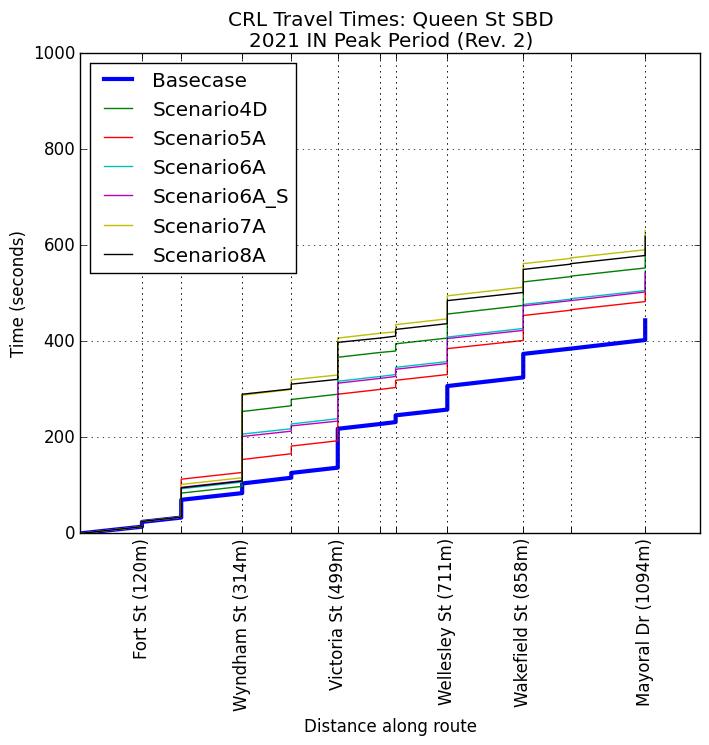
26.2 The purpose of the monitoring is to monitor congestion on the transport network by measuring average delays for traffic travelling along specified routes. The evaluation times will be:
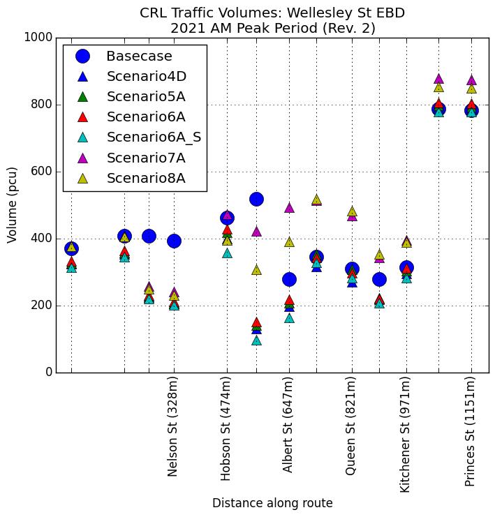
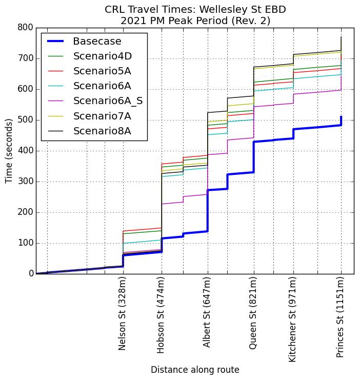
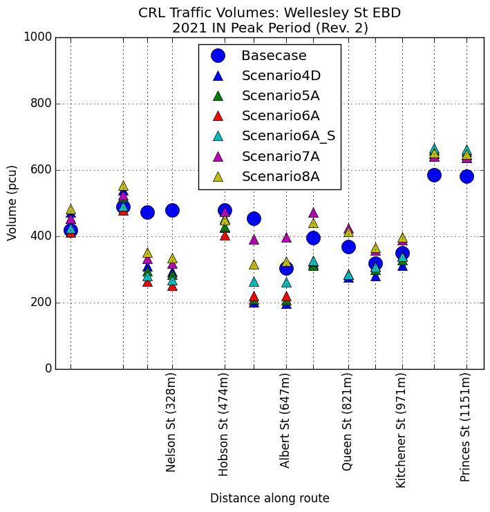
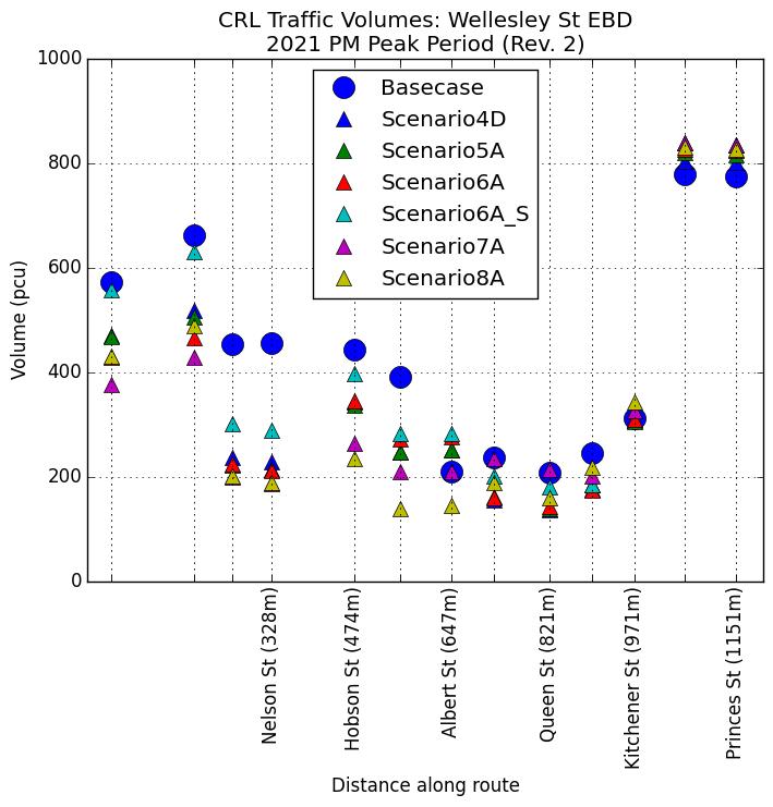
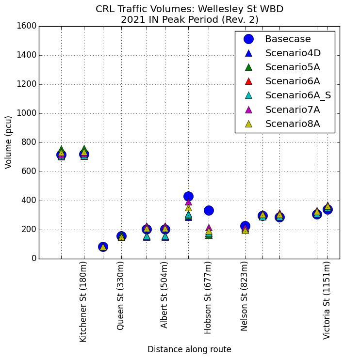
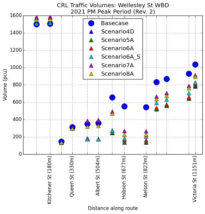
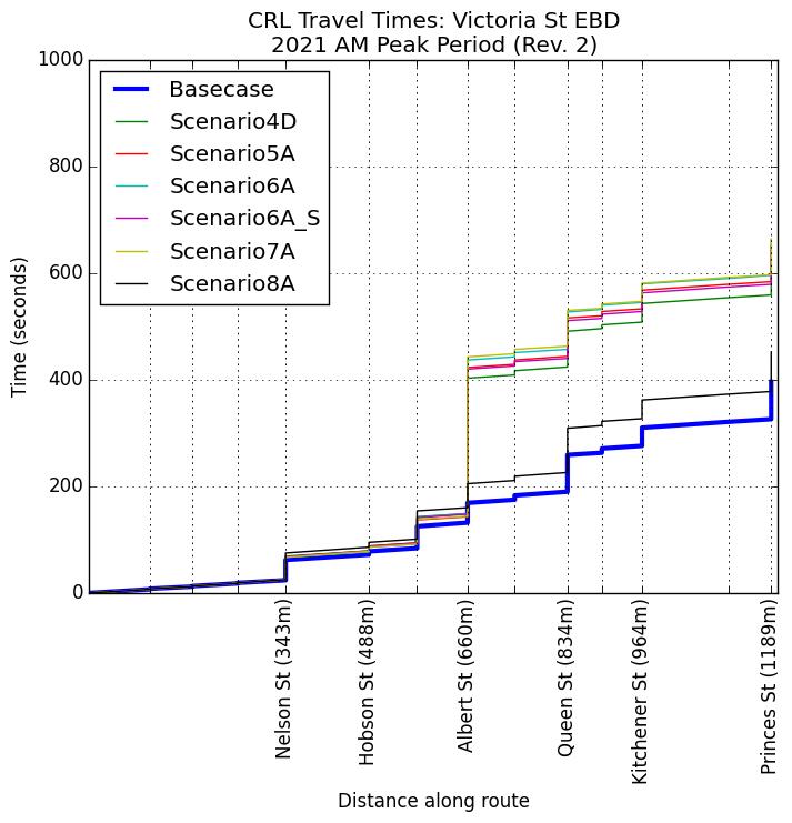
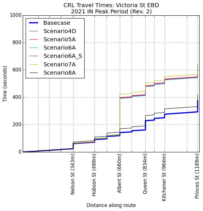
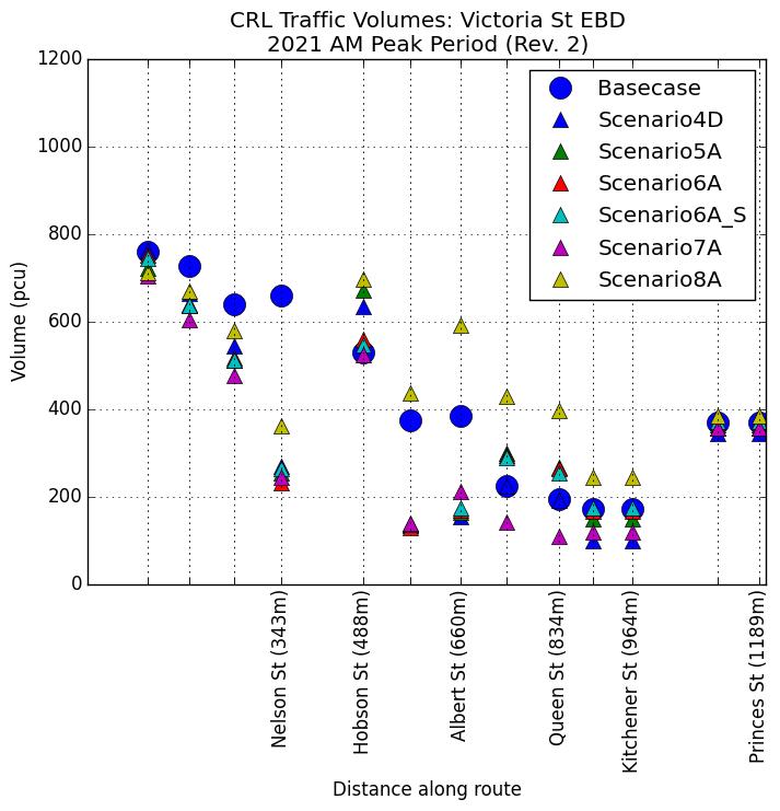
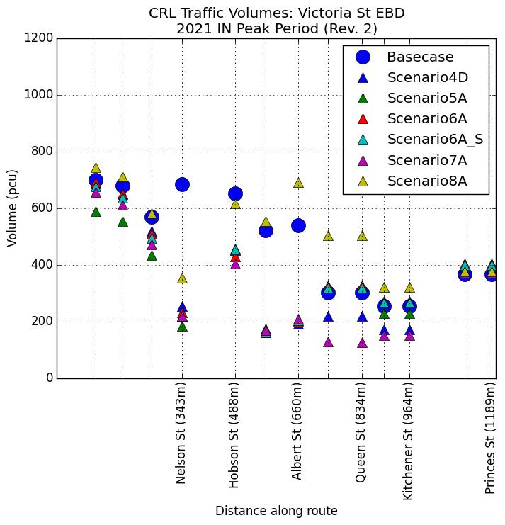
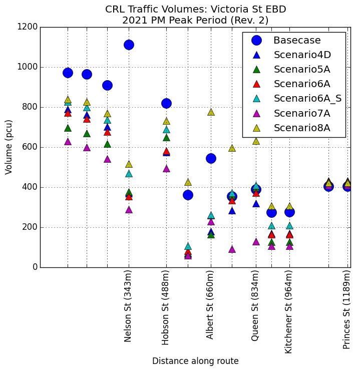
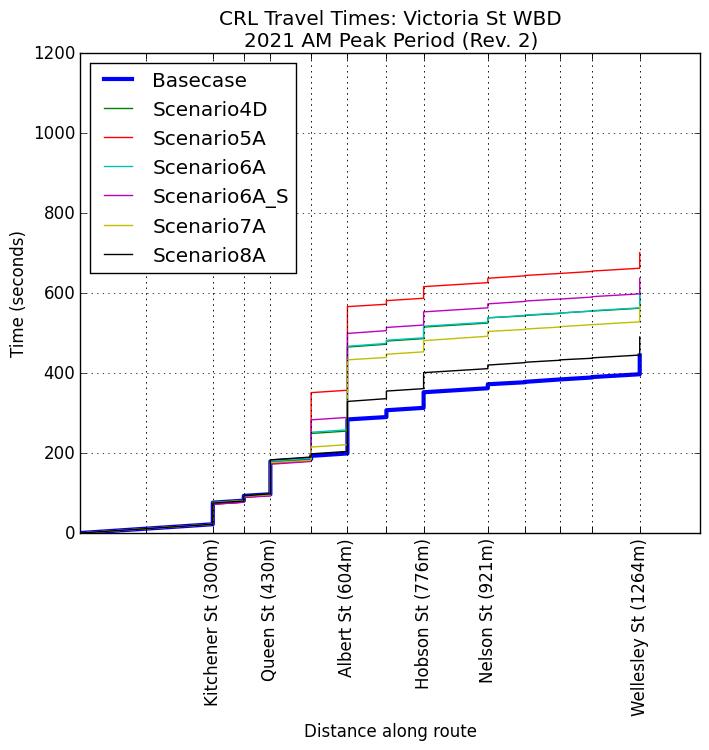
5 and 7
(a) The average travel times over the weekday two hour morning or evening peak period; and 5 and 7
(b) The average travel times over the weekday two hour evening peak period; and 5 and 7
(c) The average weekday inter peak travel times between 9am to noon, noon to 2pm and 2 to 4pm.
26.3 The Requiring Authority shall carry out continuous monitoring for the duration that construction of the City Rail Link is occurring. The intention is that this monitoring is to be continuous, although it is acknowledged that there may be occasional malfunctions.
26.4 If a congestion incident occurs (such as an accident), the monitoring during the affected period will be considered unrepresentative.
26.5 Monitoring shall commence six months prior to construction of the City Rail Link to establish a baseline of existing transport congestion.
26.6 The monitoring will establish whether the City Rail Link construction works have increased traffic delays as follows:
(a) Either by more than 10 minutes (from the monitoring previously undertaken in accordance with this condition)
(b) Or if the travel times are more than three minutes or 30% greater than the forecast modelled increases along that route (according to the most recent traffic model test of that scenario, undertaken prior to the start of construction. The modelled time is to be based on the Auckland City Centre SATURN traffic model or a different traffic model approved by the Requiring Authority).
5 and 7
5 and 7
4.19.3 and 5
5 and 7
5 and 7
5 and 7
5 and 7
(c) The 30% above shall only apply for an increase predicted to be over four minutes. 5 and 7
26.7 If the travel times exceed the above criteria on any one of the specified routes, then additional mitigation shall be implemented by the Requiring Authority in its role as the Road Controlling Authority (under its statutory obligation). The additional mitigation could include but is not limited to advertising alternative routes, removing on street car parking or implementing operational measures, such as lane reconfigurations or signal phasing, to increase capacity on the surrounding network where reasonably possible at that time.
26.8 The purpose of additional mitigation measures is to mitigate the increases in traffic delays, reducing these to below the levels identified in Condition 26.6 as far as is reasonably achievable.
5 and 7
5 and 7
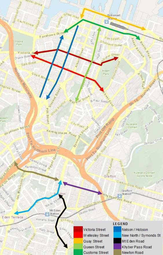
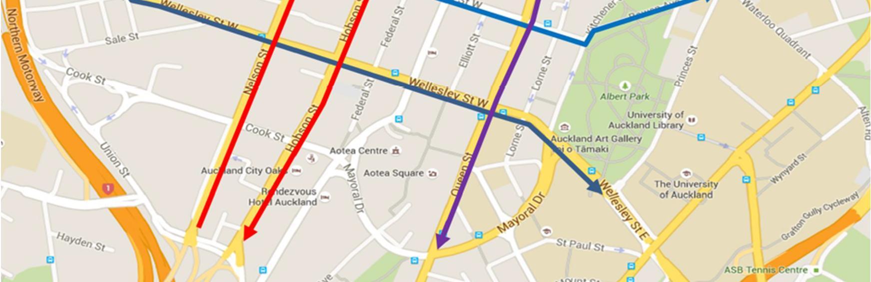
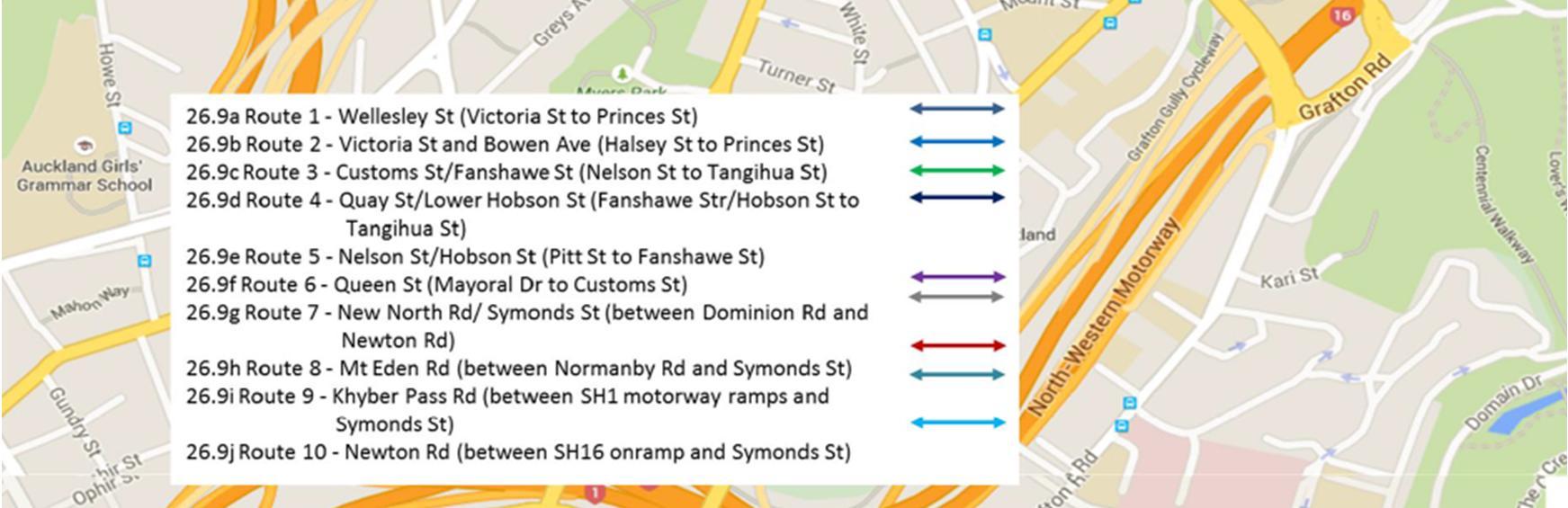
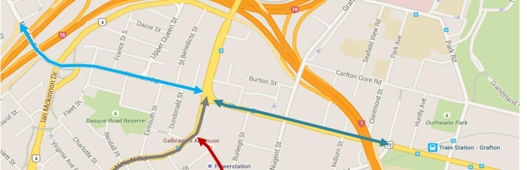
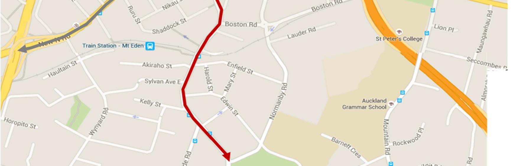
26.9 For the purposes of this condition, the following are the specified routes: 5 and 7
(a) Wellesley Street (between Victoria Street and Princes Street) 5 and 7
(b) Victoria Street (between Wellesley Street and Princes Street) 5 and 7
(c) Customs Street/Fanshawe Street (between Nelson Street and Tangihua Street) 5 and 7
(d) Quay Street/Lower Hobson Street (between Fanshawe Street/Hobson Street and Tangihua Street) 5 and 7
(e) Nelson Street/Hobson Street (between Pitt Street and Fanshawe Street) 5 and 7
(f) Queen Street (between Mayoral Drive and Customs Street) 5 and 7
(g) New North Road/Symonds Street (between Dominion Road and Newton Road) 5 and 7
(h) Mount Eden Road (between Normanby Road and Symonds Street) 5 and 7
(i) Khyber Pass road between the southern motorway ramps and Symonds Street if this route is to be used by construction related trucks 5 and 7
(j) Newton Road between the north western motorway ramps and Symonds Street 5 and 7
26.10 The specified routes shall exclude whichever east-west route has its intersection with Albert Street closed at the time of the surveys. 5 and 7
Transport, Access and Parking: Specific Requirements (Britomart to Mayoral Drive)
27.1 To achieve the objective in Condition 25, the following measures shall be implemented:
(a) A vehicle access lane at least 3m wide shall be provided along the eastern side of Albert Street between Customs Street and Victoria Street to provide access to properties (except that while the Albert Street/Victoria Street intersection is closed, this access lane is only to be provided between Customs Street and Durham Street);
(b) A vehicle access lane at least 3m wide shall be provided along the western side of Albert Street between Customs Street and Victoria Street to provide access to properties, except that:
(i) While the Albert Street/Customs Street intersection is closed, this access lane is only to be provided between Victoria Street and Wolfe Street; and 4, mainly 4.3
(ii) While the Albert Street/Victoria Street intersection is closed, this access lane is only to be provided between Kingston Street and Customs Street. 4, mainly 4.3
(c) The east-west / west-east connection (two fully operational traffic lanes in each direction) is to be maintained in each direction at two of the Customs Street, Victoria Street and Wellesley Street intersections with Albert Street during the period when the third of those intersections is otherwise fully closed; 4, mainly 4.3
(d) The left turn movement from Customs Street (from the east) into Albert Street, and the left turn from Customs Street (from the west) into Albert Street, shall be retained while the Albert Street / Customs Street intersection is fully closed;
4, mainly 4.3
(e) The left turn from Durham Street into Queen Street shall be reopened while the Albert Street/Victoria Street intersection is fully closed; n/a
(f) Two way access shall be provided on the single service lane along the western side of Albert Street between 87 Albert Street and Kingston Street while the Albert Street/Victoria Street intersection is fully closed; 4, mainly 4.3
(g) Vehicular Access into and egress from: 4, mainly 4.3
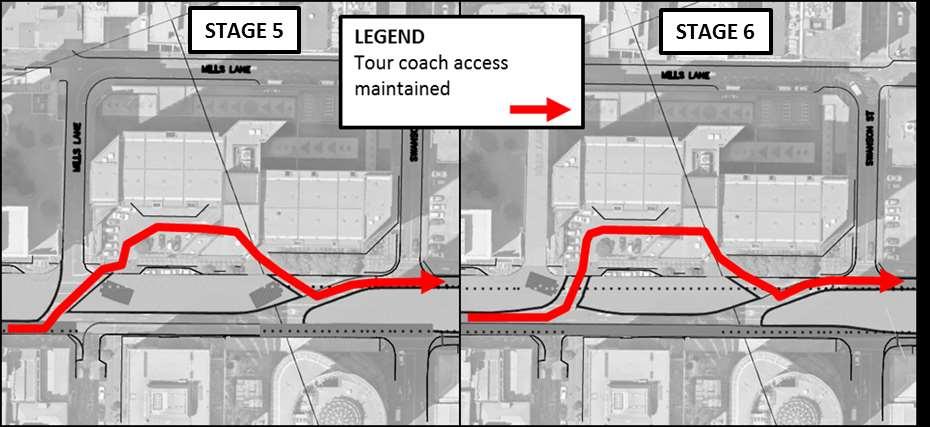
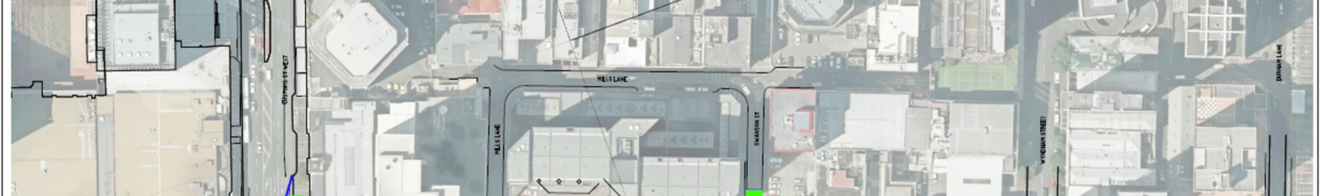
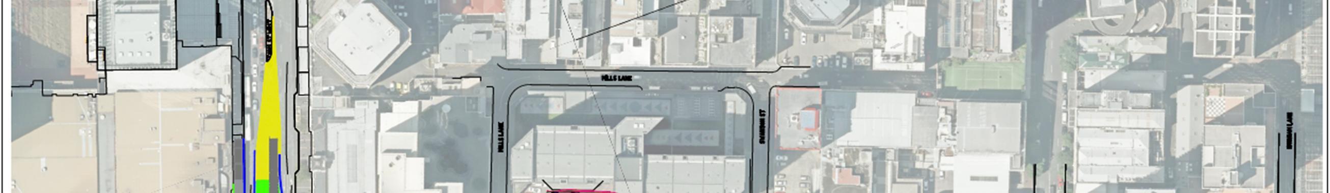
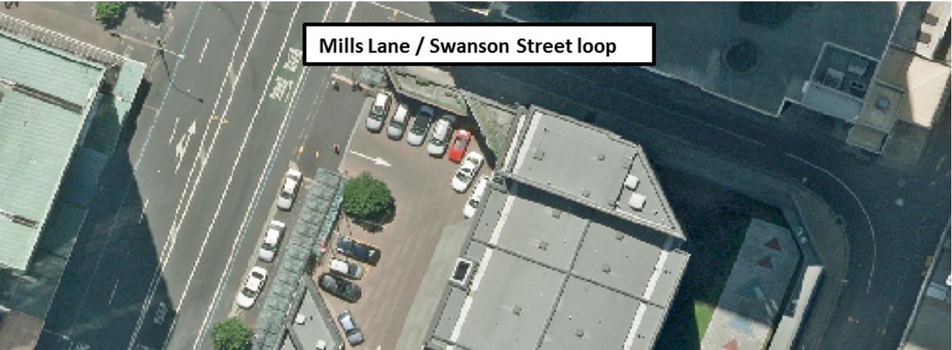
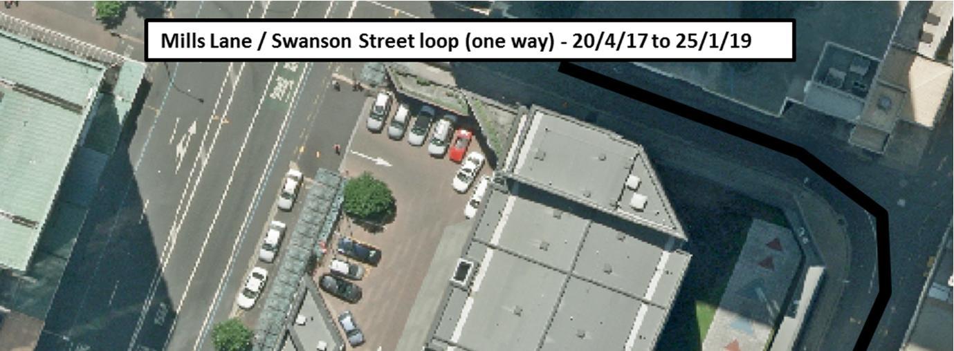
(i) Mills Lane to and from either Albert Street or Swanson Street; and 4, mainly 4.3
(ii) The Stamford Plaza Auckland main entrance and forecourt area is to be provided at all times and for the avoidance of doubt cannot be temporarily closed during construction. 4, mainly 4.3
(h) Providing pedestrian and cycle access to private property at all times; 4, mainly 4.3
(i) Providing footpaths of at least 1.5m in width along either side of Albert Street; 4, mainly 4.3
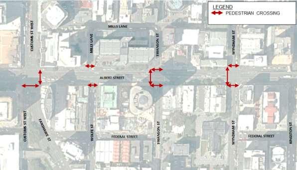
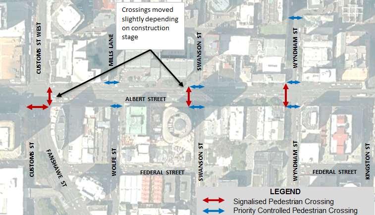
(j) At a minimum two safe crossing passageways (which are “fully accessible” with a minimum width of 1.5m wide and well lit ), need to be provided in the vicinity of Swanson Street and Wyndham Street, in addition to pedestrian crossings at the intersections of Victoria Street and Customs Street; and 4, mainly 4.3
(k) Ensuring that construction traffic does not use Swanson Street, Wolfe Street or Federal Street north of Swanson Street; 4, mainly 4.3
27.2 The Traffic, Access and Parking DWP shall demonstrate how these measures will be implemented and shall also include the following:
(a) How construction works will be undertaken to mitigate congestion on Albert Street, Wellesley Street, Victoria Street, Customs Street, and Quay Street including retaining east-west traffic movements across Albert Street on Customs Street, Victoria Street and Wellesley Street;
(b) The timing and sequencing of temporary road lane reductions and / or closures, and the alternative routes and temporary detours to be used, including:
4 and 6
4 and 6
(i) How these have been selected and will be managed to, where practicable, mitigate congestion on the surrounding road network; 4 and 6
(ii) How the Albert Street/Wyndham Street intersection will be reopened as soon as practically possible; 4 and 6
(c) How disruption to the use of private property located immediately adjacent the designation with access onto Galway Street, Tyler Street, Queen Elizabeth Square, Customs Street, Albert Street, Victoria Street and Wellesley Street will be mitigated through:
4 and 6
(i) Providing vehicle access to private property as practicably possible at all times; 4 and 6
(ii) Retaining local vehicle access to properties located along Albert Street (which may include only left in, left out access ); 4 and 6
(iii) Retaining access for loading and unloading of goods located along the service lane on the eastern side of Albert Street, between Victoria Street and Wellesley Street; and; n/a
(iv) Providing an on street loading bay on Customs Street, Lower Albert Street or Lower Queen Street to provide servicing to 21 Queen Street if access during construction cannot be provided to the existing loading bay area for 21 Queen Street, accessed from Lower Albert Street;
4 and 6
Project #: 2665
Client: Auckland Transport Revision: 5, Date: 2 June 2016
(d) How disruption to the use of the local road network will be mitigated for private bus users, pedestrians and cyclists through:
(i) Providing, where practicable, for the continued operation of private bus operators from hotels and other pick up / drop off locations in the city centre area (cross references to the Communication and Consultation Plan for consulting with private bus operators shall be included in the CEMP and Traffic, Access and Parking DWP); and
(ii) Retaining pedestrian and cycle access through Lower Queen Street and / or Queen Elizabeth Square to provide access to and from the Ferry terminal and Customs Street; and
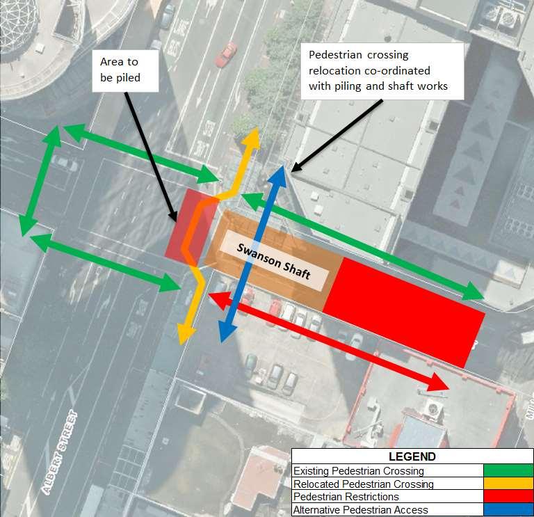
(e) How disruption to pedestrians and cyclists requiring the ability to cross from east to west (and vice versa) across Albert Street between Victoria Street and Customs Street can be mitigated through providing, where practicable, safe pedestrian and cyclist passageways across the construction works on Albert Street.
21.1
In order to give effect to the objective in Condition 19.1, the CEMP shall include the following details and requirements in relation to all areas within the surface designation footprint where construction works are to occur, and / or where materials and construction machinery are to be used or stored:
(a) Where access points are to be located and procedures for managing construction vehicle ingress and egress to construction support and storage areas;
(b) Methods for managing the control of silt and sediment within the construction area; 4.12.3
36 The Consent Holder shall, so far as is it is reasonably practicable, avoid, remedy or mitigate the adverse effects of construction on transport, parking and property access. This is to be achieved through the following objectives:
a. managing the road transport network for the duration of the construction by adopting the best practicable option to manage congestion; 4 and 6
b. maintaining pedestrian access to private property at all times; and 4 and 6
c. providing on-going vehicle access to private property to the greatest extent possible. 4 and 6
Advice Note 1: Condition 36 refers to objectives to be achieved. The requirement to provide mechanisms to achieve these objectives is included in the relevant CRL or Britomart Transport Centre designation conditions.
Table 2 CRL Britomart to Wyndham Street enabling works resource consent1 conditions related to traffic and the relevant sections of this document (for reference only)
Connectus Transport, Access and Parking Delivery Work Plan
Client: Auckland Transport Revision: 5, Date: 2 June 2016
Advice Note 2: This resource consent does not provide approval to close or occupy temporarily Tyler or Galway Streets. If such actions are required they will be sought and managed under the CRL designation and / or an application to vary the Britomart Transport Centre designation.
Discharge Permit (to Air, R/REG/2014/5437)
71 The final AQMP(s) shall also provide detailed methods including, but not limited to, the following matters:
b. a 20 km/hr vehicle speed limit within the Active Construction Zones and Construction Support Areas; 4.4
c. installation of wheel washes; 4.12
d. regular sweeping of public roads around the exit points of Active Construction Zones and Construction Support Areas and sealed vehicle accessways within these areas;
g. covering of loads of material being delivered and removed from the site;
Project #: 2665
Client: Auckland Transport Revision: 5, Date: 2 June 2016
2 PROJECT DESCRIPTION
This section presents a summary of the Project in relation to the matters required to be addressed by the TAP DWP. A detailed description of the construction methodology is provided in the CEMP.
2.1 SUMMARY OF METHODOLOGY
Connectus will construct two parallel rail tunnels within the Albert Street road corridor between Customs Street and Wyndham Street using a “bottom up2” cut and cover trench method. The total length of the tunnel for the Project will be 340m. A number of utilities are required to be removed, relocated, or supported during construction.
Generally, the Project works will consist of the following Phases:
Phase 1. Utility alterations, piling and capping beam construction within Albert Street (including localised relocation of any conflicting utilities)
Phase 2. Piling and road deck construction within the Customs Street Intersection
Phase 3. Trench excavation, including using shotcrete and Rock Dowelling
Phase 4. Construction and waterproofing of the rail tunnels
Phase 5. Backfilling of the trench, including construction of the new road pavement.
The traffic management for these construction phases will be conducted in Stages as shown in Table 3.
Table 3 Traffic management stages
Traffic management stages
Stage A, B, C and 0 to 9
Stage 10
Stage 10+
Construction Phases
Phase 1 and 2
Phase 2, 3 and 4
Phase 5
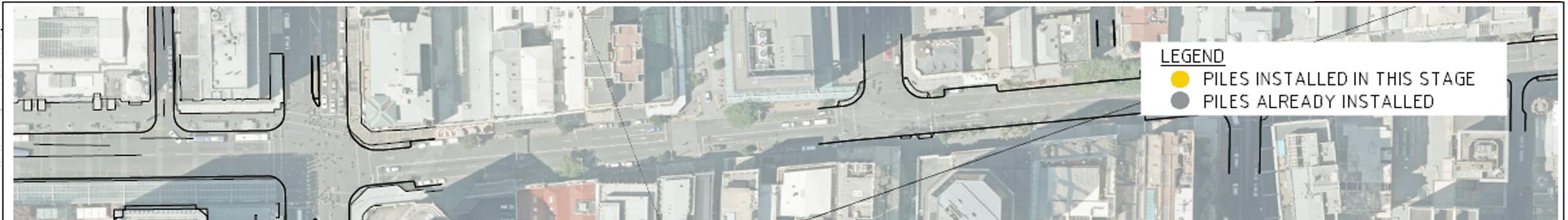
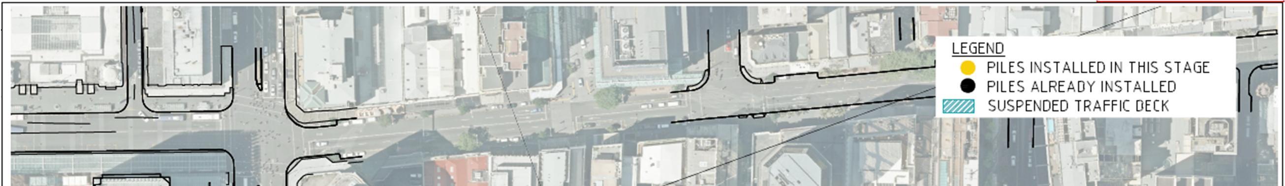
2.1.1 Piling and capping beam construction within Albert Street
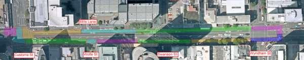
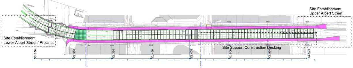
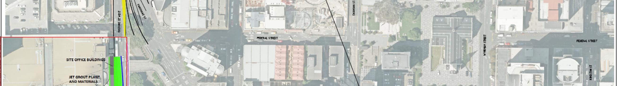
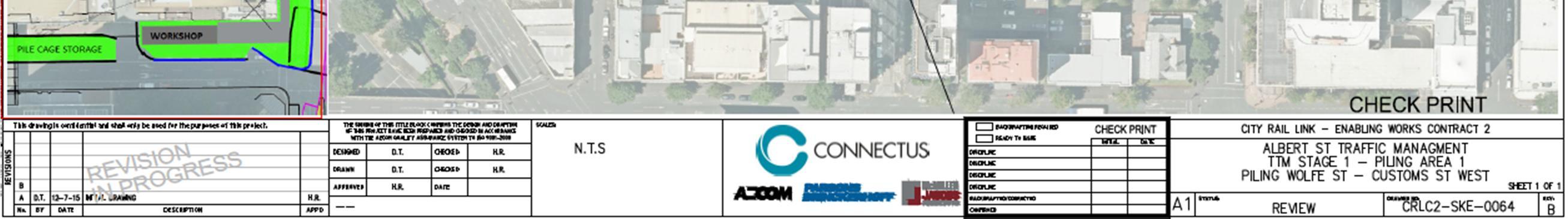
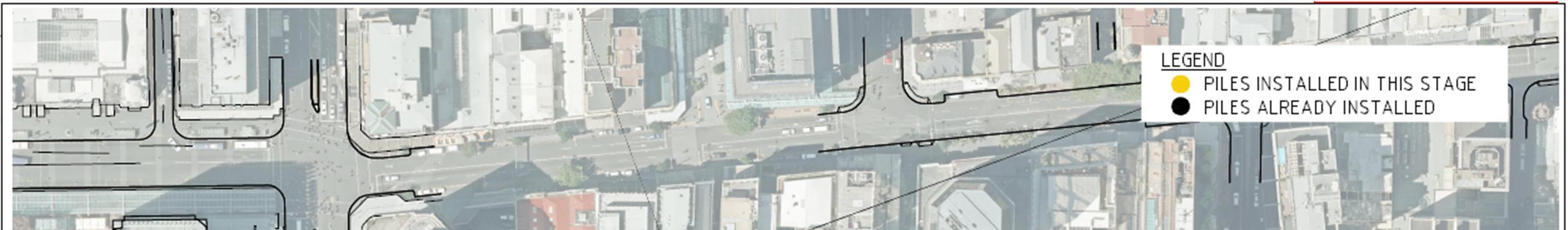
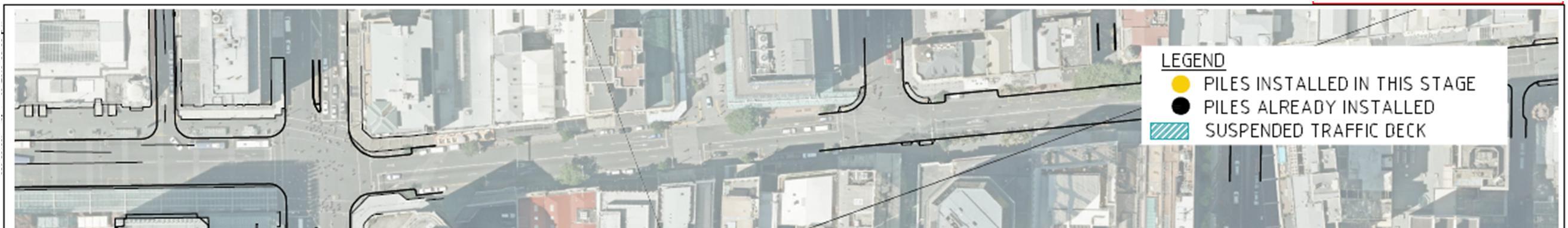
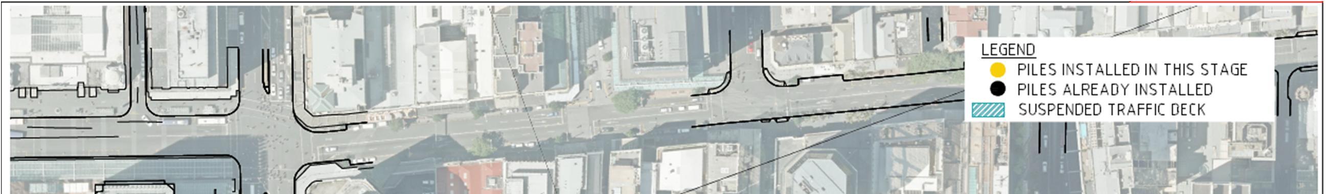
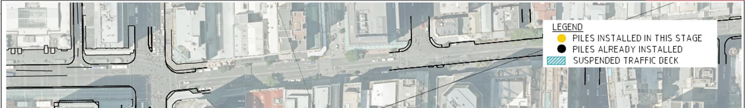
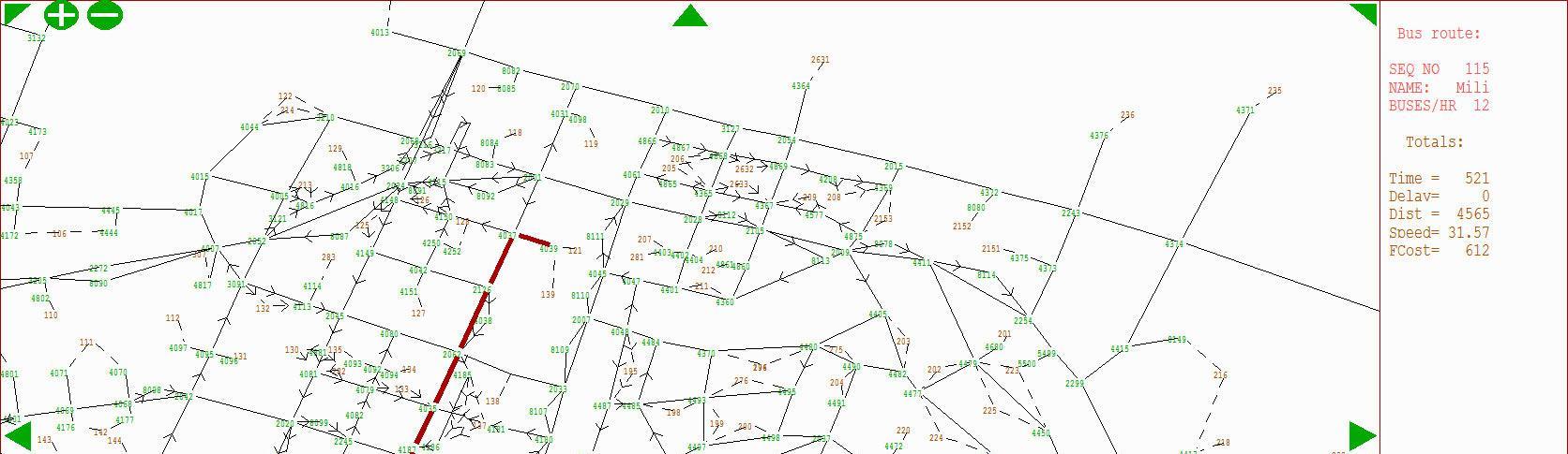
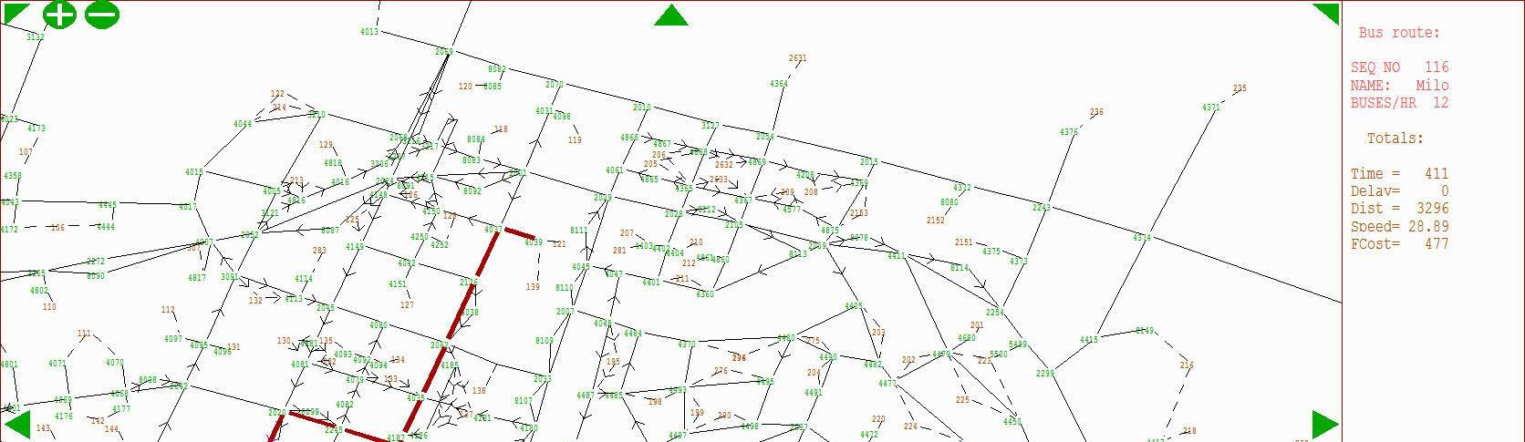
Piling is required as the initial stage of construction for the Project. It includes the installation of cased continuous flight auger (CFA) piles and the construction of the pile cap on the western side of Albert Street. Figure 2 shows the location and staging of the piling (the sequence will be confirmed closer to construction). The asphalt surface of the road carriageway will be removed and the utilities relocated. Piling will then occur, and a Pile-Cap constructed to connect the piles along the western side of Albert Street. Reinforcing will be installed and concrete placed.
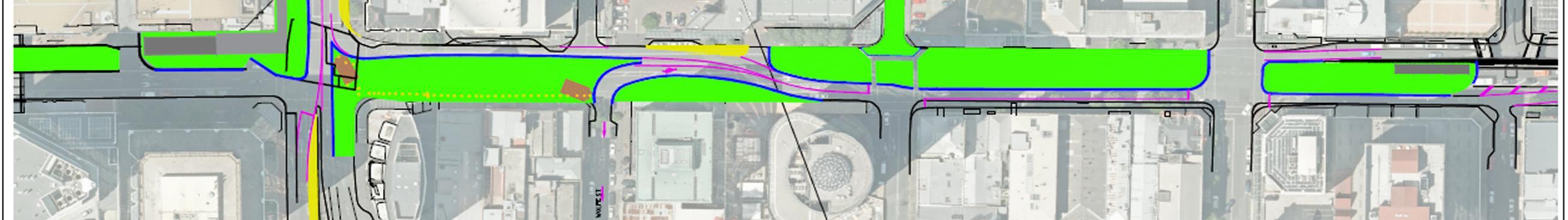
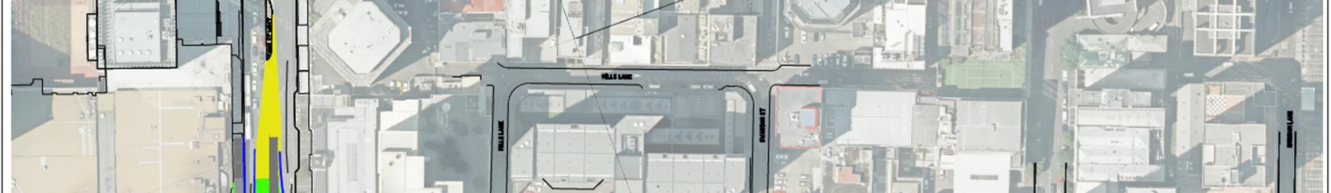
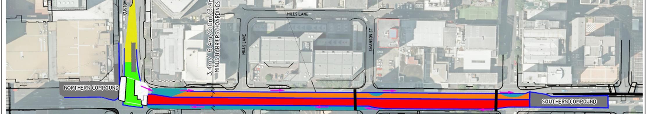
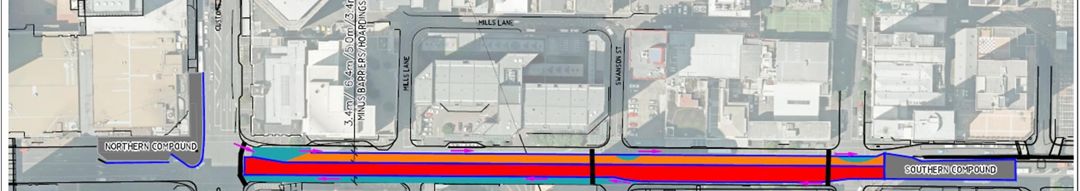
On the eastern side of Albert Street, a service lane for construction traffic only will be constructed that predominantly sits on the piles and trench propping beams Underground utilities will be lowered or protected as required to prevent their damage. The 5m wide construction deck will be installed along the eastern edge of Albert Street for construction traffic use only
On the western side of Albert Street a general traffic lane will be constructed that predominantly sits between the existing kerb line and the new piles and is supported by the existing pavement (see Figure 3)
2 The bottom up method involves piling and excavating the trench in full, constructing the tunnel structure and then backfilling. Top down construction involves piling, constructing a trafficable deck and the excavation to depth and construction from below.
The piling rig will be moved across traffic lanes between work areas (such as between Albert Street and the work sites each side of Customs Street) in coordination with traffic phasing and under traffic control in off peak periods. The crossing distance is typically 3-7m and will take 1-2min.
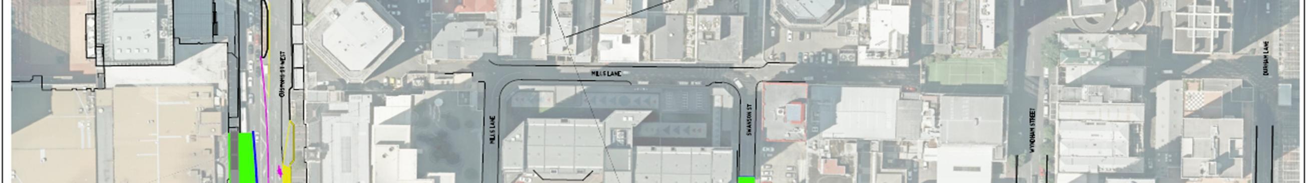
2.1.2 Customs Street intersection piling and road deck construction
Piling and construction of a temporary deck structure3 at the Customs Street/Albert Street intersection will permit traffic to cross over the intersection, while tunnel construction occurs underneath. The deck will be constructed in four stages as shown in Figure 4. This will enable traffic to utilise the intersection during excavation and construction of the rail tunnel structures and avoids closing the intersection completely.
Each stage requires pile installation and jet-grouting followed by excavation to approximately 2m depth to allow the construction of the concrete deck. Once all four piling and deck sections are complete, excavation and tunnel construction can commence beneath the live intersection with access from the main trench excavation
In addition to supporting the traffic deck, the piles and jet-grout columns hold back the soil during excavation beneath the deck and stop water from entering the excavation site. After tunnel construction the area under the deck will be backfilled and the deck structure ‘buried’ - i.e. the deck will no longer be a separate deck structure and will be permanently incorporated in the area immediately below the intersection pavement.
3 Top down construction method
Figure 2 Piling Stages
Figure 3
Western traffic deck
Connectus Transport, Access and Parking Delivery Work Plan
Project #: 2665
Client: Auckland Transport
Doc. No. CRL-PAT-ENV-CON-PLN-000904
Revision: 5, Date: 2 June 2016
Figure 4 Staged construction of road deck – sections of the deck will be constructed in 4 stages (sequentially)
2.1.3 Trench excavation and spoil handling
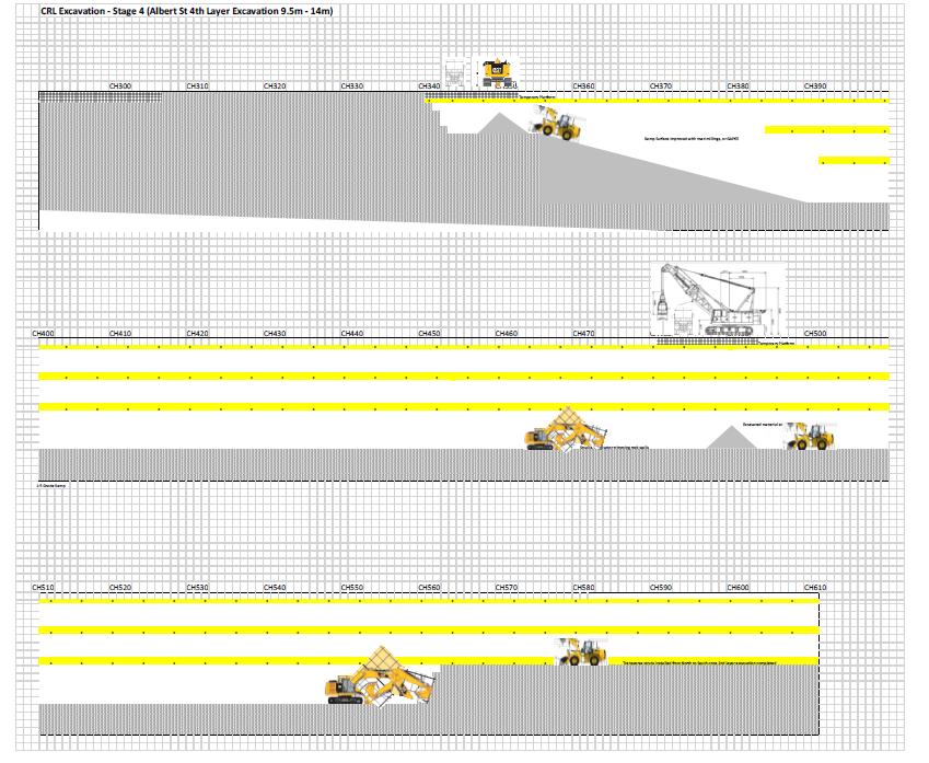
As a general principle, the trench excavation will be carried out in layers as shown in Figure 5 with installation of temporary struts and ground anchors as the depth increases. The programme of excavation will be structured in such a way as to aim to complete full depth excavation between CH350 and 610 first, allowing tunnel construction works (approximately CH 270-350) to commence following this.
As excavation progresses, steel whaler beams and struts are installed in combination with ground anchors to support the piled trench walls. In addition, a conveyor belt will be installed to move spoil material to loading points along the eastern deck. Installation of shotcrete and vertical strip drainage will also occur in tandem with the excavation process. Once the strip drains, ground support and shotcrete have been installed, struts will be installed and the excavation continued to the next level. The excavation will be undertaken from construction traffic, machinery and loading deck running the full length of the eastern side of the works. Figure 6 shows a typical section for the cut and cover tunnels along Albert Street.
Connectus Transport, Access and Parking Delivery Work Plan
Project #: 2665
Doc. No. CRL-PAT-ENV-CON-PLN-000904
Client: Auckland Transport Revision: 5, Date: 2 June 2016
5 Excavation - layers
Figure
Connectus Transport, Access and Parking Delivery Work Plan
Project #: 2665
Client: Auckland Transport
Doc. No. CRL-PAT-ENV-CON-PLN-000904
Revision: 5, Date: 2 June 2016
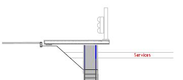
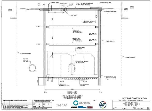
Figure 6 Typical cross section for the Albert Street Cut and Cover Tunnels
2.1.4 Waterproofing and tunnel construction
The construction of the rail tunnels will be a rolling process with multiple work faces progressing simultaneously. The tunnel works will start at the southern end of Albert Street when the excavation plant is clear of the base of the tunnel.
Tunnel construction will be broken into 12m lengths, and comprises the following tasks:
- Base drainage and blinding
- Waterproofing
- Base foundation and construction
- Wall construction
- Roof construction
- Roof waterproofing.
Concrete will be pumped to the works by pump machinery that is initially located at the southern compound near Wyndham Street. The pump machinery is moved along the eastern construction deck as required
2.1.5 Trench backfilling
As the construction of the tunnels progresses, back filling of the cut and cover excavation in the Custom Street Intersection and Albert Street trench will occur. The trench backfill will be placed on top of the tunnel structure after construction has been completed for a sufficient length (approximately 50m), including the installation of the waterproofing membrane, and will continue to follow the tunnel construction as it progresses. A layer of concrete blinding (or similar) will be placed over the roof
Project #: 2665
Client: Auckland Transport Revision: 5, Date: 2 June 2016
membrane for protection from the trench backfill works. A delivery truck will unload backfill material at the southern compound and along the eastern construction deck. Backfill material will be loaded onto the conveyor system that will transport it to the correct position above the tunnel.
The majority of the trench structure removal (i.e. backfill, pile cap removal, deck and barrier removal and new pavement construction) will occur within the trench worksite with temporary lanes required as the barriers are removed.
Works to complete new utility routes or reinstate existing utilities will be co-ordinated with the filling operation as it reaches the upper layers. Finally, the construction of the new permanent road pavement will occur in stages after the trench backfill has been completed.
2.1.6 Utilities location and exposure
The location of all network utilities will have been thoroughly identified prior to piling and, wherever possible, the pile positions selected so that they do not conflict with any utilities. Once a thorough site inspection has been completed, a permit to dig will be issued which will clearly show the location of all utilities. Any necessary relocation of utilities within the established work sites will occur prior to commencement of piling as required with the majority of utilities relocated or altered prior to the start of piling and the main civil works (also see Section 4.2 of this DWP4). Network utility operators that will be affected by the works include Vector Electricity and Communications, Vector Gas, Chorus, Auckland City and Vodafone.
The final method for protecting, or relocating each utility will be provided by the relevant utility operator and depends on the type of utility and its location (confirmed during excavation).
2.1.7
Temporary pavement
Where required in order to maintain traffic movements, it will be necessary to put down a temporary pavement. Temporary pavements will consist of unbound granular material with a bituminous seal, concrete panels or secured and cushioned (for noise mitigation) steel plates on the surface.
2.1.8 Deconstruction and final reinstatement
The deconstruction of the tunnel barrier and temporary decks will essentially follow the reverse staging of the construction, albeit over a shorter period and with the majority of the works undertaken from within the trench barrier area. Following this will be the construction of the final urban design streetscape works. The urban design is currently being developed and this TAP DWP will be updated to confirm the deconstruction and streetscape TMP works form and methodology.
4 The CEMP contains a full description of the required utility works and methodology for their implementation if further detail is required.
Project
Client: Auckland Transport Revision: 5, Date: 2 June 2016
2.2 CONSTRUCTION PROGRAMME SUMMARY
The Project works will start in May 2016 with mobilisation and compound establishment then utility alterations and piling along Albert Street. Indicative key milestones for the project phases relevant to the TAP DWP are described in Table 4 while the programmed lengths of each TMP phase are given in Table 5. A comprehensive programme of works is provided in the CEMP.
Table 4 Summary of indicative key milestones relevant to traffic management
3. Tunnel box Stage 10
4. Backfill
5. Reinstatement Stage 10+
Table 5 Summary of indicative TMP stage key milestones
2.3 CONSTRUCTION TRAFFIC GENERATION
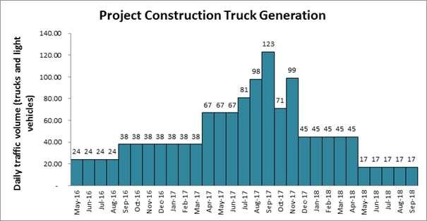
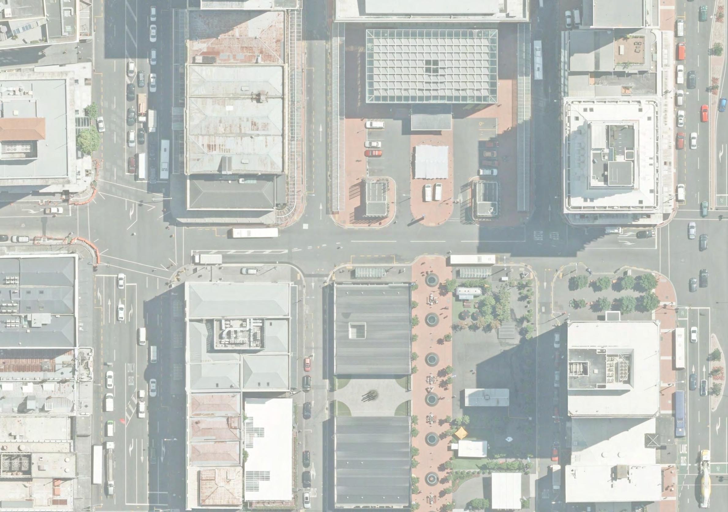
Overall, the predicted volume of construction traffic generated by the Project will be relatively low, averaging approximately six vehicles per hour and 50 per day over the expected ten hour workday. This construction traffic will be spread across the several site accesses and loading zones on the eastern side of Albert Street and in Customs Street and Lower Albert Street. Figure 7 shows the estimated construction traffic generation across the Project life
Connectus Transport, Access and Parking Delivery Work Plan
Figure 7 Estimated construction truck generation across Project life
Revision: 5, Date: 2 June 2016
As shown in Figure 7, daily vehicle movements (trucks and light vehicles) are expected to vary for the Project as a whole from an initial volume of approximately 40 vehicles / day during piling to a peak of approximately 140 vehicles / day during excavation and tunnel box concrete pouring In addition to the estimated truck volumes shown in Figure 7, it is anticipated that there will be up to 12 light vehicle movements per day across the Project area. These generated traffic estimates exclude third party vehicles associated with the changes to traffic management and temporary works installation, streetscape, or utility alterations5 or other discrete traffic events (typically weekend or night time) as may be required for the delivery of large specialist plant or road sweeping.
2.4 CONSTRUCTION WORKFORCE
The Project workforce is estimated to vary between approximately 20 staff initially, and a peak of 70, with up to 30 being office based engineering or administration staff. Additional third party workforce such as utility authority and traffic management staff will attend site for utility alterations or discrete events in addition to those described above.
2.5 WORKFORCE TRAVEL MANAGEMENT PLAN
A Workforce Travel Management Plan has been prepared for the Project and is provided in Appendix A Limited parking will be provided for Project staff, with this being provided for core staff (predominately office and managerial), at the Downtown Car Park operated by AT General workforce parking will not be available in the worksites.
It is expected that associated trips and traffic impacts will be minimised through car sharing, use of public transport and off-peak shift starts (especially in the morning). The Project workforce will be provided with public transport travel information, and encouraged to car pool if they choose to drive and use nearby public car parks.
5 Note that the program has been amended to include utility works prior to the start of main works shown in this figure and the actual construction volumes will vary in timing but are not expected to increase.
2.6 HOURS OF OPERATION
2.6.1 General
The normal Project work hours will be 7am to 7pm, Monday to Saturday.
CRL designation condition 31.1 and 36.3 (b) sets limitations on operating hours for piling and road (saw) cutting:
7pm-7am: no piling
10pm-7am: more significant noise and vibration limitations
Night time works are proposed (subject to noise restrictions and management) for installation of the permanent wearing course at the Customs Street intersection (two night’s total) and for steel fixing of the rail tunnel roof (one full year). A number of discrete events will be needed for the installation of traffic management measures, the delivery of large plant to the site and minor amendments to signals, which will be undertaken as weekend works when motorised and pedestrian traffic is significantly reduced.
2.6.2 Site attendance
The site(s) will be attended by a qualified Manual Traffic Controller (MTC) during operational hours to manage construction vehicle access and other traffic management duties as needed.
A project wide Site Traffic Safety Manager (STMS) will be on site during the normal operational hours; and available when the site is unattended in accordance with normal practice.
2.6.3
Residential zone road use restrictions
Wyndham Street has residential zoned properties along its northern boundary between Albert Street and Hobson Street as shown in Figure 8 as required by NoR condition 25.3 (d) Construction trucks will only use this length of Wyndham Street during the following hours and after prior advice to residents consist with the requirements of the Communication and Consultation:
9:30am-4pm, Monday to Friday (i.e. no CRL construction trucks to use this road section 7am9:30am or 4pm-10pm)
9am to 2pm, Saturday (i.e. no CRL construction trucks to use this road section 7am-9am or 2pm-7pm)
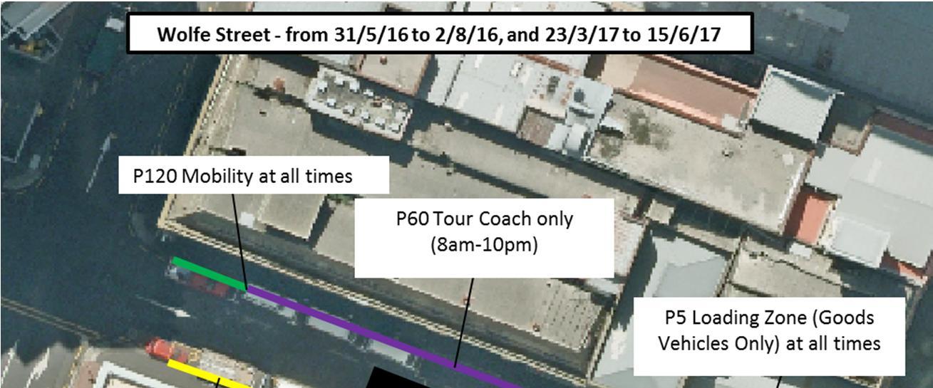
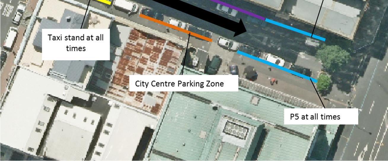
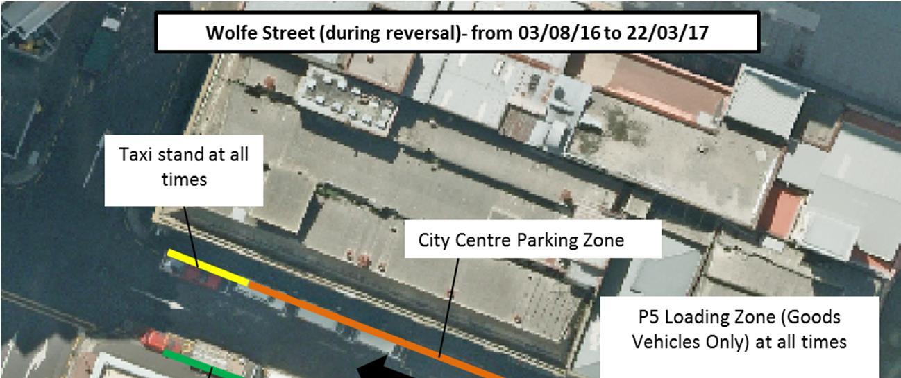
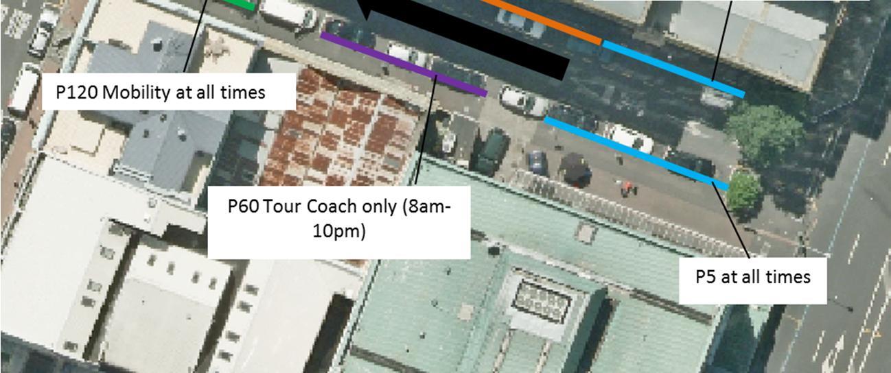
CRL construction trucks may not use Wolfe Street or Swanson Street (west of Albert Street) at any time as prescribed by NoR condition 27.1(k). This route ban will be included in directions to staff and suppliers both at project induction, in individual TMPs and again on leaving the site by the controlling MTC.
Connectus Transport, Access and Parking Delivery Work Plan
Project #: 2665
Doc. No. CRL-PAT-ENV-CON-PLN-000904
Client: Auckland Transport Revision: 5, Date: 2 June 2016
Figure 8 Estimated construction traffic generation across Project life6
Auckland City Operative District Plan 2004 (Central Area Section)
Project #: 2665
3 EXISTING CONDITIONS
3.1 GENERAL
The existing transport network conditions are described in the Integrated Transport Assessment (ITA) submitted as part of the Notice of Requirement process for the CRL designations, and are summarised in the following sections
3.2 ROAD FORM AND USE
3.2.1 Description
Albert Street currently provides for traffic distribution and property access in the central city with the addition of a significant number of bus services. Albert Street currently has two lanes, including a bus lane for each direction, with the following existing turning restrictions:
NBD right turn into Victoria Street (east)
NBD and SBD right turn into Wyndham Street (both east and west)
Peak hour SBD right turn into Swanson Street (west)
There is also a southbound single lane “service lane” which provides access to Durham Street.
Lower Albert Street has a two-lane approach to Customs Street intersection and provides accesses to adjoining buildings
Customs Street has three lanes in the west approach to Albert Street, and four lanes in the east approach. This street forms a key east-west connection in the CBD. The right turn into Albert Street from Customs St west approach is currently banned.
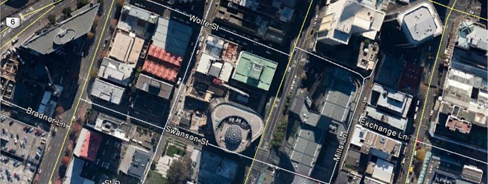
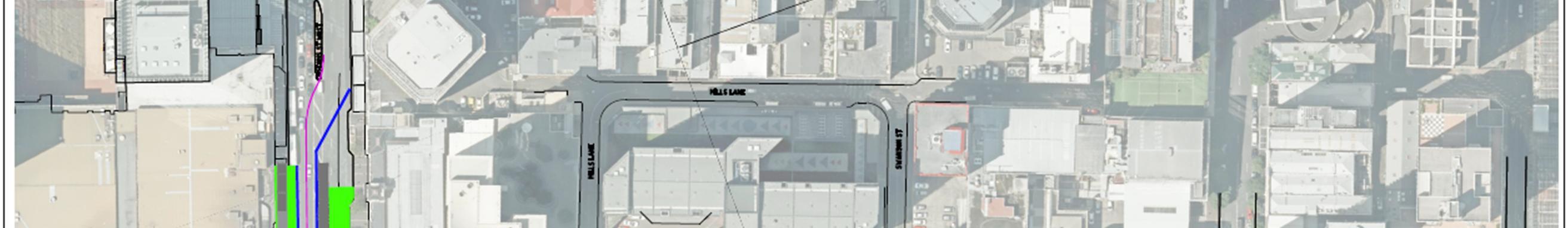
Swanson Street and Mills Lane currently have one general traffic lane for each direction of traffic without turning restrictions at the Albert Street or Mills Lane intersections. These minor side streets primarily provide back of house access to adjoining properties, notably including Stanford Plaza, the Foodstuffs Queen Street New World supermarket and a number of residential and business carparks. No on-street parking is allowed on the east-west sections.
Wolfe Street is currently a single lane one-way street (eastbound direction). This street provides access to local businesses, residential properties and an educational facility.
Federal Street south of Swanson Street is a two-way street with a single general traffic lane in both directions, and primarily provides access to two car parking facilities, one within the Reo building at 15 Federal Street and the second within the ANZ building (the entrance is located adjacent to 18 Federal Street). There are a number of apartment buildings on the street and an educational facility.
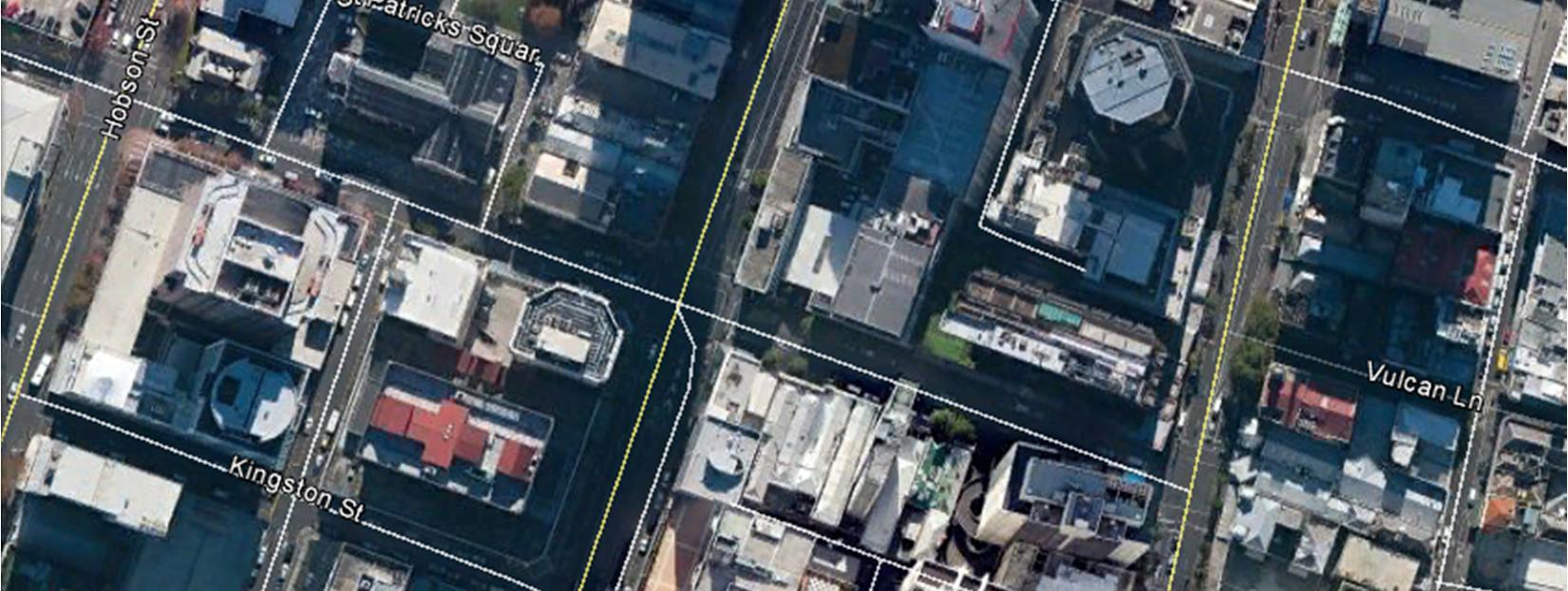
Wyndham Street currently has two lanes plus parking for each approach to Albert Street and primarily provides access to businesses and St Patricks Square. Wyndham Street forms a signalised intersection with Albert Street.
Victoria Street (along with Wellesley Street and Customs Street) is one of three primary east –west routes through the CBD for all modes, but especially general traffic and buses. Victoria Street typically has two lanes in each direction with an additional stand up lane at intersections (such as for right turns), with the following turning restrictions:
WBD right turn into Albert Street (north)
Project #: 2665
Client: Auckland Transport Revision: 5, Date: 2 June 2016
EBD right turn into Queen Street (south)
Wellesley Street is a key east-west arterial through the CBD with an increasing importance and primacy as a bus route. Wellesley Street typically has two general lanes for each direction of traffic, without turning restrictions at the Albert Street intersection notably.
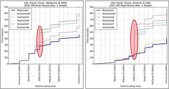
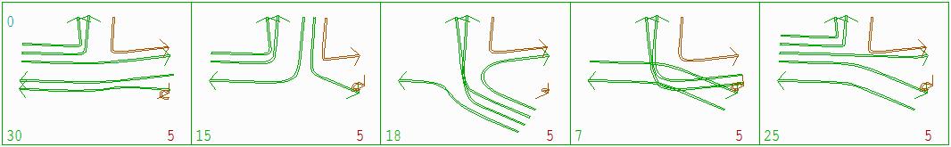
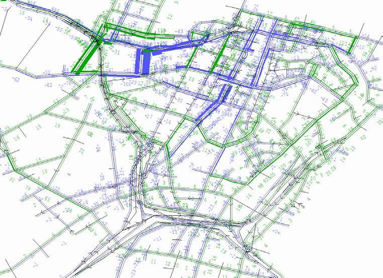
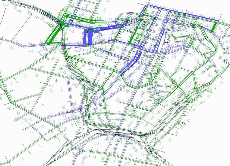
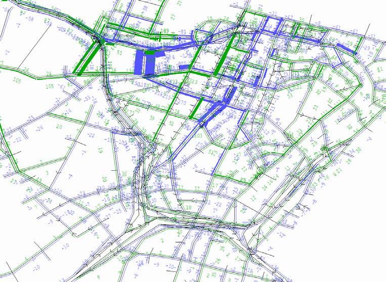
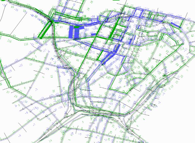
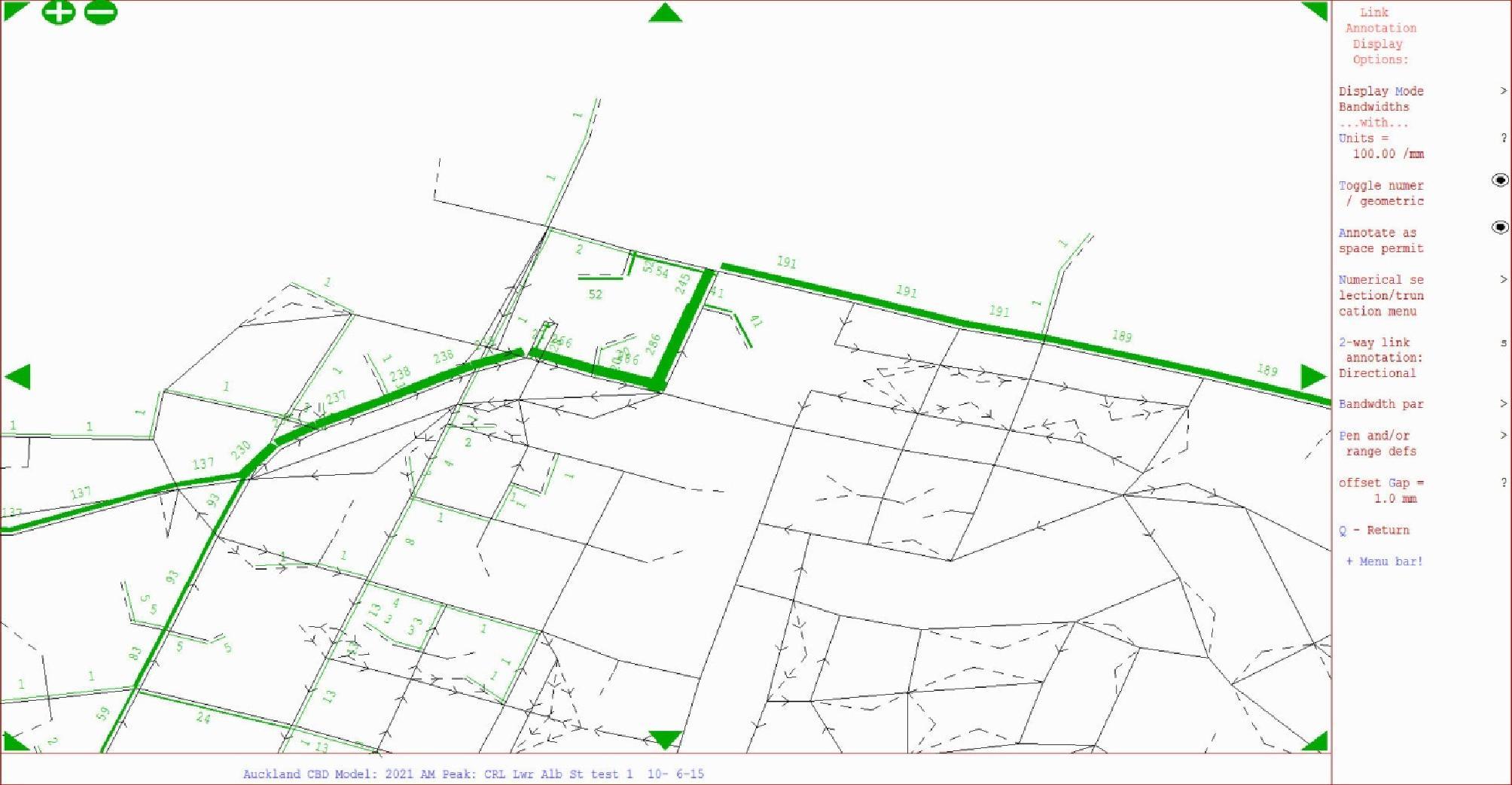
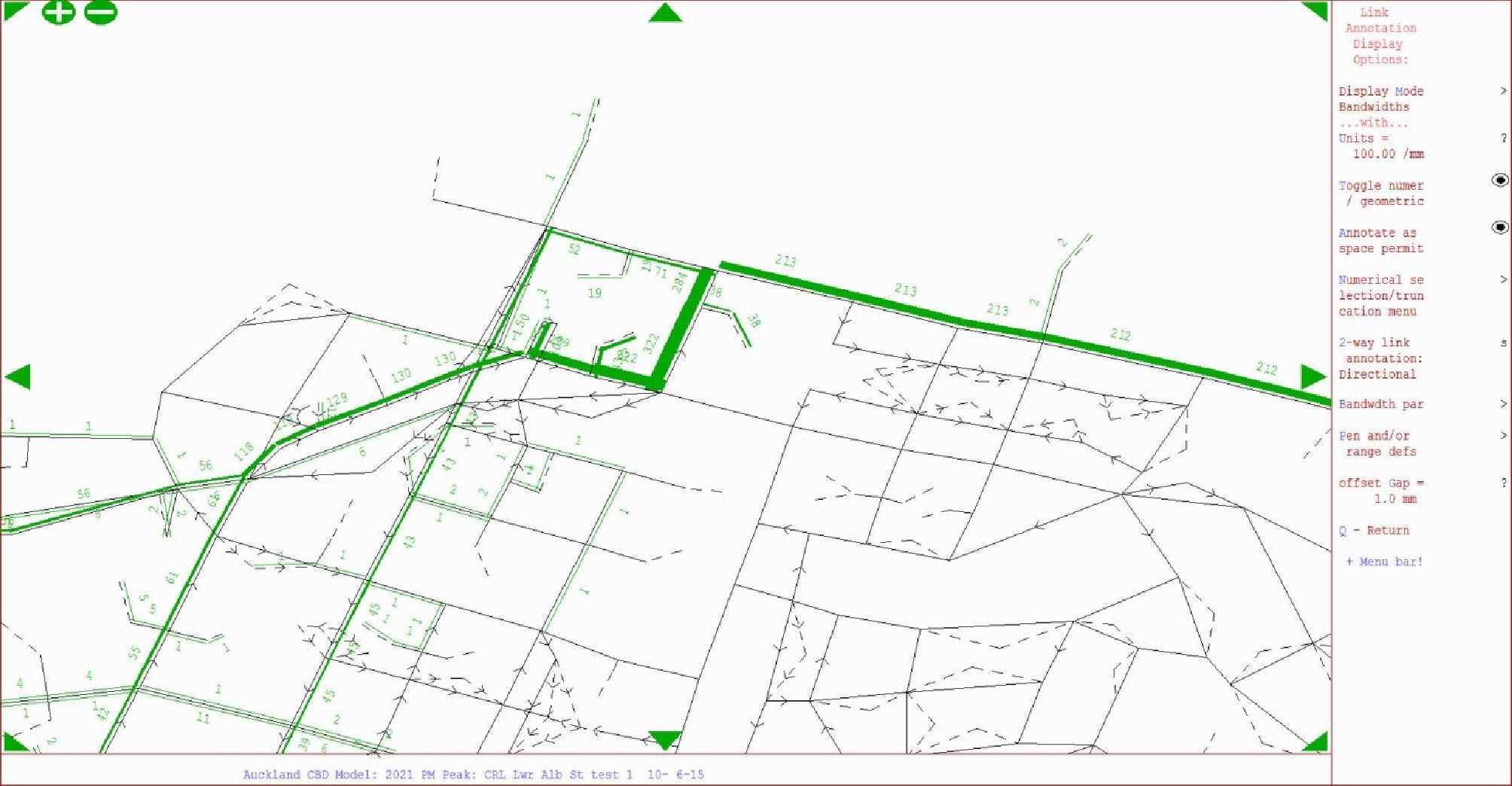
Current travel times indicating current performance along the notable roads are provided in the preworks monitoring undertaken by NZTA (via Auckland Motorway Alliance – AMA) for AT as described in Section 5 of this TAP DWP
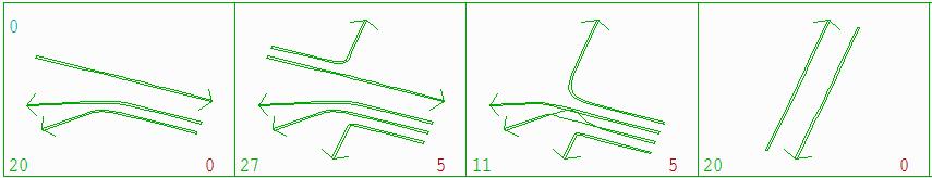
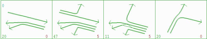
3.2.2 Temporary Traffic Management (TTM) levels and road hierarchy
The features described above and the prescribed Temporary Traffic Management (TTM) from ATCoP are summarised in Table 6. The applicable TTM levels and road hierarchy designations are also shown diagrammatically in Appendix B.
Table 6 Road form and TTM summary
(VictoriaWellesley) 2
Swanson Street Local 1
Mills Lane Local 1, L
Victoria Street District Arterial 2
1NBD, 1SBD general lanes
1NBD, 1SBD bus lanes
1SBD service lane (between Victoria St and Wellesley St)
1WBD, 1EBD general lanes
1WBD, 1EBD general lanes
2 WBD, 2 EBD lanes between Fanshawe St and Queen St
2 EBD, 3 WBD between Queen St and Princes St
Wellesley Street District Arterial 2
2 WBD, 2 EBD lanes between Victoria St and Princes St Customs Street District Arterial 2
Wyndham Street District Arterial 1
Federal Street (South of Swanson Street) Local 1
Wolfe Street Local 1
3.3 CYCLISTS AND PEDESTRIANS
3.3.1 Infrastructure
3EBD, 4WBD
2EBD, 2 WBD
1 NBD, 1SBD general lanes
1 WBD general lane
In general existing pedestrian provision in the Project area can be summarised as:
There is an existing footpath on both sides of all streets in the Project area.
Existing footpaths are typically wider than 3.5m and up to 4-5m wide on Victoria, Wyndham, Wellesley and Albert Streets, except for Swanson Street and Wolfe Street where they are generally 2.5m or slightly wider
Project #: 2665
Client: Auckland Transport
Revision: 5, Date: 2 June 2016
There is an existing footpath pinch point along Albert Street between Wyndham Street and Wellesley Street adjacent to the low level service lane
Crossroads along Albert Street have steep gradients making for unattractive walking (and cycling) conditions; e.g. Victoria Street is approximately 9% grade east of Albert St and Wellesley Street is approximately 11% grade.
Traffic splitter islands associated with the SBD low level service lane between Victoria and Wellesley streets makes for difficult waiting conditions with limited storage capacity for crossing pedestrians at the Albert Street signals
A two-way, fully segregated cycleway has been installed on Beach Road7
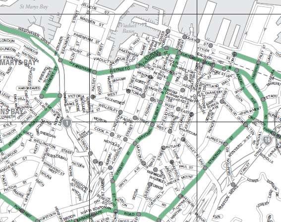
Table 7 and Figure 9 outline the cycle facilities available in relation to the Project area.
Table 7 Project area cycle facilities summary
- WBD approach lanes to Hobson Street signals
- EBD and WBD approach lanes to Federal Street signals - EBD and WBD approach lanes to Albert Street
- EBD and WBD approach lanes to High Street
can use existing bus lanes along Lower Albert Street
7 Included in modelled ‘basecase’
8 Interim cycle lanes and stop boxes will be provided at these intersections during some stages of the pipe jack works as width allows – refer Pipe Jack TTMP for detail
9 Interim cycle lanes are expected to be provided to provide a two way facility on this street through a tactical urbanism intervention prior to or soon after the start of the main works.
Connectus Transport, Access and Parking Delivery Work Plan
Project #: 2665
Doc. No. CRL-PAT-ENV-CON-PLN-000904
Client: Auckland Transport Revision: 5, Date: 2 June 2016
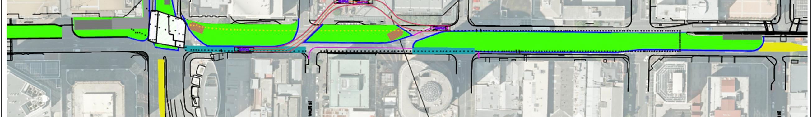
Figure 9 Project area cycle network (source: AT Central Area guide map)
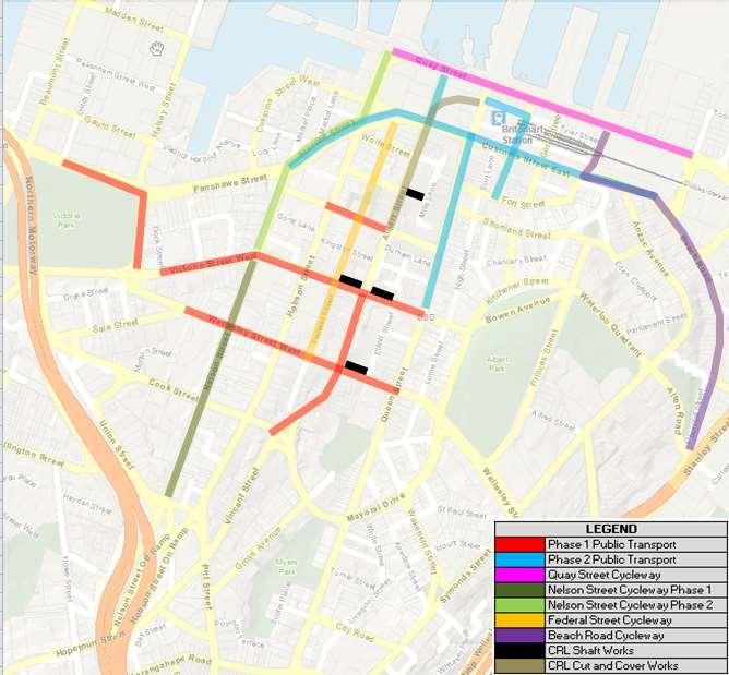
Cycle projects of note in the Project area which may increase cycle use through improved cycling conditions and connectivity include:
Phase 1 of the segregated Nelson Street Cycleway (open late 2015 / early 2016) from CMJ down to Victoria Street.
Nelson Street Cycleway Phase 2 (Victoria Street to Quay Street) is expected to be operational from August 2016
Tactical urbanism project (paint and minor civil works) along Federal Street (in place April 2016)
The Quay Street Cycleway will be constructed in an interim form and will be operational before the Project starts in May 2016.
The cycleway projects currently proposed or under construction in place of current general traffic lanes are shown in Figure 10
Connectus Transport, Access and Parking Delivery Work Plan
Project #: 2665
Doc. No. CRL-PAT-ENV-CON-PLN-000904
Client: Auckland Transport Revision: 5, Date: 2 June 2016
Figure 10 CBD Cycleway and bus lane projects in place of general traffic lanes
3.3.2 Demand
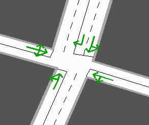
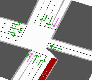
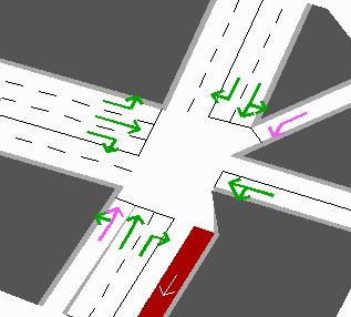
Pedestrian surveys were undertaken around the work site between Tuesday 28 July and Thursday 30 July 2015. The surveys were undertaken during the morning (7-9am), inter-peak (12-2pm) and evening (4-6pm) periods at:
The Victoria / Albert intersection and approaches
Across Albert Street and the Swanson Street and Wyndham Street signals
Along Albert Street in the blocks to the south of Wyndham Street and north of Quay Street
The survey results show low levels of pedestrian activity along and across Albert Street in the vicinity of the Wyndham Street and Swanson Street signals. The surveys show moderate to busy levels of pedestrian activity around the Victoria / Albert intersection. In both cases the busiest period was the inter-peak and is likely associated with lunchtime eating and retail activity. There is some evening peak precedence WBD on Victoria and NBD on Albert Street which may be associated with bus use. The results of the survey are summarised in the diagrams presented in Appendix C
Cycle activity in the project areas is unconfirmed, but casual site observation suggests it will be relatively low perhaps due to the steep topography of the crossroads and high levels of bus and other traffic volumes. This may change with the opening of the Nelson Street Cycleway.
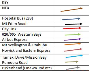
3.4 PUBLIC TRANSPORT
3.4.1 Current areas served
In general, the following routes are served:
Central routes (CBD only) by Albert Street, Victoria Street and Wellesley Street
Northern route by Albert Street, Victoria Street and Wellesley Street
No southern routes through the affected area
No eastern routes through the affected area
Western routes by Albert Street
Morning and evening peak hour bus lanes on both sides of Albert Street (which can also be used by cyclists)
No existing bus lanes on other streets
3.4.2 New network infrastructure
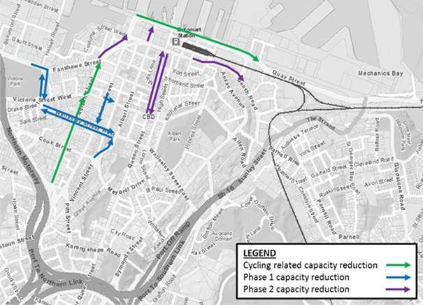
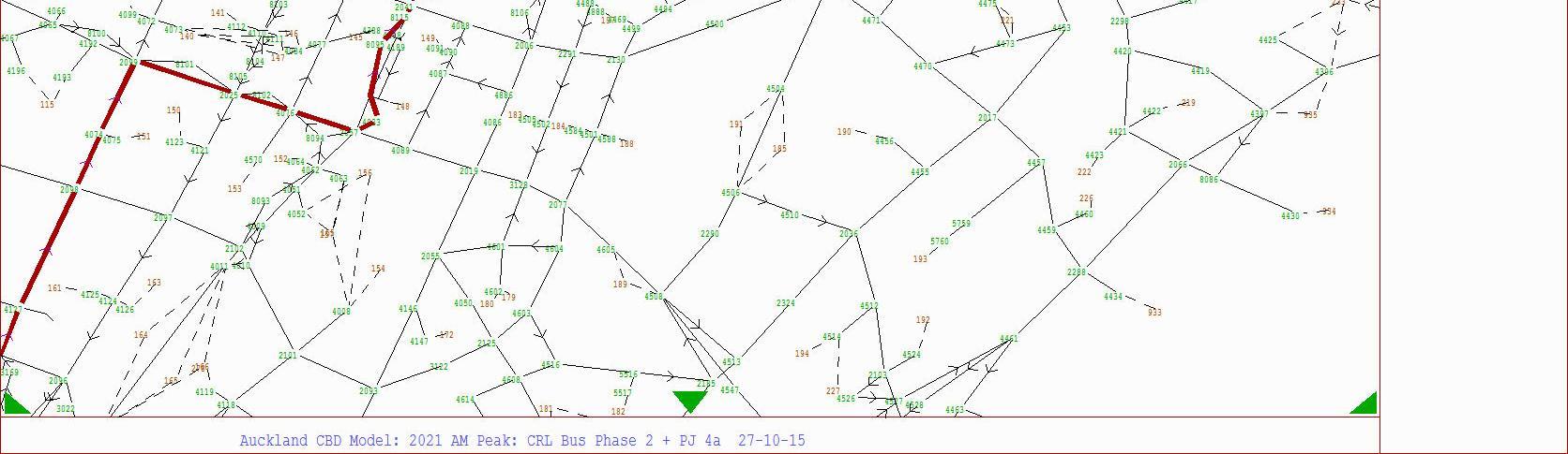
AT is currently in the process of implementing bus lane, service route and stop changes which align with the proposed future ‘New Network’ and remove bus movements from direct conflict with the CRL enabling works projects along Albert Street and around Britomart (i.e. from lower Queen Street, Tyler Street and Galway Street) The key driver for this work is to implement the New Network with the side benefit of supporting TDM measures and mode shift to minimise impact to bus users due to CRL construction activities. The bus lanes will mitigate bus service levels and improve bus travel times and reliability (bus priority) to encourage and support mode shift and reduce single occupant vehicle trips (and thus reduce network congestion).
These operational and infrastructure changes include amendments to kerbside management (i.e. parking, taxi ranks, loading zones and the like). The proposed works are to be delivered in two stages, with Phase 1 changes already implemented:
Phase 1 (recently constructed and operational) – the schemes and resolution reports have been approved by the Traffic Control Committee and have been currently operational since October 2015, with the relocation of the majority of Albert Street buses onto Queen Street and Hobson Street
Phase 2 – the infrastructure design to support the proposed changes is currently under investigation and is expected to be constructed and operational by mid-April 2016, prior to the start of the main CRL enabling works on Albert Street and at Britomart. This phase will see the remaining bus services on Albert Street (south of Victoria Street) re-routed and all services removed from Lower Queen, Galway and Tyler streets.
The Albert Street services will be removed from the CRL project area and the Albert Street bus lanes (or at least the SBD lane) will become redundant as will interim layover on Wyndham Street. Buses and infrastructure will also be removed from Lower Queen Street during this phase.
Summary diagrams supplied by AT summarising the current and proposed bus network service changes are presented in Appendix D The additional bus lanes and associated changes to kerbside management (i.e. bus stop locations, parking and loading zone changes) are shown in Appendix E10 Figure 10 summarises the bus lanes being installed by phase, which supplement or extend the
10 The Phase 2 concepts are provided with the Phase 1 legal resolution drawings as enacted
Connectus Transport, Access and Parking Delivery Work Plan
Project #: 2665
Doc. No. CRL-PAT-ENV-CON-PLN-000904
Client: Auckland Transport Revision: 5, Date: 2 June 2016
existing bus lanes. These changes are mentioned here as they will be in place prior to the start of the Project works and strongly influence network performance for both buses and general traffic.
3.5 FREIGHT
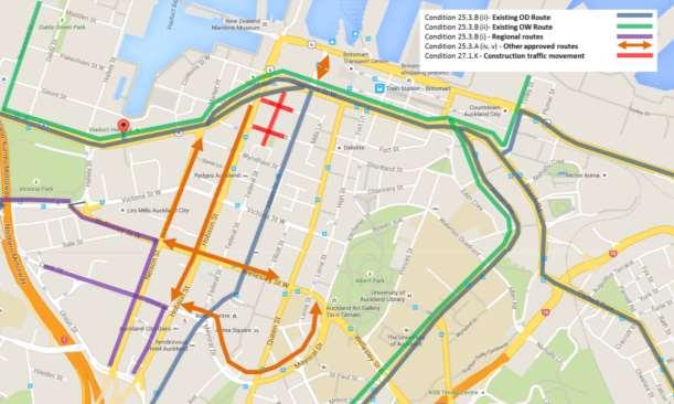
Albert Street is currently a nominated over-dimension (OD) route as shown in Figure 11, with it and the other roads in the Project area otherwise providing for local property service activities (e.g. deliveries and couriers). Albert Street will cease to be an OD route with implementation of the CRL cut and cover works along Albert Street.
Customs Street is a nominated OD and over-weight (OW) route but will be restricted in this regard during the Customs / Albert intersection works. When the below grade bridge structure is in service Customs Street will not be available as an OW route.
Figure 11 CBD OD routes (source: NZTA OD map 27)
Connectus Transport, Access and Parking Delivery Work Plan
Project #: 2665
Doc. No. CRL-PAT-ENV-CON-PLN-000904
Client: Auckland Transport Revision: 5, Date: 2 June 2016
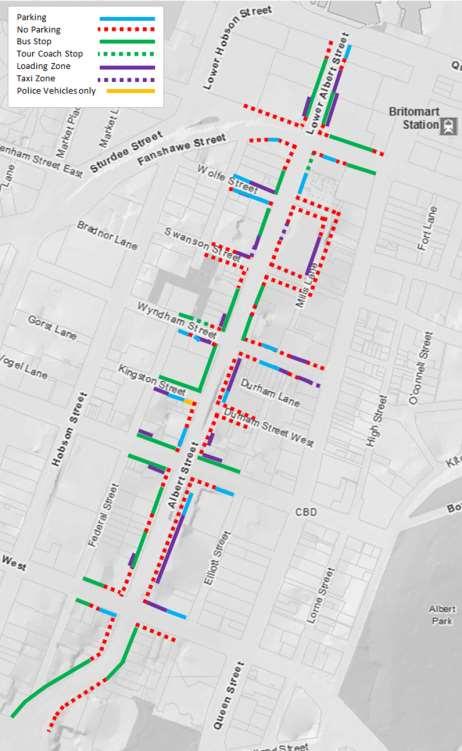
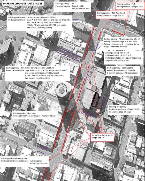
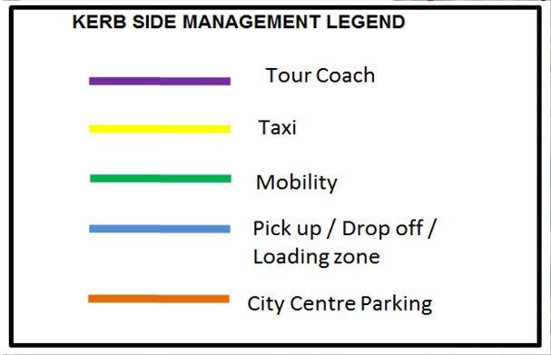
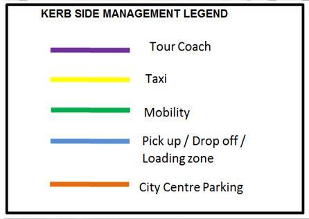
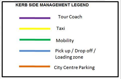
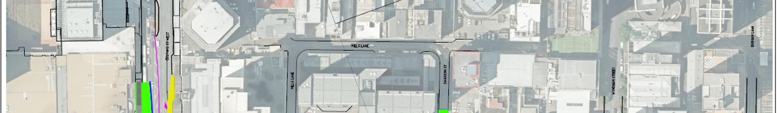
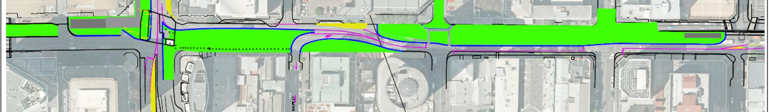
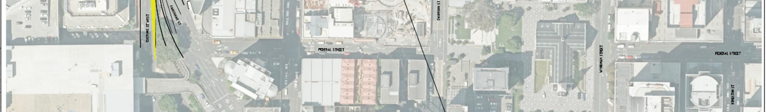
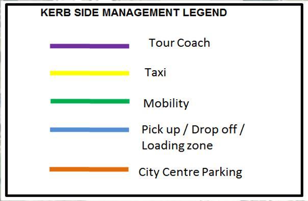
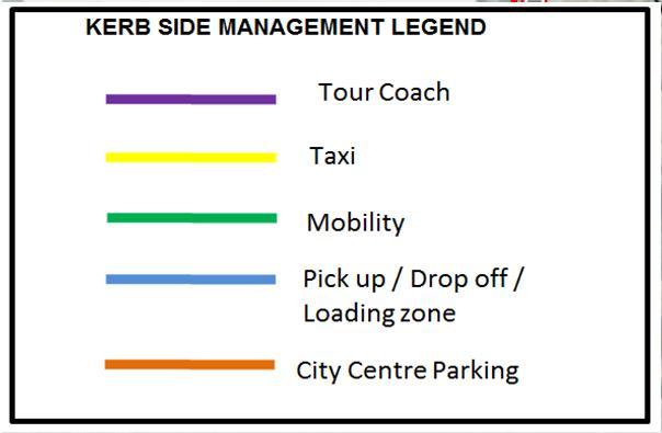
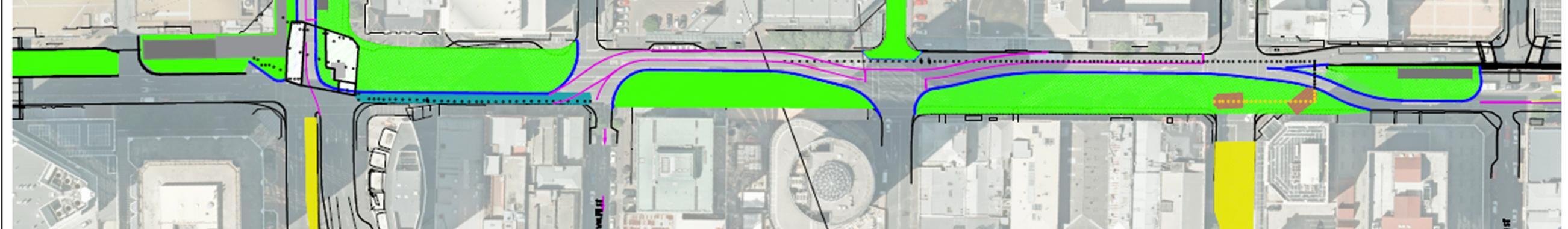
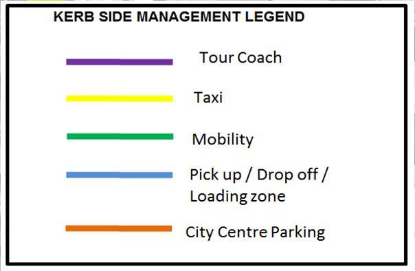
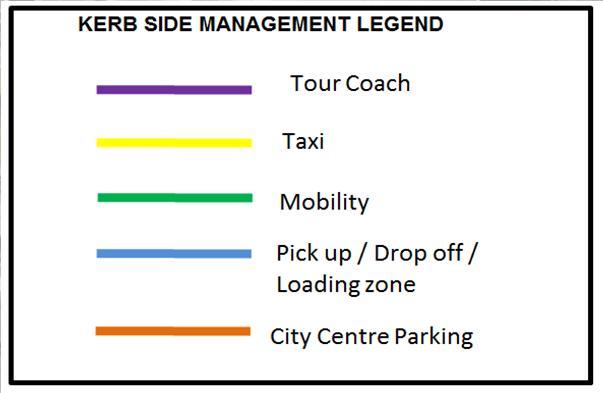
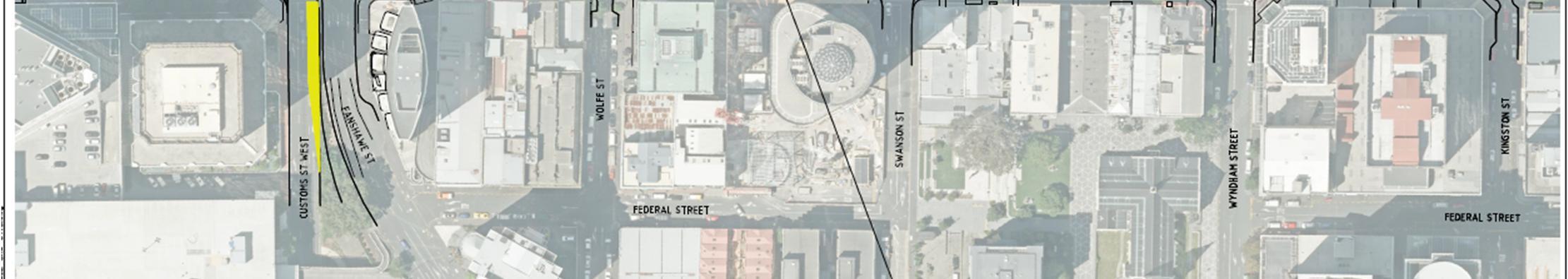
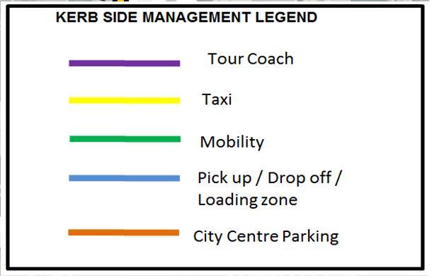
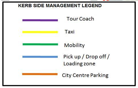
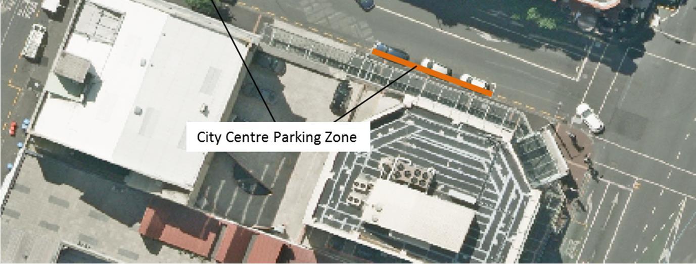
3.6 KERBSIDE MANAGEMENT
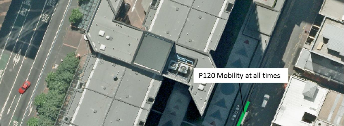
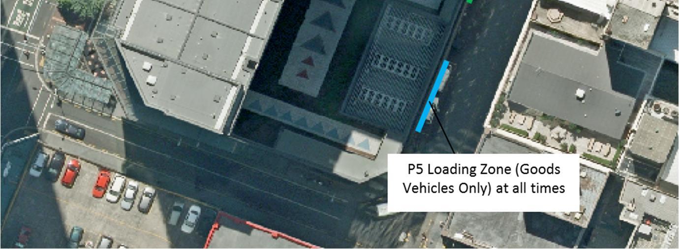
Figure 12 summarises the existing kerbside management types in the Project area. Not shown for simplicity are the loading zones on the two lower level service lanes on the eastern side of Albert Street between Wyndham Street and Victoria Street, and Victoria Street and Wellesley Street.
Figure 12
Existing kerbside management areas in the project area
Connectus
Project #: 2665
Client: Auckland Transport
Transport, Access and Parking Delivery Work Plan
Doc. No. CRL-PAT-ENV-CON-PLN-000904
Revision: 5, Date: 2 June 2016
3.7 CONCURRENT PROJECTS AND DEVELOPMENTS
3.7.1 Auckland Transport and other Public projects
Various projects are planned for commencement and completion in the CBD during the project construction. These have been discussed in workshops with AT CRL team, wider AT stakeholders, ATOC team and the Project ECI contractor team members. Table 8 below summarises known upcoming public works projects within the Auckland CBD.
Table 8 Relevant concurrent public projects
Project
CRL Enabling
Works – cut and cover tunnel (Contract 2)
ECI phase construction methodology development
PT Phase 1 In service
PT Phase 2
Design underway
Nelson Street Cycleway Phase 1
Nelson Street Cycleway Phase 2
Quay Street Cycleway (Stage 1)
Watercare Halsey Street Rising Main
Ports of Auckland Stormwater Outfall work
In service
Construction start –June 2016
Construction end –January 2019
Complete
Construction start –December 2015.
Operational by – May 2016
Complete
Design to be finalised
Design to be finalised
Under construction, methodology of latter stages TBC
Construction start –August 2015.
Operational by – May 2016
Construction start –February 2016
Operational by start of May 2016
Construction –Underway
Operational by – April 2016
Design to be finalised TBC
Beach Road cycleway In service
Federal Street cycleway
Complete
Design to be finalised TBC
Reduction of Customs/Albert signals and short side road closures (including potentially Swanson Street east).
Prioritisation of public transport for TDM. Reduction of general traffic capacity. On various streets but notably Wellesley and Victoria.
Prioritisation of public transport for TDM, notably bus lanes on Queen Street with reduction of general traffic capacity (especially on Fanshawe Street).
Reduction of general vehicle capacity during construction and when operational on Nelson. Promotion of cycling for TDM.
Reduction of general vehicle capacity during construction and when operational. Promotion of cycling for TDM.
Reduction of general vehicle capacity on Quay Street (primary diversion route during Customs Street works) during construction and when operational.
Reduction of general vehicle capacity during construction due to launch pit in kerbside lane of Fanshawe Street.
Negligible traffic network impact expected with maintenance of traffic lanes.
Off-road so negligible traffic network impact expected.
Negligible traffic network impact expected. Promotion of cycling for TDM in support of project.
Connectus Transport, Access and Parking Delivery Work Plan
Project #: 2665
Doc. No. CRL-PAT-ENV-CON-PLN-000904
Client: Auckland Transport Revision: 5, Date: 2 June 2016
Figure 13 shows the location of these projects other than the stormwater works (but not all public works projects in the wider CBD such as the Nelson Street cycleway bridge works over CMJ).
In summary, the projects will cumulatively increase traffic congestion as a result of reduced lane capacity (temporary reduction during construction and permanent reduction when operational). The relevant lane capacity impacts have been included in the SATURN model prepared to assess the overall impact to traffic congestion and travel time during the period of the Project (see Section 6 of this TAP DWP). The construction traffic associated with these works is not considered to be significant and has not been modelled.
Figure 13
Relevant concurrent public projects
Connectus Transport, Access and Parking Delivery Work Plan
Project #: 2665
Client: Auckland Transport
3.7.2 Private developments
Doc. No. CRL-PAT-ENV-CON-PLN-000904
Revision: 5, Date: 2 June 2016
Table 9 describes known private developments within the CBD with the potential for temporary traffic management interaction.
Table 9 Relevant concurrent private projects (confirmed and proposed)
Developments Status Programme
1 Mills Lane Office Tower and Hotel (the former Herald site at 46-56 and 58 Albert Street)
35 Albert Street (Park Residences)
Applied for consent March 2016+, TBC TBC
Under construction
NDG Auckland Centre Project is consented. Construction planning underway. Contractor not engaged yet.
Completion unknown Albert-Swanson-Hobson. This development is primarily accessing the site from the west and this will be increased with an upcoming proposal to widen the loading zone on Swanson Street West and make the section between Albert Federal streets WBD one-way only.
Construction planned to start in August 2016 with perimeter piling including Victoria frontage
Hotel opening mid2019
51-53 Albert Street
Consented
NZ International Convention Centre (Sky City)
75 Victoria Street residences
Downtown Shopping Centre redevelopment
Consented
TBC, but currently expected to be to and from Victoria Street
June 2016, TBC TBC, but developer seeking construction access from rear of site to avoid use of Albert Street during cut and cover works.
Construction starts –November 2015.
Operational by – April 2019
TBC, but expected to be Hobson and Nelson Streets with some use of Wellesley Street and others for local circulation
Under construction Completion unknown TBC, but likely to be: Nelson Street / HobsonVictoria-Albert-WellesleyNelson / Hobson
Consented and contractor appointed May 2016 to September 201811
TBC, but likely to be Quay-Lower Queen-siteLower Albert-Quay
11 Most recent dates for this project made available since the preparation of this assessment and modelling is that this will now start in June 2016 and complete mid-2019 for tower block component (shopping podium is expected to open earlier)
Connectus Transport, Access and Parking Delivery Work Plan
Project #: 2665
Doc. No. CRL-PAT-ENV-CON-PLN-000904
Client: Auckland Transport Revision: 5, Date: 2 June 2016
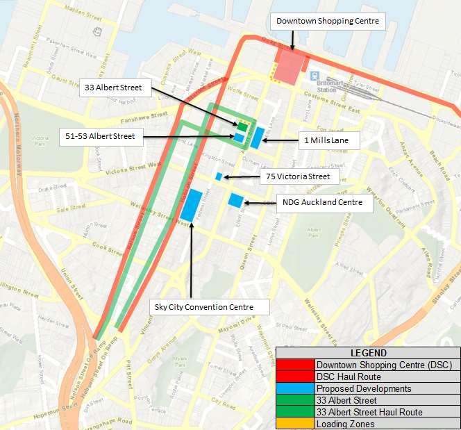
Figure 14 shows the location of the proposed developments.
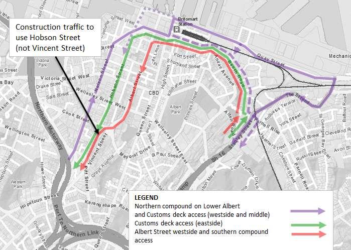
Figure 14 Relevant concurrent private projects and known current haul routes
Project #: 2665
Client: Auckland Transport Revision: 5, Date: 2 June 2016
4 PROPOSED TRAFFIC MANAGEMENT MEASURES
4.1 TMP PARAMETERS & PHILOSOPHY
4.1.1 Philosophy
This TAP DWP has been developed in general accordance with the traffic management approach put forward in the CRL designation conditions and the supporting ITA
In practical terms this means providing for the connectivity and access described in the designation conditions wherever and whenever possible and in particular for main road movements. Additional turn bans or changes to connectivity or access have been restricted to those imposed by safe operational practice, and geometric or spatial constraints for traffic management.
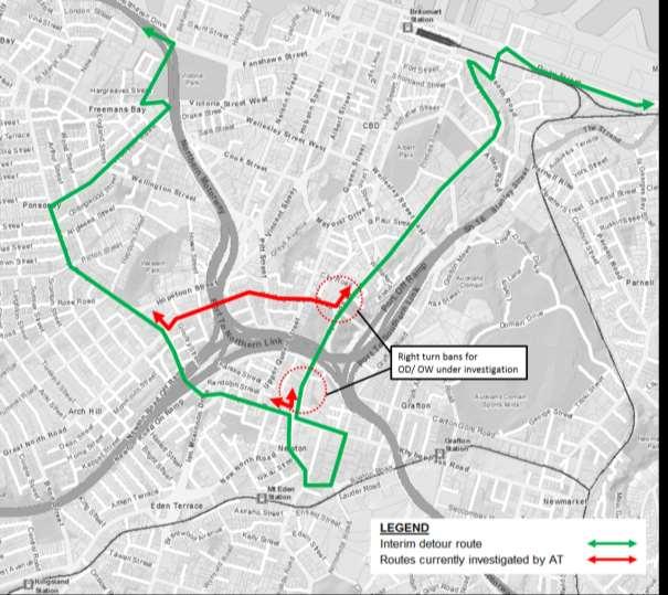
Measures to mitigate congestion further (but which would alter connectivity and community expectations as envisaged by the designation) are identified for further investigation if monitoring or general feedback suggests they are warranted. The likely value of some of these additional measures has been assessed through early modelling. These and other mitigation measures (such as Wellesley WBD right turn ban or changes to ramp metering of the motorway) are being considered by AT’s network and road operations teams with the cooperation of NZTA for faster deployment if needed (see Sections 4.17 and 4.18 of this TAP DWP).
A practical approach also recognises that the cumulative effects of the Project, reduction in general traffic capacity for bus and cycle lanes and the many other public and private projects being undertaken around the CBD will be much greater than previously noted. Uncertainty in the overall traffic condition and levels of congestion will persist as the timing and method of public and private developments continues to evolve. If the traffic impacts are less palatable than anticipated, there may be greater acceptance of more restrictive traffic management measures by the wider community.
The modal priorities adopted are (in order):
1. Active transport
2. Public transport
3. Service vehicles / taxis / freight
4. General traffic (including construction traffic).
4.1.2 Notable parameters
The following notable parameters have been provided for in the development of management concepts, layouts and modelling:
Active and public transport should be prioritised where possible to encourage mode shift and reduce congestion in line with the Project consent philosophy.
Pedestrian and cycle access to properties will be maintained at all times.
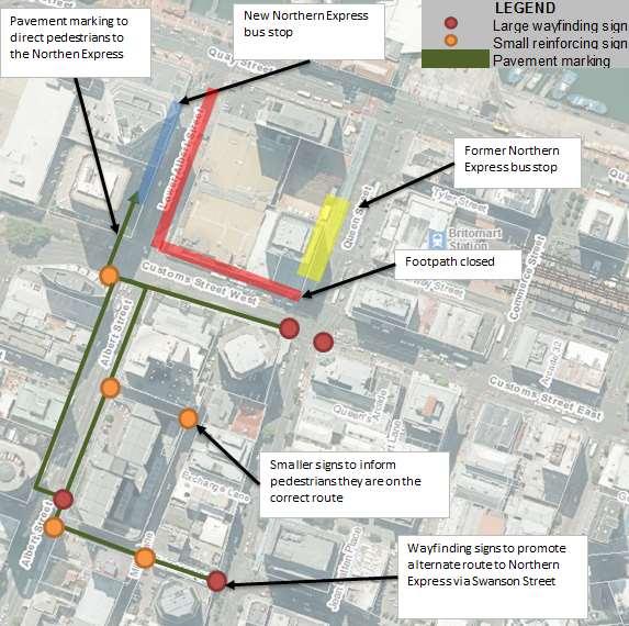
Pedestrian movement to and from the interim Northern Busway platforms on Lower Albert Street will be maximised along the southern side of Customs Street (with the closure of the northern footpath for the Downtown Shopping Centre re-development and work compounds).
Project #: 2665
Client: Auckland Transport
Revision: 5, Date: 2 June 2016
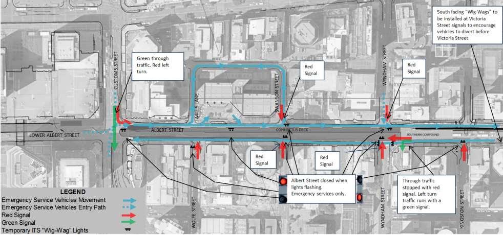
East-west connectivity must be maintained at Customs, Victoria and Wellesley streets at all times. There are three principal east-west routes across the Auckland CBD, namely Customs Street, Victoria Street and Wellesley Street; and to a lesser degree Quay Street. These are supplemented by Quay Street and the motorway collar between the Grafton Gully and Fanshawe Street on and off ramps for cross-town traffic. To allow the CRL Albert Street stormwater main realignment and main tunnel works to proceed in parallel (and thus reduce the duration of impacts to the community by approximately 14 months and the significant associated establishment costs) the east-west movements on all of these routes will be maintained to some degree at all times. In other words none of the Customs / Albert, Victoria / Albert or Wellesley / Albert intersections are to be fully closed at any time as defined by the designation conditions12. As a minimum a single through lane will be maintained in each direction, at each of these three intersections, at any point of time; which is equivalent to three of the total six EBD or seven WBD lanes being open.
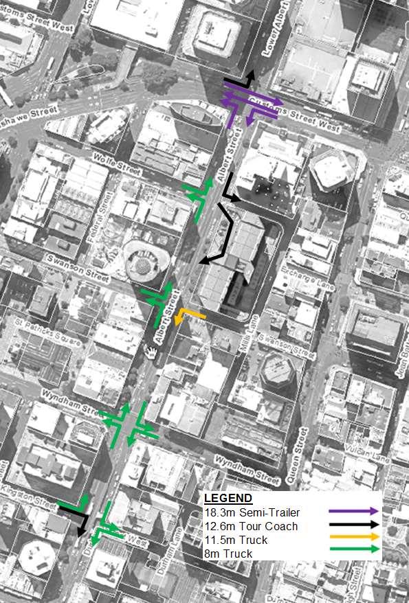
An 8m small rigid truck has been provided as a minimum for turning movements to side roads along Albert Street13 Critical turn movements and associated lane widths and intersection layouts (notably at the Customs, Victoria and Wellesley intersections with Albert Street) have been provided for 12.6m tour coach movements with a 0.3m buffer on each side. This design vehicle choice allows for private tour coach movements (such as associated with hotels) as well as public, scheduled services with the new bus network changes proposed. This design vehicle also allows for all fire tenders (including type 5 and 6 aerial appliances) and construction and delivery trucks up to 11.5m rigid in size. 18.3m semi-trailers are also provided for movements along Customs Street. The design vehicles adopted are shown in Figure 15 A 12.6m tour coach is to be provided for during the Wolfe Street diversion.
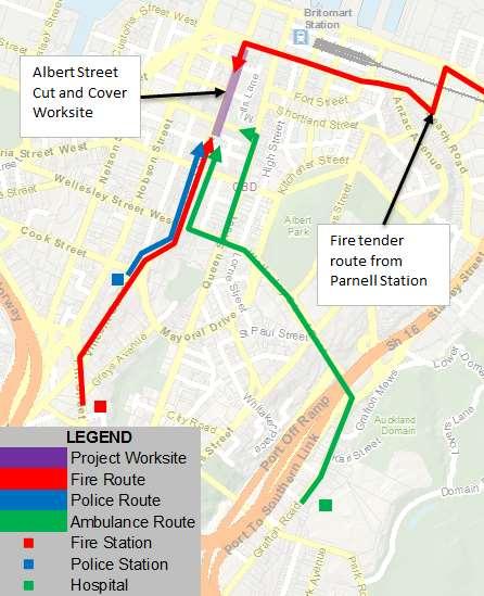
The sites will not typically be attended by MTC or STMS staff outside normal daytime working hours and will provide for unattended use and access by the Fire Service.
The majority of works will be undertaken between 7am-7pm, with discreet night time activities for the moving of traffic barriers, piling rig, surfacing, etc
The sites are to be accessed by trucks up to semi-trailer size; but will typically be 11.5m medium trucks during the installation / piling stage and truck and trailer size for g excavation.
Access to the Mills – Swanson loop will be provided at all times for an 11.5m medium rigid truck
12 The conditions define the closure of an intersection as being the closure of the intersection other than specified turning movements such as the left turn from Customs Street into Lower Albert Street or Albert Street.
13 The consented reference design allowed for a 6m Delivery Van only to exit Swanson Street West and Wolfe Street which is not considered appropriate for reasonable use of these streets or is a generally recognized design vehicle. This change in parameter was confirmed with the CRL project team
Connectus Transport, Access and Parking Delivery Work Plan
Project #: 2665
Client: Auckland Transport
Figure 15
Project design vehicles during the long term trench stage
Doc. No. CRL-PAT-ENV-CON-PLN-000904
Revision: 5, Date: 2 June 2016
4.1.3 Applied standards
The DWP has been developed to meet the requirements of the CRL designation conditions, ATCoP and CoPTTM and in general accordance with the ITA prepared for the CRL designation Notice of Requirement process. The individual TMP controls and drawings that will be developed for the Project will also consequently be bound by these standards and this DWP
A number of Engineering Exception Decisions (EED) will be required under CoPTTM for a coherent and suitable TMP regime to be provided in the CBD environment, such as: due to the influence of block length on taper length and signage spacing, road / movement closures and potentially overlapping TMPs for different projects; reduced detour signage; and pinned barrier system14 acceptance. These EED’s are consistent with those typically and previously applied successfully on similar projects in Auckland and the CBD. This will be particularly important to ease project TMP issues and ensure that the travelling public is not confused by overlapping or closely spaced TMP signage.
14 Required to prevent errant vehicle access to the cut and cover tunnel or Customs / albert bridge excavations
Project #: 2665
Client: Auckland Transport Revision: 5, Date: 2 June 2016
4.2 UTILITIES
This DWP only considers the management and impact of utility works inside the CRL designation with a separate resource consent being prepared for those recently identified utility works outside the CRL designation.
The location of all the utilities in the Project footprint have been thoroughly identified through site inspections and liaison with Network Utility Operators, including Vector Electricity, Vector Gas, Vector Communications, Chorus, Auckland City and Vodafone. Wherever possible, piling locations and other construction activities have been selected to avoid conflict with utilities although avoiding all utilities is not feasible.
Utility relocation works required for Project Construction includes works both inside and outside of the trench alignment. All works outside of the trench will be completed prior to excavation works, while the works within the trench will be completed during trench excavation or as the trench is being backfilled on completion of tunnel construction.
The CEMP contains a full description of the proposed utility alteration and relocation works and methodology required to accommodate the piling and trench construction. The following key items are noted from a traffic management perspective as being of interest:
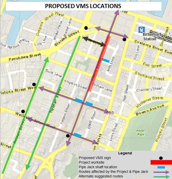
A permanent stormwater line is required diagonally across the Customs / Albert intersection outside the tunnel alignment. This will run between the worksite area on the south-west corner and the northern compound area with the line between installed by trenchless methods to avoid disruption to intersection traffic. The western crossing of the intersection will be staggered to pass around the new southern manhole tie in and launching pit area, but will operate as a single phase and signal timings adjusted as a result. This will be compensated for by the removal of the right turn (for duration of project) into Lower Albert and associated phase time.
A combined service trench approximately 1.5m wide will be required along most of both sides of Albert Street for the full length of the project to accommodate changes to telecommunications and power supply cables (to move them into the new footpath, away from the piling). During this time (the first stage of works) pedestrians will use the remaining footpath width and where necessary be diverted onto the current carriageway and temporary footpaths behind approved crash barriers. Vehicle or plant movement across the footpaths will be controlled by MTC and timed to minimise disruption to pedestrians as far as practicable. Access to building entries will be maintained at all times through the use of preformed steel bridges (with handrails) across the trench line and staging where possible to avoid full closure of an entry area or multiple access to buildings.
The works required in Albert Street for the connection of the stormwater to the Kingston Street line will require closure of two or three traffic lanes of Albert Street. Albert St is four lanes at this point at the top of the retaining wall and the bus lanes will not be needed as all bus services will have been removed prior to the start of works through the second phase bus changes project. If the stormwater alignment is found to require three lanes to be shut then southbound traffic will be diverted to use the lower level service lane (as it does for the majority of the project in any case). If the alignment is closer to the kerb line and the required work and set down area allows, southbound traffic will be continue to use the upper level traffic lanes. This latter arrangement is assumed at present based on field investigations to date and is shown in the appended traffic sequencing plans (see Appendix F).
Project #: 2665
Client: Auckland Transport Revision: 5, Date: 2 June 2016
4.2.1 Utilities works inside trench alignment
Utility relocation inside the trench alignment consists of supporting existing utilities, abandoning confirmed redundant utilities, and the installation of permanent and temporary wastewater and stormwater. It is expected that these works will take 24 months and will be completed during the excavation and backfilling stages of the Project.
4.2.2 Utilities works outside trench alignment
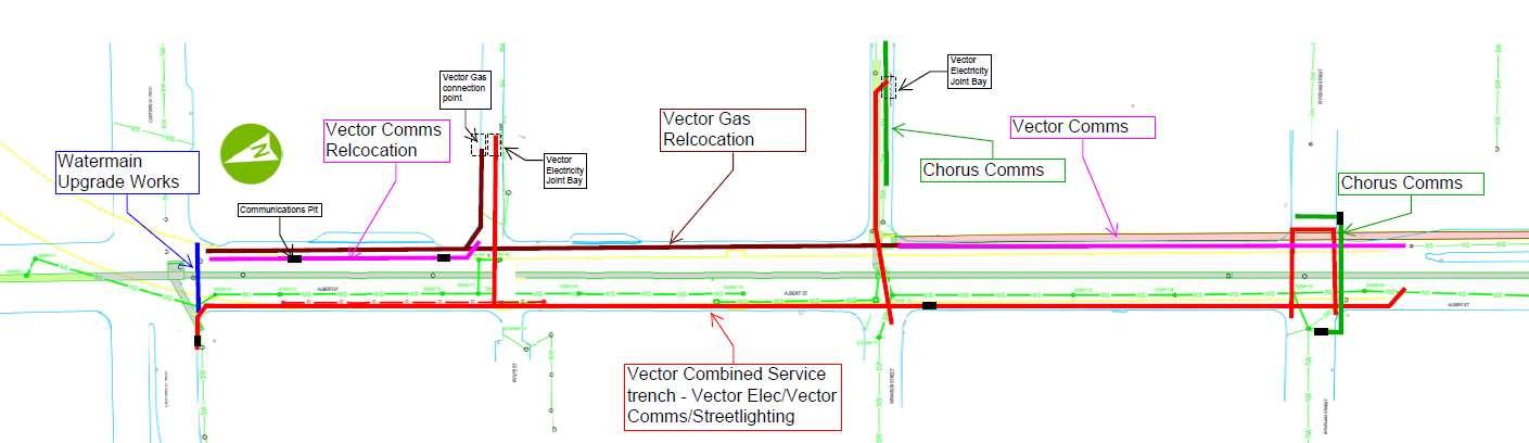
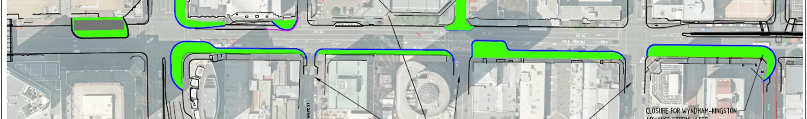
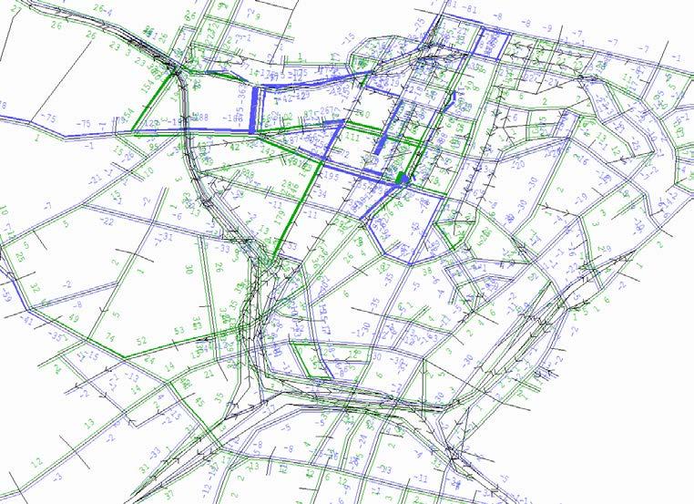
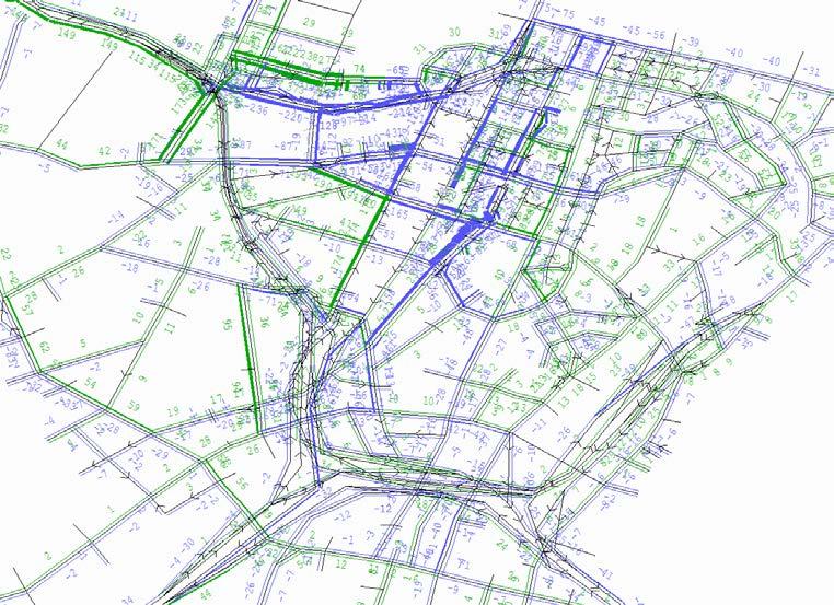
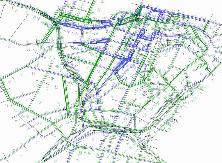
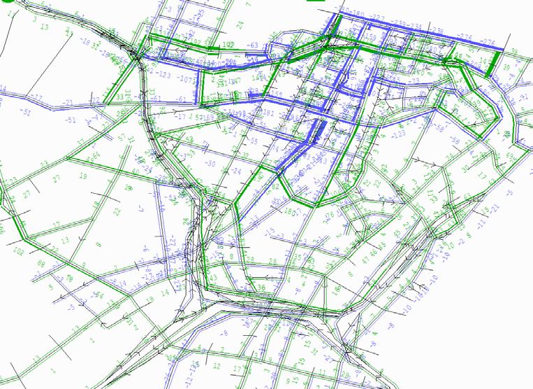
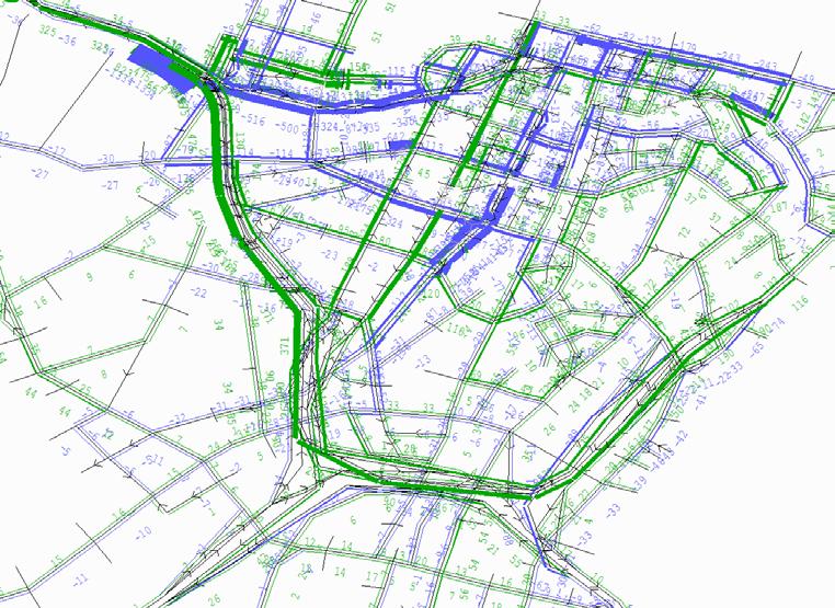
The utility relocation works required as part of the Project outside the trench alignment is predominately stormwater relocation, in addition to surface works, combined utility trenches in the footpaths, and electrical and water upgrades. Figure 16 shows the location of the stormwater works outside the trench alignment, whilst Figure 17 shows the Vector and Water upgrades. A full description of the utility works and methodologies is included in the CEMP.
Connectus Transport, Access and Parking Delivery Work Plan
Client: Auckland Transport Revision: 5, Date: 2 June 2016
Figure 16 Stormwater Works outside Trench Alignment
Connectus Transport, Access and Parking Delivery Work Plan
Project #: 2665
Doc. No. CRL-PAT-ENV-CON-PLN-000904
Client: Auckland Transport Revision: 5, Date: 2 June 2016
Figure 17 Vector, Watermain and Chorus Works outside Trench
Project #: 2665
4.3 TRAFFIC SEQUENCE SUMMARY
The traffic sequencing has been developed from the Project construction methodology and will guide the preparation of individual TMPs and Project Corridor Access Request (CAR) applications. These individual plans will be submitted to Auckland Council with the resulting individual Work Access Permits (WAPs), for certification as being consistent with the strategies of the DWP as they are developed. Traffic sequencing plans are shown in Appendix F
Table 10 summarises key traffic management features of each traffic management stage.
Table 10 Traffic management features
Advanced utilities works
Swanson Street (east) closed for pipe jack works
Closures for 2 days each for the following streets for utilities works:
o Wolfe Street
o Swanson Street (west)
o Wyndham Street (west)
o Kingston Street (narrowing only, traffic access shall be maintained)
Southbound traffic on Albert Street diverted through ‘lower accessway’ adjacent Durham Lane
Lower Albert Street southbound approach closed to set up northern site compound
Site establishment outside 8 Albert Street
C
1
Kerb cutbacks reduce footpaths to 1.5 metres absolute minimum on the SE corner of Albert Street and Customs Street
Kerb cutbacks reduce footpaths to 1.5 metres absolute minimum on Albert Street (West) between Swanson Street and Wyndham Street, and outside 63 Albert Street
Kerb cutbacks on the NE corner of Albert Street / Mills Lane to provide sufficient space for 12.6m tour coach tracking
Canopy cutback on the SE corner of Albert Street / Mills Lane
Wolfe Street diversion in place for northbound traffic on Albert Street, no northbound traffic through Customs Street
Customs Street eastbound and westbound approaches reduced to two lane approaches
Swanson Street (east) closed for pipe jack works
Parking outside 22 Customs Street relocated to corner of Albert Street / Fanshawe Street
Southbound right turn from Customs Street to Lower Albert Street banned
Customs Street eastbound approach reduced to one left turn and one through lane
Albert Street northbound approach at the intersection with Customs Street will be closed and general traffic only will be detoured along Wolfe Street (i.e. no construction trucks). Wolfe Street direction will be reversed for the entire length of the street
Additional traffic signals installed at the Customs / Hobson intersection to accommodate the temporary Wolfe Street approach
Worksites opened on Albert Street
Storage and site compound established outside 17 Albert Street
Project #: 2665
Stage Temporary Traffic Management Features
Albert Street reduced to one in the North-South direction, realigned to accommodate worksites
Swanson Street closed and shaft work site active
Piling works at piling area 1
Advanced direction sign installed on Wolfe Street
Through movement banned on Swanson Street eastbound
2
3
4
5
Wyndham Street East closed and access restricted to local traffic only
Piling works on the eastern side of Albert Street at the intersection with Wyndham Street (Area 2, 3A and 3B)
Piling works from Customs Street to Mills Lane (Area 4)
Wyndham Street West closed and access restricted to local traffic only
Swanson Street West closed and access restricted to local traffic only
Access restrictions on Wyndham Street East removed
P5 zone outside 8 Albert Street removed
Piling works across Swanson Street (Area 5a, 5b and 5c)
Access restrictions on Wyndham Street West continue through this stage
Swanson Street West closed and access restricted to local traffic only
Swanson Street East reopened as shaft works temporarily stopped
Mills Lane – Swanson Street East changed to southbound only one-way operation and loading zone established (for use of Galleria mini-bus and others)
Access restrictions on Wyndham Street West removed
Full access maintained to Stamford Hotel while half of entry and exit piled and barrier installed.
Mills Lane – Swanson Street East changed to southbound only one-way operation and loading zone established (for use of Galleria mini-bus and others)
Swanson Street East access opened with completion of shaft works ( left out only)
Wolfe Street diversion removed (and temporary interim signals at Hobson / Customs removed)
Taxi rank outside Stamford Hotel relocated to 12 Wolfe Street
Piling works in Area 6A
6
Piling works at Mills Lane / Albert Street intersection (Area 6b)
Full access maintained to Stamford Hotel while second half of entry and exit piled and barrier installed.
Access restrictions on Customs Street, and Albert Street opposite Kingston Street, remain in place through this stage
Mills Lane closed to general traffic, construction vehicles only
Albert Street northbound approach at the intersection with Customs Street reopened with one lane
7
Customs Street/ Albert Street intersection restrictions as per Stage 6
Wolfe Street and Mills Street access from Albert Street closed
Left in, left out only for access to Swanson Street (east and west)
Left in, left out only for access to Wyndham Street (east and west)
Piling in Area 7
8
Piling works on Customs Street (intersection with Albert Street – Area 8)
Access restrictions on Customs Street and Albert Street opposite Kingston Street remain in place through this stage
Taxi rank outside Stamford Hotel reopened
Stage
Temporary Traffic Management Features
Wolfe Street closed at Albert Street with local traffic access only
Mills Lane – Swanson Street East changed to southbound only one-way operation
9
Completion of Custom Street deck works
Trench excavation and tunnel box construction works through Albert Street
Construction of traffic decks
Side streets restricted to left in, left out only
Mills Lane – Swanson Street East continues to operate as southbound only one-way operation
Wolfe Street re-opened to general traffic, left out only onto Albert Street
P5 zone outside 8 Albert Street reinstated
10
10+
Long term trench and service lane configuration for trench excavation and tunnel construction; and construction (including tunnel excavation and construction under Customs Street)
General traffic service lane (including using western traffic deck) in full operation with side road movements restricted to left in left out.
Mills Lane – Swanson Street East operates as southbound one-way with loading zones established away from Albert Street intersections to suit 12.6m truck tracking
Northbound left, through and right turn movements provided from service lane to Lower Albert Street and Customs Street.
Decommission of site and trench backfill in reverse order to installation
Albert Street reinstatement (proposed design yet to be finalised)
4.4 TEMPORARY SPEED ZONES & LANE WIDTHS
4.4.1 Temporary speed zones
Albert Street, Lower Albert Street and the section of Customs Street between Hobson and Queen Street will be established as 30km/hr zones for the duration of the Project. While the Customs Street lanes will be returned to normal geometry once the intersection bridge works are complete, the traffic on the section through the intersection will remain at 30km/hr consistent with the Albert Street approaches and controls (and as needed to establish / disestablish the temporary speed zone control on Albert Street and create safe entry / exit conditions to the northern compound)
4.4.2 Temporary and long-term lane widths
Where possible, lane widths have been provided at a width of 3.0m or greater; although an absolute minimum lane width of 2.75m is allowed for a 30km/hr speed zone under CoPTTM. In most cases the lane width is actually greater and is determined by the tracking requirements of the applicable design vehicle
The width of the service lane down each side of the Albert Street trench has been widened from the reference design and designation condition requirement of 3.0m to a minimum 3.3m width. This will allow for use by delivery trucks, Fire tenders and other vehicles with reduced likelihood of conflict with street furniture such as traffic signals or streetlights (which are often close to the back of the kerb). It
Project #: 2665
No. CRL-PAT-ENV-CON-PLN-000904
Client: Auckland Transport Revision: 5, Date: 2 June 2016
also allows for aerial Fire tenders to deploy outrigger arms and easier working room for the crew around the tenders (such as for pump operation and locker access)15 .
4.5 VEHICLE TRACKING
Tracking curve sketches at the following intersections with Albert Street are presented in Appendix G Figure 15 summarise the design vehicle movements for these roads at critical stages
Customs Street
Wolfe Street
Mills Lane
Swanson Street (east and west approaches to Albert Street)
Wyndham Street (east and west approaches to Albert Street)
Entry and exit tracking from Stamford Residences
These curves show that kerb and canopy cut backs and limit line set backs or adjustments are required at the:
North-west and south-east corners at Customs/ Albert intersection for scheduled metro buses or turning tour coaches respectively. The cut back on the north-west corner is to be undertaken separate to this Project by AT as part of the Phase 2 bus changes16 .
Northern corner of Mills Lane with Albert Street for turning fire tenders and the canopy removed on the opposing corner at Stamford Plaza. The existing give way sign will also be removed when the Mills-Swanson loop is operating as a southbound one-way in order to provide for large vehicles to sweep over the existing kerb and footpath if needed. The need for this was identified during field trials with the Fire Service.
Southern corner of Wolfe Street with Albert Street for turning private tour coaches
Southern corner of Swanson Street East for turning supermarket delivery trucks. The canopies on this corner are also being trimmed as part of the CRL Albert Street stormwater main realignment works. Larger fire tenders (the type 5 and 6 aerial appliances) may need to make multiple turns to accomplish this exit manoeuvre. This would be after an incident in Mills Lane only, when the need for fast movement is not present and Albert Street is still under emergency service control17 . The outer barrier and hoarding on the western construction deck will be set back from the general traffic lane to provide tracking for large vehicles exiting Swanson Street East.
Northern corner of Swanson Street West at Albert Street to accommodate an 8m small rigid trucks (e.g. rubbish truck)
Outer barriers and hoardings separating the eastern construction deck and the live traffic lane will need to be offset onto the turning deck at the intersection of Wyndham East / Albert to provide tracking for 8 metre trucks
15 See Section 4.19.2 of this report for further details of Fire Service and emergency access measures.
16 The changes to the Lower Albert Street / Quay Street changes will be undertaken by Auckland Transport at the same time before this Project.
17 Approach confirmed with Fire Service by field testing of manoeuvring for these large trucks at each end of the Mills Lane – Swanson Street East loop.
Client: Auckland Transport Revision: 5, Date: 2 June 2016
4.6 INTERSECTION CONTROLS
The required changes to the intersection controls during the project are summarised in Table 11. It should be noted that the duration of side road closures will be minimised so that although a traffic stage may be in place for a month or more the side road will only be closed for 1-2 weeks.
Table 11
Approach
Intersection control changes
Installation phases
Long term trench phase (stg 10+)
Sturdee @ Albert Minimum LT/TH, typically separate LT & TH Signal, as per existing
Lower Albert @ Customs Shut Shut
Customs @ Albert Minimum LT/TH, typically separate LT & TH, RT shut; LT truck and trailer restriction
Albert @ Customs
Stg A and B: Single lane for TH, RT and LT movements
Stg C: shut
Stg1-4: shut
Stg 5-10: LT only; 12.6m tour coach restriction
Wolfe @ Albert Stg A and B: no change
Stg C: no control (reversed, exit only);
12.6m tour coach restriction
Stg 1-4: no control (reversed, exit only); 12.6m tour coach restriction
Stg 5-6: Priority LT out only (one way); 8m small truck restriction
Stg 7-8: closed
Stg 9-10: Priority LT out only (one way); 8m small truck restriction
Mills @ Albert Stg A-B: no change
Stg C, 1-2: priority, LILO (cul-de-sac)
Stg 3-4: priority, left in, left out and right in (cul-de-sac)
Stg 5: left in only (one way)
Stg 6-7: closed
Stg 8-10: LT in only (one way)
All stages: 11.5m medium truck restriction all stages (12.6m coach tracking provided for fire service only)
Signal RT shut, otherwise as per existing
Signal LT/TH/RT
Priority LT out only (one way); 8m small truck restriction
Priority LT in only (one way); 11.5m medium truck restriction (12.6m coach tracking provided for fire service only)
Swanson W @ Albert
Stg A-C, 1-2: no change
Stg 3-4: closed
Stg 5-10: signal LILO
All stages: 8m small rigid truck restriction
LILO = left in, left out only
Signal LILO18, 8m small truck restriction
Project #: 2665
Client: Auckland Transport Revision: 5, Date: 2 June 2016
Approach Installation phases
Swanson E @ Albert
Stg A-C, 1-4: closed
Stg 5: signal LT out only (one way)
Stg 6-7: signal LILO, cul-de-sac
Stg 8-10: signal LT out only (one way)
All stages: 11.5m medium truck restriction
Wyndham W @ Albert Stg A: no change
Stg B: closed
Stg C, 1-2: as existing, signalised
Stg 3-4: closed
Stg 5-10: signal LILO
All stages: turning movements for 8m rigid only
Wyndham E @ Albert Stg A, B, C and 1: no change
Stg 2: closed
Stg 3-4: signal LT/TH/RT
Stg 5-10: signal LILO
Kingston @ Albert Stg A-B: Lane narrowed, existing left out only
Stg B-10: Left out only (as per existing); 8m small rigid truck restriction
4.7 TRAFFIC SIGNALS
Long term trench phase (stg 10+)
Signal LT out only (one way), 11.5m truck restriction
Signal LILO, 8m small truck restriction
Signal LILO, 8m small truck restriction
Left out only (as per existing); 8m small rigid truck restriction
4.7.1 Long-term signal infrastructure and operational changes
Changes are required to the signalised intersections at Customs / Albert, Swanson / Albert and Wyndham / Albert for the Project as set out in Table 12
It is currently proposed to use preformed loops instead of repeatedly re-cutting loops in the road. The preformed loops to be used are nailed to the road surface and then asphaltic tape applied. This approach will significantly reduce the noise and duration of works required and reduces worker risk. Preformed loops have previously been used in Auckland. If performance issues are encountered then cut loops will be used (but are not anticipated).
Temporarily relocated signal poles will generally be mounted in concrete filled barrels within the barrier / hoarding area (i.e. with the signal head above the hoarding), with cabling protected by conduit.
4.7.2 Signalised pedestrian crossings
The pedestrian crossings on the western and southern approaches of the Customs / Albert intersection will be retained at all times, and are shown in Figure 18 The signalised crossing of Albert Street (southern approach) will be shifted laterally at times by 10-20m to suit the construction activity. The crossing will be made wider than normal to minimise congestion at the western footpath which is narrowed at the corner of the Galleria building and maximise the ability of pedestrians turning the corner to move past those waiting to cross. Pedestrian signals and call buttons will be mounted on moveable poles. Additional call buttons will also be installed on the pedestrian bridge in the event pedestrians’ jay-walk and became trapped on the bridge by traffic.
Project #: 2665
Client: Auckland Transport
Revision: 5, Date: 2 June 2016
Two additional pedestrian crossings across Albert Street will also be maintained at Swanson Street and Wyndham Street at all times using bridges over the trench These pedestrian bridges will consist of two 2.5m wide open ended shipping containers supported on the trench support beams. The containers will be lit internally and viewing windows provided for natural light. The Swanson Street pedestrian bridge crossing will be located slightly north of the current location while the Wyndham Street bridge crossing will be on the alignment of the existing northern crossing in the long term case.
Zebra crossings were initially considered, however solid hoardings around construction sites along the Albert Street trench and the realignment of the Albert Street corridor are considered likely to reduce sight distances to unsafe levels. Signalising pedestrian crossings is safer and has the added benefit of allowing pedestrian call frequencies to be controlled and co-ordinated.
In Stage 1 during the piling across the threshold of Swanson Street East with Albert Street, piling will be undertaken within the eastern pedestrian crossing area. A pedestrian crossing will be maintained through this construction period by relocating the pedestrian crossing onto the Swanson Street shaft (required for the stormwater main realignment) to permit piling through the intersection while the shaft is temporarily reinstated, and then shifting the pedestrian crossing onto the completed piles afterwards.
Figure 18 Pedestrian crossings to be maintained on Albert Street
In stages C and 1 to 5 Wolfe Street will be used as a detour for general traffic as Albert Street north of Wolfe Street will be closed. The intersections of Wolfe Street / Federal Street and Wolfe Street / Fanshawe Street will remain as priority controlled intersections. A new signal pole with a left turn aspect will be installed at the intersection of Wolfe Street and Hobson Street, with the Wolfe Street phase running at the same time as the pedestrian phase across Hobson Street (located to the north of Wolfe Street). This additional signal display is required to address limited sight lines to vehicles left turning into Hobson Street from Customs Street.
4.7.3 Wolfe Street direction reversal
Connectus Transport, Access and Parking Delivery Work Plan
Client: Auckland Transport Revision: 5, Date: 2 June 2016
4.7.4 Victoria / Albert signals
The majority of construction vehicles will be exiting the site by re-joining Albert Street at the gates and use the low level service lane; however some construction vehicles will drive through the southern compound. They will merge with other construction and general traffic at the existing signals without the need for change to the signal equipment. The phasing priority and timing will need to be amended to give priority to the service lane approach instead of the upper, Albert Street approach as is currently the case.
4.7.5 Lower Albert / Quay and other Quay Street signals
The Lower Albert Street approach to Quay Street will be amended by AT prior to the Project to allow for the proposed bus lane left turn to extend to the stop line for bus journey reliability, and the lanes reconfigured being a LT/RT and LT for general traffic. Other changes will be made by AT to signals along Quay Street for the Quay Street Cycleway project.
Project #: 2665
Client: Auckland Transport Revision: 5, Date: 2 June 2016
A
Albert Street (south approach) reduced to a single lane and left turn only
Custom Street (east approach) reduced to three lanes
Lower Albert Street approach closed. All other approaches and movements maintained
Pedestrian crossings maintained
Signal phasing changed, with 3 phases overall
Swanson Street East approach closed
Albert Street reduced to one lane per direction
Through movement on Swanson Street West banned
Three phase cycle implemented, with Albert Street movements, Swanson Street movements, and pedestrian movements all in separate phases
Detector loops moved on Albert Street approaches. Additional detector shift required in Stage 3.
Pedestrian movements maintained in NorthSouth direction
Signal controller personality chip changed
Albert Street approaches reduced to one lane in each direction
Four phase signal arrangement used, with separate phases for each Wyndham Street approach. The two Albert Street approaches will run in the same phase, and an exclusive pedestrian phase will be provided.
Detector loops moved on Albert Street approaches.
Signal controller personality chip changed
Albert Street approaches reduced to one lane in each direction
Wyndham Street west closed, no access via Wyndham Street east and both Albert Street approaches
Three phase signal arrangement used, with separate phases for each Albert Street approaches and for Wyndham Street east approach
C
Albert Street approaches closed
Pedestrian crossings maintained
Customs Street approach right turn banned
Two phase cycle adopted, with all vehicles movements running, followed by all pedestrian movements
Detector loops moved on Fanshawe Street approach
Signal controller personality chip changed
Swanson St (both approaches) closed
Through traffic movements only on Albert Street
Two signal phases proposed, one for pedestrians and one for general traffic
Same as Stage A
Same as Stage B, except Wyndham Street east closed instead of Wyndham Street west
Same as Stage B
Table 12
Signalised intersection changes by TTM Stage
Project #: 2665
Client: Auckland Transport Revision: 5, Date: 2 June 2016
4
Same as Stage C to 3, except:
o Customs Street approach reduced to one shared left and through lane
o Detector loops moved on Customs Street approach
Same as Stage A to 2 during Piling Area 5A
Swanson Street (east) approach opened to traffic during Piling Area 5B
Split phasing (one for each leg) proposed during Piling Area 5B
5
Swanson Street (east) left out only
Swanson Street (west) restricted to LILO
A two phase signal cycle will be implemented. Both Swanson Street approaches will be run simultaneously, and both Albert Street approaches will be run with filter pedestrian movements
Same as Stage B, except:
o During works at Piling Area 5c, left turn off Wyndham Street west onto Albert Street allowed
o Four phase signal arrangement used, with separate phases for each Wyndham Street approach. The two Albert Street approaches will run in the same phase, and an exclusive pedestrian phase will be provided.
Both Wyndham Street approaches reduced to a single lane with LILO access restrictions
Three phases proposed
o Phase A: Albert Street movements
o Phase B: Wyndham Street movements
o Phase C: pedestrian movements across Albert Street 6
Same as Stage 5, except Albert Street (south) approach opened for left turn only
Albert Street NBD approach reopened with one shared left and through lane
New pre-formed detector loop to be installed on Albert Street NBD approach
Three phase cycle implemented with an exclusive pedestrian phase
Signal controller personality chip changed
Same as Stage 5
Project #: 2665
4.8 LINES AND SIGNS
4.8.1 Line markings and delineation
During the installation stages of the works (Stages A-C and 1-9), when there are repeated changes to work areas and traffic lane arrangements, stick on / tape type line marking will be used for delineation in conjunction with traffic barriers and cones. During the long-term tunnel works (Stage 10+) painted line markings will be used for delineation.
Stick on / tape type line markings will be used for footpath pedestrian guidance lines to divert pedestrians away from the narrowed footpath at the corner of Customs Street and Albert Street. The use of this type of marking will allow it to be removed at the completion of works with minimum damage to existing footpath surfaces.
Safe hit marker posts will be installed on the centreline of Customs Street when there are working zones on each side narrowing this road19
4.8.2 Traffic management signs
The temporary traffic management signage required will be mounted on existing infrastructure (e.g. existing sign poles or streetlight columns) where possible, or ground mounted on semi-permanent mounts to reduce maintenance requirements and costs over the extended project duration. Exact sign placement will depend to some degree on local service location in relation to post foundations.
Truck size restriction sizes signs will be placed on the side road approaches to Albert Street where tracking is only possible for 8m medium rigid trucks, 11.5m large rigid trucks or 12.6m tour coaches as appropriate. This signage will conform to device type R5-8 Heavy Vehcile – maximum length as described in Schedule 1 of the Traffic Control Devices Rule 2004. Signage will also include ‘no coach or bus entry’ as appropriate.
Custom pedestrian and ITS signage will be approved by AT as the Road Controlling Authority through the CAR process.
See Section 4.9 of this DWP for details of VMS sign placement and management and Section 6.3 for ITS signage required for emergency management access control.
4.9 VMS SIGNAGE
As for the Albert Street stormwater main realignment TTMP, VMS boards on the motorway and mobile units in the vicinity of traffic changes will be used to inform motorists of upcoming traffic layout changes. The mobile VMS units will be in place five days before the changes are to occur. After this period the mobile VMS signs will be replaced with fixed ‘road layout changed’ or ‘signal phasing changed’ type signage. The message for the mobile VMS units will be composed by Connectus with the agreement of ATOC and the CAR team for consistency with that used across the wider city.
Suggested mobile VMS signage locations in the local work area are shown in Figure 19. Consultation with the AT road operations team determined that VMS signs were not required or appropriate for the Queen Street valley approaches to the Project area. The placement of the mobile VMS signs will be dependent on the positioning of those associated with other projects and avoiding blocking the entries to bus stops or footpaths.
19 Note: no turning movements are possible across the centreline of Customs Street at this intersection during the bridge construction works.
Connectus Transport, Access and Parking Delivery Work Plan
Project #: 2665
Doc. No. CRL-PAT-ENV-CON-PLN-000904
Client: Auckland Transport Revision: 5, Date: 2 June 2016
The mobile VMS signs proposed will be supplemented by use of the fixed VMS signs on the motorway network and elsewhere by NZTA (as operational requirements allow). The closest fixed VMS signs on the motorway are at:
SH1 Northern Motorway at Esmonde Road
SH1 Southern Motorway at Mountain Road.
SH16 North Western Motorway at Western Spring.
The fixed motorway VMS signs will display the agreed message for five days before the change and five days after. Connectus will advise NZTA and ATOC of upcoming traffic changes. NZTA and ATOC will compose and display the messages to motorists via the fixed VMS signage
Figure 19 Mobile VMS signage locations
Project #: 2665
Client: Auckland Transport Revision: 5, Date: 2 June 2016
4.10 PAVEMENTS
Asphalt running surfaces will be used for all general traffic lanes including the western general traffic deck and side tracks over the western footpaths. These temporary pavements will be strong enough to protect footpath utilities and may include concrete base courses or AC covered steel plates as appropriate. Where the service lanes are side tracked over the existing footpath (i.e. down the western side) requiring the footpath level to be reduced, the existing pavement structure will be reinforced or replaced with stronger material to ensure that the underground utilities beneath are not damaged by traffic loads. If the existing carriageway is raised to match the existing footpath level it will drain towards the trench and a transition provided on the side road. The details of the temporary pavement, strengthening and / or re-profiling will be agreed with AT and provided with the relevant individual TMP and CAR.
The construction decks will be made of reinforced concrete without AC running surface. The very low speeds of trucks and machines on this deck will avoid the normal running noise issues.
Where concrete pavements are encountered on side roads they will be replaced ‘like for like’, with new free edges and breaks in slabs addressed through local concrete underpinning or dowel stitching (horizontal between old and new slab sections). This is needed to prevent edge break or differential movement of slabs and reflective cracking through the pavement layers that may result otherwise. However, the concrete pavement in Albert Street will be removed and replaced with an AC pavement for the temporary and final reinstatement.
4.11 BARRIERS AND HOARDINGS
4.11.1
Barriers
The work sites at the Albert / Customs intersection and both northern and southern compounds will be surrounded by a proprietary concrete barrier system. This barrier system (JJ Hooks) consists of precast linked units which are pinned to the pavement by bolts epoxied into the concrete road structure. Where concrete is not encountered the barriers can be secured with long driven pins. The barriers at each site can be installed quickly within a single night’s discrete traffic control (single lane operation of a road link under manual alternating directional control) before 10pm when more stringent noise controls come into force.
The barrier runs are connected at corners by a custom made section of curved Thrie beam bolted to the barrier face, and Triton energy absorbing end treatments will be installed on leading ends within 3m of a traffic lane. The barriers are considered to provide no deflection protection (especially at the 30km/hr TSL, rather than the tested 100km/hr) which allow for the omission of a lateral safety zone behind the barrier, minimising the work site areas and enabling the works at Customs Street, Albert Street and Lower Albert Street to proceed with full use of the limited compound areas. Triton 350 crash cushion end terminals will be supplied to the leading end of the concrete barriers. This system of pinned concrete barriers, thrie beam connectors and end treatments has been used previously in Auckland with suitable EED’s and has been adopted and certified by AC for the stormwater main realignment works.
Water-filled barriers will be used at the installation stage worksites where direct vehicle strikes are unlikely and the size of the work space allows their use (i.e. during Stages A-C and 1-9). These barriers have a one metre deflection zone and will be able to be relocated quickly to accommodate changes in the alignment of Albert Street and shifting work sites.
A bespoke rigid thrie beam based barrier system will be provided along both sides of the trench and eastern construction deck. These barriers will be anchored to the pile cap and deck structures; and will provide full restraint to errant vehicles without deflection allowing the work zone to extend up to the
Client: Auckland Transport Revision: 5, Date: 2 June 2016
rear face of the barrier. Trailing end terminals will be provided to the leading end of the barriers at the gates along the western construction deck as an EED. The outer barrier line will be shifted inwards at the Swanson Street and Wyndham Street intersections to provide for turning by general traffic exiting these side roads. The construction lane on the deck will be narrowed to 4m (from 5m) at Swanson Street East and 3m at Wyndham Street East. The construction lane width will not be less than 3m between the two barrier faces. Truck drivers will not be allowed to exit their vehicles
4.11.2 Hoardings and fences
The installation worksites (i.e. for piling, deck and barrier construction) will be protected by water filled barriers on the trafficked side as described above. Wire mesh fencing will be installed behind the barrier line around excavations and material storage areas to prevent unauthorised and unsafe entry by the public to the work or hazardous areas. The use of wire mesh fences and water filled barriers will maximise sightlines through the various curves in the temporary lanes during the installation phase and allow easily adjustment. The water filled barrier and fencing approach will also allow easy afterhours access to the site and adjacent building frontages for the Fire Service if needed.
Solid temporary hoardings and a debris protection frame will be provided between piling works and pedestrian areas to protect passing pedestrians from any (unexpected) debris falling from piling machines during tunnel works. These will extend typically 10m each side of the piling rig area.
The long term trench worksite and both construction compounds will be surrounded by solid hoardings to an overall height of at least 2 m (above the concrete barriers where relevant). The hoardings will be painted a uniform colour to minimise driver distraction and side friction effects. Project signage and information boards may be mounted on non-traffic faces of the hoardings subject to normal District Plan requirements. This signage may include signage promoting local businesses with potentially reduced passing trade opportunities.
These hoardings will secure the site to unauthorised access and reduce driver distraction caused by construction activity. Hoardings will not be provided along the inner barrier line between the construction deck and general traffic lane on the western side of the trench to allow for excavator access to the trench. Unauthorised access will be prevented by the hoardings on the outer barrier line. Gates will be provided to close the construction deck outside work hours.
Wire ‘pool fence’ type barriers will be placed along the kerb edge of Albert Street when footpath widths are reduced to less than 2m, ensuring that a minimum navigable width of 1.5m is maintained
4.12 SITE ACCESS
4.12.1 Haul route restrictions
Figure 20 below shows the roads which can be used by CRL construction traffic. To summarise:
Roads with construction traffic:
o Existing OD/ OW routes
o Regional routes
o Other approved routes from NOR
Roads where construction traffic is banned:
o Swanson Street (west)
o Wolfe Street
o Federal Street north of Swanson Street
Roads where construction traffic is restricted
Connectus Transport, Access and Parking Delivery Work Plan
Project #: 2665
Client: Auckland Transport
Doc. No. CRL-PAT-ENV-CON-PLN-000904
Revision: 5, Date: 2 June 2016
o Wyndham Street (west of Albert Street) is restricted to weekday and Saturday daytime interpeak use only (see section 2.6.3 of this DWP).
Figure 20 Construction traffic routes restrictions summary
Access is required to the construction sites from the motorway network and wherever possible by the arterial network, avoiding high amenity areas as practical.
4.12.2 Site access
For the purposes of this TAP DWP it has been assumed that material haulage and spoil disposal will be via the southern and north-western motorways with little traffic to or from the North Shore directly. The location of spoil disposal sites (all outside the CBD) will change over the course of the Project according to market demands / availability, however the assumption that the Southern and Northwestern motorways will be used to depart the city is considered realistic and reasonable at the time of preparing this DWP.
Appendix F shows the proposed site accesses, while Figure 21 shows the haul routes during all stages of the Project. In developing the haul routes the distance travelled on the CBD road network has sought to be minimised; and to avoid sensitive areas such as Queen Street (high amenity) residential areas (as per conditions) and bus corridors The identification of the Connectus haul routes has also sought to avoid those routes expected to be heavily used by other projects. Spreading the total construction traffic load in this way is expected to reduce congestion and the concentrated displacement of general traffic. Anticipated haul routes of particular note are associated with the New Zealand International Convention Centre (Nelson-Victoria-Hobson and Nelson-Wellesley-AlbertWellesley-Hobson)
The majority of Connectus construction truck traffic (e.g. for earthmoving machine deliveries, spoil removal, concrete and backfill deliveries) will enter the CBD from Grafton Gully, travel southbound along the Albert Street worksite and cross over to Hobson Street to re-enter the motorway network. A much smaller number of delivery vehicles (e.g. for reinforcement cage, structural support strut and beam or minor material deliveries) will access the northern and southern compound set down areas. A
Connectus Transport, Access and Parking Delivery Work Plan
Project #: 2665
Client: Auckland Transport
Doc. No. CRL-PAT-ENV-CON-PLN-000904
Revision: 5, Date: 2 June 2016
small number of trucks will also need to access the Customs / Albert bridge worksites from each direction of Customs Street as shown in Figure 21
Depending on prevailing traffic conditions, Connectus trucks accessing the northern construction compound will avoid Quay Street as much as possible when cruise ships are in port (and time critical tour coaches are using Queens Wharf) by turning off Quay Street at Tangihua Street to use Beach Road, or turning left from Lower Albert Street to use Hobson Street
Figure 21 Connectus construction truck haul routes
4.12.3 Site access and gate controls
Construction drivers will call ahead to the STMS by radio or mobile phone when approaching the worksite gates to ensure that the gate area is clear of obstructions and that they can enter the site directly without blocking following traffic. In general site access will be possible without an MTC being present as it will be a forward drive in. Egress from the sites will be undertaken with MTC assistance to ensure it is safe for truck and general traffic where sight lines are restricted (primarily an issue for the trench works which will have solid hoardings between the site exit and general traffic lane) or a reversing manoeuvre is required (such as to the Customs / Albert bridge work site areas). All reversing manoeuvres will be made within the coned worksite areas, clear of traffic lanes with the final exit into traffic made as a conventional forwards merge.
Two MTC’s will be needed to access the temporary work sites on the western side of the road between Wyndham Street West and Swanson Street and between Swanson Street West and Wolfe Street. This is needed to stop traffic in both directions of Albert Street briefly to allow trucks to cross the southbound lane on the eastern wide of the road, across the northbound lane. Except when piling, the work area on the western side of Albert Street will typically only be used to accommodate a workers break shed and thus will only require foot access from the footpath
Project #: 2665
Client: Auckland Transport Revision: 5, Date: 2 June 2016
All trucks will be manually sprayed down before leaving the worksites and any frangible loads covered to ensure that dust and debris are not tracked or spread onto the adjacent roads and environment. A 15km/hr speed limit will be enforced within the work areas to minimise dust potential and for worker safety. This is expected to be self-enforcing given the tight nature of the work areas and construction deck activity (such as excavators and cranes). Solid loads such as reinforcing, structural beams and concrete deliveries will not be covered. In addition a rotary brush equipped bobcat will be kept on site to undertake daily sweeping of the site and adjacent traffic lanes. An EED will be applied to allow the bobcat to undertake the road sweeping in traffic lanes as a mobile closure without the need for a shadow attenuator truck. It is noted that the road environment will be slowed by the temporary speed limit and increased congestion and the mobile closure is not expected to appreciably contribute to delay. To further mitigate any delay potential the regular sweeping of roads will be undertaken outside of peak traffic periods.
4.13 PROPERTY ACCESS & DIVERSION PLANNING
Pedestrian and cycle connectivity and property access will be maintained at all times under the proposed traffic management framework. Albert Street is intended to provide access to local residences, businesses, etc. Therefore, entry points into Albert Street shall be signed with “No Through Traffic” or “Local Access Only” to discourage drivers from using the service lanes for northsouth movements through the CBD. It is expected that the constrained nature of the road environment and construction works will generally discourage through traffic and that the ability to enforce any signage will be limited.
4.13.1
Albert Street Southbound Service Lane (Wyndham Street to Victoria Street)
With the exception of Stages A and B, southbound traffic will be diverted to use the low level service lane between Wyndham Street and Albert Street. This lane will be temporarily posted as a 30km/hr zone along with the rest of the works area in acknowledgment of its narrow profile and relatively steep grades. The signals at the Victoria Street end will be re-prioritised to favour movement from this lane. A small number of construction trucks will use the upper level to access the southern compound set down area which will merge using these signals on an actuated basis.
The service lane passes below two bridges between the upper levels and two car parking buildings (one each side of Durham Street West) The nominal clearance below the first of these bridges (i.e. the northern one) has historically been marked as 4.2m on the sign hanging below the leading edge. It is noted that this sign has been removed at some point in the past few years. A vertical clearance of 4.4m is considered to be needed to accommodate a maximum legal vehicle height of 4.25m with an allowance for suspension travel and minimum clearance at 30km/hr To address this issue the following will be done (if needed):
Remove the on-street pay and display parking along the eastern side of the service lane where the vertical clearance is greater due to the bridge rising to the east and the road super elevation falling to the east. The traffic lane will then be moved eastwards to utilise this additional clearance with safe hit posts placed each side of the lane to enforce the travel path and keep traffic approximately 0.3m away from the narrow footpath for additional safety. This realignment is expected to gain 100-200mm clearance.
A height advisory sign will be mounted directly to the bridge structure.
A low clearance warning sign will be placed at the Customs Street end of the temporary traffic lane along Albert Street.
An advisory “slow speed, low clearance” sign will be installed at the service lane entry by the Wyndham Street intersection.
Connectus Transport, Access and Parking Delivery Work Plan
Project #: 2665
Client: Auckland Transport
Doc. No. CRL-PAT-ENV-CON-PLN-000904
Revision: 5, Date: 2 June 2016
The downstream bridge is higher and no clearance issues are anticipated. Tall delivery trucks have been noted using this service lane during site observations.
Connectus will confirm the available clearance beneath the first bridge before submission of the first relevant individual TMP and CAR submission. If needed, Connectus will further increase the vertical clearance by lowering the service lane surface through milling, lowering service lids and replacing the pavement with stronger structural AC (in addition to the measures described above)
4.13.2 Property access to Stamford Residences
The Stamford Plaza Hotel “porte-cochere” access is directly adjacent to the work site. Piling works will be staged such that tour-coach access to Stamford Plaza is maintained at all times. Figure 22 shows the proposed works stages to maintain access consistent with the sequencing plans of Appendix F Four to five carparks will need to be temporarily removed from the forecourt to maintain coach access during this period. Appendix G contains tracking plans demonstrating that tour coach access can be maintained. The taxi rank outside the Stamford Plaza will be temporarily moved to Wolfe Street during piling of that section and then reinstated.
22 Access to Stamford Residences during piling
4.13.3 Mills Lane loop access (including Foodstuffs)
The establishment of construction zones along Albert Street will restrict the size of trucks serving the Foodstuffs supermarket site on Mills Lane to 11.5m rigid trucks. This is due to the limited space available for tracking into Mills Lane from the kerbside service lane and preceding temporary installation lanes (refer to Appendices G and F respectively). This has been discussed with the supermarket operator and they are requesting suppliers to not use truck and trailer (B-train) combinations or smaller semi-trailers as is currently the case. Construction traffic to the proposed (but currently un-consented) 1 Mills Lane development will have to make similar manoeuvres.
The following movements will be maintained during works:
Up to 12.6m truck (emergency vehicle access) into Mills Lane, when Mills Lane is not closed due to piling works
Up to 11.5m truck exit from Swanson Street onto Albert Street (left out only) to allow delivery trucks exit
Figure
Project #: 2665
Client: Auckland Transport
Revision: 5, Date: 2 June 2016
When the Swanson shaft for the Albert Street stormwater main realignment is not open, Mills Lane and Swanson Street will become a southbound, one-way loop system at various stages20 during the piling and installation works and throughout the trench and service lane period. This includes left turn only into Mills Lane and left turn exit out of Swanson Street onto Albert Street. The conversion to a one-way system allows for the full width of the side roads to be used for tracking of vehicles through the turns to and from the narrow service lane on Albert Street. It also allows for some on-street loading to be provided for the use of Galleria and others to replace that lost from Albert Street.
4.13.4 Access to Wyndham Street and Swanson Street (West) properties
Whilst Wyndham Street and Swanson Street (West) do not have CRL construction activity directly adjacent to the existing properties, access to general traffic will be restricted to these streets while piling and associated utility alterations take place at their intersection with Albert Street. However, property access shall be maintained for pedestrians and cyclists at all times, and vehicle access will be available from Hobson Street. Vehicles using the loading zones in these areas will need to undertake three point turns in the absence of a turning head but this can be done without conflict from through traffic (which will be absent).
Although shown as closed in several installation sequences for clarity, these roads will be closed for the minimum period needed to move utilities and pile and then be reopened to traffic and a path provided through the work area for side road traffic
It should be noted that the loading zone outside the Shakespeare Tavern will only be accessible to 8m small rigid trucks for the majority of the works period, due to the restriction on turning to and from the temporary and service lanes.
4.13.5
Property access to 57 Albert Street
Access ways to the properties shown in Figure 23 are located immediately adjacent to the work zone and will require mitigation to maintain vehicle access.
Figure 23 Properties with vehicle access affected by works
20 See the sequencing plans contained in Appendix A
Connectus Transport, Access and Parking Delivery Work Plan
Project #: 2665
Doc. No. CRL-PAT-ENV-CON-PLN-000904
Client: Auckland Transport Revision: 5, Date: 2 June 2016
Both access ways are very narrow and cannot be widened as this would require building openings to be widened. Currently, vehicles wishing to turn left into the properties have to start turning from the outer lane. With the trenching works occupying the centre lanes of Albert Street, this manoeuvre will no longer be possible. Tracking curves have been undertaken with 90th percentile vehicles, and are shown in Figure 24
Connectus will undertake field trials with the narrow lane in place during Stage A-B to test the ability of car access to 57 Albert Street under discrete traffic management TMP. If reasonable car access cannot be provided to this property the occupants will be offered alternative secure parking The preferred option (if required) is the provision of parking at the AT controlled Downtown carpark building at the end of Albert Street. Residents would be provided with allocated parks and remote controls to provide them with secure 24 hour access. Alternately the private parking buildings on the eastern side of Albert Street may be considered. Further decking of the trench to provide a wider turning area is not considered appropriate and would impact on the barrier system and potentially construction access to the trench under the current methodology and programme.
4.13.6 Access to 56 Albert Street
Car access to 56 Albert Street (part of the former Herald site) is no longer needed as the site is vacant and will become a demolition and development site during the Project. Construction traffic access arrangements for this development are yet to be confirmed but are currently expected to be from Mills Lane
4.13.7 Proposed traffic diversions
Various traffic diversions are required throughout the different stages of the Project. Table 13 below summarizes these. In order to minimise detour signage (potentially overlapping due to the large number of work sites and diversions during this period) it is not proposed to sign these detours. Instead the public will be informed of upcoming closures by VMS, on-going consultation (including e-
mail) and the Project website as described in the Project Communication and Consultation Plan; and reliance made on the CBD grid and alternate routing opportunities it presents.
Table 13 Proposed traffic diversions
Location Restriction
Lower Albert Street
Customs Street West
General traffic access restricted to southbound movements only
Right turn restriction for all vehicles into Albert Street
Customs Street East Right turn restriction for all vehicles into Lower Albert Street
Mills Lane –Swanson Street (east) loop
Wolfe Street
Mills Lane restricted to left in only, approach lane closed. Swanson Street (east) left out only.
One-way direction reversed to allow general traffic from Albert Street to turn into Wolfe Street during the installation Stages C and 15
Albert Street East-west movement between Customs Street and Wyndham Street restricted
Left turn into Customs Street restricted
4.13.8 Compensatory parking and travel provision.
Diversion
Northbound traffic moves through Lower Queen Street from Quay Street
Traffic moves through Queen Street or Hobson Street
Traffic moves through Commerce Street or Lower Hobson Street
N/A
Albert Street bound traffic moves to Hobson Street
Traffic moves through either Customs Street, Victoria Street or Wellesley Street
Left turning general traffic to Customs Street moves through Wolfe Street diversion
The methodology and controls developed in the DWP (as described in section 4.13 of this DWP) are expected to avoid the need for the alternate travel or parking arrangements beyond those described. If this should occur however the need for it will be identified prior to implementation and alternate parking arrangements arranged prior to the start of the works to the timeframes described in the condition. Taxi chits will be held by the construction manager for issue to blocked in residents on a case by case basis, as needed to meet the requirements of NoR condition 25.3(g).
4.14 PUBLIC TRANSPORT (BUS) PRIORITISATION
While primarily associated with the New Network roll out, AT has developed a programme of network changes, service increase and additional bus priority infrastructure (bus lanes and phasing) to both implement the regional bus ‘New Network’ and mitigate the impacts of the CRL enabling works on the bus network. This programme will generate mode shift from single occupant vehicles (by making bus travel quicker and more reliable) and ensure that the majority of people can still move in, around and out of the CBD. In effect the Project is bringing forward parts of the New Network changes within the CBD to mitigate the impacts of the CRL enabling works. The network changes will remove all bus services from areas directly affected by the CRL enabling works - Albert Street, Lower Queen Street, Tyler Street and Galway Street.
The changes will take place in two phases:
Phase 1 – Currently operational
Phase 2 – new bus routing and bus stops on:
o Queen St
Project #: 2665
Client: Auckland Transport Revision: 5, Date: 2 June 2016
o Customs St/ Beach Rd
o The roads directly surrounding the Britomart Rail Station
The Phase 1 works were recently implemented in October 2015 in anticipation of the start of the Albert Street stormwater main realignment works.
The details of the Phase 2 works are currently being refined and are expected to go to consultation and TCC for legal resolution and approval by early 2016 The Phase 2 works and changes will be in place in mid-April 2016 before the Project commences. The implementation dates have been selected so that the bus changes are in place for 2-3 weeks before the major construction activity associated disruption occurs and patrons are used to the new arrangements.
Full details of the proposed works are included in Appendix D and Appendix E, including current and proposed bus network alteration summary schematics, resolution plans and reports (for Phase 1 works), and supporting information including problem definition and consultation undertaken.
4.15 ACTIVE TRANSPORT PRIORITISATION
The designation conditions require measures to be enacted to ensure pedestrian and cycle access to private property is retained at all time. They further require the prioritisation (safety and efficiency) of pedestrians and cyclists (as far as practically possible) at the intersections affected by works. Key aims of this requirement are to maintain the vitality of the local area and to encourage the reduction of single occupant vehicles and achieve mode shift to reduce traffic demand and congestion.
4.15.1 Pedestrian measures
The following specific measures will be implemented to prioritise or otherwise improve the amenity, safety and capacity of the pedestrian environment:
Exclusive pedestrian phases will be implemented at the intersections of Customs / Albert, Swanson / Albert, and Wyndham / Albert
The pedestrian movement along Albert Street past the Swanson Street site will be maintained through a barricaded passage in place of the redundant left turn and bus lanes. A temporary kerb crossing may be needed (most likely pre-fabricated steel or aluminium ramp / bridge with handrail). All footpaths will be throughout the works period.
Footpath widths will otherwise be generally maintained during the Project – other than the closure of the southern footpath on Swanson Street adjacent to the work site. In the case of the Swanson Street closure pedestrians will be easily able to cross the cul-de-sac road which has no property access (foot or vehicle).
Where footpaths are altered and reduced to less than 2.0 metres, pedestrian fencing will be used to improve separation between the carriageway and the footpath. Pool fencing will used to maintain visibility and sight lines while being frangible to minimise hazard potential.
The width of the footpath along the eastern side of Albert Street will not be reduced other than at the corner with Customs Street.
Where crossings are located on footpaths of 1.5 metre widths (notably the southern crossing at the Customs Street intersection), the signalised crossings will be widened to allow pedestrians to wait without blocking the footpath.
Pedestrian crossing bridges over the trench at Wyndham Street and Swanson Street will consist of two 2.5m open ended shipping containers. These bridges provide more than twice the consented minimum crossing width of 1.5m to cater for groups of pedestrians crossing in platoons and for cyclists to move across the trench Each of the two container bridges at each
Project #: 2665
Client: Auckland Transport Revision: 5, Date: 2 June 2016
location will be marked for travel in an opposing direction to minimise conflict between opposing pedestrians and cyclists. Pedestrian call buttons will be installed in the middle of the pedestrian bridge allowing more efficient two stage operation. This will allow pedestrians who jay-walk to activate the signals in the event they are trapped on the bridge by heavy traffic flows. This will also improve pedestrian safety, as pedestrian sightlines from the pedestrian bridge will be obstructed by solid hoardings and site machinery. The upstream side road approaches will also be signalised due to their proximity to the crossings. The structures will be internally lit and provided with windows for natural light and to provide a view of the trench works.
During the combined utility trench works (prior to the start of the main piling works) in the footpaths of Albert Street, provision will be made in the remaining footpaths or on road behind barriers of at least 1.5m width. Building access will be maintained at all times through the use of bridging across the trench line and staging of works to minimise full closure of entry areas or multiple building accesses where possible.
As the footpaths along the western and southern frontages of the Downtown Centre will be closed for the duration of the project for demolition of the Downtown Shopping Centre and construction of the new Commercial Bay development, the western and southern pedestrian crossings at the adjacent Customs / Albert intersection will be maintained at all times. During the initial utility pipe jack works for the minor stormwater diversion, the western crossing will be staggered to pass around the launch pit work site and the retaining wall between Sturdee Street and Customs Street carriageways. This crossing will be undertaken as a single movement (with signal timing increased for the pedestrian phase accordingly) and directional tactile pavers provided to guide the vision impaired through the required path.
Pedestrians using the Northern Express services will be guided to the new location of the bus service. Wayfinding signage will be installed at key decision points on major approach routes and between transport modes to advertise the new location of the bus services. Figure 25 outlines the locations of the wayfinding signage. A green guide line will be installed between Queen Street and Albert Street via both Customs Street and Swanson Street – Albert Street on the footpath similar to those used in airports or hospitals to guide passengers. Swanson Street will be highlighted as an alternative route to reduce pedestrian demand on the southeast corner of Customs Street and Albert Street.
Connectus Transport, Access and Parking Delivery Work Plan
Project #: 2665
Client: Auckland Transport
Figure 25 Wayfinding signage and pavement treatments
Doc. No. CRL-PAT-ENV-CON-PLN-000904
Revision: 5, Date: 2 June 2016
4.15.2 Cyclist measures
The following specific measures will be implemented to prioritise or otherwise improve the amenity, safety and capacity of the cycling environment:
North-south cycle movements will be provided for by the Nelson Street Cycleway (when completed) and the Beach Road Cycleway; as well as the tactical urbanism uphill cycleway proposed on Federal Street parallel and just to the west of the Project. The reduced speed environment and narrow lanes will improve cyclist safety and ability to defend their road space for those who choose to stay on Albert Street.
East-west cycle movements will be provided for by the Quay Street cycleway and by the widened crossings of the trench at Wyndham Street and Swanson Street.
Cyclists will be required to dismount and walk to building entries along footpaths
Project #: 2665
Client: Auckland Transport Revision: 5, Date: 2 June 2016
4.16 TRAVEL DEMAND MANAGEMENT
AT are undertaking a CBD wide TDM campaign and suite of interventions with the aspiration of reducing SOV trips by approximately 4000 trips (approximately 10-15% of current demand) in the peak traffic periods. Achievement of this goal will aid in mitigating delay generated by lane loss and construction traffic generated by the Project and other private and public works in the CBD
This work is being undertaken separate to this Project by AT’s TD Unit and is being driven by both the CRL enabling works (including this Project) and the large number of public and private developments occurring at the same time within the CBD. The TDM campaign consists of a range of interventions which include measures such as the bus priority works described in this DWP, increased PT capacity (all modes), CBD wide active transport infrastructure improvements and information campaigns. An overview of the campaign (supplied by the AT TD Unit) is provided in Appendix H
The physical and information supply tasks of this campaign along with early communications messaging (as described in the CEMP) have already commenced at the time of preparing this DWP; and include information sessions at major buildings and the installation of bus priority lanes for the Phase 1 bus changes. The TDM changes started with the amended bus network changes for Bus Phase 1, which became operational in October 2015. The activities of the wider TDM campaign will continue throughout the duration of the CRL project with particular effort preceding major events such as the start of the stormwater realignment work and the start of the subsequent main cut and cover tunnel works.
This Project will contribute to the overall CBD TDM effort through the pedestrian priority and cycle measures described in Section 4.15 of the TAP DWP, the Workforce TDM measures described in Section 2.5 of this DWP, and wider CRL communications measures described in the CEMP.
The Project will benefit from the implementation of the TDM campaign and associated infrastructure through reduced traffic demand on the CBD network and resulting mitigation of traffic congestion. Sensitivity modelling of the effects of SOV trip suppression was explored in early modelling of the Albert Street stormwater main realignment works which overlap (see the modelling report prepared by Flow Transportation Specialists for early stormwater main realignment project planning, provided in Appendix I). This modelling suggested overall network travel time benefits in the critical evening peak traffic period of 12% with a 5% reduction in SOV (i.e. general traffic) volumes as a result of TDM measures. It was noted that this network figure hides local network effects such as on the critical arterial road corridors identified in the CRL designation conditions for specific monitoring. However, the sensitivity testing at a route level does indicate mitigation of travel time increases, particularly at the sought trip suppression 21rates of 10-15%.
4.17 PLANNED MITIGATION MEASURES
The planned network congestion mitigation measures included in the DWP and assessed in the associated modelling include:
1. The management and interaction of traffic measures across the city has been allocated to the established Traffic Operations Plan group jointly run by AT and NZTA. This group is responsible for the management of temporary works and traffic incidents (ie planned and unplanned traffic congestion management) on a One System basis. This tactical level group is overseen at a higher level by a strategic steering group of senior managers form each organisation with allocated decision making delegated authority.
21 Note that ‘trip suppression’ in modelling terms refers to the reduction in general traffic (e.g. private car) trips and not a suppression of journeys by people to and from work, entertainment and educational activities (and which are taken up by other modes such as walking, cycling, bus and other PT use).
Client: Auckland Transport Revision: 5, Date: 2 June 2016
2. The planned public transport prioritisation bus priority measures described in Section 4.14 of this DWP and detailed for the Phase 1 changes in Appendix H
3. Active transport prioritisation as detailed in Section 4.15 of this DWP.
4. TDM campaign as outlined in Section 4.16 of this DWP. Analysis of the impact of mode shift is considered in the initial modelling technical note presented in Appendix I. The modelling explored the relative impacts of mode shift by sensitivity testing of the models with 5%, 10% and 15% reduction in central city trips (i.e. excluding through trips without origin or destinations in the CBD). The most significant travel time savings were seen at between 10% and 15% mode shift.
5. The Wolfe Street diversion during Stages C and 1-5 of the construction of the Customs / Albert bridge significantly reduces the phasing at this intersection from six to two phases allowing significant reallocation of green time to the east-west movement on Customs Street and largely if not entirely overcoming the capacity reduction of a single through lane in each direction. In addition the simplified arrangement at the intersection allows for more efficient and quicker construction, enabling the programme for the bridge works to be reduced by approximately two months It also allows the works to be undertaken with three main traffic configurations on Customs Street instead of the 12 mooted in the reference design at the time of consent. The gains to the network performance are described in the early planning modelling undertaken for the stormwater main realignment provided in Appendix J. Although the details of the Albert Street works have changed slightly in development of the trench installation methodology, this modelling confirms the benefit of this proposal. The southbound service lane is provided between Customs Street and Victoria Street at all times as required by the designation conditions.
6. The methodology for the permanent stormwater realignment required diagonally across the Customs / Albert intersection (and which sits outside the main tunnel works areas) has been changed to trenchless method (i.e. pipe jack) and the launch and receiving pits moved to inside the main works area. Previously the works required extensive closure of the intersection beyond that needed for the tunnel works and notably would have prevented the movement of NEX buses left turning between Sturdee Street and Lower Albert Street soon after service relocation.
7. Prior to commencement of the Project, AT will amend the Lower Albert / Quay intersection to provide a double left turn onto Quay Street with the kerbside lane being a bus only lane which extends up to the stop line. This full length bus lane between Customs and Quay streets will maximise reliable bus movements for the Northern Busway services and operation of the new platforms.
8. Removal of the Barnes Dance phases and signals at the Victoria / Albert and Wellesley / Albert signals on completion of the stormwater main realignment works and the reinstatement of Victoria Street and Wellesley Street to two lanes plus turning lanes in each direction as a result The Barnes Dance phases at the intersections of Victoria / Albert and Wellesley / Albert will be removed at the completion of the stormwater main works. Removing the Barnes’ Dance phase allows a significant reallocation of green time back to the critical and most highly effected eastwest routes. This will have the flow-on effect of reducing pressure on the Customs Street and Quay Street corridors.
9. The methodology of the Watercare project for Wynyard Quarter stormwater upgrades involving pipe works in Halsey Street (Fanshawe Street to Victoria Street) has been altered to avoid closure of this link through the use of trenchless installation (i.e. pipe jacking) and resulting increase in traffic congestion in the city and around the stormwater main realignment work sites (especially the Victoria Street and Wellesley Street corridors)..
10. The Quay Street cycleway project scope and programme has been adjusted so that the interim cycleway construction works will be completed and operational before the start of the CRL cut and cover tunnel works (and associated congestion). In addition the interim cycleway will be off-road at the intersection with Lower Hobson Street and between Lower Queen Street and Commerce Street intersections, allowing for retention of the turn pockets to improve through
Client: Auckland Transport Revision: 5, Date: 2 June 2016
traffic conditions and minimise blockage potential. The tunnel works at the Albert / Customs intersection especially will reduce overall network east-west capacity and will result in traffic diversion to parallel routes including Victoria Street, Wellesley Street and the Quay Street corridor. During the peak periods especially, the capacity of the latter corridor should be maximised (i.e. construction activity requiring further lane closures avoided) to mitigate congestion around the stormwater main realignment work sites. The change in programme and scope does this to the benefit of the Project.
11. The right-turn into Lower Queen Street from Quay Street will be banned for construction traffic in the evening traffic peak period to minimise the occurrence and length of this phase to maximise east-west movement capacity.
12. The Customs Street right turn into Lower Albert Street will be banned throughout the project for capacity and geometric reasons (the turn can’t be provided past the northern compound). This removes a phase from the intersection, and with the closure of both Albert Street approaches in TTM Stages 1 to 5, allows the intersection to run a very efficient two phase cycle.
4.18 POTENTIAL FURTHER MITIGATION MEASURES
Additional network changes and general traffic management which might be included (identified as part of traffic management planning for the stormwater main realignment works, and also of relevance to the cut and cover works during the overlap between the two projects) are outlined as follows:
1. Removing the right turn from Wellesley Street east into Albert Street north to reduce the number of phases and allow reallocation of green time to the cross town through route. This option was included in the original modelling undertaken by Flow Transportation Specialists (rev 0) but was not adopted for the stormwater main realignment TTMP or this TAP DWP or assessed in the revised (rev2) modelling to meet community connectivity expectations noted in the ITA. The comparison between the two modelling revisions however suggests that this intervention could relieve congestion on the Wellesley corridor by as much as 60-100 seconds in the critical evening peak. This high value option could be installed at very short notice simply through the installation of no right turn signage, without the need for alteration of signal plant or software change.
2. Banning the right turn from Wellesley Street (west) into Mayoral Drive and thereby reducing the cycle by one phase, allowing green time reallocation. This may place excessive pressure on the Victoria Street corridor through traffic displacement. Further modelling of the wider network effects of this proposal would be required before implementation. Minor changes to signal plant (i.e. covering of the right turn arrow aspects) and signal controller software would be needed.
3. Allowing the right turn from Albert Street into Victoria Street (east) and then removing the right turn from Albert Street into Wellesley Street (east). Wellesley Street is under more pressure than the Victoria Street corridor and serves an arguably higher strategic function in being one of two bus priority corridors (the other being Fanshawe – Customs). As a result both general traffic and buses in Wellesley Street may benefit from travel time reductions. This intervention has not been investigated to date.
4. Encourage peak spreading through a campaign to stagger work start times in different precincts of the CBD and thus relieve traffic demand and congestion as well as space on public transport. This technique has been employed with some success overseas (e.g. Brisbane) and could be suggested to the AT TD Unit if required. For example the Wynyard Quarter area and west of Albert Street businesses could be encouraged to start at 7am, those between Albert Street and Anzac Avenue at 8am and those east of Anzac Avenue at 9am.
Project #: 2665
Client: Auckland Transport Revision: 5, Date: 2 June 2016
5. Opportunities will be explored by the AT CRL team to provide daily updates on traffic events to mapping organisations such as Google, Navman and TomTom in addition to the dedicated Project website. This technique has been used in the Christchurch recovery by the SCIRT Alliance.
6. CBD network and corridor signal optimisation, especially of Albert Street, Wellesley Street and Victoria Street. This is ‘business as usual’ activity and is expected to be on-going throughout the life of this Project and the wider CRL enabling works programme. A particular opportunity occurs at the Queen / Victoria intersection. Queen Street is not forecast to have significant delay increases but Victoria will so there is an opportunity to reallocate green time from Queen Street to Victoria Street.
7. The displacement of through traffic onto the motorway network and localised congestion associated with weave and merge manoeuvres on the NBD lanes near the Fanshawe Street and Wellington Street on-ramps is expected to result in significant diversion of NBD traffic to the Grafton Gully on-ramps, which can experience severe congestion at times. This may result in travel time increases and trip reliability issues for traffic accessing the port and motorway network on the eastern side of the CBD due to queue back onto Stanley Street and affect the Southern Motorway access. A principal reason for this flow breakdown and resulting congestion is the uncontrolled weave between access roads and on-ramps to the respective motorways at the head of the gully. By ramp metering the access to the Northern and North-western motorways, this weave could be controlled and the effects minimised or avoided. It is understood that this and related measures are being considered for early investigation and pre-planning (including potentially the pre-installation of communication ducts which can take an extended period and might delay a more timely response) jointly by AT and NZTA, but that this activity has not commenced.
8. The displacement of through traffic from the CBD onto the motorway ring (which is the intended function of this infrastructure) may require increased ramp metering management across the wider motorway network. It is understood that investigation into this and related measures is being considered for early investigation and pre-planning jointly by AT and NZTA, but that this has not yet commenced.
9. Potential congestion associated with additional traffic using the motorway in the critical NBD section could be addressed through closure of the Wellington Street on-ramp (at least to general traffic with buses from Wellesley Street being diverted to use it). This would potentially remove flow breakdown associated with the merge and weave associated with densely packed on and off ramps. This change would likely result in additional use of the Curran Street on-ramp, involving some loss of amenity to residents of that area (although intended and made possible by infrastructure). It is understood that this and related measures are being considered for early investigation and pre-planning jointly by AT and NZTA, but that this has not yet commenced.
10. Adoption of bus signal pre-emption and phase extension technology such as PTIPS using pre-detection to actively prioritise bus movements (albeit at some cost to general traffic). This approach is central to high performing BRT and LRT operations on surface road corridors internationally. It may have the added benefit of attracting more mode shift through reliability gains as well as directly through travel time savings. This measure has wider network and technology implications and has not been investigated to date.
11. The retention of the kerbside lanes on Albert Street at the Victoria Street and Wellesley Street intersections during the stormwater main realignment works (which close these lanes to allow for left turning movements to take place from the next lane for tracking purposes). This would require the banning of the left-turn movements for the entire duration of this Project as they are not geometrically possible from that position into the narrow side road receiving lanes. This intervention would increase throughput on the Albert Street approaches allowing green time reallocation to the congested crossroads but would alter CBD and local property connectivity. It
Project #: 2665
Client: Auckland Transport Revision: 5, Date: 2 June 2016
would however also require a significant re-organisation of the bus network in the case of the Wellesley Street turn. While relatively easy to implement, this measure has not been investigated in detail to date and would involve long term changes to property access and connectivity (perhaps not anticipated by the CRL designation)
Additional measures identified for potential investigation and implementation for the cut and cover tunnel works include:
1. Closure of Commerce Street northbound between Galway Street and Tyler Street This would reduce demand on this intersection and the Quay Street east-west movement caused by cross-block traffic between Customs Street and Quay Street. Cross-block traffic would then move to Britomart Place and Tangihua Street which are believed to have more capacity. This measure has not been investigated in detail, however could be deployed in the event traffic delays from the Quay Street Cycleway project are worse than anticipated.
2. Northbound through traffic could be banned at Customs / Albert after the bridge works are complete in order to reduce traffic demand at Quay / Lower Albert and on Quay Street (which is critical to timely access to Queens Wharf during the cruise ship season)
3. The Wolfe Street reversal could be continued once the Customs / Albert intersection works are complete to spread the traffic load by removing left turning traffic from the single lane approach to Albert Street. This would potentially significantly decrease congestion on Albert Street and allow some green time reallocation to benefit Customs Street traffic.
4. Construction traffic management to restrict deliveries/ spoil removal during peak hours for private developments (and potentially the Project and other CRL enabling works at Britomart and the Downtown Shopping Centre redevelopment site). Sensitivity testing undertaken which restricted construction access for private developments (namely the New Zealand International Convention Centre, NDG Auckland Centre and 1 Mills Lane) to the inter-peak period only showed a network wide general traffic travel time improvement of 6% in the morning and 9% in the evening.
5. Construct an additional traffic deck over the trench at the intersection of Wyndham Street and Albert Street for the morning and evening peak, and rerouting cross-town bus routes to use Wyndham Street from Victoria Street (and possibly Wellesley Street). They would then turn onto the new Queen Street bus lanes to continue their journey. Car parking on Wyndham Street would be removed during the morning and evening peak; however off-peak parking would be permitted to allow loading zones to remain in use. This mitigation allows the bus lanes to be removed from the cross-streets, increasing capacity and reducing delays for both buses and general traffic albeit with changes to the buses travelled distance. Some loop terminating bus services will remain on the cross-roads west of Albert Street This deck would also allow for access to the 1 Mills Lane development site for trucks larger than 11.5m and spread the general east-west traffic load. The possible impacts on residents would need to be considered in detail.
6. Removal of bus lanes. The Project modelling suggests that the bus lanes result in a significant net reduction in general traffic capacity, as discussed in the modelling report in Appendix J. The net benefit of the anticipated mode shift is outweighed by benefits to general traffic, including freight and tourist buses. However, the bus lanes and mode shift are integral to the long term vision for the city and implementation of the new network and provide the journey time reliability improvement required for short and long term mode shift. This measure is contrary to the long term need and vision to increase public transport patronage and is not recommended.
4.19 CONTINGENCY PLANNING
4.19.1 General procedures
If there is a major incident22 on or around the Project site, staff will abide by the generic procedures described in the TMP full form pro-forma23. The major aspects of these requirements are not to interfere with the scene of an accident involving serious harm other than to prevent further harm, and provide assistance to the emergency services at their direction.
Should the entry of vehicles to site cause excessive delay to following traffic (i.e. more than normally associated with use of a driveway on the roads around the Project), the MTC shall cease the site access manoeuvre (i.e. return the vehicle to a position clear of through traffic) until the congestion has eased.
4.19.2 Emergency vehicle access and procedure
During the installation stages the emergency services will be able to enter the worksites using the gates or when unattended by removing the connection pin on the water filled barriers and pushing them and fencing away.
Figure 26 summarises the proposed traffic management required for Fire Service access to buildings along Albert Street during the long term trench and service lane works In the event of a fire in a building fronting Albert Street the Fire Service require access from both direcitons to ensure that their tenders face downhill at no more than 7% to ensure pump operation. With the service lanes in place this will require them to approach the effected site against the flow of traffic on the eastern side. To achieve this, when the site is both attended and unattended, it is neccessaary to stop traffic entering the service lane and allow general traffic within the service lane to exit to provide a clear path.
Clearance of the service lanes will be achieved by:
The Fire Service advising ATOC to activate the prearranged emergency signal and ITS plan to clear general traffic from Albert Street between Customs Street and Wyndham Street
Switching the traffic signals at each of the service lane to red for entering traffic while keeping the alternate movement away form the service lane on green
Indicating that the service lanes and Albert Street are closed by the use of fixed red flashing lights and signage (wig wags) at the entry points and side connections (roads and Stamford Plaza). Traffic on the side roads will be stopped and directed to turn around when the Fire Service traffic management team arrives. Stamford Plaza forecourt and Mills Lane – Swanson Street East loop traffic will need to remain in place for the duration of the emergency.
Access to the Mills Lane – Swanson Street East loop will be provided at all times from the Mills Lane intersection where tracking has been provided for a 12.6m tour coach (which equates to the largest Fire Service type 5 and 6 aerial appliances) in a single movement – see Section 4.5 of this DWP. After an event, egress from the loop by the larger appliances may require a multi-point turn onto
22 An incident being any crash, breakdown, emergency engineering works or other event considered to have notable effect on CBD main road operations / delay. Given the high levels of use / congestion in the CBD it is likely that the majority of events will fairly quickly cause queueing that blocks back onto main roads or the motorway network.
23 This is the standard CoPTTM document detailing the TMP details for an individual TMP application; and includes details of the road environment, proposed traffic management measures, activities and timings, contingency planning, EED decisions, communications planning, monitoring and records, key staff contact details, and RCA approval – essentially the contents of this DWP focused on individual TMPs and including key staff contacts
Connectus Transport, Access and Parking Delivery Work Plan
Client: Auckland Transport Revision: 5, Date: 2 June 2016
Albert Street although this would not be against traffic on Albert Street and when the urgency of response is not needed. The majority of Fire tenders are smaller (an 8m truck chassis) and would not be impeded at any of the side roads.This approach has been confirmed with the Fire Service and manouvering checked by field trial and tracking analysis. A test of the emergency repsonse plan will be held early during the approariate stage and Fire and other emergency services advised of on-going changes to traffic layout and works progression through regular liasion.
Fire Service aerial appliances will extend their outrigger arms only on the building side where lane widths restrict deployment on both sides. The western traffic deck has been designed to accept the high point loads generated, while a reinforced concrete beam will be installed on the footpath along the eastern side to provide for the outriggers without the risk of collapse due to shallow utilities. These outrigger loading strips will be identified by blue hatching and text on the surface and will be provided for the full length of the footpath adjacent to the service lane.
Access to side road buildings will be available from Albert Street and the direction of Hobson Street and Queen Street.
Connectus Transport, Access and Parking Delivery Work Plan
Client: Auckland Transport Revision: 5, Date: 2 June 2016
Figure 26 Emergency access proposal
Project #: 2665
CRL-PAT-ENV-CON-PLN-000904 Client: Auckland Transport Revision: 5, Date: 2 June 2016
4.19.3 Traffic incidents
If there is a major incident (typically a crash, materials spill or breakdown) on or around the Project site, staff will abide by the generic procedures described in the TMP full form pro-forma. The major aspects of these requirements are not to interfere with the scene of an accident involving serious harm other than to prevent further harm; and provide assistance to the emergency services at their direction.
The project STMS will contact ATOC to implement the emergency access signal and ITS plan during the long term trench stage.
4.19.4 Adjacent building evacuation
The footpaths adjacent to the work sites will be maintained at all times, therefore there will be no impact on the existing adjacent building evacuation procedures or paths (as pedestrians should not be entering the live traffic lanes in the existing condition).
As such no specific footpath management measures are proposed beyond the following:
The Project Manager and relevant site supervisor will be advised of the incident and the potential interruption of construction operations or site closure, and the emergency services advised as appropriate.
The site MTC or STMS will move to the footpath to discourage pedestrians from entering the relevant end of the affected footpath ‘corridor’. The public will be encouraged to use the designated informal or formal crossings at each end of the worksites in the normal way to avoid the affected footpath corridor. The MTC/STMS may be helped in this by other staff members at the direction of the site supervisor. It should be noted that no Project staff member has any power to prevent those intent on passing through the area from using the footpath or evacuating a building.
The MTC / STMS must stay near the site access to ensure its continuing safe operation and diversion of construction traffic as appropriate.
If the work site is affected by the incident and site closure is requested or appropriate for workforce safety, the Project staff will make the worksite safe and evacuate to a designated assembly point using footpaths and designated crossings, as nominated in the site specific safety plan. The site supervisor or representative will withdraw to a nearby safe location to liaise with emergency services.
Project staff will defer to the emergency services on their arrival.
Project #: 2665
Client: Auckland Transport Revision: 5, Date: 2 June 2016
4.20 ALTERNATIVE TRANSPORT SOLUTIONS
Minimisation of spoil and truck movements have been considered during the development of the construction methodology. A number of alternative transport solutions have also been investigated with the aim of reducing construction traffic generation. Table 14 summarises the solutions considered.
In summary, transportation of spoil and the majority of materials by road is considered the best method for environmental protection, programme and cost and would not reduce overall truck movements in critical sections of the CBD road network.
Table 14 Alternative transport assessments
Alternative Options
Transport and remove all materials by rail
Remove spoil by conveyor belt and barge
Description
Transporting materials by rail would remove a portion of heavy vehicle trips in the city but would still require journeys between the excavation and a rail loading spur (to be built taking up valuable waterfront land) The short access trips would occur over the Customs Street and Quay Street corridors which will already under pressure due to diverted traffic. The increase in rail demand would disrupt passenger train services to and from Britomart potentially, ultimately resulting in a risk that patronage numbers would fall and fail to meet the targets for funding. In addition, transporting spoil through an area intended to be used by members of the general public at a later date may be a nuisance to the public. The minor traffic reduction and double handling of materials and repetition of dust, sediment and water controls (and risks) both on and offsite result in this option being considered infeasible.
A conveyor belt could be constructed along or above Customs Street, Lower Albert Street and Quay Street to transport spoil to barges in the harbour. This would remove vehicles carrying excavation spoil from the network; however delivery of materials will still need to be transported by truck. This option is not considered feasible as the conveyor belt will need to be enclosed and the spoil dampened to reduce dust. Additional double handling and de-watering of the spoil will be required at the dump site along with containment and treatment of discharges at the barge loading and unloading points. The conveyor belt would also need to be built over Quay Street, creating additional traffic management requirements and imposing additional consenting, programme and cost impacts to the project. The alternative loading of barges by truck would result in truck movements across and along the pressured Customs Street and Quay Street corridors and potentially adversely impact on Port and ferry operations.
Project #: 2665
No. CRL-PAT-ENV-CON-PLN-000904 Client: Auckland Transport Revision: 5, Date: 2 June 2016
5 ASSESSMENT OF TRAFFIC EFFECTS
5.1 GENERAL APPROACH
An assessment of indicative traffic effects for the Project has been based on traffic modelling using the following approach:
The modelling has used the existing, approved 2021 Auckland City Centre SATURN model for the AM, daytime Interpeak and PM peak periods. This model was used for the CRL designation Notice of Requirement ITA and is the most suitable available for the preparation of this DWP. The modelling identifies the scale of impact to travel times on the nominated routes under each scenario by comparison to the modelled base case scenario.
Known network changes have been based upon changes in the public transport network and construction phasing which have then been applied in the model to approximate changes in network capacity and operation.
Model outputs have been extracted to provide an aggregate network view of the impacts and specific corridor measures to meet consent conditions.
Several rounds of traffic modelling have been completed for the overall CRL enabling works (i.e. including the various enabling works packages). Appendix K details the latest modelling covering the duration of this Project and the stormwater realignment works, with early modelling detailed in the Technical Note (dated 31st July 2015, by Flow Transportation Specialists) attached in Appendix I24
The modelling has been updated to assess the effects of the developed construction methodology cumulatively with other major projects in the CBD. The CBD is currently a very dynamic environment with many major private and public projects proposed and developing since the ITA was prepared. These projects either directly change the road network or generate significant construction traffic and have been incorporated with the best and most recent knowledge available. The consenting of further projects or confirmation of construction programmes may add further congestion to the network and effect travel times observed throughout the duration of the Project.
As with all traffic modelling, the redistribution of traffic and resulting travel time changes implicitly assumes perfect knowledge of drivers as to the most efficient path between points. Practically this is considered to occur after a settling period of 1-2 weeks following any major traffic layout or operational change during which monitoring may yield misleading results.
The modelling does not directly allow for mode shift or ‘trip suppression’ but rather shows the impact of accommodating the current traffic demands. The beneficial impact of this on network travel times (as a result of TDM) has been explored through sensitivity testing of traffic movements within the CBD (excluding reductions in traffic passing through the model with origins and destinations outside the CBD), and is discussed in Section 5.3.3 of this DWP
24 Note that the initial modelling described in Appendix I accidentally included a Barnes Dance phase at the Victoria / Albert intersection in the basecase scenario. This addition decreased the performance of this intersection and the wider basecase network performance as a hole with the result that the comparisons of the tested options under-estimate the scale of forecast travel time increases somewhat.
The modelling also does not allow for peak spreading of traffic demands i.e. that people will undertake their journeys earlier or later than the nominal two hour peak period modelled, thus reducing traffic volumes and the congestion experienced. Again, the model assesses impacts of current traffic demand levels with the imposed network changes.
This assessment without reduction of traffic volumes as a result of mode shift or peak spreading is considered to be conservative and appropriate for the consideration of the impacts of the cumulative travel time and traffic effects of the Project works in conjunction with those of other projects.
5.2 TRAFFIC OPERATION TESTS
Five main scenarios were tested as described in the main CRL works modelling report attached as Appendix K.
In summary:
Tests 4d-6a consider different side road closure scenarios along Albert Street during the installation phases, the Wolfe Street diversion and with all the stormwater main diversion pipejacking shafts in place with varying levels of construction traffic from different projects and the Tyler Street reversal required for the Britomart works coming into effect in Test 6a.
Test 7 has the trench installation and Customs / Albert intersection works complete and associated excavation traffic but has only the Victoria Main pipe-jacking shaft in place. The Barnes Dance at Wellesley / Albert is removed.
Test 8 is similar to Test 7 but has Victoria Street back to normal configuration (i.e. the shaft removed and the Barnes Dance removed).
All of the tests include the revised Quay Street layout and right turn restriction into Lower Queen for construction trucks during the evening peak traffic period. Construction traffic generation for various projects, taken from consenting documents and more recent planning along with plots of their assumed haul routes, are included in the modelling report given in Appendix K. The configuration and phasing of amended intersections is also presented in this report.
5.3 TRAFFIC MODELLING SUMMARY
5.3.1 Network wide statistics
Network statistics provide a comparative base from which to understand how changes impact on overall travel. Network travel times and distances for each scenario have been extracted for general traffic, construction trucks and buses. Increases in person hours travelled indicate increased congestion or that people are taking a different route and travelling further. Increases in the total kilometres travelled indicate that people are changing routes to avoid congestion.
Little weight should be given to the absolute values presented in Table 15 and Table 16 as the total travel times and distances are largely dependent on the size of the network modelled. The statistics, however, provide an indicative measure of the potential disruption to traffic caused by each modelled scenario, relative to each other.
Table 15 shows the network wide travel times and travel distances for the modelled scenarios for general traffic. These summary statistics are compared to the revised Rev1 Base Case. The travel time and travel distance presented are in the same format as Rev1 outputs. Travel times in personhours are calculated by using 1.2 persons per vehicle and bus occupancy of 30 people. This provides consistency with earlier reports.
Project #: 2665
Client: Auckland Transport Revision: 5, Date: 2 June 2016
Table 15 Summary statistics – general traffic
All scenarios are predicted to show large cumulative impacts on the general traffic with no improvement in network wide travel times when compared to the Rev1 Base Case. No improvement in travel times is predicted due to the reduction of Albert Street north and south approach to single lanes. Scenario 5 and 6 are predicted to result in a relatively large increase in travel time which represents the greatest traffic restrictions due to piling for cut and cover works along Albert Street. Scenario 7 and 8 performs better when compared to Scenarios 5 and 6 as they represent the period where piling, the Customs / Albert intersection road deck and the stormwater main diversion are complete.
All scenarios are predicted to result in longer travel distances for the network as a whole when compared to the Rev1 Base Case. Scenario 5 and 6 are predicted to result in a relatively large increase in travel distance that represents the greatest traffic restrictions due to piling for cut and cover works along Albert Street. Scenario 8 results in the lowest increase in travel distance as they represent the period where piling is complete.
Table 16 shows the network wide travel times and travel distances for the modelled scenarios, for buses and construction trucks. All scenarios are predicted to have large cumulative impacts on the buses and construction traffic with no improvement in network wide travel times when compared to the Rev1 Base Case. The majority of this apparent worsening is due to construction trucks (which are in general traffic lanes) being coded in the model as fixed flows as are buses, and which the model reports on together (i.e. reports fixed flows without regard to mode or use of priority lanes). Scenario 7a and 8a performs better for buses and construction traffic when compared to scenario 5a and 6a as they represent the period where piling is complete – as is the case for general traffic.
Project #: 2665
Client: Auckland Transport Revision: 5, Date: 2 June 2016
Table 16 Summary Statistics – Buses and Construction Trucks
Based on our revised model outputs, the following are noted:
No significant difference in travel times and travel distances between scenarios 5a and 6a
Significant increase in travel times and travel distances for all scenarios when compared to the Rev1 Base Case
Significant increase in travel times for buses / construction trucks predicted for all scenarios when compared to the Rev1 Base Case
No significant difference in travel times and travel distances predicted between scenarios 7a and 8a
Scenario 7a and 8a performs better for general traffic, buses and construction traffic when compared to scenario 4d, 5a and 6a as they represent the period where piling is complete
5.3.2
Travel time along key routes
Travel times along key routes specified in the CRL designation conditions have been extracted from the model. These travel times provide average travel times over an hour period. As an average these figures will under-represent the travel time when compared to more common engineering measures such as the 85th percentile and maximum travel time. It is also noted that the model cannot represent peak spreading (i.e. when motorists start their journey earlier or later in order to achieve a personally acceptable journey time and level of service) and so may conservatively over-represent congestion to some degree.
It should be noted that only around one third of the Mount Eden Road route is included in the model. This is not expected to change any conclusions of the modelling as the cumulative impacts of all the projects in the CBD are largely restricted to the area north of SH1.
The ten routes specified in Condition 26.9 of the designation conditions were assessed and are shown in Figure 27
Route 1: Wellesley Street (between Victoria Street and Princes Street)
Route 2: Victoria Street (between Wellesley Street and Princes Street)
Route 3: Customs Street/Fanshawe Street (between Nelson Street and Tangihua Street)
Route 4: Quay Street/Lower Hobson Street (between Fanshawe Street/Hobson Street and Tangihua Street)
Connectus Transport, Access and Parking Delivery Work Plan
Project #: 2665
Doc. No. CRL-PAT-ENV-CON-PLN-000904
Client: Auckland Transport Revision: 5, Date: 2 June 2016
Route 5: Nelson Street/Hobson Street (between Pitt Street and Fanshawe Street)
Route 6: Queen Street (between Mayoral Drive and Customs Street)
Route 7: New North Road/Symonds Street (between Dominion Road and Newton Road)
Route 8: Mount Eden Road (between Normanby Road and Symonds Street)
Route 9: Khyber Pass Road between the southern motorway ramps and Symonds Street if this route is to be used by construction related trucks
Route 10: Newton Road between the north western motorway ramps and Symonds Street
27 Journey Time Routes (as per designation conditions 26.9)
Forecast changes in journey times are colour coded as shown in Table 17 and are consistent with previous reporting while Tables 18-21 show the forecast travel time changes. Journey time plots comparing the revised modelled scenario for the ten key routes are provided in the updated modelling technical note in Appendix K.
Figure
Project #: 2665
Client: Auckland Transport Revision: 5, Date: 2 June 2016
Table 17 Colour Scale for Changes to Journey Times (consistent with the original pipe jack modelling ITA and initial test reporting)
Journey Time Increases
Increases under 30 seconds
Increases between 30 seconds and 60 seconds
Increases between 60 seconds and 120 seconds
Increases over 120 seconds
Journey Time Reductions
Reductions under 30 seconds
Reductions between 30 seconds and 60 seconds
Reductions between 60 seconds and 120 seconds
(Direction)
Newton Road (WBD) 140 140 140 140
*The SATURN model only covers the northern half of the Mt Eden Rd route.
Based on model outputs for the morning peak:
A significant increase in travel time for Wellesley and Victoria Street for scenarios 4d, 5a, 6a and 7a that are directly affected by stormwater main realignment work sites and cut and cover works along Albert Street.
Reducing capacity along Albert Street to accommodate cut and cover works has increased pressure and increased in travel time on the Wellesley Street, Victoria Street, Queen Street, Nelson Street and Hobson Street.
Traffic using Quay Street, New North Road, Mount Eden Road, Khyber Pass Road and Newton Road will have negligible difference in travel time.
Scenario 8a experiences a lower travel time when compared to scenario 4d, 5a, 6a and 7a as it represents the period where piling is complete.
Table 19 Average Interpeak Peak Journey Times (seconds)
(Direction)
*The SATURN model only covers the northern half of the Mt Eden Rd route Based on the model outputs for the inter-peak the following can be observed:
A significant increase in travel time for Victoria Street for scenarios 4d, 5a, 6a and 7a that are directly affected by pipe jacking work sites and cut and cover works along Albert Street.
Traffic using Wellesley Street has an increase of 70 to 110 seconds for scenarios 4d, 5a and 6a. No significant increase in travel time for scenarios 7a and 8a.
Traffic using Queen Street Southbound has an increase of 80 to 190 seconds for all scenarios.
Reducing capacity along Albert Street to accommodate cut and cover works has increased pressure and increased in travel time on the Wellesley Street, Victoria Street, Queen Street, Nelson Street and Hobson Street.
Traffic using Quay Street, Hobson Street, New North Road, Mount Eden Road, Khyber Pass Road and Newton Road will have negligible difference in travel time.
Scenario 8a operates with lower travel time when compared to scenario 4d, 5a, 6a and 7a as it represents the period where piling is complete.
Table 20 Average Evening Peak Journey Time (seconds)
*The SATURN model only covers the northern half of the Mt Eden Rd route
Based on the model outputs for the evening peak the following can be observed:
Victoria Street east and west and Wellesley Street westbound are the worst affected routes in scenarios 4d, 5a, 6a and 7a with a significant increase in travel time of 150 to 500 seconds. Wellesley Street westbound has an increase of 180 to 330 seconds for scenarios 4d, 5a, 6a and 7a. Travel time along Wellesley Street eastbound direction varies between 180 to 250 seconds for all scenarios.
A significant increase in travel time for Wellesley and Victoria Street for scenarios 4d, 5a, 6a and 7a that are directly affected by pipe jacking work sites and cut and cover works along Albert Street.
Reducing capacity along Albert Street to accommodate cut and cover works has increased pressure and increased in travel time on the Wellesley Street, Victoria Street, Queen Street, Nelson Street and Hobson Street.
Traffic using Nelson Street northbound will have an increase in travel time from 80 to 120 seconds for scenarios 4d, 5a, 6a and 7a.
Traffic using Hobson Street southbound will have an increase in travel time from 120 to 260 seconds for all scenarios.
Traffic using Quay Street, New North Road, Mount Eden Road, Khyber Pass Road and Newton Road will have negligible difference in travel time.
Scenario 8a operates with lower travel time when compared to scenario 4d, 5a, 6a and 7a as it represents the period where piling is complete.
As expected, analysis of the travel time along the city centre routes show that the biggest delay on both the Wellesley Street and Victoria Street routes occurs at the intersection with Albert Street. Figure 28 presents an example of the delay caused by Albert Street when travelling westbound along Wellesley Street and eastbound along Victoria Street during the evening peak period. Scenarios 4d, 5a, 6a and 7a experience excessive delays at the Wellesley / Albert Street and Victoria / Albert Street intersection. The delays at the other intersections along Victoria and Wellesley Street are similar to the Base Case. This pattern is typical across all the peak periods.
The Queen Street intersection is also a notable point of delay to these cross-town routes and there is an opportunity to prioritise the cross corridors over Queen Street which is less affected by delay.
Project #: 2665
Client: Auckland Transport
Revision: 5, Date: 2 June 2016
Vehicles travelling westbound along Wellesley Street and eastbound along Victoria Street would have a travel time similar to the Base Case if the delay at Albert Street intersection could be reduced to the Base Case delay. The travel time and traffic volume graphs are provided in Appendix K.
Figure 28 Example of delay at intersection with Albert Street
5.3.3
Sensitivity testing
Sensitivity testing was undertaken to assess the potential impact of banning private development (i.e. NZ International Convention Centre, NDG Auckland Centre and 1 Mills Lane) construction trucks during the morning and evening peak traffic periods, as described in the attached modelling report (see Appendix K). This shows a reduction in peak travel times across the network of 6-9%.
Sensitivity testing undertaken as to the potential effect of mode shift resulting from bus priority and other TDM measures suggests an improvement of 12% with a 5% mode shift in the evening peak see Appendix I. A mode shift of 10-15% can reasonably be expected in line with Auckland and international experience.
5.3.4
Modelling conclusions
The Albert Street tunnel works and Britomart underpinning and tunnel works are expected to have similar or lesser traffic impacts than predicted by the modelling undertaken in the ITA’s prepared during the consenting phase for these projects and the stormwater main realignment project.
Since consents were granted, a large number of major public and private projects have come to fruition, or are expected to come to fruition, during the course of the CRL projects. These additional projects significantly increase the overall cumulative increase in delays expected over the course of the CRL enabling works in the CBD.
The worst period is clearly during the overlap between the Albert Street stormwater main realignment and cut and cover works, when there is also high private development activity including demolition and excavation. This is evidenced by the drop in travel time delay in test 8a which is relatively close to current conditions and those anticipated by the consent modelling without the additional public and private works that have come to light in the past few months.
A significant proportion of the forecast travel time increases stem from a reduction in lane capacity due to the Customs / Albert intersection road deck works being done simultaneously with the stormwater
Client: Auckland Transport Revision: 5, Date: 2 June 2016
main realignment works on the alternate routes. The creation of additional bus lanes and cycleways within the CBD is also a large factor in reducing general traffic capacity albeit while increasing the people carrying productivity of the available road corridor.
In addition, the cumulative impacts of private development projects in the CBD are also greater than previously identified, with the NZ International Convention Centre, the NDG Auckland Centre building, and 1 Mills Lane being the largest contributors to traffic congestion. In particular, spoil removal from the Convention Centre project is expected to surpass all other projects combined and generate high construction traffic volumes along Hobson Street and Nelson Street (and also impose an additional phase at Hobson / Wellesley). Additional information on the cumulative impacts of these private developments is provided in Appendix K. Construction traffic generation for the Albert Street cut and cover tunnel works is comparatively light by comparison to the Convention Centre and Downtown Shopping Centre redevelopment projects.
To summarise elements contributing to the increase in cumulative effects, the following are noted:
Permanent bus and cycle lanes replacing general traffic lanes on key detour routes for the CRL project including:
Victoria Street
Wellesley Street
Queen Street
Hobson Street
Customs Street
Nelson Street
Beach Road
Quay Street
The Customs / Albert intersection road deck works – 1 year
Pipe jack shafts for the Albert Street stormwater main realignment – up to 18 months only (1 year overlap with CRL cut and cover works projects).
Lower Albert Street to accommodate the Project site compound and Downtown Shopping Centre loading and site access – duration of works, approximately 2.5-3 years
High construction traffic volumes for CRL, public works and private developments (notably NZICC and Downtown Centre) – 2-3 years
Victoria / Albert and Wellesley / Albert Barnes Dance phases needed when approach lanes reduced to single lanes – 18 months
Extra truck exit phase required to safely exit trucks from the Convention Centre main loading zone on Hobson Street at the Wellesley Street signals (to address conflict between through trucks and left turning general traffic movements) – 2-3 years
Lower Albert to Quay Street left turn general traffic capacity loss to provide bus reliabilitypermanent
The traffic model does not take peak spreading or any potential mode shift to public transport into account, nor allow for optimisation of the network to balance effects across routes or optimise the most affected. The effects predicted by the model are likely to be conservative and actual traffic delays less severe.
Connectus Transport, Access and Parking Delivery Work Plan
Client: Auckland Transport Revision: 5, Date: 2 June 2016
6 ASSESSMENT OF GENERAL EFFECTS
6.1 PUBLIC TRANSPORT
Figure 29 below shows the recently implemented Phase 1 and the proposed Phase 2 bus routes through the Project extent, where the key overlapping areas are:
Phase 1 route - Northbound on Albert Street, going straight through Customs Street onto Lower Albert Street
Phase 2 route - Westbound on Customs Street through Albert Street
Phase 2 route - Eastbound on Fanshawe Street, turning left into Lower Albert Street
29 Bus routes through Project
Figure
Project #: 2665
Client: Auckland Transport
Doc. No. CRL-PAT-ENV-CON-PLN-000904
Revision: 5, Date: 2 June 2016
The existing phase 1 bus route goes through Albert Street (Birkenhead bound buses) but will be off this route from April 2016 (prior to cut and cover works along Albert Street).
Phase 2 bus routes will be able to go through the Project site during works. The site has been designed to allow through movements at the Customs / Albert intersection during the road deck construction stage and for left turns by buses into Lower Albert Street. Figure 30 shows bus stop impacts due to the cut and cover works. Bus stops are proposed to be relocated to Lower Albert to service Northern Express and Birkenhead routes. The Customs Street bus stop will need to be shortened during Customs / Albert deck works (between May 2016 and February 2017).
Bus operations will become more reliable and quicker with the proposed priority and rerouting changes (as described Appendix D) as part of the Phase 1 and 2 bus changes. This will be due to both reduced impedance when travelling through the system and lesser travel distances overall as
Figure 30 Bus stop impacts
Project #: 2665
Client: Auckland Transport
Revision: 5, Date: 2 June 2016
demonstrated by the modelling (see Appendix K). Some passengers will need to walk further to their bus stops with the reorganisation of the service routes under the new network (resulting in part from the removal of bus services from Albert Street required by the CRL enabling works).
6.2 PEDESTRIANS
6.2.1 Pedestrian demand
Pedestrian surveys around Albert Street have been used to build a picture of existing pedestrian movements in the area. The heaviest pedestrian demands were found at a count site north of the Swanson Street intersection (outside 17 Albert Street) on the western side of Albert Street, where approximately 15 pedestrians per minute were counted in both directions during the AM peak and 22 pedestrians per minute during the PM peak The eastern side of Albert Street at the same location has less pedestrian demand, with only around 5 pedestrians per minute during the AM and PM peaks.
Pedestrian demand overall is concentrated in the PM peak with a total two hour demand (4:00 pm –6:00 pm) of around 1,800 pedestrians for the western side count site outside 17 Albert Street. Fewer pedestrians were counted during the AM peak (7:00 am – 9:00 am) with a total of around 1,200 pedestrians for the same site.
When compared with pedestrian volumes on Queen Street, pedestrian volumes on Albert Street are relatively modest. The count site located on the western side of Lower Queen Street outside McDonalds (in the Mercure Hotel Building) recorded volumes of around 4,600 pedestrians in the AM peak and 6,600 pedestrians during the PM peak.
6.2.2 Footpath treatments
The CRL designation requires that footpaths of at least 1.5 metres in width are provided on both sides of Albert Street. Table 21 outlines the footpath widths and footpath treatments to be provided along Albert Street.
Table 21 Footpath treatments on Albert Street
Location
Between Wolfe Street and Fanshawe Street (Western Side)
Between Swanson Street and Wolfe Street (Western Side)
Between Wyndham Street and Swanson Street (Western Side)
Outside 63 Albert Street (Western Side)
Between 63 Albert Street and Kingston Street (Western Side)
SE Corner of Albert Street and Customs Street (Eastern Side)
Footpath width and treatments
Existing footpath width retained
Pedestrian fencing installed
Existing footpath width retained
Pedestrian fencing installed
Footpath reduced to 1.5 metre width
Footpath reduced to 1.5 metre width
Existing footpath width retained
Footpath reduced to 1.5 metre width
Connectus Transport, Access and Parking Delivery Work Plan
Client: Auckland Transport Revision: 5, Date: 2 June 2016
6.2.3
Pedestrian crossings
The CRL designation also requires a minimum of two pedestrian crossings of the trench with one each in the vicinity of Swanson Street and Wyndham Street to be maintained throughout the Project. Figure 31 shows the pedestrian crossings which will be provided. Some crossings will be relocated to accommodate piling works, and cut and cover works between stages A-C and 1-9. From Stage 10 onwards pedestrian crossing locations will be fixed.
The western crossing of Customs Street will be maintained at all times but will be staggered and operated as a single movement crossing at all times. The southern crossing of Albert Street at the Customs Street intersection will be also be maintained at all times, its width maximised (a minimum of 4m) and angled slightly at the western end to pass around the end of the trench and barrier system.
Figure 31 Pedestrian crossings to be maintained through the Project
6.2.4
Relocation of PT and pedestrian capacity
A detailed pedestrian assessment has not been undertaken, however based on the Austroads GTEP Pedestrian guide, the 1.5 metre footpath provided adjoining the Project site is able to cater for around 35 pedestrians per minute with comfortable pedestrian movements. With current pedestrian demands well below this level there is spare capacity available to accommodate any changes in pedestrian flows caused by the relocation of the Northern Express bus services.
In addition, signage and advertising will be provided to encourage pedestrians to use alternative routes to access the new location of the Northern Express and avoid the potential bottleneck on the south-eastern corner of Albert Street and Customs Street. These alternative routes are shown in Figure 25.
6.2.5
Customs Street
The piling and cut and cover works are expected to have the following impacts to pedestrians at the Albert Street intersection:
Project #: 2665
Client: Auckland Transport Revision: 5, Date: 2 June 2016
The kerb adjustments at the corner of Customs Street and Albert Street will reduce the footpath width to 1.5 metres. When combined with the effects of the relocated Northern Express services onto Lower Albert Street, this corner may become a potential bottleneck for pedestrians although signage and advertising would be undertaken to divert pedestrians away from this corner.
The signalised crossings across Albert Street at the intersection of Customs / Albert will be widened to provide additional waiting space for pedestrians wishing to cross. This would mitigate the impact of the narrowed footpath somewhat.
The reduction in the number of phases at the Customs / Albert intersection and the new exclusive pedestrian phase will reduce pedestrian delay through more efficient phasing.
6.2.6 Swanson Street
The combination of stormwater main realignment works and cut and cover works means that the Swanson Street crossing will need to be realigned to maintain access through the Project.
The Swanson Street pipe-jacking shaft will be temporarily covered between 22 March 2016 and 19 July 201625 During this time, the main pedestrian crossing will be located on top of the covered shaft, and piling will take place within the Swanson Street intersection (from 12 July 2016 at the latest). Once piling is completed, the pedestrian crossing will be relocated around the shaft onto the piled areas. The Swanson Street shaft will be reopened and pedestrians will cross around the shaft.
The existing southern crossing at the Swanson signals will typically be closed during the project due to the closure of the southern footpath on each side of the crossing due to construction works by others and then later as only a single pedestrian crossing is needed when the trench is in place.
25 The sequencing of installation works will be adjusted to coordinate with these shaft works, should there be any change in the programme of the stormwater main realignment project.
Connectus Transport, Access and Parking Delivery Work Plan
Project #: 2665
Client: Auckland Transport
Doc. No. CRL-PAT-ENV-CON-PLN-000904
Revision: 5, Date: 2 June 2016
6.3 EMERGENCY SERVICES
Emergency services are not expected to be restricted in terms of connectivity or accessibility by this Project when moving under lights in an emergency due to the relatively open nature of the projects road arrangements beyond the Albert Street work area Refer section 4.19.2 for details of emergency vehicle procedures and movements within the Albert Street corridor.
Additional congestion in the CBD generally may reduce response times for emergency services. However, as previously noted the increase in bus lanes which are available to them (under lights) will offset or negate much of this change by providing a means to by-pass the majority of congestion and queueing (such as on Victoria and Wellesley streets) unless specific response corridors and signal plans are developed. This change has been acknowledged in discussions with the emergency services for consideration in incident planning. Figure 33 shows likely response routes to the Project area (note that there is an Ambulance base opposite the uptown fire station at the bottom right of the image). The response path for tenders from the Parnell Fire Station is not shown but would be via Customs or Quay streets.
Figure 32 Pedestrian crossing relocation at Swanson Street (Map Source: Auckland GIS)
Connectus Transport, Access and Parking Delivery Work Plan
Project #: 2665
Doc. No. CRL-PAT-ENV-CON-PLN-000904
Client: Auckland Transport Revision: 5, Date: 2 June 2016
Figure 33 Summary of emergency service response routes to the project area
6.4 OVER-DIMENSION AND OVERWEIGHT ROUTE CHANGES
Construction works at the Customs / Albert intersection will restrict OD and OW movements between the Port and Wynyard Quarter and along the current Albert Street designated route. The following movements will be restricted during works:
Eastbound OD and OW movements on Fanshawe St through Customs / Albert intersection.
Westbound OD and OW movements on Customs St through Custom / Albert intersection.
Northbound OD movements through Albert Street
Southbound OD movements through Albert Street. Therefore, the proposed Detour Routes for OD and OW movements are:
Symonds Street for north / south movements
Newton Road, Ponsonby Road and Beaumont Street for east / west movements.
Connectus Transport, Access and Parking Delivery Work Plan
Project #: 2665
Doc. No. CRL-PAT-ENV-CON-PLN-000904
Client: Auckland Transport Revision: 5, Date: 2 June 2016
AT has been consulted regarding the proposed detours and allowing right turns into Newton Road from Symonds Street (currently banned) is currently being investigated. Boston Road will be used as an interim detour (refer to Figure 34)
Hobson Street and Nelson Street have not been proposed as detour routes due to existing gantries restricting movements of over-sized trucks.
Figure 34 Proposed OD/ OW detour
6.5 KERB SIDE MANAGEMENT
Figure 35 below shows the proposed parking changes required during construction works. Refer to Appendix O for detailed parking proposal for the following sections:
Customs Street
Wolfe Street
Mills Lane/ Swanson Street loop
Wyndham Street
Active and on-going parking enforcement is recommended in the project area to maintain high parking compliance in the area. Most of Albert Street (other than sections highlighted in Figure 35 and Appendix O) shall have no parking at all time restrictions, which shall be highlighted by the appropriate road marking and “No Parking” signage at entry/ exit points to Albert Street. Kerbside parking
Connectus Transport, Access and Parking Delivery Work Plan
Project #: 2665
Client: Auckland Transport
Doc. No. CRL-PAT-ENV-CON-PLN-000904
Revision: 5, Date: 2 June 2016
allocation shall be monitored by Connectus and AT, and further changes shall be implemented if deemed necessary. Regular users (such as Taxis, service/ delivery vehicles, tour coaches, etc) shall be notified through industry bodies of the proposed parking changes and need to keep the single Albert Street and side street lanes clear prior to implementation, as well as the ‘no excuses’ enforcement regime that will be implemented by AT.
Figure 35 Amendments to kerbside management (parking, loading zones, taxi, tour coaches, others)
Project #: 2665
6.5.1
Service vehicle parking
As noted in the resolution reports for the Phase 1 Bus Changes, there is an alternative loading zone created at 3 Fanshawe Street that can replace the removed loading zone at 22 Customs Street. Figure 35 and Appendix O show the proposed loading zone during works.
6.5.2
Taxi Operators
The taxi rank outside Stamford Plaza Hotel will be removed during Stage 5-7 of the piling programme. This taxi rank will be relocated onto 12 Wolfe Street, as outlined in Figure 35 and Appendix O
6.5.3 General Parking and Pickup/ Drop-off
Three to five car parks will be lost in the Stamford Plaza Hotel forecourt during Stages 5-7to accommodate the required tracking for a 12.6m tour coach to use the forecourt.
One car park will also be lost on Wolfe Street to accommodate the left turn from Federal Street to Fanshawe Street due to tracking requirements for 12.6 metre truck, as Wolfe Street was not required to cater for this movement previously.
In addition five P5 car parks will be lost outside 8 Albert Street between Stages 3 and 6, and will be reinstated during Stage 10. Overall, these losses in parking are not considered significant or different to that identified during the CRL designation Notice of Requirement process. There are additional parking spaces available nearby in either paid parking facilities or on-street parking.
Figure 35 and Appendix O shows the proposed new parking allocations during works.
6.6 UTILITIES ASSESSMENT
The utilities relocation works (outside the trench) is expected to take place from May 2016 to September 2016. The main work areas are:
Customs Street/ Albert Street intersection
Along the westside of Albert Street between Custom Street and Kingston Street
Along the eastside of Albert Street between Custom Street and Wyndham Street
Across Albert Street intersections with Mills Lane, Swanson Street and Wyndham Street
Both sides of Mills Lane
Both sides of Swanson Street (east)
Short section of Swanson Street (west)
Short section of Wyndham Street (west)
Short section of Kingston Street
The impact of utilities works only within the CRL designation has been assessed. Refer to Figure 35 showing the designation and utilities work overlay.
Project #: 2665
6.6.1 Public Transport
Bus Phase 1 and 2 changes are to be implemented prior to utilities works. Therefore works along Albert Street will have no impact on public transport operators and users. Works across Custom Street shall be staged such that eastbound and westbound movements are maintained at all times, allowing buses and general traffic use. Left turning into Lower Albert Street from Customs Street is expected to be unaffected as the utilities works on Lower Albert is generally within the southern site compound.
6.6.2
Pedestrian
Pedestrian movement along the east and west side of Albert Street will be maintained at all times through the use of the remnant footpath where possible or diversion to designated footpaths in the road, protected by approved barrier system. Access to buildings will be maintained using temporary bridges (with handrails) when needed to connect temporary paths to doorways. Footpaths will be at least 1.5m at all times.
For the corner of Customs Street/ Albert Street (south-west): Due to existing site constraints and utilities works proposed, there is little room to shift the existing pedestrian crosswalk at this location. Works shall be either down at night or with manual traffic controllers guiding pedestrians at this crossing.
Pedestrian access shall be maintained as shown in Figure 31
6.6.3
General Traffic Access
Access to the following streets from Albert Street shall be limited during utilities works:
Mills Lane – access maintained via STOP/ GO traffic management
Swanson Street (east) – closed as required by pipe jack shaft work area
Swanson Street (west) – access to and from Albert Street restricted for 2 days. Traffic shall be redirected through Wolfe Street
Wolfe Street – Access to Albert Street closed for 2 days. Local property access shall be maintained at all times
Wyndham Street (east) – Staged construction so that vehicle access is maintained
Wyndham Street (west) – staged construction so that vehicle access is maintained
Client: Auckland Transport Revision: 5, Date: 2 June 2016
It should be noted that Swanson Street (west), Wolfe Street and Wyndham Street (west) closures will not be concurrent.
6.6.4
Emergency Services
Emergency vehicle access to properties will be maintained at all times during works:
Works across Mills Lane shall be staged such that LILO access is maintained at all times. This will allow emergency vehicles to access Mills Lane – Swanson Street loop. Works can also be carried out at night with a STOP/GO arrangement, allowing greater work area whilst still maintaining LILO access, and having less impact for general traffic due to lower volumes
As discussed previously, works across Wolfe Street, Swanson Street, Wyndham St and Kingston Street shall require temporary closures from Albert Street (not concurrent). Depending on the extent of construction activity, emergency vehicles can be allowed access from Albert Street if required, however, as there are alternate routes available (such as through Queen Street or Hobson Street) and it is recommended to use such routes during the discreet closures
6.6.5
Service and Freight Traffic
Works across Mills Lane shall be staged and access to Mills Lane – Swanson Street loop shall be maintained for Foodstuffs New World Supermarket and other deliveries.
Client: Auckland Transport Revision: 5, Date: 2 June 2016
7 MONITORING
7.1 MONITORING REQUIREMENTS
CRL designation Condition 26 specifies monitoring of travel times on ten key main routes across the CBD, against those observed before the Project works and forecast change during the works as shown in Figure 37.
Additional mitigation measures are required if monitoring indicates that the travel time exceeds the trigger time. The trigger times are calculated as per Condition 26 of the CRL designation regarding the monitoring requirements:
If the modelled forecast time is less than or equal to 4 minutes above the observed base case time, the trigger time for that route is defined to be 3 minutes greater than the forecast time.
Otherwise, if the forecast time is more than 4 minutes above the observed base case time, the trigger time is defined to be 30% greater than the forecast time. The routes for which this condition applies are marked with an asterisk in the travel time tables.
Figure 37 Journey Time Routes specified by the CRL Designation
Client: Auckland Transport Revision: 5, Date: 2 June 2016
7.2 ON-GOING CONTINUOUS MONITORING OF TRAVEL TIME
In order to have continuous monitoring data to hand (and not be reliant on third party data), AT commissioned a Bluetooth data mining system to be installed on the six northern monitoring routes specified by the designation conditions. This system became operational on 2nd October 2015 and will provide a reliable and statistically significant data set on those routes. The Bluetooth system installed is currently used in central Christchurch and samples typically 10-15% of vehicles passing the sensor, providing a continuous stream of data and hundreds of data points in the peak traffic periods of particular interest. It will provide real time feedback to the AT road operations, network optimisation and ATOC teams through control room dashboard reporting and can be used to investigate congestion associated with a particular incident.
It is proposed to use this improved data source to update the observed data and resulting forecast and trigger times given in the preceding section of this DWP prior to the start of construction activity (with the agreement of Auckland Council).
Although not specified in the designation, it is proposed to provide monthly reporting of travel times on the specific routes. Reporting and active monitoring will also be undertaken by the AT road operations team after each major traffic switch. It has been agreed that a 1-2 week settling period will be made for travel time reporting after a major TMP switch. This period is typical after a network change and allows drivers to adapt to road conditions (as some will ignore on-site and more general pre-publicity). To aid in this, AT also have access to the ‘Snitch’ data source which is GPS based and will provide a cross check on the Bluetooth data and wider view of the network. A daily log of traffic events and activity will need to be maintained to enable abnormal incident days to be identified when reporting on travel time performance eon the prescribed routes and wider network.
In addition AT will continue with normal real time monitoring of traffic performance and treatment effectiveness including bus travel times (GPS linked to real time passenger information system and contract performance management) and kerbside management and adjust, optimise or improve TMP measures in conjunction with the project team
7.3 TRAVEL TIMES AND ADDITIONAL CONGESTION MITIGATION TRIGGERS
7.3.1 Determination of Indicative Travel Time Triggers
Existing average (mean) travel times for the ten specified routes have been obtained for the 12 months to August 2015. The use of 12 month averages is considered appropriate to account for the effects of potential incidents on the wider road network and seasonal variation in traffic flow. This data has been supplied by NZTA from the GPS based TomTom system for each of the three modelled forecast periods. The number of observations available for each route and period from this system are commercially sensitive and are not available to the Project as a third party under NZTA’s data agreement.
The observed average travel times before the construction works are given in the tables of Appendix L alongside the indicative forecast travel times for the two major traffic periods for the Project (i.e. before and after the start of the Britomart underpinning and Albert Street cut and cover tunnel works). The application of the scale of the travel times forecast by the modelling to the observed travel times as a percentage rather than absolute model values is considered appropriate as the 2021 SATURN models include an allowance for annual traffic growth which will not directly align with the observed 2014 / 2015 data period before the start of works.
Client: Auckland Transport Revision: 5, Date: 2 June 2016
7.3.2 Determination of Monitoring Travel Time Triggers during Construction Phase
As previously noted, the Auckland CBD is currently and expected to continue to present a very dynamic traffic environment; as the result of on-going changes to nature and timing of the road network, public transport mode share, major project site access haul routes and construction traffic from public works and private developments. An indication of the scale of development expected during (and before) the Project is given by Figure 38. Since the traffic modelling was prepared (and more recently updated) for this DWP a number of major public and private project programmes have slipped which affects the physical form and loading of the network and thus the modelled network and applied traffic.
Figure 38Illustration of expected developments in relation to the CRL corridor (CRL projects shown in yellow and stormwater main realignment shown in red)
Although the traffic models and process is considered to be robust and valuable in identifying the scale of effect and determination of mitigations measures and their potential effectiveness, it is considered that the models and this DWP should be updated during the project to provide more meaningful travel time trigger values. This should occur closer to the time of each relevant major traffic event through the course of the project when traffic and network conditions can be more confidently agreed and assessed.
The traffic models and the trigger time table in Appendix L will be updated by the following process:
Establish ‘New Basecase’ 3-4 weeks before start of physical works for the Britomart underpinning and Albert Street (and notably the Customs / Albert intersection reduction). This ‘New Basecase’ will include the changes identified previously in this DWP for the Phase 1 and 2 bus, cycleway, major development traffic and stormwater main realignment (Pipe Jack) projects. It will be based on the Scenario / Test 3 model established for the stormwater main realignment TTMP (and subsequent models referred to previously).
Obtain observed travel time data for the northern six (CBD group) monitoring routes from the AT Bluetooth system for the preceding six months (or more if available).
Obtain updated observed travel time data for the southern four (Mt Eden group) monitoring routes from the NZTA GPS system for the preceding year.
Client: Auckland Transport Revision: 5, Date: 2 June 2016
Update the Test 426 model 3-4 weeks before the start of physical works on the Britomart underpinning and Albert Street tunnel projects27 to reflect actual road network and traffic conditions
Compare the updated Test result against the ‘New Basecase’ to derive percentage scale of effect and then apply this to the updated observed travel time data (as done for the indicative travel time triggers and already certified trigger times of the stormwater main realignment project TTMP28. The observed travel times for this new basecase will be maintained as a comparison point throughout the project for consistency of reference (recognising that each test model includes the cumulative impact of network changes included in the ‘New Basecase’).
Update the remaining Test models 3-4 weeks before identified major changes in road network or traffic conditions. Although dependent on the timing of various projects the following events are considered likely to require model updates:
Customs Street (East) further reduced and both sides Wyndham temporarily closed –Test 5
Wolfe St diversion removal with left turn exit from NBD service lane only, Tyler Street reversal, and Customs Street (West) is further reduced – Test 6
Customs / Albert bridge works & trench installation complete – Test 7
Pipe jack complete, long-term Albert Street operation – Test 8
Albert Street works complete but Britomart underpinning continues – New Test 9 (an update of test 8)
The following model items will also be considered for update after assessment of their potential influence at the time of assessment:
Major project network features, haul routes and construction truck volumes (including stormwater main realignment, Downtown Centre, NZICC29, NDG Auckland Centre, 1 Mills Lane and Ports of Auckland stormwater)
Private development peak hour site access restrictions
Observed mode shift due to TDM campaign
26 The letter following each model is due to an update or alternate scenario tested, Test 4d will therefore become Test 4e
27 The modelling of these two projects is essentially identical with the Albert Street works being more influential in terms of changes to the physical road network.
28 It is expected that the observed data will underestimate travel times to a degree due to the reductions in road network capacity during that period due to bus, cycle lane and turn restrictions.
29 New Zealand International Convention Centre
Project #: 2665
Client: Auckland Transport Revision: 5, Date: 2 June 2016
8 COMMUNICATION AND STAKEHOLDER INTERFACE
8.1 PROCESS
8.1.1 General
This TAP DWP has been developed in conjunction with the following parties (as previously discussed throughout this DWP in relation to specific elements of the TMP design and strategy):
AT CRL project team
Connectus (the Albert Street tunnel contractor)
DSBJV (the Britomart contractor)
Traffic Management Coordination Group (TMCG) – whose fortnightly / monthly meetings regularly include representatives of: the Precinct downtown development, NZTA, Auckland Transport CAR team, CCI and ATEED
Emergency services (and especially the Fire Service)
AT sub-consultants for the bus change programme (and thus representatives of AT’s teams for cycling, PT, road operations and others)
AT project teams for the Quay Street cycleway and Nelson Street cycleway
AT PT service disruption and planning team
Various developers (seeking or holding consent or TMPs and WAPs – including ensuring that proposed TMP strategies and measures are compatible with the Project)
8.1.2 Specific consultation requirements
Section 4.4 of the Project CEMP sets out the communication and consultation procedures and periods that will be followed to advise affected parties and the general public of the proposed temporary traffic management works. The following are noted for early and specific consultation and agreement in regards to traffic matters:
The established Community Liaison Group (CLG)
NZTA (and the Auckland Motorway Alliance)
AT bus service disruption planning team
AT travel demand management team
Directly adjacent businesses and residents
Emergency services
Private and public bus operators (including those serving the local hotels and Galleria building)
Courier, taxi, haulage companies and associations30 30 On need to keep service lanes clear and no excuses enforcement especially)
Project #: 2665
Client: Auckland Transport Revision: 5, Date: 2 June 2016
8.1.3 Complaints
A full complaints management process has been developed for the Project. Further details on complaint procedures and dispute resolution are provided in Section 4 of the CEMP. Traffic (motorised, bus or active modes) related complaints will first be referred to the Project Manager and then to the construction phase traffic manager for assessment and whether they are judged to involve more than maintenance of agreed measures.
8.2 TEMPORARY TRAFFIC MANAGEMENT COORDINATION AND PROCESS
During the development of the enabling works design and this DWP AT established a strategic level Traffic Management Coordination Group (TMCG) to coordinate the TMPs of the various large (and small as required) projects in the CBD. This group met fortnightly to coordinate traffic management issues between projects at a planning level and has contributed to the development and refinement of this DWP. The TMCG included representatives of major projects (including the two CRL enabling works, Precinct Group Downtown Shopping Centre redevelopment contractor and those of the other major private developers as appropriate), the AT CAR, road operations and ATOC teams, ATEED and CCI.
NZTA and its agents from the Auckland Motorway Alliance (tasked with the efficient operation of the Auckland motorway network) have been involved in the development of this DWP through open invitation to the TMCG, supply of baseline travel time data, on-going review of the draft document and continuing assessment and planning of motorway management measures in conjunction with normal planning and management for recent rapid population growth traffic and events such as the upcoming opening of the Waterview connection. NZTA have confirmed that they support the project and have formed the TOP group with AT to this end. The final, formal feedback from NZTA is attached as Appendix P of this DWP with commentary provided in the response to condition 18.1 in the Independent Peer Reviewer response presented in Appendix N of this DWP
For the delivery of the project the responsibility for traffic management of the project effects (outside the immediate construction area and coordination of projects is to be passed to the established Traffic Operations Plan group which is a joint initiative of AAT and NZTA to manage planned and unplanned congestion management and incident response on a ‘One Network’ basis. This group is overseen by a steering group of senior AT and NZTA managers and will draw on subject matter experts including the CRL and other project teams as needed. Monthly reporting to the PCG, Steering Group and onto the AT and NZTA boards is expected. Figure 39 shows the structure of the TOP group, reporting line and organisational commitment (not shown is the AMA team represented by NZTA in the working group as needed).
Connectus Transport, Access and Parking Delivery Work Plan
Project #: 2665
Doc. No. CRL-PAT-ENV-CON-PLN-000904
Client: Auckland Transport Revision: 5, Date: 2 June 2016
Figure 39 CBD Tactical Operation Plan Structure
Project #: 2665
Client: Auckland Transport Revision: 5, Date: 2 June 2016
8.2.1 Review process
This DWP will be updated, with the necessary approval, over the course of the Project to reflect material changes associated with changes to the traffic environment, construction techniques or due to unresolved complaints. Approval from Auckland Council will be required for any relevant revisions of the DWP that are of a material nature.
The DWP has also undergone a review process with the relevant CRL Community Liaison Group (CLG) and an external Independent Peer Reviewer, and updated to incorporate comments received. A clear explanation where any comments have not been incorporated is provided with the reasons why not. The review comments received and their address by this DWP are noted in Appendix M and Appendix N of this DWP for the CLG and Independent Peer Reviewer respectively.
A management review of the DWP will be undertaken at least annually by the Project Management team and the AT representatives. The management review will be organised by the Environmental Compliance Manager and the Project team will be informed of any changes to this DWP through the regular Project communications processes. The review will take into consideration:
Compliance with the CRL and BTC designation conditions, and resource consent conditions, the CEMP, this and other DWPs and EMPs (including site specific plans) and material changes to these plans.
Any significant changes to construction activities or methods.
Key changes to roles and responsibilities within the Project team.
Changes in industry best practice standards.
Changes in legal or other requirements (social and environmental legal requirements, consent conditions, AT objectives and relevant policies, plans, standards, specifications and guidelines).
Results of inspections, monitoring and reporting procedures associated with the management of adverse effects during construction.
Comments or recommendations from Auckland Council regarding the CEMP, DWPs and EMPs.
Unresolved complaints and any response to complaints and remedial action taken to address the complaint.
Reasons for making changes to this DWP will be documented. A copy of the original DWP document and subsequent versions will be kept for the Project records, and marked as obsolete. Each new / updated version of this DWP documentation will be issued with a version number and date to eliminate obsolete DWP documentation being used.
A summary of the review process will be provided annually to Auckland Council and otherwise be made available on request.
Connectus Transport, Access and Parking Delivery Work Plan
Client: Auckland Transport Revision: 5, Date: 2 June 2016
APPENDIX A – DRAFT WORKFORCE TRAVEL MANAGEMENT PLAN
This page intentionally left blank.
DOCUMENT INFORMATION
Organisation: Connectus
Document Title: Workplace Travel Plan
Fulcrum Document Number: TBC
Document based on MMS No: n/a
Client: Auckland Transport
Project: CRL Enabling Works: Contract Two
Location: Auckland CBD
Project No: 2665
REVISION HISTORY
This document remains the property of Connectus. Its contents are confidential and shall not be reproduced, destroyed or given away without the express, written permission of Connects. The electronic version of this document in MMS Database on designated server(s) is the Master Copy and is a controlled document. Unless specifically noted thereon, other copies of this document are uncontrolled.
This page intentionally left blank
1 INTRODUCTION
Travel Planning is an internationally recognised process where a workplace, working in conjunction with the Council, implements and promotes safer and more sustainable travel options for its staff. Travel plan measures help communicate opportunities for staff to use sustainable travel modes safely, along with incentives to do so.
The City Rail Link (CRL) Enabling Works Contract 2 (C2) Separable Portion 1 (SP1) piling and tunnel works site on Albert Street in Auckland is the workplace site of this travel plan document. The main work activities within this site are as follows:
- Piling and tunnel construction works at in Albert Street between and including the intersections of Customs Street and Wyndham Street; and
- Two construction support sites (site compounds) on: Lower Albert Street and Albert Street just south of Customs Street; Albert Street between Wyndham Street and Kingston Street.
The CRL C2 SP1 work site has a current estimated 2.5 year timeframe, between May 2016 and October 2018... During this time there is anticipated to be between 20 and 70 total staff on site at any one time, with up to 30 being office based engineering or administration staff.
The CRL NOR Designation Conditions 20.1 (d)1 requires the following:
“A Travel Management Plan for each construction site outlining onsite car parking management and methods for encouraging travel to the site using forms of transport other than private vehicle to assist in mitigating localised traffic effects.”
To meet this condition, this document outlines a travel plan for the CRL C2 SP1 work site. Through the development and implementation of the measures within this travel plan it is envisaged that the workplace staff will strive towards using sustainable modes of travel and thereby alleviating congestion around the construction areas of Auckland City Centre.
It should be noted that this travel plan has been structured to generally follow Auckland Transport’s (AT) workplace travel plan template.
1 Condition 20.1 (d)
Client: Auckland Transport Revision: 1, Date: 26 November2015
2 OBJECTIVES
The development and implementation of this travel plan is both a requirement of the consent conditions, and is recommended practice by Auckland Transport’s (AT) Travel Demand team.
This travel plan is consistent with the intent of the wider CBD TDM Plan2 being undertaken by the Travel Demand team to support the CRL project and advise the overall consent outcome of managing and mitigating traffic congestion.
The main purpose of the plan is to minimise the use of private cars by staff travelling to and from the site during construction works, to assist with efficient traffic management. The following objectives are therefore key to the success of the travel plan:
1. To reduce vehicle congestion around the site, and provide leadership by example to the CBD community in this regard
2. To facilitate the uptake of sustainable travel modes by staff travelling to/from the site
3. To ensure the safety of staff travel within the site proximity
4. To encourage staff to embed physical activity into their commute
These objectives are inter-linked, as reducing vehicle movements around the site has safety benefits (through reduced conflict potential), wider environmental benefits (through reduced emissions), along with health benefits for staff (through increased physical activity, especially for office staff).
The benefits of implementing travel plan measures can also include improved site management and efficiency; for example needing to provide less commuter car parks on site frees up space for other activities or greater storage capacity, and reduced site congestion will lead to fewer business trip delays.
Reduced congestion around the site will improve local accessibility for the general public. Reducing the number of car trips coming into the city centre will contribute to AT meeting their TDM Plan targets.
2 AT’s draft Travel Demand Management (TDM) Plan. This forms part of measures to reduce number of daily vehicle trips coming into Auckland City Centre by 4,000, to enable the current network functionality within the CBD to be maintained during construction works disruption.
3 SITE TRAVEL INFORMATION
3.1 WORKINGHOURS
The CRL C2 SP1 work site will operate on standard site working hours, Mondays to Saturdays. The majority of office staff and engineers will be working between 7/8am and 5/6pm (but could be up to 8pm, in the site office). The general workforce will be working between 7am and 4/5pm on weekdays with a potentially earlier finish on Saturdays.
3.2 PHYSICALINFRASTRUCTURE
Construction support sites (site compounds) primarily provide for:
- Site offices
- Material / spoil storage, set down and handling
- Staff facilities (e.g. briefing and rest areas, OSH spaces including showers and first aid, toilets)
- Minor trades access and parking
They may also provide for staff or visitor parking if space permits.
Figure 1 provides an overall site layout plan, as per Connectus’ tender. More detailed site compound layout plans are provided in Appendix B.
Figure 1 Site layout (as per Connectus’ tender)
There is anticipated to be the following yards offices and compounds3 :
1. CPO Office: A portion of Level 1 of the CPO building, in which the majority of the administrative and management staff will be located, as well as meeting rooms.
2. Northern Compound: Located on Lower Albert Street eastern side and Customs Street north side. This will be the main office close to the site works, which will accommodate the C&C Tunnel Manager, Superintendent, Safety Representatives, and the majority of the Engineering and Supervisory Staff. It will also incorporate a workshop and storage area, as well as a number of lunchrooms and the main ablutions facilities on site.
3. Portable Lunch Room: A 6x3 lunch room, small generator and 2 portable single toilets will be relocated to various places throughout the project as required. Areas may include the South –East corner of the Customs Street intersection, and the Western side of Albert Street just opposite Stamford Plaza. In the final 12 Months of the project, these offices may be positioned in the centre of Albert Street once the trench has been backfilled.
4. Southern Compound: Albert Street between Wyndham Street and Kingston Street. This compound will house only a handful of staff, a lunch room and a small ablutions facility. The
3 Subject to further discussion between AT, Connectus and Precinct
Client: Auckland Transport Revision: 1, Date: 26 November2015
main purpose of this area is laydown storage of items that are too large to be delivered into the Northern Site Office and Workshop Compound.
5. Offsite Laydown Yard: Located on the corner of Boston Road and Normanby Road, this area will be used for the longer term storage of materials and equipment for which there is insufficient room on site, such as bulk deliveries of fabricated steelwork and pile reinforcing cages.
6. 28 Car parking spaces will be provided by AT at the Downtown Shopping Centre Carpark, on Customs Street West.
Table 1 Northern Compound (main site) facilities
Table 2 Southern Compound facilities
The Southern Compound will only contain plant, machinery and sufficient buildings to support construction activities.
Connectus supports the idea of providing end of trip facilities designed to encourage workers to cycle/walk to work. Connectus would like to provide locker rooms, shower facilities and bicycle storage racks. Unfortunately there is insufficient room in either the Northern or Southern Compound Areas to house these, so Connectus will discuss with AT whether room can be made available at the CPO building. If no room can be made available at CPO, these facilities will not be provided.
Client: Auckland Transport Revision: 1, Date: 26 November2015
3.3 ACCESSIBILITY
As staff have not yet been recruited for the construction works, staff home locations are not known. For this travel plan it has therefore been assumed that staff will be travelling into the site from all areas around Auckland. Once staff home locations are known, the travel plan action plan can be tailored accordingly.
Census 2013 ‘main means of travel to work’ data along with 2015 traffic survey data4 has been assessed to gain an indication of the mode split anticipated by staff working at the site. Table 3 details percentage estimates from this analysis.
Table 3 Census mode of travel data
Mode of travel
Census 2013: Main means of travel to work for employed people (%)
Traffic survey data 2015: Travel mode split for people entering CBD in AM peak Living in Auckland region Living in New Zealand
Other (incl. didn’t work that day, worked from home, motorcycle)
Sustainable transport mode access to the work site is good due to the central city location, however the Construction workforce typically live significant distances from the CBD and start work several hours earlier than a typical CBD worker, therefore it is anticipated that the mode split estimates will be halfway between the reflect the Census data for workers from CBD workers column and the Census data for workers living in the Auckland Region column. These percentages have been used to inform mode split targets for this travel plan.
A reasonable walking catchment covers the central city residential areas, along with the closer suburbs of Newmarket, Ponsonby and Newton. Temporary workers are most likely to be accommodated in central city apartments/hotels, from which access to the site would be only a short walk.
Cycling access to the site is improving from Auckland Isthmus residential areas. For example, Grafton Gully cycleway now connects the North-western Cycleway through motorway and urban areas to Beach Road. This will soon be extended to Britomart and Quay Street, creating an almost entirely offroad cycle route from Te Atatu to the city centre and waterfront in conjunction with the Nelson Street cycleway currently under construction or in detailed design. These projects are part of the wider Auckland Cycle Network programme, which is improving Auckland’s cycling connections.
The work site has excellent accessibility by bus, train and ferry services from all areas of Auckland. The site is only 2 minutes’ walk from Britomart train station and bus terminal and the ferry terminals. In addition, the regional bus service terminal at Sky City is only 10 minutes’ walk southwest of the site.
4 Auckland Transport Travel Demand team 2015 traffic survey data
Client: Auckland Transport Revision: 1, Date: 26 November2015
The NOR designation conditions include items to be provided for by the temporary works including: the maintenance of pedestrian access at all times and crossing points at key locations; prioritising pedestrian and bus movements at intersections; relocating bus stops and taxi stands; and continuous monitoring. These conditions, amongst others, aim to reduce congestion on the network and enable efficient work site access by all modes.
4 MANAGEMENT
4.1 MANAGEMENTSTRUCTURE
The CRL C2 Project Director, Chris Powell, will have overall responsibility to authorise and oversee the implementation and monitoring of travel management measures. To do this, Hugh will be supported by a travel working group, along with being responsible for liaising with other CRL site managers on any CRL wide travel initiatives.
The proposed working group would include the following members and roles:
- Connectus Project Director, Chris Powell
- Connectus Cut and Cover Tunnel Manager
- Connectus Pipejack Manager
- Connectus Cut and Cover Tunnel Superintendent
- Connectus Safety Manager
- Sue Philbin (AT) – CRL TDM Plan Manager
- Kate Brill (AT) – CBD Workplace Travel Plan Co-ordinator
This group will be responsible for driving sustainable travel and safety measures, reporting quarterly to management.
4.2 PARKINGMANAGEMENT
28 Car parks will be provided at the Downtown Carpark.
No charges will be made for these car parks and they will not be accessible by the general public.
Management of the assignment of the car parks will be at the Project Director’s discretion. However, Connectus anticipate that the car parks will be allocated as follows:
- 10 car parks for senior office staff/managers
- 5 car parks for visitors (predominantly site vehicles)
- 8 car parks for minor trades (assigned at discretion of Superintendent and Construction Manager, based on those needing to bring tools onto the site)
Permanent office based or field staff will generally not be provided a car parking space in line with the CBD environment and leadership principles to the wider community.
4.3 STAFFINDUCEMENTS
During the staff recruitment process, work site travel information will be included in the contract pack. This is discussed in more detail in the measures section.
Travel advice will be provided as an integral part of the staff health & safety site induction process. This will be in the form of a site access information sheet, and a tour of the active travel facilities and allocation of personal lockers as appropriate.
See Section 5.2.2 for AT incentives to use public transport.
5 TRAVEL MODE MEASURES
5.1 INTRODUCTION
The AT Commute5 programme gives Auckland workplaces the information and planning tools to help staff find more options for commuting to work. This programme, along with the draft CRL TDM Plan activities programme, has been used as the structure of this travel plan action plan, providing support to the measures and ensuring consistency across CBD workplace travel planning activities.
This section provides details of the travel plan measures. These are summarised, along with timescales and delivery responsibilities in the appended Action Plan.
The measures will be implemented to encourage reduced vehicle trips. This will assist with the wider target of removing 4,000 vehicle trips coming into the city centre daily to alleviate congestion issues caused by construction network disruption. This target will aid in maintaining the current network functionality within the CBD.
5.2 ACTIVEMODES
This section of the action plan includes means by which active travel (cycling and walking) will be promoted and encouraged by staff. These measures include both promotional and facilities measures and are linked with the Walking and Cycling AT Commute packages.
5.2.1
Facilities
Connectus supports the idea of providing end of trip facilities designed to encourage workers to cycle/walk to work, if AT is able to provide sufficient area at the CPO building, Connectus will provide locker rooms, shower facilities and bicycle storage racks.
These end of trip facilities will enable staff to cycle/run to work, or do physical activity during their lunch break.
Ø Two showers in the ablution building in the Northern Compound. (The showers will have the primary purpose for decontamination wash-down, but a secondary role as end of trip facilities for staff to use after physical activity including cycling/running to work.)
Ø Bike rack at the Northern Compound which will be secure.
Ø Lockers to enable staff to store personal gear – this could be combined with lockers for work gear, with locker keys / keycodes allocated during the staff induction process. Standalone lockers could be hired for the duration of the project and incorporated into the rest and lunch facilities.
5.2.2
Promotion & Incentives
Promotion of walking and cycling through health and wellbeing campaigns, and incentives for staff to use these modes include the following. The majority of these measures are supported by AT’s TDM team and therefore resources are available at no cost from the AT CBD workplace travel plan coordinator.
5 https://at.govt.nz/driving-parking/commute
Project #: 2665
Client: Auckland Transport Revision: 1, Date: 26 November2015
Ø Provide cycle maps (e.g. https://at.govt.nz/cycling-walking/auckland-cycle-run-walkway-maps/
Ø Hold walk/cycle to work events, in line with national walk/cycle to work month (February) and AT’s proposed “Walk in to work out” (February) and “Love to Ride” (March) campaigns.
Ø Offer cycle training courses and/or trial bike hire scheme to staff, through AT programmes.
5.3 PUBLICTRANSPORT
The following measures are means by which public transport measures will be promoted and encouraged by those using the work site:
Ø Incentivise use of public transport through offering the AT ‘Give it a go’6 pass. This pass is offered to drivers who are travelling in the peak period (7-9am). The AT Commute team calculate the cost of each applicant’s commute by public transport and a HOP card is credited with two weeks funds for the applicant to trial public transport for free. The applicant will also receive journey planning advice.
This is the current ‘Give it a go’ pass methodology and may change to a two week concession pass approach, however it will still provide an incentive for staff to trial public transport.
Ø Promotion of AT online journey planner (https://at.govt.nz/bus-train-ferry/journey-planner/) and online public timetable links (https://at.govt.nz/bus-train-ferry/timetables/)
Ø Information on how to access the site using public transport – information packs for staff for inclusion in induction, and information sheet for visitors.
5.4 CARPOOLING
5.4.1
Car Pooling
Car pooling is a good option for staff to share the cost of travelling to work by car, especially if public transport is not a feasible option. AT supports carpooling as an alternative transport option and has established priority lanes, park and ride facilities (at Albany Bus Station, Birkenhead Ferry Terminal and Half Moon Bay Ferry Terminal) and transit lanes across Auckland for car poolers to use.
AT provides a free, secure online car pool matching service: 7
Let’s Carpool is open to individuals and registration is free. It enables staff to find car pool matches and choose whether to car pool on a single occasion or regularly. AT also offers workplaces the option of setting up dedicated schemes to encourage staff to register. In this instance the staff numbers are not necessarily high enough to warrant this, however, this could be an option across all CRL construction sites.
Therefore the following measures can be provided for:
Ø Promote staff registration on AT’s Let’s Carpool website to find car pool matches. This can be done in conjunction with the wider AT’s city centre car pooling campaigns.
Ø Set up a Let’s Carpool scheme for all CRL construction site staff.
6 ‘Give it a go’ pass is subject to AT Commute terms and conditions.
7 http://www.letscarpool.govt.nz
5.5 ORGANISATIONALMEASURES
The following measures will be implemented on site to encourage reduced vehicle trips. Unfortunately due to the nature of the construction site, flexitime / working from home and teleconferencing / videoconferencing will not be available as staff will be required on site full time.
5.5.1 Logistics
Large construction sites create large vehicle traffic flows. To reduce the impact of these flows deliveries to the site will be consolidated. Further construction traffic vehicle trips will be removed through logistics planning and potential use of a centralised set down area / staging compound away from the main works.
Ø Consolidate material deliveries: Create a plan to manage/co-ordinate site deliveries.
Ø Where possible and construction demands allow, construction truck and other vehicle movements will be undertaken in the daytime inter-peak period rather than during the morning and evening peak traffic periods (which are permitted by consent conditions).
5.5.2
Promotion
Promotional measures have already been mentioned in previous sections, but will also be listed as individual measures here to provide further details. These measures are multi-modal and will ensure all sustainable travel mode options are considered based on applicability.
Ø Staff induction travel briefing: An information pack on travel options for staff starting work at the work site, as part of the safety briefing.
Ø Sustainable travel expo: AT led expo on site in a communal area at various significant stages of construction / change of workforce. This will involve an information stand and AT advisors on standby to help staff with travel queries. This could be carried out in conjunction with the expos at nearby tower blocks, through AT’s CRL TDM Plan.
5.6 COMMUNICATIONS
Transport communications will be provided to staff through information provision at interviews/with contracts, during the staff induction process, and through promotional events/expos. All staff will be given a travel information pack at their induction which will include information on the work site’s travel policy, walking and cycling facilities, local public transport services and car pool options and parking regulations. This will be tailored in accordance with work site security.
Any work site information provided to staff through an intranet will provide an opportunity to post travel links (journey planner etc.).
Visitors and suppliers will be provided with a site travel access information sheet, providing multimodal options and noting construction access restriction time periods; and advised of upcoming changes to traffic conditions and controls allowing planning around periods of expected congestion.
6 EXPECTED OUTCOMES
The expected outcomes resulting from the implementation of the above measures are both quantitative and qualitative, and are shown as targets within the Action Plan (appended).
The quantitative mode split targets have been informed by Census 2013 ‘main mode of travel to work’ data and 2015 traffic survey data, as explained in Chapter 3. Sustainable transport mode access to the work site is good due to the central city location, therefore it is anticipated that the mode split achievable will reflect this accordingly.
Staff travel inductions will be 100% achievable, by being embedded into the site safety induction process. And any sustainable travel expos should reach at least half of the staff at a given time.
As a result of reaching the suggested targets, the expected number of vehicle trips coming into the site on a typical weekday morning would be in the order of 40, excluding deliveries. However, this is a rough estimate and more accurate traffic impact assessments are included in the Traffic Management Plan.
7 MONITORING & REVIEW
The Action Plan (see Appendix A) details responsibilities and timeframes for the implementation of the measures. This includes the site manager and facilities manager, supported by AT’s CBD travel plan co-ordinator.
The Action Plan is also a reference list on which to base travel monitoring and reviews during the workplace duration, to comply with consent conditions and notices of requirement.
Monitoring of the outcomes of the travel plan, in relation to the targets, will be carried out bi-annually due to the transient nature of the size of the workforce. It is suggested that monitoring be carried out by three methods to obtain the data required:
· Staff travel survey: A survey of staff to determine their main mode of travel to work and reason for doing so. This will be done through a quick online survey, or alternatively a simple tick box approach on a site entry sign-in sheet. AT’s Travel Demand team can provide assistance with this survey through the Commute programme, annually during October/November.
· Facilities survey: An administrator will carry out a quick assessment of usage of active travel end of trip facilities, and staff inductions check.
· Traffic survey: A survey of number of vehicles entering the site in the morning across a week. This is likely to be undertaken in conjunction with traffic surveys required for the wider Traffic Management Plan.
Client: Auckland Transport Revision: 1, Date: 26 November2015
APPENDIX A: ACTION PLAN
The following table provides a consolidated travel plan action plan listing the key actions, targets, delivery timeframe (assuming construction starts May 2016) and responsibility.
The action delivery timeframes have been aligned with the wider CRL TDM activity schedule.
This is a working action plan and will be updated as appropriate and construction activity planning work progresses.
Key Action:
Walking and Cycling
Target:
10% mode share
Timeframe for delivery of measure:
Person/ Department
Responsible for delivery of measure:
Showers May 2016 Site manager
Bike rack – secure and preferably covered
Lockers
May 2016 Site manager
May 2016 Site manager
Cycle maps May 2016 Online
Promotion events
Cycle training courses / trial bike hire scheme
Public Transport
Promotion of AT online journey planner and timetables
PT ‘Give it a go’ passes (or alternative)
Site access information sheets – staff and visitors
Car pooling
Set up Let’s Carpool CRL scheme
Promote Let’s Carpool
Other
Consolidate material deliveries
35% mode share
March 2017 AT CBD travel plan co-ordinator
March 2017 AT CBD travel plan co-ordinator
5% mode share
May 2016 Site manager
July 2016 AT CBD travel plan co-ordinator
May 2016 Site manager
June 2016 AT CRL communications manager
October 2016 Site manager – aligned with AT’s city wide car pooling campaigns
Logistics plan May 2016
Logistics manager
Project #: 2665
Client: Auckland Transport Revision: 1, Date: 26 November2015
Staff induction travel briefing
Sustainable travel expo –at site or in nearby tower building, in conjunction with AT CRL TDM Plan
100% of staff receive briefing Continuous Site manager
50% of staff attend July 2016 AT CBD travel plan co-ordinator
APPENDIX B: SITE COMPOUND DRAWINGS
Northern and Southern site compound layout plans, as included in Connectus’ tender.
Northern Compound concept drawing:
Southern Compound:
Connectus Transport, Access and Parking Delivery Work Plan
Client: Auckland Transport Revision: 5, Date: 2 June 2016
APPENDIX H – TDM CAMPAIGN
SUMMARY
AucklandCityCBDTDMPlanOverview
The following early overview has been supplied by the AT TD Unit.
The AT Travel Demand (TD) Units’ role within the CRL project (including the pipe jack Project) is to make best use of existing multi-modal transport networks in order to reduce single occupant vehicle (SOV) trips (i.e. private motor car use) to the Central Business District (CBD) by 10% in the morning peak. The area shown in Figure 1 is the target destination area for promoting travel to, and within the CBD, by alternative modes of transport other than single occupant vehicles. The TD plan will benefit congestion mitigation for both the CRL enabling works projects and that associated with the large scale developments occurring across the CBD simultaneously (e.g. the NDG Auckland Centre and other private developments)
The TDM planning and implementation is currently underway and will form an important part in mitigating network congestion.
Due to the disruption of the Auckland inner city street network which will be caused by the enabling works for the CRL project, approximately 4,000 SOV drivers will need to change their travel mode in the morning peak in order to maintain the current network functionality within the CBD.
It is feasible that TDM initiatives (including expanded PT capacity through electric trains, expanded ferry services, double decker buses and the new bus network) can accommodate 4,000 trips if a combination of initiatives are implemented simultaneously e.g. encouraging people to change the time
they travel, work from home occasionally, and change mode from SOV trips to walking, cycling, bus, train, ferry and carpooling.
Table 1 gives an indication of the type of TDM measures that could potentially be implemented in the CBD.
Table 1: ExamplesofTDMMeasures
Mode
Walking
TDM Hard Measures
Improved footpaths
Dedicated walking routes from parking areas and residential areas
Way-finding signage showing direction, time and distance to destinations
Prioritised pedestrian signals in the CBD to reduce delays
City centre walking maps
End of trip facilities: lockers, drying rooms, showers
TDM Soft Measures
Walk in to work out –awareness raising events
10,000 step challenges
Cycling
Dedicated segregated cycle ways
Way-finding signage showing direction, distance and time
End of trip facilities: secure covered cycle parking, lockers, showers and drying rooms
Advertising and promotions
Competitions and events
Expos for business, towerblock, residents and students
Walk to work month
Resource consents that require the provision of trip end facilities
Cycle training events
Guided Cycle Rides showing people safe routes
Route maps
Business and tower block expos
Advertising and promotion Cycle to work month events
Train Transport
Ferry Transport
Carpooling
Bus hubs
High quality bus shelters
Bus priority lanes
Bus priority signals
Electric trains
New stations
Ferry terminals
Priority parking for people who carpool to catch the ferry
Dedicate public carpools spaces
personalised journey planning (PJPs)
Events and expos
Advertising campaigns
Flexible working
Dedicated carpool spaces in private/workplace car parks
Hop card marketing PJPs
Events and expos
Hop card marketing PJPs
Events and expos
Guaranteed ride home schemes promoted by businesses or Transport Management Associations
Marketing and publicity
AT carpooling website, promotions and competitions
Business hubs (e.g. SBN feasibility study for Hobsonville)
Tele-working
Provision of company laptops
Working with businesses to promote flexible working
Advertising and promotion
Working with businesses to promote working from home
Advertising and promotion
Soft measures can be implemented by working directly with the travelling public, either at the origin of their trip (generally at home), at the destination (generally at work or tertiary establishment) or enroute by encouraging companies to become part of the AT Commute Programme, or by working directly with people, one-on-one.
In developing the TDM plan for CRL the aim is to reach as many of the travelling public who will be affected by disruption in the CBD as possible. The most effective way to do this is through Expos and Events, company and tertiary travel plans and by running mode specific targeted marketing campaigns, events and promotions.
A different mode of transport will be the focus for marketing each quarter to ensure messages are kept ‘fresh’ and relevant.
Next Steps:
1. Estimate the number of trips to be accommodated by each mode and set targets.
2. Map the PT routes and services that have excess capacity to enable the promotion of PT to areas where it will be most effective for the travelling public.
3. Map the cycle routes and walking routes that can be promoted to the travelling public (Note: liaise with the walking and cycling team as there are some published maps for walking routes in the CBD that could be updated).
4. Link with the timetable for the construction of cycle paths accessing the CBD (3 year plan).
5. Liaise with Waterfront Auckland and AT parking management to establish dedicated carpool car parks spaces in city centre car parks to link in with the carpool promotions.
6. Link with the Transport Management Association at Wynyard Quarter.
7. Prepare action plans showing what measures we are going to promote, when and by whom.
8. Establish a monitoring strategy to monitor effectiveness of TDM measures and make changes accordingly.
9. Further liaise with CRL communications advertising campaigns.
Project #: 2665
Client: Auckland Transport Revision: 5, Date: 2 June 2016
APPENDIX I – EARLY PIPE JACK MODE
SHIFT SENSITIVTY
TESTING REPORT
PROJECT CRL PIPE JACKING
SUBJECT SCENARIO TESTING
TO CHRIS BIRD, MIGUEL MENEZES, JENNY CHU, SCOTT ELWARTH, RICHARD JENKINS, LAURENCE JONES (AT); MATTHEW HOYLE, BRUCE KASSIR (JTOC); MARCUS WILLIAMS (AECOM), PAULO NAITITI (XIGO)
FROM MICHAEL JONGENEEL
REVIEWED BY IAN CLARK
DATE 31 JULY 2015
The following technical note documents the outputs of traffic modelling tests of the proposed temporary traffic management associated with the Pipe Jacking works within Auckland’s city centre. The assessment uses the 2021 Auckland City Centre SATURN model (so as to remain consistent with previous traffic modelling of the pipe jacking works, as well as that of the wider City Rail Link (CRL) works).
The technical note compares six scenarios, as follows:
Base Case – Representing the existing city centre traffic network as at July 2015
Base Case + Bus Phase 1 – A scenario representing approximately October 2015 traffic conditions, following the first phase of bus priority measures intended to mitigate the effects of the CRL construction
Pipe Jacking Test 1 – A November 2015 traffic scenario, with work commencing at the first thee pipe jacking work sites
Pipe Jacking Test 2 – A January 2016 traffic scenario, with work being undertaken at all four pipe jacking work sites, and with the second phase of bus priority measures operational
Pipe Jacking Test 3 – A February 2016 traffic scenario, with conditions as per Test 2 but with the Quay Street cycleway under construction and one pipe jacking work site reopened to traffic
Pipe Jacking Test 4 – A July 2016 traffic scenario, as per Test 3 but with additional works associated with the CRL enabling works at Britomart, Albert Street and at the Downtown Shopping Centre.
During each of the above six scenarios, various other ‘background’ projects are also anticipated to affect the city centre traffic network. A full record of which projects are included within each scenario is included on Table 1 the following page. Below this, Table 2 provides details of the Albert Street intersections with Victoria Street and Wellesley Street.
Table 1: Summary of
Jacking Works
Swanson Street shaft
Victoria Street west shaft
Victoria Street east shaft
Wellesley Street shaft
Bus Projects
Bus Phase 1
Bus Phase 2
Other Projects
Beach Road cycleway Under construction (two traffic lanes each way, shared right turn and through lanes)
Nelson Street cycleway
Work site in operation
Work site in operation
Work site in operation
Work site in operation
Bus lanes on Wellesley Street, Victoria Street, Hobson Street, Halsey Street and Mayoral Drive;
Bus routes shifted off Albert Street (north of Victoria Street), some North Shore services shifted to Wellesley Street
Bus lanes on Queen Street and Customs Street/Beach Road; Bus routes shifted off Queen Street (Customs Street to Quay Street)
Stage 1 under construction
(one lane closed from Union Street to Victoria Street during commuter peaks, two lanes closed off peak)
Stage 1 operational
(one lane closed from Union Street to Victoria Street)
Stage 1 operational;
Stage 2 under construction (Lower Hobson Street southbound service lane closed)
Quay Street cycleway
City Rail Link works
Halsey Street closed (Gaunt Street to Pakenham Street)
Halsey Street bus only (Victoria Street to Fanshawe Street)
Under construction
(two lanes each direction during the commuter peaks, with a shared right turn and through lane; one eastbound lane off peak with right turns banned except at Queen Street)
Lower Albert Street northbound only from Customs Street to the HSBC building access;
Double left turn from Lower Albert Street into Quay Street; Queen Street closed (Customs Street to Quay Street), except to construction traffic; Wyndham Street (east) closed at Albert Street
One westbound through lane removed on Customs Street at Albert Street intersection
to Wynyard Quarter;
15 trucks/day to CRL CPO site; 8-23 trucks/day to Precinct site
Wynyard Quarter closures Halsey Street closed (Fanshawe Street to north of Gaunt Street)
In the above intersection plots, bus lanes are generally represented by solid red pavement marking, and bus only movements are represented by pink arrows. Some bus lanes on Albert Street however have been represented by separate links. These links should not be confused with the service lanes running parallel to Albert Street, which are not represented in the SATURN models.
It should be noted that the bus priority works and revised bus routes associated with Bus Phase 2 are scheduled to take some four months to implement before becoming fully operational (December 2015 to April 2016). This transition period has been simplified in the modelling sequence, with Bus Phase 2 assumed to be fully operational from pipe jacking Test 2 onwards (January 2016). As a result, Tests 2 and 3 may each underestimate effects for buses, as the Bus Phase 2 bus lanes may not yet be operational at that time, and the existing (generally longer) bus routes may still be operating
1 FLOW DIFFERENCE PLOTS
Traffic flow difference plots are appended to this technical note. The plots illustrate the predicted traffic effects of the various scenarios assessed, by comparing the modelled traffic flows of each scenario with those of the Base Case. In these plots, green bands indicate increases in traffic flows due to the option, while blue lines indicate decreases in flows. The flows displayed are what SATURN terms “demand” flows, which are the traffic flows that wish to pass through each link, but may or may not be able to due to upstream bottlenecks. In congested networks, demand flows are higher than “actual” flows, which represent the traffic flows which are able to pass through each link, and the assessment of journey times in the following sections are based on these “actual” rather than “demand” flows.
Note that the flow difference plots show an apparent decrease in traffic on streets that have bus lanes added as part of either the Bus Phase 1 or Bus Phase 2 works. In these instances the bus lanes have been represented as separate links in the scenario models. SATURN shows the reduction in traffic on the original link due to buses shifting onto the bus lane link, but is unable to show an increase on the bus lane link itself as these links are not in the Base Case network.
In general, Bus Phase 1 is predicted to result in the least significant traffic redistributions, with no large increases predicted. Tests 1, 2, 3 and 4 are generally predicted to result increasing levels of traffic redistribution, with the following noted:
Increased pressure on Nelson Street in the morning peak, and increased pressure on Hobson Street in the evening peak, in all scenarios
Increased traffic on Gaunt Street due to the reopening of that route in Test 1
Relatively large increases in traffic on Beaumont Street in Tests 2 and 3, due to the closure of Halsey Street to all traffic except buses
Increased pressure on the motorway network in Test 4, particularly the evening peak.
2 SUMMARY STATISTICS
Table 3 and Table 4 present the network wide travel times and travel distances for the scenarios modelled, for general traffic and for buses, respectively. These summary statistics are compared to the July 2015 Base Case.
The travel times presented are in person-hours. This has been done in order to present a meaningful comparison between the predicted effects on general traffic users and those predicted for bus
passengers. To determine these, an average car occupancy of 1.2 persons per vehicle has been applied, as well as an average bus occupancy of 30 people.
Little weight should be given to the absolute values presented in the following tables, as the total travel times and distances are largely dependent on the size of the network modelled. The statistics however provide an indicative measure of the potential disruption to traffic caused by each modelled scenario, relative to each other.
Table 3: Summary Statistics – General Traffic (including Construction Trucks)
Bus Phase 1, Test 1 and Test 2 are predicted to have relatively modest impacts on general traffic, with some improved network travel times predicted in part due to the reopening of Halsey Street between Fanshawe Street and Gaunt Street. Test 3 and Test 4 are predicted to have larger impacts on general traffic due to the restrictions on Quay Street to construct the cycleway on this route. Test 4 in particular is predicted to result in relatively large traffic effects in the evening peak period, due to the cumulative effects of the Quay Street cycleway and the wider CRL construction works.
Unusually, traffic effects during the inter peak are predicted to be greater than the commuter peaks for some modelled scenarios. In these tests, additional inter peak lane closures on Nelson Street (and on the Nelson Street off ramps from the Southern and Northwestern motorways) to support the Nelson Street cycleway construction, and on Quay Street to support that cycleway, are predicted to result in increased inter peak travel time effects.
Table 4: Summary Statistics – Buses
1 Bus travel times corrected at Fanshawe Street on ramp, where the bus priority lane is not represented in the model
Table 4: Summary Statistics – Buses
In terms of bus effects, both travel times and travel distances are predicted to reduce for most time periods and most scenarios. This is due both to the new bus lanes proposed as mitigation, but also due to the shorter bus routes.
Relatively large increases in bus travel times are predicted under Test 4, particularly in the evening peak. Significant delays for buses under this scenario are predicted on Anzac Avenue at the intersection of Waterloo Quadrant/Alten Road, where increased general traffic queues from Grafton Gully are predicted to affect this intersection.
SATURN is a “mesoscopic” level traffic model, while the modelling of bus priority measures at closely spaced signalised intersections would correctly require a more microscopic level of analysis. As a result, the SATURN models predict zero bus benefits due to some bus priority measures, and in some instances dis-benefits. An example of this is on Albert Street, under tests 1 to 4, where the northbound bus lane will merge into the general traffic lane approximately 20 m short of the Victoria Street intersection. Within the SATURN models, all of the delay associated with the northbound queue is incurred at the Victoria Street intersection, and by stopping 20 m short of the intersection, the bus lane provides zero benefit. In reality of course, buses would bypass much of the northbound queue and be subject to a shorter delay than queued general traffic. As a result, the above assessment of overall bus travel times is somewhat conservative.
3 JOURNEY TIMES
3.1 General Traffic
For each modelled scenario, journey times on six key city centre routes have been assessed as follows (see Figure 1 below):
Route 1: Wellesley Street between Victoria Street and Princes Street
Route 2: Victoria Street between Wellesley Street and Princes Street
Route 3: Customs Street/Fanshawe Street between Nelson Street and Tangihua Street
Route 4: Quay Street and Lower Hobson Street between Fanshawe Street and Tangihua Street
Route 5: Nelson Street/Hobson Street between Pitt Street and Fanshawe Street
Route 6: Queen Street between Mayoral Drive and Customs Street
Figure 1: Journey Time Routes
Victoria Street Queen Street
Wellesley Street Customs Street
Quay Street Nelson/Hobson
The above routes are consistent with those referred to in the Resource Consent for the Albert Street Stormwater Main Realignment Project. Condition 15 of these Consent Conditions set out a maximum permissible increase in journey times on the above routes of ten minutes, as a result of any temporary construction works.
Table 5 to Table 7 present the modelled journey times for the six routes assessed. While the journey times given are generally for general traffic (ie not buses), it is noted that Wellesley Street westbound from Mayoral Drive to Lorne Street is bus only. As a result, the Wellesley Street westbound journey time shown is a bus journey time.
Forecast changes in journey times in the tables below have been colour coded, in order to more clearly illustrate trends and compare scenarios. The following scale has been used:
Journey Time Increases Journey Time reductions
Increases under 30 seconds
Increases between 30 seconds and 1 minute
Increases between 1 and 2 minutes
Increases over 2 minutes
Reductions under 30 seconds
Reductions between 30 seconds and 1 minute
Reductions between 1 and 2 minutes
Reductions over 2 minutes
Table 5: Morning Peak Journey Times
Table 6: Inter Peak Journey Times
Table 6: Inter Peak Journey Times
7: Evening Peak Journey Times
In general, no travel time increases over four minutes are predicted, with most increases being two minutes or less. The routes most affected are Victoria Street and Wellesley Street, which are directly affected by the pipe jacking work sites. Smaller increases are predicted on all of the routes assessed. Understandably, Quay Street and Customs Street are predicted to be most affected in scenarios where the Quay Street cycleway is under construction. Queen Street is most affected from Test 2 onwards, when bus lanes remove one lane of traffic from this route.
Table
Notably, Nelson Street during the inter peak is predicted to be subject of delays of approximately one minute when the Nelson Street cycleway is under construction. Commuter peak delays on this route are however predicted to be negligible.
Eastbound journey times on Wellesley Street during the evening peak are predicted to be variable between tested scenarios. Here, right turning traffic from Wellesley Street into Hobson Street and Mayoral Drive receive only short right turn lanes. While demand for these right turns varies only slightly between the various scenarios, in some cases the right turn queues are predicted to extend back into the single eastbound through lane, delaying through traffic.
4 SIGNAL PHASING
4.1 Pipe Jack Intersections
The following tables document the signal phasing applied at the three intersections directly affected by the pipe jacking works, namely the Albert Street intersections with Victoria Street, Wellesley Street and Swanson Street.
Base Case, Bus Phase 1 and Test 1 Tests 2, 3 and 4 3 Inter Peak Evening Peak
Table 10: Signal Phasing – Albert Street and Swanson Street
Base Case, Bus Phase 1, Test 3 and Test 4 Tests 1 and 2 Morning Peak
Table 9: Signal Phasing – Albert Street and Wellesley Street
Table 10: Signal Phasing – Albert Street and Swanson Street
Base Case, Bus Phase 1, Test 3 and Test 4
Inter Peak
Tests 1 and 2
North & south pedestrian phases + South ped phase
Evening Peak
North & south pedestrian phases + South ped phase
The following tables document signal phase changes applied elsewhere within the city centre, as a result of background construction programmes.
Table 11: Signal Phasing – Halsey Street and Fanshawe Street
Base Case and Bus Phase 1
(Halsey closed north of Fanshawe)
Test 1 and 4 (Halsey open 4)
Morning Peak
Inter Peak
Tests 2 and 3
(Halsey open to buses only, Victoria to Fanshawe)
+ NE ped phase + NE ped phase + NE ped phase
Same as Test 1 Evening Peak
4 Except north of Gaunt Street, Test 1
Morning Peak
Base Case, Bus Phase 1, Test 1 and Test 4
(Halsey open, Victoria to Gaunt )
Tests 2 and 3
(Halsey open to buses only, Victoria to Fanshawe; Two right turn lanes from SH1 off ramp into Beaumont )
Inter Peak
Evening Peak
Cycle time extended to match Halsey Street intersection
Base Case, Bus Phase 1, Test 1 and Test 4
(Halsey open, Victoria to Gaunt )
Morning Peak
Tests 2 and 3
(Halsey open to buses only, Victoria to Fanshawe)
Table 12: Signal Phasing – Fanshawe Street and Beaumont Street
Table 13: Signal Phasing – Halsey Street, Victoria Street and Wellesley Street
Table 13: Signal Phasing – Halsey Street, Victoria Street and Wellesley Street
Base Case, Bus Phase 1, Test 1 and Test 4 (Halsey open, Victoria to Gaunt ) Tests 2 and 3
open to buses only, Victoria to Fanshawe)
Table 14: Signal Phasing – Customs Street and Queen Street
Base Case, Bus Phase 1 and Test 1
2 and 3
Table 15: Signal Phasing – Customs Street and Commerce Street Base Case, Bus Phase 1 and Test 1
2, 3 and 4
16:
Table 17: Signal Phasing – Quay Street and Queen Street
(Quay Street Cycleway; Right turns banned into Lower Albert in inter peak, shared right turn and through lane in commuter peaks; Double left turn into Quay in Test 4)
Table 18: Signal Phasing – Quay Street and Commerce Street
Base Case, Bus Phase 1, Test 1 and Test 2
Morning Peak
Inter Peak
Tests 3 and 4
(Quay Street Cycleway; Right turns banned into Commerce in inter peak, shared right turn and through lane in commuter peaks)
change in phase times
change in phase times
Peak
19: Signal Phasing – Quay Street and Gore Street
Base Case, Bus Phase 1, Test 1 and Test 2
Morning Peak
Tests 3 and 4
(Quay Street Cycleway; Right turns banned into Gore in inter peak, shared right turn and through lane in commuter peaks )
Table
Base Case, Bus Phase 1, Test 1 and Test 2
Tests 3 and 4
(Quay Street Cycleway; Right turns banned into Gore in inter peak, shared right turn and through lane in commuter peaks ) Inter Peak
and
Base Case, Bus Phase 1, Test 1 and Test 2
Tests 3 and 4
(Quay Street Cycleway; Right turns banned into Britomart in inter peak, shared right turn and through lane in commuter peaks ) Morning
Table 19: Signal Phasing – Quay Street and Gore Street
Table 20: Signal Phasing – Quay Street
Britomart Place
Table 20: Signal Phasing – Quay Street and Britomart Place
Base Case, Bus Phase 1, Test 1 and Test 2
Tests 3 and 4
(Quay Street Cycleway; Right turns banned into Britomart in inter peak, shared right turn and through lane in commuter peaks ) Evening Peak No change in phase times
Table 21: Signal Phasing – Quay Street and Tangihua Street
Base Case, Bus Phase 1, Test 1 and Test 2
Tests 3 and 4
(Quay Street Cycleway; Right turns banned into Tangihua in inter peak, shared right turn and through lane in commuter peaks ) Morning
Morning Peak
Base Case, Bus Phase 1, Tests 1, 2 and 3
Inter Peak
Test 4
Evening Peak
Table 22: Signal Phasing – Customs Street and Albert Street
(CRL Britomart works)
5 EFFECTS OF TRIP SUPPRESSION
Beginning with the current closure of Halsey Street between Fanshawe Street and Gaunt Street, and culminating with the major CRL construction phases, the city centre will be subject to multiple temporary road closures and restrictions over a period of several years. Given these conditions, some quantity of trip suppression can be expected, driven by a combination of mode shift away from private vehicle travel, shifting of trips from peak to off-peak times, diversion of non-essential trips away from the city centre, and other factors.
Acknowledging this, a series of sensitivity tests has been run that assesses the traffic effects of supressed traffic on the pipe jacking Test 4. The sensitivity test has been run on this scenario, as this is the scenario with the greatest traffic impacts. The tests have been run by supressing 5%, 10% and 15% of all trips to and from zones bounded by the city’s motorway cordon. Through traffic on the motorway network and on other external routes has not been reduced.
The results of the sensitivity tests, in terms of network travel times for general traffic and buses, are shown in Table 23 Note that the travel times shown are for all traffic collectively (buses, trucks and general traffic), and are represented in PCU-hours.
Table 23: Network Wide Travel Times with Trip Suppression – All Traffic (pcu-hours)
The above table indicates that overall travel times within the city centre are very elastic in relation to demand reductions. This is not unexpected given the generally congested nature of the city centre, where small increases or reductions in demand or supply can have disproportionate effects. In the evening peak in particular, a 5% demand reduction is predicted to result in a 12% travel time reduction overall, relative to Test 4 without any trip suppression.
By comparing the network overall, the above table however hides local effects. To give a more complete picture of the expected effects, Table 24 to Table 26 below go on to present the modelled journey times on Victoria Street and Queen Street under each trip suppression scenario. Reporting has been limited to Victoria Street and Queen Street, acknowledging that these are the most significantly affected east-west and north-south routes, respectively.
Table 24: Morning Peak Journey Times with Trip Suppression
Table 25: Inter Peak Journey Times with Trip Suppression
26: Evening Peak Journey Times with Trip Suppression
The above tables demonstrate that the 5%, 10% and 15% trip suppression applied across the network is predicted to go some way towards mitigating the traffic effects of the various construction programmes across the city centre. The success of any trip suppression however will vary across the city centre network, depending on specific intersections, routes, and times of day. While trip suppression will likely improve the performance of the city centre network overall, delays on specific constrained corridors, such as Victoria Street, may well remain.
Reference: S:\atmp\032 CRL Lower Albert\TN4C150731 Pipe Jack Scenario Testing.docx - Michael Jongeneel
Table
Table 27: Demand Flow Difference Plots (Compared to Base Case)
Table 27: Demand Flow Difference Plots (Compared to Base Case)
Table 27: Demand Flow Difference Plots (Compared to Base Case)
Project #: 2665
Client: Auckland Transport Revision: 5, Date: 2 June 2016
APPENDIX J – WOLFE STREET DIVERSION CONCEPT TRAFFIC MODELLING
PROJECT CITY RAIL LINK
SUBJECT LOWER ALBERT STREET CONSTRUCTION TESTS TO CHRIS BIRD (AT), MARCUS WILLIAMS (AECOM)
FROM MICHAEL JONGENEEL
REVIEWED BY IAN CLARK
DATE 11 JUNE 2015
1 INTRODUCTION
The following technical note documents the traffic modelling undertaken of temporary traffic management measures proposed during the CRL Enabling Works, in response to a brief from Aecom dated 26 May 2015
The modelling has been carried out using the 2021 Auckland City Centre SATURN model, and compares four scenarios:
Reference Case: The CRL Enabling Works, including:
Restricting Albert Street to a single lane in each direction, from north of Victoria Street to Customs Street
Permitting only left-in and left-out manoeuvres to/from Albert Street, over the above sections
Restricting each approach to the Albert Street/Customs Street/Fanshawe Street intersection to a single lane
Closing Lower Albert Street to southbound traffic, except for access
Closing Queen Street to all traffic, between Tyler Street and Galway Street, and
Opening Wolfe Street to two way access, between Albert Street and Federal Street.
Scenario 1: The CRL Enabling Works as above, plus:
Albert Street closed between Customs Street and Wolfe Street
The direction of traffic on Federal Street reversed between Wolfe Street and Fanshawe Street, and
The direction of traffic on Wolfe Street reversed between Hobson Street to Federal Street; the left turn from Wolfe Street onto Hobson Street would run during the pedestrian crossing phase on Hobson Street
Scenario 2: As above, but with a bus only lane and a general traffic lane northbound on Lower Albert Street1
Scenario 3: As per Scenario 1, but with Wolfe Street exiting onto Fanshawe St through an additional signal phase
Additional modelling of the intersection of Quay Street and Lower Albert Street has been undertaken using SIDRA traffic modelling software.
2 MODEL OUTPUTS
2.1 Summary Statistics
Table 1 presents the network wide travel times predicted for each modelled scenario during each peak hour. Little significance should be given to the absolute values of travel times, as these depend on the size of the network modelled. However the relative changes in travel times between the scenarios modelled gives an indication of the relative performance of each, from a traffic perspective.
Table 1: Network Wide Travel Time (vehicle -hours)
Reference Case Scenario 1 Scenario 2 Scenario 3
Morning
In all three scenarios, overall travel times are predicted to improve slightly, relative to the Reference Case. Scenario 3 is predicted to result in the lowest travel time in the morning peak, while Scenarios 1 and 2 are predicted to do so in the evening peak.
2.2 Operation of Intersections
2.2.1 Wolfe Street/Hobson Street/Fanshawe Street Intersection Operation
Modelled volume to capacity ratios for the intersection of Wolfe Street/Hobson Street/Fanshawe Street are shown in Table 2 below. A range of volume to capacity ratios are given for each modelled scenario, showing the ratios for the least and most saturated movement.
Table 2: Wolfe Street/Hobson Street/Fanshawe Street Volume to Capacity Ratios
Reference Case Scenario 1 Scenario 2 Scenario 3
1 In both scenarios 1 and 2 there would be an additional northbound lane on Lower Albert Street for buses using the bus stops
2 Actual modelled travel time predicted is 7,350 vehicle-hours, but the increase appears to be due to “model noise” The total has been corrected to match that in scenario 1, as there are no significant changes in traffic patterns between the two tests.
All three scenarios are predicted to improve the operation of the above intersection, in both peak periods. The existing critical movement at this intersection is the left turn from Fanshawe Street (east) into Hobson Street, as this movement is held by the pedestrian phase on Hobson Street. Each scenario provides relief to this movement by allowing traffic from the streets bounded by Hobson Street, Fanshawe Street, Albert Street and Swanson Street to exit directly onto Hobson Street, bypassing the pedestrian crossing.
Scenario 3 brings the above movement back into the intersection, and right turning traffic from Wolfe Street into Hobson Street must give way to (or wait for) the Hobson Street pedestrian phase. In the evening peak, a relatively high demand for this movement requires additional green time and is predicted to reduce the efficiency of the intersection, relative to Scenarios 1 and 2.
Note that in the morning peak models, a relatively low cycle time of 87 seconds has been used, consistent with the validated average morning peak cycle time. It is reasonable to expect that, during periods of high demand, a longer cycle time would be applied and the resulting volume to capacity ratios would be lower than those shown.
2.2.2 Fanshawe Street/Customs Street/Albert Street Intersection Operation
Modelled volume to capacity ratios for the intersection of Fanshawe Street/Customs Street/Albert Street are shown in Table 3 below.
Table 3: Fanshawe Street/Customs Street/Albert Street Volume to Capacity Ratios
The intersection is predicted to operate at or very close to capacity in the Reference Case. Scenarios 1 to 3 however all close the Albert Street approach to this intersection, allowing greater green time to be allocated to east-west through movements Similarly, allowing only north-south pedestrian phases at the intersection (as opposed to a Barnes Dance crossing which is assumed in the Reference Case) increases the green time available to east-west vehicle movements. Therefore, congestion at this intersection is predicted to reduce as a result of the closure, with travel reliability likely to improve.
The Reference Case assumed a single eastbound approach lane at this intersection on Customs Street, shared by left turning and through traffic. In each of the three other scenarios, two lanes are assumed, one each for left turning and through traffic. This too is predicted to significantly improve the operation of this intersection in all three scenarios
3 Excluding left turn from Albert Street to Fanshawe Street, which has a zero volume to capacity ratio
2.2.3 Quay Street/Lower Albert Street Intersection Operation
In all modelled scenarios, the left turn from Lower Albert Street is predicted to operate at or close to capacity, with volume to capacity ratios between 83% and 93% (and with bus traffic accounting for approximately one third of this demand). SATURN is a strategic modelling tool, and somewhat coarse in its approach to modelling traffic queues. As a result, no bus travel time savings are predicted in the model as a result of the northbound bus lane on Lower Albert Street (Scenario 2).
In reality however, this high level of saturation would cause some travel time unreliability, and there may be periods where the left turning queue extends back to Customs Street. If so, a northbound bus lane could be justified in order to improve bus travel time reliability. This issue has been explored by putting the forecasts from the SATURN model (an area wide model) into SIDRA (a model for assessing isolated intersections) - see Section 3 below
2.3 Other Traffic Effects
Scenarios 1 to 3 are all predicted to result in unusual traffic patterns for vehicles west of Albert Street accessing properties on the east side of Albert Street (between Mills Lane and Wyndham Street). The circuitous approaches (shown in Figure 1 below) are due to the reversal of traffic on Wolfe Street as well as the Albert Street construction works preventing traffic from crossing Albert Street between Wolfe Street and Victoria Street. This traffic pattern is predicted to put pressure on the Federal Street approach to Wolfe Street, but would be eliminated if Wolfe Street could be made two way along its full length (possible for Scenarios 1 and 2, which require only a single lane Wolfe Street approach to Hobson Street)
Nonetheless, the above routes are an improvement on those in the Reference Case, where all traffic must approach the above properties from the east on Customs Street. For traffic approaching from Fanshawe Street and Nelson Street, this would require a significant detour.
Figure 1: Traffic Movements from West of Albert Street to East Side of Albert Street
3 FURTHER ASSESSMENT OF LOWER ALBERT STREET
As noted in Section 2.2.3 above, SATURN cannot provide an assessment of the likely extent of queuing. Therefore, the operation of the Lower Albert Street/Quay Street intersection has been assessed using SIDRA.
The forecast traffic flows turning out from Lower Albert Street into Quay Street are set out in Table 4.
Table 4: Forecast Traffic Flows turning from Lower Albert Street into Quay Street (Scenario 2 volumes, vehicles/hour)
The results of the SIDRA assessment, in terms of predicted northbound queue lengths, are shown in Table 5.
Table 5: Forecast Queue Lengths on Lower Albert Street (at Quay Street Intersection)
Scenario 1 (shared bus and general traffic lane)
Scenario
Without the northbound bus lane (Scenario 1), the northbound left turn queue is predicted to extend up to 140 m in the evening peak. This exceeds the 30 m available within the short left turn lane, and will result in a combined left-turn and right-turn queue4 in the order of 170 m, exceeding the 125 m available to the Customs Street intersection. By comparison, in the scenario with a northbound bus lane (Scenario 2), the left turn queue is predicted to be 50 m, with a total northbound queue length in the order of 80 m.
However, a key issue with the above test is that it assumes that the existing two right turn lanes are retained from Lower Albert Street into Quay Street (see Figure 2 below, left hand side). This in turn means that the bus lane would need to stop short of the Quay Street intersection. Furthermore, as identified in Table 4, while no buses are assumed to turn right from Lower Albert Street onto Quay Street, much of the general traffic is predicted to turn left, and this would require an awkward merge (of buses and general traffic) into the single left turn lane.
4 SIDRA assesses queuing within individual lanes only, and does not consider the effects of queues within short lanes extending back into shared approach lanes
As a result, the SIDRA models have been rerun with two left turn lanes (one for buses and one for general traffic) and a single right turn lane. This layout is shown on the right hand side of Figure 2 below, and the results of this test shown in Table 6
Figure 2: Intersection of Quay Street and Lower Albert Street, Test 2 Layout (left) and Revised Layout (right)5
6: Forecast Queue Lengths on Lower Albert Street (at Quay Street Intersection)
Scenario 2 (left diagram in Figure 2) Test on alternative layout (right diagram in Figure 2)
The results indicate that the queue in the single right turn lane will extend back into Customs Street in the evening peak.
These SIDRA tests are based on the forecast flows from SATURN and it is useful to consider what proportion of traffic predicted to use Lower Albert Street needs to be there. Therefore, Figures 3 and 4 below provide select link plots, showing the modelled origins and destinations of vehicles (excluding buses) using Lower Albert Street northbound.
5 In both cases, it is assumed that there will also be a bus stop lane, within Lower Albert Street, which will stop short of the intersection
Table
The plots indicate that some through traffic (from Sturdee Street to Quay Street) is predicted to use Lower Albert Street in both modelled time periods, but particularly in the morning peak. During the evening peak, the model predicts a reasonable volume of traffic exiting the Downtown car park and then heading west or south, via Lower Albert Street. This traffic would appear to have a legitimate reason to use Lower Albert Street, but other traffic should probably bypass the street, eg by using Lower Hobson Street.
6 Select link plot excludes buses and CRL trucks on Lower Albert Street
Figure 3: Select Link of traffic using Lower Albert Street (Scenario 1, morning peak)6
Figure 4: Select Link of traffic using Lower Albert Street (Scenario 1, evening peak)6
The above assessment appears to support the proposed northbound bus lane, which would allow buses to bypass much of the northbound queue within Lower Albert Street. However, if space is at a premium, and the space is critically needed for construction yard purposes, then it may be preferable to concentrate on eliminating as much through traffic from Lower Albert Street as possible, by “local access only” signage, possibly by active monitoring and active management, and by minimising the green time for traffic turning right from Lower Albert Street (and maximising the green time for eastbound through traffic on Quay Street).
An alternative to the above would be a ban on traffic turning left from Customs Street into Lower Albert Street. This has not been specifically tested, as it appears to be contrary to condition 27.1 (d). That condition actually related to the period over which the intersection of Customs Street/Albert Street is otherwise fully closed, and also the condition did not refer to whether the left turn into Lower Albert Street needed to be retained for all traffic or whether bus only would be sufficient, but the intention was to retain local accessibility.
4 CONCLUSIONS
The conclusions are as follows:
Tests on using Wolfe Street and lower Federal Street
Closing Albert Street between Wolfe Street and Customs Street (Tests 1 to 3) is predicted to improve the operation of the Albert Street/Customs Street intersection, compared to the Reference Case
Similarly, reversing the direction of portions of Wolfe Street and Federal Street (Tests 1 to 3) is predicted to improve the operation of the intersection of Hobson Street/Fanshawe Street/ Wolfe Street, compared to the Reference Case, if only a left turn is allowed, from Wolfe Street to Hobson Street
Allowing through movements out of Wolfe Street into Fanshawe Street (Test 3) is predicted to result in mixed effects. While there appears to be adequate capacity at the intersection to allow this additional signal phase, it adversely affects the operation of the other (busier) approaches
There may be benefit in allowing two way traffic operation on all of Wolfe Street, to provide better access to properties on the east side of Albert Street. This would not however be compatible with Test 3, which requires a second westbound lane on Wolfe Street on the approach to Hobson Street.
It should be noted that this technical note only considers traffic operational issues. It has not addressed any planning/legal issues relating to the consistency of the proposals for Wolfe and Federal Street with the City Rail Link conditions. Nor has it considered any issues relating to the environmental effects of increases in traffic on Wolfe and Federal Street.
Tests on using Lower Albert Street
There appears to be merit in providing a northbound bus lane on Lower Albert Street. However, this would require a change in the road layout approaching Quay Street, to two left turn lanes and one right turn lane, which will then extend the queue for right turning traffic
However, the model suggests that Lower Albert Street may be used by through traffic which does not need to be there. If space within Lower Albert Street is at a premium, and the space is critically needed for construction yard purposes, then it may be preferable to concentrate on eliminating as much through traffic from Lower Albert Street as possible, by “local access only” signage, possibly by active monitoring and active management, and by minimising the green time for traffic turning right from Lower Albert Street (and maximising the green time for eastbound through traffic on Quay Street).
Reference: S:\atmp\032 CRL Lower Albert\TN1B150611.docx - Michael Jongeneel
Connectus Transport, Access and Parking Delivery Work Plan
AECOM has prepared this document for the sole use of the Client and for a specific purpose, each as expressly stated in the document. No other party should rely on this document without the prior written consent of AECOM. AECOM undertakes no duty, nor accepts any responsibility, to any third party who may rely upon or use this document. This document has been prepared based on the Client’s description of its requirements and AECOM’s experience, having regard to assumptions that AECOM can reasonably be expected to make in accordance with sound professional principles. AECOM may also have relied upon information provided by the Client and other third parties to prepare this document, some of which may not have been verified. Subject to the above conditions, this document may be transmitted, reproduced or disseminated only in its entirety.
QualityInformation
Document City Rail Link Enabling Works Traffic Modelling
Ref 60344327
Date 23-Nov-2015
Prepared by Sebastian Lourdusamy, Michelle Ye
Reviewed by Andrew Foy
Revision History
Revision Revision Date Details
Authorised
Name/Position Signature
A 13-Nov-2015 For issue to client Marcus Williams –CRL ECI Phase Traffic Manager Original signed
B 23-Nov-2015 For re-issue to client Marcus Williams –CRL ECI Phase Traffic Manager
1.0 Overview
The purpose of this report is to document the outputs of traffic modelling tests undertaken to replicate the proposed temporary traffic management associated with the construction that involves cut and cover works along Albert Street (C2-SP1) and Britomart / CPO works (C1). The scenarios tested are therefore for periods after 2 May 2016.
A report from AECOM, dated 11 September 2015, reports on the revised modelling tests of the proposed temporary traffic management associated with the pipe jacking works that are based on the original SATURN model provided by Flow. The revised modelling tests were based on the existing 2021 Auckland City Centre SATURN model (AM, Interpeak and PM peak periods), consistent with previous traffic modelling of the project for consent and as used for initial SP2 pipe jack TTMP planning and assessment.
This report summarises the outputs for the updated modelling tests undertaken for each scenario that includes traffic management during construction for cut and cover works along Albert Street (C2-SP1) and Britomart / CPO works (C1). The revised Pipe Jacking Test 4a model (from September 2015 – Rev1 SATURN Model) was used to create models for each scenario. The travel times reported are average travel times over a one hour period.
2.0 ModelandSoftwareVersionControl
As per report dated 11 September 2015, to ensure consistency in calibration and comparisons the same software version has been used for traffic assignment. SATURN version 11.2.05 is used for all model assignments. Prior to undertaking the Rev1 scenario tests for revised SP2 pipe jack TTMP planning and assessment, a complete set of results for Rev0 was created and compared to previously assigned networks. This confirmed that acceptably consistent model outputs were generated.
3.0 Modellingtodate
The modelled scenarios to date are:
· July 2015 - Rev0 modelling to test the proposed temporary traffic management associated with the pipe jacking works within Auckland’s city centre (technical note, 31st July 2015).
· September 2015 - Rev1 modelling to report on the revised modelling tests for the proposed temporary traffic management associated with the pipe jacking works within Auckland’s city centre (report, 11th September 2015).
· Early November 2015 – Rev1 C2 SP1 to report on traffic management operations during construction for proposed cut and cover works along Albert Street (C2-SP1) and Britomart / CPO works (C1).
· Late November 2015 – Rev2 C2 SP1 with updates to Rev1 C2 SP1 (summarised in this report). The Rev2 C2 SP1 models have been updated prior to issue to include:
o Addition of construction traffic and controls associated with the New Zealand International Convention Centre, NDG Auckland Centre 1 Mills Lane developments.
o Refined tunnel works sequencing.
o Lower Albert / Quay Street intersection with a kerbside bus only lane, shared left and right middle lane and right turn only outside lane at the southern leg.
o Existing lane arrangement for Quay Street retained between Lower Queen and Commerce streets in all periods, i.e. there is separated right turn bays into Queens Wharf (WBD) and Commerce St (EBD) and the cycleway will be off-road. Quay Street cycleway modelled as per consultation plans supplied by Auckland Transport dated 19th November 2015.
o Tyler Street one way direction reversed for Scenario 6a, 7a and 8a.
o Construction trucks not allowed to turn right from Quay Street into Lower Queen St during the PM peak. General traffic wanting to access the properties on Tyler St will still be able to do this. All Precinct and C1 trucks were routed to access the worksite from the east during the PM peak via Quay Street.
o Construction trucks travelling into Mills Lane during the PM peak will access via Beach Road for Scenario 8a.
4.0 Rev2C2SP1ModellingScenarios
Five Scenarios (4d, 5a, 6a, 7a and 8a) have been modelled to include the traffic management proposed during construction for cut and cover works along Albert Street (C2-SP1) and Britomart / CPO works (C1). The scenarios include proposed CBD developments, Auckland Transport and Auckland Council projects, CRL pipe jack works (C2-SP1) and CRL Britomart/ CPO works.
The revised Pipe Jacking Test 4a model is used as a basis to create models for each scenario and includes:
· CRL Pipe jack works - Construction at Victoria main shaft, Swanson Shaft and Wellesley shaft. OMS shaft works complete but interim lane arrangement in place due to Victoria main shaft works
· Public transport changes - Phase 1 and Phase 2 PT changes in place
· Nelson Street cycleway - Stage 1 operational and construction of Stage 2
· CRL cut and cover trenching works - Enabling works at Albert / Customs consisting of the removal of one WBD through lane and the OMS work site works complete, and the interim two-lane traffic arrangement in place. East-west lanes at the Customs / Albert intersection reduced to a single through and left turn lane with NBD traffic on Albert diverted to Customs Street and Hobson Street by reversal of Wolfe Street (Wolfe Street reversal in scenarios 4d and 5a only).
· CRL Britomart and Precinct works
The details on the network operations of PJ 4a are provided in Appendix A. The modelled scenarios are as follows:
· Scenario 4d (TMP Stage 1): Represents the traffic conditions at the commencement of piling for cut and cover works along Albert Street (C2-SP1).
o Albert Street north and south approach reduced to single lanes
o Victoria 2 shaft open (OMS) and, therefore, a single lane for Victoria Street east approach
o Increase Customs Street east approach to two lanes
o Increase Customs Street west approach to two lanes
o Remove Wyndham Street east approach closure
o Wyndham Street east and west approach reduced to single lanes
o Albert Street southbound traffic to use service lane between Wyndham and Victoria Street
o Additional through phase at Hobson / Wellesley Street intersection for construction trucks
o Albert / Quay Street intersection with a kerbside bus only lane, shared left and right middle lane and right turn only outside lane at the southern leg
o Existing lane arrangement retained between Lower Queen and Commerce streets in all periods, i.e. there are separated right turn bays into Queens Wharf (WBD) and Commerce St (EBD) and the cycleway will be off-road
· Scenario 5a (TMP Stage 3): Represents the period that has greatest traffic restrictions due to piling for cut and cover works along Albert Street (C2-SP1) and is the same as Scenario 4d with the following changes.
o Reduce Customs Street east approach to a single lane
o Both Wyndham Street east and west approach closed
o Albert Street southbound traffic not on service lane between Wyndham and Victoria Street
· Scenario 6a (TMP Stage 8): Represents the period that has greatest traffic restrictions due to piling for cut and cover works along Albert Street (C2-SP1) and is the same as Scenario 5a with the following changes.
o Albert Street south approach to Customs Street open to left turn only traffic
o Customs Street west approach reduced to a single lane
o Wolfe Street diversion removed, modelled as existing one way, but left out only
o Wyndham Street east and west approaches open to traffic, but left in left out only
o Swanson Street east approach open to traffic
o Left in left out for the Albert / Swanson Street and Albert / Wyndham Street intersections
o Tyler Street one way direction reversed
o Victoria Street shaft 2 (OMS) removed
o Albert Street southbound traffic to use service lane between Wyndham St and Victoria Street
· Scenario 7a (TMP Stage 10): Represents the period where piling is complete, and the trench along Albert Street (C2-SP1) restricts east-west traffic movements between Customs Street and Wyndham Street and is the same as Scenario 6a with the following changes.
o Albert Street south approach to Customs Street open to left, through and right turn traffic
o Customs Street west and east approach to two lanes
o Mills Lane approach closed, left in from Albert Street only
o Swanson Street east left out into Albert Street only, i.e., no vehicles left in from Albert St
o Left in left out for the Swanson Street west approach, Albert / Wyndham Street and Wolfe / Albert Street Intersections
o Wellesley / Albert Street intersection works complete shaft removed and Barnes Dance phase removed to alleviate corridor congestion by green time reallocation.
· Scenario 8a (TMP Stage 10): Represents the long-term traffic conditions that will exist with the trench and service lanes in place. It is the same as scenario 7a but with the PT phase 1 scenario at Albert Street / Victoria Street intersection without a Barnes Dance phase. PT phase 1 is the scenario representing approximately October 2015 traffic conditions, following the first phase of bus priority measures intended to mitigate the effects of the CRL construction.
The period after the completion of the Albert Street works has not been modelled as it will be clearly much improved. Key features during this non-modelled period include the permanent lane reductions for bus and cycle lanes, reduced Albert Street lanes for the urban design (TBC), new bus routes (TBC), C1 Britomart works and the private development traffic.
5.0 ConstructionTrucks
The model includes truck traffic from a number of construction projects occurring in the model area. The construction truck volumes and routes are shown in Appendix B. The following parameters and assumptions were used to model the construction trucks:
· Construction trucks were not allowed to turn right from Quay Street into Lower Queen St during the PM peak. General traffic wanting to access the properties on Tyler St will still be able to do this. All Precinct and C1 trucks were routed to access the worksite from the east during the PM peak via Quay Street.
· Construction trucks travelling into Mills Lane during the PM peak will access via Beach Road for Scenario 8a.
· Daily construction truck volumes are distributed evenly across a working day of 10 hours. A range of sizes of construction trucks is expected to operate during construction.
· A factor of 2 was used to convert heavy truck vehicles into PCU’s (average of regional truck fleet) that is consistent with original assessment. Using a factor of 3 is expected to have marginal impact on the model outputs.
· Construction trucks from SP2 of CRL C2 were not included. It was assumed that due to their low truck volumes, these would not have any noticeable impact.
· Construction trucks for other CBD developments, Auckland Transport and Auckland Council projects, as well as CRL pipe jack works (C2-SP1), are included.
· Where there were multiple routes to one construction site, the model assumes an even split in traffic volumes. The one exception to this is the Sky City Convention Centre construction site, where it was assumed that half the construction traffic would use the eastern entrance, and a quarter would use each of the western and southern entrances.
· Although modelled as fixed flows like buses, construction trucks are assigned to general traffic and not bus lanes.
The development programme for the construction works is provided in Appendix C.
6.0 SignalPhasingandNodeGraphic
The signal phasing and node graphics for the C2 SP1 intersections affected by the cut and cover works are provided in Appendix G, for the following intersections.
· Albert Street / Customs Street
· Albert Street / Wolfe Street
· Albert Street / Swanson Street
· Albert Street / Wyndham Street
· Albert Street / Victoria Street
· Albert Street / Wellesley Street
· Hobson Street / Wellesley Street
· Victoria Street / Federal Street
· Halsey Street / Fanshawe Street
· Quay Street / Commerce Street
· Lower Albert Street / Quay Street
· Queen Street / Quay Street
· Gore Street / Quay Street
· Commerce Street / Quay Street
· Queen Street / Tyler Street
· Commerce Street / Tyler Street
The volume capacity plots for nodes within the network for all scenarios are provided in Appendix H.
7.0 TrafficFlowDifferencePlots
The traffic flow difference plots for C2 SP1 models are provided in this report. The plots illustrate the predicted traffic effects of the various scenarios assessed, by comparing the modelled traffic flows of each C2 SP1 scenario with those of the Rev1 Base Case.
All scenarios display redistributions when compared to the Rev1 Base Case. Based on our model outputs, there are:
· Reduced traffic on Albert Street due to reducing the north and south approach to single lanes during all peak periods, for all scenarios
· Increased traffic on Nelson Street and Hobson Street due to lane reduction on Albert Street during all peak periods, for all scenarios
· Reduced traffic on Quay Street due to increasing capacity on the east and west approach of Customs Street during all peak periods, for all scenarios
· Custom Street typically decreases in traffic volume although there are some increases when capacity increases through phase reductions
· Reduction in traffic on Wyndham Street due to approach closures and left restrictions during all peak periods
· A similar pattern of traffic redistribution observed for Scenario 7a and 8a
· Increased pressure on the motorway network for all scenarios during the evening peak period due to northbound traffic rerouting to the port onramp from Tamaki Drive and the eastern parts of the CBD.
Flow difference plots comparing the modelled traffic flows of each scenario with the Rev1 Base Case are provided in Appendix D. These plots show the traffic redistribution. Note that the scale used is greater than that used by Flow consultants.
8.0 Network Statistics
Network statistics provide a comparative base from which to understand how changes impact on overall travel and include the sum effect of changes on local and other roads not reported on otherwise. Network travel times and distances for each scenario have been extracted for general traffic, construction trucks and buses. Increases in person hours travelled indicate increased congestion or that people are taking a different route and travelling further. Increases in the total kilometres travelled indicate that people are changing routes to avoid congestion. Little weight should be given to the absolute values presented in Table 1 and Table 2 as the total travel times and distances are largely dependent on the size of the network modelled. The statistics, however, provide an indicative measure of the potential disruption to traffic caused by each modelled scenario, relative to each other.
Table 1 shows the network wide travel times and travel distances for the modelled scenarios for general traffic. These summary statistics are compared to the revised Rev1 Base Case. The travel time and travel distance presented are in the same format as Rev1 outputs. Travel times in person-hours are calculated by using 1.2 persons per vehicle and bus occupancy of 30 people. This provides consistency with earlier reports.
All scenarios are predicted to have large impacts on the general traffic with no improvement in network wide travel times when compared to the Rev1 Base Case. No improvement in travel times is predicted due to the reduction of Albert Street north and south approach to single lanes, and overall reduction in lane capacity due to replacement with cycle and bus lanes. Scenario 5a and 6a are predicted to result in a relatively large increase in travel time which represents the greatest traffic restrictions due to piling for cut and cover works along Albert Street. Scenario 8a performs better when compared to scenario 5a and 6a as it represents the period where piling is complete.
All scenarios are predicted to travel longer distances when compared to the Rev1 Base Case. Scenario 5a and 6a are predicted to result in a relatively large increase in travel distance that represents the greatest traffic restrictions due to piling for cut and cover works along Albert Street. Scenario 8a results in the lowest increase in travel distance as they represent the period where piling, Victoria Street and Wellesley Street works are complete.
It should be noted that all periods improve in scenario 8a when the pipe jack works are complete and the constraints on Victoria Street and Wellesley Street are removed. This improvement is muted by the permanent lane reduction to accommodate bus lanes however.
Table 1 Summary Statistics – C2 SP1 General Traffic
Table 2 shows the network wide travel times and travel distances for the modelled scenarios, for buses and construction trucks. All scenarios are predicted to have large impacts on the buses and construction traffic with no improvement in network wide travel times when compared to the Rev1 Base Case. Bus travel times and distances are predicted to increase for all scenarios due to the removal of bus lanes and reduction of Albert Street north and south approach to single lanes. Scenario 8a performs better for buses and construction traffic when compared to scenario 5a, 6a and 7a as it represents the period where piling Victoria and Wellesley Street works are complete. The increases seen are primarily due to the addition of construction trucks rather than bus changes. Based on our revised model outputs, we note the following:
· No significant difference in travel times and travel distances between scenarios 5a and 6a
· Significant increase in travel times and travel distances for all scenarios when compared to the Rev1 Base Case
· Significant increase in travel times for buses predicted for all scenarios when compared to the Rev1 Base Case
· No significant difference in travel times and travel distances predicted between scenarios 7a and 8a
· Scenario 8a performs better for general traffic, buses and construction traffic when compared to scenario 5a and 6a as it represents the period where piling and the pipe jack works are complete.
9.0 TravelTimes
Travel times along key routes associated with the consent conditions have been extracted from the model. These travel times provide average travel times over an hour period. As an average, these figures will under-represent the travel time when compared to more common engineering measures such as the 85th percentile and maximum travel time. It is also noted that the model is based on annual dates and does not represent yearly or major event high downward periods. The ten routes assessed are as follows.
· Route 1: Wellesley Street between Victoria Street and Princes Street
· Route 2: Victoria Street between Wellesley Street and Princes Street
· Route 3: Customs Street/Fanshawe Street between Nelson Street and Tangihua Street
· Route 4: Quay Street and Lower Hobson Street between Fanshawe Street and Tangihua Street
· Route 5: Nelson Street/Hobson Street between Pitt Street and Fanshawe Street
· Route 6: Queen Street between Mayoral Drive and Customs Street
· Route 7: New North Road/Symonds Street between Dominion Road and Newton Road
· Route 8: Mount Eden Road between Symonds Street and Enfield Street
Table 2 Summary Statistics – C2 SP1 Buses and Construction Trucks
· Route 9: Khyber Pass Road between SH 1 motorway ramps and Symonds Street
· Route 10: Newton Road between SH 16 on ramps and Symonds Street
The NoR defines the Mount Eden Road route between Symonds Street and Normanby Road. The SATURN model does not extend beyond Enfield Street and only covers approximately a third of the Mount Eden Road. However, traffic using the route via Mount Eden Road is expected to have no significant difference in travel time and flows between scenarios as Mount Eden Road is located far (approximately three kilometres) from the construction site with no alternate route to the city centre. Figure 1 shows the travel time routes.
The levels of impact1 and forecast changes in travel times are colour coded as shown in Table 3. Travel time plots comparing the modelled scenario for the ten key routes are provided in Appendix E.
Negligible Increases under 30 seconds
Minor Increases between 30 seconds and 60 seconds
Major Increases between 60 seconds and 120 seconds
Significant Increases over 120 seconds
Reductions under 30 seconds
Reductions between 30 seconds and 60 seconds
Reductions between 60 seconds and 120 seconds
1 an arbitrary definition used to express the level of impact
Table 3 Colour Scale for Changes to Travel Times
Table 4 to Table 6 present the revised modelled travel times for the ten routes assessed.
Table 4 Average Rev2 Morning Peak Travel
*The SATURN model only covers the northern half of the Mt Eden Road route
Based on model outputs for the morning peak:
· A significant increase in travel time for Wellesley and Victoria Street for scenarios 4d, 5a, 6a and 7a that are directly affected by pipe jacking work sites and cut and cover works along Albert Street.
· Reducing capacity along Albert Street to accommodate cut and cover works has increased pressure and increased in travel time on the Wellesley Street, Victoria Street, Queen Street, Nelson Street and Hobson Street.
· Traffic using Quay Street, New North Road, Mount Eden Road, Khyber Pass Road and Newton Road will have negligible difference in travel time.
· Scenario 8a experiences a lower travel time when compared to scenario 4d, 5a, 6a and 7a as it represents the period where piling is complete.
*The SATURN model only covers the northern half of the Mt Eden Road route
Based on the model outputs for the interpeak the following can be observed:
· A significant increase in travel time for Victoria Street for scenarios 4d, 5a, 6a and 7a that are directly affected by pipe jacking work sites and cut and cover works along Albert Street.
· Traffic using Wellesley Street has an increase of 70 to 110 seconds for scenarios 4d, 5a and 6a. No significant increase in travel time for scenarios 7a and 8a.
· Traffic using Queen Street Southbound has an increase of 80 to 190 seconds for all scenarios.
· Reducing capacity along Albert Street to accommodate cut and cover works has increased pressure and increased in travel time on the Wellesley Street, Victoria Street, Queen Street, Nelson Street and Hobson Street.
· Traffic using Quay Street, Hobson Street, New North Road, Mount Eden Road, Khyber Pass Road and Newton Road will have negligible difference in travel time.
· Scenario 8a operates with lower travel time when compared to scenario 4d, 5a, 6a and 7a as it represents the period where piling is complete.
*The SATURN model only covers the northern half of the Mt Eden Road route
Based on the model outputs for the evening peak the following can be observed:
· Victoria Street east and west and Wellesley Street westbound are the worst affected routes in scenarios 4d, 5a, 6a and 7a with a significant increase in travel time of 150 to 500 seconds. Wellesley Street westbound has an increase of 180 to 330 seconds for scenarios 4d, 5a, 6a and 7a. Travel time along Wellesley Street eastbound direction varies between 180 to 250 seconds for all scenarios.
· A significant increase in travel time for Wellesley and Victoria Street for scenarios 4d, 5a, 6a and 7a that are directly affected by pipe jacking work sites and cut and cover works along Albert Street.
· Reducing capacity along Albert Street to accommodate cut and cover works has increased pressure and increased in travel time on the Wellesley Street, Victoria Street, Queen Street, Nelson Street and Hobson Street.
· Traffic using Nelson Street northbound will have an increase in travel time from 80 to 120 seconds for scenarios 4d, 5a, 6a and 7a.
· Traffic using Hobson Street southbound will have an increase in travel time from 120 to 260 seconds for all scenarios.
· Traffic using Quay Street, New North Road, Mount Eden Road, Khyber Pass Road and Newton Road will have negligible difference in travel time.
· Scenario 8a operates with lower travel time when compared to scenario 4d, 5a, 6a and 7a as it represents the period where piling is complete.
As expected, analysis of the travel time along the city centre routes show that the biggest delay on both the Wellesley Street and Victoria Street routes occurs at the intersection with Albert Street. Figure 2 displays an example of the delay caused by Albert Street when travelling westbound along Wellesley Street and eastbound along Victoria Street during the evening peak period. Scenarios 4d, 5a, 6a and 7a experience excessive delays at the Wellesley / Albert Street and Victoria / Albert Street intersection. The delays at the other intersections along Victoria and Wellesley Street are similar to the Base Case. This pattern is typical across all the peak periods.
The Queen Street intersection is also a notable point of delay to these cross-town routes and there is an opportunity to prioritise the cross corridors over Queen Street which is less affected by delay.
Vehicles travelling westbound along Wellesley Street and eastbound along Victoria Street would have a travel time similar to the Base Case if the delay at Albert Street intersection could be reduced to the Base Case delay. The travel time and traffic volume graphs are provided in Appendix F.
10.0 TravelTimesforConsent Conditions
The consent conditions2 state that additional mitigation measure may be required if monitoring indicates that the delay to traffic has increased:
a. Either by more than 10 minutes above the previous monitoring
b. Or if the surveyed times are more than three minutes or 30% greater than the modelled forecast. The 30% increase to derive consent trigger only applies if the difference between the Base Case and the modelled scenario forecast is greater than four minutes. The modelled time is to be based on the Auckland City Centre SATURN traffic model or a different traffic model approved by Auckland Transport). The forecast change has been applied to annual observed travel times on the ten monitoring routes as a percentage rather than absolute change.
The percentage changes and resulting monitoring travel times are given in Appendix I along with the forecast model times for the ten routes that must be monitored in accordance with consent condition 15. These tables show that the 10-minute threshold from the Base Case generally far exceed the modelled increases in travel and the 3 minute or 30% thresholds for each corridor.
2 Condition 15 of the Main Decision regarding the monitoring requirements
Figure 2 Example of delay at intersection with Albert Street
A sensitivity analysis was undertaken to test the impacts of private development construction truck volumes based on the worst case scenario (Test) 6a that has high construction truck generation and the overall worst network performance. The original analysis is based on daily construction truck volumes that are distributed evenly across a working day of 10 hours.
The sensitivity analysis test the impacts of the trucks operating during the interpeak hours in between 10 am to 4 pm across a working day for the NDG Auckland Centre, (SkyCity) NZ International Convention Centre (NZICC) and 1 Mills Lane building projects undertaken by private developers. The following parameters were used to undertake sensitivity analysis for the construction trucks:
· Trucks are distributed evenly during the inter-peak hours for the NDG tower, SkyCity Convention Centre and Mills Lane project. No construction trucks allowed during morning and evening peak period and volumes reassigned to the inter-peak.
· Additional through phasing at Hobson Street / Wellesley Street intersection for construction trucks exiting the NZICC Hobson loading zone removed and green time reallocated to Wellesley Street.
Table 7 shows the hourly construction truck volumes used for the original and sensitivity analysis for all peak periods. The sensitivity analysis is based on the construction trucks operating during interpeak hours when traffic flows are lower so that access can be carried out with impact on other road users.
Table 7 Hourly Construction Truck Volumes
Table shows the summary statistics for the general traffic and buses and construction trucks for the original and sensitivity analysis for all peak periods. A negative difference represents an improvement to the overall network performance.
Table 8 Summary Statistics – Sensitivity Analysis
*Scenario 6a_S is the modelled scenario for sensitivity analysis of construction truck volumes.
Table 9 shows the forecast travel times for the key corridor for the original and sensitivity analysis for all peak periods.
The impacts of the sensitivity analysis by comparing scenario 6a and 6a_S3 are:
· No noticeable difference in network travel distances between scenarios 6a and 6a_S for general traffic.
· 15 to 22% reduction in network travel time during the morning and evening peak period, and 25% increase in travel time during the interpeak period for scenario for 6a_S.
· 15% reduction in network travel distance during the morning and evening peak period, and 15% increase in travel distance during the interpeak period for scenario 6a_S.
· Slight improvement in travel time of 10 to 20 seconds typically for the key routes during the morning peak, except traffic using Victoria Street westbound has an increase of 40 seconds for scenario 6a_S.
· No noticeable difference in travel time for the key routes during the interpeak, this shows that construction trucks cause less inconvenience during the interpeak period.
· Significant improvement in travel time (of up to 30% compared to basecase) for the routes along Wellesley Street, Victoria Street, Hobson Street, Customs Street westbound and Queen Street Southbound during the evening peak for scenario 6a_S.
· Removal of construction trucks has reduced travel time by 120 and 60 seconds for the westbound and eastbound traffic along Victoria Street and Wellesley Street during the evening peak. Reduction in travel time of 70, 80 and 230 seconds along Customs Street westbound, Queen Street southbound and Hobson Street southbound during the evening peak.
The modelled and observed travel time for all scenarios including the scenario 6a_S modelled for sensitivity analysis is provided in Appendix I along with the changes in percentage delay growth.
3 Scenario 6a_S is the modelled scenario for sensitivity analysis of construction truck volumes.
Table 9 Peak Hour Travel Times – Sensitivity Analysis
12.0 Conclusions
Based on the modelled scenario outputs and travel time analysis the impacts of the scenarios assessed are:
· Reducing capacity along Albert Street to accommodate cut and cover works has increased pressure and travel time on theWellesley Street, Victoria Street, Queen Street, Nelson Street and Hobson Street.
· Reduced traffic on Albert Street due to reducing the north and south approach to single lanes during all peak periods, for all scenarios.
· Increased traffic on Nelson Street and Hobson Street due to lane reduction on Albert Street during all peak periods, for all scenarios.
· Reduced traffic on Quay Street due to increasing capacity on the east and west approach of Customs Street during all peak periods, for all scenarios.
· Increased traffic on Customs Street due to increasing capacity on the east and west approach during all peak periods, for all scenarios.
· A significant increase in travel time for Wellesley and Victoria Street for scenarios 4d, 5a, 6a and 7a that are directly affected by pipe jacking work sites and cut and cover works along Albert Street.
· Wellesley Street westbound and eastbound has a significant increase of 180 to 330 seconds and 180 to 260 seconds for scenarios 4d, 5a, 6a and 7a during the evening peak period.
· Victoria Street westbound and eastbound has a significant increase of 160 to 400 seconds and 300 to 500 seconds for scenarios 4d, 5a, 6a and 7a during the evening peak period.
· Traffic using Quay Street, New North Road, Mount Eden Road, Khyber Pass Road and Newton Road will have negligible difference in travel time.
· Scenario 8a operates with lower travel time when compared to scenario 4d, 5a, 6a and 7a as it represents the period where piling is complete.
· Increased pressure on the motorway network for all scenarios during the evening peak period.
· Increase in construction trucks volume causes less inconvenience to road users during the interpeak period. Removal of construction trucks during the peak period provides significant travel time benefits during the evening peak and slight travel time benefits during the morning peak. Site access to off-road developments should be restricted to the inter-peak period only.
Details of Pipe Jack Scenario 4a
Scenario Basic description
Pipe Jack Testing 4a (PJ 4a)
A July 2016 traffic scenario with works associated with the CRL enabling works at Britomart, Albert Street and at the Downtown Shopping Centre that includes:
1) Work at all four pipe jack work sites and the second phase of bus priorities
2) Quay Street cycleway under construction and one pipe jack work site open to traffic; and major development traffic included (e.g. C1 and Precinct)
3) CRL enabling works at Albert / Customs consisting of the removal of one WBD through lane; and the OMS work site works complete and the interim two lane traffic arrangement in place
4) First TBM drive being to Swanson Street and the east-west lanes at the Customs / Albert intersection reduced to a single through and left turn lane with NBD traffic on Albert diverted to Customs Street and Hobson Street by reversal of Wolfe Street.
Work Network Changes
CRL PJ Works
Bus Phase 1
Victoria Street west shaft, Victoria Street east shaft and Wellesley Street shaft in operation
Bus lanes on Wellesley Street, Victoria Street, Hobson Street, Halsey Street and Mayoral Drive;
Bus routes shifted off Albert Street (north of Victoria Street), some North Shore services shifted to Wellesley Street
Bus Phase 2 Bus lanes on Queen Street and Customs Street/Beach Road;
Bus routes shifted off lower Queen Street
Nelson Street Cycleway
Quay Street cycleway
City Rail Link cut and cover and Britomart works
Stage 1 operational on Nelson Street between Union Street and Victoria Street
Stage 2 under construction (Lower Hobson Street southbound service lane closed)
Under Construction on Quay Street (two lanes each direction during the commuter peaks, with a shared right turn and through lane; two eastbound lane off peak with right turns banned except at Queen Street)
Queen Street closed (Customs Street to Quay Street), except to construction traffic;
Right turn into Federal Street from Victoria Street is banned, and east approach reduced to 2 lanes (bus & general lane)
Wyndham Street (east) closed at Albert Street
One westbound through lane removed on Customs Street at Albert Street intersection
Removed bus only restrictions on Halsey Street
Updated intersection layout at Halsey / Fanshawe Street intersection
Right turn ban from Wellesley Street (east) into Albert Street (north) removed & split approach phasing for east leg, Intergreen time of 8 seconds changed to 5 seconds
Swanson Street approach to Albert Street closed
Customs Street approach to Albert Street reduced to one lane for both approaches
OMS shaft now open, i.e. traffic restrictions removed
Wellesley / Albert - Left turn ban removed from SBD Albert Street to Wellesley Street
Wellesley / Albert - Right turn ban into Albert Street (north) removed & split approach phasing for east leg, Intergreen time of 8 seconds changed to 5 seconds
Wolfe Street – Wolfe Street one way direction reversed
Wolfe / Albert – Left turn into Wolfe Street from Albert Street included Wolfe / Albert – NBD through from south approach banned
Wolfe / Albert – NBD left turning vehicles from Albert St to Customs St redirected through Wolfe St
Wolfe / Hobson – Left turn into Wolfe Street from Hobson Street removed
Lower Albert Street northbound only from Customs Street to the HSBC building access; Double left turn from Lower Albert Street into Quay Street;
Construction Truck Routes and Frequencies
Construction Truck PCUs per hour
Daily Construction Vehicles
*Note: In Scenario 8, construction trucks travelling into Mills Lane during the PM peak will go via Beach Road.
Milo - Mills Lane out
Mili - Mills Lane in*
SkEi - Skycity East in
SkEo - Skycity East out
SkSi - Skycity South in
SkSo - Skycity South out
SkWi - Skycity West in
SkWo - Skycity West out
NDGo - NDG out
*Note: Construction trucks will not be allowed to turn right from Quay St into Lower Queen St during the PM peak. The Precinct route "Prei" will travel into Precinct via Quay St (instead of Nelson St) during the PM peak.
Preo - Precinct out Prei - Precinct in*
C1Qi - C1 via Quay in
C1Qo - C1 via Quay out
C1Ci - C1 via Customs in
C1Co - C1 via Customs out
C2Ai - SP1 via Albert in
C2Ao - SP1 via Albert out
C
Development Programme for Construction Works
Base Case Flow Plots and Scenario Flow Difference Plots
AM
AM
PM
Travel Time and Volume Graphs
Wellesley St EBD - AM Peak
Wellesley St EBD - IN Peak
Wellesley St EBD - PM Peak
P:\603X\60344327\4. Tech work Area\WPP14B - Traffic Management Modelling\Python\PNG
P:\603X\60344327\4. Tech work Area\WPP14B - Traffic Management Modelling\Python\PNG
P:\603X\60344327\4. Tech work Area\WPP14B - Traffic Management Modelling\Python\PNG
Wellesley St WBD - AM Peak
Wellesley St WBD - IN Peak
Wellesley St WBD - PM Peak
P:\603X\60344327\4. Tech work Area\WPP14B - Traffic Management Modelling\Python\PNG
P:\603X\60344327\4. Tech work Area\WPP14B - Traffic Management Modelling\Python\PNG
P:\603X\60344327\4. Tech work Area\WPP14B - Traffic Management Modelling\Python\PNG
Victoria St EBD - AM Peak
Victoria St EBD - IN Peak
Victoria St EBD - PM Peak
P:\603X\60344327\4. Tech work Area\WPP14B - Traffic Management Modelling\Python\PNG
P:\603X\60344327\4. Tech work Area\WPP14B - Traffic Management Modelling\Python\PNG
P:\603X\60344327\4. Tech work Area\WPP14B - Traffic Management Modelling\Python\PNG
Victoria St WBD - AM Peak
Victoria St WBD - IN Peak
Victoria St WBD - PM Peak
P:\603X\60344327\4. Tech work Area\WPP14B - Traffic Management Modelling\Python\PNG
P:\603X\60344327\4. Tech work Area\WPP14B - Traffic Management Modelling\Python\PNG
P:\603X\60344327\4. Tech work Area\WPP14B - Traffic Management Modelling\Python\PNG
Customs St EBD - AM Peak
Customs St EBD - IN Peak
Customs St EBD - PM Peak
P:\603X\60344327\4. Tech work Area\WPP14B - Traffic Management Modelling\Python\PNG
P:\603X\60344327\4. Tech work Area\WPP14B - Traffic Management Modelling\Python\PNG
P:\603X\60344327\4. Tech work Area\WPP14B - Traffic Management Modelling\Python\PNG
Customs St WBD - AM Peak
Customs St WBD - IN Peak
Customs St WBD - PM Peak
P:\603X\60344327\4. Tech work Area\WPP14B - Traffic Management Modelling\Python\PNG
P:\603X\60344327\4. Tech work Area\WPP14B - Traffic Management Modelling\Python\PNG
P:\603X\60344327\4. Tech work Area\WPP14B - Traffic Management Modelling\Python\PNG
Quay St EBD - AM Peak
Quay St EBD - IN Peak
Quay St EBD - PM Peak
P:\603X\60344327\4. Tech work Area\WPP14B - Traffic Management Modelling\Python\PNG
P:\603X\60344327\4. Tech work Area\WPP14B - Traffic Management Modelling\Python\PNG
P:\603X\60344327\4. Tech work Area\WPP14B - Traffic Management Modelling\Python\PNG
Quay St WBD - AM Peak
Quay St WBD - IN Peak
Quay St WBD - PM Peak
P:\603X\60344327\4. Tech work Area\WPP14B - Traffic Management Modelling\Python\PNG
P:\603X\60344327\4. Tech work Area\WPP14B - Traffic Management Modelling\Python\PNG
P:\603X\60344327\4. Tech work Area\WPP14B - Traffic Management Modelling\Python\PNG
Nelson St NBD - AM Peak
Nelson St NBD - IN Peak
Nelson St NBD - PM Peak
P:\603X\60344327\4. Tech work Area\WPP14B - Traffic Management Modelling\Python\PNG
P:\603X\60344327\4. Tech work Area\WPP14B - Traffic Management Modelling\Python\PNG
P:\603X\60344327\4. Tech work Area\WPP14B - Traffic Management Modelling\Python\PNG
Hobson St SBD - AM Peak
Hobson St SBD - IN Peak
Hobson St SBD - PM Peak
P:\603X\60344327\4. Tech work Area\WPP14B - Traffic Management Modelling\Python\PNG
P:\603X\60344327\4. Tech work Area\WPP14B - Traffic Management Modelling\Python\PNG
P:\603X\60344327\4. Tech work Area\WPP14B - Traffic Management Modelling\Python\PNG
Queen St NBD - AM Peak
Queen St NBD - IN Peak
Queen St NBD - PM Peak
P:\603X\60344327\4. Tech work Area\WPP14B - Traffic Management Modelling\Python\PNG
P:\603X\60344327\4. Tech work Area\WPP14B - Traffic Management Modelling\Python\PNG
P:\603X\60344327\4. Tech work Area\WPP14B - Traffic Management Modelling\Python\PNG
Queen St SBD - AM Peak
Queen St SBD - IN Peak
Queen St SBD - PM Peak
P:\603X\60344327\4. Tech work Area\WPP14B - Traffic Management Modelling\Python\PNG
P:\603X\60344327\4. Tech work Area\WPP14B - Traffic Management Modelling\Python\PNG
P:\603X\60344327\4. Tech work Area\WPP14B - Traffic Management Modelling\Python\PNG
Signal Phasing & Node Graphics
Intersection VC Plots
**The SATURN model only covers the northern half of the Mt Eden Road route. (The forecast time has still been factored up, so it is a forecast travel time of the entire route)
**The SATURN model only covers the northern half of the Mt Eden Road route. (The forecast time has still been factored up, so it is a forecast travel time of the entire route)
**The SATURN model only covers the northern half of the Mt Eden Road route. (The forecast time has still been factored up, so it is a forecast travel time of the entire route)
Forecast increase is between modelled scenario and modelled base case. Forecast time is base case factored up by forecast increase. Trigger time type is based on observed base case and forecast time.
Additional mitigation measures are required if monitoring indicates that the travel time exceeds the trigger time. The trigger times are calculated as per Condition 15 of the Main Decision regarding the monitoring requirements:
- If the modelled forecast time is less than or equal to 4 minutes above the observed base case time, the trigger time for that route is defined to be 3 minutes greater than the forecast time.
- *Else, if the forecast time is more than 4 minutes above the observed base case time, the trigger time is defined to be 30% greater than the forecast time. The routes for which this condition applies are marked with an asterisk in the travel time tables.
Connectus Transport, Access and Parking Delivery Work Plan
Client: Auckland Transport Revision: 5, Date: 2 June 2016
APPENDIX L – INDICATIVE MONITORING TRAVEL TIMES
*The SATURN model only covers the northern half of the Mt Eden Road route. (The forecast time has been factored up to represent the entire route)
The forecast increase is the difference between the modelled scenario and modelled base case. The forecast time is derived by factoring the base case up by forecast percentage increase. The trigger time type is based on observed base case and forecast times.
Additional mitigation measures are required if monitoring indicates that the travel time exceeds the trigger time. The trigger times are calculated as per Condition 26 of the CRL designation regarding the monitoring requirements:
- If the modelled forecast time is less than or equal to 4 minutes above the observed base case time, the trigger time for that route is defined to be 3 minutes greater than the forecast time.
- *If the forecast time is more than 4 minutes above the observed base case time, the trigger time is defined to be 30% greater than the forecast time. The routes for which this condition applies are marked with an asterisk in the travel time tables.
Connectus Transport, Access and Parking Delivery Work Plan
Client: Auckland Transport Revision: 5, Date: 2 June 2016
APPENDIX M – COMMUNITY LIAISON GROUP REVIEW RESPONSE
CLG Stakeholder Draft DWP Review Comment
Charles Levin
1. There is an absolute need for a new drop off area for couriers/passengers etc for Stamford Residences/Quay West. Currently the slip lane in front of the building is used (illegally) by the Residences and of course the 5 min park by Quay West.
We have no pedestrian access through Mills Lane and I do not imagine Quay West have either. In any event there is only goods vehicle parking in Mills Lane which is already fully utilised. As it is cars park at the Mills lane intersection to drop people off !
Obviously this will have to be over the road around Wolfe/Swanson/Federal streets. Please make ample allowance for this plus additional goods parking. Taxis should be a secondary consideration.
2. We would like emphasis on policing parking restrictions in Mills Lane and any additional special parking for the duration as this is regularly abused at the moment.
3. We think the construction zone in Albert Street should be closed to through traffic. We just don’t see anything else as being feasible.
4. We do not believe Mansons should be allowed to carry out demolition/construction activities using Mills Lane. There will simply not be enough capacity. The have ample access off Wyndham Street.
Description of DWP Amendment or AT Response
1. While it is recognised that there are existing issues with access for this property it is necessary to assign kerbside space in a balanced manner to provide for the wider local community. Feedback from businesses in the area such as the ANZ Centre confirm the need for taxis and site observation shows relatively high demand for kerbside space for this mode. As a mode, taxis are important to aid in support of TDM measures and overall reduction in traffic entering the city. Alongside taxi use and limited short term parking will be provided when and where possible. As noted in the DWP, the existing recessed taxi bays on Albert Street will be retained subject to check of suitability when the service lane is in operation. It is noted that a ten minute grace period is typically made in the application of the existing City Centre Parking Zone (i.e. pay and display) which allows for some further drop off activity. – Minor changes to parking allocation have been made in the DWP with various new loading zones, taxi and drop off areas proposed during different stages to accommodate for loss of parking (see Appendix O and Section 6.5 of TAP DWP).
2. The project is unable to specify parking enforcement regimes however this has been noted by AT early in the project and considerably higher levels of enforcement throughout the project area are expected to ensure that various roads are not blocked and traffic impact’s are minimised. AT have proposed dedicating a parking warden to the project area for at least the initial period of the project - No change to DWP.
3. It is agreed that through traffic should be discouraged from using Albert Street during the project. Appropriate signage will be provided however it is noted that in practical terms this signage frequently has limited effect and that the use of Albert
Charles Levin The references to the taxi rank are perplexing
I thought under the redevelopment plan the taxi rank was to go and there would be no room for any sort of parking, taxi or otherwise? If so what is the point of reinstating the taxi rank?
If that is not correct and there is room for a parking facility, then the safety of the residents must have greater priority.
We have repeatedly asked for a pick up and drop off area outside the building to service the 300 plus people who live here, as a very significant safety issue.
Street is expected to be self-regulating due to the construction environment and capacity constraints imposed by the changes to lane numbers and intersection arrangements.
4. The consenting and control of construction traffic for this private development is subject to resource consent (understood to be currently being prepared by Mansons TCLM) and outside the scope of this project and DWP. However it is noted that there are practical truck size restrictions on use of Mills Ln and Wyndham St due to turning space availability with the service lane and trench in place. The resource consent is expected to be resubmitted (timing not known at present) and will be referred to the CRL team as a stakeholder for comment and this concern is noted – no change to DWP.
This on-going issue has been noted by AT for continued consideration in development of long term planning for the corridor outside the scope of this DWP.
Kerbside management and demand will be monitored during the project as part of normal daily TMP checks (by Connectus STMS) and weekly audits (by AT CAR team ) as well as observations by the Connectus Traffic Manager and Project Management staff. As required by the CRL designation conditions, AT must manage the local network to minimise impacts to the greatest extent practicable.
Should conditions warrant change or optimisation of kerbside management controls throughout the project, then these may be revisited by AT. It is noted that there is a need to provide continuity and user expectation of available carparks and other kerbside allocations in order to prevent confusion and give all local users some certainty of expectation. It is further noted that the legal resolution process required to amend kerbside (and other traffic)
Charles Levin I see it says the reinstatement of the taxi rank is not necessarily permanent and awaits the final design of Albert Street
However the issue remains the same. With the removal of the 5 minute park outside Quay West (clause 6.6) there will be no legal pick up and drop off zone
Galleria are provided with temporary facilities (see below) but residents will apparently not. The combined needs of the 600 plus residents/occupants appears to have been given no weight as against relatively minor commercial interests.
To the extent the space occupied by the taxi rank is available during the CRL construction we believe this should be made available as a pick up and drop off zone. There is no reason the taxi rank cannot be relocated to Wolfe Street for the duration of the construction instead of just part (clause 6.5).
Charles Levin Cause 4.1.2 I cannot recall the exact wording from the consent conditions but I believe the requirement to provide 24 hour usable access for all within the works area should be stated. Its omission is concerning as an indication of a low priority.
References to access at all times to the Mills -Swanson loop (and in 4.13.7 and 4.19.2) are incompatible with other references in the document (e.g. clause 4.6) to the closure of Mills lane for piling works.
controls can be lengthy and costly and changes to parking controls should also be minimised for this reason.
No change to DWP.
The P5 drop off space at this location will be removed during some stages and alternate (and additional) P5 drop off, taxi and loading zones provided in Wolfe St, Mills Ln / Swanson St E and Wyndham St at various times of the project (see Appendix O and Section 6.5 of TAP DWP)
P60 tour coach parking will be provided on Customs St and Wolfe St but will not be designated for the exclusive use of Galleria or any other party in line with normal AT practice.
Also refer previous responses.
As required by the designation conditions, pedestrian access to all buildings will be available at all times, along all existing footpaths and at or in close proximity to the existing signalised intersections along Albert Street.
Vehicle access it required the CRL designation conditions to be provided where practicable, rather than at all times. In practice, vehicle access will be maintained throughout the project, although alternative and potentially longer (depending on origin) routing may be required (e.g. driveways on Swanson W will only be accessible from the direction of Hobson Street instead of Albert Street at times). Residents will be advised in advance of the need
Charles Levin Clause 4.6 . Are the stage 9-10 controls for Mills@Albert and Swanson @ Albert compatible (both in only) ?
Charles Levin Clause 4.11.2 is incompatible with clause 3.1p of our agreement with AT and must be changed to reflect our agreement.
for any occasional short duration restrictions to vehicular property access (such as for the establishment of TMP schemes or delivery of large kit and stores). The possible exception to this is 57 Albert St where if field tests show car access to be infeasible other measures are identified for alternative parking arrangements.
For clarity (and as stated in the DWP) access to Mills Lane and Swanson Street (east) will be maintained at all times, during the installation stages and the long term stage. Full closure at Mills Lane and Swanson Street (east) will not happen, with access to the loop road available at all times either via Mills Lane or Swanson Street (east) as required by the CRL designation conditions and shown in the DWP sequencing plans (with controls, such as oneway with LILO or two way with cul-de-sac operation at times).
Extensive effort has been made and will continue to be made to minimise the duration of any impact’s on vehicular access and ongoing liaison will be continued with local property occupiers throughout the project.
No change to DWP.
Mills – Swanson loop access maintained at all times. Typo corrected in DWP.
AT will confirm the final finish / colour of the hoardings outside 2226 Albert Street in consultation with the residents of Stamford Plaza as required by the side agreement, prior to their installation for the long term service lane.
As noted in the DWP, a uniform colour is proposed to the hoardings (to be confirmed with Stamford Residences outside 2226 Albert St as per side agreement) to minimise driver distraction and side friction effects (ie safety and capacity reductions which would increase impacts or local residents including Stamford Plaza
Charles Levin Clause 4.13.6. There appears to be no or inadequate consideration of the use of Wyndham Street by Mansons.
and road users). This is a requirement of COPTTM (as is the mounting of frames on the inside face to stop ‘flashing’ of frame and drivers slowing down further) and there are similar reasoning / restrictions on signage and messaging under the District Plan. AT may decide to pursue a non-uniform finish in consultation with Stamford Plaza residents and this will likely be subject to road safety and capacity assessment and potentially resource consent application.
Solid hoardings are not considered appropriate / practical for the installation phases where there a multiple, relatively short lived changes to traffic arrangements and work sites; and the curving alignment of the temporary lanes requires maximisation of sightlines for safety.
No change to DWP
See previous responses
There will be restrictions on the use of Wyndham Street (only trucks / vehicles up to 8m will be able to turn to and from Wyndham St with the service lane in place; and the open trench will be in place across Wyndham St along Albert St preventing through movements. Truck size will also be restricted to 11.5m (large) truck size on Mills-Swanson E. Normal construction vehicles include truck and trailer and semi-trailer units of up to 22m size which will not be able to use these movements.
The proposed use of Mills Ln by Mansons is noted from their initial consent application (being refined for resubmission) as a nominal basis for traffic modelling and is expected to change in part at least.
Charles Levin Clauses 4.17 and 4.18. Banning of through traffic on Albert Street (other than Lower Albert street) does not appear to have been
See previous responses
considered.
We also believe reference needs to be included to the allocation of sufficient resources to police parking restrictions in the area, particularly in Mills Lane
Charles Levin The two substantive issues we have at the moment are
1. Short term parking (or lack thereof)
2. The use of lasers to monitor building movement
Charles Levin Figure 12 shows an existing loading zone on the southern side of Wolfe street. Not correct. A disabled parking space is all there is.
Charles Levin Figure 32 shows the Northern side of Wolfe Street as an amended loading zone when it is existing. In this diagram the Southern side is correctly noted as new but not noted is the proposal to convert to a taxi rank for part of the time.
1. See previous responses
2. Issue not relevant to this DWP and addressed elsewhere
Text and diagram error in DWP corrected
This figure summarises the proposed changes to loading zones and other kerbside management restrictions and has been amended to incorporate amendments as described above and their timing. The arrangement of loading zones and other restrictions will be extended in location and extent as appropriate to the stage of works (and direction of traffic) In addition a number of diagrams have been to the DWP for clarity of measures and opportunities proposed at each stage and overall.
Kathy Ross Here is a series of photos describing one example of access, and there are a great many other examples occurring daily… Can you please put them on the record with my concerns.
As noted in previous responses, the need for enhanced enforcement of the corridor and adjacent side streets has been noted and agreed with the AT Parking team as critical to ensure that congestion is minimised and lanes / footpaths are not blocked.
The AT / Connectus project team will ensure that the need and timing of this enforcement continues to be highlighted. It is currently expected that a parking warden may be assigned specifically to the project area, especially during the initial stages of the project and during changes in traffic conditions. This will be continuously reviewed and amended as appropriate.
In addition taxi, courier and delivery companies will be advised in
advance through industry bodies or individually of the restrictions needed by the project and consequences (to network and infringing drivers / vehicles) through the Comms plan.
The majority of bus service sprefvisouly using Albert Street were removed in late 2015 and the remaining services will be removed from the corridor in mid-April 2016, prior to the start of utility or main works. The removal of the associated bus shelters and the elimination of waiting patrons will considerably ease movement along the corridor.
No amendment of DWP
Connectus Transport, Access and Parking Delivery Work Plan
Client: Auckland Transport Revision: 5, Date: 2 June 2016
APPENDIX N – INDEPENDENT
PEER REVIEW & RESPONSE
18.1 The Requiring Authority and its contractor shall work collaboratively with the New Zealand Transport Agency (NZTA) during the preparation of the Traffic, Access and Parking DWP (Conditions 25, 27, 28, 29, and 30) in relation to confirming the management of adverse transport effects on the road network. A record of this consultation and outcomes shall be included in the Traffic, Access and Parking DWP. The Requiring Authority shall consult with the NZTA throughout the duration of construction on any changes or updates to the Traffic, Access and Parking DWP which relate to the management of the road network.
4, 7.2 and 8.2
The DWP outlines where and how the NZTA will be engaged and it is noted that they are also reviewing the documentation. This is a critical element of the successful management of the traffic effects as a ‘one network’ response is critical. This is important given that a significant portion of traffic is re-routing from the local road network to the motorway network in the model forecasts.
There is strong operational alignment proposed. In addition to the measures proposed, it is recommended that there is also engagement at higher levels within AT and NZTA, with this project a standing agenda item on the regular meetings between NZTA and AT. This will be a very high profile project and the effects will need to be managed by all parties.
During the DWP process the NZTA provided analysis and commentary on the likely effects on the Transport network. This analysis outlined a number of areas where the NZTA felt that further analysis and planning was required. However the NZTA also outlined that they are part of the CRL Traffic Operations Planning team (TOP), looking at the active management of the city transport network during the project and have indicated that this group undertake the following:
· Engage with Ports of Auckland and Auckland Hospital to establish their needs for effective and reliable access to better inform decisions around how best to manage the City Centre network during construction.
· Develop and assess a wider demand management program that is effective in reducing vehicle demands to the City Centre – including interventions such as increasing passenger transport capacity potentially beyond what is currently committed.
· Engage with the NZTA and Auckland Transport Network Performance teams to establish a Network operating Plan to mitigate the effects of the wider City Centre Program
· Engage with NZTA’s National Journey Team to develop operational strategies and interventions (for example, developing a fit-for-purpose ramp signal strategy) to respond to traffic responding to the demand.
These activities can be undertaken by the TOP
As noted in the DWP, NZTA have been a party to the TMCG during the development of this document, supplied baseline GPS derived journey time data and have indicated in meetings and correspondence that they do not oppose the project and will work cooperatively with AT to manage and further develop planning for management of the wider network. NZTA are continuing to assess and develop potential active management and mitigation measures for the motorway network using diverted traffic volumes from the CRL modelling as well as observed and expected (e.g. from the Waterview project next year) rapid changes to motorway volumes.
The CBD Tactical Operations structure proposed is jointly staffed by AT and NZTA and will consist of a Steering Group, PCG and Tactical Operations Plan (TOP) Working Group. Monthly reporting on CBD and associated traffic management (including the motorway network and CMJ) is expected to be reported on monthly through this structure or as needed by particular event. As with all groups and projects within AT and given the high profile of the works it is expected that the steering group members will report to their respective boards as appropriate.
The structure, roles, composition and expected reporting structure of this group has been further described in the DWP in sections 7 and 8.
The final written response from NZTA summarised in the peer review comment here has been included in the DWP as an additional Appendix P. It is agreed that the issues raised by NZTA and the aligned comments peer reviewer regarding traffic management of the CBD for this project and the multitude of concurrent projects will be addressed at a wider city level by the TOP organisation; while this DWP provides suitable control and management structures and measures for this Project.
Liaison with Ports of Auckland and Auckland Hospital are expected as part of the activities of the TOP group and wider Project communications plan.
It is confirmed that the TDM campaign referred to in the NZTA final written response has been underway since prior to the start of the Pipe Jack works in November 2015 and has been significantly increased in scope and prominence since early 2016 as noted in the following response to condition 25.2(a) below. The response to this condition also notes the additional public transport capacity introduced by AT since April 2015 and further capacity increases expected in 2016. Additional interventions and capacity will be considered and developed as required through
Construction Environmental Management Plan (CEMP) and Delivery Work Plans (DWPs)
20.1 In order to give effect to the objective in Condition 19.1, the CEMP must provide for the following:
(d) A Travel Management Plan for each construction site outlining onsite car parking management and methods for encouraging travel to the site using forms of transport other than private vehicle to assist in mitigating localised traffic effects
2.5
21.1 In order to give effect to the objective in Condition 19.1, the CEMP shall include the following details and requirements in relation to all areas within the surface designation footprint where construction works are to occur, and / or where materials and construction machinery are to be used or stored:
(a) Where access points are to be located and procedures for managing construction vehicle ingress and egress to construction support and storage areas;
4.12
The DWP is considered to appropriately address this condition. A preliminary travel plan has been prepared that is considered appropriate (subject to further detail being provided once staff travel patterns are known). There are very few car parks provided for staff and a mixture of TDM measures are proposed to reduce the workforce dependency on private vehicle travel. It is acknowledged however that given the construction nature of the project there will need to be contractors with tools that drive to work as is the case on many construction sites throughout the CBD. The needs of specialist staff can be covered in subsequent TMP documents.
the TOP group.
It is understood that network operating plans have already been developed and used to establish optimisation measures in response to issues encountered as a result of the Pipe Jack works with benefits to delay and queues resulting.
The proposal to develop motorway strategies such as amended ramp metering plans is supported and expected to be implemented through the TOP group as part of wider City traffic management measures during the construction of this and other projects, and subsequently to address population growth and development of the CBD traffic environment.
It is expected that relatively few light vehicles associated with minor trades will be required for the project due to the civil nature of works (as opposed to a building project which generates many minor trades requiring tool access such as carpenters, electricians, floorers etc). The civil works will typically require long term use of large plant such as excavators, concrete pumps and cranes which will remain on-site. It is expected that the northern and southern compounds along with the continuous eastern construction deck and installation phase barricaded work areas will provide ample space for the relatively small number of light vehicle trips expected over the course of each day. As noted in the DWP and travel plan load rationalisation will be promoted as far as practical as well.
No change to DWP or Workforce Travel Plan.
The DWP outlines the routes for access and in particular heavy vehicle movements. From a wider network perspective these truck haul routes are on main arterial routes. The use of Beach Road, Hobson and Nelson Street is considered appropriate. The Quay Street Road as indicated in the DWP should be used as a last resort.
Specific access points are located and identified in Appendix F. It is assumed that the detailed TTMP’s will include the necessary signage for these points, as is standard practice. For certain stages of construction, there may be a need to establish waiting areas for a large number of vehicles within the CBD (such as concrete delivery vehicles). Any waiting areas should be identified now to minimise queues at the work sites.
To clarify, the DWP nominates Quay Street for the use of the occasional delivery vehicles accessing the Northern Compound. Egress from this compound can only physically be made via Quay Street as Lower Albert Street will become one-way northbound with the Downtown works and compound establishment. The right turn from Lower Albert Street, then eastbound on Quay Street was chosen to de-conflict this small amount of delivery traffic for C2 from that serving the Downtown development site and the greater potential congestion point of Hobson Street and construction traffic from the NZ International Convention Centre site. It is not expected or promoted that construction trucks serving the main works site will use this route, not least because it will not be possible to proceed north across Customs Street from Albert Street during the installation phases (the road being dug up for the construction of the Customs / Albert bridge) at least.
No change to DWP.
It is agreed that the signage of site access points (such as SAP –Site Access Point – numbers) will be developed as needed in the normal course of preparing individual stage and activity TMP’s.
No change to DWP.
Discussions with the construction team has not indicated a specific need for off-site staging areas such as for concrete trucks during tunnel cell pours due to the relatively modest pour sizes envisaged and associated truck volumes. It is noted that at approximately 250m long the continuous construction deck will provide ample room for the accumulation of concrete trucks or other such vehicles as needed. If two thirds of the deck is conservatively assumed to be available for this purpose (the deck is typically 5m wide and designed to allow trucks to pass machinery such as cranes or pumps) then this allows approximately 165m of lane space or enough for 16-19 concrete trucks with more in the linked southern compound. This is a generous allowance compared to most CBD worksites and will allow for a rotation of arriving, processing and departing trucks. If of-site staging areas are required the DWP and or individual TMP’s can be updated as needed with potential sites previously identified at the properties acquired by AT for the wider project in the southern works area or elsewhere in the CBD road network.
No change to DWP
General Transport, Access and Parking
25.1 A Transport, Access and Parking DWP shall be prepared to manage the adverse effects of construction of the City Rail Link, or any part of it, on the transport network.
25.2 The objective of the Transport, Access and Parking DWP is to so far as is reasonably practicable, avoid, remedy or mitigate the adverse effects of construction on transport, parking and property access. This is to be achieved by:
(a) Managing the road transport network for the duration of construction by adopting the best practicable option to manage congestion;
4 and 6 This is covered in the summary section in this report. See following
4 and 6 This is covered in the summary section in this report. See following
4 and 6 Significant planning has been undertaken by AT for shifting bus services to accommodate the CRL works. Additional bus priority works have also been identified and implemented. It is recommended that bus travel times are monitored continually to understand where delays are occurring and to maintain appropriate service levels. During construction, the transport priorities should be public transport, pedestrians and cyclists. Private vehicle travel should be managed as best as possible however the effects should be mitigated by clearly communicating that works are significant and delays should be expected.
The proposed Transport Operations Plan group will help with this task and managing effects on the ground.
The transport modelling shows considerable impacts on the performance of the transport network during construction. Whilst these impacts are generally in line with the impacts forecast when the designation was granted, these are still significant. There will need to be live and active management of the network as proposed. A key opportunity identified is the reduction of 4,000 SOV during construction. For this to occur there will need to be considerable behavioural change. A TDM
As noted in DWP section 7.2 AT will undertake continuous monitoring of bus travel times, patronage and kerbside management issues amongst others as ‘business as usual’ (BAU) and their KRA and KPI reporting to the AT Board and elsewhere. Additional bus priority facilities will be installed in mid-April before the start of the works including bus lanes on Queen Street which will address some recent issues. The AT TOP group and Tactical Response Team are and will actively monitor and optimise all mode movements with priority given to public and active transport consistent with the time of day network operating plans which promote people carrying productivity over vehicle movements.
No change to DWP.
Clear, prior communications of work activities and significant congestion expected will and are being delivered by the project Communications plan and TDM campaign being delivered prior to the project by AT’s Commute team. This work started prior to the pipe jack works, some 6 months before the main works and has stepped up again more recently in March of this year for the main
approach is summarized in Appendix H, however timing of its implementation is not included. This should be happening now and should be confirmed in the DWP. In regards to public transport, there is a strong need for services to accommodate the proposed 4,000 SOVs being removed from the network. This suggests the need for additional public transport capacity and depending on the amount of mode shift that occurs, more aggressive measures may be worth considering, including incentives to spread the load at peak times (such as journey discounts for off-peak periods).
The interface with other significant projects in the CBD is an area of concern. The modelling undertaken confirms this concern. It is acknowledged that it is not practical to stop projects and therefore forward planning is required in terms of timing to ensure traffic effects of other projects do not occur in parallel. It is therefore recommended that further thought be given to the central coordination of the temporary traffic management associated with all public and private projects in the CBD and AT as road controlling authority set up regular (could be weekly) meetings with all of the projects to coordinate this critical activity and allow feedback and planning to be undertaken in real time to ensure a streamlined and best for city for outcome. The modelling shows that there could be considerable effects. Active management will help manage this. There has also been a lot of thought to contingency planning and what other mitigation could be implemented if required. This is good practice. It is recommended that to ensure some of these schemes could be implemented immediately when they are required, it is suggested that any necessary design and/or consenting processes occur now.
works including the start of a multi-media campaign and information days (‘The Build is On’). In addition this message has been conveyed through multiple presentations to public and professional bodies and the media over the same period with resulting press articles and CLG feedback amongst other results.
No change to DWP.
Significant additional PT capacity has been added as noted in recent press releases from AT with 35,000 additional seats being added to the network since April last year and another 18,000 to be added in the next four months (i.e. by approximately the end of utility works and the start of main piling works along Alert Street and at the Customs / Albert intersection). Additional bus, train and ferry capacity has been added with further additions possible over the life of the project which will be identified through the active and continuous monitoring of the PT network and general integrated transportation network undertaken by AT as BAU.
No change to DWP.
As noted in the DWP, the modelling does not allow for trip rationalisation, mode shift (although this has been considered as a sensitivity test) or natural peak spreading. Along with other assumptions as to development traffic and controls, it therefore represents a very conservative assessment and it is expected that there will be a degree of ‘natural’ peak spreading as drivers choose a travel time that allows them to experience what they consider to be an acceptable level of service. This is consistent with long term planning for the city which would maintain the current number of carparks but reduces lane capacity to allow for more productive mode use (e.g. bus or cycle lanes) or creation of improved public realm.
No change to DWP.
As noted in the DWP a number of major public and private projects will occur in parallel with attendant traffic effects occurring in parallel. It is agreed that where possible short term traffic management events need to be coordinated to avoid enhancing the cumulative effects unnecessarily (such as closing adjacent cross-town routes at the same time on a particular night for discrete events). During the development of this document this role was performed by the TMCG to ease the network task of the Road Corridor Access team. The fortnightly TMCG included representatives of the various major developments in the CBD to understand the interaction of upcoming TMP activities; from now on this role will be undertaken by the TOP group which includes senior representatives of the RCA and network operations teams with provision for input from subject matter experts such as from
(b) Maintaining pedestrian access to private property at all times; and 4 and 6
(c) Providing on-going vehicle access to private property to the greatest extent possible.
The DWP addresses these matters however the generic proposed pedestrian routes and footpath closures during various stages of the construction have been identified on the DWP plans. There are a mixture of footpath treatments at the different stages, including reductions in width to 1.5m and localized widening in some areas.
Two new signalised pedestrian facilities are proposed to assist with demand crossing Albert Street. The location and number of these is considered appropriate.
Importantly pedestrian access is maintained to all buildings during construction. There are some buildings (including ANZ Centre) where access may be altered, however this condition is met by the DWP.
We also not that the vehicle tracking shows that the heavy vehicle swept paths are very ‘tight’ in some areas. Typically, road design standards such as RTS-18 and Council Engineering standards require a 500mm clearance around design vehicles used in vehicle tracking assessments. Given the pedestrian amenity issues in this area this is considered an important consideration that should be investigated further. It is recommended that this is picked up in the TTMP process which is at the next level of detail.
4 and 6 Section 4.13 of the DWP outlines the measures proposed to address this condition. There are a number of properties with vehicle access that will be affected by the Albert Street works. The Albert Street service lane proposals are considered
the CRL construction team.
No change to DWP.
It is noted that a number of the potential additional mitigation interventions identified can be implemented at short notice with minimal if any design effort or infrastructure changes (i.e. turn bans or other signal amendments). It is understood that a number of other measures are being further investigated and planned on a continuing basis including motorway ramp management measures by At, NZTA and the Auckland Motorway Alliance (AMA). It is suggested that the wider AT organisation is encouraged to develop planning and physical works early design through the TOP group. The TOP working group and Tactical Response Team should and is expected to be familiar with the DWP and requirements of consent and designation for this and associated Projects.
No change to DWP
Pedestrian comments are noted
No change to DWP.
All tracking undertaken for the project includes a 300mm offset outside the physical envelope to allow for variations in driver ability and approach alignment. It is acknowledged that this is not clear in all the swept paths shown in Appendix G of the DWP – the provision of this offset is confirmed however. A 300mm offset is considered appropriate given the ‘temporary ‘reduced speed zone that will be in place over the work site area of 30kph, which will be enhanced by the levels of congestion and tight geometry of the Albert Street corridor and side road connections during the work period. A 300mm offset is commonly applied to temporary traffic works with reduced speed limits in similar situations. The 500mm is typically applied in 50kph+ environments where drivers are not alerted to tight geometry by consultation and temporary traffic measures as will be the case here. In the same way shoulder offsets on higher speed roads are typically 8001000mm+. The exception to this is the left turn from Albert Street into Mills Lane for a 12.6m tour coach which is the design vehicle representing the largest fire tender which will need to sweep over the footpath. It will do so only in an emergency and under lights with the current give way sign post and adjacent canopy being removed to facilitate this when the service lanes are in operations (i.e. after the trench installation phases are complete).
No change to DWP
The proposed staging of works and impact on forecourt short term ‘parking’ is understood to have been discussed with Stamford Plaza without objections being raised. Compensatory offsite parking would be inconvenient and not meet the needs of
appropriate to retain vehicle access to this area. The Stamford Plaza vehicles access will remain, however at various stages the tour coach tracking will result in the need to remove parking from the forecourt. Whilst it is assumed (by the reviewer) that these spaces could be valet spaces and therefore easily ‘managed’ when a coach arrives, the removal of these four spaces should be confirmed with the Stamford Plaza as no mitigation is proposed. The length of the ‘temporary’ loss would determine if other spaces need to be provided.
The Mills Lane loop will require a restriction in the size of vehicles. It is understood this has been discussed with the Foodstuffs supermarket operators. However to ensure large vehicles (such as B-Trains) do not become “stuck”, signage should be erected clearly outlining the maximum vehicle size that can access Mills Lane.
The need for service vehicles to undertake ‘three-point turns’ on Wyndham Street and Swanson Street when Mills Lane is closed is considered appropriate however there may need to be additional pedestrian safety measures introduced in this area. These measures can be detailed in later TTMPs.
57 and 56 Albert Street will have their access restricted during construction. Efforts have been made to see how access could be maintained. The alternative approach of providing a carpark nearby is a sound option. It should investigated if a closer space than the Downtown carpark can be found as this is over 300m from the property. Continued engagement with 56 Albert Street will be required re: the permanent access arrangement for this site.
the forecourt (i.e. drop off / pick up, taxi, courtesy car or valet services). In addition, at no point will the forecourt be ‘blocked in’ which might otherwise trigger the need for compensatory parking described in condition 25.3g of the NoR conditions. Full consultation and on-going communications will be maintained with the hotel operator and residents during this period.
No change to DWP.
The DWP already specifies vehicle restriction size signage (refer section 4.8.2). It is noted that the geometry and spatial constraints at the Albert Street entry point to the lop will be obvious and self-enforcing. The three potential generators of large vehicles in the Mills – Swanson loop (supermarket and delivery agents, Stanford Plaza furniture vans and the developers of the 1 Mills Lane site) have been advised of the truck size restrictions and are truck sizes adjusted or provided for (ie 11.5m rigid trucks). This approach is considered to be the most practical and reliable as there is no need for other large vehicles to enter the loop. It is further noted that the pipe jack has imposed the same condition and has been operating successfully for some weeks already without vehicle size restriction signage and without incident.
No change to DWP.
Comments on service vehicle manoeuvring are noted (although Wyndham Street is not affected at all by Mills Lane closure? Culde-sac type operation will be needed on side roads when they are closed for short periods in turn for utility relocation and piling works during the installation phases). NO change to DWP.
Efforts to provide closer on-street parking have been made in the development of the DWP and initially included the provision of permit parking on street on Wyndham Street around 50m south fo the site, however this was found to be contrary to AT parking policy and practice and was not endorsed by the AT Parking team for this reason. It is acknowledged that the Downtown site is relatively distant from the subject site however as noted in the DWP, the Downtown site can provide secure 24/7 access. The DWP also notes the possible use of the private carparks on the eastern side of Albert Street however these will impose significant additional cost, 24/7 access cannot be guaranteed by AT and accessibility is also restricted by crossing of the corridor and worksite. The property occupier is to be consulted on this and alternate arrangements but the Downtown site continues to be the preferred solution.
No change to DWP.
It is understood that this entry is redundant with the Herald
25.3 To achieve the above objective, the following shall be included in the Transport, Access and Parking DWP:
(a) The road routes which are to be used by construction related vehicles, particularly trucks to transport construction related materials, equipment, spoil, including how the use of these routes by these vehicles will be managed to mitigate congestion, and to the greatest extent possible, avoid adverse effects on residential zoned land and education facilities;
4.12
(b) Transport route options for the movement of construction vehicles carrying spoil, bulk construction materials or machinery shall be identified and details provided as to why these routes are considered appropriate routes. In determining appropriate routes, construction vehicles carrying spoil, bulk construction materials or machinery shall as far as practicably possible only use roads that:
4.12
Routes have been identified and are considered appropriate. The focus on arterial roads is considered an appropriate approach. We note that the modelling is forecasting a significant increase in traffic on the already congested motorway network and it is unclear how this will be appropriately managed. It is understood that there will be restrictions on heavy vehicles near residentially zoned properties.
vacating this site (56 Albert) and it is not needed for light vehicle movements during redevelopment. The CRL NoR designation and development TMP review process provides mechanisms to manage this access issue to the benefit of the CRL project.
No change to DWP.
No change to DWP.
The NZTA (via AMA) are currently modelling the motorway network under the various scenarios identified in this DWP and using the modelled changes to network traffic distribution. This modelling also includes recent unexpected increases in motorway traffic resulting from rapid population growth in the region as well as expected future events such as the opening of the Waterview connection. This modelling will determine ramp metering and other management strategies as is done on a BAU basis and as is needed for the management of other development and regional growth traffic. The findings of this continuing and on-going modelling and management planning will contribute to the joint TOP group activities of TA, AC and NZTA.
No change to DWP.
Restrictions on CRL EW construction traffic in relation are described and clarified in section 2.6.3 of the DWP.
(i) Form part of the regional arterial network; 4.12
We note that the modelling is forecasting a significant increase in traffic on the already congested motorway network and it is unclear how this will be appropriately managed. It is understood that there will be restrictions on heavy vehicles near residentially zoned properties.
Routes have been identified and are considered appropriate. The focus on arterial roads is considered an appropriate approach.
(ii) Are overweight / over dimensioned routes; 4.12 and 6.4 The most appropriate routes for heavy vehicles are being proposed.
(iii) Or other routes (specified below) where no other practical option is available. 4.12 As above
(c) For the purposes of this condition the following routes (that at the time this designation was confirmed were not part of the regional arterial network and / or overweight / over dimensioned) shall be used where practicable for the movement of construction vehicles carrying spoil, bulk construction materials or machinery: 4.12
(i) Ngahura Road, for trucks heading to/from Eden Terrace construction site; n/a
(ii) Dundonald Street and Basque Road, for trucks heading to/from the Newton Station construction sites; n/a
(iii) Pitt Street (between Hobson Street and Hopetoun Street), Beresford Square, Mercury Lane, Canada Street and Upper Queen Street (between Canada Street and n/a
See previous item response
No change to DWP.
No change to DWP.
No change to DWP.
No change to DWP.
No change to DWP.
No change to DWP.
No change to DWP.
Karangahape Road), for trucks heading to/from Karangahape Station construction sites;
(iv) Wellesley Street (between Nelson Street and east of Albert Street), Cook Street (between Mayoral Drive and Hobson Street) and Mayoral Drive (between Wellesley Street and Cook Street) for trucks heading to/from Aotea Station construction sites;
(v) Nelson Street (north of Wellesley Street), Hobson Street (north of Cook Street) and Lower Albert Street, for trucks heading to/from the Albert Street and Downtown construction sites.
(d) Where other routes are necessary (other than those routes identified above), the Transport, Access and Parking DWP shall identify any residential zoned land and education facilities and shall provide details on how adverse effects from these vehicle movements are to be mitigated through such measures as:
(i) Communication and consultation (in accordance with Condition 15 of this designation) with these properties in advance of the vehicle movements occurring;
4.12
No change to DWP.
(ii) Restricting vehicle movements on Monday to Friday to between 9.30am and 4pm, and on Saturday to between 9am and 2pm.
4.12
Nelson and Hobson Street are proposed as the routes No change to DWP.
There is residential zoned land between Wolfe Street and Wyndham Street. No change to DWP.
4.12 and 8 This has not been confirmed in this DWP (it is assumed to be included in the engagement strategy) and subsequent TTMPs need to be aware of potential heavy vehicle restrictions near these locations.
4 Section 2.6 of the report restricts construction traffic on Wyndham Street to these hours.
The other streets with residential zoned land (being Albert Street, Swanson Street and Wolfe Street do not appear to have such restrictions. Further assessment is required to explain why restrictions are not proposed for these streets.
The occupiers of these and other effected properties across the project area will be advised in advance of this and all other changes to the local road network layout, operation or use.
CRL EW construction traffic route restrictions are currently noted in section 2.6.3 of the DWP. It should be noted that general heavy vehicle use of these streets will continue as is currently the case and that the restriction requirement only applies to CRL EW construction truck traffic.
No change to DWP.
NoR condition 27.1(k) specifically bans CRL EW construction trucks from using Wolfe Street or Swanson Street at any time. Albert Street is an arterial road and OD / OW route whose use by construction traffic is specifically prescribed by NoR condition 25.3(b). For these reasons further restrictions regarding residential zoned land are considered to be redundant.
(e) Proposed temporary road lane reductions and / or closures, alternative routes and temporary detours, including how these have been selected and will be managed to mitigate congestion as far as practicably possible and how advance notice will be provided;
4,6 and 8 A detailed staging and implementation plan has been developed.
This has considered a number of transport factors, including local access (all modes), existing transport infrastructure (bus routes, parking locations, loading bays, taxi ranks etc).
Detailed traffic management plans in accordance with COPTTM will be developed and approved at each stage. This is an appropriate standard and gives confidence of the implementation of temporary traffic management measures.
The DWP has appropriately identified alternative routes and implications of their works. The impacts will likely be considerable, however they are in line with those impacts predicted at the time that the works were designated.
Section 2.6.3 of the DWP has been clarified to repeat the banning of Project construction trucks from Wolfe Street and Swanson Street.
Commentary on sequencing, TMP development and alternative routes are noted, No change to DWP.
The TDM campaign has been on-going for some time already by the AT Commute team – refer to response to condition 25.2(a) above.
No change to DWP.
The critical element will be the advanced notice to affected parties. Property owners and tenants can be targeted easily (as you know where they are based) however other users such as bus passengers, cyclist and tourists will be harder to engage with. The TDM plan is summarised in Appendix H, however what is missing is the timing. There needs to be considered effort before the works begin to make people aware and provide them sufficient detail to make informed choices on transport to and from the city centre. This could be happening already but it is not clear. The TDM plan is the main opportunity to minimise the impacts of this projects construction effects.
(f) How disruption to the use of private property will be mitigated through: No change to DWP.
(i) Ensuring pedestrian and cycle access to private property is retained at all times;
(ii) Providing vehicle access to private property as far as practicably possible at all times, except for temporary closures where landowners and occupiers have been communicated and consulted with in reasonable advance of the closure; and
(iii) How the loss of any private car parking will be mitigated through alternative car parking arrangements.
(g) Where an affected party unexpectedly finds their vehicle blocked in as a result of a temporary closure, the Requiring Authority shall (within reasonable limits) offer alternative transport such as a taxi, rental car, or other alternative.
Note: For the purposes of designation Conditions 25, 27, 28, 29 and 30 “temporary closure” is defined as the following:
(i) In place for less than six hours, the Requiring Authority shall communicate and consult on the closure at least 24 hours in advance, but is not required to offer or provide alternative parking arrangements, though it may choose to offer this on a case by case basis in consultation with the affected party; and
(ii) In place for between six and 72 hours, the Requiring Authority shall communicate and consult on the closure at least 72 hours in advance, and will offer and provide where agreed with the affected party alternative parking arrangements. The alternative parking arrangement should be as close to the site affected as is reasonably practicable.
(h) How disruption to use of the road network will be mitigated for emergency services, public transport, bus users, taxi operators, freight and other related vehicles, pedestrians and cyclists through:
4 and 6
4 and 6
This has been addressed above. No change to DWP.
This has been addressed above. No change to DWP.
4 and 6
Alternative parking spaces are proposed for some property owners. It is not clear if the Stamford Plaza forecourt spaces are covered by this replacement. This should be clarified.
8 It is unclear where this is addressed in the DWP. This needs to be addressed specifically to comply with the condition.
The methodology and controls developed in the DWP (as described in section 4.13) are expected to avoid the need for the alternate travel or parking arrangements beyond those described. If this should occur however the need for it will be identified prior to implementation and alternate parking arrangements arranged prior to the start of the works to the timeframes described in the condition. Taxi chits will be held by the construction manager for issue to blocked in residents on a case by case basis, as needed.
A new section 4.13.8 has been added to the DWP to confirm this arrangement.
6 Figure 26 outlines the proposed ITS solution for managing emergency vehicle access to the areas affected by the works. This should allow swift access for emergency vehicles. The tracking is tight and there will need to be onsite alterations to the temporary traffic management in an emergency as required. This is a sensible approach. There has, and will continue to be, close liaison with the emergency services which is critical. The proposed early trial of the systems and approach will be critical to
As noted, early and repeated trial runs and site visits by the NZ Fire Service have been discussed and are expected in the installation and long term traffic / construction stages. These will also allow emergency services to understand in-situ travel time and response times.
No change to DWP.
(i) Prioritising, as far as practicably possible, pedestrian and public transport at intersections where construction works are occurring;
6
(ii) Relocating bus stops and taxi stands to locations which, as far as practicably possible, minimise disruption; and
6
ensuring the emergency services can access the site appropriately. It is recommended that this occurs early in the installation stages so that fine tuning of the construction site can take place before being committed to large scale excavation works.
Pedestrian priority is provided through three signalised pedestrian crossing points at Swanson and Wyndham Streets, as well as Customs Street. Pedestrian way finding and signage will also be provided. Footpath widths will no be less than 1.5m and appropriate hoarding and safety features will be provided to maintain pedestrian safety.
There is a concern during some stages of the Customs Street/Albert Street intersection works that space for pedestrian safety will be challenging. Close monitoring of this is recommended to ensure safety is not compromised. The change in phasing should address this problem, however monitoring is suggested. It is noted that the pedestrian analysis indicates there is sufficient capacity. As outlined above the Customs Street/Albert Street intersection is a key location and should be monitored closely.
Bus stop relocations are a significant issue for this component of the project. Albert Street currently provides for a number of bus stops and services. In addition, the Northern Express services are to be located to the northern end of Albert Street.
Given these changes and the reductions (at various stages) to pedestrian footpath widths, careful planning is required to ensure the safe and efficient movement of pedestrians to the new bus stops. The mitigation proposed includes signage and education as outlined in Figure 25 of the DWP. The pavement marking in particular is considered a good idea and further pavement marking is recommended.
Taxi ranks are relocated from the existing rank outside the Stamford Plaza to Wolfe Street during the appropriate stages. This is the most convenient location for this relocation.
Agreed and currently noted approach in DWP and on-going activity of site staff and TOP group.
No change to DWP.
No change to DWP.
(iii) Identifying alternate heavy haul routes where these are affected by construction works.
(i) Cross references to the specific sections in the Communication and Consultation Plan that detail how emergency services, landowners, occupiers, public transport users, bus and taxi operators, and the general public are to be consulted with in relation to the management of the adverse effects on the transport network.
(j) The alternative (to road) transport options that are available (including the option of rail use at the main construction site adjacent the North Auckland Rail Line) and that have been considered and assessed for the transportation of spoil. This will include as applicable:
(i) Benefits that could be provided by alternative options;
(ii) Potential adverse effects associated with alternative options;
Alternative heavy haul routes have been identified (ie Quay Street). These will likely only be used if congestion is significant or there are other operational issues. The DWP is considered to appropriately address this condition. No change to DWP.
The DWP is considered to appropriately address this condition. No change to DWP.
DWP is considered to appropriately address this condition. No change to DWP.
DWP is considered to appropriately address this condition. No change to DWP.
DWP is considered to appropriately address this condition. No change to DWP.
(iii) Where an alternative option is proposed, methods for managing potential adverse effects; and 4.20 The DWP is considered to appropriately address this condition. No change to DWP.
(iv) Reasons for either adopting or not adopting alternative transport options. 4.20 The DWP is considered to appropriately address this condition. No change to DWP.
Monitoring of Transport Network Congestion
26.1 To achieve the objective of Condition 25.2(a), the Requiring Authority will undertake monitoring of the transport network and implement additional mitigation measures as required to manage congestion to achieve the best practicable option.
4, 5 and 7 Transport monitoring is proposed and the implementation of Bluetooth along the key routes will provide robust data before and during construction. It is noted that the assumed performance of the future network is based on 4000 SOV trips being removed from the network through TDM measures. A plan is in place to work towards achieving this, however it is noted that this is an ambitious target.
Additional measures are outlined that could be implemented if this monitoring shows there is an issue. The additional measures are a mix of operational and physical interventions and are considered appropriate at this time. However, many of these measures could take some time to implement if required (weeks or months in some instances) and therefore advanced work is recommended on some of these to allow the response to be quicker if required.
We also note that to achieve the required reduction in private vehicle trips, there may need to be a ‘carrot and stick’ approach of increasing commercial carpark charges, allocating car pool spaces within commercial car parks and decreasing public transport charges for instance. There is also the need to recognise that drivers may park on the fringe of the city centre and complete the last stage of the journey into the city centre by alternative modes. This may place additional parking demands on Link bus routes and at train stations closer to the city centre (Orakei, Mt Eden etc)
To clarify, the assumed performance of the system as modelled / forecast does not assume that the TDM derived mode shift (including physical works such as extra PT service and bus lanes is achieved in predicting travel time changes. Nor does it include peak spreading or trip rationalisation in its calculation of expected travel times on the nominated routes and more widely in the network as required by NoR conditions 26 (et al). It is expected that the TDM measures will have a measureable effect on reducing demand and the potential impact of this has been considered through sensitivity testing (see section 5.3.3 of the DWP and the appended modelling reports). The forecast travel times are typically less or very close to the baseline plus ten minutes requirement of the conditions. The greater risk is political in response to community disquiet with the significant changes anticipated and resulting cultural change in travel mode and patterns. In this regard the TDM campaign and other mitigation measures such as physical interventions and additional PT capacity previously described above will be of great importance as noted.
No change to DWP.
We agree that early planning, design, consenting and legal resolution of additional mitigations is best practice and should be pursued. Early assessment of additional mitigation works is understood to be underway by AT and NZTA as noted in the response to condition 25.2(a) above. Although considered to be
26.2 The purpose of the monitoring is to monitor congestion on the transport network by measuring average delays for traffic travelling along specified routes. The evaluation times will be:
outside the direct scope of this project and DWP, it is recommended that the carrot and stick measures described and importance of preplanning some additional mitigation works is passed onto and emphasised with the TOP group and Commute teams for further consideration and implementation.
No change to DWP.
5 and 7 The DWP is considered to appropriately address this condition. No change to DWP.
(a) The average travel times over the weekday two hour morning or evening peak period; and 5 and 7
(b) The average travel times over the weekday two hour evening peak period; and 5 and 7
(c) The average weekday inter peak travel times between 9am to noon, noon to 2pm and 2 to 4pm.
26.3 The Requiring Authority shall carry out continuous monitoring for the duration that construction of the City Rail Link is occurring. The intention is that this monitoring is to be continuous, although it is acknowledged that there may be occasional malfunctions.
26.4 If a congestion incident occurs (such as an accident), the monitoring during the affected period will be considered unrepresentative.
5 and 7
No change to DWP.
No change to DWP.
No change to DWP.
5 and 7 The DWP is considered to appropriately address this condition. No change to DWP.
4.19.3, 5 and 7.2
26.5 Monitoring shall commence six months prior to construction of the City Rail Link to establish a baseline of existing transport congestion.
This is noted, however this will be difficult to quantify and greater clarity around what an 'incident' means. For instance, an accident on SH1 that cause congestion within the City Centre should be removed however localised congestion as a result of a crash within a CRL temporary traffic management site should not be excluded.
For the purposes of CBD traffic management monitoring and this DWP an incident is considered to be any event which is not expected in normal operation of the network and generates congestion or delay on the arterial network. In this case an event on a local road would not be considered an event until and if traffic queues spill back onto the main road network. It is considered that a crash within the CRL temporary worksite and TMP control area is not a normal event and should not be considered in network and prescribed route performance monitoring; however it should and will be investigated by the Project team to learn lessons and potentially provide improved controls as described in section 4.19.3 and 7.2. Incidents can be classified into two groups; planned and unplanned. Planned incidents will include events such as parades or protests (but excluding regular but currently unexpected utility or road maintenance works); while unplanned incidents will include crashes, spills, breakdowns, burst water mains or other utilities damage.
The defintion if an incident is further clarified in section 4.19.3 of the DWP
5 and 7 The DWP is considered to appropriately address this condition. No change to DWP
26.6 The monitoring will establish whether the City Rail Link construction works have increased traffic delays as follows: 5 and
The DWP includes both criteria and provides a detailed method for developing the latest travel time forecast and the method outlined is considered appropriate.
We also note that given the number of other projects being progressed in the CBD at the time, pinpointing ‘traffic effects’ to this project will be difficult.
We agree that assigning a figure for traffic delay to one of the CRL enabling works packages or any of the other dozen or more recent and planned public and private works will be difficult if not impossible. Simply considering the Project in isolation will not yield a meaningful result as the net effect of the various projects in isolation will not equate to the cumulative effect due to the non-linear relationship between traffic speed and volume or
(a) Either by more than 10 minutes (from the monitoring previously undertaken in accordance with this condition) 5 and 7
(b) Or if the travel times are more than three minutes or 30% greater than the forecast modelled increases along that route (according to the most recent traffic model test of that scenario, undertaken prior to the start of construction. The modelled time is to be based on the Auckland City Centre SATURN traffic model or a different traffic model approved by the Requiring Authority). 5 and 7
(c) The 30% above shall only apply for an increase predicted to be over four minutes.
26.7 If the travel times exceed the above criteria on any one of the specified routes, then additional mitigation shall be implemented by the Requiring Authority in its role as the Road Controlling Authority (under its statutory obligation). The additional mitigation could include but is not limited to advertising alternative routes, removing on street car parking or implementing operational measures, such as lane reconfigurations or signal phasing, to increase capacity on the surrounding network where reasonably possible at that time.
26.8 The purpose of additional mitigation measures is to mitigate the increases in traffic delays, reducing these to below the levels identified in Condition 26.6 as far as is reasonably achievable.
5 and 7
5 and 7 A mix of operational and physical additional measures are proposed in the DWP and are considered appropriate at this time. The interaction with operations to actively manage the network will give the greatest early efficiency gains and this is proposed to occur.
capacity and resulting changes to underlying travel behaviours and network distribution. It is considered that the cumulative approach taken (beyond the cumulative effect of the CRL projects only required by the consents) is appropriate and practical. It is clear that the proposed CRL EW TMP measures and mitigations developed will maintain or reduce the scale of the impacts of the project as originally envisaged. In practice the cause of perceived unacceptable delay will be irrelevant if from CRL or a private development such as the NZ International Convention Centre and AT will need to actively manage and mitigate delay on the network with the prioritisation of public and active transport presenting the only means practical to do so.
No change to DWP.
No change to DWP.
5 and 7 This is the outcome of the proposed mitigation measures identified above.
No change to DWP.
It is noted that active management is already underway and a number of ATOC and AT resources have been dedicated to CBD continuous operations optimisation through the Tactical Response team of the TOP group.
No change to DWP.
No change to DWP.
26.9 For the purposes of this condition, the following are the specified routes: 5 and 7 These routes are identified appropriately in the DWP. No change to DWP.
(a) Wellesley Street (between Victoria Street and Princes Street) 5 and 7
(b) Victoria Street (between Wellesley Street and Princes Street) 5 and 7
No change to DWP.
No change to DWP.
(c) Customs Street/Fanshawe Street (between Nelson Street and Tangihua Street)
(d) Quay Street/Lower Hobson Street (between Fanshawe Street/Hobson Street and Tangihua Street)
(e) Nelson Street/Hobson Street (between Pitt Street and Fanshawe Street)
and 7 No change to DWP.
and 7
and 7
(f) Queen Street (between Mayoral Drive and Customs Street) 5 and 7
(g) New North Road/Symonds Street (between Dominion Road and Newton Road)
(h) Mount Eden Road (between Normanby Road and Symonds Street)
(i) Khyber Pass road between the southern motorway ramps and Symonds Street if this route is to be used by construction related trucks
(j) Newton Road between the north western motorway ramps and Symonds Street
26.10 The specified routes shall exclude whichever east-west route has its intersection with Albert Street closed at the time of the surveys.
Transport, Access and Parking: Specific Requirements (Britomart to Mayoral Drive)
and 7
and 7
and 7
and 7
and 7
change to DWP.
change to DWP.
change to DWP.
change to DWP.
change to DWP.
change to DWP.
change to DWP.
change to DWP.
27.1 To achieve the objective in Condition 25, the following measures shall be implemented: No change to DWP.
(a) A vehicle access lane at least 3m wide shall be provided along the eastern side of Albert Street between Customs Street and Victoria Street to provide access to properties (except that while the Albert Street/Victoria Street intersection is closed, this access lane is only to be provided between Customs Street and Durham Street); 4, mainly 4.3 Section 4.5 confirms the width is 3.3, to allow for vehicle maneuvering. To make sure this is implemented, we recommend this critical dimension is shown explicitly on the plans in the DWP.
The 3.3m service lane width is only achieved through the provision of structural elements such as the cantilevered deck along the western side of the trench, barrier form and support mechanism, trafficking of the pile capping beam and suspended decks. These structural elements require specific design and this has been done based on achieving a 3.3m clear service lane width between kerb and barrier faces. The temporary realignment / winding of the general traffic lane in each direction in the preceding installation phases is driven by vehicle tracking. It is therefore considered redundant to mark this on the TAP DWP schematics. The primary drivers for the widened lane are: to allow for Fire Service aerial tender outriggers, improve turning to and from side roads (left in / left out movements) and reduce side friction and conflict potential with street furniture etc.
No change to DWP.
(b) A vehicle access lane at least 3m wide shall be provided along the western side of Albert Street between Customs Street and Victoria Street to provide access to properties, except that:
(i) While the Albert Street/Customs Street intersection is closed, this access lane is only to be provided between Victoria Street and Wolfe Street; and
(ii) While the Albert Street/Victoria Street intersection is closed, this access lane is only to be provided between Kingston Street and Customs Street.
(c) The east-west / west-east connection (two fully operational traffic lanes in each direction) is to be maintained in each direction at two of the Customs Street, Victoria Street and Wellesley Street intersections with Albert Street during the
4, mainly 4.3 Whilst it is assumed that a 3m lane is provided, there is no dimensioned plan or text that confirms this. This should be made explicit in the DWP.
4, mainly 4.3 This is confirmed by the DWP.
4, mainly 4.3 This is confirmed by the DWP.
4, mainly 4.3 This is confirmed in the DWP.
This dimension is confirmed in the structural temporary works design drawings and CEMP methodologies.
No change to DWP.
No change to DWP.
No change to DWP.
No change to DWP.
period when the third of those intersections is otherwise fully closed;
(d) The left turn movement from Customs Street (from the east) into Albert Street, and the left turn from Customs Street (from the west) into Albert Street, shall be retained while the Albert Street / Customs Street intersection is fully closed;
(e) The left turn from Durham Street into Queen Street shall be reopened while the Albert Street/Victoria Street intersection is fully closed;
4, mainly 4.3 This is confirmed in the DWP.
No change to DWP.
(f) Two way access shall be provided on the single service lane along the western side of Albert Street between 87 Albert Street and Kingston Street while the Albert Street/Victoria Street intersection is fully closed;
(g) Vehicular Access into and egress from:
4, mainly 4.3
This is not specifically identified in the DWP and an indicative cross-section should be provided to demonstrate how vehicle and pedestrian demands can be satisfied at this location.
4, mainly 4.3 This is confirmed in the DWP.
The enabling works do not require the full closure of the Victoria / Alert intersection at any time and therefore this condition is not considered to be applicable to the enabling works or this stage of the Project.
The reference to the relevant section in table 1 of the DWP has been removed for clarity.
No change to DWP.
4, mainly 4.3
(i) Mills Lane to and from either Albert Street or Swanson Street; and 4, mainly 4.3 This is confirmed in the DWP and changes through different stages.
(ii) The Stamford Plaza Auckland main entrance and forecourt area is to be provided at all times and for the avoidance of doubt cannot be temporarily closed during construction.
4, mainly 4.3 This is confirmed in the DWP.
No change to DWP.
No change to DWP.
No change to DWP.
(h) Providing pedestrian and cycle access to private property at all times; 4, mainly 4.3 This is confirmed in the DWP.
(i) Providing footpaths of at least 1.5m in width along either side of Albert Street;
4, mainly 4.3 This is confirmed in the DWP.
(j) At a minimum two safe crossing passageways (which are “fully accessible” with a minimum width of 1.5m wide and well lit ), need to be provided in the vicinity of Swanson Street and Wyndham Street, in addition to pedestrian crossings at the intersections of Victoria Street and Customs Street; and 4, mainly 4.3 This is confirmed in the DWP.
(k) Ensuring that construction traffic does not use Swanson Street, Wolfe Street or Federal Street north of Swanson Street;
27.2 The Traffic, Access and Parking DWP shall demonstrate how these measures will be implemented and shall also include the following:
(a) How construction works will be undertaken to mitigate congestion on Albert Street, Wellesley Street, Victoria Street, Customs Street, and Quay Street including retaining east-west traffic movements across Albert Street on Customs Street, Victoria Street and Wellesley Street;
4, mainly 4.3 The DWP plans show that heavy vehicles will not use these street. However to confirm this is the case signage is recommended to inform vehicles there is no construction traffic on these routes.
No change to DWP.
No change to DWP.
No change to DWP.
4 and 6
Construction will be staged to minimise the impact on access to properties and users of Albert Street, whilst also balancing the need to undertake the works as soon as possible. The staging allows different parts of the networks to have capacity reductions whilst other areas are kept open. Albert Street through traffic will be discouraged and essentially will only provide for access to properties along the works area. Cross Albert Street capacity is
It is proposed to manage this through standing orders and direction to staff and suppliers through the Project Induction process and reinforcement by the MTC when leaving the work site. Signage at the effected roads is considered to be ineffective as they will have no option to proceed and break the condition once they reach that point and there is nowhere to pull aside.
No change to DWP.
No change to DWP.
We agree with the reviewer as described in the DWP and note that the reduction of this intersection during the installation phases is more than compensated for by the reduction in phases from five to only two, removal of conflicting turning movements and associated reassignment of green time to the east-west traffic movement.
(b) The timing and sequencing of temporary road lane reductions and / or closures, and the alternative routes and temporary detours to be used, including:
(i) How these have been selected and will be managed to, where practicable, mitigate congestion on the surrounding road network;
4 and 6
4 and 6
managed through the proposed staging. The biggest area of concern is the Customs Street/Albert Street intersection. This is a significant intersection and capacity (particularly east-west) will be severely constrained during construction. The modelling shows the network generally copes within the limits allowed by the conditions, however active management will be required (as is proposed), at this intersection.
VMS signs are proposed to help direct traffic and there is an active management approach through the project specific Traffic Operations Plan group. Close monitoring and active management of the network will be required. Further mitigation has been identified that could be implemented if required.
No change to DWP.
(ii) How the Albert Street/Wyndham Street intersection will be reopened as soon as practically possible;
(c) How disruption to the use of private property located immediately adjacent the designation with access onto Galway Street, Tyler Street, Queen Elizabeth Square, Customs Street, Albert Street, Victoria Street and Wellesley Street will be mitigated through:
(i) Providing vehicle access to private property as practicably possible at all times;
(ii) Retaining local vehicle access to properties located along Albert Street (which may include only left in, left out access );
4 and 6
4 and 6
A staged approach to construction has been proposed. This staging has been driven by the need to retain pedestrian and vehicular access to and through the area. The construction is complex and there are a number of stages proposed. Considerable thought and analysis has been undertaken to interfacing construction requirements with access requirements. There will be congestion, however needs to be balanced with the duration of works and disruption. The proposed staging seeks to balance all of these issues.
The staging proposed seeks to open this intersection as soon as practical.
No change to DWP.
No change to DWP.
4 and 6
4 and 6
(iii) Retaining access for loading and unloading of goods located along the service lane on the eastern side of Albert Street, between Victoria Street and Wellesley Street; and; n/a
(iv) Providing an on street loading bay on Customs Street, Lower Albert Street or Lower Queen Street to provide servicing to 21 Queen Street if access during construction cannot be provided to the existing loading bay area for 21 Queen Street, accessed from Lower Albert Street;
(d) How disruption to the use of the local road network will be mitigated for private bus users, pedestrians and cyclists through:
4 and 6
This is confirmed in the DWP.
As outlined above, this is provided in the DWP. There are some properties with restricted access (by vehicle type or movement eg left in left out) and the DWP outlines how this will be managed. There is one property that may require parking spaces being relocated.
No change to DWP.
No change to DWP.
A new loading space is proposed at 3 Fanshawe Street. This is some distance from DFS and 21 Queens Street, however is as close as practically possible during periods of the construction.
No change to DWP.
No change to DWP.
No change to DWP.
This DWP notes some opportunity for loading as described but the primary responsibility for providing this service facility is understood to be provided by the Downtown development TMP which proposes a loading zone on the southern remnant stub of Lower Queen Street directly outside the subject site.
No change to DWP.
No change to DWP.
(i) Providing, where practicable, for the continued operation of private bus operators from hotels and other pick up / drop off locations in the city centre area (cross references to the Communication and Consultation Plan for consulting with private bus operators shall be included in the CEMP and Traffic, Access and Parking DWP); and
(ii) Retaining pedestrian and cycle access through Lower Queen Street and / or Queen Elizabeth Square to provide access to and from the Ferry terminal and Customs Street; and
(e) How disruption to pedestrians and cyclists requiring the ability to cross from east to west (and vice versa) across Albert Street between Victoria Street and Customs Street can be mitigated through providing, where practicable, safe pedestrian and cyclist passageways across the construction works on Albert Street.
4 and 6 This is confirmed in the DWP.
No change to DWP.
No change to DWP.
4 and 6 As outlined in the assessment above there are pedestrian crossing points provided on Albert Street as is confirmed in the DWP. Cyclists will have additional city wide facilities to use as they come on line during construction. Traveling on Albert Street for cyclists will be challenging. The low speed environment will help, however with cyclists in this area likely to only be accessing properties, there will be interaction between cyclist and pedestrians on the footpaths as cyclists will need to dismount and cross at crossing points etc. Whilst not ideal, given the constraints of the works this is considered appropriate.
We agree with the reviewer that cycling on Albert Street will be challenging with the low speed environment contributing to safety; but also note the tripling of the width of the two crossings at Wyndham and Swanson and proposed tactical urbanism cycle intervention on Federal Street, parallel to the corridor.
No change to DWP.
Project: CRL Independent Peer Review
Report title: Transport, Access and Parking Review
Document reference: Contract 2 Peer Review Report Final to Client
Date: 29 March 2016 Report
Tony Innes
Mike Nixon
Tony Innes
EXECUTIVE SUMMARY
BACKGROUND
The City Rail Link (CRL) is the key project in an integrated transport programme to keep Auckland moving as the city grows by more than 700,000 people during the next 30 years. The 3.5km double track underground rail line linking Britomart and the existing western line near Mt Eden via the city centre will allow a train every five to 10 minutes from most Auckland rail stations. Britomart would become a through station and provide for two intermediate stations in the Aotea and Karangahape Road areas.
The project recently obtained a designation. This designation had a number of conditions attached to it. Particularly related to this review is condition 11 which requires an independent review of the Delivery Works Plan (DWP) and other management plans that outline how the project is to be delivered and the effects addressed as outlined below:
This report documents the independent peer review of the Transport, Access and Parking DWP for Enabling Works Contract 2 (Separable Portion 1: Albert Street Cut and Cover Tunnel) of the CRL project
An assessment of the DWP’s compliance with the relevant designation conditions has been undertaken as part of this peer review.
PEER REVIEW ASSESSMENT
This assessment has identified a number of areas where further work is required to confirm that the designation conditions are met
The issues of greatest significance are:
Co-ordination with Other Projects – Numerous large-scale projects are planned to be constructed in the city at the same time as the CRL works. Given the dynamic nature of these projects, sufficient coordination needs to be undertaken to minimise the impact on the road network;
Active management – Real-time management of the road network is proposed in the DWP and should (and appears to from the DWP) have real focus. The monitoring identified needs to be fed back to the management team (through Transport Operating Plan group) to allow adverse effects to be identified early and dealt with promptly.
Clear and Visible TDM – The opportunity to minimise the impacts of the works is through removing the required 4,000 SOV from the road network and providing existing users of all modes with real and useful information on construction progress and alternative transport options. The DWP refers to the TDM plan being implemented and the available measures. However, what is not clear is the timing. There needs to be considerable engagement before works begin to ensure the reduction in private vehicle trips can be realised
These areas for consideration can be summarised as follows:
CRL18.1 - It is recommended that there is a formal process and engagement set up at the higher levels of Auckland Transport and the NZ Transport Agency, given the high profile nature of this project. It is understood that this relationship already exists and perhaps CRL could be a standing agenda item of these meetings. This is particularly important for the next stages of the project when considerable additional traffic is forecast to use the already congested motorway network.
CRL25.2 (a) – Further citywide coordination of temporary traffic management is sought in relation to the interaction between this project and others within the CBD to appropriately manage this significant risk given the dynamic nature of the timing and impact of other projects on the capacity of the surrounding road network. The Transport Operations Plan group could have a role in this regard.
CRL25.2 (a) – Further clarity on the TDM timing is required with a focus on engaging before the works and seeking to change behaviours now rather than once construction has commenced.
CRL25.2 (b) – The larger vehicle tracking is tight with no clearance shown on the tracking diagrams. This tracking needs to be confirmed in the TTMP process.
CRL25.2 (c) – Confirmation that the 4/5 forecourt parking spaces at the Stamford Plaza that are affected by coaches are to be replaced or not is required.
CRL25.2 (c) – Signage showing the heavy vehicle restrictions are required on Mills Road.
CRL25.2 (d) – If required, the parking space off site for 56 Albert Street should be investigated to be provided as close to the site as possible.
CRL25.3(d)(i) – Confirmation of timing of vehicle access with property owners is required.
CRL25.3(d)(ii) – Confirmation of timing of construction traffic on all road next to residential zoned land is required.
CRL25.3(h) – Early test for emergency vehicles is recommended during the installation phase
CRL26.1 – Further progress on potential mitigation measures is recommended to ensure these measures, if required can be implemented in a timely manner.
CRL26.4 – Clarification of what an ‘incident’ is defined as would be beneficial before an ‘incident’ occurs.
Given a project of this scale, there will be inevitably be disruption associated with construction. However, the DWP has identified that there is a sufficient process, and mitigation proposed, to manage the transportation effects to ensure that the project will “so far as is reasonably practicable, avoid, remedy or mitigate the adverse effects of construction on transport, parking and property access” subsequent to the above areas being addressed. Importantly the DWP seeks to ensure that pedestrian safety and amenity is maintained, property access is maintained and the impact of construction on the surrounding road network is kept to a minimum.
Once the above comments are addressed, it is considered that the DWP adequately addresses the intent and requirements of the designation conditions.
1 INTRODUCTION
1.1 SCOPE OF PEER REVIEW
The City Rail Link (CRL) is the key project in an integrated transport programme to keep Auckland moving as the city grows by more than 700,000 people during the next 30 years. The 3.5km double track underground rail line linking Britomart and the existing western line near Mt Eden via the city centre will allow a train every five to 10 minutes from most Auckland rail stations. Britomart would become a through station and provide for two intermediate stations in the Aotea and Karangahape Road areas.
Prior to the main CRL construction contract, enabling works are proposed to be undertaken between Britomart and the Albert Street/Wyndham Street intersection, with the objective to proceed far enough to avoid the points of conflict and to create a construction support area for the remaining CRL works. This would mean that the Lower Albert Street works area proposed in the Notice of Requirement (NoR) can be released before any main CRL contract commences.
These enabling works are split into three specific areas located around the Britomart end of the designated route. The three areas included within the “Enabling Works” are:
Contract 1 – providing the twin tunnel bores underneath the existing Auckland CPO building (with associated reconfiguration of Britomart).
o Separable Portion 1 – Chief Post Office & Britomart
o Separable Portion 2 – Running Tunnels & Civil Works
Design and construction of the twin tunnel bores under the existing Downtown Shopping Centre (DSC) and Queen Elizabeth Square. DSC is privately owned by Precinct Properties Downtown Limited (PPL).
Contract 2 – Albert Street (Downtown Shopping Centre to Wyndham Street). The work involves major services relocation, ground preparation and tunnel “box” construction for the works along Albert Street. By continuing work along Albert St the project team can ensure that CRL construction activities undertaken as part of the main CRL works will not require space to the north of Customs St. The enabling works contracts will therefore need to progress the construction a sufficient distance up Albert St to create a viable laydown area for the main works Constructor to utilise. For a number of reasons, the logical extension is to a point just to the south of Wyndham St.
The project recently obtained a designation. This designation had a number of conditions attached to it. The purpose of this report is to address condition 11 which requires an independent peer review of the Delivery Works Plan (DWP) and other management plans that outline how the project is to be delivered and the effects addressed. Condition 11 is outlined overleaf.
Independent Peer Review of CEMP and DWPs
11.1Prior to submitting the CEMP, DWPs, SSCNMPs and SSCVMPs (other than those prepared in accordance with Condition 39) to Auckland Council for the construction of the City Rail Link, the Requiring Authority shall engage suitably qualified independent specialists agreed to by Auckland Council to form an Independent Peer Review Panel. The purpose of the Independent Peer Review Panel is to undertake a peer review of the CEMP, DWPs, SSCNMPs and SSCVMPs (other than those prepared in accordance with Condition 39), and provide recommendations on whether changes are required to those plans in order to meet the objective and other requirements of these conditions.
11.2The CEMP, DWPs, SSCNMPs and SSCVMPs (other than those prepared in accordance with Condition 39) must clearly document the comments and inputs received by the Requiring Authority during its consultation with stakeholders, affected parties and affected in proximity parties, along with a clear explanation of where any comments have not been incorporated, and the reasons why not. This information must be included in the CEMP, and DWPs, SSCNMPs and SSCVMPs (other than those prepared in accordance with Condition 39) provided to both the independent peer reviewer and Auckland Council as part of this condition.
11.3The CEMP, DWP’s, SSCNMPs and SSCVMPs (other than those prepared in accordance with Condition 39) submitted to Auckland Council shall demonstrate how the recommendations from the independent peer reviewers have been incorporated, and, where they have not, the reasons why not.
11.4In reviewing an Outline Plan submitted in accordance with these designation conditions, Auckland Council shall take into consideration the independent specialist peer review undertaken in accordance with this condition and any additional information provided to Auckland Council by affected parties.
This report documents the independent peer review for the Transport, Access and Parking for Contract 2 of the above described enabling works.
This independent peer review has been undertaken by Tony Innes from Commute Transportation Consultants.
1.2 BACKGROUND INFORMATION
In undertaking this review the following documents have been reviewed:
ENABLING WORKS CONTRACT 2 :TRANSPORT ACCESS AND PARKING DELIVERY
WORK PLAN - Separable Portion 1: Albert Street Cut and Cover Tunnel (Document ref: CRLPAT-ENV-CON-PLN-000904), DRAFT FOR CONSULTATION, Revision: 3. 1st March 2016
The most up-to-date (10 November 2015) set of the CRL designation conditions
1.3 STRUCTURE OF THIS REPORT
There are a large number of designation conditions and sub-conditions that need to be addressed in the Transport, Access and Parking DWP. To provide an efficient assessment and peer review, this report follows the same format as the DWP report.
The DWP report included a table (Table 1) which cross-referenced the section of the report that addressed the designation conditions considered applicable to the Transport, Access and Parking. This reports adds a column to this table and provides a summary of the peer reviewers assessment of the DWP against each criteria.
A summary against the key designation conditions has then be undertaken to summarise the peer review.
2 TRANSPORT, ACCESS AND PARKING DWP
An assessment of the DWP’s compliance with the relevant designation conditions has been undertaken as part of this peer review. Table 1 provides this assessment by individual condition. Where further assessment is recommended, or non-compliance of criteria is considered to be identified, this is highlighted in the table. These areas for consideration can be summarised as follows:
CRL18.1 - It is recommended that there is a formal process and engagement set up at the higher levels of Auckland Transport and the NZ Transport Agency, given the high profile nature of this project. It is understood that this relationship already exists and perhaps CRL could be a standing agenda item of these meetings. This is particularly important for the next stages of the project when considerable additional traffic is forecast to use the already congested motorway network.
CRL25.2 (a) – Further citywide coordination of temporary traffic management is sought in relation to the interaction between this project and others within the CBD to appropriately manage this significant risk given the dynamic nature of the timing and impact of other projects on the capacity of the surrounding road network. The Transport Operations Plan group could have a role in this regard.
CRL25.2 (a) – Further clarity on the TDM timing is required with a focus on engaging before the works and seeking to change behaviours now rather than once construction has commenced.
CRL25.2 (b) – The larger vehicle tracking is tight with no clearance shown on the tracking diagrams. This tracking needs to be confirmed in the TTMP process.
CRL25.2 (c) – Confirmation that the 4/5 forecourt parking spaces at the Stamford Plaza that are effected by coaches are to be replaced or not is required.
CRL25.2 (c) – Signage showing the heavy vehicle restrictions is required on Mills Road.
CRL25.2 (d) – If required, the parking space off site for 56 Albert Street should be investigated to be provided as close to the site as possible.
CRL25.3(d)(i) – Confirmation of timing of vehicle access with property owners is required.
CRL25.3(d)(ii) – Confirmation of timing of construction traffic on all road next to residential zoned land is required.
CRL25.3(h) – Early test for emergency vehicles is recommended during the installation phase.
CRL26.1 – Further progress on potential mitigation measures is recommended to ensure these measures, if required can be implemented in a timely manner.
CRL26.4 – Clarification of what an ‘incident’ is defined as would be beneficial before an ‘incident’ occurs
Communication and Consultation
18.1 The Requiring Authority and its contractor shall work collaboratively with the New Zealand Transport Agency (NZTA) during the preparation of the Traffic, Access and Parking DWP (Conditions 25, 27, 28, 29, and 30) in relation to confirming the management of adverse transport effects on the road network. A record of this consultation and outcomes shall be included in the Traffic, Access and Parking DWP. The Requiring Authority shall consult with the NZTA throughout the duration of construction on any changes or updates to the Traffic, Access and Parking DWP which relate to the management of the road network.
4 and 8, Appendix L
The DWP outlines where and how the NZTA will be engaged and it is noted that they are also reviewing the documentation. This is a critical element of the successful management of the traffic effects as a ‘one network’ response is critical. This is important given that a significant portion of traffic is re-routing from the local road network to the motorway network in the model forecasts.
There is strong operational alignment proposed. In addition to the measures proposed, it is recommended that there is also engagement at higher levels within AT and NZTA, with this project a standing agenda item on the regular meetings between NZTA and AT. This will be a very high profile project and the effects will need to be managed by all parties.
During the DWP process the NZTA provided analysis and commentary on the likely effects on the Transport network. This analysis outlined a number of areas where the NZTA felt that further analysis and planning was required. However the NZTA also outlined that they are part of the CRL Traffic Operations Planning team (TOP), looking at the active management of the city transport network during the project and have
indicated that this group undertake the following:
Engage with the Ports of Auckland and Auckland Hospital to establish their needs for effective and reliable access to better inform the decisions around how best the manage the City Centre network during construction.
Develop and assess a wider demand management program that is effective in reducing vehicle demands to the City Centre – including interventions such as increasing passenger transport capacity potentially beyond what is currently committed.
Engage with the NZTA and Auckland Transport Network Performance teams to establish a Network Operating Plan to mitigate the effects of the wider City Centre Program.
Engage with NZTA’s National Journey Team to develop operational strategies and interventions (for example, developing a fit-for-purpose ramp signal strategy) to respond to traffic responding to the demand.
These activities can be undertaken by the TOP.
Construction Environmental Management Plan (CEMP) and Delivery Work Plans (DWPs)
20.1 In order to give effect to the objective in Condition 19.1, the CEMP must provide for the following:
(d) A Travel Management Plan for each construction site outlining onsite car parking management and methods for encouraging travel to the site using forms of transport other than private vehicle to assist in mitigating localised traffic effects
2.5
21.1 In order to give effect to the objective in Condition 19.1, the CEMP shall include the following details and requirements in relation to all areas within the surface designation footprint where construction works are to occur, and / or where materials and construction machinery are to be used or stored:
(a) Where access points are to be located and procedures for managing construction vehicle ingress and egress to construction support and storage areas;
4.12
The DWP is considered to appropriately address this condition. A preliminary travel plan has been prepared that is considered appropriate (subject to further detail being provided once staff travel patterns are known). There are very few car parks provided for staff and a mixture of TDM measures are proposed to reduce the workforce dependency on private vehicle travel. It is acknowledged however that given the construction nature of the project there will need to be contractors with tools that drive to work as is the case on many construction sites throughout the CBD. The needs of specialist staff can be covered in subsequent TMP documents.
The DWP outlines the routes for access and in particular heavy vehicle movements. From a wider network perspective these truck haul routes are on main arterial routes. The use of Beach Road, Hobson and Nelson Street is considered appropriate. The Quay Street Road as indicated in the DWP should be used as a last resort.
Specific access points are located and identified in Appendix F. It is assumed that the detailed TTMP’s will include the necessary signage for these points, as is standard practice. For certain stages of construction, there may be a need to establish waiting areas for a large number of vehicles within the CBD (such as concrete delivery vehicles). Any waiting areas should be
9 identified now to minimise queues at the work sites.
General Transport, Access and Parking
25.1 A Transport, Access and Parking DWP shall be prepared to manage the adverse effects of construction of the City Rail Link, or any part of it, on the transport network.
25.2 The objective of the Transport, Access and Parking DWP is to so far as is reasonably practicable, avoid, remedy or mitigate the adverse effects of construction on transport, parking and property access. This is to be achieved by:
(a) Managing the road transport network for the duration of construction by adopting the best practicable option to manage congestion;
4 and 6 This is covered in the summary section in this report.
4 and 6 This is covered in the summary section in this report.
4 and 6 Significant planning has been undertaken by AT for shifting bus services to accommodate the CRL works. Additional bus priority works have also been identified and implemented. It is recommended that bus travel times are monitored continually to understand where delays are occurring and to maintain appropriate service levels. During construction, the transport priorities should be public transport, pedestrians and cyclists. Private vehicle travel should be managed as best as possible however the effects should be mitigated by clearly communicating that works are significant and delays should be expected.
The proposed Transport Operations Plan group will help with this task and managing effects on the ground.
The transport modelling shows considerable impacts on the performance of the transport network during construction. Whilst these impacts are generally in line with the impacts
forecast when the designation was granted, these are still significant. There will need to be live and active management of the network as proposed. A key opportunity identified is the reduction of 4,000 SOV during construction. For this to occur there will need to be considerable behavioral change. A TDM approach is summarized in Appendix H, however timing of its implementation is not included. This should be happening now and should be confirmed in the DWP. In regards to public transport, there is a strong need for services to accommodate the proposed 4,000 SOVs being removed from the network. This suggests the need for additional public transport capacity and depending on the amount of mode shift that occurs, more aggressive measures may be worth considering, including incentives to spread the load at peak times (such as journey discounts for offpeak periods).
The interface with other significant projects in the CBD is an area of concern. The modelling undertaken confirms this concern. It is acknowledged that it is not practical to stop projects and therefore forward planning is required in terms of timing to ensure traffic effects of other projects do not occur in parallel. It is therefore recommended that further thought be given to the central coordination of the temporary traffic management associated with all public and private projects in the CBD and AT as road controlling authority set up
(b) Maintaining pedestrian access to private property at all times; and
4 and 6
regular (could be weekly) meetings with all of the projects to coordinate this critical activity and allow feedback and planning to be undertaken in real time to ensure a streamlined and best for city for outcome.
The modelling shows that there could be considerable effects. Active management will help manage this. There has also been a lot of thought to contingency planning and what other mitigation could be implemented if required. This is good practice. It is recommended that to ensure some of these schemes could be implemented immediately when they are required, it is suggested that any necessary design and/or consenting processes occur now.
The DWP addresses these matters however the generic proposed pedestrian routes and footpath closures during various stages of the construction have been identified on the DWP plans. There are a mixture of footpath treatments at the different stages, including reductions in width to 1.5m and localized widening in some areas.
Two new signalised pedestrian facilities are proposed to assist with demand crossing Albert Street. The location and number of these is considered appropriate.
Importantly pedestrian access is maintained to all buildings during construction. There are some buildings (including ANZ Centre) where access may be altered, however this condition is met by the DWP.
(c) Providing on-going vehicle access to private property to the greatest extent possible.
4 and 6
We also not that the vehicle tracking shows that the heavy vehicle swept paths are very ‘tight’ in some areas. Typically, road design standards such as RTS-18 and Council Engineering standards require a 500mm clearance around design vehicles used in vehicle tracking assessments. Given the pedestrian amenity issues in this area this is considered an important consideration that should be investigated further. It is recommended that this is picked up in the TTMP process which is at the next level of detail.
Section 4.13 of the DWP outlines the measures proposed to address this condition. There are a number of properties with vehicle access that will be affected by the Albert Street works. The Albert Street service lane proposals are considered appropriate to retain vehicle access to this area.
The Stamford Plaza vehicles access will remain, however at various stages the tour coach tracking will result in the need to remove parking from the forecourt. Whilst it is assumed (by the reviewer) that these spaces could be valet spaces and therefore easily ‘managed’ when a coach arrives, the removal of these four spaces should be confirmed with the Stamford Plaza as no mitigation is proposed. The length of the ‘temporary’ loss would determine if other spaces need to be provided.
The Mills Lane loop will require a restriction in the size of vehicles. It is understood this has
25.3 To achieve the above objective, the following shall be included in the Transport, Access and Parking DWP:
(a) The road routes which are to be used by construction related vehicles, particularly trucks to transport construction related materials, equipment, spoil, including how the use of these routes by these vehicles will be managed to mitigate congestion, and to the greatest extent possible, avoid adverse effects on residential zoned land and education facilities;
4.12
been discussed with the Foodstuffs supermarket operators. However to ensure large vehicles (such as B-Trains) do not become “stuck”, signage should be erected clearly outlining the maximum vehicle size that can access Mills Lane. The need for service vehicles to undertake ‘three-point turns’ on Wyndham Street and Swanson Street when Mills Lane is closed is considered appropriate however there may need to be additional pedestrian safety measures introduced in this area. These measures can be detailed in later TTMPs.
57 and 56 Albert Street will have their access restricted during construction. Efforts have been made to see how access could be maintained. The alternative approach of providing a carpark nearby is a sound option. It should investigated if a closer space than the Downtown carpark can be found as this is over 300m from the property. Continued engagement with 56 Albert Street will be required re: the permanent access arrangement for this site.
Routes have been identified and are considered appropriate. The focus on arterial roads is considered an appropriate approach. We note that the modelling is forecasting a significant increase in traffic on the already congested motorway network and it is unclear how this will be appropriately managed.
(b) Transport route options for the movement of construction vehicles carrying spoil, bulk construction materials or machinery shall be identified and details provided as to why these routes are considered appropriate routes. In determining appropriate routes, construction vehicles carrying spoil, bulk construction materials or machinery shall as far as practicably possible only use roads that:
(i) Form part of the regional arterial network;
4.12
It is understood that there will be restrictions on heavy vehicles near residentially zoned properties.
We note that the modelling is forecasting a significant increase in traffic on the already congested motorway network and it is unclear how this will be appropriately managed. It is understood that there will be restrictions on heavy vehicles near residentially zoned properties.
4.12
(ii) Are overweight / over dimensioned routes; 4.12 and 6.4
(iii) Or other routes (specified below) where no other practical option is available. 4.12
(c) For the purposes of this condition the following routes (that at the time this designation was confirmed were not part of the regional arterial network and / or overweight / over dimensioned) shall be used where practicable for the movement of construction vehicles carrying spoil, bulk construction materials or machinery:
Routes have been identified and are considered appropriate. The focus on arterial roads is considered an appropriate approach.
The most appropriate routes for heavy vehicles are being proposed.
As above
4.12
(i) Ngahura Road, for trucks heading to/from Eden Terrace construction site; n/a
(ii) Dundonald Street and Basque Road, for trucks heading to/from the Newton Station construction sites; n/a
(iii) Pitt Street (between Hobson Street and Hopetoun Street), Beresford Square, Mercury Lane, Canada Street and Upper Queen Street (between Canada Street and Karangahape Road), for trucks heading to/from Karangahape Station construction sites; n/a
(iv) Wellesley Street (between Nelson Street and east of Albert Street), Cook Street (between Mayoral Drive and Hobson Street) and Mayoral Drive (between Wellesley Street and Cook Street) for trucks heading to/from Aotea Station construction sites; n/a
(v) Nelson Street (north of Wellesley Street), Hobson Street (north of Cook Street) and Lower Albert Street, for trucks heading to/from the Albert Street and Downtown construction sites.
(d) Where other routes are necessary (other than those routes identified above), the Transport, Access and Parking DWP shall identify any residential zoned land and education facilities and shall provide details on how adverse effects from these vehicle movements are to be mitigated through such measures as:
(i) Communication and consultation (in accordance with Condition 15 of this designation) with these properties in advance of the vehicle movements occurring;
4.12
(ii) Restricting vehicle movements on Monday to Friday to between 9.30am and 4pm, and on Saturday to between 9am and 2pm.
4.12
4.12 and 8
Nelson and Hobson Street are proposed as the routes
4
There is residential zoned land between Wolfe Street and Wyndham Street.
(e) Proposed temporary road lane reductions and / or closures, alternative routes and temporary detours, including how these have been selected and will be managed to mitigate congestion as far as practicably possible and how advance notice will be provided; 4,6 and 8
This has not been confirmed in this DWP (it is assumed to be included in the engagement strategy) and subsequent TTMPs need to be aware of potential heavy vehicle restrictions near these locations.
Section 2.6 of the report restricts construction traffic on Wyndham Street to these hours. The other streets with residential zoned land (being Albert Street, Swanson Street and Wolfe Street do not appear to have such restrictions. Further assessment is required to explain why restrictions are not proposed for these streets.
A detailed staging and implementation plan has been developed. This has considered a number of transport factors, including local access (all modes), existing transport infrastructure (bus routes, parking locations , loading bays, taxi ranks etc).
(f) How disruption to the use of private property will be mitigated through:
(i) Ensuring pedestrian and cycle access to private property is retained at all times;
(ii) Providing vehicle access to private property as far as practicably possible at all times, except for temporary closures where landowners and occupiers have been
4 and 6
4 and 6
Detailed traffic management plans in accordance with COPTTM will be developed and approved at each stage. This is an appropriate standard and gives confidence of the implementation of temporary traffic management measures. The DWP has appropriately identified alternative routes and implications of their works. The impacts will likely be considerable, however they are in line with those impacts predicted at the time that the works were designated. The critical element will be the advanced notice to affected parties. Property owners and tenants can be targeted easily (as you know where they are based) however other users such as bus passengers, cyclist and tourists will be harder to engage with. The TDM plan is summarised in Appendix H, however what is missing is the timing. There needs to be considered effort before the works begin to make people aware and provide them sufficient detail to make informed choices on transport to and from the city centre. This could be happening already but it is not clear. The TDM plan is the main opportunity to minimise the impacts of this projects construction effects.
This has been addressed above.
This has been addressed above.
communicated and consulted with in reasonable advance of the closure; and
(iii) How the loss of any private car parking will be mitigated through alternative car parking arrangements.
(g) Where an affected party unexpectedly finds their vehicle blocked in as a result of a temporary closure, the Requiring Authority shall (within reasonable limits) offer alternative transport such as a taxi, rental car, or other alternative.
Note: For the purposes of designation Conditions 25, 27, 28, 29 and 30 “temporary closure” is defined as the following:
(i) In place for less than six hours, the Requiring Authority shall communicate and consult on the closure at least 24 hours in advance, but is not required to offer or provide alternative parking arrangements, though it may choose to offer this on a case by case basis in consultation with the affected party; and
(ii) In place for between six and 72 hours, the Requiring Authority shall communicate and consult on the closure at least 72 hours in advance, and will offer and provide where agreed with the affected party alternative parking arrangements. The alternative parking arrangement should be as close to the site affected as is reasonably practicable.
(h) How disruption to use of the road network will be mitigated for emergency services, public transport, bus users, taxi operators, freight and other related vehicles, pedestrians and cyclists through:
4 and 6
Alternative parking spaces are proposed for some property owners. It is not clear if the Stamford Plaza forecourt spaces are covered by this replacement. This should be clarified.
8 It is unclear where this is addressed in the DWP. This needs to be addressed specifically to comply with the condition.
6 Figure 26 outlines the proposed ITS solution for managing emergency vehicle access to the areas affected by the works. This should allow swift access for emergency vehicles. The tracking is tight and there will need to be onsite alterations to the temporary traffic management in an emergency as required. This is a sensible approach. There has, and will continue to be,
(i) Prioritising, as far as practicably possible, pedestrian and public transport at intersections where construction works are occurring;
(ii) Relocating bus stops and taxi stands to locations which, as far as practicably possible, minimise disruption; and
close liaison with the emergency services which is critical. The proposed early trial of the systems and approach will be critical to ensuring the emergency services can access the site appropriately. It is recommended that this occurs early in the installation stages so that fine tuning of the construction site can take place before being committed to large scale excavation works.
6 Pedestrian priority is provided through three signalised pedestrian crossing points at Swanson and Wyndham Streets, as well as Customs Street. Pedestrian way finding and signage will also be provided. Footpath widths will no be less than 1.5m and appropriate hoarding and safety features will be provided to maintain pedestrian safety.
There is a concern during some stages of the Customs Street/Albert Street intersection works that space for pedestrian safety will be challenging. Close monitoring of this is recommended to ensure safety is not compromised. The change in phasing should address this problem, however monitoring is suggested. It is noted that the pedestrian analysis indicates there is sufficient capacity. As outlined above the Customs Street/Albert Street intersection is a key location and should be monitored closely.
6 Bus stop relocations are a significant issue for this component of the project. Albert Street currently provides for a number of bus stops and
(iii) Identifying alternate heavy haul routes where these are affected by construction works.
(i) Cross references to the specific sections in the Communication and Consultation Plan that detail how emergency services, landowners, occupiers, public transport users, bus and taxi operators, and the general public are to be consulted with in relation to the management of the adverse effects on the transport network.
(j) The alternative (to road) transport options that are available (including the option of rail use at the main construction site adjacent the North Auckland Rail Line) and that have been considered and assessed for the transportation of spoil. This will include as applicable:
6
services. In addition, the Northern Express services are to be located to the northern end of Albert Street.
Given these changes and the reductions (at various stages) to pedestrian footpath widths, careful planning is required to ensure the safe and efficient movement of pedestrians to the new bus stops. The mitigation proposed includes signage and education as outlined in Figure 25 of the DWP. The pavement marking in particular is considered a good idea and further pavement marking is recommended.
Taxi ranks are relocated from the existing rank outside the Stamford Plaza to Wolfe Street during the appropriate stages. This is the most convenient location for this relocation.
Alternative heavy haul routes have been identified (ie Quay Street). These will likely only be used if congestion is significant or there are other operational issues. The DWP is considered to appropriately address this condition.
8 The DWP is considered to appropriately address this condition.
4.20
The DWP is considered to appropriately address this condition.
(i) Benefits that could be provided by alternative options; 4.20
The DWP is considered to appropriately address this condition.
(ii) Potential adverse effects associated with alternative options; 4.20 The DWP is considered to appropriately address this condition.
(iii) Where an alternative option is proposed, methods for managing potential adverse effects; and 4.20
(iv) Reasons for either adopting or not adopting alternative transport options. 4.20
Monitoring of Transport Network Congestion
26.1 To achieve the objective of Condition 25.2(a), the Requiring Authority will undertake monitoring of the transport network and implement additional mitigation measures as required to manage congestion to achieve the best practicable option.
4, 5 and 7
The DWP is considered to appropriately address this condition.
The DWP is considered to appropriately address this condition.
Transport monitoring is proposed and the implementation of Bluetooth along the key routes will provide robust data before and during construction. It is noted that the assumed performance of the future network is based on 4000 SOV trips being removed from the network through TDM measures. A plan is in place to work towards achieving this, however it is noted that this is an ambitious target.
Additional measures are outlined that could be implemented if this monitoring shows there is an issue. The additional measures are a mix of operational and physical interventions and are considered appropriate at this time. However, many of these measures could take some time to implement if required (weeks or months in some instances) and therefore advanced work is recommended on some of these to allow the response to be quicker if required.
We also note that to achieve the required reduction in private vehicle trips, there may need to be a ‘carrot and stick’ approach of increasing
26.2 The purpose of the monitoring is to monitor congestion on the transport network by measuring average delays for traffic travelling along specified routes. The evaluation times will be:
(a) The average travel times over the weekday two hour morning or evening peak period; and
(b) The average travel times over the weekday two hour evening peak period; and
(c) The average weekday inter peak travel times between 9am to noon, noon to 2pm and 2 to 4pm.
26.3 The Requiring Authority shall carry out continuous monitoring for the duration that construction of the City Rail Link is occurring. The intention is that this monitoring is to be continuous, although it is acknowledged that there may be occasional malfunctions.
26.4 If a congestion incident occurs (such as an accident), the monitoring during the affected period will be considered unrepresentative.
commercial carpark charges, allocating car pool spaces within commercial car parks and decreasing public transport charges for instance. There is also the need to recognise that drivers may park on the fringe of the city centre and complete the last stage of the journey into the city centre by alternative modes. This may place additional parking demands on Link bus routes and at train stations closer to the city centre (Orakei, Mt Eden etc)
5 and 7 The DWP is considered to appropriately address this condition.
5 and 7
5 and 7
5 and 7
5 and 7
5 and 7
The DWP is considered to appropriately address this condition.
This is noted, however this will be difficult to quantify and greater clarity around what an 'incident' means. For instance, an accident on SH1 that cause congestion within the City Centre should be removed however localised congestion as a result of a crash within a CRL temporary traffic management site should not be excluded.
26.5 Monitoring shall commence six months prior to construction of the City Rail Link to establish a baseline of existing transport congestion.
26.6 The monitoring will establish whether the City Rail Link construction works have increased traffic delays as follows:
(a) Either by more than 10 minutes (from the monitoring previously undertaken in accordance with this condition)
(b) Or if the travel times are more than three minutes or 30% greater than the forecast modelled increases along that route (according to the most recent traffic model test of that scenario, undertaken prior to the start of construction. The modelled time is to be based on the Auckland City Centre SATURN traffic model or a different traffic model approved by the Requiring Authority).
(c) The 30% above shall only apply for an increase predicted to be over four minutes.
26.7 If the travel times exceed the above criteria on any one of the specified routes, then additional mitigation shall be implemented by the Requiring Authority in its role as the Road Controlling Authority (under its statutory obligation). The additional mitigation could include but is not limited to advertising alternative routes, removing on street car parking or implementing operational measures, such as lane reconfigurations or signal phasing, to increase capacity on the surrounding network where reasonably possible at that time.
26.8 The purpose of additional mitigation measures is to mitigate the increases in traffic delays, reducing these to below the levels identified in Condition 26.6 as far as is reasonably achievable.
26.9 For the purposes of this condition, the following are the specified routes:
(a) Wellesley Street (between Victoria Street and Princes Street)
5 and 7
5 and 7
5 and 7
5 and 7
The DWP is considered to appropriately address this condition.
The DWP includes both criteria and provides a detailed method for developing the latest travel time forecast and the method outlined is considered appropriate.
We also note that given the number of other projects being progressed in the CBD at the time, pinpointing ‘traffic effects’ to this project will be difficult.
5 and 7
5 and 7
5 and 7
A mix of operational and physical additional measures are proposed in the DWP and are considered appropriate at this time. The interaction with operations to actively manage the network will give the greatest early efficiency gains and this is proposed to occur.
5 and 7
5 and 7
This is the outcome of the proposed mitigation measures identified above.
These routes are identified appropriately in the DWP.
(b) Victoria Street (between Wellesley Street and Princes Street)
(c) Customs Street/Fanshawe Street (between Nelson Street and Tangihua Street)
and 7
and 7
(d) Quay Street/Lower Hobson Street (between Fanshawe Street/Hobson Street and Tangihua Street) 5 and 7
(e) Nelson Street/Hobson Street (between Pitt Street and Fanshawe Street) 5 and 7
(f) Queen Street (between Mayoral Drive and Customs Street)
(g) New North Road/Symonds Street (between Dominion Road and Newton Road)
and 7
and 7
(h) Mount Eden Road (between Normanby Road and Symonds Street) 5 and 7
(i) Khyber Pass road between the southern motorway ramps and Symonds Street if this route is to be used by construction related trucks
(j) Newton Road between the north western motorway ramps and Symonds Street
26.10 The specified routes shall exclude whichever east-west route has its intersection with Albert Street closed at the time of the surveys.
27.1 To achieve the objective in Condition 25, the following measures shall be implemented:
(a) A vehicle access lane at least 3m wide shall be provided along the eastern side of Albert Street between Customs Street and Victoria Street to provide access to properties (except that while the Albert Street/Victoria Street intersection is closed, this access lane is only to be provided between Customs Street and Durham Street);
5 and 7
5 and 7
and 7
4, mainly 4.3
Section 4.5 confirms the width is 3.3, to allow for vehicle maneuvering. To make sure this is implemented, we recommend this critical dimension is shown explicitly on the plans in the DWP.
(b) A vehicle access lane at least 3m wide shall be provided along the western side of Albert Street between Customs Street and Victoria Street to provide access to properties, except that:
(i) While the Albert Street/Customs Street intersection is closed, this access lane is only to be provided between Victoria Street and Wolfe Street; and
(ii) While the Albert Street/Victoria Street intersection is closed, this access lane is only to be provided between Kingston Street and Customs Street.
(c) The east-west / west-east connection (two fully operational traffic lanes in each direction) is to be maintained in each direction at two of the Customs Street, Victoria Street and Wellesley Street intersections with Albert Street during the period when the third of those intersections is otherwise fully closed;
(d) The left turn movement from Customs Street (from the east) into Albert Street, and the left turn from Customs Street (from the west) into Albert Street, shall be retained while the Albert Street / Customs Street intersection is fully closed;
(e) The left turn from Durham Street into Queen Street shall be reopened while the Albert Street/Victoria Street intersection is fully closed;
4, mainly 4.3
Whilst it is assumed that a 3m lane is provided, there is no dimensioned plan or text that confirms this. This should be made explicit in the DWP.
4, mainly 4.3
This is confirmed by the DWP.
4, mainly 4.3
This is confirmed by the DWP.
4, mainly 4.3
This is confirmed in the DWP.
4, mainly 4.3
This is confirmed in the DWP.
4, mainly 4.3
(f) Two way access shall be provided on the single service lane along the western side of Albert Street between 87 Albert Street and Kingston Street while the Albert Street/Victoria Street intersection is fully closed; 4, mainly 4.3
(g) Vehicular Access into and egress from: 4, mainly 4.3
(i) Mills Lane to and from either Albert Street or Swanson Street; and 4, mainly 4.3
This is not specifically identified in the DWP and an indicative cross-section should be provided to demonstrate how vehicle and pedestrian demands can be satisfied at this location
This is confirmed in the DWP.
This is confirmed in the DWP and changes through different stages.
(ii) The Stamford Plaza Auckland main entrance and forecourt area is to be provided at all times and for the avoidance of doubt cannot be temporarily closed during construction.
4, mainly 4.3
This is confirmed in the DWP.
(h) Providing pedestrian and cycle access to private property at all times; 4, mainly 4.3
(i) Providing footpaths of at least 1.5m in width along either side of Albert Street;
mainly 4.3
(j) At a minimum two safe crossing passageways (which are “fully accessible” with a minimum width of 1.5m wide and well lit ), need to be provided in the vicinity of Swanson Street and Wyndham Street, in addition to pedestrian crossings at the intersections of Victoria Street and Customs Street; and 4, mainly 4.3
(k) Ensuring that construction traffic does not use Swanson Street, Wolfe Street or Federal Street north of Swanson Street; 4, mainly 4.3
27.2 The Traffic, Access and Parking DWP shall demonstrate how these measures will be implemented and shall also include the following:
(a) How construction works will be undertaken to mitigate congestion on Albert Street, Wellesley Street, Victoria Street, Customs Street, and Quay Street including retaining east-west traffic movements across Albert Street on Customs Street, Victoria Street and Wellesley Street;
4 and 6
This is confirmed in the DWP.
This is confirmed in the DWP.
This is confirmed in the DWP.
The DWP plans show that heavy vehicles will not use these street. However to confirm this is the case signage is recommended to inform vehicles there is no construction traffic on these routes.
Construction will be staged to minimise the impact on access to properties and users of Albert Street, whilst also balancing the need to undertake the works as soon as possible. The staging allows different parts of the networks to have capacity reductions whilst other areas are kept open. Albert Street through traffic will be discouraged and essentially will only provide for access to properties along the works area. Cross Albert Street capacity is managed through the proposed staging. The biggest area of concern is the Customs Street/Albert Street intersection. This is a significant intersection and capacity (particularly east-west) will be severely
(b) The timing and sequencing of temporary road lane reductions and / or closures, and the alternative routes and temporary detours to be used, including:
(i) How these have been selected and will be managed to, where practicable, mitigate congestion on the surrounding road network;
4 and 6
constrained during construction. The modelling shows the network generally copes within the limits allowed by the conditions, however active management will be required (as is proposed), at this intersection.
VMS signs are proposed to help direct traffic and there is an active management approach through the project specific Traffic Operations Plan group. Close monitoring and active management of the network will be required. Further mitigation has been identified that could be implemented if required.
(ii) How the Albert Street/Wyndham Street intersection will be reopened as soon as practically possible;
(c) How disruption to the use of private property located immediately adjacent the designation with access onto Galway Street, Tyler Street, Queen Elizabeth Square, Customs Street, Albert Street, Victoria Street and Wellesley Street will be mitigated through:
4 and 6 A staged approach to construction has been proposed. This staging has been driven by the need to retain pedestrian and vehicular access to and through the area. The construction is complex and there are a number of stages proposed.
Considerable thought and analysis has been undertaken to interfacing construction requirements with access requirements. There will be congestion, however needs to be balanced with the duration of works and disruption. The proposed staging seeks to balance all of these issues.
4 and 6 The staging proposed seeks to open this intersection as soon as practical.
4 and 6
(i) Providing vehicle access to private property as practicably possible at all times;
(ii) Retaining local vehicle access to properties located along Albert Street (which may include only left in, left out access );
4 and 6 This is confirmed in the DWP.
4 and 6 As outlined above, this is provided in the DWP. There are some properties with restricted access (by vehicle type or movement eg left in left out) and the DWP outlines how this will be managed. There is one property that may require parking spaces being relocated.
(iii) Retaining access for loading and unloading of goods located along the service lane on the eastern side of Albert Street, between Victoria Street and Wellesley Street; and;
(iv) Providing an on street loading bay on Customs Street, Lower Albert Street or Lower Queen Street to provide servicing to 21 Queen Street if access during construction cannot be provided to the existing loading bay area for 21 Queen Street, accessed from Lower Albert Street;
(d) How disruption to the use of the local road network will be mitigated for private bus users, pedestrians and cyclists through:
(i) Providing, where practicable, for the continued operation of private bus operators from hotels and other pick up / drop off locations in the city centre area (cross references to the Communication and Consultation Plan for consulting with private bus operators shall be included in the CEMP and Traffic, Access and Parking DWP); and
(ii) Retaining pedestrian and cycle access through Lower Queen Street and / or Queen Elizabeth Square to provide access to and from the Ferry terminal and Customs Street; and
(e) How disruption to pedestrians and cyclists requiring the ability to cross from east to west (and vice versa) across
n/a
4 and 6 A new loading space is proposed at 3 Fanshawe Street. This is some distance from DFS and 21 Queens Street, however is as close as practically possible during periods of the construction.
4 and 6
This is confirmed in the DWP.
n/a
4 and 6 As outlined in the assessment above there are pedestrian crossing points provided on Albert
Albert Street between Victoria Street and Customs Street can be mitigated through providing, where practicable, safe pedestrian and cyclist passageways across the construction works on Albert Street.
Street as is confirmed in the DWP. Cyclists will have additional city wide facilities to use as they come on line during construction. Traveling on Albert Street for cyclists will be challenging. The low speed environment will help, however with cyclists in this area likely to only be accessing properties, there will be interaction between cyclist and pedestrians on the footpaths as cyclists will need to dismount and cross at crossing points etc. Whilst not ideal, given the constraints of the works this is considered appropriate.
2.1 CRL DESIGNATION CONDITION 25.1
Condition 25.1 of the overall CRL designation and 24.1 of the Britomart Transport Centre designation require that the DWP mitigates the adverse transport effects of the project. The wording of CRL25.1 is as follows:
A Transport, Access and Parking DWP shall be prepared to manage the adverse effects of construction of the City Rail Link, or any part of it, on the transport network.
Based on the review undertaken it is clear that a comprehensive DWP has been development for the Contract 2 enabling works. The DWP is clearly written and shows how compliance with the appropriate designation conditions will be met during construction. Whilst this review has identified a number of areas of the assessment that need to be updated or refined to completely meet the conditions, these are generally not significant and the reviewer anticipates that once these items are completed that the DWP will show compliance with the appropriate designation conditions.
The CRL project is a significant and complex infrastructure project within the busy CBD environment of Auckland. This stage of works will impact on the wider area of Albert Street, a critical hub for public transport trips in Auckland.
The impact on the transport network will be significant. It will require a combination of passive and active management. The proposed traffic management and staging are examples of the passive traffic management that will be put in place to manage specific effects. Given the scale of the potential impacts (given the importance of Albert Street to the operation of the CBD transport network) the actual effects cannot be known until the works commence. As good a job as possible has been done to predict the impacts, however given this relies on predicting travel behaviour of the wider community, there is inherent uncertainty. This behaviour is likely to change regularly as a result of the relative performance of the various transport modes. Poor public transport capacity, frequency or reliability will likely encourage private vehicle travel whilst significant congestion (that can be bypassed by public transport) will like encourage those modes. These dynamics could change for various stages of the project and therefore three key areas need to be the focus in this reviewers mind, being:
Co-ordination with Other Projects – Numerous large scale projects are planned to be constructed in the city at the same time as the CRL works. Given the dynamic nature of these projects, sufficient co-ordination needs to be undertaken to minimise the effects on the road network.
Active management – Real time management of the road network is proposed in the DWP and is an area that should (and appears to from the DWP) have real focus. The monitoring identified needs to be fed back to the management team (through Transport Operating Plan group) to allow adverse effects to be identified early and dealt with promptly
Clear and Visible TDM – The opportunity to minimise the impacts of the works is through removing the required 4,000 SOV from the road network and providing existing users of all modes with real and useful information on construction progress and alternative transport options. The DWP refers to the TDM plan being implemented and the available measures. However, what is not clear is the timing. There needs to be considerable engagement before works begin to ensure the reduction in private vehicle trips can be realised
Given a project of this scale there will be inevitable disruption associated with the projects construction. However the DWP has identified (with the proposed recommendations of this review) that there is sufficient process and mitigation proposed to manage the transportation effects to ensure that the effects “so far as is reasonably practicable, avoid, remedy or mitigate the adverse effects of construction on transport, parking and property access”. Importantly the DWP seeks to ensure that
pedestrian safety and amenity is maintained, property access is maintained and the impact of construction on the surrounding road network is kept to a minimum.
With the measures proposed in this DWP and the resolution of the issues identified in this review it is considered by the reviewer that Condition 25.1 of the CRL conditions are satisfied.
2.2 CRL DESIGNATION CONDITION 25.2
Condition 25.2 of the overall CRL designation require that the DWP mitigates the adverse transport effects of the project. The wording of BTC24.2 is outlined below for reference.
The objective of the Transport, Access and Parking DWP is to so far as is reasonably practicable, avoid, remedy or mitigate the adverse effects of construction on transport, parking and property access. This is to be achieved by:
(a) Managing the road transport network for the duration of construction by adopting the best practicable option to manage congestion;
(b) Maintaining pedestrian access to private property at all times; and
(c) Providing on-going vehicle access to private property to the greatest extent possible
As outlined in the preceding section of this report, based on this review it is considered that the DWP can achieve the objectives set out in this overarching condition. Specifically, this is achieved through:
1. Managing the road transport network for the duration of construction by adopting the best practicable option to manage congestion – Active traffic management is proposed that identifies appropriate routes for heavy vehicles to and from the construction area and also identifies route through the wider transport network. Travel demand management is also proposed to be used. Whilst thought has been given to the other projects also underway in the CBD at the same time, the interface with these other projects is a key area of concern and an area where further mitigation is sought to manage this risk. The level and success of the active management and TDM will determine the level of impact of the construction effects. The NZTA have also outlined a number of measures they consider necessary to mitigate effects that the TOP management team will develop
2. Maintaining pedestrian access to private property at all times – Pedestrian safety and efficient is a key focus of the DWP, ensuring pedestrian have safe access to all areas around the construction area.
3. Providing on-going vehicle access to private property to the greatest extent possible –Existing property access has been identified and plans prepared to maintain this access wherever possible. When this is not possible the engagement proposed should allow for adequate planning and based on this review strengthened final measures will ensure existing access users are inconvenienced as little as practical.
It is therefore considered that the DWP adequately outlines how the proposed construction project will meet these objectives.
3 RECOMMENDATIONS
Based on the above assessment this independent peer review has found that whilst there are a number of areas where the proposed DWP does not comply with the designation conditions, these areas are minor and based on the reviewers view that these areas can be addressed without significant changes to the proposed DWP.
Given there are a number of areas that need to be addressed to confirm this conclusion it is recommended that the following comments are addressed before the DWP is finalised:
CRL18.1 - It is recommended that there is a formal process and engagement set up at the higher levels of Auckland Transport and the NZ Transport Agency, given the high profile nature of this project. It is understood that this relationship already exists and perhaps CRL could be a standing agenda item of these meetings. This is particularly important for the next stages of the project when considerable additional traffic is forecast to use the already congested motorway network.
CRL25.2 (a) – Further citywide coordination of temporary traffic management is sought in relation to the interaction between this project and others within the CBD to appropriately manage this significant risk given the dynamic nature of the timing and impact of other projects on the capacity of the surrounding road network. The Transport Operations Plan group could have a role in this regard.
CRL25.2 (a) – Further clarity on the TDM timing is required with a focus on engaging before the works and seeking to change behaviours now rather than once construction has commenced.
CRL25.2 (b) – The larger vehicle tracking is tight with no clearance shown on the tracking diagrams. This tracking needs to be confirmed in the TTMP process.
CRL25.2 (c) – Confirmation that the 4/5 forecourt parking spaces at the Stamford Plaza that are effected by coaches are to be replaced or not is required.
CRL25.2 (c) – Signage showing the heavy vehicle restrictions is required on Mills Road.
CRL25.2 (d) – If required, the parking space off site for 56 Albert Street should be investigated to be provided as close to the site as possible.
CRL25.3(d)(i) – Confirmation of timing of vehicle access with property owners is required.
CRL25.3(d)(ii) – Confirmation of timing of construction traffic on all road next to residential zoned land is required.
CRL25.3(h) – Early test for emergency vehicles is recommended during the installation phase.
CRL26.1 – Further progress on potential mitigation measures is recommended to ensure these measures, if required can be implemented in a timely manner.
CRL26.4 – Clarification of what an ‘incident’ is defined as would be beneficial before an ‘incident’ occurs.
Once these comments are addressed, it is considered that the DWP adequately address the intent and requirements of the appropriate designation conditions.
APPENDIX O – KERBSIDE MANAGEMENT (PARKING)
PARKINGCHANGES
Existingparking -P10
Proposed parking -Stage A to 10. P60, tour coach only
Existingparking -City centre parking zone and LZ (1 bay)
Parking amendment-Stage A & B, 6-10, P5 LZ, city centre parking zone, taxi stand -C to 5, P5 LZ, P60 tour coach, P120 Mobility park
Existingparking -P10
Parking removal -Stage A to 10
Existingparking -P60 Tour Coach
Parking removal -Stage A to 10
Existingparking -City centre parking zone and mobility park
Parking amendment-Stage A & B, 6-10, P5, P60 tour coach, P120 Mobility park -C to 5, P5 , city centre parking zone, taxi stand
Existingparking -P5 (pick up/ drop off/ LZ)
Parking removal -Stage A, B, and 3 to 6
Parking reinstatement -as existing during stages unaffected by works
Existingparking -taxi stand
Parking removal -Stage 5 to 7
Parking reinstatement -as existing during stages unaffected by works
Existing parking -Loading zone
Parking amendment (all stages)1 mobility parking, 1 P5 loading zone
Existing parking -Bus stop
Parking amendment (all stages) -P5 LZ, P120 mobility park
Client: Auckland Transport Revision: 5, Date: 2 June 2016
APPENDIX P – NZTA FINAL FEEDBACK
CRL Traffic Management
Graham O’Connell
24th March 2016
VERSION 1
Good afternoon Chris,
Thank you for the continued opportunity to provide feedback on the CRL Traffic Management reports. I apologise for the delay in responding to you. We have been working to understand the effects from not only the CRL project, but also the planned or committed development in the City Centre; and how this will impact inter-regional travel and access to key facilities such as the Port and the Hospital.
The key issues for the NZTA:
· Maintaining reliable and effective access to and from the Port
· Maintaining reliable and effective access to the Hospital
· Managing safety risks associated queuing back into the motorway network
· Minimising the impact to people and freight travelling through the Central Motorway Junction
Our initial investigations through some additional modelling work and observations after the implementation of the Nelson Street cycle way indicate that there is a risk to the safe and effective operation of the motorway network between the Harbour Bridge and the Port (including the Central Motorway Junction) resulting from redistribution of traffic across the network, and queuing into the motorway network.
We also understand that the safe and effective operation of the City Centre transport network during the construction of CRL is reliant on a 3,000 – 4,000 reduction in car trips. From our understanding, the CRL Project Team has not sought to identify how this reduction in vehicle demand could be achieved; hence if this is not achieved the NZTA considers that there is a serious risk to the safe and effective operation of the transport system as a whole.
Whilst we recognise that the construction of CRL will have more than minor impacts to the travelling public, we consider that it is highly likely to be cumulative impacts from the CRL project and other projects in the City Centre, which are likely to further increase the risks to the safe and effective operation of the Central Motorway Junction and SH16 (Stanley Street).
We are aware that Auckland Transport has started looking at the City Centre as a whole, rather than on a project-by-project basis with a view to developing a Network Operating Plan for the period of construction in the City Centre. As part of this work we understand that the team that has been established by Auckland Transport. This tactical Traffic Operations Planning team (TOP), of which the NZTA and CRL team is a part, is looking at interventions beyond what the scope of the CRL project to best manage the City Centre network for all modes of travel.
We therefore have the following recommendations for the TOP and CRL Project team, including for the purposes of implementing the CRL Transport, Access and Parking Delivery Work Plan:
· Engage with the Ports of Auckland and Auckland Hospital to establish their needs for effective and reliable access to better inform the decisions around how best the manage the City Centre network during construction.
· Develop and assess a wider demand management program that is effective in reducing vehicle demands to the City Centre – including interventions such as increasing passenger transport capacity potentially beyond what is currently committed.
· Engage with the NZTA and Auckland Transport Network Performance teams to establish a Network Operating Plan to mitigate the effects of the wider City Centre Program.
· Engage with NZTA’s National Journey Team to develop operational strategies and interventions (for example, developing a fit-for-purpose ramp signal strategy) to respond to traffic responding to the demand.
As a partner in the One Network approach, NZTA is happy to assist Auckland Transport to successfully deliver the City Centre program by enabling the safe and effective operation of the transport network during construction.
Moving forward the NZTA believe that the Access and Parking Delivery Work Plan developed by the CRL project is continually updated to reflect wider City Centre works and delivered in partnership with the CRL team and TOP management structure.
Appendix A attached is the findings of the modelling review carried out by the Auckland Motorway Alliance on behalf of the NZTA which will
Graham O'Connell / Principal Traffic Engineer
Appendix A
Dave Rendell
24th March 2016
VERSION 1
CRL Traffic Management
To assist the CRL team and Auckland Transport in the wider management of transport in the City the Auckland Motorway Alliance have summarised the modelling review and identified a number of points for the CRL and TOP teams to consider in the coming months as the City centre works increases in scale and scope:
1. The model over estimates the available capacity on the SH network which surrounds the CBD. The assumptions mean that the assumed flows in and out of the CBD will cause greater congestion than suggested in the analysis. Both on-ramps and the network links around the CBD (e.g. SH16 Port to SH1 link currently hold significant queues on the SH16 /SH1 ramp, which are not reflected in the SATURN model).
2. Off-ramp capacities are known to be more constrained than modelled. For instance the SH16 and SH 1 Nelson Street off-ramps have recently been throttled due to downstream capacity reductions – this new impact has yet to be assessed.
3. The modelling makes no allowance for redistribution of SH traffic due to the opening of the Waterview Tunnel (expected in early 2017). This will be very difficult to predict with certainty but a factor the CRL and TOP teams will need to cognitive of and have a flexible response in place.
4. The analysis makes an assumption that there is a mode shift to public transport during the construction period, and this will offset (to some extent) additional traffic generated during the construction period. The relatively small additional flows (overall) appear to be the combination of a reduction due to mode shift to passenger transport, and an increase due to construction traffic. The analysis has make an assumption of mode shift by sensitivity testing of the model with 5%,10% and 15% reduction in central city trips. The Connectus report commented a mode shift of 5-15% is reasonably be expected in line with Auckland and international experience. While a sensitivity test is shown in Appendix I in the report, we are concerned that this may not eventuate. The CRL and TOP teams should consider strategies and options if that shift does not occur.
The SATURN model scenarios are as follows (extracted from the CRL modelling report):
1. Scenario 4d (TMP Stage 1): Represents the traffic conditions at the commencement of piling for cut and cover works along Albert Street (C2-SP1)
2. Scenario 5a (TMP Stage 3): Represents the period that has greatest traffic restrictions due to piling for cut and cover works along Albert Street (C2-SP1)
3. Scenario 6a (TMP Stage 8): Represents the period that has greatest traffic restrictions due to piling for cut and cover works along Albert Street (C2-SP1), similar to Scenario 5a but with further restrictions along Albert Street.
4. Scenario 7a (TMP Stage 10): Represents the period where piling is complete, and the trench along Albert Street (C2-SP1) restricts east-west traffic movements between Customs Street and Wyndham Street
5. Scenario 8a (TMP Stage 10): Represents the long-term traffic conditions that will exist with the trench and service lanes in place.
Our material findings based on the SATURN model outputs are summarised below. Overall the total changes in flows suggested by the CRL analysis are small, however redistribution effects will create congestion in particular locations which will need to be managed. Notable changes to flow in peak hours are predicted to be as follows:
· The most significant changes occur on the Fanshawe St on ramps. A reduction of 250vph in the AM peak and 670 in the PM peak. This traffic is predicted to divert to Curran St (50%), Wellington St (10%) and the Port (40%). Currently the Curran Street ramp is metered to allow for the mainline traffic to flow. The reasons for the diversion of 50% of the traffic to Curran Street are not immediately obvious, and we are uncertain that the additional flow can be accommodated entering lane 1 at the base of the Harbour Bridge, rather than distributing between lanes 1 and 5 at the Fanshawe street on-ramp as at present.
· In the SH1 southbound direction, Fanshawe St off ramp volume is predicted to reduce by 200vph in the AM peak and divert to Shelly Beach (25%) and the Port (75%). Both Shelly Beach Road and the link to the Port have sufficient capacity, therefore impact is limited. Note we have not confirmed this quantitatively at Alten Road and Beach Road, but simple inspection shows it should be satisfactory.
· Demands on both Nelson St off-ramps and Hobson St on-ramps are predicted to be increased. The change is around +50~150vph. These additional traffic will cause capacity issues (additional queueing) on Nelson St Off ramp (from SH16) in the AM peak, as the off ramp is already at capacity during peak period with queues extending well back down the off-ramp.
· Hobson St On ramp (to southern motorway) is currently at capacity in the PM peak, the further increase in demand would worsening congestion either by adding additional traffic to the motorway, or within the CBD by maintaining current ramp signal capacity. Our base model shows there are 110 vehicles queuing on Hobson Street during the evening peak, and this would need to increase.
· The demand from the Port link is predicted to increase (50~300vph) in all peak periods, with most of the additional traffic heading north. The observed 2015 demand on the 2-lane section approaching the ramp signals is around 3100vph in the PM peak. While there is enough capacity to cater for the additional queuing traffic, additional delays will result.
· Other on and off ramps on SH1 and SH16 (Newton Rd only) are predicted to have minor increases in demand (<50vph). The impact to these ramps should be limited.
· There are only small demand variations between the 5 scenarios. AECOM explains the construction works mainly affect local road access and movement within the CBD. The main CBD through route affected is Quay Street. We note the comment that reductions in capacity due to cycleway construction on Quay Street (and other locations?) are also planned. We believe it is not prudent to further restrict capacity on CBD arterials during the construction phase due to effects on the CBD traffic (including buses) movement.
· The CRL works results in additional traffic coming from the north-western and southern motorway into the CBD. AECOM explains these are construction traffic and normal traffic volume remains constant in all model scenarios.
At face value, if the additional traffic and it’s associated redistribution is similar to the scenarios provided (which are all similar to each other in terms of effects on the SH on/off ramps), then at a global level the demand for travel represents a small increase. This will have the overall effect of increasing congestion around the SH network surrounding the CBD and it’s approaches. Some of this will be more significant, but local effects. Some of this can be mitigated by restricting access to the SH network by the use of ramp signals, which will cause additional congestion in the CBD, and possibly affect the redistribution of traffic assumed by the CRL project team. However other congestion effects will occur within the highway corridor for traffic which is bypassing the CBD. These effects will not be able to be mitigated easily. We recommend the TOP and CRL teams work with the NZTA and AMA to establish critical network congestion points that will trigger appropriate mitigation measures.
Commentary
The modelling assumes that the SH around the CBD effectively has unlimited capacity. We know that not to be the case. Congestion builds up in the afternoon to become the evening peak. We can model the impact on the motorway using the Cell Transmission Model (down to Wellesley Street on SH16). We advise Auckland Transport and the NZTA agree to ground rules on how the ramps will be operated, and the capacities maintained (or if altered, how).