ST LEONARDS AND WAVERLEY NEIGHBOURHOOD PLAN
Structure Plan and Infrastructure
Funding Framework
October 2025
Structure Plan and Infrastructure
Funding Framework
October 2025
© Mesh Liveable Urban Communities Pty Ltd
This work is copyright. Apart from any use permitted under the Copyright Act 1968, no part may be reproduced by any process without written permission from Mesh Livable Urban Communities Pty Ltd.
Disclaimer
All professional care has been taken to ensure that the content of this report is current and accurate. However, it is not purported that it is complete, and it is not guaranteed that the content of the report is free from errors. Mesh accepts no liability for error, loss, damages or other consequences arising from reliance on information contained in this report.
This document has been a collaborative effort with significant input and advice from the City of Launceston Strategic Land Use Planning Team, the community and key stakeholders. Specialist advice has been provided by ERA Advisory, pitt&sherry, North Barker, Geo-Environmental Solutions, Cultural Heritage Management Australia and Geografia.
Client City of Launceston
Project St Leonards and Waverley Neighbourhood Plan
Version 02
Prepared By Mesh
Reviewed By Mesh
Date October 2025
We acknowledge Tasmanian Aboriginal People as traditional custodians of this land. We pay respect to Elders past and present. We acknowledge and honour the profound histories, knowledge and lived experiences of the Tasmanian Aboriginal People, who are the First People of this land and uphold the world’s oldest continuing land use planning and management system.
We deeply respect their lasting connection to Country and the profound importance they place on shelter, community and belonging.
TERM DEFINITION
City of Launceston Launceston City Council or Council
Neighbourhood Plan St Leonards and Waverley Neighbourhood Plan
Background Report St Leonards and Waverley Neighbourhood Plan Background Report 2025
Turn up and go Turn up and go bus services
TERM DEFINITION
NTRLUS Northern Tasmanian Regional Land Use Strategy
GLP Greater Launceston Plan
IFF Infrastructure Funding Framework
SAP Specific Area Plan
NTC Neighbourhood or Town Centres
WIK Works In Kind
LUPA Land Use Planning and Approvals Act 1993
TPS Tasmanian Planning Scheme
TPP Draft Tasmanian Planning Policies
SPP State Planning Provisions
LPS Local Provisions Schedule
Charge Area
The charge area is the boundary to which shared infrastructure levies apply. It represents the spatial boundary to calculate and allocate shared infrastructure levies based on development activity and projected demand.
Demand Unit
Growth Corridor
Land Budget
Net Developable Area (NDA)
The expected demand that different land uses places on infrastructure. It allows for the equitable cost apportionment across the development. For the purpose of this IFF, demand units are expressed per Net Developable Area (NDA).
Identified in Figure 1 and also referred to as Growth Area Boundary.
A table setting out the total precinct area, net developable area and specific land uses proposed within the precinct.
Land within a precinct available for development. This excludes encumbered land, arterial roads, railway corridors, schools, community facilities and public open space. It includes lots, local streets, and collector streets. Net Developable Area maybe expressed in terms of hectare units (for example NDHa).
Works In Kind (WIK)
Describes the delivery of infrastructure projects (land and/or construction) that are provided by the developer in lieu of making a cash contribution under the respective Infrastructure Funding Framework.
It’s really exciting to share the City of Launceston’s St Leonards and Waverley Neighbourhood Plan, a co-funded project with the Commonwealth Government through its $1.5 billion Housing Support Program.
This plan is about more than maps and zoning, it’s about shaping the future of these neighbourhoods, and Launceston more broadly, over the next 30 years. It ties directly into our Strategic Plan 20252035 and the Launceston Housing Plan 20252040, which we adopted earlier this year.
The balance is important. We want to see growth that respects the unique character of St Leonards and Waverley, while also improving liveability, transport, services and access to the things people need.
This plan has been built alongside the community. Through workshops, engagement sessions and local conversations we heard what matters:
• Quality housing choices
• Better transport links
• Vibrant local spaces
• Infrastructure that’s sustainable and family-friendly.

It’s underpinned by three big directions:
• Sustainable Growth
• Connected Communities
• Vibrant Places.
These will guide future rezoning, infrastructure planning and investment so we can see real results on the ground.
The Infrastructure Funding Framework is a first for Tasmania at this scale, and it’s designed to unlock development by planning ahead for the infrastructure that gets homes built faster.
At the heart of this, it’s about building neighbourhoods that respect our heritage, embrace innovation and create great places for people to live, work and play.
I’m looking forward to seeing this vision take shape and I’m proud of the work that’s been done so far to get us here.
— Mayor Matthew Garwood
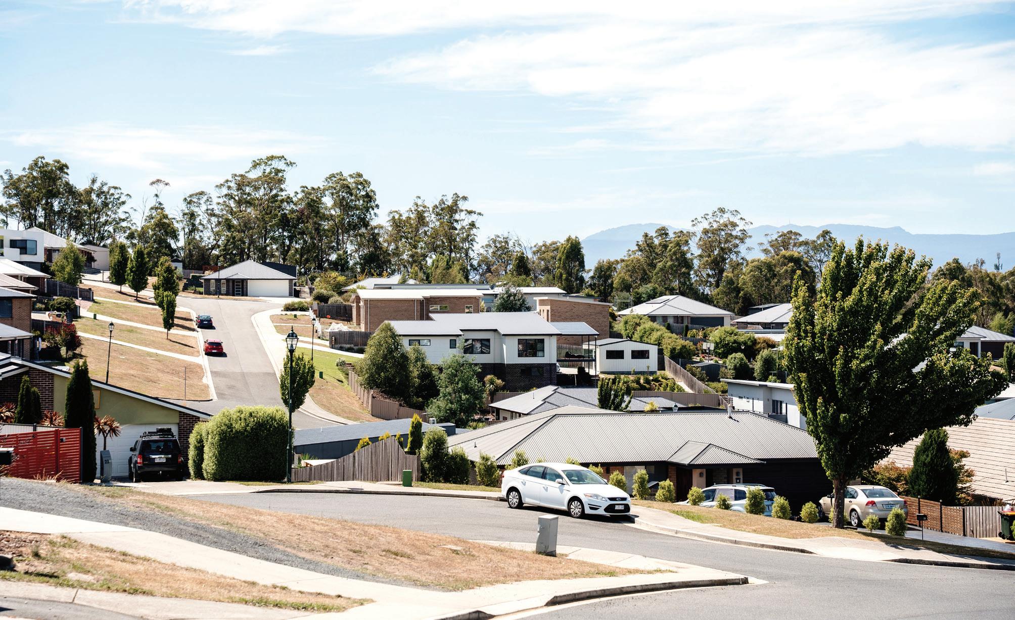
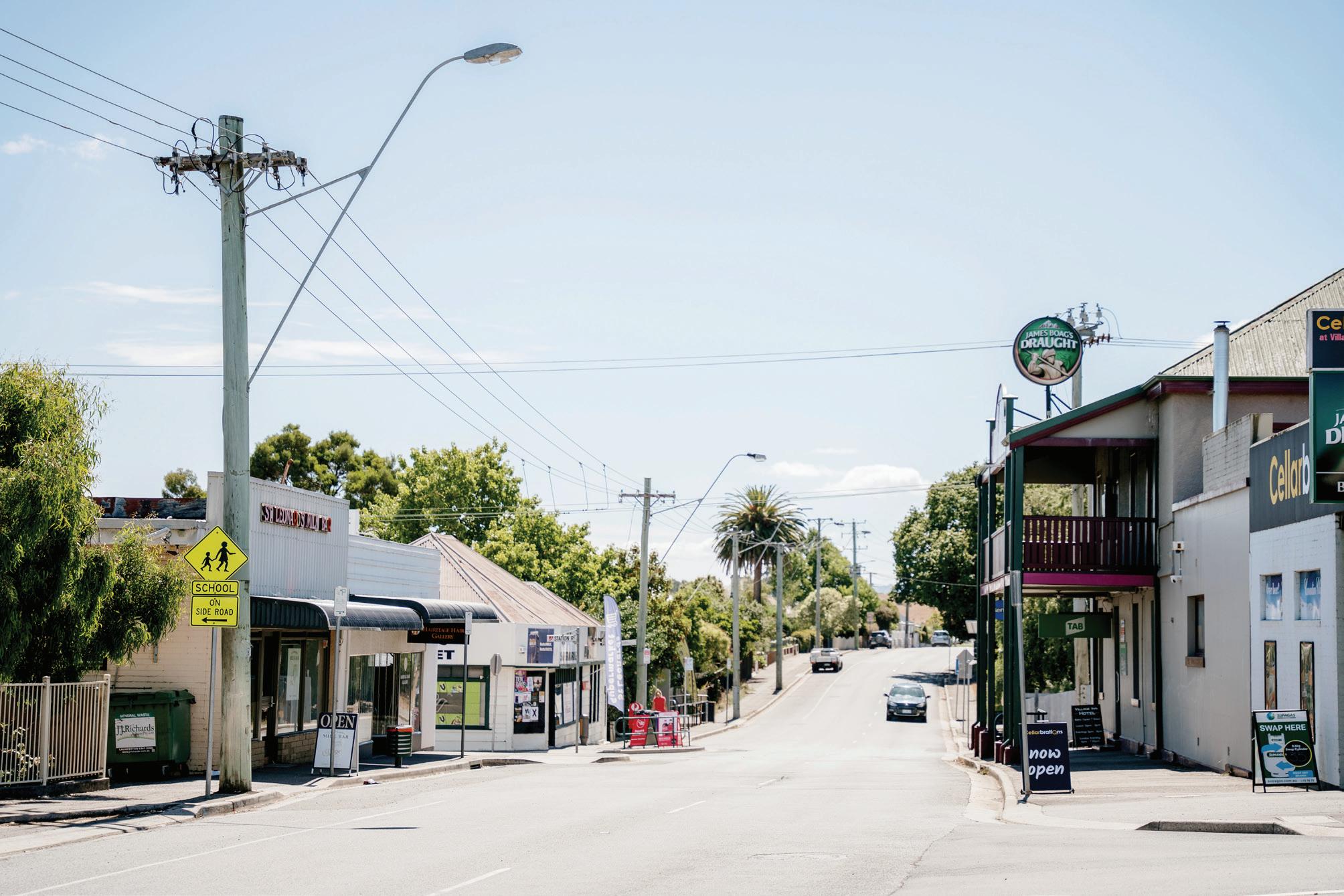
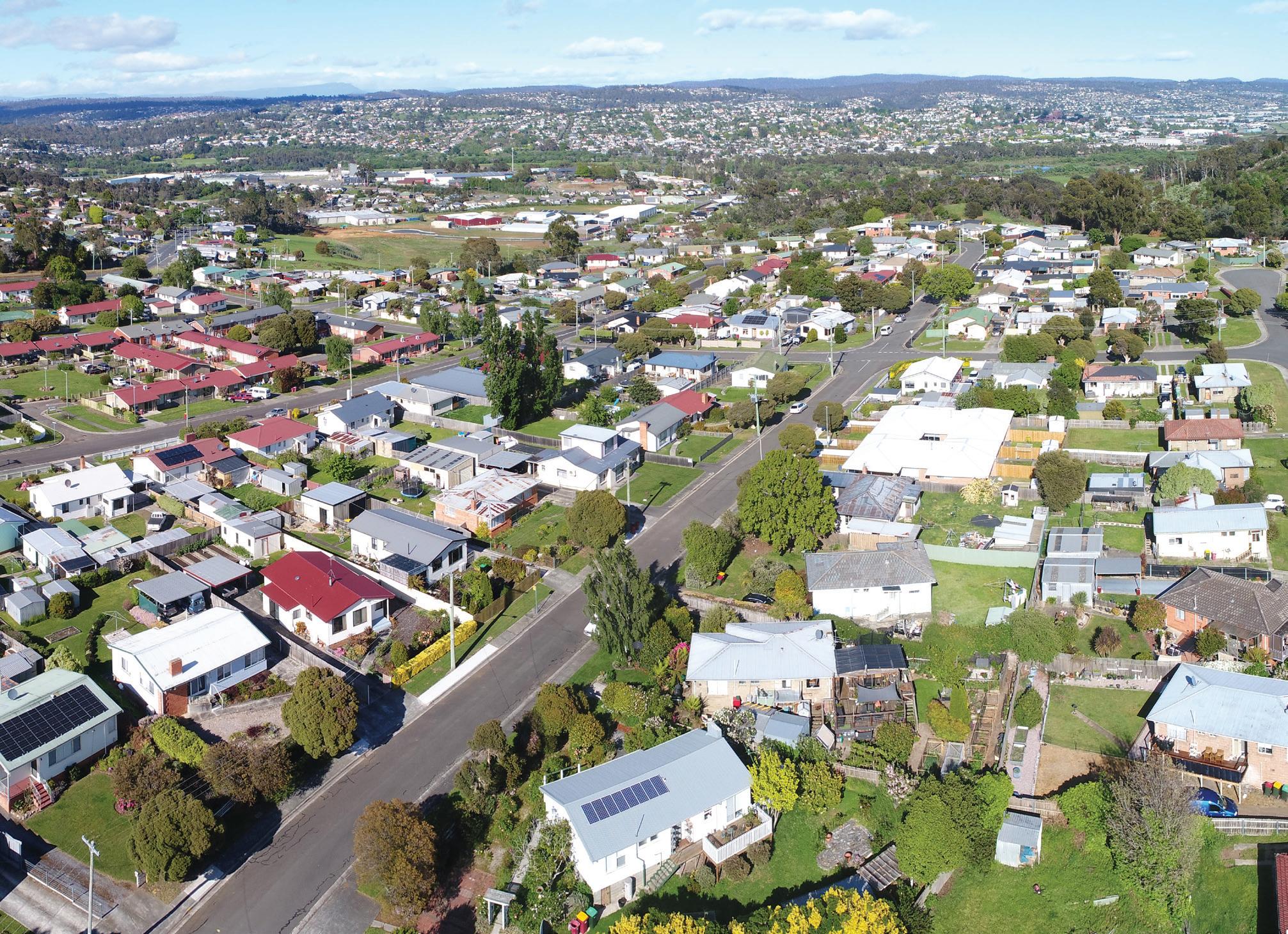
St Leonards and Waverley are established suburbs located close to central Launceston. The area primarily features standalone housing, with some parts accommodating low-density rural lifestyle properties. Employment opportunities are provided through light industrial activities along St Leonards Road, complemented by community facilities such as schools and the St Leonards Sport Centre.
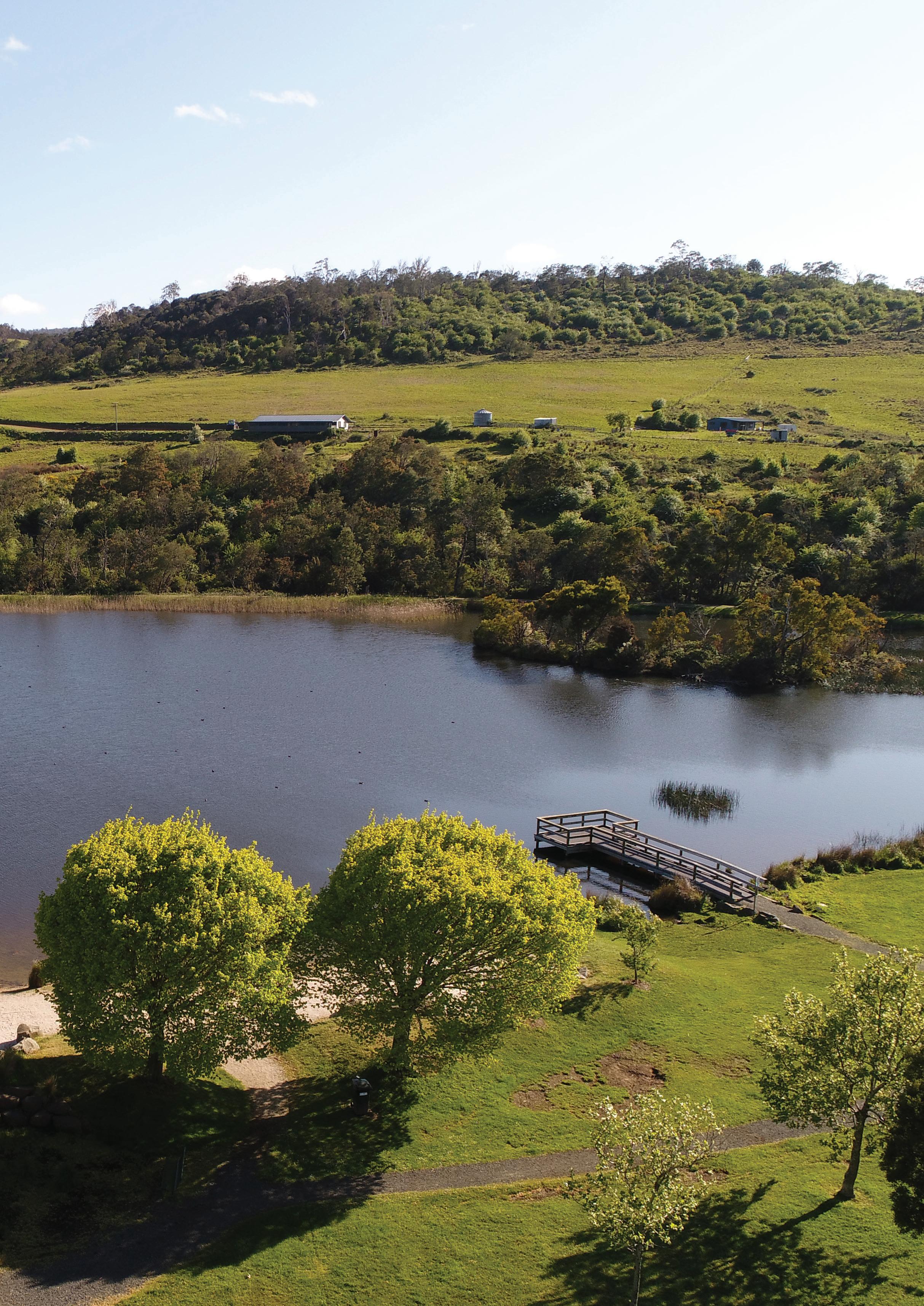
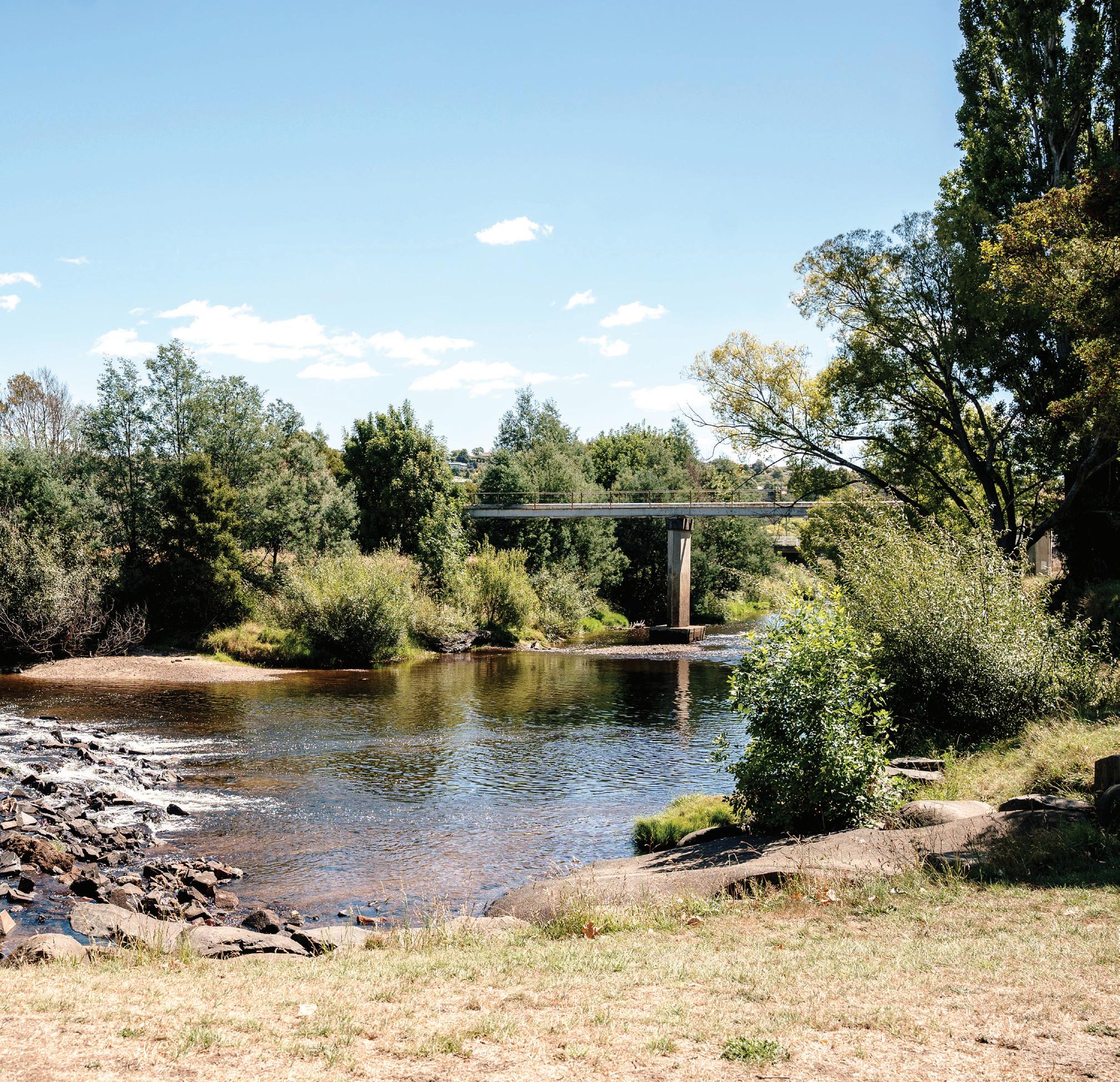
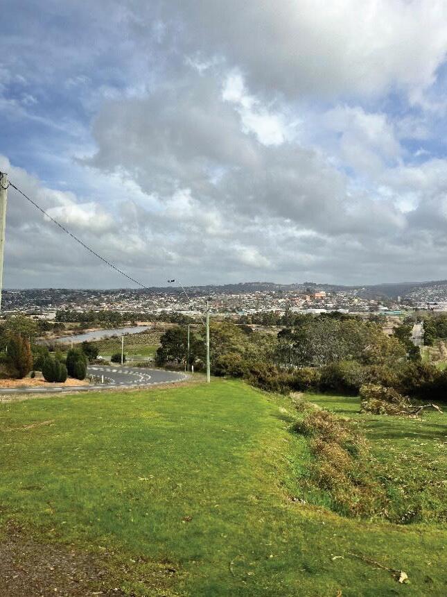
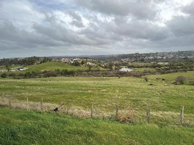
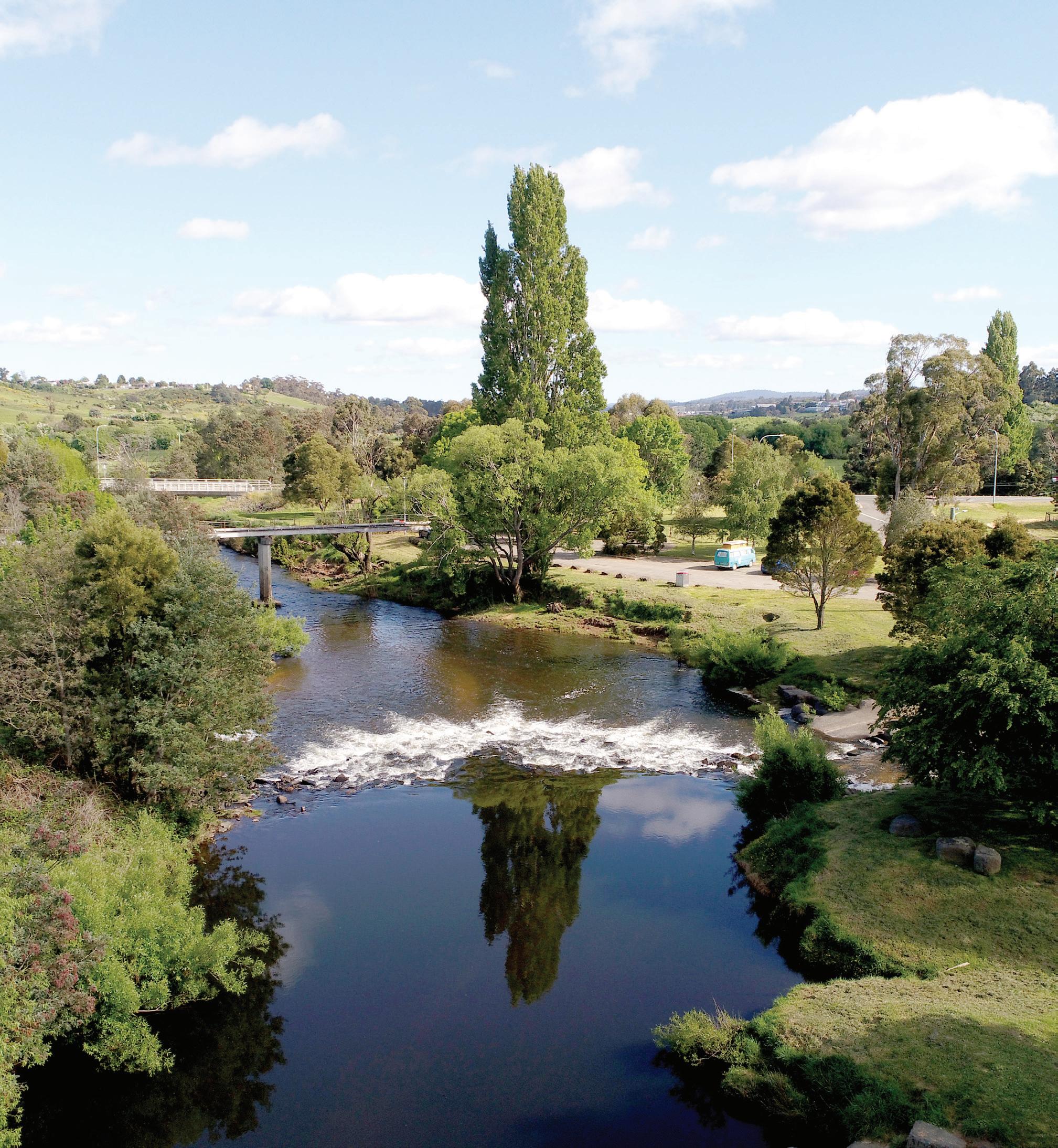
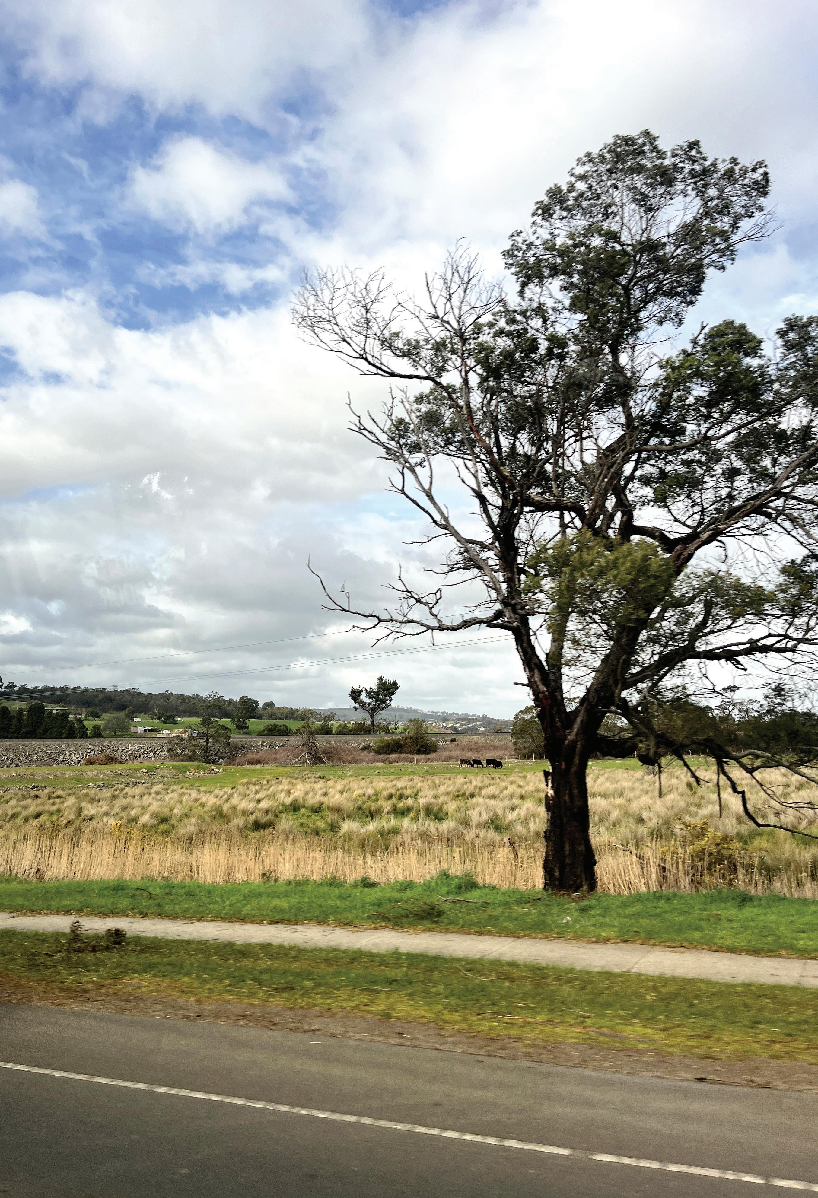
The landscape is defined by scenic views of nearby mountain ranges, the North Esk River, Launceston city and Ben Lomond. Significant waterways in the area include the North Esk River and Distillery Creek. Residents describe the area as having a semi-rural character, shaped by its natural surroundings and proximity to farmland.
Identified as a priority growth area in the Northern Tasmanian Regional Land Use Strategy (NTRLUS), St Leonards and Waverley have seen several large land parcels rezoned for urban development in recent years. However, these developments have largely occurred in an ad-hoc manner, placing strain on existing infrastructure and services, raising concerns about the preservation of the area’s valued character. The St Leonards and Waverley Neighbourhood Plan (Neighbourhood Plan) seeks to address this by setting a vision and guiding the long term development of the area.
The Neighbourhood Plan is structured as follows:
Introduction and Context
Overview of the area, regional context and purpose of the Neighbourhood Plan.
Neighbourhood Plan Purpose
Outlines the role of the Neighbourhood Plan and why it has been prepared.
Preparing the Neighbourhood Plan
Outlines the inputs and steps that informed the Neighbourhood Plan, including how the community has informed the plan’s directions.
The Neighbourhood Plan for St Leonards and Waverley
Sets the long-term vision for St Leonards and Waverley including the Strategic Directions for the corridor, and strategies and actions for how change will occur.
Implementation
Outlines proposed staging, statutory implementation and actions for further strategic work.
Infrastructure Funding Framework
Sets an approach to infrastructure funding and delivery.
Monitoring and Review
Sets out how the Neighbourhood Plan will be reviewed and updated over time to ensure its content remains relevant and accurate.
The Neighbourhood Plan includes a vision and three strategic directions that will shape how St Leonards and Waverley will grow and change over time.
The Vision for St Leonards and Waverley is:
“ The St Leonards and Waverley growth area is a dynamic community balancing new homes with its existing semi-rural surrounds. It safeguards the environment, including waterways, landforms and vegetation, while honouring the area’s history.
Building homes here focuses on accessibility, sustainability and community through integrated transport, open spaces and local amenities. This is where people come to live, work and thrive in an inclusive and vibrant community”.
The three Strategic Directions of the Neighbourhood Plan help to achieve the Vision:
Each strategic direction includes a series of strategies and actions, which will be implemented to ultimately deliver the vision.
The Implementation chapter of the document is critical to ensure the Neighbourhood Plan’s aspirations are realised. Putting a Neighbourhood Plan into action involves a range of different implementation steps including statutory implementation (such as rezoning land), infrastructure funding and delivery and general actions (like advocacy and further work).
The last chapter is Monitoring and Review to ensure the Neighbourhood Plan remains relevant and completion of actions remain on track. This section identifies the need to periodically re-engage with the community to ensure the Neighbourhood Plan’s aspirations remain relevant and aligned with community needs.
The St Leonards and Waverley Neighbourhood Plan (the Neighbourhood Plan) guides future growth in Greater Launceston.
The Greater Launceston Plan 2014 (GLP) and the Northern Tasmanian Regional Land Use Strategy 2021 (NTRLUS) recognise St Leonards and Waverley as a growth corridor, emphasising the need for strategic planning.
The Tasmanian State Government requires structure plans to address 15-year land supply. This Neighbourhood Plan will guide growth over the next 30 years, including staged land release.
An Infrastructure Funding Framework (IFF) is included in the Neighbourhood Plan to ensure infrastructure supports this growth.
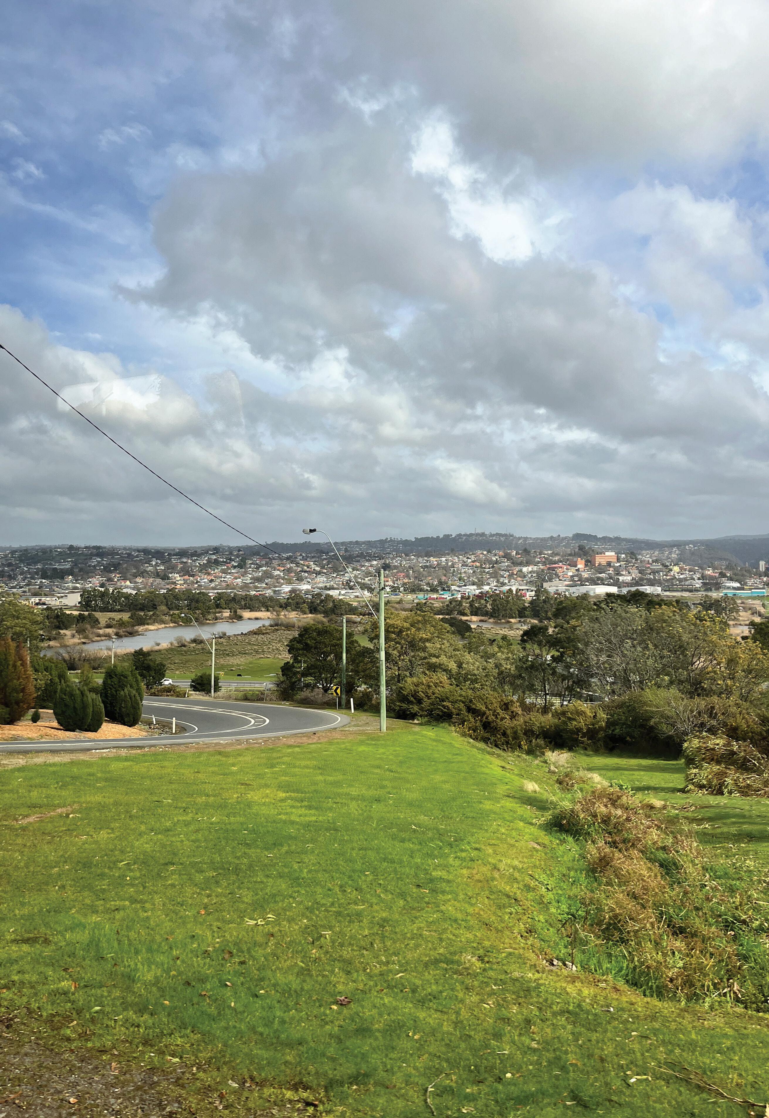
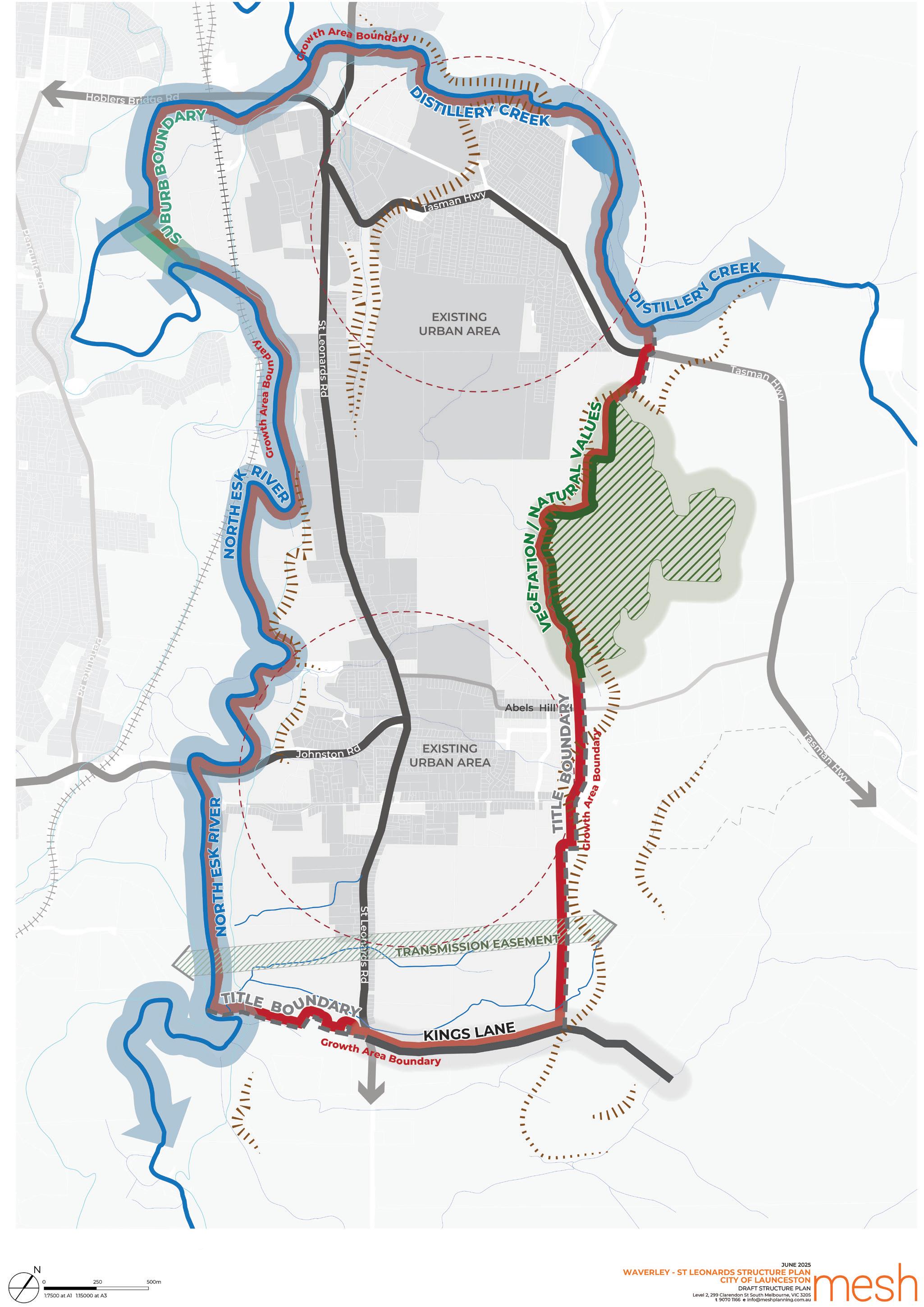
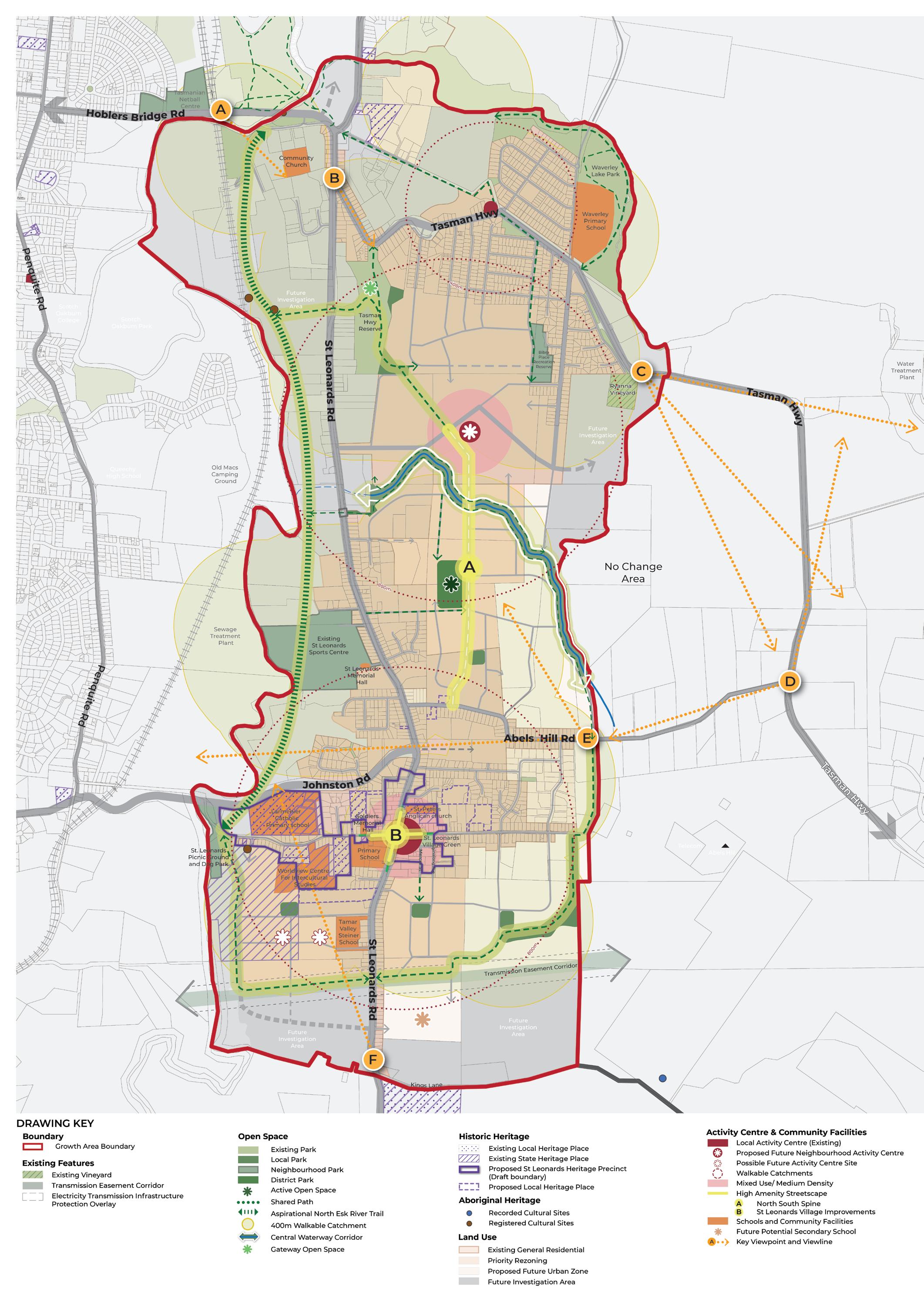
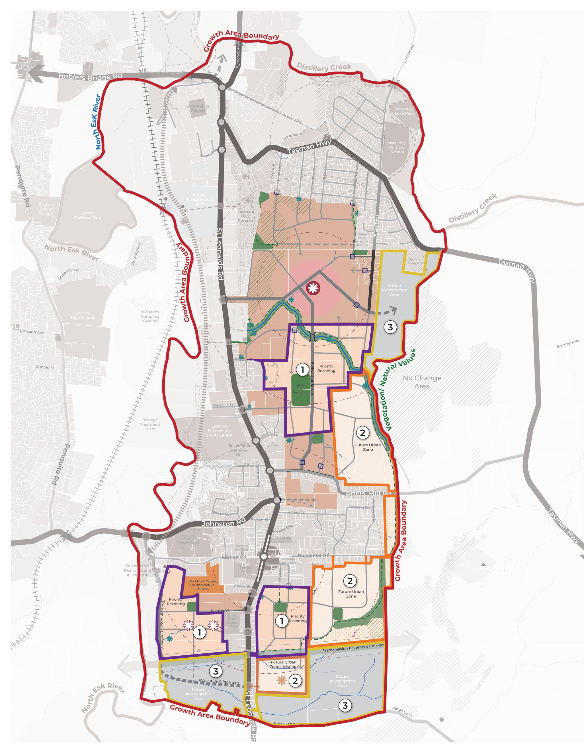
St Leonards and Waverley are located on the eastern edge of Launceston, approximately 5 kilometres from the Central Business District (Figure 1). Located in the Tamar Valley, these suburbs offer a semi-rural character with easy access to Launceston’s city centre. St Leonards and Waverley connect to nearby agricultural land and natural landscapes, supporting sustainable growth and development consistent with Launceston’s function as the major regional city in northern Tasmania.

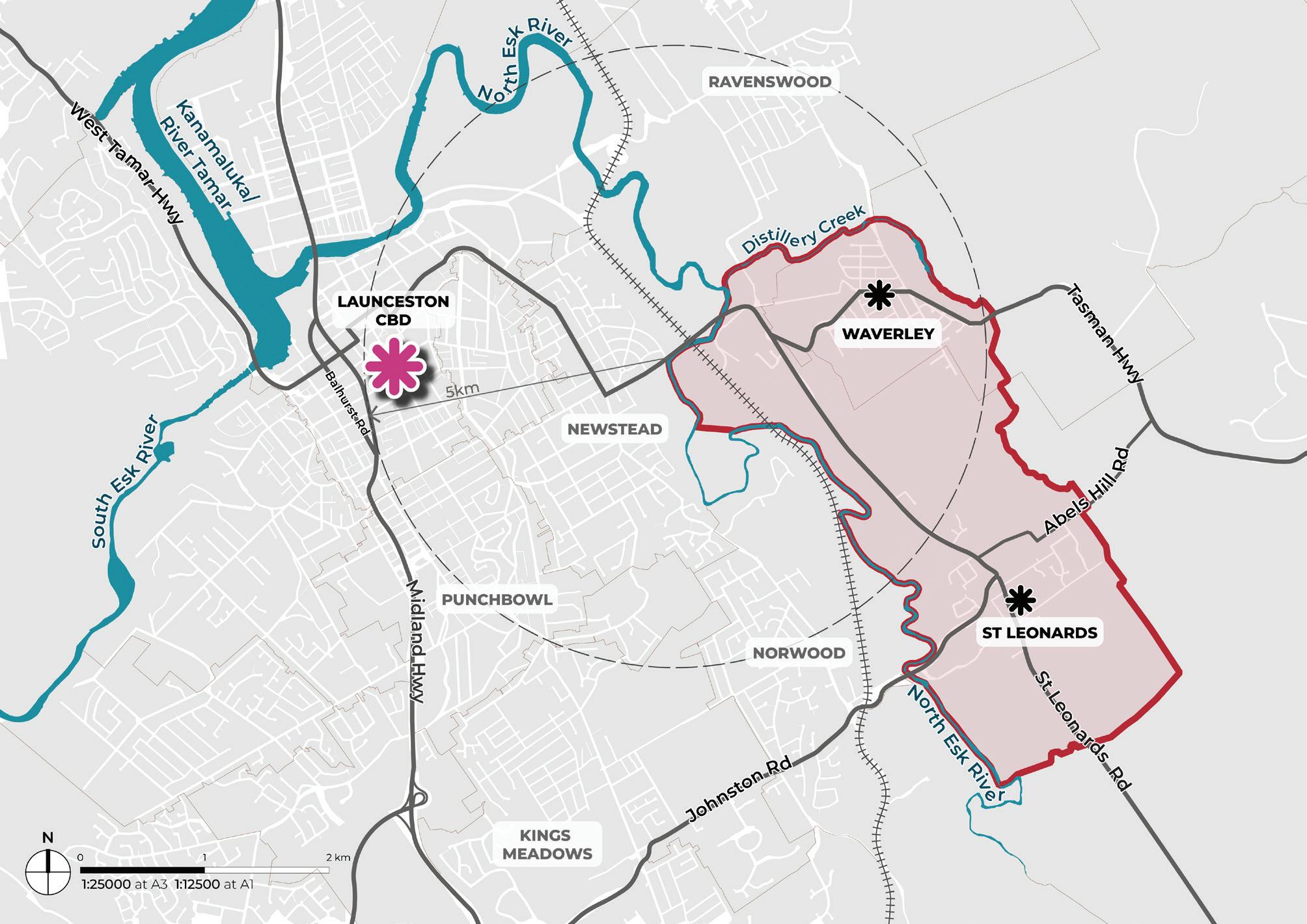
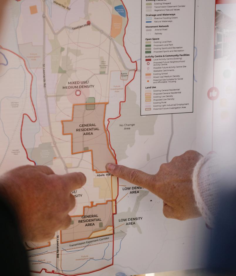
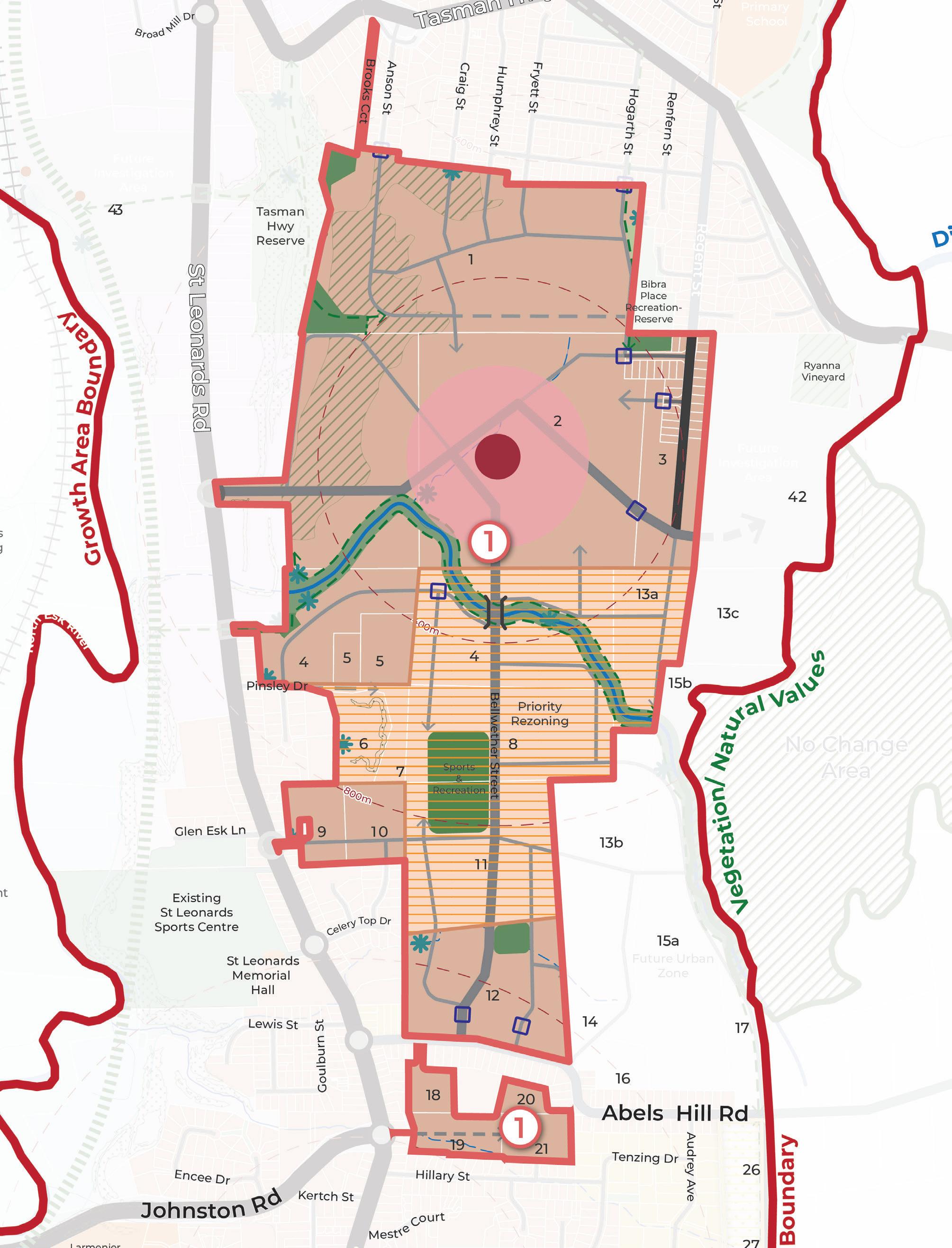
The growth area boundary of the Neighbourhood Plan (Figure 2) includes both the suburbs of St Leonards and Waverley. The NTRLUS broadly designates St Leonards and Waverley as a growth corridor and future investigation area for residential development and recommends the boundary for growth be defined through a structure planning process.
The boundary is informed by the existing zoned land, current residential land uptake, land use constraints, logical barriers to development and physical features including topography, waterways and vegetation as identified on Figure 2.
A broader study area was adopted in the site analysis that informed this growth area boundary, as illustrated in the St Leonards and Waverley Neighbourhood Plan Background Report 2025 (Background Report).

A Neighbourhood Plan, which can also be called a Structure Plan, is a guide for how a local area should evolve and develop over time. Having a forward focus, a Neighbourhood Plan sets a framework for how future development will be coordinated with the delivery of roads, open space, shops and community services. A Neighbourhood Plan includes a vision, strategies and actions for further work, including implementation responsibilities.
A Neighbourhood Plan can incorporate a funding framework, in this case an Infrastructure Funding Framework (IFF). An IFF sets out how infrastructure such as roads, intersections, recreation facilities and other community infrastructure will be funded and delivered. The purpose of the IFF is to outline infrastructure projects required to support development and outline who is responsible for their delivery.
St Leonards and Waverley are identified in the GLP and the NTRLUS as locations to support additional housing. The Neighbourhood Plan and IFF are called out as an action in the Launceston Housing Plan 2025-2040. The Neighbourhood Plan and IFF provide local-level guidance on how this growth occurs in a coordinated and sustainable way.
The Neighbourhood Plan provides local guidance in response to state and regional policy direction (Figure 3). The Neighbourhood Plan will be implemented through the Launceston Local Provisions Schedule of the Tasmanian Planning Scheme, ensuring its plans and directions are considered in development application assessments. Implementation will take the form of changes to zones, overlays, and preparation of Specific Area Plans (SAPs) or Particular Purpose Zones. The implementation of the Neighbourhood Plan will be staged through planning scheme amendments, guided by Council direction or driven by developer-led initiatives.
Other actions in the Neighbourhood Plan include further strategic work such as master planning or advocacy (for example, to advocate for improved bus services). These actions will be led by Council or other stakeholders to support the plan’s vision.
Schedule 1 Objectives
Land Use Planning and Approvals Act 1993 (LUPAA)
Tasmanian Planning Policies (TPPs) (draft)
Northern Tasmanian Regional Land Use Strategy (NTRLUS) (under review)
Municipal Plan
City of Launceston Strategic Plan 2025 - 2035
Launceston Housing Plan 2025 - 2040
Local Strategic Plan
St Leonards and Waverley Neighbourhood Plan
Statutory Implementation Tasmanian Planning Scheme
State Planning Provisions (SPP)
Local Provisions Schedule (LPS)
State PoliciesState Policies and Projects Act 1993
The Neighbourhood Plan was developed through a collaborative process, including workshops with council staff, consideration of technical inputs, review of existing background documents and comprehensive community and stakeholder engagement (Figure 4).

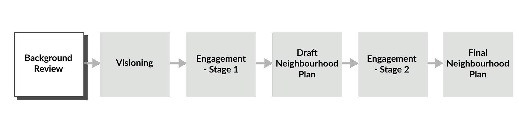
Background investigations included:
• A review of existing strategic and technical documents
• An understanding of existing planning scheme guidance
• A site visit to key locations across St Leonards and Waverley
• A review of approved and draft subdivision plans prepared by land owners
• Review of previous stakeholder and community feedback on the St Leonards Village Plan (2018)
Preparation of a series of site analysis maps, including topography, natural features, existing infrastructure and other relevant site attributes.
The Background Report provides a detailed overview of the information considered at this stage.
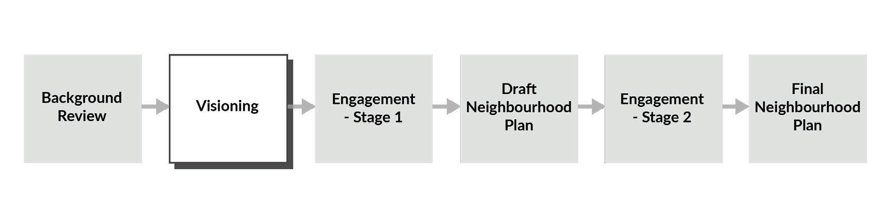
During the visioning phase, a preliminary plan was developed and shaped by insights from a workshop attended by council staff and key technical consultants specialising in community engagement, drainage, transport, natural values, bushfire management, agricultural capability, historic heritage, and cultural heritage. These experts have provided detailed reports that have informed the Neighbourhood Plan (Table 1).
During the visioning phase and throughout the project, targeted engagement also occurred with State Government stakeholders including TasWater, TasNetworks, Department for Education, Children and Young People, Department of State Growth and Department of Health.
Major land owners were consulted during this phase. The first round of community engagement, detailed in the next section, also informed the preliminary plan.
An integrated transport assessment that provides strategies and concept designs for managing mobility and connectivity across the study area, including transport infrastructure requirements and upgrades aligned with planning objectives and municipal standards.
An assessment of historic heritage that identifies significant sites and provides recommendations to preserve and integrate these historic values into the Neighbourhood Plan, ensuring alignment with heritage planning objectives.
A natural values assessment that identifies flora and fauna values and provides strategies for their protection and enhancement to ensure alignment with environmental objectives.
Technical insights, concept designs and recommendations for managing stormwater across the study area, including drainage catchments, water quality and infrastructure upgrades.
An assessment of retail and community needs that provides insights and strategies for prioritising land uses and community infrastructure, including open space, to support sustainable residential growth.
An Aboriginal heritage assessment that identifies culturally significant sites and provides strategies for their protection and integration, aligning with relevant legislation.
A land capability assessment that evaluates the study area’s suitability for agricultural land using a land classification system to guide sustainable land management and development practices, consistent with State policy guidance.
A bushfire advice report that identifies bushfire hazard risks and protection measures for the study area to ensure compliance with bushfire management standards.
Community and stakeholder engagement advice that provides critical insights and feedback, shaping the Neighbourhood Plan to reflect local needs and priorities while aligning with broader planning objectives.
TABLE 1. NEIGHBOURHOOD PLAN TECHNICAL INPUTS
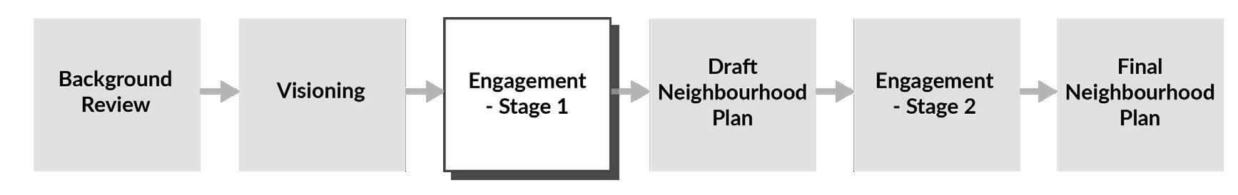
The Neighbourhood Plan is informed by two engagement stages; Stage 1 a reintroduction of the project to the community and Stage 2 seeking feedback on the Draft Neighbourhood Plan.
(7 November 2024 to 6 December 2024)
Purpose: To re-introduce the project following previous engagement in 2018, including re-introduction of the project purpose and understanding whether previous feedback is still relevant.
Approach: Distribution of posters and flyers, social media posts, creation of a project webpage on City of Launceston’s ‘Tomorrow Together’ site and release of a survey. The survey asked questions like ‘what facilities would you like to see in the area?’, ‘how do you live and travel?’ and ‘what are your priorities for the future?’.
418
Survey Responses
854 Visits to the project homepage
A total of 418 survey responses were collected, providing a comprehensive representation of residents from St Leonards and Waverley as follows:
72%
Of respondents were female.
47% Are couples with children.
39% Are aged between 35-49.
89%
Live in St Leonards or Waverley.
The community’s key priorities from the analysis of survey results from the Stage 1 Engagement are summarised below.
Transport and movement
• Additional walking paths, cycle ways and bushwalking connections.
• Safe, connected and accessible footpath network.
• Frequent and reliable bus services connecting the area to service centres such as Kings Meadows and the Launceston CBD.
• Enhanced road safety and better management of congestion and speeding.
Open space and recreation
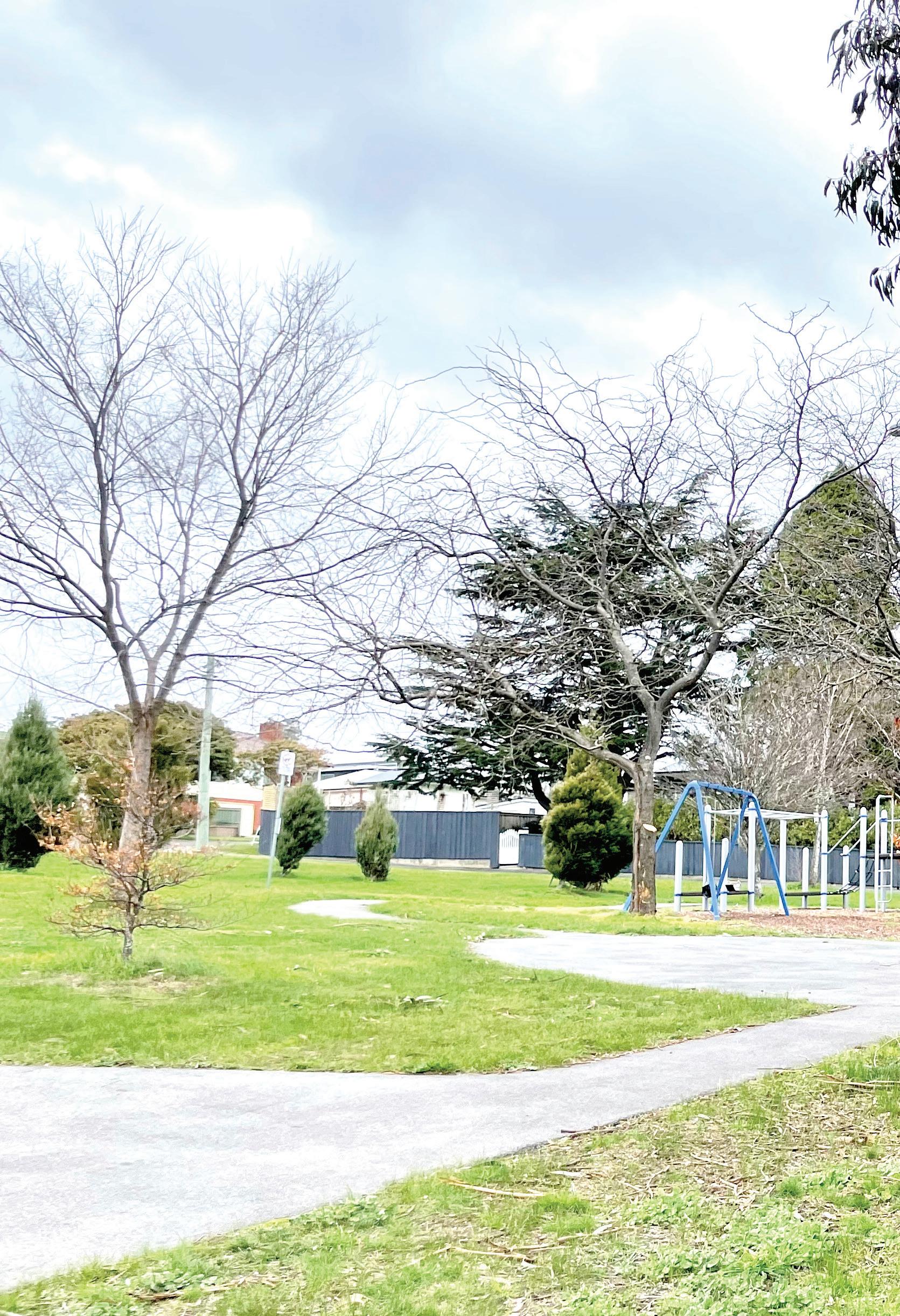
• Improved playground equipment and family-friendly open spaces.
• New amenities in local parks such as BBQs, public toilets and lighting.
• Improved off-leash, fenced dog parks.
Social infrastructure
• Community facilities suited to host events and gatherings.
• Local health services, particularly general practitioners and a pharmacy.
• Additional childcare services, improved schools and the addition of a high school.
Retail and commercial services
• More shops and retail services:
- Supermarkets and service stations.
- Local cafes and food businesses.
- Small businesses such as a butcher, florist or convenience store.
Residential development
• Mixed views on residential growth.
• Acknowledgement that growth will result in additional facilities and services.
• Concern around density and the loss of the existing ‘village feel’.
Community perceptions and safety
• Desire for increased police presence to address anti-social behaviour.
• Negative sentiment regarding social and community housing.
• Stigma associated with the socio-economic profile of the area, particularly Waverley.
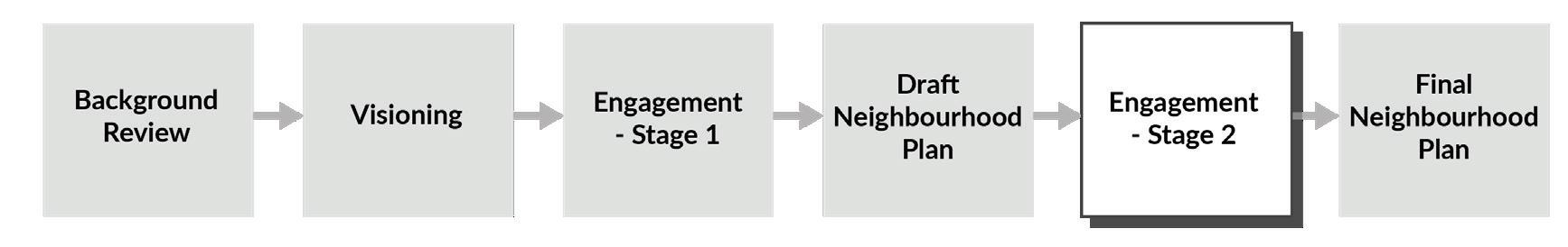
March 2025 to 29 April 2025)
Purpose: To seek feedback on the contents and direction of the Draft Neighbourhood Plan.
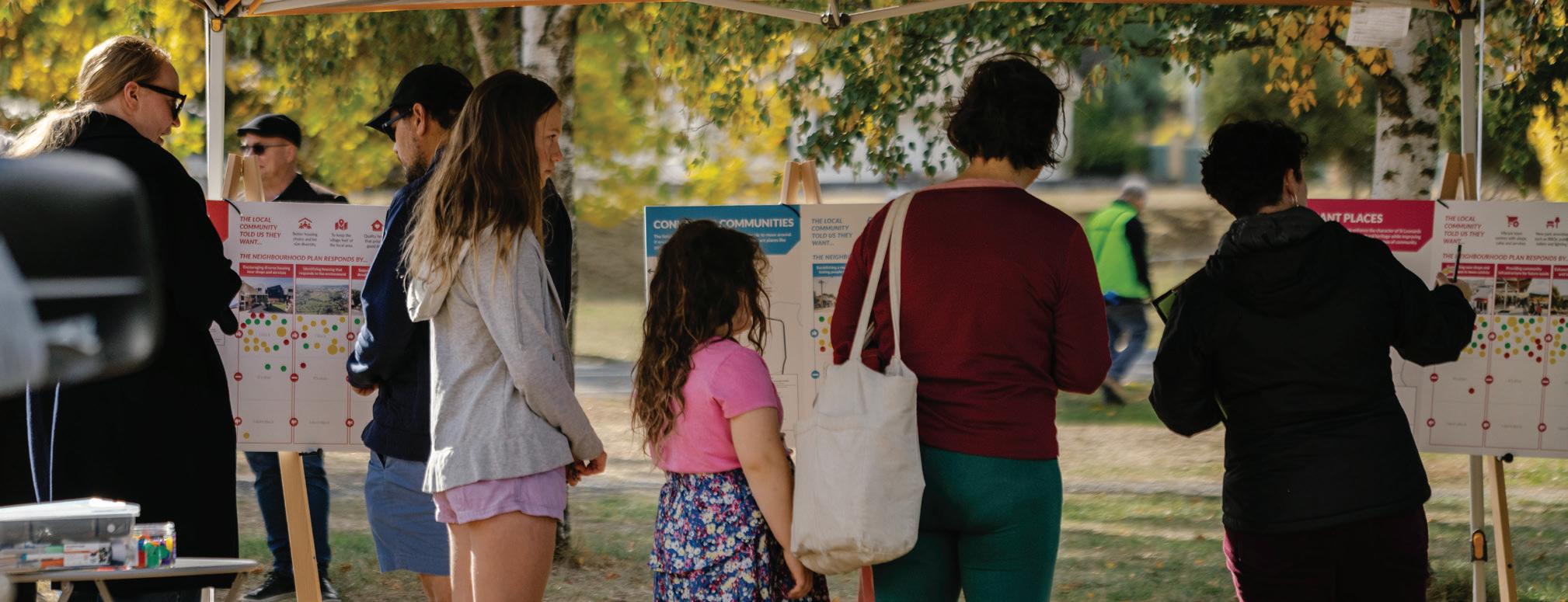
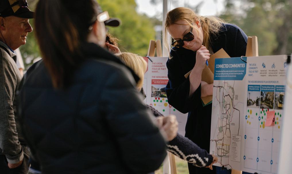
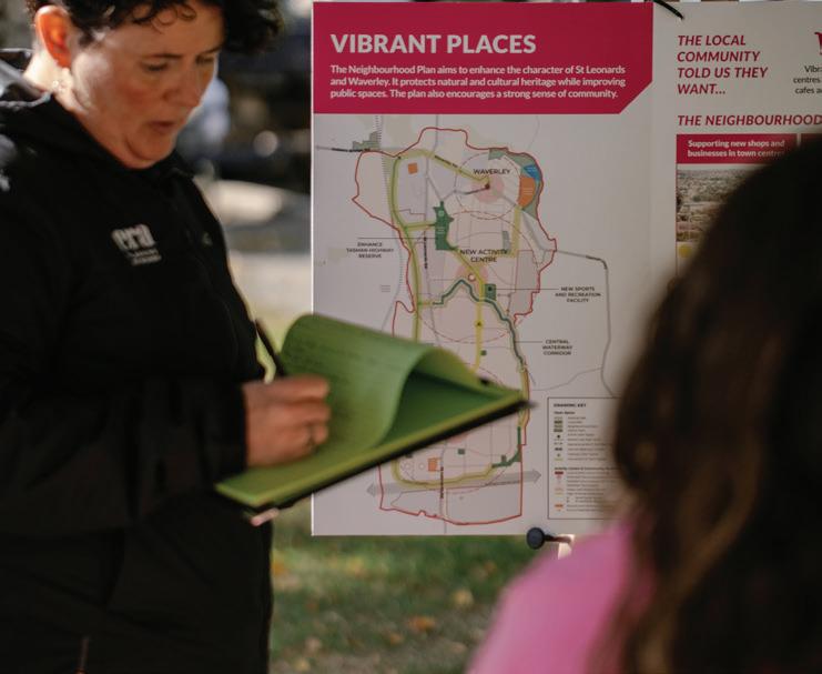
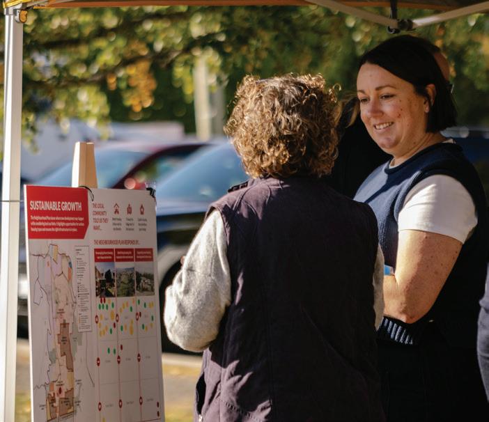
Approach: This engagement included two pop up events in St Leonards and Waverley where people could learn more about the project and provide feedback directly to the project team. A community workshop was also held and online engagement was available via a survey. Written submissions where also received from major land owners within the study area and a number of government agencies.


The community feedback from the engagement activities is summarised below. The feedback is grouped under the Neighbourhood Plan’s three Strategic Directions.
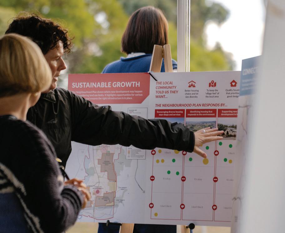
• Participants involved in face-to-face engagement activities demonstrated strong support for sustainable growth strategies that focus on early and co-ordinated infrastructure delivery and clear planning for future development. Survey respondents rated infrastructure considerations as a top priority, along with the need for designated areas to guide where new housing should and should not be located.
• Feedback from in-person sessions showed a preference for well-located, environmentally responsive housing while expressing a desire to maintain the area’s established character. There was less support for new development and increased housing diversity via the survey, than from those attending in-person sessions. This may indicate the importance of the context and nuance provided during face-to-face discussions whereby the team can respond to queries and provide more detail on the strategic basis for certain actions within the Neighbourhood Plan.
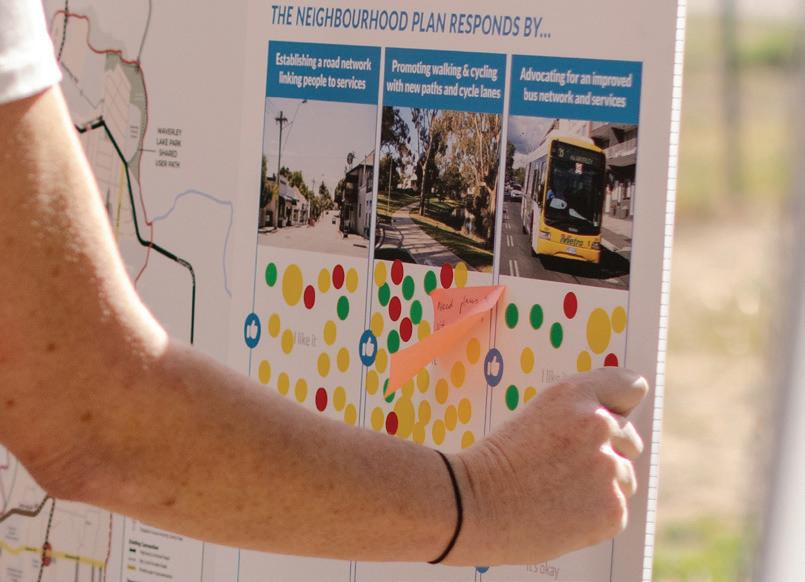
• Feedback highlighted strong support for connected communities in St Leonards and Waverley. Survey respondents rated high-quality streets and roads, easy access to open spaces and improved bus services as top priorities. There was also significant support for encouraging walking and cycling through new paths and cycle lanes.
• Feedback from pop-up sessions showed strong approval for establishing a road network linking people to services, promoting active transport and advocating for better public transport. Workshop participants emphasised the need for safe, fit for purpose roads, addressing traffic congestion and enhancing transport connections and accessibility.

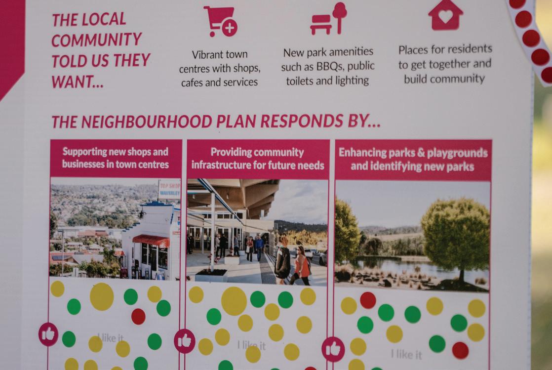
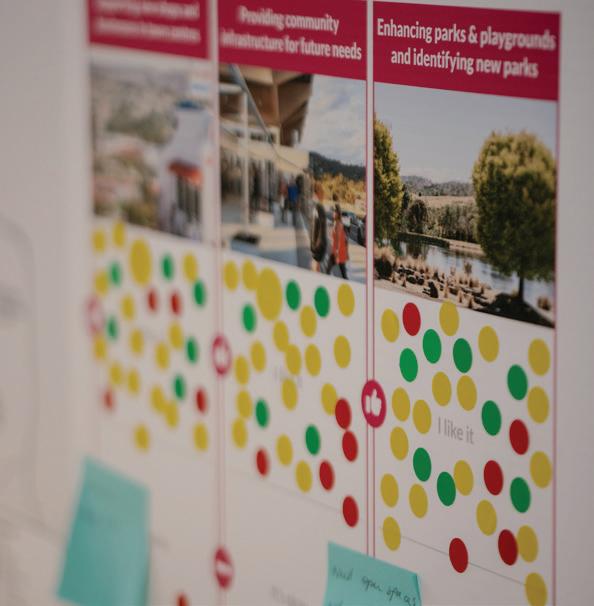
• Community feedback indicates strong support for enhancing the character of St Leonards and Waverley. Survey respondents rated improving parks and playgrounds, protecting heritage values, enhancing tree cover and landscaping as top priorities. There was also significant support for providing new shops, businesses and facilities to meet future community needs.
• Feedback from pop-up sessions showed strong approval for supporting local businesses, investing in community infrastructure and enhancing public spaces. Workshop participants expressed the need for additional services and facilities, greener and more inclusive public spaces and better local connectivity.
In response to the community and stakeholder feedback received during the Stage 2 engagement a number of updates were made to the Neighbourhood Plan, including:
• Introduction of clearer development sequencing advice, including identifying some land to be zoned Future Urban Zone.
• Inclusion of additional proposed local road links in response to developer subdivision plans and to ensure a connected movement network.
• Relocation of part of the proposed through road linking St Leonards Road to Johnston Road to the future investigation area, signaling this section will be developed as a long-term road project.
• Re-location of the proposed Sport and Recreation facility to be located on flatter land and more central to the priority development area.
• Excluding land from development that’s subject to the Riverine Flood Extent along the North Esk River.
• Re-location of some local parks to be more central to a development area or to align with proposed sub-division layouts.
• Prioritisation of Regent Street as a collector road to potentially form part of the future bus network.
• Identification of Hogarth Street as the key opportunity for street scape improvements (previously Regent Street) to form part of the connected shared network.
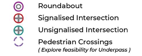
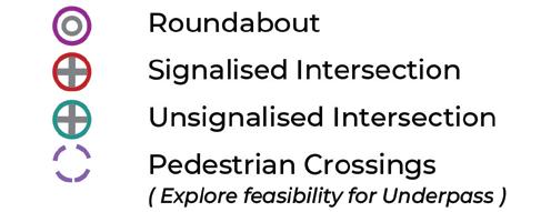
• Clearer direction with respect to intersections that will require upgrade and new intersections that will be delivered as part of future development.
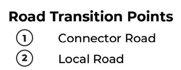
• Identification of additional transition points where existing roads will need to transition to new widths as identified by the cross sections in the Neighbourhood Plan.
• Revisions to the cross sections to ensure sufficient space for servicing infrastructure and to more closely align with approved road designs.
• Removal of guidance around staging of sewer and water infrastructure, at the request of TasWater.
• Review of road connections around the Tamar Valley Steiner School and Laimar Street location to maximise use of existing already constructed infrastructure.
• A number of graphic design updates were also made to more clearly communicate the key aspirations of the figures within the document.
The Background Review, Visioning and Community Engagement informed the development of key planning and urban design considerations for the growth area, which are detailed within the Background Report and summarised in Figure 5. These key considerations were categorised into three broad themes that have formed the Strategic Directions that helped shape the Vision of the Neighbourhood Plan.
SITE FEATURES

MOVEMENT NETWORK
PUBLIC AND ACTIVE TRANSPORT

TOPOGRAPHY / VIEW LINES

LAND USES
LAND USE BUFFERS

NATURAL VALUES / WATERWAYS

Vegetation/Natural Values

ACTIVITY

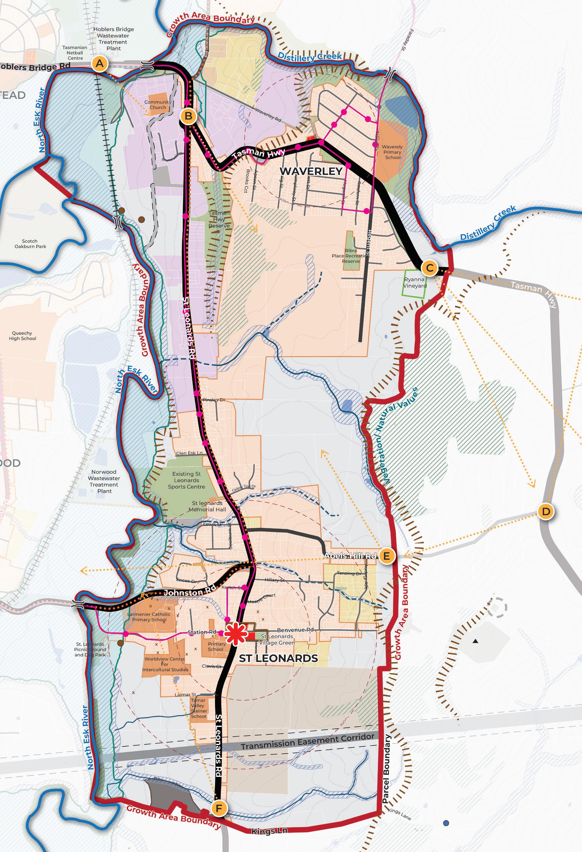
Growth Area Boundary is informed by waterways (North Esk River and Distillery Creek), areas of natural value, property boundaries, topography and road access.
Area of traffic congestion during peak times (Hoblers Bridge Road and Johnston Road).
Limited opportunity for new intersections from St Leonards Road and Tasman Highway into the growth area.
St Leonards Road is the primary north-south arterial servicing the growth area.
The Tasman Highway cuts through the northern section of the growth area, servicing existing developed areas.
Bus routes are limited to the existing Waverley residential areas and St Leonards Road.
Designated Cycling Routes are limited to St Leonards Road and Johnston Road.
Walking paths through the growth area are often narrow and obstructed in some instances. Recreational trails are mainly located on the edges of the growth area.
Areas where slope is greater than 20% limit the type, extent and viability of residential development.
Key view lines from road entrances into the growth area are from the north along Hoblers Bridge Road (A), entrance to St Leonards Road to the Tasman Highway Reserve (B), along Tasman Highway looking east (C), looking north (D) and west (E) from Abels Hill Road and looking north from the southern end of the growth area (F).
Pockets of rural zoned land located between existing residential areas form land use “gaps”.
Isolated corridor of light industrial along St Leonards Road.
No clear open space hierarchy, making it difficult to identify gaps within the network.
Electricity transmission corridor provides an enduring boundary to development to the south.
Protect ability for vineyard to continue operation.
Natural values to be retained through exclusion from growth area boundary. Future development to respond to bushfire hazard areas and waterways.
Quality of existing natural values to be understood.
Limited retail provision, the main activity centre is the St Leonards village with a small number of shops in Waverley.
Gap in the offering and distribution of community facilities and opportunity to co-locate complimentary land uses (i.e. co-locate schools with community facilities).
Existing primary schools in St Leonards presents an opportunity to contribute to the vibrancy of the St Leonards village.
Heritage sites within the growth area not adequately captured in planning policy. A number of heritages sites around St Leonards Village are concentrated contributing to an overarching character.
Existing Aboriginal Heritage sites are located along North Esk River. A new Aboriginal Heritage site was identified outside of the growth area boundary.
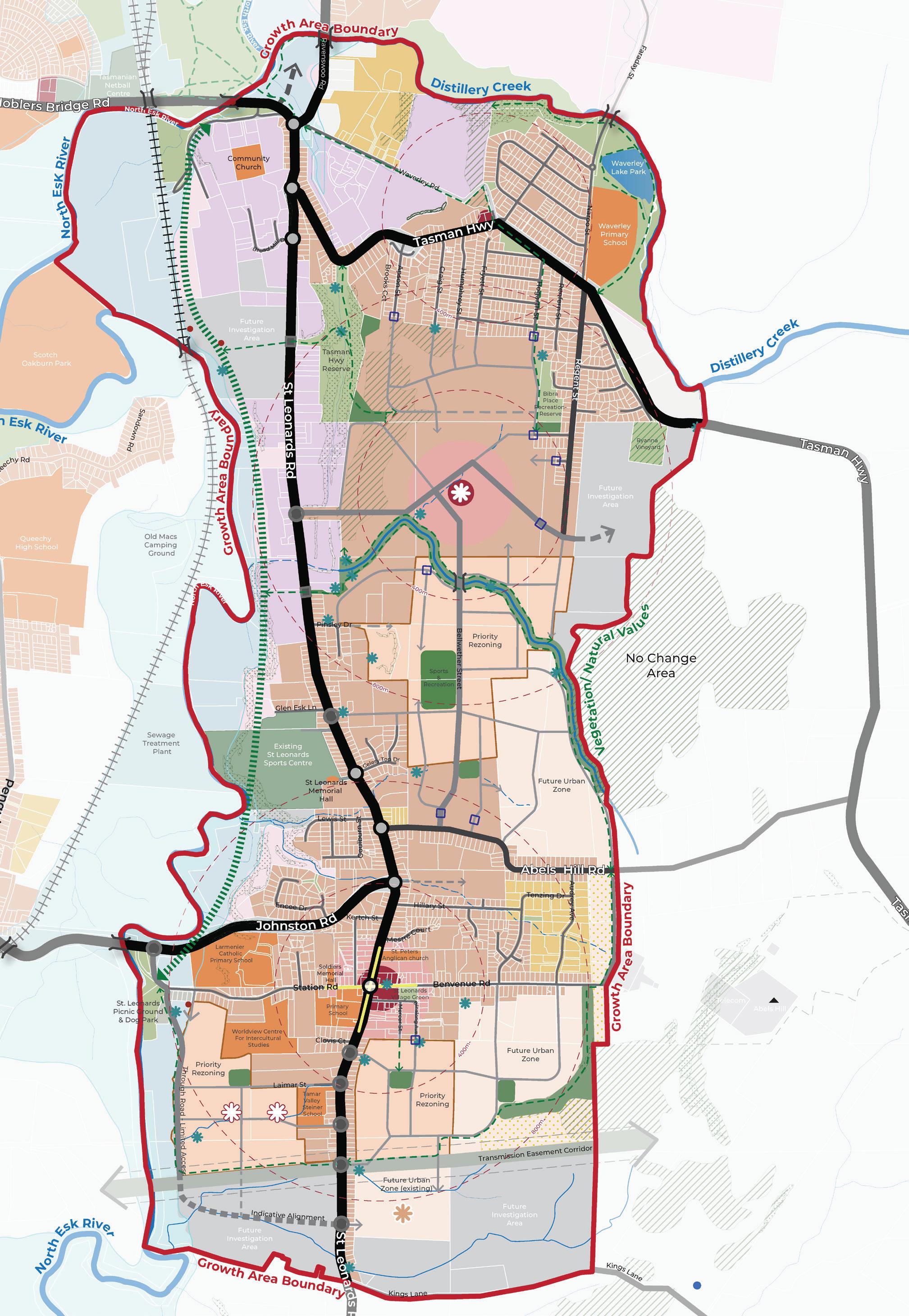
The Neighbourhood Plan for St Leonards and Waverley outlines the planning and design goals for future growth (Figure 7). It highlights strategic land use directions, including the growth area boundary, land uses, activity centres, open spaces, movement network, natural features and future investigation areas.
Delivery of the Neighbourhood Plan is supported by a Vision, Strategic Directions, Strategies and Actions (Figure 6).
The Vision describes the future desired land use and design outcomes for St Leonards and Waverley. It defines WHAT we are trying to achieve.
The Neighbourhood Plan (Figure 7) identifies WHERE change is located.
The Strategic Directions describe the WAYS the Neighbourhood Plan will achieve the vision under the following themes:
The Strategies outline HOW the Strategic Directions will be achieved.
The Actions identify the FURTHER WORK required to achieve the Strategies.
Actions are split into Council and Agency Actions, led by the City of Launceston with some occurring in partnership with Government agencies. Proponent Actions are led by developers or key stakeholders.
Actions include Catalyst Projects, which are projects identified as important in kickstarting the Strategic Directions. The Council will begin implementing the Neighbourhood Plan with these immediate actions.
“ The St Leonards and Waverley growth area is a dynamic community, balancing new homes with its existing semi-rural surrounds. It safeguards the environment, including waterways, landforms and vegetation, while honouring the area’s history.
Building homes here focuses on accessibility, sustainability and community through integrated transport, open spaces and local amenities. This is where people come to live, work and thrive in an inclusive and vibrant community”.
The Strategic Directions implement the Vision for St Leonards and Waverley. The Strategic Directions have been informed by the background work discussed previously in the document, policy direction and technical guidance.
The NTRLUS is the state government policy document that provides the strategic basis for decisions related to growth and development for the North of Tasmania. The Strategic Directions implement the directions from the NTRLUS as identified on the following page.
The Neighbourhood Plan sets a Strategic Direction for Sustainable Growth which builds on the NTRLUS strategic direction G2.1 sustainable urban settlement patterns. This is achieved through definition of a growth area boundary that responds to context and land use constraints. Housing density responds to technical information (such as flooding, natural values and heritage as per NTRLUS strategic direction G3.1), with denser housing proposed close to amenities.
CATALYST PROJECT 1
Rezone the northern new development area (referred to as Planning Implementation Precinct 1 in the Implementation section) and prepare a Specific Area Plan to unlock new housing and amenities.
The Neighbourhood Plan sets a Strategic Direction for Connected Communities to achieve integration of infrastructure delivery with land use planning, consistent with NTRLUS strategic direction G1.2. Safe, inclusive, and sustainable connections are proposed to support all forms of transport, for enhanced walkability and convenient access to community amenities including open space and activity hubs (consistent with delivering an inclusive community as per NTRLUS strategic direction G2.4).
CATALYST PROJECT 2
Prepare streetscape Master Plans for Station Road / Benvenue Road and Hogarth Street which identify opportunities for footpath widening, street furniture and tree planting opportunities consistent with the aspirations of the City of Launceston Urban Greening Strategy 2023 – 2040.
The Neighbourhood Plan sets a Strategic Direction for Vibrant Places which builds on the NTRLUS strategic direction G2.3 (promotion of local character values) by protecting view lines, natural values, cultural and historic heritage. The Neighbourhood Plan emphasises responsive design, integration of green infrastructure, and creation of vibrant hubs that support community interaction, amenity, and liveability.
CATALYST PROJECT 3
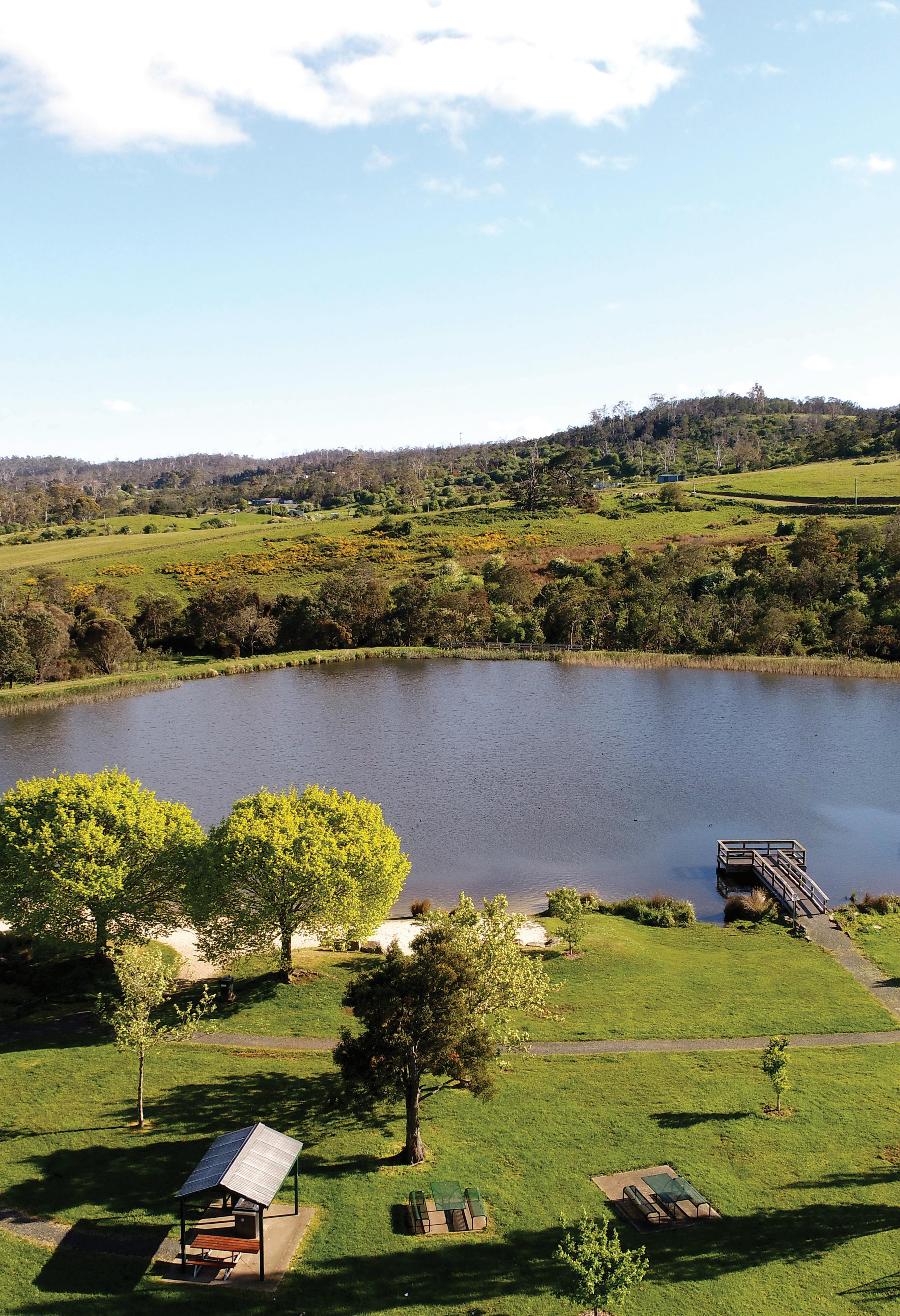
Prepare a Landscape Master Plan for the Waverley Lake Park that identifies opportunities for improved shared path connections, consistent with the Draft City of Launceston Recreation and Open Space Strategy.
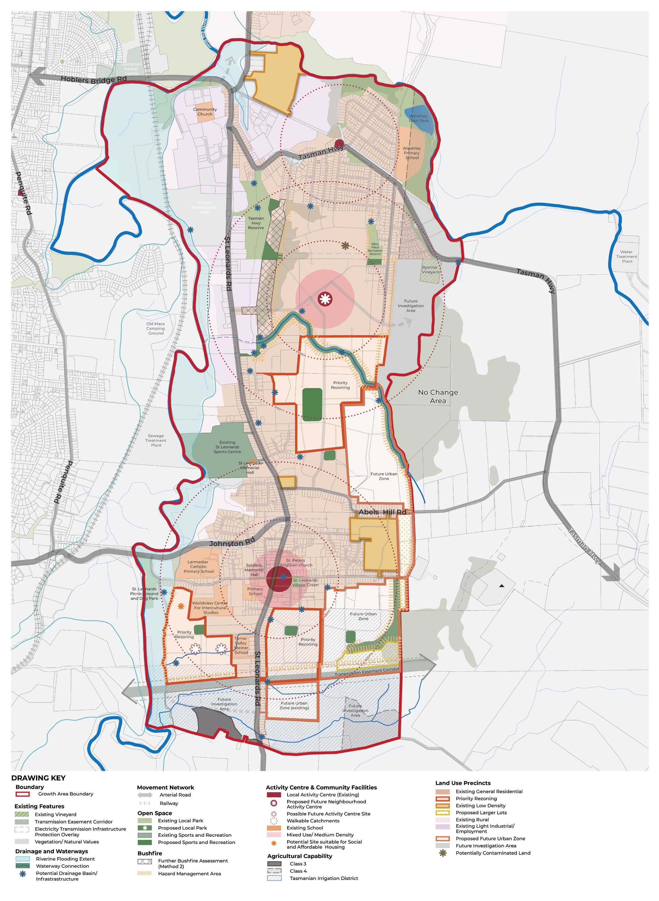


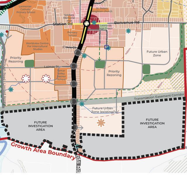
Implement the growth area boundary as shown in Figure 8, which responds to physical context and avoids land use constraints.
Support priority rezoning areas as preferred initial rezonings to complete missing gaps in the development pattern and to facilitate a coordinated approach to infrastructure delivery (Figure 8).
Apply the Future Urban Zone to areas identified on Figure 8 as locations suitable for residential development in the medium to long term
Confirm extent of Natural Values within the growth area to be retained as part of future development as per mapped Natural Values area on Figure 8, consistent with the findings of the Natural Values Constraints Report, North Barker 2025.
Define a preferred land use for areas with potential agricultural capability consistent with the recommendations of the Agricultural Land Capability Assessment, GES 2025. Land with potential agricultural capability is classified as Class 3, Class 4 or within a Tasmanian Irrigation District (Figure 8).
Ensure building design and vegetation management occurs consistent with the Bushfire Advice Report, North Barker 2025.
Confirm an appropriate bushfire interface response (such as vegetation management, setbacks or provision of an interface road) to areas marked as “further bushfire assessment (method 2)” on Figure 8.
Confirm preferred bushfire hazard management approach for areas marked as “hazard management area” in Figure 8. This could include vegetation management, provision of interface roads or setbacks consistent with Bushfire Advice Report, North Barker 2025.
Encourage diverse housing types including townhouses and low-rise apartments) within the 200m walkable catchments of activity and amenity (Figure 8 and 9), consistent with the guiding principles of the Launceston Housing Plan 2025 – 2040.
Launceston Housing Plan 2025 – 2040
The Housing Plan identifies key challenges around affordability, housing inequality, shortage of new homes and lack of diversity. It establishes guiding principles to improve housing supply and diversity in well-located vibrant neighbourhoods. The Neighbourhood Plan implements the relevant principles and actions of the Housing Plan.


Support areas of serviced (with a water and sewer connection) larger lots in areas which contain significant slope, vegetation, natural values, bushfire hazards, flooding or other land use constraints (Figure 8).
Encourage the delivery of social and affordable housing within the growth area, consistent with the Launceston Housing Plan 2025 – 2040 and as identified in Figure 8.
Establish a retail hierarchy within the walkable catchment of the growth area community Figure 8 (also discussed in Strategic Direction 3). The hierarchy should:
• Support the St Leonards Village and Waverley Activity Centres as a Neighbourhood or Town Centres, as per the NTRLUS Activity Centre Hierarchy.
• Establish a new Neighbourhood or Town Centre to be located centrally within the growth area.
• Consider a future limited-line supermarket and potential supporting retail in the southwest of the growth area, subject to future market trends and retail demand.


Deliver a catchment wide approach to drainage infrastructure by retaining natural waterways as part of the overall stormwater management system and by delivering infrastructure projects identified on Figure 8. Delivery of infrastructure is discussed in the Implementation section.
Confirm suitable land use for area identified on Figure 8 as potentially contaminated, such as provision of an open space area or widened road reservation.
Support planning investigations for the Future Investigation Areas (Figure 8) to determine their suitability for urban development when the following can be demonstrated:
• Genuine land supply need.
• Ability to bring forward connection to the servicing network (water, sewer and power).
• Ability to provide supporting infrastructure (transport, drainage and open space).
The investigations for the Future Investigation Areas should demonstrate the preferred design outcomes as identified on Figure 12.
These areas are identified in the Neighbourhood Plan as suitable for investigation for urban development in the long term. The Investigation Areas will form a logical expansion of the urban area when it can be demonstrated there is a land supply need and the land is capable to support urban development.
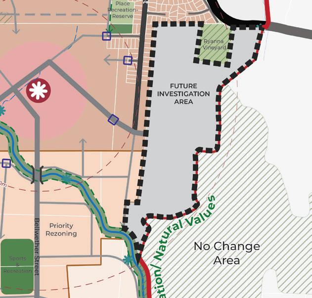
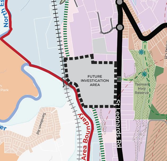
Future Investigation Area 1 should:
• Retain existing vegetation to preserve natural values.
• Respect the growth area boundary.
• Respond sensitively to the existing vineyard to the north, through the application of land use buffers, low-density residential outcomes or design requirements (consistent with the findings of the Agricultural Land Capability Assessment, GES 2025).
Future Investigation Area 2 should:
• Be investigated for an industrial land use consistent with surrounding development, subject to an industrial / commercial land supply and demand assessment.
• Support the development of the North Esk River Trail and provide a link between the Tasman Highway Reserve and the North Esk River.
• Ensure access and built form outcomes respond positively to the slope of the land.
Future Investigation Areas 3 and 4 should:
• Be informed by more detailed land capability assessments in accordance with the Agricultural Land Capability Assessment, GES 2025.
• Respond to flooding, natural values, electricity transmission line easement and Aboriginal heritage.
• Connect areas west and east of St Leonards Road by a high-amenity green-link connection using the transmission easement as a vegetation corridor.
• Ensure a gradual transition from low-density residential areas to rural regions further south.
• Provide an appropriate interface between development and adjacent rural land.
FIGURE 12. PREFERRED DESIGN OUTCOMES FOR THE FUTURE INVESTIGATION AREAS
A summary of the Council and proponent actions are detailed below. Refer to the Implementation section for a detailed overview of the Actions and associated sub-tasks (where relevant), responsibilities and timing.
Rezone the northern new development area (referred to as Planning Implementation Precinct 1 in the Implementation section) and prepare a Specific Area Plan to unlock new housing and amenities.
A1 Incorporate the Neighbourhood Plan into future updates to the NTRLUS, including the growth area boundary, proposed priority rezoning areas, future urban zone areas and identified infrastructure provision.
A2 Prepare a Planning Scheme Amendment to rezone land to Future Urban Zone as identified on Figure 8 and detailed in the Implementation section.
A3 Prepare a Planning Scheme Amendment to introduce Specific Area Plans (SAP) to embed the Neighbourhood Plan requirements into the Launceston Local Provisions Schedule of the Tasmanian Planning Scheme as identified in the Implementation section.
A4 Partner with Homes Tasmania, TasNetworks, TasWater, local community housing providers and developers to identify and deliver appropriately located future social and affordable housing sites within the growth corridor.
A5 Work with TasWater and TasNetworks to ensure appropriate sewer, water and power infrastructure planning occurs to unlock the priority rezoning areas in Figure 8, consistent with the timing identified in the Implementation section.
A6 Establish an internal Council Project Working Group responsible for cross Council Implementation and Monitoring and Review of the Neighbourhood Plan and the IFF, as detailed in the Monitoring and Review section.
A7 Complete a detailed agricultural land suitability assessment of land identified on Figure 8 as Class 3, Class 4 or within a Tasmanian Irrigation District, prior to lodging a rezoning request.
A8 Complete a detailed bushfire report to confirm an appropriate development interfaces for areas marked as “further bushfire assessment (method 2)” and “hazard management area” on Figure 8.
A9 Complete a retail demand assessment to investigate the need for a limited-line supermarket (as identified for Possible Future Activity Centre site in Figure 8) as part of any future rezoning process. If a supermarket site (and potential supporting retail) is deemed required, deliver a master plan for the site.
A10 Complete the required investigations of Future Investigation Areas (Figure 8 and 12) for urban development, subject to a demonstrated land supply need and ability to deliver necessary infrastructure.
A11 Prepare Planning Scheme Amendments to unlock new development areas identified in Figure 8 and detailed in the Implementation section.
A12 Deliver a master plan for the “Proposed Future Activity Centre” as per Figure 8 and Table 3.
A13 Complete a detailed natural values assessment to confirm the extent of natural values to be protected as part of future development.
A14 Complete the relevant technical study to investigate potential impact on, and fettering of, existing extractive industries (and potential to sterilise strategic mineral resources). This applies to land identified within the MRT Strategic Resources layer on the LIST.
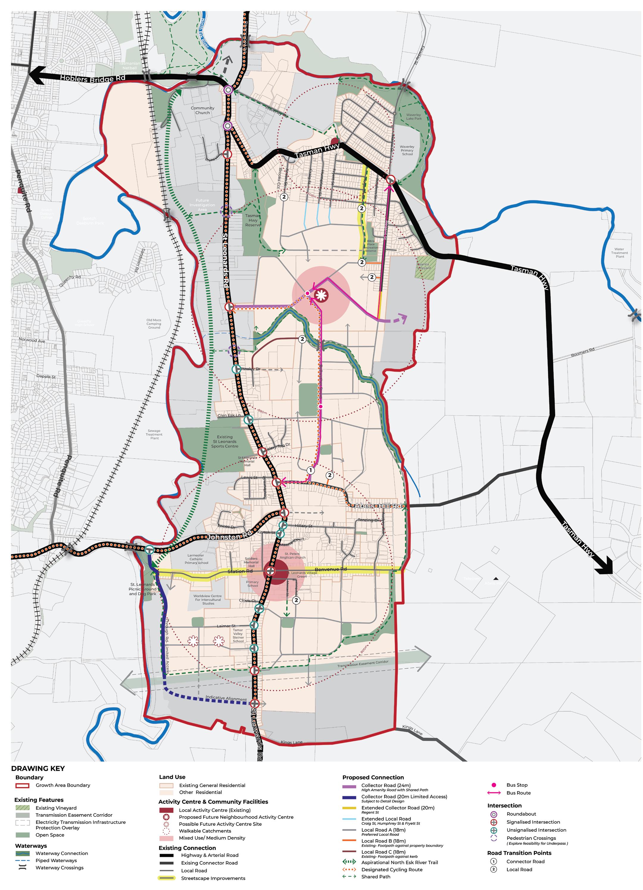


Develop a primary collector road network (Figure 13) that supports all transport modes linking people to amenities and services, including:
A high-amenity north-south spine road forming a multi-modal link connecting to open space and the proposed Activity Centre. This is Collector Road (24m) and will transition from the already approved design at Abels Hill Road (Appendix 1).
Extension of the existing Collector Road (20m) cross section for Regent Street to ensure a continuous and seamless movement network.
Investigation of a limited access Collector Road (20m) to provide an alternative access to Johnston Street (Appendix 1), to facilitate a more pedestrian friendly movement network within the St Leonards Village Centre.
A collector road network that encourages connection too and vistas towards open space areas, activity centres and waterways to create high amenity neighbourhoods that are anchored by areas of interest.
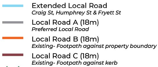
Develop local roads (Figure 13) that support the higher order network with logical, safe and connected streets within neighbourhoods, including:
Delivery of the local road network identified on Figure 13, which often reflect or are a continuation of roads that are approved within existing sub-division plans. Where local road cross sections have been approved, the Neighbourhood Plan seeks to extend the approved cross section or in some instances transition the approved cross section to a higher amenity outcome (Appendix 1).
For the balance of the local road network, ensure subdivision applications provide a permeable street network of local streets, each less than 200m in length, consistent with the preferred local road cross section (Local Road A in Appendix 1).
Promote walking and cycling by creating a connected network of paths and bicycle lanes (Figure 3) linking to activity area, open spaces and community uses, including:
Delivery of shared path connections as part of the Collector Road network consistent with Appendix 1.
Encouraging shared path connections in new local roads where it will complete the overarching network on Figure 13.
Enhancing safety and amenity for pedestrians on key roads such as St Leonards Road, Benvenue Road / Station Road and Hogarth Street.
Providing shared paths along linear open space, including investigation of a shared path connection along the North Esk River linking the growth corridor to the existing Hoblers Bridge Trail to provide a connection to the Launceston CBD.
Delivery of the proposed shared link between the Tasman Highway to Waverley Road to provide a safe and direct pedestrian connection through to Hoblers Bridge Road from Waverley.


Enhance the public transport network by expanding the bus routes to serve the growth corridor and connect key activity hubs (see Figure 13 for bus-capable roads).
Protect and enhance existing waterways, as high-amenity, multi-functional linear open space corridors that become the focus for connectivity and active transport, this includes protecting the central waterway as a key connection between the proposed activity centre and open space walkable catchments (see Appendix 1, Cross Section 6).
Progress important strategic road connections that will support growth in the corridor and across the broader region, such as the new link road project (Hoblers Bridge Road to Henry Street) and upgrades required to the overarching Department of State Growth road network.
A summary of the Council and proponent actions are detailed below. Refer to the Implementation section for a detailed overview of the Actions and associated sub-tasks, responsibilities and timing.
CATALYST PROJECT 2
Prepare streetscape Master Plans for the constructed sections of Station Road / Benvenue Road and Hogarth Street which identify opportunities for footpath widening, street furniture and tree planting opportunities consistent with the aspirations of the City of Launceston Urban Greening Strategy 2023 – 2040.
A15 Investigate delivery of the Hoblers Bridge Road to Henry Street link road.
A16 Work with the Department of State Growth to prepare a streetscape Master Plan for St Leonards Road.
A17 Prepare streetscape Master Plans for the constructed sections of Station Road / Benvenue Road and Hogarth Street.
A18 Allocate funding through Council’s Capital Works Program or advocate for grant funding for the implementation of the streetscape master plans for St Leonards Road, Station Road / Benvenue Road and Hogarth Street.
A19 Advocate to the Department of State Growth for network upgrades consistent with the projects identified in the Implementation chapter.
A20 Advocate to the Department of State Growth for improved bus services.
A21 Investigate the feasibility of a North Esk River Trail to connect from the existing St Leonards Picnic Ground and Dog Run to the to the existing Hoblers Bridge trail that links into the Launceston CBD.
A22 Prepare a detailed design for a new shared path connection from Tasman Highway to Hoblers Bridge Road. Allocate funding through Council’s Capital Works Program or advocate for grant funding for its construction.
A23 Deliver road cross sections consistent with Figure 13 and Appendix 1.
A24 Transition key local and collector roads as identified in Figure 13, consistent with the principles in Appendix 1.

Enhance the scale and retail and service offer of the St Leonards Neighbourhood/Town Centre (existing) as identified in Figure 14 and Table 2, consistent with the St Leonards Structure Plan – Retail and Community Infrastructure Needs Analysis, Geografia 2025.
POTENTIAL USES
Local Grocer
Supporting Retail
FLOOR SPACE ALLOCATION
1,500 sqm
1,500 sqm
Food & Beverage 2,000 sqm
Other uses with identified demand:
• General Practice
• Childcare
• Child Health and Parenting Services (CHaPS)


This to be determined by the market. These uses are to be distributed between St Leonards Village and new Neighbourhood Activity Centre.
TABLE 2. ST LEONARDS VILLAGE POTENTIAL USES AND FLOOR SPACE ALLOCATION
Support a new neighbourhood activity centre to service the northern portion of the growth corridor consistent with Table 3.
POTENTIAL USES
Local Grocer
Supporting Retail
Food & Beverage
Other uses with identified demand:
• General Practice
• Childcare
• Child Health and Parenting Services (CHaPS)

FLOOR SPACE ALLOCATION
850 sqm
2,000 sqm
2,500 sqm
This to be determined by the market. These uses are to be distributed between St Leonards Village and new Neighbourhood Activity Centre.
TABLE 3. NEW ACTIVITY CENTRE POTENTIAL USES AND FLOOR SPACE ALLOCATION
Enhance the existing Waverley Local Activity Centre by supporting uses that encourage activation of the centre, including retail, food and beverage services.
Understand, protect, and acknowledge Aboriginal heritage significance, including preserving significant Aboriginal heritage sites identified on Figure 14, as supported by the St Leonards Structure Plan Aboriginal Heritage Assessment, ACHMA 2024.


Recognise valued historic heritage and neighbourhood character though implementation of the recommendations from the Historical Heritage Assessment, ACHMA 2024 as follows:
Protect properties that are identified on the Tasmanian Heritage Register (Figure 14).
Retain historic landscape features as part of new development, including boundary hedges, stone fences, winding lanes, stands of exotic trees associated with historic homesteads to preserve the character of the area.
Support high-quality built form design outcomes that respond to the existing and emerging character of the growth corridor and sensitively responds to the planned density of development.
Deliver new open space that fills the gaps in the network for walkable neighbourhoods in line with the Draft City of Launceston Recreation and Open Space Strategy (Figure 14). Delivery of open space projects is discussed in the Implementation section.
Deliver a new sports and recreation facility that comprises an oval, small pavilion and a multi-purpose outdoor court consistent with the recommendations of the St Leonards Structure Plan – Retail and Community Infrastructure Needs Analysis, Geografia 2025.
Enhance and elevate the role of existing open spaces through delivery of the projects identified in Table 4, consistent with the Draft City of Launceston Recreation and Open Space Strategy.
EXISTING OPEN SPACE AREA
CLASSIFICATION (AS PER DRAFT CITY OF LAUNCESTON RECREATION AND OPEN SPACE STRATEGY)
Bibra Place Recreation Reserve Uplift to Neighbourhood Park
Waverley Lake Park
St Leonards Picnic Ground and Dog Run
Neighbourhood Park
Neighbourhood Park
Tasman Highway Reserve Local Open space
DESCRIPTION
Deliver improved amenities which could include facilities such as public toilets, accessible play spaces, parking and a basketball court.
Deliver improved shared path connections.
Deliver improved path connections, play facilities, parking and river access.
Formalisation of open space through weed removal and delivery of path network and re-vegetation.
St Leonards Village Green Uplift to Neighbourhood Park Deliver improved recreation options which could include facilities such as public toilets, exercise equipment and climbing gym equipment.
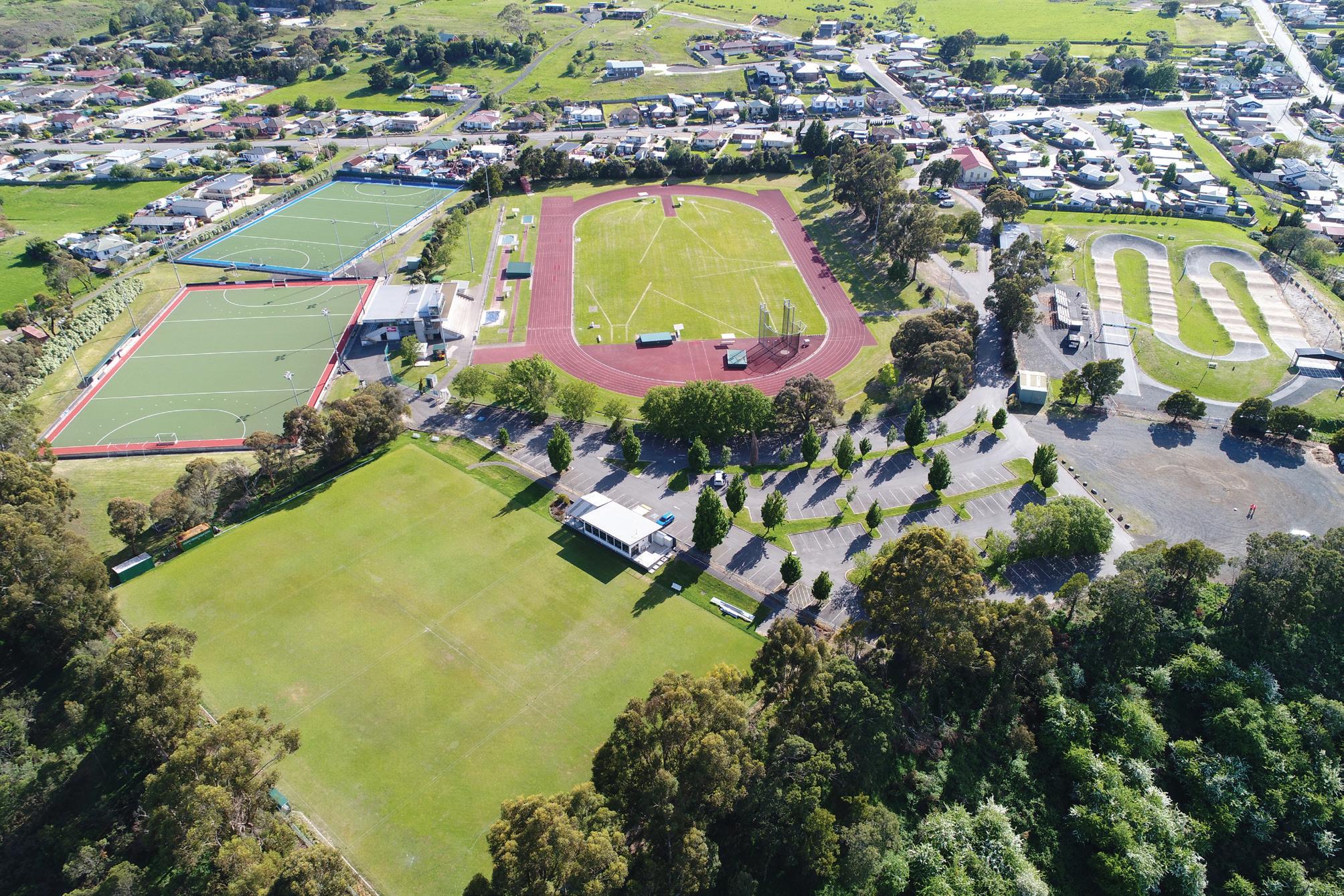
St Leonards Sport Centre Sports Facility


TABLE 4. PROJECTS TO ENHANCE EXISTING OPEN SPACES
Engage with lease holders to seek to achieve greater community access to current facilities. Identify opportunities for improved seating, shade, toilets and nature play.
Retain existing waterway corridors and focus on replanting projects to support habitat and contribute to neighbourhood character, including delivery of the Central Waterway corridor (see Appendix 1, Cross Section 6 for a supported cross section).
Provide community infrastructure that meets the future needs of the growth area, consistent with the recommendations of the St Leonards Structure Plan – Retail and Community Infrastructure Needs Analysis, Geografia 2025 (Table 5).
COMMUNITY
INFRASTRUCTURE LOCATION DESCRIPTION
Soldiers Memorial Hall upgrades 14 Station Road, St Leonards
New Waverley Community Centre
To be defined
TABLE 5. PROPOSED COMMUNITY INFRASTRUCTURE PROJECTS

Upgrades to the existing Soldiers Memorial Hall in the form of refurbishment to the existing amenities and kitchen facilities, improved storage space to enhance this facility for broader community use.
Define a location for a new local community centre within Waverley to include general purpose meeting spaces, a small commercial kitchen and amenities.
Protect areas of vegetation and existing tree patches within road reserves, open space areas and private properties that contribute to the character of the corridor (Figure 14).


Improve the delivery of tree canopy and landscaping outcomes as part of the development approvals process.
Protect and enhance view lines (see A to F) to mountain ranges and destinations within the growth area through careful subdivision design and road alignments (Figure 14).
Improve the entrance to the growth corridor by enhancing the Tasman Highway Reserve as a gateway open space (Figure 14).
Investigate the long term need for a potential future secondary school as shown on Figure 14.
Enhance the north south spine road (marked as B on Figure 14) as a high amenity connection for vehicle and active transport as supported by Strategic Direction 2.
Note: St Leonards Village Improvements under Action A25 on the following page.
A summary of the Council and proponent actions are detailed below. Refer to the Implementation section for a detailed overview of the Actions and associated sub-tasks, responsibilities and timing.
CATALYST PROJECT 3
Prepare a landscape Master Plan for the Waverley Lake Park that identifies opportunities for improved shared path connections, consistent with the Draft City of Launceston Recreation and Open Space Strategy.
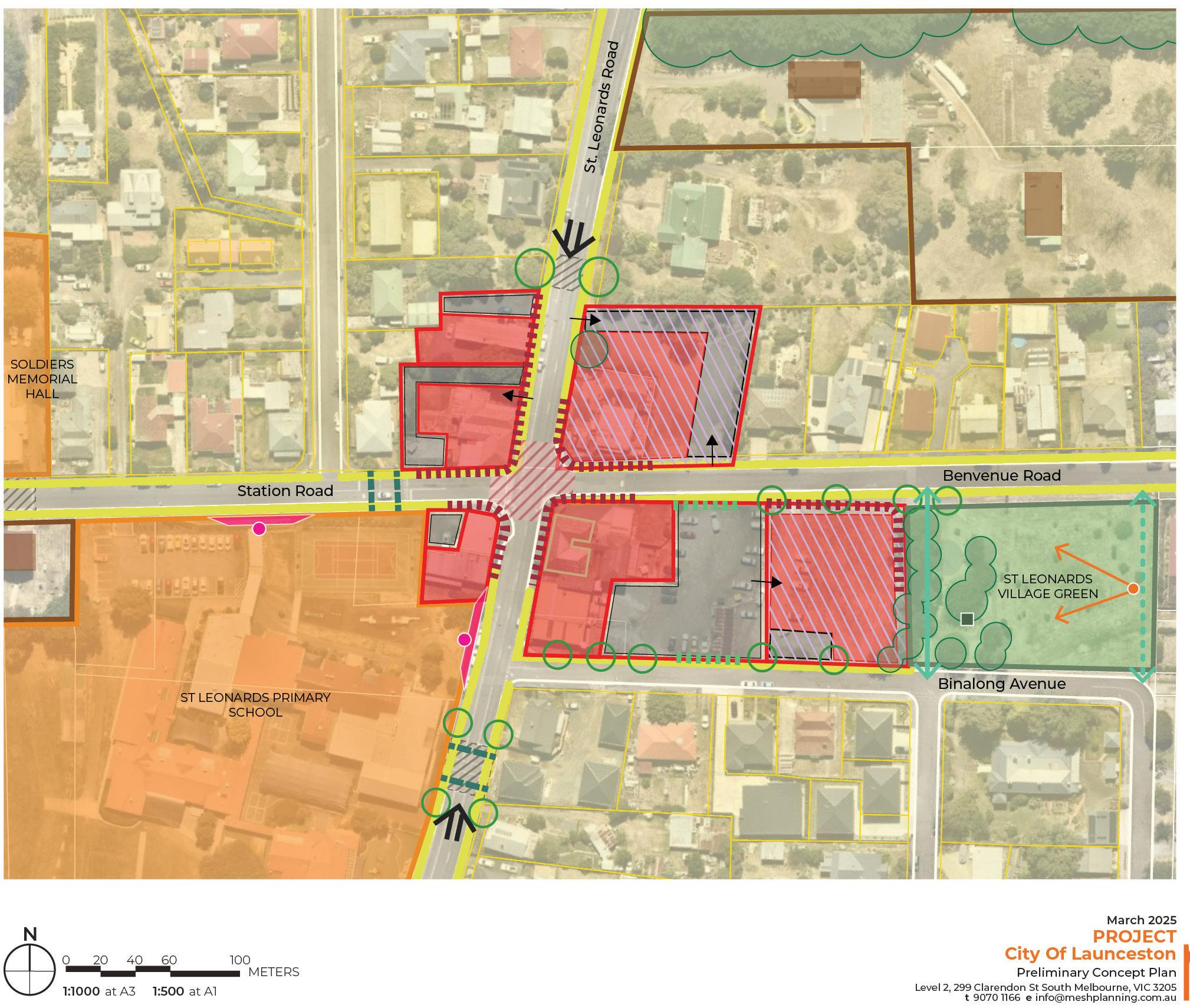
A25 Prepare a master plan for the St Leonards Village (label B, on Figure 14) that examines the development opportunities shown on Figure 15.
A26 Implement the recommendations of the Historical Heritage Assessment, ACHMA 2025.
A27 Prepare a Landscape Master Plan for the Tasman Highway Reserve.
A28 Prepare Landscape Master Plans for the existing open space projects identified in Table 4, the proposed sport and recreation facility and the new open space areas identified on Figure 14.
A29 Prepare a detailed design for the upgrade to the Soldiers Memorial Hall (as per Table 5).
A30 Investigate delivery of a new small community facility in Waverley as per Table 5.
A31 Prepare Landscape Design Guidelines that are used by Council to assess landscape master plans prepared by proponents.
A32 Prior to rezoning, engage with the Department of Education, Children and Young People (DECYP) to confirm the need for a secondary school site (Figure 14). If no commitment can be made by DECYP to secure the land, the land will revert to the underlying future land use (residential).
A33 Work with the Department of Health to identify suitable locations for the delivery of Child Health and Parenting Services (CHaPS). Consider locations within existing or proposed activity centres as well as the potential to use proposed community infrastructure for these services.
A34 Develop Landscape Master Plans that consider the proposed high amenity waterway corridor consistent with Appendix 1, Cross Section 6. The landscape master plans should identify opportunities for re-vegetation of the corridor and provision of a shared path connection for a high amenity public open space.
Putting a Neighbourhood Plan into action involves a range of implementation steps (Figure 16). This chapter describes those steps, when they should be taken and who is responsible for leading the change.
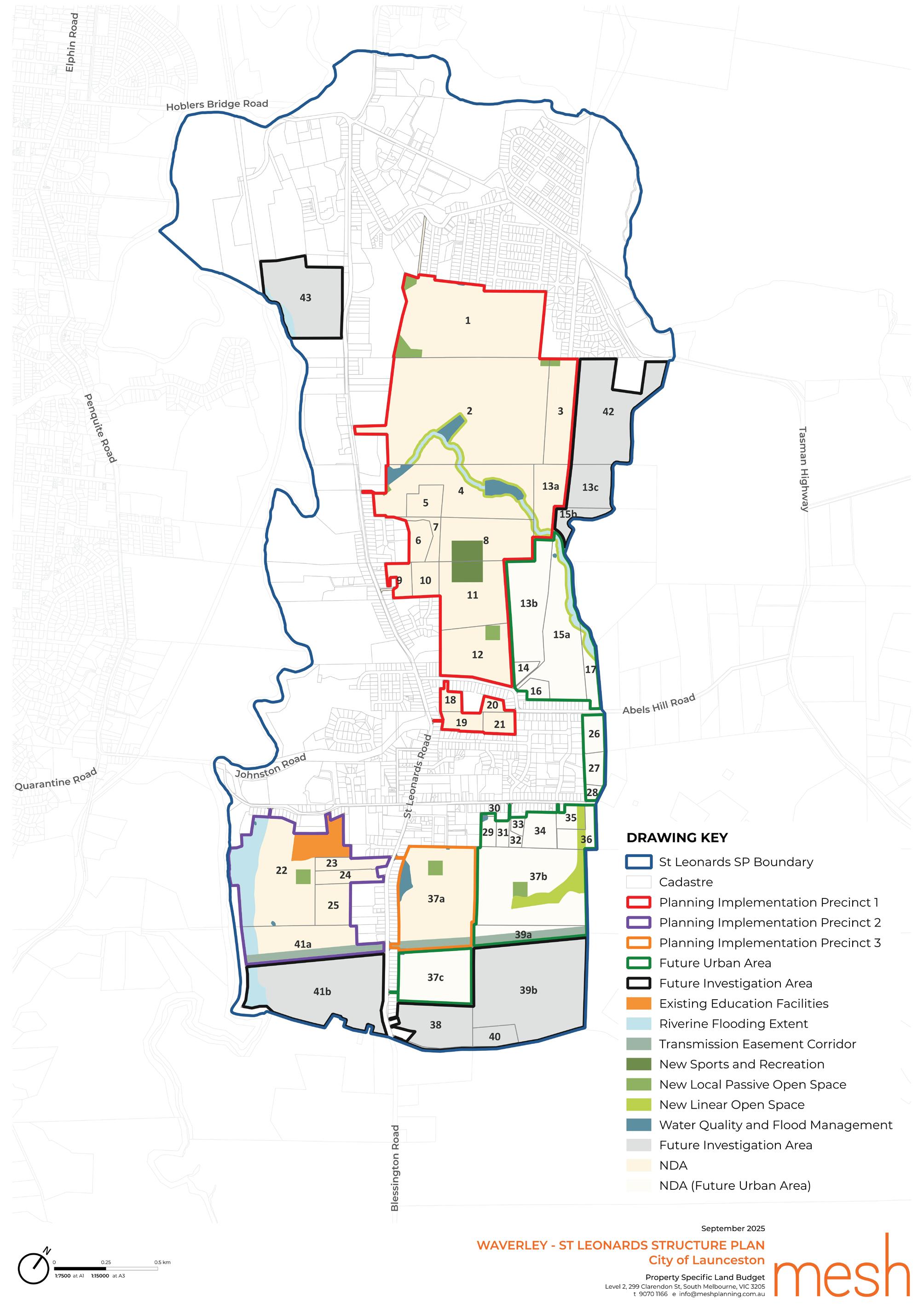
Firstly, there are statutory implementation steps to ensure the Launceston Local Provisions Schedule of the Tasmanian Planning Scheme is updated to reflect the strategies and plans contained within the document. This includes rezoning and preparing more detail statutory planning guidance for specific areas. This is critical for setting the planning framework for future development applications. The approach to rezoning will inform sequencing of future development, which is proposed to occur in three stages:
- First priority, identified in the Neighbourhood Plan as Priority Rezoning areas.
- Second priority, identified as Future Urban Zone area.
- Third priority, identified as Future Investigation Areas.
Infrastructure delivery is a critical yet complex area of implementation. The Infrastructure Funding Framework (IFF) sets out the higher order shared infrastructure projects and the approach to how these will be funded and delivered, to unlock the staged delivery of the growth area. The IFF is addressed in the next chapter of this document.
Lastly, there are general actions that may involve further investigations or advocacy efforts to support the long-term vision for the area. These actions might include advocacy, more detailed planning and design processes, environmental assessments, or partnerships with various stakeholders to achieve broader goals. Some actions are required to occur to inform statutory implementation.
Actions
Further work to achieve the Vision & Strategic Directions
Proponent Led Actions
Actions led by proponents to inform statutory implementation / Development Applications
Council + Agency Led Actions
Further work from Agencies and Council
Statutory Implementation
Planning Scheme Amendments for rezoning or new Specific Area Plans (Council or proponent led).
Development Applications
Subdivision Applications in response to Zoning and SAP provisions
Statutory implementation involves amending the Launceston Local Provisions Schedule of the Tasmanian Planning Scheme, so future development applications are submitted consistent with the Neighbourhood Plan. Statutory implementation is in the form of planning scheme amendments for rezoning or new Specific Area Plans (SAPs).
The Neighbourhood Plan sets out a proposed sequencing approach facilitated by the application of zones and Specific Area Plans (SAPs).
The approach to sequencing is based on meeting the following objectives:
• To ensure a priority 15 year land supply pipeline, followed by a second stage of land release for the longer term. The release of at least 15 year land supply is a key objective of the draft Tasmanian Planning Policies.
• To deliver diverse housing product and to safeguard housing release. This is consistent with the City of Launceston Housing Plan 2025-2040, which identifies the St Leonards and Waverley corridor as a critical contributor to the City’s housing supply needs.
In order to achieve these objectives, the following land use zoning sequencing is proposed:
Priority rezonings are considered the first priority.
Three areas are identified for priority rezoning (Figure 17) based on the following principles:
• Facilitate development adjacent to existing zoned land to achieve orderly and connected development outcomes.
• Deliver new housing within walkable catchments of existing or proposed Activity Centres.
• Prioritise parcels with active developers who are committed to bringing forward housing and associated infrastructure in the short term.
• Prioritise delivery of the core connected movement network (in particular the key north south spine road, to alleviate pressure on St Leonards Road).
• Identify development in missing gap areas to deliver complete neighbourhoods.
• Prioritise areas that form an extension of a substantially zoned or developed area.
• Deliver at least 15 years land supply.
The three priority rezoning areas meet the principles above and are all included for the following reasons:
• Proceeding with multiple development fronts provides certainty to achieve the 15 year land supply, safeguards housing release and provides a diversity of product to the market.
• Each area has a strategic implementation approach:
- The northern area between Tasman Highway and Abels Hill Road includes a number of land parcels in different ownership, so the Planning Scheme Amendment is a strategic opportunity for the Council to lead.
- The southern priority rezoning to the east of St Leonards Road is in consolidated land ownership with an active developer. This is a proposed proponent let rezoning.
- The priority rezoning area to the west of St Leonards Road could either be a Council priority, or a proponent led rezoning. If Council led, it will occur once the northern priority area rezoning is complete. As identified on Figure 17, there are also areas that are already zoned for residential development but are yet to be subdivided. These are also considered priority areas.
Future Urban Zone land is considered the second priority. Areas proposed to be zoned Future Urban Zone are considered suitable for urban development, however are secondary to deliver on the principles identified above.
Land will be re-zoned Future Urban Zone by Council as part of the implementation of the Neighbourhood Plan. The land will transition from Future Urban Zone to a residential land zoning once the majority of the land in the priority area has developed. The timing of this rezoning will be reviewed as part of the ongoing Monitoring and Review of the document. It’s noted that the existing zoned land, and priority rezoning areas are expected to provide the required 15 year land supply. The Future Urban land will be a second stage of land release.
Investigation Areas are the third priority, however are subject to further work to confirm their developability.
The Investigation Areas require further work to confirm they are suitable for development. These areas are expected to be released beyond the 30-year timeframe and are subject to further work as identified in Strategic Direction 1. The timing of release of the Investigation Areas will be reviewed as part of the Monitoring and Review of the document.
The Future Investigation Area in the north between existing industrial zoned land is not prioritised on Figure 17, as this area is to be investigated for light industrial uses so its timing will be dependant on demonstrating the need for this form of development (see Strategic Direction 1).


Specific Area Plan’s (SAPs) will be used as the mechanism to provide guidance on areas where a unique development outcome is being sought. SAPs are proposed to implement the Neighbourhood Plan to give it statutory effect, so the plan’s directions are responded to as part of future development applications.
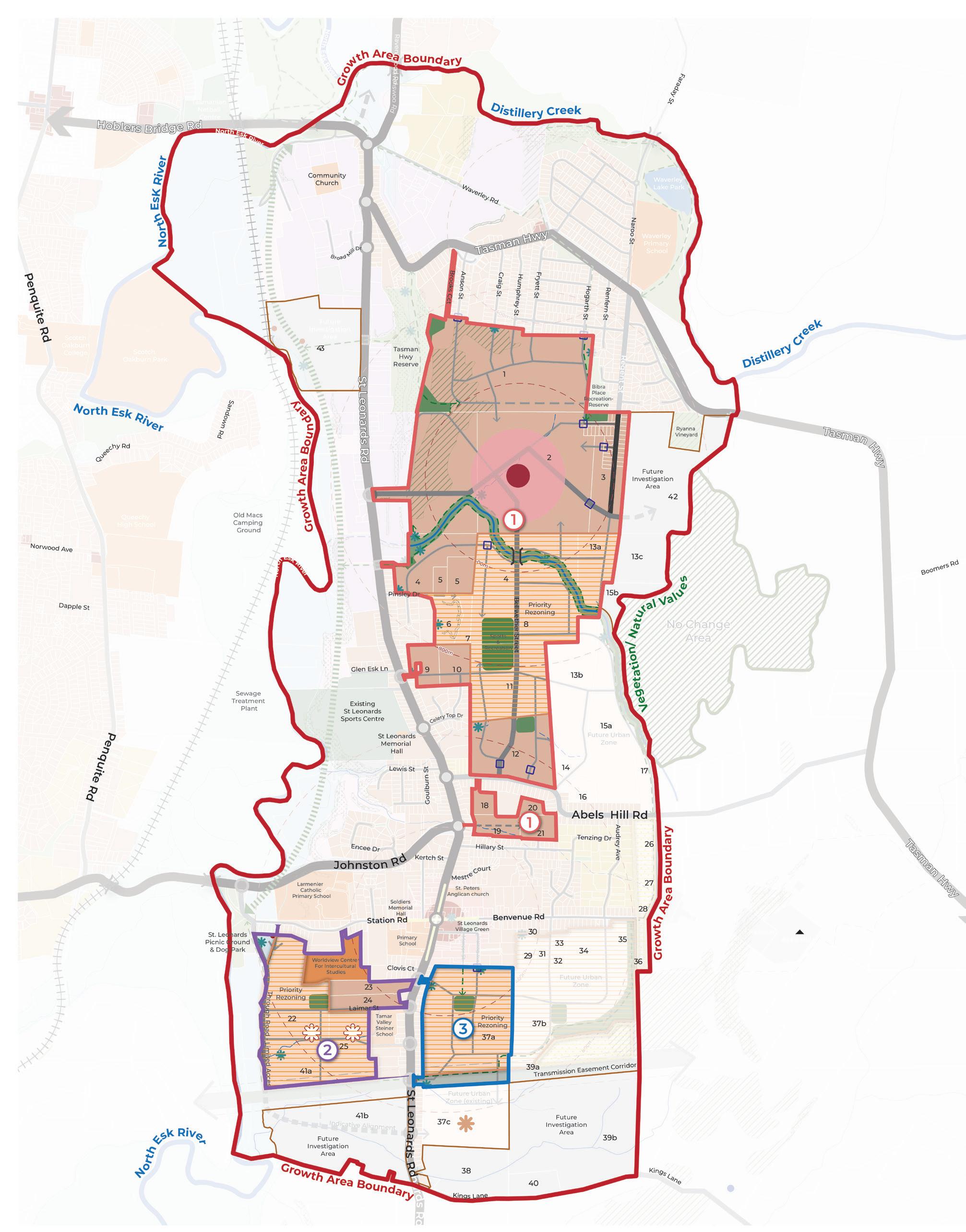
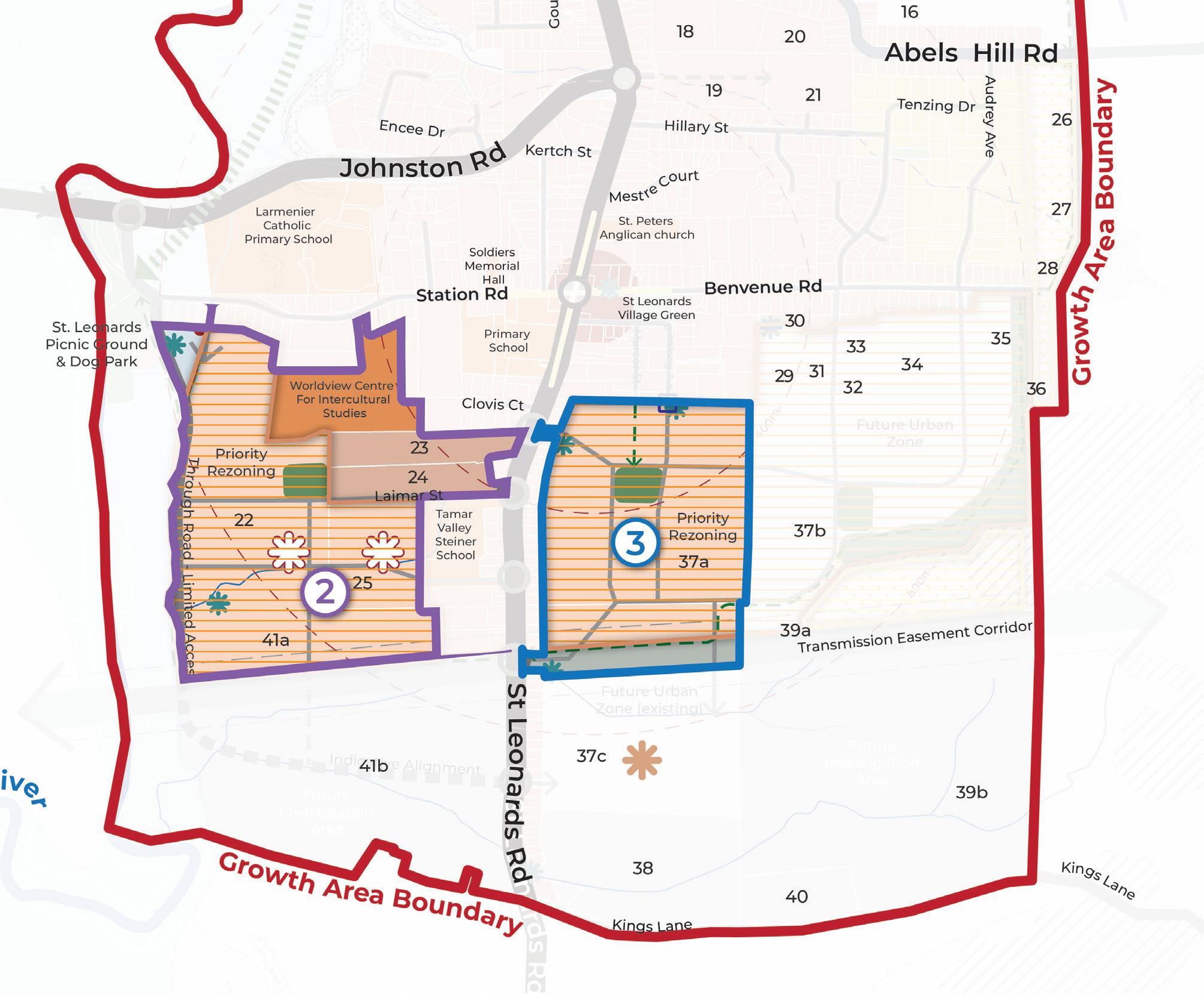
The boundaries to which the SAPs will apply generally align with the sequencing approach as discussed above and are referred to as Planning Implementation Precincts (Figure 18). The Planning Implementation Precincts are also relevant to the Infrastructure Funding Framework. The SAP control will be applied to the Planning Implementation Precinct at the time of rezoning (discussed below). Planning Implementation Precincts 1 and 2 include land that’s already zoned for residential purposes, but is not yet developed. The SAP control will also apply to this land.
It is proposed that the two existing SAPs that apply within the growth corridor are removed at the time that new SAPs are introduced.
The existing SAPs are:
• LAU-S4.0 – Hillary Street Specific Area Plan
• LAU-S12.0 – Development Potential Specific Area Plan
The drafting of the SAPs should include the following general guidance:
• Requirement to develop and use land consistent with the Neighbourhood Plan (Figure 7).
• A provision to ensure any short term planning, building or subdivision approvals do not preclude delivery of the Neighbourhood Plan outcomes in the long term.
Specific consideration should be given to inclusion of the following, more detailed, guidance in each SAP.
At a minimum, the purpose section of each SAP should include:
• Reference to implementing land use and development consistent with the Neighbourhood Plan.
• Reference to the IFF and requirements for funding and delivery of infrastructure.
• The SAP should apply in accordance with the Planning Implementation Precincts in Figure 18, at the time of rezoning as discussed in the next section of the Neighbourhood Plan.
• The Neighbourhood Plan (Figure 7) and any relevant master plans (consistent with the Actions in this document) should be included as Figures within the SAP.
At a minimum, the purpose section of each SAP should include:
• Local Area Objectives should implement the Strategic Directions of the Neighbourhood Plan and reference the relevant strategies for each Planning Implementation Precinct.
• The key strategies to highlight as Local Area Objectives include:
- Aspirations for diverse housing within 200m walkable catchment of the two Activity Centres (Neighbourhood/Town Centres).
- Provision for road cross sections consistent with the Neighbourhood Plan.
- Aspirations to retain vegetation on site where possible.
- Delivery of sport and recreation and community infrastructure.
- Protection of cultural heritage values.
- Protection of historic heritage values.
A SAP can modify, substitute or add to the State Planning Provision (SPP) based on the underlying zone to which the SAP applies. This needs to be clearly identified within the SAP under the relevant headings:
• Use table.
• Use standards.
• Development standards for building and works.
• Development standards for subdivision.
At the time of preparing the SAP for each Planning Implementation Precinct, the relevant provisions should be reviewed to determine if any modifications or substitutions are required in order to implement the Neighbourhood Plan. It is likely that the majority of standards will be “in addition” to the standards of a Zone or Code.
18. PLANNING IMPLEMENTATION PRECINCTS
Rezoning is required to translate non-urban zones into urban zones consistent with the Neighbourhood Plan. The proposed approach to zone changes are set out in the following sections of the document to implement the sequencing identified above. While the Neighbourhood Plan has been informed by high level technical investigations (as identified in the Preparing the Neighbourhood Plan section), any planning scheme amendment or development application will need to be accompanied by the necessary technical assessments as required by the Land Use Planning and Approvals Act 1993 and the Tasmanian Planning Scheme - Launceston (such as land contamination, landslip hazard etc).
Zoning Acronyms
AZ Agriculture Zone
CPZ Community Purpose Zone
FUZ Future Urban Zone
LCZ Landscape Conservation Zone
LBZ Local Business Zone
GRZ General Residential Zone
RLZ Rural Living Zone
RZ Rural Zone
A number of Code Overlays apply across the Neighbourhood Plan area including:
• Local Historic Heritage Code.
• Natural Assets Code.
• Scenic Protection Code.
• Flood-Prone Areas Code.
• Bushfire-Prone Areas Code.
• Potentially Contaminated Land Code.
• Landslip Hazard Code.
• Waterway and Coastal Protection Code.
There is an opportunity to review the code mapping as a result of the technical findings and directions of the Neighbourhood Plan. Particularly with respect to Action 27 in relation to Historic Heritage and the findings of the Natural Values Assessment.

Statutory Implementation of Planning Implementation Precinct 1 (Figure 19) will be led by Council and will occur as soon as practicable upon finalisation of the Neighbourhood Plan.
Implementation Precinct 1 includes some land that’s already zoned GRZ, which is considered appropriate. However, with respect to Property 2 some LBZ and IRZ is proposed to also be introduced. Property 2 includes the proposed activity centre, which anticipates uses that aren’t permissible under the GRZ. Therefore, as identified by Action 14, a master planning process is recommended to occur to refine the extent and location of the activity centre site to inform application of the LBZ. This master plan will also identify opportunities for diverse housing (in the form of town house and potentially low rise apartments). It is recommended the IRZ be applied to facilitate this form of housing consistent with the master plan.
A SAP will be applied to the entirety of Planning Implementation Precinct 1, at the time of rezoning the parcels identified in Table 6.
to be confirmed)
& Proponent (for the master plan) SAP & Section 71 Agreement (see IFF Section of document) + Master Plan to define extent of IRZ and LBZ (see Action 14)
& Section 71 Agreement (see IFF section of document)
Section 71 Agreement (see IFF section of document)

Planning Implementation Precincts 2 and 3 are also considered priorities and will also proceed as soon as practicable upon finalisation of the Neighbourhood Plan.
Planning Implementation Precinct 2 will be a Council or Proponent led process. If Council led, it will commence following the completion of the amendment to implement Planning Implementation Precinct 1. The proponent for Planning Implementation Precinct 3 will be responsible for progressing a rezoning request for their land, and potentially preparation of a SAP (if agreed by Council).
PROPERTY & EXISTING ZONE PROPOSED ZONE
Planning Precinct 2
41a – AZ GRZ
22 – RZ
25 – RZ GRZ Potential for LBZ and IRZ to be applied to property 22 or 25.
RESPONSIBILITY
Council or proponent
Council or proponent
Planning Precinct 3
37a – FUZ GRZ and IRZ Proponent
• Preparation of a SAP (to be prepared by Council).
• Section 71 Agreement (see IFF section of document).
• Investigations into demand for a limited line supermarket and associated retail.
• If retail required, completion of a master plan to confirm extent of activity centre site and application of the LBZ.
• Preparation of a SAP (to be prepared by Council).
• Section 71 Agreement (see IFF section of document).
• If the activity centre is required, the master plan should identify appropriate locations for diverse housing to inform application of the IRZ.
• Section 71 Agreement (see IFF section of document).
• Preparation of a SAP to be prepared by Council. Proponent prepared SAP may be considered, but must be prepared to the Councils satisfaction.
• Extent of IRZ to be confirmed, but within approximately 200m of St Leonards Neighbourhood/Town Centre.

The St Leonards and Waverley Infrastructure Funding Framework (IFF) has been prepared to guide the delivery of shared, higher order, infrastructure to service the proposed development across the growth corridor. The IFF:
• Identifies the shared infrastructure required to support the development of the St Leonards and Waverley growth corridor;
• Determines the scope, cost, justification and apportionment of the shared corridor infrastructure;
• Specifies the infrastructure charges payable for the shared infrastructure and the requirement to directly deliver specific infrastructure; and
• Describes how this IFF is to be administered and implemented.
This IFF will be implemented via a Specific Area Plan (SAP), with each landowner contributing to shared infrastructure projects required to enter into an agreement under Section 71 of the Land Use Planning and Approvals Act 1993 (LUPAA) with the Launceston City Council.
The IFF has been informed by the land use and development directions identified in the Neighbourhood Plan. Tasmania does not currently have legislation that gives legal effect to a formal infrastructure contributions system, however this IFF has been prepared with regard to the following principles commonly used in infrastructure planning in other states, which are considered to be relevant and appropriate for this project:
NEED clearly establishing the need for the infrastructure
NEXUS identifying and describing the nexus between the number and type of projects included in the IFF and the land it services
SIMPLICITY simplifying the number and type of projects included in the IFF
EQUITY maintaining a fair and equitable distribution of funding obligations
TRANSPARENCY clearly articulating the justification for the infrastructure and calculation of charges
ACCOUNTABILITY ensuring that the IFF obligations are implemented by focusing on development coordination and monitoring and reporting on these obligations.
The following documents were prepared to support the Neighbourhood Plan and preparation of the IFF:
• St Leonards Neighbourhood Plan, Integrated Transport Assessment, 2025, pitt&sherry
• St Leonards Structure Plan, Stormwater - Stage 2 Report, 2025, pitt&sherry
• St Leonards Stormwater Management, FMO1 Concept/Investigation Report, 2025, pitt&sherry
• St Leonards Neighbourhood Plan, Retail and Community Infrastructure Needs Analysis, 2025, Geografia
• Sport and Recreation Project and Community Infrastructure Project Costs, 2025, Prowse
• Valuation Report LG25/1832 – Infrastructure Funding Framework for St Leonards & Waverley Neighbourhood Plan, 2025, LG Valuation Services.
The IFF applies to the Planning Implementation Precincts identified in Figure 18, consistent with the implementation guidance provided in the Neighbourhood Plan. Planning Implementation Precincts 1 and 2 include land that’s proposed for rezoning, and some existing zoned land. The existing zoned land that has been included is zoned General Residential Zone and is considered to have development potential.
Each Planning Implementation Precinct has some larger consolidated land ownership, Planning Implementation Precinct 3 is owned by a single land owner.
The Neighbourhood Plan includes areas to be zoned as Future Urban Zone (FUZ), as these areas are considered longer term growth options (i.e. potentially beyond 15 years) these are excluded from this IFF with apportionment for these items directed to Council. Council will seek to re-coup these funds when the Future Urban Zone areas develop (See Shared Infrastructure Section below).
The Neighbourhood Plan also includes Investigation Areas that are longer term, potential growth areas that will be subject to further investigations to confirm the suitability of these areas for urban development. Due to the need to confirm the developability of these areas in the future, they have been excluded from the IFF.
Table 8 provides a summary land budget for all parcels within the IFF study area, and has been calculated based on the St Leonards and Waverley Neighbourhood Plan in Figure 21. See Appendix 2 for a complete, detailed property specific land budget.
Contributions towards shared infrastructure will be distributed according to the net developable area (NDA) of the parcel.
For the purpose of this IFF, NDA is defined as land within the development area boundaries that is made available for development including all collector roads and local streets.
The Neighbourhood Plan and IFF calculates NDA as the total growth area, minus land that’s already developed, local parks, sport and recreation infrastructure, drainage, easements and road/servicing reserves. Any additional land set aside for non-developable purposes at the time of subdivision is included in the NDA.
The amount of NDA for each site will not be amended without the consent of the Council.
The infrastructure projects for St Leonards and Waverley are identified in Figure 22. The context surrounding proposed infrastructure projects is identified below.
The transport context for the growth area is as follows:
• Road and intersection design approved as part of recent subdivisions have generally been designed to meet the needs of individual applications, rather than the growth corridor more broadly.
• There are existing capacity constraints on the surrounding road network, in particular the Hoblers Bridge Road / David Street intersection. This is the main intersection used by vehicles travelling from St Leonards and Waverley into the Launceston CBD. Council is investigating a new road link to provide an alternative access route, referred to as the Henry to Hoblers connection.
• St Leonards Road, Tasman Highway and Johnston Road are State Roads that benefit and provide access to the growth corridor. The majority of traffic generated from the growth area will access these roads. This traffic will mostly travel north and for this reason, upgrades to existing intersections and new signalised intersections along St Leonards Road are required.
• There are limited opportunities for new access points off St Leonards Road into the growth corridor due to the existing development footprint, with several constructed buildings along St Leonards Road.
• There are a number of existing destinations along St Leonards Road that have existing access points (i.e. existing industrial development and the St Leonards Sport Centre).
• The bus network will need to be extended to service the proposed growth of St Leonards and Waverley.
• The St Leonards Neighbourhood Plan Integrated Transport Assessment, 2025, pitt&sherry identifies the transport related projects required to support development in the corridor.
The drainage context for the growth area is as follows:
• Stormwater management infrastructure approved as part of recent subdivisions has generally been designed to meet the needs of individual applications, rather than a catchment wide solution to managing stormwater.
• Stormwater utilises a number of pipes under St Leonards Road to outfall to the North Esk River. There are some existing capacity and functionality constraints with this pipe infrastructure.
• Catchments have been identified within the proposed new development areas, however don’t align with property boundaries meaning a shared funding approach for some infrastructure items is required.
• The St Leonards Neighbourhood Plan Stormwater Management Strategy, 2025, pitt&sherry identifies stormwater management solutions for each identified catchment within the growth corridor.
The sport & recreation, open space and shared path context for the growth area is as follows:
• Council is currently finalising a new open space plan for the municipality, the Draft Recreation and Open Space Strategy (ROSS).
• There are a number of existing local parks within the growth area, the ROSS anticipates upgrades to a number of these to be delivered by Council.
• The St Leonards Sport Centre is also located within the growth area. This Sport Centre is currently leased and therefore use of the facility is restricted for general community use. The ROSS will investigate ways for community to better access the facility and explore improved public amenity within the Sport Centre.
• There is currently an under provision of both passive and active open space at a suburb level for St Leonards and Waverley.
• The St Leonards Neighbourhood Plan Retail and Community Infrastructure Needs Analysis, 2025, Geografia identifies the demand for open space and sport and recreation infrastructure that’s generated as a result of new development in the corridor. Cost sheets for the delivery of this infrastructure have been prepared by Prowse, 2025.
• An aspirational shared path has been discussed for a number of years along the North Esk River. This would extend the existing North Esk trail, between the CBD and Hoblers Bridge Road in Newstead, a further 3.5km to Johnston Road in St Leonards.
The community infrastructure context for the growth area is as follows:
• There are existing community facilities within the growth corridor, these are mainly clustered around St Leonards and include a number of schools and the Soldiers Memorial Community Hall. The existing hall requires upgrades to enable broader community use (i.e. improved kitchen and amenities).
• Waverley currently has limited community infrastructure, the school is the only existing facility.
• The St Leonards Neighbourhood Plan Retail and Community Infrastructure Needs Analysis, 2025, Geografia identifies the demand for new community infrastructure that’s generated as a result of new development in the corridor. Cost sheets for the delivery of this infrastructure have been prepared by Prowse, 2025.
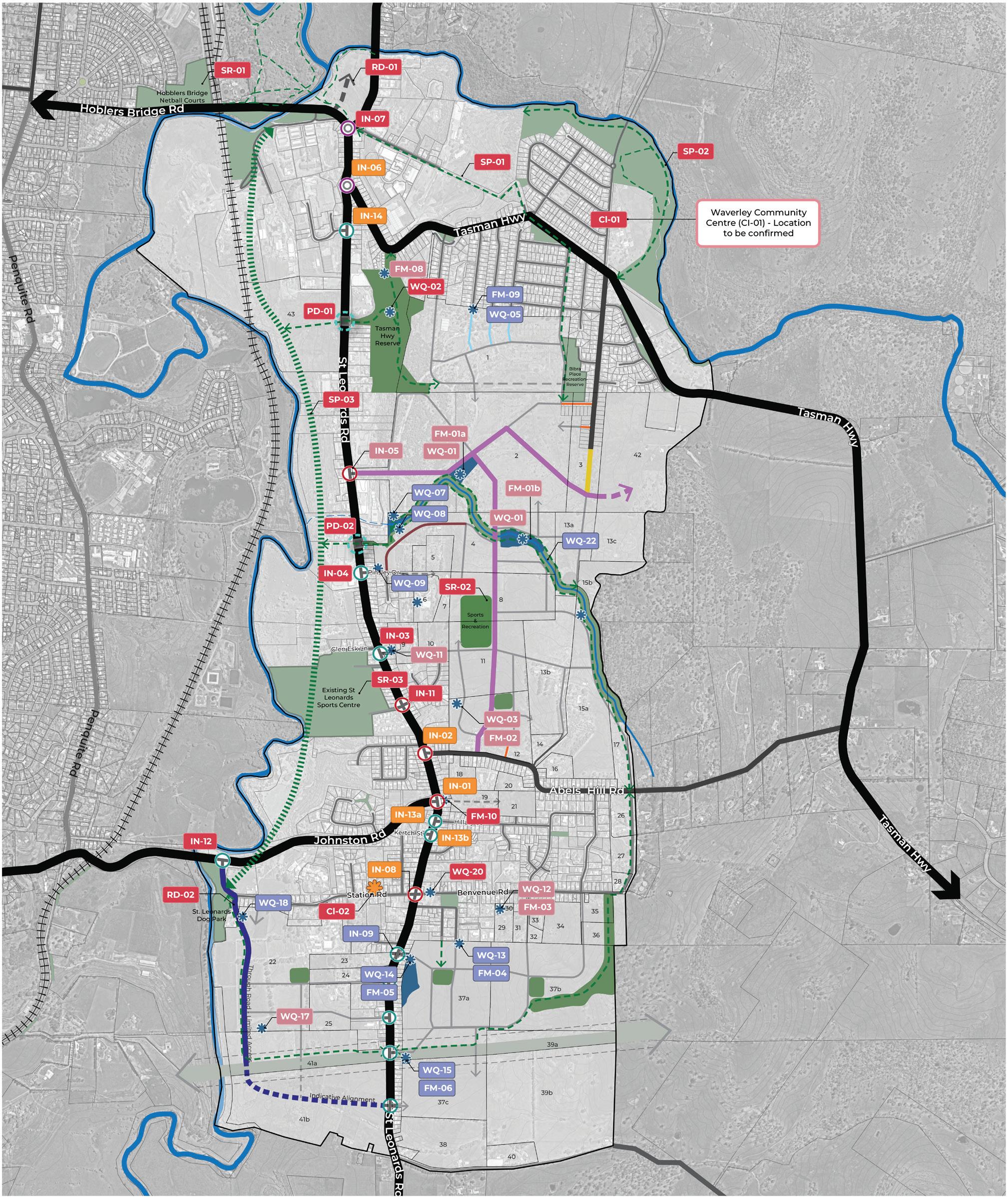
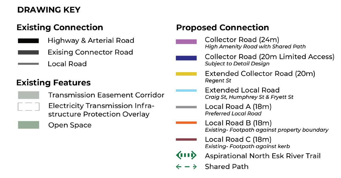
The approach to delivery and funding of infrastructure has been formed by the principles identified in the Strategic Basis Section.
This IFF is focused on defining the funding and delivery approach of shared higher order corridor infrastructure, this is infrastructure that is benefitting more than one parcel.
However, it’s important to note there is a significant amount of infrastructure that’s proposed to be directly delivered by both Council and State Government. This is infrastructure the growth corridor will benefit from but is not required to contribute to. There is also infrastructure that will be directly delivered by developers, where there is an individual developer benefitting from the project.
1. STATE GOVERNMENT PROJECTS
2. COUNCIL PROJECTS
3. DEVELOPER DIRECT DELIVERED
Shared Infrastructure
4. SHARED INFRASTRUCTURE PROJECTS.
Direct delivery projects will be directly funded and delivered by either the State Government, Council or a developer. Projects identified as being directly delivered by a developer are projects that an individual developer is benefitting from, and therefore shared funding arrangements are not required.
The costs provided in each of the sections below are estimates and will be confirmed through detailed design processes. The costs identified are for construction only (i.e. don’t include land acquisition if this is required).
The construction costs included in this Section are based on 24/25 dollars and indexed to 25/26 dollars.
Projects that are part of the State Government road network, and are therefore proposed to be delivered by the State, are identified in Table 9 and Figure 23. The timing of State projects will be dependent on ongoing monitoring of traffic volumes to confirm need. The construction cost is an estimate and will be confirmed through progressing detailed design of each project.
PROJECT DESCRIPTION
IN-01
IN-02
IN-06
IN-08
IN-13a
IN-13b
IN-14
St Leonards Road & Johnston Road Intersection
St Leonards Road & Johnston Road intersection upgrade to signals.
St Leonards Road & Abels Hill Road Intersection
St Leonards Road & Abels Hill Road intersection upgrade to signals.
St Leonards Road & Tasman Highway Intersection
St Leonards Road & Tasman Highway capacity improvements. Staged approach possible, with initial capacity increase through provision of a second circulating lane within the roundabout.
St Leonards Road & Station Road Upgrade
St Leonards Road & Station Road upgrade to signals for performance and improve safety to school and within town centre. Council to progress Master Plan for Town Centre improvements and advocate to Department of State Growth for intersection improvement.
St Leonards Road & Hillary Street
Potentially down grade to left in left out based on traffic volumes.
St Leonards Road & Kertch Road
Potentially down grade to left in left out based on traffic volumes.
St Leonards Road & Board Mill Drive
Potential upgrade to signals based on observed traffic volumes.
COST (estimates based on Financial Year 25/26)
TIMING FOR DELIVERY
$8,999,747 Dependant on traffic network performance.
$5,999,832 Dependant on traffic network performance.
$6,472,421 Dependant on traffic network performance.
$3,698,526 Dependant on traffic network performance.
To be confirmed. Dependant on traffic network performance.
To be confirmed. Dependant on traffic network performance.
$3,698,526 Dependant on traffic network performance.
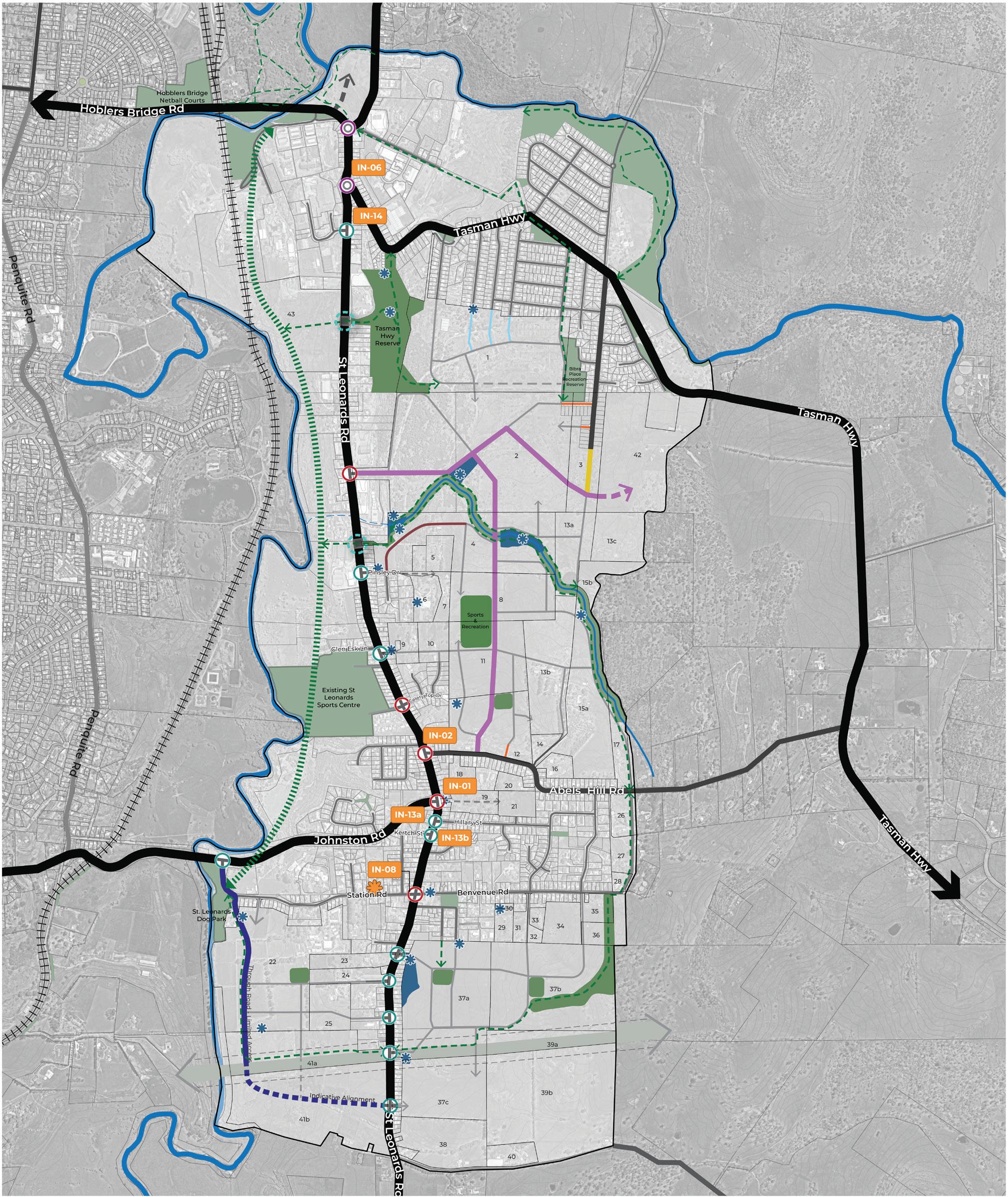
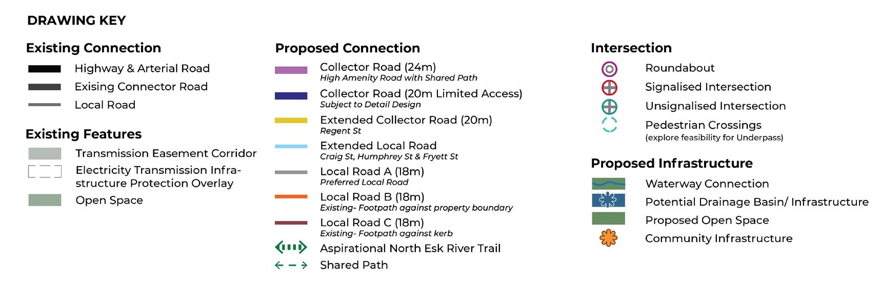
Projects that Council is responsible for are identified in Table 10 and on Figure 24. Council will allocate funding through its Capital Works Program (CWP) or seek grant funding to deliver the identified infrastructure.
The timing identified is indicative and is identified based on the findings from the supporting technical reports or based on the likely roll out of development. The costs provided are estimates and will be confirmed through a detailed design process.
Roads
RD-01
Hoblers Bridge Road to Henry Street
Hoblers Bridge Road to Henry Street Road project.
(seek grant funding)
RD-02
Collector Road Extension
Extension of new Collector Road to link into Station Road. Council to facilitate delivery of short section of this road to connect to Station Road.
(capital works program)
IN-03
IN-04
Glen Esk Lane extension to Bellwether Street
Right turn lane to be provided as development of growth corridor occurs and new road is formalised connecting through to Bellweather Street. Potential to restrict right turn movements at peak times.
(capital works program)
St Leonards Road & Pinsley Drive Intersection
Remain as a give way control. Potential to downgrade based on traffic volumes to encourage right turn movements at IN-05.
(capital works program)
CONSTRUCTION COST (estimates based on Financial Year 25/26) TIMING FOR DELIVERY
$35,957,895 High priority.
Subject to detailed design process and confirmation of funding. Council will seek funding support from state / federal government for the delivery of this road.
To be confirmed. Likely low priority.
To occur with development.
To be confirmed. Likely low priority.
To occur with development. Potential to seek project be delivered as developer item.
$10,274
Low priority.
Dependant on traffic network performance.
Volumes and timing of delivery of IN-05. Potential to seek project be delivered as developer item.
INFRASTRUCTURE
PROJECT DESCRIPTION
IN-07
IN-11
IN-12
St Leonards Road and Ravenswood Road Upgrade (Hoblers Bridge Road to Henry Street Project)
St Leonards Road and Ravenswood Road intersection to be upgraded to a roundabout as part of the Hoblers Bridge Road to Henry Street road link project (RD-01).
(seek grant funding)
St Leonards Road & St Leonards Sport Centre & Celery Top Drive
Part of Department of State Growth network but facilitates access to a Council facility. Potential to upgrade to signals in the long term to support access to St Leonards Sport Centre.
(capital works program)
Station Road & Johnston Road
Give way control to be retained. The right turn lane into Johnston Street may need to be extended as part of delivery of RD-02.
(capital works program)
PD-01
PD-02
SP-01
New signalised pedestrian crossing connecting the gorge parkland across St Leonards Road. Potentially explore feasibility for an Underpass.
(capital works program)
New signalised pedestrian crossing of St Leonards Road adjacent to Pinsley Drive. Potentially explore feasibility for an Underpass.
(capital works program)
New shared path for missing section to connect Tasman Highway to Waverley Road and upgrade of existing Waverley Road path to connect to Ravenswood Road. Project to provide shared path link facilitating access to the Hoblers Link Track.
(capital works program)
CONSTRUCTION COST (estimates based on Financial Year 25/26) TIMING FOR DELIVERY
Cost included in cost estimate for RD-01.
High priority.
Subject to detailed design process and confirmation of funding.
$3,698,526 Low priority.
Dependant on traffic network performance.
$205,474
Likely low priority.
To occur with development of Precinct 2 and as part of RD-02 project.
$308,211 Low priority.
Deliver as part of Tasman Highway Reserve upgrades or when Future Investigation Area progresses.
$308,211 Low priority.
Deliver to facilitate access to long term aspirational shared path along the North Esk River (SP-03).
$308,211 High priority.
Allocate funds through Capital Works Program.
INFRASTRUCTURE
PROJECT
SP-02
SP-03
DESCRIPTION
New shared path connection linking Tasman Highway to Waverley Lake Park. To be investigated as part of Waverley Lake Park Master Plan. Note: Title is owned by the Crown, open space area is leased by Council.
(capital works program)
North Esk Regional shared path connection (previously identified as ‘Ribbon of Blue’ project).
(seek grant funding)
SR-01
SR-02
SR-03
Additional Netball Courts – Hoblers Bridge
There is demand for 1.4 netball courts generated from the development of the growth corridor, as such Council will deliver 2 new courts at the existing Hoblers Bridge Facility. (capital works program)
New Sport & Recreation Facility
Delivery of 1 oval, 1 multi-purpose court and a small pavilion as part of the development of the growth corridor.
(seek grant funding)
Upgrades to existing St Leonards Sports Centre
Upgrades to occur consistent with recommendations of the Draft Recreation and Open Space Strategy (ROSS).
(capital works program)
CONSTRUCTION COST (estimates based on Financial Year 25/26) TIMING FOR DELIVERY
$770,526 High priority for investigation.
Investigate as part of the priority project to progress a Master Plan for Waverley Lake Park. Funding allocation to be confirmed.
$4,674,526 Low priority.
Aspirational shared path that will likely require external funding sources (i.e. grant funding).
$519,333 Low priority.
$13,367,640 Medium priority.
Land to be secured through subdivision process.
Construction subject to allocation of funds in CWP or grant funding.
To be confirmed. Ongoing.
Project timing identified in the Implementation Plan of the Draft ROSS.
INFRASTRUCTURE
PROJECT
Community Centre
CI-01
DESCRIPTION
Soldiers Memorial Hall Upgrades
Upgrades to the existing Soldiers Memorial Hall on Station Road St Leonards. Refurbishment of multipurpose room, store, canopy, toilet and domestic kitchen. Improvement to car park and provision of landscaping.
(seek grant funding)
CI-02 Waverley Community Centre
Construction of a new Community Centre in Waverley. Location to be confirmed. Facility to include multipurpose community space, community meeting space, toilets, staff room and toilets and reception and circulation space.
(seek grant funding)
Drainage
FM-10
St Leonards Road / Johnston Road Culvert Upgrade
Required to address existing capacity constraints. Council to complete as part of IN-01 upgrades. The intersection upgrades are a State Government project.
(capital works program)
WQ-02 Tasman Highway Channel Water Quality Asset
This is an opportunity only to be investigated by Council.
(capital works program)
WQ-20 Bioretention Raingardens in St Leonards Village
Opportunity only for Council to consider as part of Master Plan for the St Leonards Village.
(capital works program)
CONSTRUCTION COST (estimates based on Financial Year 25/26) TIMING FOR DELIVERY
$2,285,067 Low Priority.
Project timing dependant on seeking grant funding.
$3,614,560 Low / Medium Priority.
Project timing dependant on securing suitable site and seeking grant funding for delivery.
$2,106,105 Low Priority. Timing dependant on Department of State Growth progressing with IN-01 project.
To be confirmed. Low Priority. For investigation only.
To be confirmed. Low Priority.
Project to be investigated as part of the St Leonards Village Master Plan.
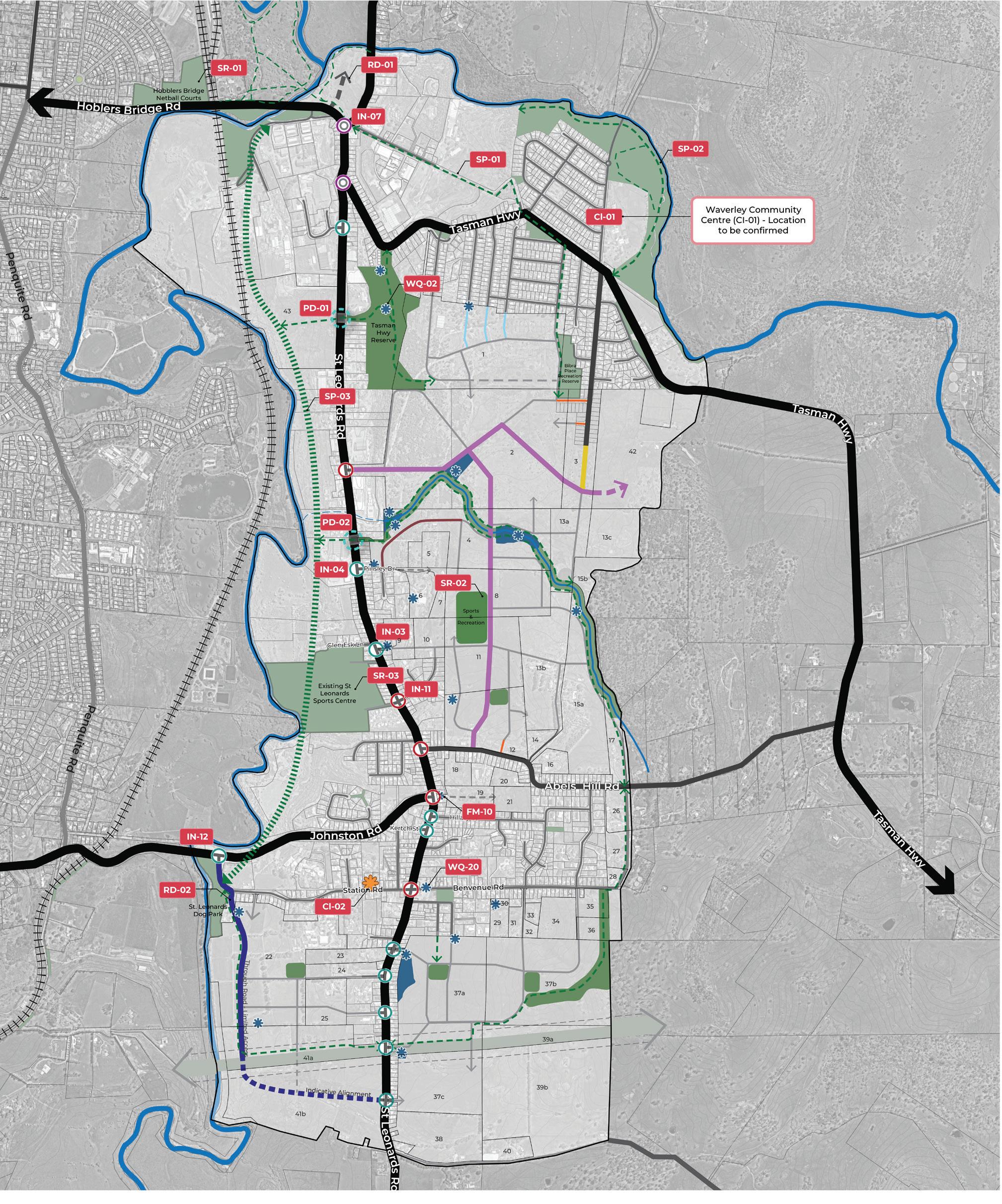
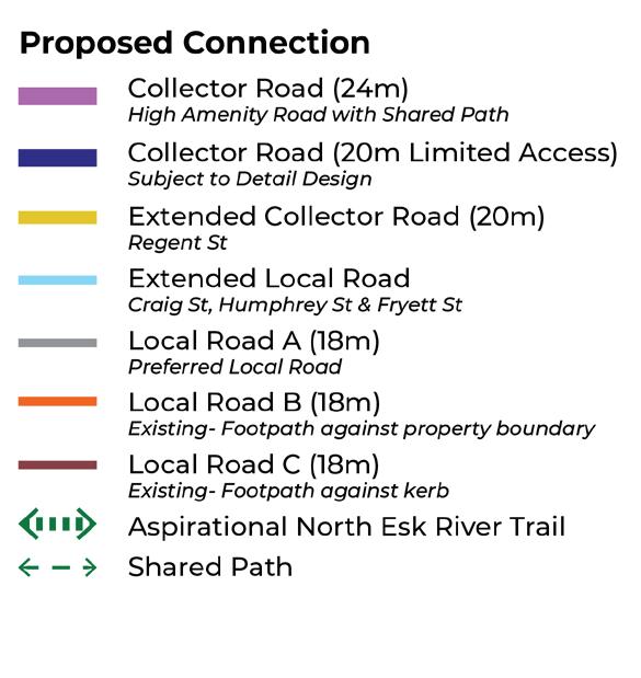
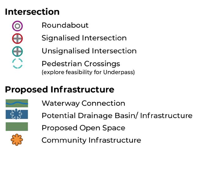
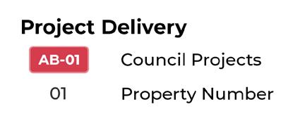
3. DEVELOPER PROJECTS
Transport and Drainage
Projects that will be directly delivered by a developer are identified in Table 11 and Figure 25. These are projects where the drainage catchment boundary falls within an individual development parcel. For the intersection project, this intersection is considered to directly benefit an individual developer.
The projects identified in Table 11 will undergo detailed design and submitted to Council for consideration as part of subdivision applications (consistent with current processes). Therefore the timing for delivery of these projects is subject to an individual developer proceeding with their subdivision.
FM-04 & WQ-13
FM-05 & WQ-14
FM-06 & WQ-15
FM-09 & WQ-05
Detention Basin prior to Stormwater Connection and Binalong Avenue + Water Quality (WQ13).
St Leonards Road 1 - (355 & 357 St Leonards Rd) + Water Quality (WQ14).
St Leonards Road 2 - (389 and 391 St Leonards Road) + Water Quality (WQ15).
Craig Street Pipe Upgrade / Detention Chamber + Water Quality (WQ-05).
Bioretention Swales. Property 2 to directly deliver water quality solution to the satisfaction of Council.
Property 37a
Property 37a
Property 37a
Property 1
WQ-07
WQ-08
WQ-09
WQ-18
WQ-22
IN-09
Note: Council has approved a stormwater asset on property 4 which may fulfill the Water Quality function of WQ-07.
Bioretention Swales. Property 2 to directly deliver water quality solution to the satisfaction of Council.
Note: Council has approved a stormwater asset on property 4 which may fulfill the Water Quality function of WQ-08.
Bioretention Basin. Property 4 to directly deliver water quality solution to the satisfaction of Council.
Bioretention Basin
Creek Remediation to be delivered by individual properties benefitting from waterway system 2, 4, 8, 13a, 15a and 17.
New Connection into Precinct 3 Priority Rezoning Area
Subject to a detailed traffic assessment, offset T intersection likely required. Potential to restrict right turn movements during peak times.
TABLE 11. DEVELOPER DIRECT DELIVERY PROJECTS
Property 2
Property 2
Property 4
Property 22
Properties 2, 4, 8, 13a, 15a and 17
Property 37a
The following infrastructure items and services are not included in the IFF, as they are not considered to be higher order items, but must be provided by developers as a matter of course:
• All internal local and collector roads and associated traffic management measures;
• Intersections connecting the development to the existing road network (except where identified as direct delivered or shared infrastructure projects);
• Local site specific water, sewerage, underground power, gas and telecommunications services;
• Local pathways and connections to the shared pathway network;
• Shared pathways within road reservations;
• Basic levelling, water tapping and landscaping of open space; and Council’s plan checking and supervision fees.
Local open space is to be provided in accordance with the Local Government (Building and Miscellaneous Provisions) Act 1993. Under the Act developers are required to provide a contribution of 5% of the subdivision gross land area. This contribution can be provided in land or cash.
For the purpose of implementing the Neighbourhood Plan, developers with proposed Open Space projects (see Figure 25) will contribute land in accordance with the Act. If the individual developer’s identified portion of Open Space is below the 5%, the balance will be provided in Cash. If the developer’s portion of Open Space is above the 5%, the developer will be credited for the over provision. This is subject to agreement with Council at the subdivision stage.
The Neighbourhood Plan proposes a total land take for Open Space of 14.86ha which is 4.10% of the total IFF area. Refer to Table 8 for a breakdown of new open space areas.
Council will be responsible for the embellishment of proposed Open Space through provision of play equipment, furniture, shelter, planting etc. consistent with Council’s Recreation and Open Space Strategy. These projects will be delivered directly by Council and are not included in the IFF.
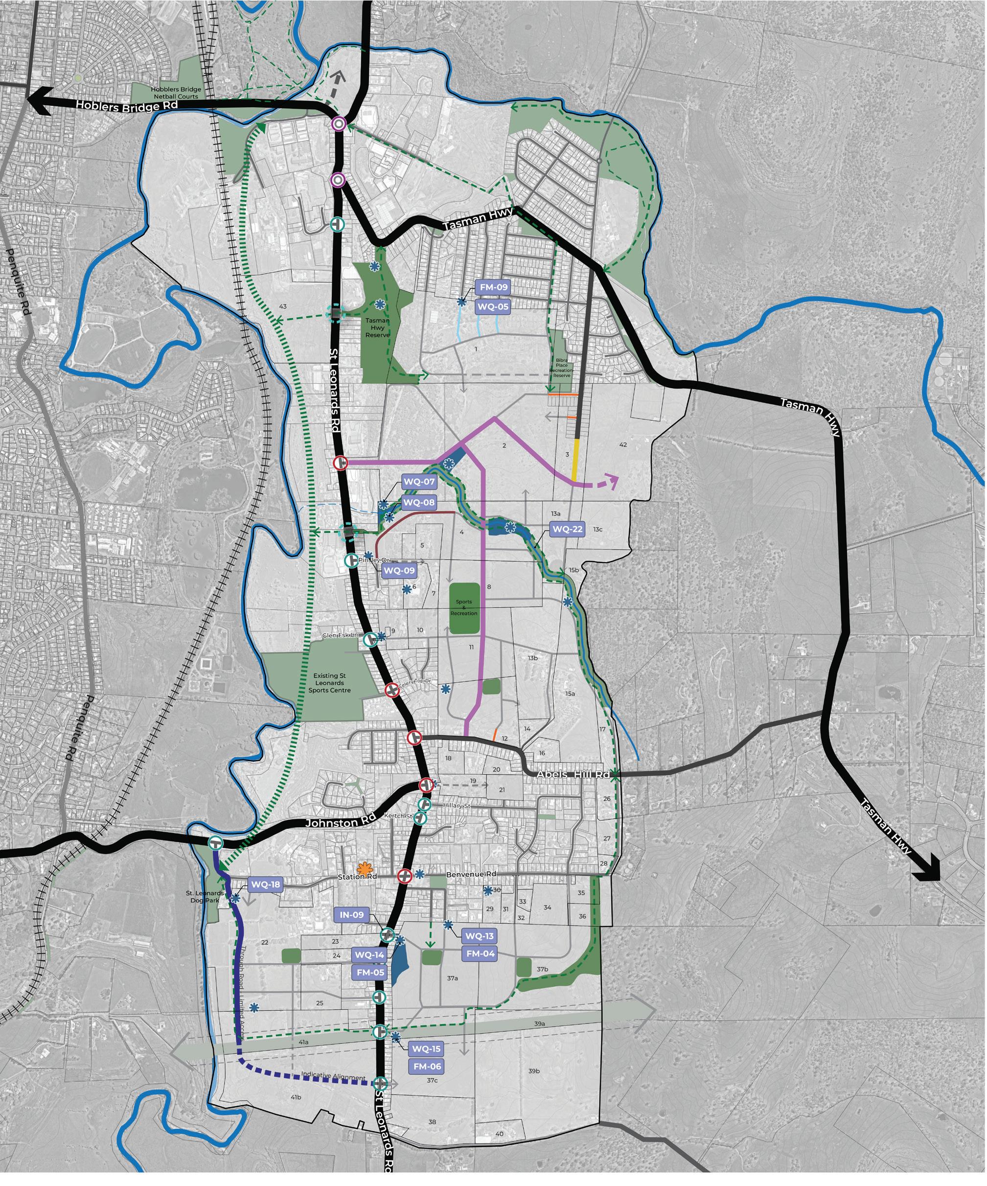
Shared Infrastructure are projects that are benefitting more than one landowner, therefore the construction and land cost will be shared amongst the benefitting catchment. The projects the IFF has classified as Shared Infrastructure include drainage projects, and one intersection project.
This Section outlines:
• The approach to delivery of shared infrastructure projects, proposed to occur via Works in Kind (WIK1) , with one project delivered by Council.
• The method used and land values calculated for each shared drainage projects.
• The apportionment of projects across the planning implementation precincts (internal apportionment) and to the Future Urban Zone areas (external apportionment).
• The seven charge areas and calculation of shared drainage and transport levy amounts.
• The property specific shared infrastructure levy each property will be responsible for, taking into account delivery of WIK projects and associated credit amounts.
The costs for land and construction included in this Section are based on 24/25 dollars and indexed to 25/26 dollars.
The delivery approach of shared infrastructure will take place as WIK or be delivered by Council with the costs shared, as identified in Table 12.
INFRASTRUCTURE
Works In Kind (WIK) Drainage Intersection
Council Delivery (shared cost) Drainage
TABLE 12. INFRASTRUCTURE DELIVERY APPROACHES
Developer delivers shared infrastructure project and is credited the cost via IFF.
Council delivers infrastructure project that is funded through levies collected from developers.
1 Works In Kind (WIK) – Is an agreement between a Council and a land owner to provide land or construction services instead of paying a cash fee.
Drainage Projects
The shared drainage projects are identified in Table 13 and Figure 26. Table 13 identifies the delivery approach for each drainage project, the majority of which are proposed to be delivered as WIK. The identified developer will deliver the project and will be credited by the IFF for both land and construction.
Apportionment of drainage project is determined by the drainage catchment that each project is servicing (Figure 27). For projects where the catchment overlaps with land proposed to be zoned Future Urban Zone, the Future Urban Zone contribution has been considered as external apportionment for the purpose of this IFF. INFRASTRUCTURE
FM-01 & WQ-01 (A) Detention Basin + Detention Basin on main channel + Water Quality (WQ01).
(Indexed to Financial Year 25/26)
$1,636,084 1, 2, 3, 4, 8, 11, 17, 26, 13a, 13b, 15a
FM-01 & WQ-01 (B) Detention Basin + Detention Basin on main channel + Water Quality (WQ01). 1.07 $1,702,863 1, 2, 3, 4, 8, 11, 17, 26, 13a, 13b, 15a WIK – Property 4
FM-02 & WQ-03 Pipe upgrade solution for broader catchment. Potential opportunity for Water Quality (WQ03) solution, this is not costed in this item. 0.00 $976,000 11, 12, 14, 16, 13b, 15a WIK – Property 12
FM-03 & WQ-12 Detention Basin – Benvenue Road + Water Quality (WQ12). 0.10 $821,895 29, 30, 31, 32, 33, 34, 35, 36, 37b WIK – Property 29
FM-08 North-West Stormwater Detention System (Tasman Highway). 0.00 $359,579 1, 2 WIK – Property 2
WQ-11 Bioretention Basin. 0.00043 $102,737 9, 10 WIK – Property 9
WQ-17 Bioretention Basin. 0.04 $410,947 22, 23, 24, 25, 41a WIK – Property 22
TABLE 13. SHARED DRAINAGE PROJECTS
The Shared Transport Project is identified in Table 14 and on Figure 26. The shared intersection is proposed to be delivered as WIK by Property 2. Property 2 will deliver the project and will be credited by the IFF for the construction cost.
Apportionment of the transport project is determined by the properties benefitting from the project. For IN-05, all properties within Planning Implementation Precinct 1 (excluding properties 12 and 18 – 21) are considered as benefitting from this intersection.
St Leonards Road & new Collector Road link through to Bellweather Street upgrade to signals.
Planning Implementation Precinct 1 (excluding properties 12, 18-21)
The area of land to be acquired for each shared drainage project is identified from the property specific land budget (Appendix 2).
The land valuations were undertaken by LG Valuation Services for the City of Launceston and are presented in the land valuation report dated September 17th 2025. A description of the land area has been provided to a registered land valuer to prepare an estimate of value. As such, the land value has been adopted as the basis for determining the total land costs for each of the identified shared infrastructure projects, where a land take is required.
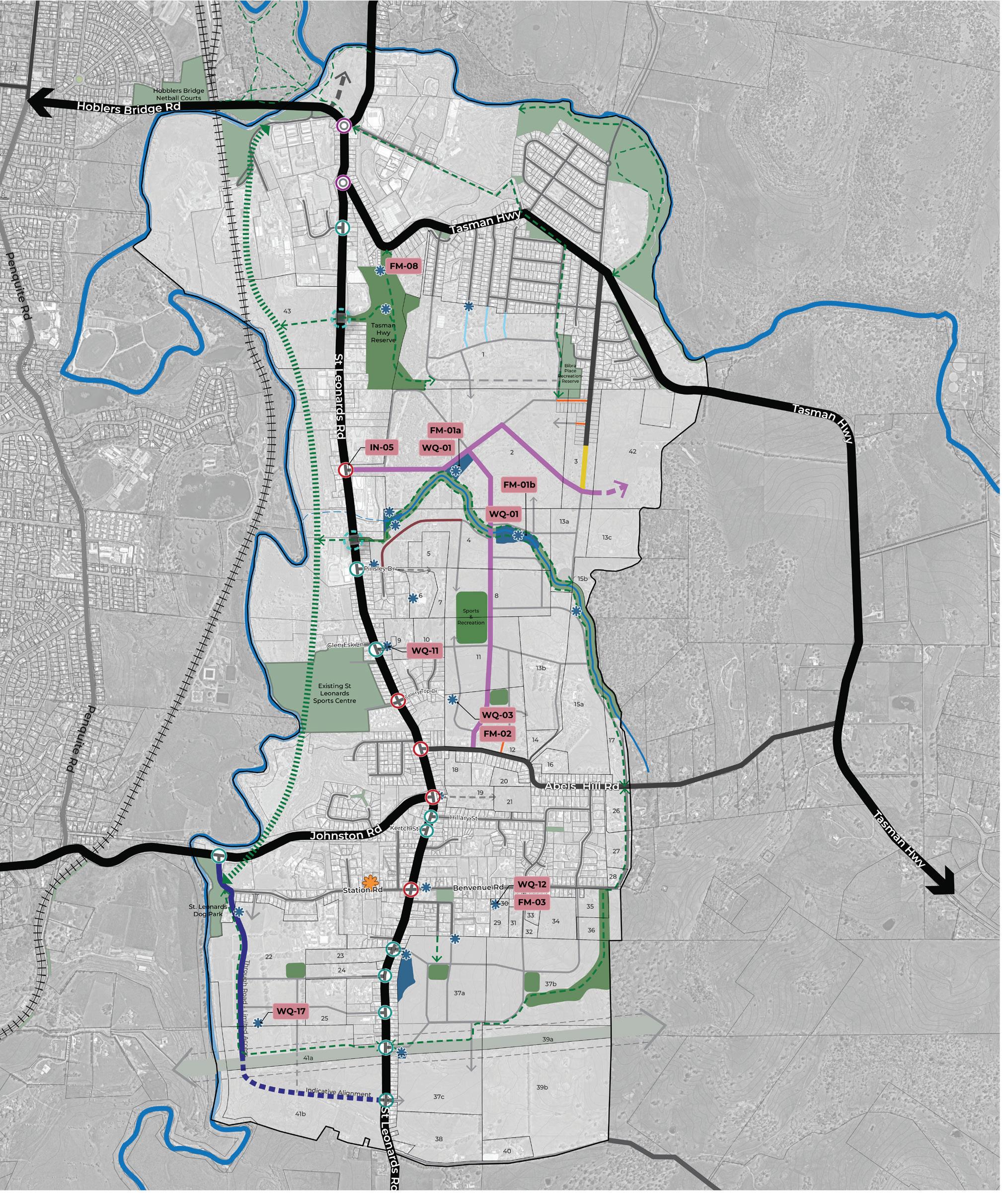
Table 15 explains the approach to apportionment for the transport project, and the drainage projects that have a catchment that is servicing both a planning implementation precinct and land proposed to be zoned Future Urban.
IN-05
New Signalised Intersection. St Leonards Road & new Collector Road link through to Bellweather Street upgrade to signals.
FM-01 & WQ-01
Two Detention Basins, within property 2 and 4 (on main channel). Included in each basin is allocation for Water Quality (WQ-01).
The proposed intersection upgrade will benefit all properties across Planning Implementation Precinct 1 excluding Properties 12, 18, 19, 20 and 21. The cost of this project is attributed to the total demand units of these properties which is a total NDA of 112.12ha.
These detention basins and water quality assets will benefit properties within the designated catchment across Properties 1, 2, 3, 4, 8, 11, 17, 26, 13a, 13b, 15a that are located within Planning Implementation Precinct 1 and the Future Urban Area.
Given the Future Urban Area is excluded from this IFF, the table below illustrates the internal and external cost apportionment percentage which applies to benefiting properties within Planning Implementation Precinct 1 and the Future Urban Area based on the total NDA. Council will be required to fund the external apportionment percentage and seek to re-coup these funds at the time the Future Urban Area develops.
Precinct NDA (hectares) for FM01 & WQ-01 Catchment
FM-02 & WQ-03
Pipe upgrade solution for broader catchment. Potential opportunity for Water Quality (WQ-03) solution, this is not costed in this item.
Precinct NDA (hectares) for FM-02 & WQ-03 Catchment
Precinct 1
of apportionment
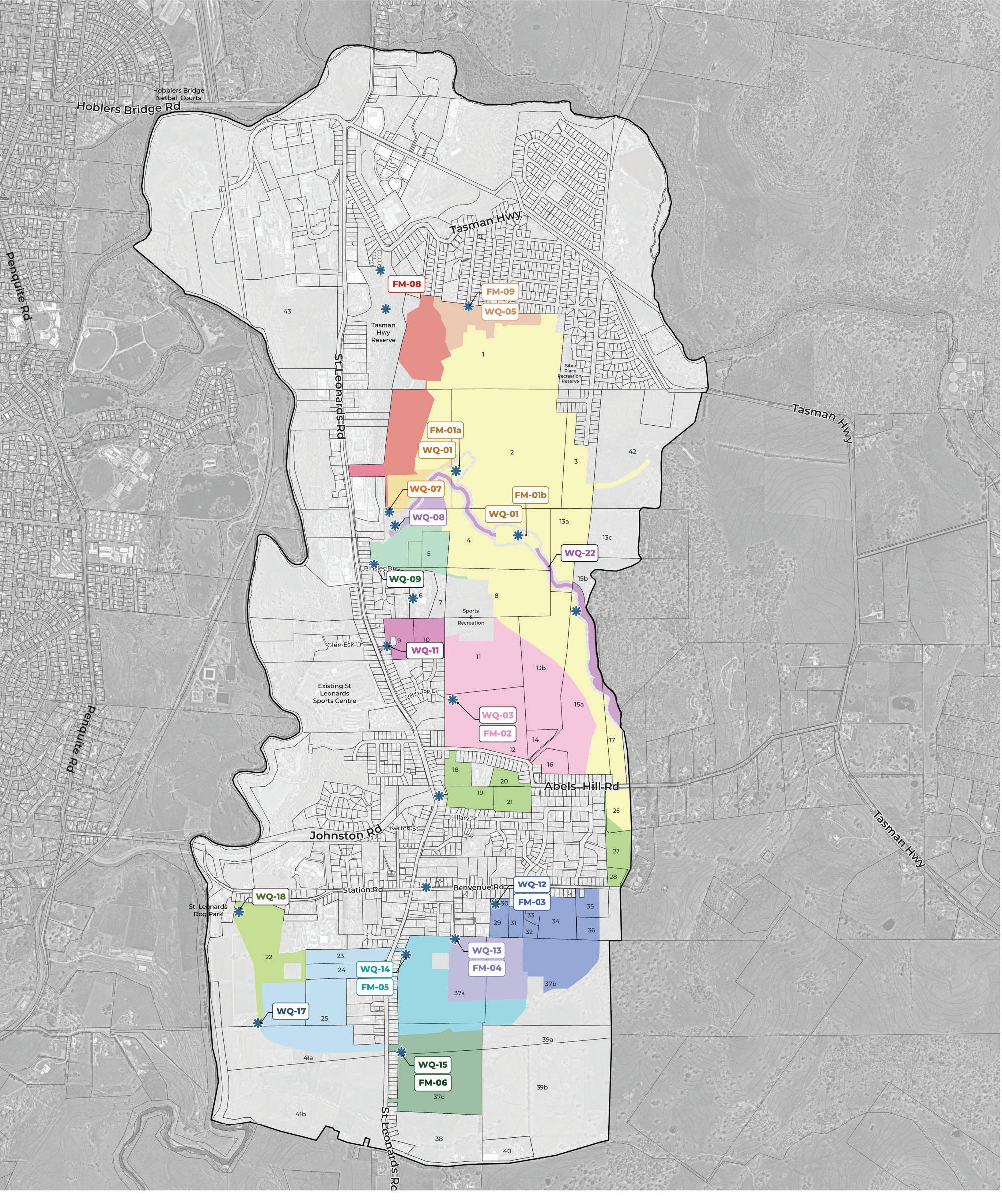
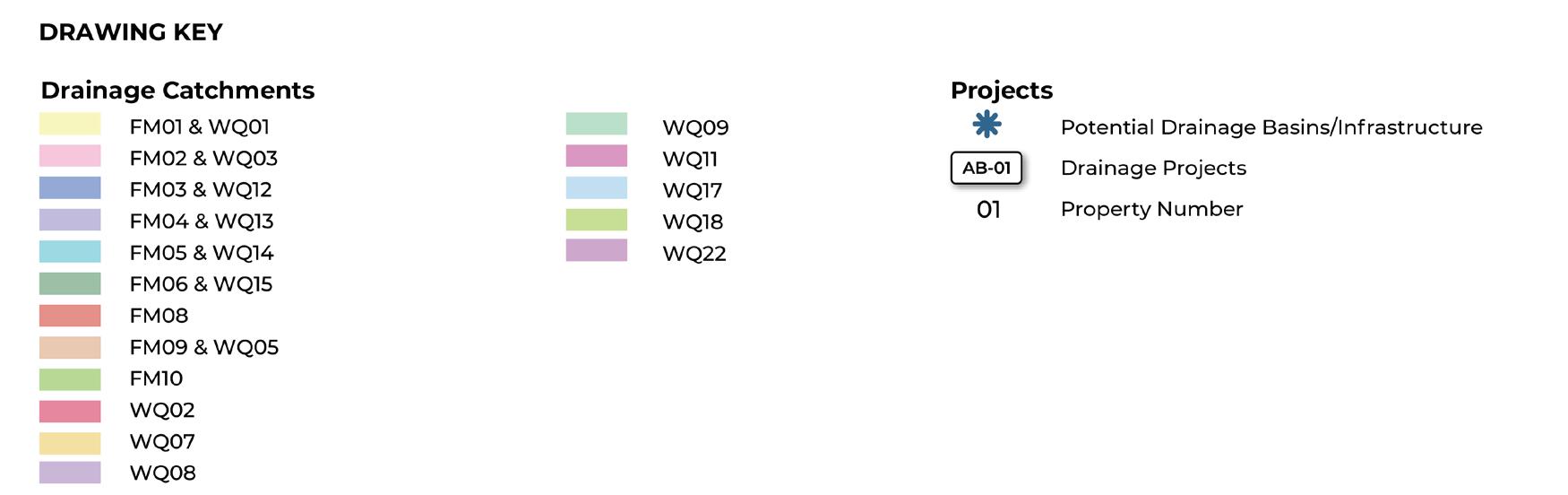
As described in the apportionment approach section above, not all properties are benefitting equally from each share infrastructure project.
Therefore, seven residential charge areas (see Figure 28) have been identified. These charge areas are defined based on the extent of residential land that is benefitting from each infrastructure project.
Table 16 outlines each charge area, the corresponding infrastructure associated with it, and the per NDA rate applicable to each charge area.
Table 17 calculates the shared drainage levy, which is used to calculate a developers total liability based on their NDA within the relevant charge area. Table 18 calculates the shared transport levy, which is used to calculate a developers total liability based on their NDA within the relevant charge area. Total property specific levies are identified in the property specific obligations section below.
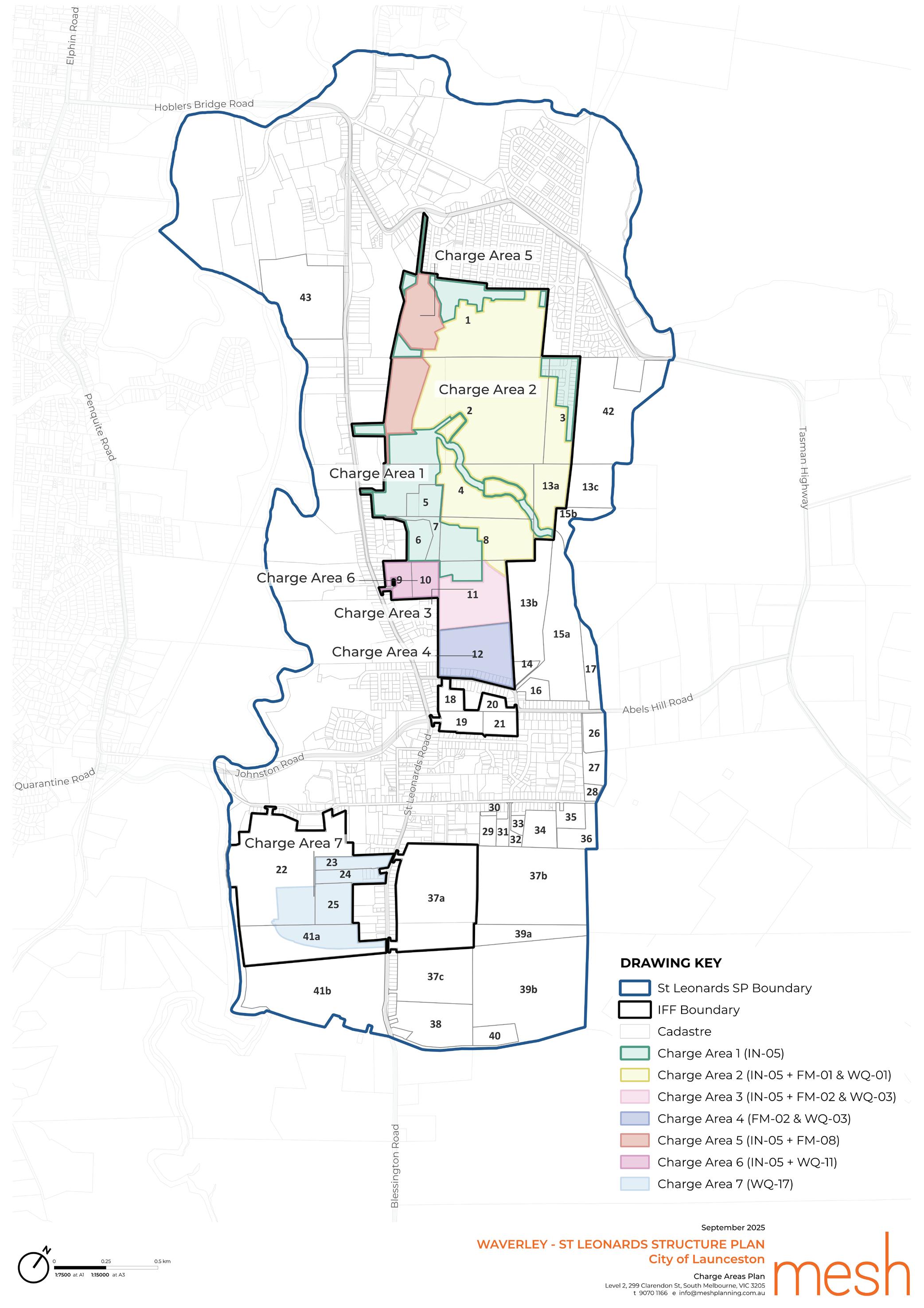
FM-01 & WQ-01 (A)
Detention Basin within property 2. Included in each basin is allocation for Water Quality (WQ-01)
FM-01 & WQ-01 (B) Detention Basin within Property 4 on main channel. Included in each basin is allocation for Water Quality (WQ-01).
& WQ-03 Pipe upgrade solution for broader catchment. Potential opportunity for Water Quality (WQ-03).
Basin –Benvenue Road + Water Quality (WQ12)
2, 3, 4, 8, 11, 17, 26, 13a, 13b, 15a
2, 3, 4, 8, 11, 17, 26, 13a, 13b, 15a
$1,702,863.16
As identified above, developers are required to contribute to the shared infrastructure projects through an equitable contribution for drainage and transport projects. This is calculated on a per net developable hectare (NDA) rate.
Table 19 sets out the property specific obligations, including the calculation of individual liabilities for drainage and transport and any credits individual developers will receive for land and construction of WIK projects. Table 19 identifies the total liability amount to be paid, or if a reimbursement is required.
This section sets out how the IFF will be implemented and administered and covers the timing of payment, provision of works and land in kind and how funds generated by this Framework will be managed in terms of reporting, indexation and review.
The IFF will be implemented through agreements entered into pursuant to Section 71 of the Land Use Planning and Approvals Act 1993 via:
a. A requirement that as part of the consideration of any application for rezoning, the relevant landowner is to enter into a Section 71 Agreement with Council for the provision of contributions to shared infrastructure projects;
b. A SAP/s which will contain subdivision standards requiring the relevant landowner to contribute to shared infrastructure projects via a Section 71 Agreement with the Council; or
c. Where land is already zoned for urban purposes, where appropriate, on the determination of an application for use and development, permit conditions will be included to require the entering into of a Section 71 Agreement for the provision of contributions to shared infrastructure projects.
Each Section 71 Agreement will be based on the template prepared by the Council, which describes the funding principles and specifies the infrastructure contribution obligation, and implementation and administration provisions contained in the IFF. The Section 71 Agreement is to be signed by Council and the land owner prior to the approval of rezoning of the respective subject land. For land that’s already zoned, the requirement for the Section 71 Agreement will be a permit condition requirement.
The Section 71 Agreements will:
• Require payment of the shared levies in accordance with the Charge Areas and Calculations of Levies identified in the Shared Infrastructure Section above (subject to annual indexation refer to Indexation Section below).
• Require the direct delivery of projects identified as Developer Direct Delivery in the Direct Delivery Projects Section above.
• Set out any infrastructure or land projects the developer intends (at the Council’s discretion) to deliver as WIK in lieu of payment of contributions.
• Set out the credit value of any WIK construction projects to be delivered by the developer.
• Set out the credit value for any land project to be delivered as WIK.
• Provide for the timing of the payment of monetary contributions and give effect to the indexation of contributions.
• Address where relevant the provision of direct delivery, works in kind and temporary or staged infrastructure works.
• Set out the controls for the administration of funds.
• Allow for the adjustment to the scope of infrastructure projects where appropriate.
The Section 71 Agreements will provide for the payment of the monetary contributions to the Council as follows:
• In the case of subdivision, the trigger for payment will be made at the subdivision application stage. The payment of monetary contributions must occur no more than 30 days prior to the sealing of the Final Plan of Subdivision with respect of the subdivision creating any new lot, unless the Planning Authority has otherwise consented to accept the provision of infrastructure works in lieu of payment.
• In relation to the development or use of land not requiring subdivision, the payment of monetary contributions must occur prior to the issue of a building permit, unless the Planning Authority has otherwise consented to accept the provision of infrastructure works in lieu of payment, or there is an agreement with the Planning Authority to secure the payment of the contribution at another time.
The Section 71 Agreements will provide for the infrastructure contribution payment to be calculated by Council prior to sealing of Final Plan (for subdivision) or prior to the commencement of development (for building works), as appropriate based on the NDA in the relevant stage of subdivision.
As per the Shared Infrastructure section of the document above, the shared infrastructure levy required for each parcel is directly linked to the NDA specified in Table 8 and this will not be amended to respond to minor changes unless agreed to by Council.
The Section 71 Agreements will provide for the infrastructure contribution payment to be calculated by Council prior to sealing of Final Plan (for subdivision) or prior to the commencement of development (for building works), as appropriate based on the NDA in the relevant stage of subdivision.
All infrastructure identified as Direct Developer Delivery is to be provided by the respective land owners and no credit is issued for the provision of these projects. This will be specifically identified in the applicable Section 71 Agreement to that land.
For some infrastructure projects, it may be possible for a development proponent to carry out the works or provide land in lieu of making a cash contribution. However, this will only be possible where the Council agrees to this and there is agreement reached on the standard and timing of the works.
The Council will only accept the provision of works in kind if:
• The works in kind constitute part or all of the delivery of an infrastructure project(s) identified in this IFF;
• The Council has agreed that the timing of the works in kind is consistent with priorities in this IFF (alternatively a credit for works may be delayed to align with clearly identified and published development priorities);
• The works in kind are defined and agreed in a Section 71 Agreement applicable to that land; and
• The detailed design of the works in kind is to the satisfaction of the Council and any regulated entity or government department.
If the Council accept the provision of works in kind (subject to the arrangements specified above):
• The credit value of the works and land for infrastructure projects provided (unless an alternative approach is agreed with the Council) shall equal the final cost of the works identified in the IFF, taking into account the impact of indexation as per the Indexation Section below.
• The development infrastructure liability payable by the developer will be offset by the agreed value of the works in kind; and
• No further financial contributions will be required until the agreed value of any credits is used.
The Section 71 Agreement will confirm that temporary works are not eligible for works in kind credits against this IFF.
It may be appropriate to deliver some IFF projects in a staged manner based on the needs of the development or the functionality of the asset, however any eligibility for these works to be credited as works in kind must be agreed to by the Council and be provided for in a Section 71 Agreement.
Where the Council agrees that a development proponent can deliver an infrastructure item (either works and/ or land), the situation may arise where the developer makes a contribution with a value that exceeds that required by the IFF.
The Section 71 Agreement will provide for that in such a case the developer may be entitled to credits against other projects in the IFF to the extent of the excess contribution. Alternatively, a developer may seek an agreement with Council to provide a reimbursement where an over-contribution has been made. The timing of any reimbursement is entirely at Councils discretion and will be subject to Council having the available funds for a reimbursement having regard to other payments received under the IFF.
The administration of contributions made under the IFF and Section 71 Agreement will be transparent and demonstrate:
• Amount and timing of funds collected;
• The source of funds collected;
• Amount and timing of expenditure;
• The purpose for which the expenditure was made; and
• All transactions will be clearly identified in Council records and kept in accordance with the Local Government Act 1993.
To ensure that the estimated cost of each infrastructure project remains reasonably accurate, the construction cost of all projects identified in Table 17 and 18 will be indexed annually by Council in July for inflation. Provision for this will be made in each Section 71 Agreement. Table 20 sets out the indexation method to be applied to the respective infrastructure categories.
For projects that have been constructed, the project cost will be indexed annually using CPI (All groups - Hobart).
Council will publish the indexed charge for the infrastructure projects on their website.
Intersections, Roads, Shared Paths & Drainage
Active Recreation and Community Facilities
Land
TABLE 20. INDEXATION AND TIMING
Australian Bureau of Statistics Producer Price Indexes Road & Bridge Construction Index, Australia (Catalogue 6427.0, Table 17 Output of the Construction Industries)
Australian Bureau of Statistics Producer Price Indexes Non-Residential Construction, Tasmania (Catalogue 6427.0, Table 17 Output of the Construction Industries)
To be revalued annually by an independent valuer.
Once land is secured the land project cost will be indexed using CPI (All groups - Hobart).
July 1
July 1
July 1
It’s anticipated the IFF will be reviewed every 5 years or earlier if required. It is expected that most infrastructure projects in the current funding arrangement will be rolled over into a revised funding arrangement.
The infrastructure projects in the IFF have been costed to a sufficient level of detail, however the shared infrastructure projects will require a detailed design process prior to construction. As part of detailed design, the Council or a development proponent with the consent of the Council may amend or modify some aspects of projects, so long as they are still generally in accordance with the Neighbourhood Plan and any direction regarding the scope outlined in the IFF.
Where the Council or another agency seeks to change the scope of an IFF infrastructure project to meet changing standards imposed by adopted policy or a public regulatory agency, such changes of standards and the resulting cost changes should normally be made through a change to the IFF at the time of a regular review of the document. Where appropriate and necessary these changes should be reflected in amended Section 71 Agreements.
Table 21 identifies the Actions required to Implement the Neighbourhood Plan.
The elements of the Action table are:
• The description of the action includes the main task, in some instance there are sub-tasks that will also be required to be completed.
• The responsibility column identifies who will be responsible for leading delivery of the action. Where both Council and an agency is identified, Council will lead the action in partnership with the agency. A proponent action will be led by the developer or other key relevant stakeholder.
• The timing column is identified as either immediate, short, medium or long term. The immediate category applies to the Catalyst Projects as actions Council will proceed with as soon as practicable possible upon finalisation of the Neighbourhood Plan. Short term actions are intended to occur within 0 – 5 years, medium term are within 5 – 10 years and long term actions are beyond 10 years.
Catalyst Project 1
Rezone the northern new development area (referred to as Planning Implementation Precinct 1 in the Implementation section) and prepare a Specific Area Plan to unlock new housing and amenities.
A1 Incorporate the Neighbourhood Plan into future updates to the NTRLUS, including the growth area boundary, proposed new development areas and identified infrastructure provision.
A2 Prepare a Planning Scheme Amendment to rezone land to Future Urban Zone as identified on Figure 8 and detailed in the Implementation section.
A3 Prepare a Planning Scheme Amendment to introduce Specific Area Plans (SAP) to embed the Neighbourhood Plan requirements into the Launceston Local Provisions Schedule of the Tasmanian Planning Scheme as identified in the Implementation section.
A4 Partner with Homes Tasmania, TasNetworks, TasWater, local community housing providers and developers to identify and deliver appropriately located future social and affordable housing sites within the growth corridor.
Council or proponent (see Statutory Implementation section)
to long term
A5 Work with TasWater and TasNetworks to ensure appropriate sewer, water and power infrastructure planning occurs to unlock the priority rezoning areas in Figure 8, consistent with the timing identified in the Statutory Implementation.
(see Statutory Implementation section)
Council or proponent Homes Tasmania TasNetworks TasWater local community housing providers Short to long term
Council TasWater TasNetworks Short to long term
A6 Establish an internal Council Project Working Group responsible for cross Council Implementation and Monitoring and Review of the Neighbourhood Plan and the IFF, as detailed in the Monitoring and Review section.
A7 Complete a detailed agricultural land suitability assessment of land identified on Figure 8 as Class 3, Class 4 or within a Tasmanian Irrigation District, prior to lodging a rezoning request.
A8
Complete a detailed bushfire report to confirm an appropriate development interfaces for areas marked as “further bushfire assessment (method 2)” and “hazard management area” on Figure 8.
A9 Complete a retail demand assessment to investigate the need for a limited-line supermarket (as identified for Possible Future Activity Centre site in Figure 8) as part of any future rezoning process. If a supermarket site (and potential supporting retail) is deemed required, deliver a master plan that identifies:
• Location and extent of limited line supermarket and any associated retail needs and associated extent of Local Business Zone that should apply.
• Opportunities for delivery of diverse housing associated with the activity centre site, to be rezoned to Inner Residential Zone.
A10 Complete the required investigations of Future Investigation Areas (Figure 8 and 13) for urban development, subject to a demonstrated land supply need and ability to deliver necessary infrastructure.
A11 Prepare Planning Scheme Amendments to unlock new development areas identified in Figure 8 and detailed in the Implementation section.
A12 Deliver a master plan for the “Proposed Future Activity Centre” as per Figure 8 and Table 3 that identifies:
• The mix of uses consistent with the recommendations of the St Leonards Structure Plan – Retail and Community Infrastructure Needs Analysis, Geografia 2025, including identification of a land area to which the Local Business Zone should apply.
• Identification of locations suitable for diverse housing such as town houses and low rise apartments, and subsequent extent of re-zoning to the Inner Residential Zone.
• Location of a local grocer.
• Streetscape treatment, including wayfinding, and interfaces to diverse housing outcomes.
• Landscape outcomes including tree planting opportunities and enhancement of the retained waterway as a key open space and amenity feature.
A13 Complete a detailed natural values assessment to confirm the extent of natural values to be protected as part of future development.
A14 Complete the relevant technical study to investigate potential impact on, and fettering of, existing extractive industries (and potential to sterilise strategic mineral resources). This applies to land identified within the MRT Strategic Resources layer on the LIST.
Council Short
Proponent Short to long
Proponent Short to long
Proponent Short
Proponent Long
Council or proponent Short to long
Proponent Short
Proponent Short to long
Proponent Short to long
Catalyst Project 2
Prepare streetscape Master Plans for the constructed sections of Station Road / Benvenue Road and Hogarth Street which identify opportunities for footpath widening, street furniture and tree planting opportunities consistent with the aspirations of the City of Launceston Urban Greening Strategy 2023 – 2040.
A15 Investigate delivery of the Hoblers Bridge Road to Henry Street link road connection by:
• Confirming a preferred alignment and completing detailed design.
Council Immediate
• Advocating for grant funding for the roads delivery, in consultation with the Department of State Growth. Council
A16 Work with the Department of State Growth to prepare a streetscape Master Plan for St Leonards Road which identifies:
• Opportunities for improved safety for on-road cyclists, such as painted cycle lanes and signage.
• Opportunities for improved pedestrian safety through footpath widening and provision of paths on both sides of the road.
• Tree planting opportunities consistent with the aspirations of the City of Launceston Urban Greening Strategy 2023 – 2040.
• Opportunities for improved and consistent signage to support businesses.
• Entry signage / treatment opportunities at each end to mark arrival into the corridor.
A17 Prepare streetscape Master Plans for the constructed sections of Station Road / Benvenue Road and Hogarth Street which identify:
• Opportunities for footpath widening.
• Tree planting opportunities consistent with the aspirations of the City of Launceston Urban Greening Strategy 2023 – 2040.
A18 Allocate funding through Council’s Capital Works Program or advocate for grant funding for the implementation of the streetscape master plans for St Leonards Road, Station Road / Benvenue Road and Hogarth Street.
A19 Advocate to the Department of State Growth for network upgrades consistent with the projects identified in the Implementation chapter.
A20 Advocate to the Department of State Growth for improved bus services including:
• A new bus route utilising the bus capable road network identified in Figure 13.
• Increased service frequency in the form of a “Turn up and Go” service as is delivered along Invermay Road, servicing Newnham and Mowbray.
A21 Investigate the feasibility of a North Esk River Trail to connect from the existing St Leonards Picnic Ground and Dog Run to the existing to the existing Hoblers Bridge trail that links into the Launceston CBD including:
• Prepare alignment options that consider topography, safety, cost and accessibility.
• Prepare a detailed design and cost for the trail.
• Advocate for funding for its delivery.
A22 Prepare a detailed design for a new shared path connection from Tasman Highway to Hoblers Bridge Road. Allocate funding through Council’s Capital Works Program or advocate for grant funding for its construction.
A23 Deliver road cross sections consistent with Figure 13 and Appendix 1.
A24 Transition key local and collector roads as identified in Figure 13, consistent with the principles in Appendix 1.
Council Short to Medium
Council Short to Medium
Council Medium to Long
Department of State Growth Short
Council Short
Council Short
Proponent Short to Long
Proponent Short to Medium
Catalyst Project 3
Prepare a landscape Master Plan for the Waverley Lake Park that identifies opportunities for improved shared path connections, consistent with the Draft City of Launceston Recreation and Open Space Strategy.
A25 Prepare a master plan for the St Leonards Village (label B, on Figure 14) that examines the development opportunities shown on Figure 16, including:
• Encourage investment in the St Leonards village to deliver objectives of the Master Plan.
• Detail of public realm upgrades, including built form and landscape requirements.
• Implement the Policy recommendations as identified on page 112 of the Launceston Heritage Study – Summary Report and Recommendations 2007.
• Transport safety improvements through delivery of a signalised intersection at Station Road and St Leonards Road (see Implementation section).
• Explore locations for a Civic Plaza.
Following completion of the master plan, confirm required statutory implementation which may include rezoning to Local Business Zone of key sites within the Neighbourhood/Town Centre and potential introduction of a SAP.
A26 Implement the recommendations of the Historical Heritage Assessment, ACHMA 2025 by:
• Conducting a full heritage assessment of “The Grange” at 356 St Leonards Road.
• Consider listing state significant properties from the Launceston Heritage Study 2007 – Places of State Significance Site Inventory on the Tasmanian Heritage Register.
• Include locally significant properties identified in the Launceston Heritage Study 2007 – Places of Local Significance Site Inventory through introduction of a Heritage Precinct in Table C6.2 of the Launceston Local Provisions Schedule – Historic Heritage Code.
• Prepare a Planning Scheme Amendment to introduce a Heritage Precinct for St Leonards (draft extent identified in Figure 14).
A27 Prepare a Landscape Master Plan for the Tasman Highway Reserve, that identifies:
• Improved entry signage from the Tasman Highway, St Leonards Road and growth corridor interfaces.
• Opportunities for improved shared pathways through the reserve.
• Weed removal and improved landscaping and public open space.
A28 Prepare Landscape Master Plans for the existing open space projects identified in Table 4, the proposed sport and recreation facility and the new open space areas identified on Figure 14.
A29 Prepare a detailed design for the upgrade to the Soldiers Memorial Hall (as per Table 5).
A30 Investigate delivery of a new small community facility in Waverley as per Table 5 including:
• Selection of a suitable site.
• Confirmation of scope of facility.
• Advocate for grant funding for its delivery.
A31 Prepare Landscape Design Guidelines that are used by Council to assess landscape master plans prepared by proponents. These guidelines should:
• Implement the aspirations of the City of Launceston Urban Greening Strategy 2023 – 2040
• Consider landscaping on nature strips, open space and waterway corridors.
• Identify an appropriate species planting list.
• Encourage proponents to retain existing vegetation on site as part of subdivision design, where possible
• Provide guidance on retention of heritage vegetation protection.
A32 Prior to rezoning, engage with the Department of Education, Children and Young People (DECYP) to confirm the need for a secondary school site (Figure 14). If no commitment can be made by DECYP to secure the land, the land will revert to the underlying future land use (residential). Steps to include:
• Identification of preferred site which considers access arrangements, walkable catchments, land area requirements and bushfire hazard management.
• Confirmation of the land take required and mechanism for securing this land.
A33 Work with the Department of Health to identify suitable locations for the delivery of Child Health and Parenting Services (CHaPS). Consider locations within existing or proposed activity centres as well as the potential to use proposed community infrastructure for these services (see Action 30 and 31).
A34 Develop Landscape Master Plans that consider the proposed high amenity waterway corridor consistent with Appendix 1, Cross Section 6. The landscape master plans should identify opportunities for re-vegetation of the corridor and provision of a shared path connection for a high amenity public open space.
Council Immediate
Council Short
Short
Council Short
Council Short to Medium
Council Short
Council Short
Council Short
Council Department of Education, Children and Young People Medium to Long
Council Department of Health Short to Medium
Proponent Short
The Neighbourhood Plan and Infrastructure Funding Framework will be reviewed on a regular basis to ensure the guidance is still relevant and the actions are on track to being achieved within the identified timeframes. The Council Project Working Group should be established as per Action 7 to meet regularly to ensure cross Council awareness of actions and responsibilities.
The following tasks should be undertaken by Council.
Every 12 months
• Review progress of Neighbourhood Plan actions against the implementation plan.
• Review of land uptake and development activity to determine whether subsequent stages of land release are required.
• Promote progress against actions on the project webpage.
Every 5 years
• Seek feedback from key stakeholders and the wider community on the strategic directions and vision to ensure the Neighbourhood Plan still meets community and stakeholder expectations.
• Review the Neighbourhood Plan to ensure it aligns with the latest trends and information available.
• Review the IFF, including costings, apportionment and proposed delivery approach. It is expected that most infrastructure projects in the current funding arrangement will be rolled over into a revised funding arrangement.
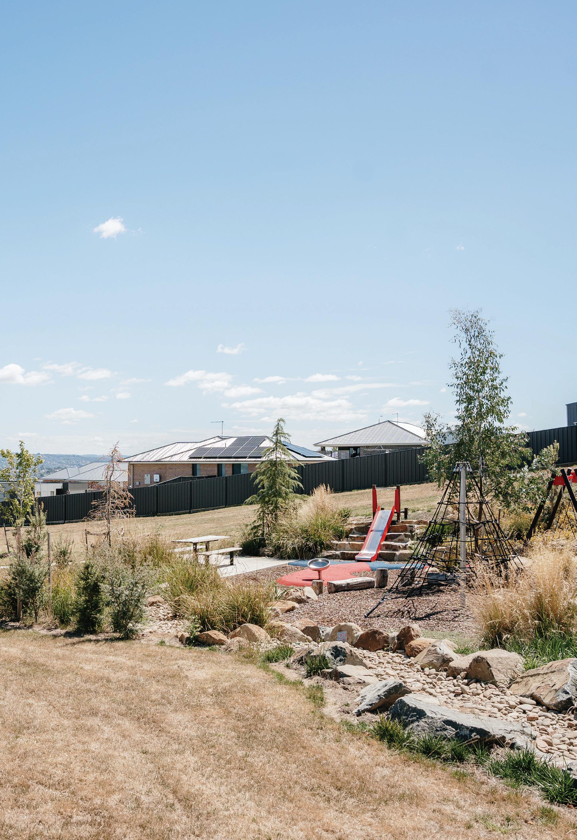
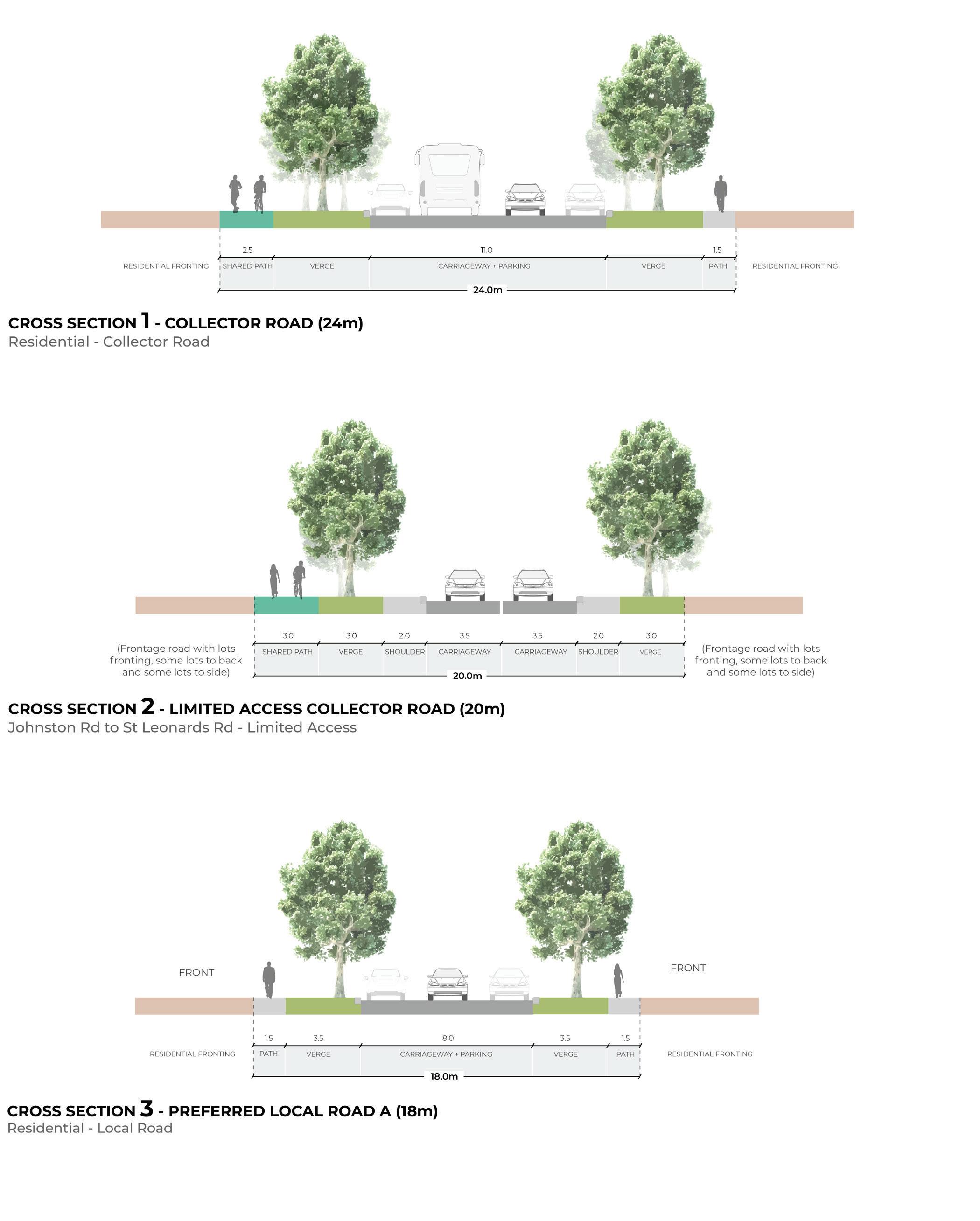
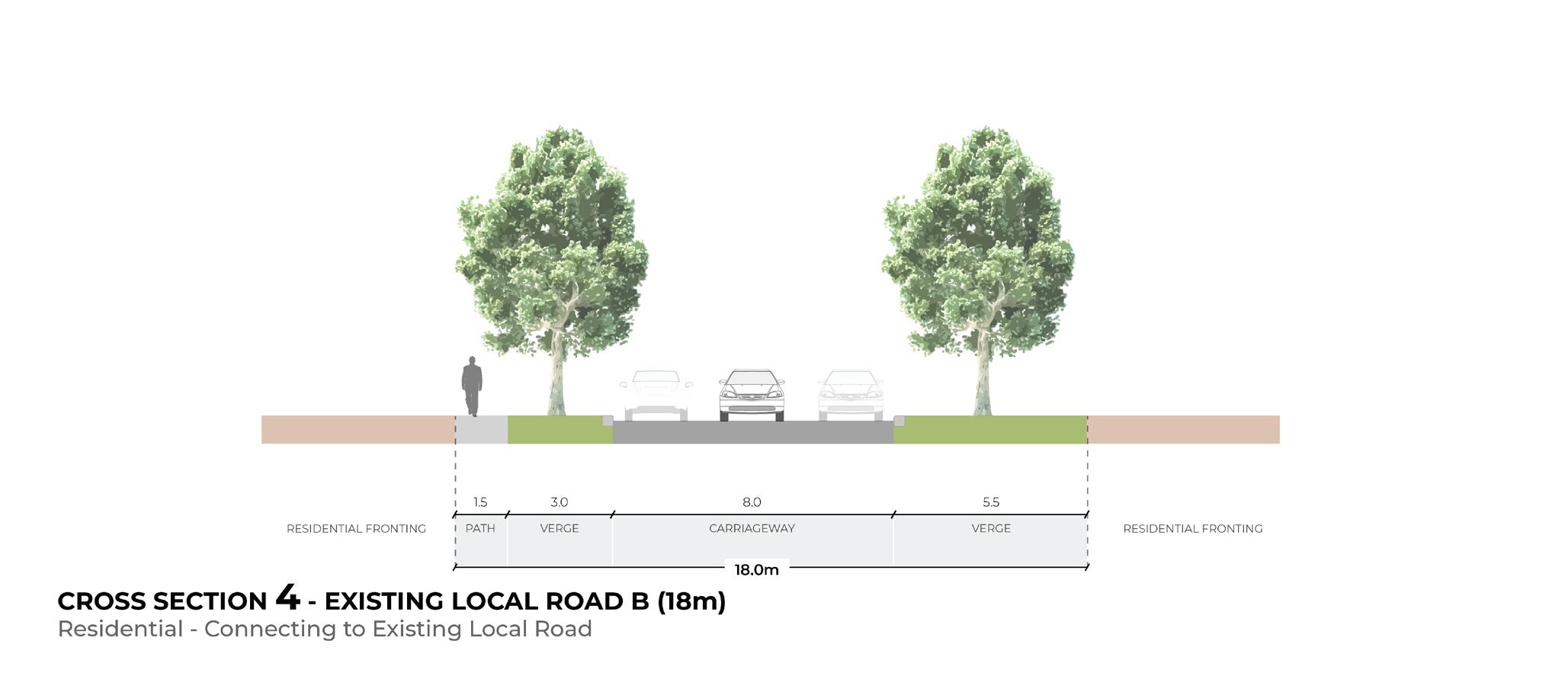
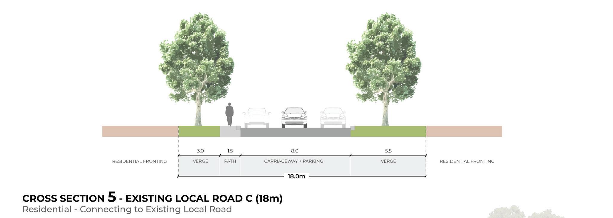
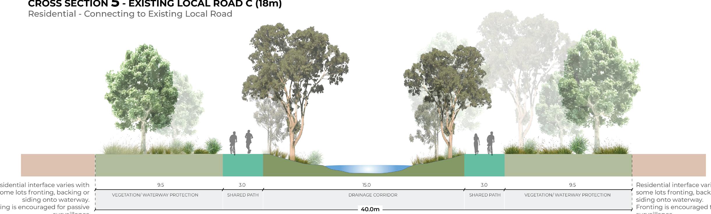
As identified in Strategic Direction 2, a number of roads that have been approved and constructed are proposed to transition to cross sections identified above. The intent of transitioning these roads to an alternative cross section is to deliver on the aspirations of the Neighbourhood Plan and ensure the road is designed to fulfill its broader role in the network, not just the role it was approved to do as part of an individual subdivision application.
When designing a road to transition from a constructed section, the following principles should be applied:
• Depending on the extent of change from the existing to proposed design, the transition might occur in a staged way to make the change occur more seamlessly (i.e. the road width might transition out over several metres rather than occurring all at once).
• The transition should seek to extend any delivered footpath construction in a way that prioritises a connected network.
• The transition should consider a logical street tree planting approach that integrates with the approved road.
Council may be responsible for modifications to the existing road if required to appropriately deliver the transition (i.e. extension of a footpath etc.). This is discussed in Strategic Direction 2.