Appendix A – Public Engagement Phase II Summary Report
Appendix B – Public Engagement Phase IV Summary Report
Appendix C – Summary of Stakeholder Advisory Group Feedback
Appendix D – Existing Transportation Conditions
Appendix E – Future Transportation Conditions
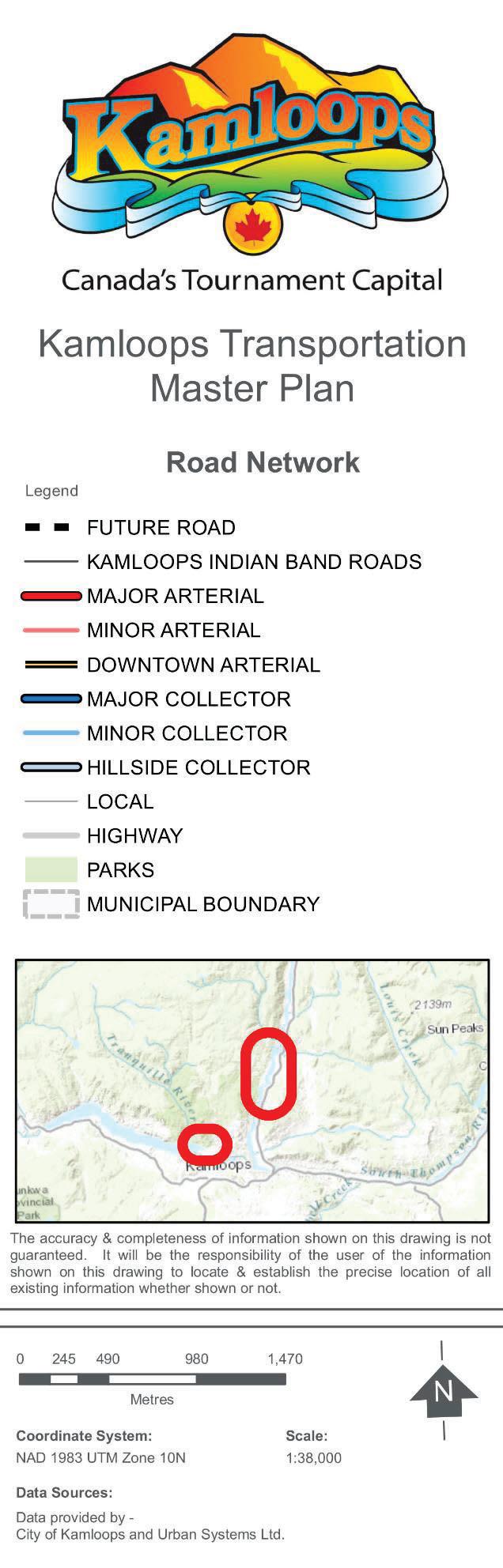
Appendix F – Transportation Master Plan Maps
Appendix G – Project Preliminary Cost Estimates
Appendix H – Complete List of TMP Projects
Appendix I – Key Performance Indicator Calculation Methodology
EXECUTIVE SUMMARY
BACKGROUND
The city of Kamloops is a diverse and thriving community within the beautiful Thompson Valley in British Columbia. With a population of 90,280 as of the 2016 census, Kamloops is a growing community and serves as a regional centre for surrounding communities. The City will address growth through planning initiatives and improvements that assist residents in adapting to a lifestyle of transportation choices, including walking, cycling, taking transit, and driving.
The purpose of the Transportation Master Plan (TMP) is to prepare a long term guide for the planning, design, development, and long-term maintenance of transportation facilities and infrastructure. The TMP was prepared in alignment with “KAMPLAN: City of Kamloops Official Community Plan (OCP)” and in consideration to many existing plans, including the Bicycle Master Plan, the Pedestrian Master Plan, and the Transit Future Plan.
The TMP was developed with the participation of Kamloops residents, key community stakeholders, City staff and City Council to ensure the plan addresses current transportation issues and reflects community values and interests. Throughout the course of developing the plan, there were several opportunities for key stakeholders, City Council, and the public to provide input: The public engagement report s from Phase II and Phase IV of the plan’s development are provided in Appendices A and B, respectively. A summary report of stakeholder input and feedback is provided in Appendix C.
The development of the TMP included a comprehensive review of existing transportation conditions, land uses, demographic data, and relevant municipal plans and policies. A report on existing transportation conditions is provided in Appendix D. Further, a future transportation conditions assessment was completed, which involved updating the City’s network -wide EMME transportation model. The detailed analysis and findings from the future conditions assessment are documented in the future transportation conditions report provided in Appendix E.
TRANSPORTATION
VISIO N AND GOALS
Vision of Transportation in Kamloops:
A transportation system in the city of Kamloops, consistent with the vision of KAMPLAN, that provides a diversity of safe, accessible, affordable, and sustainable travel choices for all that integrate well, are effective to use, promote healthy lifestyles, and support economic prosperity.
The vision of transportation in Kamloops will be achieved by implementing strategic directions under the following six goals and their supporting objectives. The following TMP goals are aligned with the transportation goals within the OCP:
Sustainable Transportation – Create an environmentally, socially, culturally, and economically sustainable transportation system.
Walking – Be a pedestrian-friendly community with networks that integrate with transit, neighbourhood amenities, parks, open space, and schools.
Bicycling – Provide safe and convenient bicycle routes suitable for commuting, recreating, and other daily trips.
Transit – Foster an efficient, affordable, safe, and accessible transit system that is an attractive alternative to the private vehicle and integrates with other transportation modes.
Goods and Emergency Services – Maintain and enhance the efficient movement of goods and emergency services.
Integrated Transportation System – Sustain the responsible planning and development of roads and transportation connections to facilitate the efficient movement of people.
For each Goal, a set of objectives were identified that describe how the City will have achieved each goal. Further, a set of Strategic Directions and actions to implement the TMP’s goals and objectives were identified. The transportation network maps and projects for Walking, Cycling, Transit, Roads, and Truck Routes are summarized within each respective section of this plan and are provided in Appendix F. Preliminary planning-level cost estimates, including unit rate costs and project costs, are provided in Appendix G; and a complete list of TMP projects is provided in Appendix H. Key performance indicators (KPIs) and targets have been identified for the City to monitor progress towards achieving each goal as the strategic directions and actions are implemented. The full list of KPIs is provided in Section 4.3 of this report, and the method of calculating the KPIs is provided in Appendix I.
TMP OUTCOMES
The TMP is intended to be a high-level transportation planning tool. Many of the ideas outlined build on and reinforce transportation planning goals from other City plans and policy documents. Moving forward with implementing the TMP is important for several reasons:
To inform and support staff and City Council ’s decisions on transportation and land use matters for existing areas and new developments.
To promote a healthy and active community.
To help the City to work in partnership with local businesses, institutions, and government partners in making informed future transportation decisions.
To assist the City with preparing annual budgets and developing capital plans.
As previously mentioned, the TMP helps inform other plans and documents such as KAMPLAN, but it can also be informed by new direction provided by future City plans, policies, and decisions. The TMP is a living document and should be reviewed and updated every 10-15 years so that it can remain relevant to changing transportation and land use conditions.
1 INTRODUCTION
The city of Kamloops is a diverse and thriving community within the beautiful Thompson Valley in British Columbia. With a population of 90,280 as of the 2016 census, Kamloops is a growing community and serves as a regional centre for surrounding communities. The city has a healthy economy driven by industries in government services, health and education, mining, pulp and paper, and others.
Kamloops continues to be known as a connected and mobile city with the convergence of three regional highways, two regional rail lines, five bridge spans over the Thompson Rivers, and a robust network of roads, pathways, and trails. The success of the City’s transportation system has been a result of careful planning and community engagement, which continue to be the core building blocks for future City planning initiatives.
Kamloops is experiencing a moderate growth trend and must strategically address issues and opportunities to improve the transportation system through to the 100,000 and 120,000 population levels. The City will address growth through planning initiatives and improvements that assist residents in adapting to a lifestyle of transportation choices, including walking, cycling, taking transit, and driving.
The City has a history of undertaking transportation -related master plans. The 1999 TravelSmart Plan was the City’s last major transportation planning exercise dedicated to optimizing the capacity and operation of the community’s existing road infrastructure. Subsequently, “KAMPLAN: City of Kamloops Official Community Plan (OCP)” was updated in 2004. In addition, the Bicycle Master Plan was completed in 2010, the Transit Master Plan was completed in 2012, and the Pedestrian and Trails Master Plans were completed in 2013.
In 2014, the City initiated an OCP review and update process to reflect changes to land use and community goals and to build on the 2010 Sustainable Kamloops Plan (SKP), which outlined a 40-year vision for becoming a more sustainable city. New transportation target s were identified in the SKP that support the vision that sustainability in Kamloops is “about living well but within our means and considering the social, economic, and environmental impacts of everything we do.” This Transportation Master Plan (TMP) was developed in coordination with the OCP update and builds on the goals and policies within the SKP and previous City transportation plans.
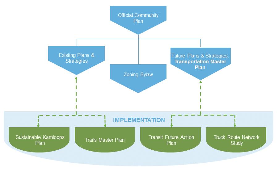
Figure 1.1 illustrates the City’s planning framework and how the TMP and OCP relate to the City’s existing plans and strategies, Zoning Bylaw, and future plans and strategies.
Figure 1.1: OCP Planning Framework
The TMP was prepared with consideration to many existing plans. For existing plans like the Pedestrian Master Plan, Bicycle Master Plan and the Transit Future Plan, the contents of the TMP supersede the contents of the pre-existing plan. The TMP does not however supersede plans like the SKP or the Trails Master Plan, which are existing plans that continue to influence their own implementation strategies. There will also be new plans created after this TMP that will be used to expand and provide detail to the strategic directions of the TMP during implementation. A full list of these implementation phase studies is provided in the Implementation section of this report. Examples of these include Transit Future Action Plan and Truck Route Network Study.
1.1 PURPOSE OF THE PLAN
The purpose of the TMP is to prepare a long term guide for the planning, design, development, and long-term maintenance of transportation facilities and infrastructure. By 2039, at a moderate annual growth rate of 1.25%, the population is expected to grow to 120,000, resulting in an overall growth of 33%. At the same time, the sustainability targets established within the SKP require significant reductions in greenhouse gas (GHG) emissions. The TMP includes a vision, goals, objectives, targets, indicators, and strategic directions for all modes of transportation while integrating current and planned transportation projects.
1.2 STUDY APPROACH
The process for developing the TMP occurred in alignment with the OCP Update, which involved planning of land use and transportation network strategies to support an integrated built environment in the city. The TMP was developed between January 2016 and June 2018 over four phases. In Phases 1 and 2, the existing transportation conditions and challenges were identified and the project vision, values, and goals were established through public engagement and work with a stakeholder advisory group. In Phase 3, the Future possibilities for travel in the city were considered and the draft TMP was developed. In Phase 4, the plan was referred to the public and government agencies and presented to City Council. These four phases are described as follows:
January-May 2016 June-September 2016 October 2016-February 2018 March-June 2018
1.3 PUBLIC ENGAGEMENT
The TMP was developed with the participation of Kamloops residents, key community stakeholders, City staff, and Council to ensure the plan addresses current transportation issues and reflects community values and interests. Throughout the course of developing the plan, there were several opportunities for key stakeholders, City Council, and the public to provide input:
KAMPLAN Review and Update – The City has engaged the public, stakeholders, and Tk’emlúps te Secwépemc throughout the OCP review and update process. This engagement has resulted in the development of a community vision, values, goals, and policies, and a refined growth strategy for the draft OCP. Information procured during the KAMPLAN process was used to coordinate and guide the TMP process.
Public Engagement – Sessions were held at various locations in the city to provide an opportunity for face-to-face community engagement. The City hosted pop-up booths at farmers’ markets and community events in 2016. During these engagement sessions, residents discussed transportation issues and ideas with the project team and provided feedback via poster boards and other interactive activities. A paper and online community survey was provided to gather broad community input on several key transportation questions. In March 2018, the draft TMP was presented to Junior Council to engage and inform youth leaders about the TMP and to solicit their input on the TMP key performance indicators and targets. In 2018, another public engagement session was held to present the draft TMP
and to confirm the current and future transportation needs of Kamloops residents. The detailed public engagement reports are provided in Appendices A and B
Stakeholder Advisory Group – At the onset of the project, an advisory group was formed with representatives from government agencies, community organizations, and other stakeholder groups. Several meetings and workshops were held with the advisory group between 2016 and 2018. A final meeting with the advisory group was held in 2018 to present the draft TMP and confirm any final changes. A detailed summary of stakeholder input and feedback is provided in Appendix C.
City Council Presentations – Several presentations were made to City Council to provide project updates, discuss issues, identify possibilities, and seek direction for the TMP.
2 DEVELOPING THE TRANSPORTATION MASTER PLAN
Based on the input of stakeholders, City staff, and City Council, a vision of transportation in Kamloops was created with goals related to sustainable transportation, walking, cycling, transit, movement of goods and emergency services, and an integrated transportation system. Drawing from the technical analysis of future growth and projected transportation conditions as the city grows to 120,000 residents, the project team developed objectives, strategic directions, and actions to implement the TMP’s vision and goals.
2.1 EXISTING CONDITIONS
The development of the TMP included a comprehensive review of existing transportation conditions, land uses, demographic data, and relevant municipal plans and policies. Factors such as user behaviour, safety, and accessibility were studied to understand existing challenges and to identify opportunities to improve conditions for pedestrians, cyclists, transit users, and road users. A report on existing transportation conditions is provided in Appendix D.
2.2 VISION OF TRANSPORTA TION IN KAMLOOPS
Vision of Transportation in Kamloops:
A transportation system in the city of Kamloops, consistent with the vision of KAMPLAN, that provides a diversity of safe, accessible, affordable, and sustainable travel choices for all that integrate well, are effective to use, promote healthy lifestyles, and support economic prosperity.
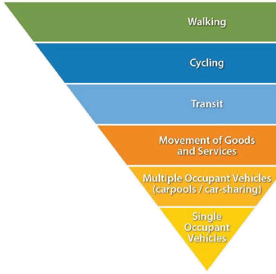
The following Figure 2.1 illustrates the hierarchy of transportation modes that should be adhered to in the development of the City’s network and the management and design of transportation infrastructure. Walking is the highest priority as it is the primary human mode of transportation and the most vulnerable in terms of the consequences from roadside collisions. Walking is also the most sustainable mode of transportation. This is followed by cycling and transit.
The movement of goods and emergency services takes priority above other motorized transportation as it is critical to sustaining the local and regional economy. Emergency services require a high priority as they are vital to community safety. Multiple-occupant vehicles, including carpools and car-share vehicles, are a more efficient form of transportation over single-occupant vehicles. Single-occupant vehicles are considered last on the hierarchy of transportation modes as they are the least efficient mode.
2.3 TRANSPORTATION GOALS
The vision of transportation in Kamloops will be achieved by implementing strategic directions under the following six goals and their supporting objectives. The TMP goals are aligned with the transportation goals within the OCP:
Sustainable Transportation – Create an environmentally, socially, culturally, and economically sustainable transportation system.
Walking – Be a pedestrian-friendly community with networks that integrate with transit, neighbourhood amenities, parks, open space, and schools.
Bicycling – Provide safe and convenient bicycle routes suitable for commuting, recreating, and other daily trips.
Transit – Foster an efficient, affordable, safe, and accessible transit system that is an attractive alternative to the private vehicle and integrates with other transportation modes.
Goods and Emergency Services – Maintain and enhance the efficient movement of goods and emergency services.
Integrated Transportation System – Sustain the responsible planning and development of roads and transportation connections to facilitate the efficient movement of people.
2.4 FUTURE CONDITIONS
The Kamloops transportation system was studied and assessed in detail using the City’s network -wide EMME transportation model to develop a strong understanding of where future constraints and challenges will likely occur in the network and to understand what possible improvements will help the city maintain an effective and efficient transportation system. The future conditions assessment was undertaken concurrently with the OCP review and update process to understand the impacts that two different future land use scenarios could have on the network. The detailed analysis and findings from the future conditions assessment are documented in a future transportation conditions report provided in Appendix E.
Figure 2.1: City of Kamloops Hierarchy of Transportation Modes
3 TRANSPORTATION MASTER PLAN
The development of the Kamloops TMP is the culmination of a review of existing and future transportation conditions, stakeholder and public engagement, and City staff and City Council input. The Vision, goals and objectives provide the overall structure and guidance for the TMP. Implementable strategic directions and actions to realize the TMP’s goals and objectives are included in this section.
For each goal of the TMP, key performance indicators (KPIs) and targets have been identified for the City to monitor and measure progress towards achieving each goal as the strategic directions and actions are implemented. The full list of KPIs is provided in Section 4.3 of this report. The transportation network maps and projects for Walking, Cycling, Transit, Roads, and Truck Routes are summarized within each respective section of this plan.
3.1 SUSTAINABLE TRANSPORTATION
The City’s 2010 Sustainable Kamloops Plan (SKP) included policies, actions and targets for a broad range of topics including transportation. Integ rating the City’s sustainability principles into the TMP is critical to ensuring the City can achieve its community-wide sustainability goals and targets to create a vibrant, productive, clean, healthy, and environmentally-friendly community for all of its residents.
The current transportation system in Kamloops results in negative impacts for the environment and public health. Large quantities of GHGs are produced by fossil-fuel-burning vehicles, which make up most of the vehicle fleet in Kamloops. Noise impacts and the amount of land used for roads also have negative effects on the environment.
The current transportation system also comes with social and economic impacts for residents. Since the majority of trips are made by private vehicle, many members of the community carry the cost of financing, operating, and maintaining one or more vehicles to get around the city. Further, many people drive alone in single-occupancy vehicles to get to work, school, and services, which limits how often people interact with other people in the community. However, it is recognized that the transportation system supports efficient and fast trips across the city by vehicle, which makes it easy for some community members with access to a vehicle to connect with friends, colleagues, and family through planned social interactions.
Despite the sustainability challenges that the Kamloops transportation system faces, there is significant opportunity to improve the environmental and social sustainability of the system by prioritizing resources and improvements in effective transportation solutions.
We heard the following key themes in relation to sustainable transportation during the TMP public and stakeholder engagement process:
More than half of public participants (55%) said they would like to bicycle more, almost half (48%) say they would take the bus more, and over one third (35%) say they would walk more often.
31% of public participants felt that current GHG emissions are unacceptable and an immediate shift from private vehicles to sustainable modes is required.
A key public engagement theme was that the City should consider opportunities to promote carsharing and carpooling.
A key public engagement theme was the need to improve and connect active transportation networks for pedestrians and cyclists in existing neighbourhoods.
GOAL: Create an environmentally, socially, culturally, and economically sustainable transportation system.
1. Users of all ages and abilities have safe and comfortable options for travel.
2. Transportation greenhouse gas emissions trend downwards.
OBJECTIVES:
3. Safe transportation for all users regardless of their mode of choice.
4. Infrastructure is efficient to operate and maintain.
5. The City is following a plan to accommodate growth.
Maintain or increase investment in cycling, pedestrian, and transit infrastructure, and continue promotion of sustainable transportation choices.
Collect and record good data through regular traffic counts to enable timely, sound, and fact-based decision making.
Make improvements to transit services and promote the use of transit.
Adopt a complete streets approach to planning and designing new roads and to retrofitting existing roads. Complete streets are designed and operated to enable users of all ages and abilities, including pedestrians, cyclists, public transit passengers and vehicles, commercial vehicles, and private automobiles, with safe and comfortable access, movement, and crossing.
Complete streets are intended to serve all users and transportation modes equally, as opposed to conventional 20th century designs that prioritize low-occupancy motorized vehicles.
Accept that traffic congestion will occur as a result of urban growth and offset the congestion by providing sustainable transportation options for residents to adopt as part of their daily commute (refer to KAMPLAN pg. D-17).
Work with the Kamloops Central Business Improvement Association (KCBIA) to review parking in the City Centre to achieve a balance between parking for patrons and encouraging alternate modes.
Continue to lead by example by incorporating electric vehicles into the City’s vehicle fleet.
Continue to partner with ICBC through the Safer City program and other initiatives to increase the safety of the travelling public.
Continue to implement safety and design improvements in the transportation network on all projects where feasible.
Prepare for and be open to new technologies where they can help to achieve the goals of the TMP (e.g. Autonomous Vehicles, alternative fuels, e-bike technology).
Develop and implement a comprehensive Vision Zero Road Safety Strategy by 2021 that outlines goals and measures to achieve a target of zero collisions causing fatalities or serious injuries by 2039.
Identify and remove barriers to car-share programs and carpooling.
Develop intelligent transportation systems for the transportation network to maintain efficient mobility for all users.
Explore different types of bike-sharing programs and develop a program designed to meet the context and needs of bicycle users in Kamloops.
Promote transit-oriented development.
Be vigilant at following KAMPLAN and this TMP, recognizing they are the primary tools to ensure there is a strategy to accommodate growth.
Develop a downtown transportation demand management (TDM) strategy.
Support car-share businesses and programs.
Balance roadway capacity between all users, including passenger and commercial vehicles, transit vehicles, bicycles, and pedestrians within the city.
Promote electric and alternative fuel vehicles through policy and incentives.
Consider the cost of operating and maintaining infrastructure when deciding what to build and where to build it.
3.2 WALKING
Establish vehicle speed limitations through regulation and design that foster a safe community.
Regularly review and update the future projects needed to accommodate growth updating the City’s Development Cost Charges Bylaw on a regular basis.
Many people will choose to walk if it is a comfortable, safe, and convenient way to travel. Walking is the most fundamental form of transportation and forms part of almost every trip within the city, whether that trip is also made by car, transit, or bicycle. In addition, there are many benefits to walking and active transportation, and residents that choose these modes reap the health benefits. Investing in pedestrian facilities can position walking as a more convenient, attractive, and healthy travel choice for local residents, businesses, and organizations.
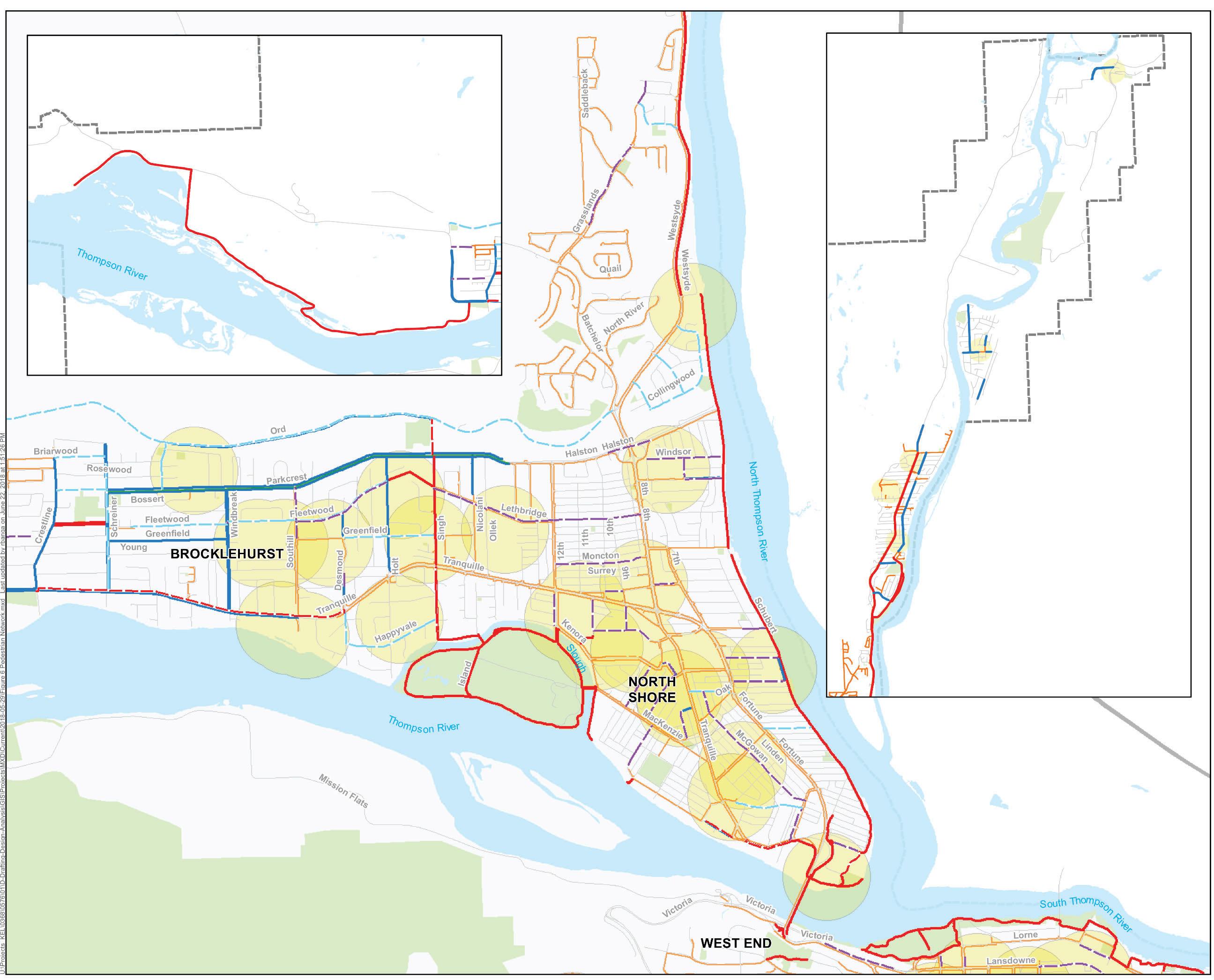
Kamloops has a unique geographical layout that attracts walking and pedestrian activity in some areas and inhibits pedestrian activity in others. Pedestrian activity is relatively high in the City Centre, the Thompson Rivers University (TRU) area, and the North Kamloops area due to relatively flat terrain and the presence of multiple land uses and densities, including schools, homes, businesses, institutions, and parks. There are also areas of the city with strong potential for increased pedestrian activity, including Valleyview, Brocklehurst, and Westsyde. Commuting to key destinations from Aberdeen, Pineview, Juniper Ridge, Rose Hill, Batchelor Heights, or Barnhartvale by walking may not be realistic, but there are many opportunities to improve walking facilities for recreational use or to connect residents to transit stops. The strategic directions outlined for each Walking objective were developed in consideration of each of the city’s neighbourhood areas; existing pedestrian facilities (or lack thereof); connectivity to high-activity pedestrian centres; and constraints such as road right-of-way width, utilities, storm water servicing, access spacing, and other conditions.
We heard the following key themes related to walking during the TMP public and stakeholder engagement process:
40% of public participants identified walking as their most used mode of transportation.
36% of public participants said that if they could, they would like to use walking more as a means of getting around Kamloops.
About half (51%) of public participants said having more sidewalks/multi-use pathways would be required for them to walk more often.
Stakeholders felt that more pedestrian facilities are needed and people need to live closer to destinations to address some of the barriers to walking, including lack of time, weather and safety.
GOAL:
OBJECTIVES:
Be a pedestrian-friendly community with networks that integrate with transit, neighbourhood amenities, parks, open space, and schools.
1. Facilities provide a high level of pedestrian connectivity.
2. The walking environment is safe for users.
3. Pedestrian accessibility and comfort levels support walking as a preferred mode.
Require that new developments provide a sidewalk on at least one side of the roadway.
Focus pedestrian facilities around high need areas, which are defined as schools, parks with major civic facilities, community care facilities, major business and employment areas, mixed-use centres, and neighbourhood centres.
Include an assessment of pedestrian safety to identify specific issues and develop improvements at problematic locations as part of the vision zero road safety strategy.
Integrate accessibility planning into all pedestrian facilities and improvements to support users of all ages and abilities.
Implement accessibility treatments on all new pedestrian facilities and crossings citywide, with more extensive treatments in high-need areas.
Require commercial centres to design parking facilities to meet pedestrian needs. This includes the safe design of internal pedestrian walkways and crosswalks connecting parking aisles to entrance points as well as connecting internal walkways to City sidewalks and transit stops (source: KAMPLAN pg D-18).
Maintain or increase investment in cycling, pedestrian, and transit infrastructure, and continue promotion of sustainable transportation choices.
Provide snow clearing on sidewalks adjacent to City-owned property, multi-use pathways, and pedestrian shoulders.
Add lighting to existing and install lighting on new sidewalks and multi-use path projects.
Work with community partners to effectively track the frequency and severity of pedestrian injury and fatalities (e.g. ICBC collision data or explore partnership with Interior Health to acquire anonymized injury data to better measure bicycling/pedestrian safety statistics).
Update the City’s snow clearing priorities and enforcement practices with a focus on how they affect walkability.
Ensure road standards provide for accessible walking facilities.
Encourage all sidewalk and multi-use pathway construction on new development roads and retrofitted city corridors to have lighting, curb let-downs, and design elements in compliance with best practices.
Establish protocol to measure and monitor the Level of Service (LOS) of the bicycle and pedestrian conditions on facilities such as sidewalks, bicycle lanes and multi-use pathways.
Focus on creating connectivity in areas without any dedicated walking facility ahead of those that have a facility even if it is substandard by the current design criteria.
Properly fund operations and maintenance of existing facilities to ensure they are maintained and operated to the maximum benefit of the community.
Construct additional and improved pedestrian facilities through the capital projects identified in the City’s Five-Year Financial Plan, as well as through requirements imposed at the time of development.
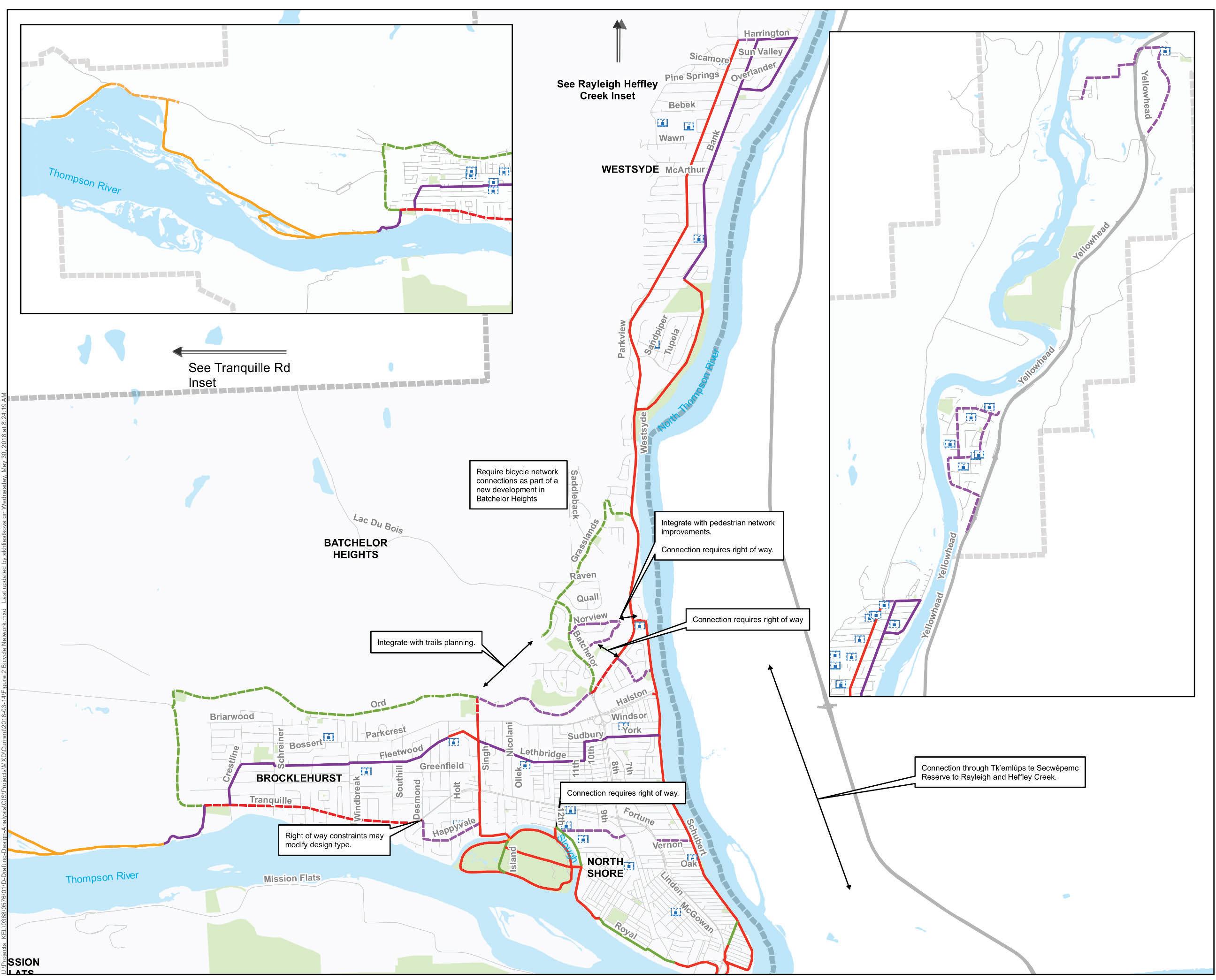
Based on the goal, objectives, and strategic directions for Walking, the high priority projects for implementation are summarized in Table 3.1. These projects were evaluated and identified as priority improvements as they support multiple goals of the TMP. Further description of how the various projects were prioritized is outlined in Section 4 of the TMP. Planning level cost estimates for Walking projects are also summarized in Section 4 of the TMP and detailed for each project in Appendix G
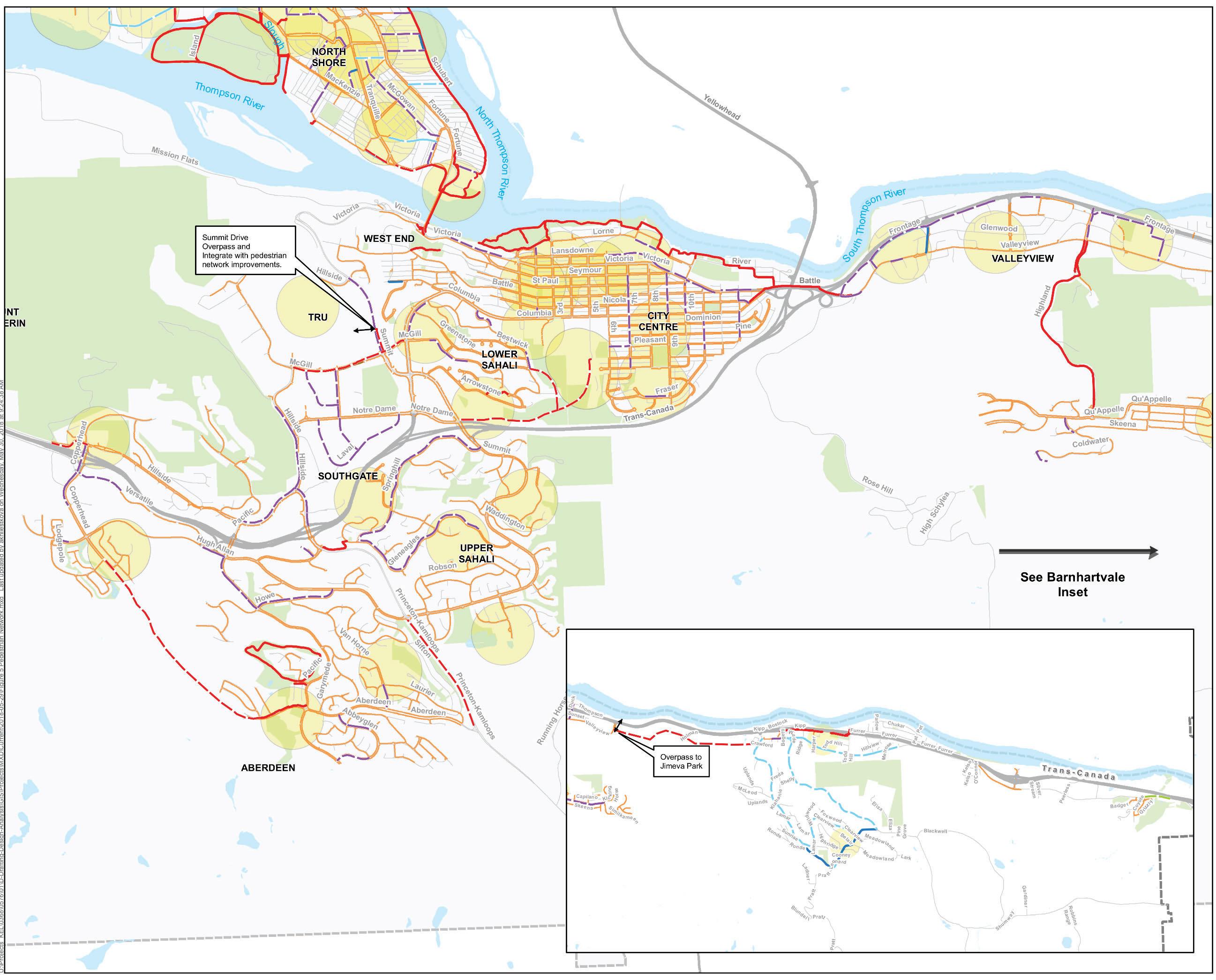
The Walking Map, which identifies all pedestrian improvements, including the priority walking projects, is provided on the following pages and in Appendix F
Table 3.1: Summary of Priority Short- and Medium-Term Walking Projects
Short-Term Project Priorities
9th St Renfrew Ave to Fortune Dr
Renfrew
Lorne St
Chestnut Ave
Ave to 8th Ave
Dr to Schubert Dr
to Mackenzie Ave
to Tranquille Rd
Project Name
Yew Street Dot St to Tranquille Rd Standard Sidewalk
York Ave
Schubert Dr to Sitka St
Standard Sidewalk
Pleasant St 6th Ave to 7th Ave Standard Sidewalk
Bebek Rd
Westsyde Rd to Westside Pool
Kyle Dr Bank Rd to Westsyde Rd
River Rd
Sydney Ave
Trans-Canada Hwy E to Valleyview Dr
Standard Sidewalk
Standard Sidewalk
Standard Sidewalk
Schubert Dr to Sarnia Pl Standard Sidewalk
McGowan Ave Elm Ave to Leigh Rd Standard Sidewalk
Brentwood Ave 8th St to 7th St Standard Sidewalk
Westminster Ave 8th St to 9th St
Highway 5A
Pine Springs Rd
Aberdeen Dr to Summit Dr
Bebek Rd to Wawn Rd
Wawn Rd Pine Springs Rd to Westsyde Rd
Hugh Allan Dr
Bank Rd
Desmond St
Lodgepoll Dr to Pineview Heights Access
Bissette Rd to Overlander Dr
Happyvale Ave to Tranquille Rd
Standard Sidewalk
Multi-Use Pathway
Standard Sidewalk
Standard Sidewalk
Standard Sidewalk
Pedestrian Shoulder
Pedestrian Shoulder
3.3 CYCLING
The Bicycle Master Plan (2010) guided the City in completing key components of the bicycle network that provide safe and convenient routes for existing and new cyclists to travel across the city for commuting and recreational trips. Cycling is an important transportation option for Kamloops and any city given its benefits of being an economical, healthy, and environmentally friendly way to travel short to medium distances.
In Kamloops, recreational cycling has long been a deeply ingrained part of the community’s culture . The city hosts numerous cross-country, downhill, and freeride cycling events each year. Cycling is also becoming a more common form of transportation for daily and weekly travel trips within the city. Since the Bicycle Master Plan was developed, the City has implemented a number of new multi-use pathways, on-street bicycle lanes, and shared bicycle routes to support cycling as a viable transportation mode. Completed projects include the multi-use pathway connection on Valleyview Road through the Highway 1 and Highway 5 interchange, the Highland Road multi-use pathway, and the Tranquille Road multi-use pathway from Leigh Road to Royal Avenue. A multi-use pathway connecting Sahali to Downtown through Peterson Creek will be completed in 2018.
While recently completed bicycle improvements have helped to increase the number of people cycling, additional improvements are needed to improve the connectivity of the bicycle network and to increase the viability of cycling as a transportation mode for residents in Kamloops. The low availability of designated and separated bicycle facilities continues to be a common barrier for individuals to take up cycling. In addition, the geography of Kamloops will continue to challenge some residents living in hilly neighbourhoods to incorporate cycling into their chosen modes of transportation. However, there are many neighbourhoods, including the Downtown, Nort h Kamloops, Brocklehurst, Westsyde, Valleyview and Dallas, which are built on mostly flat land and are more desirable for cycling. The objectives, strategic directions, and actions in this section recognize these issues and opportunities and provide a strategy to make smart investments in the bicycle network infrastructure.
We heard the following key themes related to cycling during the TMP public and stakeholder engagement process:
More than half of people (54%) said that if they could, they would like to use cycling more as a means of getting around Kamloops.
More than half of public participants (51%) said that safer bicycle routes and a more connected bicycle route network are needed for them to bicycle more often.
GOAL: Provide safe and convenient bicycle routes suitable for commuting, recreating, and other daily trips.
1. There is a continuous network of safe and direct bicycle routes.
2. There is an ability to navigate the bicycle network with ease.
OBJECTIVES:
3. End-of-trip facilities support cycling as a preferred mode of transportation.
4. The bicycling environment is safe.
Provide a continuous network of safe and direct bicycle routes with dedicated bicycle lanes, separated bikeways, shared routes, and multi-use pathways that enable residents to connect between mixed-use and neighbourhood centres, major employment areas, schools, and amenities.
Investigate gaps and needs to determine priority improvements in neighbourhood centres, near school and parks, near major transit facilities, and in mixed-use centres.
Regularly review the community’s needs for additional bicycle repair stations, parking, and other bicycle amenities.
Encourage cyclist training and education programs for new riders, children, and motorists.
Partner with the RCMP to encourage better safety for cyclists through speed enforcement on bicycle routes.
Use wayfinding materials to help cyclists plan trips efficiently, identify amenities, and navigate the bicycle network between
mixed-use and neighbourhood centres and other major destinations.
Regularly maintain and distribute hard copy and online cycling route maps and other. resources related to wayfinding and navigation.
Encourage and/or incentivize developments to provide end-of-trip bicycle amenities, including bicycle storage, showers, and change rooms.
Incorporate showers and change rooms into municipal facilities.
Implement public bicycle parking amenities through the City’s capit al projects whenever it would be considered beneficial.
Undertake a bicycle parking and amenity study by 2021.
Undertake a bicycle safety study as part of the Vision Zero Road Safety Strategy.
Re-assess and improve facility design types such as the marked wide curb lane.
Work with community partners to effectively track the frequency and severity of cyclist injury and fatalities (e.g. ICBC collision data or explore partnership with Interior Health to acquire anonymized injury data to better measure cycling/pedestrian safety statistics).
Update the City’s Design Criteria Manual to incorporate bicycle safety treatments such as coloured conflict zone markings, elephant’s feet bicycle crossings, and bicycle boxes.
Investigate opportunities to amend bylaws to clearly permit small-wheel transport and children riding bicycles on sidewalks.
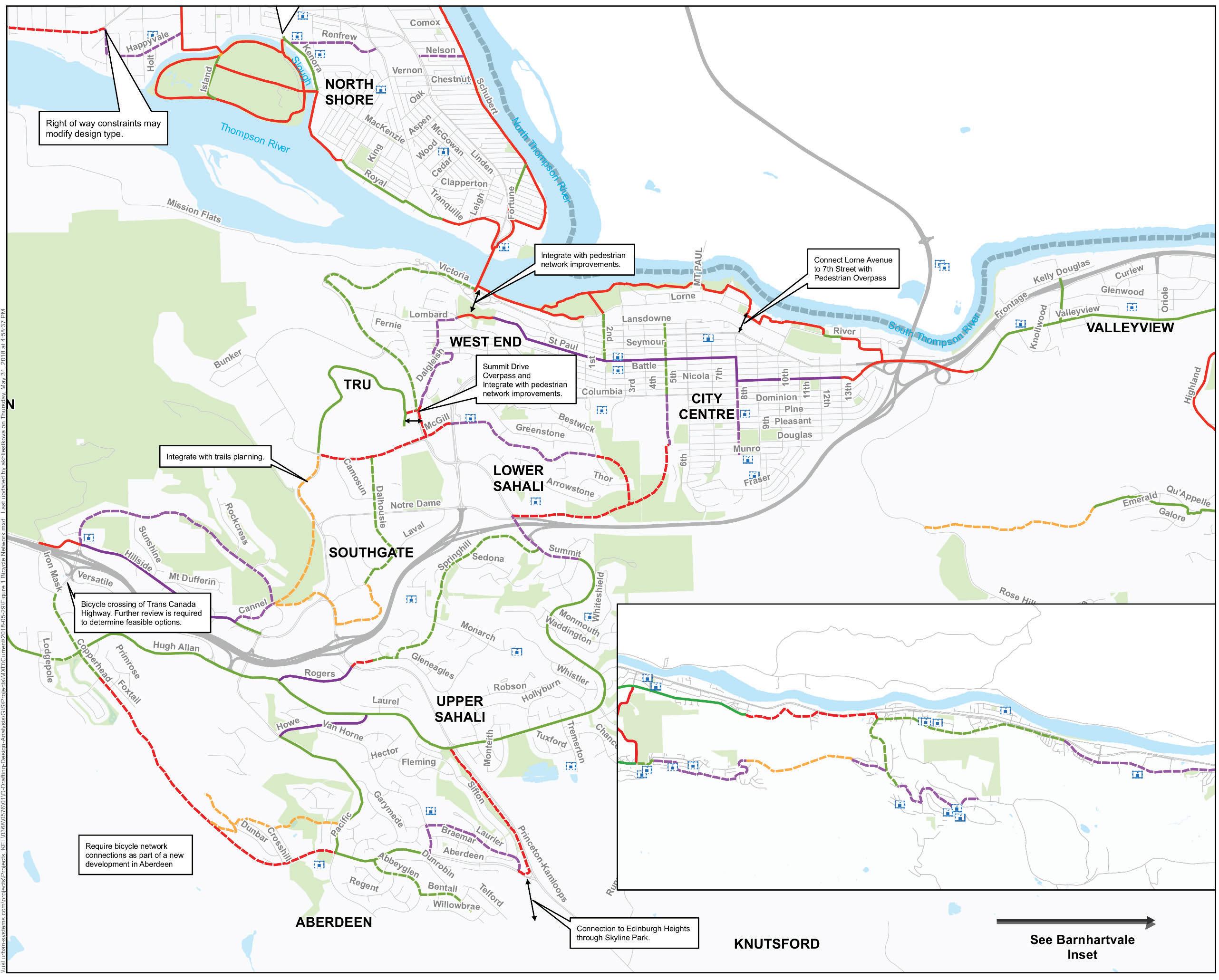
Continue to implement major components of the bicycle network as identified on the Cycling Map and focus on the projects as prioritized in the summary table of Priority Cycling projects.
Based on the goal, objectives, and strategic directions for Cycling, the high priority projects for implementation are summarized in Table 3.2. These projects were evaluated and identified as priority improvements as they support multiple goals of the TMP. Further description of how the various projects were prioritized is outlined in Section 4 of the TMP. Planning level cost estimates for Cycling projects are also summarized in Section 4 of the TMP and detailed for each project in Appendix H
The Cycling Map, which identifies all bicycle improvements, including the priority cycling projects, is provided on the following pages and in Appendix F
Project Name
Table 3.2: Summary of Priority Cycling Projects
Short-Term Project Priorities
McGill Rd (west)
Tranquille Connector (Desmond to Aviation Way)
Westsyde Rd (north)
Dallas to Valleyview
Peterson Creek Path
Singh St North
Summit Dr
Peterson Creek Path
Springhill Dr
City Centre West End Connection
Medium-Term Project Priorities
Columbia St to Hillside Dr
Desmond St to Aviation Way
Batchelor Dr to Westmount Dr
Grand Blvd to Todd Rd
Glenfair Dr to Summit Dr (Design in Progress)
Parkcrest Ave to Ord Rd
Notre Dame Dr to Whiteshield Cres
Glenfair Dr to Columbia St
Gleneagles Dr to Summit Dr
Strathcona Terrace to Summit Dr
Summit Overpass East of Summit Dr to West of Summit Dr
Aberdeen Dr (Copperhead to Aberdeen)
2nd Ave
Creek Path
Paul St to Lansdowne St
6th Ave Peterson Creek MUP to Columbia St
Hillside Parallel Trail (Kenna Cartwright Trail)
Happyvale Ave and Desmond St
York Ave
Renfrew Ave (McArthur Island to Tranquille)
McGill Rd (east)
Harrington Way
Nelson Ave
Rd to Hillside Dr
Tranquille Rd to Singh St
8th St to Schubert Dr
Kenora Rd to Tranquille Rd
Columbia St to Bestwick Dr
Westsyde Rd to Bank Rd
Fortune Dr to Schubert Dr
Pathway
Pathway
Pathway
Trail
Pathway
Pathway
Route
Lane
Route
Route
Route
Route
Route
Route
3.4 TRANSIT
Transit service in the City of Kamloops is planned and funded in partnership with BC Transit. Decisions on fares, routes, and service levels are made by City Council based on public feedback and information provided by BC Transit. Buses are operated by First Canada ULC. Operating costs are met by a combination of farebox revenues and joint municipal and provincial funding.
In May 2012, BC Transit and the City completed a long-term Transit Future Plan (TFP). This strategic plan lays out what the transit network in Kamloops should be 25 years from now and describes the priorities, infrastructure, and investment needed to get there. The network envisioned in the TFP is a hub and spoke system, designed with a frequent transit network (primary routes) connecting major destinations and a local transit network (secondary routes) connecting to residential neighbourhoods, making it a transfer-based system. In 2013, some of the recommendations outlined in the TFP were implemented, and, in 2015, the system was fine-tuned for operational efficiencies.
Transit service in Kamloops has improved notably over the past decade with a number of efficiency changes to routing and frequency to meet the needs of a growing transit-riding community. In addition to service improvements, fleet upgrades have also been gradually occurring in the system. The bus fleet has been upgraded to Compressed Natural Gas buses that provide a high-quality transit experience for users. While these recent improvements support the vision and goals of the Transit Future Plan, there is still opportunity to attract and grow transit as a commonly used mode of transportation among Kamloops residents.
In general, improved transit service frequency, route connections, supporting amenities, and intensification of land use in the mixed-use centres and neighbourhood centres are required for the City and BC Transit to achieve their common transit goals. As Kamloops continues to observe population and employment growth, it will become more important to provide efficient, equitable and accessible transit services within and outside of the city.
We heard the following key themes related to transit during the TMP public and stakeholder engagement process:
Almost half (49%) of public participants responded, if they could, they would like to use transit more often as a means of getting around Kamloops.
The most often cited factor that discourages people from taking transit is, it is simply not as flexible or convenient as driving.
About 47% of public participants claim that bus service is too infrequent while some (19%) say that seasonal schedules make it difficult.
GOAL:
OBJECTIVES:
Foster an efficient, affordable, safe, and accessible transit system that is an attractive alternative to the private vehicle and integrates with other transportation modes.
1. Transit contributes to a more environmentally sustainable Kamloops.
2. Transit is well integrated with all other transportation modes.
3. A robust frequent transit network serves the community.
4. Riding transit provides the rider with a great experience.
5. There are high levels of bus stop accessibility and safety.
6. There is public awareness that transit is an attractive alternative to the private vehicle.
Support higher frequency public transit service in areas where the City aims to achieve higher density, as per the OCP.
Strive to maximize transit ridership.
Continue to invest in and collaborate on short-, medium-, and long-term facility and operational infrastructure projects to achieve ridership and mode share targets set out by the SKP.
Work with BC Transit to implement and enhance the frequent transit network (FTN) service that will provide convenient, reliable, and frequent service on mediumto high-density mixed land use corridors.
Improve the consistency of the transit rider experience by providing more amenities such as bus shelters, lighting, bicycle parking, and seating.
Encourage transit priority measures to give transit vehicles priority over general traffic (e.g. high-occupancy vehicle lanes for transit vehicles).
Explore opportunities to provide park and rides at the periphery of the transit system.
Encourage students, organizations, and residents to take transit more regularly through incentive programs such as ProPASS, U-PASS, BC Bus Pass, and Family Travel.
Promote and inform the community about transit service improvements to ensure that new and existing transit riders understand how the transit system works, how it is being improved, and how they can benefit from transit improvements.
Work with BC Transit to continue making investments in technology on transit buses such as implementation of SmartBus technology on transit systems that provide riders with accurate, real-time information about schedules, route changes, and other important customer information.
Increase the accessibility and safety of bus stops to ensure transit riders of all ages and abilities can access the transit network safely and easily.
Integrate transit facilities and bus stops with walking, cycling and driving modes to provide more transportation choices for residents of Kamloops to move around the city.
Review and update the Transit Future Plan in partnership with BC Transit.
Market transit to key neighbourhoods, employers, and organizations where improvements have the potential to attract new and regular transit users.
Seek coordination amongst the City’s transit services and regional public transit operations whether public or private (e.g. airports, Greyhound, passenger rail).
Implement major projects by priority, as per the Transit Future Plan.
Continue to make operational improvements to roads and intersections as identified in the Transit Future Plan.
Refine and update the Transit Future Plan with BC Transit on regular intervals to keep the plan relevant and specific to current need.
Based on the goal, objectives, and strategic directions for Transit, the high-priority projects for implementation are summarized in Table 3.3. These projects were evaluated and identified as priority improvements as they support multiple goals of the TMP. Further description of how the various projects were prioritized is outlined in Section 4 of the TMP.
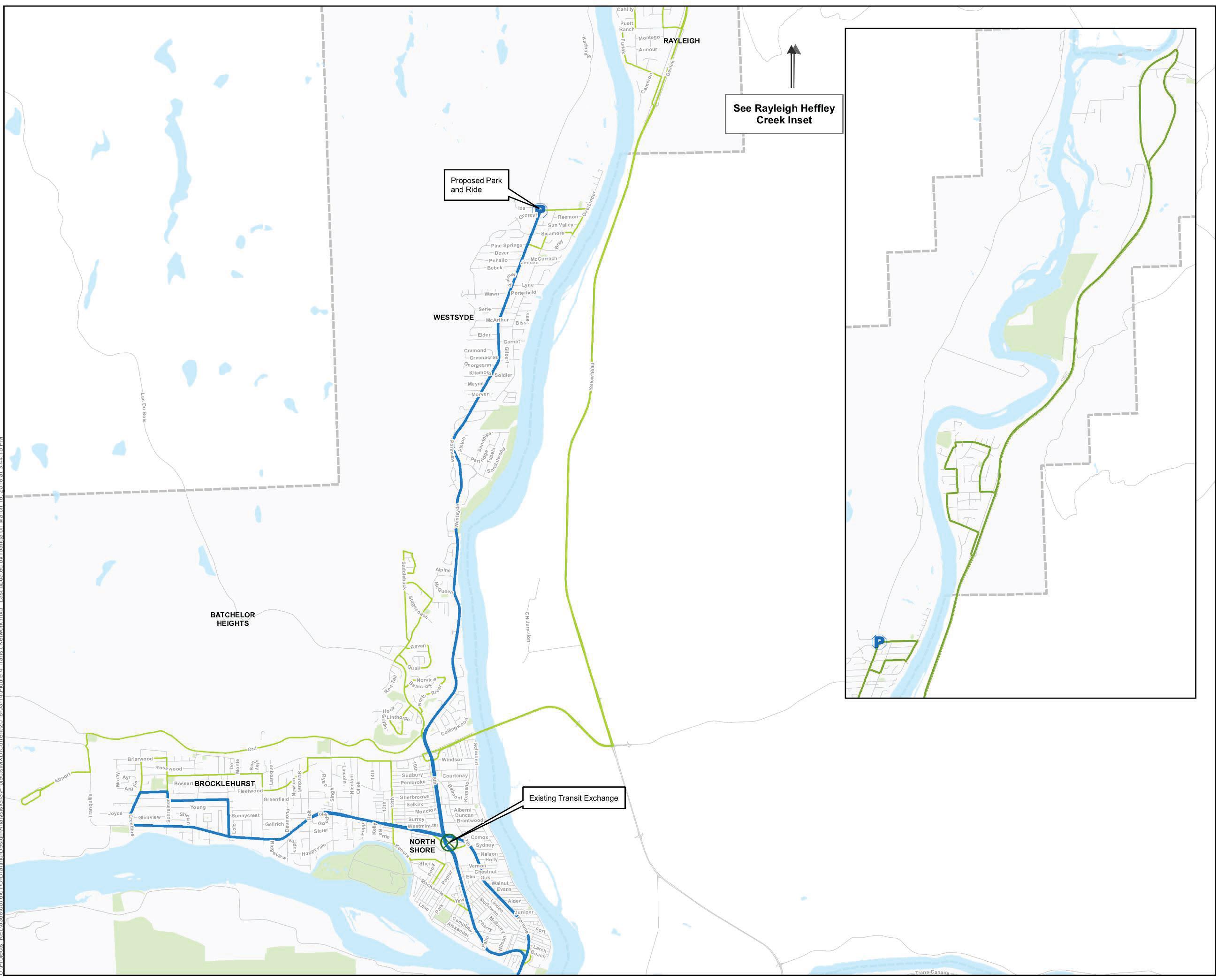
The Transit Map, which identifies all transit improvements, including the priority transit projects, is provided on the following pages and in Appendix F
Project
Table 3.3: Summary of Priority Transit Projects
Summit Dr Bus Stop Columbia St / Summit Dr Intersection
Valleyview Transit Exchange Oriole Rd to Falcon Rd
Downtown Transit Circulation Upgrade
Lansdowne Street to 6th Ave
Westsyde Transit Park and Ride Westsyde Neighbourhood
Campbell Creek Transit Park and Ride
Campbell Creek Neighbourhood
and
Exchange
Operation Improvement
Park and Ride
Park and Ride
3.5 MOVEMENT OF GOODS AND EMERGENCY SERVICES
The road network in Kamloops plays a vital role in facilitating the movement of goods and emergency services and supporting the local economy. While goods and emergency services can be moved by almost any form of transportation (e.g. shipping, rail freight, cargo bicycles, air freight), the majority of goods and emergency services are transported in Kamloops by trucks. Other than rail, trucks provide the most efficient means to move large quantities of goods both locally and provincially.
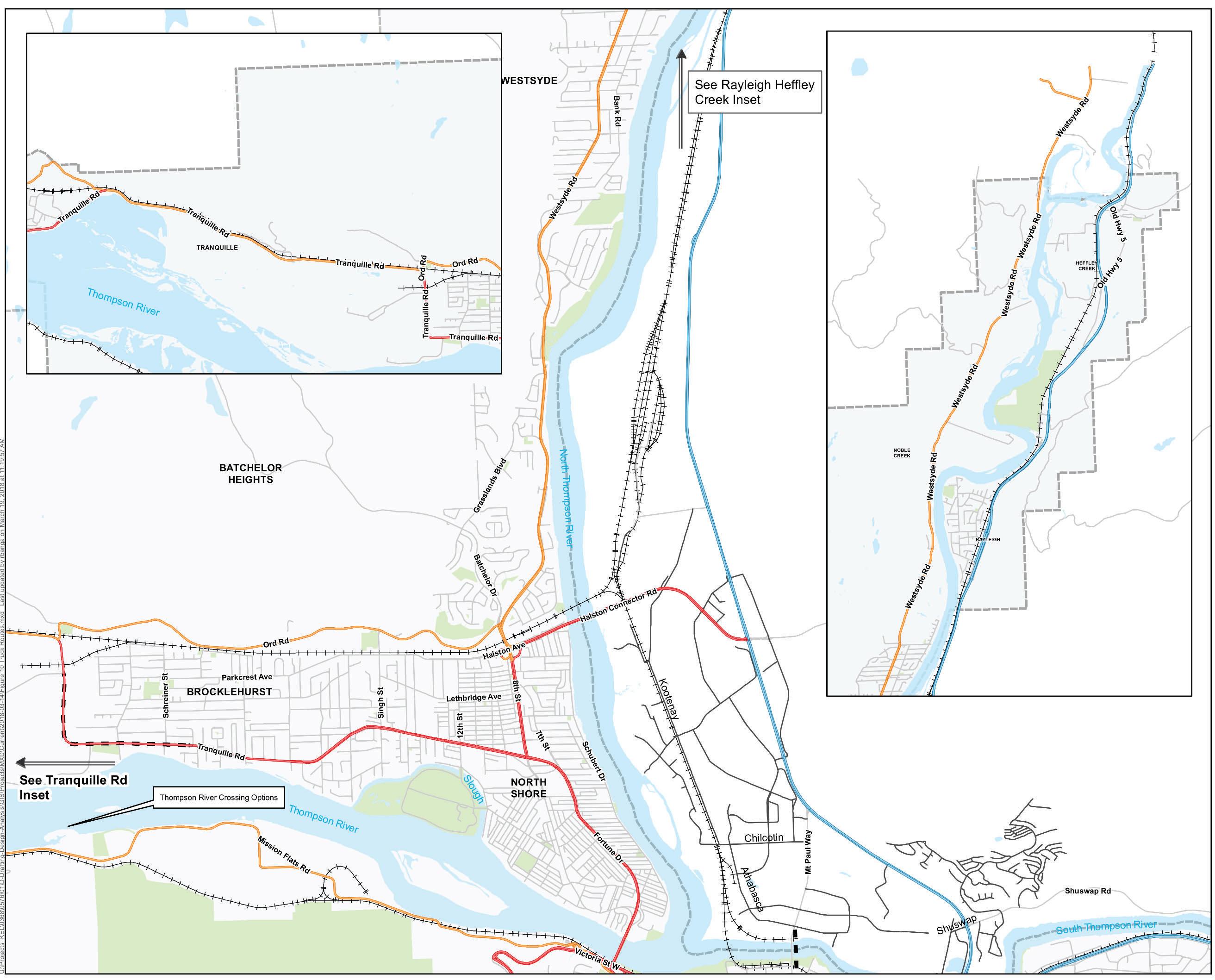
The City’s Traffic Bylaw and Transportation of Dangerous Goods Bylaw outline the specific roads and connections that trucks are permitted to use for travel through Kamloops until they reach their destination. Most of the truck routes are identified on roads classified as major arterials and collectors, which serve the purpose of moving traffic efficiently, effectively, and safely.
While most of the roads designated for trucks provide a substantial right-of-way with separation from the adjacent land use, a frequent issue raised by the community is the dangerous goods route that runs along Fortune Drive and Tranquille Road. Given the close proximity of the roadway to homes and businesses, the City often receives feedback and concern about the amount of truck traffic and dangerous goods that travel along this corridor. Other areas where residents have expressed concern about the proximity of truck routes to neighbourhoods include the McGill Road mixed-use corridor, Sahali Town Centre, and TRU. Other issues include the amount and type of dangerous goods travelling through the community, truck traffic on local roads off the designated truck routes, and traffic congestion that slows the delivery of goods and emergency services to their destination. The following objectives, strategic directions, and actions are intended to address these issues and to guide future planning for the movement of goods and emergency services.
Police, fire, and ambulance vehicles respond daily to calls from residents throughout the community. Their ability to keep the community safe relies on their ability to respond quickly to urgent calls. Any time lost getting to an emergency can have drastic impacts on the end result. The transportation network must provide a high level of mobility for emergency service providers in order to help keep the community safe.
We heard the following key themes related to the movement of goods and emergency services during the TMP public and stakeholder engagement process:
More than half of public participants said major roads and truck routes in the City are important to maintain.
Stakeholders indicated that even though emergency service providers support the changes to prioritize sustainable modes over the single occupant vehicle, there must still be consideration given when designing the network to minimize emergency response times.
GOAL: Maintain and enhance the efficient movement of goods and emergency services.
1. Truck traffic avoids areas designated for high-density residential, mixeduse, and pedestrian- and transit-oriented development.
OBJECTIVES:
2. There is a high level of goods and emergency services mobility on major regional routes.
3. Goods and emergency services are being delivered at a local level.
4. High level of accessibility and mobility for emergency services.
Continue enforcement of dangerous goods and truck traffic through the Transportation of Dangerous Goods Bylaw, the Road Right-of-Way Usage Bylaw, and the Traffic Bylaw.
Monitor mobility conditions for goods and emergency services.
Regularly optimize traffic signal timing, traffic signal pre-emption for emergency vehicles, and traffic signal coordination.
Consider improvements such as additional intersection lanes and truck-climbing lanes to improve mobility of goods and emergency services.
Improve the mobility of goods and emergency services within the city by maintaining efficient traffic flow on major routes into and across the city.
Ensure truck traffic uses the road network safely and efficiently through regulatory bylaws, enforcement, and long-term planning.
Regulate on-street and off-street commercial vehicle loading according to the City’s Traffic Bylaw.
Work closely with stakeholders and representatives from the goods movement industry at the early stages of development planning to locate transportationdependent businesses close to major road network access points.
Require high-truck-traffic-generating development to be located within close access of designated truck and dangerous goods routes.
Ensure all existing and new developments provide sufficient access for emergency vehicles and ample off-street commercial vehicle loading capacity.
Review long-term planning that considers truck route relocation and consolidation of truck routes.
Evaluate the Ord Road truck route to determine the feasibility of upgrading this route to support the movement of dangerous goods from the airport to Highway 5 via the Halston Avenue connector. If feasible, this route could replace the existing Fortune Drive and Tranquille Road truck and dangerous goods route.
Review the McGill Road truck route to determine if this route can be removed to support the growth and development of the
McGill Road mixed-use corridor and adjacent Sahali Town Centre.
Continue to minimize heavy truck traffic disruption to local traffic conditions and adjacent businesses.
Ensure the transportation network supports fast and safe movement of emergency vehicles across all service areas in the city and leverage technologies such as signal pre-emption and dedicated emergency routing.
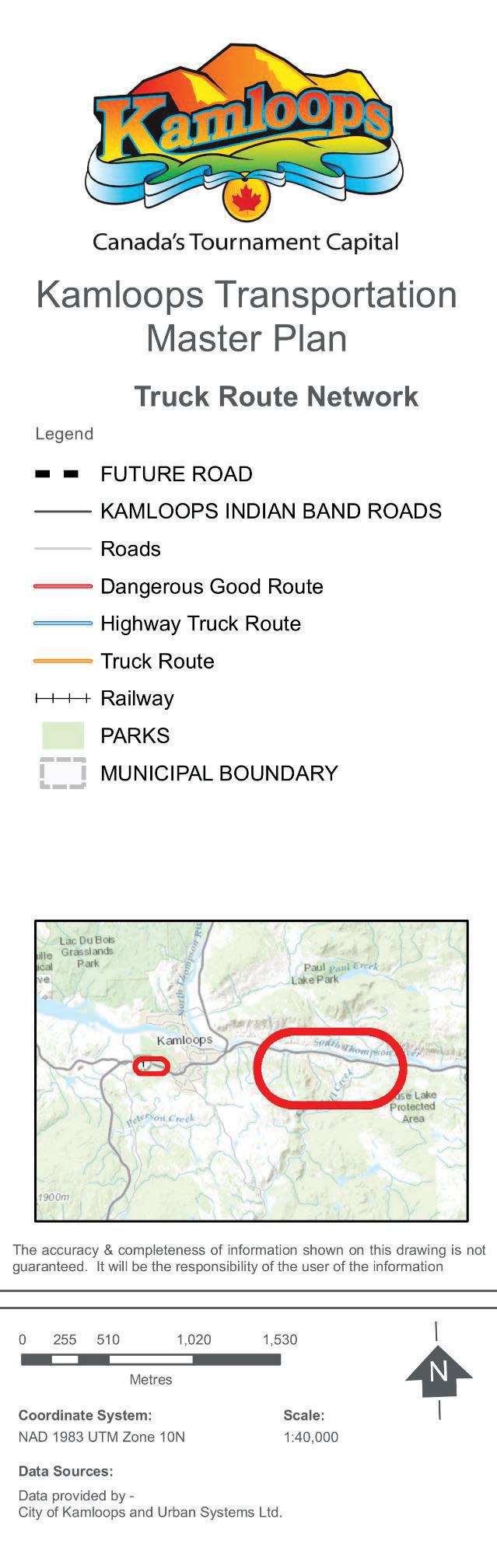
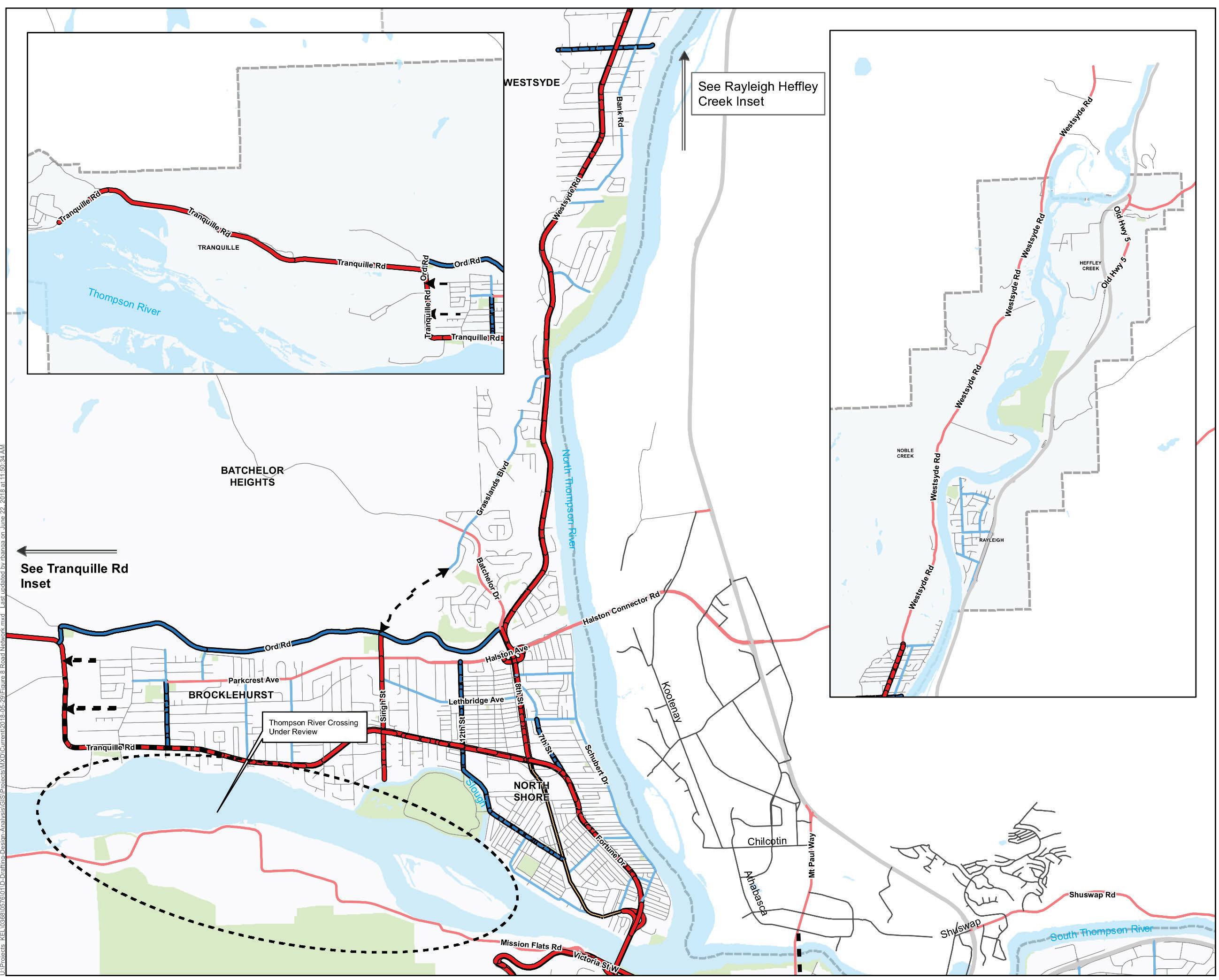
The Truck Route Map, which also identifies future road network connections, is provided on the following pages and in Appendix F
3.6 INTEGRATED TRANSPORATION SYSTEM
Maintaining a safe, efficient, and connected road network that supports all transportation modes will enhance mobility and quality of life for local residents. With a growing population expected to reach upwards of 120,000 residents by 2039, there will be increasing pressure on the road network to serve more people living and working in Kamloops. Building new roads and increasing roadway capacity enables the efficient movement of private vehicles, goods, and emergency services; however, these solutions are also resource intensive, and provide only short-term relief of traffic congestion. Aspects of the road network that relate to the sustainability of the transportation system are discussed specifically in Section 3.1 of this plan.
While sustainability challenges exist, it is important to recognize the value that the road network provides to the community. Kamloops has a total of 1,220 km of paved roads and 110 km of unpaved roads within the municipal boundary. Since the TravelSmart plan was adopted, the City has completed many major road projects, including the Hillside Drive extension, Highland Road expansion, Summit Drive expansion, Overlanders Bridge rehabilitation, and others. These projects have improved transportation conditions and have helped to ensure key transportation links are maintained.
A number of projects identified in TravelSmart were not started for various reasons, including project costs, funding sources, insufficient development, changing economic conditions, and shifting community needs and perspectives on transportation. These projects include the 6th Avenue extension, the Singh Street Bridge connection, and the Red Bridge replacement. In developing this plan, these previously identified road connections were reviewed and discussed through the stakeholder engagement process to determine how relevant they are to the TMP’s vision and goals. New road connections and improvement projects have been identified that support the same principles of the plan. The objectives, strategic directions, and actions in this section are intended to address the changing transportation needs of the community and to identify solutions to existing and future constraints in the road network system.
We heard the following key themes related to an integrated transportation system during the TMP public and stakeholder engagement process:
Current traffic delays, and even small increases in delays, are acceptable to Kamloopsians. 50% of participants feel that increases in traffic delays and road congestion are acceptable with many indicating that delays and congestion should be allowed to encourage uptake of more sustainable travel options.
A theme from the engagement process was that parkland should be protected from the development of roads.
Public participants proposed that the City monitor active transportation users similar to what is done with vehicles to enable better decision making and transportation investments.
GOAL:
OBJECTIVES:
Sustain the responsible planning and development of roads and transportation connections to facilitate the efficient movement of people.
1. Road network connectivity that supports local and regional mobility.
2. There is a balance between traffic congestion and mobility performance.
3. All systems integrate and work together to move people, goods, and services.
4. Roads adapt to accommodate the future.
Maintain connectivity with the provincial highway network.
Integrate community planning and road design with School District No. 73 to account for the unique transportation demands generated by schools.
Continuously evaluate and identify current gaps and deficiencies across all modes.
Avoid cul-de-sac designs in new growth areas as they hamper connectivity for sustainable modes, emergency services’ access, and efficient maintenance (e.g. garbage collection and snow removal).
Undertake planning, design, and construction of major road projects identified in this TMP and illustrated on the Major Road Network Map as they are needed to accommodate growth and changes in demand.
Complete identified road connections and leverage DCC funding to plan, design, and implement connections as development occurs.
Support local and regional mobility by continuing to maintain the integrity of local road connections with the provincial highway network, in particular for commercial, industrial, and goods movement.
Promote connectivity to TteS lands for all transportation modes.
Undertake studies to determine the location of a preferred corridor and crossing of the Thompson River to manage growth beyond 120,000 residents.
Encourage more residents to choose bicycle and walking modes to help alleviate traffic congestion on the network.
Adopt Level of Service (LOS)1 thresholds that foster a balance between efficient vehicle movement and the desire to facilitate mode shift to sustainable choices.
Maintain mobility performance to a LOS D or better for major road approaches at intersections, and by allowing minor road approaches to perform at LOS E or better.
LOS D or better on all designated truck routes.
Ensure, through development approval processes, that the design of new roads adheres to current design standards and supports the future transportation needs of all users in the community.
Review and update road design standards within the City’s Design Criteria Manual through evaluation of recent road design and construction projects to determine opportunities for revision
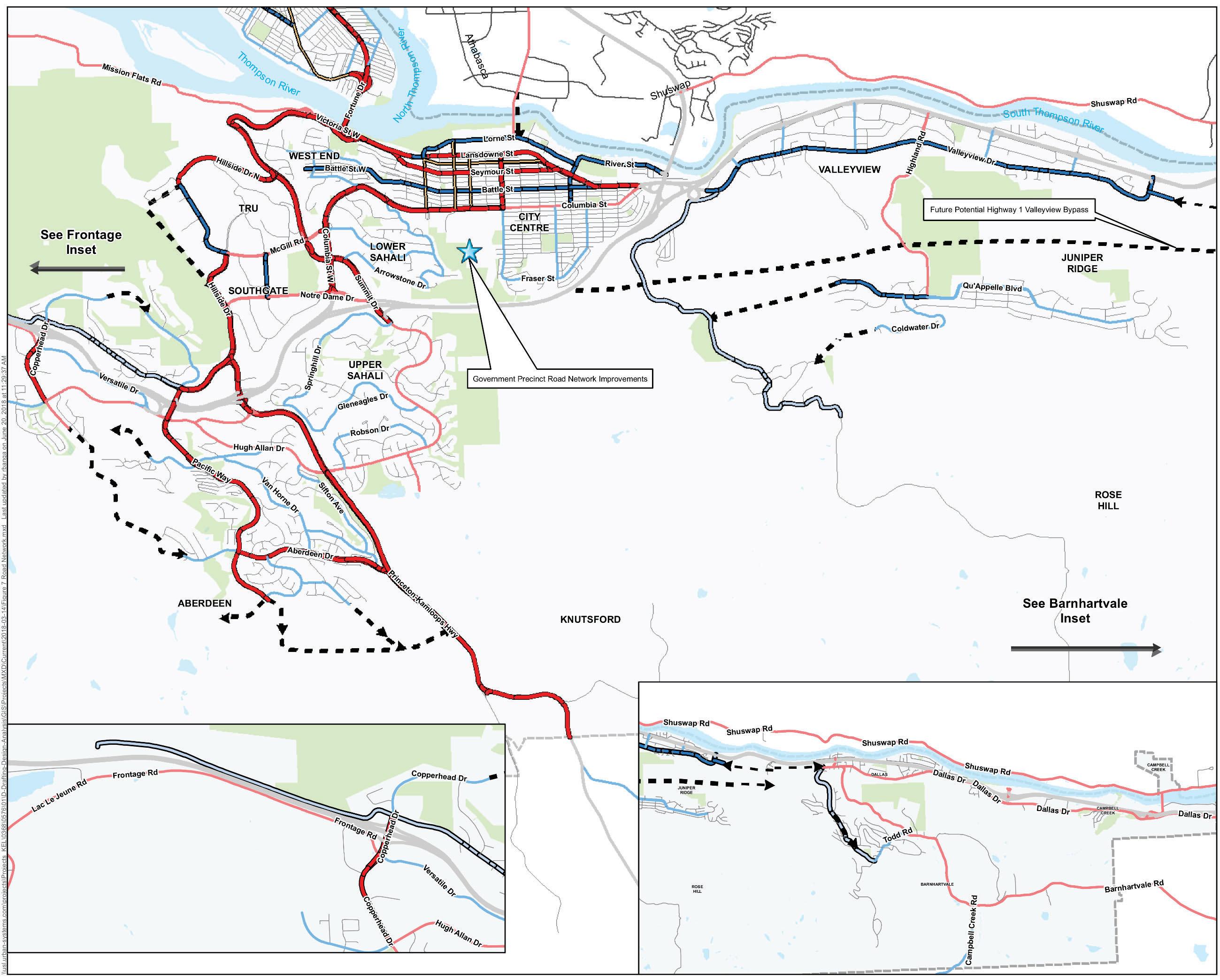
In addition, the Major Road Network Map (provided in the following pages) shows future potential projects under consideration. While no timeframe has been identified for these projects, they may be triggered prior to reaching a population of 120,000. These projects may include:
Valleyview bypass, as identified by the Province, on the bench lands between Valleyview and Juniper Ridge. The City will continue to work with the Province to understand the need for additional capacity improvements throughout the Southeast Sector.
Secondary bridge crossing the Thompson River. No additional river crossings are anticipated within the term of this plan, although upgrading and rehabilitation of existing bridges may be required. The City will protect an additional corridor across the Thompson River for growth beyond the 120,000 population. During the term of this plan, the City will undertake studies to confirm the location of the preferred crossing. (source: KAMPLAN pg D-19)
1Level of Service is a measure of traffic delay (in seconds) and ranges on a scale from A to F, with A providing drivers with an average delay of 10 seconds or lower and F providing drivers with an average delay of 80 seconds or more
Based on the goal, objectives, and strategic directions for Roads, the high-priority projects for implementation are summarized in Table 3.4. These projects were evaluated and identified as priority improvements as they support multiple goals of the TMP. Further description of how the various projects were prioritized is outlined in Section 4 of the TMP. Planning level cost estimates for Road Network projects are also summarized in Section 4 of the TMP and detailed for each project in Appendix G.
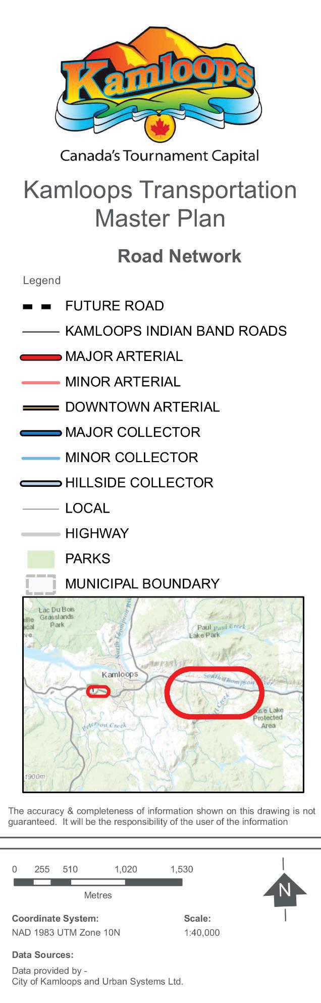
The Road Network Map, which identifies all road improvements, including the priority road projects, is provided on the following pages and in Appendix F.
Table 3.4:Summary of Priority Road Network Projects
Project Name
Major Road Projects
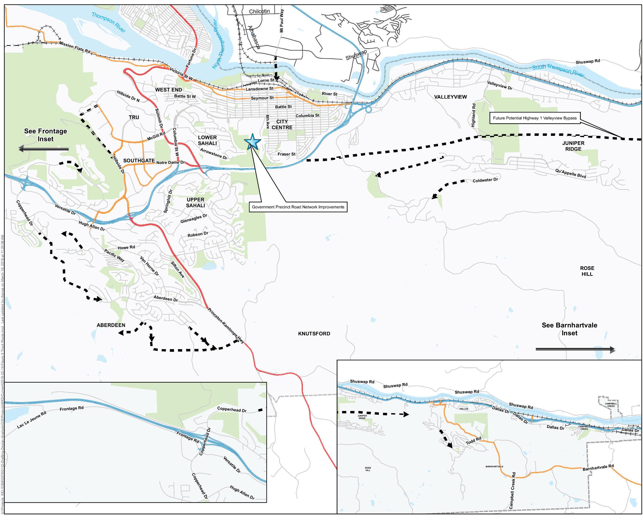
Government Precinct and City Road Network Integration
Aberdeen Drive Extension (Aberdeen to Copperhead)
Project Extents
Glenfair Drive to 6th Avenue
Avens Way to Aberdeen Drive
Thompson River Crossing (New Bridge) To be determined
Hillside Drive Extension
Copperhead Drive Extension to Pacific Way
Juniper Extension (Qu'Appelle Blvd) to Rose Hill Road
Pacific Way Extension to Highway 5A
Bentall Drive Extension
Bunker Road to Hillside Drive
Sunshine Court to Rockcress Drive
Galore Crescent to Rose Hill Road
Abbeyglen Way to Highway 5A
Facility Type
Site Road Network Redevelopment
Two-Lane Road Connection
Two-Lane Road Connection
Road Connection
Road Connection
Two-Lane Road Connection
Two-Lane Road Connection
Raeburn Drive to Highway 5A New Two-Lane Road Connection
4 TMP IMPLEMENTATION
Implementation of the TMP will be carried out through several measures and actions that help achieve the Plan’s vision and goals. Some TMP strategic directions relate to higher level planning documents and bylaws, including the OCP, Subdivision and Development Control Bylaw, Traffic Bylaw, and Zoning Bylaw. The TMP’s objectives and strategic directions will be considered when new developments are planned and capital projects are proposed and implemented.
Critical to the TMP is the formation of a capital improvement plan that details projects and funding requirements to successfully achieve the TMP’s vision and goals. This includes the identification of individual project segments, their attributes, and planning level cost estimates. A list of anticipated pedestrian, bicycle, transit, and road improvement projects are included throughout this document and an extensive list is included in Appendix H
Some of these projects may require the involvement of stakeholders or partners, including the City, BC Transit, Ministry of Transportation and Infrastructure (MOTI), Tk’emlúps te Secwepemc, School District No. 73, TRU, and other organizations. In addition to partnerships, financing and funding sources to help implement projects will need to be identified.
Implementation of the TMP’s road improvement projects is part of a broader City capital planning and annual budget approval process. Growth and development rates play a role in project prioritization and detailed project planning. The transportation improvement projects identified will be reviewed and integrated where possible within the City’s Five -year Financial Plan. Other capital infrastructure investments, such as rehabilitation and replacement of existing roads and other utilities, will also influence the City’s long -term capital plans and priorities for investment in transportation.
4.1 PROJECTS AND COST ESTIMATES
Preliminary planning-level cost estimates are prepared for each transportation project identified below and detailed in Appendix G. Generalized cost estimating procedures were used and do not include allowances for right-of-way, property acquisition, and utility relocations. Contingency allowances are included in each project estimate to account for engineering costs and costs for unknown constructability constraints. These estimates are high-level Class D estimates that provide an order of magnitude for the long term and will allow the City to evaluate its allocation of resources and to begin funding discussions with other partner organizations. These estimates are not intended for short-term capital planning. As the timeline for implementation of specific projects approach, the scope of work and estimates will be refined to provide more accurate budget numbers.
An overall summary of the TMP projects, phasing, and preliminary cost estimates for pedestrian, bicycle, transit, and road improvements is provided in Table 4.1. A detailed list of the projects and each
one’s conceptual planning-level Class D cost estimate, organized by improvement type and by the TMP assessed score, is provided in Appendix H
Table 4.1: Overall Summary of TMP Projects by Phase
Road Projects (non-phased)
Within the detailed lists of TMP projects, a TMP assessed score was provided for each project according to how positively or negatively it would impact the City’s ability to achieve each of the TMP’s goals. A simple five scale scoring system was used that would allow a maximum score of 12 if a project had a high positive effect for each goal. A guideline defining the value of each possible score is summarized in Table 4.2
2 Project has significant benefits, is in a high-need location, and directly helps with achieving the identified goal.
1 Project has benefits, is in a desirable location, and directly or indirectly helps with achieving the identified goal.
0 Project has neutral benefits, is in an average-need location, and does not help or hinder achieving the identified goal.
-1 Project has drawbacks, is in a less-desirable location, and directly or indirectly hinders achieving the identified goal.
-2 Project has significant drawbacks and directly hinders achieving the identified goal.
Table 4.2: Scoring System Applied to Assess TMP Projects
4.2 FURTHER STUDIES
The TMP strategic directions necessitate future studies to further investigate complex transportation issues and develop solutions. A summary of these recommended studies is provided in Table 4.3 below.
Table 4.3 Summary of Recommended Studies
Study Initiate by Study Purpose / Scope
Transportation Demand Management 2018
Future Thompson River Crossing Identification 2019
Review Downtown TDM policies and transportation plans, including bylaws and regulations, enforcement, and technology to support the goals of the TMP. Identify transportation demand management strategies for the Downtown that will directly support the objectives of the 2005 City Centre Plan (or its successor).
The Singh Street Bridge has been assessed in this TMP to align poorly with the stated Vision, Goals, and Objectives of the TMP, and it does not appear to be required within the horizon of KAMPLAN. However, a future Thompson River crossing for the long term is crucial, and this study should identify the preferred future crossing location to perm it the City to plan for and secure this future corridor.
Transit Future Action Plan 2019
Design Criteria Manual Updates
2020
Vision Zero Road Safety Strategy 2021
Truck Route Network Study 2023
The last update to the Transit Future Plan was completed in 2012, and many of the short- and medium-term actions have been completed. The plan envisions the transit network long term and describes the services, infrastructure and investments needed to get there.
Update the City’s road design standards to ensure standards support the goals of the TMP.
Develop an overarching vision and strategy for improving the safety of all road users and reducing road-based fatalities to zero by identifying and implementing tools, projects, and partnership measures.
Review and evaluate the truck route network to improve the movement of goods and emergency services while minimizing impacts to mixed-use and neighbourhood centres.
4.3 KEY PERFORMANCE INDICATORS
The long-term success of the TMP will be monitored by evaluating key performance indicators (KPIs) which have been developed for all of the Goals and Objectives described in this TMP. City staff can report on these measurements to City Council and the public to evaluate the level of progress that is being made to achieve the Vision and Goals of the TMP. It is important to note that a KPI does not necessarily provide the complete picture or measurable for a specific goal, nor does a KPI have to be a perfect measurement. What is important is that the data used for the KPI is reliable and repeatable, so it paints a clear picture of changes in performance. There must also be a clear and logical correlation between the KPI and the Goal or Objective it is an indicator for.
Each KPI has been assigned a Target that has been established to indicate meaningful progress in a positive direction. Targets that are defined as ‘Baseline Targets’ represent the existing baseline condition from which the City is working to improve. Some Targets have been set as ‘Aspirational Targets’, which means that they may not be realistically achievable within the life of the plan. The purpose of aspirational targets is to encourage creativity and innovation, which are of the core values of the City of Kamloops.
The following Table 4.4 describes the KPIs, their relevance to the TMP Goals and Objectives, the current measured value of the KPI, and the Target set for each. Note that many of the KPIs chosen are also KPIs, which will be used to track the implementation success of KAMPLAN.
The methodology for how each KPI and Target was measured and calculated is provided in Appendix I and should be used for future periodic progress reviews of the TMP Goals and Objectives.
Table 4.4: Summary of Key Performance Indicators – Kamloops Transportation Master Plan
KPI 1 – Percent share of employed labour force who walk, cycle, take public transit, carpool, or use other forms of sustainable transportation for commuting to work, as measured by Statistics Canada Census data (only provided every 5 years).
KPI 2 – Transit Ridership, as measured annually by BC Transit.
Target 1 – Increase share of travel to work by sustainable modes to 30% by a population of 120,000 (2039),
Target 1 Baseline: 20% (2016 Census Profile)
Sustainable Transportation
Walking Cycling Transit
Integrated Transportation System
KPI 3 – Percent of active transportation infrastructure length compared to total network length. Active mode infrastructure (sidewalks, multi-use paths, pedestrian shoulders, marked curb lanes, bike lanes, signed bike routes) divided by total transportation infrastructure length (active infrastructure length plus lane-km distance of asphalt roads).
Target 2 – Achieve annual ridership of 8 million at a population of 120,000 (2039), representing 5% mode share at 3.4 trips per day per person.
Target 2 Baseline: 3.5 million (2016/17)
Target 3 – Increase the percent share of active transportation infrastructure to 33% by 2039
Target 3 Baseline:
414 km of active mode infrastructure
1,168 lane km of asphalt roads
1,582 km total infrastructure
26% active transportation infrastructure (April 2018).
Sustainable Transportation Transit Integrated Transportation System
Sustainable Transportation
Walking Cycling Transit
Integrated Transportation System
KPI 4 – Municipal GHG emissions, as measured by the City’s corporate emissions inventory
Target 4 – Reduce to 4,600 tonnes of carbon dioxide equivalents per year (tCO2e/year) by 2020 with continued reduction in GHG emissions to 2039. (Note: Target under review through corporate emissions strategy)
Target 4 Baseline: Total 2016 tCO2e (excluding contracted emissions): 7665. Total 2016 tCO2e (including contracted emissions): 7955.
Sustainable Transportation
KPI 5 – Number of annual traffic collisions on Kamloops roads causing fatalities as per available ICBC collision data
KPI 6 – Number of annual traffic collisions on Kamloops roads (as per available ICBC collision data) per 1,000 population
Target 5 – Zero traffic collisions resulting in fatalities by 2039.
Target 5 Aspirational – Reduce traffic collisions resulting in serious injuries or fatalities to zero by 2039.
Target 5 Baseline: Five traffic collisions resulted in fatalities in 2016.
Target 6 – Maintain or reduce number of traffic collisions per 1,000 population.
Target 6 Baseline: 2,793 traffic collisions were reported on Kamloops roads in 2016. For a population of 90,280 people (2016 Census), this equals 31 collisions/1,000 people.
Sustainable Transportation
Walking Cycling Transit Goods and Emergency Services
Integrated Transportation System
Sustainable Transportation
Walking Cycling Transit
Integrated Transportation System
KPI 7 – Residential Growth: Percent of new housing units in each sector of the City based on building permits issued
2016: 8% Core, 18% North West, 0% North East, 30% South East, 44% South West.
Historical (2005 to 2016): 13% Core, 30% North West, 0% North East, 19% South East, 37% South West.
Sustainable Transportation
KPI 8 – Weighted average pavement quality index (PQI) per lane km of roadway on arterial and collector roads. PQI is a factor of surveyed asphalt road conditions that considers surface distress conditions, rideability, and structural durability with a maximum score being 100.
KPI 9 – Percentage of urban residential properties connected within 400m or less walking distance to a public transit stop.
Target 8 – Maintain or exceed an average PQI of 75
Target 8 Baseline:
550 lane kms surveyed (arterials and collectors only).
2012 survey PQI 80.1
2015 survey PQI 77.3
Target 9 Aspirational – 100% of urban residential properties connected within 400m or less walking distance to a public transit stop.
Target 9 – By 2039, 95% of urban residential properties connected within 400m or less walking distance to a public transit stop.
Target 9 Baseline: In 2018, 85% of urban residential properties in Kamloops are connected
Sustainable Transportation Transit Goods and Emergency Services
Integrated Transportation System
Sustainable Transportation
Walking Transit
Integrated Transportation System
Goal
KPI 10 – Annual crime rate, which is the number of criminal code offenses in the City per 1,000 people, as measured by the RCMP (2017 CSCS departmental annual report data, pg. 22.
within 400m or less walking distance to a public transit stop.
Target 10 – Decrease annual crime rate per 1,000 people.
Target 10 Baseline: Crimes vs person (1526), crimes vs property (7497) and other criminal code violations (3159) estimate 90,000 population.
= 135 crimes per 1,000 people (2017).
KPI 11 – Percentage of marked crosswalks with sidewalk letdowns for wheelchair user accessibility.
Target 11 – 100% of intersections with marked crosswalks to have letdowns for wheelchair access by 2039.
Target 11 Baseline: 89% (817 out of 915) of marked crosswalks have letdowns or do not require a letdown for wheelchair access (April 2018)
Sustainable Transportation
Walking Cycling Transit Goods and Emergency Services
Integrated Transportation System
Sustainable Transportation
Walking
Integrated Transportation
KPI 12 – Annual pedestrian and bicycle counts along routes that provide key connectivity
Target 12 – Annual increase in both bicycle and pedestrian usage
Target 12 Baseline: 335 pedestrians and cyclists per day crossing Valleyview Pedestrian Bridge (Summer 2013). Counts for additional major cycling or walking routes may be added in future.
Sustainable Transportation
Walking Cycling
Integrated Transportation System
KPI 13 – Number of routes where SmartBus technology is implemented
Target 13 – SmartBus technology is implemented on all transit routes by 2020
Sustainable Transportation
Transit
Target 13 Baseline: Zero routes with SmartBus technology out of 13 routes total (2017)
KPI 14 – Percentage of wheelchair accessible bus stops in the city
Target 14 Aspirational – 100% of bus stops in urban areas are wheelchair accessible
Target 14 – Increase the percentage of wheelchair accessible bus stops in the City annually
Target 14 Baseline: 70% (394 out of 561) are wheelchair accessible bus stops (April 2018)
Integrated Transportation System
Sustainable Transportation
Transit
Integrated Transportation System
KPI 15 – Level of Service (LOS) on truck routes, as measured by vehicle delay at intersections along truck routes during peak hour periods.
KPI 16 – Percentage of building structures in the city that are within the Kamloops Fire and Rescue (KFR) 10-minute response time
Target 15 – Provide a LOS D1 or better on identified truck routes
Target 15 Baseline: Truck routes currently have a LOS C
Target 16 – Maintain the percentage of building structures in the city that are within the KFR 10-minute response time
Target 16 Aspirational – 100%
Target 16 Baseline: 77.6% (April 2018)
Sustainable Transportation Goods and Emergency Services
Integrated Transportation System
Sustainable Transportation Goods and Emergency Services
Integrated Transportation System
1 Level of Service is a measure of traffic delay (in seconds) and ranges on a scale from A to F, with A providing drivers with an average delay of 10 seconds or lower and F providing drivers with an average delay of 80 seconds or more
KPI 17 – Average time duration of commute to work per person, as measured by Census data
KPI 18 – Traffic Level of Service (LOS) as measured by vehicle delay at intersections
Target 17 – Maintain average duration of commute time in Kamloops within 10% of the existing 19.9-minute commute time by the 2021 Household Survey
Target 17 Baseline: 19.9 minutes (Average of 2016 Census Household Survey Travel Time to Work)
Target 18 – Maintain overall LOS D or better at all intersections and all major approaches are LOS D or better. Minor approaches level of service E or better. (note exception for truck routes)
Target 18 baseline: Overall LOS C or better at all intersections and all major approaches are LOS D or better.
Sustainable Transportation Walking Cycling Transit Integrated Transportation System
Sustainable Transportation Transit Goods and Emergency Services Integrated Transportation System
KPI 19-Transit System Cost Recovery (percentage of operating cost recovered through fares) Reported by BC Transit Annual Performance Summary (APS)
Target 19: Be the top Tier 1 system in the province (excluding Whistler)
Target 19 Baseline: 37.3% as per 2016/17 APS was top Tier 1 system in the province (excluding Whistler)
Sustainable Transportation Transit Integrated Transportation System
KPI 20-Transit Productivity (Riders per Revenue Hour). Reported by BC Transit APS
Target 20: Be the top Tier 1 system in the province (excluding Whistler)
Target 20 Baseline: 34.6 as per 2016/17 annual performance summary
Sustainable Transportation Transit Integrated Transportation System
4.4 CLOSING
The TMP is intended to be a high-level transportation planning tool. Many of the ideas outlined build on and reinforce transportation planning goals from other City plans and policy documents. Moving forward with implementing the TMP is important for several reasons:
To inform and support staff and City Council’s decisions on transportation and land use matters for existing areas and new developments.
To promote a healthy and active community.
To help the City to work in partnership with local businesses, institutions, and government partners in making informed future transportation decisions.
To assist the City with preparing annual budgets and developing capital plans.
As previously mentioned, the TMP helps inform other plans and documents such as KAMPLAN, and it can also be informed by new direction provided by future City plans, policies, and decisions. The TMP is a living document and should be reviewed and updated every 10-15 years so that it can remain relevant to changing transportation and land use conditions.