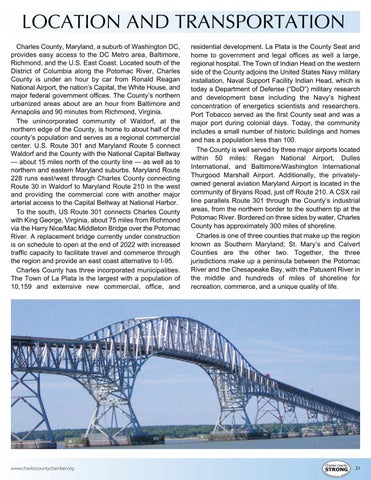
LOCATION AND TRANSPORTATION Charles County, Maryland, a suburb of Washington DC, provides easy access to the DC Metro area, Baltimore, Richmond, and the U.S. East Coast. Located south of the District of Columbia along the Potomac River, Charles County is under an hour by car from Ronald Reagan National Airport, the nation’s Capital, the White House, and major federal government offices. The County’s northern urbanized areas about are an hour from Baltimore and Annapolis and 90 minutes from Richmond, Virginia. The unincorporated community of Waldorf, at the northern edge of the County, is home to about half of the county’s population and serves as a regional commercial center. U.S. Route 301 and Maryland Route 5 connect Waldorf and the County with the National Capital Beltway – about 15 miles north of the county line – as well as to northern and eastern Maryland suburbs. Maryland Route 228 runs east/west through Charles County connecting Route 30 in Waldorf to Maryland Route 210 in the west and providing the commercial core with another major arterial access to the Capital Beltway at National Harbor. To the south, US Route 301 connects Charles County with King George, Virginia, about 75 miles from Richmond via the Harry Nice/Mac Middleton Bridge over the Potomac River. A replacement bridge currently under construction is on schedule to open at the end of 2022 with increased traffic capacity to facilitate travel and commerce through the region and provide an east coast alternative to I-95. Charles County has three incorporated municipalities. The Town of La Plata is the largest with a population of 10,159 and extensive new commercial, office, and
www.charlescountychamber.org
residential development. La Plata is the County Seat and home to government and legal offices as well a large, regional hospital. The Town of Indian Head on the western side of the County adjoins the United States Navy military installation, Naval Support Facility Indian Head, which is today a Department of Defense (“DoD”) military research and development base including the Navy’s highest concentration of energetics scientists and researchers. Port Tobacco served as the first County seat and was a major port during colonial days. Today, the community includes a small number of historic buildings and homes and has a population less than 100. The County is well served by three major airports located within 50 miles: Regan National Airport, Dulles International, and Baltimore/Washington International Thurgood Marshall Airport. Additionally, the privatelyowned general aviation Maryland Airport is located in the community of Bryans Road, just off Route 210. A CSX rail line parallels Route 301 through the County’s industrial areas, from the northern border to the southern tip at the Potomac River. Bordered on three sides by water, Charles County has approximately 300 miles of shoreline. Charles is one of three counties that make up the region known as Southern Maryland; St. Mary’s and Calvert Counties are the other two. Together, the three jurisdictions make up a peninsula between the Potomac River and the Chesapeake Bay, with the Patuxent River in the middle and hundreds of miles of shoreline for recreation, commerce, and a unique quality of life.
21


