People, Habitats, Species, and Governance:
An Assessment of the Social-Ecological System of La Parguera, Puerto Rico
Manuel Valdés Pizzini
Michelle Schärer Umpierre

Foreword
The origin of La Parguera as an important natural destination can be traced back to a small fishing village on the southwestern coast of Puerto Rico. Like with many other coastal regions, one’s first impression of the area is framed by its exposure to fair weather and gentle breezes, the clear waters that bathe its coral reefs and support a diverse wildlife, and its sense of place or what many have called “its magic.” While most everyone who has lived in or visited this very special part of Puerto Rico has likely seen it at different stages of its development, no one is without a unique story or experience that becomes more precious as time goes by.
From its humble beginning and through its relative modernization, particularly over the last 30 or 40 years, La Parguera has seen much change. Yet, many would agree it has retained that magical character. Its famous Phosphorescent Bay, lush tropical coastal marine habitats, and the marine lab of the University of Puerto Rico just a stone’s throw away off the main island. Its interesting mix of houses, hotels, and tourist stores and the myriad of recreational activities largely oriented around its incredibly diverse coastal environments. These are the attributes that make La Parguera not only unique to Puerto Rico, but to just about anywhere on this planet.
However, change in La Parguera has not occurred without its share of challenges. The marine resources that were once the source of income for subsistence, recreational, and commercial nearshore fishing are mostly gone. The once vibrant reefs and the stunning island shelf break offshore that once teemed with life and a seeming endless supply of many species of fish and shellfish have been impacted by overfishing and environmental degradation. Decades ago we thought the abundance of these resources, as in much of the area worldwide where coral reefs occur, appeared almost inexhaustible. We now realize how fragile these resources were in reality and the focus of La Parguera as a small fishing village has become somewhat of a distant memory.
Fortunately, there is increasing recognition of the importance of restoring the “ecosystem services” of the once vibrant and productive marine environments of La Parguera back to their previous state. The work synthesized in this report, reflects the dedication and hard work of professors and students, state and federal researchers coming together over a ten year period towards that goal. They have built upon 50 years’ worth of scientific knowledge of La Parguera to provide an accurate assessment of where its ecosystem stands today and help chart the path to recovery.
Restoring La Parguera will not be easy. The threats of overfishing, land based pollution, and recreational overuses, superimposed against the background of natural variability and climatic change, remain severe. However, we now know that La Parguera is still bathed almost constantly by clean oceanic waters that bring with them a supply of larvae of many of the species that were taken for granted not so long ago. If the insults are removed or minimized, the seeds of recovery are there. It is now up to us, the human dimension, to set aside differences and personal interests and focus on the one true goal, bringing the Parguera of our memories back. The unknowns are daunting and challenges will be many, but failure to act should not be an option.
Felix A. Martínez
Michael J. Dowgiallo University of Puerto Rico Alumni
documented for Puerto Rico (Pittman et al. 2010, Appeldoorn 2011), as well as for other areas of the Caribbean (Mahon et al. 2011).
A key objective of the CRES program was to integrate the diverse types of data and analyses on the coral reef ecosystem, to build a model of physical, biological and human (social) interactions in the ecosystem. In achieving that objective, the results of the funded research could provide a comprehensive portrait of the system’s functioning that could support the development and implementation of management strategies and actions, aimed at the conservation (or better yet, the ecosystem-based management) of the habitats and species of La Parguera, threatened by diseases (Weil et al. 2009), regional patterns of pollution and contamination (Pait et al. 2009), land-based sedimentation (Ramos 2010), resource use and extraction (Ault et al. 2008, Guénette and Hill 2009) and a diversity of stressors (Pittmann et al. 2010), all of which are also shaped by natural processes. Indeed, conditions of the La Parguera coral reef ecosystem are also the result of a historical process of resource utilization of the coast, and the ensuing systems of governance instituted in the region, as documented by CSCOR sponsored projects (Aguilar-Perera et al. 2006, Valdés-Pizzini 2009).
The CCRI provided the means for the analysis of the data collected by CRES, and CCRI—as well as other programs and initiatives on La Parguera—with the objective of integrating the data in a portrait of the La Parguera’s ecosystems, including the human activity on a historical scale. Such a challenge requires the development of a comprehensive overview of the system that includes: (1) a description and delimitation of the geographical are under analysis, (2) the description of the habitats and species, (3) a statement on the current status of the resources, habitats and biodiversity, (4) an analysis of the stressors that contribute to the current condition of the systems, such as the drivers, pressures and their impacts, (5) the historical trajectory of governance that responds to those drivers and pressures, and (6) a description and analysis of the human-environment interface.
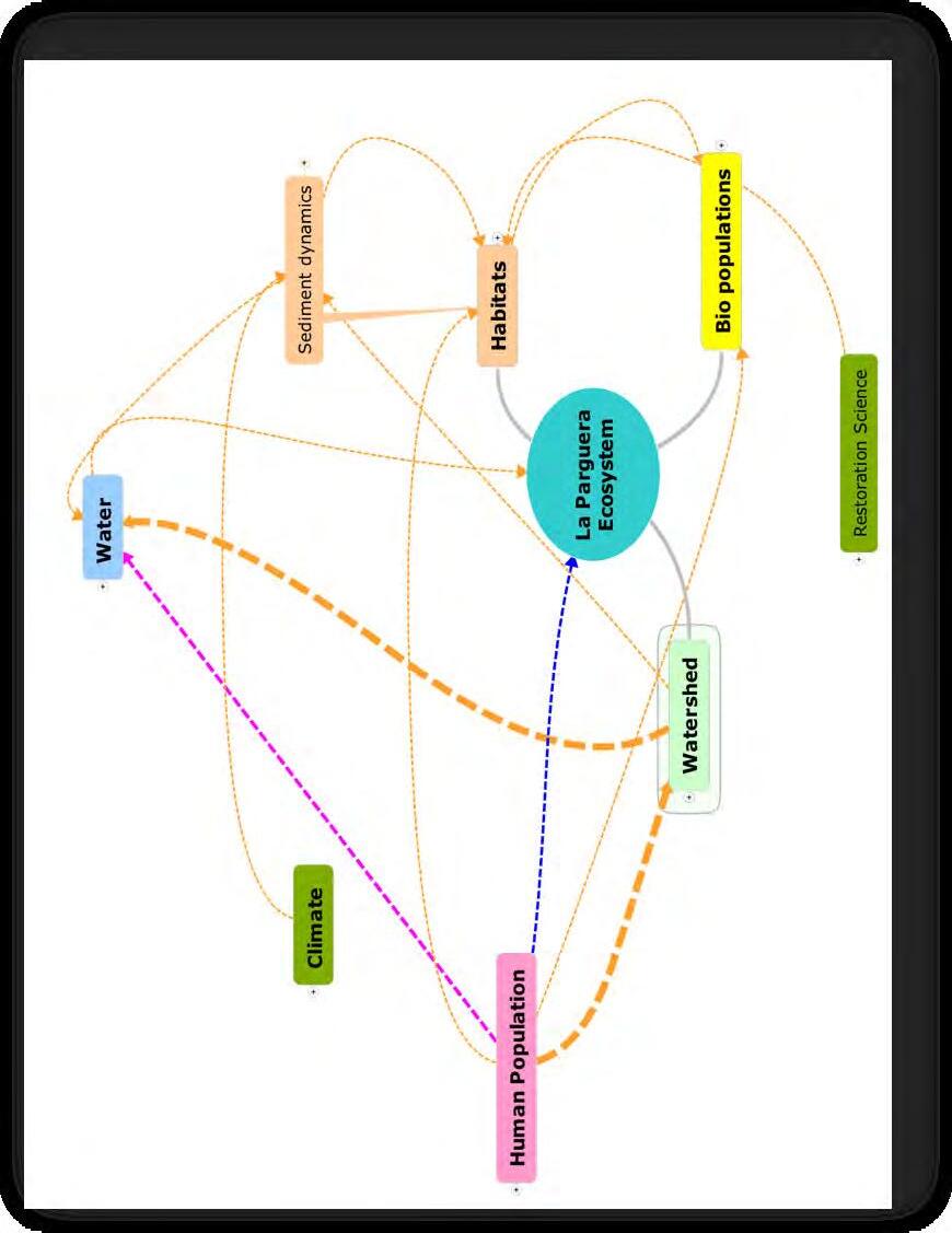
Our team approached the challenge by “building” an initial and descriptive “model” of the social-ecological system of La Parguera, taking as a guideline an array of variables and concepts discussed in the literature for the assessment of ecosystems (see Levin et al. 2008). In this report we are using the tenets of the social-ecological system outlined and discussed by Chapin et al. (2009) in their work Principles of Ecosystem Stewardship: Resilience-Based Natural Resource Management in a Changing World. We use the concept of social-ecological system as a toolbox that enables us to describe and analyze the system, starting with the size, shape and boundaries of the system, as well as the heterogeneity of habitats “mosaic of subsystems” that are the building blocks of the system (Chapin et al. 2009).
A social-ecological system also presents “cross-scale linkages”, that is, “processes that connect the dynamics of a system to events occurring at other times and scales” (2009). For example, governance in La Parguera is tied to the conservation policies of Spain and the United States (the Department of the Interior, to select a concrete example), that respond to a framework and guidelines devised in the 19th and 20th century, in places other than La Parguera.
A social-ecological system consists of physical components… organisms (plants, microbes and animals, including humans); and the products of human activities such as food, money, credit, computers, building and pollution. A socialecological system is like a box or a board game, with explicit boundaries and rules, enabling us to quantify the amount of materials (for example, carbon, people, or money) in the system and the factors that influence their flows into, through and out of the system (Chapin et al. 2009).
The methodological approach for the construction of this social-ecological system model consisted in an intensive and extensive data mining process that primed the information produced by CRES, CCRI and other NOAA projects, as well as the search and analysis of articles, reports (gray literature), management plans, thesis, and dissertations produced over the past 50 years or so. The mandate was to rely on already produced data, and to identify the research and data gaps that could contribute to a larger and deeper effort, such as an integrated ecosystem assessment. However, our team deviated slightly from that directive, and also seized the opportunity to analyze data already collected on the stakeholders’ perceptions on the status and conditions of the habitats, gathered socioeconomic data (employment and jobs), worked on the fisheries’ landing data provided by NOAA Fisheries’ Southeast Fisheries Science Center, and delved in the Puerto Rican archives for information on the history of La Parguera, and the governance strategies during the 1950’s and 1960’s. These actions helped explain the trajectory of the responses to drivers, pressures and impacts on the environment, that is, of the system’s path dependence, defined as the “Effects of historical legacies on the future trajectory of a system, or, more narrowly, the co-evolution of institutions and socialecological conditions in a particular historical context” (Chapin et al. 2009).
Scientific Data on the Habitats and Species
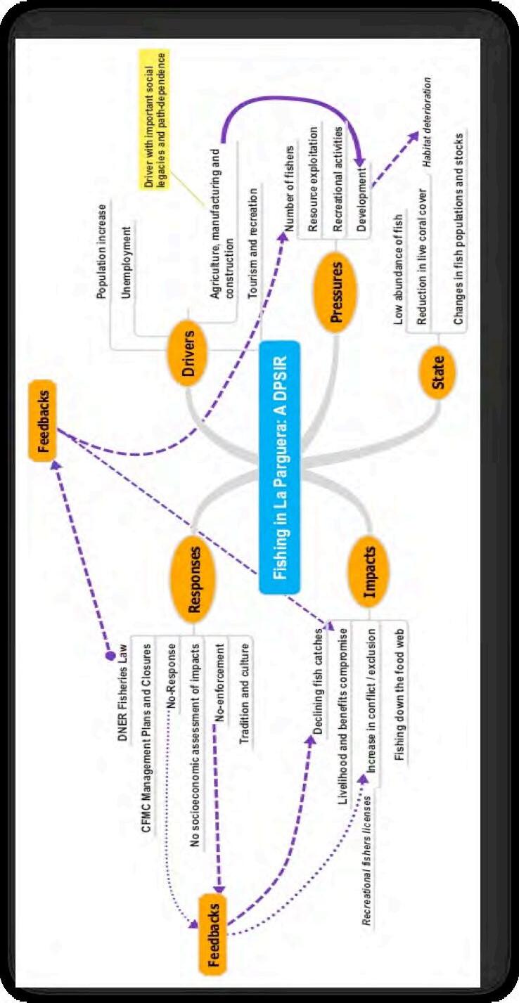
The wealth of scientific studies for La Parguera provide us with a glimpse of the different ways in which researchers have documented the characteristics of ecosystem (habitats, water quality and species), as well as the stressors and impacts on the environment’s health. Most of the studies we examined, including those supported by CRES and CCRI provide a general outlook on those variables, but do not account for fine grained documentation on indicators, and their attributes, or a quantitative correlation between human activities and specific impacts on the ecosystem. However, those studies provide, as stated before, a wide-lens perspective on a number of variables suitable for a cursory drivers pressures state indicators response (DPSIR) analysis.
Pittman et al. (2010) summarized the changes in La Parguera ecosystem, and the impacts of an array of stressors in the following manner:
“Multiple interacting stressors including sedimentation, nutrient runoff, elevated sea water temperature and fishing are changing are changing the structure and functions of coral reef ecosystems of La Parguera (García-Sais et al. 2008; Ballantine et al. 2008). Deterioration in water quality due largely to increased nutrients and turbidity as a result of landbased sources has been reported as a primary threat to nearshore coral reefs in South West Puerto Rico (Pittman et al. 2010).“
In addition, these researchers underscored the “impact” of the following variables and processes: (1) redistribution of sediments due to storm events, (2) the positive relationship between turbidity and coral cover (after Bejarano-Rodríguez 2006), (3) the role of diseases and bleaching in the deterioration of coral reefs, (4) the declining trends in the population structure of herbivores and predators in the system, (5) the reduction in the amount of fish and shellfish landed (after Matos-Caraballo et al. 2005), despite a reduction in the number of fishers, due to an increase in fishing pressure (Pittman et al. 2010, see also Ault et al. 2008 for an assessment of the unsustainability of the local fisheries).
Finally, in delving into this process we also decided to “translate” the mined data into maps depicting the complexity of the social-ecological system. For that process, we used the cartographic data on the submerged habitats of La Parguera produced by NOAA’s Biogeography group, and placed the information produced by this analysis in a geographical and ecological context, producing a view of the La Parguera’s seascape and its complex network of processes.
1.2 The People in the social-ecological system
The human agency, central to the analysis of the system (as a force that shapes landscapes and seascapes over time, and put into motion the stressors that contribute to the current status of the system), is also responsible for producing two critical processes: social legacies and social memory. Social legacies are “the lasting effects of past events affecting current conditions”, and social memory refers to “the collective memory of past experiences that is retained by the groups” (Chapin et al. 2009). Here we argue that the current system of responses to the current status of the system, the governance, is conditioned by the obstacles imposed by an adversarial legacy of contested visions and actions, among the stakeholders that is capable of derailing conservation efforts. Ironically, the social memory, interpreted as the knowledge built by humans and conceptualized as traditional and local ecological knowledge, also has the potential of contributing to the resilience of resource users and their communities, and could build the appropriate mechanisms for local collaborative forms governance, such as co-management.
In La Parguera, for example, fishers, and their network-based community (as opposed to a placed-based community, are threatened by social change and development, that take the form of coastal gentrification, or the displacement of the local population by new forms of living, social classes, and architecture (Brusi 2008, Griffith et al. 2007). In facing that pervasive process in all coastal areas of the United States and its territories (Jacob et al. 2010, ValdésPizzini et al. 2010), the fishers and local residents may be able to keep their coastal and piscatorial identity, through the local ecological knowledge they assembled and shared over three centuries (Valdés-Pizzini and García-Quijano 2009).
1.3 The stakeholders’ perceptions of the ecosystem: A methodological note on the Damage Schedule
The social-ecological system provides backdrop based on the notion that we are dealing with “complex adaptive systems” that “enable us to study the integrated nature of the system but recognizes legacies of past events and path dependence of human agency as fundamental properties of the model (Chapin et al. 2009). Such approach is also flexible in terms of the use (and value) of both, quantitative and qualitative data. Humans are an essential component of the system that also provides assessments (based on research, opinions, experiences, observations) of the status and conditions of the environment. In this document we use all the available information on the conditions of the habitats and species at La Parguera, but also include the perceptions of the stakeholders, in relation to those “habitats” impacted the most, and their stressors, through the use of the damage schedule technique developed by Ratana Chuenpagdee et al. (Chuenpagdee et al. 2001 a, b).
Consultation with stakeholders to identify a manageable number of variables and processes is essential to define the social-ecological system. Damage schedule allows us to have a clear view of the perceptions that the stakeholders have of the human activities that
impact the habitats and a ranking of those habitats and activities, as per their importance. We employed this method, devised by Chuenpagdee et al. (2001 a,b), and applied them to La Parguera. In this section we present the results of the damage schedule, indicating the habitats that the respondents felt were affected the most by anthropogenic activities, and a ranking of those activities, in order of importance. Data from the damage schedule is also used in the development of a composite of the conservation goals and objectives.
This method measured the perceptions of 121 stakeholders interviewed in La Parguera (2005-2006) regarding the impacts upon a set of habitat types and the threats that impact them. The damage schedule method utilizes a paired comparison to elicit a choice of which of the two options is most important in order to value judgments of local stakeholders that could be used to gauge the significance of potential environmental damage (Chuenpagdee et al. 2001 a,b). The first set of comparisons was specific towards choosing the most impacted or degraded of 7 habitat types (Figure 1). The second set of questions was designed to identify the activities that posed the greatest threat to marine ecosystems of La Parguera (Figure 2). The stakeholders interviewed for this exercise included permanent residents, business owners, scientific community, commercial fishers, and a group considered part of the ‘floating population’ of La Parguera.
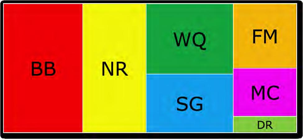
BB=bioluminescent bay
NR=near shore reefs
WQ=water quality
SG= seagrass
FM=fringing mangroves
MC=mangroves on keys
DR=deep reefs
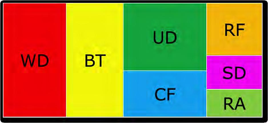
WD=waste disposal
BT=boat traffic
UD=urban development
CF=commercial fishing
RF=recreational fishing
SD=SCUBA diving
RA=research activities
design and implementation of policies and actions. Thus, governance is an inclusive process that incorporates policy and management activities, and we add, the science and knowledge that produce them. Such conceptualization of governance views it as “a widely practiced activity and a broad responsibility” among many potential actors (Ibid.).
Governance also comes in many forms and shapes. Kooinman and Banvick reduce the number to three fundamental options: (1) Hierarchical: a unilateral, top-down relationship between the State and the citizens, which is—and has been—the dominant mode in Puerto Rico and in La Parguera; (2) Self-governance: when actors rule themselves with little, if any, participation from the government, which may be the de facto form of governance in La Parguera, and (3) Co-governance: an ideal form for many stakeholders (see Mahon et al. 2011) in which the actors (from the private and public sectors) collaborate, and “join hands with a common purpose in mind” (Kooinman and Banvick 2005).
In assessing a social-ecological system, governance is essential, since it has to face the challenge of managing for environmental (ecological) and human (social) goals and objectives at unison. For example, in fisheries, governance must provide the tools and mechanisms for the conservation of populations, stocks and the health of the ecosystem, while procuring social justice, sustain livelihoods and employment, provide food security and safety (see Kooinman and Banvick 2005) and protect the social integrity and identity of coastal communities, as in the case of the United States (Valdés-Pizzini et al. 2010). Future actions (research, design and implementation of policies and regulations) for La Parguera must take into consideration the social legacy of governance, and an understanding of the path dependence, that is, the relationship between the current conditions and the history of contentions, as well as the human agency (actions) responsible for the current state of the ecosystem.
1.5 DPSIR: Drivers, Pressures, State, Indicators and Responses
The construction of a social-ecological system model requires a number of exercises and analyses, to understand the complexity of variables that shape the landscape and the seascape at different temporal and spatial scales. Here we use, as a framework, the identification of the DPSIR. This model was developed by the European’s Organisation for Economic Co-operation and Development (OECD), and quickly became a preferred tool to understand human actions and environmental impacts in a diversity of contexts (Mangi et al. 2007). Over the past 25 years a number of environmental organizations worldwide (e.g., The World Wildlife Fund and the World Bank) tested a number of conceptual frameworks to deal with environmental change, as a product of human agency.
In recent years, a number of scientists, practitioners and resource managers have taken the DPSIR framework as a useful tool to understand such processes in coastal, marine and estuarine habitats and ecosystems. The application of the DPSIR conceptual framework requires an interdisciplinary approach and methodology by which environmental and social scientists “jump together” into the analysis of the processes under review. A full-fledged DPSIR requires a sophisticated data gathering process, and even the design and implementation of field research activities to construct quantitative databases that sustain the indicators of the effects that pressures impinge upon the environment.
An integrated assessment of any ecosystem requires a well-laid, and funded, research program to identify and analyze the variables of the DPSIR, on different spatial and temporal
scales. However, in absence of that process, researchers and resource managers depend on the analysis of the available information, which seldom is gathered, constructed and analyzed in a manner appropriate for a full quantitative analysis of the indicators of the status of the environment. Another dimension of a DPSIR is the systematic consultation of the stakeholders to appraise their views on the ecosystem, namely: their knowledge, experiences and perceptions on the habitats under duress, the human activities that impact the biotic and abiotic conditions and dimensions, the root causes of those human activities, the different ways in which the impacts could be measured (via indicators), and the historical steps taken by society to respond to those environmental conditions. The consultation of the stakeholders must also provide researchers with their views on the goals and objectives for the ecosystem, which theoretically could set the parameters for the potential array of actions that could be taken by society to address the environmental issues identified.
As stated earlier, for this effort we did not engage in any data gathering activity, nor did we consult the stakeholders on any aspect related to the DPSIR, except for a brief participation in a DPSIR exercise for the Guánica watershed that connects with La Parguera ecosystem, and a panel consultation with CRES and CCRI researchers on the physical, biological and scientific (the existing literature) dimensions of the ecosystem. Also, we analyzed a previously collected data set, amenable for a Damage Schedule (Chuenpagdee et al. 2001 a, b). As a result, we have the analysis of 123 interviews that offer a proxy for the perceptions of most stakeholders (community members for the parcelas, marine science students, researchers, recreational service providers and visitors), on the most critical habitats that deserve the attention of the authorities, and the pressures impacting them. In addition, we extracted from the primary and secondary sources that we examined, the views of a number of stakeholders (scientists and community members) on the key problems impacting the ecosystem and the goals and objectives. While we do not have adequate source of information on the majority of the stakeholders of La Parguera, we do have—as a result of the CRES and CCRI projects—an accurate view of the fishers, through interviews with key informants with high levels of LEK, and information on the fishers and managers perceptions on the regulations and management practices, through a series of focus groups (Valdés-Pizzini and García Quijano 2009).
Unless heavily funded, most efforts to identify the key variables involved in a DPSIR are based on the examination of existing data (and its “adaptation” to the requirements of the framework), or the use of a small panel of experts to identify the variables and processes. Mangi et al. (2007) examined a number of published and unpublished sources—including anthropological studies—to identify the drivers and pressures impacting the Kenyan reef fisheries, and to describe the economic and sociocultural context of their predicament, and the indicators of their status (e.g. low coral cover, fishing down the food web, an increase in the population of coral boring sea urchins), the barriers to change, and the gaps in the information (Mangi et al. 2007). The study also identified the policy actions (legislation, regulations, outreach programs) in response to the decline in the stocks (Mangi et al. 2007). Rehr et al. (2012) applied a “decision support framework for science-based multi-stakeholder deliberation” in the case of Florida coral reefs. Researchers used a panel of experts (n=9) to elicit the information needed to apply the DPSIR conceptual approach to the Florida Keys. A more comprehensive analysis is expected with the incorporation of a larger number of participants representing the diverse stakeholders (Rehr et al. 2012). In our case, we used a variety of sources, and explored the perceptions of a larger number of stakeholders through data already collected by the CCRI and CRES projects. In the future, a more precise integrated assessment of the La Parguera ecosystem will require a systematic study of all the stakeholders.
Goals:
1) The protection and conservation of the biotic and abiotic components and resources of La Parguera for the benefit of the environment; that is, the natural and socioeconomic components of the social-ecological system.
2) The open access to La Parguera’s natural resources with minimal, but effective, intervention from government agencies (Federal and Commonwealth).
Objectives:
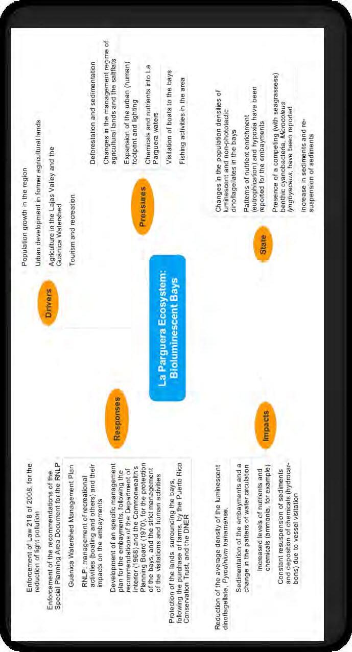
1. To protect the integrity of the bioluminescent bays1
2. To protect coral reefs.2
3. To develop and implement a resource management system that includes the input of the stakeholders and respects the recommendation of the users 3
4. To protect the fishery resources while allowing sustainable catches of commercially important species 4
5. To develop and implement no-take zones in La Parguera5
6. To avoid the implementation of no-take zones in La Parguera 6
7. To develop and implement a plan for the conservation of coastal and marine resources in a manner that protects the economic integrity of stakeholders 7
8. To allow the continuation of the stilt houses (casetas) in a sustainable manner and their contribution to management through fees 8
9. To eliminate the casetas and restore the patrimony of the maritime zone9
10. To develop and implement an educational plan for La Parguera residents and stakeholders on the ecosystem and the importance of conservation 10
11. To enforce environmental regulations in a democratic manner that takes into consideration malpractices in the terrestrial area, as well as in the coastal-marine area
1 Documents of the Department of Interior and the Puerto Rico Conservation Trust.
2 Damage Schedule Report.
3 La Parguera, armonía entre mar y tierra. A pilot plan for the management plan. April 20th, 2007.
4 Interviews with fishermen. Focus group with local fishermen, June 22, 2004.
5 La Parguera, armonía entre mar y tierra.
6 Meetings and interviews with fishers. Case studies discussed in Valdés-Pizzini 2009, CRES Report,
7 La Parguera, armonía entre mar y tierra.
8 Ibid., Colón Carlo (2005).
9 Meeting with fishermen from Pitahaya to Guánica, May , 2009.
10 Ibid.
12. To reduce the impact of boaters and resources users on the cays and coral reefs through a mooring system and the selection of an area for heavy use11
13. To restore the littoral area for aesthetic and conservation purposes12
14. To improve the water quality of the neritic zone through controls of the disposal of wastewater and reduction of sediment loads 13
15. To incorporate stakeholders into the design and implementation of management plans (conservation, education, research) for La Parguera 14
16. To protect the integrity of the Special Planning Area, through planning, law enforcement, and implementation of regulations and conservation programs that limit development in the area 15
11 Otero and Carruba 2006, Vicente et al. 2008.
12 Plan de Manejo del Área de Planificación Especial de La Parguera.
13 Krausse 1994,
14 Valdés-Pizzini 1990, Fiske 1992, Krausse 1994.
15 Ponencia ante la Asamblea Municipal de Lajas, del Comité Vecinos Unidos de La Parguera. October 1, 2001.
Chapter 2 – A Timeline of Human Interactions: The Shaping of the SocialEcological System
2.1 Geographical Setting
The southwestern coast of Puerto Rico is characterized by coastal plains at the southern extent of the westernmost tip of the ‘Cordillera Central’ or central mountain chain. The southwestern coastal municipalities range from Cabo Rojo on the western extreme to Ponce. Three municipalities make up the southwestern most corner of the island (Cabo Rojo, Lajas and Guánica). These areas are part of a coastal ecosystem corridor that extends eastwards from the western coast of the Cabo Rojo municipality along the southern coast of the island (Figure 3).
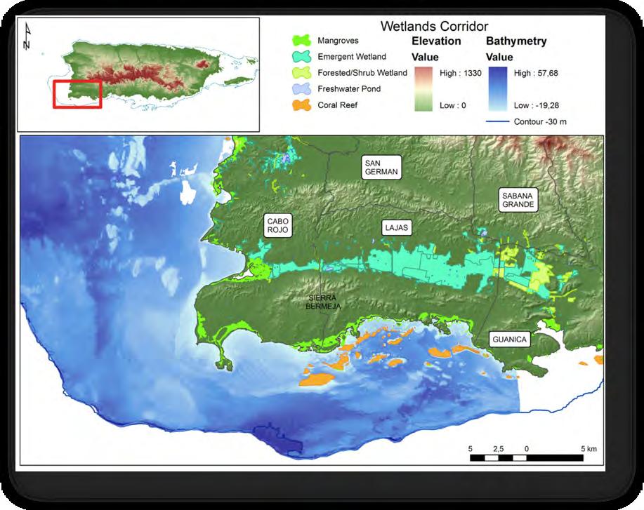
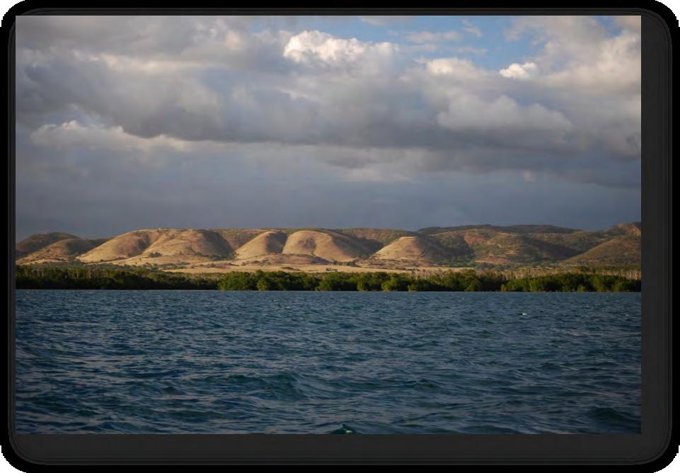
The low hills of the Sierra Bermeja “vermillion hills” (Figure 4) formation extend from Cabo Rojo to Lajas and separate the south facing coastal plain from low-lying areas to the north. Sierra Bermeja covers approximately 1,537 ha (15.37 km2) with elevations ranging from 15 m to 301 m above sea level, and lies on 195 million-year-old serpentine rocks considered the most ancient rocks of the Caribbean plate (Montgomery et al. 1994). Red-ribbon chert rock is abundant and gives Sierra Bermeja its name due to the reddish tinge of the terrain. To the north of Sierra Bermeja the Lajas Valley includes a variety of habitats including wetlands as well as areas of intensive agricultural use. The wetlands compose a drainage corridor that connects the now extinct Guánica Lagoon with the Lajas Valley and exit into the Boquerón Bay
in Cabo Rojo. These wetlands serve as critical habitat to a variety of aquatic and migrating bird species threatened by different factors including habitat loss and degradation, housing and industrial development, invasive species such as patas monkey ( ) and rhesus macaque ( ), soil and water pollution, diversion of runoff, and human disturbance (Méndez-Gallardo and Salguero-Faría 2008).
This study focuses on the coastal ecosystem of La Parguera, which extends beyond the Lajas municipality coastal limits. This ecosystem is composed of the habitats that occur on the areas south of Sierra Bermeja including areas of the Cabo Rojo and Guánica municipalities as well as the complete Lajas coast. The terrestrial area is characterized by soils of volcanic origin, a limestone formation, and the presence of xerophitic vegetation dominated by low precipitation and high temperatures. It is located within the subtropical dry forest life zone, with an annual rainfall of 600-1,100 mm (Ewel and Whitmore 1973). Despite a general pattern of low precipitation, heavy rains and tropical storms have a direct impact on the soils by eroding and transporting sediments and nutrients to the coastal habitats and waters. Some of the terrestrial habitats found in this area are forested with dense woodlands including secondary forests, ravines with higher stands of vegetation, open areas of low-density woodlands consisting of current and abandoned cattle pastures as well as intermittent ponds used in cattle-ranching activities (Aukema et al. 2006). Adequate vegetation cover on steep slopes (the most susceptible to erosion) and along riparian corridors reduces the effects of flooding and protects soils from erosion. Because the terrestrial areas north of the coast are under a dry and seasonal precipitation regime, soils do not absorb large amounts of rain quickly, which can cause flash floods and erosion.
The watersheds facing south towards La Parguera have the potential for generating increased sediment loads towards the wetlands and submerged habitats due to their land use and development (Hertler 2002). Sediment cores taken from La Parguera Bay demonstrated a significant increase; almost double the sediment settling rates, over the past 70 years (RyanMishkin et al. 2009). Sediment production rates were measured on unpaved roads in the La Parguera watershed by (Ramos 2010), and results demonstrate that sediment production rates on roaded surfaces in La Parguera are 15–50 times higher than analogous undisturbed surfaces, and changes in vegetation cover also might have played a role in declining sediment production. The conclusion of this study was:
“In a sub-tropical semi-arid to dry climatic region like La Parguera, rainfall appears to play a paradoxical role in controlling surface erosion rates on abandoned road surfaces. While ample rainfall is needed to generate erosion by rain splash and overland flow, it appears that once rainfall satisfies the soil moisture required for vegetation recovery it also may contribute to declining sediment production rates.” (Ramos 2010)
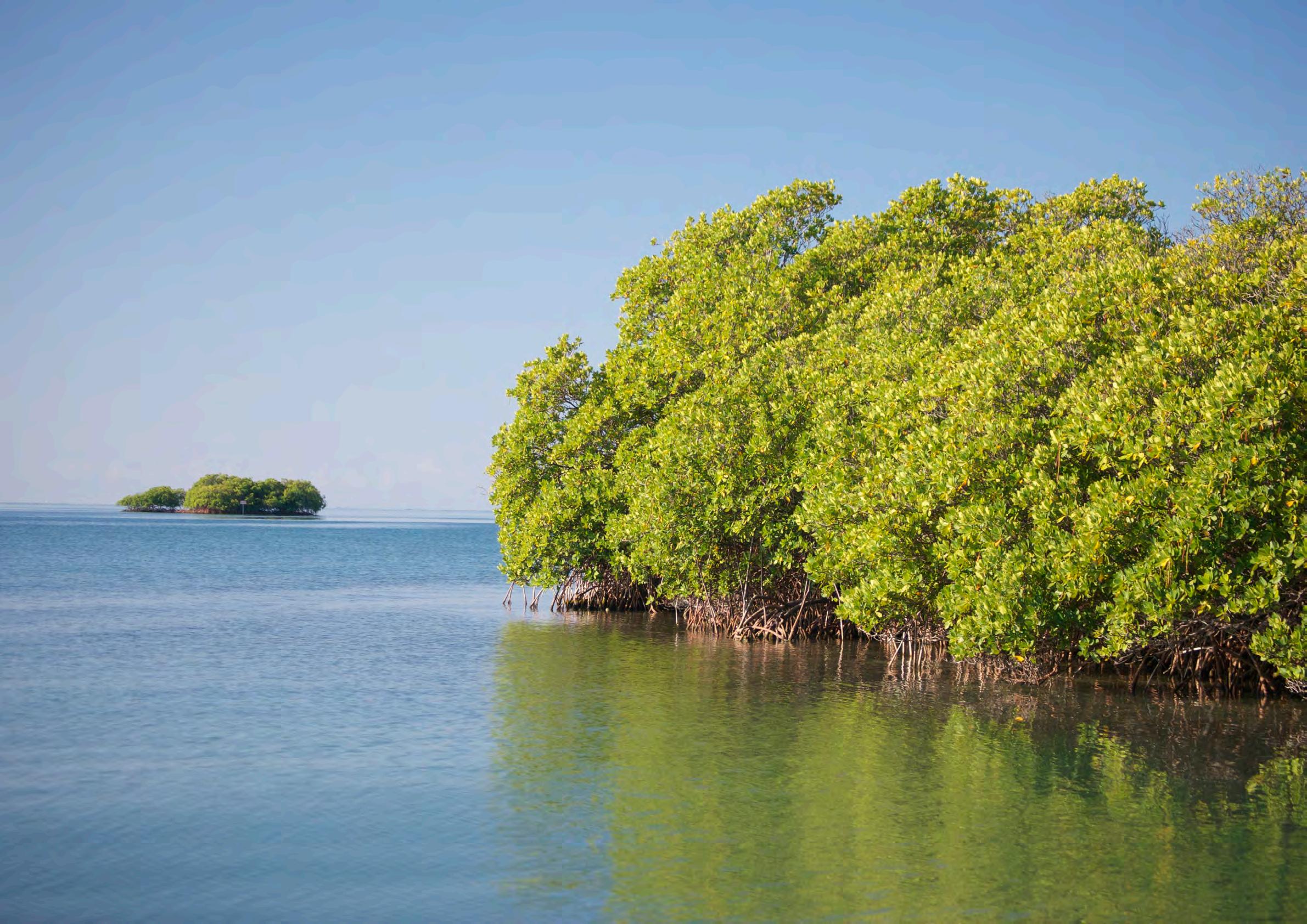
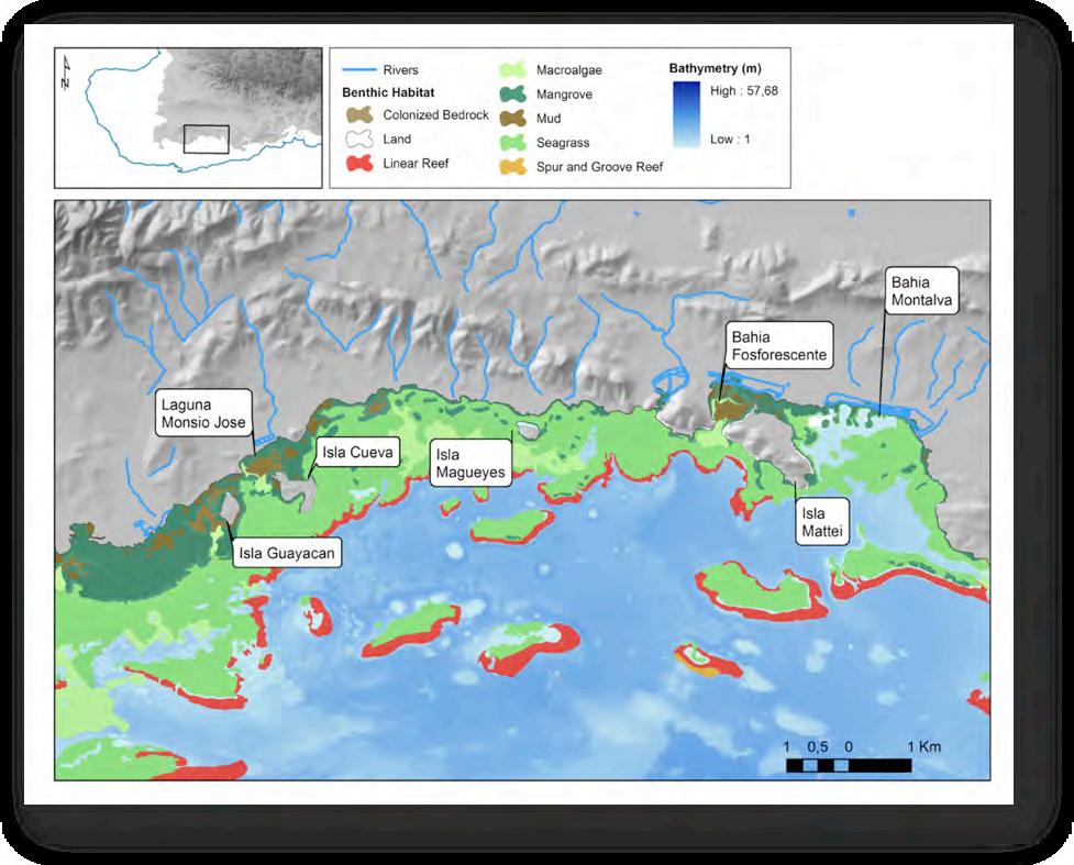
The Lajas coastline extends approximately 33 km with marine habitats that include fringing mangroves, seagrass, and macroalgae, as well as offshore coral reefs with emergent rubble, sand, and mangrove keys. Three relatively large rocky islands are located off the southern coast of Lajas including Mattei Island towards the east, Magueyes Island near the La Parguera center, Guayacán and Cueva Ayala Islands towards the west (Figure 5). Various natural embayments are part of this coastline such as Bahía Montalva towards the eastern part of Lajas, the bioluminescent bay (Bahía Fosforescente) as well as Laguna Monsio-José and other mangrove lined narrow bays at the western extreme. These bays are shallow and composed of fine sediments in close proximity to the shoreline and generally lined by submerged red mangroves. Laguna Monsio-José is part of a mangrove lined waterway or passage parallel to the coast that exits at Pitahaya, Cabo Rojo. The insular shelf on the southwestern extreme of Puerto Rico (between Cabo Rojo and Guánica) extends between 5 and 11 km from shore with submerged habitats that include a fringing mangrove forest, offshore mangrove keys, seagrass, macroalgae plains, coral reefs and hardbottom habitats as well as shelf break zones that descend to 1,000 m.
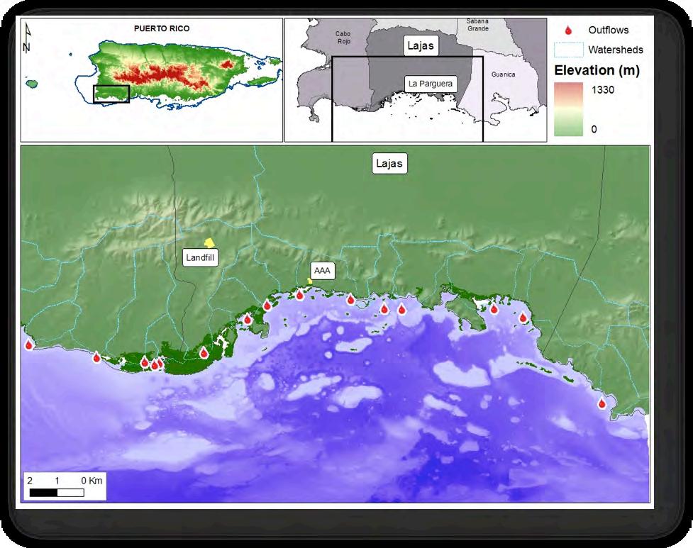
Few rivers discharge directly into the Lajas coastline and most creeks and canals are intermittent (Figure 6). Various man-made hydrological control canals remain from salt production activities near mangrove lagoons and salt flats, the most prominent of which are located in Salinas Fortuna east of Papayo. Another source of water is the waterworks plant (Autoridad de Acueductos y Alcantarillados or AAA) that is located on the coast towards the west of La Parguera. This system collects wastewater from the housing developments and houseboats within La Parguera, and discharges secondary sewage effluents into the mangroves. However during high visitation seasons, the system overflows and sewage enters the coastal waters untreated. The residences that are not connected to the wastewater treatment plant are most likely relying on septic tanks for their water waste disposal. This water treatment plant is supposed to be replaced by a pump to move water to a facility with greater capacity that is currently being constructed in the Lajas Valley, although the extent of treatment and disposal of effluents from this new site is unknown.
The coastal townships (barrios) for the coastal counties are depicted in Figure 7. La Parguera is the main coastal town located on the southern shore of Lajas, and a secondary smaller coastal town, El Papayo, is located further east (Figure 8). Most of the urban development near the coast is located in La Parguera and consists of concrete residences, multi-story buildings and townhouses.
2.2 Historical Background
La Parguera was a marginal socioeconomic area in the nineteenth century; a sort of cul-de-sac separated from Lajas Valley by the low hills of Sierra Bermeja, with minimal economic activity except for mangrove cutting for charcoal production and salt production. In the twentieth century, sugar cane production in the nearby areas stimulated an increment in the population of rural workers in the area. The municipality of Guánica, to the East, became a central hub for the processing of sugar cane, as most of the land in the surrounding municipalities (Sabana Grande, San Germán and Cabo Rojo) started to produce sugar cane in large quantities. The local population sustained themselves with small agricultural plots; work in the salt ponds and sugar cane fields, and raising pigs and goats, as well as fishing.
In the 1950’s the government of Puerto Rico promoted La Parguera as a tourist destination, underscoring the beauty of the seascape and the bioluminescence of the embayments. Land reform policies in the 1950’s removed the poor and landless rural workers from the shoreline. The government resettled those families in homestead communities, or parcelas” (a land parcel) as they are locally known. With the shoreline cleared of “shantytowns”, middle and upper class families claimed the shoreline as their leisure space, initiating a pattern of stilt-houses (or casetas) among the fringing mangroves. The casetas have been at the core of managerial, conservation, social and economic conflicts and disputes over the last sixty years; a conflict that is also central to the perceptions and judgments of the desirable state of the ecosystem. Over the last 30 years, La Parguera and the surrounding areas have become a highly gentrified area, with the development of sub-divisions and several tourism and recreational projects.
The report of the socioeconomic component of the CRES program features a detailed analysis of the historical and political processes that shaped La Parguera, including the development of MPAs in the area (Valdés-Pizzini 2009). This report explores further the process of governance. It is in this historical and geographical context that the reader must appraise the varied and complex social processes that contributed to the formation of MPAs in La Parguera and structured the system of governance.
2.3 Governance
A. History of MPA Designations
Historically, coastal areas of Puerto Rico have been considered important for conservation since May 28, 1918 when the islands, then governor, Dr. Arthur Yager, proclaimed mangrove swamps of public domain as Insular Forests. The justification for this designation came about because there was a need to preserve mangroves due to intense charcoal production practices. This was the first protective measure that was applied to the coastal resources of La Parguera and the island (Administrative Bulletin 143, 1918). Rexford G. Tugwell, a subsequent governor, added additional areas of La Parguera to the Insular Forest on January 15, 1943. The near shore islands of Guayacán and Cueva Ayala located west of the main town are surrounded by mangroves and were considered nonagricultural and more useful for forestry use (Administrative Bulletin 830, 1943). These Insular Forest designations as well as the establishment of the Puerto Rico Forestry Service were based on the 1917 Forestry Law (Law 22, 1917). The Puerto Rico Legislature created a Forestry Law in 1975, which applied to all the forests of the island (Law 133, 1975). The law stated the importance
in conserving forests for their “products, services and utilities” and specified that the Puerto Rico Department of Natural and Environmental Resources (DNER) would manage these areas in the name of the Freely Associated State of Puerto Rico and the Forestry Service of Puerto Rico would form part of the DNER.
Protected areas outside the forestry designations were designated by the Planning Board resolutions (Aguilar-Perera et al. 2006). In 1978 the Planning Board approved the Coastal Zone Management Program by Resolution PU-002 that proposed the designation of 26 areas as Natural Reserves (NR), among which was La Parguera (Resolution PU-002 2nd Extension, 1979). According to the map included in the Resolution, the extension of La Parguera Natural Reserve (LPNR) was 1 km towards the north from the coastline (terrestrial limit) and 3 nautical miles seaward to the south (maritime limit). The designation included the offshore keys and reefs of Lajas as well as some of the fringing mangroves of Cabo Rojo and Guánica.
The first amendment to Resolution PU-002 (2nd Extension, 1979) was drafted in 1986 specifically for La Parguera in which the NR area was extended longitudinally. The amendment resulted in the expansion of the LPNR to include the westernmost mangrove key at Punta Pitahaya, Cabo Rojo to Punta Jorobado, in Guánica towards the east. This designation overlaps spatially with the Boquerón State Forest designation that includes all mangroves from Cabo Rojo to Lajas. However, this extension did not adopt the buffer zone for LPNR of 1 km towards land (north), proposed by the DNER.
Another designation over the areas of La Parguera is the Special Planning Area (SPA) of the Southwest of Puerto Rico, La Parguera Sector. The management plan for this SPA was adopted by the PR Planning Board as (P.U. – 002 on October 25, 1995), and approved by the governor as Executive Order (OE-1995-75 on December 5, 1995). Subsequently there was an amendment to the boundaries of the LPNR in which the southern limit was extended seaward from 3 to 9 nautical miles from shore. This modification was submitted by the DNER and approved by the Planning Board (PU-002-98-57-01 on May 14, 1998).
Finally, the lands surrounding the Bahía Fosforescente located to the east of the main town were included into the LPNR designation by amendment to the Planning Board resolution (PU-002-2000-57-01 in 2000). This included four terrestrial lots (Botoncillo, Salinas-Fortuna, La Julia, and Matos Zeno) and the island Isla Mattei, surrounding the main bioluminescent cove, Bahía Fosforescente (Figures 10 and 11). This extension added 633 acres to the LPNR and includes the coastal area of salt works of Salinas Fortunas that are currently managed by the Puerto Rico Conservation Trust.
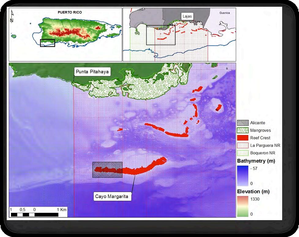
Within the LPNR, a submerged area approximately half a mile from shore was designated (August 27, 1998) as an underwater archeological site (Figure 13). The area was designated due to the presence of the Alicante shipwreck of 1882 (Fontánez-Aldea 2007). This 200 ft. long Spanish sail and steamboat of Scottish construction was en route from Cuba to St. Thomas when it ran aground on the western end of Cayo Margarita, an emergent reef near the shores of Lajas. Posterior to the grounding there was a salvage operation of engine and vessel parts.
In the 1960’s the Department of the Interior (DOI) of the United States prepared a report on the bioluminescent bays of Puerto Rico, which gave La Parguera prominence. The report was sparked by an article in the National Geographic published in 1960, which “brought national prominence to the remarkable Bahía Fosforecente near the village of La Parguera” (US Department of Interior 1968). The bioluminescence was highly regarded and recognized by scientific organizations, and then there was an urgent need to protect that peculiar and highly valuable resource. Highly valuable (dubbed as an “extraordinary feature”) due to its role in attracting the public (both local visitors and tourists), the bay became an important natural attraction and the source of many businesses that persist in the area.
The National Park Service (NPS), one of the key agencies of the Department of Interior, produced the report on the bioluminescent bay of La Parguera in March 1960 and concluded that the area was threatened by the deterioration of the environment. These were critical years in the economic development of Puerto Rico, and the conservation and preservation of the bioluminescent bays “took a back seat” in the government agenda, until the Planning Board requested the DOI to develop a comprehensive plan for the preservation of the bays. A number of government officials and scientists participated in the development of the plan, but most prominently, Howard T. Odum and Juan Gerardo González-Lagoa. Based on their findings, the authors of the DOI report stated the urgent need to establish a conservation program to protect the bioluminescent bays of Puerto Rico “from the forces of environmental deterioration” ( US Department of Interior 1968). The report presents three alternatives to the conservation of the embayments, based on the following set of guiding principles: (1) the public appreciation of the bioluminescent is the main goal, and thus, the long-range preservation of the bays must be achieved; (2) such preservation requires the strict control and the conservation of the adjacent water and land-based areas; (3) water skiing, swimming, and motor boating must not be the dominant activities in La Parguera, and therefore, must be encouraged in other areas, such as Cabo Rojo.
The conservation strategies indicated and supported by the DOI were as follows: (A) commonwealth (territory) control of the watershed areas, with strict zoning and regulations to prevent threats to the health of the ecosystems; (B) protection of the marine habitats contained in the waters from Pitahaya to the West to Guánica Bay to the East, as well as the ownership or firm zoning control of the coastal strip of land in that area; (C) elimination of sewage disposal through sewage treatment technologies, and the removal of houses not connected to the recommended system; (D) control and limitation of lighting; (E) banning of fishing in the embayments; (F) restoration of the conditions of Monsio José and the damages done to Isla Cueva; (G) use of electrical motors by the tour boats; and (H) development on an aggressive research plan to understand the physical, chemical and ecological dynamics of the embayments.
The DOI report also tackles the problem of the excessive use of the cays and coral reefs, a key element of the landscape and seascape that are connected to the health of the bays and other habitats. In order to protect the embayments, there was a need to also protect the reefs. The recommendations of the DOI for the future of the conservation (preservation, as indicated in the document) of coral reefs in La Parguera reads as the prospective history of the forthcoming processes, and the acknowledgement of enforcement, as the weakest link in resource management.
The experience and trajectory of the NPS in managing properties for a multiplicity of purposes, and their goal of providing the public with recreational opportunities and education (in terms of nature, history and culture), becomes evident in the report’s emphasis on signage, interpretation and the design of routes and trails to enjoy the resources. For La Parguera, the DOI designed two different management alternatives, Plan A and Plan B (Table 3). The former required less land and area of water, while the latter covers a larger area and encompasses sections of the Boquerón and the Guánica Forest Reserves and includes a more comprehensive and extensive use of the adjacent lands to add to the visitor ’s experience.
E. La Parguera Marine Fishery Reserve, Cayo Turrumote
At the beginning of the 1990’s the Puerto Rican fisheries were considered to be overfished, and certain resources such as conch (Strombus gigas), groupers including the red hind (Epinephelus guttatus) and silk snapper (Lutjanus vivanus) reached critical levels, as their numbers dwindled in the landing figures due to increased fishing effort (Matos-Caraballo 2009). Over-fishing was identified as the main culprit, according to fishery scientists and managers, despite the fact that urban growth and development was having a major impact in the health of coastal ecosystems throughout the island (Hunter and Arbona 1995). In 1992, Dr. Jorge García-Sais, a faculty member from the Department of Marine Sciences, University of Puerto Rico at Mayagüez, initiated a move to develop a marine fishery reserve (MFR) in La Parguera. Perhaps the most studied place in the whole Caribbean, La Parguera is also the site of critical resource user conflicts, and the space in which several jurisdictional battles have been fought among the municipal government, the Commonwealth of Puerto Rico, and the Federal government of the United States. In order to develop a MFR in La Parguera a process was structured to incorporate the fishermen, and provide opportunities for their participation as partners in the management process. A departure from the historical management process was growing by stating that “fisheries management is primarily the management of people” and “without the participation and cooperation of fishermen, management will be difficult at best, and most likely impossible” (Appeldoorn et al. 1992). The process initiated in La Parguera is succinctly described in the following quote:
“One of the most significant recent events, one we feel holds perhaps the best promise of forwarding fisheries management in Puerto Rico, is a movement to establish a small marine reserve in the La Parguera area. This movement is being spearheaded by Dr. García of the UPR Department of Marine Sciences, and is based from the very first on the full collaboration of local fishermen. With the initial support from [University of Puerto Rico] Sea Grant and the Council [Caribbean Fisheries Management Council] a proposal for the development of the reserve has been prepared and presented to the Department of Natural Resources. ... [The reserve] has the potential for demonstrating to fishermen the severe impact overfishing has had on the local resources, demonstrating to fishermen and managers that fishermen are capable of initiating management and controlling their activities, and demonstrating to managers that management is indeed possible.” (Appeldoorn et al. 1992).
The University of Puerto Rico Sea Grant College Program supported the feasibility study, which was the first step for the establishment of a MFR in La Parguera (García-Sais 1993). The objectives of this study were: (1) to consolidate local fishermen support for the project; (2) select a site for establishment of the MFR; (3) develop a scientific baseline for evaluation of the effectiveness of the MFR as a fisheries management option; and (4) to convey the MFR as a focus of multidisciplinary scientific research in Puerto Rico. The results of this study, and the scientific undercurrent led Sea Grant to develop a research initiative on MFR, coupled with a programmatic effort in marine extension to support those efforts and develop a MFR in La Parguera. For the first time, the Program had a coherent research initiative where most of its funding was allocated from 1994 to 2000.
In synthesis, the MFR project received, at the beginning, the support of the presidents of the two fishermen associations in La Parguera. Fishers selected three reefs in La Parguera as possible sites for a MFR: Media Luna, San Cristóbal and Turrumote (Figure 14). The study gathered data on the fish community structure and abundance of commercially important species. Overall San Cristóbal had the highest density of commercially important fishes and
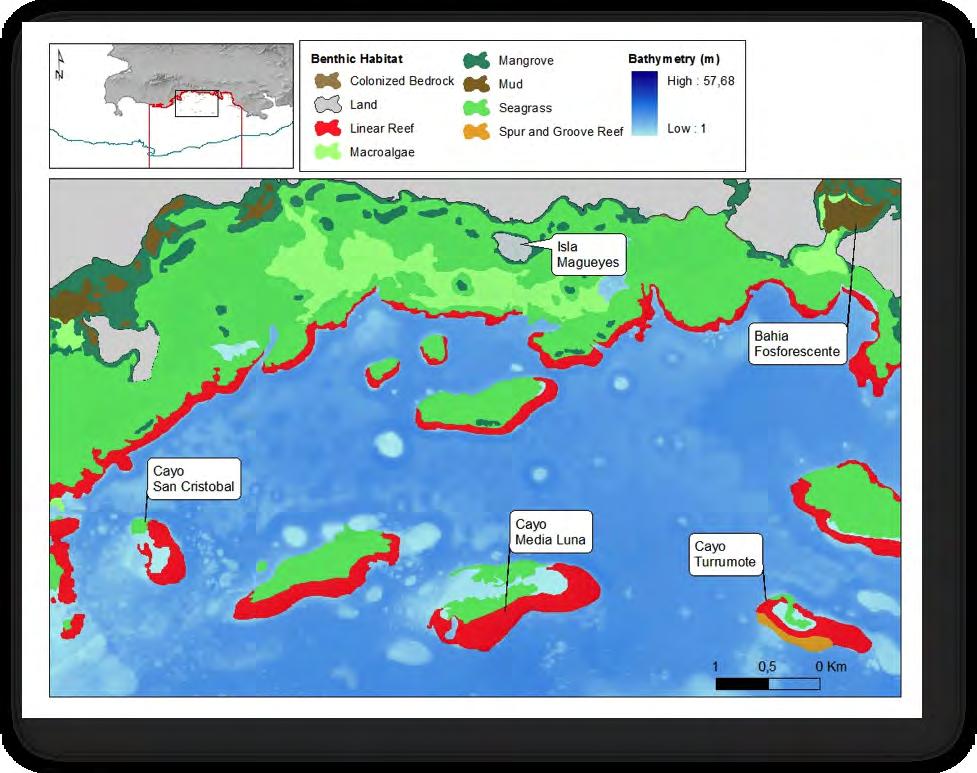
Of the three reefs studied in La Parguera the participants (17 fishermen from La Parguera) selected one reef, Turrumote, as the preferred site for a MFR by voting on a ballot in a meeting held in 1993. As it turns out Turrumote was an area in which most participants did not use consistently. Other reasons for the selection of Turrumote were the following: It had the lowest density of commercial species (San Cristóbal had the highest); the reserve had the shortest east-west extension, and the lowest basal area; it was located farther offshore than any other reef, and the back reef lacked the typical seagrass beds of other reefs, an important habitat in the perception of the fishers. However, Turrumote is located near Papayo (a community to the east of La Parguera) and a number of fishers from that community argued that they were not part of the decision-making process and its results affected them more directly since they used that particular area consistently.
Turrumote was proposed as a small manageable restricted area that could serve as an experimental MFR in La Parguera. Once the scientific community, government agencies and the University of Puerto Rico Sea Grant became involved in the process, the fishermen from Papayo (mostly divers and gill-netters) opposed the MFR. The people of Papayo (technically, one of the poorest rural communities in Puerto Rico) were an important stakeholder that was not consulted at the onset of the process. The community of Papayo also had a historical axe to grind with the people of La Parguera, viewed as usurpers of ‘their’ bay (the bioluminescent bay) and people who despised them; thus, bitter opposition to the MFR (Valdés-Pizzini 2009).
After the initial support for the MFR fishermen from La Parguera also started to have doubts and concerns, based on the following arguments: Potential for additional closures without the fishers’ approval; Competition and poaching on behalf of the recreational fishers; The Turrumote reserve could lead to another “Marine Sanctuary” proposal; and Government was viewed as imposing a reserve but not taking care of the removal of houseboats. The fishers were interested in demonstrating that they were willing to engage in conservation efforts due to their commitment and environmental ethics. However, they felt uncomfortable by their perception, that the government and the scientific community was eager to curtail their fishing through a MFR, but did not move a finger to stop the assault of the construction sector on the slopes of La Parguera (Martínez-Reyes and Valdés-Pizzini 1997).
There were other processes that worked against the development of the MFR that will be briefly outlined here. First, the process was designed and planned as a co-management effort but those involved in the process were not well versed in such theory and practice, and therefore stumbled on the way to the designation of the MFR. Turrumote also created a rift at the core of the Sea Grant Program, and the internal differences among those involved also contributed to the postponement and eventual abortion of the process. Second, despite the good faith of the scientific community and the agencies involved, the MFR was proposed and designed without any socioeconomic information. Critical data was missing, such as: spatial utilization; perceptions, attitudes and beliefs of the fishers; traditional ecological knowledge (TEK); estimates of fishing effort from recreational and commercial fishers; history of conservation measures and policies in La Parguera; and the political economy of La Parguera, that is the class differences among those who live in La Parguera and Papayo, differences that shaped their actions. Third, the proponents wanted to allow recreational activities in the MFR, through the collection of a fee to sustain the conservation efforts; however, the fishers did not want any recreational activities in the MFR. Fourth, the proponents wanted an indefinite time for the closure, while the fishers wanted the reserve to be closed for 5 years. Finally, at the time, those involved (and engaging in a critical perspective of the process) had more questions –in terms of the science and policy considerations— than answers. A handful of those questions were the following: Are MFR an experiment? Will catches increase in the surrounding areas? Was the proposed size appropriate? Will fishers observe an increase in size and biomass of commercially targeted species, as promised? Was co-management the most appropriate arrangement? Were the government and the communities prepared for co-management? What policy and structural changes are needed to promote full participation in the development and implementation of MPA?
F. Special Planning Area, Sector La Parguera
As stated previously, many stakeholders had second thoughts on their opposition to the Marine Sanctuary. That is perhaps the reason why there was tacit support to designate
the coastal area as a Special Planning Area (SPA) under the Puerto Rico Coastal Zone Management Program (1995). This designation of La Parguera as a Special Planning Area (SPA) of the Southwest of Puerto Rico, La Parguera Sector included a management plan adopted by the PR Planning Board as (P.U. – 002 on October 25, 1995), and approved by the governor as Executive Order (OE-1995-75 on December 5, 1995).
The SPA management plan was created by local agencies with financial assistance from the Coastal Zone Management Program, administered by the Office of Ocean and Coastal Resources Management of NOAA. The document describes the terrestrial component of La Parguera and the value of the natural resources contained within the SPA. It also identified user conflicts in the SPA and the potential impacts these have upon the natural resources, as well as management strategies to deal with these issues. In order to implement this management plan it was up to the local government agencies to create a committee in collaboration with a citizens committee from La Parguera and the municipal governments of Lajas, Guánica and Cabo Rojo. These committees should respond to the PR Planning Board in order to evaluate the implementation of this plan, which should be revised every two years.
This plan recommended a series of projects to help improve the conservation of the natural resources of the area. First of all was the protection of lands and public properties around Bahía Fosforescente by incorporating these into the La Parguera Natural Reserve designation. These lands were already under the control of the Puerto Rico Conservation Trust (PRCT) and in 2000 were incorporated into the LPNR by the Planning Board (PU-002-200057-01). Another proposal in the SPA management plan was the restoration of the maritime front of the LPNR to be achieved by the removal of houseboats on the shore.
In 1999 the House Owners of La Parguera Association appealed the PR Planning Board in the Supreme Court of PR. The appeal was based on the alleged violation of the PR Planning Board in the public hearing procedures to approve the SPA management plan. According to the legal documents the Planning Board had not provided the final version of the management plan at the time it was supposed to and therefore this affected the time allowed for comments. In addition they argued that the management plan lacked an environmental impact statement that would have been necessary if the actions in the plan were to be undertaken. Finally the legal documentation exhibits the claim of the perceived impact upon private property that the implementation of this plan would have.
The resolution of this legal argument clearly stated that the SPA management plan was essentially a sketch of the public policy regarding the strategies for the use of these lands. It was not viewed as a zoning regulation and did not constitute a specific decision upon a certain parcel of land; therefore it did not qualify as an action of the state against the appellants.
Recently PR senator Romero Donnelly proposed legislation that would legalize the houseboats located on the coast by amendments to the laws that established the DNER. Project of the PR Senate # 1903 (November 9, 2010) proposes to establish a “Touristic Special Planning Area for Houseboats and Piers” that would ‘resolve’ the legal status of the structures on the shore, establish a fee for the use of the public lands and seafloor, and that the money collected from the shoreline occupation should go towards the construction and maintenance of infrastructure for the LPNR and benefit of the local residents.
Table 4. List of laws available for the management of natural resources in Puerto Rico.
Law Number (year)
Law Name
Law # 23 (1972) Ley Orgánica del DRNA
Law# 133 (1975)
Ley de Bosques de Puerto Rico
Law # 1 (1977) Ley de Vigilantes de Recursos Naturales del DRNA
Law # 144 (1977)
Law # 10 (1987)
Ley para Control de la Extracción y Excavación de los Materiales de la Corteza Terrestre
Ley de Protección, Conservación y Estudio de los Sitios y Recursos Arqueológicos Subacuáticos
Law # 170 (1988) Ley de Procedimiento Administrativo Uniforme
Law # 150 (1988) Programa de Patrimonio Natural de Puerto Rico
Law # 115 (1997)
Law # 278 (1998)
Law # 340 (1998)
Law # 147 (1999)
Para la Promoción y el Desarrollo de la Pesca Deportiva y Recreativa de Puerto Rico
Ley de Pesquerías de Puerto Rico
Ley de Ecoturismo de Puerto Rico
Ley para la Protección, Conservación y Manejo de los Arrecifes de Coral en Puerto Rico
Law # 241 (1999) Nueva Ley de Vida Silvestre de Puerto Rico
Law # 430 (2000) Ley de Navegación y Seguridad Acuática de Puerto Rico
Law # 416 (2004) Ley sobre Política Pública Ambiental
Law # 218 (2008)
2.4 Uses in La Parguera
Ley del Programa para el Control y la Prevención de la Contaminación Lumínica
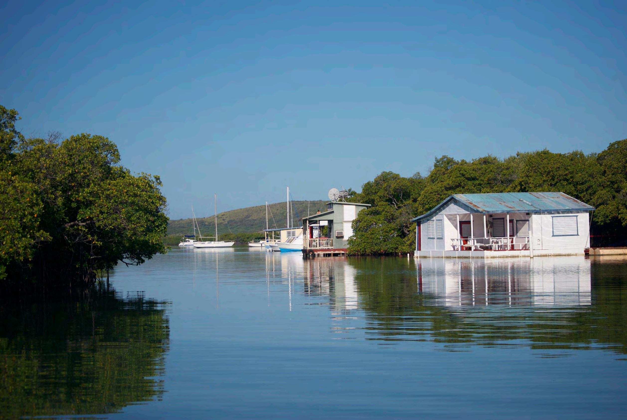
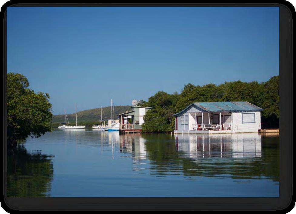
Houseboats in La Parguera
Various conflicts ensued after 1996 that imposed new challenges for the governance and conservation of La Parguera. Ongoing disputes between different groups of stakeholders and resource users caused concern regarding the impacts on marine habitats, which shaped the structure and emphasis of the scientific research. A case in point is the work of Heidi Hertler (Hertler 2002), whose research was mostly supported by the Association of Houseboat Owners. The main objective of this research was to determine if the houseboats (Figure 16) had a pernicious impact on the environment, and if there were other threats or causes for environmental deterioration. Hertler concluded that houseboats did not contribute to the degradation of the coastal ecosystem. However, she measured the loss of the seagrass, and associated habitats in the western side of La Parguera. Hertler associated the environmental degradation with government policies that changed the classification of the land use zone of adjacent dry forest areas in 1994, to encourage development and tourism. This suggests that although both new and old development sites received runoff from similar areas, more freshwater was entering the habitats near new developments. Salt flats and mangroves were not retaining freshwater inputs, significantly changing the salinity in the water
Hertler employed an east-to-west gradient or axis of development along the coast, in which various parameters (suspended materials in the water column, metal concentrations of sediments, amount of light reaching the benthos) were measured. Hertler described the old developments (casetas) at the Eastern end, the town in the middle, and the new developments to the West. There is almost no description of the parameters for the “old development”. However, the parameters were high (or low, in the case of light) for the town area and the western section of the settlement, where new developments were located. An improvised boat ramp in that area contributed to habitat degradation by directing runoff into the water (Hertler 2002). Using aerial photographs and maps, Hertler also measured what we now call “the human footprint” in La Parguera. She found that between 1960 and 1997 the urban patch grew from 4.7 to 25.2 km2, most of which was located to the west. This trend was expected to continue, as the expansion of housing subdivisions moved westward. Indeed, recent development and projects are slowly occupying the western hills of La Parguera. and intense development in this area also imposed pressures on the existing infrastructure, a situation that also contributed to the deterioration of the environment.
(photo credit M. Schärer).
Chlorophyll-a was invariable between tidal cycles and with changes in weather conditions but was nearly double near the sewage treatment facility. There have been numerous complaints that the sewage treatment plant of La Parguera cannot support the urban expansion. Stilt houses were often disconnected from the sewage treatment plant to prevent back flows of sewage into their homes, particularly on weekends when use is highest. High fecal coliform counts were also found at this station, suggesting that nutrient inputs associated with sewage was leading to algal blooms in this area (Hertler et al. 2009).
The new development in the western section of La Parguera also had a deleterious impact to the seagrass beds, assessed by Hertler as being “in a state of decline”. The cover of Thalassia beds in the area, as reported by González Liboy in 1979, was no longer there. The
decline in water quality, due to urban development, affected the light attenuation in some areas and had a negative impact on the health of the seagrass beds, reducing the area covered by seagrass (Hertler 2002). Although it is not clear if Hertler’s observations of rain events were also matched with the measurements of suspended solids, she stated in an almost anecdotal manner that “rain events were observed washing large quantities of sediment from areas under construction into the adjacent bay” (Hertler 2002).
Indeed, La Parguera experienced a boom in development and construction during the 1980’s and in the 1990’s, sparked by government policies designed to help the construction sector during a period when the industrial base was eroding. Tourism and recreational use became increasingly important in the local economy (Krausse 1994). According to the US census of 1990 and 2000, La Parguera was one of the few coastal communities able to create jobs for the local population, as the services industry for tourists and visitors grew. An increase in the floating population of La Parguera was made possible by the increase in the number of houses, apartments and rooms available for rent, which was larger than in any other coastal community during those decades. Despite the growth in buildings, apartments and structures, the resident population of La Parguera remained low. Indeed, those who acquired properties did so as second homes (Brusi 2004). We believe that more work is needed on the relation between the demographic structure (including the floating population) and the urban development in La Parguera. The aesthetic appeal of the landscape and seascape of La Parguera attracts visitors and investors in the area; a process that contributes to the increase in the human footprint for the area.
Marine Recreational Use
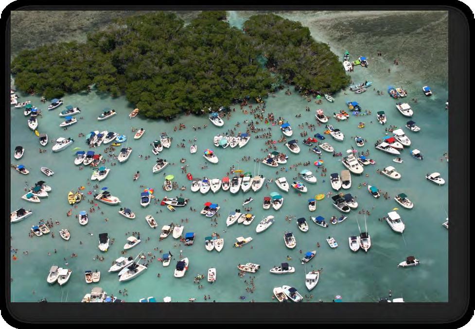
In La Parguera the diversity of coastal and marine habitats has led to the development of a variety of marine recreational uses. The most obvious uses are those related to nautical activities such as boating, snorkeling, SCUBA diving, fishing, water-skiing, kayaking, wind and kite surfing etc. The town hosts at least 3 dive shops and various local establishments rent small boats or provide guided tours of the coast, including trips to the mangroves, reefs, and bioluminescent bays. The average number of visitors to dive and snorkel sites (Figure 17) ranges from 1 to 33 per week and seems to be more intense in areas near the coast (Macko et al. 2008). In addition, several of the part-time residents of La Parguera are boat owners and regularly visit the nearby reefs and mangrove keys or cayos for get-togethers that can aggregate large numbers of boats on specific keys on weekends and holidays.
Private boats activities represent an increasing conflict on the shores and keys of La Parguera. No operative boat ramps exist on the Lajas coast; instead a few sites located between fringing mangroves and on the salt flats are used as improvised ramps. These improvised ramps are extremely congested on weekends and during vacations and are not suitable to accommodate large numbers of boats (including jet-ski), trailers and vehicles. The DNER has proposed to build boat ramps throughout the island as part of a Sport Fish Restoration program. The planning process for locating these boat ramps has been complicated in LPNR due to a variety of factors and the agencies involved in the evaluation have not come to an agreement. Although the need for the boat ramps in La Parguera is clear, the specific locations for these and the infrastructure needed to support their operations hasn’t been decided. The area near the ‘Las Crayolas’ housing development to the west of town has been identified as the potential site for locating one of these boat ramps of public access.
Many of the local recreational boats congregate on the shallow seagrass and sandy bottom habitats near mangrove keys. The number of boats at these keys is orders of magnitude greater than the number of mooring buoys available, therefore anchoring and ‘rafting’ is common at these sites. These practices have the potential of impacting the seafloor due to trampling, anchoring, propeller scars and re-suspension of sediments (Figure 18). Otero and Carrubba (2006) documented some of these impacts in areas of high vessel traffic.
(photo credit E. Rodríguez).
Trips to the bioluminescent bays (Bahía Fosforescente and Bahía Monsio-José) are offered daily by local businesses. However these operators are not organized in any professional entity and many lack the government-required concessions to occupy the shoreline or maritime zone (zona maritimo terrestre) with private piers, docks, and shops
(Reglamento para el Aprovechamiento, Vigilancia, Conservación y Administración de las Aguas Territoriales, los Terrenos Sumergidos bajo éstas y la Zona Marítimo Terrestre, DNER). In addition, there is another regulation for activities within protected areas (Reglamento Para la Administración de los Aprovechamientos Mediante Autorización y Concesión en Áreas Naturales Protegidas). These regulations were amended in 2011 and now are registered as DNER Regulation # 8013, which along with the DNER Administrative Order # 201103 establishes that various protected areas (including LPNR) will be subject to fees for concessioner activities. Based on this regulation, only 2 concessions have been proposed to DNER for LPNR (C. D. Rodríguez, DNER, pers. comm.).
The area of La Parguera is also home to the UPR-M Department of Marine Sciences’ Magueyes Island Marine Laboratory, and hence a focal point for marine scientific research for over 50 years. Since 1980 the UPR Sea Grant College Program provided a source of funding for research in La Parguera with topics spanning a diversity of themes: reproductive strategies of groupers, movements of grunts, MPA design strategies, impacts of pollutants, reproductive strategies of corals, fishermen knowledge, coral reef populations, and coral diseases among others.
Recently, the most comprehensive study of the area was conducted under NOAA Center for Sponsored Coastal Ocean Research’s (CSCOR) Coral Reef Ecosystems Studies (CRES) program, a 5-year study involving multiple institutions and government agency partners encompassing research on reef organisms, coral diseases, population dynamics, connectivity, sedimentation and water quality, and human uses. Coral reef research, under the leadership of the Caribbean Coral Reef Institute (CCRI) at UPR, has supported important research on the characterization of coral populations, and the study of diseases and management strategies in Puerto Rico and the United States Virgin Islands. More recently, NOAA also supported the Deep-CRES program, delving into the study and analysis of the Mesophotic Coral Ecosystem (MCE) throughout the archipelago. In other words, in the last decade our knowledge of the benthic habitats and biodiversity has increased significantly.
This report, includes information produced over the last 50 years, including a number of technical reports and testimonies from stakeholders, over a number of key issues in La Parguera, that are described throughout the document. The information was used to identify the spatial and ecological dimensions of La Parguera, as a region, which encompasses a number of marine, coastal, and terrestrial habitats, and human settlements from Cabo Rojo to Guánica. We used a historical perspective to understand the human processes that shaped the present day conditions of species and habitats, as documented by the extensive literature, compiled in a conceptual model of the social-ecological system of La Parguera. Over the years, government officials, scientists, resource managers, and community members have expressed themselves in reports, legislation, projects and public hearings on what need to be done to address the environmental (natural-human) problems of La Parguera, in terms of quality of life and the condition of the ecosystem.
Chapter 3 – Ecological Status of La Parguera
The ecosystem of the La Parguera is defined as a complex mosaic of habitat types extending from the hilltops in the watershed to the abyssal depths beyond the insular platform and all the species that inhabit these. This geographical area includes habitats of great value and unique ecological features, such as: dry forests, salt marshes, mudflats, mangroves, bioluminescent bays, seagrass beds, macroalgal beds, pelagic waters, and well developed, extensive coral reefs, and emergent keys. It is important to keep in mind that the ecosystem concept implies the complex interactions between the different elements that often rely on relationships and ecological functions that are dynamic and respond to environmental changes. An important component of the social-ecosystem is the human community that is in the center of the watershed and coastal zone of La Parguera (Figure 19).
The broad insular shelf and coastal embayments of La Parguera provide relatively shallow environments that support a diverse and productive seascape, with important ecological, economic and cultural value. These attributes, have allowed the transformation of La Parguera from a small, undeveloped fishing village to a busy tourist and residential destination. Resorts, guesthouses, boating yards, and vacation homes have proliferated over the past twenty years, and the transient population has increased at least three-fold — from approximately 35,000 visitors per year to more than 100,000 (García-Sais et al. 1999).
3.1 Bioluminescent Bays
One of the most remarkable features of the La Parguera ecosystem are the bioluminescent bays, Monsio José Lagoon and Bahía Fosforescente (Phosphorescent Bay), embedded in the fringing mangrove forests which line the shore. Bioluminescence is a glow in the dark phenomenon produced by microscopic organisms, called dinoflagellates, which become luminescent when agitated or disturbed. The embayments are characterized by
demonstrated that there has been a change in the size and composition of the sediments within the bay (Sanjuan and González 1999). However it is unknown where these sediments originate and how currents affect these deposits. It can be expected that sediments suspended in the water column affect the amount of light that reaches the seafloor; therefore it is an important factor to consider because of the photosynthetic requirements of dinoflagellates.
La Parguera’s Bahía Fosforescente has shown a decrease in its bioluminescence by approximately 80% in the past years compared with Puerto Mosquito in Vieques (Walker 1997). A comparison between these two bays has shown a difference in benthic sediment composition. At La Parguera sediments are dominated by smaller grained terrigenous sediment, while at Vieques the sediments are mostly coarse grains of carbonate origin. These differences suggest that greater re-suspension of sediments can occur at La Parguera with intense boat traffic that was estimated as 5 times greater in La Parguera when compared to Vieques (Arocho 2004). Land use patterns around the Bahía Fosforescente were classified and estimated by remote sensing into the following categories; Urban or Built land (1%), Forested land (55%), Barren land (12%) and Wetland (9%), (Soto 2004). This was compared with Vieques and it was concluded that La Parguera is more exposed to anthropogenic activities or urban development, which affects the bioluminescent bays and also contribute to reduce the bioluminescence (Soto 2004).
Another element to consider in the management of the bioluminescent bays is the environmental conditions necessary for the appreciation of bioluminescence, which relate to the surrounding reflection of lights during nighttime. To be able to observe this biological phenomenon, it is imperative that there is complete darkness surrounding the bays and mangroves. A lighting plan is required to manage artificial lights and reduce the impact of this form pollution on the appreciation of bioluminescence. This plan requires the identification of sources of light, promote best lighting practices and regulate proposed developments so that they do not add to the light pollution of the area. The PRCT is developing a similar plan for the Cabezas de San Juan Natural Reserve in Fajardo.
In 2008 a legislation to create a program for the control and prevention of light pollution (Ley del Programa para el Control y la Prevención de la Contaminación Lumínica) was signed into Law # 218 (2008) proposed by the PR Senate. The law specifically mentions the impacts of light pollution upon the bioluminescent bays in Vieques and La Parguera and two special zones are defined around these bays (one 5 miles around the La Parguera bioluminescent bay). The local agency responsible for the implementation of this law is the Environmental Quality Board (EQB) in coordination with the PR-DNER and the Planning Board. The law began its effectiveness as to the EQB on July 1, 2009 and specifies the rest of the dispositions are effective after January 1, 2010. Recently, amendments have been proposed to this law by the PR Senate (P. del S. 1543, May 4, 2010) to include public lighting restrictions and expand the special zone designation to 5 miles around Laguna Grande, Fajardo. The local government has not approved this amendment to the existing legislation, and regulations for Law # 218 (2008) are being drafted.
3.2 Mangroves and Wetlands
The southern coast of Lajas is fringed by red mangrove forests (Figure 20) that contribute to approximately 15% of the total mangrove area (8,870 ha) in Puerto Rico (Martínez et al. 1979). The mangrove forests of today are the remainders of 30,000 ha, which was estimated in the 1970’s (García-Sais et al. 1998). Mangrove habitat destruction has continued to make space for marinas and coastal developments despite the Forestry Law and other regulations that aim to protect them (Lugo-Ascorbe 1988). The mangrove forests from Mayagüez to La Parguera have been protected since 1918 (Aguilar-Perera et al. 2006), including coastline fringing mangroves and those located on emergent offshore keys.
Other types of wetland habitats are distributed contiguous to the mangroves and form a barrier that collects water landwards of shore including salt flats, mud flats and coastal vegetation (Martínez et al. 1979). Many of these mangrove and terrestrial wetlands are severely impacted by human uses in La Parguera. Since the 18th and 19th centuries workers modified the flow of seawater for the production of salt altering the wetlands and maintaining that system. More recently the wetlands and mangroves were either filled, dredged and
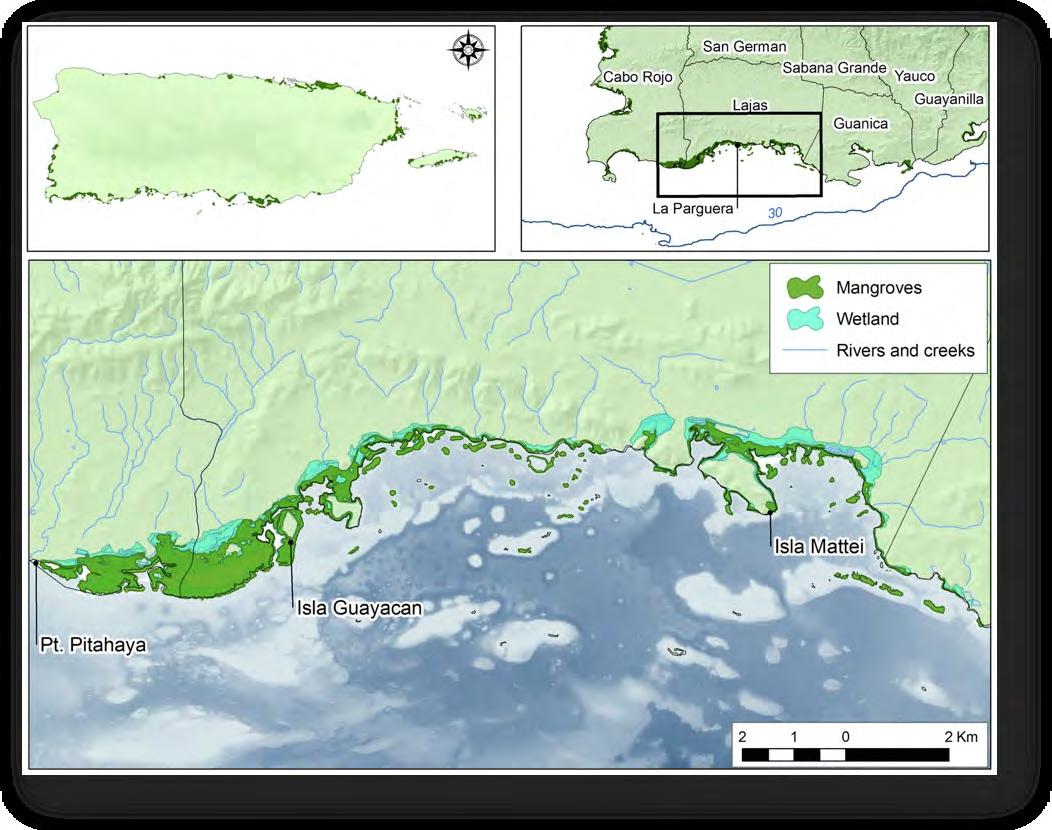
mangroves cut to make place for parking lots, hotels, piers, casetas, urbanizations and roads. The changes in these wetlands and mangrove habitats have undoubtedly altered some of the ecological functions these provided. Wetlands in some coastal areas still flood during extremely high tides and heavy rains, therefore collecting water and buffering the mangroves from direct erosion and runoff. During this flooding they also collect runoff from roads and urbanizations that could be considered as a non-point source of pollution to the marine environment.
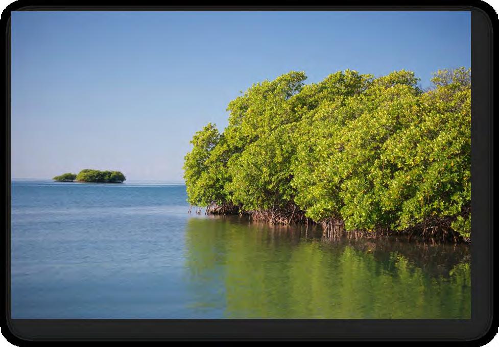
The fringing mangroves of La Parguera include wide lagoons and channels through which navigation is possible (García- Sais et al. 1998). At least two bioluminescent bays are also located among these fringing mangroves one to the east, Bahía Fosforescente, and another further west known as Laguna Monsio José. The mangrove forest extending from La Pitahaya to Punta Guayacán including the lagoons is the largest (1.2 by 6.5 km) and most developed mangrove stand in southwestern Puerto Rico. These submerged forests are composed mainly of red mangrove trees Rhizophora mangle (Figure 21). This is the dominant species on the offshore keys along with a few white mangrove trees (Laguncularia racemosa) since exposure to waves limits the development of mangroves on these keys (Yoshioka 1975). Higher areas within inshore keys and on the coast of La Parguera that accumulate higher salt content are colonized by the salt-tolerant black mangrove (Avicenna germinans) in a succession from red mangroves.
These fringing mangrove forests can also be considered more productive than the basinal mangrove stands that have lower tree heights and smaller trunk diameter (Cintrón et al. 1978). The growth of these mangroves may be enhanced due to the local nutrient availability. One of the sources of abundant nutrients is the wastewater treatment plant that for years provided sewage to the mangroves west of the area known as Varadero in La Parguera. The local water treatment plant administered by the Autoridad de Acueductos y Alcantarillados (AAA) released effluent of primary treatment wastewaters during years. Some of the offshore mangrove keys are rookeries for seabirds and receive abundant nutrients from bird wastes as well (Figure 22). It has been demonstrated that the mangroves can uptake micronutrients from their surroundings and grow making them primary producers.
Much of the seafloor in the fringing mangrove forests is made up of fine sediments colonized by an average of 9% of submerged aquatic vegetation including turf algae, seagrasses, cyanobacteria and filamentous algae. Some of the most common species are: turtle grass (Thalassia testudinum), associated algae (e.g., Dictyota divarica, Laurencia obtusa, Caulerpa verticillata, and Acanthophora spicifera), upside-down jellyfish (Cassiopeia frondosa), starfish (Oreaster reticulatus), and sea cucumbers (Holothuria mexicana) among others (Cerame-Vivas 1973). A thick layer of detritus is commonly observed over the substrate of mangrove areas (Appeldoorn et al. 2009). Organisms that colonize the prop roots of red mangroves include sponges, corals, coralline algae, mollusks, tunicates, hydroids and fire coral. Epiphytic algae, mainly macroalgae are the dominant benthic cover of prop roots.
Submerged mangrove habitat is known to provide an important nursery function for a diversity of ichthyofauna. This nursery function has been associated with highly productive coastal fisheries (Faunce and Serafy 2006). Many important fish species use mangroves during part of their ontogenetic migrations in combination with other habitats such as seagrasses and coral reefs (Aguilar-Perera 2004). The density of juvenile fishes of La Parguera was most influenced by the seagrass habitat immediately surrounding mangroves (Pittman et al. 2010). This relationship between mangroves, seagrasses and coral reefs helps maintain the rich biodiversity of marine ecosystems in La Parguera.
3.3 Seagrass beds
Seagrass habitats provide a variety of ecological functions in coastal marine ecosystems. Among these functions seagrasses are known for their high primary productivity via photosynthesis, the accumulation of sediments and nursery function for fish and invertebrates. The seagrasses themselves provide forage for grazers such as sea turtles and manatees and support a variety of algae that are food for some fishes and invertebrates such as conch. In addition the detritus accumulates on the seafloor and supports a variety of invertebrates such as sea cucumbers and urchins. Various small sized organisms flourish in the protective shelter of seagrass blades. Young lobsters, mollusks and fishes hide among the seagrass and complete the earliest stages of their life cycle in this habitat. The baffling effect of the seagrass blades serves to slow down the water velocity and deposit the fine grain sediments in this area. The sediments are incorporated into the rhizome system of the seagrasses and these are not dumped over the coral reefs.
The seagrass itself is a flowering plant that thrives in marine and brackish environments. The areas of seagrass can be distributed in small patches of backreef areas to large expanses of seagrass meadows that vary greatly in depth. It has been estimated that the seagrasses are
providing 1% of all primary production and 15% of total carbon storage (Hemminga and Duarte 2000). Seagrasses and the associated epiphytes can account for just as much primary produc
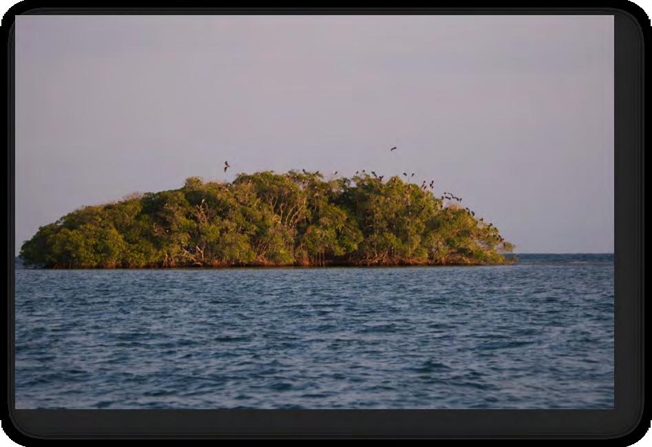
(Diadema antillarum), Queen conch (Strombus gigas) and green sea turtle (Chelonia mydas), which are now rare.
The growth and productivity of seagrasses has been measured in La Parguera demonstrating spatial and temporal variations in total biomass. In areas near mangroves the biomass of turtle grass is low (100g m-2 dry weight) whereas if can reach very high levels (5800g m-2) in high light intensity (Vicente 1992). The average of above ground productivity was estimated to range from 2-7g m-2 daily (González-Liboy 1979). The standing crop of turtle grass in La Parguera ranged from 96 to 480 g m-2 dry weight (Delgado-Hyland 1978). Up to 60% of the total productivity of seagrasses can be result of the other components of seagrass habitats such as epiphytes (Hemminga and Duarte 2000). Seagrasses propagate by rhizome growth and sexual reproduction in flowers and seeds that occurs mainly in spring and summer. The presence of buds, flowers and fruits varies from 4 to 54% during May and various factors influence this process such as wave energy, sediment load, turbidity and water temperature (Vicente et al. 1980).
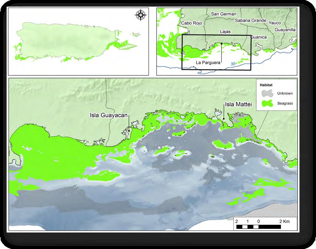
In La Parguera seagrass habitats are common in the unconsolidated sediments nearest shore and become less frequent with increasing depth. The areas nearshore, adjacent to mangroves and in backreef zones of emergent reefs are commonly dominated by turtle grass up to depths of 16m. Live cover of seagrasses was dominated by turtle grass with much less manatee grass in areas less than 10m in depth, however at increasing depths the manatee grass cover was higher than turtle grass (Pittman et al. 2010).
The information regarding the area covered by seagrass habitat in La Parguera may be underestimated due to a variety of factors such as the seasonal changes in coverage, changes in light penetration, wave energy and human disturbances such as dredging, propeller wash, scars and anchoring (Fonseca et al. 1998). The current extent of seagrass for the area may be affected by the limitations in water quality that allow for the photointerpretation of aerial pictures from which currently available habitat maps are delineated (Pittman et al. 2010). Given the importance of this habitat in the habitat connectivity of the seascape of La Parguera the protection of seagrasses is justified.
3.4 Coral Reefs and Consolidated or Bedrock Habitats
The coral reefs of La Parguera are believed to be growing upon a limestone base of the Cretaceous Period, over 65 millions of years ago (Almy 1969). Rising sea level during the last Pleistocene glaciations flooded these areas of the shelf where coral growth could occur and present reefs develop (Glynn 1973; Goenaga and Cintrón 1979). During the past 10,000 years reef formation was dominated by branching Elkhorn coral (Acropora palmata) deposits (Hubbard et al. 1986). Coral reef development followed sea level rise to colonize inshore areas in what is known as back stepping providing the present coral reef and marine habitats distribution (Figure 24).
Today two separate, parallel lines of emergent reefs can be observed to the south of the coast of La Parguera, dividing the area into three zones: inner, mid and shelf-edge reefs (Hubbard et al. 1986). Depths of up to 25 m separate the mid and shelf-edge reef lines by about 1.5 km. Most of the coral reef development is believed to have occurred during the mid-Holocene Period (approximately 6,000 years ago) when environmental conditions were most favorable for coral growth (Vicente 1993). Some coral reef patches have formed at other sites on the shelf and along with the larger reef formations they occupy approximately 20% of the insular shelf (Morelock et al. 1977).
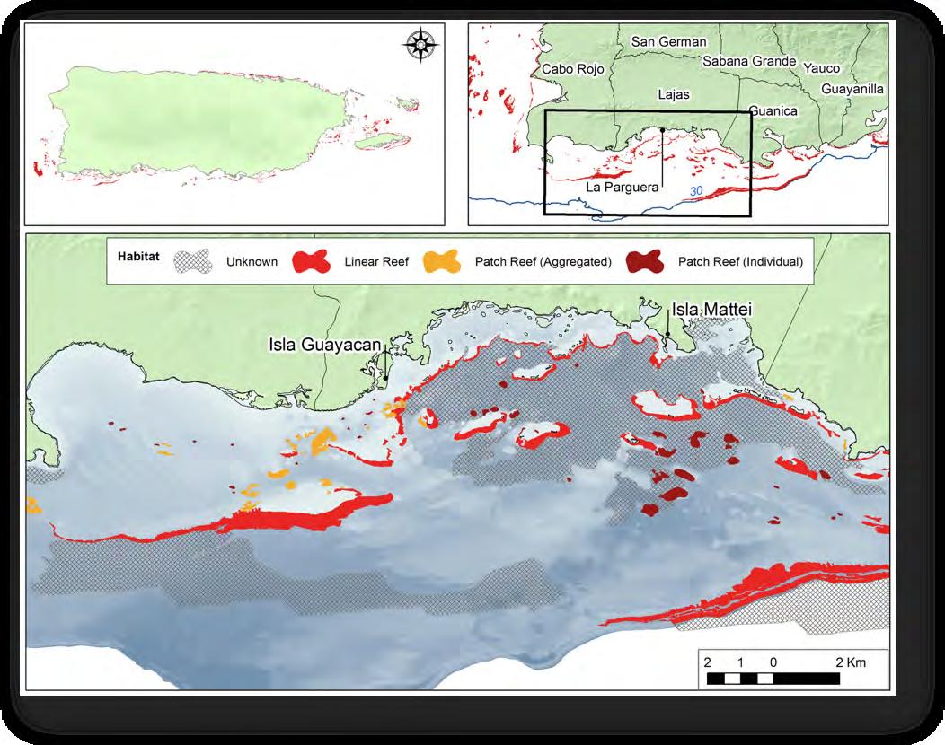
The geological record suggests corals developed in very clear waters with little or no input of terrestrial sediments form upland sources. A shift towards more sediment tolerant coral species (i.e. Montastraea annularis complex) seems to have accompanied the near shore reef development. A pattern of coral species zonation can be observed at depth on the fore reef of emergent keys and this community structure responds to the level of sedimentation in the zones (Acevedo and Morelock 1988). More recently another shift has been observed in the shallowest zones of emergent reefs in which fire corals of the genus Millepora have substituted Elkhorn corals as the dominant reef crest species (Ballantine et al. 2008). Liver cover of corals in La Parguera has been estimated in 18% that is near the percentage of northern Caribbean reefs. This parameter varies with higher values at intermediate depths when compared to shallow areas (Appeldoorn et al. 2009). In another study the cover of live coral was higher on inshore reefs with higher survival of juvenile corals when compared to shelf-edge zones (Irizzary-Soto 2006). The most developed coral reefs are located to the westernmost areas of La Parguera with 10 to 37% live coral cover (Pittman et al. 2010). Much of the coral cover of the region has declined significantly due to bleaching and disease since 2005 (Appeldoorn et al. 2009). Macroalgae and other benthic organisms such as sponges and fire coral quickly colonize the space made available when corals die. At least two coral species have been designated as threatened with extinction (Acropora palmata and A. cervicornis) and various others are being considered to be listed due to recent population declines throughout their range.
Diverse hard-bottom or consolidated sediment seafloor habitats complete the non-sandy areas of the insular shelf of La Parguera. Many of these habitats are not considered coral reefs but are colonized by sponges, algae, corals and octocorals in varying densities and amounts. Nearshore the bedrock and rocky zones can be exposed during low tides and are colonized by organisms that are dependent on high illumination and hard substratum. Further towards the south areas of hard substratum include a mix of bedrock or pavement upon which a thin film of sediment also known as bedload occurs. This bedload is believed to be important for the establishment of corals and octocorals on the seafloor due to the constant movement of sand grains over the hard substratum making areas available for recruitment of invertebrate larvae (Yoshioka, pers. com.). Many important species can be found in this habitat including queen conch and lobsters that are the basis of the commercial fisheries in the region. This habitat type (pavement) constitutes approximately 45% of all mapped habitats in La Parguera (Pittman et al. 2010) however very little research has been conducted throughout this habitat.
3.5 Unconsolidated Sediment Habitats
Mud, sand, gravel and coral rubble make up much of the area between the reef lines of La Parguera. Corals are rare in these sediment-dominated habitats however they support a unique suite of organisms in areas of high productivity such as the ‘Algal Plain’. This zone extends to depths of 27 m and is covered by a great diversity of algae species, erect coralline algae, bryozoans, sponges and small octocoral and coral colonies. In this habitat a variety of invertebrates such as crabs, shrimps, lobster and conch are commonly observed. The unconsolidated sediment habitats nearshore also serve as an important foraging area in which schools of fish migrate nightly to feed from adjacent reef and seagrass areas. Understanding the full distribution of these unconsolidated sediment habitats is important for assessing the connectivity of habitats in the seascape of La Parguera.
3.6 Mesophotic Zone
In recent years the scientific community has explored deeper areas of the insular shelf with the aid of remotely operated vehicles (ROV) and divers have descended to the twilight zone using closed circuit re-breathers and mixed gases (Bejarano-Rodríguez et al. 2011). These technologies have facilitated exploration within the mesophotic zone at depths between 50 and 100 m to conduct research focusing on the mesophotic coral ecosystem (MCE) for the Deep Coral Reef Ecosystem Studies Program at La Parguera. This research effort has explored the benthic and fish fauna of MCEs as well as the geological features that shape these ecosystems.
The mesophotic zone extends along the slope of the insular shelf and the development of benthic habitats that cover the seafloor is dependent upon factors such as depth, geomorphology, slope, wave exposure, and sedimentary processes (Sherman et al. 2010). Although protected from the direct impact of high terrigenous sediment load, biogenic sediments also impact the habitats of the mesophotic zone. A horizontal spatial pattern in geomorphology has emerged at La Parguera where southeast facing areas have a steeper slope and complex topography whereas southwest facing areas have lower slope and flat topography. At sites with complex topography the downslope sediment flow is funneled along channels promoting well developed benthic communities on promontories (Sherman et al. 2010), Habitats within the mesophotic zone at La Parguera include coral reef, colonized pavement, rubble, and sand (Nemeth, pers. comm.).
Organisms other than corals dominate the benthic cover of the habitats of the mesophotic zone. An assemblage of sessile species such as sponges, algae, octocorals, and hydrozoans are common in other mesophotic habitats studied in Puerto Rico (García-Sais et al. 2010). Benthic habitats on the insular slope of La Parguera are similar to those of shallower zones up to a depth of 50 m. Deeper than that the benthic community composition is distinct, and habitat distribution is patchy. Within the coral dominated habitat there are specific areas of significant coral development (i.e., Agaricia spp. biotopes) associated with complex topography and geomorphology.
In general terms algae are the dominant benthic cover group in the mesophotic habitats, a trend similar to habitats of shallower zones of La Parguera. The average percent cover of algae ranges from 56% at less than 50 m to 37% at 70 m depth (Ruiz, pers. comm.), and the forms of algae shift from turf and fleshy macroalgae to a unique suite of encrusting coralline algae and Peyssonellia spp. that are not reported for shallower sites (Ballantine and Ruiz 2005; Ruiz and Ballantine 2007). Sponges are, in La Parguera and Guánica, ubiquitous, jointly with gorgonians, Anthipatharids (black corals), and algae (Rivero-Calle 2010). Black corals (Anthipatharians) are unique to the MCE and provide small-scale habitat structure. Although this species was collected for commercial purposes in La Parguera, recent surveys have documented their presence in the MCE at most study sites in La Parguera (Nemeth, pers. comm.).
Coral development in the mesophotic zone is reduced to plating and encrusting morphs of a few species. The plating growth forms are an adaptation to the limited amounts of sunlight at these depths, which is essential for photosynthesis (Figure 25). The most common corals in the mesophotic zone belong to two scleractinian genera Agaricia and Madracis. Some species include Agaricia lamarcki, A. fragilis, A. undata, Undaria agaricites, U. humilis, Stephanocoenia intercepta, and Madracis pharensis, followed by a few reef building coral species such as Montastrea franksi and M. cavernosa at shallower depths. Measurements of percent cover of live coral in the MCE of La Parguera ranged from 5 to 48% although the latter is characteristic of patches of high topographic relief where plating forms of Agarica spp. create a highly complex biotope unique to
the mesophotic zone (Sherman et al. 2010). Recent studies of these corals have shown signs of disease and bleaching at mesophotic depths.
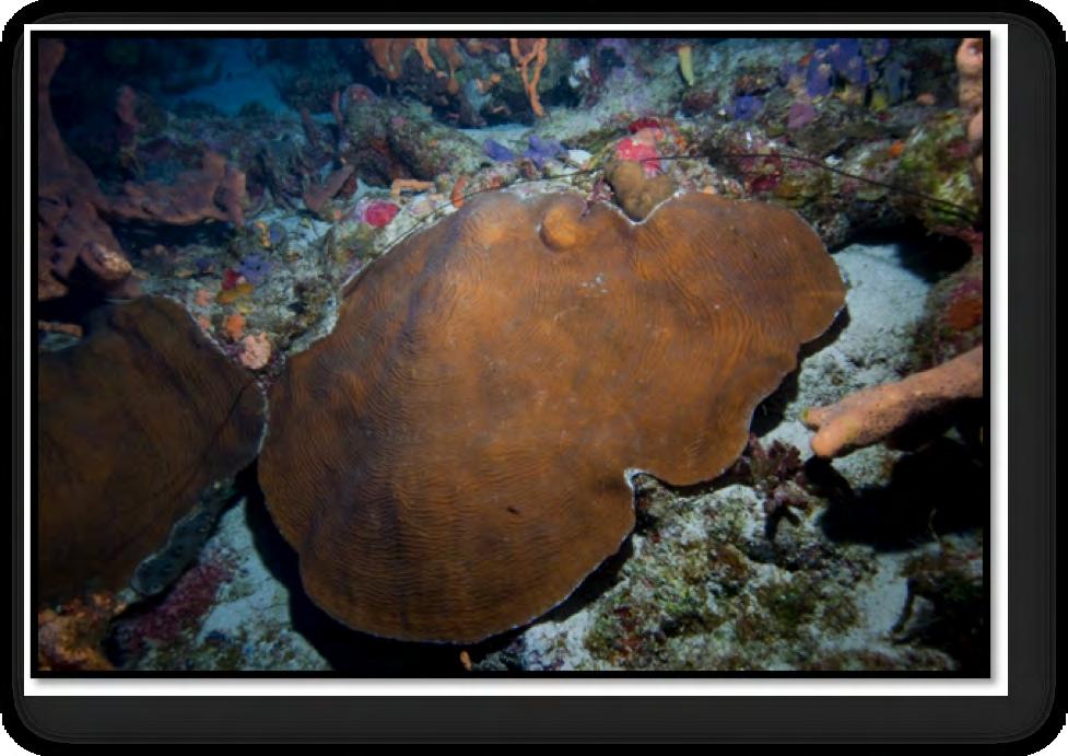
(photo credit H. Ruíz).
Recent efforts to characterize the MCE’s across a longitudinal gradient from Mona Island to the U. S. Virgin Islands provided data to compare habitats among 8 study sites. From these sites only Cane Bay, St. Croix presented MCE development and coral abundance similar to that of La Parguera between 50 and 60 m depth (Appeldoorn et al. 2010). However, the distribution of these high coral development habitats is patchy and further exploration is warranted to fully understand this ecosystem.
The fish community of the mesophotic zone has a species composition and structure that is different from shallower reefs. Scientists have identified a total of 109 species from 29 families in the MCEs of La Parguera (Bejarano-Rodríguez et al. 2011). Species richness in MCEs is lower overall than in in shallower depths and this difference is most notable deeper than 50 m. A subset of species is unique to the mesophotic zone suggesting a depth related endemism that has also been reported for other locations (García-Sais et al. 2010). In shallower habitats herbivorous species dominate the fish community, however in MCEs the zooplanktivores are proportionally more abundant (BejaranoRodríguez et al. 2011).
Another important characteristic of the fish community of the mesophotic zone of La Parguera is the presence of large sized, predatory species such as groupers, snappers and sharks that are rarely documented in shallower habitats (Pittman et al. 2010). Commercial and recreational fisheries target these species heavily resulting in the decline of populations in shallower zones, some of which are now classified as overfished (Ault et al. 2008). The use of the mesophotic zone by vulnerable species suggests these habitats provide a refuge from fishing pressure (Bejarano-Rodríguez et al. 2011) and could potentially serve as spawning stock for population recovery. Habitat use by large groupers and snappers is focused around areas of complex topography and geomorphology, a pattern that can play a role in spatial management alternatives for MCEs. The occurrence of large snappers and barracuda in MCEs indicates the ontogenetic connectivity with near-shore areas since these species predominantly recruit to mangrove and seagrass habitats and migrate offshore as adults (Appeldoorn, pers. comm.).
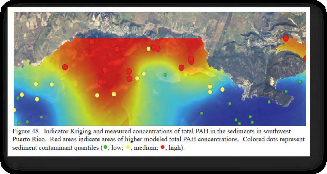
Figure 26. Areas of pollution in La Parguera (Pait, et al. 2007).
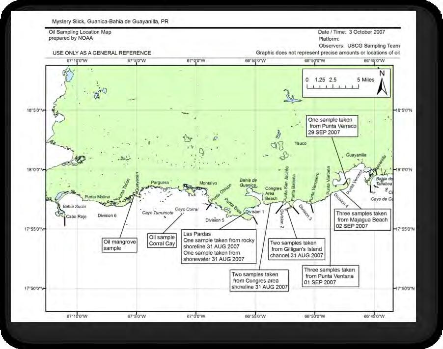
Figure 27. Sampling locations for the mystery slick oil spill in 2007 (http://www.incidentnews.gov/browse/thumbs/7689/maps/by-date).
chemical contaminants in the sediments and corals of La Parguera including polycyclic aromatic hydrocarbons (PAH). These chemicals are associated with the use and combustion of fossil fuels (e.g., oil and gas) and other organic materials (e.g., wood). Contamination of PAH was more notable near the town’s center of La Parguera (Figure 26).
Petroleum based pollution has also been identified in the fringing mangroves, keys with mangroves and emergent reefs of La Parguera and Cabo Rojo. On March 18, 1973 the 605’ tanker Zoe Colocotroni grounded on Margarita Key 3 miles south west of La Parguera. In efforts to remove the ship from the reef approximately 36,000 barrels of crude oil were released impacting the reefs, seagrasses, mangroves and beaches of Cabo Rojo to the west of La Parguera. The local government sued for environmental damages and local businesses and fishers received compensation due to the impact of this oil spill. Five years after the incident it was estimated that two acres of mangrove fringe areas were still contaminated with oil (Gilfilan et al. 1981). In 2007 a ‘mystery slick’ oil spill occurred on the southern coast of PR (Figure 27). Approximately 14,000 gallons oil was estimated to reach the coastal habitats and sludge/oil was removed from the coasts of Guánica, Guayanilla, Lajas and La Parguera (Griffin, pers. comm.).
4.2 Direct Impacts
The seagrass habitat is, according to researchers and resource users alike, a critical one that serves as the epicenter of ecological processes and connectivity in La Parguera (Pittman et al 2007, Valdés-Pizzini and García Quijano 2009). The prevalence of seagrasses in the shallow contours of the insular shelf makes them prone to the impact of a number of human activities on land, and in shallow coastal waters. One of them is known as scarring, a process in which narrow trenches are created by boat propellers impacting the seagrass on the seafloor. Boating is one of the most intensive human uses of these waters. In one of the earliest studies on this
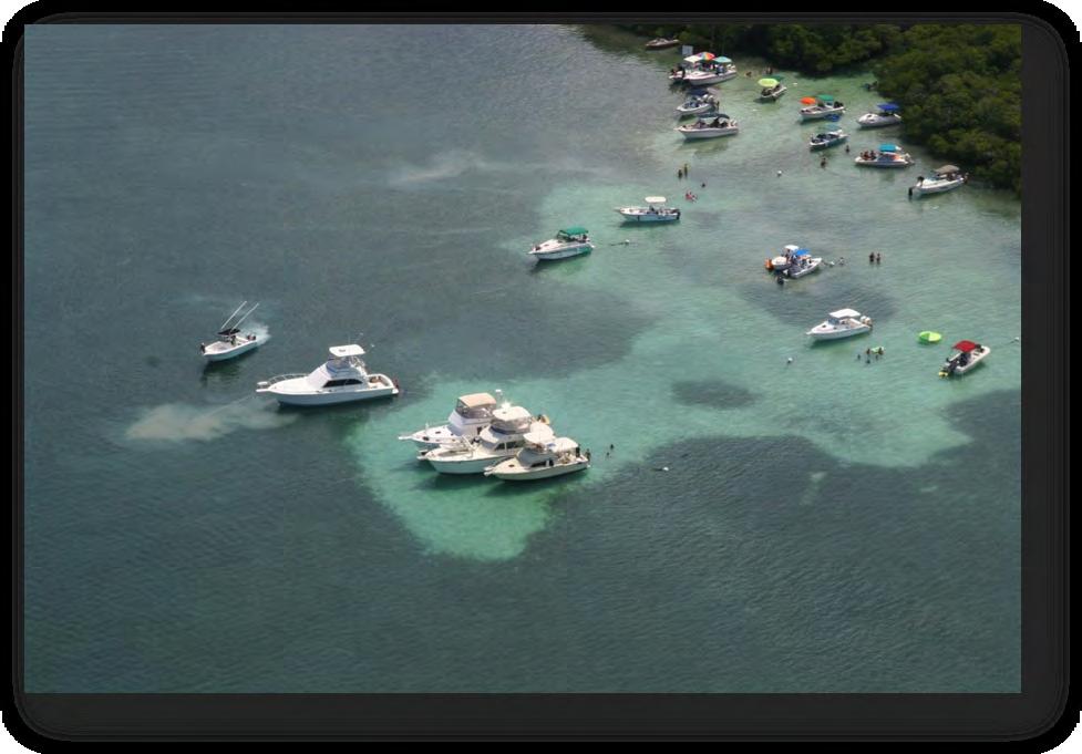
Recreational
Several reef localities in Puerto Rico and La Parguera have been studied intensively (Cróquer and Weil 2009). A number of recent studies have shown that coral cover continued to decline rapidly (e.g., 53% in the last 4 years) and most unexpectedly, that the number and prevalence of diseases is higher in reefs located at a distance from the developed coastal areas (Appeldoorn et al. 2009),suggesting perhaps a more complex suite of variables involved, including climate change, among others.
Research on coral reefs of Puerto Rico has demonstrated that WP-II and YBD are the most widespread and damaging diseases affecting scleractinian corals in Puerto Rico. The first reports of WP-II are from 1995 and since 1999 the prevalence has increased for shallow and deep reefs across the insular shelf of La Parguera (Bruckner and Bruckner 1997). The coral diseases, particularly white band disease, have caused significant declines in Acropora palmata since 1980 when it was first reported. There are some indications that YBD may be associated to one or more types of Vibrio spp. and the potential pathogenicity could be affected by temperature (Appeldoorn et al. 2009). A difference in the mucous layers of corals has been found in healthy vs. diseased M. faveolata colonies, and it seems to be specific to cellulose degradation and nitrification which suggests physiological changes in the coral that allows the pathogens and other microorganisms to colonize (Kimes et al. 2010). Research has revealed that a diverse micro biota exists on coral mucus which can be altered when corals are under stress. Some of these changes have been documented in gorgonians affected with aspergillosis (Gil-Agudelo et al. 2006).
Ocean Acidification
On a global scale, changes in the atmosphere and climate are producing a chain reaction in a number of physical and chemical processes that are transforming the oceans. Increases in temperature, produced by the greenhouse effect (caused by increased emission and accumulation of CO2 and other gases in the atmosphere and the oceans), and the rise in sea level are responsible for dramatic changes in ocean and coastal habitats, ecological processes, species behavior (for example, in corals) and the composition and behavior of the oceans at a planetary scale.
The rise in seawater temperature is one of the most commonly cited causes of coral bleaching and may have led to the increased incidence of coral disease after major bleaching events in La Parguera. One dramatic consequence of the rise in levels of atmospheric carbon dioxide (CO2) is a decrease in pH, a process also known as ocean acidification. The result of this change is the degree of supersaturation that strongly controls the ease at which calcium carbonate minerals can be precipitated from the seawater. This is important for most reef building species, as well as for some important commercially important species for local fisheries. The combination of these factors draws a bleak scenario for coastal communities such as La Parguera. A feasible prediction is that reduced reef accretion due to rising temperatures and acidification combined with increased sea level will undoubtedly make the social component of the shoreline (communities, settlements, infrastructure, economic activities, livelihoods) more vulnerable to natural events (storms, hurricanes) and probably less resilient (in ocean, atmospheric and geophysical terms).
An ocean acidification study is being conducted in La Parguera and provides an opportunity for monitoring carbonate chemistry dynamics across the ecosystem (Meléndez et al. 2011). Preliminary results have detected higher acidification during winter and spring months. This is an important area of research, with a bearing on our understanding of the Socio-Ecological System of La Parguera that deserves more attention.
Chapter 5 - The Complexity of the Social-Ecological System of La Parguera: The Case Study of a Local Fishery
We define the social-ecological system as the collection of habitats, land and sea formations, human presence, species, habitats and climatic conditions that form complex relationships and support interactions among its sectors. A social-ecosystem is dynamic and for the purposes of this document we are scaling the area geographically to the limits of the Lajas municipality. Appendix 3 contains a graphical representation of the social-ecosystem in the context of La Parguera, and includes a schematic of scientific information available, possible actions and reactions as well as other features that have been identified during our research and expert consultation. This is by no means a complete conceptual map since the scientific community perceptions were recorded and provide a starting point for mapping the social-ecosystem. For this section only the main categories will be discussed as the importance of the elements is how they are interacting and some of these relationships have been mapped, although many probable remain undocumented. A useful result of this exercise has been the identification of gaps in the scientific knowledge that would lead to a better understanding of impacts of the complex relationships and what information is necessary to adapt management of the area following an ecosystem-based approach.
The main categories under which different themes were organized include: water, the watershed, climate, sediment dynamics, habitats, biological populations, the human population and a grouping of restoration science. Water is viewed as an important element that connects the other elements of the marine environment with the neighboring areas and activities that shape the ecosystem. Various studies have measured water quality and changes in the optic characteristics of seawater off La Parguera. However long-term monitoring of the coastal waters is lacking, which limits any conclusions about the changing conditions of the ecosystem. A high resolution map indicating the flow dynamics of these near shore waters would also help determine the movement of these water masses and the particles they transport. The watershed has a high degree of connection with the other main elements from which activities and impacts were identified. Many of the processes that were identified as detrimental to the ecosystem are originated in the watershed, including sedimentation, pollution, and habitat deterioration. However many of these processes need to be measured from their source and throughout the ecosystem in order to determine the direction of the gradient of anthropogenic impacts.
Habitats are subdivisions of the ecosystem that contain similar characteristics and support several of the biological populations. The habitats of La Parguera support most of the productivity of the ecosystem and are influenced to different degrees depending on their location and patterns of use. The perceptions of how to categorize habitats are variable and in La Parguera much attention has focused on coral reef habitats as they provide much of the structure and diversity to the ecosystem. However the combination of the associated habitats is what makes the ecosystem of La Parguera so unique. The connectivity between habitats has been identified as an important process shaping the ecosystem. For example water quality was probably maintained by the wetland habitats’ function of trapping sediments and organic matter near shore. This allowed a filtration of rainwater and runoff from the watershed that limited the sediments and other particles reaching the waters. As these habitats were destroyed, the functions they provided were reduced and the water quality impacted, leading to changes in the ecosystem, as we know it today.
In La Parguera at least 6 major habitat classifications were identified, including: wetlands, bioluminescent bays, seagrass, mangroves, coral reefs and unconsolidated sediments. Each habitat can be further characterized and subdivided based on its location, benthic composition and ecological functions. Currently a benthic habitat map has identified most of the submerged habitats for La Parguera (Pittman et al. 2010). However the representation of near shore habitats is incomplete due to the limitations that aerial photography presents in turbid waters. The lack of transparency in many coastal areas of La Parguera resulted in the ‘unknown’ classification for benthic habitats that are perhaps the most directly impacted in this ecosystem. Although many of the habitats, uses, and impacts have been mapped these are dispersed in various location. Different methodologies over time allow for better interpretation of data that has been collected on the habitats over time. All benthic habitat-mapping products would serve a wider purpose if they were available and utilized by subsequent projects and integrated for improvement and application to other research questions.
The biological populations of the marine organisms of La Parguera have been the focus of many investigations throughout the years at the Department of Marine Sciences. The bibliography of theses and dissertations generated here provide information of almost all the groups of biota in La Parguera. Pittman et al. (2010) reported that many of these populations are distributed throughout the habitats of La Parguera and spatial distribution of reef fishes and benthic organisms is available. One of the most notable findings of this study was the lack of large bodied fishes and the smaller sizes of commercially important species that supported a productive fishery for La Parguera in the past (i.e. Mutton snapper). Despite searching during 7 years in over 1,000 surveys, only a handful of commercially important reef fishes have been documented in La Parguera wide studies. Although the metrics on fisheries landings for La Parguera are not available over the same time frame, the condition of the biological populations is thought to have decreased, significantly affecting the condition of the ecosystem.
Perhaps the most important of the biological populations in terms of the ecosystem of La Parguera is the human population. Many of the historical and current behaviors of the humans have shaped the ecosystem and remain an inextricable part of La Parguera. The quantity and quality of human activities in La Parguera is constantly acting upon the other elements identified in this model. These actions and subsequent impacts provide a significant source of complexity to the social-ecological system. Unfortunately these impacts and activities are less studied than other components of the ecosystem and require quantification and mapping in order to address them adequately.
Finally climatic influences are a significant factor in shaping the environment and the ecosystem of La Parguera. Changes due to climate that have been observed affecting some elements of the social-ecological model include increased coral bleaching, changes in precipitation, and storm impacts. The expectation is that climatic changes will continue to influence the ecosystem in the years to come and the complexity of this model will increase with time.
5.1 Fishing in La Parguera
Understanding fishers’ behaviors is critical for the construction of the social-ecological system in a coastal tropical environment such as La Parguera. Fishers (Figure 30) are one of the key users of the natural resources, and thus are important stakeholders, who know and traverse most habitats, coastal and marine. The main assumption and reason for integrating fishers into an ecological assessment is the fact that they engage in extractive activities that impact species, stocks, and habitats. Their activities modify the environment and impose ecological relationships with the milieu and biological populations. The CRES Report (ValdésPizzini 2009) documented a number of activities and characteristics of the fishermen of La Parguera based on a number of sources, including the data from the DNER’s Fisheries Research Laboratory (Laboratorio de Investigaciones Pesqueras). Fishing in La Parguera, as defined in this report, is performed by a variety of fishers, such as recreational anglers, sport fishermen (in the pelagic waters, beyond the insular shelf), subsistence fishers throughout the coast, forest gatherers (pesca de monte, as labeled by other fishers in the south coast, García Quijano, personal communication) targeting mangrove oysters and clams, and small-scale commercial fishers from Cabo Rojo to Guánica.
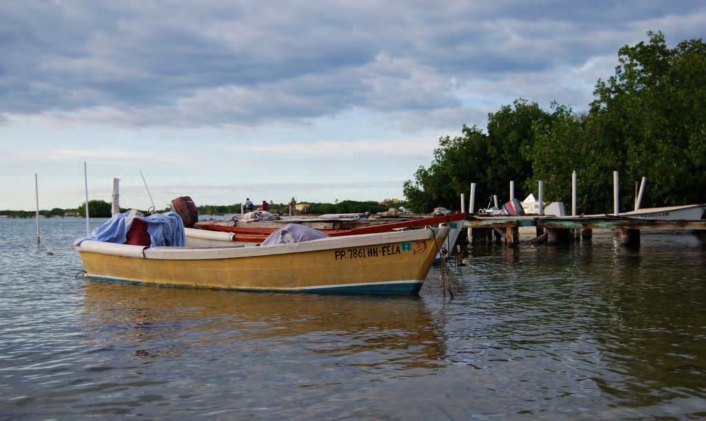
In other words, the seascape, habitats, and marine populations of La Parguera are targeted by a diversity of fishers from various socioeconomic groups. They reach those resources from the Club Náutico, the de-facto marina of the stilt houses (and the hundreds of informal slips they collectively contain), the countless informal piers sprouting from the fringing mangrove forest, on foot from the shoreline, the two or three makeshift ramps, and the three or four recognized fishing piers.
Over the years, we have collected information of the most important variables relevant for the analysis of the extractive activities in which the fishermen are involved: fishing areas, gears employed, and the species they target. The Fisheries Research Laboratory collects information on the commercial fishers’ landings, while there is no published information on the sport and
recreational anglers, except for creel census data in unpublished reports. Ecological systems are complex, and the incorporation of the human factor in the analysis increases complexity. Our argument in this document is that each component of the human system, actors, agents, stakeholders, for example, is connected to the habitats, and bring an array of social and economic relationships (energy and information) into the system that shape the human-nature interface. Those relationships are directly related to their extractive endeavors, but go beyond the extractive process, and put forth the kinship, labor, political and cultural / cognitive relations that determine their level and intensity of participation in the system, including governance. Figure 31 represents the diverse components of the relationships, and processes, related to the fishers, as well as their ramifications and connections with the ecological system.
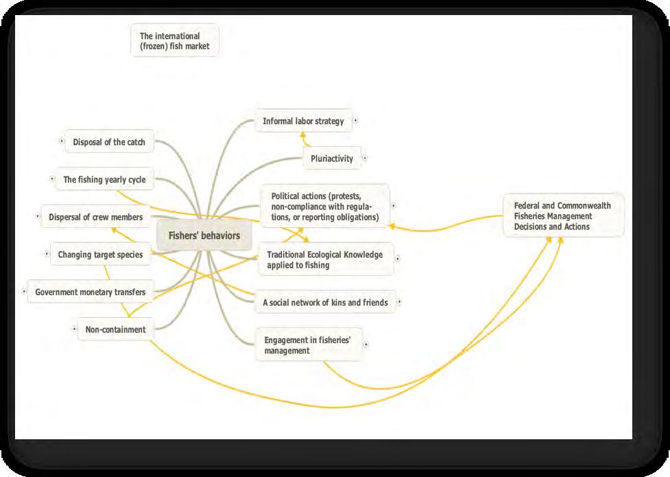
How many fishers?
Since fishers are, as many other resource users, an elusive sort, it is quite difficult to assess their number. Indeed, fishers avoid the state’s strategies of containment, such as: censuses, surveys, interviews, and even licenses and permits. In Puerto Rico, a number of events, such as the NOAA sponsored marine sanctuary, and the deployment of the Fisheries Regulations in 2004, moved the fishers to stop participating in the fisheries landing program of the DNER (Valdés-Pizzini 1990; Matos-Caraballo et al. 2007). The 2008 fishers’ census data from the DNER, Fisheries Research Laboratory, was recently published, providing information on the general socioeconomic characteristics of the fishers. The summary stated: (1) the number of fishermen dwindled from previous censuses, (2) The Fisheries Law, regulations, permits and closures forced a number of individuals out of the fisheries, mainly those who worked part-time, and (3) there is a pattern of fishermen non-compliance, which licenses and permits requirements may have exacerbated.
Based on the database of the 2008 Fishers Census, we estimate that there are 85 fishers using the coastal and marine resources of La Parguera, 32 from Guánica, and 53 from the municipality of Lajas. Twenty-one fishers from Cabo Rojo, live and land their catch in areas close to La Parguera: Corozo, Punta Águila and Combate. There are an unspecified number of harvesters of mangrove oyster who occasionally engage in pesca de monte, gathering ostiones or oysters (Cassostrea rhizophorae) in the roots of the red mangrove forest, west of La Parguera town. It is safe to state that the number of commercial, small-scale, fishermen operating in the habitats of La Parguera range from 85 to 106. From Lajas, most fishers are from Papayo (17), La Parguera (16) and Salinas-Fortuna (10). The majority of the fishers accounted in the census was full-time fishermen, and most reported not having a license. In fact, the census database shows that the fishers, across the board, contented the containment strategy of the government, by stating they did not have licenses, not reporting having one, and suppressing their names (and even nicknames) from the DNER enumerators who collected the data.
Fishermen from Lajas target reef fishes, conch, lobster and snappers and groupers from the shelf drop-off, or veril. The fishers of Guánica have the same pattern of resource exploitation, but they also target pelagic species, to a greater extent that their peers from Lajas. Most fishers from the area interviewed for the census stated that the status of the fisheries’ resources remain similar as in years past. However, fishers from Guánica tend to be a bit more pessimistic and a handful of them (3) perceived that the condition of the resources was worst now, due to contamination, habitat destruction, and overfishing.
Informal labor strategy
Engagement in a number of informal activities, not reported, or illegal, is part of the socioeconomic landscape of La Parguera. Although we do not have information on the current status of those activities, nor is it an appropriate activity for us, it suffice to say that over the past fifteen years a handful of fishers from Guánica and Lajas have been prosecuted for drug trafficking. The coastline of La Parguera is heavily monitored by police and Homeland Security in order to intercept drug and human trafficking operations.
Pluriactivity
La Parguera was, until the last U.S. Census, one of the few coastal communities of the west coast that had a high percentage of the employed population working in the area. The University of Puerto Rico Marine Sciences Department, and its Magueyes Marine Station is one of the main employers, and historically had workers that were also fishermen. In the past, the community had a large number of businesses that recruited the employees from the local community: The Club Náutico, Varadero (shipyard), hotels, guest houses, restaurants, stores, water-based recreational services (wind-surfing, boat rentals, and SCUBA diving), and the boat service outfits taking the public to the bioluminescent bays. There are several government facilities and satellite offices that also provide job opportunities for the local population, such as: the public school, the Headstart program, Playita Rosada public beach (now administered by the municipality of Lajas), Mata la Gata public beach (managed by DNER), and the DNER’s Rangers and RNLP offices. This array of posts, outfits and job opportunities do not exist at the other coastal settlements encompassed by the RNLP and the La Parguera region, except for the few public service and hospitality industry jobs in Guánica.
Livelihood diversification is indeed one strategy used by fishermen to cope with uncertainty particularly as it relates to regulations, scarcity of fish, or variability in the stocks. However, the new regulations discouraged part-time fishers and, overall, the number of fulltime fishermen increased in the last six years, reducing engagement in pluriactivity in La Parguera.
Political actions: protests, non-compliance with regulations, or reporting obligations
Fishers engage in a number of activities to resist and contest government actions and regulations, and the fishers of La Parguera are not the exception. The practice of contesting the government actions started with the perceived “threat” of a NOAA’s Marine Sanctuary in the early 1980s (Fiske 1992). The Fisheries Law and Regulations also provoked the same sentiment and actions, as stated above. Data from the census show that there is a pattern of non-compliance with government exigencies, such as licenses and permits. That assertion is inferred from the data (Matos-Caraballo et al. 2007), but there is no study on the process.
A social network of kin and friends
The fishing community is usually a localized settlement, but it is also a network of friends and relatives, helping and serving as a safety net in duress, and contributes to the resilience of local, traditional (and place-based) coastal communities (Griffith et al. 2007). Fishers in this region are mostly tied by kinship ties formed by clusters of relatives and their friends, in La Parguera, Papayo and Salinas Fortuna (and Montalva), Guaypao (Guánica), and Corozo (Cabo Rojo).
Non-containment
As stated above, the fishers of La Parguera are indeed fishing, most of the time, under the radar of government agencies. They also refuse to be accounted for and identified for the Census.
Government monetary transfers
The subsistence strategy incorporates transfer from government programs: retirement, social security, food stamps, and other aids. There is no information on this aspect of the fishers’ livelihood. In the town of La Parguera, there is large number of fishers that are retirees and therefore receive their pensions, probably handling their household economies with a diversified strategy consisting of: fish for their tables, fish for the market and cash, pensions, social security, and some odd jobs (chiripas) that remain unreported as other economic activity (Griffith and Valdés-Pizzini 2002).
Dispersal of crewmembers
In many fishing areas throughout the Caribbean, coastal demographic growth and gentrification have caused the dispersal of households and crewmembers throughout the landscape. That is the case of St. Croix, for example (Valdés-Pizzini et al. 2010). Data from the fishers’ census suggest that the fishing units are recruiting crewmembers from the local communities, as the total number of available fishermen has been reduced from the potential pool of participants. If the information from the database is correct, it is appropriate
to assume that part-timers left the fishery, and many others, from surrounding communities, were discourage to participate. Thus, the majority of those engaged in fishing come from the “traditional” coastal communities in rural areas or homesteads (parcelas), with only a few that reported living in other barrios or quarters. The reduction in the number of fishers may have caused the social and kin homogenization of the crews and the fishing firms.
5.2 Engagement in fisheries’ management
Fishing is a form of management, however, fishers also engage in a number of social and political interactions conducive to a debate on the conservation of resources. In La Parguera (from Cabo Rojo to Guánica) the debate is centered on the following arguments: (1) There is no mechanism or process for the appropriate and democratic participation of the fishers in the management process, a situation that was exacerbated, in their view, during the implementation of the Fisheries Law, (2) The lop-sidedness of enforcement, and the perceived abuse of the DNER Rangers on their livelihood and behaviors, (3) The weight of Commonwealth and Federal regulations and procedures, (4) Lack of access to the deliberations (although one local fisherman was the head of the Caribbean Fishery Management Council, fifteen years ago). When asked by government agents (DNER) about the conditions and the problems of the local fisheries, interviewees do not recognize overfishing as a problem and, according to the census data, in La Parguera things remain the same. However, when key informants are queried on this matter, they recognize that fishing pressure is increasing and that overfishing is also a factor, jointly with contamination, competition from recreational anglers, and habitat destruction.
Our interviews in 1998, 2006 and focus groups in 2004 (the latter two with the CRES project) show that fishers recognize several problems, including: overfishing, DNER Rangers’ abuse of power, deficiencies in the landing data collected by the DNER, an increase in the number of fishers (circa 2000), the presence of “dead areas” due to sedimentation (GarcíaQuijano 2006), the human impact on the watersheds and the sedimentation of coastal and marine habitats, including the shelf drop-off in the Guánica area, and the lack of an open and democratic participation of the stakeholders in the management process. As fishers are criminalized, and their Traditional Ecological Knowledge (TEK) not recognized (a situation that is changing due, in part, to the results of the CRES project), they remain separated from management. Indeed, they underscore the argument that, due to their TEK, they should also be incorporated in management, via research design and implementation. Their arguments hit the bull’s-eye on the objectives of an ecosystem approach to management strategy that incorporates stakeholders and their forms of wisdom and knowledge.
5.3 Local Ecological Knowledge applied to fishing
Our research on the relationship between fishers and coral reef resources underscored the fact that these stakeholders do have a traditional (or local) form of knowledge on the environment, the species and their ontogenetic behavior, bio-physical temporality, seasonality, the form, shape and composition of the seascape, and a schema of the ecological relationships, based on their systematic observation (and testing) of environmental variables, through fishing, and the sharing of information (García-Quijano 2006; Valdés-Pizzini and García-Quijano 2009). Previous research had shown that the fishers in Puerto Rico (and those of La Parguera) consistently use a system of fish classification based on their habitat and behaviors (Valdés-Pizzini et al. 1996 a,b). An analysis of data collected in the 1990s
(from La Parguera, and other fishing communities in the northwest coast) showed that fishers sort the names of species based on the following four principal criteria: (1) habitat, (2) familyrelatedness, (3) morphology, and (4) behavior. The application of the Multidimensional-Scaling technique, and our interpretation of the data, suggest that fishers cluster species based on the aforementioned criteria (Valdés-Pizzini and García-Quijano 2009).
Coupling of species and habitats
In our CRES project we asked fishers to participate in in-depth interviews on types of habitats, names of places corresponding to those habitats, physical characteristics, and species found at each area (Valdés-Pizzini and García-Quijano 2009). As a guide, we used a list of names fishermen use to refer to habitats: (1) Yerbales: seagrass beds; (2) Matales: reefcolonized pavement; (3) Rastreales: scattered coral unconsolidated substrate; (4) Veril: shelf drop-off; (5) Placeres: shallow areas in reefs (or deep water, and in the mangrove forest); (6) Bajos: shallow areas on the shelf platform or in the deep water; (7) Seco: another category of shallow waters; and (8) Caños: channels in the estuaries and mangrove forests. A handful of fishers also added the following: Arenales: sand scattered materials; Salitrales: salt flats; and Fanguizales: clusters of muddy areas in the reef and in the near shore waters.
The most important results from this procedure were the following: (1) Fishermen recognized all of the areas and provided specific information on the physical characteristics of each “habitat” and the specific geographical names given to each type of habitat (although some indicated that those areas were uncommon in their region and thus did not offer names); (2) Interviewees provided information on connectivity among different habitats. It is clear from the data that fishers conceptualize habitats as belonging to a continuum of places (a habitat gradient) that links them physically and in terms of the species assemblages that populate the habitats; (3) For each habitat the interviewees provided a description of the species found in each area. Although most of the species provided were commercial fishes they exploit, a number of fishers also listed other organisms found in the area. Ecological information and ecological thinking is a key component of small-scale fishers’ cognition of the seascape. It guides their activities as well as their folk taxonomies. Recent research has pointed out that ecosystem-like concepts for describing the biophysical world are not new; in fact, there are numerous examples of ecosystem-like concepts that guide cognition and behavior in traditional subsistence-oriented cultural groups (Berkes et al. 1998).
In our local ecological knowledge (LEK) work in the south coast, we also explored fishers’ ecological thinking by the elicitation and analysis of ‘ecological narratives’ about fishing and the local environment (García-Quijano 2006; García-Quijano 2009). A prominent topic in fishers’ narratives was their emphasis on knowing the fishing areas. Simply stated, fishing areas are places where fish can be caught. The ecological parameters (Johnson et al.1968) of the fishing areas (e.g., bottom/substratum composition, depth, salinity, water turbidity, sediment input, currents, prey species populations, and the species assemblages found) determine what species can be found by fishers and in what quantity. Some localities, such as specific seamounts, reefs, and seagrass beds have been productive fishing grounds over time and thus they have become widely known, named fishing areas. A named fishing area such as, for example, Turrumote, usually refers to a relatively large geographic location. Inside these broad locations, fishers have to find smaller fishing areas to utilize. Because these parameters change in particular underwater localities, fishing areas can, and do, change over time. GarcíaQuijano (2006) presents data on the fact that fishers define a fishing area by the following: 1)
the type of habitat, defined by the type of bottom substratum, and 2) availability of food for the targeted species. A fishing area may only be considered as such during certain times of the year. Fishers report and realize that many species are predictably seasonal in their movements between habitats and geographic locations and they move their fishing effort between habitat patches as productivity varies through the seasons (Aswani and Lauer 2006).
Habitats
The fishers’ schema of habitats is straightforward. First, habitats and species are geographically connected. Second, each habitat has specific physical features and specific species associated with it. In fact, for each habitat the fishermen listed a series of assemblages of species that were unique to that habitat. Third, habitats have, in most cases, names and are recognized by such names in each region. Fourth, fishers recognized specific physical features and characteristics of many habitats. While most provided general descriptions, a few provided details of the physical characteristics of the habitat including depth. Fifth, the fishers provided information on the characteristics of three types of areas that, in general terms, referred to shallow areas. These were: bajos, placeres and secos. These three areas occur either in the insular shelf, or in the outer banks. Placeres, an Old Spanish maritime word for a shoal, is often used for very shallow and calm waters inside the mangrove forests and coastal lagoons. However, placeres are also very shallow extensions in either the shelf or in the outer banks. Bajos, or low areas are also shallow extensions in areas of reefs or in seagrasses, and are often associated with coral reefs, and a rich biodiversity of species and marine organisms. Secos (dry or shallow areas) was perhaps the most problematic as the fishers had different views and descriptions on its physical features. There was consensus in that it was a shallow area and in most cases, navigation was rather difficult in those areas, mainly during low tide.
In this section we describe the basic attributes that the fishers ascribed to the habitats, including the species associated with them. For each site, the fishermen provided a list of the key species of fishes, invertebrates, and other organisms that characterize the area. They also provided names of places and physical characteristics of the area, sometimes in some detail. As expected, some species are found in many habitats, as they spend a portion of their lives or daily routines in a number of them. As in the past, fishers provided unrequested comments on ontogeny of species, in terms of developmental stages, sizes, and uses of habitats. To synthesize the data, we provide a short description of the habitat and the “ensemble” of organisms that they provided for each site.
Yerbales or seagrass beds were characterized as a shallow area covered by seagrasses (both Thalassia testudinum and Syringodium filiforme), inhabited by a large number of invertebrates such as crabs, lobsters, and conch. A number of finfishes were associated with seagrasses, mostly yellowtail snappers, mutton snappers, parrotfishes, grunts, and others. Yerbales was described as a garden, a forest (meaning richness in biodiversity), and a nursery for a number of species. Although this may be a subjective interpretation on our behalf, the network views generated in Atlas.ti (qualitative data analysis and research software) suggest that fishers conceptualize seagrasses as rich and physically irregular habitats where sand patches, corals and mud flats may be also found. Seagrasses are also the habitat connected to the rest of the benthic habitats and thus play a key role in the marine ecology. Large extensions of seagrasses as well as patches scattered on the bottom connect with other habitats including the pathway to the shelf drop-off. Our interpretation of the fishers’ views is that yerbales represent a key habitat that links the benthos. In fact, some descriptions
Table 5. List of fish and shellfish caught, seasons, habitats and gears employed.
Fish and shellfish JFMAMJJASONDHabitats or areasGears
Red hind grouper XX
Coral Reefs / El Hoyo Lines / Traps
Pejepuerco/ Triggerfish XXXXX Reefs / Drop-off Lines / Traps
ParrotfishesXXXXX
Coral Reefs / Rastreales Nets
Blue runnersXXX XXX Lines
HogfishXXXX X Coral Reefs (matales) / Rastreales Traps
Dolphin fishXXX Drop-off / Deep Waters Trolling
Mutton snapper XXXXX
Conch XXXX
Seagrasses / Coral Reefs El Hoyo Lines
Rastreales / seagrasses SCUBA
Mackerel XXXXX Reefs / Drop-offLines
Trunkfish XXXXX
OctopusXX XXXXX
Grunts XXXXX
Coral Reefs / Seagrasses Traps
Coral Reefs / Rocky Bottoms SCUBA
Coral Reefs / Rastreales Nets
Yellowtail snapper XXXXEl Hoyo / Seagrasses Lines / Traps
Lane snapper XXXX Rastreales / Reefs Lines / Traps
Lobster XXXX Rastreales / Coral Reefs Traps
Silk snapper XXXDrop-offReel-lines
Fishing activities on the insular shelf of La Parguera
Fishers from Cabo Rojo to Guánica use all the habitats of the insular shelf for their incursions, including the deep habitats where they used to fish the grouper aggregations (Ojeda-Serrano et al. 2007). For the CRES project we transferred qualitative data on fishing areas and efforts into a map (Figure 33). Fishers target the species richness of the area, as they cover all habitats with their gears. For the CRES project we were able to transfer the information from the interviews to a geographical layer for GIS (ArcView). The extent of the fishing effort, on a wide temporal scale, is also evident in the deployment of traps in the 1990’s (Valdés-Pizzini et al. 1996 b; Jean-Baptiste 1999).
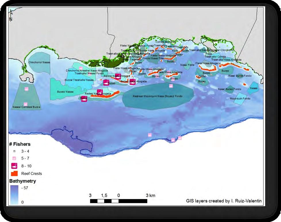
The older fishers of La Parguera (mainly, those key informants interviewed in the 1990’s) have used different gears over the last four decades, and thus had an ample opportunity to observe organisms in different parts of the seascape, under a diversity of circumstances, including temporal scales. Table 6 summarizes in a list the gear types most used.
Table 6. List of gears used by the fishers of La Parguera (Used=it was used in the past).
Gears YesNoUsed
Hand-lines3011
Trolling 2821
Gill nets2155
Bottom-lines1973
Trammel nets1886
Free diving151212
Traps (iron rods)13910
Traps (wood)10616
Traps (weaved)8222
Electric Reel8177
Long-lines61412
SCUBA5189
Beach seines31315
Turtle nets01913
A brief look at the list of gears used by fishers provides an idea of the extent of use, as well as the “historical” process of changes in type, over time. Lines, nets, and traps are the preferred gears among the selected key informants who participated in the study. Most use, or have used, free diving as part of their strategies. Sorting the data by gears used in the past, but not currently used, suggests that traps are in decline, followed by beach seines, and turtle nets, which are now prohibited. A number of fishers used SCUBA but stopped due to age and illness. Interestingly, the shift from traps to lines is actually a symptom of the increase in the number of divers in the region, a gear that allows youngsters without a family tradition of fishing to engage in the trade. These new divers, because of the lack of connection to tradition, are prone to poach fish traps they encounter. Data from the Fisheries Research Laboratory of the DNER indicate that diving for fish and shellfish, using SCUBA equipment is becoming an important activity, showing in the landing figures. The multi-species, multi-gear approach, whether simultaneous or transitional over time, provides fishers with the opportunity of learning and increasing their knowledge of habitats and the assemblages of target species and their behavior. Figure 34 presents a simplified model of the trends in shifting gears at La Parguera.

As the problems and challenges facing coastal fisheries around the world become both more complex and more urgent, all sources of knowledge including LEK for insight into fisheries resource managers should tap ecology and the state of resources. Some fishery management programs are making serious attempts to include fishers’ LEK and we think it will be an important base from which partnerships can be built between resource users, scientists, and managers. In general, fishers have a good working knowledge of the species and the ecosystems in which they operate, as that knowledge is critical for their success. However, there are also differences in the depth, quality, and specificity of their knowledge. First, the geographical area that they utilize limits fishers. Most fishers can make a good assessment of habitats close to their home base (i.e. 15 to 20 mile radius). Second, their fishing gears and daily activities limit them. Some fishers specialized on near shore and mangrove areas; others in deep-water fishing (snapper-grouper complex), and the majority have experience with the fish and shellfish of coral reefs and associated habitats. Garcia-Quijano (2007) and Valdés-Pizzini and García-Quijano (2009) found that fishers selected randomly from license records correlated highly with fishers who were selected for their greater knowledge of key characteristics of exploited species’ ecology. This is primarily due to fishers’ mobility between types of fisheries over time and, to an extent, their communication with other fishers. Thus fishers in general had a working knowledge of those areas they did not usually exploit and recognized the key physical characteristics of each area.
One of the goals of ecosystem approach to management is based on an understanding of the ecosystem, and the human interaction with species and habitats, including the knowledge that resource users have accumulated historically (Helfman 2007). A key insight resulting from our research with Puerto Rican fishers is that, just like fishery scientists and managers, fishers ‘think ecologically’ when they engage with coastal ecosystems. Recognizing
and building on this conceptual common ground can result in increased knowledge sharing and collaborative management with fisheries scientists and government ecosystem managers.
5.4 The DPSIR framework for the La Parguera fishery
Undoubtedly, small-scale commercial fishers are the stakeholder group for which we have the largest amount of socioeconomic data, as shown in this SES analysis (see ValdésPizzini 1990, Griffith and Valdés-Pizzini 2002, Griffith et al. 2007, Valdés-Pizzini and García Quijano 2009). Fishers are the main target of regulations in the governance system, as they are perceived as having a critical role in the status of a number of marine resources, through fishing pressure or overfishing, which responds to a number of socioeconomic drivers. Regardless of the array of pressures and problems that coral reef resources face, fishers are the quintessential culprit of the decline in the health of the ecosystem, despite the identification of severe problems with sedimentation, turbidity and pollution produced by other human activities on a large socio-temporal scale (see for example Pittman et al. 2010).
Nevertheless, it is true that fishers (all types, including recreational and sport fishers) have a direct impact on the structure and function of the ecosystem that may affect its ability to provide adequate ecological and economic services. In this section of the report, we follow the lead of the efforts by Stephen C. Mangi, Callum M. Roberts and Lynda D. Rodwell in the preliminary assessment of the DPSIR for the Kenyan coral reef fisheries (Mangi et al. 2007). Also, we are employing Simon Jennings’ outline on the potential indicators for the analysis of drivers, pressures and impacts in fisheries, from the perspective of the EBFM (Jennings 2005). The application of a DPSIR focuses on the components of the ecosystem (in the case of fisheries, habitats, water quality, species, species groups). Indicators provide a “good coverage” of the components of the system and their attributes (their properties). Indicators are “variables, pointers, indices of a phenomenon” that serve as a proxy for the attributes, which in turn provide us with a picture of the state of the environment and the processes that are the source of change (Jennings 2005).
Similar to our analysis of the bioluminescent bays, and the coral reef ecosystems, we provide here a diagram showing the DPSIR connections for fisheries in La Parguera. However, we are following here a modified outline of the discussion presented by Mangi et al. (2007), on those critical processes and their indicators, for the coral reef fisheries.
Socioeconomic drivers
Population: Usually an increase in the population—at the national level—is viewed as an important driver, since it serves as a proxy for an increase in the demand for fresh fish, and an encroachment of coastal habitats through urban development; a process that impacted La Parguera from 1980 to 2000. However, population increase is a problematic indicator for the driver for many reasons: (1) Puerto Rico lost population in the last decade, (2) Lajas, and the nearby municipalities’ constant levels of population, (3) The demand for fish (fresh, frozen and salted) remains the same (see Griffith et al. 2013). The number of fishers in Puerto Rico, as stated in the previous section diminished in the past decade, and therefore, fishing pressure could have declined.
Unemployment: Puerto Rico is undergoing a major economic crisis due to lack of productivity in the manufacturing sector, as well as low levels of production in the agricultural and service sectors. A large debt is debilitating the government’s ability to recruit civil servants (it has been one of the key employers in the last 20 years), and the reduction in the number of government employees, and early retirees has compromised the government retirement funds (Marxuach 2012). Although economic growth in 2012 maintained a level similar to 2011, the downward trend in the last 10 years, and the massive capital and labor drain to the United States in the last decade (Duany 2011) has undermined the territory’s economic capabilities and its credit, to sustain services and build infrastructure. The real-estate bubble forced the halt of the construction sector that was, since the 1990’s the most important sector in the economy (Valdés-Pizzini 2006), one that fueled the financial market and banking sector.
Data from the Bureau of Labor Statistics (BLS) show that unemployment in Lajas and Guánica kept constant levels throughout the last decade, although a small increase is shown towards the end of the timescale (Figure 35).
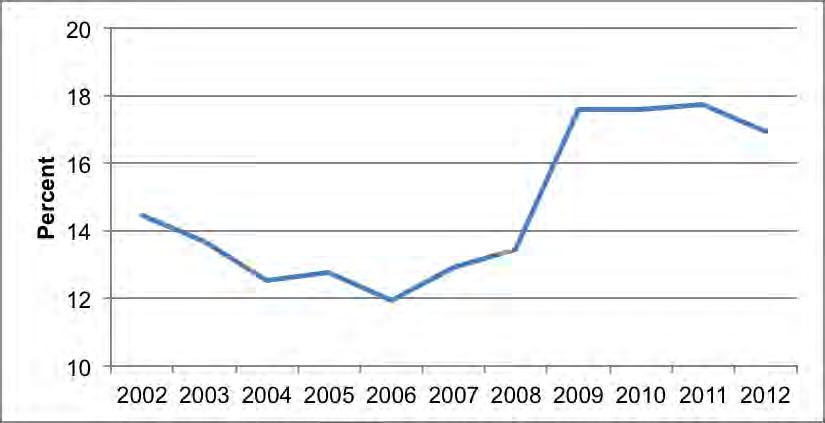
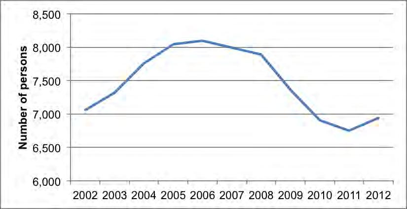
Fish consumption and demand: Puerto Rico has maintained, over the years, a steady demand for fish. The history of that demand and process has been extensively documented (see Griffith et al. 2013 for a summary). Salted fish dominated until the first half of the 20th century, when frozen fish started to dominate the market. Puerto Rico imports more than 75% of the fish it consumes, and fresh fish and shellfish are only a fraction of that amount (we suspect that the amount is higher, reaching the 90-95% mark). However, fresh fish and shellfish play a critical role in the local gastronomy and restaurant businesses. Restaurants use fresh fish as chum to attract customers to whom they sell and serve a mixed fare of frozen (imported) and (to a minor extent) fresh fish. Restaurateurs use the local fare (lobsters, conch, snappers, groupers, hogfish, and trunkfish, among others), to show and tell customers about their supply, and to sell the fresh fish to those who order it whole. Frozen fish—of great quality—is served in other dishes in which the local side dishes and the sauces are perhaps of more importance. Both, fishers and restaurant owners make an effort to offer and to buy the fresh local catch. The market controls over the effort and products captured is an area of research and regulations that has not been investigated at all in the local fisheries, but could provide much insight into the current uses of the marine resources.
Another dimension of fish consumption that has not been studied is the role of those other fishes that are seldom consumed at restaurants but that are important in the gastronomy (and nourishment) of the coastal households. Fishers distribute their catch among friends and relatives for their consumption. An unspecified amount of fishers, without license and oscillating (in terms of behavior) between “commercial” and “recreational,” fish for their subsistence, to add more food to their plates. In difficult economic times, when unemployment is at its highest, it is expected to observe a number of fishers under said conditions who also increase the amount and diversity of fishes caught.
Pressures
The number of fishers: As stated above, the number of reported fishers in Puerto Rico declined in the last decade from the previous average of 1,500 per census since the 1930’s. A summary of the most recent census data is presented in Figure 37. The 2008 Fishers’ Census conducted by the FRL of the DNER counted 868 registered (and licensed) fishers through the archipelago, the lowest number ever (Matos-Caraballo and Agar 2010).
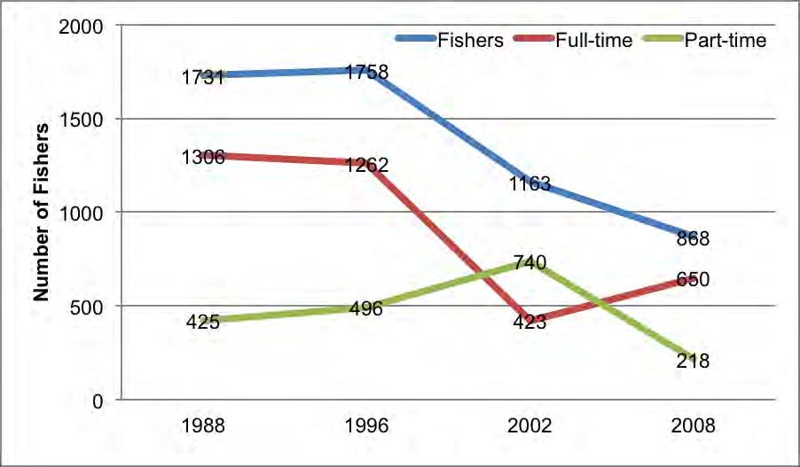
However, we suspect that the actual number of fishers has remained the same or increased, without being licensed or recognized by the authorities. As stated in the previous section of this report, there are 85 fishers using the coastal and marine resources of La Parguera, 32 from Guánica, and 53 from the municipality of Lajas. Twenty-one fishers from Cabo Rojo live and land their catch in areas close to La Parguera: Corozo, Punta Águila, and Combate. From Lajas, most fishers are from Papayo (17), La Parguera (16) and SalinasFortuna (10). In this section we are also including the landing data from Guánica, and therefore, we need to include the 18 fishers from that municipality in our calculation. The number of fishers operating in this (extended) area of La Parguera, and beyond, is at least 124.
Resource exploitation: Overfishing has been indicated as the culprit for the decline in catches from 1996 to 2002 (Matos-Caraballo et al. 2007). Overall, an increase in effort is suspect for the decline in the fisheries, and certain key commercial species such as conch and lobster. Recreational activities: La Parguera (and those coastal sites in the region, from Bahía Sucia, in Cabo Rojo, to Aurora Key [aka Gilligan’s Island] in Guánica) have become important sites for leisure-oriented activities, at the shoreline and at the keys near the coastline. These activities range from beach going activities at Playita Rosada and Mata La Gata, to boating activities from Varadero (West) to the Club Náutico (East), to the unmanageable boating activities held a Cayo Caracoles and other keys, to traditional leisure activities of parguereños at a number of cayos. As a result, boat traffic near the coast is, particularly on weekends, unbearable for fishers who often decide not ply in those waters during those days due to speeding, irresponsible navigation, groundings, etc. Non-extractive recreational activities do have an impact on the biodiversity and habitats (García-Saís and Sabater 2004). However, more precise indicators and documentation on that specific human activity and its impact on fishing remain to be explored in detail.
Development: Urban development in the 20th century also impacted the estuaries where the urban poor squatted in large numbers, a process that also resulted—with the suburban expansion after the 1960’s—an encroachment of certain areas of mangroves throughout the island (Martinuzzi et al. 2009).
Ironically, with the decline in agricultural activities, and the demise of the sugar cane industry, the vegetation cover throughout the island increased (López-Marrero et al. 2001), and La Parguera is an example of that, if measured by the amount of vegetation cover in the surrounding hills and the recuperation of the fringing mangroves, despite the occupation of the shoreline by the casetas (Valdés-Pizzini 2009). However, with land free from agriculture, some local landowners turned into developers, urbanizing their lands and selling plots for construction projects or individual homes. That development, mostly in the western area of town, impacted the coastal habitats (Hertler et al. 2009).
State change
Fish abundance: There is consensus the abundance of fish has declined over the past 50 years in La Parguera. Large catches of mutton snapper (L. synagris) and red-hind groupers (E. guttatus) are a thing of the past. Recreational fishers identified La Parguera, in the 1950’s, as one of the promising fishing areas, and a quaint spot for leisure (Bird 1960). The newspaper weekly column (Pescando en Puerto Rico, “Fishing in Puerto Rico”, El Mundo) consistently published notes and anecdotes of legendary catches, and the cornucopia of their spoils. Indeed, the personal archive of one of the most important sport fishers in the region, Manuel
Domenech (who also owned a caseta called Shangri-La) showed large catches of fishes and shellfish by the recreational fishermen (Figure 38).
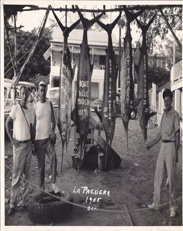
(Photograph from the CIEL Coastal Collection, UPR-M).
In focus groups conducted under CRES research (Valdés-Pizzini 2009), both, recreational and commercial fishers acknowledged that the fisheries are declining in abundance, for a number of natural and human related reasons. Small-scale commercial fishers with a high level of knowledge on the fishery indicate that the increase in pressure over the years, and the number of youngsters entering the fisheries—without a well-formed LEK, and a conservation ethic—are also the culprit for the decline, along with human-environmental causes, such as pollution and sedimentation of the coastal waters, with the deterioration of coastal habitats (see Valdés-Pizzini et al. 1996a, Valdés-Pizzini and García-Quijano 2009).
Although there are discrepancies on the issue of the increase of commercial fishers in the last decade, one important fact stands out: the number of recreational and sport fishers is quite large, although it remains inestimable. Estimates on the number of recreational fishers vary widely, as well as the amount of pounds they land, which most expert suspect either equals or surpasses yearly catches of the small-scale fishers. Griffith et al. (2007) reported, using data from the Marine Recreational Fishing Statistics Survey of 2004 that the local number of recreational fishers was estimated at 141,000, which harvested more than two million pounds of fish and shellfish.
In addition, there is an array of problems associated with the data collected on the landings of commercial fishers. The problem, and its dire consequences on the management of the local fisheries, has been acknowledged by local authorities, fishers, scientists, managers and federal authorities (SEDAR 2009, Matos-Caraballo and Agar 2010, Appeldoorn 2011, Valdés-Pizzini et al. 2012).
Live coral cover: CRES and CCRI sponsored research indicates that the amount of coral cover in La Parguera has declined. As reported in this document, CRES sponsored research has shown that there is a relationship between turbidity and live coral cover (Bejarano-Rodríguez 2006). Disease and bleaching, since 2005, has contributed—as stated in this report—to the loss of the major reef building corals (e.g., Montastraea) in La Parguera (Appeldoorn et al 2009), followed by an increase in the cover of algae and other benthic organisms. Nonscientist experts (divers and operators) also agree on the status of the coral reefs (Valdés Pizzini 2009). Changes in the live coral cover may also impact the associated habitats such as unconsolidated sediments and, more importantly, seagrass beds, a habitat that plays a critical role in the ecosystem, and is a predictor of fish species richness (Pittman et al. 2007), and a space of high importance (cognitive and practical) to fishers.
Fish Populations: Fish and shellfish populations are reported to be declining throughout the last 25 years. CRES sponsored research found that “large bodied fish species targeted by the fishery have decline substantially (Pittman et al. 2010). The study found that the size of snappers was smaller than previously reported, important predators, such as Mycteroperca spp. were absent from all surveys over a period of 7 years, and all groupers observed were much smaller than the maximum size (length) reported for their species. Recent analyses on the length-based structure of commercially important species (from both fishery dependent and independent data sets) have shown that most species of groupers and snappers have decreased, indicating a substantial reduction in their population, due perhaps to overfishing (Ault et al. 2008).
Impacts
Declining fish catches: Landings data collected by the DNER Fisheries Research Laboratory staff presents a grim picture for La Parguera. For this analysis we present recent landings data from Cabo Rojo (those landing centers closest to La Parguera, where we documented incursions into the area), Lajas, Guánica and Guayanilla, thus covering a large segment of fishing operations in which there is connectivity of habitats, species and humans. Although the data is suspect, and its reliability questionable, those are the numbers by which fisheries management decisions are made, albeit some corrections derived from the models, and consultations with experts, fishers included (SEDAR 2009).
The most important trends are the following:
(1) The amount of fish and shellfish landed in the selected sites has declined since 2001, featuring a 70% decrease (Figure 39). That decrease represented a 52% decrease in the total value of the catch (from $1.7 million dollars to $850,000) as reported.
(2) The landing sites from Guayanilla and Lajas suffered the harshest reduction in landings, with 93% and 86% respectively (Figure 40). Fishers from Guayanilla may be reporting at other sites, while an unspecified number of fishers from Lajas are not reporting at all.
(3) Arguably, the most consistent fishing gear or methods are SCUBA diving operations and the bottom line, which had the lowest reductions in catches (54% and 66%), when compared with other competing gears in the region. Fishing with trammel nets, gill nets and fish pots practically collapsed in the area under study (Figure 41).
(4) Keystone commercial species, such as Caribbean spiny lobster (Panulirus argus), queen conch (Lombatus ‘Strombus’ gigas), dolphinfish (Coryphaena hippurus), groupers, snappers, and parrotfishes (Figures 42, 43, 44, and 45 show a marked decrease in landings.
(5) Dolphin fish is a species shared between the recreational and the commercial alike, and it is the main target of the La Parguera Club Náutico fishing tournament (Griffith et al. 2007).
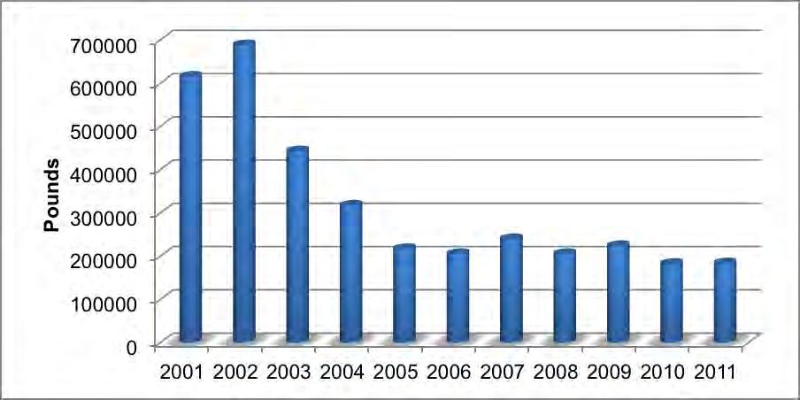
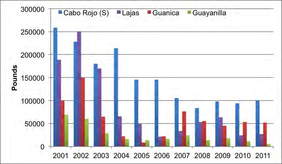
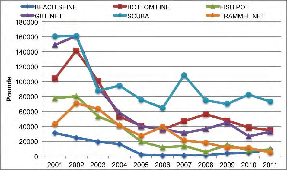
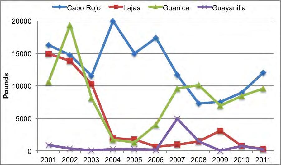
Livelihood benefits compromise: There is no documentation on the current socioeconomic condition of the fishers, or the impact of regulations and the decline in the catches. Fishers are believed to have other options, and to articulate a diversity of income alternatives, through their incorporation in other sectors of the economy (Griffith and Valdés Pizzini 2002). However, with the high unemployment figures for Puerto Rico and Lajas, and the inability of construction and agricultural work to recruit laborers, it is unlikely that they will find jobs under the current circumstances. One hypothesis on the economic behavior of fishers at the present time, consist in arguing that these producers will find the current state of affairs (licenses, fees, requisites, closures and prohibitions) onerous and unfeasible (due to the number of hurdles imposed) and thus will abandon the fishery. Another hypothesis is that fishers, facing the onerous and unfeasible, will continue in the fishery unlicensed (as the recreational fishers do), dodging the containment strategy of the state.
Increase conflict / exclusion: One of the most significant aspects of La Parguera (and Puerto Rico), is the undocumented increase in the number of recreational and sport fishers, who target similar species, and compete for space and catches with the small-scale commercial fishers. That dearth of knowledge is critical for the understanding of the stocks and the management of the fisheries (Guénette and Hill 2009). Historically, recreational anglers have competed for the same species (Griffith et al.1988), and all types of fishers covet one key species, dolphin fish. La Parguera harbors a small yacht club and there are several businesses (including fishers households) that cater to the needs of the recreational fishers (mechanics, guarding and keeping the boats, boat piloting). Many outsider recreational and sport fishermen have houses, apartments, and casetas in La Parguera, and have, historically, incorporated into the life of the community, with a social legacy that is the source of a number of conflicts and perceptions that hinder collaboration in management. It is appropriate to state here that the casetas, serve the function of a marina of sorts, and that there are two improvised boat ramps in La Parguera, which serve as infrastructure to boating and recreational and sport fishing activities.
Fishing down the food web: The low abundance of predators and the poor state of herbivores in surveys, suggest that the local fisheries may have impacted the food web (Pittman et al. 2010, Guénette and Hill 2009). The dramatic decline in the catches of groupers, snappers and parrotfishes is perhaps an indicator of this impact.
Responses
In the context of governance, as defined in this document, civil society (environmental organizations, stakeholders, universities) and the state respond to the current conditions of the fisheries by proposing regulations, seasonal closures, fishery management plans (in the Federal context, through the Caribbean Fishery Management Council), minimum size regulations, the creation of marine reserves (Matos-Caraballo 2009, Aguilar-Perera et al. 2006), and the development of social practices (human agency) to defray the costs and consequences brought by the chain of drivers, pressures, and impacts.
In response to the downward trend in the catches and the size of fishes caught, the DNER promoted a highly unpopular Fisheries Law, which included a number of restrictions, prohibitions and seasonal closures, in addition to the ratification of marine fisheries reserves (Tres Palmas, Mona Island, Canal Luis Peña, Condado Lagoon and Isla Desecheo), as notake reserves.
As a result of these responses, fishermen had a new system of licenses that classified them into full-time, part-time fishers, and apprentices, depending on the years they have fished, and the amount of time devoted to fishing. As part of the licensing, fishers also had to pay fees to fish certain species (lobster, conch and snappers).
The regulations prohibit the capture of two threatened species, Goliath and Nassau groupers, and established seasonal closures for red-hind and yellowfin groupers, silk, mutton and blackfin snappers, conch and land crabs (Cardisona guanhumi, an important species for coastal-land fishing, or pesca de monte) for Puerto Rican waters and coasts. For US federal waters (beyond 11.35 miles), the regulations prohibit the capture of Nassau grouper, Goliath groupers, and conch, while seasonal closures are in place for red-hind, yellowfin, tiger, black, red and yellowedge groupers, as well as for mutton and lane snappers. These restrictions impose a difficult productive schedule to fishers who are rather unhappy with the amount of restrictions, even when recognizing their importance (Griffith et al. 2007).
No-response (licensing system for recreational fishers): Oftentimes, a course of noaction has a negative impact on a fishery. Here we argue that the DNER inaction in regards to the implementation of a licensing system for recreational fishers, due to a political move of the government to avoid any appearance of imposing a new tax, resulted in a negative outcome. The number of recreational fishermen remains unknown and their impact is barely estimated by creelcensuses. It is also viewed as an unjust and biased manner in which the law is implemented by the government, favoring the recreational fishers, which have a heftier political clout.
No socioeconomic documentation on the impacts of closures and regulations: There is no information, except for a handful of educated guesses, on the economic impact (and the labor arrangements of the fishers) of the license system and the closures. Weather conditions (especially in the north coast, and in the Mona Passage), personal conditions and situations (sickness, family affairs, personal matters, loss of equipment, repairs, mechanical failure, availability of crew members), and the seasonal closures impose a very restrictive schedule on the productive agenda of fishers. This is indeed a major information gap for both La Parguera and for the Island.
No enforcement: The biggest problem faced by officials when dealing with fisheries and the management of marine reserves is the lack of law enforcement and compliance. A number of citizens (commercial, recreational, subsistence, and sport fishers) fail to comply with regulations in regards to closures (seasonal and spatial), bags and size limits. This situation has been documented in a number of reports, but has not been evaluated by the government agencies.
Tradition and culture: Although it is seldom considered, we believe that NGOs, community based organizations, and the communities and the stakeholders themselves engage in responses to tackle the difficulties provoked by pressures and impacts on the habitats, the resources, and their livelihood. Maintaining traditions, inventing, and re-living and re-inventing them (the Three Kings festivities, the coastal procession of St. Peter), facing the government and the developers with activities, discourses and data, and protesting, are but a handful of ways in which the people of La Parguera, with all their social differences, and the acrimonious legacies, built a front to engage the government and their practices (see ValdésPizzini 1990, Fiske 1992, Krausse 1994).
La Parguera has a long tradition of fishing, and hence the development by fishers over the years of LEK. It is difficult to assess if that knowledge and tradition is waning or keeping its strength, as family and crew members of traditional fisher families are moving into other occupations, and the void is filled by newcomers. Despite modernization and development over the past 50 years in La Parguera, with the increased housing and population (both residents and a floating population), the site has kept its identity as a coastal community. However, it is the perception of social scientists that La Parguera is a fishing community only as a postcard, that is, in appearance (Brusi 2004). Indeed, La Parguera has suffered the social displacement of the local population, who originally lived on the coast, to the parcelas, while middle and upper class families from Lajas and nearby towns moved into the floating houses and the casetas since the 1950’s and 1960’s. That process is dubbed as coastal gentrification (Griffith et al. 2007, Brusi 2008), and is impacting, in socioeconomic and political terms, fishing and coastal communities throughout the United States.
La Parguera has maintained some cultural elements that underscore their fishing and coastal heritage, as well as religious and social celebrations and commemorations to that effect (Griffith et al. 2007). The communities of Papayo (one of the poorest communities in Puerto Rico) and Salinas Fortuna (an area of parcelas) also maintain their coastal identity. Papayo has suffered the impact of gentrification in the last 15 years with the occupation of the land closer to the coast by what Brusi calls “deluxe squatters” that shows some resemblance with the process in La Parguera. At the time of this writing, fishers from Salinas Providencia and Papayo were under the market control of a fisher dealer from La Parguera. This adds to a long termed competition and discrepancies (and animosity) between the people of Papayo and those in La Parguera, that was exacerbated during the process to promote Cayo Turrumote as a marine reserve.
Final comments on Responses- One of the difficulties or challenges in elaborating a DPSIR model is that, in reality, those links and relationships are not static, but dynamic, and there are an unspecified number of feedbacks that modify the components of the system. Appendix 4 presents a diagram that organizes the information provided in this section, on the Fisheries DPSIR. The diagram depicts a handful of feedback relationships that we documented for the fisheries.
The Fisheries Law, the ensuing regulations, and the licenses had a series of unexpected consequences that have been well documented, or suggested, by Matos-Caraballo et al. 2007, and Matos-Caraballo and Agar (2010).
These are:
i. The number of licensed fishers decreased dramatically.
ii. According to Matos-Caraballo et al. (2007) admission, the Fisheries Law led many fishers to retire from this productive activity. Seasonal closures and restrictions (e.g., minimum sizes) played a major role in this process,
iii. A large number of fishers (33.5%) in the 2008 Census did not have a license. It is feasible to suggest that the loss in the number of fishers is due to the fishers’ decision to contend the containment strategy of the government and to remain uncounted and fishing without any restrictions.
iv. The data discrepancies between the DNER accounting of licenses (a total of 1,129: 416 apprentice, 89 part-time, and 624 full-time) and the Fisheries Research Laboratory
(Matos-Caraballo and Agar 2010), add uncertainty and suspicion regarding the real number of commercial fishers, and suggests a practice of dodging the system.
v. Fishers interviewed in the Census (39%) indicated that one of the impacts of the DNER regulations consisted in a reduction of their income, a number lower than in previous years (Matos-Caraballo and Agar 2010).
vi. The decrease in the number of fishers who are declaring their catches is also reflected in the decline in the landings.
vii. The reporting of landings suffered from several budget cuts through the last 4 years, and therefore, the accuracy of the reporting also suffered (Matos-Caraballo, personal communication). Reporting is also viewed as cumbersome by some fishers, who do not comply with the process (Matos-Caraballo and Agar 2010).
The government of Puerto Rico succeeded—by the sheer, and unforeseen force of their actions—to reduce the number of part-time fishers. Arguably, part-time fishers may be the most resilient producers who could have been essential for the sustainability of the fisheries, as they had other jobs and occupation to fall back during difficult periods. Part-time fishing is a quintessential mode of operation in most fisheries throughout the world, and these producers also show levels of LEK, similar to the full-time fishers (García Quijano 2007).
As stated in this section, a number of processes are charged with social legacies and recognizable path dependences, such as agriculture, manufacturing and construction, a triad of activities that will continue to impact the local fisheries, as well as the habitats of the La Parguera ecosystem. The cluster of responses to the fisheries, are having—and will continue to have—both, positive and negative effects on the resource users, the habitats and the species. We are recommending that the stakeholders become involved in a process of distillation and refinement to explore all the possibilities and complexities of the socialecological system of La Parguera using the DPSIR diagrams and discussions presented in this report.