HISTORICAL MAPS

CARA CONLON


In the 1960s map, the peacewall had not been erected yet, therefore making the two communities unwillingly live side by side.


In this site, you can clearly see that it was an empty space showing an underdevelopment within the area. When the Peacewall was erected, this site had the opportunity to develop terraced housing.
You can also see here that the streets of Beechfield and Madrid continued through the two communities until the Peacewall stopped this.

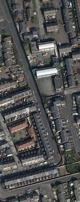
In the 1980s map, you can see here in this, a Transport Depot which evidently had taken up a large site
Later this site, due to high demand in housing and after numerous attacks within the Short Strand area, the area of Langtry Court and Clandeboye Gardens were brought about


Now looking at the 2015 map, we can see a large difference in the development of housing.
The main difference being the large Peacewall. This Peacewall was initially constructed to stop Catholics from moving into the more Protestant populated areas.
The 10 foot high brick wall with barbed wire has had many of fights along the edges which had led to rioting.
Streets such as Cluann Place, Beechfield Street and Madrid Street have remained there for decades although with some changes over the years after the Peacewall divided them.