Birkhäuser
Basel

Birkhäuser
Basel
Nitin Bathla, Elisa T. Bertuzzo, Rodrigo Castriota, Nancy Couling, Alice Hertzog, Nikos Katsikis, Metaxia Markaki, Philippe Rekacewicz, AbdouMaliq Simone, Kit Ping Wong
Edited by Christian Schmid and Milica TopalovićIntroduction
Territories of Extended Urbanisation. Planetary Struggles and Agendas for Action
Christian Schmid and Milica Topalović
23 Extended Urbanisation. A Framework for Analysis
Christian Schmid
83 The Mine, the City, and the Encampment. Contesting Extractivism in Eastern Amazonia
Rodrigo Castriota
121
The Horizontal Factory. The Operationalisation of the US Corn and Soy Belt
Nikos Katsikis
159
Losing Sea. Abstraction and the End of the Commons in the North Sea
Nancy Couling
197
Expropriation and Extended Citizenship. The Periphalisation of Arcadia
Metaxia Markaki
235
Urbanisation through Movement. The Lagos-Abidjan Corridor
Alice Hertzog
269 Translocalisation and the Production of Space. West Bengal’s Ex-Centric Territories
Elisa T. Bertuzzo
303
The Territory and the State. The Urbanisation of Dongguan Kit Ping Wong
345 The Highway Revolution. Enclosure and State Space in India Nitin Bathla
379 Coda When Extended Urbanisation Becomes Extensive Urbanisation
AbdouMaliq Simone
403 Biographies
Acknowledgements
Colophon
At the time of writing the last pages of this book, apocalyptic news of migrant tragedies, governance failures, political polarisation, and warfare are inundating the media. Since our international group of scholars started this project in 2017, perceptions of urban stability have been forcefully shattered again and again: exhausted palm oil plantations in Sumatra were burnt to make room for new plantations cloaking Singapore in dangerous fumes; floods swept through the densely settled areas of Bangladesh and Pakistan forcing thousands to resettle; heat waves struck popular holiday destinations in Europe and North America, and forest fires in Canada caused toxic clouds of smoke to choke New York. The entrenched centre-periphery dynamics of stable urban core zones that externalise the crises generated by their own consumption is changing significantly: the turmoil in the peripheries is folding back onto the centres. We argue that destructive developments in both peripheries and centres are aspects of urbanisation.
One of the main motivations of this book, then, is to examine how planetary social and environmental crises are related to urbanisation. Our research perspective stands in contrast to mainstream academia, media, international institutions, state actors, and global enterprises who promote cities and agglomerations as solutions to those crises and present them as the future of humanity; however, they do not acknowledge the planetary character of urbanisation. Such city-centric imaginaries are no longer simply
naïve—they are dangerous. Urbanisation needs to be reframed as a multifaceted and contradictory process that is simultaneously productive and destructive and affects both urban centres and sparsely settled peripheries. During its historical course, and particularly in the last five decades, urbanisation has unleashed a host of destructive forces leaving a footprint that extends across the planet. For some, this can be seen as “creative destruction” advancing the modernisation of society, the “unintended consequences” of which must be accepted as the price for progress, economic growth, and private profit.
While urban development in the metropolitan centres—“concentrated urbanisation” in our vocabulary—has attracted much attention, “extended urbanisation”—the urbanisation of the peripheries—has remained largely overlooked by mainstream scientific research and public discourse. However, new concepts and engagements with this kind of urbanisation have recently been developed in certain strands of critical and postcolonial urban research, as well as in architecture and urban design. This book contributes to these endeavours, based on insights resulting from ethnographic engagements with many different actors and situations. Most significantly, our interactions with people struggling to establish and protect their livelihoods reinforced our impression of urgency. In conversations with food hawkers along the Lagos-Abidjan corridor, pastoralists in the Arcadian mountains, camponeses in the Amazon, workers on oil platforms in the North Sea, villagers in Dongguan and West Bengal, farmers in Iowa, and inhabitants of subaltern settlements in Delhi, we encountered growing political consciousness, struggles for self-determination, and in some cases, organised political movements engaging with and contesting the manifold impacts of planetary crises. Tracing these struggles and resistances against the devastating effects of extended urbanisation became a focus of our research and is the focus and inspiration for this book.
We are convinced that the study of extended urbanisation can give us a better understanding of the interlinked planetary crises. But, in order to engage with these processes, a critical perspective on conventional concepts and theoretical frameworks concerning urbanisation is required. The examples analysed in this book affirm that urbanisation processes unfold both within and beyond centres and agglomerations. A perspective that goes beyond city-centrism does not focus on the facts and statistics that are used to define areas we call “cities” and does not restrict attention to settlements that fulfil the limited criteria of density and population size. In this project, we understand urbanisation as a multidimensional process that produces territories and settlements with implications for the entire planet. We also see it as part of a collective social practice that is neither inevitable nor neutral but intrinsically political. We emphasise the agency
involved in the processes of urbanisation and explore the inherent possibilities for changing social practice. Our perspective is directed towards action.
This edited volume is a common intellectual project resulting from a collective effort of empirical research and theory building. We selected eight territories to study how processes of extended urbanisation unfold on the ground. These territories are located across North-South and East-West divides to bring different geographies and urban constellations into comparison and dialogue. We were looking for a diversity of study areas, that could allow us to identify and conceptualise different processes of extended urbanisation. When we started this project, most case studies were part of ongoing research projects; thus, the researchers were already familiar with their fields of study. By initiating a transdisciplinary conversation, we analysed how these territories develop, learning from the different experiences, and building a common understanding of urbanisation processes. What does it mean to carry out research in territories of extended urbanisation? The researchers had to cover vast study areas and often stayed there for long periods of time. They traversed territories on foot, by train and car and applied adapted mobile and multi-sited ethnographic research methods. They also worked with photographs, video, and oral histories. Two of the case studies, Arcadia and the North Sea, build upon prior research that was conducted with architecture students in design studios. Another important instrument brought into this project was an adapted form of radical cartography. It was led by geographer and cartographer Philippe Rekacewicz in collaboration with the researchers. Our main instrument of synthesis were workshops that served as moments of evaluation, comparison, conceptualisation, and theory building. Four workshops took place in Zurich (between 2017 and 2022), two in Singapore (2018), and two at AAG conferences in Boston (2017) and Washington DC (2019). These workshops were generative as we learned from the different positions of the team members, opened up conversations with other researchers, engaged with diverse perspectives, and developed new understandings of the emerging categories and concepts of extended urbanisation, now presented in this collection.
To contribute to the concept of extended urbanisation, we worked with a dynamic, multidimensional understanding of urbanisation, inspired by diverse researchers and thinkers whose ideas have allowed us to gradually refine; these efforts are presented in the opening chapter by Christian Schmid. We further developed these thoughts and concepts during the research and workshops. We understand urbanisation as a historical process that should not be confounded with the long history of human settlements and their traces on Earth. Our focus is on the relatively recent historical phase of urbanisation as a process linked to the development of capitalism and rooted in Western anthropocentric rationality and the philosophical split between society and nature. In many parts of the world, it is characterised by the industrialisation of society and the commodification of space, time and experience. The shift from earlier stages of the development of human territories, including the establishment of cities, to urbanisation as a dominant, and potentially planetary, process is not marked by a single event. Starting with the industrial revolution in the early nineteenth century and anchored in the core zones of colonial empires, urbanisation unfolded gradually as an uneven and non-simultaneous process affecting both central and peripheral territories. The concept of planetary urbanisation captures the latest chapter of this historical development, resulting from a shift in the world capitalist system that started at the beginning of the twentieth century, to fully unfold in the last decades. This resulted from a major shift of the global accumulation regime occurring during the long 1980s, based on the globalisation of financial circuits, the development of global communication and production networks, the gradual deconstruction of the Fordist-Keynesian and national-developmentalist regimes of accumulation, the collapse of state socialism, and the subsequent establishment of an intricate web of global production networks. In the wake of these processes, the entire planet has become an arena of extractivism and commodification. Planetary urbanisation produces a “space of effects” consisting of territorial outcomes such as pollution, the exhaustion of resources, and the destruction of nature, with grave social consequences. This space of effects destabilises existing spatial arrangements, often because neither state actors nor other protagonists can provide the instruments and regulations to ensure stable or sustainable “spatial fixes” to such extended processes that often occur in remote locations. This not only aggravates the climate crisis and intensifies social and economic crises but erodes the very conditions that sustain life itself.
This book presents extended urbanisation as a theoretical concept and a tool for social practice and action. It traces planetary struggles provoked by extended urbanisation in order to increase our capacity to act and challenge the conditions that lead to planetary crises. It outlines strategies of empowerment to achieve social change and self-determination through political networks and everyday practices at different scales and levels. It is a scientific contribution, a theory book, and comprises a collection of well-researched essays. The eight case studies explore and analyse different constellations of extended urbanisation processes, and document the transformations of territories and the social struggles that these sparked and implied. They inform the theoretical propositions concerning the character and forms of extended urbanisation.
The opening chapter by Rodrigo Castriota, “The Mine, the City and the Encampment: Contesting Extractivism in Eastern Amazonia,” shows that extractivism has induced various forms of extended urbanisation in Amazonia. In Carajás, the construction of the largest open pit mine in human history and the associated extension of logistics infrastructure led to unprecedented in-migration and urban growth in the Amazon rainforest. Once the mine was completed, most of the workforce was made redundant, as the mine offered permanent jobs to fewer than a hundred workers. Castriota followed the struggles of mining workers who lost their jobs and used their knowledge of the area to squat land in the vicinity of the mine. Amid extreme socioenvironmental disruption, new forms of resistance and contestation informed by indigenous and immigrant experiences and practices took hold.
Nikos Katsikis’s chapter, “The Horizontal Factory: The Operationalisation of the US Corn and Soy Belt,” reconstructs how large parts of the North American Midwest have become a highly specialised hinterland for the primary production of commodities–such as bio fuel, corn syrup, and animal fodder linked to other hinterlands of cattle raring–subjected to an extreme degree of operationalisation. With this term, we denote a process of mechanisation, automation, and exhaustion of ecological surplus in the production of raw materials. This process has led to the gradual depletion of the soil’s natural fertility, the pollution of land and groundwater, the loss of jobs, and continuous emigration. The result is a hinterland-of-hinterlands, a highly exploited, emptied, and dehumanised landscape, an exclusive production zone of agricultural commodities.
In “Losing Sea: Abstraction and the End of the Commons in the North Sea,” Nancy Couling examines a vast, dispersed, but mostly invisible urbanised realm that stretches across the
The speed, scale, and scope of urbanisation have increased dramatically in recent decades. Urban research is confronted with urbanisation processes that are unfolding far beyond the realm of agglomerations, extended urban regions, and megaregions. Today, the entire planet is the site and arena of urbanisation processes. Novel patterns of excentric urbanisation are crystallising in agricultural areas, rain forests, and the oceans, challenging inherited conceptions of the urban as a bounded zone and a dense settlement type. However, we are poorly equipped with concepts and theories that allow us to grasp the planetary extension of urbanisation processes and understand the dramatic transformations affecting the most diverse landscapes and territories across the planet.
These observations have sparked fundamental debates about the specificity of the urban. They have catalysed the development of the conception of planetary urbanisation as a tool for better understanding the contemporary patterns and pathways of urbanisation. Its analytical core is the distinction between
concentrated, extended, and differential urbanisation. While the term concentrated urbanisation denotes the formation and growth of agglomerations, resulting in dense urban areas, the term extended urbanisation invites us to look at what is seemingly outside of the urban and to study processes of urbanisation “beyond the city” that are transforming sparsely settled areas. The third term, differential urbanisation, expresses the potential of urbanisation to generate spaces for encounter and social interaction that create a different urban world. Processes of extended, concentrated, and differential urbanisation should be understood as vectors, not as territories. They may develop on the same territories at the same time, overlapping and permeating each other. In this sense, territories of extended urbanisation are not bounded areas, but territories that are dominated by processes of extended urbanisation, which are often simultaneously also transformed by processes of concentrated and differential urbanisation.
Processes of extended urbanisation are shaping the planet in unprecedented and
unpredictable ways, often positioning dynamic and depleting areas side by side. Consequently, territories of extended urbanisation are more varied and complex than might be expected. It is urgent to gain a more comprehensive picture and a systematic understanding of these processes that increasingly determine our planet’s destiny. This chapter sheds light on the theoretical, conceptual, and empirical questions that the research on extended urbanisation addresses. It discusses some of these processes and territories that question conventional understandings and boundaries of the urban. It presents an overview of the current research on extended urbanisation and embeds the eight case studies published in this book in the wider context of the rapidly growing scientific literature. This chapter is divided into four parts; the individual parts are articles in themselves and can be read independently of each other. Part I, “Planetary Urbanisation: An Epistemological Reorientation,” outlines the basic arguments of a general theory of urbanisation. It presents a critique of city-centric conceptions, scrutinises the foundational figure in mainstream urban studies of the agglomeration and its hinterland, and sketches out a different conception of urbanisation. Part II, “The Urbanisation of the territory: A Three-Dimensional Framework,” develops and explains the guiding principles of our approach to decentring urban analysis. This framework is based on earlier efforts to theorise urbanisation based on Henri Lefebvre’s theory of the production of space and inspired by research projects of ETH Studio Basel.1 The reflections on extended urbanisation result from the collective efforts of the entire research team assembled in this book to better understand extended urbanisation.2 Part III, “From Concentrated to Extended Urbanisation: The Search for an Elusive Urban Boundary,” focuses on the various conceptual attempts to bind the urban and to theoretically and conceptually perpetuate the classic distinction between city and country, which has been constantly destabilised and undermined by the relentless motion of the urbanisation process itself. It presents a critique of conventional conceptions in urban
studies and urban design, which have created confusion about the very nature of urbanisation and allowed many processes to remain under the radar of urban analysis. In this situation, the concept of extended urbanisation offers a different approach and methodology for urban analysis and contributes to the development of an entirely new field of urban research.
Part IV, “Processes of Extended Urbanisation: An Exploration,” gives an overview of the different processes of extended urbanisation that we could detect during our research. Together, these four parts introduce the emerging study of extended urbanisation.
In recent decades, new urban phenomena emerging across the planet questioned and undermined the familiar canon of concepts and cartographies of the urban. The approach of planetary urbanisation has been developed to precisely address these radical transformations of patterns and pathways of urbanisation. It is based on the hypothesis that urbanisation has acquired a planetary reach and needs a planetary perspective to be adequately understood and analysed. Inspired by Henri Lefebvre’s conception of a planetary “urban revolution,” it proposes a fundamental epistemological reorientation of our understanding of the urban and urbanisation and demands a radical change of perspective towards a decentring of urban research.3 At the beginning of the twenty-first century, Roberto Luís Monte-Mór analysed these new phenomena in the Brazilian Amazon and developed the first understanding of extended urbanisation referring to Lefebvre’s analysis.4 In the early 2010s, also directly inspired by Lefebvre’s theory, Andy Merrifield, Neil Brenner, and Christian Schmid introduced the concept of planetary urbanisation to the discussion.5 In the meantime, the concepts of planetary and extended urbanisation have been widely applied and further developed across divergent terrains globally. They also provoked some intense, sometimes highly polemical debates on the appropriate epistemology, conceptualisation, and methodology for urban research today.6
The core of the concept of planetary urbanisation is the proposal for an epistemological reorientation of the understanding of urbanisation that is outlined in Part I of this chapter. It starts with a critique of city centrism and, thus, a critique of the traditional vision of the city as a nodal, bounded, singular, and
universally replicable settlement type that makes it impossible to grasp and understand some of the most pressing urban transformations of our time.7 To develop an adequate conceptualisation of contemporary urbanisation processes, we have to abandon the classic figure of the urban agglomeration with its agrarian hinterland that has formed the foundations of contemporary urban theory and research. The key argument Brenner and Schmid brought forward is not that agglomerations no longer exist or are no longer central sites and expressions of urbanisation processes. On the contrary, the “power of agglomeration” has been a vital driver of urbanisation since the beginning of the industrial revolution and plays a dominant role in the formation and development of dense urban territories to this day. Instead, the problem is that contemporary approaches continue to focus exclusively on agglomeration processes and obfuscate the most dramatic transformations shaping our planet. Urbanisation encompasses a much broader set of territories, not only dense agglomerations, their proximate hinterlands, and their long-distance networks of connectivity, but also a great diversity of territories “beyond the city” that provide urban areas with labour, energy, food, water, infrastructure, and waste disposal.8 Therefore, we have to move from an analysis of bounded settlement spaces and urban forms to an analysis of urbanisation processes producing and transforming these forms. For this purpose, Brenner and Schmid proposed a dialectical understanding that brings together three moments of urbanisation in a relational, dynamic, and dialectical framework, including processes of concentrated, extended, and differential urbanisation that are interrelated and mutually constitutive.
For a long time, the analysis of urbanisation has been restrained by city-centric conceptions of the urban, focusing on the spatial concentration of population, production sites, infrastructure, and investment within a more or less clearly delineated spatial zone. Despite
It was much bigger than I expected . . . it was like a full city in the middle of the North Sea and I felt very small.1
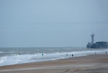
The Process Electrician worked at Ekofisk for 35 years, since he was 19 years old. He described his first offshore impressions, how he loved both his job and the working environment and how he developed strong bonds with workmates. The regular office job he tried once just didn’t suit him and he couldn’t wait to head back offshore. In December 1969, Ekofisk became the North Sea’s first major oil discovery on the Norwegian continental shelf. It turned out to be a giant reservoir and was developed rapidly into a complex of eight fields with over 30 different installations, including a sub-sea storage tank the size of a city block, leisure facilities, and accommodation for workers from over 50 different professions. “Ekofisk City,” as it was called, was located in the extreme south-west corner of the Norwegian continental shelf, 280 kilometres from Stavanger, in waters 70 to 75 metres deep. 2 [Fig. 1]
The North Sea hosts a working life that goes beyond standard formats. The longevity, operational density, and functional complexity of the Ekofisk fields, including its residential components, challenge inherited understandings of urbanisation. In the early 1970s, a new type of space was produced offshore, marked by giant clusters of steel and concrete, with long distances to land and extreme on-site spatial restrictions. These places emerged above petroleum-rich geological formations located up to 3,200 meters below the sea’s crust. They were far removed from established places of work or settlement. During the construction phase, 7,000–8,000 workers were based at Ekofisk—a population four times that of most Norwegian coastal towns. Ekofisk has been the singularly most important place for the Norwegian economy. It earned Norway 190 billion US dollars between 1974 and 2004. This amount is equivalent to 20% of Norway’s total oil and gas production during this period.3
The discovery of the Ekosfisk field marked the beginning of a new oil economy, manifested
by the Government Pension Fund of Norway, otherwise known as the “Oil Fund.” Despite the current process of North Sea decommissioning, the oil economy is still omnipresent.

Today the Ekofisk complex is a cultural artefact that has outlived its original life expectancy. While some parts are currently being dismantled, the Ekofisk South field is still being developed, making Ekofisk the longestproducing field on the North Sea. Due to its remarkable place in Norwegian history, the Ekofisk complex has been recognised by the Norwegian Directorate for Cultural Heritage as a technical-industrial monument.4
At the Ekofisk complex, all three “dimensions of urbanisation” conceptualised by Henri Lefebvre and further articulated by Neil Brenner and Christian Schmid are manifest: the explicit forms of territorial regulation that enabled its emergence, the physically constructed “urban fabric”—it is the North Sea’s most concentrated agglomeration of material installations and pipelines—and the highly regulated practices of everyday working life.5
Yet despite these characteristics, sites like Ekofisk City and numerous other manifestations of extended urbanisation in the North Sea are unfamiliar and enigmatic in urban terms. They contradict conventional notions of the urban, such as density, diversity, and centrality, and they exemplify a specific operationalised and industrialised territory located at a carefully maintained distance outside public visibility and consciousness.
This chapter tells the story of intensifying urbanisation processes in the North Sea. These processes enabled national governments and industrial enterprises to take possession of the entire sea and fill it with a particular type of urban fabric exemplified by Ekofisk, which requires organised labour relations to operate and maintain it. The sea space has become a place where capitalist practices accumulate, thereby inducing accumulated forms of loss; the loss of the sea as a socio-cultural space,
as a space of human labour, as a commons, and finally as a space of balanced ecosystems.
The historical overview in the first section charts the role of the sea in western European socio-cultural and economic relations from the Roman Empire to the Second World War. The central nexus of trading activity moved from the Mediterranean to the North Sea during this period, where the sea was increasingly exploited in the service of the expansion of empires and the commodity economy. It began to be conceptualised and mapped in a rational way, illustrating the transformation of the sea from an animated space full of geographic features and human experience to an efficient, neutralised trading highway. By the seventeenth century, the sea was losing its socio-cultural significance, followed by its importance as a place of work in the twentieth century as containerisation and air travel began to make large sections of maritime labour redundant.
The second section examines how the urbanisation of the North Sea began in earnest after the Second World War. The North Sea played a major role in the conflicts of both World Wars, and the military domination meant that the sea had been largely cleared of civilian activities—the state had gained a major role in organising and controlling the sea commons. International post-war conventions not only resulted in the regulation of sea space but also paved the way for creating a state space, determining resource use in vast exclusive economic zones at the expense of the sea commons. The way these zones consumed the sea space entirely in the North Sea, resulted in the loss of the sea commons.
The abstract state enclosures in the North Sea established the basis for further planning and operationalisation for oil and gas and, more recently, wind-energy industries. The third section illuminates this process and how the urban fabric described above for Ekofisk was constructed for a dedicated workforce under strict codes, rhythms, and spatial constriction.
In 2018, the New York Times published the article “Losing Earth: The Decade We Almost Stopped Climate Change,” about the
years 1979–1989 when the effects of climate change were already understood, but scientists, politicians, and activists did not manage to finalise a global framework to reduce carbon emissions.6 This chapter’s title, Losing Sea, is in reference to this poignant article. It demonstrates how processes of extended urbanisation in the North Sea, although facilitating unprecedented economic gains for northern Europe, have resulted in an ecologically degraded marine habitat and immeasurable loss.
The transformation of society’s relationship to the sea over the long timespan between the Romans and the end of the Second World War is examined in this section. During this period, the leading trading region shifted from the Mediterranean to the North Sea. The nationstate emerged with colonial ambitions realised through the domination of maritime space, which was then heavily occupied by military activities in both World Wars. The world capitalist economy became increasingly dependent on long-distance maritime networks, culminating in the post-war container revolution. These events set up the conditions for the urbanisation of the sea, an urbanisation process paralleled by the systematic emptying of the sea’s traditional socio-cultural significance.
Before the development of road networks in Western Europe, waterways were the major logistical routes for exchanging goods, people, and knowledge.7 It was across the water that connections were established and sustained between important regional centres whose wealth frequently depended more on international trade than their hinterlands. Between 700 and 1,600, and before the rise of the nationstate, people were constantly migrating around
industrial use of the limited North Sea space; the foreground seascape, preserved as a visual metaphor for leisure and relaxation, upstages the blurred perception of the background industrial activities.97
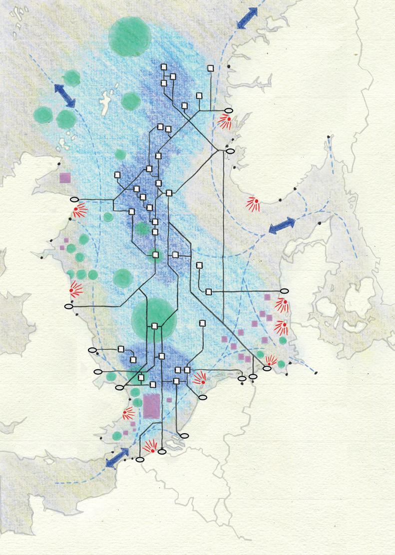
The transformation of the North Sea into a state space, organised around abstract borders and a unifying petroleum grid, enabled governments and companies to further optimise the space for industrial production. This led to the construction of an operational seascape composed of pipelines, cables, sea lanes, and offshore installations for wind farms and oil fields. Katsikis and Brenner describe operationalised landscapes as the capital-intensive, highly industrialised, and densely equipped hinterlands of the Capitalocene that, primarily for primary production, are laid out for maximum efficiency and are intermeshed with one another through complex extended global linkages.98
The urbanised North Sea shows different types of technical installations and enclosures: cables, pipelines, and the industrial activities of oil, gas, and wind energy, as well as proposed marine protected areas. [Fig. 10] While the combined vessels for fishing, heavy shipping routes, and constantly circulating offshore
petroleum servicing make a dense spatial imprint on the North Sea, these activities are not represented in this map since the objective is to draw attention to the multitude of fixed elements, which represent a marked spatial departure from the long-standing “fluid” maritime industries. The piecemeal, fragmented industrial logic of this space is apparent; operations are organised around national territories and are not coordinated. Offshore installations and their infrastructures have emerged over time; as new oil and gas discoveries were made, the offshore urban fabric was extended and adapted according to the technological limits and short-term practical and economic considerations only. It was never clear during the first phases of development how large complexes such as “Ekofisk City” would grow. The abstract unified state space of the sea afforded the conditions for unlimited and uncoordinated expansion irrespective of the sea’s inherent geophysical properties.
North Sea governments not only authorised the large-scale operationalisation of sea space for production purposes but, in particular in the case of the UK, also aimed to attract the interest of petroleum companies through rapid preparation of the territory for exploration. This operational seascape is closely aligned with the traits of operational landscapes. It includes the production of a comprehensive system of encompassing territorial regulations, the physical construction of offshore installations, the laying of infrastructure to deliver supplies through
Territorial waters
Petroleum grid
Marine protected areas
Wind energy
OFFSHORE INFRASTRUCTURE
Oil and gas platforms
Pipelines
Main cables
INTERNATIONAL BORDERS
pipelines, cables, and shipping lanes, the securing of landings for delivering offshore resources into downstream networks, and the continuous displacement of a large rotating workforce.99 While organised around the regular grid, the operational seascape is uneven and hugely distorted, at once thinly stretched over large distances and extremely compacted at industrial
nodes. It is mostly invisible and kept out of sight from the recreational and contemplative “visual” seascape and served either by permanently moving vessels or undersea conduits.
The above map of the urbanised North Sea presents an unfamiliar geography of offshore industrial operations, with places frequently named after Norse gods on the Norwegian side
CO2 emissions fail to be reached and the areas required for increased wind energy can no longer be found on land, the North Sea is now earmarked for offshore wind-energy production on a grand scale. The wholesale expansion of the North Sea’s post-oil wind-energy production demonstrates how the hydrocarbon enclosure has rapidly reoriented to renewables in the brief half-century of depleting those very resources. According to the development scenarios tested by the project Energy Odyssey 2050, the North Sea can potentially accommodate 90% of European energy demand by the year 2050.107 The spatial impact of such a scenario, however, would be overpowering. Renderings of this possible future show the North Sea consumed by dispersed, luminous, pulsing nodes extending out from the coastlines. A sea completely operationalised for the production of renewable wind energy, which would be landed at a series of unfamiliar coastal sites.
Offshore wind energy is a highly technical industry relying on state administration of tracts of sea space even larger than blocks within the petroleum grid. It requires the production and delivery of specialised components, continuous construction and dismantling to upgrade efficiency through scaling-up, and a substantial workforce to operate and maintain the system. The offshore wind industry had grossly underestimated the required maintenance and is now erecting accommodation rigs for staff rotating on a two-week basis. These new ways of living and working at sea are technical in nature, carried out in a rigidly laid-out sea, inflexible to shifting conditions, and closing off increasingly large areas. The configuration of a wind park is based on the geometry of turbine spacings, which are proportional to their height. Therefore, wind park areas expand exponentially according to turbine size. Applying a 500 metres safety zone around the projected number of North Sea wind parks would potentially produce both an energy territory and a no-fishing zone of 12,000 km 2 by default, given that these areas are also restricted to fishing.108 Greater pressure on fish stocks in non-restricted zones is predicted as a result. Fishers who know
the sea argue that the long-term ecological effects of the vast expansion of offshore wind parks have not been considered. And they notice that wind patterns have changed, and no one knows how this will affect the water circulation patterns of the North Sea itself.
This chapter shows how offshore activities in the North Sea are inextricably linked to land-side urban development in a reciprocal process operating across the land-sea threshold and mobilising people, vessels, materials, finance, and legal instruments. These operations perform vital functions for highly urbanised northern Europe and are interlocked into global economic networks. North Sea maritime activities are strictly programmed and regulated to extend, perpetuate, and intensify systems of delivery and exchange to urban agglomerations. Vast tracts of sea space and dedicated coastal sites are planned and reorganised, daily, and weekly human rhythms are strictly set, and unprecedented volumes of materials are transported across its surface, fixed to the seafloor and again dismantled in ongoing cycles.
Industrialisation has caused the social space of the sea to be replaced by a space of extraction—biomass (marine life), hydrocarbons, and wind energy—and the movement of goods, while selected shoreline spaces are redesigned to offer “leisure” and to artificially intensify the seaside experience. The conceptualised map of the urbanised North Sea illustrates this reversal. Clusters of fixed petroleum infrastructure form a series of dispersed centralities down the middle of the North Sea on which development is focused and around which operations and movements circulate. These sites are extended centres of action controlled by landside headquarters and government departments. [Fig. 18] When less dominated by industrial functions, the sea’s periphery forms a ring towards the coastlines, where the sea can be experienced as a cultural space and consumed in a pre-industrial visual form, expressly preserved for this purpose. In this
High concentration of industrial activities and human circulation
Oil and gas infrastructure (platforms and pipelines)
Maritime territory with less intense activity but still impacted by the centres
Marine protected areas
Windparks
Coastal waters linking the industrialised and urbanised North Sea, and other water bodies
Industrial infrastructure, interface between sea and land
Cultural sites, recreation and visual consumption of the sea space
Main merchandise transport routes and connections
UNITED KINGDOM NETHERLANDS
BELGIUM
THE REVERSAL OF CENTRE AND PERIPHERY IN THE URBANISED NORTH SEA
Fig. 18
way, we continue to uphold an artificial culture/ nature conceptual divide within maritime space while industrial residue has long been fully absorbed into the North Sea’s biochemical composition.
This process of urbanising the North Sea has been a process of loss; the loss of the socio-cultural sea, the loss of the sea for human labour, the loss of the sea as commons, and the loss of the ecological sea. The reinforcement of the peripheral leisure sea facilitates an illusion
of concealing these lost seas—until storm surges of increasing force and frequency pound the North Sea coastlines.
What is the outcome of this loss? Instead of unfolding complexity, diversification, and interconnectivity, which could generate social conditions comparable to those found in urban environments, extended urbanisation in the North Sea does not produce urban qualities, offer social interaction spaces, or promote synergies. Instead, this urbanisation process gathers the discrete and inert loads of industrial production while pushing selected layers of sociocultural meaning to its very edge. The cultural links between social life and new technological workplaces offshore are tenuous. In contrast to the North Sea’s heterogeneous oceanographic features, and complex ecological system, resource management is increasingly streamlined, rigid, and subject to technological abstraction and operationalisation. All sectors are tightly controlled by the state in collaboration with multinational companies or other organisations wielding power. This resonates with Lefebvre’s critique of the attack on the urban from the state level: “a global project to subject the national territory to a process of ‘development’ controlled by industrialisation,” where “the urban is reduced to the industrial” and where the places to assert rights have also been eroded.109
The grave ecological condition of the planet’s one ocean is an urgent consequence of extended urbanisation, and the evacuation of the social sea has facilitated unchecked industrial expansion. As a result, we are now losing the sea to climate change. It is, in fact, within these very relations that organic reactions, not in a social but in an ecological sense, have occurred out of the control of grids, directives, and planning efforts. Long-range pollutants, such as microplastics, are transported by currents through a borderless ocean.
In the North Sea, the “urban” must also face its own specific mode of transformation of nature. Having arrived at an understanding of the current situation through research and analytical work, it is the further task of
architectural, urban, and territorial design to set the processes of reconnecting to the sea in motion. Urban theorist Roberto Luis Monte-Mor has also provided some important responses. He argues that the intimate relationship between urban ecology and the environmental question is not yet well understood and that we should also work to rebuild and reproduce the relationships between built and natural space. “We must confront extended urbanisation with extended naturalisation if we are to deal not only with urban and environmental problems at the microlevel of everyday life but also with the global aspects of environmental and social crises.”
110
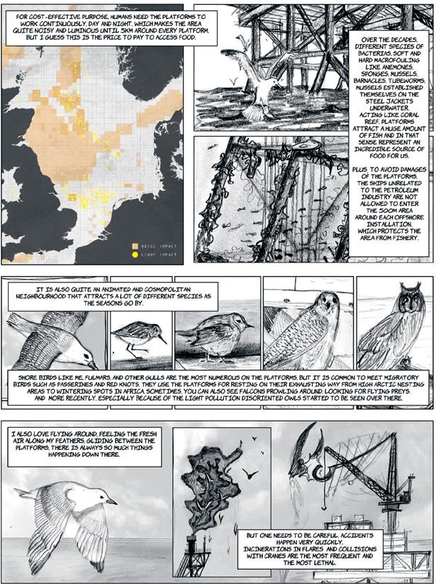
Reimagining the damaged sea with its more-than-human inhabitants is one way of assuming responsibility. Bird Station is a project that aims to reconnect people to the transformed, living sea space. [Fig 19] We can bridge the widening public gap engineered by the industrial-technological take-over through engagement and education. Reconnecting to the sea will require a major transdisciplinary effort and, in particular, a host of powerful and enticing creative visions.
Et in Arcadia Ego, “Me too in Arcadia,” wrote Johann Wolfgang von Goethe in his travelogue on the Italian countryside in 1786.1 In 1873, Arcadia re-emerged as a feral myth of naked Nymphs and the satyr-like god Pan in a painting by William-Adolphe Bouguereau, and as the pastoral ideal of a shepherd peacefully scooping water under the shade of a bush in the 1836 painting by Thomas Cole. The Arcadian landscapes reappear at the centre of the cosmopolitan life of late nineteenth-century Berlin on the murals of Café Bauer. In 1909, Shaftesbury Theatre London hosted the musical The Arcadians, introducing a metropolitan audience to a group of idyllic peasants who wished to transform the wicked metropolis into a land of truth and simplicity. [Fig. 1] Today, Arcadia is ubiquitous. Its name stands on the billboard of a university campus in Pennsylvania, a city in Los Angeles County, an immigrant’s club in Brooklyn, and a hotel in the Greek mining town of Megalopolis. Heterogeneous and dispersed in space and history, how do all these “Arcadias” relate to each other? And what is the common place they recall?
This chapter examines the actual region of Arcadia, a mountainous landscape located at the core of the Peloponnese peninsula in Greece. It is a place where extended urbanisation is unfolding under a rural and bucolic backdrop, where idyllic images cloak social struggles and dispossessions, and recent economic and environmental crises are accelerating the deregulation and depopulation of peripheral areas. In contemporary Arcadia, land expropriations and the enclosure of commons and agricultural land are silently unfolding under the pretext of green development and energy transition, while a consistent policy of emptying and flattening the mountain region has been enabling regional re-articulations and the redistribution of power and wealth, allowing processes of capital to proceed. This is a tale of peripheralisation.
This chapter draws upon archival and ethnographic fieldwork conducted in the landscapes of Mount Mainalo, located at the core of “mountainous Arcadia,”2 between 2017 and 2021. The multi-sited fieldwork took place
in bureaucratic and logistical spaces, olive groves, villages, pastures, and the forest. There, I collected qualitative information, including oral histories, everyday experiences, and counter cartographies that narrate an “invisible” landscape under extreme pressure for transformation.
In this chapter, I depart from the Western myth of Arcadia and unpack it as the fabrication of an imaginary “urban outside” and a spatial and temporal frontier enabling multiple extensions. I then return to the actual Arcadia, where a peripheral landscape can be understood as a contemporary urban outside. Over the last decades, the region has been drained of a permanent population and related social and economic structures. It has been systematically peripheralised, eventually becoming dependent on national and international centralities. As I narrate this history, I reconstruct its emptying in relation to a “filling-in” that manifests simultaneously elsewhere. I then examine the transformation of Greek state space, especially during the Greek debt crisis, allowing me to observe how extended urbanisation unfolded as part of a more extensive process of peripheralisation. This process currently exceeds the scale of the nation-state and the region and reclaims peripheralised territories when coupled with resistance and extended forms of citizenship. Overall, this chapter works towards developing a relational understanding of urbanisation. It focuses
on processes that polarise and generate unevenness, such as inhabited and uninhabited lands, developing and left-behind places, and centres and peripheries forming relationally in different geographies and scales. The chapter suggests peripheralisation as a process of extended urbanisation, which manifests as interwoven and interdependent with processes of centralisation. Peripheralisation reinvents places as “outsides,” eventually marginalising, subordinating, and enclosing them. This work mainly entails an urgent call for revisiting peripheralised and arcadised lands and their ecological margins to unveil such processes that uncontrollably occur there. It occurs to me that our generation’s most crucial social and ecological struggles are staged in such peripheral lands. Thus, this work defends those fragile, socioecological fabrics that, although latent and under extreme pressure, continue to present, persist, and resist.
Arcadia has been constructed as a myth of an urban outside. In this view, it is an outer frontier constantly negotiated, reconceived, and reconfigured. Progressively, Arcadia has transpired in literature and arts as an imaginary trope, a spatial and temporal frontier marking the beginnings of (modern) time and (anthropogenic) culture.
Pausanias, the second-century AD Greek traveller and geographer, encountered the region of Arcadia, describing it as a land far from the sea and surrounded by mountains.3 He recounted how in the “ancient world,” Arkades, the inhabitants of Arcadia, were believed to be the descendants of Pelasgians, the oldest clan of ancient Greece. Pausanias stated that Arkades were thought to have sprouted from the ground, binding Arcadia to autochthony and the idea of an archaic time.
“Sweet is the voice of the goat, sweet the shepherd’s flute,” wrote Theocritus, the founder of bucolic poetry, in his third-century BC oeuvre Idylls, celebrating for the first time in Greek poetry the everyday life of pastoralists in Sicily. Yet, his poetry was not addressed to the shepherds and landscapes it described. As a city poet, his bucolic poetry offered an idealised representation of an imaginary pastoral world for a city audience. Twentieth-century art historian Erwin Panofsky accounts how this urban myth about rural origins was translocated to Arcadia two centuries later in Latin art and literature. During the Roman Republic, pastoral poetry took further shape as a critique and a counter-narrative to corruption and vice in the city of Rome. “Blissful is the man who cultivates his land, free from city’s usurers and the power of city elites,” wrote Horace (30 BC).4 However, it was Virgil, in his Bucolics (or Eclogues, 37 BC), who translocated the pastoral ideal and reinvented Arcadia, initially known in the Roman world through the narrations of the Arcadian immigrant Polybius as a remote, rocky place with “meagre goats and frugal shepherds,”5 as a utopia with an actual topos. Synthesising the image of Sicilian pastoral landscapes (from Theocritus), with the nostalgic fascination of a distant rural homeland (from Polybius), Virgil painted an alternative: Arcadia as “a realm sufficiently remote from everyday Roman life to defy any realistic interpretation, yet sufficiently saturated with visual concreteness to appeal directly to the inner experience of the reader.”6 He opened Bucolics with an image of city warfare,
where the Roman countryside and pastures were exhausted by the metropolis’s exploitation. Since then, Arcadia has emerged as a relational topos, an urban myth for an idealised “outer” land and a constitutive “urban other.” This myth has been crafted upon the conflictual condition of the “familiar far” as a nostalgia for a place not yet reached but already experienced. In this myth, distance and groundedness matter. Locating rootedness and origins in this outside legitimises illusive rights for appropriating a shared pre-urban world. The myth of the outside lays the groundwork for possible extensions and occupations.
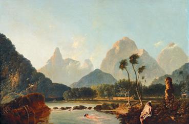
As the colonial mission approached “Port Royal” (Matavai Bay, Tahiti) in April 1769, Sir Joseph Banks noted the beauty and blissfulness of the coasts, the abundance of shade and fruits, and the welcoming kindness of the indigenous populations. As he wrote in his diary, “The image we saw was the truest picture that imagination can form of an Arcadia … of which we were going to be the kings.”7 [Fig. 2] The first French colony in Canada was officially named Acadie in reference to the mythical Arcadia. The Western depiction of Arcadia, often nestled within the imagery of Paradise, re-emerged as one of the foundational imaginaries promoting the colonisation of the new world.8 Emptying the land, declaring it as terra nullius (nobody’s land), helped metaphorically annihilate the rights of its indigenous inhabitants. This colonial gaze entails a severe provocation and an immense power of extensionality, a way to conquer by idealising or to enclose by arcadising. We can claim that the myth of Arcadia is a myth about extensions. To extend (εκ-τείνω) means to create distance, to create ground (έκ-ταση). An extension is relational; it implies a centre from which to come and a vector towards which to go. In this way, the myth of the outside resides in the firm belief in the eternal possibility of extending territory, and entails the acts that will enable such extensions.
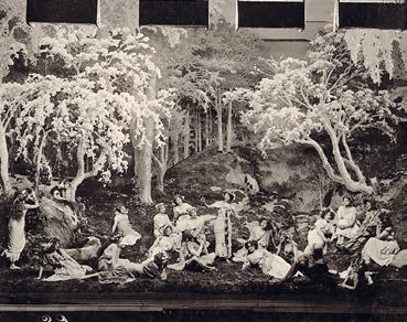
Looking at Titian’s 1508 painting, the Pastoral Concert—one of the first bucolic Renaissance paintings—it occurs to me that the Arcadian myth entails an act of abstraction. A group of bourgeois musicians and their naked female company occupy the foreground, while a shepherd and his goats fade into the background. Merged with the trees, the shepherd has become part of the landscape, an abstract pastoral world, a symbolic scenography to stage higher concepts. [Fig. 3] The fabrication of the Arcadian myth entails an act of invisibilisation and, thus, dispossession. It removes the material complexity of an actual locus to serve a more idealised depiction: the water springs, the species of Mediterranean trees, and the mythic figure of Pan and the Nymphs. Elements of ecosystems and social formations have been used but reduced, emptied of their meaning and complexity, while others remain invisible. For instance, the Arcadian painting Pan and Syrinx (1615) depicts a city arising in the far distance, [Fig. 4] while in Landscape with Satyr Family (1507), an amplified depth highlights the distance, constructing the “urban far.” Thick trunks, bushes, and pronounced naturalist elements suggest the urban outside. It is a peripheral landscape, cast as an extension and experienced as a dialectical opposition through an external narrative projected from afar. It occurs to me that the Arcadian myth itself involves a geographical act, an act of peripheralisation. The imaginary of Arcadia eventually extends to variegated landscapes beyond urban centres, nature reserves, rural areas, or tourist destinations, re-establishing each as “idyllic urban exteriors.” What struggles, land claims, and dispossessions may lie hidden under such a frozen image of an urban outside?
It is late evening on Easter Eve. We are stuck in a huge traffic jam on the outskirts of Athens. The lanes leading to the city are empty; cars are lined up in the other direction towards Peloponnese. Drivers and passengers patiently
F. 3 The Pastoral Concert, Giorgione and/or his disciple Titian, 1509–1510. Merged with the trees, the shepherd has become part of the landscape.


F. 4 Pan pursuing Syrinx, Hendrick van Balen the Elder and Follower of Jan Brueghel the Elder, 1615. A city arises in the distance, constructing the “urban far.”

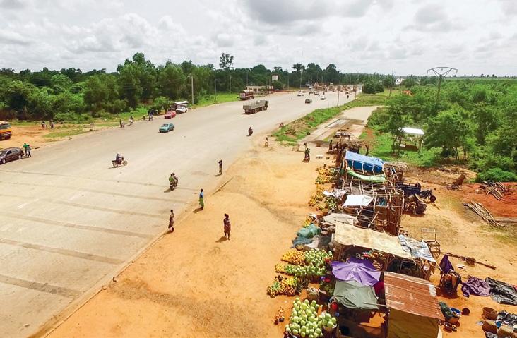
Nina wakes at 3:30 am five days a week to cook for her food stall in the Lagos-Abidjan Corridor. Cheap and cheerful restaurants like Nina’s are synonymous with roadside urbanism all across West Africa. They are called maquis in Benin, Mama’s Puts, Food is Ready, aka Bukkas in Nigeria, and Chop Bars over in Ghana. Nina prepares the food and packs it into two plastic thermal containers. Then, along with her middle-aged sister, caregiver for children always with an infant or two in tow, piled on two mototaxis with all their day’s stock, coolers expertly balanced, and a block of ice carefully wrapped to protect it from the sun. The site they are heading to is a few hundred metres from the toll booth and happens to be a perfect location for feeding hungry truckers. It is also a good vantage point from which to observe everyday mobility and contemplate how this mobility produces extended urban spaces along the Lagos-Abidjan Corridor. After all, to the east, the road continues straight to Cotonou, Porto Novo, and Lagos; to the west are Lomé, Accra, and, several hundred kilometres further, Abidjan.
Out on the highway, the empty frame of Nina’s maquis awaits them. The open structure of the maquis is slightly set back from the road. It is made from bamboo, wooden panels, corrugated iron sheets, and a rapidly deteriorating cement floor. Upon arrival, Nina and her team transform it into a roadside diner. The floor is swept, tarpaulins folded away, and a child is sent to pump water. They fetch the wooden table from the back, cover it in a plastic floral tablecloth, and sprinkle it with kerosene to keep the flies away. They rope a piece of nylon lace over the window and unpack the toothpicks and bottle openers, the palm wine and plastic jugs. Under a makeshift counter, Nina stashes away the portions of mashed yam and corn dough, smoked fish, boiled spicy eggs, and Fulani cheese, all prepped and hidden under several layers of bed sheets to keep the dust, flies, and sun off. Her sister lays out her goods for sale: toothbrushes, sweets, pills and medicine, soft drinks, and disposable plastic bags of whisky. She breaks the ice to cool the 50 centilitre plastic bags of water she will be selling as she
stands on her toes, extending a handful of bags up into a trucker’s cab or through a bus window.


All around, vendors are setting up for the day in anticipation of the traffic that will pass through. [Fig. 1] There are women selling watermelons, mangos, piles of limes, and pastoralists primed with buckets of fresh cheese that will later be pressed against the tinted windows of passing four-by-four vehicles. A handful of teenage boys are cycling from the Fan Milk ice cream depot in the periphery of Cotonou, working on commission. They can be spotted from a mile off in their blue jackets, with iceboxes mounted on the front of their bikes, blowing their shrill bicycle horns. Between the lanes of the toll booth, girls are selling bread, madeleines, and peanuts while women are preparing glasses of crushed ice and concentrated milk, and men are pitching racks of pirated CDs. The vendors and hustlers are ready for a long day’s work, hopeful for a good day’s business.
At the toll booth, like many locations along the corridor, all sorts of people will pass through, loiter or bump into each other. For Nina and her colleagues, there’s no knowing what opportunities the road will bring today. A bus of school children on an outing? A pastor with his flock of followers? A delegation of civil servants on a donor-funded training seminar? Or maybe Ghanaian traders en route to Lagos with cash to spare? Most likely, familiar faces will stop for a chat and gossip, and strangers will order food in pidgin English. Here, people will slow down, take a break, catch some sleep, and have something to eat.
The toll booth is one of many stops along the Lagos-Abidjan Corridor. Situated in Benin between Lomé and Cotonou, it is not quite in either periphery, and it is far away from the bustling districts of Lagos or Abidjan. This chapter starts here, at the toll booth. As a starting place, it does not contain any premature definitions or aspirations of what the corridor could be, should be or will be. The toll booth is never a final destination in itself, and nobody sets out in the morning, intent on eating at Nina’s
maquis. Instead, they end up here, side-lined as they order yams and fish, watching traffic pass as they rinse their hands and tuck in.
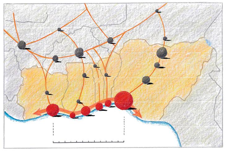
Starting from the toll booth in Benin, this contribution explores the polycentric development of the Lagos-Abidjan Corridor, notably the role that migration and mobility play in underpinning urban development between its major city hubs. [Fig. 2] It positions this mobility within a larger historical context that has seen traders, the displacement of slaves, and the forced migration of African labour under colonialism shape this space since the fifteenth century. [Fig. 3] This chapter suggests that to grasp the role of contemporary mobility within urbanisation, theories of extended urbanisation must be “mobilised.” This mobilisation involves both operationalising theories and addressing modes of urban development
NITIN BATHLA
is a lecturer and postdoctoral researcher at the Department of Architecture, ETH Zürich, where he also coordinates the Doctoral Programme at the Institute of Landscape and Urban Studies. His research practice actively combines academic research with artistic practices of filmmaking, and socially-engaged art. He is the director of the award-wining film Not Just Roads, which premiered at several important film festivals across the world.
ELISA T. BERTUZZO
is an urban ethnographer and theorist. Working with feminist, decolonial, and political ecology literature, she takes interest in underrepresented facets of everyday solidarity, resistance, and self-organisation. Having extensively published on urbanisation and migration in Bangladesh and India, she is currently mapping the European trajectories of seeds and edible plants imported from South Asia through the socio-material and ecological infrastructures enabling translocalised livelihoods.
RODRIGO CASTRIOTA
is a Postdoctoral Research Fellow on the ERC Project Inhabiting Radical Housing at DIST/ Politecnico di Torino. He holds a PhD in Urban and Regional Development from CEDEPLAR/UFMG (Brazil), where he did extensive research on urbanisation processes in the Brazilian Amazon. His main research interests also include popular economies, neo-extractivism, and postcolonial/ decolonial theory.
NANCY COULING
is an architect, Associate Professor at Bergen School of Architecture and Senior Researcher at the Chair of Professor Milica Topalović, Architecture of Territory, D-Arch, ETH Zürich. She is co-editor of Barents Lessons: Teaching and Research in Architecture (Zurich: Park Books, 2012) and The Urbanisation of the Sea: From Concepts and Analysis to Design (Rotterdam: nai010, 2020).
ALICE HERTZOG
is a social anthropologist whose work in the Republic of Benin examines the circulation of migrants and subsequent transformations within the urban fabric. Her current research addresses the (re)circulations of contested cultural heritage in West Africa. An alumnus of Cambridge University, Sciences Po, L’École Normale Supérieur Paris, and ETH Zürich, she was recently appointed to the Ethnographic Museum at the University of Zurich.
NIKOS KATSIKIS
is an urbanist and Assistant Professor at the Urbanism Department, TU Delft. His research seeks to contribute to a geographical understanding of the relations between cities and non-city landscapes that support urban life. He holds a Doctor of Design from Harvard Graduate School of Design, where he also served as Lecturer in Urban Planning and Design, and as editor of the New Geographies journal.
METAXIA MARKAKI
is an architect, urbanist, educator, and Lecturer at the Department of Architecture at ETH Zürich. Her ongoing PhD research delves into extended urbanisation in mountainous peripheral landscapes in Greece. Previously, she has been engaged in territorial research and teaching at the ETH Architecture of Territory with Professor Topalović, at ETH Studio Basel and Harvard Graduate School of Design with Professors Herzog and deMeuron, and co-authored the book achtung: die Landschaft
PHILIPPE REKACEWICZ
is a geographer, cartographer, and information designer who graduated from Sorbonne University. He was the head of the cartographic department of Le Monde diplomatique (1988–2014) and associate researcher and lecturer at the University of Helsinki (Crosslocation programme, 2016–2022). He currently works on embedded ecologies at the Department of Social Sciences, University of Wageningen, Netherlands and co-animates the site Visionscarto. net with Philippe Rivière.
CHRISTIAN
is an urban researcher, geographer, sociologist, and Professor of Sociology, Department of Architecture at ETH Zürich. His scientific work is on planetary urbanisation, comparative urban analysis and theories of urbanisation and space. He wrote a comprehensive reconstruction of Henri Lefebvre’s theory of the production of space, and is a member of the International Network for Urban Research and Action (INURA).
is Senior Professorial Fellow at the Urban Institute, University of Sheffield, co-director of the Beyond Inhabitation Lab at the Polytechnic University of Turin, and Honorary Professor of Urban Studies at the African Centre for Cities, University of Cape Town.
is an architect and Professor of Architecture and Territorial Planning at the Department of Architecture at ETH Zürich. Her work addresses territories beyondthe-city and the transformation processes they are exposed to through the movement of capital, social restructuring, and environmental change. She has studied remote regions, resource hinterlands, and countrysides in an effort to decentre and ecologise architectural approaches to the city, the urban, and urbanisation.
is a geographer, urban researcher, and Research Fellow at the Urban Resilience Research Centre, Osaka Metropolitan University, Japan. Her research is on urbanisation in a comparative perspective and on extended urbanisation, with a focus on urban theories and urban histories and politics in Hong Kong, Shenzhen, and Dongguan.
This book is the result of the collaborative research project Territories of Extended Urbanisation. Initiated by the editors in 2017, the project aimed to bring together and sketch out vastly diverse territories characterised by different aspects of extended urbanisation in an open-ended, collaborative way. It was therefore also largely determined by the researchers themselves through workshops, conferences, and co-lateral discussions. These exchanges not only developed into stimulating and supportive collaborations and lasting friendships, they were also hugely enjoyable. The dedicated research and editorial team therefore gratefully acknowledges all those who supported and encouraged our project during our long and adventurous journey through the territories of extended urbanisation. We are particularly indebted to Nancy Couling for her crucial editorial, communication, and coordination work and for assembling this book.
We thank radical geographer and cartographer Philippe Rekacewicz for his engagement and collaboration in producing the unique maps that are a key element of this book. By applying his own expert knowledge, carrying out extra research, and embracing our conceptual proposals, Philippe has bought these previously unseen aspects of extended urbanisation to cartographic life. We are also grateful for his refinement of our cartographic approach and language through collaboration on the three exhibitions the Shenzhen Bi-City Biennale of Urbanism / Architecture in autumn 2015, Cartographies of Planetary Urbanisation in Bologna 2019, and the Venice Architecture Biennale 2021.
We thank Jennifer Robinson for her careful reading and editing of the introductory essay and her invaluable comments on Christian Schmid’s text “Extended Urbanisation: A Framework for Analysis.” Many thanks to Neil Brenner for his collaboration and insightful discussions on planetary urbanisation and extended urbanisation over many years, and in particular for the productive collaboration on the Venice Biennale 2021, together with the Urban Theory Lab team.
Goda Budvytytė has carefully crafted the book concept and the book design with the researchers since 2018 in a highly professional manner with enormous patience and creativity. We thank her for giving an enticing and coherent shape, structure, and aesthetic to this diverse material.
Without the expertise and support of Angelika Gaal and Baharak Tajbakhsh at Birkhäuser throughout the complex editing, printing, and publishing process,
this project would not have come to fruition. Thank you for this exceptional collaboration.
We are also indebted to Evelyne Gordon for her administrative and organisational support; to copy editor Jake Starmer; to Ada St. Laurent for proofreading; and to E. Ece Emanetoğlu, Aikaterini Katsuoli, and Jan Zimmermann for supporting us in the final map adjustments. We also thank guest researchers Nazli Tümerdem and Giulia Torino who contributed to our workshops and discussions. We thank Pius Krütli and the USYS Transdisciplinary Lab ETH and Freek Persyn and the Newrope Design in Dialogue Chair ETH for hosting several of our Zurich meetings.
This project was carried out at the Future Cities Laboratory (FCL), Singapore-ETH Centre, as well as the Chair of Architecture and Territorial Planning and the Chair of Sociology at the Department of Architecture, ETH Zürich. This study was supported by the National Research Foundation Singapore as part of its Campus for Research Excellence and Technological Enterprise (CREATE) programme, as well as by the Department of Architecture at ETH Zürich.
We thank all our colleagues from FCL and from the Chairs of Architecture and Territorial Planning and of Sociology for their support, advice, and inspiration. Particular thanks to previous scientific director of the FCL, Stephen Cairns, and his team, who encouraged a stimulating dialogue with us, sharing ideas and research results. We also thank our collaborators in the ongoing FCL research project New Agendas Under Planetary Urbanisation, which builds on some of the findings discussed in this book; particularly Sacha Menz and Stephen Cairns for their crucial institutional support, our ETH colleagues and Co-PIs Adrienne Grêt-Regamey, Naomi Hanakata, Christoph Küffer, and Johan Six, and researchers Hans Hortig, Hiromi Inagaki, Karoline Kostka, Matteo Riva, and Kevin Vega.
Is grateful to his interlocutors, who allowed him to enter their lifeworlds despite the difficult circumstances that they are confronted with. He would like to especially thank Mazdoor Ekta Manch, the residents of Dwarka Expressway, the Commuters Welfare Association, and IamGurgaon. Additionally, he thanks Marie-Hélène Zérah and Shubhra Gururani, who have been important conversation partners. His gratitude also
goes out to the Territories of Extended Urbanisation collective for their friendship and collegial intellectual exchange all these years. Lastly, thanks to Christian Schmid and Milica Topalović́ for providing such great input to the chapter and giving it good direction and form, and to Nancy Couling for the excellent guidance through the sometimes difficult coordination of the book.
Is grateful to all her interview partners and co-passengers for invaluable stories and sharing; and to the rains, blocked roads, sand banks, and train delays that had a part in occasioning them. She thanks Keya and Subhendu Dasgupta for the enriching and rigorous conversations and soothing meals; Labani Jangi for launching into the exploration of the Nadia district with as much spontaneity as dedication; and all the researchers and staff of the Centre for Studies in Social Sciences Calcutta (CSSSC). Anindita Ghoshal and Bhim Reddy provided crucial insights into the subcontinent’s modern history and the agrarian question. Thank you also to Nancy Couling for her patient coordination throughout a very long publication process, and to Tammy Wong for being a most motivating and sincere peer.
Is very grateful to all the participants in this research—peasants, activists, educators, shopkeepers, activists, and mining employees—in short, residents of the Carajás region who made this work possible. He is particularly indebted to the network of social movements in southeast Pará, particularly the MST (Landless Workers Movement), MAM (National Movement for Popular Sovereignty in Mining), CEPASP (Centre for Education, Research and Union and People’s Advisory), CPT (Pastoral Land Commission), STTRCC (Rural Union of Canaã dos Carajás), as well as the Federal Universities of Pará (UFPA) and South/Southeast Pará (UNIFESSPA). Gratitude also goes out to the Territories of Extended Urbanisation team for vibrant discussions, continued engagement, and support, as well as PhD dissertation supervisor Prof. Roberto Monte-Mór, at the Centre for Development and Regional Planning (Cedeplar/UFMG) from where this book chapter emerged.
Would like to thank interviewees Gunleiv Hadland, the Norwegian Petroleum Museum; Daniel Ayala Høydal and Chriss Thomas Grimstad, CCB (NO);
Walter Brown, Gavin Mowat, and Alexandros Fotakis, Shell platforms (UK); shrimp fisherman Johann Looden (DE) and Paul Fetcher, Scottish Fishermen’s Organisation (UK), for generously contributing their insights into offshore working life and operations in the North Sea fishing and oil and gas sectors. The research for this chapter was funded through the EU Horizon 2020 programme, Marie Skłodowska-Curie Individual Grant No. 753882. She also thanks Prof. Carola Hein, research supervisor during this fellowship, and her BAS students for their innovative design work tackling these issues, in particular Zoelie MillereauDubesset, author of “Bird Station.”
ALICE HERTZOG
Is grateful to her fellow authors, who have been invaluable companions throughout this project. Much gratitude goes to Christian Schmid, Armelle Choplin, and Pius Krütli for their generous supervision of her doctoral thesis. Thanks also go to Milica Topalović́ and Christian Schmid for their commitment to this project, and to Nancy Couling for keeping everybody on the same page. Most importantly, this work would not have been possible without the many relationships forged along the Lagos-Abidjan Corridor with vendors, hustlers, drivers, and dwellers. Gratitude goes in particular to her friends at the Ahozon tollbooth for their hospitality and patience, and to Celestin Alloeiti for his valuable assistance. This research was supported by the Global Programme for Migration and Development of the Swiss Agency for Development and Cooperation.
Is grateful to all members of the Territories of Extended Urbanisation research project for offering a unique intellectual environment, as well the ETH FCL program for supporting the necessary fieldwork. He is also especially grateful to Andrew Suiter and Don Vogel for facilitating multiple visits across Iowa in the most generous way, and for sharing their invaluable guidance and knowledge on the region. He would like to give special thanks to Neil Brenner and all members of the University of Chicago’s Urban Theory Lab for contributing to the intellectual development of key concepts and theoretical frameworks.
Is deeply grateful to all her interview participants and co-travellers who generously shared their time, resources, and knowledge during her field trips
in Arcadia, including Giannis Lagos, the Nikoloutsos and Striggos families, Panagiotis, Dimitris, Nena, Vaggelis, Maria, Manolis, George, and all those who wish to remain anonymous. She owes special thanks to Milica Topalović and the teaching team and students of the Architecture of Territory design studio ARCADIA for initiating this research together in 2015.
Is very grateful to the entire team that participated in the Territories of Extended Urbanisation project for having accepted and integrated him into their discussions and reflections on cities, urban space, and in particular spaces undergoing processes of urbanisation. The project enabled him to discover the immensely diverse types of urban territories and pathways of urbanisation, challenging all his preconceived ideas as a geographer and cartographer trying to understand the systemic links between the elements of human geography. There is indeed a before and after the Extended Urbanisation project.
Particularly thanks Jennifer Robinson for her unflinching support during the entire work on this research and book project and for being such a great companion during the not always easy task of bringing this project to a successful completion; he is also very grateful for her insightful comments on his book chapter. He thanks Phil Harrison for his valuable comments on the chapter and for the invitation to the exciting discussions on extended urbanisation in South Africa. The long-standing collaboration with Neil Brenner on planetary urbanisation was an indispensable basis and invaluable source for this project: thank you!
Expresses great appreciation for the ideas and friendship of all the members of the Territories of Extended Urbanisation collective, which embodies a much-needed way of researchers working together.
Extends warmest gratitude to the friends and colleagues of the Territories of Extended Urbanisation collective. Getting to know you and following your work from the initial ideas through all stages of writing and cartography over several years has been a privilege and a great source of learning and inspiration. Thank you to all collaborators at the Chair of Architecture and Territorial Planning, Alice Clarke, Nancy Couling, Muriz
Djurdjevic, Evelyne Gordon, Dorothee Hahn, Santiago del Hierro, Hans Hortig, Vesna Jovanović, Karoline Kostka, Metaxia Markaki, Nazli Tümerdem, Jakob Walter, and Jan Westerheide for supporting the project, the workshops and the exhibitions in various ways. She is particularly grateful for the shared teaching of territorial research and design studios on the countrysides and hinterlands of Asia and Europe for more than ten years. Many of the insights, ideas, and sketches created in those studios have been vital for the extended urbanisation project.
Expresses deep gratitude to all interview partners and anonymous sources from institutions, universities, and villages that made her fieldwork in Dongguan fulfilling and meaningful. Special thanks to the young villagers for their invaluable assistance, sharing, and friendship throughout the years. Their support not only facilitated her contacts to local sources and the exploration of villages, histories, and people’s lives, but also practical matters like accommodation, travel, and safety. She is also grateful to the local scholars and planners who generously shared their time, knowledge, and insights about Dongguan, as well as to the ordinary villagers and migrants who told their stories amidst enormous changes underway in Dongguan. She also extends her gratitude to Soloman Benjamin, Carolyn Cartier, Kam Wing Chan, Wing Yin Chan, Sylvie Fanchette, Geerhardt Kornatowski, Angela Stienen, and Wing-shing Tang for their encouragement, support, discussion, and feedback on the first research output in a special journal mentioned in the chapter. She also thanks all contributors to this book for their inspiration, discussion, and support during the workshops and conferences. Lastly, she thanks Christian Schmid deeply for his patience, openness, and rigorous supervisory work—it was crucially important throughout the entire fieldwork, mapping, writing, and editing process.
Urbanisation processes are unfolding far beyond the realm of agglomerations, profoundly transforming agrarian areas, rain forests, deserts, and oceans. Enmeshed in the metabolic flows and ecologies of life, they are producing manifold planetary crises and demand urgent action.
Through detailed analysis and fieldwork captured in text, photographs, and maps, this book reveals the processes of extended urbanisation and traces struggles against their effects in eight world regions. It offers new concepts and cartographies of urbanisation processes beyond-the-city and proposes agendas for action to address planetary challenges.
Resulting from a collective research effort, the book decentres the perspective on the urban, foregrounds practice and action, and transcends rural-urban and North-South divides.
Nitin Bathla
Elisa T. Bertuzzo
Rodrigo Castriota
Nancy Couling
Alice Hertzog
Nikos Katsikis
Metaxia Markaki
Philippe Rekacewicz
Christian Schmid
AbdouMaliq Simone
Milica Topalović
Kit Ping Wong
ISBN 978-3-0356-2297-3
www.birkhauser.com