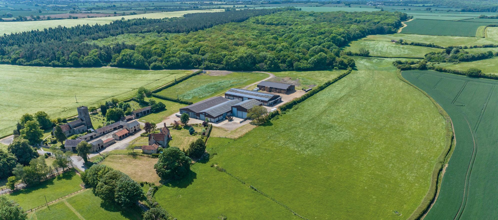
church farm
Stoke Goldin G ton ° Buckin G ham S hire


(All distances are approximate)
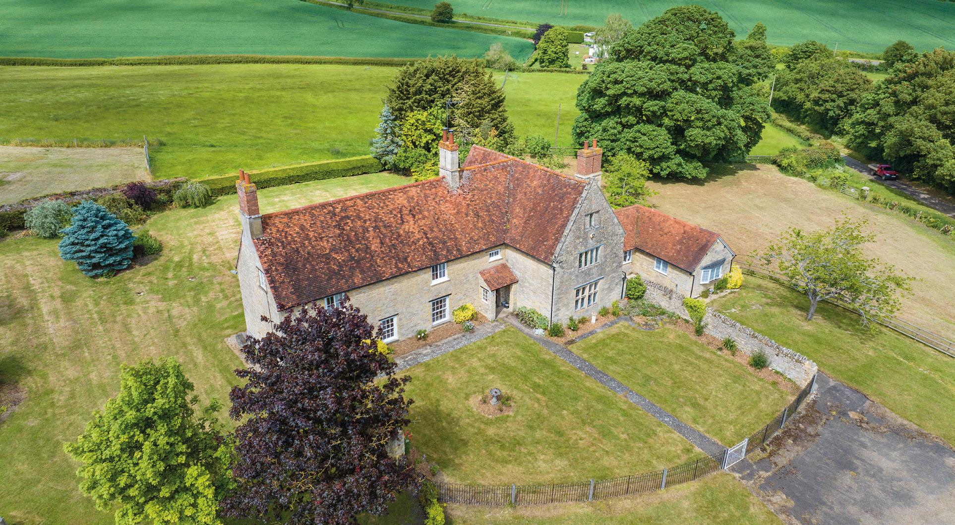
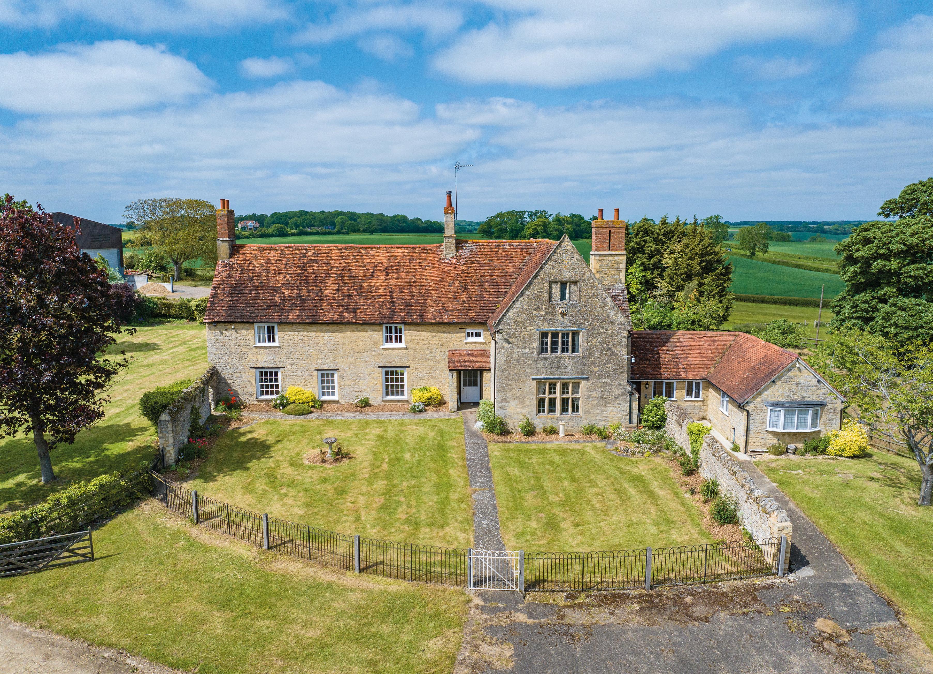
• s ubstantial g rade ii l isted stone farmhouse.
• A courtyard of traditional stone buildings (with development potential - subject to planning).
• A range of modern farm buildings extending to over 52,000 sq ft.
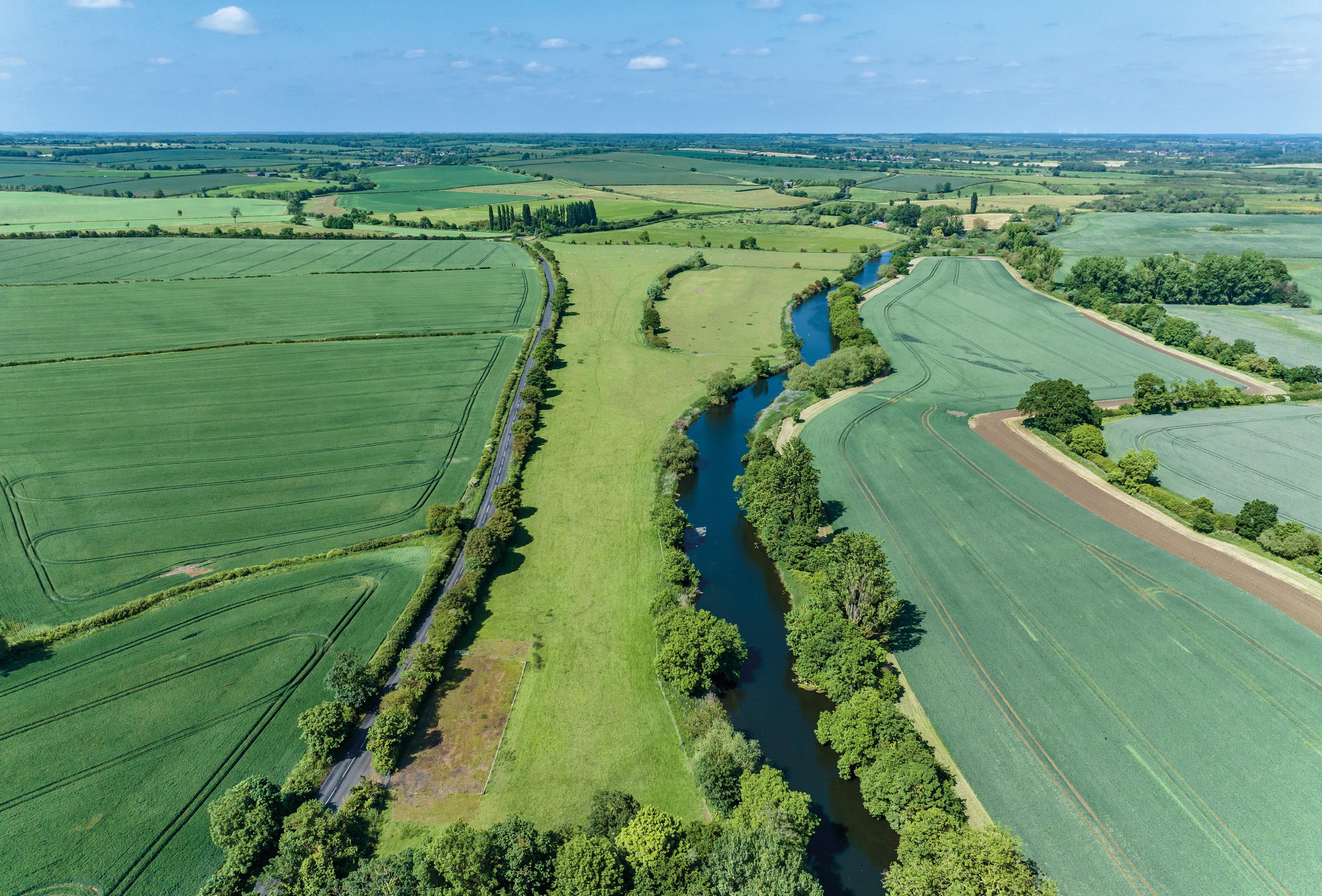
• Arable land, woodland, pasture, and river meadows with frontage to the River g reat o use.
• p icturesque rural village location but also in close proximity to several towns.
i n A ll App R oxi MAtely 906.17 Ac R es (366.721 hectAR es).
f o R s A le As A whole, o R in nine l ots, B y pR ivAte tR e Aty.
Matthew Alexander
matthew.alexander@bidwells.co.uk
+44 (0) 7918 561606
ruth.bonner@bidwells.co.uk
+44 (0) 7443 350780
These particulars are only a guide and must not be relied on as a statement of fact. Your attention is drawn to the Important N otice on the last page of text.
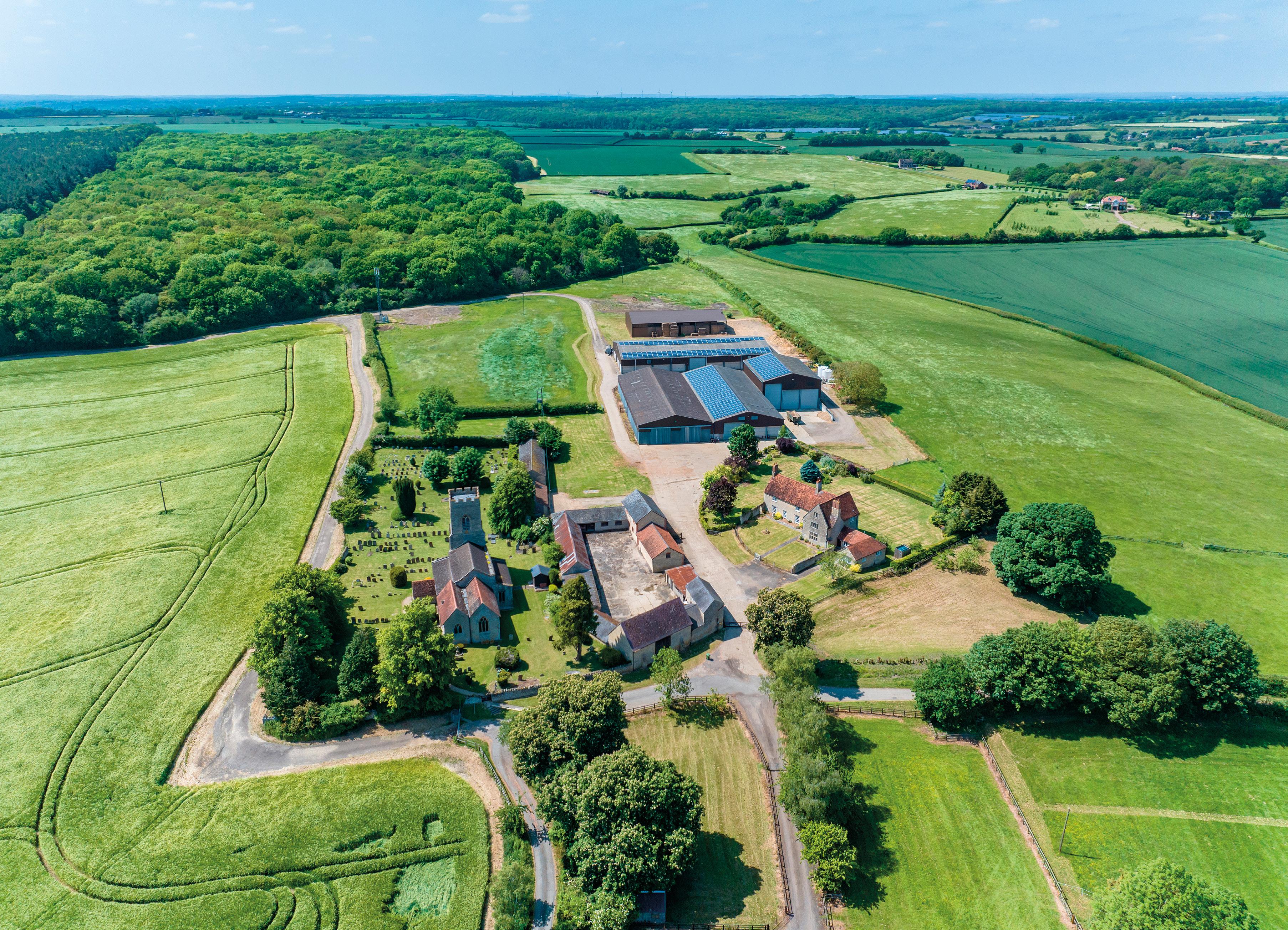
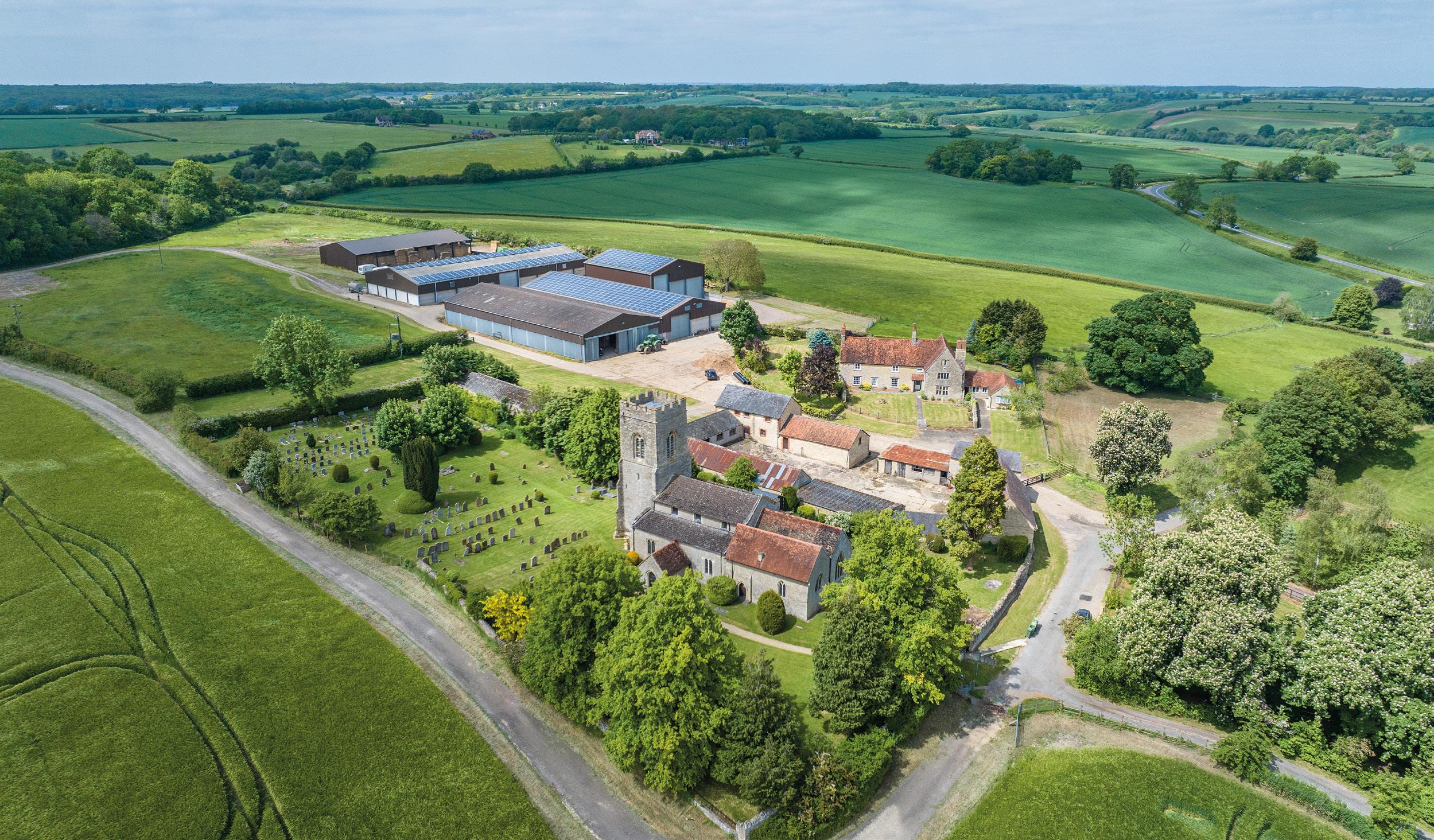
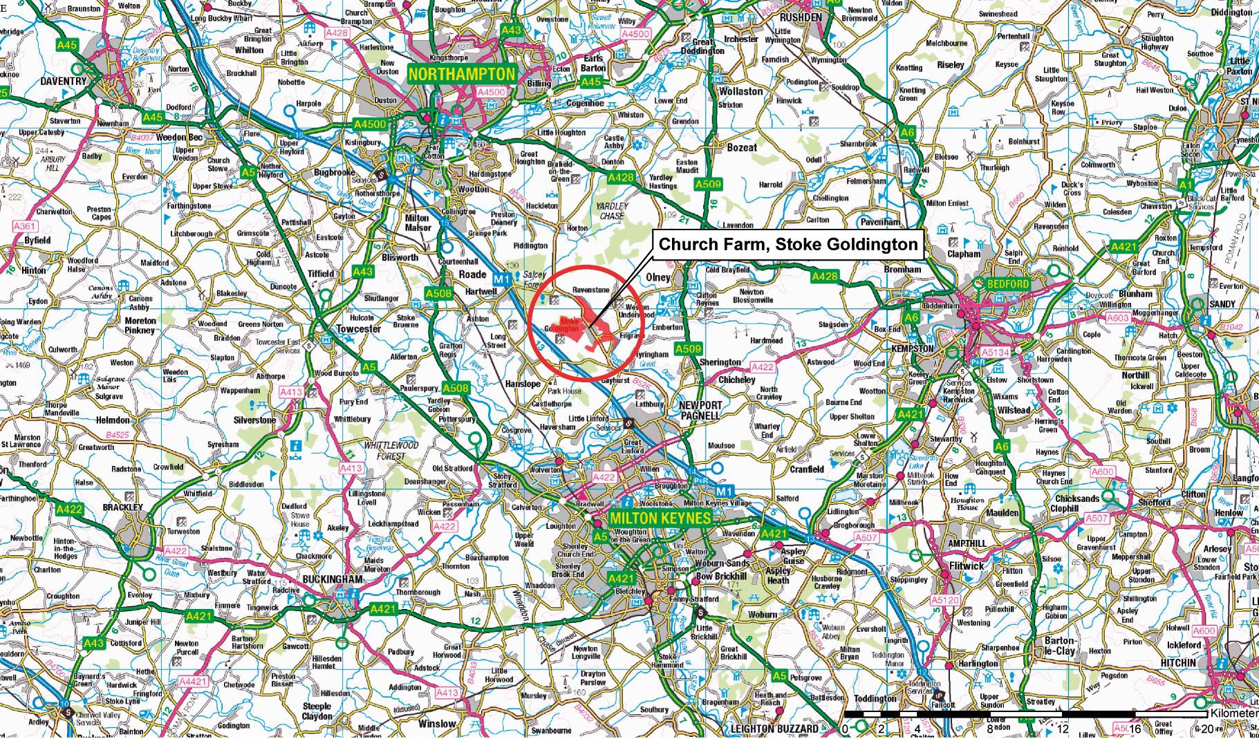
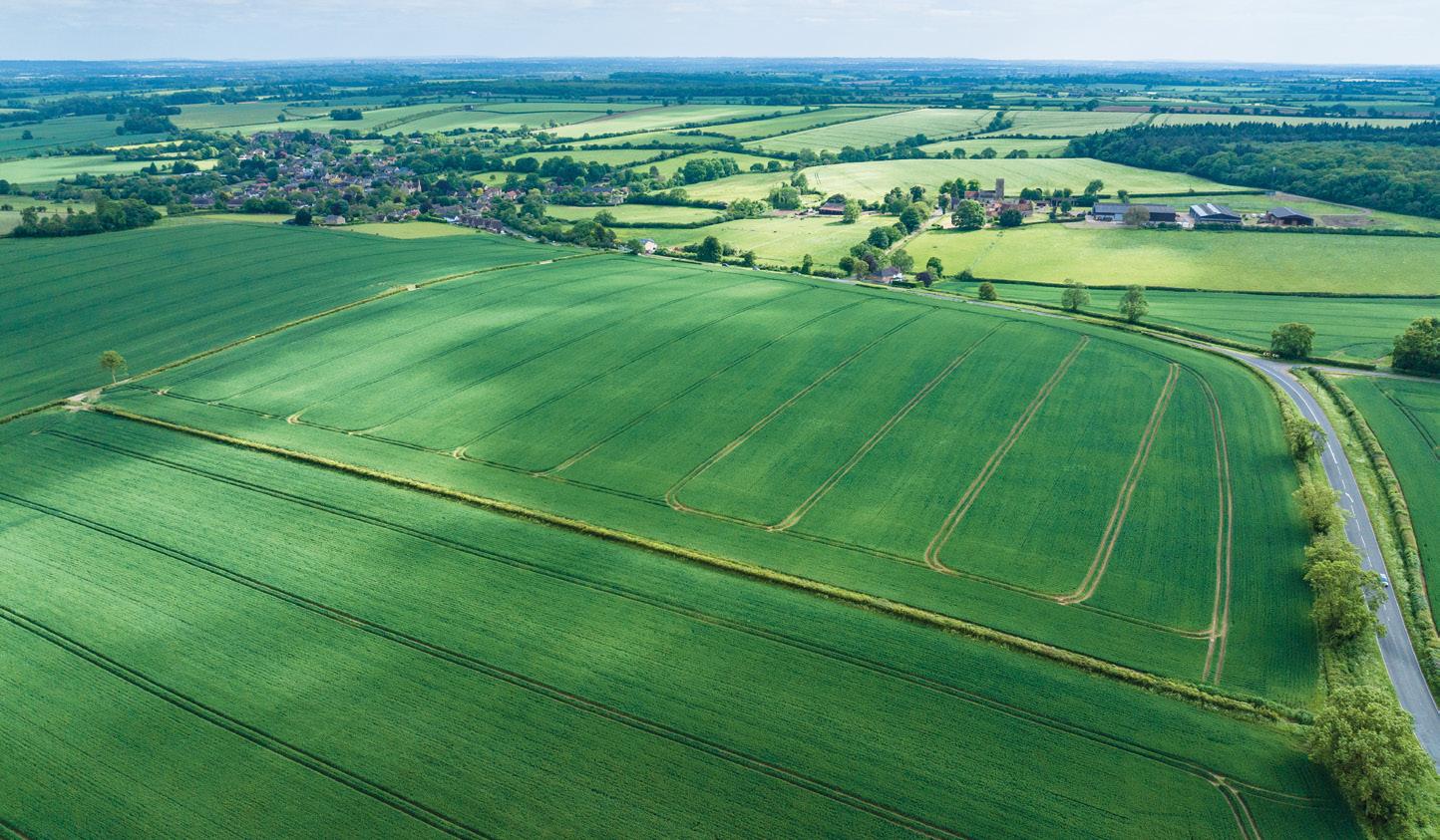
The sale of Church Farm offers a rare opportunity to acquire a quintessentially English farm located on the edge of the sought after village location of Stoke Goldington, close to Newport Pagnell but also within easy distance of Milton Keynes, Bedford and Northampton.
The farm benefits from a substantial Grade II Listed five-bedroom stone farmhouse with scope to extend into the attic (subject to planning). The Farmhouse has expansive views overlooking the surrounding countryside and is located within walking distance of the village and close to the local amenities.
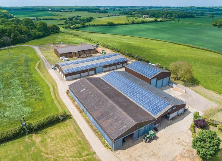
The farmyard benefits from a range of both traditional farm buildings and modern grain storage. The attractive traditional buildings present development opportunities, subject to planning, whilst the modern farming facilities include a comprehensive range of grain storage and general-purpose buildings providing approximately 5,000 tonnes of crop storage. The total area of buildings extends to approximately 52,196.34 sq ft in all.
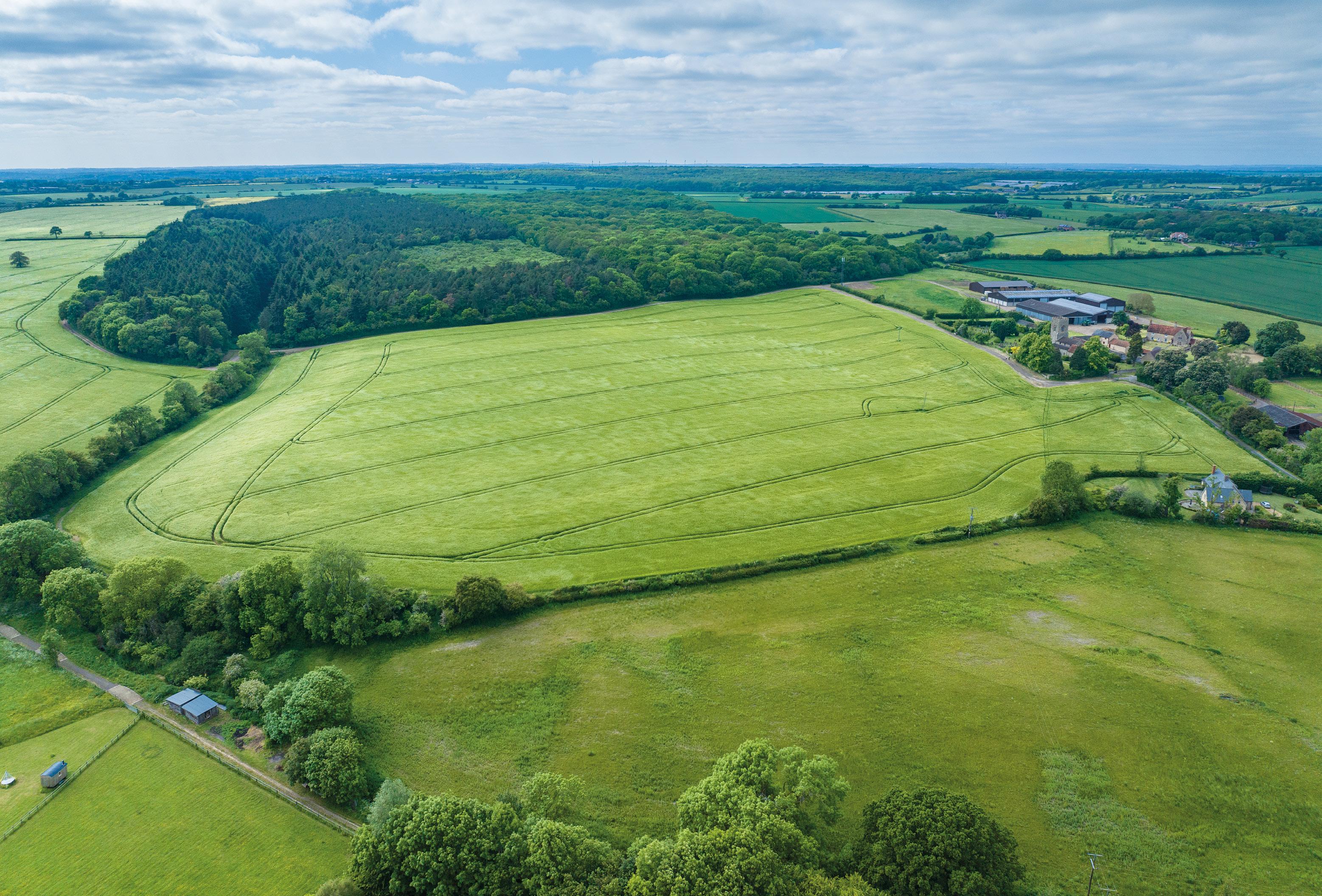
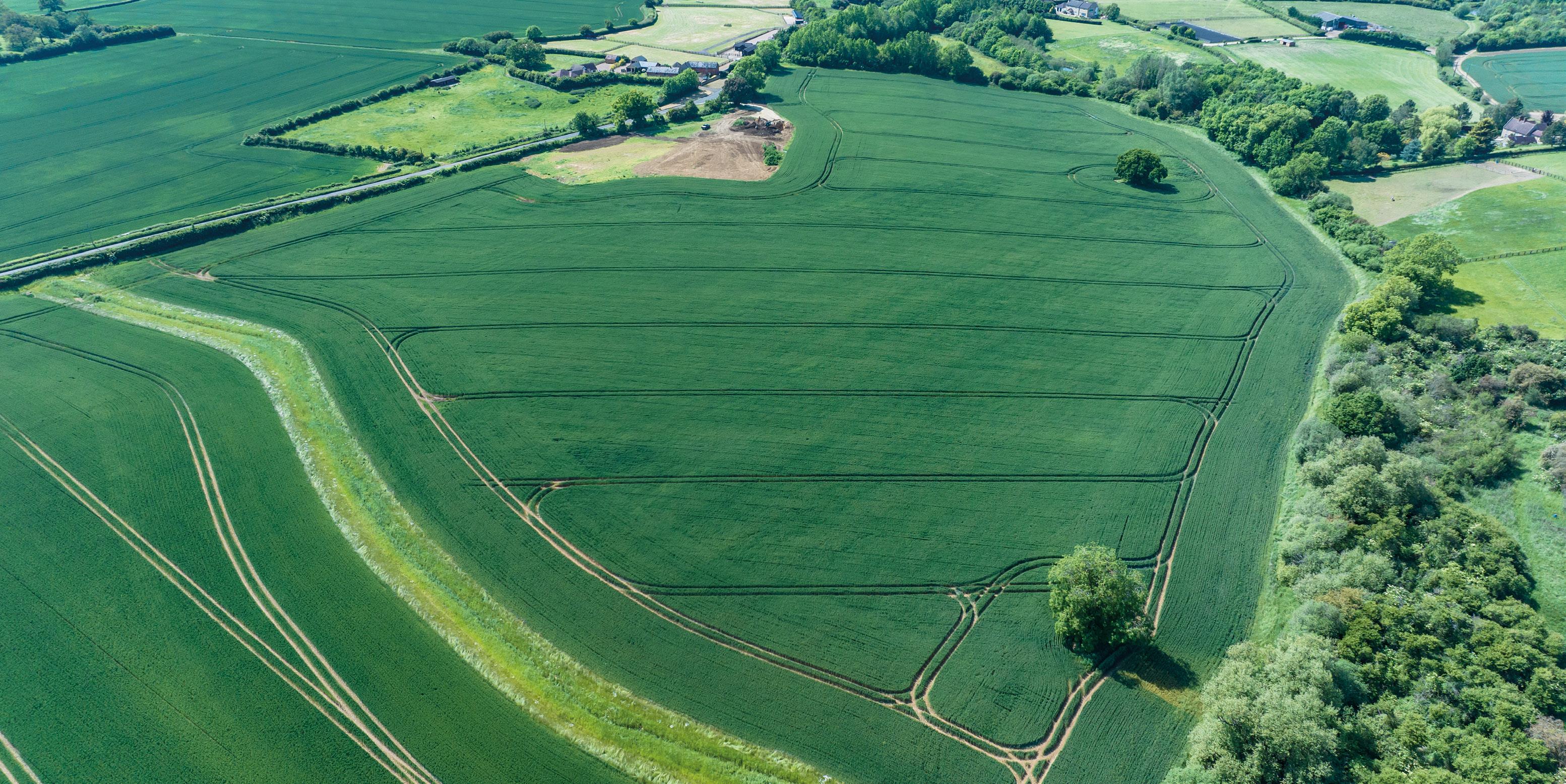
The majority of the farmland is located adjacent to the main farmyard with a further three blocks within close proximity to the main yard. The arable land extends to 661.59 acres (267.735 hectares) the woodland extends to 158.49 acres (64.138 hectares) and the pasture extends to approximately 75.59 acres (30.590 hectares).
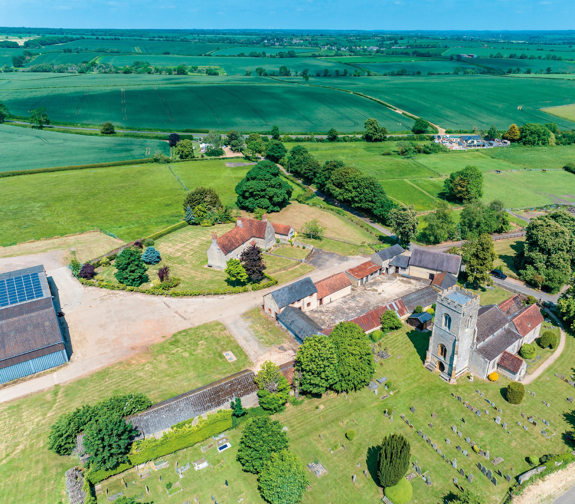
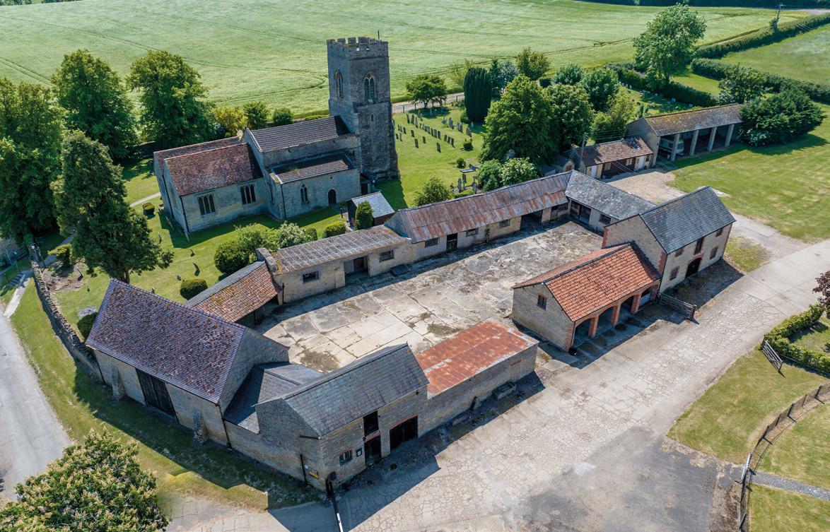
The farm is located around the village of Stoke Goldington in the north of the county of Buckinghamshire. The farmyard is located to the north of the village, off Church Lane, and adjacent to the Church of St Peter. The village benefits from a whole host of local facilities including a pre-school and Church of England Primary School along with two separate public buildings including a Village Hall and the Reading Room. There are also allotments, a recreation ground, and several clubs and social groups. The Lamb Public House is located centrally in the village. Miles of bridleways and footpaths located on the farm provide extensive riding and walking; these also extend around the countryside locally. The farm is also well located for amenities and recreation further afield including being only 3.5 miles from Salcey Forest, owned by the Forestry Commission, which provides many miles of walking, cycling and horse-riding trails.
The town of Newport Pagnell with a range of amenities is only six miles away and the larger city of Milton Keynes is located seven miles to the south. Northampton is approximately ten miles to the north.
Junction 14 of the M1 is six miles away, providing direct access south to London and to the north of England. From Milton Keynes Central Station there are regular trains into Central London.
There is an excellent range of schools in the locality including Stoke Goldington Pre-School, Stoke Goldington C of E School and other schools locally including Bedford School, Bedford Girls School, Bedford Modern, Northampton School for Girls, Hardingstone, Thornton College, Akeley Wood and Stowe School.
Road - The M1 is approximately seven miles from the farm via the B526 and A509 providing good access to the national motorway network.
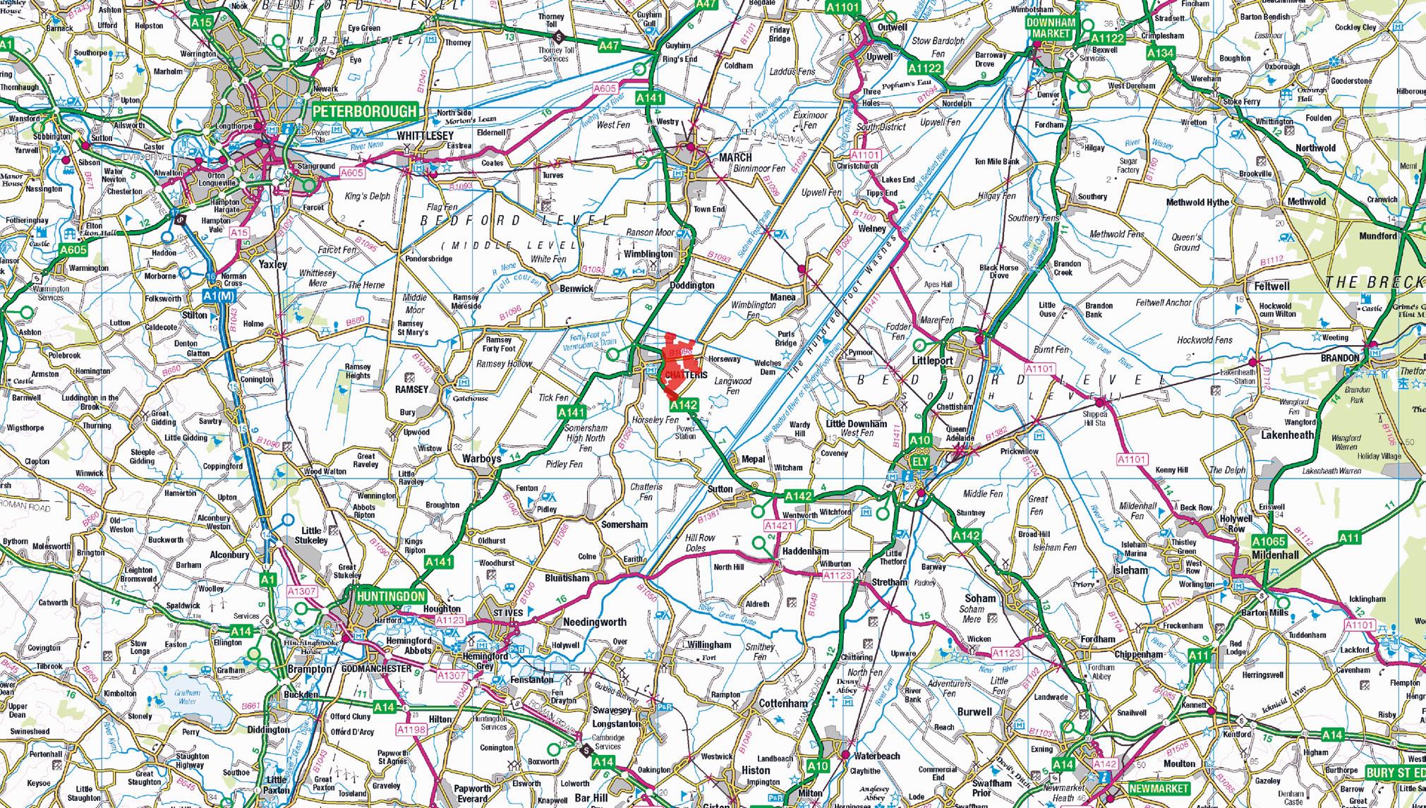
Rail - The train station at Milton Keynes offers direct services to Manchester, Birmingham and London Euston.
Air - Luton Airport is approximately 30 miles to the southeast and offers national and international flights.
The land has been farmed in hand by the Vendors, with some operations contracted to a local operator, with those operations invoiced on a work done basis. Vacant possession will be available on completion with payment to the Vendors of all ingoing costs associated with the establishment of a crop for the 2024 harvest.
The typical cropping has included a rotation of winter wheat, beans, oilseed rape, peas and winter barley. A table of cropping history is available in the data room and also detailed in these particulars.
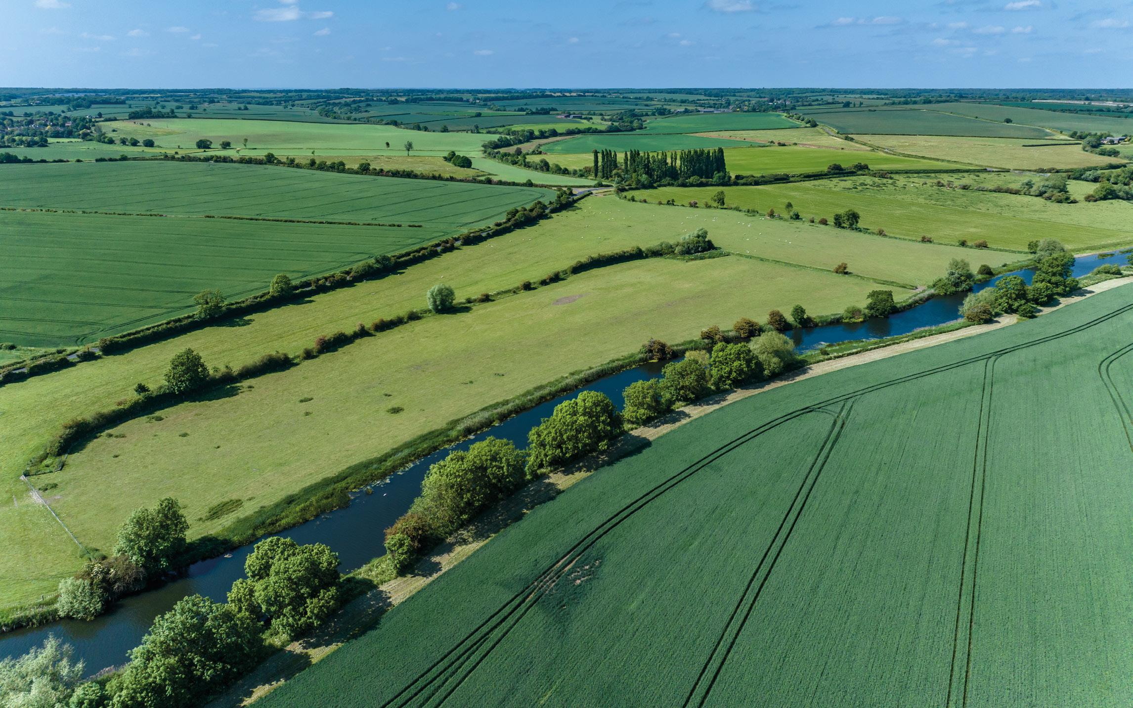
The land is classified as Grade 2 and 3 on the DEFRA published Agricultural Land Classification of England and Wales and is predominantly of the Hanslope series in the Soil Survey of England and Wales, which are described as coarse loamy over clayey soils. The Property extends to 906.17 acres (366.722 hectares) in all and comprises approximately 661.59 acres (267.735 hectares of arable land, 75.59 acres (30.590 hectares of permanent pasture and 158.49 acres (64.138 hectares) of woodland. The buildings and yard extend to approximately 10.50 acres (4.251 hectares).
There are grass paddocks adjacent to the farmhouse providing an attractive setting. The woodland, known as Stoke Park Wood, is a large block of mixed woodland with hardwoods of predominantly Oak and Ash along with some Alder. The soft wood comprises mostly Corsican and Scots Pine with some Norway Spruce. A good network of internal tracks provides access to the wood for shooting and timber extraction purposes. The Vendors have undertaken basic management of the woodland. There is an historic stocking schedule in the data room. There is no woodland management plan.
The Estate is being offered as a whole or in nine lots.
(As shaded pink on the sale plan)
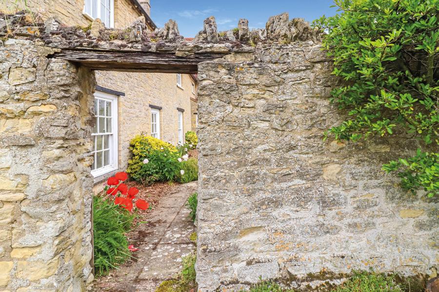
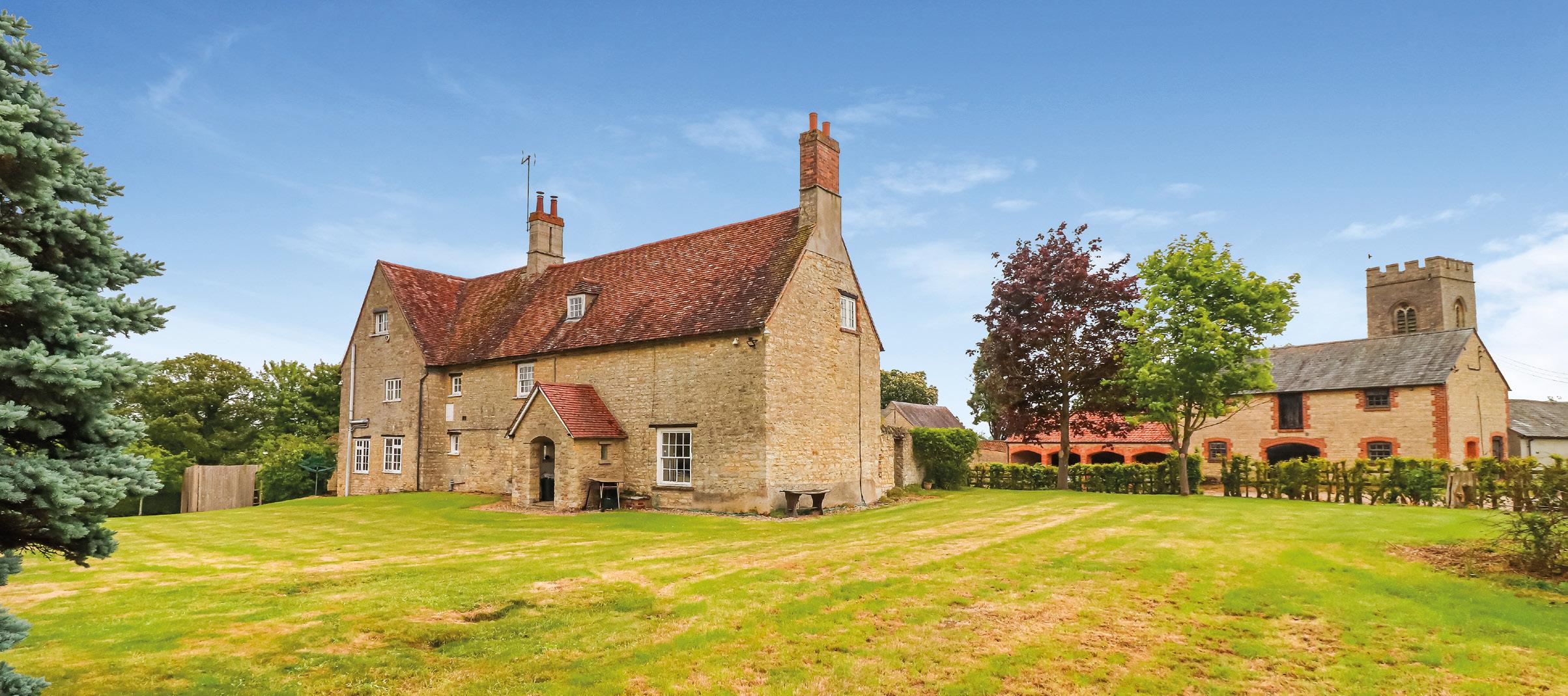
Church Farmhouse is a traditional five-bedroom Grade II Listed house, constructed of Coursed Rubblestone under a tile roof and sits in an elevated location overlooking the surrounding land and farmyard. The farmhouse extends to approximately 4,732 sq ft (439.61 sq m) including the annexe, cellar and attic rooms. Access to the farmhouse is currently through the main farm entrance off Church Lane, but there could be the opportunity to create a private access solely for use of the farmhouse via a separate gate off Church Lane.
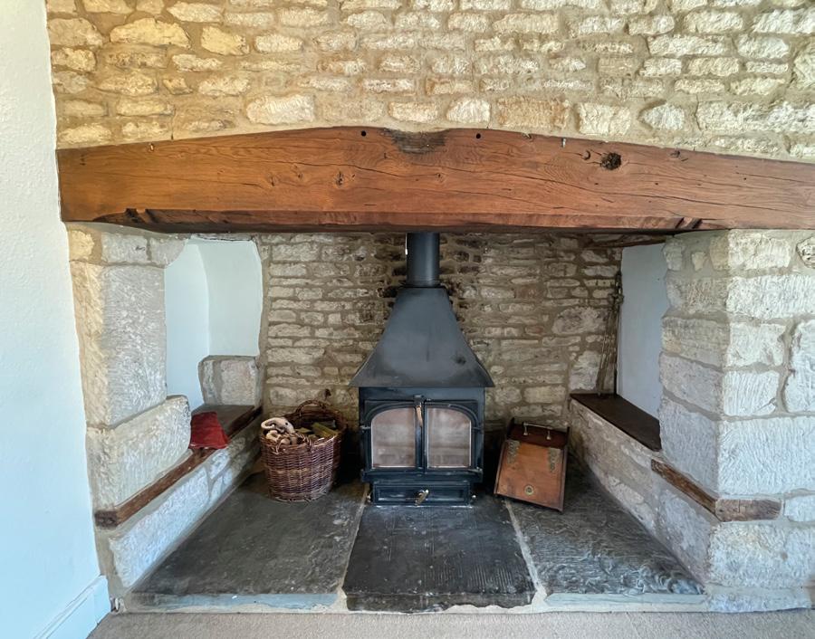
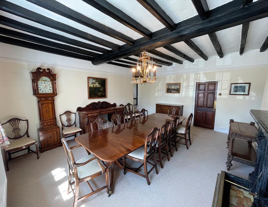
The farmhouse, a former Manor House, dates to the 16th Century (east wing) with additions in the 17th and 18th Century (west wing). The farmhouse features include stone mullion and leaded light windows along with a number of well-proportioned beamed rooms and open fireplaces. The listing entry is included in the data room.
The farmhouse provides extensive accommodation, including a large kitchen, dining room (with exposed beams and open fireplace), a cloakroom with exposed brickwork, living room and drawing room both with fireplaces. There is also a large cellar. By the back door there is an annexe adjoining the farmhouse leading from the utility room, providing an additional bedroom, living room and bathroom.
On the first floor there are four well-proportioned bedrooms one with an ensuite W.C. along with a large family bathroom. On the second floor there are extensive attic rooms that offer the potential to provide additional accommodation (subject to the necessary planning and Listed Building Consents).
Outside there is a mature, sheltered garden that wraps around the north of the house. The front garden is enclosed with part stone walls and Court fence with mature hedges and trees to the rear garden. The garden overlooks the paddocks and the farmyard to the north.
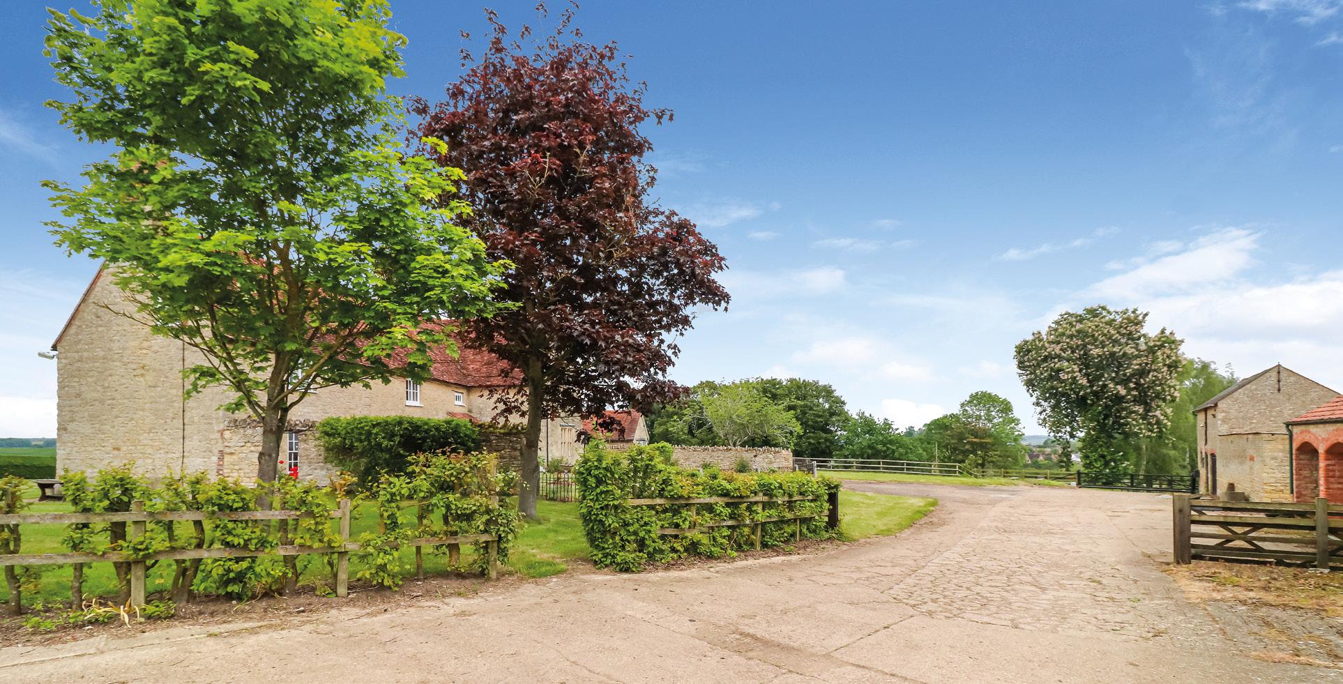
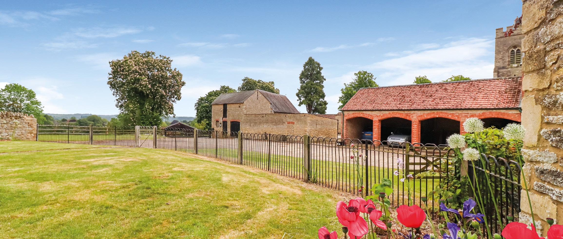
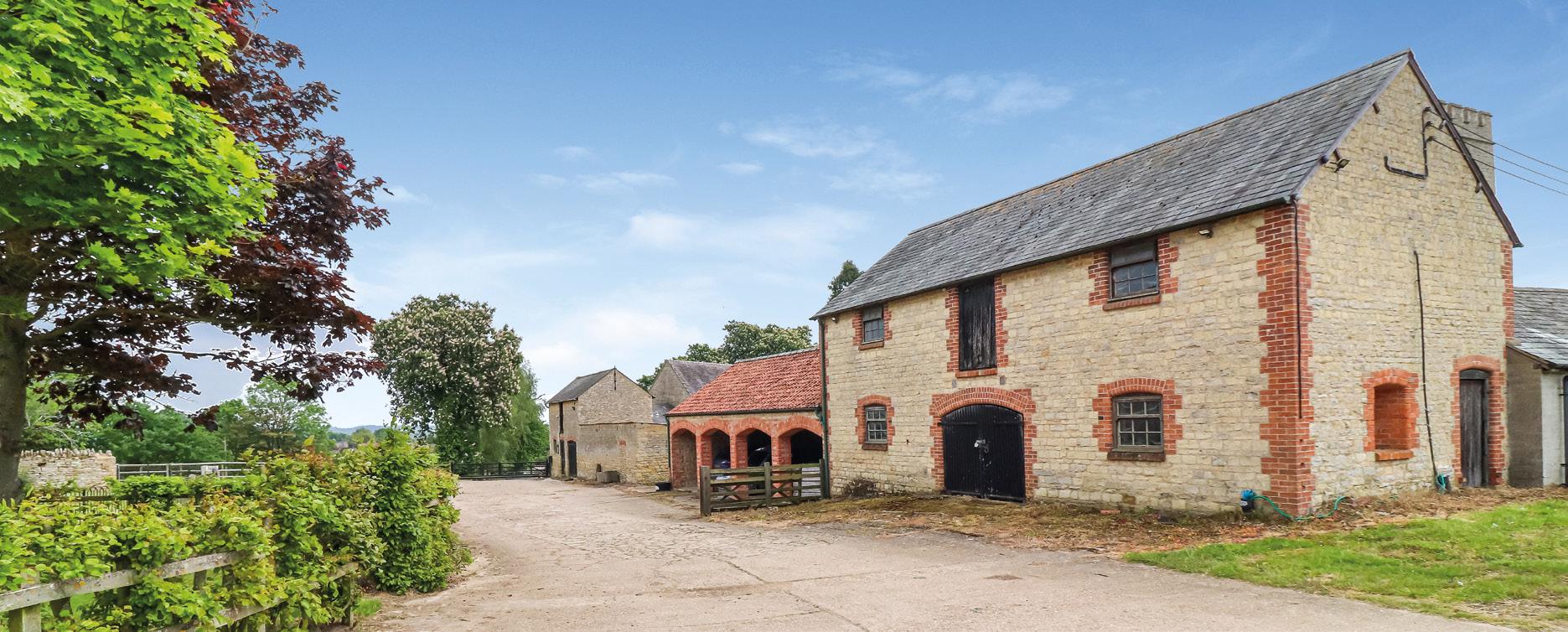
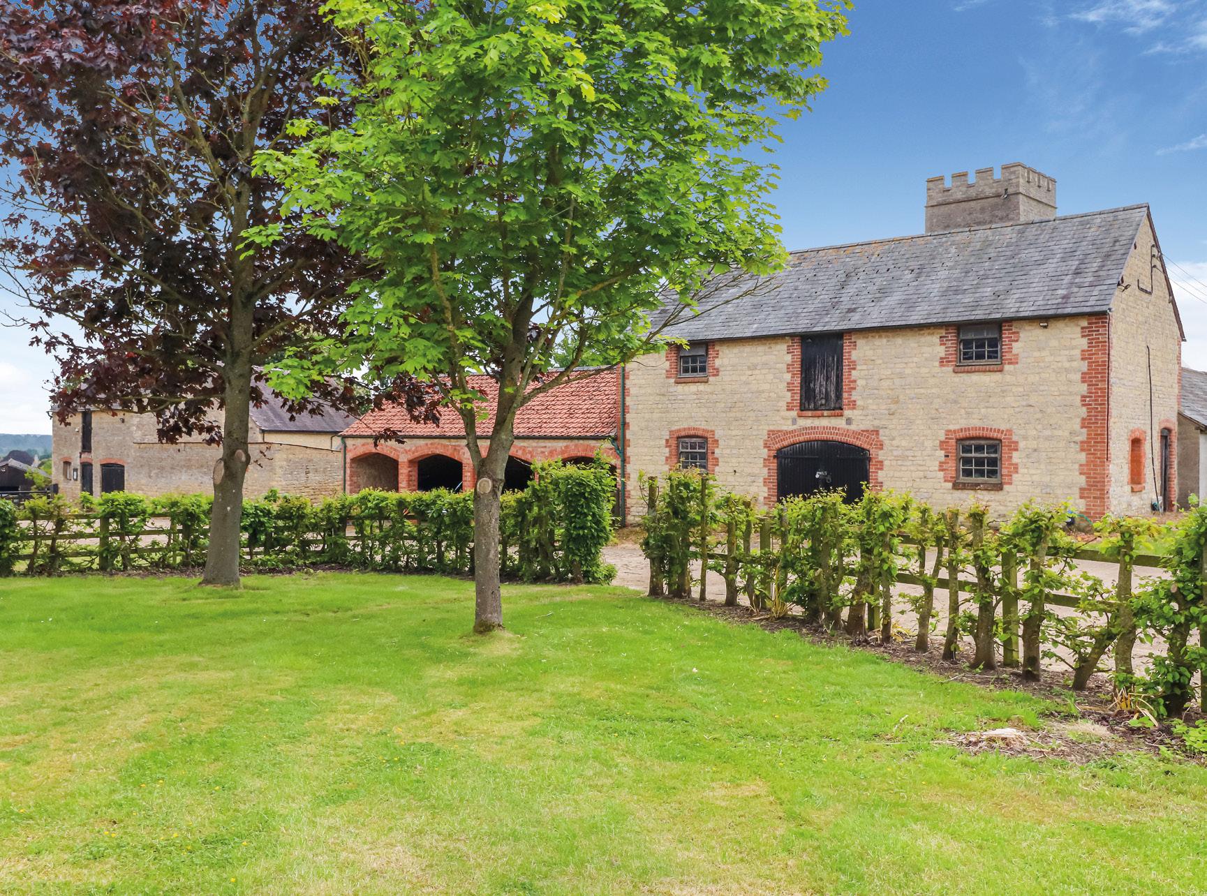
The traditional courtyard buildings at Church Farm extend to approximately 6,789 sq ft (630.71 sq m) and, in brief, comprise the following:
• A four-bay cart shed with pantile roof, used as parking for the farmhouse.
• A two-storey granary with slate roof, stone features with a wooden floor.
• Cow byre of rendered construction under a slate roof with sliding doors.
• Three stable blocks and storage shed with a corrugated iron and fibrecement roof and concrete brick floors.
• A three bay cart shed with part-tiled, part-slate roof.
• Stone store, partly over two floors with a slate roof.
Within the courtyard buildings there is also a stone barn with a tiled roof, which is Grade II Listed. The building is of the early 18th Century with a central wagon entry to the south gable elevation (fronting Church Lane). Double purlin roof with queen struts to lower purlins. The listing entry is included in the data room.
In 1997 full planning permission was granted for the conversion of the traditional buildings to four residential units. This application was not implemented at the time. Further details of this application are available in the data room.
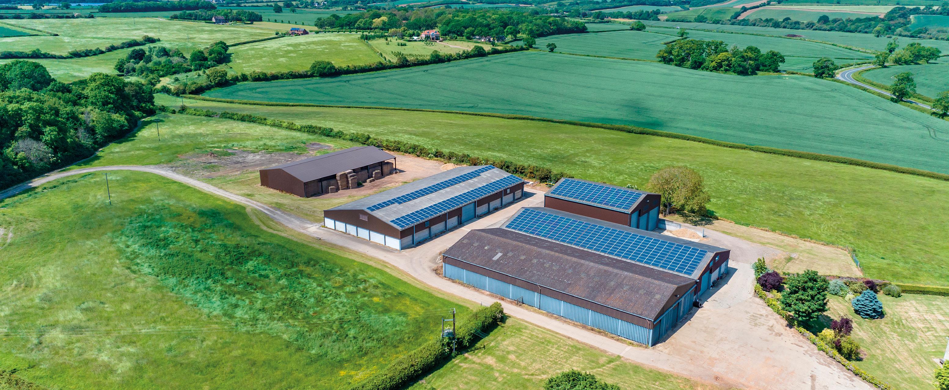
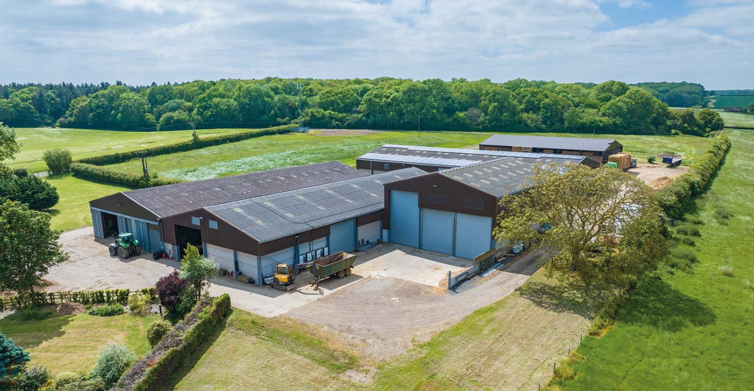
The farm buildings are located to the north of the farmhouse and are accessed off Church Lane. New buildings have been constructed over the years and they provide extensive machinery storage, hay and straw storage and a grain storage capacity of up to approximately 5,000 tonnes.
Buildings 2, 3 and 4 have solar panels fitted to the roofs, which supply the farm and also export to the grid with the Vendors receiving on average £24,000 per annum over the past four years. At the top of the yard adjacent to Stoke Park Wood, there is a telecommunications mast occupied under a Landlord and Tenant Act 1954 lease to Cornerstone Telecommunications Infrastructure. The Vendors currently receive £4,000 per annum. Further details are available in the data room.
Building 1
Grain store extending to approximately 11,146.97 sq ft (1,035.591 sq m) with a storage capacity of approximately 2,000 tonnes. Constructed in the early 2000s, it is of steel portal framed construction with 3.6 metre high grain walling, fibre cement cladding and roof panelling. There are double sliding doors to either end and a Challow hardwood drying floor with central air tunnel. The dryer has been disconnected. There is a Opico dryer with a 2000L Calor gas tank installed adjacent to Building 4. The dryer is portable so can be moved and stored inside during the winter. The dryer is available to purchase by separate negotiation.
Building 2
Machinery Shed / Workshop extending to approximately 10,810.92 sq ft (1,004.371 sq m). Constructed in 2010, it is of steel portal framed construction with 3.6 metre high grain walling, fibre cement cladding and roof panelling. The building has a roller shutter door and personnel door to the front. There is also an internal roller shutter door that provides access to the inside of the adjacent grain store (Building 3).
Building 3
Grain store extending to approximately 4,714.53 sq ft (437.996 sq m) with a storage capacity of approximately 1,000 tonnes. Constructed in 2014, it is of steel portal framed construction with 4-metre-high concrete grain panelling, with box profile steel cladding and fibre cement roof sheeting with rooflights. There are three 5-metre-wide galvanized roller shutter doors to the front with access to the two storage bays, one being almost nine metres to the eaves. There is also a personnel door. There is one galvanized roller shutter door to the rear, on top of 2-metre-high concrete panels.
Building 4
Grain store extending to approximately 14,282.67 sq ft (1,326.909 sq m) with a storage capacity of approximately 2,000 tonnes. Constructed in 2010. There is one galvanised roller shutter door on the eastern elevation. There is a small
lean to attached on the northern elevation used for general storage.
Straw Shed extending to approximately 8,587.54 sq ft (797.812 sq m) and was constructed in 2019. It is open on the northern and eastern elevations. It is of a steel portal framed construction with box profile steel sheeting to the walls and roof. The building has been let on a verbal agreement for the storage of straw for £8,000 per annum. Vacant possession of this building can be provided if required.
Welfare Facility extending to approximately 657 sq ft (61.05 sq m) and was converted in 2019 constructed of stone with a tiled roof. There is weatherboarding to part of the front of the building. The welfare facility includes a kitchen and living area, with a woodburning stove, and a shower room. There is a separate private drainage system for the welfare facility.
Two open fronted storage buildings extending to approximately 1,996.71 sq ft (185.501 sq m) in all. One is constructed of concrete block with a fibre cement sheet roofing and the other is a timber pole barn. Split into several bays, the buildings have been used primarily for storage of farm machinery.
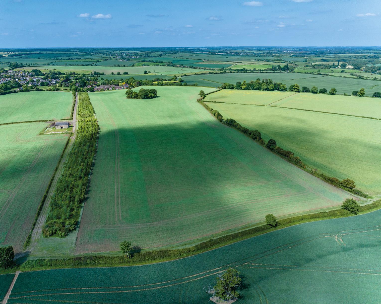
ARABle lAnd - 15.828 hA (39.11 AcRes)
(As shaded blue on the sale plan)
Divided into two fields, Church Piece and Little Piece, the land is currently in an arable rotation and countryside stewardship scheme. The land is accessed off Church Lane. A footpath runs along the hedgerow between the two fields and long the hardcore track.
Little
* Flower-rich plots.
ARABle lAnd - 21.468 hA (53.05 AcRes)
(As shaded bright blue on the sale plan)
Divided into two fields, Long Park and Park with Pond, the land is accessed off a substantial hardcore track. The land is undulating with a mature hedgerow separating the two fields.
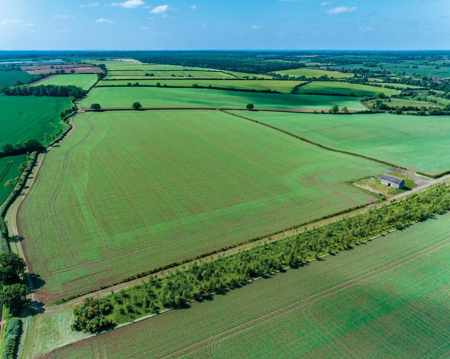
ARABle lAnd - 58.247 hA (143.93 AcRes)
(As shaded light blue on the sale plan)
A significant block of arable land divided into four fields, Terminal 1, Terminal 2, Heathrow Top and Heathrow Bottom. Accessed by a hardcore track off Church Lane and running along the southern boundary of the woodland. There are three public rights of way passing through the middle of this block of land, bridleway 1 to the southern boundary, bridleway 13 and footpath 17a both bisect the land leading from Stoke Park Wood
Heathrow Top Winter Barley Winter Wheat Peas Spring Beans
OSR Spring Beans
Heathrow Bottom Winter Barley Winter Wheat Peas Spring Beans Winter OSR Spring Beans
Terminal 1 AB9*/AB15** Over Wintered Stubble - AB9/AB15 Winter Wheat Spring Oats Spring Oats Spring Beans
Terminal 2 Winter Barley Winter Wheat Winter Barley Spring Beans Winter OSR Spring Beans
* Winter bird food ** Two-year sown legume fallow.
The Vendors have entered into an Option Agreement across this lot with Ecotricity Group for a proposed wind farm development. The Vendors receive £2,000 per annum and the agreement expires in May 2024. Further details are available from the selling agent and in the data room.
(As shaded green on the sale plan).
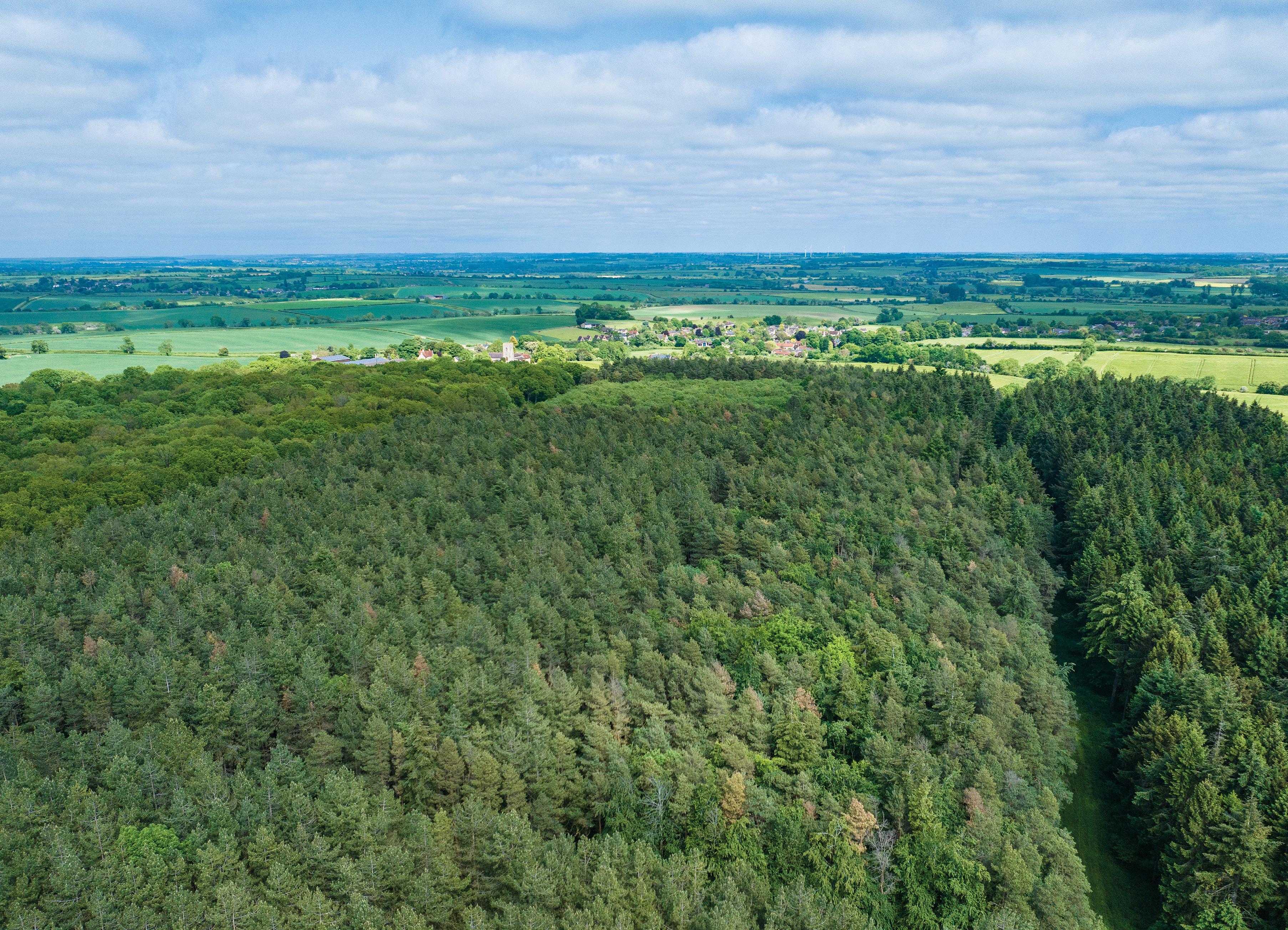
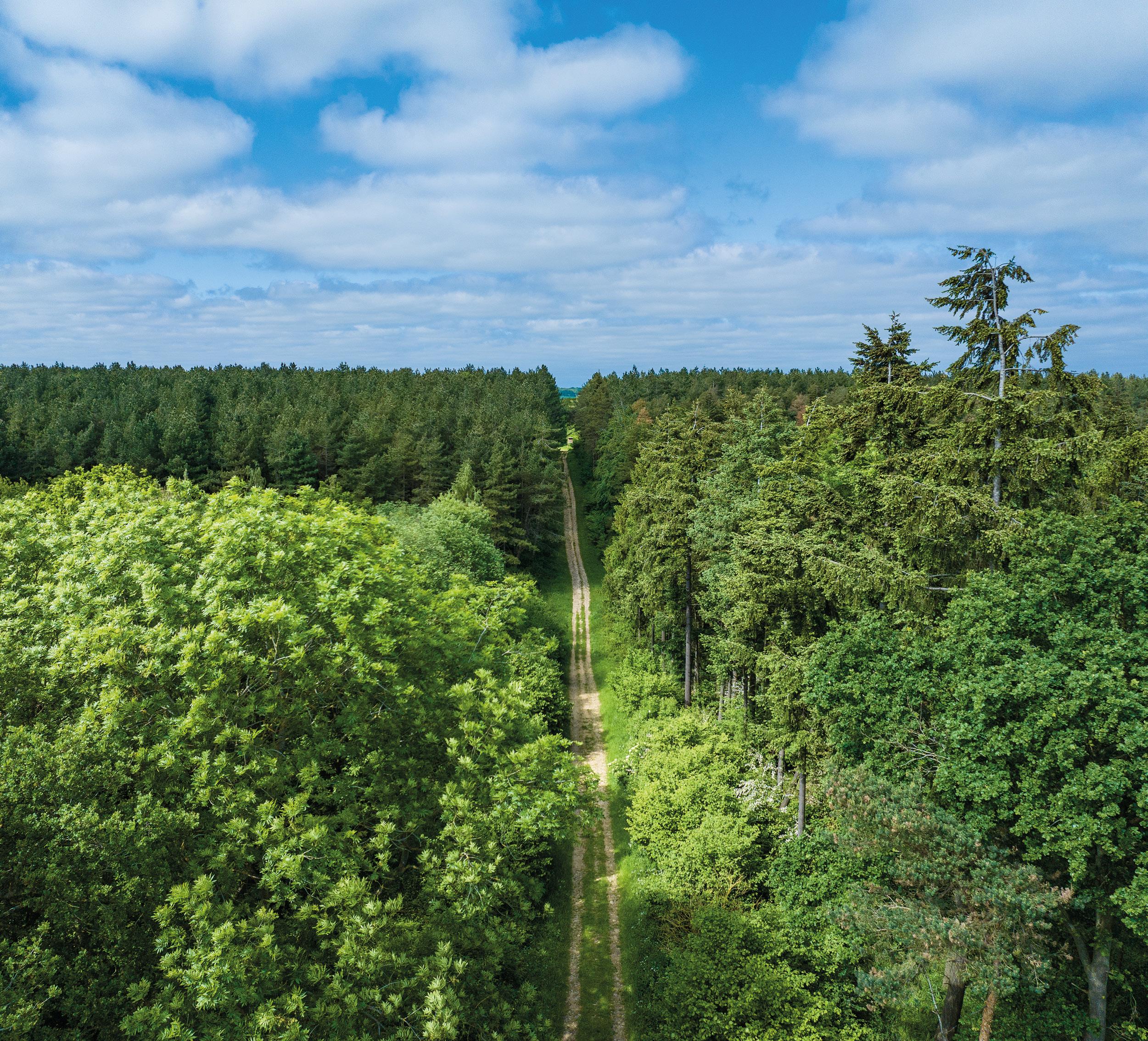
Accessed via a hardcore track off Church Lane and also from Dag Lane (as shown shaded brown on the sale plan), Stoke Park Wood is a large block of mixed woodland with hardwoods of predominantly Oak, Ash, Sycamore, Birch, Field Maple and some Alder. The softwood comprises Corsican Pine, Scots Pine, Douglas Fir and Norway Spruce. A good network of tracks and rides provides access and would be well suited for timber extraction or for shooting. The woodland has not been actively managed in recent years and could benefit from a thinning operation. There is no management plan for the woodland.
There are two public rights of way through the woodland: bridleway 13 crosses north to south, and footpath 8 crosses east to west. Footpath 17 runs along the southern boundary and footpath 9 and 15 runs along the eastern boundary.
The Forestry Commission has undertaken a deer activity and impact assessment and has undertaken management of the Deer across Church Farm and particularly within Stoke Park Wood.
The woodland is a haven for wildlife and plants providing both wetland and dry habitats, in the past it has formed the basis of a successful farm shoot.
An historic stocking schedule is available in the dat a room.
ARABle lAnd - 45.562 hA (112.59 AcRes)
(As shown shaded dark yellow on the sale plan)
A large block of arable land split into three fields, Big Hill, Valley Field and Pit Field East. The land is accessed off the Ravenstone Road, to the north, and an unnamed road leading from Stoke Goldington towards Weston Underwood, to the south.
There is one footpath, number 29 on the southern boundary of Valley Field leading from Stoke Goldington towards Ravenstone Mill Road.
name 2023 2022 2021 2020 2019 2018
Big Hill Sheep Keep / Peas Winter Barley
Winter Wheat Spring Oats
Valley Sheep Keep / Peas Winter Barley Winter Wheat Spring Oats
Winter Wheat Winter OSR / Fallow
Winter Wheat Winter OSR
Pit Field East Sheep Keep / Peas Permanent Pasture Permanent Pasture Permanent Pasture Permanent Pasture Permanent Pasture
ARABle lAnd - 65.621 hA (162.15
(As shown shaded light yellow on the sale plan)
A large block of arable land split into four fields, running along the length of the B526, Eakleys Lane. The land is accessed off Ravenstone Road and the B526. The fields are named as Ravenstone Road, Smarts Corner, Howkins and Osier Bed, the land is bordered by a small brook on the eastern side.
We understand some of the trees in this lot are subject to a Tree Preservation Order.
name 2023 2022 2021 2020 2019 2018
Osier Bed Winter Wheat Sheep Keep / Peas Spring Oats
Howkins Winter Wheat Sheep Keep / Peas Spring Oats
Smarts Corner Winter Wheat Sheep Keep / Peas Spring Oats
Ravenstone Road
Winter Wheat Sheep Keep / Peas Spring Oats
Spring Beans
Spring Beans
Spring Beans
Spring Beans
Winter Wheat Winter OSR
Winter Wheat Winter OSR
Winter Wheat Winter OSR
Winter Wheat Winter OSR
(As shown shaded bright yellow on the sale plan)
A block of arable land, known as Quarry Field with direct access of B526, Eakleys Lane, and an area of hardstanding by the entrance.
Quarry Winter Wheat Sheep Keep / Peas Spring Oats Spring Beans Winter Wheat Winter OSR
(As shown shaded light green on the sale plan)
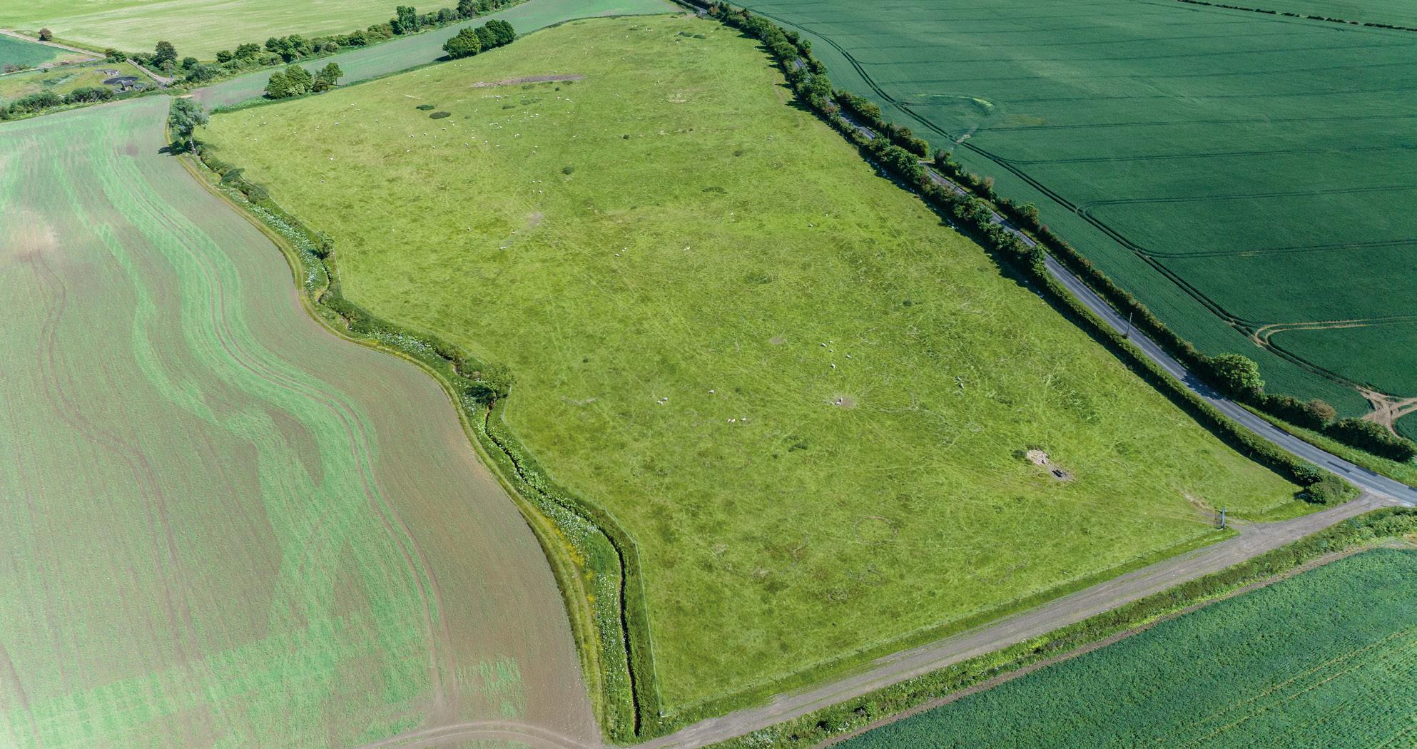
Attractive permanent pasture, used for the grazing of sheep. The land is split into two fields, one is partly a former landfill site to the north of Ravenstone Mill Road (Pit Field West), and the other is pleasant water meadows to the south of Ravenstone Mill Road adjacent to the River Great Ouse (River Meadow). The river provides excellent coarse fishing and amenity for sporting and wildlife. New fencing has been installed along the river providing regular stiles and fishing pegs. The meadow also benefits from a gated hardcore parking area for cars that has been used in relation to the fishing. Historically, the fishing has been let to a local angling club. The river attracts ducks, swans, geese and other waterfowl.
(As shown shaded grey on the sale plan)
The land is accessed to the south of the unnamed road leading from Stoke Goldington towards Weston Underwood. The land is split into two fields referred to as Gravel Field and Lambing Field. We understand the land has mineral deposits of approximately 420,000 tonnes of sand, gravel and the minerals. The Purchaser(s) can extract gravel for their own agricultural purposes. Further information is detailed in Mineral Rights on page 25 and available in the data room.
(As shown shaded purple on the sale plan)
The land is accessed off the B526, Newport Road through the double gates. There is also a secondary, narrower, gated access via a right of way off Town End Crescent (as shown shaded brown on the sale plan).
The land is split into two fields, Bunsty East and Bunsty West. There is a small strip of young woodland planted alongside the main track leading from Town End Crescent.
name 2023 2022 2021 2020 2019 2018
Bunsty East Overwintered Stubble / Peas Winter Barley
Bunsty West Overwintered Stubble / Peas Winter Barley
Winter Wheat Winter OSR Spring Beans Winter Wheat
Winter Wheat Winter OSR Spring Beans
Winter Wheat
Bridleway Way 22 runs along the hardcore track leading from Town End Crescent and Footpath 19 runs along the southeastern boundary and crosses past the spinney known as Town End Clump. We understand the spinney is subject to a Tree Preservation Order.
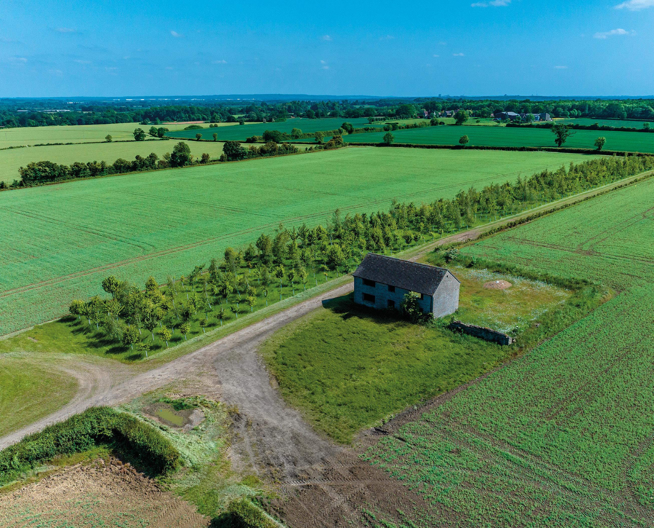
(As shown shaded orange on the sale plan)
Harley Field Barn provides an extremely rare opportunity to purchase a stone barn, and approximately half an acre, with the potential for conversion to a residential dwelling in a spectacular location overlooking surrounding countryside. The property received full planning permission in 2005 for the conversion to a four-bedroom dwelling. The permission was not implemented at the time, and the Purchaser(s) will need to undertake their own due diligence in relation to any planning and will be deemed to have satisfied themselves as to any planning requirements.
There are no services connected to the building and should the building be sold separately rights will be granted to enable the connection of services, if required. Rights of access to the building will be granted across the hardcore track of Lot 8 to Town End Crescent. If the lot is sold separately the Purchaser(s) will be required to erect, and maintain, a new fence on the boundary of the plot.
Bridleway Way 22 passes to the east of the building leading towards Hanslope Road to the south.
The proposed drawings and decision notice can be found in the data room.
The freehold interest is offered for sale with Vacant Possession on completion.
The property is for sale as a whole, or in nine lots, and is to be sold by private treaty.
Offers may be considered on any part. Purchaser(s) interested in any specific part should contact the selling agents at an early stage indicating the area of specific interest to them.
e xchange of c ontracts and c ompletion
A 10% deposit will be payable on exchange of contracts. The completion date is to be agreed between the parties.
Further information about the farm can be found in the data room at www. churchfarmstokegoldington.co.uk. Please contact the selling agents for access.
The property is offered for sale subject to new development plans, tree preservation orders, existing planning permissions or listed building designations and public rights of way.
The planning history for the property is shown in the table but the Purchaser(s) will be deemed to have satisfied themselves as to any planning matters affecting the property.
The installation of a 20 metre lattice tower, 3 x antennas, 2 x microwave dishes, 2 x equipment cabinets and ancillary development
Prior notification for erection of steel framed building for use as grain store
A wind energy development comprising the erection of fifteen wind turbines, each with a maximum overall height of up to 120m together with access tracks and hard standing areas and a temporary site compound (part of Lot 3d)
Listed building consent for underpinning to front and side elevations and two internal walls and internal crack repair and
The Purchaser(s) will be deemed to have satisfied themselves of the condition of the property and be purchasing the property on the basis of their own enquiries, inspections and surveys.
There is an overage provision that benefits the previous vendors across the land in Lot 3b as shown hatched on the sale plan. This is in the event of planning permission being granted for change of use and is for 50% of the difference between the value of the land with the benefit of planning permission and the agricultural value of the land immediately prior to the granting of planning permission.
Payment to be made to the previous vendors within 28 days following the granting of planning permission. The overage provision has a further 10 years remaining. Further details are available from the selling agent and in the data room.
Drainage Rates are payable for the holding and are charged by the Environmental Agency.
The general drainage charge raised by the Environment Agency (EA) for the period 1 April 2023 - 31 March 2023 was £738.13 (216.46 pence per assessable hectare).
p lanning & e nvironmental d esignations
Church Farm is located within an Area of Attractive Landscape and part of the Open Countryside.
The property is situated within a surface water Nitrate Vulnerable Zone.
Stoke Park Wood is classified as an Ancient Woodland.
Areas of the property are within Flood Zones 2 & 3. The entirety of the land adjacent to the river (River Meadow) is within Flood Zones 2 & 3.
We understand trees in Lot 5b and the spinney in Lot 8 (Town End Clump) are subject to Tree Preservation Orders (TPO). The Vendors are not aware of any other TPO’s across the property.
The Purchaser(s) will be deemed to have full knowledge and satisfied themselves as to all designations or orders affecting the property.
The property will be sold subject to, and with the benefit of, all existing wayleaves, easements, covenants and rights of way (whether or not disclosed).
There are a number of public rights of way within the boundary of the property and these are shown with purple and green dashed lines on the Rights of Way plan included in the data room.
If the property is sold in lots, the appropriate rights of access will be granted as necessary.
The Purchaser(s) will be deemed to have full knowledge and will have satisfied themselves as to the provisions of any such matters affecting the property.
All mineral rights across the property are
included (except Lot 7) in the sale insofar as they are owned.
Previous investigations on the site have identified deposits in the area defined as Lot 7. There is a seam of gravel averaging 3.3 metres thick underlined by London Clay that could be processed to provide good quality concreting aggregate. It is estimated that the deposit is in the order of 420,000 tonnes of sand and gravel.
Lot 7 is sold subject to the previous vendor having excepted all mines, minerals and mineral substances and the right to let down the surface. If the minerals are to be worked at any future date 50% of any sale proceeds or royalties for mineral extracted or filling would go to the previous vendor and 50% to the Purchaser(s) of Lot 7.
The professional costs incurred in securing the planning permission to extract mineral or any filling will be shared equally between the previous vendor and the Purchaser(s) and agreed in advance.
The Purchaser(s) will be able to use any gravel for their own agricultural purposes on the farm.
Further details are available from the selling agent s.
In so far as they are owned, the sporting rights, as well as any standing timber on the estate are included in the sale.
The shooting and stalking rights are not let save for the Forestry Commission managing the Deer within Stoke Park Wood and surrounding land.
A small area to the south of Lot 5a (Pit Field West) was a former Council landfill site. Tipping ceased approximately 40 years ago, and the area is now down to grass and has been grazed with sheep.
The land is registered under HM Land Registry Title Numbers BM266318, BM93377 and BM86026.
As a result of the delinking of BPS payments it will not be possible for the Purchaser(s) to make a claim for a payment under this scheme and the Vendor will retain all payments on the land between 2024 and 2027.
The Purchaser(s) will be required to comply with the scheme rules and indemnify the Vendor against any breaches should the sale complete prior to the end of 2023.
The land has been entered into a Countryside Stewardship Scheme which commenced on 1st January 2019 expiring on 31st December 2023. The Vendor will retain the payment for 2023 and the Purchaser(s) will be required to comply with the scheme rules and indemnify the Vendor against any breaches should the sale complete prior to the end of 2023.
The land has not been entered into a Sustainable Farming Incentive scheme; however, the land would be well suited to a range of options available to the incoming Purchaser(s).
Church Farm will be sold subject to the following rights of holdover:
i) To store grain and all necessary rights of access and management up until March 2024.
ii) To hold a machinery sale within 28 days of completion.
i ngoing valuation
On the basis of a sale completing after September 2023, in addition to the purchase price, the Purchaser(s) shall pay upon completion for the following items if, and when, applicable:
i) Stocks of fuel, oil, seeds, fertilisers, sprays including those in store and those applied to the land at calculated cost;
ii) All cultivation and applications (including mole drainage and subsoiling) carried out at CAAV rates or at a specified contractor’s rates if greater. Further details available from the Vendors’ agents.
iii) Any hedge cutting and ditching carried out at CAAV rates or at a specified contactor’s rates;
iv) An enhancement payment calculated at £20 per arable hectare per month calculated from 1 September 2023 up to completion.
v) VAT where applicable at the current rate.
There will be no charge for unexhausted and residual manurial values of fertiliser or lime applied. There will be a charge for manure spread in 2023.
Machinery may be available by separate negotiation.
The Purchaser(s) will not be entitled to make any counter claim for dilapidations or any other matters. Tenant right will be paid for immediately upon completion.
value Added tax
Should any sale of the land as a whole or in lots, or any right attached to it become a chargeable supply for the purpose of VAT, such tax will be payable by the Purchaser(s) in addition to the contract price.
s ervices
Drainage
- Church Farmhouse drains to a septic tank in the paddock adjacent to the farmhouse.
- The Welfare Facility drains to a septic tank in front of the building.
Electricity
- Mains electricity is connected to the Farmhouse.
- Three phase supply at Church Farmyard and the electricity feed comes into the farm in a small stone building adjacent to the Welfare Facility
Water
- Mains water is connected.
Central Heating
- Church Farmhouse has oil fired central heating. A new system was installed in 2019.
The Purchaser(s) will be deemed to have satisfied themselves as to any services connected to the Property.
Church Farmhouse
Band G - 2022/23 - £3,180.05
s olicitors
DLS Law
Gloucester House, 399 Silbury Boulevard, Milton Keynes, MK9 2AH
FAO: David Pilgrim
To comply with the Money Laundering Regulations 2017 and 2019 once an offer is accepted the Purchaser(s) will be required to provide any information requested in order to undertake the relevant due diligence. This is a legal requirement.
l ocal Authority
Milton Keynes City Council
1 Saxon Gate East Central Milton Keynes
MK8 3EJ
Plans att ached to the particulars are based upon the Ordnance Survey National Grid and are for reference only.
The Purchaser(s) will be deemed to have satisfied themselves of the property as scheduled.
The location of the entrance of Church Farm is: ///surviving.compounds.excavate
A schedule of what3words for each Lot is available within the data room.
post c ode
The post code for Church Farm is MK16 8NZ.
video l ink
Please scan this QR Code to access an aerial video of the property. https://vimeo. com/836493251/6706377384
360 view
Please scan this QR Code https://kuula.co/share/collection/7 J4lS?logo=0&info=0&fs=1&vr=1&in itload=0&thumbs=1
viewings
Viewing and access to the property is strictly by appointment with Bidwells. Please contact Bidwells Rural Agency on 01865 953 080.
Website: www.milton-keynes.gov.uk
Telephone: 01908 691 691
c hancel Repair l iability
There is no Chancel Repair Liability associated with the property.
The Vendors and the Vendors’ agent will do their best to specify the ownership of boundary hedges, fences and ditches but will not be bound to determine these.
The Purchaser(s) will be deemed to have satisfied themselves as to the ownership of any boundaries.
Given the potential hazards of a working farm and its associated machinery we would ask you to be as vigilant as possible for your own personal safety when making an inspection of this property.
The photographs in these particulars were taken in June and July 2023. The Purchaser(s) should assume that all the fixtures and fittings, light fittings, electrical appliances and garden statuary in all property are specifically excluded from the sale.
These sales details were prepared in August 2023.
Bidwells LLP act for themselves and for the vendors/landlords of this property, whose agents they are, give notice that:
Nothing contained in these particulars or their contents or actions, both verbally or in writing, by Bidwells LLP form any offer or contract, liability or implied obligation to any applicants, viewing parties or prospective purchasers of the property to the f ullest extent permitted
by law and should not be relied upon as statements or representative of fact. No person in the employment of Bidwells LLP or any joint agents has authority to make or give any representation or warranty whatever in relation to this property. Any areas of measurements or distances are approximate. The text, photographs and plans are for guidance only, may not be to scale and are not necessarily comprehensive. No assumptions should be made that the property has all necessary planning, building regulation or other consents. Bidwells LLP has not carried out a survey, nor tested the services, appliances or facilities. Purchasers must satisfy themselves by inspection or otherwise. All rentals and prices are quoted exclusive of VAT unless otherwise stated.
Prospective purchasers and tenants will be asked to produce identification of the intended purchaser/tenant and other documentation in order to support any conditional offers submitted to the vendors. Bidwells LLP accepts no liability of any type arising from your delay or other lack of co-operation. We may hold your name on our database unless you instruct us otherwise.
OS licence no. ES 100017734.
Copyright Bidwells LLP 2023. Bidwells LLP is a limited liability partnership registered in England and Wales (registered number OC 344553). Registered office is Bidwell House, Trumpington Road, Cambridge CB2 9LD where a list of members is available for inspection. Your statutory rights are not affected by this notice.