History Spotlight
The Earliest Marple Map of 1816 Written by Doug Humes Photos courtesy of the Marple Historical Society
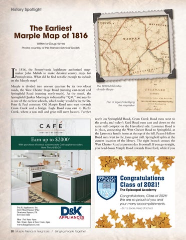
I
n 1816, the Pennsylvania legislature authorized mapmaker John Melish to make detailed county maps for Pennsylvania. What did he find notable enough to include on the Marple map? Marple is divided into uneven quarters by its two oldest roads, the West Chester Stage Road (running east-west) and Springfield Road (running north-south). At the south, the Springfield Quaker Meeting is indicated by “QM,” and nearby is one of the earliest schools, which today would be in the Sts. Peter & Paul cemetery. Old Marple Road runs west towards Crum Creek and a bridge. Eagle Road runs east to Darby Creek, where a saw mill and grist mill were located. Further
The 1816 Melish Map of early Marple
Part of legend identifying the mapmaker
north on Springfield Road, Crum Creek Road runs west to the creek; and today’s Reed Road runs east and down to the same mill complex on the Haverford side. Lawrence Road is in place, connecting the West Chester Road to Springfield, at the Lawrence family home at the top of the hill. Paxon Hollow Road runs west to the Jones grist mill. Springfield splits at the current location of the library. The right branch crosses the West Chester Road at present day Broomall. If you go straight, you head down Marple Road towards Haverford, while if you
EPISCOPAL ACADEMY
Congratulations Class of 2021! The Episcopal Academy
Congratulations, Class of 2021! We are so proud of you and your many accomplishments. ~Dr. T.J. Locke, Head of School
20 Marple Friends & Neighbors / Bringing People Together


