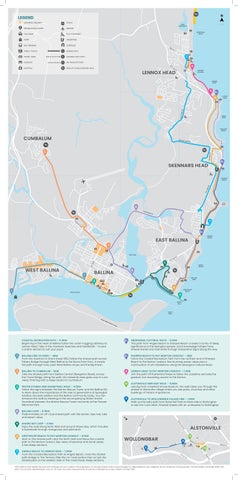
COASTAL RECREATION PATH – 11.5KM
Beginning in the heart of Ballina follow the coast-hugging pathway to Lennox Head. Take in the riverbank, beaches and headlands – or pick a scenic section to suit your pace.
BALLINA CBD TO FERRY – 4KM
From the riverfront in Grant Street (RSL) follow the shared path across Fishery Bridge through West Ballina to the Burns Point Ferry. A mostly flat path through town, past West Ballina shops and the Big Prawn.
BALLINA TO CUMBALUM – 5KM
Take the shared path from Ballina Central (Bangalow Road), across the Canal Bridge. Along the path, the industrial area gives way to rural views, finishing with a steep ascent to Cumbalum.
WATER STORIES AND SOUNDTRAIL WALK – 4.5KM
Follow the signs between the Marine Rescue Tower and the Ballina RSL to learn about the importance of the river to generations of Nyangbal families, the early settlers and the Ballina community today. You can enhance the walk by listening to the accompanying Water Stories Soundtrail between the Marine Rescue Tower and ends at the Pioneer Memorial Park.
BALLINA LOOP – 11.5KM
Predominately an off-road shared path with flat terrain. See river, lake and beach views.
SHAWS BAY LOOP – 3.1KM
Enjoy the walk along North Wall and around Shaws Bay, which includes a boardwalk through mangroves and saltmarsh.
LIGHTHOUSE BEACH TO PAT MORTON LOOKOUT – 8.1KM
Start on the shared path near the North Wall and follow the coastal path to Pat Morton Lookout. See views of beaches and dunal areas. A few steep sections.
ANGELS BEACH TO LENNOX HEAD – 7.8KM
From the Coastal Recreation Path at Angels Beach, cross the shared path bridge to The Terrace. Ride this on-road section then re-join the shared path on the western side of The Coast Road. Steep sections.
ABORIGINAL CULTURAL WAYS – 2.5KM
This path from Angels Beach to Sharpes Beach crosses Country of deep significance to the Nyangbal people. Local knowledge holders have shared stories and memories through interpretive signs along the way.
SHARPES BEACH TO PAT MORTON LOOKOUT – 3KM
Follow the Coastal Recreation Path from the northern end of Sharpes Beach to Pat Morton Lookout. See stunning ocean views plus a continuation of art installations along the Aboriginal Cultural Ways.
LENNOX HEAD TO PAT MORTON LOOKOUT – 1.2KM
Join the path off Rutherford Street to follow the coastline and take the gradual, but rewarding, ascent to Pat Morton.
ALSTONVILLE HERITAGE WALK – 0.8KM
Leaving from Crawford House Museum, the walk takes you through the streets of Alstonville village where you see parks, churches and other buildings of historic importance.
ALSTONVILLE TO WOLLONGBAR VILLAGE LINK – 1.4KM
Walk up the leafy path from Bulwinkel Park at Alstonville to Wollongbar to see rich rural views. Gradual slopes with an underpass to Wollongbar.